ies-svn.jrc.ec.europa.eu€¦ · web viewservice that provides a client access to a geographic...
TRANSCRIPT

Annex xxx - INSPIRE Metadata Codelists
This Annex gives a description of the value domains (codelists) to be used for the INSPIRE metadata elements, as specified in the descriptions given in the previous sections. Those domains are defined:
in the metadata Regulation (CE) no. 1205/2008 (section 1); in this metadata TG or in INSPIRE data specifications TG (section 2); in the ISO standards (see section 3). In that case, the value domains corresponding, even only in part, to the codelists defined in ISO
Standards but already given in section 1 or in section 2 are non included.
For every codelist, each value is defined by:
a numerical identifier (No. ID), if any, corresponding, in most cases, to the numerical identifier defined in Regulation (CE) no. 1205/2008 or to ISO domain code;
a textual name; a language neutral name, if any; an optional definition/description; an URI identifier, if any.
1. Codelists defined/foreseen in the Regulation (CE) no. 1205/2008
1.1 Resource Type
The codelist is defined in part D.1 of the Regulation (CE) n. 1205/2008, to be used for the INSPIRE metadata element “Resource Type”. The values included are a subset of the MD_ScopeCode codelist given in ISO 19115 (see B.5.25).
No. ID Textual name Language neutral name Description / definition INSPIRE Registry URI identifier1.1 Spatial data set series series a collection of spatial data sets sharing the same product specification http://inspire.ec.europa.eu/metadata-codelist/
ResourceType/series/1.2 Spatial data set dataset an identifiable collection of spatial data http://inspire.ec.europa.eu/metadata-codelist/
ResourceType/dataset/1.3 Spatial data services services the operations which may be performed, by invoking a computer application, on the
spatial data contained in spatial data sets or on the related metadatahttp://inspire.ec.europa.eu/metadata-codelist/ResourceType/services/
1.2 Topic categories
The codelist is defined in part D.2 of the Regulation (CE) n. 1205/2008, to be used for the INSPIRE metadata element “Topic category”. It corresponds to the MD_TopicCategoryCode enumation given in ISO 19115 (see B.5.27).

No. ID Textual name Language neutral name Description / definition INSPIRE Registry URI identifier2.1 Farming Farming Rearing of animals and/or cultivation of
plants.http://inspire.ec.europa.eu/metadata-codelist/TopicCategory/farming/
2.2 Biota biota Flora and/or fauna in natural environment.
http://inspire.ec.europa.eu/metadata-codelist/TopicCategory/biota/
2.3 Boundaries boundaries Legal land descriptions. http://inspire.ec.europa.eu/metadata-codelist/TopicCategory/boundaries/
2.4 Climatology / Meteorology / Atmosphere
climatologyMeteorologyAtmosphere Processes and phenomena of the atmosphere.
http://inspire.ec.europa.eu/metadata-codelist/TopicCategory/climatologyMeteorologyAtmosphere/
2.5 Economy economy Economic activities, conditions and employment.
http://inspire.ec.europa.eu/metadata-codelist/TopicCategory/economy/
2.6 Elevation elevation Height above or below sea level. http://inspire.ec.europa.eu/metadata-codelist/TopicCategory/elevation/
2.7 Environment environment Environmental resources, protection and conservation.
http://inspire.ec.europa.eu/metadata-codelist/TopicCategory/environment/
2.8 Geoscientific Information
geoscientificInformation Information pertaining to earth sciences. http://inspire.ec.europa.eu/metadata-codelist/TopicCategory/geoscientificInformation/
2.9 Health health Health, health services, human ecology, and safety.
http://inspire.ec.europa.eu/metadata-codelist/TopicCategory/health/
2.10 Imagery / Base Maps / Earth Cover
imageryBaseMapsEarthCover Base maps. http://inspire.ec.europa.eu/metadata-codelist/TopicCategory/imageryBaseMapsEarthCover/
2.11 Intelligence / Military
intelligenceMilitary Military bases, structures, activities. http://inspire.ec.europa.eu/metadata-codelist/TopicCategory/intelligenceMilitary/
2.12 Inland Waters inlandWaters Inland water features, drainage systems and their characteristics.
http://inspire.ec.europa.eu/metadata-codelist/TopicCategory/inlandWaters/
2.13 Location location Positional information and services. http://inspire.ec.europa.eu/metadata-codelist/TopicCategory/location/2.14 Oceans oceans Features and characteristics of salt water
bodies (excluding inland waters).http://inspire.ec.europa.eu/metadata-codelist/TopicCategory/oceans/
2.15 Planning / Cadastre planningCadastre Information used for appropriate actions for future use of the land.
http://inspire.ec.europa.eu/metadata-codelist/TopicCategory/planningCadastre/
2.16 Society society Characteristics of society and cultures. http://inspire.ec.europa.eu/metadata-codelist/TopicCategory/society/
2.17 Structure structure Man-made construction. http://inspire.ec.europa.eu/metadata-codelist/TopicCategory/structure/
2.18 Transportation transportation Means and aids for conveying persons and/or goods.
http://inspire.ec.europa.eu/metadata-codelist/TopicCategory/transportation/
2.19 Utilities / Communication
utilitiesCommunication Energy, water and waste systems and communications infrastructure and services.
http://inspire.ec.europa.eu/metadata-codelist/TopicCategory/utilitiesCommunication/
1.3 Spatial data service type

The codelist is defined in part D.3 of the Regulation (CE) n. 1205/2008, to be used for the INSPIRE metadata element “Spatial data service type”.
No. ID Textual name Language neutral name Description / definition INSPIRE Registry URI identifier3.1 Discovery Service discovery Services making it possible to search for spatial data
sets and services on the basis of the content of the corresponding metadata and to display the content of the metadata.
http://inspire.ec.europa.eu/metadata-codelist/SpatialDataServiceType/discovery/
3.2 View Service view Service that makes it possible, as a minimum, to display, navigate, zoom in and out, pan or overlay viewable spatial data sets and to display legend information and any relevant content of metadata.
http://inspire.ec.europa.eu/metadata-codelist/SpatialDataServiceType/view/
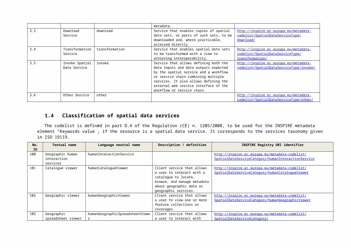
3.3 Download Service download Service that enables copies of spatial data sets, or parts of such sets, to be downloaded and, where practicable, accessed directly.
http://inspire.ec.europa.eu/metadata-codelist/SpatialDataServiceType/download/
3.4 Transformation Service
transformation Service that enables spatial data sets to be transformed with a view to achieving interoperability.
http://inspire.ec.europa.eu/metadata-codelist/SpatialDataServiceType/transformation/
3.5 Invoke Spatial Data Service
invoke Service that allows defining both the data inputs and data outputs expected by the spatial service and a workflow or service chain combining multiple services. It also allows defining the external web service interface of the workflow or service chain.
http://inspire.ec.europa.eu/metadata-codelist/SpatialDataServiceType/invoke/
3.6 Other Service other http://inspire.ec.europa.eu/metadata-codelist/SpatialDataServiceType/other/
1.4 Classification of spatial data services
The codelist is defined in part D.4 of the Regulation (CE) n. 1205/2008, to be used for the INSPIRE metadata element “Keywords value”, if the resource is a spatial data service. It corresponds to the services taxonomy given in ISO 19119.
No. ID Textual name Language neutral name Description / definition INSPIRE Registry URI identifier100 Geographic human
interaction serviceshumanInteractionService http://inspire.ec.europa.eu/metadata-codelist/SpatialDataServiceCategory/
humanInteractionService101 Catalogue viewer humanCatalogueViewer Client service that allows a user to
interact with a catalogue to locate, browse, and manage metadata about geographic data or geographic services.
http://inspire.ec.europa.eu/metadata-codelist/SpatialDataServiceCategory/humanCatalogueViewer
102 Geographic viewer humanGeographicViewer Client service that allows a user to view one or more feature collections or coverages.
http://inspire.ec.europa.eu/metadata-codelist/SpatialDataServiceCategory/humanGeographicViewer
103 Geographic spreadsheet viewer
humanGeographicSpreadsheetViewer Client service that allows a user to interact with multiple data objects and to request calculations similar to an arithmetic spreadsheet but extended to geographic data.
http://inspire.ec.europa.eu/metadata-codelist/SpatialDataServiceCategory/humanGeographicSpreadsheetViewer
104 Service editor humanServiceEditor Client service that allows a user to control geographic processing services.
http://inspire.ec.europa.eu/metadata-codelist/SpatialDataServiceCategory/humanServiceEditor
105 Chain definition editor humanChainDefinitionEditor Provides user interaction with a chain definition service.
http://inspire.ec.europa.eu/metadata-codelist/SpatialDataServiceCategory/humanChainDefinitionEditor
106 Workflow enactment manager
humanWorkflowEnactmentManager Provides user interaction with a workflow enactment service.
http://inspire.ec.europa.eu/metadata-codelist/SpatialDataServiceCategory/humanWorkflowEnactmentManager
107 Geographic feature editor humanGeographicFeatureEditor Geographic viewer that allows a user to interact with feature data.
http://inspire.ec.europa.eu/metadata-codelist/SpatialDataServiceCategory/humanGeographicFeatureEditor
108 Geographic symbol editor humanGeographicSymbolEditor Client service that allows a human to select and manage symbol libraries.
http://inspire.ec.europa.eu/metadata-codelist/SpatialDataServiceCategory/humanGeographicSymbolEditor
109 Feature generalisation editor
humanFeatureGeneralizationEditor Client service that allows a user to modify the cartographic characteristics of a feature or feature collection by simplifying its visualisation, while maintaining its salient elements – the spatial equivalent of simplification.
http://inspire.ec.europa.eu/metadata-codelist/SpatialDataServiceCategory/humanFeatureGeneralizationEditor
110 Geographic data-structure viewer
humanGeographicDataStructureViewer Client service that allows a user to access part of data set to see its internal structure.
http://inspire.ec.europa.eu/metadata-codelist/SpatialDataServiceCategory/humanGeographicDataStructureViewer
200 Geographic model/information management service
infoManagementService http://inspire.ec.europa.eu/metadata-codelist/SpatialDataServiceCategory/infoManagementService
201 Feature access service infoFeatureAccessService Service that provides a client access to and management of a feature store.
http://inspire.ec.europa.eu/metadata-codelist/SpatialDataServiceCategory/infoFeatureAccessService
202 Map access service infoMapAccessService Service that provides a client access to a geographic graphics, i.e. pictures of geographic data.
http://inspire.ec.europa.eu/metadata-codelist/SpatialDataServiceCategory/infoMapAccessService
203 Coverage access service infoCoverageAccessService Service that provides a client access to and management of a coverage store.
http://inspire.ec.europa.eu/metadata-codelist/SpatialDataServiceCategory/infoCoverageAccessService
204 Sensor description service infoSensorDescriptionService Service that provides the description of a coverage sensor, including sensor location and orientation, as well as the sensor’s geometric, dynamic, and radiometric characteristics for geo-processing purposes.
http://inspire.ec.europa.eu/metadata-codelist/SpatialDataServiceCategory/infoSensorDescriptionService
205 Product access service infoProductAccessService Service that provides access to and management of a geographic product store.
http://inspire.ec.europa.eu/metadata-codelist/SpatialDataServiceCategory/infoProductAccessService
206 Feature type service infoFeatureTypeService Service that provides a client to access to and management of a store of feature type definitions.
http://inspire.ec.europa.eu/metadata-codelist/SpatialDataServiceCategory/infoFeatureTypeService
207 Catalogue service infoCatalogueService Service that provides discovery and management services on a store of metadata about instances.
http://inspire.ec.europa.eu/metadata-codelist/SpatialDataServiceCategory/infoCatalogueService
208 Registry Service infoRegistryService Service that provides access to store of metadata about types.
http://inspire.ec.europa.eu/metadata-codelist/SpatialDataServiceCategory/infoRegistryService
209 Gazetteer service infoGazetteerService Service that provides access to a directory of instances of a class or classes of real-world phenomena containing some information regarding position.
http://inspire.ec.europa.eu/metadata-codelist/SpatialDataServiceCategory/infoGazetteerService

210 Order handling service infoOrderHandlingService Service that provides a client with the ability to order products from a provider.
http://inspire.ec.europa.eu/metadata-codelist/SpatialDataServiceCategory/infoOrderHandlingService
211 Standing order service infoStandingOrderService Order handling service that allows a user to request that a product over a geographic area be disseminated when it becomes available.
http://inspire.ec.europa.eu/metadata-codelist/SpatialDataServiceCategory/infoStandingOrderService
300 Geographic workflow/task management services
taskManagementService http://inspire.ec.europa.eu/metadata-codelist/SpatialDataServiceCategory/taskManagementService
301 Chain definition service chainDefinitionService Service to define a chain and to enable it to be executed by the workflow enactment service.
http://inspire.ec.europa.eu/metadata-codelist/SpatialDataServiceCategory/chainDefinitionService
302 Workflow enactment service
workflowEnactmentService The workflow enactment service interprets a chain and controls the instantiation of services and sequencing of activities.
http://inspire.ec.europa.eu/metadata-codelist/SpatialDataServiceCategory/workflowEnactmentService
303 Subscription service subscriptionService Service to allow clients to register for notification about events.
http://inspire.ec.europa.eu/metadata-codelist/SpatialDataServiceCategory/subscriptionService
400 Geographic processing services - spatial
spatialProcessingService http://inspire.ec.europa.eu/metadata-codelist/SpatialDataServiceCategory/spatialProcessingService
401 Coordinate conversion service
spatialCoordinateConversionService Service to change coordinates from one coordinate system to another coordinate system that is related to the same datum.
http://inspire.ec.europa.eu/metadata-codelist/SpatialDataServiceCategory/spatialCoordinateConversionService
402 Coordinate transformation service
spatialCoordinateTransformationService Service to change coordinates from a coordinate reference system based on one datum to a coordinate reference system based on a second datum.
http://inspire.ec.europa.eu/metadata-codelist/SpatialDataServiceCategory/spatialCoordinateTransformationService
403 Coverage/vector conversion service
spatialCoverageVectorConversionService Service to change the spatial representation from a coverage schema to a vector schema, or vice versa.
http://inspire.ec.europa.eu/metadata-codelist/SpatialDataServiceCategory/spatialCoverageVectorConversionService
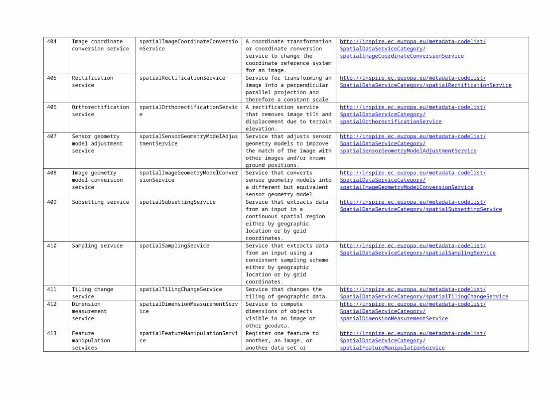
404 Image coordinate conversion service
spatialImageCoordinateConversionService A coordinate transformation or coordinate conversion service to change the coordinate reference system for an image.
http://inspire.ec.europa.eu/metadata-codelist/SpatialDataServiceCategory/spatialImageCoordinateConversionService
405 Rectification service spatialRectificationService Service for transforming an image into a perpendicular parallel projection and therefore a constant scale.
http://inspire.ec.europa.eu/metadata-codelist/SpatialDataServiceCategory/spatialRectificationService
406 Orthorectification service spatialOrthorectificationService A rectification service that removes image tilt and displacement due to terrain elevation.
http://inspire.ec.europa.eu/metadata-codelist/SpatialDataServiceCategory/spatialOrthorectificationService
407 Sensor geometry model adjustment service
spatialSensorGeometryModelAdjustmentService
Service that adjusts sensor geometry models to improve the match of the image with other images and/or known ground positions.
http://inspire.ec.europa.eu/metadata-codelist/SpatialDataServiceCategory/spatialSensorGeometryModelAdjustmentService
408 Image geometry model conversion service
spatialImageGeometryModelConversionService
Service that converts sensor geometry models into a different but equivalent sensor geometry model.
http://inspire.ec.europa.eu/metadata-codelist/SpatialDataServiceCategory/spatialImageGeometryModelConversionService

409 Subsetting service spatialSubsettingService Service that extracts data from an input in a continuous spatial region either by geographic location or by grid coordinates.
http://inspire.ec.europa.eu/metadata-codelist/SpatialDataServiceCategory/spatialSubsettingService
410 Sampling service spatialSamplingService Service that extracts data from an input using a consistent sampling scheme either by geographic location or by grid coordinates.
http://inspire.ec.europa.eu/metadata-codelist/SpatialDataServiceCategory/spatialSamplingService
411 Tiling change service spatialTilingChangeService Service that changes the tiling of geographic data.
http://inspire.ec.europa.eu/metadata-codelist/SpatialDataServiceCategory/spatialTilingChangeService
412 Dimension measurement service
spatialDimensionMeasurementService Service to compute dimensions of objects visible in an image or other geodata.
http://inspire.ec.europa.eu/metadata-codelist/SpatialDataServiceCategory/spatialDimensionMeasurementService
413 Feature manipulation services
spatialFeatureManipulationService Register one feature to another, an image, or another data set or coordinate set; correcting for relative translation shifts, rotational differences, scale differences, and perspective differences. Verify that all features in the Feature Collection are topologically consistent according to the topology rules of the Feature Collection, and identifies and/or corrects any inconsistencies that are discovered.
http://inspire.ec.europa.eu/metadata-codelist/SpatialDataServiceCategory/spatialFeatureManipulationService
414 Feature matching service spatialFeatureMatchingService Service that determines which features and portions of features represent the same real world entity from multiple data sources, e.g., edge matching and limited conflation.
http://inspire.ec.europa.eu/metadata-codelist/SpatialDataServiceCategory/spatialFeatureMatchingService
415 Feature generalisation service
spatialFeatureGeneralizationService Service that reduces spatial variation in a feature collection to increase the effectiveness of communication by counteracting the undesirable effects of data reduction.
http://inspire.ec.europa.eu/metadata-codelist/SpatialDataServiceCategory/spatialFeatureGeneralizationService
416 Route determination service
spatialRouteDeterminationService Service to determine the optimal path between two specified points based on the input parameters and properties contained in the Feature Collection.
http://inspire.ec.europa.eu/metadata-codelist/SpatialDataServiceCategory/spatialRouteDeterminationService
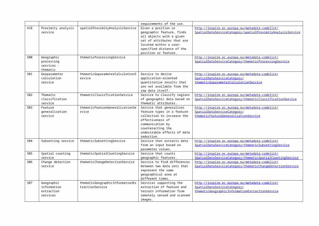
417 Positioning service spatialPositioningService Service provided by a position-providing device to use, obtain and unambiguously interpret position information, and determines whether the results meet the requirements of the use.
http://inspire.ec.europa.eu/metadata-codelist/SpatialDataServiceCategory/spatialPositioningService
418 Proximity analysis service spatialProximityAnalysisService Given a position or geographic feature, finds all objects with a given set of attributes that are located within a user-specified distance of the
http://inspire.ec.europa.eu/metadata-codelist/SpatialDataServiceCategory/spatialProximityAnalysisService

position or feature.500 Geographic processing
services - thematicthematicProcessingService http://inspire.ec.europa.eu/metadata-codelist/SpatialDataServiceCategory/
thematicProcessingService501 Geoparameter calculation
servicethematicGoparameterCalculationService Service to derive application-oriented
quantitative results that are not available from the raw data itself.
http://inspire.ec.europa.eu/metadata-codelist/SpatialDataServiceCategory/thematicGoparameterCalculationService
502 Thematic classification service
thematicClassificationService Service to classify regions of geographic data based on thematic attributes.
http://inspire.ec.europa.eu/metadata-codelist/SpatialDataServiceCategory/thematicClassificationService
503 Feature generalisation service
thematicFeatureGeneralizationService Service that generalises feature types in a feature collection to increase the effectiveness of communication by counteracting the undesirable effects of data reduction.
http://inspire.ec.europa.eu/metadata-codelist/SpatialDataServiceCategory/thematicFeatureGeneralizationService
504 Subsetting service thematicSubsettingService Service that extracts data from an input based on parameter values.
http://inspire.ec.europa.eu/metadata-codelist/SpatialDataServiceCategory/thematicSubsettingService
505 Spatial counting service thematicSpatialCountingService Service that counts geographic features.
http://inspire.ec.europa.eu/metadata-codelist/SpatialDataServiceCategory/thematicSpatialCountingService
506 Change detection service thematicChangeDetectionService Service to find differences between two data sets that represent the same geographical area at different times.
http://inspire.ec.europa.eu/metadata-codelist/SpatialDataServiceCategory/thematicChangeDetectionService
507 Geographic information extraction services
thematicGeographicInformationExtractionService
Services supporting the extraction of feature and terrain information from remotely sensed and scanned images.
http://inspire.ec.europa.eu/metadata-codelist/SpatialDataServiceCategory/thematicGeographicInformationExtractionService
508 Image processing service thematicImageProcessingService Service to change the values of thematic attributes of an image using a mathematical function.
http://inspire.ec.europa.eu/metadata-codelist/SpatialDataServiceCategory/thematicImageProcessingService
509 Reduced resolution generation service
thematicReducedResolutionGenerationService
Service that reduces the resolution of an image.
http://inspire.ec.europa.eu/metadata-codelist/SpatialDataServiceCategory/thematicReducedResolutionGenerationService
510 Image Manipulation Services
thematicImageManipulationService Services for manipulating data values in images: changing colour and contrast values, applying various filters, manipulating image resolution, noise removal, "striping", systematic-radiometric corrections, atmospheric attenuation, changes in scene illumination, etc.
http://inspire.ec.europa.eu/metadata-codelist/SpatialDataServiceCategory/thematicImageManipulationService
511 Image understanding services
thematicImageUnderstandingService Services that provide automated image change detection, registered image differencing, significance-of-difference analysis and display, and area-based and model-based differencing.
http://inspire.ec.europa.eu/metadata-codelist/SpatialDataServiceCategory/thematicImageUnderstandingService
512 Image synthesis services thematicImageSynthesisService Services for creating or transforming images using computer-based spatial models, perspective transformations, and manipulations of image characteristics to improve visibility, sharpen resolution, and/or reduce the effects of cloud cover or haze.
http://inspire.ec.europa.eu/metadata-codelist/SpatialDataServiceCategory/thematicImageSynthesisService
513 Multiband image manipulation
thematicMultibandImageManipulationService
Services that modify an image using the multiple bands of the image.
http://inspire.ec.europa.eu/metadata-codelist/SpatialDataServiceCategory/thematicMultibandImageManipulationService
514 Object detection service thematicObjectDetectionService Service to detect real-world objects in an image.
http://inspire.ec.europa.eu/metadata-codelist/SpatialDataServiceCategory/thematicObjectDetectionService
515 Geoparsing service thematicGeoparsingService Service to scan text documents for location-based references, such as a place names, addresses, postal codes, etc., in preparation for passage to a geocoding service.
http://inspire.ec.europa.eu/metadata-codelist/SpatialDataServiceCategory/thematicGeoparsingService
516 Geocoding service thematicGeocodingService Service to augment location-based text references with geographic coordinates (or some other spatial reference).
http://inspire.ec.europa.eu/metadata-codelist/SpatialDataServiceCategory/thematicGeocodingService
600 Geographic processing services - temporal
temporalProcessingService http://inspire.ec.europa.eu/metadata-codelist/SpatialDataServiceCategory/temporalProcessingService
601 Temporal reference system transformation service
temporalReferenceSystemTransformationService
Service to change the values of temporal instances from one temporal reference system to another temporal reference system.
http://inspire.ec.europa.eu/metadata-codelist/SpatialDataServiceCategory/temporalReferenceSystemTransformationService
602 Subsetting service temporalSubsettingService Service that extracts data from an input in a continuous interval based on temporal position values.
http://inspire.ec.europa.eu/metadata-codelist/SpatialDataServiceCategory/temporalSubsettingService
603 Sampling service temporalSamplingService Service that extracts data from an input using a consistent sampling scheme based on temporal position values.
http://inspire.ec.europa.eu/metadata-codelist/SpatialDataServiceCategory/temporalSamplingService
604 Temporal proximity analysis service
temporalProximityAnalysisService Given a temporal interval or event, find all objects with a given set of attributes that are located within a user-specified interval from the interval or event.
http://inspire.ec.europa.eu/metadata-codelist/SpatialDataServiceCategory/temporalProximityAnalysisService
700 Geographic processing services - metadata
metadataProcessingService http://inspire.ec.europa.eu/metadata-codelist/SpatialDataServiceCategory/metadataProcessingService
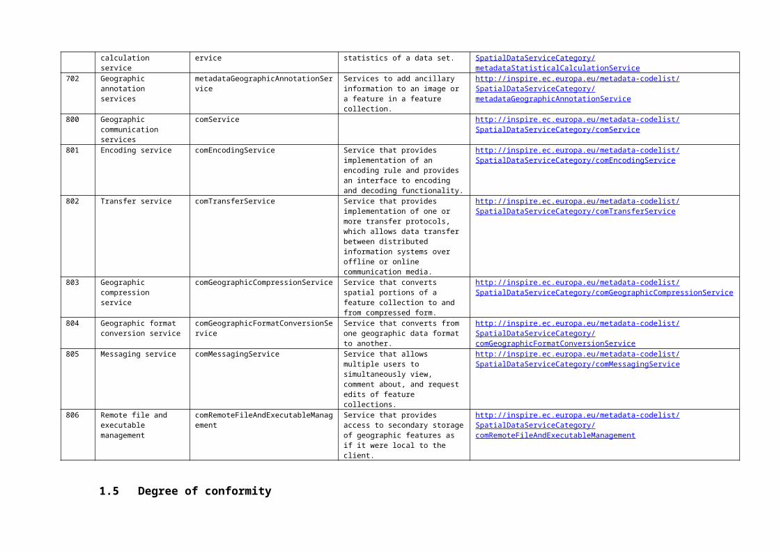
701 Statistical calculation service
metadataStatisticalCalculationService Service to calculate the statistics of a data set.
http://inspire.ec.europa.eu/metadata-codelist/SpatialDataServiceCategory/metadataStatisticalCalculationService
702 Geographic annotation services
metadataGeographicAnnotationService Services to add ancillary information to an image or a feature in a feature collection.
http://inspire.ec.europa.eu/metadata-codelist/SpatialDataServiceCategory/metadataGeographicAnnotationService
800 Geographic communication services
comService http://inspire.ec.europa.eu/metadata-codelist/SpatialDataServiceCategory/comService
801 Encoding service comEncodingService Service that provides implementation of an encoding rule and provides an interface to encoding and decoding functionality.
http://inspire.ec.europa.eu/metadata-codelist/SpatialDataServiceCategory/comEncodingService
802 Transfer service comTransferService Service that provides implementation of one or more transfer protocols, which allows data transfer between distributed information systems over offline or online communication media.
http://inspire.ec.europa.eu/metadata-codelist/SpatialDataServiceCategory/comTransferService

803 Geographic compression service
comGeographicCompressionService Service that converts spatial portions of a feature collection to and from compressed form.
http://inspire.ec.europa.eu/metadata-codelist/SpatialDataServiceCategory/comGeographicCompressionService
804 Geographic format conversion service
comGeographicFormatConversionService Service that converts from one geographic data format to another.
http://inspire.ec.europa.eu/metadata-codelist/SpatialDataServiceCategory/comGeographicFormatConversionService
805 Messaging service comMessagingService Service that allows multiple users to simultaneously view, comment about, and request edits of feature collections.
http://inspire.ec.europa.eu/metadata-codelist/SpatialDataServiceCategory/comMessagingService
806 Remote file and executable management
comRemoteFileAndExecutableManagement Service that provides access to secondary storage of geographic features as if it were local to the client.
http://inspire.ec.europa.eu/metadata-codelist/SpatialDataServiceCategory/comRemoteFileAndExecutableManagement
1.5 Degree of conformity
The codelist is defined in part D.5 of the Regulation (CE) n. 1205/2008, to be used for the INSPIRE metadata element “degree of conformity”.
No. ID Textual name Language neutral name Description / definition INSPIRE Registry URI identifier5.1 Conformant conformant The resource is fully conformant with the cited specification. http://inspire.ec.europa.eu/metadata-codelist/
DegreeOfConformity/conformant/5.2 Not Conformant notConformant The resource does not conform to the cited specification. http://inspire.ec.europa.eu/metadata-codelist/
DegreeOfConformity/notConformant/5.3 Not evaluated notEvaluated Conformance has not been evaluated. http://inspire.ec.europa.eu/metadata-codelist/
DegreeOfConformity/notEvaluated/
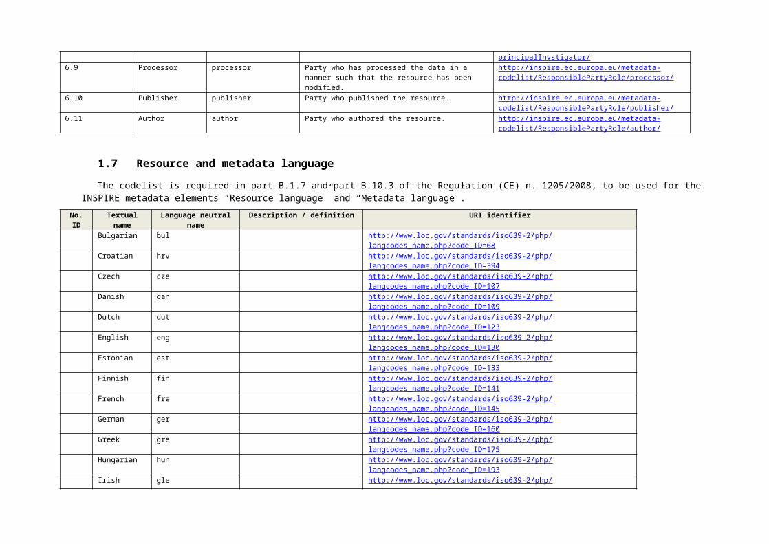
1.6 Responsible party role
The codelist is defined in part D.6 of the Regulation (CE) n. 1205/2008, to be used for the INSPIRE metadata element “Responsible party role”. It corresponds to the CI_RoleCode codelist given in ISO 19115 (see B.5.5).
No. ID Textual name Language neutral name Description / definition INSPIRE Registry URI identifier6.1 Resource Provider resourceProvider Party that supplies the resource. http://inspire.ec.europa.eu/metadata-codelist/
ResponsiblePartyRole/resourceProvider/6.2 Custodian custodian Party that accepts accountability and responsibility for the
data and ensures appropriate care and maintenance ofthe resource.
http://inspire.ec.europa.eu/metadata-codelist/ResponsiblePartyRole/custodian/
6.3 Owner owner Party that owns the resource. http://inspire.ec.europa.eu/metadata-codelist/ResponsiblePartyRole/owner/
6.4 User user Party who uses the resource. http://inspire.ec.europa.eu/metadata-codelist/ResponsiblePartyRole/user/
6.5 Distributor distributor Party who distributes the resource. http://inspire.ec.europa.eu/metadata-codelist/ResponsiblePartyRole/distributor/
6.6 Originator originator Party who created the resource. http://inspire.ec.europa.eu/metadata-codelist/ResponsiblePartyRole/originator/
6.7 Point of Contact pointOfContact Party who can be contacted for acquiring knowledge about or acquisition of the resource.
http://inspire.ec.europa.eu/metadata-codelist/ResponsiblePartyRole/pointOfContact/
6.8 Principal Investigator
principalInvestigator Key party responsible for gathering information and conducting research.
http://inspire.ec.europa.eu/metadata-codelist/ResponsiblePartyRole/principalInvstigator/
6.9 Processor processor Party who has processed the data in a manner such that the resource has been modified.
http://inspire.ec.europa.eu/metadata-codelist/ResponsiblePartyRole/processor/
6.10 Publisher publisher Party who published the resource. http://inspire.ec.europa.eu/metadata-codelist/ResponsiblePartyRole/publisher/
6.11 Author author Party who authored the resource. http://inspire.ec.europa.eu/metadata-codelist/ResponsiblePartyRole/author/
1.7 Resource and metadata language
The codelist is required in part B.1.7 and part B.10.3 of the Regulation (CE) n. 1205/2008, to be used for the INSPIRE metadata elements “Resource language” and “Metadata language”.
No. ID Textual name Language neutral name
Description / definition URI identifier
Bulgarian bul http://www.loc.gov/standards/iso639-2/php/langcodes_name.php?code_ID=68Croatian hrv http://www.loc.gov/standards/iso639-2/php/langcodes_name.php?code_ID=394Czech cze http://www.loc.gov/standards/iso639-2/php/langcodes_name.php?code_ID=107Danish dan http://www.loc.gov/standards/iso639-2/php/langcodes_name.php?code_ID=109Dutch dut http://www.loc.gov/standards/iso639-2/php/langcodes_name.php?code_ID=123English eng http://www.loc.gov/standards/iso639-2/php/langcodes_name.php?code_ID=130Estonian est http://www.loc.gov/standards/iso639-2/php/langcodes_name.php?code_ID=133Finnish fin http://www.loc.gov/standards/iso639-2/php/langcodes_name.php?code_ID=141French fre http://www.loc.gov/standards/iso639-2/php/langcodes_name.php?code_ID=145German ger http://www.loc.gov/standards/iso639-2/php/langcodes_name.php?code_ID=160Greek gre http://www.loc.gov/standards/iso639-2/php/langcodes_name.php?code_ID=175Hungarian hun http://www.loc.gov/standards/iso639-2/php/langcodes_name.php?code_ID=193Irish gle http://www.loc.gov/standards/iso639-2/php/langcodes_name.php?code_ID=164Italian ita http://www.loc.gov/standards/iso639-2/php/langcodes_name.php?code_ID=213Latvian lav http://www.loc.gov/standards/iso639-2/php/langcodes_name.php?code_ID=258Lithuanian lit http://www.loc.gov/standards/iso639-2/php/langcodes_name.php?code_ID=262Maltese mlt http://www.loc.gov/standards/iso639-2/php/langcodes_name.php?code_ID=298Polish pol http://www.loc.gov/standards/iso639-2/php/langcodes_name.php?code_ID=361Portuguese por http://www.loc.gov/standards/iso639-2/php/langcodes_name.php?code_ID=363Romanian rum http://www.loc.gov/standards/iso639-2/php/langcodes_name.php?code_ID=376Slovak slo http://www.loc.gov/standards/iso639-2/php/langcodes_name.php?code_ID=406Slovenian slv http://www.loc.gov/standards/iso639-2/php/langcodes_name.php?code_ID=407Spanish spa http://www.loc.gov/standards/iso639-2/php/langcodes_name.php?code_ID=422Swedish swe http://www.loc.gov/standards/iso639-2/php/langcodes_name.php?code_ID=433
1.8 INSPIRE themes

The codelist is required in part B.3 of the Regulation (CE) n. 1205/2008, to be used for the INSPIRE metadata element “Keywords value”, if the resource is a spatial data set or a spatial data set series. The values of the codelist are defined in the Annexes I, II and III of the INSPIRE Directive.
No. ID Textual name Language neutral name Description / definition INSPIRE Registry URI identifierI.1 Coordinate reference systems coordinateReferenceSystems Systems for uniquely referencing spatial information in space as a
set of coordinates (x, y, z) and/or latitude and longitude and height, based on a geodetic horizontal and vertical datum.
http://inspire.ec.europa.eu/theme/rs
I.2 Geographical grid systems geographicalGridSystems Harmonised multi-resolution grid with a common point of origin and standardised location and size of grid cells.
http://inspire.ec.europa.eu/theme/gg
I.3 Geographical names geographicalNames Names of areas, regions, localities, cities, suburbs, towns or settlements, or any geographical or topographical feature of public or historical interest.
http://inspire.ec.europa.eu/theme/gn
I.4 Administrative units administrativeUnits Units of administration, dividing areas where Member States have and/or exercise jurisdictional rights, for local, regional and national governance, separated by administrative boundaries.
http://inspire.ec.europa.eu/theme/au
I.5 Addresses addresses Location of properties based on address identifiers, usually by road name, house number, postal code.
http://inspire.ec.europa.eu/theme/ad
I.6 Cadastral parcels cadastralParcels Areas defined by cadastral registers or equivalent. http://inspire.ec.europa.eu/theme/cpI.7 Transport networks transportNetwork Road, rail, air and water transport networks and related
infrastructure. Includes links between different networks. Also includes the trans-European transport network as defined in Decision No 1692/96/EC of the European Parliament and of the Council of 23 July 1996 on Community Guidelines for the development of the trans-European transport network (1) and future revisions of that Decision.
http://inspire.ec.europa.eu/theme/tn
I.8 Hydrography hydrography Hydrographic elements, including marine areas and all other water bodies and items related to them, including river basins and sub-basins. Where appropriate, according to the definitions set out in Directive 2000/60/EC of the European Parliament and of the Council of 23 October 2000 establishing a framework for Community action in the field of water policy (2) and in the form of networks.
http://inspire.ec.europa.eu/theme/hy
I.9 Protected sites protectedSites Area designated or managed within a framework of international, Community and Member States' legislation to achieve specific conservation objectives.
http://inspire.ec.europa.eu/theme/ps
II.1 Elevation elevation Digital elevation models for land, ice and ocean surface. Includes terrestrial elevation, bathymetry and shoreline.
http://inspire.ec.europa.eu/theme/el
II.2 Land cover landCover Physical and biological cover of the earth's surface including artificial surfaces, agricultural areas, forests, (semi-)natural areas, wetlands, water bodies.
http://inspire.ec.europa.eu/theme/lc
II.3 Orthoimagery orthoimagery Geo-referenced image data of the Earth's surface, from either satellite or airborne sensors.
http://inspire.ec.europa.eu/theme/oi
II.4 Geology geology Geology characterised according to composition and structure. Includes bedrock, aquifers and geomorphology.
http://inspire.ec.europa.eu/theme/ge
III.1 Statistical units statisticalUnits Units for dissemination or use of statistical information. http://inspire.ec.europa.eu/theme/suIII.2 Buildings buildings Geographical location of buildings. http://inspire.ec.europa.eu/theme/buIII.3 Soil soil Soils and subsoil characterised according to depth, texture,
structure and content of particles and organic material, stoniness, erosion, where appropriate mean slope and anticipated water storage capacity.
http://inspire.ec.europa.eu/theme/so

III.4 Land use landUse Territory characterised according to its current and future planned functional dimension or socio-economic purpose (e.g. residential, industrial, commercial, agricultural, forestry, recreational).
http://inspire.ec.europa.eu/theme/lu
III.5 Human health and safety humanHealthAndSafety Geographical distribution of dominance of pathologies (allergies, cancers, respiratory diseases, etc.), information indicating the effect on health (biomarkers, decline of fertility, epidemics) or well-being of humans (fatigue, stress, etc.) linked directly (air pollution, chemicals, depletion of the ozone layer, noise, etc.) or indirectly (food, genetically modified organisms, etc.) to the quality of the environment.
http://inspire.ec.europa.eu/theme/hh
III.6 Utility and governmental services utilityAndGovernmentalServices Includes utility facilities such as sewage, waste management, energy supply and water supply, administrative and social governmental services such as public administrations, civil protection sites, schools and hospitals.
http://inspire.ec.europa.eu/theme/us
III.7 Environmental monitoring facilities environmentalMonitoringFacilities Location and operation of environmental monitoring facilities includes observation and measurement of emissions, of the state of environmental media and of other ecosystem parameters (biodiversity, ecological conditions of vegetation, etc.) by or on behalf of public authorities.
http://inspire.ec.europa.eu/theme/ef
III.8 Production and industrial facilities productionAndIndustrialFacilities Industrial production sites, including installations covered by Council Directive 96/61/EC of 24 September 1996 concerning integrated pollution prevention and control (1) and water abstraction facilities, mining, storage sites.
http://inspire.ec.europa.eu/theme/pf
III.9 Agricultural and aquaculture facilities agriculturalAndAquacultureFacilities Farming equipment and production facilities (including irrigation systems, greenhouses and stables).
http://inspire.ec.europa.eu/theme/af
III.10 Population distribution - demography populationDistributionDemography Geographical distribution of people, including population characteristics and activity levels, aggregated by grid, region, administrative unit or other analytical unit.
http://inspire.ec.europa.eu/theme/pd
III.11 Area management/restriction/regulation zones and reporting units
areaManagementRestrictionRegulationZonesAndReportingUnits
Areas managed, regulated or used for reporting at international, European, national, regional and local levels. Includes dumping sites, restricted areas around drinking water sources, nitrate-vulnerable zones, regulated fairways at sea or large inland waters, areas for the dumping of waste, noise restriction zones, prospecting and mining permit areas, river basin districts, relevant reporting units and coastal zone management areas.
http://inspire.ec.europa.eu/theme/am
III.12 Natural risk zones naturalRiskZones Vulnerable areas characterised according to natural hazards (all atmospheric, hydrologic, seismic, volcanic and wildfire phenomena that, because of their location, severity, and frequency, have the potential to seriously affect society), e.g. floods, landslides and subsidence, avalanches, forest fires, earthquakes, volcanic eruptions.
http://inspire.ec.europa.eu/theme/nz
III.13 Atmospheric conditions atmosphericConditions Physical conditions in the atmosphere. Includes spatial data based on measurements, on models or on a combination thereof and includes measurement locations.
http://inspire.ec.europa.eu/theme/ac
III.14 Meteorological geographical features meteorologicalGeographicalFeatures Weather conditions and their measurements; precipitation, temperature, evapotranspiration, wind speed and direction.
http://inspire.ec.europa.eu/theme/mf
III.15 Oceanographic geographical features oceanographicGeographicalFeatures Physical conditions of oceans (currents, salinity, wave heights, etc.).
http://inspire.ec.europa.eu/theme/of
III.16 Sea regions seaRegions Physical conditions of seas and saline water bodies divided into http://inspire.ec.europa.eu/theme/sr
regions and sub-regions with common characteristics.III.17 Bio-geographical regions bioGeographicalRegions Areas of relatively homogeneous ecological conditions with
common characteristics.http://inspire.ec.europa.eu/theme/br
III.18 Habitats and biotopes habitatsAndBiotopes Geographical areas characterised by specific ecological conditions, processes, structure, and (life support) functions that physically support the organisms that live there. Includes terrestrial and aquatic areas distinguished by geographical, abiotic and biotic features, whether entirely natural or semi-natural.
http://inspire.ec.europa.eu/theme/hb
III.19 Species distribution speciesDistribution Geographical distribution of occurrence of animal and plant species aggregated by grid, region, administrative unit or other analytical unit.
http://inspire.ec.europa.eu/theme/sd
III.20 Energy resources energyResources Energy resources including hydrocarbons, hydropower, bio-energy, solar, wind, etc., where relevant including depth/height information on the extent of the resource.
http://inspire.ec.europa.eu/theme/er
III.21 Mineral resources mineralResources Mineral resources including metal ores, industrial minerals, etc., where relevant including depth/height information on the extent of the resource.
http://inspire.ec.europa.eu/theme/mr
2 Codelist defined in metadata or in data specifications TGs
2.1 Resource locator function
The codelist is to be used for the element “description” required for the INSPIRE metadata element “Resource locator” (for spatial data services).
No. ID Textual name Language neutral name Description / definition INSPIRE Registry URI identifierAccess point accessPoint Containing a detailed description of a spatial data service, including a
list of end points to allow its execution,End point endPoint Used to directly call an operation provided by a spatial data service
2.2 Limitations on public access
The codelist is to be used for the element “otherConstraints” required for the INSPIRE metadata element “Limitations on public access”.
No. ID Textual name Language neutral name Description / definition INSPIRE Registry URI identifierINSPIRE Directive Article 13 1a
public access to spatial data sets and services would adversely affect the confidentiality of the proceedings of public authorities, where such confidentiality is provided for by law
http://inspire.ec.europa.eu/metadata-codelist/LimitationsOnPublicAccess/INSPIRE_Directive_Article13_1a
INSPIRE Directive Article 13 1b
public access to spatial data sets and services would adversely affect international relations, public security or national defence
http://inspire.ec.europa.eu/metadata-codelist/LimitationsOnPublicAccess/INSPIRE_Directive_Article13_1b
INSPIRE Directive Article 13 1c
public access to spatial data sets and services would adversely affect the course of justice, the ability of any person to receive
http://inspire.ec.europa.eu/metadata-codelist/LimitationsOnPublicAccess/INSPIRE_Directive_Article13_1c

a fair trial or the ability of a public authority to conduct an enquiry of a criminal or disciplinary nature
INSPIRE Directive Article 13 1d
public access to spatial data sets and services would adversely affect the confidentiality of commercial or industrial information, where such confidentiality is provided for by national or Community law to protect a legitimate economic interest, including the public interest in maintaining statistical confidentiality and tax secrecy
http://inspire.ec.europa.eu/metadata-codelist/LimitationsOnPublicAccess/INSPIRE_Directive_Article13_1d
INSPIRE Directive Article 13 1e
public access to spatial data sets and services would adversely affect intellectual property rights
http://inspire.ec.europa.eu/metadata-codelist/LimitationsOnPublicAccess/INSPIRE_Directive_Article13_1e
INSPIRE Directive Article 13 1f
public access to spatial data sets and services would adversely affect the confidentiality of personal data and/or files relating to a natural person where that person has not consented to the disclosure of the information to the public, where such confidentiality is provided for by national or Community law
http://inspire.ec.europa.eu/metadata-codelist/LimitationsOnPublicAccess/INSPIRE_Directive_Article13_1f
INSPIRE Directive Article 13 1g
public access to spatial data sets and services would adversely affect the interests or protection of any person who supplied the information requested on a voluntary basis without being under, or capable of being put under, a legal obligation to do so, unless that person has consented to the release of the information concerned
http://inspire.ec.europa.eu/metadata-codelist/LimitationsOnPublicAccess/INSPIRE_Directive_Article13_1g
INSPIRE Directive Article 13 1h
public access to spatial data sets and services would adversely affect the protection of the environment to which such information relates, such as the location of rare species
http://inspire.ec.europa.eu/metadata-codelist/LimitationsOnPublicAccess/INSPIRE_Directive_Article13_1h
No limitations There is no limitations on public access to spatial data sets and services
http://inspire.ec.europa.eu/metadata-codelist/LimitationsOnPublicAccess/noLimitations
2.3 Conditions applying to access and use
The codelist is to be used for the element “otherConstraints” required for the INSPIRE metadata element “Conditions applying to access and use” if no conditions apply or the consitions are unknown.
No. ID Textual name Language neutral name Description / definition INSPIRE Registry URI identifierNo conditions apply noConditionsApply no conditions apply to the access and use
of the resourcehttp://inspire.ec.europa.eu/registry/metadata-codelist/ConditionsApplyingToAccessAndUse/NoConditionsApply
conditions unknown conditionsUnknown conditions apply to the access and use of the resource are unknown
http://inspire.ec.europa.eu/registry/metadata-codelist/ConditionsApplyingToAccessAndUse/ConditionsUnkown
2.4 Coordinate reference system
The codelist is defined in the TG requirement 2 in the INSPIRE Data Specifications – Technical Guidelines and in part 4.6.1 of Technical Guidance for INSPIRE Spatial Data Services, to be used for the INSPIRE metadata element required for interoperability “Coordinate reference system”.
No. ID Textual name Short name Description / definition URI identifier3D Cartesian in ETRS89 ETRS89-XYZ http://www.opengis.net/def/crs/EPSG/0/4936
3D geodetic in ETRS89 on GRS80 ETRS89-GRS80h http://www.opengis.net/def/crs/EPSG/0/49372D geodetic in ETRS89 on GRS80 ETRS89-GRS80 http://www.opengis.net/def/crs/EPSG/0/42582D LAEA projection in ETRS89 on GRS80 ETRS89-LAEA http://www.opengis.net/def/crs/EPSG/0/30352D LCC projection in ETRS89 on GRS80 ETRS89-LCC http://www.opengis.net/def/crs/EPSG/0/30342D TM projection in ETRS89 on GRS80, zone 26N (30°W to 24°W)
ETRS89-TM26N http://www.opengis.net/def/crs/EPSG/0/3038
2D TM projection in ETRS89 on GRS80, zone 27N (24°W to 18°W)
ETRS89-TM27N http://www.opengis.net/def/crs/EPSG/0/3039
2D TM projection in ETRS89 on GRS80, zone 28N (18°W to 12°W)
ETRS89-TM28N http://www.opengis.net/def/crs/EPSG/0/3040
2D TM projection in ETRS89 on GRS80, zone 29N (12°W to 6°W)
ETRS89-TM29N http://www.opengis.net/def/crs/EPSG/0/3041
2D TM projection in ETRS89 on GRS80, zone 30N (6°W to 0°)
ETRS89-TM30N http://www.opengis.net/def/crs/EPSG/0/3042
2D TM projection in ETRS89 on GRS80, zone 31N (0° to 6°E)
ETRS89-TM31N http://www.opengis.net/def/crs/EPSG/0/3043
2D TM projection in ETRS89 on GRS80, zone 32N (6°E to 12°E)
ETRS89-TM32N http://www.opengis.net/def/crs/EPSG/0/3044
2D TM projection in ETRS89 on GRS80, zone 33N (12°E to 18°E)
ETRS89-TM33N http://www.opengis.net/def/crs/EPSG/0/3045
2D TM projection in ETRS89 on GRS80, zone 34N (18°E to 24°E)
ETRS89-TM34N http://www.opengis.net/def/crs/EPSG/0/3046
2D TM projection in ETRS89 on GRS80, zone 35N (24°E to 30°E)
ETRS89-TM35N http://www.opengis.net/def/crs/EPSG/0/3047
2D TM projection in ETRS89 on GRS80, zone 36N (30°E to 36°E)
ETRS89-TM36N http://www.opengis.net/def/crs/EPSG/0/3048
2D TM projection in ETRS89 on GRS80, zone 37N (36°E to 42°E)
ETRS89-TM37N http://www.opengis.net/def/crs/EPSG/0/3049
2D TM projection in ETRS89 on GRS80, zone 38N (42°E to 48°E)
ETRS89-TM38N http://www.opengis.net/def/crs/EPSG/0/3050
2D TM projection in ETRS89 on GRS80, zone 39N (48°E to 54°E)
ETRS89-TM39N http://www.opengis.net/def/crs/EPSG/0/3051
Height in EVRS EVRS http://www.opengis.net/def/crs/EPSG/0/57303D compound: 2D geodetic in ETRS89 on GRS80, and EVRS height
ETRS89-GRS80-EVRS http://www.opengis.net/def/crs/EPSG/0/7409
2.5 Spatial data services categories
The codelist is defined in part B.1 in Annex V of the Regulation (EU) No. 1089/2010, to be used for the INSPIRE metadata element required for spatial data services “Category”.
No. ID Textual name Language neutral name Description / definition INSPIRE Registry URI identifierInvocable invocable Invocable spatial data service means the following: a) a spatial data
service with metadata according to Regulation (EU) No 1205/2008; b) a spatial data service with at least one resource locator that is an access point; c) and a spatial data service in conformity with a documented and publicly available set of technical specifications providing the

information necessary for its execution.Interoperable interoperable an invocable spatial data service in conformity with the annex VII of the
Commission Regulation (EU) No 1089/2010 as amended by the Commission Regulation (EU) No 1312/2014.
Harmonised harmonised an interoperable spatial data service in conformity with the annex VIII of the Commission Regulation (EU) No 1089/2010 as amended by the Commission Regulation (EU) No 1312/2014.
2.6 Media type
The codelist can be used for the element “name” of the INSPIRE metadata element required for interoperability “Encoding”.
No. ID Textual name Language neutral name Description / definition INSPIRE Registry URI identifierapplication/x-filegdb The media type shall be used for Esri file geodatabases. The file is a zip
archive that contains the gdb directory.http://inspire.ec.europa.eu/media-types/
application/x-shapefile The media type shall be used for Esri shapefiles. The file is a zip archive that contains at least the shp, shx and dbf files.
application/x-ecw The media type shall be used for Enhanced Compressed Wavelet (ECW) files.image/jp2 The media type shall be used for JPEG 2000 as specified by ISO/IEC 15444-1.application/vnd.google-earth.kmz The media type shall be used for KMZ files (zip archive with KML and
associated files).application/vnd.google-earth.kml+xml The media type shall be used for KML files.application/x-gmz The media type shall be used for a zip archive that contains one or more GML
documents.application/gml+xml The media type shall be used for GML files. The media type is currently in the
IANA registration process.image/tiff The media type shall be used for TIFF files. This includes GeoTIFF files.
Inspect the TIFF file to determine, if GeoTIFF tags are present.text/csv The media type shall be used for CSV files.application/x-worldfile The media type shall be used for world files. The file extension usually
depends on the format of the associated image, e.g. .jgw for JPEG (2000) oder .tfw for TIFF.
application/x-tab-raster The media type shall be used for the MapInfo Raster TAB format. This media type is incomplete as it misses a reference to the specification of the format.
application/x-tab The media type shall be used for the MapInfo TAB format. The file is a zip archive that contains at least the tab, dat, map and id files.
application/x-laz The media type shall be used for compressed LAS files. This media type is incomplete as it misses a reference to the specification of the format.
application/x-las The media type shall be used for the LASer file format (LAS).application/x-oracledump The media type shall be used for Oracle dumps. This media type is incomplete
as it misses a reference to the specification of the format.application/x-ascii-grid The media type shall be used for ASCII GRID files.
3 Codelists defined in ISO Standards

3.1Date Type
The CI_RoleCode codelist is defined in setion B.5.2 in ISO 19115, to be used for the INSPIRE metadata elements “Date of publication”, “Date of last revision” and “Date of creation”. It is to be also used for the reference date type of the INSPIRE metadata elements “Originating controlled vocabulary” and “Specification”.
No. ID Textual name Language neutral name Description / definition URI identifier001 Creation creation date identifies when the resource was
brought into existence002 Publication publication date identifies when the resource was
issued003 Revision revision date identifies when the resource was
examined or re-examined and improved or amended
3.2Maintenance Frequency Type
The MD_MaintenanceFrequencyTypeCode codelist is defined in section B.5.18 in ISO 19115, to be used for the INSPIRE metadata element “Maintenance information”, included in theme-specific metadata elements set.
No. ID Textual name Language neutral name Description / definition URI identifier001 Continual continual data is repeatedly and frequently updated002 Daily daily data is updated each day003 Weekly weekly data is updated on a weekly basis004 Fortnightly fortnightly data is updated every two weeks005 Monthly monthly data is updated each month006 Quarterly quarterly data is updated every three months007 Biannually biannually data is updated twice each year008 Annually annually 8 data is updated every year009 As needed asNeeded data is updated as deemed necessary010 Irregular irregular data is updated in intervals that are uneven in duration011 Not planned notPlanned there are no plans to update the data012 Unknown unknown frequency of maintenance for the data is not known
3.3Spatial representation type
The MD_SpatialRepresentationTypeCode codelist is defined in section B.5.26 in ISO 19115, to be used for the INSPIRE metadata element required for interoperability “Spatial representation type”. The values in the scope of INSPIRE included here are a subset of the whole codelist defined in ISO 19115.
No. ID Textual name Language neutral name Description / definition URI identifier001 Vector vector vector data is used to represent geographic data002 Grid grid grid data is used to represent geographic data

004 Tin tin triangulated irregular network
3.4 Character Encoding
The MD_CharacterSetCode codelist is defined in section B.5.10 in ISO 19115, to be used for the INSPIRE metadata element required for interoperability “Character encoding”.
No. ID Textual name Language neutral name Description / definition URI identifier001 UCS 2 ucs2 16-bit fixed size Universal Character Set, based on ISO/IEC 10646002 UCS 4 ucs4 32-bit fixed size Universal Character Set, based on ISO/IEC 10646003 UTF 7 utf7 7-bit variable size UCS Transfer Format, based on ISO/IEC 10646004 UTF 8 utf8 8-bit variable size UCS Transfer Format, based on ISO/IEC 10646005 UTF 16 utf16 16-bit variable size UCS Transfer Format, based on ISO/IEC 10646006 ISO/IEC 8859-1 8859part1 ISO/IEC 8859-1, Information technology – 8-bit single-byte coded graphic
character sets – Part 1: Latin alphabet No. 1007 ISO/IEC 8859-2 8859part2 ISO/IEC 8859-2, Information technology – 8-bit single-byte coded graphic
character sets – Part 2: Latin alphabet No. 2008 ISO/IEC 8859-3 8859part3 ISO/IEC 8859-3, Information technology – 8-bit single-byte coded graphic
character sets – Part 3: Latin alphabet No. 3009 ISO/IEC 8859-4 8859part4 ISO/IEC 8859-4, Information technology – 8-bit single-byte coded graphic
character sets – Part 4: Latin alphabet No. 4010 ISO/IEC 8859-5 8859part5 ISO/IEC 8859-51, Information technology – 8-bit single-byte coded graphic
character sets – Part 5: Latin/Cyrillic alphabet011 ISO/IEC 8859-6 8859part6 ISO/IEC 8859-6, Information technology – 8-bit single-byte coded graphic
character sets – Part 6: Latin/Arabic alphabet012 ISO/IEC 8859-7 8859part7 ISO/IEC 8859-7, Information technology – 8-bit single-byte coded graphic
character sets – Part 7: Latin/Greek alphabet013 ISO/IEC 8859-8 8859part8 ISO/IEC 8859-8, Information technology – 8-bit single-byte coded graphic
character sets – Part 8: Latin/Hebrew alphabet014 ISO/IEC 8859-9 8859part9 ISO/IEC8859-9, Information technology – 8-bit single-byte coded graphic
character sets – Part 9: Latin alphabet No. 5015 ISO/IEC 8859-10 8859part10 ISO/IEC 8859-10, Information technology – 8-bit single-byte coded graphic
character sets – Part 10: Latin alphabet No. 6016 ISO/IEC 8859-11 8859part11 ISO/IEC 8859-11, Information technology – 8-bit single-byte coded graphic
character sets – Part 11: Latin/Thai alphabet017 (reserved for future use) a future ISO/IEC 8-bit single-byte coded graphic character set (e.g. possibly
8859 part 12)018 ISO/IEC 8859-13 8859part13 ISO/IEC 8859-13, Information technology – 8-bit single-byte coded graphic
character sets – Part 13: Latin alphabet No. 7019 ISO/IEC 8859-14 8859part14 ISO/IEC 8859-14, Information technology – 8-bit single-byte coded graphic
character sets – Part 14: Latin alphabet No. 8 (Celtic)020 ISO/IEC 8859-15 8859part15 ISO/IEC 8859-15, Information technology – 8-bit single-byte coded graphic
character sets – Part 15: Latin alphabet No. 9021 ISO/IEC 8859-16 8859part16 ISO/IEC 8859-16, Information technology – 8-bit single-byte coded graphic
character sets – Part 16: Latin alphabet No. 10022 Jis jis japanese code set used for electronic transmission

023 Shift JIS shiftJis japanese code set used on MS-DOS based machines024 Euc JP eucJp japanese code set used on UNIX based machines025 US ASCII usAscii united states ASCII code set (ISO 646 US)026 Ebcdic ebcdic ibm mainframe code set027 Euc KR eucKr korean code set028 Big 5 big5 traditional Chinese code set used in Taiwan, Hong Kong of China and other
areas029 GB2312 gb2312 simplified Chinese code set
3.5 Evaluation method type
The DQ_EvaluationMethodTypeCode codelist is defined in section B.5.6 in ISO 19115, to be used for the element “EvaluationMethodType” recommended for the INSPIRE metadata element required for interoperability “Topological consistency” and in every case the ISO class DQ_Element is used for the metadata elements concerning the data quality evaluation.
No. ID Textual name Language neutral name Description / definition URI identifier001 Direct internal directInternal method of evaluating the quality of a dataset based on inspection of items
within the dataset, where all data required is internal to the dataset being evaluated
002 Direct external directExternal method of evaluating the quality of a dataset based on inspection of items within the dataset, where reference data external to the dataset being evaluated is required
003 Indirect indirect method of evaluating the quality of a dataset based on external knowledge
3.6Coverage content type
The MD_CoverageContentTypeCode codelist is defined in section B.5.12 in ISO 19115, to be used for the element “ContentType” recommended for the INSPIRE metadata element “Image description”, included in theme-specific metadata elements set.
No. ID Textual name Language neutral name Description / definition URI identifier001 Image image meaningful numerical representation of a physical parameter that is not
the actual value of the physical parameter002 Thematic classification thematicClassification code value with no quantitative meaning, used to represent a physical
quantity003 Physical measurement physicalMeasurement value in physical units of the quantity being measured
3.7Online function
The CI_OnlineFunctionCode codelist is defined in section B.5.3 in ISO 19115, to be used for the additional element “Function” recommended for the INSPIRE metadata element “Resource locator” (for data sets and data set series).

No. ID Textual name Language neutral name Description / definition URI identifier001 Download download online instructions for transferring data from one storage device or
system to another002 Information information online information about the resource003 Offline access offlineAccess online instructions for requesting the resource from the provider004 Order order online order process for obtaining the resource005 Search search online search interface for seeking out information about the resource
3.8DCP List
The DCP list is defined in ISO 19119, to be used for the element “DCP” in the ISO class “SV_OperationMetadata”, required for the INSPIRE harmonized spatial data services.
No. ID Textual name Language neutral name Description / definition URI identifierXML xmlCORBA corbaJAVA javaCOM comSQL sqlWeb services webServices