identification and tabulation of geological …identification and tabulation of geological contacts...
TRANSCRIPT

IDENTIFICATION AND TABULATION OF GEOLOGICAL CONTACTS
IN THE EDWARDS AQUIFER, SAN ANTONIO AREA, TEXAS
By Ted A. Small
U.S. GEOLOGICAL SURVEY
Open-File Report 84-075
Prepared in cooperation with the
TEXAS DEPARTMENT OF WATER RESOURCES and the i- 1
SAN ANTONIO CITY WATER BOARD
Austin, Texas
1984

CONTENTS
Page
Abstract 1Introduction 2
Location of the San Antonio area 2Source of data 2Well-numbering and well-location system 2
Strati graphic units 5Overlying the Edwards aquifer 5Within the Edwards aquifer 9
San Marcos Platform 9Devils River Trend- 9Maverick Basin 9
Underlying the Edwards aquifer 9Identification of strati graphic contacts 11
Overlying the Edwards aquifer 11Within the Edwards aquifer 14
San Marcos Platform 14Georgetown Formation 20Person Formation 20Kainer Formation 22
Devils River Trend 23Maverick Basi n 23
Salmon Peak Formation 24McKnight Formation 24West Nueces Formation 24
Underlying the Edwards aquifer 25Data tabulation 26Selected references 27Supplemental information 28
III

ILLUSTRATIONS
Page
Figure 1. Map showing location and hydro!ogic features 32. Map showing location of wells and test holes with
Identifiable contacts on geophysical logs 43. Diagram showing system of locating wells by latitude and
longi tude 64. Map showing depositional environments of the Edwards
aqui fer 75. Strati graphic relationships and formation contact
Identification on representative logs 86. Electric log of well AY-68-36-206 in the San Marcos
Platform 127. Gamma-ray log of well AY-68-30-807 in the San Marcos
Platform 138. Induction-electric log of well TD-69-53-6 in the Devils
River Trend 159. G&mma-ray log of well YP-69-37-402 in the Devils River
Tren d 1610. Electric log of well RP-70-54-5 in the Maverick Basin 1711. Gamma ray-sonic log of well RP-70-44-8 in the Maverick
Basin 1812. Electric log of well AY-68-28-910 in the San Marcos
Platform 1913. Neutron, gamma-gamma, and caliper logs of well AY-68-29-506
in the San Marcos Platform 21
TABLES
Table 1. Carbonate-rock classification system of Dunham (1962) 10 2. Tabulation of wells and contacts 29
i-'
iv

METRIC CONVERSIONS
The "inch-pound" units used in this report may be converted to metric units by the following factor:
From Multiply by To obtain
feet 0.3048 meter
National Geodetic Vertical Datum of 1929 (NGVD of 1929): A geodetic datum derived from a general adjustment of the first-order level nets of both the United States and Canada, formerly called mean sea level.

IDENTIFICATION AND TABULATION OF GEOLOGICAL CONTACTS
IN THE EDWARDS AQUIFER, SAN ANTONIO AREA, TEXAS
By
Ted A. Small U.S. Geological Survey
ABSTRACT
Geological contacts were picked on logs of about 480 wells in the San Antonio area of the Edwards aquifer. The base of the Del Rio Clay is the most frequently picked contact because it is the top of the Edwards aquifer and also because it is easily identified on either gamma-ray or electric logs.
Other important formation contacts identified were the Austin Group, the Eagle Ford Group, the Buda Limestone, and the Glen Rose Formation. These con tacts were usually easy to identify on either gamma-ray or electric logs.

INTRODUCTION
This report describes the identification of geologic contacts and compiles the picks from well and test-hole data compiled from 1970 to 1978 by the U.S. Geological Survey as part of a study of the Edwards aquifer in the San Antonio area, Texas. The study was made in cooperation with the San Antonio City Water Board and the Texas Department of Water Resources. These picks were used to prepare geologic cross sections and a structural contour map of the top of the Edwards aquifer (Maclay and Small, 1983).
Location of the San Antonio Area
The San Antonio area of the Edwards aquifer is in the Balcones Fault Zone and includes parts of Kinney, Uvalde, Medina, Bexar, Coma! and Hays Counties. The location and the hydro!ogic features of the San Antonio area is shown in figure 1.
Source of Data
The documented geophysical logs are filed in the Geological Survey's San Antonio Subdistrict Office. Many of the logs were recorded by Geological Sur vey equipment and personnel. The remainder were obtained from outside sources, such as private companies and governmental agencies. The availability of the geophysical logs is documented in Maclay, Small, and Rettman (1981).
Well-Numbering and Well-Location System
The location of wells or test holes having geophysical logs with identi fiable contacts is shown in figure 2. The wells and test holes are identified by the standard we!1-numbering system used by the Texas Department of Water Resources.
.The well-numbering system in Texas was developed by the Texas Department of Water Resources for use throughout the State. Under this system, each 1- degree quadrangle is given a number consisting of two digits. These are the first two digits in the well number. Each 1-degree quadrangle is divided into 7-1/2-minute quadrangles which are given two-digit numbers from 01 to 64. These are the third and fourth digits of the well number. Each 7-1/2-minute quadrangle is divided into 2-1/2-minute quadrangles which are given a single- digit number from 1 to 9. This is the fifth digit of the well number. Final ly, each well within a 2-1/2-minute quadrangle is given a two-digit number in the order in which it was inventoried, starting with 01. These are the last two digits of the well number. Only the last three digits of the well number are shown at each well site; the middle two digits are shown in the northwest corner of each 7-1/2-minute quadrangle. In .addition to the seven-digit number, a two-letter prefix is used to identify the county. The prefixes for counties where well logs were used for correlation are as follows: AY, Bexar; DX, Comal; KX, Guadalupe; LR, Hays; RP, Kinney; TD, Medina; and YP, Uvalde. An example of a well numbered by this system is AY-68-27-906.

Since this well-numbering system will locate a well only to a 2-1/2- minute quadrangle, the latitude and longitude also are given so that the well can be precisely located as shown in figure 3.
STRATIGRAPHIC UNITS
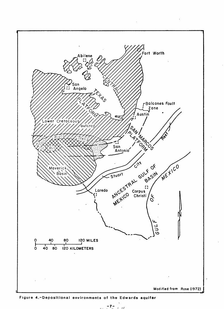
The strati graphic names used in this report are from the Geologic Atlas of Texas, San Antonio sheet (University of Texas, Bureau of Economic Geology, 1974). The stratigraphic nomenclature proposed by Rose (1972) is used to describe the geologic units of the Maverick Basin, the Devils River Trend, and the San Marcos Platform (fig. 4) and does not follow the usage of the U.S. Geological Survey. The correlation of the stratigraphic units is shown in figure 5.
Overlying the Edwards Aquifer
The formations overlying the Edwards that will be discussed in this report are, in descending order, the Austin Group, Eagle Ford Group, Buda Limestone, and the Del Rio Clay.
The Austin Group is a white to buff, dense, chalky limestone. It is about 150 feet thick in much of the eastern area and central part of the San Antonio area and thickens to more than 1,000 feet in Kinney County, where it is a mas sive limestone in the lower part and a thin-bedded chalky limestone and marl in the upper part (Bennett and Sayre, 1962).
The Eagle Ford Group is the basal unit of the Gulf Series or Upper Cre taceous. It is .chiefly flaggy, calcareous, and sandy shale interbedded with hard, shaly limestone (Arnow, 1959). It is about 35 feet thick in the eastern part of the study area and over 200 feet thick in the west where it is a fla§9y» crystalline limestone and clayey, chalky limestone interbedded with layers of marl (Bennett and Sayre, 1962).
'The Buda Limestone is the top formation of the Washita Group and is a very hard, dense, massive limestone (Holt, 1956). It is about 55 feet thick in the east and more than 100 feet thick in the west.
The Del Rio Clay overlies the Georgetown Formation, both of the Washita Group, within the San Marcos Platform, the Devils River Limestone within the Devils River Trend, and the Salmon Peak Formation within the Maverick Basin. It is a soft, sticky calcareous clay that is about 50 feet thick in the eastern and central part of the San Antonio area. In the western part of the San Antonio area, the Del Rio Clay also contains thin, flaggy beds of limestone interbedded with clay. The Del Rio Clay thickens to the west and according to Welder and Reeves (1962), is about 120 feet thick at the Uvalde-Kinney County line and more than 200 feet thick in southwestern Kinney County (Bennett and Sayre, 1962).
-5-

inr00 0>
29°37'30"
29°35*
29°32'30"
29°30'
CO
Helotes quadrangle
O K>"CM <! o000>
CM «
00 0>
o000>
o10"r-10 o 00 0>
1
4
7
-
2
5
8
3
6
9
AY-68-27-9069-- -
~QO __I
-29° 35*
29°3l'5fC. ^ W 1 WV
?Q°-sn'
O tf* -
*s> 10o$
4 MILES
1234 KILOMETERS
Approximate conversion:Latitude: I mile = 0.872 minute Longitude. I mile= I minute
Figure 3.-Diagram showing system of locating wells by
latitude and longitude
-e-
AbileneFort Worth
Balcones Fault Zone
Corpus Christi/^
<J
40i
80 i
120 MILES
40 80 120 KILOMETERS
Modified from Rose (1972)
Figure 4.-Depositional environments of the Edwards aquifer
-7-

Within the Edwards Aquifer San Marcos Platform
The Georgetown Formation of the Washita Group overlies the Edwards Group (Rose, 1972) on the San Marcos Platform. It is a dense, shaly, lime mudstone (see table 1 for carbonate identification system used in this report) and/or wackestone. The formation is about 20 to 30 feet thick.
The Edwards Group (Rose, 1972) consists of two formations, the Person (upper) and the Kainer (lower). The Person Formation is about 180 feet thick and was divided by Rose (1972) into five units: The Cyclic member, the Marine member, the Collapsed member, the Leached member, and the Regional dense member. The Cyclic member is not present or is not distinguishable within the aquifer. The Marine member is a dense, lime mudstone about 80 feet thick. The Leached member and the Collapsed member are dense, variably recrystallized lime wacke stone and lime grainstones about 80 feet thick. The Regional dense member is the basal unit and is a dense, clayey, lime mudstone about 20 feet thick. The Kainer Formation is about 250 feet thick and consists of four members. The Grainstone member is the upper member and is a well-cemented, miliolid lime grainstone about 60 feet thick. The Kirschberg evaporite is stratigraphically below and is a recrystallized, variably honeycombed, crystalline limestone about 50 feet thick. The Dolomitic member is a variably recrystallized, honey combed, crystalline, dolomitic limestone or crystalline dolomite. The Dolo mitic member is about 90 feet thick. The Basal nodular member is the lowest member and is a dense, shaly, lime wackestone about 50 feet thick. The Cyclic, Marine, Leached, and Collapsed members of the Person Formation are not readily identifiable and are not picked.
Devils River Trend
The Devils River Trend refers to the belt of strati graphically inseparable Fredericksburg and Washita rocks bordering the northern Maverick Basin (Lozo and Smith, 1964). These Edwards facies rocks are known as the Devils River Limestone and are chiefly recrystallized miliolid and shell fragment, lime grains,tones and wackestones about 450 to 600 feet thick.
M
Maverick Basin
The rocks equivalent to the Edwards in the Maverick Basin are divided into the Salmon Peak Formation, the McKnight Formation, and the West Nueces Formation (Lozo and Smith, 1964). The Salmon Peak Formation, the upper unit of the Maverick Basin, is a dense, massive lime mudstone about 350 feet thick. The McKnight Formation is a thin-bedded lime mudstone and shale, about 100 to 200 feet thick. The West Nueces Formation consists of a lower nodular, lime wackestone about 60 feet thick and an upper massive, dense, lime mudstone about 60 feet thick.
Underlying the Edwards Aquifer
The Glen Rose Formation, which is the confining unit below the Edwards aquifer, consists of beds of massive, chalky limestone alternating with beds of marly limestone (Livingston, Sayre, and White, 1936).
-9-

Tabl
e 1.--Carbonate-rock c
lassification
syst
em o
f Du
nham
(1962)
DEPOSITI
ONAL
TEXTURE R
ECOGNIZABLE
Original co
mpon
ents
not
boun
d to
geth
er d
urin
g de
posi
tion
Contains mud
(particles of c
lay
and
fine
sil
t size)
Mud-
supp
orte
d
Less
th
an
10 p
ercent grains
Mudstone
More
than
10 p
ercent grains
Wackestone
Grai
n-su
ppor
ted
Packstone
Lacks
mud
and
is
grain-supported
Grainstone
Orig
inal
co
mpon
ents
we
re b
ound to
geth
er
duri
ng de
posi
tion
...
as sh
own
by intergrown
skeletal matter,
lami
nati
on co
ntra
ry t
o gr
avit
y,or
sediment-floored
cavities that
are
roof
ed over b
y or
gani
c or
ques
tion
ably
organic m
atte
r and
are
too
larg
e to
be
interstices.
Boundstone
DEPOSITIONAL TEX
TURE
NOT
RECO
GNIZ
ABLE
rsta
llin
e C
arbo
nate
(Subdivide a
ccor
ding
to
classifications
designed t
o bear
on physical
texture
or d
lage
nesi
s.)
o
i

IDENTIFICATION OF STRATIGRAPHIC CONTACTS Overlying the Edwards Aquifer
The electrical properties of the Austin Group, Eagle Ford Group, Buda Limestone, and Del Rio Clay are illustrated on the partial electric log of well AY-68-36-206 (fig. 6).
The representative pattern for the resistivity curve for the formations from the Austin Group to the Del Rio Clay is as follows: A high uneven resis tivity zone for the Austin; a low resistivity zone commonly containing two deep reentrants for the Eagle Ford; a broad zone of high resistivity of some variation for the Buda; and a zone of deeply suppressed resistivity of little variation for the Del Rio.
The normal resistivity curve shows an abrupt shift from a low resistivity (10 ohmmeters) within the basal Anacacho Limestone to a broad unevenly elevated pattern of higher resistivity that ranges from 50 to 90 ohmmeters in the Austin Group. The top of the Austin is picked at this shift. About 150 feet below the top of the Austin, the resistivity shifts to about 20-40 ohmmeters. The top of the Eagle Ford Group is picked at this shift. Approximately 30 feet below the top of the Eagle Ford, the resistivity curve shifts sharply to a high of about 90 ohmmeters. The top of the Buda is picked where the curve shifts to the high resistivity value. About 60 feet below the top of the Buda, the curve shows a shift to a resistivity of about 10 ohmmeters and this lower resistivity marks the Del Rio Clay. The top of the Del Rio Clay is picked where the curve becomes recessive and the base is picked about 55 feet below the top where the resistivity curve shifts sharply to the high resistivity of the Georgetown Formation.
The above mentioned high, low, high pattern of the resistivity curve is offset by a spontaneous potential (SP) curve that is a flattened (no high peaks or deep valleys) mirror image of the resistivity curve. The SP curve shows a negative (to the left) shift of about 15 millivolts at the contact of the Anacacho and the Austin. This is followed by a positive (to the right) shift of 10-20 millivolts at the top of the Eagle Ford and a negative shift of about 15 millivolts at the top of the Buda. There is a positive shift of about'15 millivolts at the top of the Del Rio and a negative shift of about 15 millivolts at the base of the Del Rio.
The gamma-ray curve in figure 7, partial gamma-ray log of well AY-68-30- 807, shows the natural gamma radiation properties of the Austin Group, the Eagle Ford Group, the Buda Limestone, the Del Rio Clay, the Georgetown Forma tion, the Person Formation and the Kainer Formation. The typical pattern of gamma-ray curve for the formations from the Austin Group through the Del Rio Clay is as follows: A broad zone of relatively low radiation in the Austin; a very high spiky peak of high radiation in the Eagle Ford; low radiation in the Buda; and a zone of high spiky peaks of high radiation in the Del Rio.
*The gamma-ray curve shows that the Austin has lower natural gamma radia
tion, 15-30 counts per second (cps), than that of the overlying Anacacho which has about 60 cps. The top of the Austin is picked where the curve shifts to the left (toward lower radiation) in the Austin. About 210 feet below the top of the Austin, the curve deflects sharply to the right, showing a pattern of three high spiky peaks, having radiation of about 70 to 100 cps in the Eagle
-11-

FEET
50 r-
100
150
200
250
300
350
400
450
500
550
RESISTIVITY Spontaneous
Potential Ohms m2/m lOnrw-H + 100,
0_______IQOOiIX X"V //"/r '/r S /" S / S\
Anacacho Limestone
Austin
Group
Eagle Ford Group
Buda
Limestone
Del Rio Clay
Georgetown Formation
METERS rO
(A
a> en
IQL vt
o 2 .5?1£ <5 ®-S ° c/>-E Q>^ j:
o c o
o o
FEET
-i 50
100
150
200
250
300
350
400
450
500
550
-25
-50
-75
-100
-125
-150
H75
Figure 6.-Electric log of well AY-68-36-206 in the San Marcos Platform
-12-

GAMMA RAY
FEET
200
300
400
500
600
700
Q/V»OVAJ
oony\ju
1000
1100
4CPS LJ
^> Anacocho J^ Limestone
>-- Austin Group ^
y~ c
^ ~^" Eagle Ford Group
" <^ Buda v^_ Limestone
-^"" Del Rio Clay_ **=? °-
^^ Georgetown Formation o«r-' \ O
^^ " O O^* Cyclic, marine, leached, ^ .r J and collapsed members E o \
^^- Regional dense member?' a> j
r '' t a- . 2 ' i
Grainstone member ° ^(A
"2 Q. it. 0 UJ. ^ ^ 13*^ Kirschberg evaporite o -a £* ^ uj e>
"L - r"^^ U. to
<^ Dolomitic member ^ 5t a> ^ ^ .E «S- 5 - ^"^ . x
^^.^ Basal nodular 1 ^=5"^ member ,1
"C* Glen Rose Formation Trinity I Group
n
to
u0
3 >
J
5 f)
t>
35
5 >
-
FEET
200
300
400
500
600
700
800
900
1000
1100
METERS r-50
-100
-ISO1 w w
-200
-£OU
-300
.. iKn
Figure 7.-Gamma-ray log of well AY-68-30-807 in the San Marcos Platform

Ford. The top of the Eagle Ford is picked where the curve shifts to the right. About 30 feet below the top of the Eagle Ford, the curve kicks back to the left to low radiation of about 20 cps. The top of the Buda is picked where the curve shifts back to low radiation. Approximately 55 feet below the top of the Buda, the curve deflects sharply to the right, to a series of high spiky peaks of about 60-65 cps. This series of peaks represents the Del Rio Clay. The top is picked where the curve deflects to the right to form the series, and the base is picked about 50 to 55 feet below the top where the curve shifts back to the left to the lower radiation of the Georgetown Formation.
The electrical properties of the Austin Group, Eagle Ford Group, Buda Limestone, Del Rio Clay, and the Devils River Limestone in the Devils River Trend are shown in the induction-electric log of well TD-69-53-6 (fig. 8), and the natural gamma-radiation properties of these formations are shown in the gamma-ray log of well YP-69-37-402 (fig. 9).
The typical resistivity, SP, and gamma-ray radiation curves for the Aus tin, Eagle Ford, Buda, and Del Rio in the Devils River Trend are very similar In shape to those already described for the San Marcos Platform, and the cri teria for picking the contacts are about the same. The formations are a little thicker in the Devils River Trend.
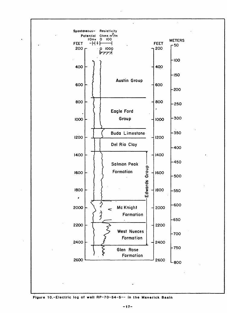
The electrical properties of the Austin Group, the Eagle Ford Group, the Buda Limestone, the Del Rio Clay, the Salmon Peak Formation, the McKnight For mation, and the West Nueces Formation in the Maverick Basin are shown in the induction-electric log of well RP-70-54-5 (fig. 10), and the natural gamma- ray properties of these formations are shown in the gamma-ray sonic log of well RP-70-44-8 (fig. 11)
The criteria for picking the contacts of the formations overlying the Edwards in the Maverick Basin are similar to the criteria used for picking the same contacts in the San Marcos Platform area. The shape of the SP-resistivity curve in figure 10 is not the same for the Austin-Eagle Ford as SP-resistivity curves in the San Marcos Platform area, but the contacts are not difficult to pick. The Buda-Del Rio pattern is much the same as it is on the San Marcos Platform. The pattern of the gamma-ray curve in figure 11 for the formations overlying the Edwards is similar to gamma-ray curves for the same formations In the San Marcos Platform area and the criteria for picking the formation contacts are the same.
Within the Edwards Aquifer San Marcos Platform
A typical example of the electrical properties of the Georgetown Formation, the Person Formation, and the Kainer Formation, along with the associated mem bers, is shown in figure 12 with an electric log of well AY-68-28-910.
The electric log is probably the best correlation log for the Edwards
because of the high and low resistivity zones common to limestone. The gamma ray is a good supplemental log but is not as satisfactory as the electric log because the limestones generally have low radiation properties. In the unsat- urated part of the Edwards the gamma-ray log is usually the only log available for correlation.
-14-

Spontaneous Resistivity'
Potential Ohms m /mlOmv 0 100
FEET
1200
1300
1400
1500
1600
1700
1800
1900
2000
2100
2200
2300
2400
2500
1 1 1 1 1Mil 1 METERS
P IOOS FEETY// ///A
r- % .
Anacacho-£ / Limestone
^ 1£ [ Austin Group
^ L. "7 ^ v^_ Eagle Ford Group
T^
L 5" Buda \ Limestone
| I Del Rio Clay
- / %
1 k "j /^^ Devils
W //^-x River"T* syfy Limestone
C *^ °*i ^^ ^r *^ °\ /=» T§
" \ ' i ^ '"
- r p- f ^
S ^Glen Rose
1200
1300
1400
1500
1600
1700
1800
1900
2000
-
2100
2200
2300
2400
2500
r350
-400
-450
-500
-550
-600
-650
-700
-750
Formation
Figure 8.-Induction-electric log of well TD-69-53-6 in the Devils River Trend
-15-

GAMMA RAY
FEET 0 r-
0 10LJ
COUNTS PER SECOND
100
200
300'
400
500
600
FEET METERS O
Austin Group
Eagle,Ford Group
BudaLimestone
Del Rio Clay
Devils River Limestone
GL3Ov-O
UJ
Glen Rose Formation (approximate)
100
200
300
400
500
600
700
r25
-50
-75
-100
-125
-150
-175
-200
-225
Figure 9.-Gamma-ray log of well YP-69-37-402 In the Devils River Trend
-16-
Spontaneous- ResistivityPotential Ohms m /m
lOmv 0 100 METERS FEET -H + l 1 . FEET n5Q200
400
600
800
1000
1200
1400
1600
1800
»
2000
2200
2400
2600
- p 1000v / / A
^/
-
- /
'-
-
_
_
r
t
-
Austin Group-
-
Eagle Ford
Group
f Buda Limestone
Del Rio Clay
-
Salmon PeakQ.
Formation o _u.oV) o
1 - oLU
- \ * < Me Knight
\ J Formation
"" ( <*
-
S West Nueces
/ Formationx ~
t > Glen Rose' , * Formation
-
200
400
600
800
*
1000
1200
1400
1600
1800
2000
2200
2400
2600
-100
-150
-200
-250
-300
-350
-400
-
-450
-500
-550
-600
-650
-700
-750
-800
Figure 10.-Electric log of well RP-70-54-5 In the Maverick Basin
-17-

GAMMA TRAVEL. RAY TIME
_,0 100 100 70 40I J I I I
FEET API MICROSECONDS FEET METERS
Oi
200
400
600
800
1000
1200
1400
1600
1800
2000
2200
PER FOOT -
AustinGroup
^^* * -r
\ Eagle Ford
\ Group}
, Buda Limestone
{ Del Rio / < Clay
- \ / M
-
I Salmoni Peakj Formation g
> 5 "
^ 7 Me Knight S^ 3 Formation -oJ _J UJ
-
-
v T West Nuecesf Formation
? " *- f -d Glen Rose^ \ Formationi..
0
200
400
600
800
1000
1200
1400
1600
1800
2000
2200
-0
-100
-200
-300
-400
-500
-600
-700
Figure 11.~Gamma ray-sonic log of well RP-70-44-8
in the Maverick Basin

c «« 9 _* 10
3 O
(ft
O oO
i O
O
OJ 8
r\j
o
om
m H
rn ST
ow
[Iv *T
3
o»
S"
3-1
<
a'
o+
- 5
oo ro
oo «D .^
o 5° * =r
CO o o 0» v n + «
o 3
£ CD 3 3)
O
</>
CD
o
</>
3 Cr
CD
O
o3
?
1 I
sr = o
^<i>
=;
g
w
o
o * *.
o>
-Kai
ner
For
mat
ion
=r
* cr
'I ^
3
CD 3
cr CD -^
a^
M/
5
</> 0 3 a> »
» * 3 S
- cr§
5 w
^
CD
Edw
ards
G
roup
Per
son
For
mat
ion
r0§ ?
§3
**
vi
5'
^.1
3
<
O~n
*
o o
-»
-n
3 «
° O
i
r. o
i <
3 a
o
oen
O o
o
oo
o
ro
o
orn
m
I ro
ro
o
ro
o
ooo
o
o>
o
JT
Or\)
o
o
ooo
o
rn

The general pattern of the resistivity curve (on the electric log) is as follows: High resistivity in the Georgetown, top of the Person, middle Person, top of the Kainer (Grainstone member), and part of the lower Kainer (Dolomitic member). These high resistivities usually are separated by low to medium-low resistivities in the upper and lower Person, middle Kainer (Kirschberg evapo- Hte), lower Kainer (Dolomitic member), and basal Kainer (Basal nodular mem ber). The tops of these formations, or members, usually are picked where the resistivity curve shifts from high to low resistivity or vice versa.
Georgetown Formation
The resistivity curve in figure 12 shows a high resistivity of more than 1,200 ohmmeters in the lower Georgetown. The top of the Georgetown cannot be determined because of the effect of well casing on the resistivity log.
The SP curve for the top of the Georgetown is adversely affected by the well casing also. In the lower Georgetown, the SP curve gradually shifts to the left (negative).
The gamma-ray curve shows the Georgetown as three spiky peaks of 45 to 50 cps (fig. 7). The top is picked at the base of the series of high spiky peaks of 60-70 cps radiation of the Del Rio Clay.
Person Formation
The resistivity curve, mentioned in the discussion of the identification of the Georgetown (fig. 12), continues to the right to a peak of more than 2,000 ohmmeters, which marks the top of the Person. The resistivity curve shows the Person Formation as three peaks of about 1,600 to 2,000 ohmmeters and three suppressed zones of about 200 to 600 ohmmeters. The Regional dense mem ber, the basal unit of the Person, is within the lower 20 feet of the lower suppressed zone. The top of the Regional dense member is picked about 20 feet above the shift toward the high resistivity peak that marks the top of the underlying Kainer with the aid of other logs.
*. ithe SP curve in figure 12 is a flattened and distorted mirror image of the
resistivity curve. It deflects about 10 millivolts to the left (negative) oppo site the resistivity peak in the top of the Person Formation. It shifts back to positive opposite the broad zone of low resistivity in the upper Person and is unevenly negative opposite the zone of high resistivity in the middle Person. The curve generally is positive opposite the zone of low resistivity in the lower Person. The Regional dense member cannot be identified on this SP.
Electric logs for the freshwater part of the aquifer are not satisfactory for locating the Regional dense member. The Regional dense member is seldom manifested on either the resistivity curve or the SP curve with an identifiable deflection. It is more reliably located on- a suite of neutron, gamma-gamma, and caliper logs (fig. 13). These logs show the Regional dense member as a zone of low porosity and high density and also indicate that the borehole is about the same diameter as the drill bit (Maclay, Small, and Rettman, 1981). Downdip, and within the saline portion of the Edwards aquifer, Rose (1972) noted that the Regional dense member shows a distinct decrease in the SP curve, and the resistivity curve shows a corresponding peak at the same relative positi on.
-20-

-13-
oe
0»*i
O O
tn O O
O O
01 O O8
9a
o o
i o09
10 o01o a>
oo03
G>
o a.c
3<D
o-
O
o
cr<D
<a
W)o"3 <D
Kainer FormationPerson Formation *
Edwards Group
31 iQ
O OC
m33 C/Jm o O
-a m33
t/j m o o
o o
00-o o
o-o ofo -o o
ro -oo
o o
00 o o
~O
mc:
! O>
n
m
1-4Q Q
1
0>0 O
1tnO O
i-fc» -O O
1O>O 0
.,.., .,,.J -nro m
§m H
i ros
i ro8
l 650
i i
o o
1
§1
O O
1 00o
oS mOH
m

The gamma-ray curve shows the Person Formation to have low gamma radiation of about 15 to 30 cps in the upper part (fig. 7). The top of the Person is picked where the curve shifts to the low 15 cps radiation from the spiky peak of about 45 cps in the Georgetown Formation. There is a zone of spiky peaks of 40-50 cps near the middle of the formation and a zone of spiky peaks of 40- 55 cps at the base of the formation that represents the Regional dense member. The top of the Regional dense member is picked where the curve shifts to the 45 cps radiation about 200 feet below the base of the Del Rio Clay.
Kalner Formation
The Kainer Formation is divided into four units, the Grainstone member, the Ki rschberg evaporite, the Dolomitic member, and the Basal nodular member. A discussion of the picks using electric logs (fig. 12) is given first and using other geophysical logs (figs. 7 and 13) is second.
As shown in figure 12, the top of the Grainstone member is picked where the resistivity curve shifts to the right, to a peak of 2,000 ohmmeters which is commonly about 200 feet below the base of the Del Rio. The Grainstone is shown as two high peaks of 1,600 to 2,000 ohmmeters resistivity separated by a recessive zone of about 1,000 ohmmeters resistivity. The top of the Kirschberg evaporite is picked about 50 feet below the top of the Grainstone member and at the base of the bottom peak. It is shown as a 50-foot zone of low resistivity of about 800 to 1,200 ohmmeters. The top of the Dolomitic member is picked at the top of a narrow peak of about 800 ohmmeters at the base of the Kirschberg. The curve is unevenly recessed for about the next 90 feet and the resistivities range from a low of about 200 ohmmeters in the upper middle part to about 800 ohmmeters near the bottom. The top of the Basal nodular member is picked at the base of a low peak of about 1,000 ohmmeters. The resistivity curve for the Basal nodular member is similar in shape and thickness to the resistivity curve for the Kirschberg evaporite. The Basal nodular member is about 60 feet thick and has an upper and lower zone of low resistivity of about 400 ohmmeters with a narrow peak of about 700 ohmmeters in the middle. The base of the Basal nod ular member, which is also the base of the Kainer Formation and of the Edwards Group,, is picked where the curve shifts to the left toward lower resistivity and becomes an erratic line of about 500 ohmmeters at the top of the Glen Rose Formation. The SP curve shows some response down through the top of the Ki rsch berg evaporite (about 480 feet). Below 480 feet, the SP gradually shifts to the right. This portion of the curve has no distinguishing features that are valuable for determining formation contacts. The SP curve deflects about 15 millivolts negative opposite the resistivity peak that indicates the position of the Grainstone member. The curve shifts to positive opposite the low resis tivity of the upper Kirschberg evaporite but below the Kirschberg, the SP curve Is insensitive to changes in lithology.
The top of the Kainer Formation (and the top of the Grainstone member) is picked at the base of the narrow spiky zone representing the Regional dense member (fig. 7) on the gamma-ray log. The base of the Grainstone member or the top of the Ki rschberg evaporite is arbitrarily picked about 70 feet below the top of the Grainstone member just above a zone of three narrow spiky peaks having radiation of about 45 cps. The Kirschberg is picked more reliably on the neutron log at the top of the high porosity zone and on the caliper log on the large increase in borehole diameter over the size of the bit (fig. 13).
-22-

The top of the Dolomitic member is picked about 40 feet below the top of the Kirschberg. The top of the Basal nodular member is picked at the top of a zone of a gradual increase of gamma radiation (fig. 7) which ranges from 50 to 80 cps. The member is about 270 feet below the top of the Kainer Formation. The neutron, gamma-gamma, and caliper logs (fig. 13) show the Basal nodular member to have low porosity and high density and to have a borehole approximately the same diameter as the drill bit. The base of the Kainer (and the base of the Basal nodular member) is picked where the gamma-ray curve (fig. 7) shifts to ward a lower gamma radiation of about 75 cps. The base of the Kainer is about 60 feet below the top of the Basal nodular member.
Devils River Trend
The only strati graphic unit in the Devils River Trend in the Edwards aqui fer is the Devils River Limestone. The resistivity curve of this unit shows the upper part of the Devils River generally to have very high resistivity (fig. 8). The top is picked where the curve shifts to the right toward the high resistivity at the base of the Del Rio Clay.
The resistivity curve of the Devils River Limestone shows medium high to high resistivity throughout the formation. A zone of high resistivity occurs near the middle of the formation and another zone of high resistivity occurs near the base of the formation. The base of the formation is picked where the curve shifts toward the left to low resistivity in the Glen Rose Formation.
The SP curve deflects left (negative) about 20 millivolts at the top of the Devils River and gradually decreases by 10 or 20 millivolts. The lower part of the SP curve is about -40 millivolts except near the lower part (base) of the formation where it shifts to the left to about -50 millivolts. The lowest part of the curve increases toward a higher SP at the base of the forma tion.
The gamma-ray curve in figure 9 shows the natural gamma radiation proper ties of the Devils River Limestone. The average radiation is low, generally between 20 and 30 cps. The top of the Devils River is picked where the curve deflects back to the left, from the high peaks of over 40 cps in the Del Rio Clay to lower radiation of about 25 cps. It increases in the basal part of the formation to about 40 cps. The curve of the formations above the Devils River show an apparently lower radiation because the signal is attenuated by casing.
Maverick Basin
Electric logs show distinctive patterns that are useful for determining stratigraphic correlations in the Maverick Basin. They usually show signifi cant changes in resistivity in the limestone and have more definition than the gamma-ray logs, which are excellent supplemental logs. The typical resistivity curve shows high resistivity for the Salmon Peak, higher resistivity for the McKnight, and medium high to medium low resistivity for the West Nueces. These high resistivities usually are separated from each other by zones of low resis tivity, and the formation contacts are picked at these changes.
-23-

Salmon Peak Formation
The resistivity curve in figure 10 shows the Salmon Peak Formation to have medium high resistivity of about 40-50 ohmmeters throughout the formation. The top is picked where the curve deflects to the right about 150 feet below the top of the Del Rio. The SP curve is without distinguishing characteristics except for a small negative deflection about 40 feet below the top of the Sal mon Peak.
The gamma-ray curve in figure 11 shows low gamma radiation of about 30-40 API gamma-ray units throughout most of the Salmon Peak Formation. The top of the Salmon Peak Formation is picked where the gamma-ray curve shifts to the left, to about 40 gamma-ray units, from the 70-80 units in the Del Rio. A nar row zone of slightly higher radiation of about 60-65 API gamma-ray units (Keys and MacCary, 1971) occurs about 130 feet below the top of the formation.
The sonic curve in figure 11 shows the Salmon Peak to have travel times of about 65-70 microseconds per foot in the upper half of the formation. Travel times in the lower half vary from 86 to about 65 microseconds per foot. The top of the formation cannot be picked on this log because it is shielded by the well casing.
McKnight Formation
The resistivity curve in figure 10 shows the McKnight as two peaks of more than 200 ohmmeters with a narrow zone of lower resistivity near the middle of the formation. The top of the McKnight Formation is picked where the resistiv ity curve deflects sharply to the right to a very high peak, which occurs about 500 feet below the top of the Salmon Peak.
The SP curve deflects about 25 millivolts to the left (negative) at the top of the McKnight. It drifts back to the right (positive) about 15 milli volts opposite the zone of low resistivity on the resistivity curve and then shifts back to the left about 10-15 millivolts in the lower part of the forma tion.
The gamma-ray curve in figure 11 shows the McKnight as a series of high spiky peaks of 80 to 100 API gamma-ray units. The top of the formation is picked at the start of the series of peaks.
The travel-time curve on the sonic log in figure 11 shows the McKnight as a broad zone of low travel time of about 50-55 microseconds per foot. This appears as a broad flat peak on the travel-time curve. There is a narrow zone of high travel time of about 75 microseconds per foot near the middle of the peak. The top of the McKnight is picked on the sonic log at the beginning of the peak where the travel times decrease from about 70 microseconds per foot to about 55 microseconds per foot.
West Nueces Formation
The West Nueces is shown as a series of unevenly elevated low peaks on the resistivity curve (fig. 10). The resistivity of these peaks decreases with
-24-

depth. The formation is separated from the high resistivity peak of the over lying McKnight by a decrease in resistivity, from about 200 ohmmeters to about 20 ohmeters, that appears on the curve as a sharp recession.
The top of the West Nueces Formation is picked at the low point in the sharp recession and is about 250 feet below the top of the McKnight. The base 1s picked at the end of a sharp recession and is about 250 feet below the top of the West Nueces Formation.
The SP curve of West Nueces Formation shifts left (negative) about 10 millivolts at the top of the formation and then drifts back in a positive dir ection. It is relatively featureless below a point about 80 feet below the top of the formation. The top of the Glen Rose is not apparent on this SP curve.
The gamma-ray curve in figure 11 shows the West Nueces to have about 50 API gamma-ray units radiation, which is about the same as the Salmon Peak. The top is picked about 180 feet below the top of the McKnight, at the base of the series of high spiky peaks. The base of the West Nueces, top of the Glen Rose, is not evident on this curve.
The sonic log shows a 50-foot zone of high travel time at the top of the West Nueces. Travel times in this zone are about 75 microseconds per foot. They decrease to about 58 microseconds per foot below this zone and remain about the same for the rest of the formation.
The top of the West Nueces is picked at the top of the 50-foot zone of high travel time. The base is picked about 230 feet below the top where the travel-time curve changes from a series of low peaks with little difference in travel time between peaks and troughs to a somewhat more erratic series of high spiky peaks with a large difference in travel times between peak and trough.
Underlying the Edwards Aquifer
*the unit below the Edwards is the Glen Rose Formation. The top of the Glen Rose is picked on most resistivity curves at the point where the curve shifts from the generally higher resistivities of the Edwards to the lower resistivities of the Glen Rose (figs. 8, 10, and 12).
The top of the Glen Rose is picked on SP curves where the curve deflects to the right (positive) after coming out of the Edwards. The SP curves in the San Marcos Platform area commonly show this shift, but the SP curves in the Devils River Trend and the Maverick Basin frequently do not. The SP curves generally are unsatisfactory for picking the top of the Glen Rose.
In the San Marcos area, the gamma-ray curve usually shows a slight decrease 1n radiation from the higher radiation of the rocks near the base of the Edwards to lower radiation in the upper Glen Rose. However, in the western part of the area there is no noticeable change in radiation shown on the gamma-ray curve near the part representing the basal Edwards and upper Glen Rose.
-25-
Few sonic logs were available for study of the Edwards-Glen Rose contact. Those that were available show a change in travel time at the top of the Glen Rose and are satisfactory for determining the top of the Glen Rose.
DATA TABULATION
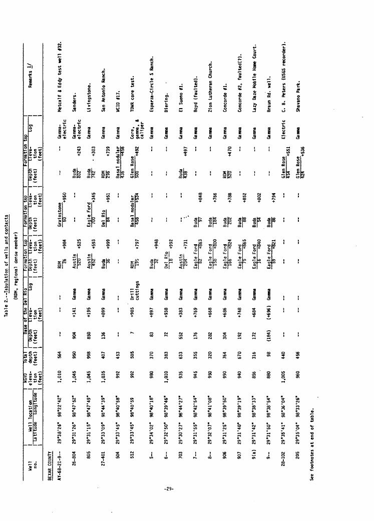
Interpretations derived from all the logs used in this study are presented In table 2 (supplemental information).
-26-

SELECTED REFERENCES
Arnow, Ted, 1959, Ground-water geology of Bexar County, Texas: Texas Board of Water Engineers Bulletin 5911, 62 p.
Bennett, R. R., and Sayre, A. N., 1962, Geology and ground-water resources of Kinney County, Texas: Texas Water Commission Bulletin 6216, 176 p.
DeCook, K. J., 1960, Geology and ground-water resources of Hays County, Texas: Texas Board of Water Engineers Bulletin 6004, 167 p. (also published as U.S. Geological Survey Water-Supply Paper 1612, 72 p., 1963).
Dunham, R. J., 1962, Classification of carbonate rocks according to depositional texture in Classification of carbonate rocks symposium: American Associ ation ofPetroleum Geologists Bulletin, v. 54, no. 2, p. 207-250.
Holt, C. L. R., Jr., 1956, Geology and ground-water resources of Medina County, Texas: Texas Board of Water Engineers Bulletin 5601, 278 p. (also pub lished as U.S. Geological Survey Water-Supply Paper 1422, 213 p., 1959).
Keys, W. S., and MacCary, L. M., 1971, Application of borehole geophysics to water-resources investigations: U.S. Geological Survey Techniques of Water-Resources Investigations, Book 2, Chapter El, 125 p.
Livingston, Penn, Sayre, A. N., and White, W. N., 1936, Water resources of the Edwards Limestone in the San Antonio area, Texas: U.S. Geological Survey Water-Supply Paper 773-B, 55 p.
Lozo, F. E., and Smith, C. I., 1964, Revision of Comanche Cretaceous strati- graphic nomenclature, Southern Edwards Plateau, Southwest Texas: Trans actions of the Gulf Coast Association of Geological Societies, v. 14, p. 285-307.
MacCary, L. M., 1978, Interpretation of well logs in a carbonate aquifer: U.S. Geological Survey Water-Resources Investigations 78-88, 30 p.
Maclay, R. W., and Small, T. A., 1976, Progress report on geology of the Edwards aquifer, San Antonio area, Texas, and preliminary interpretations of borehole geophysical and laboratory data on carbonate rocks: U.S. Geological Survey Open-File Report 76-627, 65 p.
1983, Hydrogeology of the Edwards aquifer in the San Antonio area, Texas: U.S. Geological Survey Open-File Report 83-537, 107 p.
Maclay, R. W., Small, T. A., and Rettman, P. L., 1981, Application and analysis of borehole data for the Edwards-aquifer in the San Antonio area, Texas: Jexas Department of Water Resources LP-139, 88 p.
Rosejl P. R., 1972, Edwards Group, surface and subsurface, Central Texas: Uni versity of Texas, Bureau of Economic Geology Report of Investigations No. 74, 198 p.
Schlumberger Well Surveying Corporation, 1958, Introduction to Schlumberger well logging: Houston, Texas, Schlumberger Document No. 8, 176 p.
Smith, C. I., 1974, Stratigraphy of the Edwards Group and equivalents, Eastern Edwards Plateau, Texas: Guidebook for AAPG-SEPM Field Trip, March 30-31, 1974, 121 p.
University of Texas, Bureau of Economic Geology, 1974, Geologic atlas of Texas San Antonio sheet: University of Texas, Bureau of Economic Geol ogy map, scale 1:250,000.
Welder, F. A., and Reeves, R. D., 1962, Geology and ground-water resources of Uvalde County, Texas: Texas Water Commission Bulletin 6212, 263 p. (also published as U.S. Geological Survey Water-Supply Paper 1584, 49 p., 1964).
-27-

SUPPLEMENTAL INFORMATION
-28-
Tab
le 2
.--T
abula
tion
of
we
lls a
nd c
onta
cts
(RDM
, re
gio
nal
dens
e m
embe
r)
Wel
l no
.
BEXA
R CO
UNTY
AY
-68-2
1-9
26-8
04
805
27-4
01
504
512
5-
6
703
7
8«
906
907
9(a
)
9«
28-1
02
205
See
footn
ote
s
1 1 W
ell
loca
tio
n1
La
titu
de
L
on
gitu
de
29°3
8'2
6"
98
°22
'42
"
29*3
1 '2
6"
98°4
7'5
2"
29e3
1'1
5"
98"4
7'4
9"
29°3
3'0
9"
9B
°44
'39
"
29e3
3'4
5"
98
°40
'5B
"
29e3
3'4
5"
98°4
0'5
9
29'3
4'0
2"
98°4
0'1
8"
29
°32
'50
" 98°3
9'4
6"
29°3
0'2
7"
98°4
4'2
7"
29e3
1'5
5"
98°4
2'5
4"
29e3
2'0
7"
98e4
1'0
8"
29°3
1'2
5"
98e3
9'5
0'
29e3
1'4
0"
98
°39
'19
"
29
°31
'42
" 98°3
8'3
3"
29"3
r50"
98°3
8'5
4"
29e3
5'4
1'
98°3
6'0
4"
29e3
5I0
4"
98
°33
'26
"
at
end
of
table
.
I NG
VD
I ele
va-
"1 tlo
n
I (f
eet)
1,01
0
1,04
5
1,04
5
1,03
5
992
992
980
1,01
0
935
945
950
990
940
856
880
1,00
5
960
To
tal
I de
pth
| (f
eet)
1
564
950
998
407
453
505
370
383
633
355
320
764
670
316 98
440
456
1 Ba
se o
f th
e D
el
Rio
! D
epth
(f
eet)
1
904
850
136 7
83
72
552
176
282
304
192
172
(184
)
El e
va-
tlon
(feet)
+141
+195
+899
+985
+897
+938
+383
+769
+668
+686
+748
+684
(+69
6)
Log
Gamm
a
Gamm
a
Gamm
a
Drill
cutt
ing
s
Gamm
a
Gamm
a
Gamm
a
Gamm
a
Gamm
a
Gamm
a
Gamm
a
Gamm
a
Gamm
a
1 F
orm
atio
n to
p I
I D
epth
E
leva
- 1
1 (f
eet)
tlo
n
I 1
(feet)
1
RDM
~~T6
+9
84
Au
stin
b2
0 +5
25
Au
stin
45
2 +5
93
Buda
~~
1F
+999
RDM
~I¥
5
+797
Buda
~~
32
+948
Del
R1
o IB
+
992
Au
stin
20
4 +7
31
Eag
le F
ord
82
+863
Eag
le F
ord
158
+800
Eag
le F
ord
166
+824
Eag
le F
ord
75
+865
Eag
le F
ord
16
+840
Eag
le F
ord
59
+821
For
mat
ion
top
Dep
th
(feet)
El e
va-
tlon
(f
ee
t)
1 F
orm
atio
nI
Dep
th
t-i e
va-
I (f
eet)
tlo
n
1 (f
eet)
Gra
lnst
one
60
Eag
le
+950
For
d70
0 "
+345
Del
R
io
~T
H
+951
Bas
al
nodu
lar
458
Buda
9
7
Buda
T
OT
Buda
~7
D7
Buda
S
B
Buda
~
~5*
Buda
5
5-
+5
34
+848
+766
+78B
+852
+802
+794
Buda
S
OT"
+2
43
Buda
73
F~
+3
03
RDM
295"
+7
39
Bas
al
nodu
lar
436
+456
Gle
n R
ose
Buda
*3
B~
+497
RDM
520"
+4
70
Gle
n R
ose
Gle
n R
ose
TO* +5
36
top
Log
Gam
ma-
e
lectr
ic
Gam
ma-
e
lectr
ic
Gamm
a
Gamm
a
Gamm
a
Cor
e,
gam
ma,
A
ca
ll pe
r
Gamm
a
Gamm
a
Gamm
a
Gamm
a
Gamm
a
Gamm
a
Gamm
a
Gamm
a
Gamm
a
Ele
ctr
ic
Gamm
a
i "1 R
emar
ks I/
1
Hetc
alf
S Ed
dy t
est
Men
§3
2.
San
ders
.
Llv
lng
sto
ne
.
San
Ant
onio
Ran
ch.
WCI
D 11
7.
TDW
R co
re te
st.
Esp
arz
a-d
rcle
S
Ran
ch.
Ble
ring.
El
Suen
o fl.
Boyd
(f
aulted).
Z1on
Lu
ther
an C
hurc
h.
Con
cord
e 11
.
Con
cord
e 12
, fa
ulte
df?
).
La*y
Da
ze M
obile
Ho
ne C
ourt
.
Bra
un
Rd.
w
ell.
C.
B.
Pet
ers
(USG
S re
cord
er)
.
Shav
ano
Par
k.

Tab
le 2
. T
ab
ula
tio
n o
f w
ells
an
d co
nta
cts
Co
ntin
ue
d
Wel
l no
.
AY
-68-2
8-3
--
404
503
504
605
606
6
706
809
810
8
903
909
910
911
29-1
02
103
107
109
See
foo
tno
tes
1 1 W
ell
1 Latit
ude
1
loca
tion
Long
itude
29°3
5'0
9"
98°3
2'0
6"
29°3
2'3
0"
98°3
6'1
5"
29°3
3'0
5"
98°3
3'0
0"
29°3
3'0
5"
98°3
3'0
8"
29°3
4'ir
98°3
2'1
0"
29°3
4'5
3"
98°3
0'2
6"
29°3
4'1
0"
98°3
0'2
0"
29°3
1'0
3"
98°3
7'1
0"
29°3
2'1
8"
98°3
4'2
3"
29°3
0'2
7"
98°3
4'1
6"
29°3
0'3
9"
98°3
4'1
9"
29°3
2'0
8"
98°3
0'4
4"
29°3
0'2
6"
98°3
1'3
3"
29°3
2'0
8"
98°3
2'1
7"
29"3
0' 1
2"
98°3
2'2
9"
29°3
5'4
5"
98°2
9'2
2"
29°3
5'2
2"
98°2
9'1
2"
29°3
5'0
7"
98°2
8'2
8"
29°3
5'1
2"
98
'29
'17
"
at
end
of
tab
le.
| NG
VD
I ele
va-
1 tlon
1 (f
eet)
970
910
935
910
898
895
840
902
1,04
2
1,02
4
1,02
0
885
783
815
824
947
953
885
970
Tota
l 1
dept
h I"
(fe
et)
| 1
250
546
340
430
613
553
2,13
2
655
746
662
508
416
867
804
850
496
520
606
590
Base
of
the
Del
R
io
1D
epth
(f
eet)
56
30 206
162
100 96 305
507
504
502
320
353
204
364
120
El e
va-
tlo
n
(fe
et)
+914
+880
+729
+748
+798
+799
+597
+535
+520
+518
+565
+430
+611
+460
+850
Log
| 1
Gamm
a
Gamm
a
Gamm
a
Gamm
a
Gamm
a
Gamm
a
Gamm
a
Gamm
a
Gamm
a
Gamm
a
Ele
ctr
ic
Ele
ctr
ic
Gamm
a
Ele
ctr
ic
Gamm
a
For
mat
ion
top
1D
epth
E
leva
- I
(fe
et)
tlon
I (f
eet)
|
Del
R
io
4" +
966
RDM
~I9"
2 +7
18
Eag
le F
ord
88
+847
Eag
le F
ord
32
878
Del
R
io
~P
+
854
RDM
~~2t
O +6
35
Gle
n R
ose
675
165
Eag
le F
ord
174
+728
Aus
tin
224
+818
Aust
in
"224
"
+800
Aust
in
220
+800
Aust
in
37
+848
Eag
le F
ord
210
+573
RDM
~39"
2 +4
23
Au
stin
83
+7
41
Buda
~
7f
+946
For
mat
ion
top
Dep
th
El e
va-
(fe
et)
tlo
n
(feet)
Bas
al
nodu
lar
456
+454
Bud
a ~T
08"
+827
Bud
a T
O"
850
RDM
~28"
2 +6
16
Bas
al
nodula
r50
6 +3
89
Bud
a "2
07
+798
Bud
a ~4
U2~
+640
Bud
a ~
4W
+6
24
Eag
le F
ord
374
+646
Buda
H
ZzT
+664
Buda
"2
13"
+550
Bas
al
nodu
lar
627
+188
Buda
T
BU
+5
64
Bas
al
nodu
lar
364
+583
Bas
al
nodu
lar
421
+532
Bas
al
nodu
lar
504
+46
6
1 F
orm
atio
n1
Dep
th
Ele
va-
| (f
ee
t)
tlon
1 (f
eet)
Gle
n R
ose
510
+400
Del
R
io
TP
+781
Del
R
io
TD5
+802
Gle
n R
ose
600
+298
Gle
n R
ose
550
+345
RDM
W
+420
RDM
570~
+3
72
Buda
W
+6
14
Gle
n R
ose
677
+138
Gle
n R
ose
4oo
+547
Gle
n R
ose
484
+469
Gle
n R
ose
45b
+429
Gle
n R
ose
584
+386
top
ILo
g I 1
Gamm
a
Cor
e,
ele
ctr
ic,
A ga
mm
a
Gam
ma
Gam
ma
Gam
ma
Gam
ma
Sam
ple
Gamm
a
Gamm
a
Gamm
a
Gamm
a
Drille
rs
log
Ele
ctr
ic
Cor
e,
ele
ctr
ic,
A ga
mm
a
Ele
ctr
ic
Gam
ma-
ele
ctr
ic
Gamm
a Ga
mma
Gamm
a
Ganm
a
Rem
arks
i/
Upt
mor
e C
ad
illa
c D
r.
USGS
co
re t
est
"Lock
hlll
R
d."
Old
Forr
est
Hill
s C
ount
ry
Clu
b.
Forr
est
Hill
s C
ount
ry C
lub.
Lloy
d D
ento
n.
Hid
den
Fo
rre
st.
Mid
Tex
-War
lng.
Bal
con
es W
ater
Co.
Uni
ted
Ser
vice
s A
uto
no
blle
A
ssoc
. (n
ew w
ell)
.
Met
hodi
st H
osp
ital.
Med
ical
C
ente
r.
Cas
tle H
ills W
ater
Co.
- w
ell
11.
San
Ant
onio
City
Wat
er B
oard
-W
est
Ave
. 11
(E
-17
2).
2
/
USGS
cor
e te
st
"Cast
le
Hills
."
San
Ant
onio
C
ity W
ater
Boa
rd
-Bar
bet
Rd.
11
(E
-150).
2J
H111
C
ount
ry W
ater
Wor
ks
we
ll.
Hill
C
ount
ry V
illa
ge
wat
er
we
ll.
TDW
R te
st
at
Hill
C
ount
ry
Wat
er W
orks
.
Hill
C
ount
ry
(F-1
69).

Tabl
e 2t
--T
abul
atio
n of
wtllt a
nd c
onta
cts-
Con
tinue
d
I I
NGVD
Wel
l I
VeU
lo
catio
n
I el
eva-
no.
I L
atitu
de
Lo
ng
itu
de
I
tion
__
__
_
I __
__
__
IT
feet)
Tota
l l
depth
I"(f
eet)
I
___I
Base o
f th
e De
i Rip
I Formation
top
| Formation
top
IFo
rmat
ton
top
Dept
h Eleva-
Log
I Depth
Eleva-
| De
pth
tleva-
(fee
t)
tion
| (f
eet)
tion
I (f
eet)
tion
(fee
t) ______I_____ (
feet
) I
(fee
t)
I De
pth
Elev
a-
Log
I I (feet)
tion
I
I______(feet)_______I
Rema
rks A/
AY-68-29-2
29'35'01"
98'2
5'42
" 800
2,10
0
303
29°3
6'15
" 98
'24'
32"
830
420
3(a)
29'3
6'26
" 98
'23'
18"
920
84
3
29'36'09"
98°23'17"
930
582
410
29'34'32"
98'2
9'22
" 875
346
4(a)
29°33'40"
98'2
9'03
" 80
0 73
7
4(b)
29
'34'
32"
98'27'33'
780
227
4
29'32'32"
98'2
8'40
" 770
260
506
29'34'27"
98°2
6'19
" 788
700
5(a)
29'33'44"
98'2
6'25
" 794
223
5(b)
29'3
3'20
" 98'26'16"
835
337
5(c)
29°3
3'20
" 98°26'11'
833
315
5(d)
29'33'45"
98°25'18"
820
1,943
606
29'33'44"
98'2
3'24
' 855
656
702
29°3
1'23
" 98'29'03"
787
872
707
29'3
1'23
' 98'29'02"
766
857
711
29'3
1'3r
98
'28'
32"
. 795
600
7
29'3
0'26
" 98'28'48"
710
583
804
29°3
1'50
" 98
°25"
16"
763
242
See
foot
note
s at e
nd o
f ta
ble.
198
+602
Drillers
log
65 72 40 254
193
244
220
+855
Gamma
+858
Gamm
a
+835
Gamm
a
+546
Gamm
a
+587
Gamm
a
+526
Gamma
+568
Gamm
a
(255
) (+
539)
Gamma
322
+513
Gamm
a
+563
Gamma
270
315
400
428
410
(465)
(+33
0)
Electric
(620
) (+90)
Gamm
a
238
+525
Elec
tric
+505
Drillers
log
+455
Gamm
a
+359
Electric
+356
Casing
dept
h
Glen R
ose
7D1
+97
Basal
nodular
Glen R
ose
+462
414
+416
Buda
~2T
Del
Rio
Buda
"TBT
Buda
+899
+910
+644
+684
Bas
al
nodu
lar
"525
+T
O4
RDM
"474
+376
Buda
"IS?
+611
Person F
m 238+550
Austin
30
+764
RDM
"394
Buda
Austin
Buda
"IF5
+765
Buda
"737
+394
+640
+603
+667
Glen R
ose
906
Buda
~-86
+459
Aus
tin
ToT
T"
+627
,Buda
"333
+454
RDM
~5TO
+156
Kirs
chbe
rg
"TT7
U +9
6
Aus
tin
~T
93
+600
Aus
tin
154
+516
Buda
-3
51
Buda
T
8T
+432
+226
Buda
"T
Tff
+635
Gle
n Ro
se
57F
~+35
8
Ele
ctric
Ren
lee
Oil
Co.
#1
A T
hels
.
Gamm
a O
lmos
Roc
k P
rodu
cts.
Gamm
a Ac
kerm
ann.
Gamm
a H
etc
alf
X Ed
dy t
est
wel
l f3
3.
Hill
C
ount
ry w
ater
wel
l (F
-38)
. 2/
Gle
n Ro
se
Gam
ma-
7Z
5+
72
ele
ctric
Gamm
a
Gamm
a
Bas
al
nodu
lar
Cor
e,
550
+138
" e
lectr
ic,
& ga
mma
Gamm
a
Gamm
a
Gamm
a
Ele
ctric
Gamm
a
Ele
ctrlc
Ele
ctric
~
Ele
ctric
2.7 Gamm
a
-
Ele
ctric
Met
calf
X Ed
dy t
est
wel
l f3
1.
Met
calf
X Ed
dy t
est
wel
l 13
0.
Jone
s-H
alts
berg
er R
d.
USGS
cor
e te
st "
Fea
ther
cres
t.
Rum
pcl fl.
N.
E.
Pre
serv
e #2
.
Rum
pel
#2.
Ren
lee
011
Co.
fl
Pape
.
Val
enci
a.
Mal
tsbe
rger
fl.
Matsberger *
3.
Muni
cipa
l Airport *2 (F-128).
Sunset R
d. ne
ar Jones
Malt
sber
ger.
San
Anto
nio
City W
ater B
oard
-P
errl
n #3
.

Tabl
e 2. Tabulation
of w
ells a
nd con
tact
s Co
ntin
ued
Wel
l no
.
AY
-68-
29-8
11 813
913
914
915
9
30-1
09 211
2
403
405
508
510
512
5(a)
5(b)
5(c)
5(d)
616
See
foot
note
s
1 1 W
ell
I L
atitu
de
1 29°3
0'49
"
29*3
1'55
"
29*3
1 '5
0"
29°3
0'26
"
29*3
1'52
"
29*
30 '4
7"
29*3
5'23
"
29*3
6'17
"
29*3
5' 5
4"
29*3
2'41
"
29*3
2 '5
8"
29°3
3'29
"
29°3
3'H
"
29*3
4' 1
4"
29*3
4'05
"
29*3
4'24
"
29*3
4 '3
6"
29*3
4' 1
6"
29*3
2 '3
2"
1 lo
cati
on
ILo
ngitu
de I
98°2
6'53
"
98*2
5 '0
4"
98°2
2'44
"
98°2
4'14
"
98*2
2' 4
3"
98*2
4 '1
8"
98*2
1'39
"
98*
19 '4
0"
98*1
8' 5
3"
98*2
0' 1
9"
98*2
2*12
"
98*
19 '1
4"
98*1
8 '0
4"
98°1
9'16
"
98*1
9' 1
3"
98*1
9' 2
4"
98*1
9'15
"
98*
18 '4
8"
98*1
7 '2
3"
I NG
YD
I el
eva-
|
tlo
n
I (f
eet) 735
780
811
738
816
720
944
776
760
872
850
900
835
871
880
845
770
828
758
Tot
al
1 de
pth
I (f
eet)
1
612
369
798
844
829
510
710
778
650
634
790
789
396
601
776
618
600
2,58
2
1,00
3
Bas
e of
the
Del
Rio
1
Dep
th
(fee
t)
205
(257
)
350
420
372
324
376
222
508
375
366
355
393
275
314
320
256
244
472
El e
va-
tio
n
(fee
t)
+530
(+52
3)
+461
+318
+446
+396
+568
+554
+252
+497
+484
+545
+442
+596
+566
+525
+514
+584
+286
Log
| 1
Ele
ctri
c
Ele
ctri
c
Ele
ctri
c
Ele
ctri
c
Gamm
a
Gamm
a
Gamm
a
Gamm
a
Gamm
a
Gamm
a
Gamm
a
Gamm
a
Ele
ctri
c
Gamm
a
Gamm
a
Gamm
a
Gamm
a
Ele
ctri
c
Gamm
a
Form
atio
n to
p I
Dep
th
Ele
va-
| (f
eet)
ti
on
I (f
eet)
I
Del
Rio
~T
5D +
585
Buda
T
4T
+636
Buda
"T
6TT
+551
Buda
~T
9F
+440
Aus
tin
139
+677
Buda
T
UT
+5
08
Aus
tin
176
+768
RDM
~TO
2 +3
74
Aus
tin
140
+620
Aus
tin
116
+756
Aus
tin
160
+690
Eag
le F
ord
200
+700
Eag
le F
ord
259
+576
Eag
le F
ord
150
+721
Eag
le F
ord
196
+684
Aus
tin
62
+783
Gle
n Ro
se87
5 -4
7
Aus
tin
130
+628
Form
atio
n to
pD
epth
(f
eet)
.
Buda
Buda
TT
B"
Bas
al66
2
Buda
~4
"08"
Eag
le24
0
Buda
Buda
"7
30"
Buda
~Z
S9~
Buda
Buda
~2
TT
Buda
-3
47
Buda
~I
5U
Buda
El e
va-
tlon
(f
eet)
.
+534
+666
nodu
l ar
+114
+352
For
d +632
+568
+670
+546
+691
+669
+214
+620
+390
1 Fo
rmat
ion
1 D
epth
El
eva
- i
(fee
t)
tlon
1
(fee
t)
RDM
561!
+2
56
Gle
n Ro
se71
1 +6
5
Buda
75
9~
+603
RDM
55?
+288
RDM
5TO
+4
60
Del
R
io
"3*5
+489
RDM
375"
+3
96
RDM
5T5"
+3
64
RDM
50T
+3
41
RDM
TOT
+326
RDM
558"
+1
00
top
1Lo
g
Ele
ctri
c
Ele
ctri
c
Ele
ctri
c
Ele
ctri
c
Ele
ctri
c
Gamm
a
Gamm
a
Gamm
a
Gamm
a
Gamm
a
Gamm
a
Gamm
a
Ele
ctri
c
Gamm
a
Gamm
a
Gamm
a
Gamm
a
Ele
ctri
c
Ganm
a
1 I Re
mar
ks I
/ 1
San
Ant
onio
City
Wat
er B
oard
-N
orth
woo
d «
(F-1
90).
ZJ
City
Pub
lic S
ervi
ce P
errl
n #1
(F
-142
). ZJ
San
Ant
onio
City
Wat
er B
oard
-R
ando
lph
11.
San
Ant
onio
City
Wat
er B
oard
-W
alze
m R
d. f
i.
San
Ant
onio
City
Wat
er B
oard
-R
ando
lph
12.
Mar
shal
l C
ourt
s.
Fox
Run.
USAC
E Se
lma
core
tes
t.
Reta
ma
Polo
Fie
ld.
Vill
age
Publ
ic U
tili
ty.
Val
ley
Forg
e.
Uni
vers
al C
ity (
F-25
9).
Sc h
ertz
City
Wat
er *
2.
Live
Oak
.
Uni
vers
al C
ity.
Selm
a.
Met
calf
ft E
ddy
test
wel
l #2
1.
Secu
rity
Dri
llin
g C
o. *
1.
Ran
dolp
h #9
(6
-19)
. ZJ
at e
nd o
f ta
ble.
Tab
le 2
. T
abu1at1
pn_A
f..w
ells
an
d co
nta
cts
Contin
ued
I T
Wel1
I We
ll lo
cati
on
jno.
I Latitude
Long
itud
e)el
eva
tio
n
(fe
et)
Tota
l I_
________
dept
h |D
ep
thE
leva
-(f
ee
t)
| (f
ee
t)
tion
I (f
eet)
Base
of
the
Del
R
io
| F
orm
atio
n to
p |
For
mat
ion
top
|T
og
I D
epth
El
eva
- I
| (f
eet)
tio
n
|I
(feet)
|
For
mat
ion
top
Dep
th
tTev
a-
(feet)
tio
n
__(f
eet)
IDe
pth
ET
eva
^L
og
I (f
eet)
tio
nI
(fe
et)
Rem
arks
!/
AY
-68-
30-7
05
29*3
2'26
" 98
'21'
59"
708
29'3
0'55
" 98
*21'
42"
7(a)
29
*31'
16"
98'2
0'32
"
7
29'3
1'44
" 98
*21'
46"
807
29°3
1'29
" 98
°17'
45"
8
29'3
2'18
" 98
°19'
23"
34.3
29
'28'
13"
98°4
6'39
"
6
29°2
7'28
" 98
°45'
31"
35-1
02
29'2
8'44
" 98
'42'
41"
1
29'2
7'31
" 98
'43'
04"
307
29*2
7'52
" 98
*37'
37"
308
29*2
7'45
" 98
*38'
23"
310
29*2
9'24
" 98
*37'
46"
.
401
29*2
6'44
" 98
*44'
55"
601
29°2
6'13
" 98
*38'
20"
608
29*2
5'04
" 98
*38'
13"
6
29*2
7'07
" 98
*39*
55"
7
29*22'58"
98*4
3'53
"
807
29*22'41"
98*4
2'28
"
See
foot
note
s at e
nd o
f ta
ble.
916
822
822
905
750
765
930
869
988
995
760
818
852
862
760
754
812
704
788
408
856
439
626
1,200
420
333
2,617
796
3,002
227
607
415
301
900
626
5,895
538
868
350
+566
Ga
mma
476
+346
Gamma
(500)
(+32
2)
Gamm
a
Austin
520
594
368
308
250
265
227
312
284
212
502
574
240
502
768
+385
Gamma
+156
Gamma
+397
Gamm
a
+622
Gamma
+619
Casing
depth
+723
Gamm
a
+533
+506
+568
+650
+258
+180
+572
+202
+20
Gamm
a
Gamma
Gamma
Gamm
a
Gamma
Gamm
a
Casing
dept
h
Gamm
a
Gamma
+821
Buda
Austin
208
+614
Austin
Z30
+592
Austin
220
+685
Austin
"354
" +3
98
Aus
tin
130
+630
Gle
n R
ose
755
Bud
a
+114
+823
Buda
~T3U
+6
30
Buda
~2W
+6
18
Buda
~T50
~ +6
72
Buda
"ID
? +7
60
Au
stin
20
4 +5
56
Au
stin
19
6 +5
58
Gle
n R
ose
~7?D
+7
2
Aust
in
172
+532
Aust
in
456
+332
+668
Buda
"377
+4
50RD
M 57
*+1
48
Buda
Buda
+458
+493
RDM
~8TO
-6
0
Buda
~Z5T
J +5
05
Gle
n Ro
se
Gamm
a
Gamm
a
Gamm
a
Gamm
a
Cor
e
Buda
+740
RDM
~4
T5
Gle
n R
ose
"BU
T
+513
+165
Buda
Buda
-4
35-
Buda
"1
78"
Bud
a T
57
+367
+298
+326
+136
1,1
50-4
00
gam
ma
--
--
Gamm
a
Gamm
a
Ele
ctr
ic
--
--
Gam
ma-
ele
ctr
ic
Ele
ctr
lc
Gamm
a
Gamma
Gamma
--
~
Gamma
Gamma
Gamm
a
Gamma
Gamm
a
Ganma
Ston
egat
e fl.
Ray
Elll
son.
Metc
alf
& Eddy t
est
well *
7.
Murrey.
USGS
core
test "
Rand
olph
."
Universal
City
*8.
Whlt
ehea
d.
Gen
eral
C
rude
011
C
o. *
1 T
alle
y.
San
Ant
onio
City
Wat
er B
oard
pu
mp
sta
tio
n.
Hlc
kock
X
Rey
nold
s *1
E
vert
(H
-96).
2/
Van
Cle
ave
(well
dest
roye
d).
Roy
al
Cre
st.
Tim
ber
Cre
ek.
Hill
To
p A
cres
.
Sou
thw
est
Res
earc
h #2
.
Mar
bach
R
d.-R
eyes
.
Gen
eral
C
rude
Oil
Co.
fl
Rog
ers
Ran
ch.
Jung
man
(B
arne
s).
Luck
ey R
anch
(H
-13)
. 2/

Tabl
e 2.
--Ta
bula
tion
of
wells
and contacts Continued
Wel
l no
.
AY
-68-
35-8
08 902
9(a
)
9(b
)
9(c
)
36-1
03 104
111
113
205
206
207
208
302
304
305
307
407
503
See
foo
tno
tes
1 W
ell
1 Latit
ude
1 29°2
4'28
"
29°2
4'42
"
29°2
4'05
"
29°2
4'04
"
29°2
3'52
"
29°2
9'19
"
29°2
9'25
"
29°2
8'30
"
29°2
7'57
"
29°2
8'17
"
29°2
8'22
"
29°2
8'15
"
29°2
8'47
"
29°2
8'21
"
29°2
9'12
"
29°1
9'16
"
29°2
8'27
"
29°2
5'34
"
29°2
6'24
"
1 lo
ca
tio
n
|L
on
gitu
de
I
98°4
0'4
r
98°3
9'0
5"
98°3
7'3
7"
98°3
7'4
2"
98°3
7'3
r
98°3
6'0
4"
98°3
6'0
2"
98°3
7'2
2"
98°3
5'1
0"
98"3
4'2
0"
98°3
2'5
4"
98° 3
3 '4
0"
98°3
2'4
4"
98°3
2'1
2"
98"3
2'0
4"
98°3
0'1
9"
98° 3
0 '1
5"
98°3
7'2
6"
98°3
3'5
0"
NG
YDele
va
tio
n
(fe
et)
730
800
740
740
760
910
885
790
830
807
756
755
813
743
775
747
718
735
682
Tot
al
dept
h (f
eet)
1,00
5
840
880
854
1,25
1
824
814
669
1,31
7
956
748
1,03
0
840
744
1,09
4
703
772
555
1,24
0
I B
ast
1 D
epth
1
(feet)
1
580
640
872
(862
)
(1,3
05)
335
322
320
400
522
490
605
620
551
523
558
526
704
of
the
Dei
R
io
1El
eva
- tlon
(feet)
+150
+160
-132
(-12
2)
(-54
5)
+575
+563
+470
+407
+234
+265
+208
+123
+224
+224
+160
+209 -22
Log
| 1
Ele
ctr
ic
Gamm
a
Ele
ctr
ic
Gamm
a
Ele
ctr
ic
Ele
ctr
ic
Ele
ctr
ic
Gamm
a
Ele
ctr
ic
Ele
ctr
ic
Ele
ctr
ic
Ele
ctr
ic
Ele
ctr
ic
Ele
ctr
ic
Ele
ctr
ic
Ele
ctr
ic
Gamm
a
Ele
ctr
ic
For
mat
ion
top
1"D
ep
th
Ele
va-
| (f
eet)
tion
| (f
eet)
I
Aus
tin
250
Aust
in
310
Aust
in
548
Aust
in
484
Au
stin
"5
75
Buda
Buda
~2
TT
Duda
Aust
in
Z3Z
Aust
in
198
Aust
in
Aust
in
330
Aust
in
Aust
in
246
Aust
in
223
Aust
in
421
+480
+490
+172
+256
-165
+680
+668 ~
+513
+524
+557
+503
+413
+450
+501
+512
+261
Form
atio
n to
p 1
Form
atio
n to
p i
Dep
th
Ele
va-
| D
epth
(f
ee
t)
tlon
I (f
ee
t)
(fe
et)
I
Buda
~4
7ff
+260
Buda
~5
T?
+286
Buda
"7
55"
-16
Buda
~7
BTT
-10
Buda
1T
TW
-430
.. ~
Gle
n R
ose
885
-55
Buda
~4
TT
+345
Buda
"3
70"
+385
Buda
"B
UT
+312
Buda
"5
07
+2
41
Buda
~4
"5ff
+305
Buda
""
IT*
+333
Buda
~?
5B~
+250
Buda
"7
13"
+322
Buda
T
JSJ
+89
Ele
va-
Log
I tlo
n
| (f
eet)
|
Ele
ctr
ic
Gamm
a
Ele
ctr
ic
Gamm
a
Ele
ctr
ic
Ele
ctr
ic
Ele
ctr
ic
Ele
ctr
ic
Ele
ctr
ic
El e
ctr
lc
El e
ctr
lc
Ele
ctr
ic
Ele
ctr
ic
Ele
ctr
ic
El e
ctr
lc
Ele
ctr
ic
Gamm
a
Ele
ctr
ic
1 R
emar
ks I/
1
Adam
s H
ill
11.
Halb
ard
ler.
Hum
ble
Sta
tlon-
Hw
y.
90 f
t Lo
op 1
3.
Texa
co S
tatio
n-H
wy.
90
ft
Loop
13
.
Lack
land
Air F
orce
Bas
e 14
(1
-19
1).
2J
San
Ant
onio
City
Wat
er
Boa
rd
-Wur
zbac
h S
tatio
n 1
2.
San
Ant
onio
City
Wat
er B
oard
-W
urzb
ack
Sta
tion
13.
Tlm
berc
reek
.
San
Ant
onio
City
Wat
er B
oard
-W
oodl
awn
Hill
s #
1.
San
Ant
onio
City
Wat
er B
oard
B
ande
ra
Rd.
#1
(1
-18
9).
2
/
San
Ant
onio
City
Wat
er B
oard
-S
t.
Clo
ud
ft S
unsh
ine
(Cy-
258)
San
Ant
onio
City
Wat
er B
oard
-S
utt
on
Dr.
(C
y-27
0).
2J
San
Ant
onio
City
W
ater
Boa
rd
-Lom
a Li
nda
(Cy-
290)
. 21
San
Ant
onio
City
Wat
er B
oard
-B
abco
ck
Rd.
(C
y-28
9).
21
San
Ant
onio
City
Wat
er B
oard
-V
ance
Jac
kson
(1
-20
2).
2J
San
Ant
onio
City
Wat
er B
oard
Ba
sse
Rd.
(C
y-26
1).
21
San
Ant
onio
City
Mat
er B
oard
Fr
esno
R
d.
(Cy-
260)
. 2/
Fin
n R
d.
San
Ant
onio
City
Mat
er B
oard
-3
4th
St.
2/
at
end
of
table
.

Table 2.
Tab
ulat
ion
of w
ells
and c
onta
cts
Cont
inue
d
Wel
l no
.
AY
-68-
36-5
04 511
610
704
707
7
802
803
806
8(a
)
8~
907
908
916
917
931
9
37-1
01
See
foot
note
s
1 I W
ell
I L
atit
ude
1 29°2
7'01
"
29°2
6'49
"
29°2
5'3
r
29°2
4'05
"
29'2
3'36
"
29°2
4'17
"
29°2
3'24
"
29°2
3'19
"
29°2
3'22
"
29°2
2'30
"
29°2
3'41
"
29°2
2'49
"
29°2
2'49
"
29°2
4'27
"
29°2
4'5
r
29*2
3 '3
8"
29°2
4'14
"
29°2
9'55
"
1 lo
cati
on
ILo
ngitu
de
1
98°3
4'21
"
98° 3
3 '2
3"
98°3
2'13
"
98°3
7'11
"
98°3
7'21
"
98° 3
7 '1
2"
98°3
3'35
"
98°3
2'59
"
98°3
4'10
"
98°3
2'52
"
98°3
2'57
"
98°3
1'15
"
98°3
ri3"
98°3
0'41
"
98°3
2'23
"
98'3
1'54
"
9803
1'21
"
98°2
9'17
"
NGVD
el
eva
ti
on
(fee
t) 765
706
652
720
761
730
680
675
680
660
670
640
640
629
675
652
652
725
Tot
al
i de
pth
(fee
t)
j
772
1,05
1
1,21
3
1,52
1
1,75
0
926
979
916
1,04
2
1.20
0
1,22
4
1,22
7
1,22
9
1,28
9
1,05
4
1,33
3
960
1,00
5
I Ba
se o
f th
e D
el R
io
11
Dep
th
1 (f
eet)
1
592
805
958
1,10
2
1,47
2
882
948
905
968
1,01
2
1,20
0
1,21
0
1,22
3
755
875
1,03
0
918
560
El e
va-
tion
(f
eet)
+173 -99
-306
382
-711
-152
-268
-230
-288
-352
-530
-570
-583
-126
-200
-378
-266
+165
Log
I 1
Ele
ctri
c
Ele
ctri
c
Ele
ctri
c
Ele
ctri
c
Ele
ctri
c
Gamm
a
Ele
ctri
c
Ele
ctri
c
Gamm
a
Gamm
a
Ele
ctri
c
Gamm
a
Ele
ctri
c
Gamm
a
Ele
ctri
c
Ele
ctri
c
Ele
ctri
c
Ele
ctri
c
Form
atio
n to
p I
Dep
th
Ele
va-
I (f
eet)
ti
on
| (f
eet)
I
Aus
tin
312
Aus
tin
552
Aus
tin
665
Aus
tin
800
Aus
tin
1,16
0
Aus
tin
603
Aus
tin
650
Aus
tin~5
TJ5
Aus
tin
710
Aus
tin
730
Aus
tin
908
Aus
tin
890
Aus
tin
925
Aus
tin
~?5I
Aus
tin~m
r~
Aus
tin
730
Aus
tin
~75
5~
Aus
tin
290
+453
+154 -13
-80
-399
+127 +3
0
+70
-30
-72
-238
-250
-285
+168 +95
-78
-113
+435
Form
atio
n to
p 1
Form
atio
n to
pD
epth
(f
eet)
Buda
~
W
Buda
~5
W
Buda
~B
W
Buda
~
5R Buda
1T
I54"
Buda
"7
57
Buda
~B
37
Buda
-7
87
Buda
"M
O"
Buda
"5
58"
Buda
l^
JBT
Buda
1T
09T
Buda
rrro?
Buda
~5
?0"
Buda
-7
57
Buda
~9
T7
Buda
~S
4?
Buda
"T
Cff
El e
va-
I D
epth
ti
on
1 (f
eet)
(f
eet)
I
+273 +8
-196
-244
-603 -27
-152
-109
-200
-228
-417
-452
-462 -11
-90
-265
-190
+267
Ele
va-
Log
tion
(f
eet)
El e
ctri
c
Ele
ctri
c
Ele
ctri
c
Ele
ctri
c
Ele
ctri
c
Gamm
a
Ele
ctri
c
Ele
ctri
c
Gamm
a
Gamm
a
Ele
ctri
c
Gamm
a
Ele
ctri
c
Ele
ctri
c
Ele
ctri
c
El e
ctri
c
Ele
ctri
c
Ele
ctri
c
I Re
mar
ks *
/ 1
San
Ant
onio
City
Wat
er B
oard
-H
i 11 c
rest
A B
rand
ywin
e (1
-201
). y
San
Ant
onio
City
Wat
er B
oard
-S
an F
elip
e at
Cul
ebra
(C
y-27
2).
If
San
Ant
onio
City
Wat
er B
oard
-1
9th
St.
(Cy-
62).
2/
Lack
land
Air
For
ce B
ase
(1-2
32). y
Lack
land
Air
For
ce B
ase
13
(1-1
90).
y
HI w
ay 9
0 M
otel
.
Bex
ar M
etro
polit
an W
ater
01
s-
tric
t-R
osel
awn
(Cy-
320)
.£/
Bex
ar M
etro
polit
an W
ater
Dis
tr
ict
(Cy-
311)
. y
Kel
ly F
ield
(1
-78)
. 2/
Kel
ly F
ield
(Ca
mp
Nor
moy
le,
1-94
). y
Bex
ar M
etro
polit
an W
ater
Dis
tr
ict
(Cy-
309)
. y
Bex
ar M
etro
polit
an W
ater
Dis
tr
ict
(Cy-
305)
. y
Bex
ar M
etro
polit
an W
ater
Dis
tr
ict
(Cy-
306)
. y
Uni
on S
tock
Yar
ds.
San
Ant
onio
City
Wat
er B
oard
-S
. La
redo
St.
(C
y-28
6).
2/
San
Ant
onio
City
Wat
er B
oard
-Z
arza
mor
a *
Wal
ton
(Cy-
287)
. 2J
La G
lori
a T
rail
er C
amp
(1-2
03).
y
San
Ant
onio
City
Wat
er B
oard
-B
asin
Sta
tion
17.
at e
nd o
f ta
ble.

Tab
le 2
. T
ab
ula
tio
n o
f w
ells
an
d co
nta
cts
Contin
ued
Wel
l no
.
AY
-68-
37-1
02 104
106
107
112
132
Ha)
1~
203
207
208
210
212
402
406
413
429
4
See
foo
tno
tes
1 I W
ell
I Latit
ude
I 29°2
9'5
1"
29°2
9'4
2"
29°2
9'3
7"
29°2
8'4
9"
29°2
9'0
2"
29°2
8'8
3"
29°2
8'2
2"
29°2
7'4
5"
29°2
8'4
5"
29°2
8'4
4"
29°2
9'4
3"
29°2
8'1
6"
29°2
9'0
5"
29°2
6'3
5"
29°2
6'4
3"
29°2
6'5
1"
29°2
6'0
0"
29°2
5'2
0"
1 lo
catio
n
|Lo
ngitu
de
I
98°2
9'1
4"
98°2
9'0
9"
98°2
9'2
2"
98°2
9'3
0"
98°2
7'5
5"
98°2
8'4
8"
98°2
9'4
7"
98°2
9'1
3"
98°2
5'5
4"
98° 2
6 '0
6"
98°2
6'5
2"
98°2
5'4
1"
98°2
5'4
9"
98°2
8'4
6"
98°2
8'1
8"
98°2
8'3
5"
98°2
8'5
9"
98°2
9'1
6"
NG
VDel
eva
- tlo
n
(fe
et)
724
734
727
740
802
713
800
729
731
749
821
670
710
655
670
662
654
640
To
tal
| de
pth
j (f
eet)
1
1,09
2
1,01
0
985
810
588
607
370
700
874
872
763
635
778
1,16
2
1,10
0
1,00
0
749
1,14
0
Bas
eD
epth
(f
ee
t)
560
570
540
608
400
138
260
510
484
698
406
575
457
634
683
654
657
775
of
the
Dei
R
io
|El
eva
- tlo
n
(feet)
+164
+164
+187
+132
+402
+575
+540
+219
+247 +51
+415 +95
+260 +21
-13 +8 -3
-135
Log
| I
Ele
ctr
ic
Ele
ctr
ic
Ele
ctr
ic
Gamm
a
Gamm
a
Ele
ctr
ic
Gamm
a
Ele
ctr
ic
Gamm
a
Ele
ctr
ic
Gamm
a
Gamm
a
Ele
ctr
ic
Ele
ctr
ic
Ele
ctr
ic
Ele
ctr
ic
Ele
ctr
ic
Ele
ctr
ic
For
mat
ion
top
ID
epth
E
leva
- I
(feet)
tlo
n
| (f
eet)
I
Aust
in
282
+442
Aust
in
290
+444
Aust
in
265
+462
Aust
in
366
+374
Aust
in
148
+654
Aus
tin
14
+786
Aust
in
242
+487
Aust
in
"225
+505
Aust
in
430
+319
~
Aust
in
315
+355
Aust
in
~TM
+531
Aust
in
347
+308
Aust
in
383
+287
Aust
in
360
+302
Aust
in
363
+291
Aust
in
"4T5
0
+160
For
mat
ion
top
I F
orm
atio
n to
p 1
Dep
th
(feet)
Buda
~?
57
Buda
~4
38"
Buda
"*
Z9~
Buda
-3
TO"
Buda
~"
2W
Buda
-T
5T
Buda
"T
OT
Buda
~!
8TJ
Buda
"5
07J
Buda
T
74"
Buda
"1
5TT
Buda
-3
TU
Buda
"3
24"
Buda
-3
53
Buda
~
W
Buda
~
W
Buda
"5
58"
El e
va-
| D
epth
tlo
n
| (f
ee
t)
(fe
et)
I
+272
+276
+298
+230
+506
+646
+319
RDM
+351
5
9?
+149
+542
+210
+467
+131
+115
+122
+114 -18
Ele
va-
Log
I tlo
n
| (f
ee
t)
1
._
El e
ctr
lc
Ele
ctr
ic
Gamm
a
Gamm
a
-- Ga
mm
a
Ele
ctr
ic
Ele
ctr
ic,
+39
ne
utr
on
, A
gam
ma-
ga
mm
a
El e
ctr
lc
El e
ctr
lc
El e
ctr
lc
Ele
ctr
ic
Ele
ctr
ic
El e
ctr
lc
Ele
ctr
ic
Ele
ctr
ic
Ele
ctr
ic
Rem
arks
*/
San
Ant
onio
City
Wat
er B
oard
-B
asin
S
tatio
n 1
8.
San
Ant
onio
City
Wat
er B
oard
-B
asin
S
tatio
n 1
6.
San
Ant
onio
City
Wat
er B
oard
-B
asin
Sta
tion
15.
Olm
os
Par
k at
railr
oa
d.
Ala
mo
He
igh
ts.
Olm
os
Par
k (C
y-26
2).
2/
Land
a Lib
rary
.
She
arer
Hill
s
(Cy-
293)
. 2J
Ft.
Sa
m H
oust
on
(J-1
7).
Z
f
San
Ant
onio
City
Wat
er B
oard
-K
laus
R
d.
12
(J-8
8).
2J
San
Ant
onio
City
Wat
er B
oard
-K
laus
R
d.
(Cy-
263)
. Z
f
Ft.
Sa
m H
oust
on
(J-2
0).
27
San
Ant
onio
City
Wat
er B
oard
-R
lttlm
an
A
Mili
tary
#59
(J
-89
).
2/
Pea
rl B
rew
ing
Co.
#3
Ft.
Sam
Hou
ston
17.
San
Ant
onio
City
Wat
er
Boa
rd
-Bra
cken
Mdg
e P
ark
(Cy-
274)
. 2/
San
Ant
onio
City
Wat
er
Boa
rd
-8th
A
Ave
. B
(Cy-
98
).
2/
San
Ant
onio
City
Wat
er
Boa
rd
-Mar
ket
St.
(C
y-28
1).
2/
at
end
of
tab
le.

Tabl
e 2.
Tab
ulat
ion
of w
ells a
nd con
tact
s Co
ntin
ued
Wel
l no
.
AY
-68-
37-5
07 518
519
520
701
705
706
709
710
711
717
719
7
7
7
38-1
08 110
6
I W
ell
I Latit
ude
1 29°2
5'5
7"
29°2
5'5
8"
29
*26
'02
"
29
*25
'57
"
29"2
3'2
4"
29
*23
'28
"
29°2
3'2
8"
29"2
3'2
6"
29"2
3'2
5"
29°2
3'3
0"
29°2
312
6"
29°2
4'5
9"
29°2
3'2
2"
29"2
312
3"
29°2
3'3
7"
29"2
9'5
4"
29°2
8'5
6"
29°2
6'4
4"
1 lo
ca
tio
n
|Lo
ngitu
de
I 198°2
6'1
5"
98
'26
'02
"
98
'26
'22
"
98°2
6'0
8"
98°2
9'5
0"
98"2
9'4
7"
98°2
9'4
2"
98"2
9'4
9"
98"2
9'4
7"
98°2
9'4
3"
98"2
9'4
9"
98°2
8'5
3"
98"2
9'5
0"
98°2
9'5
0"
98"2
9"2
6"
98"2
1'1
0"
98"2
2'ir
98P1
5'5
1"
NG
VDel
eva
- tlo
n
(feet)
643
631
648
640
600
601
604
600
601
604
600
650
600
600
610
730
715
567
To
tal
dept
h (f
ee
t)
1,10
8
977
1,33
4
1,00
0
1,58
2
1.BO
O
1,52
1
1,36
1
1,51
0
1,50
0
1,84
1
1,24
1
1,26
0
1,40
0
1,26
0
1,02
3
1,04
2
4,04
6
1 B
ase
of
the
Del
R
io
|1
Dep
th
1 (f
ee
t)
1
852
848
895
893
1,41
0
1,28
5
1,32
2
1,30
8
1,33
2
1,29
0
1,23
2
786
1,19
3
1,30
0
1,19
0
612
564
1,27
0
El e
va-
tlon
(fe
et)
-209
-217
-247
-253
-810
-684
-718
-708
-731
-686
-632
-136
-593
-700
-580
+118
+151
-703
Log
| 1
Ele
ctr
ic
Ele
ctr
ic
Gam
ma
Ele
ctr
ic
Ele
ctr
ic
Ele
ctr
ic,
drillers
lo
g
Ele
ctr
ic
Ele
ctr
ic
Ele
ctr
ic
Ele
ctr
ic
Gam
ma
Ele
ctr
ic
Ele
ctr
ic
Ele
ctr
ic
Ele
ctr
ic
Gam
ma
Gam
ma
Ele
ctr
ic
Form
atio
n
top
I
Dep
th
Ele
va-
I (f
eet)
tlo
n
I (f
eet)
|
Aust
in
718
Aust
in
-BB
S
Au
stin
"5
07
Au
stin
1,
100
Au
stin
86
0
Au
stin
96
0
Au
stin
1,
064
Aust
in
1,09
5
Au
stin
95
0
Au
stin
17
BU3
Au
stin
"E
TJ4"
Aust
in
1,01
7 ~
Au
stin
34
0
Au
stin
31
6
Au
stin
1,
030
-75
+46 +33
-50
0
-259
-356
-464
-494
-346
-403
+146
-417
+390
+399
-453
Form
atio
n
top
1
Form
atio
n t
op
I
Dep
th
(fe
et)
Buda
~7
H8~
Bud
a "7
38"
Buda
^7
50~
Bud
a 1T
770"
Bud
a 1T
TTO
"
Bud
a 17
225"
Buda
1T
ZDB"
Buda
1
7I3
T
Buda
17
2UO
"
Bud
a 17
T7T
Bud
a T
TU
Bud
a 17
T50"
Bud
a ~5
TJI
Bud
a "4
35"
Buda
IT
TCO
"
ET e
va-
| D
epth
tlo
n
1 (f
ee
t)
(fe
et)
I
-145
-107 ..
-12
0
-67
0
-509
-621
-605
-633
-596
-571 -20
-56
0 ..
+227
RDM
+259
75
0"
-573
Ele
va-
Log
I tlo
n
I (f
ee
t)
I
-
Ele
ctr
ic
El e
ctr
lc
Ele
ctr
ic
El e
ctr
lc
Ele
ctr
ic,
Drillers
lo
g.
Ele
ctr
ic
Ele
ctr
ic
El e
ctr
lc
Ele
ctr
ic
Gam
ma
Ele
ctr
ic
Ele
ctr
ic
..
~
..
Gam
ma
Gam
ma-
-6
5
neutr
on
Ele
ctr
ic
Rem
arks
JL/
San
Anto
nio
City W
ater
Boa
rd
-Art
esia
R
d.
(Cy-
27
8).
2J
San
Anto
nio
C
ity W
ater
Boa
rd
-Art
esia
R
d.
(Cy-
27
7).
2/
San
Anto
nio
City
Wat
er B
oard
-A
rte
sia
R
d.
#6.
San
Anto
nio
City W
ater
Boa
rd
-Art
esia
R
d.
(Cy-
276).
2J
San
Anto
nio
C
ity W
ater
Boa
rd
-Mis
sion S
tation
(Cy-
284).
2/
San
Anto
nio
City W
ater
Boa
rd
-Mis
sion S
tatio
n #
5.
San
Anto
nio
C
ity W
ater
Boa
rd
-Mis
sion S
tation #
6.
San
Anto
nio
C
ity W
ater
B
oard
-C
once
pcio
n P
ark
(Cy-
283).
21
San
Anto
nio
C
ity
Wat
er
Boa
rd
-Mis
sion S
tation
(Cy-
28
5).
2/
San
Anto
nio
C
ity W
ater
Boa
rd
-Mis
sion S
tatio
n #
7.
San
Anto
nio
C
ity W
ater
B
oard
-M
issi
on S
tation
(Cy-
173).
2/
San
Anto
nio
C
ity W
ater
B
oard
-P
each
&
Ala
mo
(Cy-
294).
ZJ
San
Anto
nio
C
ity W
ater
Boa
rd
-Mis
sion
Sta
tion
(Cy-1
72
).£
/
San
Anto
nio
C
ity
Wat
er B
oard
-M
issi
on
S
tation.
2J
Ala
mo
Dre
ssed
B
eef
(Cy-
24
1).
2J
Wal
zem
Rd.
at
Sou
ther
n P
acific
R
ailr
oad.
Dou
g S
aund
ers.
Thom
as D
rillin
g C
o. fl
Sch
wen
n.
See
foot
notes
at e
nd o
f table.

Tabl
e 2
.--T
ab
ula
tion
of
we
lls a
nd c
on
tact
s C
on
tinu
ed
I |
NGVU
T
ota
lW
ell
I V
eil
loca
tion
|
cleva
- de
pth
no.
| Latit
ude
Long
itude
I
tlon
(feet)
I I
(feet)
1 Ba
se o
f tn
e D
ei
Rio
I D
epth
E
leva-C
og"
I (f
eet)
tlo
nI
(fe
et)
For
natlo
n to
p 1
For
mat
ion
top
Form
atio
n to
pI
Dep
th
Ele
va-
I D
epth
E
leva
- I
De
pth
Ele
va
-Lo
gI
(feet)
tlo
n
I (f
eet)
tlon
I (f
ee
t)
tlon
I (f
ee
t)
I (f
eet)
I
(feet)
Rem
arks
i/
AY
-68-
39-5
29
*25'
40"
98°1
1'53
" 59
0 4,
610
6
29*2
7'27
" 98
°07'
49"
550
1,81
6
7
29°2
3'07
" 98
°12'
44"
515
1,81
0
42-2
16
29
°20
'4r
98°4
7'49
" 72
4 97
2
3
29*2
2'27
" 98
*45*
54"
740
1,32
0
43-1
04
29*2
2'00
" 98
°44'
26"
725
912
201
29°2
1'45
" 98
*41'
04"
648
1,14
0
2
29*2
1 '2
4"
98°4
0'50
" 63
5 1,
708
3 -
29*2
2"20
" 98*39'22"
670
1,714
4D6
29*18'44"
98*43'48"
727
2,126
4
29*1
8'09
" 9B*44'36"
706
5,272
602
29*1
9'53
" 98
*37'
32"
675
1,620
607
29*18'57"
98*3
9'00
" 612
2,146
6
29*1
8'39
" 98
*38'
59"
609
1,446
704
29*1
5'13
" 98
*43'
46"
725
5,14
0
815
29*1
6'55
" 98
*4r4
4"
655
2,25
1
816
29*1
6'34
" 98
*41'
23"
650
1,99
3
9--
29
*16'
45"
98°3
8'12
" 61
0 1,
330
See
foot
note
s at
end
of
tabl
e.
1,65
0 -1
,060
E
lectr
ic
1,75
0 -1
,225
E
lectr
ic
(1,9
30)
(-1,4
15)
Ele
ctr
ic
864
-140
Ga
mma
652
+88
Gamm
a
Aus
tinBu
da
832
B60
1,51
4
1,41
0
1,70
0
1,72
1
1,59
0
1,58
2
(1.4
50)
1,82
5
1,76
0
1,74
5
(1,6
70)
-107
-212
-879
-740
-973
-1,0
15
-915
-970
(-84
1)
-1,1
00
-1,1
05
-1,0
95
(-1,
060)
Gamm
a
Gamm
a
Gamm
a
Gamm
a
Ele
ctr
ic
Ele
ctr
ic
Ele
ctric
Ele
ctr
ic
Ele
ctr
ic
Ele
ctr
ic
Gamm
a
Ele
ctr
ic
Ele
ctr
ic
-826
Aus
tin
1,53
0 -9
BO
Aus
tin
1,70
0 -1
,185
Aust
in+2
02
Aus
tin
306
+434
Aus
tin
blO
+2
15
Aus
tin
545
+102
Aus
tin
1,21
7 -5
87
Aus
tin
1,10
0 -4
30
Aus
tin
1,36
0 -6
33
Aus
tin
1,37
2 -6
66
Aus
tin
Buda
17
6W
Buda
~7
47
Buda
Buda
~7
TU
Buda
Buda
Buda
17
3TJU
Buda
17
570"
Buda
-560
Aus
tin
1,28
0 -6
68
Aus
tin
1,21
0 -6
01
Aus
tin
1,46
5 -7
40
Aust
in
Buda
^
Buda
-782
Aust
in
1,43
0 -7
80
Buda
17
355"
Buda
17
7DTJ
Buda
17
617
Buda
-954
-1,1
40 -20
+214 +1
5
-94
-769
-630
-843
-886
-790
-853
-776
-975
-987
-990
RDM
RDM
1,0~
5T
RDM
1.F7
0"
Gle
n R
ose
Gle
n R
ose
2.T
50 ^T
,725
Ele
ctr
ic
Ele
ctr
ic
Ele
ctr
ic
Gamm
a
Gamm
a,-9
6 ga
mm
a-
neut
ron
Gamm
a
Gam
ma-
-406
ne
utro
n
Gam
ma-
ne
utro
n
Gamm
a--9
00
ele
ctr
ic
Ele
ctr
ic
Ele
ctr
ic
Ele
ctr
ic
Ele
ctric
Ele
ctr
ic
Ele
ctr
ic
Gamm
a
Ele
ctr
ic
Fair
Oil
II L
yro
.
We
llin
gto
n I
I S
chultz
.
Krc
hnak
et
al
Pose
k f1
-A.
Ech
tle.
Me
tca
lf &
Eddy
test
well
13.
Mea
dow
Woo
d A
cres
.
The
kla
Nen
twlc
h 12
.
A.
Nen
twlc
h II
.
U.S
. A
ir F
orce
, La
ckla
nd
Fie
ld &
Med
ina
Bas
e.
Ber
ry I
I (M
-41)
. 2J
Coa
stal
S
tate
s II
Lo
essb
erg.
0.
R.
Mite
hell
14.
0.
R. M
ltchell
13.
Lig
htn
ing 0
11
Co.
II M
ltchell.
Bur
-Kan
II
Hub
bard
.
Ald
Hdg
e N
urse
ry
(M-2
9).
Ald
ridge N
urse
ry
(M-4
0).
2f
Bak
er 1
13
(N-2
8).
2f

Tabl
e 2. T
abula
tion
of
wells
and
co
nta
cts
Co
ntin
ue
d
T
T N
EW
Wel
l I
Hel
l lo
catio
n
I e
leva
-no
. I
La
titu
de
Lo
ngitu
de
I tlo
nI
I (f
eet)
Tot
alde
pth
(feet)
I Ba
se o
f th
e D
el
Rio
|
Form
a tfon
top
I Fo
rmat
ion
top
\F
orm
atio
n to
pI
Dep
th
tleva
- Lo
gj
(feet)
tlo
nI
(feet)
I D
epth
E
leva
- |
Dep
th
tleva
-j
(feet)
tlo
n
| (f
eet)
tio
nI_
____(f
eet)
|_
______(f
eet)
IDep
tntie
va
-I
(feet)
tlo
nI
(feet)
log
I I
Rem
arks
!/
AY
-68-
44-1
- 29
e2r5
3"
98e3
7'13
" 70
2 7,
197
207
29e2
1'06
" 98
S34'
26"
640
1,12
9
218
29e2
1'45
" 98
e32'
45"
650
1,32
6
301
29°2
1'20
" 98
e32'
14"
650
1,37
3
303
29°2
2'02
" 98
°32'
05"
650
1,22
2
304
29°2
2'00
" 98
e32'
04"
650
1,50
0
307
29°2
2'05
" 98
°31'
32"
645
1,42
3
3
2902
0'02
" 98
e32'
16"
635
1,48
1
5
29e1
9'20
" 98
e34'
54"
600
1,50
0
6(a)
29
e17'
42"
98°3
2'30
" 56
4 1,
479
6(b)
29
e18'
10"
98e3
1'3
r 59
5 4,
426
6
29°1
8'58
" 98
030'
52"
573
4,48
2
8--
29
S16'
42"
98e3
4'48
" 60
1 1,
533
9
29°1
7'29
" 98
S30'
35"
570
2,12
4
45-1
--
29e2
r01
e 98
e27'
41"
585
1,39
0
301
29e2
2'14
" 98
e23'
59"
610
2,08
6
3
29e2
r32
" 98
e24'
03"
592
4,30
0
4--
2
9°1
8'0
7"
98e2
7'4
4"
540
4,11
5
See
foot
note
s at
end
of
table
.
1,32
3 -6
21
Ele
ctr
ic
1,11
5 -4
75
Ele
ctric
1,23
8 -5
88
Ele
ctric
1,29
0 -6
40
Ele
ctric
1,22
2 -5
70
Ele
ctric
1,25
0 -6
00
Ele
ctric
1,25
0 -6
05
Ele
ctric
1,45
4 -8
19
Ele
ctric
(1,5
45)
(-94
5)
Ele
ctric
1,39
4 -8
30
Ele
ctric
1,51
0 -9
15
Ele
ctric
1,55
5 -9
82
Ele
ctr
ic
1,43
5 -8
34
Ele
ctric
1,59
0 -1
,020
E
lect
ric
(1,4
39)
(-85
4)
Gamm
a
1,71
0 -1
,100
E
lect
ric
1,54
4 -9
52
Ele
ctr
ic
1,58
2 -1
,042
E
lectr
ic
Aus
tin
1,01
8 -3
16
Aus
tin
830
-90
Aus
tin
956
-306
Aus
tin
Buda
Buda
17
0TJ2
"
Buda
Buda
1,00
4 -3
54
17T7
F
Aus
tin
982
-332
Aus
tin
980
-330
Aus
tin
970
-325
Aus
tin
1,20
4 -5
69
Aus
tin
1,25
0 -6
50
Aus
tin
Buda
17
TTU
Buda
17
T75"
Buda
Buda
17
31?
Buda
Buda
17T
M~
-540
17
271
Aus
tin
1,22
5 -6
30
Aus
tin
Buda
' 17
3"9T
J
Buda
1,28
0 '
-707
17
127
Aus
tin
1,15
5 -5
54
Aus
tin
1,30
5 -7
35
Aus
tin
Buda
17
3TJ5
"
Buda
17
470"
Buda
1,12
5 -5
40
173U
5
Aus
tinBu
da1,
452
-842
17
517
Aus
tin
I,b04
-912
Aus
tin
1,30
2 -7
62B
uda
-498
-362
-480
-525
-460
-475
-490
-701
-820
-707
-795
-849
-704
-900
-720
-987
-920
Gle
n R
ose
Gle
n R
ose
2,0
95
^T
,50
0
Gle
n R
ose
RDM
-1,3
45
RDM
l.TZ
ff
-1,1
36
RDM
l.BS
ff -1
,310
Ele
ctr
ic
Pag
enko
pf #
1 Bl
um
(1-1
92
).
2/
Ele
ctr
ic
City
Pub
lic
Ser
vice
Leo
n C
reek
S
tatio
n
#4
(1-2
53).
2/
Ele
ctr
ic
Bex
ar M
etr
opolit
an M
ater
Dis
tr
ict
(Cy-
223)
. y
Ele
ctr
ic
El
Patio
Foo
ds #
2 (1
-266
).
2/
Ele
ctric
Bex
ar M
etr
opolit
an
Sou
th-
cros
s #4
. 2J
Ele
ctr
ic
Bex
ar M
etr
opolit
an
Sou
th-
cros
s (C
y-31
3).
2J
Ele
ctr
ic
Bex
ar M
etr
opolit
an
Sou
th-
cros
s (C
y-29
5).
2J
Ele
ctr
ic
Thur
man
B
arr
ett
#1
Thum
ian
Ba
rre
tt.
Ele
ctr
ic
Rob
ert
Ros
s tl
Tur
ner
Will
iam
s.
Ele
ctr
ic
Will
iam
s &
Gre
enbu
rg *
1 R
uss
ell.
Ele
ctric
Uni
on
Pro
duct
ion
#1 M
cKeo
n.
Ele
ctr
ic
J.
M.
Wes
t II T
imbe
r La
ke.
Ele
ctr
ic
0.
N.
Bee
r 12
-A C
arl
Prln
z.
Ele
ctr
ic
Phi
l top
#1
Pat
ton.
Gamm
a R
einh
ardt
#1
Chi
c H
aven
C
ourt
s.
Ele
ctr
ic
Hol
t M
achi
nery
Co.
#1
.
Ele
ctr
ic
And
erso
n P
Mtc
hard
II
Ytu
rrl
Elk
tric
P
arke
r &
McG
uIre
tl
Goa
d (0
-12
1).
2
/

Tab
le 2.-
-Tabula
tion o
f w
ells
an
d co
nta
cts
Co
ntin
ue
d
Wel
l no
.
AY
-68
-45
-8
901
46
-2--
3(a
)
3(b
)
3(c
)
4(a
)
4(b
)
5
47-1
4
52-3
(a)
3(b
)
6-
53
-1
2
4
5
See
foot
note
s
1 1 W
ell
I L
atitu
de
1 2
9°1
6'1
0"
29°1
5'2
1'
29«21'2
5"
29°2
r28"
29°2
2'0
5"
29
'20
'14
"
29e1
9'2
6"
29
°17
'45
"
29e1
9'5
8"
29°2
0'2
9"
29
°19
'08
"
29
°14
'27
"
29
°13
'12
"
29
°12
'07
"
29
'12
'34
"
29
°14
'38
"
29°1
0'4
4"
29
*10
'38
"
1 lo
ca
tio
n
1Longitu
de
1
98
°26
'36
"
98°2
2'5
2"
98
°18
'19
"
98°1
7'1
2"
98e1
5'5
5"
9B
°16'0
2"
98
°22
'25
"
98°2
0'5
5"
98 "1
7 '5
8"
9801
3'1
4"
98
°14
'5r
98 "3
0 '3
9"
98
°31
'20
"
98°3
0 '3
6"
98°2
7'5
4"
98°2
6'2
0"
98 "2
8 '2
6"
98*2
6 '1
2*
| NG
YO1
ele
va-
1 tlo
n
1 (f
eet)
535
510
550
515
570
570
571
510
480
618
550
539
610
588
582
522
705
615
To
tal
dept
h (f
eet)
2,01
4
2,92
7
1,86
9
1,94
0
2,48
1
5,09
7
1,72
0
2,31
6
1,94
2
2,16
6
2,47
6
2,36
4
2,50
0
2,69
7
2,60
4
2,12
8
3,37
3
3,47
4
1 B
ase
of
the
Del
R
io
I1
Dep
th
1 (f
eet)
1
2,06
4
2,44
3
1,83
5
1,86
0
1,94
0
2,12
0
1,65
9
2,27
4
1,91
5
(2,3
90
)
2,38
8
2,29
0
2,43
8
2,64
3
(2,7
22
)
(2,3
82
)
3,30
8
3,41
0
El e
va-
tio
n
(feet)
-1,5
29
-1,9
33
-1,2
85
-1,3
45
-1,3
70
-1,5
50
-1,0
88
-1,7
64
-1,4
35
(-1,7
72)
-1,8
38
-1,7
51
-1,8
28
-2,0
55
(-2,1
40)
(-1,8
60)
-2,6
03
-2,7
95
Log
1 1
Ele
ctr
ic
Ele
ctr
lct
Ele
ctr
ic
Ele
ctr
ic
Ele
ctr
ic
Ele
ctr
ic
Ele
ctr
ic
Ele
ctr
ic
Ele
ctr
ic
Ele
ctr
ic
Ele
ctr
ic
Ele
ctr
ic
Ele
ctr
ic
Ele
ctr
ic
Ele
ctr
ic
Ele
ctr
ic
Ele
ctr
ic
Ele
ctr
ic
For
mat
ion
top
ID
epth
E
leva
- I
(feet)
tlo
n
I (f
eet)
I
Au
stin
1
77
9D
~-1
,25
5
Au
stin
2
7I5
B~
-1,6
58
Au
stin
1,
570'
-1
,02
0
Au
stin
lT
FrU
~-l,0
95
Au
stin
1
7W
~~
-1,1
10
Au
stin
1,
875
'-1
,30
5
Au
stin
IT
TO
T"
-834
Au
stin
27
UO
T~
-1,4
94
Au
stin
17F
53~
-1,1
73
Au
stin
2,
140
-1,5
22
Au
stin
2,
123
-1,5
73
Au
stin
2,0
30-1
,491
Au
stin
27nr~
-l,5
24
Au
stin
273T
T--
1,7
45
Au
stin
27*r
Z~
-l,9
70
Au
stin
27
TD
T~"
-1,5
81
Au
stin
3T
DT
3T~-
2,29
8
Au
stin
3,
115
-1,5
00
For
natio
n
top
I
Form
atio
nD
epth
(f
eet)
Buda
17
9W
Buda
2
73
TI
Buda
17
7U7
Buda
17
7*5"
Buda
1T
HZU
Buda
27
DTU
Buda
17
5TO
Buda
27
T50"
Buda
17
751
Buda
'.
2725
8" "
Buda
27
170"
Buda
27
313B
"
Buda
27
5T3
Buda
27
F5U
Buda
(2
7?87
)
Buda
37
T7J
Bud
a 37
775
Ele
va-
1 oe
ptn
tie
va
- tlo
n
I (f
eet)
tlo
n
(feet)
1
(feet)
-1,4
15
-1.B
03
-1,1
57
-1,2
30
RDM
-1,2
50
2.
TBO
" -1
,61
0
Gle
n R
ose
-1,4
40
2,
700 7
,130
-969
-1,6
40
-1,3
13
-1.7
18
-1,6
31
-1,6
98
-1,9
25
-2,0
08
-1,7
61
-1,4
68
-2,6
60
top
Log
Ele
ctric
Ele
ctr
ic
Ele
ctr
ic
Ele
ctr
ic
Ele
ctr
ic
Ele
ctr
ic
Ele
ctr
ic
Ele
ctr
ic
Ele
ctr
ic
Ele
ctr
ic
Ele
ctr
ic
Ele
ctr
ic
Ele
ctr
ic
Ele
ctr
ic
Ele
ctr
ic
Ele
ctr
ic
Ele
ctr
ic
Ele
ctr
ic
1 1 R
emar
ks i/
1 1
Arn
old
#1
Goe
th.
City
Public
S
erv
ice
E
ast
Lake
#1.
H11
1 12
Haw
Mns
.
Hill
#1
Raw
llngs.
Ellio
t e
t a
l t\
E
dwar
ds.
Ark
ansa
s fl
Bu
rkh
ard
t (P
-28
).
2J
Bu
tch
er-
Art
hu
r flA
G
embl
er
(0-2
3).
21
Sec
Oil
Co.
#1
H
aspe
ro.
Dan
iel s
on
A M
lkey
#1
Cov
er.
McK
enzl
e fl
Gra
ms.
Tea
gle
A G
ill fl L
em
elll
er.
Long
B
roth
ers
tl A
pp
lew
Mte
.
Oak
es t
l A
pple
whlte
(N
-73
). tj
Cog
gln
et
al
#1
Wat
son.
Kelle
y «
Pag
enko
pf tl
CentllH
.
H4J
tl U
Mg
ht.
Arn
old
tl D
lllo
n.
Kat
z #1
K
eepe
rs.
at
end
of
tab
le.

Tab
le 2
. Tab
ulat
ion
of w
ells
and
con
tact
s C
onti
nued
I |
NGVD
T
otal
Wel
l |
Wel
l lo
cati
on
| el
eva-
de
pth
no.
j L
atit
ude
Lon
gitu
de
I tl
on
(fee
t)I
I (f
eet)
I B
ase
of t
he D
ei R
io
I Fo
rmat
ion
top
| Fo
rmat
ion
top
IFo
rmat
ion
top
I D
epth
ti
eva-
lo
gI
(fee
t)
Won
I (f
eet)
I D
eptn
E
leva
- I
Dep
tn
Ele
va-
II
(fee
t)
tlon
I
(fee
t)
tlon
j
I (f
eet)
I
(fee
t)
I
oepth
tieva-L
og
(fee
t)
tlon
(f
eet)
Rem
arks
i/
AY
-68-
53-6
(a)
29°1
2'26
" 98
°24'
09"
540
3,10
9
6(b)
2
9°l
l'5r
98°2
3'03
" 57
5 3,
316
8
29°0
7'33
" 98
°25'
41"
562
4,20
4
54-l
(a)
29°1
4'06
" 98
°20'
25"
472
3,01
7
Kb)
29
"14'
00"
98°2
0'28
" 47
0 2,
784
l(c)
29
°13'
50"
98°2
0'32
" 46
0 3,
003
l(d)
29e1
2'31
" 98
°20'
11"
434
3,03
7
2
29°1
4'02
" 98
°19'
49"
484
2,84
8
4(a)
2
9'1
2'3
0'
9802
1'08
" 44
3 2,
948
4(b)
29
°H'5
0"
98°2
1'17
" 57
1 3,
489
COHA
L CO
UNTY
DX
-68-
15-8
29
*45'
41"
98°1
2'?4
" 93
5 56
4
16-6
02
29e4
7'36
" 98
"01'
25"
605
500
286
701
29°4
5'25
" 98
"06'
16"
715
22-5
01
29°4
0'48
" 98
°17'
35"
908
802
29°4
7'52
" 98
"17'
55"
940
23-2
02
29°4
2'40
" 98
*12'
02"
937
304
29"4
2'40
" 98
"08'
15"
640
1,06
1 65
0
602
29"4
2'27
" 98
'08'
10"
635
840
525
See
foot
note
s at
end
of
tabl
e.
3,06
0 -2
,520
E
lect
ric
3,23
3 -2
,658
E
lect
ric
4,14
2 -3
,580
E
lect
ric
2,93
5 -2
,463
E
lect
ric
(2,9
10)
(-2,
440)
E
lect
ric
2,92
0 -2
,460
E
lect
ric
(3,1
74)
(-2,
740)
E
lect
ric
(2,9
44)
(-2,
460)
E
lect
ric
(3,1
73)
(-2,
730)
E
lect
ric
3,40
8 -2
,837
E
lect
ric
432
480
6 92
+319
Ga
mma
+709
Ga
mma
+816
Ga
mma
380
160
+780
Ga
mma
432
surf
ace
+937 -10
Ele
ctri
c
+110
E
lect
ric
Aus
tin
Buda
2777
5~-2
,235
2T
53F
-2,3
95
Aus
tin
Buda
27$3
T~-
2,36
8 37
TU3"
-2
,528
Aus
tin
Buda
378T
T~-
3,27
1 47
DU5
-3,4
46
Aus
tin
Buda
27F5
0~-2
,188
27
8UF
-2,3
33
Aus
tin
Buda
2,64
6 -2
,176
(2
7750
")
(-2,
310)
Aus
tin
Buda
2,65
0 -2
,190
27
750"
-2
,330
Aus
tin
Buda
2,89
9 -2
,465
37
CT74
" -2
,640
Aus
tin
Buda
277Z
fT~-
2,26
1 (2
79ZU
) (-
2,43
6)
Aus
tin
Buda
2790
T~~-
2,46
0 (3
7075
) (-
2,63
5)
Aus
tin
Buda
37T
3T~-
2,56
2 37
275
-2,7
07
Aus
tin
Buda
30
+575
"T
STJ
+415
RDM
~2TO
+6
58
RDM
T5B~
+7
69
Aus
tin
Buda
36
8 +2
72
"350
" +8
0
Au
stin
Bu
da
25U
+3
85
"417
+203
Ele
ctri
c Fr
ashe
r-N
orth
rupp
et
al tl
W
hltt.
Ele
ctri
c H&
J #1
La
mm.
Ele
ctri
c H&
J &
Wils
on 1
1 C
hapa
ty.
Ele
ctri
c S
tar
#1 L
oep.
Ele
ctri
c W
ilson
#1
Wel
ner.
Ele
ctri
c S
tar
#1 C
ochr
an.
Ele
ctri
c Ja
cobs
#1
Har
tl.
Ele
ctri
c H
agan
tl
Grl
esen
beck
.
Ele
ctri
c Su
tton
#1 E
sper
anza
Ran
ch.
Ele
ctri
c H
unt
#1 E
sper
anza
R
anch
.
Gle
n R
ose
Gamm
a Ha
no R
ape.
Gamm
a
Gam
ma
Bas
al n
odul
ar
Gamm
a
Aca
pulc
o C
afe.
TDWR
tes
t ho
le, do
.
Gar
den
Rid
ge.
TDWR
tes
t w
ell.
+527
Ele
ctri
c C
ity P
ublic
Ser
vice
Com
a!
#3.
Ele
ctri
c C
ity P
ublic
Ser
vice
Cow
l *2
.

Tab
le 2
. T
abul
atio
n
He
ll no
.
DX
-68-2
3-6
706
807
1 1 W
ell
1 La
titud
e 1 29
842'2
4"
2983
7'5
4"
29
°39
'57
'
1 lo
catio
n
1Lo
ngitu
de
1 1
98"1
7'57
"
98°1
3'44
*
98'1
0'1
7'
1 N
QVD
1 e
leva
- I
tlo
n
1 (f
eet)
630
790
660
Tota
l i
dept
h 1
(fe
et)
1 !
826
438
520
I ea
se o
r tn
e ue
i RI
O1
Dep
th
1 (f
eet)
1
460
326
448
Ele
va
tion
(feet)
+170
+464
+212
Log
Ele
ctr
ic
Gamm
a
Gamm
a
of
we
lls a
nd c
onta
cts
Con
tinue
d
1 F
orm
atio
n to
p |
I D
epth
E
leva
- I
1 (f
eet)
tlo
n
I I
(feet)
I
Aus
tin
"70
5~
+4
25
Aus
tin
75
~
+714
Aus
tin
208
+452
Form
at'1
on
top
ID
epth
(f
eet)
Buda
~3
77
Buda
"7
02"
Buda
"3
54-
tl e
va-
tlon
(fe
et)
+248
+588
+306
1 ue
ptn
1 (f
eet)
1
Form
s tio
nEI
eva
- tlo
n
(fe
et) ~
top
iLo
g 1 i
El e
ctr
lc
Gamm
a
Gamm
a
I R
emar
ks I/
1 i
City
Public
Ser
vice
CoM
l 11
,
Sw
lnne
y.
Fel
ck
(H-4
9).
2/
GUA
DALU
PE
COUN
TY
KX
-67-
09-8
01
10-7
03 7
17-9
01
26-2
02 2
33
-3-
68-2
4-60
5
30-2
18 3
31-1
05 212
32-6
04
40-2
03 2
29°4
5'5
3"
29
°46
'50
'
29 "4
6 '5
5"
2983
8'0
1"
2983
5'4
5"
29
°35
'35
'
2982
9'5
5"
29 "4
2 '2
8"
2983
5'4
8"
2983
6'0
r
29°3
6'2
2"
2983
6'5
3"
2983
3'1
4"
29'2
8'5
2"
29
'29
'29
"
97°5
6'14
'
9785
2'12
"
9785
2'12
"
9785
4'18
"
9704
9'24
"
97*4
8 '1
8"
9785
3 '3
6"
98°0
0'42
"
9881
7'55
"
9881
7'17
"
98°1
4'42
"
98
°10
'42
'
98°0
0'12
"
98°0
3'42
"
9880
3'54
*
567
585
522
555
490
531
510
618
765
800
807
772
610
525
545
3,08
0
3,37
2
3,20
1
4,40
0
5,43
1
4,51
5
3,66
2
2,95
8
576
491
2.64
0
2,49
9
1,87
7
3,76
7
4,01
1
850
1,26
5
1,23
0
1,79
0
2,62
2
2,43
3
2,74
8
716
308
434
327
279
1,77
5
1,75
7
1,70
3
-283
-670
-708
-1,2
35
-2,1
32
-1,9
02
-2,2
38 -98
+457
+366
+480
+493
-1,1
65
-1,2
32
-1,1
58
Ele
ctr
ic
Ele
ctr
ic
Ele
ctr
ic
Ele
ctr
ic
Ele
ctr
ic
Ele
ctr
ic
Ele
ctr
ic
Ele
ctric
Gamm
a
Gamm
a
Ele
ctr
ic
Ele
ctr
ic
Gamm
a
Ele
ctr
ic
Ele
ctr
ic
Aus
tin
565
-2
Aus
tin
973
-388
Aus
tin
~9
33
~
-413
Aus
tin
1,53
0 -9
75
Aus
tin
2737
2~~-
l,832
Aus
tin
2,12
8 -1
,597
Aus
tin
Aus
tin
456
+162
Aus
tin
surf
ace
-
Aus
tin
92
+715
-
Aus
tin
1,50
0 -8
90
Aus
tin
1750T
" -9
82
Aus
tin
1,46
3 -9
18
Buda
"7
55
Buda
17
T5J
Buda
17
T50
Buda
17
550
Buda
27
5T7
Buda
Bud
a'1,
2755
5
Buda
Buda
Buda
"7
37
Buda
T
75
Buda
17
570
Buda
17
5T7
Buda
17
557
-198
-578
-628
-1,1
45
-2,0
22
-1,7
82
-2,1
48
-08
+501
+575
+593
-1,0
60
-1,1
22
-1,0
42
Gle
n 1
,77
0"
RDM
RDM
1.TO
5
RDM
RDM
2,52
2"
RDM
2,53
8"
RDM
2,"9
W
UO
T
RDN
500 -- ROM
572"
RDM ~
Ros
e -8
53
-838
-883
-1,0
25
-2,1
32
-2,1
07
-2,4
38
-283
+265
+285
+288 ~ ~
Ele
ctric
Ele
ctr
ic
Ele
ctr
ic
Ele
ctr
ic
Ele
ctr
ic
Ele
ctr
ic
Ele
ctr
ic
Ele
ctr
ic
Ele
ctr
ic
- Ele
ctric
Ele
ctr
ic
Gamm
a
Ele
ctric
Ele
ctr
ic
Par
sons
tl
Yos
s.
Wel
nert
tl
Lehm
an.
Coa
tes tl W
olte
rs.
Ha g
en t
l C
alv
ert
.
Texa
s S
outh
ern
tl T
urne
r.
But
ton
tl W
elna
ng.
Ran
dol i
Me P
eter
s 11
Hoi*
.
Par
sons
S N
orm
an 1
1 Tl
mm
erm
an.
John
.
Up tm
ore-
Sc
he
rtz.
Sta
no
llnd
tl
Sch
mld
t.
Blu
mbe
rg 1
1 S
ande
rs.
Hue
ners
tl
Boe
cker
.
Sut
ton
tl
Kun
de.
Wils
on tl
Kub
ela.
See
foot
note
s a
t en
d of
tab
le.

Tab
le 2
.--T
ab
ula
tion
of
wells
and
co
nta
cts
Co
ntin
ue
d
Wel
l no
.
HAYS
COU
NTY
LR- 5
8-57
-302 90
2
58-1
01 104
105
108
206
4
5
59-4
7(a)
7(b)
67-0
1-20
1
5
7
02-1
03
09-1
05 106
See
foot
note
s
1 1 W
ell
I L
atit
ude
1 30e0
6'00
"
30e0
0'30
"
30°0
5 '1
0"
30e0
6'16
"
30°0
6'39
"
30°0
6'17
"
30e0
6'08
°
30e0
3'58
"
30°0
4'35
"
30*0
2 '3
4"
30"0
1'34
"
30°0
0'42
"
29°5
8'51
"
29°5
6'18
"
29°5
3'38
"
29°5
9'23
"
29'5
0'39
"
29e5
1'08
"
loca
tion
Lon
gitu
de
97e0
8'33
"
97*5
3 '4
2"
97°5
0'40
"
97e5
0'54
"
97e5
1'35
"
97'5
1'44
"
97°4
9'33
"
97°5
0'18
"
9704
9.27
.
97°4
4'51
"
97'4
4'00
"
97°4
3'54
"
97e5
5'13
"
97°5
5'06
"
97°5
7'35
"
97e5
2'24
"
97e5
9'03
"
97°5
9'14
"
NGYD
elev
a
tion
(f
eet) 809
815
707
730
775
755
668
762
745
696
634
584
672
785
795
704
700
700
Tot
al
dept
h (f
eet) 412
363
243
248
480
332
406
590
530
2,02
8
1,13
1
3,29
5
300
1,69
6
332
375
330
402
1 B
ase
of t
he D
el R
io1
Dep
th
1 (f
eet)
1
3
268
150 87 155
116
168
436
442
1,09
2
1,06
8
964 - 150 60 300
120
232
El e
va-
tlon
(f
eet)
+806
+547
+557
+643
+620
+639
+500
+326
+303
-396
-434
-380 -
+635
+735
+404
+580
+468
Log
Gamm
a
Gamm
a
Gamm
a
Gamm
a
Gamm
a
Gamm
a
Gamm
a
Gamm
a
Gamm
a
Ele
ctri
c
Ele
ctri
c
Ele
ctri
c
- Ele
ctri
c
Gamm
a
Gamm
a
Gamm
a
Gamm
a
1 Fo
rmat
ion
top
11
Dep
th
Ele
va-
1 1
(fee
t)
tlon
I
1 (f
eet)
|
- -
Aus
tin
"156
+6
06
Aus
tin
126
+619
Aus
tin
Aus
tin
~75Z
-118
Aus
tin
b69
-85
- -- -
Form
atio
n to
p I
Form
atio
n to
pD
epth
(f
eet)
Buda
17
4-
Buda
Buda
~~
57
Buda
3T
f
Buda
Buda
Buda
Buda
Buda
'-,
Buda
"5
57
Buda
5
7 --
Buda
T
OZ
Buda
Buda
El e
va-
1 D
epth
tl
on
| (f
eet)
(f
eet)
|
+641
+651 ..
+708
+725
+586
+418
+397
RDM
-299
1.
75T
-333
RDM
-283
1.
TT4"
RDM
T5Q"
RDM
+732
29
4"
RDM
T75-
+502
+676
+530
El e
va-
Log
tlon
(f
eet)
Gamm
a
Gamm
a
Ga
mma
Gamm
a
Gamm
a
Gamm
a
Gamm
a
Ele
ctri
c -5
55
Ele
ctri
c
Ele
ctri
c -5
30
Gamm
a +5
12
El e
ctrl
c +4
91
Gamm
a +6
19
Gamm
a
Gamm
a
Gamm
a
Rem
arks
JL/
Dah
lstr
om.
Gre
gg.
Hor
ton
(E-3
6).
2/
Arm
brus
ter
(E-3
1).
2/
Low
ke.
Ruby
Lel
sure
woo
d #2
.
Gra
nbur
y-T
ravl
s M
ater
ials
.
D.
J.
Sim
on.
Kel
ler.
Gil
lam
11
Ale
xand
er.
Woo
dwar
d 11
Gra
ef.
Woo
dwar
d #1
Sc
hube
rt.
Alie
n.
McA
lpIn
11
Lane
.
Gil
crea
se.
Texa
s H
ighw
ay D
epar
tmen
t (H
-20)
. y
Fish
Hat
cher
y #1
.
Fish
Hat
cher
ty *
2.
at e
nd o
f ta
ble.

Tabl
e 2.
Tab
ulat
ion
of w
ells
and
con
tact
s C
onti
nued
Wel
l |
Wel
l lo
cati
on
no.
I L
atit
ude
Lon
gitu
de
For
mat
ion
top
NGVD
T
otal
T
Bas
e of
the
Del
Rio
I
Form
atio
n to
p |
Form
atio
n to
p I_
_______________
el e
va-
dept
h (D
epth
El
eva
- Co
g I
Dep
th"E
l eva
- I
Depfi
El
eva-
I
Dep
th
tl e
va-
Cog"
tlon
(f
eet)
I
(fee
t)
tlon
(f
eet)
I
(fee
t)j
(fee
t)
tlon
I
(fee
t)
(fee
t)tl
on
(fee
t)(f
eet)
tl
on
(fee
t)
Rem
arks
JY
LR
-67-
09-1
10
29°5
0'35
" 97
*58'
54"
4
29*4
8'39
" 97
*57'
34"
KIN
NEY
COU
NTY
RP-
70-3
8-90
2 29
"24'
47"
100*
15'4
2"
43-6
29
019
I27"
10
0*39
'00"
44-5
29*1
9'06
" 100*33'48"
7
29*15'52"
100°35'30"
8(a)
29°15'46"
100°33'32"
8(b)
2901
5139"
100'33'20"
8(c)
29*1
5'28
" 10
0*34
'08"
8(d)
29*15'04"
100*
33'1
8"
9
29*1
5'04
" 100"32'24"
45-603
29*19'40"
100*24'45"
46-7
29"15'58"
100*21'30"
52-2
(a)
29°1
4'50
" 10
0*19
'44"
2
29*1
4'39
" 10
0*33
"36
"
8
29*0
8'10
" 10
0*33
'48"
53-5
29
*11'
12"
100*
25'4
2"
See
foot
note
s at
end
of
tabl
e.
685
634
76
645
1,01
6 65
4
+609
Ga
mma
-9
Gamm
a
902
1,38
0 11
8 +1
,262
Ga
mma
1,04
3 3,
502
450
+593
E
lect
ric
1,03
5 4,
000
684
+351
E
lect
ric
1,06
0 2,
010
800
+260
E
lect
ric
1,06
0 1,
432
955
+105
Ga
mma
1,06
0 1,
571
922
+138
Ga
mma
1,05
0 2,
154
950
+100
Ga
mma
1,05
0 1,
879
1,06
0 -1
0 Ga
mma
1,05
0 1,
925
1,00
5 +4
5 Ga
mma
1,15
0 1,
130
336
+814
Ga
mma
1,12
1 1,
603
590
1,03
0 1,
535
1,00
5
1,05
0 1,
832
1,09
0
950
2,50
9 1,
730
1,01
0 5,
140
1,23
0
+531
E
lect
ric
+25
Gamm
a
-40
Gamm
a
-780
E
lectr
ic
-220
E
lect
ric
Buda
RD
M~~
T5"
+667
ZW
+4
39G
len
Rose
C
ore,
US
GS c
ore
test
"Sa
n M
arco
s."
67?+
61
gam
ma,
ft el
ectr
ic
Aus
tin
Buda
39
6 +-
249
"556
"RD
M +8
9 81
6"-1
91
McK
nl g
htW
est
Nue
ces
+870
24+7
56
Buda
"7
31
Buda
McK
nlgh
t 1,
010
+33
McK
nlgh
t
Gle
n Ro
se
Gle
n R
ose
+603
17TE
Z -6
7
McK
nlgh
t
-509
Gle
n Ro
se+5
26
172
Eag
le F
ord
"170
"+6~
90Bu
da
-717
Buda
"3
50"
-200
+348
+370
Buda
Buda
+350
+250
Buda
"755
" +2
85
Buda
~T37
+1
,018
Buda
"ITS
' +7
76
Eag
le F
ord
"702+
528
Eag
le F
ord
McK
nlgh
t 1,
480
-430
McK
nlgh
t 1,
590
-540
McK
nlgh
t 1,
580
-530
McKn
lght
80
4 +3
43
HcK
nlgh
t 1,
080
+41
-670
McK
nlgh
t 1,
475 -
415
Wes
t N
uece
s 1.
7T5
3T65
Wes
t N
uece
s 1.U
3T5
^780
Wes
t N
uece
s l,
WQ
T7
50
Wes
t N
uece
s92
4+2
26
Gamm
a
Gam
ma-
el
ectr
ic
Ele
ctri
c
Ele
ctri
c
Ele
ctri
c
Gamm
a
Gamm
a
Gam
ma-
so
nic
Gam
ma-
so
nic
Gamm
a- so
nic
Gam
ma,
elec
tric
, ft
neut
ron
Tat
e.
TDWR
cor
e te
st.
Aus
tral
fl
War
dlaw
.
Jose
y fl
Bel
dler
.
Nor
bla
fl K
err.
Tra
vele
rs
Insu
ranc
e 42
5.
Tra
vele
rs
Insu
ranc
e #4
.
Tra
vele
rs I
nsur
ance
17.
Tra
vele
rs
Insu
ranc
e 16
.
Tra
vele
rs
Insu
ranc
e f2
.
Pat
Rose
Jr.
Wes
t N
uece
s 1,
775"
^T54
Buda
"7
5U
jagl
~5
0! J5
+545
Buda
-461
+270
+205
Buda
+58
Buda
McK
nlgh
t 2,
271
-1,3
21
McK
nlgh
t 1,
790
-780
McK
nlgh
t 1,
050
-530
West Nueces
2,210
IT7?00
Ele
ctri
c M
anor
fl
Tof
t.
Tra
vele
rs I
nsur
ance
f23
.
Tra
vele
rs
Insu
ranc
e fl
l.
Cann
on f
l To
wns
end
(11-
2),
If
Elte
x fl
Bel
dler
(C
C-5
). 2/
Gamm
a
Gam
ma-
so
nic
Ele
ctri
c
Ele
ctri
c
Tabl
e 2.-
-Tabula
tion of
wells
and
co
nta
cts
Co
ntin
ue
d
Wel
l I
Wel
l lo
catio
n
I e
leva
-no
. |
Latl
tude
Lo
ngitu
de
I tlo
nI
I (f
eet)
UGVD
T
otal
|
Base
of
the
Pe
l R
io
I F
orm
atio
n to
p I
For
mat
ion
top
dept
h |
Dep
th
Ele
va-
(fe
et)
|
(feet)
tlo
nI
(feet)
Tog
|
Dep
th
tleva
- I
Dep
th
tieva
-|
(fe
et)
tlo
n
| (f
eet)
tlo
nI
(fe
et)
|
(feet)
I F
orm
atio
n to
p _
__
I"I
Dep
th
tl e
va-
Log
II
(feet)
tlo
n
II
(feet)
I
Rem
arks
i/
RP
-70-
54-1
--
29°1
3'14
" 10
0°20
'26"
1,
071
3,04
0 1,
026
5(a)
29
°11'
33"
100°
18'3
0"
973
4,85
0 96
5
5(b)
29
°11'
10"
100°
17'3
0"
961
5,25
5 1,
225
5(c)
29
°10'
03"
100°
17'3
7"
937
7,92
5 1,
350
61-1
29
°06'
59"
100°
28'3
8"
971
2,13
4 1,
961
MED
INA
COUN
TY
TD
-68-
26-7
01
29°3
0'05
" 98
°5r3
0"
7
29°3
0'21
" 98
°5r4
8"
801
29°3
0'59
" 98
°49'
55'
8
29
°30
'3r
98°4
8'56
"
33-3
29
°29'
52"
98°5
3'10
"
34-5
06
29°2
5'52
' 98
°48'
44"
41-1
29
°22'
21"
98°5
8'02
"
401
29°1
7'47
" 98
°59'
13"
4
29°1
9'43
" 98
°58'
25"
8
29°1
5'10
" 98
*56'
20"
42-1
12
29°2
0'44
" 98
°50'
55'
113
29°2
0'56
" 98
051'
08"
213
29*2
2'05
" 98
°49'
05"
See
foot
note
s at
end
of t
able
.
984
740
592
+45
Ele
ctr
ic
+8
Ele
ctr
ic
264
Ele
ctr
ic
-413
E
lectr
ic
-990
Ga
mma
+392
Ga
mma
Buda
H
cKnl
ght
"7
57
+3
12
1,56
7 -4
96
Euda
HcKnlght
+119
1,541
-568
__
~90T
+6
0H
cKnl
ght
1,60
1
-
Wes
t N
uece
s E
lectr
ic
Str
lte
x I
I T
oft.
1,77
5 7
01
Wes
t N
uece
s E
lectr
ic
Sm
ith I
I F
rank
s.
1,^7
7 ^7
04
Wes
t N
uece
s E
lectr
ic
Leec
o fl F
rank
s.64
0
Buda
-153
17
9HcK
nlgh
t 79
10
-973
2.
T50
Buda
17
S57
-696
Aus
tin
Buda
~
T55
+788
Wes
t N
uece
s E
lectr
ic
Gen
eral
C
rude
#1
Hedrick
. n?23
Gamm
a 01
sen
f 1
Sco
tt.
Gamm
a+5
00B
orqu
ln.
1,06
0
989
980
930
1,04
2
1,00
0
954
972
790
765
772
778
576
480
720
420
935
1.36
3
1,93
2
1,30
5
1,64
1
1,15
5
612
706
502
(578
)
(730
)
374
406
1,27
5
1,55
4
1,29
8
1,56
5
1,12
7
510
587
+558
(+41
1)
(+25
0)
+566
+636
-275
-600
-326
-775
-362
+262
+191
Gamm
a
Gamm
a
Gamm
a
Gamm
a
Gamm
a
Ele
ctri
c
Gamm
a
Ele
ctri
c
Ele
ctri
c
Gamm
a
Gamm
a
Gamm
a
Aus
tin
~T90
Aus
tin~7
?B
Aus
tin~r
ez~
Aus
tin
ft
Aus
tin
' 875
'
~
Aus
tin
~9U
Z
Aus
tin
1,14
0
Aus
tin
746
Aus
tin
426
Aus
tin
"730
+799
+632
+768
+976
+125 +70
-350 +1
9
+346
+548
Buda
T
70'
Buda
T
78"
Buda
T
5F
,
Buda
~Z
5F
Buda
17
T50
Buda
1T
7TF
Buda
rrre
sBu
da
17*Z
O
Buda
"5
57
Buda
"4
74"
Buda
~4
TO
.. 519_
+352
+665
RDH
+776
6T
4"
-150
-462
-194
-630
-227
+298
+318
Ga
mma
Gamm
a
Gamm
a
Cor
e,
+428
ga
mma
Gamm
a
Gamm
a
Ele
ctri
c
Ele
ctri
c
Gamm
a
Gamm
a
Gamm
a
Lit
tle
"D"
Ran
ch.
TDW
R te
st w
ell.
Sto
lte.
Eng
lish.
USGS
cor
e te
st "
R
fyer
s.
Pode
vyn
.
Wel
ls.
Whi
te 1
1 B
ende
le
USGS
tes
t.
Cas
trov
llle
Airp
oi
Zln
smey
er.

Tabl
e 2.
--T
abul
atio
n of
wel
ls a
nd c
onta
cts
Con
tinu
ed
Wel
l no
.
TD
-68-
42-2
403
701
702
7
806
49
-3
5
813
8
50-1
5
8
57-1
02
58-1
69-3
8-10
1
901
905
1 1 W
ell
1 L
atit
ude
1 29*2
0 '5
9"
29'1
8'53
"
29-1
7 '0
5"
29°1
5'39
"
29'1
6'51
"
29°1
5'10
"
29 '1
4 '5
5"
29'1
2'19
"
29 '0
9 '5
5"
29*0
9 '0
1"
29-1
4'18
"
29'1
0'02
"
29-0
9 '5
1"
29-0
6 '5
1"
29 "0
7 '1
5"
29°2
8'07
"
29*2
4 '5
3"
29 "2
4 '0
4"
loca
tion
Long
l tud
e
98°4
9'38
"
98°5
0'20
"
98'5
2'03
"
98'5
2'13
"
98'5
0'49
"
98-4
8 '1
6"
98-5
2 '5
0"
98'5
6'57
"
98"5
6'19
"
98-5
6 '3
3"
98-5
2 '0
0"
98-4
8 '4
2"
98-4
9 '3
0"
98-5
7 '5
4"
98°5
6'54
"
99 "2
0 '1
5"
99'1
5'56
"
98-1
6 '4
9"
I NG
VD
1 el
eva-
I
tlon
I
(fee
t) 755
748
862
770
820
815
731
740
664
675
745
767
770
680
660
1,10
4
985
970
Tot
al
dept
h (f
eet)
1,16
0
1,24
6
1,44
8
2,40
9
1,47
9
2,03
5
1,97
7
2,62
0
3,20
0
5,70
0
2,24
9
5,20
0
5,11
0
5,23
6
2,89
2
625
652
976
i B
ase
of t
he D
el
Rio
1
1 D
epth
1
(fee
t)1
956
1,05
8
1,36
0
1,88
6
1,44
7
1,91
6
1,91
8
2,17
9
2,53
8
2,62
5
1,99
5
2,73
0
2,69
0
2,95
8
(-3,
240)
102
402
436
tiev
a-
tlon
(f
eet)
-201
-310
-498
-1,1
16
-627
-1,1
01
-1,1
87
-1,4
39
-1,8
74
-1,9
50
-1,2
50
-1,9
63
-1,9
20
-2,2
78
(-2,
580)
+1,0
02
+583
+534
Log
I 1
Gamm
a
Gamm
a
Ele
ctri
c
Gamm
a
Ele
ctri
c
Gamm
a
Ele
ctri
c
Gamm
a
Gamm
a
Ele
ctri
c
Ele
ctri
c
Ele
ctri
c
Ele
ctri
c
Ele
ctri
c
Ele
ctri
c
Gamm
a
Gamm
a
Gamm
a
Form
atio
n to
p 1
Dep
th
Ele
va-
I (f
eet)
tl
on
I (f
eet)
I
Aus
tin
626
+129
Aus
tin
698
+52
Aus
tin
980
-118
Aus
tin
1,50
8 -7
38
Aus
tin
1,09
2 -2
72
Aus
tin
1,54
4 -7
29
Aus
tin
1775
8 -1
,037
Aus
tin
1,72
0 -9
80
Aus
tin
270P
~-1
,420
Aus
tin
2718
0" '-1
,505
Aus
tin
1,58
5 -8
40
Aus
tin
2734
5~-l
,578
Aus
tin
273T
5~~-
1,54
5
Aus
tin
2 ',4
98
-1,8
18
Aus
tin
2,79
0 -2
,130
..
Aus
tin
40
+930
I Fo
rmat
ion
top
1I
Dep
th
1 (f
eet)
1
Buda
"8
30"
Buda
"5
37
Buda
17
777
Buda
17
757
Buda
17
377
Buda
17
78T
Buda
17
878"
Buda
27
034"
Buda
27
355
Buda
*
2,48
0
Buda
17
555
Buda
27
500
Buda
27
550
Buda
27
500
Buda
(3
7050
)
Buda
T
TT
Buda
~3
IO
Lle
va-
| D
epth
tl
on
| (f
eet)
(f
eet)
|
-75
-184
-365
RDM
-982
2,
050"
-502
-969
-1,0
97
-1,2
94
RDM
-1,7
24
2,55
4"
RDM
-1,8
00
2,57
0"
-1,1
10
RDM
-1,8
33
3,07
0
RDM
-1,7
80
2,55
0"
RDM
-2,1
20
3.74
1T
(-2,
330) ..
+711
+664
Form
atio
n to
p I
tiev
a-
tog
| tl
on
| (f
eet)
I
Gamm
a
Gamm
a
Ele
ctri
c
Ele
ctri
c,
-1,2
80
gam
ma,
gam
ma,
& ne
utro
n
Ele
ctri
c
Gamm
a
Ele
ctri
c
Gamm
a, so
nic
Cor
e,
-2,1
90
gam
ma,
neut
ron,
4
soni
c
Ele
ctri
c -1
,245
Ele
ctri
c
Ele
ctri
c -2
,253
Ele
ctri
c -2
,220
Ele
ctri
c -2
,560
Ele
ctri
c
..
.. Gamm
a
Gamm
a
Rem
arks
i/
Sant
lebe
n.
Jung
man
.
Ruby
(J -
4-14
4).
21
Dor
fmel
ster
(1
-4-1
45).
2J
Wise
18
Gro
ss.
Lyt
le c
ity
wel
l.
Mur
rell
113
Mur
rell
(J-4
-65)
. y
Dev
lne
city
wat
er w
ell.
USGS
cor
e te
st "
Dev
lne.
"
Prog
ress
11
Haa
s.
Park
er &
McC
une
11 W
alke
r.
Mon
crle
f 11
Col
11n
s.
Tenn
eco
il P
owel
l.
Rep
ublic
11
Sea
le.
Cam
pbel
l 11
McM
ener
y (J
-7-4
8).
2/
Woo
dwar
d V
aldl
na F
arm
s.
Fore
man
.
ftnbe
rson
.
See
foot
note
s at
end
of
tabl
e.

Tab
le 2
. T
abula
tion of
wells
and
co
nta
cts
Co
ntin
ue
d
Wel
l no
.
TD
-69-
39-5
04
508
5
803
8(a)
8(b)
901
40-4
04 601
703
45-3
01
46-4
03 601
47-1
02 202
207
701
48-4
5
See
foot
note
s
1 1
I W
ell
loca
tion
I L
atit
ude
Lon
gitu
de
1 29'2
7'01
29
°25'
05
29°2
5'21
29°2
3'17
29'2
4'38
29'2
3'23
29°2
3'27
29°2
6'01
29'2
6'20
29'2
3'45
29°2
2'06
29°1
8'33
29'1
9'43
29°2
1'39
29'2
0'34
29°2
1'58
29'1
5'27
29'1
9'53
29'1
9'06
at e
nd o
f
' 99
ell'3
9"
' 99'1
1'ir
' 99
'11'
30"
' 99
'11'
49"
' 99
'10'
48"
1 99
'12'
20"
' 99
'09'
45"
1 99
'07'
17"
1 99
'01'
55"
1 99
'05'
13"
99
°23'
26"
' 99
'20'
49"
' 99
'16'
33"
1 99
'12'
34"
1 99
e10'
39"
1 99
°10'
56"
1 99
°14'
54"
1 99
'14'
00"
1 99
'02'
59"
tab
le.
NGVD
elev
a
tion
1
(fee
t)
1,02
1
985
992
990
975
970
942
935
930
875
980
1,01
0
884
1,00
0
905
927
810
852
800
Tota
l de
pth
(fee
t) 654
622
605
840
720
971
1,08
0
527
235
1,60
1
985
1,56
9
1,28
2
1,35
1
1,46
4
1,19
0
1,82
4
1,78
0
1,42
4
T Ba
seI
ocpt
n 1
(fee
t)1
64 90 80 420
180
528
650
180
160
(1,2
65)
976
1,40
0
910
786
1,18
6
840
1,22
9
1,28
0
1,25
8
of t
ne u
ei R
IOE
leva
ti
on
(fee
t)
+957
+895
+912
+570
+795
+381
+292
+755
+770
(-39
0) +4
-390 -26
+214
-281 +8
7
-419
-428
-458
Log
Gamm
a
Gamm
a
Gamm
a
Gamm
a
Gamm
a
Ganm
a
Gamm
a
Gamm
a
Gamm
a
Ele
ctri
c
Gamm
a
Gamm
a
Gamm
a
Gamm
a
Gamm
a
Gamm
a
Gamm
a
Gamm
a
Gamm
a
Form
atio
n to
p 1
uept
n ti
eva-
i
(fee
t)
tlon
I
(fee
t)
1
- --
Aus
tin
66 --
Aus
tin
173
Aus
tin
218 -- --
Aus
tin
865
Aus
tin
"576
-^
Aus
tin
Aus
tin
464
Aus
tin
480
Aus
tin
745
Aus
tin
400
Aus
tin
TJO
Aus
tin
Aus
tin
' 820
-
+924 -
+793
+724 - +10
+314
+100
+420
+520
+165
+527 +7
0
-12
-20
Form
atio
n to
p I
uept
n (f
eet) --
'
-
Buda
Buda
Buda
Buda
"5
75
Buda
Buda
3T
Buda
17
T4U
Buda
Buda
'.
Buda
Buda
Buda
17
CF5U
Buda
~7
TU
Buda
Buda
1T
T4T
Buda
17
T2J
1 1 e
va-
i tl
on
| (f
eet)
I
- -
+697
+897
+506
+417
+735
+896
-265
+140
-240
+110
+302
-145
+217
-274
-292
-323
Form
atio
n to
pue
ptn
tiev
a-
Log
(fee
t)
tlon
(fee
t)
Ganm
a
..
.. Gamm
a
Gamm
a
Gamm
a
Gamm
a
Gamm
a
Gamm
a
Ele
ctri
c
Gamm
a
Gamm
a
Gamm
a
Gamm
a
Gamm
a
Gamm
a
Gamm
a
Gamm
a
Gamm
a
Rem
arks
i/
TWDB
cor
e te
st.
Hlc
key.
Saa
thof
f.
Nes
ter.
Anb
erso
n.
And
erso
n.
Wle
mer
s 12
.
Fohn
.
Reed
.
Rog
ers.
And
erso
n.
Bur
ks.
D'H
anls
cit
y w
ell.
Pope
.
Mar
tin.
Hond
o ci
ty w
ell.
Gra
y-Sw
an so
n.
Coo
per.
Schw
eers
.

Tabl
e 2. T
abula
tion of
wells
and
co
nta
cts
Co
ntin
ue
d
Wel
l no
.
TO
-69-
53-6
54-6
55-2
01 501
6
701
56-1
507
5(a)
5(b)
6
64-3
UYAL
OE C
OUNT
Y
YP-
«9-3
3-60
1
6--
901
35-6
02 6
901
See
foot
note
s
1 1 W
ell
I U
titu
de
1 29*i
r02"
29°1
0'58
"
29*1
3'50
"
29*1
0 '3
5"
29*1
2'21
"
29 "0
9 '0
6'
29°1
4'51
"
29*1
0'18
"
29*1
1 '5
2"
29*1
0 '5
4"
29°1
0'28
"
29*0
5'31
"
29°2
5'37
"
29*2
7 '0
0"
29°2
3'36
"
29*2
6'45
"
29*2
5 '0
4"
29*2
3 '1
2"
loca
tion
Lon
gitu
de
99°2
3'20
"
99*1
6'15
"
99*1
1'16
"
99*1
1*56
"
99°0
9'56
"
99*1
3'39
"
99*0
6 '0
6"
99*0
3 '1
6"
99*0
2' 5
2"
99*0
4'18
"
99*0
0 '3
9"
99*0
2 '0
8"
99*5
3 '4
9"
99*5
4'38
"
99*5
2 '4
3"
99*3
9 '5
4"
99*3
7'41
"
99*3
8 '4
6"
| NG
VDI
elev
a-
I tl
on
1 (f
eet) 897
855
810
736
910
710
764
713
709
704
784
725
1,33
0
1,50
4
1,25
0
1,15
0
1,12
0
1,09
2
Tot
al
dept
h (f
eet)
5,02
6
2,40
0
2,20
0
2,52
9
2,10
0
2,81
8
4,90
0
2,64
8
1,98
6
6.51
6
5,00
6
3,33
2
385
620
395
232
582
674
1 B
ase
1 D
epth
1
(fee
t)
1
1,66
0
1,93
0
1,78
5
2,00
0
2,04
1
2,16
2
1,80
3
2,14
2
1,91
0
1,95
0
2.35
5
3,15
0 ~ 180
of t
heE
leva
ti
on
(fee
t)
-763
-1,0
75
-975
-1,2
64
-1,1
31
-1,4
52
-1,0
39
-1,4
29
-1,2
01
-1,2
41
-1,5
71
-2,4
25
+912
Del
Rio
I
Log
I 1
Ele
ctri
c
Gamm
a
Gamm
a
Gamm
a
Gamm
a
Gamm
a
Ele
ctri
c
Gamm
a
Ele
ctri
c
Ele
ctri
c
Ele
ctri
c
Ele
ctri
c
- ~ Dri
ller
s lo
g
Form
atio
n to
p 1
Dep
th
Ele
va-
I (f
eet)
tl
on
I (f
eet)
I
Aus
tin
1,27
4 -3
77
Aus
tin
1,38
0 -5
25
Aus
tin
1,24
0 -4
30
Aus
tin
1,45
0 -7
14
Aus
tin
1,63
3 -7
23
Aus
tin
1,65
0 -9
40
Aus
tin
1,31
6 -5
52
Aus
tin
1,64
2 -9
29
Aus
tin
1,61
0 -9
01
Aus
tin
1,46
0 -7
56
Aus
tin
17B
53 -
1, 0
79
Aus
tin
2,65
0 -1
,925
- - .. - - ..
l-on
natlo
n to
pD
epth
(f
eet)
Buda
17
-JW
Buda
17
76T
Buda
17
670"
Buda
iT
ffBTJ
Buda
17
?3*
Buda
27
0"07
Buda
17
&33
Buda
17
9BO
Buda
17
750"
Buda
17
79H
Buda
;, 27
703
Buda
37
0TJU - -
McK
nlgl
94 -
El e
va-
tlon
(f
eet)
-593
-909
-810
-1,1
14
-1,0
24
-1,2
92
-889
-1,2
67
-1,0
51
-1,0
86
-1,4
19
-2.2
75
lit
"+1.
156
1 Fo
rmat
ion
1 D
epth
LI
eva
- 1
(fee
t)
tlon
1
(fee
t)
Gle
n R
ose
2,35
0 =T
,593
~ -- Gle
n Ro
se
-- -- Gle
n Ro
se
2,5*
0 "
,936
Gle
n Ro
se
3 03
3 -7
249
-- Gle
n Ro
se
750
+T.0
80
Gle
n Ro
se
Wes
t N
uece
s14
0 -t
-1,1
10
Gle
n Ro
se
TBZ +9
68
Gle
n Ro
se
5BZ +5
38
--
top
Log
Ele
ctri
c
Gamm
a
Ele
ctri
c
Gamm
a
Gamm
a
Gamm
a
Ele
ctri
c
Gamm
a
Ele
ctri
c
Ele
ctri
c
Ele
ctri
c
Ele
ctri
c
Ele
ctri
c
Ele
ctri
c
Gamm
a
Ele
ctri
c
1 I Re
mar
ks I
/1
Ford
4 H
amilt
on 1
1 Nu
n ley
.
Seco
Ran
ch.
Cha
dwlc
k (1
-5-8
2).
2/
War
d.
Yan
cey
wat
er s
uppl
y 11
.
Bas
kerv
llle
.
Hou
ston
Oil
X M
iner
als
11
Neu
man
.
Yan
ta.
Kea
tor
11 S
chm
ldt.
Fai
r 11
McA
nelly
.
John
son
11 A
. H
owar
d.
Thom
as *
Rif
e 11
Zed
lch
(1-9
-26)
. Z/
Mas
on
(H-l
-12)
. 2/
Mas
on
(H-l
-9).
2J
Vynn
.
Fit
zger
ald
(H-2
-23)
. 2J
Sant
lebe
n (H
-3-3
2).
2/
Seld
el
(H-3
-39)
. 2/
at e
nd o
f ta
ble
.

Tab
le 2
. T
abula
tion o
f w
ells
and
co
nta
cts
Co
ntin
ue
d
Wel
l no
.
YP
-69-
35-9
03 9(a
)
9(b)
36-6
01 602
704
705
7(a)
7(b)
37-4
02 7~
42-7
03 709
711
712
803
8
901
902
906
9(a
)
9(b
)
I I W
ell
I L
atit
ud
e
1 29
'23
'07
"
29'2
3'0
7"
29
'23
'08
"
29'2
5'1
0"
29°2
5'1
7"
29'2
2'3
8"
29
'22
'58
"
29°2
2'5
8"
29
'23
'13
"
29'2
7'U
"
29'2
2'4
8"
29
'15
'39
"
29°1
6 12
311
29 1
711
311
29'1
7'2
2"
29°1
6 '2
0"
29
'16
'52
"
29°1
5'1
6"
29
'15
'16
"
29'1
6'5
r
29°1
7'1
6"
29*1
5 '5
8'
1 lo
ca
tio
n
1L
on
gitu
de
1
99'3
8'3
0"
99°3
8'1
2"
99'3
8'2
7"
99'3
0'4
9"
99'3
1'4
0"
99e3
7'0
9"
99'3
7'0
5"
99'3
6'4
7"
29e3
5'5
5"
99°2
8'2
2"
99 "2
9 '3
8"
99°5
0'0
9"
99*5
1'4
4"
99'5
2'2
6"
99e5
2'1
4"
99*4
9 ' 2
6"
99'4
8'5
7"
99*4
5 '3
2"
99
'45
'05
"
99°4
5'1
7"
99*4
5'4
2"
99*4
6 '3
3"
NGVD
ele
va
tio
n
(feet)
1,09
0
1,08
0
1,08
9
1,06
5
1,09
6
1,05
0
1,06
0
1,06
0
1,04
0
1,15
8
1,02
7
970
1,00
5
1,02
0
1,03
1
980
975
985
995
998
1,00
2
976
Tot
al
dept
h (f
eet) 580
735
1,12
3
760
670
596
527
855
496
694
1,60
0
425
714
844
518
540 84 322
491
700
800
389
1 Ba
se o
f th
e D
el
K1o
I F
orm
atio
n to
p 1
1 D
epth
1
(feet)
1
225
246 142
108
176
230
408
(390
)
220
(650
)
395 85 80
(25)
172 44 ~ 314
185
235
El e
va-
tlo
n
(feet)
+845
+834 ~
+923
+988
+874
+830
+652
(+65
0)
+938
(+37
7)
+575
+920
+940
(+1,
006)
+868
+931 - ~
+684
+817
+741
Log
1 D
epth
E
leva
- I
I (f
eet)
tlo
n
1 1
(feet)
1
Gamm
a
Gamm
a
- Gamm
a
Gamm
a
Gamm
a
Gamm
a
Ele
ctr
ic
Ele
ctr
ic
Gamm
a
Ele
ctric
-r
Ele
ctric
Gamm
a
Ele
ctric
McK
nlgh
t 46
8 +5
52
Ele
ctr
ic
McK
nlgh
t 45
5 +5
76
Gamm
a
Ele
ctr
ic
- Gamm
a Bu
da
~T50
~ +8
48
Ele
ctr
ic
Ele
ctr
ic
For
mat
ion
top
1 F
orm
atio
nD
epth
E
leva
- 1
Dep
th
tieva
- (f
ee
t)
tlo
n
I (f
eet)
tio
n
(feet)
I
(fe
et)
Buda
G
len
Ros
e 7?
+1
,010
5B
TJ
+530
__
Gle
n R
ose
.. ._ ._ __ _. __
Buda
"I
TS
+1
,043
Gle
n R
ose
-
McK
nlgh
t W
est
Nue
ces
404"'
+601
51
8 +4
87
Wes
t N
uece
s G
len
Ros
e64
5 +3
75
BOO
+220
McK
nlgh
t 47
6
+504
..
McK
nlgh
t 31
0 +6
75
McK
nlgh
t 31
0 +6
85
__
HcK
nigh
t ' 5
00
+502
..
top
Log
Gamm
a
Ele
ctric
~ ~ ~ ~ Cor
e,
gam
ma-
ele
ctr
ic
Ele
ctric
Cor
e,
gam
ma-
ele
ctr
ic
Ele
ctr
ic
Ele
ctric
Gamm
a
~ Gamm
a
Gamm
a
Gamm
a
Ele
ctr
ic
I R
emar
ks I/
1 1
Sel
del
S S
ons.
Seld
el.
Sel
del
(H-3
-40
). 2/
Jack
son
(H-3
-23
).
21
Mec
hler
.
Nay
ak A
via
tion
.
Bis
hop.
Rog
ers
(H-3
-41
).
2/
Rog
ers
(H-3
-42
). I]
USGS
cor
e te
st
"Sa
bln
al."
Hen
ry
(1-1
-17
).
Ran
ey.
TOUR
cor
e te
st.
Pa
rdl.
do.
Spelr.
Ram
ble.
Toon
e 11
.
Toon
e <f>
2.
Car
nes.
Mar
grav
e (H
-5-1
85).
2/
Wat
klns
(H
-5-1
88).
2/
See
foo
tno
tes
at
end
of
tab
le.

Tab
le 2
. T
abula
tion of
wells
and
conta
cts
Contin
ued
Well
no
.
YP-
69-4
2-9(
c)
43-1
03 106
301
304
305
3-
4
605
606
6(a)
6(b)
701
7
804
8
910
914
9(b)
9(c)
44-1
07 1
401
405
406
See
foot
note
s
] I W
ellI
Lat
itude
1 29
'17'
08"
29"2
0'52
"
29e2
1'20
"
29e2
i'38°
29*2
0*16
"
29e2
1'42
"
29eZ
2'21
"
29e1
8'29
"
29"1
7'31
"
29e1
8'39
"
29e1
9'53
"
29°1
9'05
"
29"1
5'42
"
29"1
5'18
"
29"1
6'33
"
29"1
7'07
"
29'1
5'o
r
29'1
5'o
r
29e1
6'53
"
29e1
6'35
"
29"2
0'32
"
29e2
1*47
"
29"1
9'22
"
29*1
8*45
"
29*1
9*06
"
1 lo
catio
n 1
Long
itude
!
99°4
5'12
"
99*4
2 '3
6"
99'4
4'13
"
99*3
9 '1
5"
99e3
8'30
"
99*3
8*47
"
99°3
8'43
"
99*4
4'59
"
99*3
8*05
"
99*3
8 '2
8"
99*3
7*40
"
99*3
8'27
"
99 '4
4 "1
3"
99"4
2'41
"
99e4
1'33
"
99e4
0'ir
99 '3
8 '1
7"
99*3
8*41
"
99e3
8'51
*
99*3
8'09
"
99*3
5*21
"
99*3
5*35
"
99*3
5*35
"
99*3
6*36
"
99*3
6 "5
4"
[ NG
VU1
elev
a-
| tl
on
1 (f
eet)
1,00
5
1,09
0
1,08
1
1,08
0
1,02
5
1,05
9
1,06
8
1,03
7
977
1,00
0
1,00
9
1,00
0
984
965
970
977
930
933
970
957
1,00
2
1,02
7
995
994
1,00
0
Tota
l I
dept
h I
(fee
t)
1 1
370
693
560
690
753
552
548
518
1,27
1
694
506
286
326
848
966
1,23
5
975
1,30
0
1,40
0
1,27
8
888
455
855
1,32
0
1,13
5
1 Ba
se o
r th
e D
el K
IOD
epth
(f
eet)
1
350
102
105 50 348
110 90 - 680
188
412
184 92 160
366
787
945
840
672
454
728
425
724
684
538
El e
va-
tlon
(fee
t)
+655
+988
+976
+1,0
30
+677
+949
+978 ~
+297
+812
+597
+816
+892
+805
+604
+190 -15
+93
+298
+503
+274
+602
+271
+310
+462
Log
Gamm
a
Gamm
a
Gamm
a
Gamm
a
Gamm
a
Gamm
a
Gamm
a
« Gamm
a
Gamm
a
Ele
ctri
c
Gamm
a
Gamm
a
Ele
ctri
c
Gamm
a
Ele
ctri
c
Ele
ctri
c
Ele
ctri
c
Gamm
a
Gamm
a
Gamm
a
Ele
ctri
c
Gamm
a
Gamm
a
Gamm
a
1 Fo
rmat
ion
top
I Fo
rmat
ion
top
| Fo
rmat
ion
top
I1
Dep
th
Elev
a- I
D
epth
El
eva-
|
oept
n 1
(fee
t)
tlon
1 (f
eet)
tlo
n I
(fee
t)
1 (f
eet)
1
(fee
t)
I
__ ._ .. ~ __
McK
nlgh
t 42
5 +6
12
McK
nlgh
t 95
0
+27
.. - ~
__
l
_. __ __
Buda
M
cKnl
ght
"508
" +3
63
930
+40
Buda
~5
9T
+408
_.
Buda
~5
7?
+423
Buda
~5
3T
+460
Buda
~7
BS
+614
tiev
a-
Log
I Re
mar
ks *
/ tlo
n |
(fee
t)
1
Stoy
(H
-5-1
84).
2J
Brl
scoe
.
Hut
ches
on (
H-2
-32)
. 2/
Sand
erlln
.
Rlm
kus
13.
Ver
stuy
ft.
Sand
erlln
.
Ele
ctri
c St
oy
(H-5
-178
). 2J
Gamm
a E.
K
nlpp
a.
Knl
ppa
city
wel
l.
..
..
Mey
ers
(H-3
-58)
. 2/
--
Knl
ppa
city
wel
l 12
.
Toon
e.
Shel
l 11
Hal
cott
(H-5
-192
). 2/
E.
Knl
ppa.
Kra
mer
(H
-5-1
81).
2f
Abl
e Ir
riga
tion
Co.
do.
Gamm
a H
lyak
awa.
do.
Gamm
a H
ard.
Mey
ers.
Gamm
a G.
K
nlpp
a.
Gamm
a U
oodl
ey 1
3.
Gamm
a H
oodl
ey 1
4.
at e
nd o
f ta
ble.
Tab
le 2
. T
ab
ula
tio
n o
f w
ells
and
co
nta
cts
Co
ntin
ue
d
Wel
l no
.
YP
-69-
44-4
--
703
704
806
8(a)
8(b)
45-4
01 7
8(a)
8(b)
49-
2--
50-1
08 1"
202
206
2(a)
2(b)
2(c)
2(d)
2(e)
302
303
1 1 W
ell
I L
atit
ude
1 29°1
9'06
"
29*1
5'31
"
29*1
5'17
"
29e1
5'35
"
29*1
6 '3
0"
29*1
5'17
"
29*1
9'09
"
29"1
6 '2
7"
29'1
6'H
"
29*1
5'44
"
29°1
3'53
"
29e1
3'05
"
29*1
3'02
"
29'1
4'13
"
29e1
4'll"
29*1
4'50
"
29°1
3'36
"
29'1
3'33
"
29*1
3'17
"
29°1
3'18
"
29°1
2'37
"
29e1
3'35
"
1 lo
cati
on
1L
ongi
tude
1
99*3
7 '0
6"
99*3
5'42
"
99*3
6 '3
9"
99-3
Z-3
2-
99*3
4 '1
9"
99*3
3'55
"
99*2
8'05
"
99*2
8 '5
3"
99*2
6 '0
8"
99*2
6 '4
0"
99*2
5'13
"
99*5
2'11
"
99*5
1'25
"
99 "4
8 '0
5"
99*4
9'35
"
99*4
9 '1
3"
99*4
8'23
"
99*4
8 '5
6"
99*4
9'41
"
99*4
8 '4
1"
99*4
7 '1
2"
99°4
5'22
"
I NG
VDI
elev
a-
1 tl
on
I (f
eet)
1,00
0
935
922
895
936
912
954
898
885
860
962
958
939
927
938
941
925
928
932
928
905
938
Tot
al
dept
h (f
eet)
1,16
6
1,66
5
1,79
4
1,64
2
1,61
0
1,52
0
1,47
0
1,53
1
1,91
0
1,74
0
653
1,40
0
809
137
342
602
187
550
295
330
287
221
1 lia
se o
f th
e De
i Ri
o 1
I D
epth
1
(fee
t)
540
950
1,08
0
944
836
910
920
1,12
0
1,18
0
(1,1
95)
635
666
600
128
280
174
150
365
215
265
260 50
Ele
va-
tlon
(f
eet)
+460 -15
-158 -49
+100 +2 +3
4
-222
-295
(-33
5)
+327
+292
+340
+799
+658
+767
+775
+563
+717
+663
+645
+888
Log
I 1
Gamm
a
Gamm
a
Gamm
a
Gamm
a
Gamm
a
Ele
ctri
c
Gamm
a
Ele
ctri
c
Ele
ctri
c
Ele
ctri
c
Ele
ctri
c
Gamm
a
Ele
ctri
c
Ele
ctri
c
Gamm
a
Ele
ctri
c
Ele
ctri
c
Ele
ctri
c
Ele
ctri
c
El e
ctri
c
Ele
ctrf
c
Gamm
a
Form
atio
n to
p 1
Form
atio
n to
p 1
Form
atio
n to
pD
eptn
(f
eet)
Buda
Buda
Buda
"5
1T
Buda
Buda
Buda
Buda
"9
70"
Buda -- -
Buda
Buda
Buda
T
TF
Buda
T
ZU ~
Eie
va-
I D
epth
ti
eva-
|
Dep
tn
tlon
1
(fee
t)
tlon
1 (f
eet)
(f
eet)
1
(fee
t)
I
+612
McK
nlgh
t +1
51
1,27
0 -3
35
+8 +97
+249 ~
+188
-150
-175 --
+473
+523 ..
+822 .. --
+808 .. ~ .. ._
ti e
va-
Log
tlon
(fee
t)
1
Gamm
a
Gamm
a
Gamm
a
Gamm
a
Gamm
a
.. Gamm
a
Gamm
a
Ele
ctri
c
~
~
- Gamm
a
~
El e
ctri
c
Ga
mma
..
--
Ele
ctri
c
..
..
1 Re
mar
ks J
L/
1
Woo
dley
12.
Bri s
coe .
Her
ndon
(H
-6-8
9).
ZJ
Reag
an .
Woo
ton.
Reag
an
(H-6
-44)
. ZJ
Sabi
nal
city
wel
l.
Gul
ley
(1-4
-40)
. ZJ
Nel
son
(1-4
-42)
. ZJ
Nel
son
(1-4
-41)
. ZJ
Ingr
am (
1-4-
43).
Zf
OKM
Ranc
h.
Cle
men
ts (
H-4
-45)
. ZJ
Hei
ne
(H-5
-209
). Zf
Miy
akaw
a.
Ram
sey
(H-5
-210
). ZJ
Dal
y (H
-5-2
12).
Zf
Mon
agln
(H
-5-2
13).
ZJ
Stoy
(H
-5-2
14).
ZJ
Mon
agin
(H
-5-2
33).
ZJ
Uva
lde
city
wel
l (H
-5-1
). ZJ
Haa
g.
See
footn
ote
s at
end
of
tab
le.

Tab
le 2
.--T
abula
tion o
f w
ells
an
d co
nta
cts
Co
ntin
ue
d
Wel
l n
o.
rP-6
9-5
0-3
09
310
3(a
)
3(b
)
3(c
)
3(d
)
40$
410
4
501
507
5(a
)
5(b
)
5(c
)
601
609
611
612
6(a
)
6(b
)
6(c
)
1 1 W
ell
I L
atit
ud
e
1 29*1
4'5
4"
29*1
4'4
7"
29*1
2'4
2"
29
*12
'39
"
29
"13
'02
"
29*1
3'1
3"
29
"10
'49
"
29*1
1'3
6"
29*1
2'0
3"
29*1
1'2
8"
29eiriO
*
29"1
2'2
2"
29
*11
'45
"
29ell'59*
29*1
0'5
2"
29*1
1'1
4"
29*1
1'1
9"
29*1
0'2
8"
29*1
1'4
6"
29*1
1'2
3"
29*1
2'2
5"
1 lo
ca
tio
n
ILongitu
de
I
99°4
5'
99
*45
'
99
*46
'
99
*46
'
99 '4
6'
99
*46
'
99
*52
'
99*5
1'
99
*51
'
99
*49
'
99
*49
'
99
*48
'
99
*47
'
99
*49
'
99
*47
'
99
*47
'
99
*46
'
99
*45
'
99
*46
'
99
*46
'
99
*45
'
16"
28"
36"
05"
09"
18"
19"
24"
19"
53"
43"
26"
51"
18"
16"
57"
13"
25"
42"
42"
55"
NGVD
ele
va
tion
(feet)
970
965
901
912
925
925
943
935
936
912
913
910
902
910
880
898
880
882
900
899
907
Tota
l f
dept
h j
(feet)
| 1
568
381
167
426
599
473
1,27
5
1,12
1
960
579
750
289
387
430
562
640
225
350
451
385
302
Bas
e of
the
Del
R
io
|D
epth
(f
eet)
64 78 139
265
(80)
(99)
875
740
760
535
655
230
245
375
485
400
(225
)
(225
)
290
265
235
El e
va-
tlo
n
(feet)
+906
+887
+762
+647
(+84
5)
(+82
6)
+68
+195
+176
+377
+258
+680
+657
+535
+395
+498
(+65
5)
(+65
7)
+610
+634
+672
Log
| 1
Gam
ma
Gamm
a
Ele
ctr
ic
Ele
ctr
ic
Cas
ing
Cas
ing
Ele
ctr
ic
Ele
ctr
ic
Ele
ctr
ic
Ele
ctr
ic
Ele
ctr
ic
Ele
ctr
ic
Ele
ctr
ic
Ele
ctr
ic
Ele
ctr
ic
Ele
ctr
ic
Ele
ctr
ic
Ele
ctr
ic
Ele
ctr
ic
Ele
ctr
ic
Ele
ctr
ic
For
mat
ion
top
1
For
mat
ion
top
1D
epth
E
leva
- 1
Dep
th
Ele
va-
| (f
eet)
tio
n
I (f
eet)
tlo
n
I (f
eet)
1
(feet)
I
HcK
nigh
t "j
'42
+6
28
HcK
nigh
t 34
0 +6
25
.. -
McK
nlgh
t 40
5 -
+520
Buda
T
S5"
+2
48
Buda
"5
55"
+380
Buda
~
575
+361
Buda
~
33ff
+562
Buda
~5
ES
+3
45
n.
Buda
~
ZW
+7
10
8uda
"3
75
+5
55
Buda
T
75
" +6
73
Buda
"T
TO
+7
90
Buda
H
RU
+7
59
For
mat
ion
top
uept
n Lie
va-
Log
(feet)
tlon
(feet)
Gam
ma-
e
lectr
ic
Gam
ma-
ele
ctr
ic
~
..
..
Drillers
lo
g
& ele
ctr
ic
-
--
Ele
ctr
ic
Ele
ctr
ic
Ele
ctr
ic
Ele
ctr
ic
--
Ele
ctr
ic
-
Ele
ctr
ic
Ele
ctr
ic
Ele
ctr
ic
__
..
..
Ele
ctr
ic
Elk
trie
1 1 R
emar
ks i/
1 1
Toon
e 14
.
Olm
ltos
Ran
ch.
Ran
ey
(H-5
-218).
2/
Pu
ccin
i (H
-5-2
22).
2
/
Uva
lde
city w
ell
(H-5
-207).
y McF
atter
(H-5
-20
6).
2/
Nel
son
(H-4
-95)
. 2
/
Har
lan
(H-4
-93
).
2/
Hut
cher
son
(H-4
-88
). 2
/
U.S
. F1
sh
Hatc
hery
(H
-5-1
63
) 2/
U.S
. F
ish
H
atc
hery
(H
-5-1
62
)y W
lnan
s (H
-5-2
15).
2/
Bur
ns
(H-5
-217).
2
/
Burk
ett
(H-5
-21
6).
2
/
Pa
inte
r (H
-5-2
40).
2/
Cap
t (H
-5-5
3).
2
/
Suth
erland
(H-5
-23
4).
2/
Hoa
g (H
-5-2
30
).
Z/
Pog
ue
(H-5
-23
6).
11
Fry
(H
-5-2
37
). 2/
Hem
don
(H-5
-223).
2/
See
foot
note
s at
end
of
tab
le.

Tab
le 2
. T
abula
tion of
wells
and
co
nta
cts
Co
ntin
ue
d
Wel
l no
.
YP-
69-5
0-6(
d)
6(e)
802
901
902
51-1
04 1
2(a)
2{b)
301
3--
403
407
408
4
502
503
602
603
702
1 I W
ell
j L
atit
ude
1 29e1
2'27
"
29-1
1*19
"
29"0
8 '1
2"
29"0
9'46
"
29-0
9*54
"
29-1
3*09
"
29-1
3*59
"
29-1
3*56
"
29°1
2'56
"
29-1
3*31
"
29-1
4*01
"
29
-ll'4
1"
29"1
0'49
"
29°1
0'56
"
29el
l'17
"
29-1
0'30
"
29e1
0'46
"
29-1
0*31
"
29
-ll'4
0"
29e0
8'47
"
\ lo
cati
on
1L
ongi
tude
99"4
6'46
"
99*4
7 '0
0"
98*4
8 '5
7"
99 "4
6 '2
5"
99-4
6 '0
7"
99-4
4*49
"
99"4
4'30
"
99-4
2'16
"
99*4
1 '3
3"
99e3
8'53
"
99e3
7'35
"
99-4
3 '3
0"
99-4
4*36
"
99-4
4*11
"
99*4
3 '3
7"
99 "4
0 '3
0"
99-4
0'16
"
99-3
9*37
"
99'3
9'07
"
99e4
4'59
1'
1 NG
VD1
elev
a-
| tl
on
I (f
eet) 890
900
925
914
894
943
965
960
956
906
910
937
883
890
923
894
885
866
877
868
Tot
al
| de
pth
j (f
eet)
| 1
735
534
669
604
579
428
1,49
2
273
494
1,02
5
693
320
1,50
0
630
480
342
566
2,20
8
696
1,01
0
Bas
e of
the
Del
R
ioD
epth
(f
eet)
365
290
(694
)
595
423 68 130
230
280
458
370
(320
)
205
120
240
(170
)
210
568
252
690
El e
va-
tlon
(f
eet)
+525
+610
(+22
6)
+319
+471
+875
+835
+730
+676
+448
+540
(+63
1)
+678
+770
+683
(+72
5)
+675
+298
+625
+178
Log
Ele
ctri
c
Ele
ctri
c
Ele
ctri
c
Ele
ctri
c
Ele
ctri
c
Gamm
a
Ele
ctri
c
Ele
ctri
c
Ele
ctri
c
Gamm
a
Gamm
a
Gamm
a
Ele
ctri
c
Gamm
a
Gamm
a
Cas
ing
poin
t
Ele
ctri
c
Gamm
a
Gamm
a
Dri
ller
slo
g
I Fo
rmat
ion
top
II
Dep
th
1 (f
eet)
1
Buda
~T5U
Buda
"TJF
Buda 520
Buda
~3B5
"
Buda
~75D
"
--
Buda
Buda
"305
"
Buda
~~~5T
>
Buda
Buda TV __
Ele
va-
| ti
on
1 (f
eet)
|
+700
+765
+405
+529
+644 --
+537
+605 ~ __
+820
+462
+807 __
Form
atio
n to
p I
Form
atio
nD
epth
E
leva
- I
Dep
th
tiev
a-
(fee
t)
tlon
j
(fee
t)
tlon
(f
eet)
1
(fee
t)
_
__
--
--
--
__
--
»
McK
nigh
t 3%
~
+5
47
McK
nigh
t G
len
Ros
e 44
5
+520
52
3 +1
40
.-
McK
nigh
t 71
0 +1
96
n.
-.
McK
nigh
t G
len
Ros
e 82
2 +4
4 l.T
ID -4
44
McK
nigh
t6W
J +1
97
__
__
top
!Lo
g
j
Ele
ctri
c
Ele
ctri
c
Ele
ctri
c
Ele
ctri
c
Ele
ctri
c
Gamm
a
Ele
ctri
c
~ -- Gamm
a- el
ectr
ic
Gamm
a
~ __ Gamm
a
Gamm
a
Gamm
a
__
I R
emar
ks !
/ 1 1
Thom
pson
(H
-5-2
20).
2
/
Han
cock
(H
-5-5
2).
2/
Wlll
ough
by.
Far
r (H
-8-6
9).
2/
Est
es
(H-5
-251
).
2/
Uva
lde
city
wel
l.
New
ell
(H-5
-202
). Zf
Her
ndon
(H
-5-1
96).
2/
F.
Win
slow
(H
-5-2
27).
2/
A.
Win
slow
.
Nel
mey
er.
Car
ter.
Hoa
g.
Car
nes.
Car
ter.
Tur
ner.
Ha rg
rove
.
La M
oca
Ran
ch.
John
son.
Brl
scoe
.
See
foot
note
s at
end
of
table
.

Tab
le 2
. T
abula
tion of
we
lls
and
conta
cts
Continued
Wel
l n
o.
YP
-69-5
2-1
--
201
403
9
53-7
01
60
-1--
70
-56
-8
1 I W
ell
I la
titu
de
1 29°1
4'1
1"
29
°13
'08
"
29°H
'54"
29°0
9'3
r
29
°08
'49
"
29°0
5 '5
6"
29
°09
'46
"
1 lo
ca
tio
n
|L
on
gitu
de
j
99
°36
'44
"
99°3
4'4
r
99°3
6'5
8"
99
"32
'25
"
99
°28
'40
"
99
°36
'12
"
10
0°0
3'4
2"
1 N
GVD
1 ele
va-
1 tlo
n
1 (f
ee
t)
910
888
875
815
749
846
1,07
0
To
tal
| de
pth
| (f
eet)
| 1
887
1,52
8
1,45
5
1,78
0
3,68
8
4,01
5
2,14
0
Base
of
the
Dei
R
ioD
epth
(f
eet)
630
896
842
1,54
0
1,90
5
2,18
0
1,51
0
Ele
va
tio
n
(feet)
+280 -8 +33
-725
-1,1
56
-1,3
34
-440
Log
Cas
ing
poin
t
Gamm
a
Gamm
a
Gamm
a
Ele
ctr
ic
Ele
ctr
ic
Ele
ctr
ic
1 F
orm
atio
n to
p I
I D
epth
1
(feet)
1
Buda
-7
17
Buda
T
50
Buda
iT
SiS
?
Buda
O
^
Buda
17
3IX
I
Ele
va-
I tlon
| (f
eet)
1
+176
+225
-933
-1,1
44
-230
For
mat
ion
top
I F
orm
atio
n to
pD
epth
E
leva
- 1
Dep
th
(feet)
tio
n
I (f
eet)
(f
eet)
|
__
McK
nlgh
t l',
308
-420
.. ~
McK
nlgh
t 2,
540
-1,6
94
Ele
va-
Log
tlon
(f
ee
t) ~
- Gam
ma-
e
lectr
ic
Gamm
a
"
Ele
ctr
ic
Ele
ctr
ic
«
Ele
ctr
ic
1 R
emar
ks !/
1 1
Her
ndon
.
BH
scoe
.
John
son.
Man
er.
Woo
dley
*2
.
Ste
eger
et
al
#1 K
lnca
ld.
Texa
s H
ighw
ay
Dep
artm
ent
(G-9
-3).
2/
\J
Nam
e fo
llow
ed b
y a
num
ber
Ind
ica
tes
tha
t th
ere
Is
mor
e th
an o
ne w
ell
with
th
e sa
me
nam
e or
that
the
well
Is p
art
of
a se
ries
of
we
lls.
2/
Old
well
num
ber
from
cou
nty
report
.

100°
30'
SU
TT
ON
EX
PL
AN
AT
ION
-
INF
ILT
RA
TIO
N
AR
EA
O
F
ED
WA
RD
S
AQ
UIF
ER
I00°3
0'
ED
WA
RD
S
PLA
TE
AU
(C
atc
hm
ent
are
a)
iooe
99°
30'
0
98°3
0'
DR
AIN
AG
E
DIV
IDE
BA
LC
ON
ES
F
AU
LT
Z
ON
E
Infiltra
tio
n a
rea
)
1020
30
MIL
ES
"BAD
-WAT
ER"L
INE
(DOW
NDIP
LIM
IT O
F FR
ESHW
ATER
)0
10
20
30 K
ILO
ME
TE
RS
GU
LF
C
OA
ST
AL
PL
AIN
(A
rtesia
n
are
a)
Edw
ard
s a
qu
ife
r
Dia
gra
ma
tic
cross
se
ctio
n
)ase
fr
om
U
.S.
Ge
olo
gic
al
Su
rve
y

EX
PL
AN
AT
ION
LOC
ATI
ON
AN
D N
UM
BE
R O
F W
ELL
W
ITH
G
EO
PH
YS
ICA
L LO
G -
- O
ne-d
igi t
num
bers
by a
lpha
betic
le
tters
Fig
ure
2
-Lo
ca
tio
n
of
wells
and te
st
hole
s
with id
en
tifia
ble
co
nta
cts
on
geophysic
al
log
s
-4-
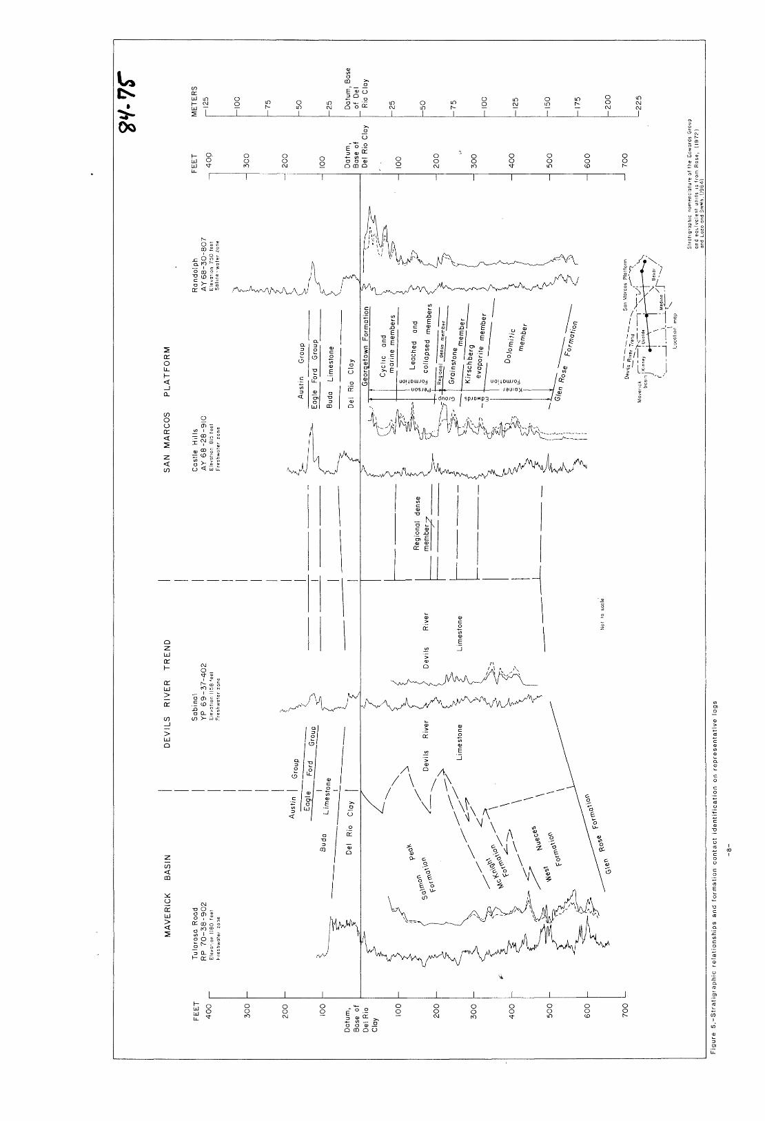
O O CD O 5- tt> D D
3 * 3 o' o J*
3 "9.
O o o~
3
-Person
Formation
ooETtoa>Q.
3CD3crCD
CDDo3~
CD Q.
D
3 D
3CD
3CD3
3 CTQ.CD
to
O
O
O
D3a.
o oOJ °
00 ^
m
o
O3
CO 2L
rn -< (/>5 T3 °
s g- OD 3" Z 3 <£> D
Om
33
<m
m
. S " oo 3 ^ I to
O
C/)> 2L
O O C/)
H n o
001 11 ro -n o o ro en
en . * D en o 0 o ?3 c3 r>
3 e
- m0 Hn m
Tl