ic 98, inactive and abandoned mine lands--lone jack … baker mining district, whatcom county,...
TRANSCRIPT

INACTIVE AND ABANDONEDMINE LANDS—
Lone Jack Mine,Mount Baker Mining District,
Whatcom County, Washington
by Fritz E. Wolff,Donald T. McKay, Jr.,
Matthew I. Brookshier,and David K. Norman
WASHINGTON
DIVISION OF GEOLOGY
AND EARTH RESOURCES
Information Circular 98March 2005
NA
TU
RA
LR
ES
OU
RC
ES
Whatcom County sitelocation


INACTIVE AND ABANDONEDMINE LANDS—
Lone Jack Mine,Mount Baker Mining District,
Whatcom County, Washington
by Fritz E. Wolff,Donald T. McKay, Jr.,
Matthew I. Brookshier,and David K. Norman
WASHINGTON
DIVISION OF GEOLOGY
AND EARTH RESOURCES
Information Circular 98March 2005

DISCLAIMER
Neither the State of Washington, nor any agency thereof, nor any of their em-ployees, makes any warranty, express or implied, or assumes any legal liabilityor responsibility for the accuracy, completeness, or usefulness of any informa-tion, apparatus, product, or process disclosed, or represents that its use wouldnot infringe privately owned rights. Reference herein to any specific commercialproduct, process, or service by trade name, trademark, manufacturer, or other-wise, does not necessarily constitute or imply its endorsement, recommendation,or favoring by the State of Washington or any agency thereof. The views andopinions of authors expressed herein do not necessarily state or reflect those ofthe State of Washington or any agency thereof.
WASHINGTON DEPARTMENT OF NATURAL RESOURCES
Doug Sutherland—Commissioner of Public Lands
DIVISION OF GEOLOGY AND EARTH RESOURCES
Ron Teissere—State GeologistDavid K. Norman—Assistant State Geologist
Washington Department of Natural ResourcesDivision of Geology and Earth ResourcesPO Box 47007Olympia, WA 98504-7007Phone: 360-902-1450Fax: 360-902-1785E-mail: [email protected]: http://www.dnr.wa.gov/geology/
Published in the United States of America
ii

Contents
Introduction . . . . . . . . . . . . . . . . . . . . . . . . . . . . . . . . . . . . . . . . . . . . 1
Summary . . . . . . . . . . . . . . . . . . . . . . . . . . . . . . . . . . . . . . . . . . . . . . 1
Ownership . . . . . . . . . . . . . . . . . . . . . . . . . . . . . . . . . . . . . . . . . . . . . 2
History . . . . . . . . . . . . . . . . . . . . . . . . . . . . . . . . . . . . . . . . . . . . . . . 2
Geologic setting . . . . . . . . . . . . . . . . . . . . . . . . . . . . . . . . . . . . . . . . . . 3
Materials and structures . . . . . . . . . . . . . . . . . . . . . . . . . . . . . . . . . . . . . . 5
Water . . . . . . . . . . . . . . . . . . . . . . . . . . . . . . . . . . . . . . . . . . . . . . . . 6
Milling operations . . . . . . . . . . . . . . . . . . . . . . . . . . . . . . . . . . . . . . . . . 6
Waste rock dumps . . . . . . . . . . . . . . . . . . . . . . . . . . . . . . . . . . . . . . . . . 6
General information . . . . . . . . . . . . . . . . . . . . . . . . . . . . . . . . . . . . . . . . 6
Mine operations data . . . . . . . . . . . . . . . . . . . . . . . . . . . . . . . . . . . . . . . 7
Physical attributes . . . . . . . . . . . . . . . . . . . . . . . . . . . . . . . . . . . . . . . . . 7
Vegetation . . . . . . . . . . . . . . . . . . . . . . . . . . . . . . . . . . . . . . . . . . . . . 8
Wildlife. . . . . . . . . . . . . . . . . . . . . . . . . . . . . . . . . . . . . . . . . . . . . . . 8
Water quality. . . . . . . . . . . . . . . . . . . . . . . . . . . . . . . . . . . . . . . . . . . . 8
Acknowledgments . . . . . . . . . . . . . . . . . . . . . . . . . . . . . . . . . . . . . . . . . 8
References cited . . . . . . . . . . . . . . . . . . . . . . . . . . . . . . . . . . . . . . . . . . 9
Appendix A. Methods and field equipment . . . . . . . . . . . . . . . . . . . . . . . . . . 10
Appendix B. Water quality standards for hardness dependent metals . . . . . . . . . . . . 11
FIGURES
Figure 1. Map showing location of Lone Jack mine in Whatcom Countyand a more detailed map of the mine site . . . . . . . . . . . . . . . . . . . . . . 1
Figure 2. Photo showing Lone Jack mine site overview . . . . . . . . . . . . . . . . . . . . 2
Figure 3. Photo showing exsolved quartz stringers in Darrington Phyllitetalus beneath Lone Jack portal . . . . . . . . . . . . . . . . . . . . . . . . . . . . 2
Figure 4. Schematic diagram showing patented claims, veins, and mine workings . . . . . 3
Figure 5. Photo showing Lone Jack portal area, south side of Bear Mountain . . . . . . . . 4
Figure 6. Photo showing Lone Jack vein portal . . . . . . . . . . . . . . . . . . . . . . . . . 4
Figure 7. Photo showing trail to Lone Jack portal, taken from Lulu portal . . . . . . . . . . 5
Figure 8. Photo showing Lulu portal entrance. . . . . . . . . . . . . . . . . . . . . . . . . . 5
Figure 9. Photo showing Whist vein outcrop and open stope . . . . . . . . . . . . . . . . . 6
Figure 10. Photo showing historic building site . . . . . . . . . . . . . . . . . . . . . . . . . 6
Figure 11. Photo showing combination bunkhouse/flotation mill circa 1922 . . . . . . . . . 7
Figure 12. Photo showing destroyed flotation mill and relocated bunkhouse . . . . . . . . . 7
TABLES
Table 1. Location and map information . . . . . . . . . . . . . . . . . . . . . . . . . . . . . 6
Table 2. Mine features . . . . . . . . . . . . . . . . . . . . . . . . . . . . . . . . . . . . . . 8
Table 3. Bat habitat information . . . . . . . . . . . . . . . . . . . . . . . . . . . . . . . . . 8
Table 4. Surface water field data . . . . . . . . . . . . . . . . . . . . . . . . . . . . . . . . . 8
Table 5. Surface water analysis and applicableWashington State Water Quality Standards . . . . . . . . . . . . . . . . . . . . . . 8
iii

iv

Inactive and Abandoned Mine Lands—Lone Jack Mine, Mount Baker Mining District,Whatcom County, Washington
Fritz E. Wolff, Donald T. McKay, Jr., Matthew I. Brookshier, and David K. Norman
Washington Division of Geology and Earth Resources
PO Box 47007; Olympia, WA 98504-7007
INTRODUCTION
The Washington State Department of Natural Resources(DNR), Division of Geology and Earth Resources (DGER) isbuilding a database and geographic information system (GIS)coverage of major mines in the state. Site characterizationwas initiated in 1999 (Norman, 2000). Work is funded throughinteragency grants from the U.S. Forest Service (USFS), Region6. Other agencies sharing in the project are the U.S. Bureau ofLand Management (BLM), the U.S. Environmental ProtectionAgency (EPA), and the Washington Department of Ecology(DOE).
More than 3800 mineral properties have been located in thestate during the last 100 years (Huntting, 1956). Many are unde-veloped prospects of little economic importance. Therefore, inconsidering the population to include in the Inactive andAbandoned Mine Lands (IAML) inventory, we have identifiedapproximately 60 sites that meet one of the following criteria:(a) more than 2000 feet of underground development, (b) morethan 10,000 tons of production, (c) location of a known mill siteor smelter. This subset of sites includes only metal mines no lon-ger in operation.
We have chosen to use the term inactive in the project’s titlein addition to the term abandoned because it more precisely de-scribes the land-use situa-tion regarding miningand avoids any politicalor legal implications ofsurrendering an interestto a property that may re-open with changes in eco-nomics, technology, orcommodity importance.
The IAML databasefocuses on physical char-acteristics and hazards(openings, structures,materials, and waste) andwater-related issues (acidmine drainage and/ormetals transport). Accu-rate location, currentownership, and land sta-tus information are alsoincluded. Acquisition ofthis information is a criti-cal first step in any sys-tematic approach to de-termine if remedial orreclamation activities arewarranted at a particular
mine. Reports such as this one provide documentation on minesor groups of mines within specific mining districts or counties.The IAML database may be viewed with assistance from DGERpersonnel. IAML reports are posted online at http://www.dnr.wa.gov/geology/pubs/.
SUMMARY
The three adits of the Lone Jack mine lie on the northeast andsoutheast slopes of a 6440-foot peak, known locally as BearMountain, inside the Mt. Baker Wilderness Area (Fig. 1). Theproperty consists of five patented claims currently owned byJohn Bullene, with various operating agreements made toDiversified Development Co. of Bellingham. The mine can bereached from Shuksan on State Route (SR) 542, by followingUSFS road 3065 (unmaintained) to Twin Lakes, then by dozertrail approximately 1.5 miles to the site (Fig. 2). U.S. Mint re-ceipts report 9463 ounces of gold and 1900 ounces of sil-ver from theLone Jack minefrom discoverythrough 1969.An additional
stamp mill prox.
Whist outcropBrooks-Willis mill
bunkhouseLulu portal
Lone Jack portalopen stope
Figure 1. Map showing the location of the Lone Jack mine in Whatcom County (top) and a more detailed map of
the mine site (bottom). Section lines are 1 mile apart.
Nooksack
River
20
RossLake
5
Mt. BakerBellingham
Lone Jackmine
1

900 ounces gold were produced circa 1992. Thetotal dollar value at the historic price of $20 perounce would have been approximately $192,000,including a small amount of silver; total value intoday’s precious metals market would exceed $4million. Using these data as the only reliable dataof record, and an approximate 10 to 15 thousandtons mined, the grade from all operations is in therange of 0.63 to 0.94 ounces per ton gold.
Three widely separated quartz fissure veins,containing free gold, tellurobismuthite, and ironsulfides, are visible on cliffs above the mineadits. Argillaceous Darrington Phyllite shotthrough with exsolved quartz stringers is perva-sive in the mine area. This material containssome sulfide mineralization, but is barren of goldcontent. The production veins are in massivequartz bodies that pinch and swell, ranging inthickness from 3 to 9 feet (Moen, 1969).
The mine has seen four discontinuous periodsof operation. The Mount Baker Mining Co.mined the Lone Jack lode from 1898 through1907, at which time the stamp mill burned, theaerial tramway collapsed, and operations ceased.Most of the mine’s precious metal output oc-curred during this period. Boundary Gold Co. de-veloped the Lulu lode in 1915 under lease. Operations ceased in1917. The Brooks-Willis Metals Co. leased the mine in 1917and exercised their option to purchase it in 1920. They erected aflotation mill, bunkhouse, sawmill, flume, and power plant(Lindstrom, 1941). The company mined ore from the Lulu lodein 1923. Evidence indicates that avalanches destroyed the flota-tion mill in the winter of 1924/1925, after which operationsceased (DGER mine files). In the early 1990s, Diversified De-velopment Co. drove development on the Whist vein for the firsttime. The mine has been idle since 1997 (Chris Secrist, Diversi-fied Development Co., written commun., 2001). Angles fromthe horizontal at the mine range from 30 to 90 degrees, and snowaccumulations of 10 to 20 feet are normal. The operations win-dow has been limited to mid-August through mid-October, de-pending on yearly snow accumulations at this altitude.
DGER personnel acquired field data at the site on August 8,2002, and September 29, 2004. The location is secs. 22 and 23,T40N R9E. The five patented claims were located from U.S.Land Monument No. 1, established in 1899 in conjunction withMineral Survey 534.
OWNERSHIP
The Lulu, Sidney, Whist, Jennie, and Lone Jack patented claimswere acquired by Harry Bullene circa 1940 as agent to the estateof Philip Brooks. Current owner is John Bullene, Kamiah,Idaho, with various operating agreements transferred to Diver-sified Development Co., Bellingham, Wash., in conjunctionwith permits and agreements with the U.S. Forest Service.
HISTORY
The property was discovered in 1897 by R. Lambert, J. Post, andL. Van Valkenburg, and originally known as the Post-Lambertmine. The following year H. Hahn and L. Friede of Portland,Oregon, purchased the property for $50,000 and formed the Mt.Baker Mining Co. The company winched a 10-stamp mill up toSkagway Pass and Twin Lakes using horses and a skid-mountedsteam engine. The mill was lowered down a switchback trail to
an area near West Fork Silesia Creek thought to be free of snow-slides. An aerial tramway erected in 1901 transported ore fromthe mine to the mill until 1907 when the mill burned (Lindstrom,1941).
2 INFORMATION CIRCULAR 98
Figure 2. Lone Jack mine site overview. 1, trail to Lone Jack portal; 2, flotation mill site,
next to talus; 3, Lulu portal; 4, Whist vein outcrop; 5, Lulu vein outcrop. View to the south.
Figure 3. Exsolved quartz stringers in Darrington Phyllite talus be-
neath Lone Jack portal. Pack for scale.
2
3
451

The mine lay idle until 1915 when the property was leasedby the Boundary Gold Co., which mined a few hundred tons ofore from the Lulu vein. In 1917, the Brooks-Willis Metals Co.purchased the property, continued mining, and built a 30-ton-per-day flotation mill on a slope immediately below the Luluportal. This mill, which also served as a boardinghouse, wassupplied with power from a diversion flume and hydroelectricplant several thousand feet below the mine on West Fork SilesiaCreek. A snow slide in the winter of 1924/25 destroyed the milland operations ceased. Harry Bullene, agent to the estate ofPhilip Brooks, acquired title to the property after Brooks’ deathin July 1940. Between 1925 and 1941, general improvementswere made to the mine, focused mainly on building a road fromSkagway Pass to the mine, a distance of about 1.5 miles. RobertJ. Cole leased the property from the Brooks estate in 1941 andperformed annual assessment work on the surrounding 15 un-patented claims until about 1970 (Garrett, 1967).
In August 1964, an Army demolition team and U.S. ForestService personnel detonated 300 cases of dynamite stored insidethe Lulu portal. Significant quantities of nitroglycerin had infil-trated the powder magazine’s floor. The explosion shot a ball of
fire 200 feet in the air but did little damage to the interior of theopening (DGER mine file).
From the inception of operations by Diversified Develop-ment Co. in 1992 until 1996, approximately 800 tons of ore perseason were shipped to the Asarco smelter in East Helena,Montana. A crosscut driven in 1995 intercepted the Whist veinfor the first time. Three hundred feet of drifting on the vein thefollowing season met with limited success. Since 1997, road andsafety maintenance have been carried out (Chris Secrist, writtencommun., 2001).
GEOLOGIC SETTING
The veins of the Lone Jack group occur as three disconnectedquartz fissure veins in pre-Jurassic black phyllitic schist, knownas the Darrington Phyllite. The schist contains numerous string-ers and lenses of exsolved quartz that formed during metamor-phism of the schist (Fig. 3). Except for small amounts of fine-grained pyrite, the exsolved quartz is barren. The gold-bearingvein quartz (see Fig. 9) is younger than the exsolved quartz andis probably related to Tertiary granodioritic intrusives in theLone Jack cirque (Christenson, 1986). Lindstrom (1941) identi-
IAML—LONE JACK MINE, WHATCOM COUNTY, WASHINGTON 3
Figure 4. Patented claims, veins, and mine workings (after Moen, 1969).

fied two distinct generations of quartz in the mineralized veins.The older quartz is white, coarse-grained, and allotriomorphic.Movement along the vein microbrecciated this material whichwas later recemented by an infusion of fine-grained second gen-eration quartz containing free gold and tellurobismuthite. Thegold and tellurobismuthite are mostly invisible to the unaidedeye; however, some parts of the vein contain pinhead-sizespecks of gold and platy flakes of tellurobismuthite up to 1/8inch in diameter.
The three veins at the Lone Jack mine may be faulted seg-ments of the same vein or separate and distinct entities emplacedunder similar conditions. However, the mineral paragenesis isidentical: pyrite�pyrrhotite�chalcopyrite�tellurobismuthiteand gold (probably simultaneously). Christenson (1986) de-scribes the Lone Jack vein as lying in a “relatively coherentblock of Darrington Phyllite between two [high-angle] shearzones, parallel to local planes of foliation.” Christenson’s mapindicates that the Whist vein lies “within the fault which trun-cates the eastern margin of the Lone Jack vein. The Whist ap-pears to pinch out upwards into this fault.” The relatively flat-lying Lulu vein has been juxtaposed during faulting, but alsoappears to have been emplaced parallel to local foliation(Christenson, 1986).
The mineralogy, paragenesis, gold content, and data fromfluid inclusion studies at the Lone Jack mine and the BoundaryRed Mountain mine are virtually identical (Chaney, 1992). TheBoundary Red Mountain mine is located 3 miles north of theLone Jack mine adjacent to the high-angle Shuksan fault.
OPENINGS
The relationship of the three veins to each other and the claimboundaries is shown in Figure 4. The Lone Jack portal is thesouthernmost opening. It is perched on the south side of BearMountain and intersects a massive quartz vein approximately 3feet thick, 300 feet from the portal (Figs. 5 and 6). The veinstrikes N10°W and dips 45 degrees to the west. From 1900 to1907, the Mount Baker Mining Co. operated stopes in this adit,dropping ore 2200 vertical feet to the aforementioned stampmill via an aerial tramway. No further mining of any extent oc-curred in this opening after 1907. Grant (1985) felt that most ofwhat was minable from this vein had been extracted. His reportindicates that the vein appears to pinch out at the south end andis truncated 500 feet north at a fault where the stope opens onto avertical cliff. An exploratory drift angles 250 feet to the north-west from this termination. It is largely in barren talc schist. Thegold content in Grant’s 35 samples, taken from the stope, rangefrom 0.01 ounce per ton to 2.41 ounces per ton (Christenson,1986). The Lone Jack adit can only be reached from the Luluportal by following a steep, barely recognizable trail leadingsoutherly through the avalanche chute and notch shown in theupper center of Figure 7. The stope is open to the surface 300feet southwest of the adit at 5600 feet elevation. A large blue ar-row spray-painted above the opening is visible above the trail.Safety at this point requires technical rock climbing equipmentand skills.
The Lulu vein crops out on the north side of Bear Mountainin a cliff. It strikes generally east and dips 8 to 60 degrees south,varying in width from several inches to 9 feet. The portal is open
4 INFORMATION CIRCULAR 98
1
2
3
Figure 5. (top right) Lone Jack portal area, south side of Bear Moun-
tain. 1, Lone Jack vein portal (hidden); 2, waste rock dump; 3, access
trail. View to the north.
Figure 6. (bottom right) Lone Jack vein portal.
and appears stable (Fig. 8). The portal isY-shaped with a pillar in the center. A bit-sharpening forge and blacksmith shopwere located at this point. A clear streamdischarged approximately 10 gallons perminute from the portal in August of2003.
The 190 pounds of ore Lindstrom(1941) took from the Lulu workings forlaboratory flotation tests averaged 0.33ounce of gold per ton. A map in Grant’s1985 report notes that samples takenfrom the south extension of the stope are50 percent phyllite and 50 percent quartz,which indicates that the Lulu vein beginsto lose structural integrity or disseminateat this point.
The Whist vein had no developmentdone on it prior to a new portal driven byDiversified Development Co. beginningaround 1992 (DGER mine file). Thisvein crops out 800 feet northwest of theLulu portal, several hundred feet higherin elevation. A dozer road connects thetwo openings. The Whist vein standsclose to vertical and strikes S10°W. It isthe mine’s northernmost geologic structure. It is exposed on thesurface for 80 feet and then disappears under talus and verticalcliffs. In 1995 the company intersected the vein from a new aditbelow the outcrop. Some success was achieved in terms of goldvalues in 300 feet of drifting along the vein. A snowfield ob-scured the Whist portal on August 8, 2002. Mining has exposedthe outcrop to the surface for a distance of approximately 40feet. Efforts have been made to close the opening to public entryby covering it with chain link fencing and a collection of boardsand timbers (Fig. 9). Crossland (1923) reported assay values of0.8 to 1.3 ounces per ton gold taken at this point.
An overall view of 80 samples taken by Grant in 1985 cor-roborates precisely with the experience of previous operations:namely, that the gold is very rich in localized areas and impover-ished in others separated by only a few feet. The gold is found inthe free state, often accompanied by concentrations of telluro-bismuthite. Pyrite and pyrrhotite are also present in the vein(s)but do not appear to contain dissolved gold. Samples from theLone Jack stope showed values ranging from 0.01 to 2.41ounces gold per ton; from the Lulu stope, values of 0.02 to 1.3ounces per ton.
MATERIALS AND STRUCTURES
Two steel containers, possibly for storing tools and/or powder,are present. Several hundred feet of 4-inch aluminum pipe werecached near the Lulu portal. A rock retaining wall indicates abuilding site of unknown provenance adjacent to the access roadat elevation 4520 feet (Fig. 10).
Crossland’s report (1923) indicates the Brooks-Willis oper-ation constructed a combination bunkhouse/flotation mill (Fig.11) on the steep slope below the Lulu portal and a sawmill andpower plant on West Fork Silesia Creek. His report verifies thatthese structures were standing and in good condition in Novem-ber of that year. A photo taken some years later (exact date un-known) shows the mill destroyed by avalanche and the relocatedbunkhouse intact (Fig. 12).
Lindstrom (1941) identified the location of the stamp mill,flotation mill, and bunkhouse in a photograph taken from point6521 in the Skagit Range immediately east of the mine. The ap-proximate locations are shown in Figures 1 and 2. Remains of
IAML—LONE JACK MINE, WHATCOM COUNTY, WASHINGTON 5
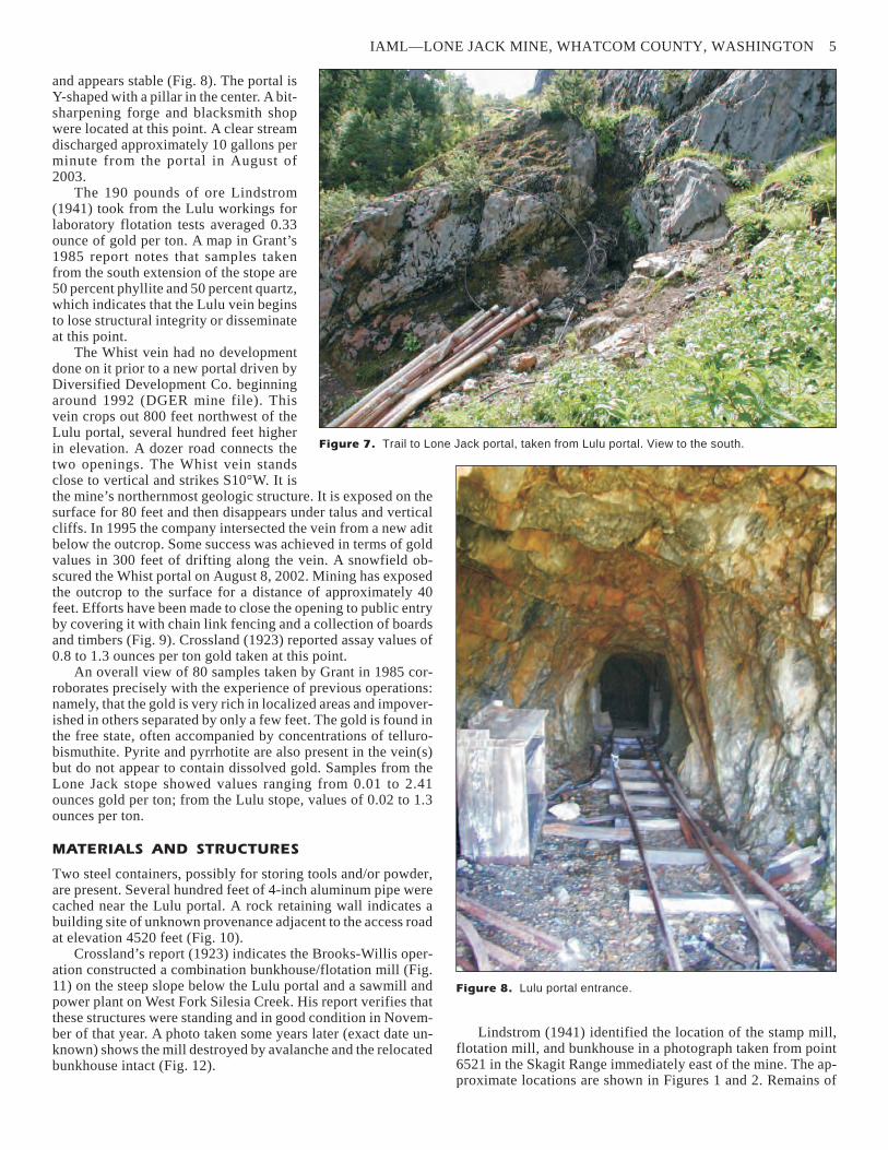
Figure 7. Trail to Lone Jack portal, taken from Lulu portal. View to the south.
Figure 8. Lulu portal entrance.

the bunkhouse were still observable in 1941 (Lindstrom) and1965 (Garrett, 1967), but no trace of any structures were ob-served by us or by Christenson in 1985.
WATER
Water discharged from the Lulu portal at approximately 10 gal-lons per minute in August of 2002. The pH measured 5 and theconductivity reading was 35 �S/cm. Analyses for arsenic, cop-per, lead, and zinc were below the Washington State require-ments (see Table 5). A trickle of water was present in the LoneJack portal in September of 2004. The pH was 9.4 and the con-ductivity 160 �S/cm. The water at both locations was clear.
MILLING OPERATIONS
Lindstrom (1941) reported that two mills were built at the LoneJack mine. The first, a 10-stamp mill that was later enlarged to15, was located on a bench near West Fork Silesia Creek, 4000feet distant from the mine and 2800 feet lower in elevation. Thismill was built in 1900 and fed by a 50-ton aerial tramway fromthe Lone Jack portal. It was destroyed by fire in 1907. Recordsindicate that a 10-foot Lane grinding mill replaced the stamps in1915, probably at the same location. Mercury amalgamationwas used to recover free-milling gold. Brooks-Willis Metals Co.constructed the second mill in 1922/23. It contained primaryand secondary crushers rated at 30 tons/day, flotation cells, andamalgamation plates (Katz, 1927). No mill tailings can be ob-served on color aerial photographs. Tailings from the stamp millwere probably discharged into West Fork Silesia Creek andhave long since disappeared. Records indicate that the flotationmill may have operated only during the summer of 1924, the lastyear of mining by Brooks-Willis (DGER mine files). If so, thevolume of tailings generated would have been very small.Lindstrom (1941) reported “The mine has notbeen operated since 1924.…After operationsceased, the mill built by Brooks and Willis wasdestroyed by a snow slide.”
WASTE ROCK DUMPS
Waste rock dumps of approximately 500 cubicyards lie near the Whist portal and outcrop. Ahand-picked sample of quartz containing majorpyrrhotite was obtained near the Whist outcrop.It analyzed equal amounts of bismuth and tellu-rium; gold was not detected above the analyses’practical quantitation limit of 9.9 milligrams/ki-logram (0.29 ounce/ton). Waste rock below theLone Jack portal is predominantly unmineralizeddevelopment rock with slight iron staining.Waste rock from the Lulu workings has sliddown a 50-degree slope and is covered with slidealder and brush.
GENERAL INFORMATION
Names: Lone Jack; Post-Lambert
MAS/MILS sequence number: 0530730073
Access: four-wheel drive vehicle and hike
Status of mining activity: none
Claim status:
The property consists of five patented claims(Lone Jack, Whist, Lulu, Jennie, and Sidney)
6 INFORMATION CIRCULAR 98
Figure 10. Historic building site.
Mine
property County Location
Decimal
latitude
Decimal
longitude
1:24,000
quad.
1:100,000
quad.
Lone Jack Whatcom sec. 22, T40N R9Eunsurveyed
48.945092 121.61956 Mt. Sefrit Mt. Baker
Table 1. Location and map information
Figure 9. Whist vein outcrop and open stope.

surveyed in 1899 under Mineral Survey 534.U.S. Land Monument No. 1 is located approxi-mately 1921 feet S54°E from the Lone Jackportal.
Current ownership: John Bullene, Kamiah,Idaho. Operating agreement(s) with DiversifiedDevelopment Co., Bellingham, Wash., and theU.S. Forest Service.
Surrounding land status: Mt. Baker–Snoqualmie National Forest, Mt. BakerWilderness Area
Location and map information: see Table 1
Directions: Follow Mt. Baker Highway (SR542) to a turnoff on a graveled road 11 miles eastof Glacier, Wash. Follow USFS road 3065 up theSwamp Creek drainage a distance of about 3miles, at which point four-wheel drive is re-quired just prior to reaching Twin Lakes. Twohiking routes can be taken from Skagway Pass adjacent to thelakes: (1) a 10-foot-wide dozer trail proceeds northeasterly pasta locked gate and contours around the mountain in a southerlydirection, reaching an area near the Lulu portal at a distance ofabout 2 miles. This is the easiest route. (2) An obvious foot traildeparts Skagway Pass heading south. The trail maintains an alti-tude of about 5000 feet for a distance of 1.5 miles before reach-ing a permanent snowfield adjacent to the Whist vein openingdescribed above. The snowfield can be crossed with care. Cram-pons and ice axes may be required.
MINE OPERATIONS DATA
Type of mine: underground
Commodities mined: gold, minor silver
Geologic setting: quartz fissure veins in metasedimentaryrocks of the Jurassic–Cretaceous Darrington Phyllite. The depo-sit is 2 miles east of the west boundary of the Chilliwack batho-lith (Moen, 1969).
Ore minerals: gold, tellurobismuthite (Bi2Te3); may containdissolved precious metals
Non-ore minerals: pyrite, pyrrhotite
Host rock: Darrington Phyllite of the Shuksan MetamorphicSuite
Period of production: 1900–1907; 1916–1917; 1922–1924;1991–1996 (approximate)
Development: in excess of 2300 feet of drifts and raises, plusstoping volumes (Moen, 1969)
Production: 10,370 ounces of gold and 2000 ounces of silverhave been documented; actual production may be greater
Mill data: 10-stamp mill (increased to 15-stamp), burned1907; 30 ton/day flotation mill destroyed by snowslides
PHYSICAL ATTRIBUTES
Features: see Table 2
IAML—LONE JACK MINE, WHATCOM COUNTY, WASHINGTON 7
Figure 12. Flotation mill (arrow) destroyed by avalanche in fore-
ground, relocated bunkhouse in background. Approximate date post-
1924. Note trace of tramway cables in center. Photo courtesy of P.
Jeffcott Collection.
Figure 11. Combination bunkhouse/flotation mill
constructed circa 1922 by Brooks-Willis Metals Co.
Cutouts for (relocated) bunkhouse foundation in back-
ground. Photo courtesy of Whatcom County Museum,
Bellingham, Wash.

Materials: several hundred feet of 12-pound steel mine rail,>200 feet 4-inch aluminum air pipe
Machinery: none
Structures: two steel storage containers
Waste rock dumps, tailings impoundments, highwalls, orpit walls: no tailings; minimal waste rock dumps oppositeportals
Analysis of waste rock dumps: quartz grab sample contain-ing pyrrhotite analyzed 50.4 milligrams/kilogram (mg/kg)bismuth, 48.2 mg/kg tellurium; gold not detected above 9.9mg/kg, the practical quantitation limit of the method used
Waste rock, tailings, or dumps in excess of 500 cubicyards: three
Reclamation activity: none
VEGETATION
Cascade alpine zone grasses, wild-flowers, shrubs, and alpine fir observed.
WILDLIFE
The mine is located within a suspectedspotted owl management area, but insuf-ficient data is available for designationas an established territory (WDFW,2004). See Table 3 for bat habitat infor-mation.
WATER QUALITY
Surface waters observed: West ForkSilesia Creek
Proximity to surface waters: 4000 feet
Domestic use: none
Acid mine drainage or staining: none
Water field data: see Tables 4 and 5
Surface water migration: none
ACKNOWLEDGMENTS
The authors thank our editors Jari Roloff and Karen Meyers forhelpful suggestions on the layout and content of this report. Ad-ditional appreciation goes to USFS Region 6 personnel BobFujimoto and Dick Sawaya. Darrell Jacobson and Phil Wood-house of Northwest Underground Explorations contributed his-toric photos.
8 INFORMATION CIRCULAR 98
PART 1: ANALYSIS BY USEPA METHOD 6020, INDUCTIVELY COUPLED PLASMA/MASS SPECTROMETRY
Sample location Arsenic Cadmium** Copper** Iron Lead** Mercury Zinc** Hardness
Lulu portal <1.5 – – – 1.6 – – – <0.5 – – – 6.4 11
PART 2: APPLICABLE WASHINGTON STATE WATER QUALITY STANDARDS
Type of standards
(applicable Washington Administrative Code) Arsenic Cadmium Copper Iron Lead Mercury Zinc Hardness
Surface water standards (WAC 173-201A, Standardfor aquatic life in surface freshwater, chronic levelmaximums at 100 mg/L hardness)
190 ** ** none ** 0.012 ** 100
Ground water standards (WAC 246-290,Washington State Department of Health, standardsfor ground water, domestic consumption)
50.0 none 1300 300(cosmetic
only)
15 2.0 5000 – – –
Table 5. Surface water analysis. Metal concentrations are in micrograms/liter ( �g/L); hardness is in milligrams/liter (mg/L); USEPA, U.S. Environ-
mental Protection Agency; – – –, no data; **, standards for these metals are hardness dependent. Conversion formulae are shown in http://
www.ecy.wa.gov/pubs/wac173201a.pdf. Standards calculated for hardness values specific to Part 1 below are shown in Appendix B
Opening Aspect
Air temp. (°F)
at portal
Air flow:
exhaust
Air flow:
intake
Multiple
interconnected
openings
Bats or bat
evidence
Lulu Portal NE 70 yes no yes no
Lone Jack portal E 55 yes no yes no
Table 3. Bat habitat information
Description Flow (gpm) Conductivity (�S/cm) pH Bed color Temp (°F)
Lulu portal discharge ~10 35 5 natural 51
Lone Jack portal discharge ~2* 160 9.4 natural 44
Table 4. Surface water field data. *, taken at lowest flow time of year
Description Condition
Fenced
(yes/no)
Length
(feet)
Width
(feet)
Height/depth
(feet)
True
bearing
Elev.
(feet)
Decimal
latitude
Decimal
longitude
Whist outcrop open to the surface, precarious exposure,chain link fence being dragged down 60
degree face
no 300** 3 7 N10E 4880 48.94587 121.62304
Lulu portal open, stable appearance no 680* 6 7 N45E 4680 48.94516 121.62009
Lone Jack portal open, stable appearance; stope partlycaved and open to surface at two locations
no 300* 5 7 N10W 5520 48.94345 121.6229
Table 2. Mine features. *, data from DGER mine map file; **, Chris Secrist, Diversified Development Co., written commun., 2001

REFERENCES CITED
Chaney, R. L., 1992, A study of gold mineralization at the BoundaryRed Mountain mine, Whatcom County, Washington: WesternWashington University Master of Science thesis, 108 p.
Christenson, L. G., 1986, Genesis of gold mineralization in the LoneJack mine area, Mt. Baker mining district, Washington: WesternWashington University Master of Science thesis, 87 p., 2 plates.
Crossland, F. J., 1923, Report on Lone Jack mine, Bear Mountain,Mount Baker Mining District, Whatcom County, Washington,U.S.A.: unpublished report from Francis J. Crossland, Mining En-gineer & Geologist, to Phillip R. Brooks, Esq., Vancouver, B.C.,22 p. [DGER mine files]
Garrett, C. R., 1967, Report of mineral examination, Lone Jack mine,2810 - mining claims, Mt. Baker N.F., Cole, Robert J. [claimant],P.L. 167, job no. 34: United State Department of Agriculture For-est Service unpublished report, 17 p.
Grant, R. A., 1985, The Lone Jack property: S. A. Collender Co.[Langley, Wash.] unpublished report, 13 p.
Huntting, M. T., 1956, Inventory of Washington minerals; Part II—Metallic minerals: Washington Division of Mines and GeologyBulletin 37, Part II, 2 v.
Katz, F. J., 1927, Mineral resources of the United States 1923; Part1—Metals: U.S. Geological Survey, 653 p.
Lindstrom, P. M., 1941, The Lone Jack gold mine, Whatcom County:University of Washington Bachelor of Science thesis, 71 p.,4 plates.
Moen, W. S., 1969, Mines and mineral deposits of Whatcom County,Washington: Washington Division of Mines and Geology Bulle-tin 57, 134 p., 14 plates.
Norman, D. K., 2000, Washington’s inactive and abandoned metalmine inventory and database: Washington Geology, v. 28, no. 1/2, p. 16-18.
Washington Department of Fish and Wildlife (WDFW), 2004, Habi-tats and species map in the vicinity of T40R09E section 23: Wash-ington Department of Fish and Wildlife digital report [generatedOctober 28, 2004], 1 plate, scale 1:24,000, 2 p. text. �
IAML—LONE JACK MINE, WHATCOM COUNTY, WASHINGTON 9

Appendix A. Methods and field equipment
METHODS
We recorded observations and measurements in the field. Lon-gitude and latitude were recorded with a global positioning sys-tem (GPS) unit in NAD83 decimal degree format. Literature re-search provided data on underground development, which wasverified in the field when possible.
Soil samples from dumps or tailings were taken from subsur-face material and double bagged in polyethylene. Chain of cus-tody was maintained.
Soil samples were analyzed for the metals listed in this re-port by inductively coupled plasma/mass spectrometry (ICP/MS) following USEPA (U.S. Environmental ProtectionAgency) Method 6010. Holding times for the metals of interestwere observed. Instrument calibration was performed beforeeach analytical run and checked by standards and blanks. Matrixspike and matrix spike duplicates were performed with each set.
FIELD EQUIPMENT
barometric altimeterbinocularsdigital cameraflashlightGarmin GPS III+, handheld GPS unitHanna Instruments DiST WP-3 digital conductivity meter
and calibration solutionlitmus paper, range 0–14, and 4–7Oakton digital pH meterOakton digital electrical conductivity meterTaylor model 9841 digital thermometer
10

Appendix B. Water quality standards forhardness dependent metals
Conversion formulae are given in WAC 173-201A at http://www.ecy.wa.gov/pubs/wac173201a.pdf.Chronic standard in micrograms/liter (�g/L)
Sample location Hardness (mg/L) Cd (�g/L) Cu (�g/L) Pb (�g/L) Zn (�g/L)
Lulu portal discharge 11 0.20 1.72 0.21 16.10
11