i35 capital area improvement program...
TRANSCRIPT
IImprovement Program(Mobility35)
Corridor Implementation Plan
SH
WilliamsonApril 2015
I-35 Capital Area Improvement Program(Mobility35)
Corridor Implementation Plan
SH 130
WilliamsonApril 2015
35 Capital Area Improvement Program(Mobility35)
Corridor Implementation Plan
30 to RM 1431
Williamson County
35 Capital Area Improvement Program(Mobility35)
Corridor Implementation Plan
RM 1431
County, Texas
35 Capital Area Improvement Program
Corridor Implementation Plan
, Texas
35 Capital Area Improvement Program
Corridor Implementation Plan
Improvement Program


Table of Contents
1.01.01.01.0
2.02.02.02.0
3.03.03.03.0
4.04.04.04.0
5.05.05.05.0
6.06.06.06.0
7.07.07.07.0
8.08.08.08.0
Table of Contents
1.01.01.01.0 Introduction and BIntroduction and BIntroduction and BIntroduction and B
Mobility351.1
2.02.02.02.0 Need for Improvement and Contributing FactorsNeed for Improvement and Contributing FactorsNeed for Improvement and Contributing FactorsNeed for Improvement and Contributing Factors
Population and Employment2.1
2.2 Corridor Traffic
3.03.03.03.0 Previous Studies and Planning EffortsPrevious Studies and Planning EffortsPrevious Studies and Planning EffortsPrevious Studies and Planning Efforts
3.1 I
Williamson County Improvement Efforts3.2
4.04.04.04.0 Implementation Plan DevelopmentImplementation Plan DevelopmentImplementation Plan DevelopmentImplementation Plan Development
Definition of Corridor Planning Area4.1
Phases of Project Development4.2
Program Objective4.3
4.4 Public and Agency Involvement
Tech4.5
5.05.05.05.0 Overarching Improvement ConceptsOverarching Improvement ConceptsOverarching Improvement ConceptsOverarching Improvement Concepts
Future Transportation Corridor (FTC)5.1
Corridor Access Improvements5.2
Conventional Intersection5.3
Diverging Di5.4
Roundabout5.5
Continuous Flow Intersection5.6
Median U5.7
Travel Demand Management5.8
Integrated Corridor Management5.9
6.06.06.06.0 Recommended Program of ProjectsRecommended Program of ProjectsRecommended Program of ProjectsRecommended Program of Projects
6.1 Assumptions and Limitations
6.2 Williamson County S
6.3 Current Williamson County Construction Projects
6.4 Segments W1
7.07.07.07.0 Other Mobility35 InitiativesOther Mobility35 InitiativesOther Mobility35 InitiativesOther Mobility35 Initiatives
7.1 Regional Projects
Integrated Corridor Ma7.2
Trip Reduction7.3
Non7.4
8.08.08.08.0 Preliminary Project Costs and FundingPreliminary Project Costs and FundingPreliminary Project Costs and FundingPreliminary Project Costs and Funding
Williamson County8.1
8.2 Project Funding
Table of Contents
Introduction and BIntroduction and BIntroduction and BIntroduction and B
Mobility35 ................................
Need for Improvement and Contributing FactorsNeed for Improvement and Contributing FactorsNeed for Improvement and Contributing FactorsNeed for Improvement and Contributing Factors
Population and Employment
Corridor Traffic
Previous Studies and Planning EffortsPrevious Studies and Planning EffortsPrevious Studies and Planning EffortsPrevious Studies and Planning Efforts
I-35 Corridor Advisory Committee Plan (My 35)
Williamson County Improvement Efforts
Implementation Plan DevelopmentImplementation Plan DevelopmentImplementation Plan DevelopmentImplementation Plan Development
Definition of Corridor Planning Area
Phases of Project Development
Program Objective
Public and Agency Involvement
Technical Concept Development
Overarching Improvement ConceptsOverarching Improvement ConceptsOverarching Improvement ConceptsOverarching Improvement Concepts
Future Transportation Corridor (FTC)
Corridor Access Improvements
Conventional Intersection
Diverging Di
Roundabout
Continuous Flow Intersection
Median U-turn
Travel Demand Management
Integrated Corridor Management
Recommended Program of ProjectsRecommended Program of ProjectsRecommended Program of ProjectsRecommended Program of Projects
Assumptions and Limitations
Williamson County S
Current Williamson County Construction Projects
Segments W1
Other Mobility35 InitiativesOther Mobility35 InitiativesOther Mobility35 InitiativesOther Mobility35 Initiatives
Regional Projects
Integrated Corridor Ma
Trip Reduction
Non-motorized Travel Considerations
Preliminary Project Costs and FundingPreliminary Project Costs and FundingPreliminary Project Costs and FundingPreliminary Project Costs and Funding
Williamson County
Project Funding
Introduction and BIntroduction and BIntroduction and BIntroduction and Backgroundackgroundackgroundackground
................................
Need for Improvement and Contributing FactorsNeed for Improvement and Contributing FactorsNeed for Improvement and Contributing FactorsNeed for Improvement and Contributing Factors
Population and Employment
Corridor Traffic ................................
Previous Studies and Planning EffortsPrevious Studies and Planning EffortsPrevious Studies and Planning EffortsPrevious Studies and Planning Efforts
35 Corridor Advisory Committee Plan (My 35)
Williamson County Improvement Efforts
Implementation Plan DevelopmentImplementation Plan DevelopmentImplementation Plan DevelopmentImplementation Plan Development
Definition of Corridor Planning Area
Phases of Project Development
Program Objective ................................
Public and Agency Involvement
nical Concept Development
Overarching Improvement ConceptsOverarching Improvement ConceptsOverarching Improvement ConceptsOverarching Improvement Concepts
Future Transportation Corridor (FTC)
Corridor Access Improvements
Conventional Intersection
Diverging Diamond Intersection
Roundabout ................................
Continuous Flow Intersection
turn ................................
Travel Demand Management
Integrated Corridor Management
Recommended Program of ProjectsRecommended Program of ProjectsRecommended Program of ProjectsRecommended Program of Projects
Assumptions and Limitations
Williamson County Segments
Current Williamson County Construction Projects
Segments W1 – W3 Program of Projects
Other Mobility35 InitiativesOther Mobility35 InitiativesOther Mobility35 InitiativesOther Mobility35 Initiatives ................................................................................................................................
Regional Projects ................................
Integrated Corridor Management Study and Development Strategy
Trip Reduction ................................
motorized Travel Considerations
Preliminary Project Costs and FundingPreliminary Project Costs and FundingPreliminary Project Costs and FundingPreliminary Project Costs and Funding
Williamson County ................................
Project Funding ................................
I-35 Capital Area Improvement Program
ackgroundackgroundackgroundackground ................................................................................................................................
................................................................
Need for Improvement and Contributing FactorsNeed for Improvement and Contributing FactorsNeed for Improvement and Contributing FactorsNeed for Improvement and Contributing Factors
Population and Employment ................................
................................................................
Previous Studies and Planning EffortsPrevious Studies and Planning EffortsPrevious Studies and Planning EffortsPrevious Studies and Planning Efforts ................................................................................................................................
35 Corridor Advisory Committee Plan (My 35)
Williamson County Improvement Efforts
Implementation Plan DevelopmentImplementation Plan DevelopmentImplementation Plan DevelopmentImplementation Plan Development ................................................................................................................................
Definition of Corridor Planning Area
Phases of Project Development ................................
................................
Public and Agency Involvement ................................
nical Concept Development ................................
Overarching Improvement ConceptsOverarching Improvement ConceptsOverarching Improvement ConceptsOverarching Improvement Concepts ................................................................................................................................
Future Transportation Corridor (FTC)
Corridor Access Improvements ................................
Conventional Intersection ................................
amond Intersection ................................
................................................................
Continuous Flow Intersection ................................
................................................................
Travel Demand Management ................................
Integrated Corridor Management ................................
Recommended Program of ProjectsRecommended Program of ProjectsRecommended Program of ProjectsRecommended Program of Projects ................................................................................................................................
Assumptions and Limitations ................................
egments ................................
Current Williamson County Construction Projects
Program of Projects
................................................................................................................................
................................
nagement Study and Development Strategy
................................................................
motorized Travel Considerations
Preliminary Project Costs and FundingPreliminary Project Costs and FundingPreliminary Project Costs and FundingPreliminary Project Costs and Funding ................................................................................................................................
................................
................................
35 Capital Area Improvement Program
................................................................................................................................................................................................................................................................
................................
Need for Improvement and Contributing FactorsNeed for Improvement and Contributing FactorsNeed for Improvement and Contributing FactorsNeed for Improvement and Contributing Factors ................................................................................................................................
................................
................................
................................................................................................................................
35 Corridor Advisory Committee Plan (My 35)
Williamson County Improvement Efforts................................
................................................................................................................................
Definition of Corridor Planning Area ................................
................................
................................................................
................................
................................
................................................................................................................................
Future Transportation Corridor (FTC) ................................
................................
................................................................
................................
................................
................................
................................
................................
................................
................................................................................................................................
................................
................................
Current Williamson County Construction Projects
Program of Projects ................................
................................................................................................................................................................................................................................................................
................................................................
nagement Study and Development Strategy
................................
motorized Travel Considerations ................................
................................................................................................................................
................................................................
................................................................
35 Capital Area Improvement Program
................................................................................................................................
................................................................
................................................................................................................................
................................................................
................................................................
................................................................................................................................................................................................................................................................
35 Corridor Advisory Committee Plan (My 35) ................................
................................
................................................................................................................................................................................................................................................................
................................................................
................................................................
................................................................
................................................................
................................................................
................................................................................................................................................................................................................................................................
................................................................
................................................................
................................
................................................................
................................................................
................................................................
................................................................
................................................................
................................................................
................................................................................................................................................................................................................................................................
................................................................
................................................................
Current Williamson County Construction Projects ................................
................................
................................................................................................................................
................................................................
nagement Study and Development Strategy
................................................................
................................................................
................................................................................................................................................................................................................................................................
...............................................................
................................................................
35 Capital Area Improvement Program - Corridor Implementation Plan, April 2015
....................................................................................................................................................................................................................
..............................................
........................................................................................................................................................................................................................
.................................................
................................
................................................................................................................................
..................................................
..............................................................
................................................................................................................................
................................
................................
................................
................................
................................
................................................................................................................................
................................
................................
...................................................
................................
................................
.............................................
................................
.............................................
................................
................................................................................................................................
.............................................
.............................................
............................................
...........................................................
............................................................................................................................................................................................................................
................................
nagement Study and Development Strategy...............
................................
................................
................................................................................................................................
...............................
................................
Corridor Implementation Plan, April 2015
.................................................................................... 1111
.............. 1
........................................................................................ 2222
................. 2
....................................... 3
............................................................................................................................................................ 4444
.................. 5
.............................. 5
................................................................................................................................................................................ 6666
..................................... 6
........................................... 6
................................. 6
............................................ 7
.......................................... 9
................................................................................................................................................................ 11111111
................................. 11
........................................... 12
................... 13
......................................... 13
......................................... 14
............. 14
...................................... 15
............. 15
....................................... 15
................................................................................................................................................................ 17171717
............. 17
............. 17
............ 18
........................... 18
............................................................................................ 25252525
................................. 25
............... 25
...................................... 25
................................ 26
................................................................................................................................................ 27272727
............................... 27
.................................... 29
Corridor Implementation Plan, April 2015 i

9.09.09.09.0
10.010.010.010.0
Appendices
Appendix A:
Appendix B:
Appendix C:
Acronyms
AADT
ATIS
ATMS
CAC
CAIP
CAMPO
CCTV
C
CFI
CIP
CSC
CTECC
CTRMA
DC
DDI
DMS
FEMA
FHWA
FTC
HOV
ICM
ITS
MUT
NAFTA
P3
PS&E
RIF
RM
8.3 Potential Funding Sources
9.09.09.09.0 Next StepsNext StepsNext StepsNext Steps
10.010.010.010.0 ReferenReferenReferenReferen
Appendices
Appendix A:
Appendix B:
Appendix C:
Acronyms
AADT
ATIS
ATMS
CAC
CAIP
CAMPO
CCTV
C-D
CFI
CIP
CSC
CTECC
CTRMA
DC
DDI
DMS
FEMA
FHWA
FTC
HOV
ICM
ITS
MUT
NAFTA
P3
PS&E
RIF
RM
Potential Funding Sources
Next StepsNext StepsNext StepsNext Steps ................................................................................................................................
ReferenReferenReferenReferencescescesces ................................................................................................................................
Appendices
Refined Improvement Concepts
Project Development Summary Sheets
Preliminary Cost Estimates
Annual Average Daily Traffic
Advanced Traveler Informati
Advanced Traffic Management System
Corridor Advisory Committee
Capital Area Improvement Program
Capital Area Metropolitan Planning Organization
Closed Circuit Television
Collector Distributor
Continuous Flow Inter
Capital Improvement Plan
Corridor Segment Committee
Combined Transportation, Emergency & Communications Center
Central Texas Regional Mobility Authority
Direct Connector
Diverging Diamond Interchange
Dynamic Message S
Federal Emergency Management Agency
Federal Highway Administration
Future Transportation Corridor
High Occupancy Vehicle
Integrated Corridor Management
Intelligent Transportation Systems
Median U
North American
Public Private Partnership
Plans, Specifications and Estimates
Regional Infrastructure Fund
Ranch to Market
Potential Funding Sources
................................................................................................................................
................................................................................................................................
Refined Improvement Concepts
Project Development Summary Sheets
Preliminary Cost Estimates
Annual Average Daily Traffic
Advanced Traveler Informati
Advanced Traffic Management System
Corridor Advisory Committee
Capital Area Improvement Program
Capital Area Metropolitan Planning Organization
Closed Circuit Television
Collector Distributor
Continuous Flow Inter
Capital Improvement Plan
Corridor Segment Committee
Combined Transportation, Emergency & Communications Center
Central Texas Regional Mobility Authority
Direct Connector
Diverging Diamond Interchange
Dynamic Message Sign
Federal Emergency Management Agency
Federal Highway Administration
Future Transportation Corridor
High Occupancy Vehicle
Integrated Corridor Management
Intelligent Transportation Systems
Median U-turn
North American Free Trade Agreement
Public Private Partnership
Plans, Specifications and Estimates
Regional Infrastructure Fund
Ranch to Market
I-35 Capital Area Improvement Program
Potential Funding Sources ................................
................................................................................................................................................................................................................................................................
................................................................................................................................................................................................................................................................
Refined Improvement Concepts
Project Development Summary Sheets
Preliminary Cost Estimates
Annual Average Daily Traffic
Advanced Traveler Information System
Advanced Traffic Management System
Corridor Advisory Committee
Capital Area Improvement Program
Capital Area Metropolitan Planning Organization
Closed Circuit Television
Continuous Flow Intersection
Capital Improvement Plan
Corridor Segment Committee
Combined Transportation, Emergency & Communications Center
Central Texas Regional Mobility Authority
Diverging Diamond Interchange
ign
Federal Emergency Management Agency
Federal Highway Administration
Future Transportation Corridor
High Occupancy Vehicle
Integrated Corridor Management
Intelligent Transportation Systems
Free Trade Agreement
Public Private Partnership
Plans, Specifications and Estimates
Regional Infrastructure Fund
35 Capital Area Improvement Program
................................................................
................................................................................................................................................................................................................................................................
................................................................................................................................
Project Development Summary Sheets
on System
Advanced Traffic Management System
Capital Area Improvement Program
Capital Area Metropolitan Planning Organization
Combined Transportation, Emergency & Communications Center
Central Texas Regional Mobility Authority
Federal Emergency Management Agency
Integrated Corridor Management
Intelligent Transportation Systems
Free Trade Agreement
Plans, Specifications and Estimates
35 Capital Area Improvement Program
................................
................................................................................................................................
................................................................................................................................................................................................................................................................
Capital Area Metropolitan Planning Organization
Combined Transportation, Emergency & Communications Center
35 Capital Area Improvement Program - Corridor Implementation Plan, April 2015
..................................................
....................................................................................................................................................................................................
................................................................................................................................................................................................
Combined Transportation, Emergency & Communications Center
Corridor Implementation Plan, April 2015
.................. 29
.................................................................... 36363636
................................................................ 37373737
Corridor Implementation Plan, April 2015 ii

RMA
SH
SIB
STIP
TDM
TIF
TIFIA
TIGER
TIM
TRZ
TTI
TxDOT
RMA
SH
SIB
STIP
TDM
TIF
TIFIA
TIGER
TIM
TRZ
TTI
TxDOT
Regional Mobility Authority
State Highway
State Infrastructure Bank
State Transportation Improv
Travel Demand Management
Tax Increment Finance
Transportation Infrastructure Finance and Innovation Act (TIFIA)
Transportation Investment Generating Economic Recovery
Traffic Incident Management
Transportation Reinves
Texas A&M Transportation Institute
Texas Department of Transportation
I-35 Capital Area Improvement Program
Regional Mobility Authority
State Infrastructure Bank
State Transportation Improvement Plan
Travel Demand Management
Tax Increment Finance
Transportation Infrastructure Finance and Innovation Act (TIFIA)
Transportation Investment Generating Economic Recovery
Traffic Incident Management
Transportation Reinvestment Zone
Texas A&M Transportation Institute
Texas Department of Transportation
35 Capital Area Improvement Program
ement Plan
Transportation Infrastructure Finance and Innovation Act (TIFIA)
Transportation Investment Generating Economic Recovery
tment Zone
Texas A&M Transportation Institute
Texas Department of Transportation
35 Capital Area Improvement Program
Transportation Infrastructure Finance and Innovation Act (TIFIA)
Transportation Investment Generating Economic Recovery
35 Capital Area Improvement Program - Corridor Implementation Plan, April 2015
Transportation Infrastructure Finance and Innovation Act (TIFIA)
Transportation Investment Generating Economic Recovery
Corridor Implementation Plan, April 2015Corridor Implementation Plan, April 2015 iii

PAGE INTENTIONALLY LEFT BLANK
I-35 Capital Area Improvement Program
PAGE INTENTIONALLY LEFT BLANK
35 Capital Area Improvement Program
PAGE INTENTIONALLY LEFT BLANK
35 Capital Area Improvement Program
PAGE INTENTIONALLY LEFT BLANK
35 Capital Area Improvement Program - Corridor Implementation Plan, April 2015
Corridor Implementation Plan, April 2015Corridor Implementation Plan, April 2015 iv

1.01.01.01.0
The existing Interstate 35 (I
from the Oklahoma state line
original Interstate Highway System in the 1950s,
a variety of daily users including commuters, freig
Interstate Highway connecting Mexico and Canada through the U.S. heartland, the majority of
American Free Trade Agreement
commercial truc
is the backbone of the Texas economy and it plays a critical role in facilitating economic activity and
business productivity in the state.
I-
economic development.
I-
A&M Transportation Institute’s (TTI’s)
more congestion than any other roadway in the
Dallas, Fort Worth, Austin, and San Antonio, are in the top twen
These cities are expected to see robust population growth in the future, which will place an even
g
In
area)
traffic demand. Previous improvement studies and recommendations for I
focused primarily on large
environmental, and political challenges to implementation. Delay in implementation of these long
term solutions has resulted in severe congestion for many sections of I
1.1
In light of these challenges, the Texas Department of Transportation (TxDOT)
transportation partners
Mobility35
Williamson and Hays Counties as well
term strategies that can be implemented to improve mobility and connectivity along and across the
I-
partner agencies and stakeholders are working together to develop mobility solutions that are
implementable, cost
or substa
Mobility35
M
from RM 1431 to SH 45 is the subject of an independent implementation plan.
1.01.01.01.0 Introduction and Background
The existing Interstate 35 (I
from the Oklahoma state line
original Interstate Highway System in the 1950s,
a variety of daily users including commuters, freig
Interstate Highway connecting Mexico and Canada through the U.S. heartland, the majority of
American Free Trade Agreement
commercial truc
is the backbone of the Texas economy and it plays a critical role in facilitating economic activity and
business productivity in the state.
-35 is one of the most
economic development.
-35 currently seeing over 200,000 vehicles per day.
A&M Transportation Institute’s (TTI’s)
more congestion than any other roadway in the
Dallas, Fort Worth, Austin, and San Antonio, are in the top twen
These cities are expected to see robust population growth in the future, which will place an even
greater strain on the existing I
In Central Texas
area), improvements to the existing I
traffic demand. Previous improvement studies and recommendations for I
focused primarily on large
environmental, and political challenges to implementation. Delay in implementation of these long
term solutions has resulted in severe congestion for many sections of I
Mobility351.1
In light of these challenges, the Texas Department of Transportation (TxDOT)
transportation partners
Mobility35, in 2011 with
Williamson and Hays Counties as well
term strategies that can be implemented to improve mobility and connectivity along and across the
-35 corridor (while cons
partner agencies and stakeholders are working together to develop mobility solutions that are
implementable, cost
or substantial additional right
Mobility35 efforts
Market (RM)
from RM 1431 to SH 45 is the subject of an independent implementation plan.
Introduction and Background
The existing Interstate 35 (I
from the Oklahoma state line
original Interstate Highway System in the 1950s,
a variety of daily users including commuters, freig
Interstate Highway connecting Mexico and Canada through the U.S. heartland, the majority of
American Free Trade Agreement
commercial trucks and rail.
is the backbone of the Texas economy and it plays a critical role in facilitating economic activity and
business productivity in the state.
is one of the most import
economic development.
currently seeing over 200,000 vehicles per day.
A&M Transportation Institute’s (TTI’s)
more congestion than any other roadway in the
Dallas, Fort Worth, Austin, and San Antonio, are in the top twen
These cities are expected to see robust population growth in the future, which will place an even
reater strain on the existing I
Central Texas, which includes Williamson, Travis and Hays Counties
improvements to the existing I
traffic demand. Previous improvement studies and recommendations for I
focused primarily on large
environmental, and political challenges to implementation. Delay in implementation of these long
term solutions has resulted in severe congestion for many sections of I
obility35
In light of these challenges, the Texas Department of Transportation (TxDOT)
transportation partners
in 2011 with
Williamson and Hays Counties as well
term strategies that can be implemented to improve mobility and connectivity along and across the
35 corridor (while cons
partner agencies and stakeholders are working together to develop mobility solutions that are
implementable, cost-effective, and generally do not require wholesale reconstruction of
ntial additional right
efforts in Williamson County
arket (RM) 1431 (University
from RM 1431 to SH 45 is the subject of an independent implementation plan.
Introduction and Background
The existing Interstate 35 (I-35) corridor spans approximately 550 miles across the state of
from the Oklahoma state line to the international border
original Interstate Highway System in the 1950s,
a variety of daily users including commuters, freig
Interstate Highway connecting Mexico and Canada through the U.S. heartland, the majority of
American Free Trade Agreement (NAFTA)
ks and rail. In addition to serving many
is the backbone of the Texas economy and it plays a critical role in facilitating economic activity and
business productivity in the state.
important corridors in the state of Texas in terms of future growth and
economic development. The diverse users of I
currently seeing over 200,000 vehicles per day.
A&M Transportation Institute’s (TTI’s)
more congestion than any other roadway in the
Dallas, Fort Worth, Austin, and San Antonio, are in the top twen
These cities are expected to see robust population growth in the future, which will place an even
reater strain on the existing I-35 corridor.
which includes Williamson, Travis and Hays Counties
improvements to the existing I
traffic demand. Previous improvement studies and recommendations for I
focused primarily on large-scale, lo
environmental, and political challenges to implementation. Delay in implementation of these long
term solutions has resulted in severe congestion for many sections of I
In light of these challenges, the Texas Department of Transportation (TxDOT)
developed
in 2011 with an initial focus on Travis County
Williamson and Hays Counties as well
term strategies that can be implemented to improve mobility and connectivity along and across the
35 corridor (while considering long
partner agencies and stakeholders are working together to develop mobility solutions that are
effective, and generally do not require wholesale reconstruction of
ntial additional right-of-way.
in Williamson County
1431 (University Boulevard
from RM 1431 to SH 45 is the subject of an independent implementation plan.
I-35 Capital Area Improvement Program
Introduction and Background
corridor spans approximately 550 miles across the state of
the international border
original Interstate Highway System in the 1950s,
a variety of daily users including commuters, freig
Interstate Highway connecting Mexico and Canada through the U.S. heartland, the majority of
(NAFTA) trade pa
In addition to serving many
is the backbone of the Texas economy and it plays a critical role in facilitating economic activity and
corridors in the state of Texas in terms of future growth and
The diverse users of I-
currently seeing over 200,000 vehicles per day.
A&M Transportation Institute’s (TTI’s) 2014 Top 100 Most Congested Roadways list, indicating
more congestion than any other roadway in the
Dallas, Fort Worth, Austin, and San Antonio, are in the top twen
These cities are expected to see robust population growth in the future, which will place an even
corridor.
which includes Williamson, Travis and Hays Counties
improvements to the existing I-35 facility have not kept pace with increasing population and
traffic demand. Previous improvement studies and recommendations for I
scale, long-term solutions, which have presented numerous financing,
environmental, and political challenges to implementation. Delay in implementation of these long
term solutions has resulted in severe congestion for many sections of I
In light of these challenges, the Texas Department of Transportation (TxDOT)
developed the I-35 Capital Area Improvement Program, locally known as
focus on Travis County
Williamson and Hays Counties as well. Mobility35
term strategies that can be implemented to improve mobility and connectivity along and across the
idering long-term corridor needs).
partner agencies and stakeholders are working together to develop mobility solutions that are
effective, and generally do not require wholesale reconstruction of
way. This Corridor
in Williamson County from S
Boulevard) in Round Rock
from RM 1431 to SH 45 is the subject of an independent implementation plan.
35 Capital Area Improvement Program
corridor spans approximately 550 miles across the state of
the international border with Mexico
original Interstate Highway System in the 1950s, I-35 is the hub of transportation in Texas, serving
a variety of daily users including commuters, freight trucker
Interstate Highway connecting Mexico and Canada through the U.S. heartland, the majority of
trade passes through Texas along the I
In addition to serving many major population centers, the I
is the backbone of the Texas economy and it plays a critical role in facilitating economic activity and
corridors in the state of Texas in terms of future growth and
-35 create substantial demand, with some sections
currently seeing over 200,000 vehicles per day. Eighteen
Top 100 Most Congested Roadways list, indicating
more congestion than any other roadway in the state. Four Texas cities along the I
Dallas, Fort Worth, Austin, and San Antonio, are in the top twen
These cities are expected to see robust population growth in the future, which will place an even
which includes Williamson, Travis and Hays Counties
35 facility have not kept pace with increasing population and
traffic demand. Previous improvement studies and recommendations for I
term solutions, which have presented numerous financing,
environmental, and political challenges to implementation. Delay in implementation of these long
term solutions has resulted in severe congestion for many sections of I
In light of these challenges, the Texas Department of Transportation (TxDOT)
35 Capital Area Improvement Program, locally known as
focus on Travis County
Mobility35 focuses on feasible and effective short
term strategies that can be implemented to improve mobility and connectivity along and across the
term corridor needs).
partner agencies and stakeholders are working together to develop mobility solutions that are
effective, and generally do not require wholesale reconstruction of
Corridor Implementation Plan
State Highway
) in Round Rock.
from RM 1431 to SH 45 is the subject of an independent implementation plan.
35 Capital Area Improvement Program
corridor spans approximately 550 miles across the state of
with Mexico.
is the hub of transportation in Texas, serving
ht truckers, and business
Interstate Highway connecting Mexico and Canada through the U.S. heartland, the majority of
sses through Texas along the I
major population centers, the I
is the backbone of the Texas economy and it plays a critical role in facilitating economic activity and
corridors in the state of Texas in terms of future growth and
create substantial demand, with some sections
Eighteen segments of I
Top 100 Most Congested Roadways list, indicating
Four Texas cities along the I
Dallas, Fort Worth, Austin, and San Antonio, are in the top twenty larges
These cities are expected to see robust population growth in the future, which will place an even
which includes Williamson, Travis and Hays Counties
35 facility have not kept pace with increasing population and
traffic demand. Previous improvement studies and recommendations for I
term solutions, which have presented numerous financing,
environmental, and political challenges to implementation. Delay in implementation of these long
term solutions has resulted in severe congestion for many sections of I
In light of these challenges, the Texas Department of Transportation (TxDOT)
35 Capital Area Improvement Program, locally known as
which was eventually expanded to include
focuses on feasible and effective short
term strategies that can be implemented to improve mobility and connectivity along and across the
term corridor needs). Using past I
partner agencies and stakeholders are working together to develop mobility solutions that are
effective, and generally do not require wholesale reconstruction of
Implementation Plan
ighway (SH) 130
The Williamson County segment of I
from RM 1431 to SH 45 is the subject of an independent implementation plan.
35 Capital Area Improvement Program - Corridor Implementation Plan, April 2015
corridor spans approximately 550 miles across the state of
. Constructed as part of the
is the hub of transportation in Texas, serving
s, and business travellers
Interstate Highway connecting Mexico and Canada through the U.S. heartland, the majority of
sses through Texas along the I
major population centers, the I
is the backbone of the Texas economy and it plays a critical role in facilitating economic activity and
corridors in the state of Texas in terms of future growth and
create substantial demand, with some sections
segments of I-35 are on
Top 100 Most Congested Roadways list, indicating
Four Texas cities along the I
ty largest cities in the United States.
These cities are expected to see robust population growth in the future, which will place an even
which includes Williamson, Travis and Hays Counties (also known as the capital
35 facility have not kept pace with increasing population and
traffic demand. Previous improvement studies and recommendations for I-35 in this region have
term solutions, which have presented numerous financing,
environmental, and political challenges to implementation. Delay in implementation of these long
term solutions has resulted in severe congestion for many sections of I-35 in the
In light of these challenges, the Texas Department of Transportation (TxDOT) and local
35 Capital Area Improvement Program, locally known as
was eventually expanded to include
focuses on feasible and effective short
term strategies that can be implemented to improve mobility and connectivity along and across the
Using past I-35 studies as background,
partner agencies and stakeholders are working together to develop mobility solutions that are
effective, and generally do not require wholesale reconstruction of
Implementation Plan report focuses on
130 in Georgetown
e Williamson County segment of I
from RM 1431 to SH 45 is the subject of an independent implementation plan.
Corridor Implementation Plan, April 2015
corridor spans approximately 550 miles across the state of
Constructed as part of the
is the hub of transportation in Texas, serving
travellers. As the only
Interstate Highway connecting Mexico and Canada through the U.S. heartland, the majority of
sses through Texas along the I-35 corridor via
major population centers, the I-35 corridor
is the backbone of the Texas economy and it plays a critical role in facilitating economic activity and
corridors in the state of Texas in terms of future growth and
create substantial demand, with some sections
are on the Tex
Top 100 Most Congested Roadways list, indicating
Four Texas cities along the I-35 corridor,
t cities in the United States.
These cities are expected to see robust population growth in the future, which will place an even
also known as the capital
35 facility have not kept pace with increasing population and
35 in this region have
term solutions, which have presented numerous financing,
environmental, and political challenges to implementation. Delay in implementation of these long
35 in the capital area.
and local
35 Capital Area Improvement Program, locally known as
was eventually expanded to include
focuses on feasible and effective short- and mid
term strategies that can be implemented to improve mobility and connectivity along and across the
35 studies as background,
partner agencies and stakeholders are working together to develop mobility solutions that are
effective, and generally do not require wholesale reconstruction of the corridor
report focuses on
Georgetown to Ranch to
e Williamson County segment of I
Corridor Implementation Plan, April 2015
corridor spans approximately 550 miles across the state of Texas
Constructed as part of the
is the hub of transportation in Texas, serving
. As the only
Interstate Highway connecting Mexico and Canada through the U.S. heartland, the majority of North
corridor via
corridor
is the backbone of the Texas economy and it plays a critical role in facilitating economic activity and
corridors in the state of Texas in terms of future growth and
create substantial demand, with some sections of
the Texas
Top 100 Most Congested Roadways list, indicating
corridor,
t cities in the United States.
These cities are expected to see robust population growth in the future, which will place an even
also known as the capital
35 facility have not kept pace with increasing population and
35 in this region have
term solutions, which have presented numerous financing,
environmental, and political challenges to implementation. Delay in implementation of these long-
rea.
35 Capital Area Improvement Program, locally known as
was eventually expanded to include
and mid-
term strategies that can be implemented to improve mobility and connectivity along and across the
35 studies as background,
partner agencies and stakeholders are working together to develop mobility solutions that are
the corridor
anch to
e Williamson County segment of I-35
1

2.02.02.02.0
I-
C
provides connectivity
along the corridor include
Population and employment growth in Williamson County
projected
Without question the single most important issue relating to economic development was the
location of
was very much in doubt as most alignments had the road going through or near
Taylor was the economic hub of Williamson County as the center for cott
Taylor leadership supported the Taylor route, local farmers opposed it. The interstate required a
then
and many farmers worried that their
concerns about noise relating to cattle and other farm animals. Meanwhile, Round Rock and
Georgetown leadership strongly lobbied for a route along the
which wo
2.1
In every decade since the 1970s
p
from
Table 2.1: Historical Population Growth, 1950
Source: U.S. Census Bureau (1950, 1960, 1970, 1980, 1990, 2000, 2010)
2.02.02.02.0 Need for Improvement and Contributing Factors
-35 is one of the pr
Canada. It is the major north
provides connectivity
along the corridor include
Population and employment growth in Williamson County
projected congestion on I
Without question the single most important issue relating to economic development was the
location of Interstate 35
was very much in doubt as most alignments had the road going through or near
Taylor was the economic hub of Williamson County as the center for cott
Taylor leadership supported the Taylor route, local farmers opposed it. The interstate required a
then-unheard
and many farmers worried that their
concerns about noise relating to cattle and other farm animals. Meanwhile, Round Rock and
Georgetown leadership strongly lobbied for a route along the
which would later become U.S. Highway 81 and eventually
Population and Employment2.1
In every decade since the 1970s
phenomenal
from 38,853
Table 2.1: Historical Population Growth, 1950
YearYearYearYear
1950
1960
1970
1980
1990
2000
2010
Source: U.S. Census Bureau (1950, 1960, 1970, 1980, 1990, 2000, 2010)
Need for Improvement and Contributing Factors
35 is one of the primary
anada. It is the major north
provides connectivity between
along the corridor include
Population and employment growth in Williamson County
congestion on I
Without question the single most important issue relating to economic development was the
Interstate 35
was very much in doubt as most alignments had the road going through or near
Taylor was the economic hub of Williamson County as the center for cott
Taylor leadership supported the Taylor route, local farmers opposed it. The interstate required a
unheard-of 300 feet of
and many farmers worried that their
concerns about noise relating to cattle and other farm animals. Meanwhile, Round Rock and
Georgetown leadership strongly lobbied for a route along the
uld later become U.S. Highway 81 and eventually
Population and Employment
In every decade since the 1970s
henomenal growth rate,
38,853 in 1950 to
Table 2.1: Historical Population Growth, 1950
YearYearYearYear
1950
1960
1970
1980
1990
2000
2010
Source: U.S. Census Bureau (1950, 1960, 1970, 1980, 1990, 2000, 2010)
Need for Improvement and Contributing Factors
imary NAFTA roadways connecting Mexico to the continental United States and
anada. It is the major north-south freeway in Texas and serves as a primary commuter route that
between Georgetown
along the corridor include commercial,
Population and employment growth in Williamson County
congestion on I-35.
Without question the single most important issue relating to economic development was the
Interstate 35 through Georgetown. Originally, when first conceived, a Georgetown route
was very much in doubt as most alignments had the road going through or near
Taylor was the economic hub of Williamson County as the center for cott
Taylor leadership supported the Taylor route, local farmers opposed it. The interstate required a
of 300 feet of Right of Way
and many farmers worried that their
concerns about noise relating to cattle and other farm animals. Meanwhile, Round Rock and
Georgetown leadership strongly lobbied for a route along the
uld later become U.S. Highway 81 and eventually
Population and Employment
In every decade since the 1970s the population in Williamson
growth rate, as shown in
in 1950 to 422,679 in 2010
Table 2.1: Historical Population Growth, 1950
Source: U.S. Census Bureau (1950, 1960, 1970, 1980, 1990, 2000, 2010)
I-35 Capital Area Improvement Program
Need for Improvement and Contributing Factors
NAFTA roadways connecting Mexico to the continental United States and
south freeway in Texas and serves as a primary commuter route that
Georgetown, Round Rock and
commercial, retail, motels, residential,
Population and employment growth in Williamson County
Without question the single most important issue relating to economic development was the
through Georgetown. Originally, when first conceived, a Georgetown route
was very much in doubt as most alignments had the road going through or near
Taylor was the economic hub of Williamson County as the center for cott
Taylor leadership supported the Taylor route, local farmers opposed it. The interstate required a
Right of Way across the entire county and through nearby Taylor farms
and many farmers worried that their homes might
concerns about noise relating to cattle and other farm animals. Meanwhile, Round Rock and
Georgetown leadership strongly lobbied for a route along the
uld later become U.S. Highway 81 and eventually
Population and Employment
the population in Williamson
s shown in Table Table Table Table 2.2.2.2.
in 2010.
Table 2.1: Historical Population Growth, 1950
PopulationPopulationPopulationPopulation
38,853
35,044
37,305
76,521
139,551
250,466
422,679
Source: U.S. Census Bureau (1950, 1960, 1970, 1980, 1990, 2000, 2010)
35 Capital Area Improvement Program
Need for Improvement and Contributing Factors
NAFTA roadways connecting Mexico to the continental United States and
south freeway in Texas and serves as a primary commuter route that
Round Rock and
retail, motels, residential,
Population and employment growth in Williamson County, detailed below,
Without question the single most important issue relating to economic development was the
through Georgetown. Originally, when first conceived, a Georgetown route
was very much in doubt as most alignments had the road going through or near
Taylor was the economic hub of Williamson County as the center for cott
Taylor leadership supported the Taylor route, local farmers opposed it. The interstate required a
across the entire county and through nearby Taylor farms
homes might be cut off from their field. There were also
concerns about noise relating to cattle and other farm animals. Meanwhile, Round Rock and
Georgetown leadership strongly lobbied for a route along the
uld later become U.S. Highway 81 and eventually
the population in Williamson
2.2.2.2.1111, the population of
Table 2.1: Historical Population Growth, 1950-2010
Williamson CountyWilliamson CountyWilliamson CountyWilliamson County
PopulationPopulationPopulationPopulation
38,853
044
37,305
76,521
139,551
250,466
422,679
Source: U.S. Census Bureau (1950, 1960, 1970, 1980, 1990, 2000, 2010)
35 Capital Area Improvement Program
Need for Improvement and Contributing Factors
NAFTA roadways connecting Mexico to the continental United States and
south freeway in Texas and serves as a primary commuter route that
Round Rock and the greater capital area.
retail, motels, residential, and undeveloped tracts.
, detailed below,
Without question the single most important issue relating to economic development was the
through Georgetown. Originally, when first conceived, a Georgetown route
was very much in doubt as most alignments had the road going through or near
Taylor was the economic hub of Williamson County as the center for cott
Taylor leadership supported the Taylor route, local farmers opposed it. The interstate required a
across the entire county and through nearby Taylor farms
cut off from their field. There were also
concerns about noise relating to cattle and other farm animals. Meanwhile, Round Rock and
Georgetown leadership strongly lobbied for a route along the Balcones Escarpment
uld later become U.S. Highway 81 and eventually Interstate 35
the population in Williamson County
, the population of Williamson County
2010
Williamson CountyWilliamson CountyWilliamson CountyWilliamson County
Source: U.S. Census Bureau (1950, 1960, 1970, 1980, 1990, 2000, 2010)
35 Capital Area Improvement Program - Corridor Implementation Plan, April 2015
NAFTA roadways connecting Mexico to the continental United States and
south freeway in Texas and serves as a primary commuter route that
the greater capital area.
and undeveloped tracts.
, detailed below, contribute to current and
Without question the single most important issue relating to economic development was the
through Georgetown. Originally, when first conceived, a Georgetown route
was very much in doubt as most alignments had the road going through or near
Taylor was the economic hub of Williamson County as the center for cotton and cattle. While the
Taylor leadership supported the Taylor route, local farmers opposed it. The interstate required a
across the entire county and through nearby Taylor farms
cut off from their field. There were also
concerns about noise relating to cattle and other farm animals. Meanwhile, Round Rock and
Balcones Escarpment
Interstate 35.
County has experienced a
Williamson County
Williamson CountyWilliamson CountyWilliamson CountyWilliamson County
% Change% Change% Change% Change
-
6.5%
105.1%
82.4%
79.5%
68.8%
Source: U.S. Census Bureau (1950, 1960, 1970, 1980, 1990, 2000, 2010)
Corridor Implementation Plan, April 2015
NAFTA roadways connecting Mexico to the continental United States and
south freeway in Texas and serves as a primary commuter route that
the greater capital area. Land uses
and undeveloped tracts.
contribute to current and
Without question the single most important issue relating to economic development was the
through Georgetown. Originally, when first conceived, a Georgetown route
was very much in doubt as most alignments had the road going through or near Taylor. At the time,
on and cattle. While the
Taylor leadership supported the Taylor route, local farmers opposed it. The interstate required a
across the entire county and through nearby Taylor farms
cut off from their field. There were also
concerns about noise relating to cattle and other farm animals. Meanwhile, Round Rock and
Balcones Escarpment fault line, a line
has experienced a
Williamson County increased
% Change% Change% Change% Change
--
-9.8%
6.5%
105.1%
82.4%
79.5%
68.8%
Corridor Implementation Plan, April 2015
NAFTA roadways connecting Mexico to the continental United States and
south freeway in Texas and serves as a primary commuter route that
Land uses
contribute to current and
Without question the single most important issue relating to economic development was the
through Georgetown. Originally, when first conceived, a Georgetown route
. At the time,
on and cattle. While the
Taylor leadership supported the Taylor route, local farmers opposed it. The interstate required a
across the entire county and through nearby Taylor farms
cut off from their field. There were also
concerns about noise relating to cattle and other farm animals. Meanwhile, Round Rock and
fault line, a line
increased
2
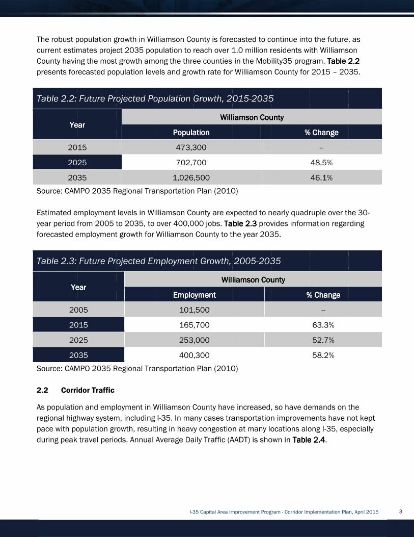
The robust population
current estimates project 2035 population to reach over 1.
County having the most growth
presents forecasted
Table 2.2: Future Projec
Source: CAMPO 2035 Regional Transportation Plan (2
Estimated employment levels in
year period from 2005 to 2035, to over
forecasted employment growth for
Table 2.3: Fut
Source: CAMPO 2035 Regional Transportation Plan (2010)
2.2
As population and employment in
regional highway system, including I
pace with population growth, resulting in heavy congestion a
during peak travel periods.
The robust population
current estimates project 2035 population to reach over 1.
County having the most growth
presents forecasted
Table 2.2: Future Projec
YearYearYearYear
2015
2025
2035
Source: CAMPO 2035 Regional Transportation Plan (2
Estimated employment levels in
year period from 2005 to 2035, to over
forecasted employment growth for
Table 2.3: Fut
YearYearYearYear
2005
2015
2025
2035
Source: CAMPO 2035 Regional Transportation Plan (2010)
2.2 Corridor
As population and employment in
regional highway system, including I
pace with population growth, resulting in heavy congestion a
during peak travel periods.
The robust population growth in Williamson County
current estimates project 2035 population to reach over 1.
County having the most growth
presents forecasted population levels and growth ra
Table 2.2: Future Projec
YearYearYearYear
2015
2025
2035
Source: CAMPO 2035 Regional Transportation Plan (2
Estimated employment levels in
year period from 2005 to 2035, to over
forecasted employment growth for
Table 2.3: Future Projected Employment Growth
YearYearYearYear
2005
2015
2025
2035
Source: CAMPO 2035 Regional Transportation Plan (2010)
Corridor Traffic
As population and employment in
regional highway system, including I
pace with population growth, resulting in heavy congestion a
during peak travel periods.
growth in Williamson County
current estimates project 2035 population to reach over 1.
County having the most growth among the three counties in the
population levels and growth ra
Table 2.2: Future Projected Population Growth, 2015
Source: CAMPO 2035 Regional Transportation Plan (2
Estimated employment levels in Williamson
year period from 2005 to 2035, to over
forecasted employment growth for
ure Projected Employment Growth
Source: CAMPO 2035 Regional Transportation Plan (2010)
Traffic
As population and employment in Williamson
regional highway system, including I
pace with population growth, resulting in heavy congestion a
during peak travel periods. Annual
I-35 Capital Area Improvement Program
growth in Williamson County
current estimates project 2035 population to reach over 1.
among the three counties in the
population levels and growth ra
ted Population Growth, 2015
PopulationPopulationPopulationPopulation
473,300
702,700
1,026,500
Source: CAMPO 2035 Regional Transportation Plan (2
Williamson County
year period from 2005 to 2035, to over 400,000 jobs.
forecasted employment growth for Williamson
ure Projected Employment Growth
EmploymentEmploymentEmploymentEmployment
101,500
165,700
253,000
400,300
Source: CAMPO 2035 Regional Transportation Plan (2010)
Williamson County
regional highway system, including I-35. In many cases transportation improvements have not kept
pace with population growth, resulting in heavy congestion a
Annual Average Daily Traffic (AADT) is shown in
35 Capital Area Improvement Program
growth in Williamson County is forecasted to continue i
current estimates project 2035 population to reach over 1.
among the three counties in the
population levels and growth rate for
ted Population Growth, 2015
Williamson CountyWilliamson CountyWilliamson CountyWilliamson County
PopulationPopulationPopulationPopulation
473,300
702,700
1,026,500
Source: CAMPO 2035 Regional Transportation Plan (2010)
County are expected to nearly
,000 jobs. Table Table Table Table
County to the year
ure Projected Employment Growth, 2005
Williamson CountyWilliamson CountyWilliamson CountyWilliamson County
EmploymentEmploymentEmploymentEmployment
101,500
165,700
253,000
400,300
Source: CAMPO 2035 Regional Transportation Plan (2010)
County have increased, so have demands on the
n many cases transportation improvements have not kept
pace with population growth, resulting in heavy congestion a
Average Daily Traffic (AADT) is shown in
35 Capital Area Improvement Program
is forecasted to continue i
current estimates project 2035 population to reach over 1.0 million residents
among the three counties in the Mobility35
te for Williamson
ted Population Growth, 2015-2035
Williamson CountyWilliamson CountyWilliamson CountyWilliamson County
010)
are expected to nearly
Table Table Table Table 2.2.2.2.3333 provides information regarding
County to the year 2035.
, 2005-2035
Williamson CountyWilliamson CountyWilliamson CountyWilliamson County
Source: CAMPO 2035 Regional Transportation Plan (2010)
have increased, so have demands on the
n many cases transportation improvements have not kept
pace with population growth, resulting in heavy congestion at many locations along I
Average Daily Traffic (AADT) is shown in
35 Capital Area Improvement Program - Corridor Implementation Plan, April 2015
is forecasted to continue into the future, as
million residents with
Mobility35 program.
Williamson County for
2035
Williamson CountyWilliamson CountyWilliamson CountyWilliamson County
% Change% Change% Change% Change
are expected to nearly quadruple
provides information regarding
2035.
2035
Williamson CountyWilliamson CountyWilliamson CountyWilliamson County
% Change% Change% Change% Change
have increased, so have demands on the
n many cases transportation improvements have not kept
t many locations along I
Average Daily Traffic (AADT) is shown in Table Table Table Table
Corridor Implementation Plan, April 2015
nto the future, as
with Williamson
rogram. Table Table Table Table 2.2.2.2.
for 2015 – 2035
% Change% Change% Change% Change
--
48.5%
46.1%
quadruple over the 30
provides information regarding
% Change% Change% Change% Change
--
63.3%
52.7%
58.2%
have increased, so have demands on the
n many cases transportation improvements have not kept
t many locations along I-35, especially
Table Table Table Table 2222.4.4.4.4.
Corridor Implementation Plan, April 2015
nto the future, as
Williamson
2.2.2.2.2222
2035.
over the 30-
provides information regarding
have increased, so have demands on the
n many cases transportation improvements have not kept
35, especially
3

Table 2.4: I
LocationLocationLocationLocation
North of SH 130
South of SH 29
South of RM 1431
Source: TxDOT Annual Count Data
* Projected
Three year h
preliminary crash analysis included a summary of crashes based on severity.
developed within the limits of this analysis.
facilities
vehicle miles.
2013 and exceeded the statewide average
–
3.03.03.03.0
By the mid
the
appropriate solutions.
of projects were constructed on I
Table 2.4: I
LocationLocationLocationLocation
North of SH 130
South of SH 29
South of RM 1431
Source: TxDOT Annual Count Data
* Projected
Three year h
preliminary crash analysis included a summary of crashes based on severity.
developed within the limits of this analysis.
facilities varies over the three year period from approximately 96
vehicle miles.
2013 and exceeded the statewide average
– 2013 for I
Table 2.5: 3
YearYearYearYear Average Average Average Average
ADT*ADT*ADT*ADT*
2011 99,000
2012 97,000
2013 100,000
Three Year
Average*http://www.dot.state.tx.us/apps/statewide_mapping/StatewidePlanningMap.html
**http://www.txdot.gov/government/enforcement/annual
3.03.03.03.0 Previous Studies and Planning Efforts
By the mid-1980s, TxDOT identified the need to address
the Austin area
appropriate solutions.
of projects were constructed on I
Table 2.4: I-35 Average Daily Traffic Volumes
1980198019801980
15,200
22,000
26,000
Source: TxDOT Annual Count Data
Three year historical crash data was collected and compiled for I
preliminary crash analysis included a summary of crashes based on severity.
developed within the limits of this analysis.
varies over the three year period from approximately 96
vehicle miles. The number of crashes in Williamson County has increased significantly from 2011
2013 and exceeded the statewide average
I-35 in Williamson County
Table 2.5: 3-year Crash Data
Average Average Average Average
ADT*ADT*ADT*ADT*
Total Total Total Total
CrashesCrashesCrashesCrashes
99,000 173
97,000 276
100,000 597
Three Year
Average 348.7
/www.dot.state.tx.us/apps/statewide_mapping/StatewidePlanningMap.html
**http://www.txdot.gov/government/enforcement/annual
Previous Studies and Planning Efforts
1980s, TxDOT identified the need to address
area. In the years since s
appropriate solutions. While Travis County
of projects were constructed on I
35 Average Daily Traffic Volumes
1985198519851985
23,000
37,000
44,000
Source: TxDOT Annual Count Data
istorical crash data was collected and compiled for I
preliminary crash analysis included a summary of crashes based on severity.
developed within the limits of this analysis.
varies over the three year period from approximately 96
The number of crashes in Williamson County has increased significantly from 2011
2013 and exceeded the statewide average
Williamson County
year Crash Data
Total Total Total Total
CrashesCrashesCrashesCrashes
Fatal Fatal Fatal Fatal
CrashesCrashesCrashesCrashes
173 3
276 2
597 5
348.7 3.3
/www.dot.state.tx.us/apps/statewide_mapping/StatewidePlanningMap.html
**http://www.txdot.gov/government/enforcement/annual
Previous Studies and Planning Efforts
1980s, TxDOT identified the need to address
In the years since s
While Travis County
of projects were constructed on I-35 in Wil
I-35 Capital Area Improvement Program
35 Average Daily Traffic Volumes
1990199019901990
32,000
50,000
56,000
istorical crash data was collected and compiled for I
preliminary crash analysis included a summary of crashes based on severity.
developed within the limits of this analysis. The statewide average crash rate f
varies over the three year period from approximately 96
The number of crashes in Williamson County has increased significantly from 2011
2013 and exceeded the statewide average in 2012 and 2013.
Williamson County is shown in
Fatal Fatal Fatal Fatal
CrashesCrashesCrashesCrashes
Injury Injury Injury Injury
CrashesCrashesCrashesCrashes
3 84
2 115
5 117
3.3 105.3
/www.dot.state.tx.us/apps/statewide_mapping/StatewidePlanningMap.html
**http://www.txdot.gov/government/enforcement/annual
Previous Studies and Planning Efforts
1980s, TxDOT identified the need to address
In the years since several studies have been conducted by TxDOT to try to find
While Travis County was
35 in Williamson County from the mid
35 Capital Area Improvement Program
35 Average Daily Traffic Volumes
1995199519951995
42,000
64,000
76,000
istorical crash data was collected and compiled for I
preliminary crash analysis included a summary of crashes based on severity.
The statewide average crash rate f
varies over the three year period from approximately 96
The number of crashes in Williamson County has increased significantly from 2011
in 2012 and 2013.
shown in Table 2.5Table 2.5Table 2.5Table 2.5
Injury Injury Injury Injury
CrashesCrashesCrashesCrashes
NonNonNonNon
CrashesCrashesCrashesCrashes
84
115
117
105.3 216.7
/www.dot.state.tx.us/apps/statewide_mapping/StatewidePlanningMap.html
**http://www.txdot.gov/government/enforcement/annual
Previous Studies and Planning Efforts
1980s, TxDOT identified the need to address ever increasing
everal studies have been conducted by TxDOT to try to find
was the focus of those
liamson County from the mid
35 Capital Area Improvement Program
2000200020002000
60,000
83,000
101,000
istorical crash data was collected and compiled for I-35 in Williamson County
preliminary crash analysis included a summary of crashes based on severity.
The statewide average crash rate f
varies over the three year period from approximately 96 to 121
The number of crashes in Williamson County has increased significantly from 2011
in 2012 and 2013. A summary of
Table 2.5Table 2.5Table 2.5Table 2.5.
NonNonNonNon----Injury Injury Injury Injury
CrashesCrashesCrashesCrashes
85
155
410
216.7
/www.dot.state.tx.us/apps/statewide_mapping/StatewidePlanningMap.html
**http://www.txdot.gov/government/enforcement/annual-summary.html
ever increasing
everal studies have been conducted by TxDOT to try to find
the focus of those previous
liamson County from the mid
35 Capital Area Improvement Program - Corridor Implementation Plan, April 2015
2005200520052005
69,000
83,750
105,000
in Williamson County
preliminary crash analysis included a summary of crashes based on severity. Crash rates were
The statewide average crash rate for urban interstate
to 121 crashes per 100 million
The number of crashes in Williamson County has increased significantly from 2011
A summary of crash data from 2011
Corridor Corridor Corridor Corridor
Crash Rate Crash Rate Crash Rate Crash Rate
(per 100 (per 100 (per 100 (per 100
millmillmillmillion ion ion ion
vehvehvehvehicleicleicleicle miles)miles)miles)miles)
79.8
129.9
272.6
160.8
/www.dot.state.tx.us/apps/statewide_mapping/StatewidePlanningMap.html
summary.html
ever increasing congestio
everal studies have been conducted by TxDOT to try to find
previous studies, a large number
liamson County from the mid-1980s to the present with
Corridor Implementation Plan, April 2015
2010201020102010
85,000
101,000
128,000
in Williamson County. The
Crash rates were
or urban interstate
crashes per 100 million
The number of crashes in Williamson County has increased significantly from 2011
crash data from 2011
Corridor Corridor Corridor Corridor
Crash Rate Crash Rate Crash Rate Crash Rate
(per 100 (per 100 (per 100 (per 100
miles)miles)miles)miles)
Statewide Statewide Statewide Statewide
Urban Crash Urban Crash Urban Crash Urban Crash
Rate (per 100 Rate (per 100 Rate (per 100 Rate (per 100
million vehmillion vehmillion vehmillion veh
miles)**miles)**miles)**miles)**
96.4
114.8
120.8
110.7
/www.dot.state.tx.us/apps/statewide_mapping/StatewidePlanningMap.html
congestion on I-35 through
everal studies have been conducted by TxDOT to try to find
studies, a large number
1980s to the present with
Corridor Implementation Plan, April 2015
2035*2035*2035*2035*
154,000
183,000
232,000
The
Crash rates were
or urban interstate
crashes per 100 million
The number of crashes in Williamson County has increased significantly from 2011 –
crash data from 2011
Statewide Statewide Statewide Statewide
Urban Crash Urban Crash Urban Crash Urban Crash
Rate (per 100 Rate (per 100 Rate (per 100 Rate (per 100
million vehmillion vehmillion vehmillion vehicleicleicleicle
miles)**miles)**miles)**miles)**
96.4
114.8
120.8
110.7
35 through
everal studies have been conducted by TxDOT to try to find
studies, a large number
1980s to the present with
4

considerable collaboration between TxDOT, Williamson County, and the Cities of Georgetown and
Round Rock. Those projects served to enhance mobility with increased mainlane capacity,
road improv
Mobility35 program builds upon and refines previous efforts and is separated by county. This
refined effort began in earnest in 2008.
3.1
In 2008, the Texas Transportation Commission established the I
(CAC) to engage the citizens of Texas and develop a plan to address transportation challenges
along the I
of the CAC included business professionals, environmental planners, rail advocates, professors,
local officials, and residents that lived and did business in the I
public at the loca
Transportation Commission enlisted assistance from four I
(CSCs) located geographically along the I
recommendations of the CSCs and developed the I
Plan) to address mobility challenges along I
recommendations for the I
�
�
�
�
The CAC planning effort was a needs
Recommendations did not include any dedicated funding sources for improvements. Thus
recommendations made by
Mobility Authorities (RMAs), cities and counties. My 35 recommendations have been considered as
part of this current effort.
3.2
Williamson
These improvements
for ramping improvements, frontage road improvements, intersection improvements, new f
roads, conversion of frontage roads from 2
count
entity can expedite a project by fronting project
These and other innovative funding practices
considerable collaboration between TxDOT, Williamson County, and the Cities of Georgetown and
Round Rock. Those projects served to enhance mobility with increased mainlane capacity,
road improv
Mobility35 program builds upon and refines previous efforts and is separated by county. This
refined effort began in earnest in 2008.
3.1 I-35 Corridor Advisory Committee P
In 2008, the Texas Transportation Commission established the I
(CAC) to engage the citizens of Texas and develop a plan to address transportation challenges
along the I-35 corridor from the Oklahoma/Texas border t
of the CAC included business professionals, environmental planners, rail advocates, professors,
local officials, and residents that lived and did business in the I
public at the loca
Transportation Commission enlisted assistance from four I
(CSCs) located geographically along the I
recommendations of the CSCs and developed the I
Plan) to address mobility challenges along I
recommendations for the I
� Freight and passeng
� Roadway design to separate cars and trucks to increase safety.
� Managed lanes to ease congestion and provide relief to transportation funding.
� Integrated, real
alternate routes.
The CAC planning effort was a needs
Recommendations did not include any dedicated funding sources for improvements. Thus
recommendations made by
Mobility Authorities (RMAs), cities and counties. My 35 recommendations have been considered as
part of this current effort.
Williamson County Improvement Efforts3.2
Williamson C
These improvements
for ramping improvements, frontage road improvements, intersection improvements, new f
roads, conversion of frontage roads from 2
county utilized bond fund
entity can expedite a project by fronting project
These and other innovative funding practices
considerable collaboration between TxDOT, Williamson County, and the Cities of Georgetown and
Round Rock. Those projects served to enhance mobility with increased mainlane capacity,
road improvements and ramp revisions, and the construction of several turnaround structures.
Mobility35 program builds upon and refines previous efforts and is separated by county. This
refined effort began in earnest in 2008.
Corridor Advisory Committee P
In 2008, the Texas Transportation Commission established the I
(CAC) to engage the citizens of Texas and develop a plan to address transportation challenges
35 corridor from the Oklahoma/Texas border t
of the CAC included business professionals, environmental planners, rail advocates, professors,
local officials, and residents that lived and did business in the I
public at the local level and to better understand the local needs associated with I
Transportation Commission enlisted assistance from four I
(CSCs) located geographically along the I
recommendations of the CSCs and developed the I
Plan) to address mobility challenges along I
recommendations for the I
Freight and passeng
Roadway design to separate cars and trucks to increase safety.
Managed lanes to ease congestion and provide relief to transportation funding.
Integrated, real-time traffic information systems that
alternate routes.
The CAC planning effort was a needs
Recommendations did not include any dedicated funding sources for improvements. Thus
recommendations made by
Mobility Authorities (RMAs), cities and counties. My 35 recommendations have been considered as
part of this current effort.
Williamson County Improvement Efforts
County has m
These improvements included
for ramping improvements, frontage road improvements, intersection improvements, new f
roads, conversion of frontage roads from 2
utilized bond fund
entity can expedite a project by fronting project
These and other innovative funding practices
considerable collaboration between TxDOT, Williamson County, and the Cities of Georgetown and
Round Rock. Those projects served to enhance mobility with increased mainlane capacity,
ements and ramp revisions, and the construction of several turnaround structures.
Mobility35 program builds upon and refines previous efforts and is separated by county. This
refined effort began in earnest in 2008.
Corridor Advisory Committee P
In 2008, the Texas Transportation Commission established the I
(CAC) to engage the citizens of Texas and develop a plan to address transportation challenges
35 corridor from the Oklahoma/Texas border t
of the CAC included business professionals, environmental planners, rail advocates, professors,
local officials, and residents that lived and did business in the I
l level and to better understand the local needs associated with I
Transportation Commission enlisted assistance from four I
(CSCs) located geographically along the I
recommendations of the CSCs and developed the I
Plan) to address mobility challenges along I
recommendations for the I-35 Corridor in Texas:
Freight and passenger rail projects to alleviate freight demands on roadways.
Roadway design to separate cars and trucks to increase safety.
Managed lanes to ease congestion and provide relief to transportation funding.
time traffic information systems that
The CAC planning effort was a needs
Recommendations did not include any dedicated funding sources for improvements. Thus
recommendations made by the CAC could only be pursued by other agencies
Mobility Authorities (RMAs), cities and counties. My 35 recommendations have been considered as
part of this current effort.
Williamson County Improvement Efforts
made significant improvements to the I
included all phases of project development through design and construction
for ramping improvements, frontage road improvements, intersection improvements, new f
roads, conversion of frontage roads from 2
utilized bond funds, city funds, and pass
entity can expedite a project by fronting project
These and other innovative funding practices
I-35 Capital Area Improvement Program
considerable collaboration between TxDOT, Williamson County, and the Cities of Georgetown and
Round Rock. Those projects served to enhance mobility with increased mainlane capacity,
ements and ramp revisions, and the construction of several turnaround structures.
Mobility35 program builds upon and refines previous efforts and is separated by county. This
refined effort began in earnest in 2008.
Corridor Advisory Committee Plan (My 35)
In 2008, the Texas Transportation Commission established the I
(CAC) to engage the citizens of Texas and develop a plan to address transportation challenges
35 corridor from the Oklahoma/Texas border t
of the CAC included business professionals, environmental planners, rail advocates, professors,
local officials, and residents that lived and did business in the I
l level and to better understand the local needs associated with I
Transportation Commission enlisted assistance from four I
(CSCs) located geographically along the I-35 corridor to report to the CAC. The CAC co
recommendations of the CSCs and developed the I
Plan) to address mobility challenges along I-35. The plan made the following general
35 Corridor in Texas:
er rail projects to alleviate freight demands on roadways.
Roadway design to separate cars and trucks to increase safety.
Managed lanes to ease congestion and provide relief to transportation funding.
time traffic information systems that
The CAC planning effort was a needs-based planning effort and was financially unconstrained.
Recommendations did not include any dedicated funding sources for improvements. Thus
the CAC could only be pursued by other agencies
Mobility Authorities (RMAs), cities and counties. My 35 recommendations have been considered as
Williamson County Improvement Efforts
ade significant improvements to the I
all phases of project development through design and construction
for ramping improvements, frontage road improvements, intersection improvements, new f
roads, conversion of frontage roads from 2-way to 1
city funds, and pass
entity can expedite a project by fronting project
These and other innovative funding practices are available to
35 Capital Area Improvement Program
considerable collaboration between TxDOT, Williamson County, and the Cities of Georgetown and
Round Rock. Those projects served to enhance mobility with increased mainlane capacity,
ements and ramp revisions, and the construction of several turnaround structures.
Mobility35 program builds upon and refines previous efforts and is separated by county. This
lan (My 35)
In 2008, the Texas Transportation Commission established the I
(CAC) to engage the citizens of Texas and develop a plan to address transportation challenges
35 corridor from the Oklahoma/Texas border t
of the CAC included business professionals, environmental planners, rail advocates, professors,
local officials, and residents that lived and did business in the I
l level and to better understand the local needs associated with I
Transportation Commission enlisted assistance from four I
35 corridor to report to the CAC. The CAC co
recommendations of the CSCs and developed the I-35 Corridor Advisory Committee Plan (My 35
35. The plan made the following general
35 Corridor in Texas:
er rail projects to alleviate freight demands on roadways.
Roadway design to separate cars and trucks to increase safety.
Managed lanes to ease congestion and provide relief to transportation funding.
time traffic information systems that alert drivers to delays and provide
based planning effort and was financially unconstrained.
Recommendations did not include any dedicated funding sources for improvements. Thus
the CAC could only be pursued by other agencies
Mobility Authorities (RMAs), cities and counties. My 35 recommendations have been considered as
Williamson County Improvement Efforts
ade significant improvements to the I
all phases of project development through design and construction
for ramping improvements, frontage road improvements, intersection improvements, new f
way to 1-way, and the addition of U
city funds, and pass-through financing
entity can expedite a project by fronting project costs to be partially reimbursed by TxDOT over time.
are available to
35 Capital Area Improvement Program
considerable collaboration between TxDOT, Williamson County, and the Cities of Georgetown and
Round Rock. Those projects served to enhance mobility with increased mainlane capacity,
ements and ramp revisions, and the construction of several turnaround structures.
Mobility35 program builds upon and refines previous efforts and is separated by county. This
In 2008, the Texas Transportation Commission established the I-35 Corridor Advisory Committee
(CAC) to engage the citizens of Texas and develop a plan to address transportation challenges
35 corridor from the Oklahoma/Texas border to the Texas/Mexico border. Membership
of the CAC included business professionals, environmental planners, rail advocates, professors,
local officials, and residents that lived and did business in the I-35 corridor. In order to engage the
l level and to better understand the local needs associated with I
Transportation Commission enlisted assistance from four I-35 Corridor Segment Committees
35 corridor to report to the CAC. The CAC co
35 Corridor Advisory Committee Plan (My 35
35. The plan made the following general
er rail projects to alleviate freight demands on roadways.
Roadway design to separate cars and trucks to increase safety.
Managed lanes to ease congestion and provide relief to transportation funding.
alert drivers to delays and provide
based planning effort and was financially unconstrained.
Recommendations did not include any dedicated funding sources for improvements. Thus
the CAC could only be pursued by other agencies
Mobility Authorities (RMAs), cities and counties. My 35 recommendations have been considered as
ade significant improvements to the I-35 corridor
all phases of project development through design and construction
for ramping improvements, frontage road improvements, intersection improvements, new f
way, and the addition of U
inancing — a mechanism by which a public
costs to be partially reimbursed by TxDOT over time.
are available to help counties facilitate improvements
35 Capital Area Improvement Program - Corridor Implementation Plan, April 2015
considerable collaboration between TxDOT, Williamson County, and the Cities of Georgetown and
Round Rock. Those projects served to enhance mobility with increased mainlane capacity,
ements and ramp revisions, and the construction of several turnaround structures.
Mobility35 program builds upon and refines previous efforts and is separated by county. This
35 Corridor Advisory Committee
(CAC) to engage the citizens of Texas and develop a plan to address transportation challenges
o the Texas/Mexico border. Membership
of the CAC included business professionals, environmental planners, rail advocates, professors,
35 corridor. In order to engage the
l level and to better understand the local needs associated with I
35 Corridor Segment Committees
35 corridor to report to the CAC. The CAC co
35 Corridor Advisory Committee Plan (My 35
35. The plan made the following general
er rail projects to alleviate freight demands on roadways.
Managed lanes to ease congestion and provide relief to transportation funding.
alert drivers to delays and provide
based planning effort and was financially unconstrained.
Recommendations did not include any dedicated funding sources for improvements. Thus
the CAC could only be pursued by other agencies — TxDOT, Regional
Mobility Authorities (RMAs), cities and counties. My 35 recommendations have been considered as
35 corridor within
all phases of project development through design and construction
for ramping improvements, frontage road improvements, intersection improvements, new f
way, and the addition of U-turn structures
a mechanism by which a public
costs to be partially reimbursed by TxDOT over time.
help counties facilitate improvements
Corridor Implementation Plan, April 2015
considerable collaboration between TxDOT, Williamson County, and the Cities of Georgetown and
Round Rock. Those projects served to enhance mobility with increased mainlane capacity, frontage
ements and ramp revisions, and the construction of several turnaround structures.
Mobility35 program builds upon and refines previous efforts and is separated by county. This
35 Corridor Advisory Committee
(CAC) to engage the citizens of Texas and develop a plan to address transportation challenges
o the Texas/Mexico border. Membership
of the CAC included business professionals, environmental planners, rail advocates, professors,
35 corridor. In order to engage the
l level and to better understand the local needs associated with I-35, the Texas
35 Corridor Segment Committees
35 corridor to report to the CAC. The CAC considered the
35 Corridor Advisory Committee Plan (My 35
35. The plan made the following general
er rail projects to alleviate freight demands on roadways.
Managed lanes to ease congestion and provide relief to transportation funding.
alert drivers to delays and provide
based planning effort and was financially unconstrained.
Recommendations did not include any dedicated funding sources for improvements. Thus
TxDOT, Regional
Mobility Authorities (RMAs), cities and counties. My 35 recommendations have been considered as
within the county limits
all phases of project development through design and construction
for ramping improvements, frontage road improvements, intersection improvements, new frontage
turn structures
a mechanism by which a public
costs to be partially reimbursed by TxDOT over time.
help counties facilitate improvements
Corridor Implementation Plan, April 2015
considerable collaboration between TxDOT, Williamson County, and the Cities of Georgetown and
frontage
ements and ramp revisions, and the construction of several turnaround structures. The
Mobility35 program builds upon and refines previous efforts and is separated by county. This
35 Corridor Advisory Committee
(CAC) to engage the citizens of Texas and develop a plan to address transportation challenges
o the Texas/Mexico border. Membership
of the CAC included business professionals, environmental planners, rail advocates, professors,
35 corridor. In order to engage the
35, the Texas
35 Corridor Segment Committees
nsidered the
35 Corridor Advisory Committee Plan (My 35
based planning effort and was financially unconstrained.
TxDOT, Regional
Mobility Authorities (RMAs), cities and counties. My 35 recommendations have been considered as
county limits.
all phases of project development through design and construction
rontage
turn structures. The
a mechanism by which a public
costs to be partially reimbursed by TxDOT over time.
help counties facilitate improvements
5

along the corridor.
transportatio
4.04.04.04.0
Development of the
Plan (Implementation Plan)
describes these efforts, as well as the improvement concepts developed and refined as part of
process
4.1
The planning area for this Implementation Plan extends
SH 130 just within the northern city limits of Georgetown, Texas, to
in Round Rock, Texas
4.2
Multiple efforts are underway as part of
vari
terminology, for purposes of Mobility35, these phases are defined as:
�
�
�
�
�
4.3
The Mobility35 program
construct
Posey Road
along the corridor.
transportatio
4.04.04.04.0 Implementation Plan Development
Development of the
Plan (Implementation Plan)
describes these efforts, as well as the improvement concepts developed and refined as part of
process.
Definition of Corridor Planning Area4.1
The planning area for this Implementation Plan extends
SH 130 just within the northern city limits of Georgetown, Texas, to
in Round Rock, Texas
Phases of Project Development4.2
Multiple efforts are underway as part of
various phases of the
terminology, for purposes of Mobility35, these phases are defined as:
� Phase 1: Conceptual Planning Phase 1: Conceptual Planning Phase 1: Conceptual Planning Phase 1: Conceptual Planning
scope; a
� Phase 2: Implementation Plan Phase 2: Implementation Plan Phase 2: Implementation Plan Phase 2: Implementation Plan
components and geometrics; operational assessment; fatal flaw analysis; develop preliminary
cost estimates; identify funding opportunities;
� Phase 3: Schematic and Environmental Coordination Phase 3: Schematic and Environmental Coordination Phase 3: Schematic and Environmental Coordination Phase 3: Schematic and Environmental Coordination
right-of-way
agency coordination.
� Phase 4: Construction Plans, RightPhase 4: Construction Plans, RightPhase 4: Construction Plans, RightPhase 4: Construction Plans, Right
construction plans; acquire necessary
estimates.
� Phase 5: Letting and Construction Phase 5: Letting and Construction Phase 5: Letting and Construction Phase 5: Letting and Construction
secure funding, release final proposal, advertise request for bids, review bids and award
contract, and initiate project construction.
Program Objective4.3
The Mobility35 program
construction services for a program of
Posey Road
along the corridor. The City of Georgetown is currently considering over $100 million in
transportation bond projects up for voter approval in May 2015.
Implementation Plan Development
Development of the I-35 Capital Area Improvement Program/
Plan (Implementation Plan)
describes these efforts, as well as the improvement concepts developed and refined as part of
Definition of Corridor Planning Area
The planning area for this Implementation Plan extends
SH 130 just within the northern city limits of Georgetown, Texas, to
in Round Rock, Texas.
Phases of Project Development
Multiple efforts are underway as part of
ous phases of the project development process. In order to ensure consistent use of
terminology, for purposes of Mobility35, these phases are defined as:
Phase 1: Conceptual Planning Phase 1: Conceptual Planning Phase 1: Conceptual Planning Phase 1: Conceptual Planning
scope; and public outreach.
Phase 2: Implementation Plan Phase 2: Implementation Plan Phase 2: Implementation Plan Phase 2: Implementation Plan
components and geometrics; operational assessment; fatal flaw analysis; develop preliminary
cost estimates; identify funding opportunities;
Phase 3: Schematic and Environmental Coordination Phase 3: Schematic and Environmental Coordination Phase 3: Schematic and Environmental Coordination Phase 3: Schematic and Environmental Coordination
way needs; develop and process environmental documentation; public involvement and
agency coordination.
Phase 4: Construction Plans, RightPhase 4: Construction Plans, RightPhase 4: Construction Plans, RightPhase 4: Construction Plans, Right
construction plans; acquire necessary
estimates.
Phase 5: Letting and Construction Phase 5: Letting and Construction Phase 5: Letting and Construction Phase 5: Letting and Construction
secure funding, release final proposal, advertise request for bids, review bids and award
contract, and initiate project construction.
Program Objective
The Mobility35 program
ion services for a program of
in Hays County
The City of Georgetown is currently considering over $100 million in
n bond projects up for voter approval in May 2015.
Implementation Plan Development
35 Capital Area Improvement Program/
Plan (Implementation Plan) included technical evaluations and public outreach. Th
describes these efforts, as well as the improvement concepts developed and refined as part of
Definition of Corridor Planning Area
The planning area for this Implementation Plan extends
SH 130 just within the northern city limits of Georgetown, Texas, to
Phases of Project Development
Multiple efforts are underway as part of
project development process. In order to ensure consistent use of
terminology, for purposes of Mobility35, these phases are defined as:
Phase 1: Conceptual Planning Phase 1: Conceptual Planning Phase 1: Conceptual Planning Phase 1: Conceptual Planning ––––
nd public outreach.
Phase 2: Implementation Plan Phase 2: Implementation Plan Phase 2: Implementation Plan Phase 2: Implementation Plan ––––
components and geometrics; operational assessment; fatal flaw analysis; develop preliminary
cost estimates; identify funding opportunities;
Phase 3: Schematic and Environmental Coordination Phase 3: Schematic and Environmental Coordination Phase 3: Schematic and Environmental Coordination Phase 3: Schematic and Environmental Coordination
needs; develop and process environmental documentation; public involvement and
agency coordination.
Phase 4: Construction Plans, RightPhase 4: Construction Plans, RightPhase 4: Construction Plans, RightPhase 4: Construction Plans, Right
construction plans; acquire necessary
Phase 5: Letting and Construction Phase 5: Letting and Construction Phase 5: Letting and Construction Phase 5: Letting and Construction
secure funding, release final proposal, advertise request for bids, review bids and award
contract, and initiate project construction.
Program Objective
The Mobility35 program includes engineering, public involvement,
ion services for a program of
in Hays County. The improvements include an additional lane on I
I-35 Capital Area Improvement Program
The City of Georgetown is currently considering over $100 million in
n bond projects up for voter approval in May 2015.
Implementation Plan Development
35 Capital Area Improvement Program/
included technical evaluations and public outreach. Th
describes these efforts, as well as the improvement concepts developed and refined as part of
Definition of Corridor Planning Area
The planning area for this Implementation Plan extends
SH 130 just within the northern city limits of Georgetown, Texas, to
Phases of Project Development
Multiple efforts are underway as part of the Mobility35
project development process. In order to ensure consistent use of
terminology, for purposes of Mobility35, these phases are defined as:
–––– Perform high
–––– Identify issues and constraints; assess project scope, critical
components and geometrics; operational assessment; fatal flaw analysis; develop preliminary
cost estimates; identify funding opportunities;
Phase 3: Schematic and Environmental Coordination Phase 3: Schematic and Environmental Coordination Phase 3: Schematic and Environmental Coordination Phase 3: Schematic and Environmental Coordination
needs; develop and process environmental documentation; public involvement and
Phase 4: Construction Plans, RightPhase 4: Construction Plans, RightPhase 4: Construction Plans, RightPhase 4: Construction Plans, Right----ofofofof----Way, and Utility Coordination Way, and Utility Coordination Way, and Utility Coordination Way, and Utility Coordination
construction plans; acquire necessary right
Phase 5: Letting and Construction Phase 5: Letting and Construction Phase 5: Letting and Construction Phase 5: Letting and Construction –––– Final approval of
secure funding, release final proposal, advertise request for bids, review bids and award
contract, and initiate project construction.
engineering, public involvement,
ion services for a program of improvements to
The improvements include an additional lane on I
35 Capital Area Improvement Program
The City of Georgetown is currently considering over $100 million in
n bond projects up for voter approval in May 2015.
Implementation Plan Development
35 Capital Area Improvement Program/
included technical evaluations and public outreach. Th
describes these efforts, as well as the improvement concepts developed and refined as part of
The planning area for this Implementation Plan extends 1
SH 130 just within the northern city limits of Georgetown, Texas, to
Mobility35 planning process
project development process. In order to ensure consistent use of
terminology, for purposes of Mobility35, these phases are defined as:
Perform high-level concept planning; identify project need and
Identify issues and constraints; assess project scope, critical
components and geometrics; operational assessment; fatal flaw analysis; develop preliminary
cost estimates; identify funding opportunities; and public outreach.
Phase 3: Schematic and Environmental Coordination Phase 3: Schematic and Environmental Coordination Phase 3: Schematic and Environmental Coordination Phase 3: Schematic and Environmental Coordination ––––
needs; develop and process environmental documentation; public involvement and
Way, and Utility Coordination Way, and Utility Coordination Way, and Utility Coordination Way, and Utility Coordination
right-of-way; adjust utilities; and prepare detailed cost
Final approval of
secure funding, release final proposal, advertise request for bids, review bids and award
engineering, public involvement,
improvements to I-35
The improvements include an additional lane on I
35 Capital Area Improvement Program
The City of Georgetown is currently considering over $100 million in
n bond projects up for voter approval in May 2015.
35 Capital Area Improvement Program/Mobility35
included technical evaluations and public outreach. Th
describes these efforts, as well as the improvement concepts developed and refined as part of
11 miles along existing I
SH 130 just within the northern city limits of Georgetown, Texas, to RM 1431 (University
planning process
project development process. In order to ensure consistent use of
terminology, for purposes of Mobility35, these phases are defined as:
level concept planning; identify project need and
Identify issues and constraints; assess project scope, critical
components and geometrics; operational assessment; fatal flaw analysis; develop preliminary
and public outreach.
–––– Prepare design
needs; develop and process environmental documentation; public involvement and
Way, and Utility Coordination Way, and Utility Coordination Way, and Utility Coordination Way, and Utility Coordination
; adjust utilities; and prepare detailed cost
Final approval of Plan Specifications and Estimates (
secure funding, release final proposal, advertise request for bids, review bids and award
engineering, public involvement, environmental services
-35 from SH
The improvements include an additional lane on I
35 Capital Area Improvement Program - Corridor Implementation Plan, April 2015
The City of Georgetown is currently considering over $100 million in
Mobility35 Corridor Implementation
included technical evaluations and public outreach. Th
describes these efforts, as well as the improvement concepts developed and refined as part of
miles along existing I
RM 1431 (University
planning process; these efforts fall into
project development process. In order to ensure consistent use of
terminology, for purposes of Mobility35, these phases are defined as:
level concept planning; identify project need and
Identify issues and constraints; assess project scope, critical
components and geometrics; operational assessment; fatal flaw analysis; develop preliminary
and public outreach.
design schematic; determine
needs; develop and process environmental documentation; public involvement and
Way, and Utility Coordination Way, and Utility Coordination Way, and Utility Coordination Way, and Utility Coordination –––– Prepare detailed
; adjust utilities; and prepare detailed cost
Plan Specifications and Estimates (
secure funding, release final proposal, advertise request for bids, review bids and award
environmental services
from SH 130 in Williamson County
The improvements include an additional lane on I-35 in each direction
Corridor Implementation Plan, April 2015
The City of Georgetown is currently considering over $100 million in
Corridor Implementation
included technical evaluations and public outreach. This section
describes these efforts, as well as the improvement concepts developed and refined as part of
miles along existing I-35 from north of
RM 1431 (University Boulevard
; these efforts fall into
project development process. In order to ensure consistent use of
level concept planning; identify project need and
Identify issues and constraints; assess project scope, critical
components and geometrics; operational assessment; fatal flaw analysis; develop preliminary
schematic; determine
needs; develop and process environmental documentation; public involvement and
Prepare detailed
; adjust utilities; and prepare detailed cost
Plan Specifications and Estimates (
secure funding, release final proposal, advertise request for bids, review bids and award
environmental services, and
in Williamson County
35 in each direction
Corridor Implementation Plan, April 2015
Corridor Implementation
is section
describes these efforts, as well as the improvement concepts developed and refined as part of this
35 from north of
Boulevard)
; these efforts fall into
level concept planning; identify project need and
Identify issues and constraints; assess project scope, critical
components and geometrics; operational assessment; fatal flaw analysis; develop preliminary
schematic; determine
needs; develop and process environmental documentation; public involvement and
; adjust utilities; and prepare detailed cost
Plan Specifications and Estimates (PS&E),
secure funding, release final proposal, advertise request for bids, review bids and award
, and
in Williamson County to
35 in each direction
6

and associated ramping, interchange, frontage road and multi
improvements to enhance overall mobility along and across the corridor. The program of
improvements for Williamson County
General guiding considerations
�
�
�
�
�
�
�
�
4.4
P
program
phase
and the public with unified and coordinated
multi
open houses and online efforts.
Stakeholder Outreach
Stakeholder outreach for Phase 1 and 2 efforts included five primary outreach methods: public
open houses (including online virtual open houses), small group prese
social media postings, and community events. Additional project
during Phase 3
Phase 3,
methods
Public Open Houses
TxDOT hosted three rounds of public open house meetings on the Mobility35 Williamson County
Feasibilit
house meetings, the Mobility35 team sought public input to identify specific problems in the
corridor and opportunities that should be studied. Open house meetings were h
�
and associated ramping, interchange, frontage road and multi
improvements to enhance overall mobility along and across the corridor. The program of
improvements for Williamson County
General guiding considerations
� Increase capacity
� Better manage traffic
� Enhance safety
� Optimize exi
� Minimize need for additional right
� Improve east/west connectivity
� Improve compatibility with neighborhoods
� Enhance
4.4 Public and Agency Involvement
Public and stakeholder outreach
program; the project team will
phases. The intent
and the public with unified and coordinated
multi-jurisdictional and includes one
open houses and online efforts.
Stakeholder Outreach
Stakeholder outreach for Phase 1 and 2 efforts included five primary outreach methods: public
open houses (including online virtual open houses), small group prese
social media postings, and community events. Additional project
during Phase 3
Phase 3, the outreach methods initiated dur
methods, including
Public Open Houses
TxDOT hosted three rounds of public open house meetings on the Mobility35 Williamson County
Feasibility Study
house meetings, the Mobility35 team sought public input to identify specific problems in the
corridor and opportunities that should be studied. Open house meetings were h
� February 11, 2014, from 5
and associated ramping, interchange, frontage road and multi
improvements to enhance overall mobility along and across the corridor. The program of
improvements for Williamson County
General guiding considerations
Increase capacity
Better manage traffic
Enhance safety
Optimize existing facility
Minimize need for additional right
Improve east/west connectivity
Improve compatibility with neighborhoods
Enhance bicyclist, pedestrian and
Public and Agency Involvement
ublic and stakeholder outreach
; the project team will
s. The intent of these efforts
and the public with unified and coordinated
jurisdictional and includes one
open houses and online efforts.
Stakeholder Outreach
Stakeholder outreach for Phase 1 and 2 efforts included five primary outreach methods: public
open houses (including online virtual open houses), small group prese
social media postings, and community events. Additional project
during Phase 3 is in accordance with rules and regulations governing the NEPA process. During
the outreach methods initiated dur
including public meetings and hearings
Public Open Houses
TxDOT hosted three rounds of public open house meetings on the Mobility35 Williamson County
y Study area from
house meetings, the Mobility35 team sought public input to identify specific problems in the
corridor and opportunities that should be studied. Open house meetings were h
February 11, 2014, from 5
and associated ramping, interchange, frontage road and multi
improvements to enhance overall mobility along and across the corridor. The program of
improvements for Williamson County
General guiding considerations or goals
Better manage traffic
ting facility
Minimize need for additional right
Improve east/west connectivity
Improve compatibility with neighborhoods
, pedestrian and
Public and Agency Involvement
ublic and stakeholder outreach has been and will continue to be
; the project team will continue
of these efforts
and the public with unified and coordinated
jurisdictional and includes one
open houses and online efforts.
Stakeholder outreach for Phase 1 and 2 efforts included five primary outreach methods: public
open houses (including online virtual open houses), small group prese
social media postings, and community events. Additional project
in accordance with rules and regulations governing the NEPA process. During
the outreach methods initiated dur
public meetings and hearings
TxDOT hosted three rounds of public open house meetings on the Mobility35 Williamson County
area from north of SH 130 to RM 1431 corridor
house meetings, the Mobility35 team sought public input to identify specific problems in the
corridor and opportunities that should be studied. Open house meetings were h
February 11, 2014, from 5 – 8 p.m. at the Georgetown High School cafeteria in Georgetown
I-35 Capital Area Improvement Program
and associated ramping, interchange, frontage road and multi
improvements to enhance overall mobility along and across the corridor. The program of
improvements for Williamson County is complete and the
or goals for the Mob
Minimize need for additional right-of-way
Improve east/west connectivity
Improve compatibility with neighborhoods
, pedestrian and transit-user
Public and Agency Involvement
has been and will continue to be
continue this outreach throughout
of these efforts is to provide stakeholders, resource
and the public with unified and coordinated information and opportunities for feedback
jurisdictional and includes one-on-one meetings, small
Stakeholder outreach for Phase 1 and 2 efforts included five primary outreach methods: public
open houses (including online virtual open houses), small group prese
social media postings, and community events. Additional project
in accordance with rules and regulations governing the NEPA process. During
the outreach methods initiated during
public meetings and hearings
TxDOT hosted three rounds of public open house meetings on the Mobility35 Williamson County
orth of SH 130 to RM 1431 corridor
house meetings, the Mobility35 team sought public input to identify specific problems in the
corridor and opportunities that should be studied. Open house meetings were h
8 p.m. at the Georgetown High School cafeteria in Georgetown
35 Capital Area Improvement Program
and associated ramping, interchange, frontage road and multi
improvements to enhance overall mobility along and across the corridor. The program of
complete and the
e Mobility35 Program
user options
has been and will continue to be
this outreach throughout
is to provide stakeholders, resource
information and opportunities for feedback
one meetings, small
Stakeholder outreach for Phase 1 and 2 efforts included five primary outreach methods: public
open houses (including online virtual open houses), small group prese
social media postings, and community events. Additional project
in accordance with rules and regulations governing the NEPA process. During
ing Phases 1 and 2
public meetings and hearings, are undertaken as appropriate.
TxDOT hosted three rounds of public open house meetings on the Mobility35 Williamson County
orth of SH 130 to RM 1431 corridor
house meetings, the Mobility35 team sought public input to identify specific problems in the
corridor and opportunities that should be studied. Open house meetings were h
8 p.m. at the Georgetown High School cafeteria in Georgetown
35 Capital Area Improvement Program
and associated ramping, interchange, frontage road and multi-modal modif
improvements to enhance overall mobility along and across the corridor. The program of
complete and the subject of this Implementation Plan.
ility35 Program include:
options
has been and will continue to be a critical part of the
this outreach throughout subsequent project development
is to provide stakeholders, resource
information and opportunities for feedback
one meetings, small group meetings, large group meetings,
Stakeholder outreach for Phase 1 and 2 efforts included five primary outreach methods: public
open houses (including online virtual open houses), small group prese
social media postings, and community events. Additional project-specif
in accordance with rules and regulations governing the NEPA process. During
Phases 1 and 2 continue
undertaken as appropriate.
TxDOT hosted three rounds of public open house meetings on the Mobility35 Williamson County
orth of SH 130 to RM 1431 corridor. During the first round of open
house meetings, the Mobility35 team sought public input to identify specific problems in the
corridor and opportunities that should be studied. Open house meetings were h
8 p.m. at the Georgetown High School cafeteria in Georgetown
35 Capital Area Improvement Program - Corridor Implementation Plan, April 2015
modal modifications and operational
improvements to enhance overall mobility along and across the corridor. The program of
of this Implementation Plan.
include:
a critical part of the
subsequent project development
is to provide stakeholders, resource agencies,
information and opportunities for feedback
group meetings, large group meetings,
Stakeholder outreach for Phase 1 and 2 efforts included five primary outreach methods: public
open houses (including online virtual open houses), small group presentations, website updates,
specific outreach
in accordance with rules and regulations governing the NEPA process. During
continue and more formal outreach
undertaken as appropriate.
TxDOT hosted three rounds of public open house meetings on the Mobility35 Williamson County
. During the first round of open
house meetings, the Mobility35 team sought public input to identify specific problems in the
corridor and opportunities that should be studied. Open house meetings were held:
8 p.m. at the Georgetown High School cafeteria in Georgetown
Corridor Implementation Plan, April 2015
ications and operational
improvements to enhance overall mobility along and across the corridor. The program of
of this Implementation Plan.
a critical part of the Mobility35
subsequent project development
agencies, partner agencies
information and opportunities for feedback. Outreach
group meetings, large group meetings,
Stakeholder outreach for Phase 1 and 2 efforts included five primary outreach methods: public
ntations, website updates,
ic outreach conducted
in accordance with rules and regulations governing the NEPA process. During
and more formal outreach
undertaken as appropriate.
TxDOT hosted three rounds of public open house meetings on the Mobility35 Williamson County
. During the first round of open
house meetings, the Mobility35 team sought public input to identify specific problems in the
eld:
8 p.m. at the Georgetown High School cafeteria in Georgetown
Corridor Implementation Plan, April 2015
ications and operational
of this Implementation Plan.
Mobility35
subsequent project development
partner agencies
Outreach is
group meetings, large group meetings,
Stakeholder outreach for Phase 1 and 2 efforts included five primary outreach methods: public
ntations, website updates,
conducted
in accordance with rules and regulations governing the NEPA process. During
and more formal outreach
TxDOT hosted three rounds of public open house meetings on the Mobility35 Williamson County
. During the first round of open
house meetings, the Mobility35 team sought public input to identify specific problems in the
8 p.m. at the Georgetown High School cafeteria in Georgetown
7

�
An online virtual open house was available from February 11
A seco
concepts to improve
identified during the first round of open houses
�
�
An online virtual open house was conducted June 10
A third and final round
feedback on proposed projects to improve mobility along and across I
Open house meetings were held:
�
�
An online virtual open house was available Nov
Stakeholder Meetings
TxDOT and the project team held 20 fac
County Feasibility Study. The meetings
about Mobility35, the Williamson County Feasibility Study, and provide input on the feasibility study
It also provided the project team with an opportunity to hear from specific groups about their
priorities and concerns.
Key stakeholder meetings included representatives from:
�
�
�
�
�
�
�
�
�
� February 12, 2014, from 5
An online virtual open house was available from February 11
A second round of public open house meetings was held to obtain public input on the preliminary
concepts to improve
identified during the first round of open houses
� June 10, 2014, from 5
� June 11, 2014 from 5
An online virtual open house was conducted June 10
A third and final round
feedback on proposed projects to improve mobility along and across I
Open house meetings were held:
� November 18, 2014, from 5
� November 20, 2014, from 5
Georgetown
An online virtual open house was available Nov
Stakeholder Meetings
TxDOT and the project team held 20 fac
County Feasibility Study. The meetings
about Mobility35, the Williamson County Feasibility Study, and provide input on the feasibility study
It also provided the project team with an opportunity to hear from specific groups about their
priorities and concerns.
Key stakeholder meetings included representatives from:
� Williamson County
� City of Georgetown
� City of Round Rock
� Georgetown Chamber of
� Round Rock Chamber of Commerce, Transportation Committee
� St. David’s Hospital in Georgetown
� Scott and White Hospital in Round Rock
� Simon Properties Group
� TECO Westinghouse
February 12, 2014, from 5
An online virtual open house was available from February 11
nd round of public open house meetings was held to obtain public input on the preliminary
concepts to improve the problems and study the
identified during the first round of open houses
June 10, 2014, from 5
June 11, 2014 from 5
An online virtual open house was conducted June 10
A third and final round of open house meetings was held so the public could review and provide
feedback on proposed projects to improve mobility along and across I
Open house meetings were held:
November 18, 2014, from 5
November 20, 2014, from 5
Georgetown
An online virtual open house was available Nov
Stakeholder Meetings
TxDOT and the project team held 20 fac
County Feasibility Study. The meetings
about Mobility35, the Williamson County Feasibility Study, and provide input on the feasibility study
It also provided the project team with an opportunity to hear from specific groups about their
priorities and concerns.
Key stakeholder meetings included representatives from:
Williamson County
City of Georgetown
City of Round Rock
Georgetown Chamber of
Round Rock Chamber of Commerce, Transportation Committee
St. David’s Hospital in Georgetown
Scott and White Hospital in Round Rock
Simon Properties Group
TECO Westinghouse
February 12, 2014, from 5 – 8 p.m. at the Allen R. Baca Senior Center in Round Rock
An online virtual open house was available from February 11
nd round of public open house meetings was held to obtain public input on the preliminary
the problems and study the
identified during the first round of open houses
June 10, 2014, from 5 – 8 p.m. at the Georgetown High School cafeteria in Georgetown
June 11, 2014 from 5– 8 p.m. at the Allen R. Baca Senior Center in Round Rock
An online virtual open house was conducted June 10
of open house meetings was held so the public could review and provide
feedback on proposed projects to improve mobility along and across I
Open house meetings were held:
November 18, 2014, from 5 – 7:30 p.m. at the Allen R. Baca
November 20, 2014, from 5 – 7:30 p.m. at the Georgetown High School cafeteria in
An online virtual open house was available Nov
TxDOT and the project team held 20 fac
County Feasibility Study. The meetings
about Mobility35, the Williamson County Feasibility Study, and provide input on the feasibility study
It also provided the project team with an opportunity to hear from specific groups about their
priorities and concerns.
Key stakeholder meetings included representatives from:
Georgetown Chamber of Commerce
Round Rock Chamber of Commerce, Transportation Committee
St. David’s Hospital in Georgetown
Scott and White Hospital in Round Rock
Simon Properties Group
TECO Westinghouse
I-35 Capital Area Improvement Program
8 p.m. at the Allen R. Baca Senior Center in Round Rock
An online virtual open house was available from February 11
nd round of public open house meetings was held to obtain public input on the preliminary
the problems and study the
identified during the first round of open houses
8 p.m. at the Georgetown High School cafeteria in Georgetown
8 p.m. at the Allen R. Baca Senior Center in Round Rock
An online virtual open house was conducted June 10
of open house meetings was held so the public could review and provide
feedback on proposed projects to improve mobility along and across I
7:30 p.m. at the Allen R. Baca
7:30 p.m. at the Georgetown High School cafeteria in
An online virtual open house was available Nov
TxDOT and the project team held 20 face-to-face stakeholder meetings as part of the Williamson
County Feasibility Study. The meetings provided an opportunity for the stakeholder group to learn
about Mobility35, the Williamson County Feasibility Study, and provide input on the feasibility study
It also provided the project team with an opportunity to hear from specific groups about their
Key stakeholder meetings included representatives from:
Commerce
Round Rock Chamber of Commerce, Transportation Committee
St. David’s Hospital in Georgetown
Scott and White Hospital in Round Rock
35 Capital Area Improvement Program
8 p.m. at the Allen R. Baca Senior Center in Round Rock
An online virtual open house was available from February 11
nd round of public open house meetings was held to obtain public input on the preliminary
the problems and study the mobility
identified during the first round of open houses. Open house meetings were
8 p.m. at the Georgetown High School cafeteria in Georgetown
8 p.m. at the Allen R. Baca Senior Center in Round Rock
An online virtual open house was conducted June 10-20, 2014.
of open house meetings was held so the public could review and provide
feedback on proposed projects to improve mobility along and across I
7:30 p.m. at the Allen R. Baca
7:30 p.m. at the Georgetown High School cafeteria in
An online virtual open house was available November 18
face stakeholder meetings as part of the Williamson
provided an opportunity for the stakeholder group to learn
about Mobility35, the Williamson County Feasibility Study, and provide input on the feasibility study
It also provided the project team with an opportunity to hear from specific groups about their
Key stakeholder meetings included representatives from:
Round Rock Chamber of Commerce, Transportation Committee
35 Capital Area Improvement Program
8 p.m. at the Allen R. Baca Senior Center in Round Rock
An online virtual open house was available from February 11-28, 2014.
nd round of public open house meetings was held to obtain public input on the preliminary
opportunities
. Open house meetings were
8 p.m. at the Georgetown High School cafeteria in Georgetown
8 p.m. at the Allen R. Baca Senior Center in Round Rock
20, 2014.
of open house meetings was held so the public could review and provide
feedback on proposed projects to improve mobility along and across I
7:30 p.m. at the Allen R. Baca Senior Center in Round Rock
7:30 p.m. at the Georgetown High School cafeteria in
– December
face stakeholder meetings as part of the Williamson
provided an opportunity for the stakeholder group to learn
about Mobility35, the Williamson County Feasibility Study, and provide input on the feasibility study
It also provided the project team with an opportunity to hear from specific groups about their
Key stakeholder meetings included representatives from:
Round Rock Chamber of Commerce, Transportation Committee
35 Capital Area Improvement Program - Corridor Implementation Plan, April 2015
8 p.m. at the Allen R. Baca Senior Center in Round Rock
28, 2014.
nd round of public open house meetings was held to obtain public input on the preliminary
opportunities along and across I
. Open house meetings were held:
8 p.m. at the Georgetown High School cafeteria in Georgetown
8 p.m. at the Allen R. Baca Senior Center in Round Rock
of open house meetings was held so the public could review and provide
feedback on proposed projects to improve mobility along and across I-35 within the study area.
Senior Center in Round Rock
7:30 p.m. at the Georgetown High School cafeteria in
ember 1, 2014.
face stakeholder meetings as part of the Williamson
provided an opportunity for the stakeholder group to learn
about Mobility35, the Williamson County Feasibility Study, and provide input on the feasibility study
It also provided the project team with an opportunity to hear from specific groups about their
Corridor Implementation Plan, April 2015
8 p.m. at the Allen R. Baca Senior Center in Round Rock
nd round of public open house meetings was held to obtain public input on the preliminary
along and across I-35
held:
8 p.m. at the Georgetown High School cafeteria in Georgetown
8 p.m. at the Allen R. Baca Senior Center in Round Rock
of open house meetings was held so the public could review and provide
35 within the study area.
Senior Center in Round Rock
7:30 p.m. at the Georgetown High School cafeteria in
face stakeholder meetings as part of the Williamson
provided an opportunity for the stakeholder group to learn
about Mobility35, the Williamson County Feasibility Study, and provide input on the feasibility study
It also provided the project team with an opportunity to hear from specific groups about their
Corridor Implementation Plan, April 2015
nd round of public open house meetings was held to obtain public input on the preliminary
35
8 p.m. at the Georgetown High School cafeteria in Georgetown
of open house meetings was held so the public could review and provide
35 within the study area.
Senior Center in Round Rock
face stakeholder meetings as part of the Williamson
provided an opportunity for the stakeholder group to learn
about Mobility35, the Williamson County Feasibility Study, and provide input on the feasibility study.
It also provided the project team with an opportunity to hear from specific groups about their
8

�
�
�
�
Onli
Mobility35
located at
Mobility35 program across the three counties and all five phases of project development. The site
is being updated as needed to incorporate new information for all program efforts in Williamson,
Travis, and Hays counties. It is anticipated that the
umbrella website, located at
The Mobility35 website provides information about the
objectives, limits, process, pa
comments. It also offers downloadable handouts and presentations from public meetings, a list of
“Frequently Asked Questions” and links to a virtual open house (when open for public comment),
ne
Community Events
The Mobility35 team participated in community events in 2013 and 2014 to generate awareness
and interest in the program
Pflugerville
events, where they distributed
sheets, talked one
list.
successful outreach efforts.
4.5
Limitations
Phase 1 activities were con
evaluation and refinement. Concepts shown in the following chapters are in a preliminary stage and
are subject to
No final decisions have been made regarding implementation of any specific concepts included in
the following chapters. All concepts recommended in this Implementation Plan must undergo
Phase 3 (NEPA) and Phase 4 (PS&E) development prior to po
(Construction).
� Texas Crushed Stone
� HEB
� Teravista neighborhood
� Sun City neighborhood
Online Information
Mobility35 is represented online via an integrated website for all
located at www.mobility35.org
Mobility35 program across the three counties and all five phases of project development. The site
is being updated as needed to incorporate new information for all program efforts in Williamson,
Travis, and Hays counties. It is anticipated that the
umbrella website, located at
The Mobility35 website provides information about the
objectives, limits, process, pa
comments. It also offers downloadable handouts and presentations from public meetings, a list of
“Frequently Asked Questions” and links to a virtual open house (when open for public comment),
news articles and the program’s interactive forum and social media sites.
Community Events
The Mobility35 team participated in community events in 2013 and 2014 to generate awareness
and interest in the program
Pflugerville and
events, where they distributed
sheets, talked one
list. The Mobility35
successful outreach efforts.
Technical Concept Development4.5
Limitations
Phase 1 activities were con
evaluation and refinement. Concepts shown in the following chapters are in a preliminary stage and
are subject to
No final decisions have been made regarding implementation of any specific concepts included in
the following chapters. All concepts recommended in this Implementation Plan must undergo
Phase 3 (NEPA) and Phase 4 (PS&E) development prior to po
(Construction).
Texas Crushed Stone
Teravista neighborhood
Sun City neighborhood
ne Information
is represented online via an integrated website for all
www.mobility35.org
Mobility35 program across the three counties and all five phases of project development. The site
is being updated as needed to incorporate new information for all program efforts in Williamson,
Travis, and Hays counties. It is anticipated that the
umbrella website, located at
The Mobility35 website provides information about the
objectives, limits, process, pa
comments. It also offers downloadable handouts and presentations from public meetings, a list of
“Frequently Asked Questions” and links to a virtual open house (when open for public comment),
ws articles and the program’s interactive forum and social media sites.
Community Events
The Mobility35 team participated in community events in 2013 and 2014 to generate awareness
and interest in the program
and a Farmer’s Market in Round Rock. Mobility35 staff hosted booths at each these
events, where they distributed
sheets, talked one-on-one with event
Mobility35 team will continue to target future community events
successful outreach efforts.
Technical Concept Development
Phase 1 activities were con
evaluation and refinement. Concepts shown in the following chapters are in a preliminary stage and
are subject to change as the Mobility35 program evolves and the concepts it presents
No final decisions have been made regarding implementation of any specific concepts included in
the following chapters. All concepts recommended in this Implementation Plan must undergo
Phase 3 (NEPA) and Phase 4 (PS&E) development prior to po
(Construction).
Texas Crushed Stone
Teravista neighborhood
Sun City neighborhood
is represented online via an integrated website for all
www.mobility35.org. Website content as of the date of this report is focused on the
Mobility35 program across the three counties and all five phases of project development. The site
is being updated as needed to incorporate new information for all program efforts in Williamson,
Travis, and Hays counties. It is anticipated that the
umbrella website, located at www.my35.org
The Mobility35 website provides information about the
objectives, limits, process, participants and ways to contact the
comments. It also offers downloadable handouts and presentations from public meetings, a list of
“Frequently Asked Questions” and links to a virtual open house (when open for public comment),
ws articles and the program’s interactive forum and social media sites.
The Mobility35 team participated in community events in 2013 and 2014 to generate awareness
and interest in the program in Williamson County
a Farmer’s Market in Round Rock. Mobility35 staff hosted booths at each these
events, where they distributed Mobility35
one with event
team will continue to target future community events
successful outreach efforts.
Technical Concept Development
Phase 1 activities were concluded with Open House #1.
evaluation and refinement. Concepts shown in the following chapters are in a preliminary stage and
change as the Mobility35 program evolves and the concepts it presents
No final decisions have been made regarding implementation of any specific concepts included in
the following chapters. All concepts recommended in this Implementation Plan must undergo
Phase 3 (NEPA) and Phase 4 (PS&E) development prior to po
I-35 Capital Area Improvement Program
is represented online via an integrated website for all
. Website content as of the date of this report is focused on the
Mobility35 program across the three counties and all five phases of project development. The site
is being updated as needed to incorporate new information for all program efforts in Williamson,
Travis, and Hays counties. It is anticipated that the
www.my35.org.
The Mobility35 website provides information about the
rticipants and ways to contact the
comments. It also offers downloadable handouts and presentations from public meetings, a list of
“Frequently Asked Questions” and links to a virtual open house (when open for public comment),
ws articles and the program’s interactive forum and social media sites.
The Mobility35 team participated in community events in 2013 and 2014 to generate awareness
in Williamson County
a Farmer’s Market in Round Rock. Mobility35 staff hosted booths at each these
Mobility35 open house announcements, brochures, and kids’ activity
one with event participants, and signed people up for the
team will continue to target future community events
Technical Concept Development
cluded with Open House #1.
evaluation and refinement. Concepts shown in the following chapters are in a preliminary stage and
change as the Mobility35 program evolves and the concepts it presents
No final decisions have been made regarding implementation of any specific concepts included in
the following chapters. All concepts recommended in this Implementation Plan must undergo
Phase 3 (NEPA) and Phase 4 (PS&E) development prior to po
35 Capital Area Improvement Program
is represented online via an integrated website for all
. Website content as of the date of this report is focused on the
Mobility35 program across the three counties and all five phases of project development. The site
is being updated as needed to incorporate new information for all program efforts in Williamson,
Travis, and Hays counties. It is anticipated that the website will eventually reside under the “My 35”
The Mobility35 website provides information about the Mobility35
rticipants and ways to contact the
comments. It also offers downloadable handouts and presentations from public meetings, a list of
“Frequently Asked Questions” and links to a virtual open house (when open for public comment),
ws articles and the program’s interactive forum and social media sites.
The Mobility35 team participated in community events in 2013 and 2014 to generate awareness
in Williamson County. These events included a
a Farmer’s Market in Round Rock. Mobility35 staff hosted booths at each these
open house announcements, brochures, and kids’ activity
participants, and signed people up for the
team will continue to target future community events
cluded with Open House #1. Phase 2 and 3 efforts are subject to further
evaluation and refinement. Concepts shown in the following chapters are in a preliminary stage and
change as the Mobility35 program evolves and the concepts it presents
No final decisions have been made regarding implementation of any specific concepts included in
the following chapters. All concepts recommended in this Implementation Plan must undergo
Phase 3 (NEPA) and Phase 4 (PS&E) development prior to po
35 Capital Area Improvement Program
is represented online via an integrated website for all Mobility35
. Website content as of the date of this report is focused on the
Mobility35 program across the three counties and all five phases of project development. The site
is being updated as needed to incorporate new information for all program efforts in Williamson,
website will eventually reside under the “My 35”
Mobility35’s history, purpose, goals and
rticipants and ways to contact the Mobility35
comments. It also offers downloadable handouts and presentations from public meetings, a list of
“Frequently Asked Questions” and links to a virtual open house (when open for public comment),
ws articles and the program’s interactive forum and social media sites.
The Mobility35 team participated in community events in 2013 and 2014 to generate awareness
. These events included a
a Farmer’s Market in Round Rock. Mobility35 staff hosted booths at each these
open house announcements, brochures, and kids’ activity
participants, and signed people up for the
team will continue to target future community events
Phase 2 and 3 efforts are subject to further
evaluation and refinement. Concepts shown in the following chapters are in a preliminary stage and
change as the Mobility35 program evolves and the concepts it presents
No final decisions have been made regarding implementation of any specific concepts included in
the following chapters. All concepts recommended in this Implementation Plan must undergo
Phase 3 (NEPA) and Phase 4 (PS&E) development prior to possible implementation of Phase 5
35 Capital Area Improvement Program - Corridor Implementation Plan, April 2015
Mobility35 efforts. This website is
. Website content as of the date of this report is focused on the
Mobility35 program across the three counties and all five phases of project development. The site
is being updated as needed to incorporate new information for all program efforts in Williamson,
website will eventually reside under the “My 35”
’s history, purpose, goals and
Mobility35 team and submit
comments. It also offers downloadable handouts and presentations from public meetings, a list of
“Frequently Asked Questions” and links to a virtual open house (when open for public comment),
ws articles and the program’s interactive forum and social media sites.
The Mobility35 team participated in community events in 2013 and 2014 to generate awareness
. These events included a family Easter festival in
a Farmer’s Market in Round Rock. Mobility35 staff hosted booths at each these
open house announcements, brochures, and kids’ activity
participants, and signed people up for the
team will continue to target future community events to continue these
Phase 2 and 3 efforts are subject to further
evaluation and refinement. Concepts shown in the following chapters are in a preliminary stage and
change as the Mobility35 program evolves and the concepts it presents
No final decisions have been made regarding implementation of any specific concepts included in
the following chapters. All concepts recommended in this Implementation Plan must undergo
ssible implementation of Phase 5
Corridor Implementation Plan, April 2015
efforts. This website is
. Website content as of the date of this report is focused on the
Mobility35 program across the three counties and all five phases of project development. The site
is being updated as needed to incorporate new information for all program efforts in Williamson,
website will eventually reside under the “My 35”
’s history, purpose, goals and
team and submit
comments. It also offers downloadable handouts and presentations from public meetings, a list of
“Frequently Asked Questions” and links to a virtual open house (when open for public comment),
The Mobility35 team participated in community events in 2013 and 2014 to generate awareness
family Easter festival in
a Farmer’s Market in Round Rock. Mobility35 staff hosted booths at each these
open house announcements, brochures, and kids’ activity
participants, and signed people up for the Mobility35 mailing
to continue these
Phase 2 and 3 efforts are subject to further
evaluation and refinement. Concepts shown in the following chapters are in a preliminary stage and
change as the Mobility35 program evolves and the concepts it presents are refined
No final decisions have been made regarding implementation of any specific concepts included in
the following chapters. All concepts recommended in this Implementation Plan must undergo
ssible implementation of Phase 5
Corridor Implementation Plan, April 2015
efforts. This website is
. Website content as of the date of this report is focused on the entire
Mobility35 program across the three counties and all five phases of project development. The site
is being updated as needed to incorporate new information for all program efforts in Williamson,
website will eventually reside under the “My 35”
’s history, purpose, goals and
team and submit
comments. It also offers downloadable handouts and presentations from public meetings, a list of
“Frequently Asked Questions” and links to a virtual open house (when open for public comment),
The Mobility35 team participated in community events in 2013 and 2014 to generate awareness
family Easter festival in
a Farmer’s Market in Round Rock. Mobility35 staff hosted booths at each these
open house announcements, brochures, and kids’ activity
mailing
Phase 2 and 3 efforts are subject to further
evaluation and refinement. Concepts shown in the following chapters are in a preliminary stage and
are refined.
No final decisions have been made regarding implementation of any specific concepts included in
the following chapters. All concepts recommended in this Implementation Plan must undergo
ssible implementation of Phase 5
9

Environmental Re
As part of the Phase 2
natural environment (environmental resources) in and along the I
counties has been developed. This
in the
this study
Bicycle and Pedestrian Considerations
A bicycl
efforts
documents as a
and propose I
on existing roadway conditions, taking into consideration long term plans
agencies and organizations.
Traffic and Operational Analysis
Traffic and operational analysis is a critical component to understand the impact of potential
improvements on the overall mobility of the I
effectiveness, current traffic counts
collection, operational modelling of proposed improvement concepts, incident management, and
ITS as part of development
In general, operational analysis has confirmed the following:
�
�
�
�
�
Environmental Re
As part of the Phase 2
natural environment (environmental resources) in and along the I
counties has been developed. This
in the corridor
this study with a focus
Bicycle and Pedestrian Considerations
A bicyclist and pedestrian needs assessment was completed as part of the Phase 2 planning
efforts, including
documents as a
and propose I
on existing roadway conditions, taking into consideration long term plans
agencies and organizations.
Traffic and Operational Analysis
Traffic and operational analysis is a critical component to understand the impact of potential
improvements on the overall mobility of the I
effectiveness, current traffic counts
collection, operational modelling of proposed improvement concepts, incident management, and
ITS as part of development
In general, operational analysis has confirmed the following:
� Developing the
corridor provides the single largest mobility gain for I
� Reconfiguring ramps to optimize and consolidate mainlane access locations
corridor mobility.
� Adding or extending
improve merging/weaving
� Improving frontage
frontage road and cross
� Improving existing interchange configurations
diverging
Environmental Resources
As part of the Phase 2 efforts
natural environment (environmental resources) in and along the I
counties has been developed. This
corridor, and a planning
with a focus on “fatal flaws”
Bicycle and Pedestrian Considerations
and pedestrian needs assessment was completed as part of the Phase 2 planning
, including review
documents as a basis for bicycl
and propose I-35 bicycl
on existing roadway conditions, taking into consideration long term plans
agencies and organizations.
Traffic and Operational Analysis
Traffic and operational analysis is a critical component to understand the impact of potential
improvements on the overall mobility of the I
effectiveness, current traffic counts
collection, operational modelling of proposed improvement concepts, incident management, and
ITS as part of development
In general, operational analysis has confirmed the following:
Developing the Future Transportation Corridor (
provides the single largest mobility gain for I
Reconfiguring ramps to optimize and consolidate mainlane access locations
corridor mobility.
or extending
improve merging/weaving
Improving frontage road intersections
frontage road and cross
Improving existing interchange configurations
diverging diamond intersections improves frontage road and local mobility.
sources
efforts, an inventory and preliminary
natural environment (environmental resources) in and along the I
counties has been developed. This
and a planning-level assessment of potential impacts from concepts developed in
on “fatal flaws”
Bicycle and Pedestrian Considerations
and pedestrian needs assessment was completed as part of the Phase 2 planning
reviewing local jurisdictions’ proposed improvements and existing planning
basis for bicyclist and pedestrian needs. The intent of the assessment is to analyse
ist and pedestrian longitudinal and cross
on existing roadway conditions, taking into consideration long term plans
agencies and organizations.
Traffic and Operational Analysis
Traffic and operational analysis is a critical component to understand the impact of potential
improvements on the overall mobility of the I
effectiveness, current traffic counts
collection, operational modelling of proposed improvement concepts, incident management, and
ITS as part of development and evalu
In general, operational analysis has confirmed the following:
Future Transportation Corridor (
provides the single largest mobility gain for I
Reconfiguring ramps to optimize and consolidate mainlane access locations
or extending mainlane auxiliary lanes
improve merging/weaving also improves
road intersections
frontage road and cross street operations
Improving existing interchange configurations
diamond intersections improves frontage road and local mobility.
I-35 Capital Area Improvement Program
, an inventory and preliminary
natural environment (environmental resources) in and along the I
counties has been developed. This work included
level assessment of potential impacts from concepts developed in
on “fatal flaws” that might be present.
Bicycle and Pedestrian Considerations
and pedestrian needs assessment was completed as part of the Phase 2 planning
local jurisdictions’ proposed improvements and existing planning
and pedestrian needs. The intent of the assessment is to analyse
and pedestrian longitudinal and cross
on existing roadway conditions, taking into consideration long term plans
Traffic and operational analysis is a critical component to understand the impact of potential
improvements on the overall mobility of the I-35 corridor. Phase 2 efforts i
effectiveness, current traffic counts, projections of future traffic, crash data analysis, traffic data
collection, operational modelling of proposed improvement concepts, incident management, and
and evaluation of the refined concepts.
In general, operational analysis has confirmed the following:
Future Transportation Corridor (
provides the single largest mobility gain for I
Reconfiguring ramps to optimize and consolidate mainlane access locations
mainlane auxiliary lanes
also improves corridor mobility.
road intersections as well as east/west vehicular cross streets
operations.
Improving existing interchange configurations
diamond intersections improves frontage road and local mobility.
35 Capital Area Improvement Program
, an inventory and preliminary
natural environment (environmental resources) in and along the I
work included information on
level assessment of potential impacts from concepts developed in
might be present.
and pedestrian needs assessment was completed as part of the Phase 2 planning
local jurisdictions’ proposed improvements and existing planning
and pedestrian needs. The intent of the assessment is to analyse
and pedestrian longitudinal and cross
on existing roadway conditions, taking into consideration long term plans
Traffic and operational analysis is a critical component to understand the impact of potential
35 corridor. Phase 2 efforts i
projections of future traffic, crash data analysis, traffic data
collection, operational modelling of proposed improvement concepts, incident management, and
of the refined concepts.
In general, operational analysis has confirmed the following:
Future Transportation Corridor (FTC) to enhance mainlane mobility through the
provides the single largest mobility gain for I-35 through t
Reconfiguring ramps to optimize and consolidate mainlane access locations
mainlane auxiliary lanes and adding
corridor mobility.
as well as east/west vehicular cross streets
Improving existing interchange configurations, including use of innovative concepts such as
diamond intersections improves frontage road and local mobility.
35 Capital Area Improvement Program
, an inventory and preliminary evaluation
natural environment (environmental resources) in and along the I-35 corridor in e
information on existing
level assessment of potential impacts from concepts developed in
might be present.
and pedestrian needs assessment was completed as part of the Phase 2 planning
local jurisdictions’ proposed improvements and existing planning
and pedestrian needs. The intent of the assessment is to analyse
and pedestrian longitudinal and cross-connectivity improvements based
on existing roadway conditions, taking into consideration long term plans
Traffic and operational analysis is a critical component to understand the impact of potential
35 corridor. Phase 2 efforts i
projections of future traffic, crash data analysis, traffic data
collection, operational modelling of proposed improvement concepts, incident management, and
of the refined concepts.
In general, operational analysis has confirmed the following:
to enhance mainlane mobility through the
35 through t
Reconfiguring ramps to optimize and consolidate mainlane access locations
and adding collector
corridor mobility.
as well as east/west vehicular cross streets
, including use of innovative concepts such as
diamond intersections improves frontage road and local mobility.
35 Capital Area Improvement Program - Corridor Implementation Plan, April 2015
evaluation of the social, economic, and
35 corridor in e
existing environmental resources
level assessment of potential impacts from concepts developed in
and pedestrian needs assessment was completed as part of the Phase 2 planning
local jurisdictions’ proposed improvements and existing planning
and pedestrian needs. The intent of the assessment is to analyse
connectivity improvements based
on existing roadway conditions, taking into consideration long term plans established by lo
Traffic and operational analysis is a critical component to understand the impact of potential
35 corridor. Phase 2 efforts include measurements of
projections of future traffic, crash data analysis, traffic data
collection, operational modelling of proposed improvement concepts, incident management, and
to enhance mainlane mobility through the
35 through the corridor.
Reconfiguring ramps to optimize and consolidate mainlane access locations
collector-distributor road segments to
as well as east/west vehicular cross streets
, including use of innovative concepts such as
diamond intersections improves frontage road and local mobility.
Corridor Implementation Plan, April 2015
of the social, economic, and
35 corridor in each of the three
environmental resources
level assessment of potential impacts from concepts developed in
and pedestrian needs assessment was completed as part of the Phase 2 planning
local jurisdictions’ proposed improvements and existing planning
and pedestrian needs. The intent of the assessment is to analyse
connectivity improvements based
established by local
Traffic and operational analysis is a critical component to understand the impact of potential
nclude measurements of
projections of future traffic, crash data analysis, traffic data
collection, operational modelling of proposed improvement concepts, incident management, and
to enhance mainlane mobility through the
he corridor.
improves overall
distributor road segments to
as well as east/west vehicular cross streets improve
, including use of innovative concepts such as
Corridor Implementation Plan, April 2015
of the social, economic, and
ach of the three
environmental resources
level assessment of potential impacts from concepts developed in
and pedestrian needs assessment was completed as part of the Phase 2 planning
local jurisdictions’ proposed improvements and existing planning
and pedestrian needs. The intent of the assessment is to analyse
connectivity improvements based
cal
Traffic and operational analysis is a critical component to understand the impact of potential
nclude measurements of
projections of future traffic, crash data analysis, traffic data
collection, operational modelling of proposed improvement concepts, incident management, and
to enhance mainlane mobility through the
improves overall
distributor road segments to
improves
, including use of innovative concepts such as
10
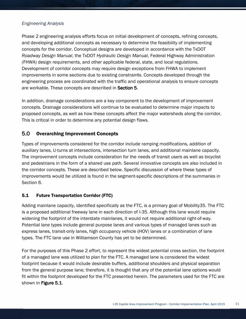
Engineering Analysis
Phase 2 engineering analysis efforts focus on
and developing additional concepts as necessary to
concepts for the corridor. Concept
Roadway Design Manual
(
Development of corridor concepts
improvements in some sections
engineering process are coordinated with the tra
are workable
In addition, drainage considerations are a key component to the development of improvement
concepts. Drainage considerations will
proposed concepts, as well as how these concepts affect
This is critical in order
5.05.05.05.0
Types of improvements c
auxiliary lanes, U
The
and
the corridor concepts. These are described below. Specific discussion of where these types of
improvements would be utilized is found in the s
Section 6.
5.1
Add
is a proposed additional freeway lane in each directi
widening the footprint of the interstate mainlanes, it would not require additional right
Potential lane types include general purpose lanes
express lanes, tran
types.
For the purposes of this Phase 2 effort, to represent the widest potential cross section, the footprint
of
footprint because it would include
from the general purpose lane; therefore,
fit within the footprint developed for the FTC presented herein. The parameters used for the FTC are
shown in
Engineering Analysis
Phase 2 engineering analysis efforts focus on
and developing additional concepts as necessary to
concepts for the corridor. Concept
Roadway Design Manual
(FHWA) design requirements, and other applicable federal
Development of corridor concepts
improvements in some sections
engineering process are coordinated with the tra
are workable
In addition, drainage considerations are a key component to the development of improvement
concepts. Drainage considerations will
proposed concepts, as well as how these concepts affect
This is critical in order
5.05.05.05.0 Overarching
Types of improvements c
auxiliary lanes, U
The improvement
and pedestrian
the corridor concepts. These are described below. Specific discussion of where these types of
improvements would be utilized is found in the s
Section 6.
Future 5.1
Adding mainlane capacity,
is a proposed additional freeway lane in each directi
widening the footprint of the interstate mainlanes, it would not require additional right
Potential lane types include general purpose lanes
express lanes, tran
types. The FTC lane use in Williamson County has yet to be determined.
For the purposes of this Phase 2 effort, to represent the widest potential cross section, the footprint
of a managed lane was utilized to plan for the FTC. A managed lane is considered the widest
footprint because it would include
from the general purpose lane; therefore,
fit within the footprint developed for the FTC presented herein. The parameters used for the FTC are
shown in Figure Figure Figure Figure
Engineering Analysis
Phase 2 engineering analysis efforts focus on
and developing additional concepts as necessary to
concepts for the corridor. Concept
Roadway Design Manual
design requirements, and other applicable federal
Development of corridor concepts
improvements in some sections
engineering process are coordinated with the tra
are workable. These concepts are described in
In addition, drainage considerations are a key component to the development of improvement
concepts. Drainage considerations will
proposed concepts, as well as how these concepts affect
This is critical in order to
Overarching Improvement Concepts
Types of improvements c
auxiliary lanes, U-turns at intersections, intersection turn lanes
improvement concepts
pedestrians in the form of a shared use path
the corridor concepts. These are described below. Specific discussion of where these types of
improvements would be utilized is found in the s
uture Transportation
mainlane capacity,
is a proposed additional freeway lane in each directi
widening the footprint of the interstate mainlanes, it would not require additional right
Potential lane types include general purpose lanes
express lanes, transit-only lanes, high occupancy vehicle (HOV) lanes or a combination of lane
The FTC lane use in Williamson County has yet to be determined.
For the purposes of this Phase 2 effort, to represent the widest potential cross section, the footprint
a managed lane was utilized to plan for the FTC. A managed lane is considered the widest
footprint because it would include
from the general purpose lane; therefore,
fit within the footprint developed for the FTC presented herein. The parameters used for the FTC are
Figure Figure Figure Figure 5555.1.1.1.1.
Phase 2 engineering analysis efforts focus on
and developing additional concepts as necessary to
concepts for the corridor. Conceptual design
Roadway Design Manual, the TxDOT
design requirements, and other applicable federal
Development of corridor concepts may
improvements in some sections due to existing constraints.
engineering process are coordinated with the tra
These concepts are described in
In addition, drainage considerations are a key component to the development of improvement
concepts. Drainage considerations will
proposed concepts, as well as how these concepts affect
to determine any potential design flaws.
Improvement Concepts
Types of improvements considered for the corridor include ramping modifications, addition of
turns at intersections, intersection turn lanes
concepts include consideration for the needs of transit users as wel
in the form of a shared use path
the corridor concepts. These are described below. Specific discussion of where these types of
improvements would be utilized is found in the s
ransportation Corridor
mainlane capacity, identified
is a proposed additional freeway lane in each directi
widening the footprint of the interstate mainlanes, it would not require additional right
Potential lane types include general purpose lanes
only lanes, high occupancy vehicle (HOV) lanes or a combination of lane
The FTC lane use in Williamson County has yet to be determined.
For the purposes of this Phase 2 effort, to represent the widest potential cross section, the footprint
a managed lane was utilized to plan for the FTC. A managed lane is considered the widest
footprint because it would include desirable
from the general purpose lane; therefore,
fit within the footprint developed for the FTC presented herein. The parameters used for the FTC are
I-35 Capital Area Improvement Program
Phase 2 engineering analysis efforts focus on
and developing additional concepts as necessary to
ual designs are developed in accordance with the TxDOT
, the TxDOT Hydraulic Design Manual
design requirements, and other applicable federal
may require design exceptions from FHWA to implement
due to existing constraints.
engineering process are coordinated with the tra
These concepts are described in
In addition, drainage considerations are a key component to the development of improvement
concepts. Drainage considerations will continue to
proposed concepts, as well as how these concepts affect
determine any potential design flaws.
Improvement Concepts
onsidered for the corridor include ramping modifications, addition of
turns at intersections, intersection turn lanes
include consideration for the needs of transit users as wel
in the form of a shared use path
the corridor concepts. These are described below. Specific discussion of where these types of
improvements would be utilized is found in the s
orridor (FTC)
identified specifically as
is a proposed additional freeway lane in each directi
widening the footprint of the interstate mainlanes, it would not require additional right
Potential lane types include general purpose lanes
only lanes, high occupancy vehicle (HOV) lanes or a combination of lane
The FTC lane use in Williamson County has yet to be determined.
For the purposes of this Phase 2 effort, to represent the widest potential cross section, the footprint
a managed lane was utilized to plan for the FTC. A managed lane is considered the widest
desirable buffers, additional shoulders and physical separation
from the general purpose lane; therefore, it is thought that
fit within the footprint developed for the FTC presented herein. The parameters used for the FTC are
35 Capital Area Improvement Program
Phase 2 engineering analysis efforts focus on initial development of
and developing additional concepts as necessary to determine the feasib
s are developed in accordance with the TxDOT
Hydraulic Design Manual
design requirements, and other applicable federal
require design exceptions from FHWA to implement
due to existing constraints.
engineering process are coordinated with the traffic and operational analysis to ensure concepts
These concepts are described in Section Section Section Section 5555.
In addition, drainage considerations are a key component to the development of improvement
continue to be eval
proposed concepts, as well as how these concepts affect
determine any potential design flaws.
Improvement Concepts
onsidered for the corridor include ramping modifications, addition of
turns at intersections, intersection turn lanes
include consideration for the needs of transit users as wel
in the form of a shared use path. Several innovative concepts are also included in
the corridor concepts. These are described below. Specific discussion of where these types of
improvements would be utilized is found in the segment-specific descriptions of the summaries
specifically as the FTC, is a primary goal of
is a proposed additional freeway lane in each direction of I
widening the footprint of the interstate mainlanes, it would not require additional right
Potential lane types include general purpose lanes and various types of
only lanes, high occupancy vehicle (HOV) lanes or a combination of lane
The FTC lane use in Williamson County has yet to be determined.
For the purposes of this Phase 2 effort, to represent the widest potential cross section, the footprint
a managed lane was utilized to plan for the FTC. A managed lane is considered the widest
buffers, additional shoulders and physical separation
it is thought that
fit within the footprint developed for the FTC presented herein. The parameters used for the FTC are
35 Capital Area Improvement Program
initial development of concepts, refining concepts,
determine the feasib
s are developed in accordance with the TxDOT
Hydraulic Design Manual, Federal Highway Administration
design requirements, and other applicable federal, state, and local regulations.
require design exceptions from FHWA to implement
due to existing constraints. Concepts developed through the
ffic and operational analysis to ensure concepts
.
In addition, drainage considerations are a key component to the development of improvement
be evaluated to determine major impacts to
the major watersh
determine any potential design flaws.
onsidered for the corridor include ramping modifications, addition of
turns at intersections, intersection turn lanes, and additional mainlane capacity
include consideration for the needs of transit users as wel
. Several innovative concepts are also included in
the corridor concepts. These are described below. Specific discussion of where these types of
specific descriptions of the summaries
the FTC, is a primary goal of
on of I-35. Although this lane would require
widening the footprint of the interstate mainlanes, it would not require additional right
various types of
only lanes, high occupancy vehicle (HOV) lanes or a combination of lane
The FTC lane use in Williamson County has yet to be determined.
For the purposes of this Phase 2 effort, to represent the widest potential cross section, the footprint
a managed lane was utilized to plan for the FTC. A managed lane is considered the widest
buffers, additional shoulders and physical separation
it is thought that any of the potential lane options would
fit within the footprint developed for the FTC presented herein. The parameters used for the FTC are
35 Capital Area Improvement Program - Corridor Implementation Plan, April 2015
concepts, refining concepts,
determine the feasibility of implementing
s are developed in accordance with the TxDOT
Federal Highway Administration
, state, and local regulations.
require design exceptions from FHWA to implement
Concepts developed through the
ffic and operational analysis to ensure concepts
In addition, drainage considerations are a key component to the development of improvement
uated to determine major impacts to
the major watersheds along the corridor.
onsidered for the corridor include ramping modifications, addition of
, and additional mainlane capacity
include consideration for the needs of transit users as wel
. Several innovative concepts are also included in
the corridor concepts. These are described below. Specific discussion of where these types of
specific descriptions of the summaries
the FTC, is a primary goal of Mobility35
Although this lane would require
widening the footprint of the interstate mainlanes, it would not require additional right
various types of managed lane
only lanes, high occupancy vehicle (HOV) lanes or a combination of lane
The FTC lane use in Williamson County has yet to be determined.
For the purposes of this Phase 2 effort, to represent the widest potential cross section, the footprint
a managed lane was utilized to plan for the FTC. A managed lane is considered the widest
buffers, additional shoulders and physical separation
the potential lane options would
fit within the footprint developed for the FTC presented herein. The parameters used for the FTC are
Corridor Implementation Plan, April 2015
concepts, refining concepts,
implementing
s are developed in accordance with the TxDOT
Federal Highway Administration
, state, and local regulations.
require design exceptions from FHWA to implement
Concepts developed through the
ffic and operational analysis to ensure concepts
In addition, drainage considerations are a key component to the development of improvement
uated to determine major impacts to
eds along the corridor.
onsidered for the corridor include ramping modifications, addition of
, and additional mainlane capacity
include consideration for the needs of transit users as well as bicycl
. Several innovative concepts are also included in
the corridor concepts. These are described below. Specific discussion of where these types of
specific descriptions of the summaries
Mobility35.
Although this lane would require
widening the footprint of the interstate mainlanes, it would not require additional right-of-way.
managed lanes such as
only lanes, high occupancy vehicle (HOV) lanes or a combination of lane
For the purposes of this Phase 2 effort, to represent the widest potential cross section, the footprint
a managed lane was utilized to plan for the FTC. A managed lane is considered the widest
buffers, additional shoulders and physical separation
the potential lane options would
fit within the footprint developed for the FTC presented herein. The parameters used for the FTC are
Corridor Implementation Plan, April 2015
concepts, refining concepts,
implementing
Federal Highway Administration
require design exceptions from FHWA to implement
Concepts developed through the
ffic and operational analysis to ensure concepts
In addition, drainage considerations are a key component to the development of improvement
uated to determine major impacts to
eds along the corridor.
onsidered for the corridor include ramping modifications, addition of
, and additional mainlane capacity.
bicyclist
. Several innovative concepts are also included in
the corridor concepts. These are described below. Specific discussion of where these types of
specific descriptions of the summaries in
. The FTC
Although this lane would require
way.
such as
only lanes, high occupancy vehicle (HOV) lanes or a combination of lane
For the purposes of this Phase 2 effort, to represent the widest potential cross section, the footprint
a managed lane was utilized to plan for the FTC. A managed lane is considered the widest
buffers, additional shoulders and physical separation
the potential lane options would
fit within the footprint developed for the FTC presented herein. The parameters used for the FTC are
11
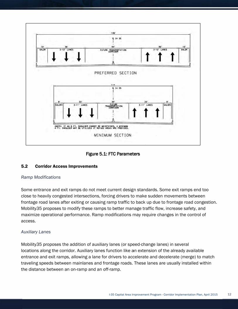
5.2
Ramp Modifications
Some
close to heavily congested intersections, forcing drivers to make sudden movements between
frontage road lanes after exiting or causing ramp traffic to back up due to frontage road congestion.
Mobility
maximize operational performance.
access.
Auxiliary Lanes
Mobility35
locations
entrance and exit ramps, allowing a lane for drivers to accelerate and decelerate (merge) to match
traveling speeds between
the distance between an on
Corridor Access Improvements5.2
Ramp Modifications
Some entrance and exit ramps do not
close to heavily congested intersections, forcing drivers to make sudden movements between
frontage road lanes after exiting or causing ramp traffic to back up due to frontage road congestion.
Mobility35 proposes to modify these ramps to better manage traffic flow, increase safety
maximize operational performance.
access.
Auxiliary Lanes
Mobility35 proposes the addition of auxiliary lanes (
locations along the corridor. Auxiliary lanes function like an extension of the already available
entrance and exit ramps, allowing a lane for drivers to accelerate and decelerate (merge) to match
traveling speeds between
the distance between an on
Corridor Access Improvements
Ramp Modifications
entrance and exit ramps do not
close to heavily congested intersections, forcing drivers to make sudden movements between
frontage road lanes after exiting or causing ramp traffic to back up due to frontage road congestion.
35 proposes to modify these ramps to better manage traffic flow, increase safety
maximize operational performance.
Auxiliary Lanes
proposes the addition of auxiliary lanes (
along the corridor. Auxiliary lanes function like an extension of the already available
entrance and exit ramps, allowing a lane for drivers to accelerate and decelerate (merge) to match
traveling speeds between
the distance between an on
Corridor Access Improvements
entrance and exit ramps do not
close to heavily congested intersections, forcing drivers to make sudden movements between
frontage road lanes after exiting or causing ramp traffic to back up due to frontage road congestion.
35 proposes to modify these ramps to better manage traffic flow, increase safety
maximize operational performance.
proposes the addition of auxiliary lanes (
along the corridor. Auxiliary lanes function like an extension of the already available
entrance and exit ramps, allowing a lane for drivers to accelerate and decelerate (merge) to match
traveling speeds between mainlanes and frontage roads. These lanes are usually installed
the distance between an on-ramp and an off
Figure Figure Figure Figure
I-35 Capital Area Improvement Program
Corridor Access Improvements
entrance and exit ramps do not meet current design standards. Some exit ramps end too
close to heavily congested intersections, forcing drivers to make sudden movements between
frontage road lanes after exiting or causing ramp traffic to back up due to frontage road congestion.
35 proposes to modify these ramps to better manage traffic flow, increase safety
maximize operational performance. Ramp modifications may require changes in the control of
proposes the addition of auxiliary lanes (
along the corridor. Auxiliary lanes function like an extension of the already available
entrance and exit ramps, allowing a lane for drivers to accelerate and decelerate (merge) to match
mainlanes and frontage roads. These lanes are usually installed
ramp and an off-ramp.
Figure Figure Figure Figure 5.15.15.15.1: FTC Parameters: FTC Parameters: FTC Parameters: FTC Parameters
35 Capital Area Improvement Program
meet current design standards. Some exit ramps end too
close to heavily congested intersections, forcing drivers to make sudden movements between
frontage road lanes after exiting or causing ramp traffic to back up due to frontage road congestion.
35 proposes to modify these ramps to better manage traffic flow, increase safety
Ramp modifications may require changes in the control of
proposes the addition of auxiliary lanes (or speed
along the corridor. Auxiliary lanes function like an extension of the already available
entrance and exit ramps, allowing a lane for drivers to accelerate and decelerate (merge) to match
mainlanes and frontage roads. These lanes are usually installed
ramp.
: FTC Parameters: FTC Parameters: FTC Parameters: FTC Parameters
35 Capital Area Improvement Program
meet current design standards. Some exit ramps end too
close to heavily congested intersections, forcing drivers to make sudden movements between
frontage road lanes after exiting or causing ramp traffic to back up due to frontage road congestion.
35 proposes to modify these ramps to better manage traffic flow, increase safety
Ramp modifications may require changes in the control of
or speed-change lanes) in several
along the corridor. Auxiliary lanes function like an extension of the already available
entrance and exit ramps, allowing a lane for drivers to accelerate and decelerate (merge) to match
mainlanes and frontage roads. These lanes are usually installed
: FTC Parameters: FTC Parameters: FTC Parameters: FTC Parameters
35 Capital Area Improvement Program - Corridor Implementation Plan, April 2015
meet current design standards. Some exit ramps end too
close to heavily congested intersections, forcing drivers to make sudden movements between
frontage road lanes after exiting or causing ramp traffic to back up due to frontage road congestion.
35 proposes to modify these ramps to better manage traffic flow, increase safety
Ramp modifications may require changes in the control of
change lanes) in several
along the corridor. Auxiliary lanes function like an extension of the already available
entrance and exit ramps, allowing a lane for drivers to accelerate and decelerate (merge) to match
mainlanes and frontage roads. These lanes are usually installed
Corridor Implementation Plan, April 2015
meet current design standards. Some exit ramps end too
close to heavily congested intersections, forcing drivers to make sudden movements between
frontage road lanes after exiting or causing ramp traffic to back up due to frontage road congestion.
35 proposes to modify these ramps to better manage traffic flow, increase safety, and
Ramp modifications may require changes in the control of
change lanes) in several
along the corridor. Auxiliary lanes function like an extension of the already available
entrance and exit ramps, allowing a lane for drivers to accelerate and decelerate (merge) to match
mainlanes and frontage roads. These lanes are usually installed within
Corridor Implementation Plan, April 2015
meet current design standards. Some exit ramps end too
close to heavily congested intersections, forcing drivers to make sudden movements between
frontage road lanes after exiting or causing ramp traffic to back up due to frontage road congestion.
and
Ramp modifications may require changes in the control of
along the corridor. Auxiliary lanes function like an extension of the already available
entrance and exit ramps, allowing a lane for drivers to accelerate and decelerate (merge) to match
within
12

Collector
Collector
on a frontage road to bypass signalized intersections without having to stop
intersection
speed changes.
roads.
5.3
A conventional intersection helps move large volumes of traffic through limited amounts of space
safely and efficiently. Potential modifications could include improving signal timing, addi
additional turn lanes or through lanes
of
improved
5.4
A
reduces travel times, and improves safety for
free left turns fo
prior to it entering the intersection. Two
significantly reduce delay compared to four
roadway, vehicles can turn left onto the frontage roads without stopping and without conflicting
with through traffic.
shown)
connections
Collector-distributor (C
Collector-distributor
on a frontage road to bypass signalized intersections without having to stop
intersection.
speed changes.
roads.
Conventional Intersection5.3
A conventional intersection helps move large volumes of traffic through limited amounts of space
safely and efficiently. Potential modifications could include improving signal timing, addi
additional turn lanes or through lanes
of traffic through the intersection. Benefits of modifying conventional intersections include
improved safety, mobility, connectivity
Diverging Diamond Intersection5.4
A Diverging D
reduces travel times, and improves safety for
free left turns fo
prior to it entering the intersection. Two
significantly reduce delay compared to four
roadway, vehicles can turn left onto the frontage roads without stopping and without conflicting
with through traffic.
shown) under a bridge
connections
distributor (C-D) road
istributor (C-D) roads help manage traffic flow along a corridor by allowing through traff
on a frontage road to bypass signalized intersections without having to stop
. C-D roads can also improve safety by providing safer opportunities for merging and
speed changes. C-D roads are typically located between the main
Conventional Intersection
A conventional intersection helps move large volumes of traffic through limited amounts of space
safely and efficiently. Potential modifications could include improving signal timing, addi
additional turn lanes or through lanes
traffic through the intersection. Benefits of modifying conventional intersections include
safety, mobility, connectivity
Diverging Diamond Intersection
Diamond Intersection
reduces travel times, and improves safety for
free left turns for motorists. This is accomplished by shifting traffic to the left side of the roadway
prior to it entering the intersection. Two
significantly reduce delay compared to four
roadway, vehicles can turn left onto the frontage roads without stopping and without conflicting
with through traffic. Frontage road through traffic
under a bridge,
connections to the frontage road
Source: FHWA Publication Number FHWA
D) road
D) roads help manage traffic flow along a corridor by allowing through traff
on a frontage road to bypass signalized intersections without having to stop
D roads can also improve safety by providing safer opportunities for merging and
D roads are typically located between the main
Conventional Intersection
A conventional intersection helps move large volumes of traffic through limited amounts of space
safely and efficiently. Potential modifications could include improving signal timing, addi
additional turn lanes or through lanes
traffic through the intersection. Benefits of modifying conventional intersections include
safety, mobility, connectivity
Diverging Diamond Intersection
ntersection (DDI)
reduces travel times, and improves safety for
r motorists. This is accomplished by shifting traffic to the left side of the roadway
prior to it entering the intersection. Two
significantly reduce delay compared to four
roadway, vehicles can turn left onto the frontage roads without stopping and without conflicting
Frontage road through traffic
, though access to properties abutting the frontage road between the C
to the frontage road is restricted
Figure Figure Figure Figure
Source: FHWA Publication Number FHWA
I-35 Capital Area Improvement Program
D) roads help manage traffic flow along a corridor by allowing through traff
on a frontage road to bypass signalized intersections without having to stop
D roads can also improve safety by providing safer opportunities for merging and
D roads are typically located between the main
A conventional intersection helps move large volumes of traffic through limited amounts of space
safely and efficiently. Potential modifications could include improving signal timing, addi
additional turn lanes or through lanes, and adding dedicated U
traffic through the intersection. Benefits of modifying conventional intersections include
safety, mobility, connectivity, and frontage road
Diverging Diamond Intersection
(DDI), shown in
reduces travel times, and improves safety for drivers
r motorists. This is accomplished by shifting traffic to the left side of the roadway
prior to it entering the intersection. Two-phase traffic signals are installed at the crossovers
significantly reduce delay compared to four-phase signals
roadway, vehicles can turn left onto the frontage roads without stopping and without conflicting
Frontage road through traffic
cess to properties abutting the frontage road between the C
is restricted.
Figure Figure Figure Figure 5.2: Diverging Diamond Intersection5.2: Diverging Diamond Intersection5.2: Diverging Diamond Intersection5.2: Diverging Diamond Intersection
Source: FHWA Publication Number FHWA
35 Capital Area Improvement Program
D) roads help manage traffic flow along a corridor by allowing through traff
on a frontage road to bypass signalized intersections without having to stop
D roads can also improve safety by providing safer opportunities for merging and
D roads are typically located between the main
A conventional intersection helps move large volumes of traffic through limited amounts of space
safely and efficiently. Potential modifications could include improving signal timing, addi
and adding dedicated U
traffic through the intersection. Benefits of modifying conventional intersections include
and frontage road
shown in Figure Figure Figure Figure 5555
drivers, bicycl
r motorists. This is accomplished by shifting traffic to the left side of the roadway
phase traffic signals are installed at the crossovers
phase signals
roadway, vehicles can turn left onto the frontage roads without stopping and without conflicting
Frontage road through traffic bypasses the intersection via a C
cess to properties abutting the frontage road between the C
5.2: Diverging Diamond Intersection5.2: Diverging Diamond Intersection5.2: Diverging Diamond Intersection5.2: Diverging Diamond Intersection
Source: FHWA Publication Number FHWA
35 Capital Area Improvement Program
D) roads help manage traffic flow along a corridor by allowing through traff
on a frontage road to bypass signalized intersections without having to stop
D roads can also improve safety by providing safer opportunities for merging and
D roads are typically located between the mainlanes of
A conventional intersection helps move large volumes of traffic through limited amounts of space
safely and efficiently. Potential modifications could include improving signal timing, addi
and adding dedicated U-turn lanes
traffic through the intersection. Benefits of modifying conventional intersections include
and frontage road traffic flow.
5555.2.2.2.2, handles higher traffic volumes,
, bicyclists and pedestrians.
r motorists. This is accomplished by shifting traffic to the left side of the roadway
phase traffic signals are installed at the crossovers
phase signals. Once on the left side of the arterial
roadway, vehicles can turn left onto the frontage roads without stopping and without conflicting
bypasses the intersection via a C
cess to properties abutting the frontage road between the C
5.2: Diverging Diamond Intersection5.2: Diverging Diamond Intersection5.2: Diverging Diamond Intersection5.2: Diverging Diamond Intersection
Source: FHWA Publication Number FHWA-HRT
35 Capital Area Improvement Program - Corridor Implementation Plan, April 2015
D) roads help manage traffic flow along a corridor by allowing through traff
on a frontage road to bypass signalized intersections without having to stop at a signalized
D roads can also improve safety by providing safer opportunities for merging and
lanes of the freeway and frontage
A conventional intersection helps move large volumes of traffic through limited amounts of space
safely and efficiently. Potential modifications could include improving signal timing, addi
turn lanes to improve the efficiency
traffic through the intersection. Benefits of modifying conventional intersections include
traffic flow.
handles higher traffic volumes,
and pedestrians.
r motorists. This is accomplished by shifting traffic to the left side of the roadway
phase traffic signals are installed at the crossovers
he left side of the arterial
roadway, vehicles can turn left onto the frontage roads without stopping and without conflicting
bypasses the intersection via a C
cess to properties abutting the frontage road between the C
5.2: Diverging Diamond Intersection5.2: Diverging Diamond Intersection5.2: Diverging Diamond Intersection5.2: Diverging Diamond Intersection
HRT-09-054
Corridor Implementation Plan, April 2015
D) roads help manage traffic flow along a corridor by allowing through traff
at a signalized
D roads can also improve safety by providing safer opportunities for merging and
freeway and frontage
A conventional intersection helps move large volumes of traffic through limited amounts of space
safely and efficiently. Potential modifications could include improving signal timing, adding
improve the efficiency
traffic through the intersection. Benefits of modifying conventional intersections include
handles higher traffic volumes,
and pedestrians. The DDI allows
r motorists. This is accomplished by shifting traffic to the left side of the roadway
phase traffic signals are installed at the crossovers, and
he left side of the arterial
roadway, vehicles can turn left onto the frontage roads without stopping and without conflicting
bypasses the intersection via a C-D road (not
cess to properties abutting the frontage road between the C
Corridor Implementation Plan, April 2015
D) roads help manage traffic flow along a corridor by allowing through traffic
D roads can also improve safety by providing safer opportunities for merging and
freeway and frontage
A conventional intersection helps move large volumes of traffic through limited amounts of space
improve the efficiency
handles higher traffic volumes,
allows
r motorists. This is accomplished by shifting traffic to the left side of the roadway
, and
he left side of the arterial
roadway, vehicles can turn left onto the frontage roads without stopping and without conflicting
(not
cess to properties abutting the frontage road between the C-D
13
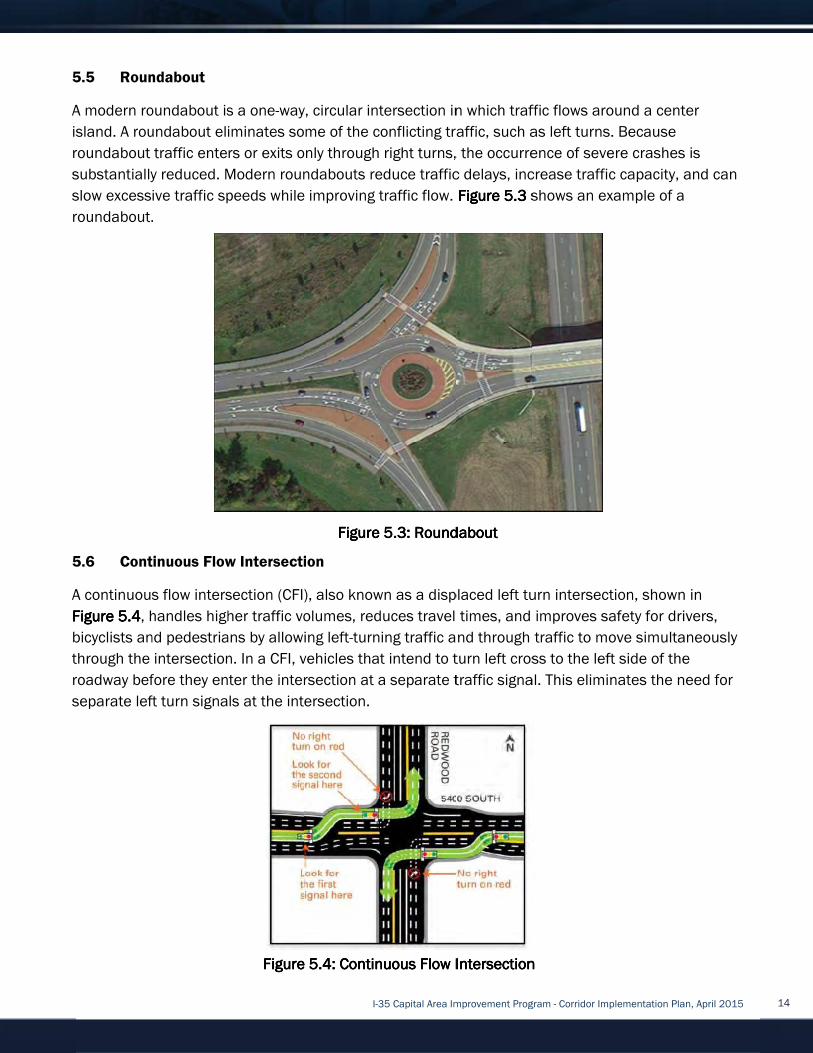
5.5
A
island. A roundabout eliminates some
roundabout traffic enters or exits only through right turns, the occurrence of severe cr
substantially reduced.
slo
roundabout
5.6
A continuous flow intersection (CFI)
Figure Figure Figure Figure
bicycl
through the intersection
roadway before they enter the intersection at a separate traffic signal. This eliminates the need for
separate left turn signals at the intersection.
Roundabout5.5
A modern roundabout
island. A roundabout eliminates some
roundabout traffic enters or exits only through right turns, the occurrence of severe cr
substantially reduced.
slow excessive traffic speeds while improving traffic flow.
roundabout.
Continuous Flow Intersection 5.6
A continuous flow intersection (CFI)
Figure Figure Figure Figure 5555.4.4.4.4, handles
bicyclists and pedestrians
through the intersection
roadway before they enter the intersection at a separate traffic signal. This eliminates the need for
separate left turn signals at the intersection.
Roundabout
oundabout is a one
island. A roundabout eliminates some
roundabout traffic enters or exits only through right turns, the occurrence of severe cr
substantially reduced. Modern roundabouts reduce traffic delays, in
w excessive traffic speeds while improving traffic flow.
.
Continuous Flow Intersection
A continuous flow intersection (CFI)
handles high
s and pedestrians
through the intersection
roadway before they enter the intersection at a separate traffic signal. This eliminates the need for
separate left turn signals at the intersection.
is a one-way, circular intersection in which traffic flows around a center
island. A roundabout eliminates some
roundabout traffic enters or exits only through right turns, the occurrence of severe cr
Modern roundabouts reduce traffic delays, in
w excessive traffic speeds while improving traffic flow.
Continuous Flow Intersection
A continuous flow intersection (CFI)
higher traffic volumes, reduces travel times, and improves safety for
s and pedestrians by allowing left
through the intersection. In a CFI, vehicles that intend to turn left cross t
roadway before they enter the intersection at a separate traffic signal. This eliminates the need for
separate left turn signals at the intersection.
Figure Figure Figure Figure
I-35 Capital Area Improvement Program
way, circular intersection in which traffic flows around a center
island. A roundabout eliminates some of the conflicting traffic, such as left turns. Because
roundabout traffic enters or exits only through right turns, the occurrence of severe cr
Modern roundabouts reduce traffic delays, in
w excessive traffic speeds while improving traffic flow.
Continuous Flow Intersection
A continuous flow intersection (CFI), also known as a
er traffic volumes, reduces travel times, and improves safety for
by allowing left-turning traffic and through traffic to move simultaneously
, vehicles that intend to turn left cross t
roadway before they enter the intersection at a separate traffic signal. This eliminates the need for
separate left turn signals at the intersection.
Figure Figure Figure Figure
Figure Figure Figure Figure 5.4: Continuous Flow Intersection5.4: Continuous Flow Intersection5.4: Continuous Flow Intersection5.4: Continuous Flow Intersection
35 Capital Area Improvement Program
way, circular intersection in which traffic flows around a center
of the conflicting traffic, such as left turns. Because
roundabout traffic enters or exits only through right turns, the occurrence of severe cr
Modern roundabouts reduce traffic delays, in
w excessive traffic speeds while improving traffic flow.
also known as a displaced left turn intersection,
er traffic volumes, reduces travel times, and improves safety for
turning traffic and through traffic to move simultaneously
, vehicles that intend to turn left cross t
roadway before they enter the intersection at a separate traffic signal. This eliminates the need for
Figure Figure Figure Figure 5.3: Roundabout5.3: Roundabout5.3: Roundabout5.3: Roundabout
5.4: Continuous Flow Intersection5.4: Continuous Flow Intersection5.4: Continuous Flow Intersection5.4: Continuous Flow Intersection
35 Capital Area Improvement Program
way, circular intersection in which traffic flows around a center
of the conflicting traffic, such as left turns. Because
roundabout traffic enters or exits only through right turns, the occurrence of severe cr
Modern roundabouts reduce traffic delays, increase traffic capacity, and can
Figure Figure Figure Figure 5.5.5.5.3333 shows an example of a
displaced left turn intersection,
er traffic volumes, reduces travel times, and improves safety for
turning traffic and through traffic to move simultaneously
, vehicles that intend to turn left cross t
roadway before they enter the intersection at a separate traffic signal. This eliminates the need for
5.3: Roundabout5.3: Roundabout5.3: Roundabout5.3: Roundabout
5.4: Continuous Flow Intersection5.4: Continuous Flow Intersection5.4: Continuous Flow Intersection5.4: Continuous Flow Intersection
35 Capital Area Improvement Program - Corridor Implementation Plan, April 2015
way, circular intersection in which traffic flows around a center
of the conflicting traffic, such as left turns. Because
roundabout traffic enters or exits only through right turns, the occurrence of severe cr
crease traffic capacity, and can
shows an example of a
displaced left turn intersection,
er traffic volumes, reduces travel times, and improves safety for
turning traffic and through traffic to move simultaneously
, vehicles that intend to turn left cross to the left side of the
roadway before they enter the intersection at a separate traffic signal. This eliminates the need for
5.4: Continuous Flow Intersection5.4: Continuous Flow Intersection5.4: Continuous Flow Intersection5.4: Continuous Flow Intersection
Corridor Implementation Plan, April 2015
way, circular intersection in which traffic flows around a center
of the conflicting traffic, such as left turns. Because
roundabout traffic enters or exits only through right turns, the occurrence of severe crashes is
crease traffic capacity, and can
shows an example of a
displaced left turn intersection, shown in
er traffic volumes, reduces travel times, and improves safety for drivers
turning traffic and through traffic to move simultaneously
o the left side of the
roadway before they enter the intersection at a separate traffic signal. This eliminates the need for
Corridor Implementation Plan, April 2015
way, circular intersection in which traffic flows around a center
ashes is
crease traffic capacity, and can
shows an example of a
shown in
drivers,
turning traffic and through traffic to move simultaneously
o the left side of the
roadway before they enter the intersection at a separate traffic signal. This eliminates the need for
14
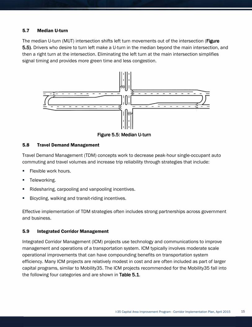
5.7
The median U
5555
then a right turn at the intersection. Eliminating the left turn at the main intersection simplifies
signal timing and provi
5.8
Travel Demand Management (TDM) concepts work to decrease peak
commuting
�
�
�
�
Effective implementation of TDM strategies often includes strong partnerships across government
and business.
5.9
Integrated Corridor Management
management and operations of a transportation system. I
operational improvements that can have compoundin
efficiency. M
capital programs, similar to Mobility35. The
the following four c
Median U5.7
The median U
5555.5.5.5.5)))). Drivers who
then a right turn at the intersection. Eliminating the left turn at the main intersection simplifies
signal timing and provi
Travel Demand Management5.8
Travel Demand Management (TDM) concepts work to decrease peak
commuting and
� Flexible work hours
� Teleworking
� Ridesharing, carpooling and vanpooling
� Bicycling
Effective implementation of TDM strategies often includes strong partnerships across government
and business.
Integra5.9
Integrated Corridor Management
management and operations of a transportation system. I
operational improvements that can have compoundin
efficiency. M
capital programs, similar to Mobility35. The
the following four c
Median U-turn
The median U-turn (MUT) intersection shifts left turn
Drivers who desire to turn left make a U
then a right turn at the intersection. Eliminating the left turn at the main intersection simplifies
signal timing and provides more green time and less congestion.
Travel Demand Management
Travel Demand Management (TDM) concepts work to decrease peak
and travel volumes and increase trip reliability through strategies that include:
Flexible work hours.
Teleworking.
idesharing, carpooling and vanpooling
icycling, walking and transit
Effective implementation of TDM strategies often includes strong partnerships across government
and business.
Integrated Corridor Management
Integrated Corridor Management
management and operations of a transportation system. I
operational improvements that can have compoundin
efficiency. Many ICM projects are relatively mo
capital programs, similar to Mobility35. The
the following four categories and are shown in
turn (MUT) intersection shifts left turn
desire to turn left make a U
then a right turn at the intersection. Eliminating the left turn at the main intersection simplifies
des more green time and less congestion.
Travel Demand Management
Travel Demand Management (TDM) concepts work to decrease peak
travel volumes and increase trip reliability through strategies that include:
.
idesharing, carpooling and vanpooling
and transit-riding
Effective implementation of TDM strategies often includes strong partnerships across government
ted Corridor Management
Integrated Corridor Management (I
management and operations of a transportation system. I
operational improvements that can have compoundin
projects are relatively mo
capital programs, similar to Mobility35. The
ategories and are shown in
I-35 Capital Area Improvement Program
turn (MUT) intersection shifts left turn
desire to turn left make a U-turn in the median beyond the main intersection, and
then a right turn at the intersection. Eliminating the left turn at the main intersection simplifies
des more green time and less congestion.
Travel Demand Management
Travel Demand Management (TDM) concepts work to decrease peak
travel volumes and increase trip reliability through strategies that include:
idesharing, carpooling and vanpooling incentives
riding incentives
Effective implementation of TDM strategies often includes strong partnerships across government
ted Corridor Management
(ICM) projects use technology and communications to improve
management and operations of a transportation system. I
operational improvements that can have compoundin
projects are relatively mo
capital programs, similar to Mobility35. The ICM
ategories and are shown in
Figure Figure Figure Figure 5.5: Median U5.5: Median U5.5: Median U5.5: Median U
35 Capital Area Improvement Program
turn (MUT) intersection shifts left turn movement
turn in the median beyond the main intersection, and
then a right turn at the intersection. Eliminating the left turn at the main intersection simplifies
des more green time and less congestion.
Travel Demand Management (TDM) concepts work to decrease peak
travel volumes and increase trip reliability through strategies that include:
incentives.
incentives.
Effective implementation of TDM strategies often includes strong partnerships across government
) projects use technology and communications to improve
management and operations of a transportation system. I
operational improvements that can have compounding benefits on transportation system
projects are relatively modest in cost and are often included as part of larger
ICM projects recommended for the
ategories and are shown in Table Table Table Table 5555.1.1.1.1.
5.5: Median U5.5: Median U5.5: Median U5.5: Median U----
35 Capital Area Improvement Program
movements out of the intersection
turn in the median beyond the main intersection, and
then a right turn at the intersection. Eliminating the left turn at the main intersection simplifies
des more green time and less congestion.
Travel Demand Management (TDM) concepts work to decrease peak
travel volumes and increase trip reliability through strategies that include:
Effective implementation of TDM strategies often includes strong partnerships across government
) projects use technology and communications to improve
management and operations of a transportation system. ICM typically involve
g benefits on transportation system
in cost and are often included as part of larger
projects recommended for the
----turnturnturnturn
35 Capital Area Improvement Program - Corridor Implementation Plan, April 2015
out of the intersection
turn in the median beyond the main intersection, and
then a right turn at the intersection. Eliminating the left turn at the main intersection simplifies
Travel Demand Management (TDM) concepts work to decrease peak-hour single
travel volumes and increase trip reliability through strategies that include:
Effective implementation of TDM strategies often includes strong partnerships across government
) projects use technology and communications to improve
typically involves moderate scale
g benefits on transportation system
in cost and are often included as part of larger
projects recommended for the Mobility35
Corridor Implementation Plan, April 2015
out of the intersection (Figure Figure Figure Figure
turn in the median beyond the main intersection, and
then a right turn at the intersection. Eliminating the left turn at the main intersection simplifies
hour single-occupant auto
travel volumes and increase trip reliability through strategies that include:
Effective implementation of TDM strategies often includes strong partnerships across government
) projects use technology and communications to improve
moderate scale
g benefits on transportation system
in cost and are often included as part of larger
Mobility35 fall into
Corridor Implementation Plan, April 2015
Figure Figure Figure Figure
turn in the median beyond the main intersection, and
then a right turn at the intersection. Eliminating the left turn at the main intersection simplifies
occupant auto
Effective implementation of TDM strategies often includes strong partnerships across government
) projects use technology and communications to improve
moderate scale
in cost and are often included as part of larger
fall into
15
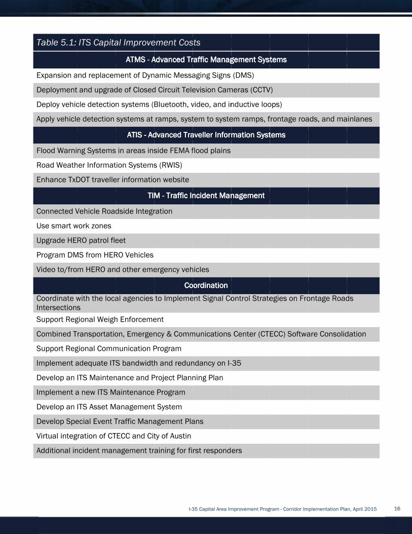
Table 5.1: ITS Capital Improvement Costs
Expansion and replacement of Dynamic Messaging Signs (DMS)
Deployment and upgrade of Closed Circuit Television Cameras (CCTV)
Dep
Apply vehicle detection systems at ramps, system to system ramps, frontage roads, and mainlanes
Flood Warning Systems in areas inside FEM
Road Weather Information Systems (RWIS)
Enhance Tx
Connected Vehicle Roadside Integration
Use smart work zones
Upgrade HERO patrol fleet
Program DMS from HERO Vehicles
Video to/from HERO and other emergency vehicles
Coordinate with the Intersections
Support Regional Weigh Enforcement
Combined Transportation, Emergency & Communicati
Support Regional Communication Program
Implement adequate ITS bandwidth and redundancy on I
Develop an ITS Maintenance and Project Planning Plan
Implement a new ITS Maintenance Program
Develop an ITS Asset
Develop Special Event Traffic Management Plans
Virtual integration of CTECC and City of Austin
Additional incident management training for first responders
Table 5.1: ITS Capital Improvement Costs
Expansion and replacement of Dynamic Messaging Signs (DMS)
Deployment and upgrade of Closed Circuit Television Cameras (CCTV)
Deploy vehicle detection systems (Bluetooth, video, and inductive loops)
Apply vehicle detection systems at ramps, system to system ramps, frontage roads, and mainlanes
Flood Warning Systems in areas inside FEM
Road Weather Information Systems (RWIS)
Enhance TxDOT
Connected Vehicle Roadside Integration
Use smart work zones
Upgrade HERO patrol fleet
Program DMS from HERO Vehicles
Video to/from HERO and other emergency vehicles
Coordinate with the Intersections
Support Regional Weigh Enforcement
Combined Transportation, Emergency & Communicati
Support Regional Communication Program
Implement adequate ITS bandwidth and redundancy on I
Develop an ITS Maintenance and Project Planning Plan
Implement a new ITS Maintenance Program
Develop an ITS Asset
Develop Special Event Traffic Management Plans
Virtual integration of CTECC and City of Austin
Additional incident management training for first responders
Table 5.1: ITS Capital Improvement Costs
Expansion and replacement of Dynamic Messaging Signs (DMS)
Deployment and upgrade of Closed Circuit Television Cameras (CCTV)
loy vehicle detection systems (Bluetooth, video, and inductive loops)
Apply vehicle detection systems at ramps, system to system ramps, frontage roads, and mainlanes
Flood Warning Systems in areas inside FEM
Road Weather Information Systems (RWIS)
DOT traveller
Connected Vehicle Roadside Integration
Use smart work zones
Upgrade HERO patrol fleet
Program DMS from HERO Vehicles
Video to/from HERO and other emergency vehicles
Coordinate with the local agenciesIntersections
Support Regional Weigh Enforcement
Combined Transportation, Emergency & Communicati
Support Regional Communication Program
Implement adequate ITS bandwidth and redundancy on I
Develop an ITS Maintenance and Project Planning Plan
Implement a new ITS Maintenance Program
Develop an ITS Asset Management System
Develop Special Event Traffic Management Plans
Virtual integration of CTECC and City of Austin
Additional incident management training for first responders
Table 5.1: ITS Capital Improvement Costs
ATMS ATMS ATMS ATMS ---- Advanced Traffic Management SystemsAdvanced Traffic Management SystemsAdvanced Traffic Management SystemsAdvanced Traffic Management Systems
Expansion and replacement of Dynamic Messaging Signs (DMS)
Deployment and upgrade of Closed Circuit Television Cameras (CCTV)
loy vehicle detection systems (Bluetooth, video, and inductive loops)
Apply vehicle detection systems at ramps, system to system ramps, frontage roads, and mainlanes
ATIS ATIS ATIS ATIS ---- Advanced Advanced Advanced Advanced
Flood Warning Systems in areas inside FEM
Road Weather Information Systems (RWIS)
traveller information website
TIM TIM TIM TIM
Connected Vehicle Roadside Integration
Upgrade HERO patrol fleet
Program DMS from HERO Vehicles
Video to/from HERO and other emergency vehicles
local agencies
Support Regional Weigh Enforcement
Combined Transportation, Emergency & Communicati
Support Regional Communication Program
Implement adequate ITS bandwidth and redundancy on I
Develop an ITS Maintenance and Project Planning Plan
Implement a new ITS Maintenance Program
Management System
Develop Special Event Traffic Management Plans
Virtual integration of CTECC and City of Austin
Additional incident management training for first responders
I-35 Capital Area Improvement Program
Table 5.1: ITS Capital Improvement Costs
Advanced Traffic Management SystemsAdvanced Traffic Management SystemsAdvanced Traffic Management SystemsAdvanced Traffic Management Systems
Expansion and replacement of Dynamic Messaging Signs (DMS)
Deployment and upgrade of Closed Circuit Television Cameras (CCTV)
loy vehicle detection systems (Bluetooth, video, and inductive loops)
Apply vehicle detection systems at ramps, system to system ramps, frontage roads, and mainlanes
Advanced Advanced Advanced Advanced TravellerTravellerTravellerTraveller
Flood Warning Systems in areas inside FEMA flood plains
Road Weather Information Systems (RWIS)
information website
TIM TIM TIM TIM ---- Traffic Incident ManagementTraffic Incident ManagementTraffic Incident ManagementTraffic Incident Management
Connected Vehicle Roadside Integration
Video to/from HERO and other emergency vehicles
CoordinationCoordinationCoordinationCoordination
to Implement Signal Control Strategies on Frontage Roads
Support Regional Weigh Enforcement
Combined Transportation, Emergency & Communicati
Support Regional Communication Program
Implement adequate ITS bandwidth and redundancy on I
Develop an ITS Maintenance and Project Planning Plan
Implement a new ITS Maintenance Program
Management System
Develop Special Event Traffic Management Plans
Virtual integration of CTECC and City of Austin
Additional incident management training for first responders
35 Capital Area Improvement Program
Table 5.1: ITS Capital Improvement Costs
Advanced Traffic Management SystemsAdvanced Traffic Management SystemsAdvanced Traffic Management SystemsAdvanced Traffic Management Systems
Expansion and replacement of Dynamic Messaging Signs (DMS)
Deployment and upgrade of Closed Circuit Television Cameras (CCTV)
loy vehicle detection systems (Bluetooth, video, and inductive loops)
Apply vehicle detection systems at ramps, system to system ramps, frontage roads, and mainlanes
TravellerTravellerTravellerTraveller Information SystemsInformation SystemsInformation SystemsInformation Systems
A flood plains
Traffic Incident ManagementTraffic Incident ManagementTraffic Incident ManagementTraffic Incident Management
Video to/from HERO and other emergency vehicles
CoordinationCoordinationCoordinationCoordination
to Implement Signal Control Strategies on Frontage Roads
Combined Transportation, Emergency & Communications Center (CTECC) Software Consolidation
Implement adequate ITS bandwidth and redundancy on I-
Develop an ITS Maintenance and Project Planning Plan
Develop Special Event Traffic Management Plans
Additional incident management training for first responders
35 Capital Area Improvement Program
Advanced Traffic Management SystemsAdvanced Traffic Management SystemsAdvanced Traffic Management SystemsAdvanced Traffic Management Systems
Expansion and replacement of Dynamic Messaging Signs (DMS)
Deployment and upgrade of Closed Circuit Television Cameras (CCTV)
loy vehicle detection systems (Bluetooth, video, and inductive loops)
Apply vehicle detection systems at ramps, system to system ramps, frontage roads, and mainlanes
Information SystemsInformation SystemsInformation SystemsInformation Systems
Traffic Incident ManagementTraffic Incident ManagementTraffic Incident ManagementTraffic Incident Management
to Implement Signal Control Strategies on Frontage Roads
ons Center (CTECC) Software Consolidation
-35
Additional incident management training for first responders
35 Capital Area Improvement Program - Corridor Implementation Plan, April 2015
Advanced Traffic Management SystemsAdvanced Traffic Management SystemsAdvanced Traffic Management SystemsAdvanced Traffic Management Systems
Deployment and upgrade of Closed Circuit Television Cameras (CCTV)
loy vehicle detection systems (Bluetooth, video, and inductive loops)
Apply vehicle detection systems at ramps, system to system ramps, frontage roads, and mainlanes
Information SystemsInformation SystemsInformation SystemsInformation Systems
to Implement Signal Control Strategies on Frontage Roads
ons Center (CTECC) Software Consolidation
Corridor Implementation Plan, April 2015
Apply vehicle detection systems at ramps, system to system ramps, frontage roads, and mainlanes
to Implement Signal Control Strategies on Frontage Roads
ons Center (CTECC) Software Consolidation
Corridor Implementation Plan, April 2015
Apply vehicle detection systems at ramps, system to system ramps, frontage roads, and mainlanes
to Implement Signal Control Strategies on Frontage Roads
ons Center (CTECC) Software Consolidation
16

Advanced Traffic Management SystemAdvanced Traffic Management SystemAdvanced Traffic Management SystemAdvanced Traffic Management System
improve the flow of vehicle traffic and improve safety. Real
sensors, etc. flow into a Transportation Management Center (TMC) where it is integrated and
processed (e.g. for incident detection), and may
informational messages on dynamic message signs (DMS) and so forth
is to improve traffic flow.
An
presents information to assist surface transportation travelers in moving from a starting location
(origin) to their desired destination. An ATIS may operate through information supplied entirely
within the vehicle (autonomous system) or it ca
centers. Relevant information may include locations of incidents, weather and road conditions,
optimal routes, recommended speeds, and lane restrictions
Traffic Incident ManagemenTraffic Incident ManagemenTraffic Incident ManagemenTraffic Incident Managemen
different partner agencies and private sector companies to detect, respond to, and clear traffic
incidents as quickly as possible to reduce the impacts of incidents on safety and congestio
protecting the safety of on
ITS Coordination ITS Coordination ITS Coordination ITS Coordination
and jurisdictions
6.06.06.06.0
By identifying a recommended program of projects, this implementation plan
for I
implemented. The con
corridor are described in
in Section 4.2.
and, in a few cases, construction.
6.1
For the purposes of this plan, the following assumptions were made:
�
�
6.2
Williamson County is divided into four segments for the purpose of planni
development. The four segments are:
Advanced Traffic Management SystemAdvanced Traffic Management SystemAdvanced Traffic Management SystemAdvanced Traffic Management System
improve the flow of vehicle traffic and improve safety. Real
sensors, etc. flow into a Transportation Management Center (TMC) where it is integrated and
processed (e.g. for incident detection), and may
informational messages on dynamic message signs (DMS) and so forth
is to improve traffic flow.
An Advanced Traveler Information System (ATIS)Advanced Traveler Information System (ATIS)Advanced Traveler Information System (ATIS)Advanced Traveler Information System (ATIS)
presents information to assist surface transportation travelers in moving from a starting location
(origin) to their desired destination. An ATIS may operate through information supplied entirely
within the vehicle (autonomous system) or it ca
centers. Relevant information may include locations of incidents, weather and road conditions,
optimal routes, recommended speeds, and lane restrictions
Traffic Incident ManagemenTraffic Incident ManagemenTraffic Incident ManagemenTraffic Incident Managemen
different partner agencies and private sector companies to detect, respond to, and clear traffic
incidents as quickly as possible to reduce the impacts of incidents on safety and congestio
protecting the safety of on
ITS Coordination ITS Coordination ITS Coordination ITS Coordination
and jurisdictions
6.06.06.06.0 Recommended Program of Projects
By identifying a recommended program of projects, this implementation plan
for I-35 corridor improvements and provide
implemented. The con
corridor are described in
in Section 4.2.
and, in a few cases, construction.
6.1 Assumptions and Limitations
For the purposes of this plan, the following assumptions were made:
� The improvement concepts delineated in
improve I
� Cost of implementation is based on preliminary, order of magnitude assessment
6.2 Williamson County Segments
Williamson County is divided into four segments for the purpose of planni
development. The four segments are:
Advanced Traffic Management SystemAdvanced Traffic Management SystemAdvanced Traffic Management SystemAdvanced Traffic Management System
improve the flow of vehicle traffic and improve safety. Real
sensors, etc. flow into a Transportation Management Center (TMC) where it is integrated and
processed (e.g. for incident detection), and may
informational messages on dynamic message signs (DMS) and so forth
is to improve traffic flow.
Advanced Traveler Information System (ATIS)Advanced Traveler Information System (ATIS)Advanced Traveler Information System (ATIS)Advanced Traveler Information System (ATIS)
presents information to assist surface transportation travelers in moving from a starting location
(origin) to their desired destination. An ATIS may operate through information supplied entirely
within the vehicle (autonomous system) or it ca
centers. Relevant information may include locations of incidents, weather and road conditions,
optimal routes, recommended speeds, and lane restrictions
Traffic Incident ManagemenTraffic Incident ManagemenTraffic Incident ManagemenTraffic Incident Managemen
different partner agencies and private sector companies to detect, respond to, and clear traffic
incidents as quickly as possible to reduce the impacts of incidents on safety and congestio
protecting the safety of on
ITS Coordination ITS Coordination ITS Coordination ITS Coordination projects or policies
and jurisdictions outside of TxDOT
Recommended Program of Projects
By identifying a recommended program of projects, this implementation plan
corridor improvements and provide
implemented. The concepts and implementation plan for
corridor are described in
in Section 4.2. Some concepts
and, in a few cases, construction.
Assumptions and Limitations
For the purposes of this plan, the following assumptions were made:
The improvement concepts delineated in
improve I-35. These concepts could change as further development occurs in Phases 3 and 4.
Cost of implementation is based on preliminary, order of magnitude assessment
Williamson County Segments
Williamson County is divided into four segments for the purpose of planni
development. The four segments are:
Advanced Traffic Management SystemAdvanced Traffic Management SystemAdvanced Traffic Management SystemAdvanced Traffic Management System
improve the flow of vehicle traffic and improve safety. Real
sensors, etc. flow into a Transportation Management Center (TMC) where it is integrated and
processed (e.g. for incident detection), and may
informational messages on dynamic message signs (DMS) and so forth
is to improve traffic flow.
Advanced Traveler Information System (ATIS)Advanced Traveler Information System (ATIS)Advanced Traveler Information System (ATIS)Advanced Traveler Information System (ATIS)
presents information to assist surface transportation travelers in moving from a starting location
(origin) to their desired destination. An ATIS may operate through information supplied entirely
within the vehicle (autonomous system) or it ca
centers. Relevant information may include locations of incidents, weather and road conditions,
optimal routes, recommended speeds, and lane restrictions
Traffic Incident ManagemenTraffic Incident ManagemenTraffic Incident ManagemenTraffic Incident Management (TIM) t (TIM) t (TIM) t (TIM)
different partner agencies and private sector companies to detect, respond to, and clear traffic
incidents as quickly as possible to reduce the impacts of incidents on safety and congestio
protecting the safety of on-scene responders and the traveling public.
projects or policies
outside of TxDOT in order to accomplish corridor
Recommended Program of Projects
By identifying a recommended program of projects, this implementation plan
corridor improvements and provide
cepts and implementation plan for
corridor are described in this plan.
concepts have progressed beyond the planning phase
and, in a few cases, construction.
Assumptions and Limitations
For the purposes of this plan, the following assumptions were made:
The improvement concepts delineated in
se concepts could change as further development occurs in Phases 3 and 4.
Cost of implementation is based on preliminary, order of magnitude assessment
Williamson County Segments
Williamson County is divided into four segments for the purpose of planni
development. The four segments are:
I-35 Capital Area Improvement Program
Advanced Traffic Management SystemAdvanced Traffic Management SystemAdvanced Traffic Management SystemAdvanced Traffic Management System (ATMS)(ATMS)(ATMS)(ATMS)
improve the flow of vehicle traffic and improve safety. Real
sensors, etc. flow into a Transportation Management Center (TMC) where it is integrated and
processed (e.g. for incident detection), and may
informational messages on dynamic message signs (DMS) and so forth
Advanced Traveler Information System (ATIS)Advanced Traveler Information System (ATIS)Advanced Traveler Information System (ATIS)Advanced Traveler Information System (ATIS)
presents information to assist surface transportation travelers in moving from a starting location
(origin) to their desired destination. An ATIS may operate through information supplied entirely
within the vehicle (autonomous system) or it ca
centers. Relevant information may include locations of incidents, weather and road conditions,
optimal routes, recommended speeds, and lane restrictions
t (TIM) t (TIM) t (TIM) t (TIM) is the process of coordinating the resources of a number of
different partner agencies and private sector companies to detect, respond to, and clear traffic
incidents as quickly as possible to reduce the impacts of incidents on safety and congestio
scene responders and the traveling public.
projects or policies include those items
in order to accomplish corridor
Recommended Program of Projects
By identifying a recommended program of projects, this implementation plan
corridor improvements and provides guidance as to how corridor improvements
cepts and implementation plan for
plan. The project phases, as used in these descriptions,
have progressed beyond the planning phase
Assumptions and Limitations
For the purposes of this plan, the following assumptions were made:
The improvement concepts delineated in this section fo
se concepts could change as further development occurs in Phases 3 and 4.
Cost of implementation is based on preliminary, order of magnitude assessment
Williamson County Segments
Williamson County is divided into four segments for the purpose of planni
development. The four segments are:
35 Capital Area Improvement Program
(ATMS)(ATMS)(ATMS)(ATMS) provides a top
improve the flow of vehicle traffic and improve safety. Real
sensors, etc. flow into a Transportation Management Center (TMC) where it is integrated and
processed (e.g. for incident detection), and may result in actions taken (e.g. traffic routing, placing
informational messages on dynamic message signs (DMS) and so forth
Advanced Traveler Information System (ATIS)Advanced Traveler Information System (ATIS)Advanced Traveler Information System (ATIS)Advanced Traveler Information System (ATIS) is any system that acquires, a
presents information to assist surface transportation travelers in moving from a starting location
(origin) to their desired destination. An ATIS may operate through information supplied entirely
within the vehicle (autonomous system) or it can also use data supplied by traffic management
centers. Relevant information may include locations of incidents, weather and road conditions,
optimal routes, recommended speeds, and lane restrictions
is the process of coordinating the resources of a number of
different partner agencies and private sector companies to detect, respond to, and clear traffic
incidents as quickly as possible to reduce the impacts of incidents on safety and congestio
scene responders and the traveling public.
include those items that will require the support of agencies
in order to accomplish corridor
Recommended Program of Projects
By identifying a recommended program of projects, this implementation plan
guidance as to how corridor improvements
cepts and implementation plan for
The project phases, as used in these descriptions,
have progressed beyond the planning phase
For the purposes of this plan, the following assumptions were made:
this section fo
se concepts could change as further development occurs in Phases 3 and 4.
Cost of implementation is based on preliminary, order of magnitude assessment
Williamson County is divided into four segments for the purpose of planni
35 Capital Area Improvement Program
provides a top-down system for usin
improve the flow of vehicle traffic and improve safety. Real-time traffic data from cameras, speed
sensors, etc. flow into a Transportation Management Center (TMC) where it is integrated and
result in actions taken (e.g. traffic routing, placing
informational messages on dynamic message signs (DMS) and so forth
is any system that acquires, a
presents information to assist surface transportation travelers in moving from a starting location
(origin) to their desired destination. An ATIS may operate through information supplied entirely
n also use data supplied by traffic management
centers. Relevant information may include locations of incidents, weather and road conditions,
optimal routes, recommended speeds, and lane restrictions, and alternate mode choices
is the process of coordinating the resources of a number of
different partner agencies and private sector companies to detect, respond to, and clear traffic
incidents as quickly as possible to reduce the impacts of incidents on safety and congestio
scene responders and the traveling public.
that will require the support of agencies
in order to accomplish corridor-wide ITS
By identifying a recommended program of projects, this implementation plan
guidance as to how corridor improvements
the Williamson County
The project phases, as used in these descriptions,
have progressed beyond the planning phase
For the purposes of this plan, the following assumptions were made:
this section form the basis for a program of projects to
se concepts could change as further development occurs in Phases 3 and 4.
Cost of implementation is based on preliminary, order of magnitude assessment
Williamson County is divided into four segments for the purpose of planni
35 Capital Area Improvement Program - Corridor Implementation Plan, April 2015
down system for usin
time traffic data from cameras, speed
sensors, etc. flow into a Transportation Management Center (TMC) where it is integrated and
result in actions taken (e.g. traffic routing, placing
informational messages on dynamic message signs (DMS) and so forth). The overall goal of ATMS
is any system that acquires, analyzes, and
presents information to assist surface transportation travelers in moving from a starting location
(origin) to their desired destination. An ATIS may operate through information supplied entirely
n also use data supplied by traffic management
centers. Relevant information may include locations of incidents, weather and road conditions,
, and alternate mode choices
is the process of coordinating the resources of a number of
different partner agencies and private sector companies to detect, respond to, and clear traffic
incidents as quickly as possible to reduce the impacts of incidents on safety and congestio
scene responders and the traveling public.
that will require the support of agencies
wide ITS improvements.
By identifying a recommended program of projects, this implementation plan serves
guidance as to how corridor improvements
Williamson County
The project phases, as used in these descriptions,
have progressed beyond the planning phases into
rm the basis for a program of projects to
se concepts could change as further development occurs in Phases 3 and 4.
Cost of implementation is based on preliminary, order of magnitude assessment
Williamson County is divided into four segments for the purpose of planning and project
Corridor Implementation Plan, April 2015
down system for using technology to
time traffic data from cameras, speed
sensors, etc. flow into a Transportation Management Center (TMC) where it is integrated and
result in actions taken (e.g. traffic routing, placing
The overall goal of ATMS
nalyzes, and
presents information to assist surface transportation travelers in moving from a starting location
(origin) to their desired destination. An ATIS may operate through information supplied entirely
n also use data supplied by traffic management
centers. Relevant information may include locations of incidents, weather and road conditions,
, and alternate mode choices.
is the process of coordinating the resources of a number of
different partner agencies and private sector companies to detect, respond to, and clear traffic
incidents as quickly as possible to reduce the impacts of incidents on safety and congestion, while
that will require the support of agencies
improvements.
serves as a blueprint
guidance as to how corridor improvements may
Williamson County portion of the
The project phases, as used in these descriptions, are described
into project design
rm the basis for a program of projects to
se concepts could change as further development occurs in Phases 3 and 4.
Cost of implementation is based on preliminary, order of magnitude assessments.
ng and project
Corridor Implementation Plan, April 2015
g technology to
time traffic data from cameras, speed
sensors, etc. flow into a Transportation Management Center (TMC) where it is integrated and
result in actions taken (e.g. traffic routing, placing
The overall goal of ATMS
nalyzes, and
presents information to assist surface transportation travelers in moving from a starting location
(origin) to their desired destination. An ATIS may operate through information supplied entirely
n also use data supplied by traffic management
centers. Relevant information may include locations of incidents, weather and road conditions,
is the process of coordinating the resources of a number of
different partner agencies and private sector companies to detect, respond to, and clear traffic
n, while
that will require the support of agencies
s a blueprint
may be
portion of the
described
design
rm the basis for a program of projects to
se concepts could change as further development occurs in Phases 3 and 4.
17
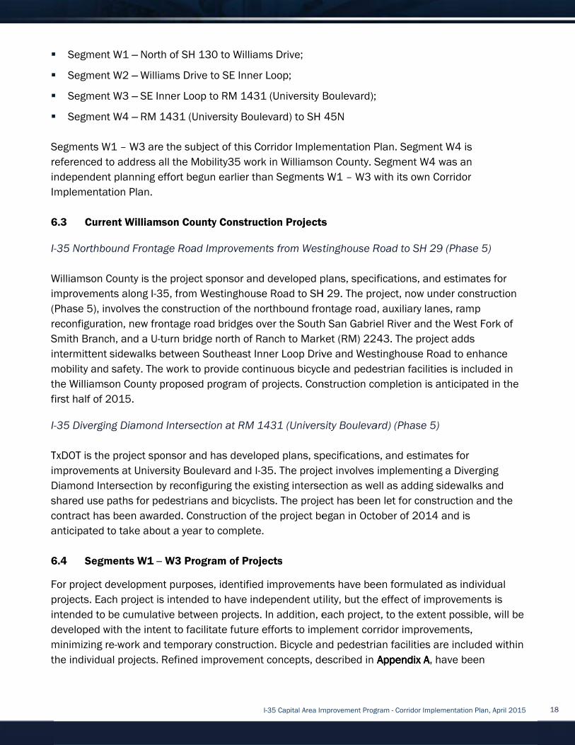
�
�
�
�
Segments W1
referenced to address all the Mobility35 work in Williamson County. Segment W4
independent planning effort begun earlier than Segments W1
Implementation Plan.
6.3
I-
Williamson County is the project sponsor and developed plans, specifications, and estimates
improvements along I
(Phase 5), involves the construction of the northbound frontage road, auxiliary lanes, ramp
reconfiguration, new frontage road bridges over the South San Gab
Smith Branch, and a U
intermittent
mobility and safety
the Williamson County
first half of 2015.
I-
T
improvements at University Boulevard and I
Diamond Intersection by reconfiguring the existing intersection as well as a
shared use paths for pedestrians and bicyclists. The project has been let for construction and the
contract has been awarded. Construction of the project began in October of 2014
anticipated to take about a year to complete
6.4
For project development purposes, identified improvements have been formulated as individual
projects.
intended to be cumulative betw
developed with
minimizing re
the individual projects.
� Segment W1
� Segment W2
� Segment W3
� Segment W4
Segments W1
referenced to address all the Mobility35 work in Williamson County. Segment W4
independent planning effort begun earlier than Segments W1
Implementation Plan.
6.3 Current Williamson County Construction Projects
-35 Northbound Frontage Road Improvements from Westinghouse Road to SH 29 (Phase 5)
Williamson County is the project sponsor and developed plans, specifications, and estimates
improvements along I
(Phase 5), involves the construction of the northbound frontage road, auxiliary lanes, ramp
reconfiguration, new frontage road bridges over the South San Gab
Smith Branch, and a U
intermittent
mobility and safety
the Williamson County
first half of 2015.
-35 Diverging Diamond Intersection at RM 1431 (University Boulevard) (Phase 5)
TxDOT is the project sponsor and has developed plans, specifications, and estimates for
improvements at University Boulevard and I
Diamond Intersection by reconfiguring the existing intersection as well as a
shared use paths for pedestrians and bicyclists. The project has been let for construction and the
contract has been awarded. Construction of the project began in October of 2014
anticipated to take about a year to complete
6.4 Segments W1
For project development purposes, identified improvements have been formulated as individual
projects. Each project is intended to have independent utility, but the effect of improvements is
intended to be cumulative betw
developed with
minimizing re
the individual projects.
Segment W1 – North of SH 130 to Williams Drive;
Segment W2 – Williams Drive to SE Inner Loop;
Segment W3 – SE Inner Loop to RM 1431 (University Boulevard);
Segment W4 – RM 1431 (University Boulevard) to S
Segments W1 – W3 are the subject of this Corridor Implementation Plan. Segment W4
referenced to address all the Mobility35 work in Williamson County. Segment W4
independent planning effort begun earlier than Segments W1
Implementation Plan.
Current Williamson County Construction Projects
35 Northbound Frontage Road Improvements from Westinghouse Road to SH 29 (Phase 5)
Williamson County is the project sponsor and developed plans, specifications, and estimates
improvements along I-35, f
(Phase 5), involves the construction of the northbound frontage road, auxiliary lanes, ramp
reconfiguration, new frontage road bridges over the South San Gab
Smith Branch, and a U-turn bridge north of Ranch to Market (RM) 2243. The project adds
intermittent sidewalks between Southeast Inner Loop Drive and Westinghouse Road to enhance
mobility and safety. The
the Williamson County proposed
first half of 2015.
35 Diverging Diamond Intersection at RM 1431 (University Boulevard) (Phase 5)
xDOT is the project sponsor and has developed plans, specifications, and estimates for
improvements at University Boulevard and I
Diamond Intersection by reconfiguring the existing intersection as well as a
shared use paths for pedestrians and bicyclists. The project has been let for construction and the
contract has been awarded. Construction of the project began in October of 2014
anticipated to take about a year to complete
gments W1 –
For project development purposes, identified improvements have been formulated as individual
Each project is intended to have independent utility, but the effect of improvements is
intended to be cumulative betw
developed with the intent to facilitate future efforts to
minimizing re-work and temporary construction.
the individual projects.
North of SH 130 to Williams Drive;
Williams Drive to SE Inner Loop;
SE Inner Loop to RM 1431 (University Boulevard);
RM 1431 (University Boulevard) to S
W3 are the subject of this Corridor Implementation Plan. Segment W4
referenced to address all the Mobility35 work in Williamson County. Segment W4
independent planning effort begun earlier than Segments W1
Current Williamson County Construction Projects
35 Northbound Frontage Road Improvements from Westinghouse Road to SH 29 (Phase 5)
Williamson County is the project sponsor and developed plans, specifications, and estimates
35, from Westinghouse Road to SH 29.
(Phase 5), involves the construction of the northbound frontage road, auxiliary lanes, ramp
reconfiguration, new frontage road bridges over the South San Gab
turn bridge north of Ranch to Market (RM) 2243. The project adds
sidewalks between Southeast Inner Loop Drive and Westinghouse Road to enhance
. The work to provide conti
proposed program of projects
35 Diverging Diamond Intersection at RM 1431 (University Boulevard) (Phase 5)
xDOT is the project sponsor and has developed plans, specifications, and estimates for
improvements at University Boulevard and I
Diamond Intersection by reconfiguring the existing intersection as well as a
shared use paths for pedestrians and bicyclists. The project has been let for construction and the
contract has been awarded. Construction of the project began in October of 2014
anticipated to take about a year to complete
– W3 Program of Projects
For project development purposes, identified improvements have been formulated as individual
Each project is intended to have independent utility, but the effect of improvements is
intended to be cumulative between projects. In addition, each project, to the extent possible, will be
intent to facilitate future efforts to
work and temporary construction.
Refined improvement concepts, described in
I-35 Capital Area Improvement Program
North of SH 130 to Williams Drive;
Williams Drive to SE Inner Loop;
SE Inner Loop to RM 1431 (University Boulevard);
RM 1431 (University Boulevard) to S
W3 are the subject of this Corridor Implementation Plan. Segment W4
referenced to address all the Mobility35 work in Williamson County. Segment W4
independent planning effort begun earlier than Segments W1
Current Williamson County Construction Projects
35 Northbound Frontage Road Improvements from Westinghouse Road to SH 29 (Phase 5)
Williamson County is the project sponsor and developed plans, specifications, and estimates
rom Westinghouse Road to SH 29.
(Phase 5), involves the construction of the northbound frontage road, auxiliary lanes, ramp
reconfiguration, new frontage road bridges over the South San Gab
turn bridge north of Ranch to Market (RM) 2243. The project adds
sidewalks between Southeast Inner Loop Drive and Westinghouse Road to enhance
work to provide continuous bicycle and pedestrian facilities is included in
program of projects
35 Diverging Diamond Intersection at RM 1431 (University Boulevard) (Phase 5)
xDOT is the project sponsor and has developed plans, specifications, and estimates for
improvements at University Boulevard and I-35. The project involves implementing a Diverging
Diamond Intersection by reconfiguring the existing intersection as well as a
shared use paths for pedestrians and bicyclists. The project has been let for construction and the
contract has been awarded. Construction of the project began in October of 2014
anticipated to take about a year to complete.
Program of Projects
For project development purposes, identified improvements have been formulated as individual
Each project is intended to have independent utility, but the effect of improvements is
een projects. In addition, each project, to the extent possible, will be
intent to facilitate future efforts to
work and temporary construction.
Refined improvement concepts, described in
35 Capital Area Improvement Program
North of SH 130 to Williams Drive;
Williams Drive to SE Inner Loop;
SE Inner Loop to RM 1431 (University Boulevard);
RM 1431 (University Boulevard) to SH 45N
W3 are the subject of this Corridor Implementation Plan. Segment W4
referenced to address all the Mobility35 work in Williamson County. Segment W4
independent planning effort begun earlier than Segments W1
Current Williamson County Construction Projects
35 Northbound Frontage Road Improvements from Westinghouse Road to SH 29 (Phase 5)
Williamson County is the project sponsor and developed plans, specifications, and estimates
rom Westinghouse Road to SH 29.
(Phase 5), involves the construction of the northbound frontage road, auxiliary lanes, ramp
reconfiguration, new frontage road bridges over the South San Gab
turn bridge north of Ranch to Market (RM) 2243. The project adds
sidewalks between Southeast Inner Loop Drive and Westinghouse Road to enhance
nuous bicycle and pedestrian facilities is included in
program of projects. Construction completion is anticipated in the
35 Diverging Diamond Intersection at RM 1431 (University Boulevard) (Phase 5)
xDOT is the project sponsor and has developed plans, specifications, and estimates for
35. The project involves implementing a Diverging
Diamond Intersection by reconfiguring the existing intersection as well as a
shared use paths for pedestrians and bicyclists. The project has been let for construction and the
contract has been awarded. Construction of the project began in October of 2014
Program of Projects
For project development purposes, identified improvements have been formulated as individual
Each project is intended to have independent utility, but the effect of improvements is
een projects. In addition, each project, to the extent possible, will be
intent to facilitate future efforts to implement
work and temporary construction. Bicycle and pedestrian facilities are include
Refined improvement concepts, described in
35 Capital Area Improvement Program
SE Inner Loop to RM 1431 (University Boulevard);
H 45N
W3 are the subject of this Corridor Implementation Plan. Segment W4
referenced to address all the Mobility35 work in Williamson County. Segment W4
independent planning effort begun earlier than Segments W1 – W3 with its own C
Current Williamson County Construction Projects
35 Northbound Frontage Road Improvements from Westinghouse Road to SH 29 (Phase 5)
Williamson County is the project sponsor and developed plans, specifications, and estimates
rom Westinghouse Road to SH 29. The project, now under construction
(Phase 5), involves the construction of the northbound frontage road, auxiliary lanes, ramp
reconfiguration, new frontage road bridges over the South San Gabriel River and the West Fork of
turn bridge north of Ranch to Market (RM) 2243. The project adds
sidewalks between Southeast Inner Loop Drive and Westinghouse Road to enhance
nuous bicycle and pedestrian facilities is included in
. Construction completion is anticipated in the
35 Diverging Diamond Intersection at RM 1431 (University Boulevard) (Phase 5)
xDOT is the project sponsor and has developed plans, specifications, and estimates for
35. The project involves implementing a Diverging
Diamond Intersection by reconfiguring the existing intersection as well as a
shared use paths for pedestrians and bicyclists. The project has been let for construction and the
contract has been awarded. Construction of the project began in October of 2014
For project development purposes, identified improvements have been formulated as individual
Each project is intended to have independent utility, but the effect of improvements is
een projects. In addition, each project, to the extent possible, will be
implement corridor
Bicycle and pedestrian facilities are include
Refined improvement concepts, described in
35 Capital Area Improvement Program - Corridor Implementation Plan, April 2015
SE Inner Loop to RM 1431 (University Boulevard);
W3 are the subject of this Corridor Implementation Plan. Segment W4
referenced to address all the Mobility35 work in Williamson County. Segment W4
W3 with its own C
35 Northbound Frontage Road Improvements from Westinghouse Road to SH 29 (Phase 5)
Williamson County is the project sponsor and developed plans, specifications, and estimates
The project, now under construction
(Phase 5), involves the construction of the northbound frontage road, auxiliary lanes, ramp
riel River and the West Fork of
turn bridge north of Ranch to Market (RM) 2243. The project adds
sidewalks between Southeast Inner Loop Drive and Westinghouse Road to enhance
nuous bicycle and pedestrian facilities is included in
. Construction completion is anticipated in the
35 Diverging Diamond Intersection at RM 1431 (University Boulevard) (Phase 5)
xDOT is the project sponsor and has developed plans, specifications, and estimates for
35. The project involves implementing a Diverging
Diamond Intersection by reconfiguring the existing intersection as well as adding sidewalks and
shared use paths for pedestrians and bicyclists. The project has been let for construction and the
contract has been awarded. Construction of the project began in October of 2014
For project development purposes, identified improvements have been formulated as individual
Each project is intended to have independent utility, but the effect of improvements is
een projects. In addition, each project, to the extent possible, will be
corridor improvements,
Bicycle and pedestrian facilities are include
Refined improvement concepts, described in Appendix AAppendix AAppendix AAppendix A,
Corridor Implementation Plan, April 2015
W3 are the subject of this Corridor Implementation Plan. Segment W4 is
referenced to address all the Mobility35 work in Williamson County. Segment W4 was an
W3 with its own Corridor
35 Northbound Frontage Road Improvements from Westinghouse Road to SH 29 (Phase 5)
Williamson County is the project sponsor and developed plans, specifications, and estimates
The project, now under construction
(Phase 5), involves the construction of the northbound frontage road, auxiliary lanes, ramp
riel River and the West Fork of
turn bridge north of Ranch to Market (RM) 2243. The project adds
sidewalks between Southeast Inner Loop Drive and Westinghouse Road to enhance
nuous bicycle and pedestrian facilities is included in
. Construction completion is anticipated in the
35 Diverging Diamond Intersection at RM 1431 (University Boulevard) (Phase 5)
xDOT is the project sponsor and has developed plans, specifications, and estimates for
35. The project involves implementing a Diverging
dding sidewalks and
shared use paths for pedestrians and bicyclists. The project has been let for construction and the
contract has been awarded. Construction of the project began in October of 2014 and is
For project development purposes, identified improvements have been formulated as individual
Each project is intended to have independent utility, but the effect of improvements is
een projects. In addition, each project, to the extent possible, will be
improvements,
Bicycle and pedestrian facilities are include
, have been
Corridor Implementation Plan, April 2015
35 Northbound Frontage Road Improvements from Westinghouse Road to SH 29 (Phase 5)
Williamson County is the project sponsor and developed plans, specifications, and estimates for
The project, now under construction
riel River and the West Fork of
sidewalks between Southeast Inner Loop Drive and Westinghouse Road to enhance
nuous bicycle and pedestrian facilities is included in
. Construction completion is anticipated in the
35. The project involves implementing a Diverging
dding sidewalks and
shared use paths for pedestrians and bicyclists. The project has been let for construction and the
For project development purposes, identified improvements have been formulated as individual
Each project is intended to have independent utility, but the effect of improvements is
een projects. In addition, each project, to the extent possible, will be
Bicycle and pedestrian facilities are included within
have been
18

develope
sheets are provided in
Williamson County program of projects.
Generally, the program of improvements consists of stand
independently of one another as funding becomes available. From a corridor standpoint, the
proj
Williamson County Improvement Concepts
In all segments, multiple improvement concepts
operational and geometric analysis. In many segmen
concept to carry forward into future phases of the project. In other segments, multiple concepts
may be viable to carry forward. In all cases, no final decisions have been made regarding what
improvement concept
through Phases 3 and 4 of project development. In addition
with additional Mobility35 projects in
segment, concepts
Project Development Summary SheetsProject Development Summary SheetsProject Development Summary SheetsProject Development Summary Sheets
developed for each project
sheets are provided in
Williamson County program of projects.
Generally, the program of improvements consists of stand
independently of one another as funding becomes available. From a corridor standpoint, the
projects can be grouped into priorities, and considered for phased implementation
Williamson County Improvement Concepts
In all segments, multiple improvement concepts
operational and geometric analysis. In many segmen
concept to carry forward into future phases of the project. In other segments, multiple concepts
may be viable to carry forward. In all cases, no final decisions have been made regarding what
improvement concept
through Phases 3 and 4 of project development. In addition
with additional Mobility35 projects in
segment, concepts
Project Development Summary SheetsProject Development Summary SheetsProject Development Summary SheetsProject Development Summary Sheets
Figure Figure Figure Figure
d for each project
sheets are provided in Appendix Appendix Appendix Appendix
Williamson County program of projects.
Generally, the program of improvements consists of stand
independently of one another as funding becomes available. From a corridor standpoint, the
ects can be grouped into priorities, and considered for phased implementation
Williamson County Improvement Concepts
In all segments, multiple improvement concepts
operational and geometric analysis. In many segmen
concept to carry forward into future phases of the project. In other segments, multiple concepts
may be viable to carry forward. In all cases, no final decisions have been made regarding what
improvement concepts should be constructed. Further evaluation and analysis will continue
through Phases 3 and 4 of project development. In addition
with additional Mobility35 projects in
segment, concepts are
Project Development Summary SheetsProject Development Summary SheetsProject Development Summary SheetsProject Development Summary Sheets
Figure Figure Figure Figure 6.4.16.4.16.4.16.4.1: Segment : Segment : Segment : Segment
d for each project in the Williamson County
Appendix Appendix Appendix Appendix BBBB
Williamson County program of projects.
Generally, the program of improvements consists of stand
independently of one another as funding becomes available. From a corridor standpoint, the
ects can be grouped into priorities, and considered for phased implementation
Williamson County Improvement Concepts
In all segments, multiple improvement concepts
operational and geometric analysis. In many segmen
concept to carry forward into future phases of the project. In other segments, multiple concepts
may be viable to carry forward. In all cases, no final decisions have been made regarding what
s should be constructed. Further evaluation and analysis will continue
through Phases 3 and 4 of project development. In addition
with additional Mobility35 projects in
presented in
Project Development Summary SheetsProject Development Summary SheetsProject Development Summary SheetsProject Development Summary Sheets
: Segment : Segment : Segment : Segment W1 W1 W1 W1
I-35 Capital Area Improvement Program
the Williamson County
and Appendix CAppendix CAppendix CAppendix C
Williamson County program of projects.
Generally, the program of improvements consists of stand
independently of one another as funding becomes available. From a corridor standpoint, the
ects can be grouped into priorities, and considered for phased implementation
Williamson County Improvement Concepts
In all segments, multiple improvement concepts
operational and geometric analysis. In many segmen
concept to carry forward into future phases of the project. In other segments, multiple concepts
may be viable to carry forward. In all cases, no final decisions have been made regarding what
s should be constructed. Further evaluation and analysis will continue
through Phases 3 and 4 of project development. In addition
with additional Mobility35 projects in Williamson
presented in Appendix A: RefinedAppendix A: RefinedAppendix A: RefinedAppendix A: Refined
Project Development Summary SheetsProject Development Summary SheetsProject Development Summary SheetsProject Development Summary Sheets....
W1 W1 W1 W1
35 Capital Area Improvement Program
the Williamson County corridor
Appendix CAppendix CAppendix CAppendix C contains
Generally, the program of improvements consists of stand
independently of one another as funding becomes available. From a corridor standpoint, the
ects can be grouped into priorities, and considered for phased implementation
In all segments, multiple improvement concepts have been
operational and geometric analysis. In many segments of the corridor, the analysis yield
concept to carry forward into future phases of the project. In other segments, multiple concepts
may be viable to carry forward. In all cases, no final decisions have been made regarding what
s should be constructed. Further evaluation and analysis will continue
through Phases 3 and 4 of project development. In addition
Williamson County as those efforts progress. Wi
Appendix A: RefinedAppendix A: RefinedAppendix A: RefinedAppendix A: Refined Improvement ConceptsImprovement ConceptsImprovement ConceptsImprovement Concepts
Segment
Study –
(Phase 2)
Segment W1 is shown i
improvement concepts for this segment would
include adding the FTC, improving frontage road
traffic flow, and improving bicyclist and
pedestrian mobility.
Key intersections
include SH 195, SH 130, Lakeway
Northwest Boulevard
team evaluated
improvements, and operational improvements.
Proposed concepts were presented at pairs of
open houses h
June 10 and 11, 2014
20, 2014
concepts
improvements are described below.
35 Capital Area Improvement Program
corridor. Project Development Summary
contains prelimina
Generally, the program of improvements consists of stand-alone projects that could be advanced
independently of one another as funding becomes available. From a corridor standpoint, the
ects can be grouped into priorities, and considered for phased implementation
have been evaluated and vetted through
ts of the corridor, the analysis yield
concept to carry forward into future phases of the project. In other segments, multiple concepts
may be viable to carry forward. In all cases, no final decisions have been made regarding what
s should be constructed. Further evaluation and analysis will continue
through Phases 3 and 4 of project development. In addition, concepts will be refined to coordinate
County as those efforts progress. Wi
Improvement ConceptsImprovement ConceptsImprovement ConceptsImprovement Concepts
Segment W1 – Williamson County Feasibility
– North of SH
(Phase 2)
Segment W1 is shown i
improvement concepts for this segment would
include adding the FTC, improving frontage road
traffic flow, and improving bicyclist and
pedestrian mobility.
Key intersections evaluated
include SH 195, SH 130, Lakeway
Northwest Boulevard
evaluated ramp locations, intersection
improvements, and operational improvements.
Proposed concepts were presented at pairs of
open houses held on February 11 and 12, 2014,
June 10 and 11, 2014
20, 2014. Final analysis of the proposed
concepts is now complete and the recommended
improvements are described below.
35 Capital Area Improvement Program - Corridor Implementation Plan, April 2015
Project Development Summary
preliminary cost estimates for the
alone projects that could be advanced
independently of one another as funding becomes available. From a corridor standpoint, the
ects can be grouped into priorities, and considered for phased implementation
evaluated and vetted through
ts of the corridor, the analysis yield
concept to carry forward into future phases of the project. In other segments, multiple concepts
may be viable to carry forward. In all cases, no final decisions have been made regarding what
s should be constructed. Further evaluation and analysis will continue
concepts will be refined to coordinate
County as those efforts progress. Wi
Improvement ConceptsImprovement ConceptsImprovement ConceptsImprovement Concepts
Williamson County Feasibility
SH 130 to Williams Drive
Segment W1 is shown in Figure 6.4.1Figure 6.4.1Figure 6.4.1Figure 6.4.1
improvement concepts for this segment would
include adding the FTC, improving frontage road
traffic flow, and improving bicyclist and
pedestrian mobility.
evaluated in this
include SH 195, SH 130, Lakeway
Northwest Boulevard, and Williams Drive
ramp locations, intersection
improvements, and operational improvements.
Proposed concepts were presented at pairs of
eld on February 11 and 12, 2014,
June 10 and 11, 2014, and November 18 and
Final analysis of the proposed
now complete and the recommended
improvements are described below.
Corridor Implementation Plan, April 2015
Project Development Summary
cost estimates for the
alone projects that could be advanced
independently of one another as funding becomes available. From a corridor standpoint, the
ects can be grouped into priorities, and considered for phased implementation.
evaluated and vetted through
ts of the corridor, the analysis yielded one
concept to carry forward into future phases of the project. In other segments, multiple concepts
may be viable to carry forward. In all cases, no final decisions have been made regarding what
s should be constructed. Further evaluation and analysis will continue
concepts will be refined to coordinate
County as those efforts progress. Within each
Improvement ConceptsImprovement ConceptsImprovement ConceptsImprovement Concepts and Appendix B: Appendix B: Appendix B: Appendix B:
Williamson County Feasibility
to Williams Drive
Figure 6.4.1Figure 6.4.1Figure 6.4.1Figure 6.4.1. Overall
improvement concepts for this segment would
include adding the FTC, improving frontage road
traffic flow, and improving bicyclist and
in this segment
include SH 195, SH 130, Lakeway Drive,
, and Williams Drive
ramp locations, intersection
improvements, and operational improvements.
Proposed concepts were presented at pairs of
eld on February 11 and 12, 2014,
and November 18 and
Final analysis of the proposed
now complete and the recommended
improvements are described below.
Corridor Implementation Plan, April 2015
Project Development Summary
cost estimates for the
alone projects that could be advanced
independently of one another as funding becomes available. From a corridor standpoint, the
one
concept to carry forward into future phases of the project. In other segments, multiple concepts
may be viable to carry forward. In all cases, no final decisions have been made regarding what
s should be constructed. Further evaluation and analysis will continue
concepts will be refined to coordinate
thin each
Appendix B: Appendix B: Appendix B: Appendix B:
Williamson County Feasibility
to Williams Drive
Overall
improvement concepts for this segment would
include adding the FTC, improving frontage road
segment
,
, and Williams Drive. The
ramp locations, intersection
improvements, and operational improvements.
Proposed concepts were presented at pairs of
eld on February 11 and 12, 2014,
and November 18 and
Final analysis of the proposed
now complete and the recommended
19

Improvement concepts
Appendix B: Project DeveloAppendix B: Project DeveloAppendix B: Project DeveloAppendix B: Project Develo
SH 195/Berry Creek Drive Intersection Improvements
The proposed concept at the SH 195/Berry Creek Drive intersection
Appendix B, sheet
for through
Creek Drive, add lanes to Berry Creek Drive at the intersection, provide a free right
Berry Creek to southbound SH 195, and install
would be completed to improve connectivity.
SH 195 Interchange Direct Connec
The proposed concept at the junction of I
Appendix B, sheet 3)
I-
The traffic operations model indicates
the 2035
considerations with operations at Ft. Hood may dictate implementation of the direct connectors
sooner than later.
I-
The proposed concept at the inte
and Appendix B, sheet 4)
I-
Berry Creek and widening southbound and northbound frontage road bridges at Berry Creek. The
southbound SH 195 connection to the I
accommodate the future SH 195 Interchange Direct Connect
would be completed to improve east/west and north/south connectivity.
Lakeway Drive/NE Inner Loop Interchange Improvements
The proposed concept at the intersection of I
A, sheets 6
provide for
levels of service for
south of Lakeway Drive/NE Inner Loop.
relocating
exists to partner with the City of Georgetown who
Improvement concepts
Appendix B: Project DeveloAppendix B: Project DeveloAppendix B: Project DeveloAppendix B: Project Develo
SH 195/Berry Creek Drive Intersection Improvements
The proposed concept at the SH 195/Berry Creek Drive intersection
Appendix B, sheet
for through-traffic. The project would construct a right
Creek Drive, add lanes to Berry Creek Drive at the intersection, provide a free right
Berry Creek to southbound SH 195, and install
would be completed to improve connectivity.
SH 195 Interchange Direct Connec
The proposed concept at the junction of I
Appendix B, sheet 3)
-35, southbound SH 195 and southbound SH 130, and northbound I
The traffic operations model indicates
the 2035 planning horizon of
considerations with operations at Ft. Hood may dictate implementation of the direct connectors
sooner than later.
-35 Frontage Roads
The proposed concept at the inte
and Appendix B, sheet 4)
-35 frontage roads
Berry Creek and widening southbound and northbound frontage road bridges at Berry Creek. The
southbound SH 195 connection to the I
accommodate the future SH 195 Interchange Direct Connect
would be completed to improve east/west and north/south connectivity.
Lakeway Drive/NE Inner Loop Interchange Improvements
The proposed concept at the intersection of I
A, sheets 6 –
provide for additional
levels of service for
south of Lakeway Drive/NE Inner Loop.
relocating State Spur (SS) 158 (
exists to partner with the City of Georgetown who
Improvement concepts
Appendix B: Project DeveloAppendix B: Project DeveloAppendix B: Project DeveloAppendix B: Project Develo
SH 195/Berry Creek Drive Intersection Improvements
The proposed concept at the SH 195/Berry Creek Drive intersection
Appendix B, sheet 2) widens SH 195 to provide northbound left
traffic. The project would construct a right
Creek Drive, add lanes to Berry Creek Drive at the intersection, provide a free right
Berry Creek to southbound SH 195, and install
would be completed to improve connectivity.
SH 195 Interchange Direct Connec
The proposed concept at the junction of I
Appendix B, sheet 3) provides di
35, southbound SH 195 and southbound SH 130, and northbound I
The traffic operations model indicates
planning horizon of
considerations with operations at Ft. Hood may dictate implementation of the direct connectors
sooner than later.
Frontage Roads at SH 195
The proposed concept at the inte
and Appendix B, sheet 4)
frontage roads. The project includes
Berry Creek and widening southbound and northbound frontage road bridges at Berry Creek. The
southbound SH 195 connection to the I
accommodate the future SH 195 Interchange Direct Connect
would be completed to improve east/west and north/south connectivity.
Lakeway Drive/NE Inner Loop Interchange Improvements
The proposed concept at the intersection of I
– 10 and Appendix B, sheet 5)
additional through traffic and turning lanes.
levels of service for a seven
south of Lakeway Drive/NE Inner Loop.
State Spur (SS) 158 (
exists to partner with the City of Georgetown who
are also illustrated in
Appendix B: Project DeveloAppendix B: Project DeveloAppendix B: Project DeveloAppendix B: Project Development Summary Sheetspment Summary Sheetspment Summary Sheetspment Summary Sheets
SH 195/Berry Creek Drive Intersection Improvements
The proposed concept at the SH 195/Berry Creek Drive intersection
widens SH 195 to provide northbound left
traffic. The project would construct a right
Creek Drive, add lanes to Berry Creek Drive at the intersection, provide a free right
Berry Creek to southbound SH 195, and install
would be completed to improve connectivity.
SH 195 Interchange Direct Connec
The proposed concept at the junction of I
provides direct connect
35, southbound SH 195 and southbound SH 130, and northbound I
The traffic operations model indicates
planning horizon of this Corridor Implementation Plan.
considerations with operations at Ft. Hood may dictate implementation of the direct connectors
at SH 195
The proposed concept at the intersection of I
and Appendix B, sheet 4) consists of widening
. The project includes
Berry Creek and widening southbound and northbound frontage road bridges at Berry Creek. The
southbound SH 195 connection to the I
accommodate the future SH 195 Interchange Direct Connect
would be completed to improve east/west and north/south connectivity.
Lakeway Drive/NE Inner Loop Interchange Improvements
The proposed concept at the intersection of I
ppendix B, sheet 5)
through traffic and turning lanes.
seven-lane section.
south of Lakeway Drive/NE Inner Loop.
State Spur (SS) 158 (Austin Avenue
exists to partner with the City of Georgetown who
I-35 Capital Area Improvement Program
illustrated in Appendix A: RefinedAppendix A: RefinedAppendix A: RefinedAppendix A: Refined
pment Summary Sheetspment Summary Sheetspment Summary Sheetspment Summary Sheets
SH 195/Berry Creek Drive Intersection Improvements
The proposed concept at the SH 195/Berry Creek Drive intersection
widens SH 195 to provide northbound left
traffic. The project would construct a right
Creek Drive, add lanes to Berry Creek Drive at the intersection, provide a free right
Berry Creek to southbound SH 195, and install
would be completed to improve connectivity.
SH 195 Interchange Direct Connectors
The proposed concept at the junction of I-35 and SH 195
rect connectors
35, southbound SH 195 and southbound SH 130, and northbound I
The traffic operations model indicates construction
this Corridor Implementation Plan.
considerations with operations at Ft. Hood may dictate implementation of the direct connectors
rsection of I-35 and SH 195
consists of widening
. The project includes widening the southbound frontage road bridge at Dry
Berry Creek and widening southbound and northbound frontage road bridges at Berry Creek. The
southbound SH 195 connection to the I-35 southbound frontage would be realigned to
accommodate the future SH 195 Interchange Direct Connect
would be completed to improve east/west and north/south connectivity.
Lakeway Drive/NE Inner Loop Interchange Improvements
The proposed concept at the intersection of I-35 and Lakeway Drive/NE Inner Loop
ppendix B, sheet 5) includes widening the existing underpass bridge to
through traffic and turning lanes.
lane section. A new northbound frontage road would be c
south of Lakeway Drive/NE Inner Loop. The northbound frontage road construction
Austin Avenue
exists to partner with the City of Georgetown who
35 Capital Area Improvement Program
Appendix A: RefinedAppendix A: RefinedAppendix A: RefinedAppendix A: Refined
pment Summary Sheetspment Summary Sheetspment Summary Sheetspment Summary Sheets.
SH 195/Berry Creek Drive Intersection Improvements
The proposed concept at the SH 195/Berry Creek Drive intersection
widens SH 195 to provide northbound left
traffic. The project would construct a right-turn lane from southbound SH 195 to Berry
Creek Drive, add lanes to Berry Creek Drive at the intersection, provide a free right
Berry Creek to southbound SH 195, and install traffic signals. Bicycle and pedestrian facilities
35 and SH 195
ors between southbound SH 195 and southbound
35, southbound SH 195 and southbound SH 130, and northbound I
construction of the direct connectors is not warranted
this Corridor Implementation Plan.
considerations with operations at Ft. Hood may dictate implementation of the direct connectors
35 and SH 195
consists of widening existing pavement
widening the southbound frontage road bridge at Dry
Berry Creek and widening southbound and northbound frontage road bridges at Berry Creek. The
35 southbound frontage would be realigned to
accommodate the future SH 195 Interchange Direct Connect
would be completed to improve east/west and north/south connectivity.
Lakeway Drive/NE Inner Loop Interchange Improvements
35 and Lakeway Drive/NE Inner Loop
includes widening the existing underpass bridge to
through traffic and turning lanes. The traffic modeling indicates acceptable
new northbound frontage road would be c
northbound frontage road construction
Austin Avenue) to the east of its current location
exists to partner with the City of Georgetown who proposed the relocation.
35 Capital Area Improvement Program
Appendix A: RefinedAppendix A: RefinedAppendix A: RefinedAppendix A: Refined Improvement Improvement Improvement Improvement
The proposed concept at the SH 195/Berry Creek Drive intersection (see Appendix A, sheet 4 and
widens SH 195 to provide northbound left-turn storage capacity an
turn lane from southbound SH 195 to Berry
Creek Drive, add lanes to Berry Creek Drive at the intersection, provide a free right
traffic signals. Bicycle and pedestrian facilities
35 and SH 195 (see Appendix A, sheets 3
between southbound SH 195 and southbound
35, southbound SH 195 and southbound SH 130, and northbound I
of the direct connectors is not warranted
this Corridor Implementation Plan. Economic and political
considerations with operations at Ft. Hood may dictate implementation of the direct connectors
35 and SH 195 (see Appendix A, sheets 1
existing pavement to provide continuous three
widening the southbound frontage road bridge at Dry
Berry Creek and widening southbound and northbound frontage road bridges at Berry Creek. The
35 southbound frontage would be realigned to
accommodate the future SH 195 Interchange Direct Connectors. Bicycle and pedestr
would be completed to improve east/west and north/south connectivity.
Lakeway Drive/NE Inner Loop Interchange Improvements
35 and Lakeway Drive/NE Inner Loop
includes widening the existing underpass bridge to
The traffic modeling indicates acceptable
new northbound frontage road would be c
northbound frontage road construction
east of its current location
proposed the relocation.
35 Capital Area Improvement Program - Corridor Implementation Plan, April 2015
Improvement Improvement Improvement Improvement ConceptsConceptsConceptsConcepts
(see Appendix A, sheet 4 and
turn storage capacity an
turn lane from southbound SH 195 to Berry
Creek Drive, add lanes to Berry Creek Drive at the intersection, provide a free right
traffic signals. Bicycle and pedestrian facilities
(see Appendix A, sheets 3
between southbound SH 195 and southbound
35, southbound SH 195 and southbound SH 130, and northbound I-35 and northbound SH 195.
of the direct connectors is not warranted
Economic and political
considerations with operations at Ft. Hood may dictate implementation of the direct connectors
(see Appendix A, sheets 1
to provide continuous three
widening the southbound frontage road bridge at Dry
Berry Creek and widening southbound and northbound frontage road bridges at Berry Creek. The
35 southbound frontage would be realigned to
. Bicycle and pedestr
would be completed to improve east/west and north/south connectivity.
35 and Lakeway Drive/NE Inner Loop
includes widening the existing underpass bridge to
The traffic modeling indicates acceptable
new northbound frontage road would be c
northbound frontage road construction
east of its current location
proposed the relocation.
Corridor Implementation Plan, April 2015
ConceptsConceptsConceptsConcepts and
(see Appendix A, sheet 4 and
turn storage capacity and a bypass
turn lane from southbound SH 195 to Berry
Creek Drive, add lanes to Berry Creek Drive at the intersection, provide a free right-turn lane from
traffic signals. Bicycle and pedestrian facilities
(see Appendix A, sheets 3 – 5 and
between southbound SH 195 and southbound
35 and northbound SH 195.
of the direct connectors is not warranted
Economic and political
considerations with operations at Ft. Hood may dictate implementation of the direct connectors
(see Appendix A, sheets 1 – 3, 5
to provide continuous three
widening the southbound frontage road bridge at Dry
Berry Creek and widening southbound and northbound frontage road bridges at Berry Creek. The
35 southbound frontage would be realigned to
. Bicycle and pedestrian facilities
35 and Lakeway Drive/NE Inner Loop (see Appendix
includes widening the existing underpass bridge to
The traffic modeling indicates acceptable
new northbound frontage road would be constructed
northbound frontage road construction is contingent on
east of its current location. An opportunity
Corridor Implementation Plan, April 2015
and
(see Appendix A, sheet 4 and
d a bypass
turn lane from southbound SH 195 to Berry
turn lane from
traffic signals. Bicycle and pedestrian facilities
5 and
between southbound SH 195 and southbound
35 and northbound SH 195.
of the direct connectors is not warranted within
considerations with operations at Ft. Hood may dictate implementation of the direct connectors
3, 5 – 6
to provide continuous three-lane
widening the southbound frontage road bridge at Dry
Berry Creek and widening southbound and northbound frontage road bridges at Berry Creek. The
ian facilities
(see Appendix
includes widening the existing underpass bridge to
The traffic modeling indicates acceptable
onstructed
is contingent on
. An opportunity
20

The
right
provide
complete
the southbound mainlanes. Frontage road auxiliary lanes would be provided between SH 130 and
Lakeway Drive/NE Inner Loop in each direction. Bicycle and pedestrian facilities would be
completed to improve east/west and north/south connectivity.
Northwest Boulevard Extension
The proposed concept
Boulevard
Boulevard extension to
bridge. Connections would be made to the
northbound frontage road. Bicycle and pedestrian facilities would be completed to improve
east/west connectivity.
State Spur 158 (
The proposed concept at the intersection of I
sheets 10
underpass bridge would provide additional lanes to accommodate turning movements
traffic,
mainlane bridge at the North Fork San Gabriel River would be widened for the southbound
collector
an
intersections
bypass for
(
The northbound frontage road will be extended from
existing frontage roads will be improved to provide continuous three
frontage road extension will require an evaluation of the need for additional right
future phases of project development.
right
29. The southbound frontage road bridge at the North Fork San Gabriel River would be widened for
an additional lane, shoulders, and a shared use path. Ramp modifications would be included to
implement the collec
Bicycle and pedestrian facilities would be completed to improve east/west and north/south
connectivity.
The existing
right-turn lane and the intersections will be signalized. Existing frontage roads would be widened to
provide a continuous three
complete the
the southbound mainlanes. Frontage road auxiliary lanes would be provided between SH 130 and
Lakeway Drive/NE Inner Loop in each direction. Bicycle and pedestrian facilities would be
completed to improve east/west and north/south connectivity.
Northwest Boulevard Extension
The proposed concept
Boulevard (see Appendix A, sheet 12)
Boulevard extension to
bridge. Connections would be made to the
northbound frontage road. Bicycle and pedestrian facilities would be completed to improve
east/west connectivity.
State Spur 158 (
The proposed concept at the intersection of I
sheets 10 –
underpass bridge would provide additional lanes to accommodate turning movements
traffic, proposed collector
mainlane bridge at the North Fork San Gabriel River would be widened for the southbound
collector-distributor transition to
and southbound would provide for frontage road through movements
intersections
bypass for SS 158 (
(Austin Avenue
The northbound frontage road will be extended from
existing frontage roads will be improved to provide continuous three
frontage road extension will require an evaluation of the need for additional right
future phases of project development.
right-turn lane to Rivery Boulevard and an auxiliary
29. The southbound frontage road bridge at the North Fork San Gabriel River would be widened for
an additional lane, shoulders, and a shared use path. Ramp modifications would be included to
implement the collec
Bicycle and pedestrian facilities would be completed to improve east/west and north/south
connectivity.
frontage road box at the I
turn lane and the intersections will be signalized. Existing frontage roads would be widened to
continuous three
the X-pattern interchange configuration. Auxiliary lanes are proposed in two locations for
the southbound mainlanes. Frontage road auxiliary lanes would be provided between SH 130 and
Lakeway Drive/NE Inner Loop in each direction. Bicycle and pedestrian facilities would be
completed to improve east/west and north/south connectivity.
Northwest Boulevard Extension
The proposed concept,
(see Appendix A, sheet 12)
Boulevard extension to
bridge. Connections would be made to the
northbound frontage road. Bicycle and pedestrian facilities would be completed to improve
east/west connectivity.
State Spur 158 (Williams Drive
The proposed concept at the intersection of I
15 and Appendix B, sheet 6)
underpass bridge would provide additional lanes to accommodate turning movements
proposed collector
mainlane bridge at the North Fork San Gabriel River would be widened for the southbound
distributor transition to
d southbound would provide for frontage road through movements
intersections. The Williams Drive/Austin Avenue intersection will be
SS 158 (Austin Avenue
Austin Avenue) to Westbound Williams Drive traffic
The northbound frontage road will be extended from
existing frontage roads will be improved to provide continuous three
frontage road extension will require an evaluation of the need for additional right
future phases of project development.
turn lane to Rivery Boulevard and an auxiliary
29. The southbound frontage road bridge at the North Fork San Gabriel River would be widened for
an additional lane, shoulders, and a shared use path. Ramp modifications would be included to
implement the collector
Bicycle and pedestrian facilities would be completed to improve east/west and north/south
connectivity.
frontage road box at the I
turn lane and the intersections will be signalized. Existing frontage roads would be widened to
continuous three-lane roadway
pattern interchange configuration. Auxiliary lanes are proposed in two locations for
the southbound mainlanes. Frontage road auxiliary lanes would be provided between SH 130 and
Lakeway Drive/NE Inner Loop in each direction. Bicycle and pedestrian facilities would be
completed to improve east/west and north/south connectivity.
Northwest Boulevard Extension
, to be developed by others,
(see Appendix A, sheet 12)
SS 158 (Austin Avenue
bridge. Connections would be made to the
northbound frontage road. Bicycle and pedestrian facilities would be completed to improve
Williams Drive) Interchange Improvements
The proposed concept at the intersection of I
15 and Appendix B, sheet 6)
underpass bridge would provide additional lanes to accommodate turning movements
proposed collector-distributor
mainlane bridge at the North Fork San Gabriel River would be widened for the southbound
distributor transition to the
d southbound would provide for frontage road through movements
. The Williams Drive/Austin Avenue intersection will be
Austin Avenue)
to Westbound Williams Drive traffic
The northbound frontage road will be extended from
existing frontage roads will be improved to provide continuous three
frontage road extension will require an evaluation of the need for additional right
future phases of project development.
turn lane to Rivery Boulevard and an auxiliary
29. The southbound frontage road bridge at the North Fork San Gabriel River would be widened for
an additional lane, shoulders, and a shared use path. Ramp modifications would be included to
tor-distributor roadways and complete the X
Bicycle and pedestrian facilities would be completed to improve east/west and north/south
I-35 Capital Area Improvement Program
frontage road box at the I-35/SH 130 intersection will be improved with a northbound
turn lane and the intersections will be signalized. Existing frontage roads would be widened to
ne roadway section
pattern interchange configuration. Auxiliary lanes are proposed in two locations for
the southbound mainlanes. Frontage road auxiliary lanes would be provided between SH 130 and
Lakeway Drive/NE Inner Loop in each direction. Bicycle and pedestrian facilities would be
completed to improve east/west and north/south connectivity.
developed by others,
(see Appendix A, sheet 12) extends Northwest Boulevard from the future Rivery
Austin Avenue
bridge. Connections would be made to the existing
northbound frontage road. Bicycle and pedestrian facilities would be completed to improve
Interchange Improvements
The proposed concept at the intersection of I-35 and
15 and Appendix B, sheet 6) is a Diverging Diamond Interchange (DDI). A new wider
underpass bridge would provide additional lanes to accommodate turning movements
ributors, and allow
mainlane bridge at the North Fork San Gabriel River would be widened for the southbound
the mainlanes
d southbound would provide for frontage road through movements
. The Williams Drive/Austin Avenue intersection will be
through traffic and a right
to Westbound Williams Drive traffic
The northbound frontage road will be extended from
existing frontage roads will be improved to provide continuous three
frontage road extension will require an evaluation of the need for additional right
future phases of project development. The southbound frontage road will be widened to provide a
turn lane to Rivery Boulevard and an auxiliary
29. The southbound frontage road bridge at the North Fork San Gabriel River would be widened for
an additional lane, shoulders, and a shared use path. Ramp modifications would be included to
distributor roadways and complete the X
Bicycle and pedestrian facilities would be completed to improve east/west and north/south
35 Capital Area Improvement Program
35/SH 130 intersection will be improved with a northbound
turn lane and the intersections will be signalized. Existing frontage roads would be widened to
ection. Ramp modifications would
pattern interchange configuration. Auxiliary lanes are proposed in two locations for
the southbound mainlanes. Frontage road auxiliary lanes would be provided between SH 130 and
Lakeway Drive/NE Inner Loop in each direction. Bicycle and pedestrian facilities would be
completed to improve east/west and north/south connectivity.
developed by others, at the intersection of I
extends Northwest Boulevard from the future Rivery
Austin Avenue) and includes the construction of a new underpass
existing southbound frontage road and a new
northbound frontage road. Bicycle and pedestrian facilities would be completed to improve
Interchange Improvements
35 and SS 158 (
is a Diverging Diamond Interchange (DDI). A new wider
underpass bridge would provide additional lanes to accommodate turning movements
and allow for I-35 mainlane widening. The southbound
mainlane bridge at the North Fork San Gabriel River would be widened for the southbound
s. Constructing collector
d southbound would provide for frontage road through movements
. The Williams Drive/Austin Avenue intersection will be
through traffic and a right
to Westbound Williams Drive traffic.
The northbound frontage road will be extended from SS 158 (
existing frontage roads will be improved to provide continuous three
frontage road extension will require an evaluation of the need for additional right
The southbound frontage road will be widened to provide a
turn lane to Rivery Boulevard and an auxiliary lane between
29. The southbound frontage road bridge at the North Fork San Gabriel River would be widened for
an additional lane, shoulders, and a shared use path. Ramp modifications would be included to
distributor roadways and complete the X
Bicycle and pedestrian facilities would be completed to improve east/west and north/south
35 Capital Area Improvement Program
35/SH 130 intersection will be improved with a northbound
turn lane and the intersections will be signalized. Existing frontage roads would be widened to
. Ramp modifications would
pattern interchange configuration. Auxiliary lanes are proposed in two locations for
the southbound mainlanes. Frontage road auxiliary lanes would be provided between SH 130 and
Lakeway Drive/NE Inner Loop in each direction. Bicycle and pedestrian facilities would be
completed to improve east/west and north/south connectivity.
at the intersection of I
extends Northwest Boulevard from the future Rivery
and includes the construction of a new underpass
bound frontage road and a new
northbound frontage road. Bicycle and pedestrian facilities would be completed to improve
Interchange Improvements
S 158 (Williams Drive
is a Diverging Diamond Interchange (DDI). A new wider
underpass bridge would provide additional lanes to accommodate turning movements
35 mainlane widening. The southbound
mainlane bridge at the North Fork San Gabriel River would be widened for the southbound
. Constructing collector
d southbound would provide for frontage road through movements
. The Williams Drive/Austin Avenue intersection will be reconfigured
through traffic and a right-turn lan
SS 158 (Williams Drive
existing frontage roads will be improved to provide continuous three-lane roadway
frontage road extension will require an evaluation of the need for additional right
The southbound frontage road will be widened to provide a
lane between SS 158 (
29. The southbound frontage road bridge at the North Fork San Gabriel River would be widened for
an additional lane, shoulders, and a shared use path. Ramp modifications would be included to
distributor roadways and complete the X-pattern interchange configuration.
Bicycle and pedestrian facilities would be completed to improve east/west and north/south
35 Capital Area Improvement Program - Corridor Implementation Plan, April 2015
35/SH 130 intersection will be improved with a northbound
turn lane and the intersections will be signalized. Existing frontage roads would be widened to
. Ramp modifications would be incorporated to
pattern interchange configuration. Auxiliary lanes are proposed in two locations for
the southbound mainlanes. Frontage road auxiliary lanes would be provided between SH 130 and
Lakeway Drive/NE Inner Loop in each direction. Bicycle and pedestrian facilities would be
at the intersection of I-35 and Northwest
extends Northwest Boulevard from the future Rivery
and includes the construction of a new underpass
bound frontage road and a new
northbound frontage road. Bicycle and pedestrian facilities would be completed to improve
Williams Drive) (see Appendix A,
is a Diverging Diamond Interchange (DDI). A new wider
underpass bridge would provide additional lanes to accommodate turning movements
35 mainlane widening. The southbound
mainlane bridge at the North Fork San Gabriel River would be widened for the southbound
. Constructing collector-distributor roads northbound
d southbound would provide for frontage road through movements to circumvent the signalized
reconfigured
turn lane for southbound
Williams Drive) to the north and
lane roadway
frontage road extension will require an evaluation of the need for additional right
The southbound frontage road will be widened to provide a
SS 158 (Williams Drive
29. The southbound frontage road bridge at the North Fork San Gabriel River would be widened for
an additional lane, shoulders, and a shared use path. Ramp modifications would be included to
pattern interchange configuration.
Bicycle and pedestrian facilities would be completed to improve east/west and north/south
Corridor Implementation Plan, April 2015
35/SH 130 intersection will be improved with a northbound
turn lane and the intersections will be signalized. Existing frontage roads would be widened to
be incorporated to
pattern interchange configuration. Auxiliary lanes are proposed in two locations for
the southbound mainlanes. Frontage road auxiliary lanes would be provided between SH 130 and
Lakeway Drive/NE Inner Loop in each direction. Bicycle and pedestrian facilities would be
35 and Northwest
extends Northwest Boulevard from the future Rivery
and includes the construction of a new underpass
bound frontage road and a new
northbound frontage road. Bicycle and pedestrian facilities would be completed to improve
(see Appendix A,
is a Diverging Diamond Interchange (DDI). A new wider
underpass bridge would provide additional lanes to accommodate turning movements, through
35 mainlane widening. The southbound
mainlane bridge at the North Fork San Gabriel River would be widened for the southbound
distributor roads northbound
to circumvent the signalized
reconfigured by adding a
southbound SS 158
to the north and
lane roadway sections.
frontage road extension will require an evaluation of the need for additional right-of-way during
The southbound frontage road will be widened to provide a
Williams Drive) and SH
29. The southbound frontage road bridge at the North Fork San Gabriel River would be widened for
an additional lane, shoulders, and a shared use path. Ramp modifications would be included to
pattern interchange configuration.
Bicycle and pedestrian facilities would be completed to improve east/west and north/south
Corridor Implementation Plan, April 2015
35/SH 130 intersection will be improved with a northbound
turn lane and the intersections will be signalized. Existing frontage roads would be widened to
be incorporated to
pattern interchange configuration. Auxiliary lanes are proposed in two locations for
the southbound mainlanes. Frontage road auxiliary lanes would be provided between SH 130 and
35 and Northwest
and includes the construction of a new underpass
northbound frontage road. Bicycle and pedestrian facilities would be completed to improve
(see Appendix A,
is a Diverging Diamond Interchange (DDI). A new wider
through
35 mainlane widening. The southbound
distributor roads northbound
to circumvent the signalized
by adding a
SS 158
to the north and
. The
way during
The southbound frontage road will be widened to provide a
and SH
29. The southbound frontage road bridge at the North Fork San Gabriel River would be widened for
an additional lane, shoulders, and a shared use path. Ramp modifications would be included to
pattern interchange configuration.
Bicycle and pedestrian facilities would be completed to improve east/west and north/south
21
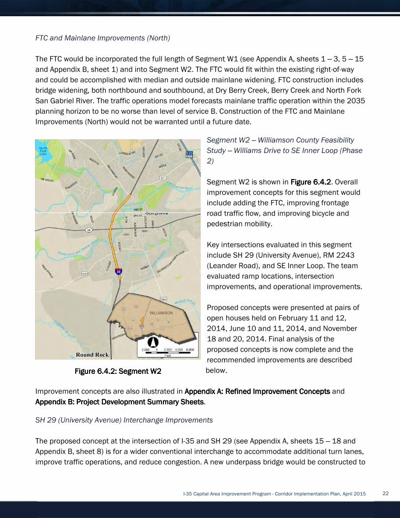
FTC and Mainlane Improvements (North)
The FTC would be incorporated the
and Appendix B, sheet 1) and into Segment W2
and could be accomplished with median and outside
bridge widening, both northbound and southbound, at Dry Berry Creek, Berry Creek and North Fork
San Gabriel River.
planning horizon to be no worse than level of service B. C
Improvements (North) would not be warranted until a future date.
Improvement concepts are also illustrated in
Appendix B: Project Development Summary SheetsAppendix B: Project Development Summary SheetsAppendix B: Project Development Summary SheetsAppendix B: Project Development Summary Sheets
SH 29 (University Ave
The proposed concept at the intersection of I
Appendix B, sheet 8)
improve traffic operations, and
Figure Figure Figure Figure
FTC and Mainlane Improvements (North)
The FTC would be incorporated the
and Appendix B, sheet 1) and into Segment W2
and could be accomplished with median and outside
bridge widening, both northbound and southbound, at Dry Berry Creek, Berry Creek and North Fork
San Gabriel River. The traffic operations model forecasts mainlane traffic operation within the 2035
planning horizon to be no worse than level of service B. C
Improvements (North) would not be warranted until a future date.
Improvement concepts are also illustrated in
Appendix B: Project Development Summary SheetsAppendix B: Project Development Summary SheetsAppendix B: Project Development Summary SheetsAppendix B: Project Development Summary Sheets
SH 29 (University Avenue) Interchange Improvements
The proposed concept at the intersection of I
Appendix B, sheet 8) is for a wider conventional interchange to accommodate additional turn lanes,
improve traffic operations, and
Figure Figure Figure Figure 6.4.26.4.26.4.26.4.2
FTC and Mainlane Improvements (North)
The FTC would be incorporated the
and Appendix B, sheet 1) and into Segment W2
and could be accomplished with median and outside
bridge widening, both northbound and southbound, at Dry Berry Creek, Berry Creek and North Fork
The traffic operations model forecasts mainlane traffic operation within the 2035
planning horizon to be no worse than level of service B. C
Improvements (North) would not be warranted until a future date.
Improvement concepts are also illustrated in
Appendix B: Project Development Summary SheetsAppendix B: Project Development Summary SheetsAppendix B: Project Development Summary SheetsAppendix B: Project Development Summary Sheets
nue) Interchange Improvements
The proposed concept at the intersection of I
is for a wider conventional interchange to accommodate additional turn lanes,
improve traffic operations, and reduce congestion. A new underpass bridge would be constructed to
6.4.26.4.26.4.26.4.2: Segment : Segment : Segment : Segment
I-35 Capital Area Improvement Program
FTC and Mainlane Improvements (North)
The FTC would be incorporated the full length of Segment
and Appendix B, sheet 1) and into Segment W2
and could be accomplished with median and outside
bridge widening, both northbound and southbound, at Dry Berry Creek, Berry Creek and North Fork
The traffic operations model forecasts mainlane traffic operation within the 2035
planning horizon to be no worse than level of service B. C
Improvements (North) would not be warranted until a future date.
Improvement concepts are also illustrated in Appendix A: RefinedAppendix A: RefinedAppendix A: RefinedAppendix A: Refined
Appendix B: Project Development Summary SheetsAppendix B: Project Development Summary SheetsAppendix B: Project Development Summary SheetsAppendix B: Project Development Summary Sheets
nue) Interchange Improvements
The proposed concept at the intersection of I-35 and SH 29
is for a wider conventional interchange to accommodate additional turn lanes,
reduce congestion. A new underpass bridge would be constructed to
: Segment : Segment : Segment : Segment W2W2W2W2
35 Capital Area Improvement Program
length of Segment
and Appendix B, sheet 1) and into Segment W2. The FTC would fit within the existing right
and could be accomplished with median and outside mainlane
bridge widening, both northbound and southbound, at Dry Berry Creek, Berry Creek and North Fork
The traffic operations model forecasts mainlane traffic operation within the 2035
planning horizon to be no worse than level of service B. Construction of the FTC and Mainlane
Improvements (North) would not be warranted until a future date.
Segment
Study
2)
Segment W2 is shown in
improvement con
include adding the FTC, improving frontage
road traffic flow, and improving bicycle and
pedestrian mobility.
Key intersections
include SH 29 (University
(Leander Road)
evaluated
improvements, and operational improvements.
Proposed concepts were presented at pairs of
open houses h
2014,
18 and 20, 2014
proposed concepts is now complete and the
recommended improvements are described
below.
Appendix A: RefinedAppendix A: RefinedAppendix A: RefinedAppendix A: Refined
Appendix B: Project Development Summary SheetsAppendix B: Project Development Summary SheetsAppendix B: Project Development Summary SheetsAppendix B: Project Development Summary Sheets.
nue) Interchange Improvements
35 and SH 29
is for a wider conventional interchange to accommodate additional turn lanes,
reduce congestion. A new underpass bridge would be constructed to
35 Capital Area Improvement Program
length of Segment W1 (see Appendix A, sheets 1
. The FTC would fit within the existing right
mainlane widening. FTC construction includes
bridge widening, both northbound and southbound, at Dry Berry Creek, Berry Creek and North Fork
The traffic operations model forecasts mainlane traffic operation within the 2035
onstruction of the FTC and Mainlane
Improvements (North) would not be warranted until a future date.
Segment W2 – Williamson County Feasibility
Study – Williams Dr
Segment W2 is shown in
improvement con
include adding the FTC, improving frontage
road traffic flow, and improving bicycle and
pedestrian mobility.
Key intersections
include SH 29 (University
(Leander Road), and SE Inner L
evaluated ramp locations, intersection
improvements, and operational improvements.
Proposed concepts were presented at pairs of
open houses held on February 11 and 12,
2014, June 10 and 11, 2014
18 and 20, 2014
proposed concepts is now complete and the
recommended improvements are described
below.
Appendix A: RefinedAppendix A: RefinedAppendix A: RefinedAppendix A: Refined Improvement ConceptsImprovement ConceptsImprovement ConceptsImprovement Concepts
35 and SH 29 (see Appendix A, sheets 15
is for a wider conventional interchange to accommodate additional turn lanes,
reduce congestion. A new underpass bridge would be constructed to
35 Capital Area Improvement Program - Corridor Implementation Plan, April 2015
(see Appendix A, sheets 1
. The FTC would fit within the existing right
widening. FTC construction includes
bridge widening, both northbound and southbound, at Dry Berry Creek, Berry Creek and North Fork
The traffic operations model forecasts mainlane traffic operation within the 2035
onstruction of the FTC and Mainlane
Williamson County Feasibility
Williams Drive to SE Inner Loop
Segment W2 is shown in Figure Figure Figure Figure
improvement concepts for this segment would
include adding the FTC, improving frontage
road traffic flow, and improving bicycle and
pedestrian mobility.
Key intersections evaluated
include SH 29 (University Avenue
, and SE Inner L
ramp locations, intersection
improvements, and operational improvements.
Proposed concepts were presented at pairs of
eld on February 11 and 12,
June 10 and 11, 2014
18 and 20, 2014. Final analysis
proposed concepts is now complete and the
recommended improvements are described
Improvement ConceptsImprovement ConceptsImprovement ConceptsImprovement Concepts
(see Appendix A, sheets 15
is for a wider conventional interchange to accommodate additional turn lanes,
reduce congestion. A new underpass bridge would be constructed to
Corridor Implementation Plan, April 2015
(see Appendix A, sheets 1 – 3, 5
. The FTC would fit within the existing right-of
widening. FTC construction includes
bridge widening, both northbound and southbound, at Dry Berry Creek, Berry Creek and North Fork
The traffic operations model forecasts mainlane traffic operation within the 2035
onstruction of the FTC and Mainlane
Williamson County Feasibility
SE Inner Loop
Figure Figure Figure Figure 6666....4444.2.2.2.2. Overall
cepts for this segment would
include adding the FTC, improving frontage
road traffic flow, and improving bicycle and
in this segment
Avenue), RM 2243
, and SE Inner Loop. The team
ramp locations, intersection
improvements, and operational improvements.
Proposed concepts were presented at pairs of
eld on February 11 and 12,
June 10 and 11, 2014, and November
Final analysis of the
proposed concepts is now complete and the
recommended improvements are described
Improvement ConceptsImprovement ConceptsImprovement ConceptsImprovement Concepts and
(see Appendix A, sheets 15 – 18 and
is for a wider conventional interchange to accommodate additional turn lanes,
reduce congestion. A new underpass bridge would be constructed to
Corridor Implementation Plan, April 2015
3, 5 – 15
of-way
widening. FTC construction includes
bridge widening, both northbound and southbound, at Dry Berry Creek, Berry Creek and North Fork
The traffic operations model forecasts mainlane traffic operation within the 2035
onstruction of the FTC and Mainlane
Williamson County Feasibility
SE Inner Loop (Phase
Overall
cepts for this segment would
include adding the FTC, improving frontage
road traffic flow, and improving bicycle and
in this segment
), RM 2243
The team
improvements, and operational improvements.
Proposed concepts were presented at pairs of
eld on February 11 and 12,
, and November
proposed concepts is now complete and the
recommended improvements are described
and
18 and
is for a wider conventional interchange to accommodate additional turn lanes,
reduce congestion. A new underpass bridge would be constructed to
22

allow mainlane widening and provide additional vertical clearance
remain.
The frontage road approaches to SH 29 would be improved to provide turning lanes a
accommodate SH 29
address merging traffic from the southbound to northbound turnaround and the northbound exit
ramp to Williams Drive. The signalized intersection
I-
modifications to complete the X
the I
pedestrian facilities would be completed to improve east/west and north/south connectivity.
RM 2243 (Leander Road) Interchange Improvements
The proposed concept at the I
18
additional turn lanes, improve traffic operations, and reduce congestion.
acceptable
coordination will be required.
as a Phase 3 activity
desi
provided to pair with the southbound to northbound turnaround structure currently being
constructed.
The proposed concept at the I
lane roadway on SE Inner Loop by converting the existing three
and adding two eastbound lanes under span 4 of the existing overpass bridges.
The southbound frontage road would be widened to pr
section
southbound frontage road auxiliary lanes would be provided, one between RM 2243/Leander Road
and SE Inner Loop and one betwee
frontage road would be widened in select locations to provide a continuous three
Ramp modifications would be included to complete the X
Bicycle and pede
connectivity.
The SW Bypass is a Williamson County sponsored project that will ultimately construct a new
controlled access highway including mainlanes and frontage roads between I
Leander Road initially with an ultimate connection to SH 29. A new fully directional interchange is
planned at I
project roughly along the SE Inner Loop alignme
allow mainlane widening and provide additional vertical clearance
remain.
The frontage road approaches to SH 29 would be improved to provide turning lanes a
accommodate SH 29
address merging traffic from the southbound to northbound turnaround and the northbound exit
ramp to Williams Drive. The signalized intersection
-35 is proposed to be relocated
modifications to complete the X
the I-35 Northbound Frontage R
pedestrian facilities would be completed to improve east/west and north/south connectivity.
RM 2243 (Leander Road) Interchange Improvements
The proposed concept at the I
18 – 22 and Appendix B, sheet 9)
additional turn lanes, improve traffic operations, and reduce congestion.
acceptable levels of ser
coordination will be required.
as a Phase 3 activity
desirable vertical cle
provided to pair with the southbound to northbound turnaround structure currently being
constructed.
The proposed concept at the I
lane roadway on SE Inner Loop by converting the existing three
and adding two eastbound lanes under span 4 of the existing overpass bridges.
The southbound frontage road would be widened to pr
section and realigned at SE Inner Loop to a more conventional interchange configuration. Two
southbound frontage road auxiliary lanes would be provided, one between RM 2243/Leander Road
and SE Inner Loop and one betwee
frontage road would be widened in select locations to provide a continuous three
Ramp modifications would be included to complete the X
Bicycle and pede
connectivity.
The SW Bypass is a Williamson County sponsored project that will ultimately construct a new
controlled access highway including mainlanes and frontage roads between I
Leander Road initially with an ultimate connection to SH 29. A new fully directional interchange is
planned at I
project roughly along the SE Inner Loop alignme
allow mainlane widening and provide additional vertical clearance
The frontage road approaches to SH 29 would be improved to provide turning lanes a
accommodate SH 29 intersection
address merging traffic from the southbound to northbound turnaround and the northbound exit
ramp to Williams Drive. The signalized intersection
35 is proposed to be relocated
modifications to complete the X
35 Northbound Frontage R
pedestrian facilities would be completed to improve east/west and north/south connectivity.
RM 2243 (Leander Road) Interchange Improvements
The proposed concept at the I
22 and Appendix B, sheet 9)
additional turn lanes, improve traffic operations, and reduce congestion.
levels of ser
coordination will be required.
as a Phase 3 activity. The new underpass bridge would allow mainlane widening and provide
vertical clearance. A
provided to pair with the southbound to northbound turnaround structure currently being
constructed.
The proposed concept at the I
lane roadway on SE Inner Loop by converting the existing three
and adding two eastbound lanes under span 4 of the existing overpass bridges.
The southbound frontage road would be widened to pr
and realigned at SE Inner Loop to a more conventional interchange configuration. Two
southbound frontage road auxiliary lanes would be provided, one between RM 2243/Leander Road
and SE Inner Loop and one betwee
frontage road would be widened in select locations to provide a continuous three
Ramp modifications would be included to complete the X
Bicycle and pedestrian facilities would be completed to improve east/west and north/south
connectivity.
The SW Bypass is a Williamson County sponsored project that will ultimately construct a new
controlled access highway including mainlanes and frontage roads between I
Leander Road initially with an ultimate connection to SH 29. A new fully directional interchange is
-35 and the roadway will continue east of I
project roughly along the SE Inner Loop alignme
allow mainlane widening and provide additional vertical clearance
The frontage road approaches to SH 29 would be improved to provide turning lanes a
intersection improvements. The northbound frontage road will be improved to
address merging traffic from the southbound to northbound turnaround and the northbound exit
ramp to Williams Drive. The signalized intersection
35 is proposed to be relocated farther to the east
modifications to complete the X-pattern interchange configuration
35 Northbound Frontage Road Improvements from Westinghouse Road to SH 29
pedestrian facilities would be completed to improve east/west and north/south connectivity.
RM 2243 (Leander Road) Interchange Improvements
The proposed concept at the I-35 and RM 2243/Leander
22 and Appendix B, sheet 9) is a partial Continuous Flow Interchange to accommodate
additional turn lanes, improve traffic operations, and reduce congestion.
levels of service from the partial CFI.
coordination will be required. Further study
The new underpass bridge would allow mainlane widening and provide
arance. A new northbound to southbound turnaround structure would be
provided to pair with the southbound to northbound turnaround structure currently being
The proposed concept at the I-35 and SE Inner Loop intersection con
lane roadway on SE Inner Loop by converting the existing three
and adding two eastbound lanes under span 4 of the existing overpass bridges.
The southbound frontage road would be widened to pr
and realigned at SE Inner Loop to a more conventional interchange configuration. Two
southbound frontage road auxiliary lanes would be provided, one between RM 2243/Leander Road
and SE Inner Loop and one betwee
frontage road would be widened in select locations to provide a continuous three
Ramp modifications would be included to complete the X
strian facilities would be completed to improve east/west and north/south
The SW Bypass is a Williamson County sponsored project that will ultimately construct a new
controlled access highway including mainlanes and frontage roads between I
Leander Road initially with an ultimate connection to SH 29. A new fully directional interchange is
35 and the roadway will continue east of I
project roughly along the SE Inner Loop alignme
I-35 Capital Area Improvement Program
allow mainlane widening and provide additional vertical clearance
The frontage road approaches to SH 29 would be improved to provide turning lanes a
improvements. The northbound frontage road will be improved to
address merging traffic from the southbound to northbound turnaround and the northbound exit
ramp to Williams Drive. The signalized intersection
farther to the east
pattern interchange configuration
oad Improvements from Westinghouse Road to SH 29
pedestrian facilities would be completed to improve east/west and north/south connectivity.
RM 2243 (Leander Road) Interchange Improvements
35 and RM 2243/Leander
is a partial Continuous Flow Interchange to accommodate
additional turn lanes, improve traffic operations, and reduce congestion.
vice from the partial CFI.
urther study to develop the proposed improvement
The new underpass bridge would allow mainlane widening and provide
new northbound to southbound turnaround structure would be
provided to pair with the southbound to northbound turnaround structure currently being
35 and SE Inner Loop intersection con
lane roadway on SE Inner Loop by converting the existing three
and adding two eastbound lanes under span 4 of the existing overpass bridges.
The southbound frontage road would be widened to pr
and realigned at SE Inner Loop to a more conventional interchange configuration. Two
southbound frontage road auxiliary lanes would be provided, one between RM 2243/Leander Road
and SE Inner Loop and one between SE Inner Loop and Westinghouse Road. The northbound
frontage road would be widened in select locations to provide a continuous three
Ramp modifications would be included to complete the X
strian facilities would be completed to improve east/west and north/south
The SW Bypass is a Williamson County sponsored project that will ultimately construct a new
controlled access highway including mainlanes and frontage roads between I
Leander Road initially with an ultimate connection to SH 29. A new fully directional interchange is
35 and the roadway will continue east of I
project roughly along the SE Inner Loop alignme
35 Capital Area Improvement Program
allow mainlane widening and provide additional vertical clearance
The frontage road approaches to SH 29 would be improved to provide turning lanes a
improvements. The northbound frontage road will be improved to
address merging traffic from the southbound to northbound turnaround and the northbound exit
ramp to Williams Drive. The signalized intersection for the
farther to the east to accommodate planned redevelopment. Ramp
pattern interchange configuration
oad Improvements from Westinghouse Road to SH 29
pedestrian facilities would be completed to improve east/west and north/south connectivity.
RM 2243 (Leander Road) Interchange Improvements
35 and RM 2243/Leander
is a partial Continuous Flow Interchange to accommodate
additional turn lanes, improve traffic operations, and reduce congestion.
vice from the partial CFI. Access modifications and signal timing
to develop the proposed improvement
The new underpass bridge would allow mainlane widening and provide
new northbound to southbound turnaround structure would be
provided to pair with the southbound to northbound turnaround structure currently being
35 and SE Inner Loop intersection con
lane roadway on SE Inner Loop by converting the existing three
and adding two eastbound lanes under span 4 of the existing overpass bridges.
The southbound frontage road would be widened to provide a continuous three
and realigned at SE Inner Loop to a more conventional interchange configuration. Two
southbound frontage road auxiliary lanes would be provided, one between RM 2243/Leander Road
n SE Inner Loop and Westinghouse Road. The northbound
frontage road would be widened in select locations to provide a continuous three
Ramp modifications would be included to complete the X-
strian facilities would be completed to improve east/west and north/south
The SW Bypass is a Williamson County sponsored project that will ultimately construct a new
controlled access highway including mainlanes and frontage roads between I
Leander Road initially with an ultimate connection to SH 29. A new fully directional interchange is
35 and the roadway will continue east of I-35 as a City of Georgetown sponsored
project roughly along the SE Inner Loop alignment. The previously described frontage road and SE
35 Capital Area Improvement Program
allow mainlane widening and provide additional vertical clearance. The
The frontage road approaches to SH 29 would be improved to provide turning lanes a
improvements. The northbound frontage road will be improved to
address merging traffic from the southbound to northbound turnaround and the northbound exit
for the major commercial/retail
to accommodate planned redevelopment. Ramp
pattern interchange configuration are being completed as part of
oad Improvements from Westinghouse Road to SH 29
pedestrian facilities would be completed to improve east/west and north/south connectivity.
35 and RM 2243/Leander Road intersection
is a partial Continuous Flow Interchange to accommodate
additional turn lanes, improve traffic operations, and reduce congestion.
ccess modifications and signal timing
to develop the proposed improvement
The new underpass bridge would allow mainlane widening and provide
new northbound to southbound turnaround structure would be
provided to pair with the southbound to northbound turnaround structure currently being
35 and SE Inner Loop intersection con
lane roadway on SE Inner Loop by converting the existing three-lane roadway to westbound travel
and adding two eastbound lanes under span 4 of the existing overpass bridges.
ovide a continuous three
and realigned at SE Inner Loop to a more conventional interchange configuration. Two
southbound frontage road auxiliary lanes would be provided, one between RM 2243/Leander Road
n SE Inner Loop and Westinghouse Road. The northbound
frontage road would be widened in select locations to provide a continuous three
-pattern interchange configurations.
strian facilities would be completed to improve east/west and north/south
The SW Bypass is a Williamson County sponsored project that will ultimately construct a new
controlled access highway including mainlanes and frontage roads between I
Leander Road initially with an ultimate connection to SH 29. A new fully directional interchange is
35 as a City of Georgetown sponsored
nt. The previously described frontage road and SE
35 Capital Area Improvement Program - Corridor Implementation Plan, April 2015
. The existing turnarounds will
The frontage road approaches to SH 29 would be improved to provide turning lanes a
improvements. The northbound frontage road will be improved to
address merging traffic from the southbound to northbound turnaround and the northbound exit
commercial/retail
to accommodate planned redevelopment. Ramp
are being completed as part of
oad Improvements from Westinghouse Road to SH 29
pedestrian facilities would be completed to improve east/west and north/south connectivity.
Road intersection (see Appendix A, sheets
is a partial Continuous Flow Interchange to accommodate
additional turn lanes, improve traffic operations, and reduce congestion. Traffic modeling indicates
ccess modifications and signal timing
to develop the proposed improvement
The new underpass bridge would allow mainlane widening and provide
new northbound to southbound turnaround structure would be
provided to pair with the southbound to northbound turnaround structure currently being
35 and SE Inner Loop intersection consists of constructing a five
lane roadway to westbound travel
and adding two eastbound lanes under span 4 of the existing overpass bridges.
ovide a continuous three-lane roadway
and realigned at SE Inner Loop to a more conventional interchange configuration. Two
southbound frontage road auxiliary lanes would be provided, one between RM 2243/Leander Road
n SE Inner Loop and Westinghouse Road. The northbound
frontage road would be widened in select locations to provide a continuous three
pattern interchange configurations.
strian facilities would be completed to improve east/west and north/south
The SW Bypass is a Williamson County sponsored project that will ultimately construct a new
controlled access highway including mainlanes and frontage roads between I-35 and RM 2243/
Leander Road initially with an ultimate connection to SH 29. A new fully directional interchange is
35 as a City of Georgetown sponsored
nt. The previously described frontage road and SE
Corridor Implementation Plan, April 2015
existing turnarounds will
The frontage road approaches to SH 29 would be improved to provide turning lanes and
improvements. The northbound frontage road will be improved to
address merging traffic from the southbound to northbound turnaround and the northbound exit
commercial/retail center east of
to accommodate planned redevelopment. Ramp
are being completed as part of
oad Improvements from Westinghouse Road to SH 29. Bicycle and
pedestrian facilities would be completed to improve east/west and north/south connectivity.
(see Appendix A, sheets
is a partial Continuous Flow Interchange to accommodate
Traffic modeling indicates
ccess modifications and signal timing
to develop the proposed improvement is recommended
The new underpass bridge would allow mainlane widening and provide
new northbound to southbound turnaround structure would be
provided to pair with the southbound to northbound turnaround structure currently being
sists of constructing a five
lane roadway to westbound travel
and adding two eastbound lanes under span 4 of the existing overpass bridges.
lane roadway
and realigned at SE Inner Loop to a more conventional interchange configuration. Two
southbound frontage road auxiliary lanes would be provided, one between RM 2243/Leander Road
n SE Inner Loop and Westinghouse Road. The northbound
frontage road would be widened in select locations to provide a continuous three-lane roadway.
pattern interchange configurations.
strian facilities would be completed to improve east/west and north/south
The SW Bypass is a Williamson County sponsored project that will ultimately construct a new
35 and RM 2243/
Leander Road initially with an ultimate connection to SH 29. A new fully directional interchange is
35 as a City of Georgetown sponsored
nt. The previously described frontage road and SE
Corridor Implementation Plan, April 2015
existing turnarounds will
improvements. The northbound frontage road will be improved to
address merging traffic from the southbound to northbound turnaround and the northbound exit
east of
to accommodate planned redevelopment. Ramp
are being completed as part of
. Bicycle and
pedestrian facilities would be completed to improve east/west and north/south connectivity.
(see Appendix A, sheets
is a partial Continuous Flow Interchange to accommodate
Traffic modeling indicates
is recommended
The new underpass bridge would allow mainlane widening and provide
new northbound to southbound turnaround structure would be
sists of constructing a five-
lane roadway to westbound travel
lane roadway
and realigned at SE Inner Loop to a more conventional interchange configuration. Two
southbound frontage road auxiliary lanes would be provided, one between RM 2243/Leander Road
n SE Inner Loop and Westinghouse Road. The northbound
lane roadway.
pattern interchange configurations.
strian facilities would be completed to improve east/west and north/south
The SW Bypass is a Williamson County sponsored project that will ultimately construct a new
35 and RM 2243/
Leander Road initially with an ultimate connection to SH 29. A new fully directional interchange is
35 as a City of Georgetown sponsored
nt. The previously described frontage road and SE
23

Inner Loop improvements are the interim facility, though they are designed in anticipation of the
future SW Bypass.
FTC and Mainlane Improvements (South)
The FTC would be incorporated through the lengths o
A, sheets 15
could be accomplished with median and outside widening. FTC construction includes replacement
of the overpass bridg
San Gabriel River. Mainlane auxiliary lanes would be constructed, southbound and northbound, at
the Westinghouse Road interchange and ramp modifications would be implemented to
acco
Westinghouse Road Interchange Improvements
The proposed concept at the intersection of I
26
additional lanes to accommodate additional turn lanes, improve traffic operations, and reduce
congestion. A new underpass bridge would be constructed to allow mainlane widening and provide
Inner Loop improvements are the interim facility, though they are designed in anticipation of the
future SW Bypass.
FTC and Mainlane Improvements (South)
The FTC would be incorporated through the lengths o
A, sheets 15
could be accomplished with median and outside widening. FTC construction includes replacement
of the overpass bridg
San Gabriel River. Mainlane auxiliary lanes would be constructed, southbound and northbound, at
the Westinghouse Road interchange and ramp modifications would be implemented to
accommodate mainlane widening.
Westinghouse Road Interchange Improvements
The proposed concept at the intersection of I
26 – 28 and Appendix B, s
additional lanes to accommodate additional turn lanes, improve traffic operations, and reduce
congestion. A new underpass bridge would be constructed to allow mainlane widening and provide
Figure Figure Figure Figure
Inner Loop improvements are the interim facility, though they are designed in anticipation of the
future SW Bypass.
FTC and Mainlane Improvements (South)
The FTC would be incorporated through the lengths o
A, sheets 15 – 28 and Appendix B, sheet 7)
could be accomplished with median and outside widening. FTC construction includes replacement
of the overpass bridges at SE Inner Loop and widening of the mainlane bridges at the South Fork
San Gabriel River. Mainlane auxiliary lanes would be constructed, southbound and northbound, at
the Westinghouse Road interchange and ramp modifications would be implemented to
mmodate mainlane widening.
Westinghouse Road Interchange Improvements
The proposed concept at the intersection of I
28 and Appendix B, s
additional lanes to accommodate additional turn lanes, improve traffic operations, and reduce
congestion. A new underpass bridge would be constructed to allow mainlane widening and provide
Figure Figure Figure Figure 6.4.36.4.36.4.36.4.3: Segment : Segment : Segment : Segment
Inner Loop improvements are the interim facility, though they are designed in anticipation of the
FTC and Mainlane Improvements (South)
The FTC would be incorporated through the lengths o
28 and Appendix B, sheet 7)
could be accomplished with median and outside widening. FTC construction includes replacement
es at SE Inner Loop and widening of the mainlane bridges at the South Fork
San Gabriel River. Mainlane auxiliary lanes would be constructed, southbound and northbound, at
the Westinghouse Road interchange and ramp modifications would be implemented to
mmodate mainlane widening.
Westinghouse Road Interchange Improvements
The proposed concept at the intersection of I
28 and Appendix B, sheet 10)
additional lanes to accommodate additional turn lanes, improve traffic operations, and reduce
congestion. A new underpass bridge would be constructed to allow mainlane widening and provide
: Segment : Segment : Segment : Segment W3W3W3W3
I-35 Capital Area Improvement Program
Inner Loop improvements are the interim facility, though they are designed in anticipation of the
FTC and Mainlane Improvements (South)
The FTC would be incorporated through the lengths o
28 and Appendix B, sheet 7). The FTC would fit within the existing right
could be accomplished with median and outside widening. FTC construction includes replacement
es at SE Inner Loop and widening of the mainlane bridges at the South Fork
San Gabriel River. Mainlane auxiliary lanes would be constructed, southbound and northbound, at
the Westinghouse Road interchange and ramp modifications would be implemented to
mmodate mainlane widening.
Segment
Inner Loop
Segment W3 is shown in
improvement concepts for this segment would include
adding the FTC, improving frontage road tra
and improving bicycle and pedestrian mobility.
The key
Road.
improvements, and operational improvements.
Proposed concepts were presented at pairs of
houses h
and 11, 2014
analysis of the proposed concepts is now complete and
the recommended improvements are described below.
Improvement concepts are also illustrated in
A: RefinedA: RefinedA: RefinedA: Refined
Project Development Summary SheetsProject Development Summary SheetsProject Development Summary SheetsProject Development Summary Sheets
Westinghouse Road Interchange Improvements
The proposed concept at the intersection of I-35 and Westinghouse Road
heet 10) is for a wider conventional interchange to provide
additional lanes to accommodate additional turn lanes, improve traffic operations, and reduce
congestion. A new underpass bridge would be constructed to allow mainlane widening and provide
35 Capital Area Improvement Program
Inner Loop improvements are the interim facility, though they are designed in anticipation of the
The FTC would be incorporated through the lengths of Segment
. The FTC would fit within the existing right
could be accomplished with median and outside widening. FTC construction includes replacement
es at SE Inner Loop and widening of the mainlane bridges at the South Fork
San Gabriel River. Mainlane auxiliary lanes would be constructed, southbound and northbound, at
the Westinghouse Road interchange and ramp modifications would be implemented to
Segment W3 –
Inner Loop to RM
Segment W3 is shown in
improvement concepts for this segment would include
adding the FTC, improving frontage road tra
and improving bicycle and pedestrian mobility.
The key intersection in this segment
Road. The team
improvements, and operational improvements.
Proposed concepts were presented at pairs of
houses held on February 11 and 12, 2014,
and 11, 2014
analysis of the proposed concepts is now complete and
the recommended improvements are described below.
Improvement concepts are also illustrated in
A: RefinedA: RefinedA: RefinedA: Refined Improvement ConceptsImprovement ConceptsImprovement ConceptsImprovement Concepts
Project Development Summary SheetsProject Development Summary SheetsProject Development Summary SheetsProject Development Summary Sheets
Westinghouse Road Interchange Improvements
35 and Westinghouse Road
is for a wider conventional interchange to provide
additional lanes to accommodate additional turn lanes, improve traffic operations, and reduce
congestion. A new underpass bridge would be constructed to allow mainlane widening and provide
35 Capital Area Improvement Program
Inner Loop improvements are the interim facility, though they are designed in anticipation of the
f Segment W2 and Segment
. The FTC would fit within the existing right
could be accomplished with median and outside widening. FTC construction includes replacement
es at SE Inner Loop and widening of the mainlane bridges at the South Fork
San Gabriel River. Mainlane auxiliary lanes would be constructed, southbound and northbound, at
the Westinghouse Road interchange and ramp modifications would be implemented to
– Williamson County Feasibility Study
to RM 1431 (Phase 2)
Segment W3 is shown in
improvement concepts for this segment would include
adding the FTC, improving frontage road tra
and improving bicycle and pedestrian mobility.
intersection in this segment
The team evaluated
improvements, and operational improvements.
Proposed concepts were presented at pairs of
eld on February 11 and 12, 2014,
and 11, 2014, and November 18 and 20, 2014
analysis of the proposed concepts is now complete and
the recommended improvements are described below.
Improvement concepts are also illustrated in
Improvement ConceptsImprovement ConceptsImprovement ConceptsImprovement Concepts
Project Development Summary SheetsProject Development Summary SheetsProject Development Summary SheetsProject Development Summary Sheets
35 and Westinghouse Road
is for a wider conventional interchange to provide
additional lanes to accommodate additional turn lanes, improve traffic operations, and reduce
congestion. A new underpass bridge would be constructed to allow mainlane widening and provide
35 Capital Area Improvement Program - Corridor Implementation Plan, April 2015
Inner Loop improvements are the interim facility, though they are designed in anticipation of the
2 and Segment
. The FTC would fit within the existing right
could be accomplished with median and outside widening. FTC construction includes replacement
es at SE Inner Loop and widening of the mainlane bridges at the South Fork
San Gabriel River. Mainlane auxiliary lanes would be constructed, southbound and northbound, at
the Westinghouse Road interchange and ramp modifications would be implemented to
Williamson County Feasibility Study
1431 (Phase 2)
Segment W3 is shown in Figure Figure Figure Figure 6.4.36.4.36.4.36.4.3
improvement concepts for this segment would include
adding the FTC, improving frontage road tra
and improving bicycle and pedestrian mobility.
intersection in this segment
evaluated ramp locations, intersection
improvements, and operational improvements.
Proposed concepts were presented at pairs of
eld on February 11 and 12, 2014,
, and November 18 and 20, 2014
analysis of the proposed concepts is now complete and
the recommended improvements are described below.
Improvement concepts are also illustrated in
Improvement ConceptsImprovement ConceptsImprovement ConceptsImprovement Concepts and
Project Development Summary SheetsProject Development Summary SheetsProject Development Summary SheetsProject Development Summary Sheets
35 and Westinghouse Road (see Appendix A, sheets
is for a wider conventional interchange to provide
additional lanes to accommodate additional turn lanes, improve traffic operations, and reduce
congestion. A new underpass bridge would be constructed to allow mainlane widening and provide
Corridor Implementation Plan, April 2015
Inner Loop improvements are the interim facility, though they are designed in anticipation of the
2 and Segment W3 (see Appendix
. The FTC would fit within the existing right-of-way and
could be accomplished with median and outside widening. FTC construction includes replacement
es at SE Inner Loop and widening of the mainlane bridges at the South Fork
San Gabriel River. Mainlane auxiliary lanes would be constructed, southbound and northbound, at
the Westinghouse Road interchange and ramp modifications would be implemented to
Williamson County Feasibility Study
6.4.36.4.36.4.36.4.3. Overall
improvement concepts for this segment would include
adding the FTC, improving frontage road traffic flow,
and improving bicycle and pedestrian mobility.
intersection in this segment is Westinghouse
ramp locations, intersection
improvements, and operational improvements.
Proposed concepts were presented at pairs of open
eld on February 11 and 12, 2014, June 10
, and November 18 and 20, 2014
analysis of the proposed concepts is now complete and
the recommended improvements are described below.
Improvement concepts are also illustrated in AAAAppendix ppendix ppendix ppendix
and Appendix B: Appendix B: Appendix B: Appendix B:
Project Development Summary SheetsProject Development Summary SheetsProject Development Summary SheetsProject Development Summary Sheets.
(see Appendix A, sheets
is for a wider conventional interchange to provide four
additional lanes to accommodate additional turn lanes, improve traffic operations, and reduce
congestion. A new underpass bridge would be constructed to allow mainlane widening and provide
Corridor Implementation Plan, April 2015
Inner Loop improvements are the interim facility, though they are designed in anticipation of the
(see Appendix
way and
could be accomplished with median and outside widening. FTC construction includes replacement
es at SE Inner Loop and widening of the mainlane bridges at the South Fork
San Gabriel River. Mainlane auxiliary lanes would be constructed, southbound and northbound, at
Williamson County Feasibility Study – SE
improvement concepts for this segment would include
ffic flow,
Westinghouse
ramp locations, intersection
open
June 10
, and November 18 and 20, 2014. Final
analysis of the proposed concepts is now complete and
the recommended improvements are described below.
ppendix ppendix ppendix ppendix
Appendix B: Appendix B: Appendix B: Appendix B:
(see Appendix A, sheets
additional lanes to accommodate additional turn lanes, improve traffic operations, and reduce
congestion. A new underpass bridge would be constructed to allow mainlane widening and provide
24

de
provided to pair with the existing northbound to southbound turnaround structure.
The frontage roads would be reconstructed on new alignments to a more traditional in
configuration
the signalized intersection on grade
reconstructed to provide continuous three
constructed; one on the southbound frontage road south of Westinghouse Road and two on the
northbound frontage road north and south of Westinghouse Road. Ramp modifications would be
included to complete the X
would be completed to improve east/west and north/south connectivity.
7.07.07.07.0
7.1
Mobility35 improvements are part of a regional effort to enhance the primar
the greater
within Travis County though the US 183 North project extends to the SH 45 Toll Road in southwest
Williamson County. Williamson Count
provide a new roadway between SH 29
to SE Inner Loop. These projects have the potential to
will
7.2
TxDOT, along with local transportation partners, has begun an Integrated Corridor Management
(ICM) Study for
evaluate a series of corridor improvements including ITS, incident management, travel demand
management, and other improvements to develop a strategy to better move traffic th
c
7.3
As part of its mission to provide safe and reliable transportation solutions for Texas, TxDOT is
actively seeking multi
agency for Texas and a major employer in
reduction best practices. That includes examining its internal workforce policies for ways to
unnecessary work trips.
In March 2014, TxDOT kicked off a Peak
policies allowing flexible work schedules, compressed work weeks and teleworking. In addition, a
number of TxDOT employees share rid
desirable vertical clearance
provided to pair with the existing northbound to southbound turnaround structure.
The frontage roads would be reconstructed on new alignments to a more traditional in
configuration
the signalized intersection on grade
reconstructed to provide continuous three
constructed; one on the southbound frontage road south of Westinghouse Road and two on the
northbound frontage road north and south of Westinghouse Road. Ramp modifications would be
included to complete the X
would be completed to improve east/west and north/south connectivity.
7.07.07.07.0 Other Mobility35 Initiatives
7.1 Regional Projects
Mobility35 improvements are part of a regional effort to enhance the primar
the greater capital
within Travis County though the US 183 North project extends to the SH 45 Toll Road in southwest
Williamson County. Williamson Count
provide a new roadway between SH 29
to SE Inner Loop. These projects have the potential to
will require on
Integrated Corridor Management Study7.2
TxDOT, along with local transportation partners, has begun an Integrated Corridor Management
(ICM) Study for
evaluate a series of corridor improvements including ITS, incident management, travel demand
management, and other improvements to develop a strategy to better move traffic th
capital area.
Trip Reduction7.3
As part of its mission to provide safe and reliable transportation solutions for Texas, TxDOT is
actively seeking multi
agency for Texas and a major employer in
reduction best practices. That includes examining its internal workforce policies for ways to
unnecessary work trips.
In March 2014, TxDOT kicked off a Peak
policies allowing flexible work schedules, compressed work weeks and teleworking. In addition, a
number of TxDOT employees share rid
vertical clearance
provided to pair with the existing northbound to southbound turnaround structure.
The frontage roads would be reconstructed on new alignments to a more traditional in
configuration, retaining the southbound frontage pavement to allow for an at
the signalized intersection on grade
reconstructed to provide continuous three
constructed; one on the southbound frontage road south of Westinghouse Road and two on the
northbound frontage road north and south of Westinghouse Road. Ramp modifications would be
included to complete the X
would be completed to improve east/west and north/south connectivity.
Other Mobility35 Initiatives
Regional Projects
Mobility35 improvements are part of a regional effort to enhance the primar
capital area.
within Travis County though the US 183 North project extends to the SH 45 Toll Road in southwest
Williamson County. Williamson Count
provide a new roadway between SH 29
to SE Inner Loop. These projects have the potential to
require on-going coordination with Williamson County and the City of Georgetown.
Integrated Corridor Management Study
TxDOT, along with local transportation partners, has begun an Integrated Corridor Management
(ICM) Study for the I-35 corridor through Williamson, Travis, and Hays counties. This study will
evaluate a series of corridor improvements including ITS, incident management, travel demand
management, and other improvements to develop a strategy to better move traffic th
rea. TxDOT is sponsoring the study, which
Trip Reduction
As part of its mission to provide safe and reliable transportation solutions for Texas, TxDOT is
actively seeking multi-dimensional
agency for Texas and a major employer in
reduction best practices. That includes examining its internal workforce policies for ways to
unnecessary work trips.
In March 2014, TxDOT kicked off a Peak
policies allowing flexible work schedules, compressed work weeks and teleworking. In addition, a
number of TxDOT employees share rid
vertical clearance. A new southbound to northbound turnaround structure would be
provided to pair with the existing northbound to southbound turnaround structure.
The frontage roads would be reconstructed on new alignments to a more traditional in
, retaining the southbound frontage pavement to allow for an at
the signalized intersection on grade
reconstructed to provide continuous three
constructed; one on the southbound frontage road south of Westinghouse Road and two on the
northbound frontage road north and south of Westinghouse Road. Ramp modifications would be
included to complete the X-pattern
would be completed to improve east/west and north/south connectivity.
Other Mobility35 Initiatives
Regional Projects
Mobility35 improvements are part of a regional effort to enhance the primar
area. The CTRMA is advancing a number of regional mobility projects
within Travis County though the US 183 North project extends to the SH 45 Toll Road in southwest
Williamson County. Williamson Count
provide a new roadway between SH 29
to SE Inner Loop. These projects have the potential to
going coordination with Williamson County and the City of Georgetown.
Integrated Corridor Management Study
TxDOT, along with local transportation partners, has begun an Integrated Corridor Management
35 corridor through Williamson, Travis, and Hays counties. This study will
evaluate a series of corridor improvements including ITS, incident management, travel demand
management, and other improvements to develop a strategy to better move traffic th
TxDOT is sponsoring the study, which
As part of its mission to provide safe and reliable transportation solutions for Texas, TxDOT is
dimensional
agency for Texas and a major employer in
reduction best practices. That includes examining its internal workforce policies for ways to
unnecessary work trips.
In March 2014, TxDOT kicked off a Peak
policies allowing flexible work schedules, compressed work weeks and teleworking. In addition, a
number of TxDOT employees share rid
I-35 Capital Area Improvement Program
new southbound to northbound turnaround structure would be
provided to pair with the existing northbound to southbound turnaround structure.
The frontage roads would be reconstructed on new alignments to a more traditional in
, retaining the southbound frontage pavement to allow for an at
the signalized intersection on grade. The southbound and northbound frontage roads will be
reconstructed to provide continuous three-lane roadways.
constructed; one on the southbound frontage road south of Westinghouse Road and two on the
northbound frontage road north and south of Westinghouse Road. Ramp modifications would be
interchange configurations. Bicycle and pedestrian facilities
would be completed to improve east/west and north/south connectivity.
Other Mobility35 Initiatives
Mobility35 improvements are part of a regional effort to enhance the primar
The CTRMA is advancing a number of regional mobility projects
within Travis County though the US 183 North project extends to the SH 45 Toll Road in southwest
Williamson County. Williamson County is developing the Southwest Bypass project which will
provide a new roadway between SH 29 and I-35
to SE Inner Loop. These projects have the potential to
going coordination with Williamson County and the City of Georgetown.
Integrated Corridor Management Study
TxDOT, along with local transportation partners, has begun an Integrated Corridor Management
35 corridor through Williamson, Travis, and Hays counties. This study will
evaluate a series of corridor improvements including ITS, incident management, travel demand
management, and other improvements to develop a strategy to better move traffic th
TxDOT is sponsoring the study, which
As part of its mission to provide safe and reliable transportation solutions for Texas, TxDOT is
dimensional solutions to reduce roadway congestion. As the transportation
agency for Texas and a major employer in the capital area
reduction best practices. That includes examining its internal workforce policies for ways to
In March 2014, TxDOT kicked off a Peak-time, Work
policies allowing flexible work schedules, compressed work weeks and teleworking. In addition, a
number of TxDOT employees share rides and participate in a Clean Air Program, which includes
35 Capital Area Improvement Program
new southbound to northbound turnaround structure would be
provided to pair with the existing northbound to southbound turnaround structure.
The frontage roads would be reconstructed on new alignments to a more traditional in
, retaining the southbound frontage pavement to allow for an at
. The southbound and northbound frontage roads will be
lane roadways.
constructed; one on the southbound frontage road south of Westinghouse Road and two on the
northbound frontage road north and south of Westinghouse Road. Ramp modifications would be
interchange configurations. Bicycle and pedestrian facilities
would be completed to improve east/west and north/south connectivity.
Mobility35 improvements are part of a regional effort to enhance the primar
The CTRMA is advancing a number of regional mobility projects
within Travis County though the US 183 North project extends to the SH 45 Toll Road in southwest
y is developing the Southwest Bypass project which will
35, which will continue east of I
to SE Inner Loop. These projects have the potential to impact Mobility35 construction phasing and
going coordination with Williamson County and the City of Georgetown.
Integrated Corridor Management Study and Development Strategy
TxDOT, along with local transportation partners, has begun an Integrated Corridor Management
35 corridor through Williamson, Travis, and Hays counties. This study will
evaluate a series of corridor improvements including ITS, incident management, travel demand
management, and other improvements to develop a strategy to better move traffic th
TxDOT is sponsoring the study, which is anticipated to be complete in
As part of its mission to provide safe and reliable transportation solutions for Texas, TxDOT is
solutions to reduce roadway congestion. As the transportation
the capital area
reduction best practices. That includes examining its internal workforce policies for ways to
time, Work-trip Reduction Initiative. Currently, TxDOT has
policies allowing flexible work schedules, compressed work weeks and teleworking. In addition, a
es and participate in a Clean Air Program, which includes
35 Capital Area Improvement Program
new southbound to northbound turnaround structure would be
provided to pair with the existing northbound to southbound turnaround structure.
The frontage roads would be reconstructed on new alignments to a more traditional in
, retaining the southbound frontage pavement to allow for an at
. The southbound and northbound frontage roads will be
lane roadways. Frontage road auxiliary lanes would be
constructed; one on the southbound frontage road south of Westinghouse Road and two on the
northbound frontage road north and south of Westinghouse Road. Ramp modifications would be
interchange configurations. Bicycle and pedestrian facilities
would be completed to improve east/west and north/south connectivity.
Mobility35 improvements are part of a regional effort to enhance the primar
The CTRMA is advancing a number of regional mobility projects
within Travis County though the US 183 North project extends to the SH 45 Toll Road in southwest
y is developing the Southwest Bypass project which will
, which will continue east of I
impact Mobility35 construction phasing and
going coordination with Williamson County and the City of Georgetown.
and Development Strategy
TxDOT, along with local transportation partners, has begun an Integrated Corridor Management
35 corridor through Williamson, Travis, and Hays counties. This study will
evaluate a series of corridor improvements including ITS, incident management, travel demand
management, and other improvements to develop a strategy to better move traffic th
is anticipated to be complete in
As part of its mission to provide safe and reliable transportation solutions for Texas, TxDOT is
solutions to reduce roadway congestion. As the transportation
the capital area, TxDOT wants to be a leader in trip
reduction best practices. That includes examining its internal workforce policies for ways to
trip Reduction Initiative. Currently, TxDOT has
policies allowing flexible work schedules, compressed work weeks and teleworking. In addition, a
es and participate in a Clean Air Program, which includes
35 Capital Area Improvement Program - Corridor Implementation Plan, April 2015
new southbound to northbound turnaround structure would be
provided to pair with the existing northbound to southbound turnaround structure.
The frontage roads would be reconstructed on new alignments to a more traditional in
, retaining the southbound frontage pavement to allow for an at-grade truck bypass of
. The southbound and northbound frontage roads will be
Frontage road auxiliary lanes would be
constructed; one on the southbound frontage road south of Westinghouse Road and two on the
northbound frontage road north and south of Westinghouse Road. Ramp modifications would be
interchange configurations. Bicycle and pedestrian facilities
would be completed to improve east/west and north/south connectivity.
Mobility35 improvements are part of a regional effort to enhance the primary corridor system within
The CTRMA is advancing a number of regional mobility projects
within Travis County though the US 183 North project extends to the SH 45 Toll Road in southwest
y is developing the Southwest Bypass project which will
, which will continue east of I-35 with improvements
impact Mobility35 construction phasing and
going coordination with Williamson County and the City of Georgetown.
and Development Strategy
TxDOT, along with local transportation partners, has begun an Integrated Corridor Management
35 corridor through Williamson, Travis, and Hays counties. This study will
evaluate a series of corridor improvements including ITS, incident management, travel demand
management, and other improvements to develop a strategy to better move traffic th
is anticipated to be complete in
As part of its mission to provide safe and reliable transportation solutions for Texas, TxDOT is
solutions to reduce roadway congestion. As the transportation
, TxDOT wants to be a leader in trip
reduction best practices. That includes examining its internal workforce policies for ways to
trip Reduction Initiative. Currently, TxDOT has
policies allowing flexible work schedules, compressed work weeks and teleworking. In addition, a
es and participate in a Clean Air Program, which includes
Corridor Implementation Plan, April 2015
new southbound to northbound turnaround structure would be
provided to pair with the existing northbound to southbound turnaround structure.
The frontage roads would be reconstructed on new alignments to a more traditional interchange
grade truck bypass of
. The southbound and northbound frontage roads will be
Frontage road auxiliary lanes would be
constructed; one on the southbound frontage road south of Westinghouse Road and two on the
northbound frontage road north and south of Westinghouse Road. Ramp modifications would be
interchange configurations. Bicycle and pedestrian facilities
y corridor system within
The CTRMA is advancing a number of regional mobility projects, primarily
within Travis County though the US 183 North project extends to the SH 45 Toll Road in southwest
y is developing the Southwest Bypass project which will
35 with improvements
impact Mobility35 construction phasing and
going coordination with Williamson County and the City of Georgetown.
TxDOT, along with local transportation partners, has begun an Integrated Corridor Management
35 corridor through Williamson, Travis, and Hays counties. This study will
evaluate a series of corridor improvements including ITS, incident management, travel demand
management, and other improvements to develop a strategy to better move traffic through the
is anticipated to be complete in Spring 2017
As part of its mission to provide safe and reliable transportation solutions for Texas, TxDOT is
solutions to reduce roadway congestion. As the transportation
, TxDOT wants to be a leader in trip
reduction best practices. That includes examining its internal workforce policies for ways to
trip Reduction Initiative. Currently, TxDOT has
policies allowing flexible work schedules, compressed work weeks and teleworking. In addition, a
es and participate in a Clean Air Program, which includes
Corridor Implementation Plan, April 2015
new southbound to northbound turnaround structure would be
terchange
grade truck bypass of
. The southbound and northbound frontage roads will be
Frontage road auxiliary lanes would be
constructed; one on the southbound frontage road south of Westinghouse Road and two on the
northbound frontage road north and south of Westinghouse Road. Ramp modifications would be
interchange configurations. Bicycle and pedestrian facilities
y corridor system within
primarily
within Travis County though the US 183 North project extends to the SH 45 Toll Road in southwest
y is developing the Southwest Bypass project which will
35 with improvements
impact Mobility35 construction phasing and
TxDOT, along with local transportation partners, has begun an Integrated Corridor Management
35 corridor through Williamson, Travis, and Hays counties. This study will
evaluate a series of corridor improvements including ITS, incident management, travel demand
rough the
Spring 2017.
As part of its mission to provide safe and reliable transportation solutions for Texas, TxDOT is
solutions to reduce roadway congestion. As the transportation
, TxDOT wants to be a leader in trip-
reduce
trip Reduction Initiative. Currently, TxDOT has
policies allowing flexible work schedules, compressed work weeks and teleworking. In addition, a
es and participate in a Clean Air Program, which includes
25
voluntarily reducing drive
to further reduce peak
reduce the number of vehicles on Austin roads at peak commuting times.
As part of this initiative, TxDOT began a telework
employees in November 2014. By having eligible employees limit their work co
than three days per week, the pilot will set an important baseline for TxDOT’s ultimate trip
initiative. The broader trip
and would include expanding tele
and
launch the fall of 2015.
Some of the ultimate benefits of a successful TxDOT peak
include:
�
�
�
�
�
7.4
As the population density along the
comprehensive, sustainable, multi
I-
barrie
discontinuous, and
corridor
for
vehicular traffic within the corridor.
Short trips are generally defined as 1.5 miles one
pedestrians.
from a transit mode such as a bus or light rail.
demographics and land uses help drive the d
throughout the corridor with these key goals st
�
�
�
voluntarily reducing drive
to further reduce peak
reduce the number of vehicles on Austin roads at peak commuting times.
As part of this initiative, TxDOT began a telework
employees in November 2014. By having eligible employees limit their work co
than three days per week, the pilot will set an important baseline for TxDOT’s ultimate trip
initiative. The broader trip
and would include expanding tele
and discounted transit passes
launch the fall of 2015.
Some of the ultimate benefits of a successful TxDOT peak
include:
� Improved congestion management
� Improved air quality.
� Increased productivity.
� Reduced commute hours
� Improved facilities management
Non-motorized Travel Considerations7.4
As the population density along the
comprehensive, sustainable, multi
--35 corridor bisects the
barrier to ma
discontinuous, and
corridor would increase the opportunities for cycling or
for short trip and end
vehicular traffic within the corridor.
Short trips are generally defined as 1.5 miles one
pedestrians.
from a transit mode such as a bus or light rail.
demographics and land uses help drive the d
throughout the corridor with these key goals st
� Provide safer bicycle/pedestrian routes
� Increase corridor
� Provide continuous routes
voluntarily reducing drive
to further reduce peak-time work trips and improve a flexible set of employee options inte
reduce the number of vehicles on Austin roads at peak commuting times.
As part of this initiative, TxDOT began a telework
employees in November 2014. By having eligible employees limit their work co
than three days per week, the pilot will set an important baseline for TxDOT’s ultimate trip
initiative. The broader trip
and would include expanding tele
discounted transit passes
launch the fall of 2015.
Some of the ultimate benefits of a successful TxDOT peak
Improved congestion management
Improved air quality.
Increased productivity.
Reduced commute hours
Improved facilities management
motorized Travel Considerations
As the population density along the
comprehensive, sustainable, multi
35 corridor bisects the
r to many bicyclists and pedestrians. Existing p
discontinuous, and cross
would increase the opportunities for cycling or
short trip and end-of
vehicular traffic within the corridor.
Short trips are generally defined as 1.5 miles one
pedestrians. End-of-trip travel relates to transportation needs once someone arrives at or departs
from a transit mode such as a bus or light rail.
demographics and land uses help drive the d
throughout the corridor with these key goals st
Provide safer bicycle/pedestrian routes
Increase corridor east/west
Provide continuous routes
voluntarily reducing drive-alone trips. The goal of the trip
time work trips and improve a flexible set of employee options inte
reduce the number of vehicles on Austin roads at peak commuting times.
As part of this initiative, TxDOT began a telework
employees in November 2014. By having eligible employees limit their work co
than three days per week, the pilot will set an important baseline for TxDOT’s ultimate trip
initiative. The broader trip-reduction initiative could potentially involve all
and would include expanding teleworking as well as other trip
discounted transit passes. If approved to move forward, the expanded pilot initiative
launch the fall of 2015.
Some of the ultimate benefits of a successful TxDOT peak
Improved congestion management
Improved air quality.
Increased productivity.
Reduced commute hours.
Improved facilities management
motorized Travel Considerations
As the population density along the
comprehensive, sustainable, multi-
35 corridor bisects the urban core
ny bicyclists and pedestrians. Existing p
cross-connectivity is uneven.
would increase the opportunities for cycling or
of-trip travel.
vehicular traffic within the corridor.
Short trips are generally defined as 1.5 miles one
trip travel relates to transportation needs once someone arrives at or departs
from a transit mode such as a bus or light rail.
demographics and land uses help drive the d
throughout the corridor with these key goals st
Provide safer bicycle/pedestrian routes
east/west permeability
Provide continuous routes.
I-35 Capital Area Improvement Program
alone trips. The goal of the trip
time work trips and improve a flexible set of employee options inte
reduce the number of vehicles on Austin roads at peak commuting times.
As part of this initiative, TxDOT began a telework
employees in November 2014. By having eligible employees limit their work co
than three days per week, the pilot will set an important baseline for TxDOT’s ultimate trip
reduction initiative could potentially involve all
working as well as other trip
If approved to move forward, the expanded pilot initiative
Some of the ultimate benefits of a successful TxDOT peak
Improved congestion management.
Improved facilities management.
motorized Travel Considerations
As the population density along the I-35 corridor continues to grow in
-modal transportation network increases
urban core of Austin.
ny bicyclists and pedestrians. Existing p
connectivity is uneven.
would increase the opportunities for cycling or
These bicycl
vehicular traffic within the corridor.
Short trips are generally defined as 1.5 miles one
trip travel relates to transportation needs once someone arrives at or departs
from a transit mode such as a bus or light rail.
demographics and land uses help drive the de
throughout the corridor with these key goals st
Provide safer bicycle/pedestrian routes.
permeability.
35 Capital Area Improvement Program
alone trips. The goal of the trip-reduction initiative is to identify strategies
time work trips and improve a flexible set of employee options inte
reduce the number of vehicles on Austin roads at peak commuting times.
As part of this initiative, TxDOT began a telework-specific pilot for a portion of its
employees in November 2014. By having eligible employees limit their work co
than three days per week, the pilot will set an important baseline for TxDOT’s ultimate trip
reduction initiative could potentially involve all
working as well as other trip
If approved to move forward, the expanded pilot initiative
Some of the ultimate benefits of a successful TxDOT peak
dor continues to grow in
modal transportation network increases
of Austin. Within the planning area
ny bicyclists and pedestrians. Existing parallel bicycle and pedestrian routes are
connectivity is uneven. Safe, continuous routes along and within the
would increase the opportunities for cycling or walk
These bicyclist and pedestrian trips, in turn,
Short trips are generally defined as 1.5 miles one-way for bicyclists and 0.5 mi
trip travel relates to transportation needs once someone arrives at or departs
from a transit mode such as a bus or light rail. Short trip distances, end
evelopment
throughout the corridor with these key goals steering the design:
35 Capital Area Improvement Program
reduction initiative is to identify strategies
time work trips and improve a flexible set of employee options inte
reduce the number of vehicles on Austin roads at peak commuting times.
specific pilot for a portion of its
employees in November 2014. By having eligible employees limit their work co
than three days per week, the pilot will set an important baseline for TxDOT’s ultimate trip
reduction initiative could potentially involve all
working as well as other trip-reduction options
If approved to move forward, the expanded pilot initiative
Some of the ultimate benefits of a successful TxDOT peak-time, work
dor continues to grow in
modal transportation network increases
planning area
arallel bicycle and pedestrian routes are
, continuous routes along and within the
walking trips within the corridor, as well as
and pedestrian trips, in turn,
way for bicyclists and 0.5 mi
trip travel relates to transportation needs once someone arrives at or departs
Short trip distances, end
of bicycle and pedestrian improvements
eering the design:
35 Capital Area Improvement Program - Corridor Implementation Plan, April 2015
reduction initiative is to identify strategies
time work trips and improve a flexible set of employee options inte
reduce the number of vehicles on Austin roads at peak commuting times.
specific pilot for a portion of its
employees in November 2014. By having eligible employees limit their work commutes to no more
than three days per week, the pilot will set an important baseline for TxDOT’s ultimate trip
reduction initiative could potentially involve all capital
reduction options
If approved to move forward, the expanded pilot initiative
time, work-trip reduction program would
dor continues to grow in the area, the need for a
modal transportation network increases, particularly
planning area, I-35 can
arallel bicycle and pedestrian routes are
, continuous routes along and within the
ips within the corridor, as well as
and pedestrian trips, in turn, could
way for bicyclists and 0.5 mile one
trip travel relates to transportation needs once someone arrives at or departs
Short trip distances, end-of-trip needs, existing
of bicycle and pedestrian improvements
Corridor Implementation Plan, April 2015
reduction initiative is to identify strategies
time work trips and improve a flexible set of employee options intended to
specific pilot for a portion of its capital area
mmutes to no more
than three days per week, the pilot will set an important baseline for TxDOT’s ultimate trip-reduction
capital area employees
reduction options like ride sharing
If approved to move forward, the expanded pilot initiative could
trip reduction program would
, the need for a
, particularly where the
can present a physical
arallel bicycle and pedestrian routes are
, continuous routes along and within the
ips within the corridor, as well as
could reduce
le one-way for
trip travel relates to transportation needs once someone arrives at or departs
trip needs, existing
of bicycle and pedestrian improvements
Corridor Implementation Plan, April 2015
reduction initiative is to identify strategies
nded to
area
mmutes to no more
reduction
area employees
ride sharing
could
trip reduction program would
, the need for a
where the
present a physical
arallel bicycle and pedestrian routes are
, continuous routes along and within the I-35
ips within the corridor, as well as
reduce
way for
trip travel relates to transportation needs once someone arrives at or departs
trip needs, existing
of bicycle and pedestrian improvements
26

�
�
These goals are based on the repeated themes of
Area Metropolitan Planning Organization
Authority (
Regional Transportation Plan
“
Roadway Networks in Williamson County are generally more rural section
pedestrian networks.
I-
8.08.08.08.0
8.1
The Willi
going development efforts already authorized by TxDOT and others. However, most implementation
recommendations for the
preliminary estimates of probable cost are shown by project in
estimates of probable cost may be found in
� Support multi
� Improve corridor safety.
These goals are based on the repeated themes of
Area Metropolitan Planning Organization
Authority (Capital Metro
Regional Transportation Plan
“Building a Multimod
Roadway Networks in Williamson County are generally more rural section
pedestrian networks.
-35 to facilitate future urbanization and multimodal travel.
8.08.08.08.0 Preliminary Project Costs and Funding
Williamson County8.1
The Williamson County recommended program of projects for Segments W1
going development efforts already authorized by TxDOT and others. However, most implementation
recommendations for the
preliminary estimates of probable cost are shown by project in
estimates of probable cost may be found in
Support multi-modalism
ve corridor safety.
These goals are based on the repeated themes of
Area Metropolitan Planning Organization
Capital Metro
Regional Transportation Plan
Building a Multimodal Transportation System.”
Roadway Networks in Williamson County are generally more rural section
pedestrian networks. Mobility35 proposes to include bike and pedestrian facilities along and across
35 to facilitate future urbanization and multimodal travel.
Preliminary Project Costs and Funding
Williamson County
amson County recommended program of projects for Segments W1
going development efforts already authorized by TxDOT and others. However, most implementation
recommendations for the
preliminary estimates of probable cost are shown by project in
estimates of probable cost may be found in
modalism.
ve corridor safety.
These goals are based on the repeated themes of
Area Metropolitan Planning Organization
Capital Metro), the City of Austin
Regional Transportation Plan recognizes bicycle and pedestrian accommodation
al Transportation System.”
Roadway Networks in Williamson County are generally more rural section
Mobility35 proposes to include bike and pedestrian facilities along and across
35 to facilitate future urbanization and multimodal travel.
Preliminary Project Costs and Funding
Williamson County
amson County recommended program of projects for Segments W1
going development efforts already authorized by TxDOT and others. However, most implementation
recommendations for the Mobility35
preliminary estimates of probable cost are shown by project in
estimates of probable cost may be found in
I-35 Capital Area Improvement Program
These goals are based on the repeated themes of
Area Metropolitan Planning Organization (CAMPO
ity of Austin and se
recognizes bicycle and pedestrian accommodation
al Transportation System.”
Roadway Networks in Williamson County are generally more rural section
Mobility35 proposes to include bike and pedestrian facilities along and across
35 to facilitate future urbanization and multimodal travel.
Preliminary Project Costs and Funding
amson County recommended program of projects for Segments W1
going development efforts already authorized by TxDOT and others. However, most implementation
Mobility35 program
preliminary estimates of probable cost are shown by project in
estimates of probable cost may be found in Appendix C: Preliminary Cost EstimatesAppendix C: Preliminary Cost EstimatesAppendix C: Preliminary Cost EstimatesAppendix C: Preliminary Cost Estimates
35 Capital Area Improvement Program
These goals are based on the repeated themes of non-motorized
CAMPO), the Capital Metropolitan Transportation
and several other local organizations.
recognizes bicycle and pedestrian accommodation
al Transportation System.”
Roadway Networks in Williamson County are generally more rural section
Mobility35 proposes to include bike and pedestrian facilities along and across
35 to facilitate future urbanization and multimodal travel.
Preliminary Project Costs and Funding
amson County recommended program of projects for Segments W1
going development efforts already authorized by TxDOT and others. However, most implementation
in Williamson
preliminary estimates of probable cost are shown by project in
Appendix C: Preliminary Cost EstimatesAppendix C: Preliminary Cost EstimatesAppendix C: Preliminary Cost EstimatesAppendix C: Preliminary Cost Estimates
35 Capital Area Improvement Program
motorized planning efforts by
the Capital Metropolitan Transportation
ral other local organizations.
recognizes bicycle and pedestrian accommodation
Roadway Networks in Williamson County are generally more rural section
Mobility35 proposes to include bike and pedestrian facilities along and across
35 to facilitate future urbanization and multimodal travel.
amson County recommended program of projects for Segments W1
going development efforts already authorized by TxDOT and others. However, most implementation
Williamson County are currently u
preliminary estimates of probable cost are shown by project in Table 8.Table 8.Table 8.Table 8.
Appendix C: Preliminary Cost EstimatesAppendix C: Preliminary Cost EstimatesAppendix C: Preliminary Cost EstimatesAppendix C: Preliminary Cost Estimates
35 Capital Area Improvement Program - Corridor Implementation Plan, April 2015
planning efforts by
the Capital Metropolitan Transportation
ral other local organizations.
recognizes bicycle and pedestrian accommodation
Roadway Networks in Williamson County are generally more rural sections with limited b
Mobility35 proposes to include bike and pedestrian facilities along and across
amson County recommended program of projects for Segments W1 – W3 incorporates on
going development efforts already authorized by TxDOT and others. However, most implementation
County are currently u
Table 8.Table 8.Table 8.Table 8.1111. More detailed preliminary
Appendix C: Preliminary Cost EstimatesAppendix C: Preliminary Cost EstimatesAppendix C: Preliminary Cost EstimatesAppendix C: Preliminary Cost Estimates
Corridor Implementation Plan, April 2015
planning efforts by the Capital
the Capital Metropolitan Transportation
ral other local organizations. CAMPO’s 2035
recognizes bicycle and pedestrian accommodations as a part of
s with limited bicycle and
Mobility35 proposes to include bike and pedestrian facilities along and across
W3 incorporates on
going development efforts already authorized by TxDOT and others. However, most implementation
County are currently unfunded. The
. More detailed preliminary
Appendix C: Preliminary Cost EstimatesAppendix C: Preliminary Cost EstimatesAppendix C: Preliminary Cost EstimatesAppendix C: Preliminary Cost Estimates.
Corridor Implementation Plan, April 2015
the Capital
2035
s as a part of
icycle and
Mobility35 proposes to include bike and pedestrian facilities along and across
W3 incorporates on-
going development efforts already authorized by TxDOT and others. However, most implementation
nfunded. The
. More detailed preliminary
27
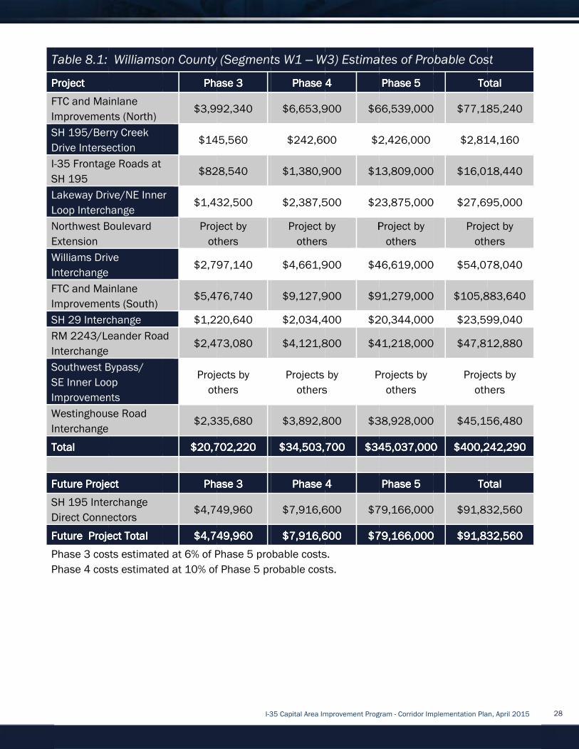
Table 8
Project Project Project Project
FTC and Mainlane
Improvements (North)
SH 195/Berry Creek
Drive Intersection
I-
SH 195
Lakeway Drive/NE Inner
Loop Interchange
Northwest Boulevard
Extension
Williams Drive
Interchange
FTC and Mainlane
Improvements (South)
SH 29 Interchange
RM 2243/Leander Road
Interchange
Southwest Bypass/
SE Inner Loop
Improvements
Westinghouse Road
Interchange
TotalTotalTotalTotal
Future Future Future Future
SH 195 Interchange
Direct Connectors
Future Project TotalFuture Project TotalFuture Project TotalFuture Project Total
Phase 3 costs estimated at 6% of Phase 5 prob
Phase 4 costs estimated at 10% of Phase 5 probable costs.
Table 8.1:
Project Project Project Project
FTC and Mainlane
Improvements (North)
SH 195/Berry Creek
Drive Intersection
-35 Frontage Roads at
SH 195
Lakeway Drive/NE Inner
Loop Interchange
Northwest Boulevard
Extension
Williams Drive
Interchange
FTC and Mainlane
Improvements (South)
SH 29 Interchange
RM 2243/Leander Road
Interchange
Southwest Bypass/
SE Inner Loop
Improvements
Westinghouse Road
Interchange
TotalTotalTotalTotal
Future Future Future Future Project Project Project Project
SH 195 Interchange
Direct Connectors
Future Project TotalFuture Project TotalFuture Project TotalFuture Project Total
Phase 3 costs estimated at 6% of Phase 5 prob
Phase 4 costs estimated at 10% of Phase 5 probable costs.
: Williamson County (Segments W1
FTC and Mainlane
Improvements (North)
SH 195/Berry Creek
Drive Intersection
35 Frontage Roads at
Lakeway Drive/NE Inner
Loop Interchange
Northwest Boulevard
Williams Drive
Interchange
FTC and Mainlane
Improvements (South)
SH 29 Interchange
RM 2243/Leander Road
Interchange
Southwest Bypass/
SE Inner Loop
Improvements
Westinghouse Road
Interchange
Project Project Project Project
SH 195 Interchange
Direct Connectors
Future Project TotalFuture Project TotalFuture Project TotalFuture Project Total
Phase 3 costs estimated at 6% of Phase 5 prob
Phase 4 costs estimated at 10% of Phase 5 probable costs.
Williamson County (Segments W1
Phase 3Phase 3Phase 3Phase 3
$3,992,340
$145,560
35 Frontage Roads at $828,540
Lakeway Drive/NE Inner $1,432,500
Project by
others
$2,797,140
$5,476,740
$1,220,640
RM 2243/Leander Road $2,473,080
Projects by
others
$2,335,680
$20,702,220$20,702,220$20,702,220$20,702,220
Phase 3Phase 3Phase 3Phase 3
$4,749,960
$$$$4,749,9604,749,9604,749,9604,749,960
Phase 3 costs estimated at 6% of Phase 5 prob
Phase 4 costs estimated at 10% of Phase 5 probable costs.
I-35 Capital Area Improvement Program
Williamson County (Segments W1
Phase 3Phase 3Phase 3Phase 3
$3,992,340
$145,560
28,540
$1,432,500
Project by
others
797,140
$5,476,740
$1,220,640
$2,473,080
Projects by
others
$2,335,680
$20,702,220$20,702,220$20,702,220$20,702,220
Phase 3Phase 3Phase 3Phase 3
$4,749,960
4,749,9604,749,9604,749,9604,749,960
Phase 3 costs estimated at 6% of Phase 5 prob
Phase 4 costs estimated at 10% of Phase 5 probable costs.
35 Capital Area Improvement Program
Williamson County (Segments W1 – W3) Estimates
Phase 4Phase 4Phase 4Phase 4
$6,653,900
$242,60
$1,380,900
$2,387,500
Project by
others
$4,661,900
$9,127,900
$2,034,400
$4,121,800
Projects by
others
$3,892,800
$34,503,700$34,503,700$34,503,700$34,503,700
Phase 4Phase 4Phase 4Phase 4
$7,916,600
$7,$7,$7,$7,916,600916,600916,600916,600
Phase 3 costs estimated at 6% of Phase 5 probable costs.
Phase 4 costs estimated at 10% of Phase 5 probable costs.
35 Capital Area Improvement Program
W3) Estimates
Phase 4Phase 4Phase 4Phase 4
$6,653,900 $66,539,000
$242,600 $2,426,000
,900 $13,
$2,387,500 $23,875,000
Project by
others
Pro
661,900 $46,619
$9,127,900 $91,279,000
$2,034,400 $20,344,000
$4,121,800 $41,218,000
Projects by
others
Projects by
$3,892,800 $38,928,000
$34,503,700$34,503,700$34,503,700$34,503,700 $345,037,000$345,037,000$345,037,000$345,037,000
Phase 4Phase 4Phase 4Phase 4
$7,916,600 $79,166,000
916,600916,600916,600916,600 $79,166,000$79,166,000$79,166,000$79,166,000
able costs.
Phase 4 costs estimated at 10% of Phase 5 probable costs.
35 Capital Area Improvement Program - Corridor Implementation Plan, April 2015
W3) Estimates of Probable Cost
Phase 5Phase 5Phase 5Phase 5
$66,539,000
$2,426,000
$13,809,000
$23,875,000
Project by
others
$46,619,000
$91,279,000
$20,344,000
$41,218,000
Projects by
others
$38,928,000
$345,037,000$345,037,000$345,037,000$345,037,000
Phase 5Phase 5Phase 5Phase 5
$79,166,000
$79,166,000$79,166,000$79,166,000$79,166,000
Corridor Implementation Plan, April 2015
of Probable Cost
TotalTotalTotalTotal
$66,539,000 $77,185,240
$2,814,160
9,000 $16,018,44
$23,875,000 $27,695,000
Project by
others
,000 $54,078,0
$91,279,000 $105,883,640
$20,344,000 $23,599,04
$41,218,000 $47,812,8
Projects by
others
$38,928,000 $45,156,480
$345,037,000$345,037,000$345,037,000$345,037,000 $400,242,290$400,242,290$400,242,290$400,242,290
TotalTotalTotalTotal
$79,166,000 $91,832,560
$79,166,000$79,166,000$79,166,000$79,166,000 $91,832,560$91,832,560$91,832,560$91,832,560
Corridor Implementation Plan, April 2015
of Probable Cost
TotalTotalTotalTotal
$77,185,240
$2,814,160
$16,018,440
$27,695,000
Project by
others
$54,078,040
$105,883,640
$23,599,040
$47,812,880
Projects by
others
$45,156,480
$400,242,290$400,242,290$400,242,290$400,242,290
TotalTotalTotalTotal
$91,832,560
$91,832,560$91,832,560$91,832,560$91,832,560
28

8.2
Table 8.2Table 8.2Table 8.2Table 8.2
unfunded construction needs for the proposed
W1
and projected funding would cover
amount of
Table 8.2: Construction Funding Needs
8.3
Texas transportation revenues are generated by motor fuel taxe
funds, bonds, and public
were funded entirely with state and federal revenues.
to keep up with demand
borrowed funds generated by bond issues.
transportation funding is the federal and state motor fuel tax.
gallon and the federal tax is $
price
increasingly fuel
to inflation.
8.2 Project
Table 8.2Table 8.2Table 8.2Table 8.2 provides a
unfunded construction needs for the proposed
W1 – W3. This table indicates a total project construction cost of $
and projected funding would cover
amount of just over
Table 8.2: Construction Funding Needs
Total Corridor Total Corridor Total Corridor Total Corridor
Construction Construction Construction Construction
CostCostCostCost
$345,037$345,037$345,037$345,037,000,000,000,000
8.3 Potential Funding Sources
Texas transportation revenues are generated by motor fuel taxe
funds, bonds, and public
were funded entirely with state and federal revenues.
to keep up with demand
borrowed funds generated by bond issues.
transportation funding is the federal and state motor fuel tax.
gallon and the federal tax is $
price of gasoline. Many people are purchasing fewer gallons of fuel because they purchase
increasingly fuel
to inflation.
Project Funding
provides a summary of anticipated construction
unfunded construction needs for the proposed
W3. This table indicates a total project construction cost of $
and projected funding would cover
just over $143
Table 8.2: Construction Funding Needs
Total Corridor Total Corridor Total Corridor Total Corridor
Construction Construction Construction Construction
Annual Average Annual Average Annual Average Annual Average
TxDOT Construction TxDOT Construction TxDOT Construction TxDOT Construction
Expenditures IExpenditures IExpenditures IExpenditures I
(over 20 years)(over 20 years)(over 20 years)(over 20 years)
,000,000,000,000 $124,800,000$124,800,000$124,800,000$124,800,000
Potential Funding Sources
Texas transportation revenues are generated by motor fuel taxe
funds, bonds, and public
were funded entirely with state and federal revenues.
to keep up with demand
borrowed funds generated by bond issues.
transportation funding is the federal and state motor fuel tax.
gallon and the federal tax is $
of gasoline. Many people are purchasing fewer gallons of fuel because they purchase
increasingly fuel-efficient vehicles. Also, the purch
Funding
summary of anticipated construction
unfunded construction needs for the proposed
W3. This table indicates a total project construction cost of $
and projected funding would cover
143 million.
Table 8.2: Construction Funding Needs
Annual Average Annual Average Annual Average Annual Average
TxDOT Construction TxDOT Construction TxDOT Construction TxDOT Construction
Expenditures IExpenditures IExpenditures IExpenditures I
(over 20 years)(over 20 years)(over 20 years)(over 20 years)
$124,800,000$124,800,000$124,800,000$124,800,000
Potential Funding Sources
Texas transportation revenues are generated by motor fuel taxe
funds, bonds, and public-private partnerships as shown in
were funded entirely with state and federal revenues.
to keep up with demand and have been supplemented by allocations from private partners and
borrowed funds generated by bond issues.
transportation funding is the federal and state motor fuel tax.
gallon and the federal tax is $0.184 per gallon.
of gasoline. Many people are purchasing fewer gallons of fuel because they purchase
efficient vehicles. Also, the purch
I-35 Capital Area Improvement Program
summary of anticipated construction
unfunded construction needs for the proposed
W3. This table indicates a total project construction cost of $
and projected funding would cover approximately
Table 8.2: Construction Funding Needs
Annual Average Annual Average Annual Average Annual Average
TxDOT Construction TxDOT Construction TxDOT Construction TxDOT Construction
Expenditures IExpenditures IExpenditures IExpenditures I----35 35 35 35
(over 20 years)(over 20 years)(over 20 years)(over 20 years)
Infrastructure Infrastructure Infrastructure Infrastructure
(FY(FY(FY(FY
$124,800,000$124,800,000$124,800,000$124,800,000 $77,000,000$77,000,000$77,000,000$77,000,000
Texas transportation revenues are generated by motor fuel taxe
private partnerships as shown in
were funded entirely with state and federal revenues.
and have been supplemented by allocations from private partners and
borrowed funds generated by bond issues. As seen in
transportation funding is the federal and state motor fuel tax.
.184 per gallon.
of gasoline. Many people are purchasing fewer gallons of fuel because they purchase
efficient vehicles. Also, the purch
35 Capital Area Improvement Program
summary of anticipated construction
unfunded construction needs for the proposed program of
W3. This table indicates a total project construction cost of $
approximately $202 million, leaving an unfunded construction
CTRMA CTRMA CTRMA CTRMA
Regional Regional Regional Regional
Infrastructure Infrastructure Infrastructure Infrastructure
FundFundFundFund
(FY(FY(FY(FY 2029202920292029----FY FY FY FY
2035)2035)2035)2035)
$77,000,000$77,000,000$77,000,000$77,000,000
Texas transportation revenues are generated by motor fuel taxe
private partnerships as shown in
were funded entirely with state and federal revenues. Since 2002, revenues have been inadequate
and have been supplemented by allocations from private partners and
As seen in Figure Figure Figure Figure
transportation funding is the federal and state motor fuel tax.
.184 per gallon. Both are flat taxes and do not vary according to the
of gasoline. Many people are purchasing fewer gallons of fuel because they purchase
efficient vehicles. Also, the purchasing power of the motor fuel tax is declining due
35 Capital Area Improvement Program
summary of anticipated construction costs, identified project fundi
rogram of projects in Williamson County, Segments
W3. This table indicates a total project construction cost of $345.037
million, leaving an unfunded construction
Infrastructure Infrastructure Infrastructure Infrastructure
FY FY FY FY
Current Available Current Available Current Available Current Available
Funding for Funding for Funding for Funding for
Corridor Corridor Corridor Corridor
ConstructionConstructionConstructionConstruction
$77,000,000$77,000,000$77,000,000$77,000,000 $201,800,000$201,800,000$201,800,000$201,800,000
Texas transportation revenues are generated by motor fuel taxes, vehicle registration fees, federal
private partnerships as shown in Figure Figure Figure Figure 8.18.18.18.1
Since 2002, revenues have been inadequate
and have been supplemented by allocations from private partners and
Figure Figure Figure Figure 8.1,8.1,8.1,8.1, currently the primary source of
transportation funding is the federal and state motor fuel tax. The state tax on gasoline is
Both are flat taxes and do not vary according to the
of gasoline. Many people are purchasing fewer gallons of fuel because they purchase
asing power of the motor fuel tax is declining due
35 Capital Area Improvement Program - Corridor Implementation Plan, April 2015
, identified project fundi
rojects in Williamson County, Segments
345.037 million. Of this, current
million, leaving an unfunded construction
Current Available Current Available Current Available Current Available
Funding for Funding for Funding for Funding for
Corridor Corridor Corridor Corridor
ConstructionConstructionConstructionConstruction
$201,800,000$201,800,000$201,800,000$201,800,000
s, vehicle registration fees, federal
8.18.18.18.1. Until 2002, TxDOT’s projects
Since 2002, revenues have been inadequate
and have been supplemented by allocations from private partners and
urrently the primary source of
The state tax on gasoline is
Both are flat taxes and do not vary according to the
of gasoline. Many people are purchasing fewer gallons of fuel because they purchase
asing power of the motor fuel tax is declining due
Corridor Implementation Plan, April 2015
, identified project funding and
rojects in Williamson County, Segments
million. Of this, current
million, leaving an unfunded construction
Total Unfunded Total Unfunded Total Unfunded Total Unfunded
Construction Construction Construction Construction
NeedsNeedsNeedsNeeds
$143,247$143,247$143,247$143,247
s, vehicle registration fees, federal
Until 2002, TxDOT’s projects
Since 2002, revenues have been inadequate
and have been supplemented by allocations from private partners and
urrently the primary source of
The state tax on gasoline is $0
Both are flat taxes and do not vary according to the
of gasoline. Many people are purchasing fewer gallons of fuel because they purchase
asing power of the motor fuel tax is declining due
Corridor Implementation Plan, April 2015
ng and
rojects in Williamson County, Segments
million. Of this, current
million, leaving an unfunded construction
Total Unfunded Total Unfunded Total Unfunded Total Unfunded
Construction Construction Construction Construction
NeedsNeedsNeedsNeeds
$143,247$143,247$143,247$143,247,000,000,000,000
s, vehicle registration fees, federal
Until 2002, TxDOT’s projects
Since 2002, revenues have been inadequate
and have been supplemented by allocations from private partners and
urrently the primary source of
0.20 per
Both are flat taxes and do not vary according to the
of gasoline. Many people are purchasing fewer gallons of fuel because they purchase
asing power of the motor fuel tax is declining due
29

Source: TxDOT
FigureFigureFigureFigure
However, in 2013, the 83
constitutional amendment authorizing annual
production tax collections to the State Highway Fund. In November 2014, voters approved the
constitutional amendment. On
proposed amendments to the T
of the passage of Proposition 1 (the constitutional amendment voter referendum authorized in SJR
1) and the recommendations from the House Select Committee on Transportation Funding,
Exp
amendments provide greater flexibility in the methods used for distributing funds through the
Department’s Unified Transportation Program (UTP). Included in the amendments
the scope of Category 2, Metropolitan and Urban Corridor Projects, to include safety, maintenance
or rehabilitation projects; clarifying the term “strategic corridors” to include any strategic corridors
located on the state highway network w
allocated to individual
basis to cover project cost overruns; and, supplementing funds allocated to individual districts
un
Discretionary, in response to special initiatives, safety issues, or unforeseen environmental factors.
Such supplemental funding is not required to be allocated proporti
is not required to be allocated according to the prescribed formulas for Category 1, Preventative
Maintenance and Rehabilitation, and Category 11, District Discretionary.
Source: TxDOT
FigureFigureFigureFigure 8.18.18.18.1: Standard Revenue (2009
However, in 2013, the 83
constitutional amendment authorizing annual
production tax collections to the State Highway Fund. In November 2014, voters approved the
constitutional amendment. On
proposed amendments to the T
of the passage of Proposition 1 (the constitutional amendment voter referendum authorized in SJR
1) and the recommendations from the House Select Committee on Transportation Funding,
Expenditures and Finance, and the Department’s Proposition 1 Stakeholder Committee. The
amendments provide greater flexibility in the methods used for distributing funds through the
Department’s Unified Transportation Program (UTP). Included in the amendments
the scope of Category 2, Metropolitan and Urban Corridor Projects, to include safety, maintenance
or rehabilitation projects; clarifying the term “strategic corridors” to include any strategic corridors
located on the state highway network w
allocated to individual
basis to cover project cost overruns; and, supplementing funds allocated to individual districts
under Category 1, Preventative Maintenance and Rehabilitation, and Category 11, District
Discretionary, in response to special initiatives, safety issues, or unforeseen environmental factors.
Such supplemental funding is not required to be allocated proporti
is not required to be allocated according to the prescribed formulas for Category 1, Preventative
Maintenance and Rehabilitation, and Category 11, District Discretionary.
Source: TxDOT
: Standard Revenue (2009
However, in 2013, the 83
constitutional amendment authorizing annual
production tax collections to the State Highway Fund. In November 2014, voters approved the
constitutional amendment. On
proposed amendments to the T
of the passage of Proposition 1 (the constitutional amendment voter referendum authorized in SJR
1) and the recommendations from the House Select Committee on Transportation Funding,
enditures and Finance, and the Department’s Proposition 1 Stakeholder Committee. The
amendments provide greater flexibility in the methods used for distributing funds through the
Department’s Unified Transportation Program (UTP). Included in the amendments
the scope of Category 2, Metropolitan and Urban Corridor Projects, to include safety, maintenance
or rehabilitation projects; clarifying the term “strategic corridors” to include any strategic corridors
located on the state highway network w
allocated to individual TxDOT
basis to cover project cost overruns; and, supplementing funds allocated to individual districts
der Category 1, Preventative Maintenance and Rehabilitation, and Category 11, District
Discretionary, in response to special initiatives, safety issues, or unforeseen environmental factors.
Such supplemental funding is not required to be allocated proporti
is not required to be allocated according to the prescribed formulas for Category 1, Preventative
Maintenance and Rehabilitation, and Category 11, District Discretionary.
: Standard Revenue (2009
However, in 2013, the 83rd Texas Legislature passed Senate Joint Resolution (SJR) 1, a
constitutional amendment authorizing annual
production tax collections to the State Highway Fund. In November 2014, voters approved the
constitutional amendment. On February 26, 2015
proposed amendments to the Texas Administrative Code relating to Transportation Funding, in light
of the passage of Proposition 1 (the constitutional amendment voter referendum authorized in SJR
1) and the recommendations from the House Select Committee on Transportation Funding,
enditures and Finance, and the Department’s Proposition 1 Stakeholder Committee. The
amendments provide greater flexibility in the methods used for distributing funds through the
Department’s Unified Transportation Program (UTP). Included in the amendments
the scope of Category 2, Metropolitan and Urban Corridor Projects, to include safety, maintenance
or rehabilitation projects; clarifying the term “strategic corridors” to include any strategic corridors
located on the state highway network w
TxDOT districts under Category 11, District Discretionary on a case
basis to cover project cost overruns; and, supplementing funds allocated to individual districts
der Category 1, Preventative Maintenance and Rehabilitation, and Category 11, District
Discretionary, in response to special initiatives, safety issues, or unforeseen environmental factors.
Such supplemental funding is not required to be allocated proporti
is not required to be allocated according to the prescribed formulas for Category 1, Preventative
Maintenance and Rehabilitation, and Category 11, District Discretionary.
I-35 Capital Area Improvement Program
: Standard Revenue (2009-2035).
Texas Legislature passed Senate Joint Resolution (SJR) 1, a
constitutional amendment authorizing annual
production tax collections to the State Highway Fund. In November 2014, voters approved the
February 26, 2015
exas Administrative Code relating to Transportation Funding, in light
of the passage of Proposition 1 (the constitutional amendment voter referendum authorized in SJR
1) and the recommendations from the House Select Committee on Transportation Funding,
enditures and Finance, and the Department’s Proposition 1 Stakeholder Committee. The
amendments provide greater flexibility in the methods used for distributing funds through the
Department’s Unified Transportation Program (UTP). Included in the amendments
the scope of Category 2, Metropolitan and Urban Corridor Projects, to include safety, maintenance
or rehabilitation projects; clarifying the term “strategic corridors” to include any strategic corridors
located on the state highway network which provide statewide connectivity; supplementing funds
districts under Category 11, District Discretionary on a case
basis to cover project cost overruns; and, supplementing funds allocated to individual districts
der Category 1, Preventative Maintenance and Rehabilitation, and Category 11, District
Discretionary, in response to special initiatives, safety issues, or unforeseen environmental factors.
Such supplemental funding is not required to be allocated proporti
is not required to be allocated according to the prescribed formulas for Category 1, Preventative
Maintenance and Rehabilitation, and Category 11, District Discretionary.
35 Capital Area Improvement Program
Texas Legislature passed Senate Joint Resolution (SJR) 1, a
disbursements from the state’s oil and gas
production tax collections to the State Highway Fund. In November 2014, voters approved the
February 26, 2015, the Texas Transportation Commission
exas Administrative Code relating to Transportation Funding, in light
of the passage of Proposition 1 (the constitutional amendment voter referendum authorized in SJR
1) and the recommendations from the House Select Committee on Transportation Funding,
enditures and Finance, and the Department’s Proposition 1 Stakeholder Committee. The
amendments provide greater flexibility in the methods used for distributing funds through the
Department’s Unified Transportation Program (UTP). Included in the amendments
the scope of Category 2, Metropolitan and Urban Corridor Projects, to include safety, maintenance
or rehabilitation projects; clarifying the term “strategic corridors” to include any strategic corridors
hich provide statewide connectivity; supplementing funds
districts under Category 11, District Discretionary on a case
basis to cover project cost overruns; and, supplementing funds allocated to individual districts
der Category 1, Preventative Maintenance and Rehabilitation, and Category 11, District
Discretionary, in response to special initiatives, safety issues, or unforeseen environmental factors.
Such supplemental funding is not required to be allocated proporti
is not required to be allocated according to the prescribed formulas for Category 1, Preventative
Maintenance and Rehabilitation, and Category 11, District Discretionary.
35 Capital Area Improvement Program
Texas Legislature passed Senate Joint Resolution (SJR) 1, a
disbursements from the state’s oil and gas
production tax collections to the State Highway Fund. In November 2014, voters approved the
, the Texas Transportation Commission
exas Administrative Code relating to Transportation Funding, in light
of the passage of Proposition 1 (the constitutional amendment voter referendum authorized in SJR
1) and the recommendations from the House Select Committee on Transportation Funding,
enditures and Finance, and the Department’s Proposition 1 Stakeholder Committee. The
amendments provide greater flexibility in the methods used for distributing funds through the
Department’s Unified Transportation Program (UTP). Included in the amendments
the scope of Category 2, Metropolitan and Urban Corridor Projects, to include safety, maintenance
or rehabilitation projects; clarifying the term “strategic corridors” to include any strategic corridors
hich provide statewide connectivity; supplementing funds
districts under Category 11, District Discretionary on a case
basis to cover project cost overruns; and, supplementing funds allocated to individual districts
der Category 1, Preventative Maintenance and Rehabilitation, and Category 11, District
Discretionary, in response to special initiatives, safety issues, or unforeseen environmental factors.
Such supplemental funding is not required to be allocated proportionately among the districts and
is not required to be allocated according to the prescribed formulas for Category 1, Preventative
Maintenance and Rehabilitation, and Category 11, District Discretionary.
35 Capital Area Improvement Program - Corridor Implementation Plan, April 2015
Texas Legislature passed Senate Joint Resolution (SJR) 1, a
disbursements from the state’s oil and gas
production tax collections to the State Highway Fund. In November 2014, voters approved the
, the Texas Transportation Commission
exas Administrative Code relating to Transportation Funding, in light
of the passage of Proposition 1 (the constitutional amendment voter referendum authorized in SJR
1) and the recommendations from the House Select Committee on Transportation Funding,
enditures and Finance, and the Department’s Proposition 1 Stakeholder Committee. The
amendments provide greater flexibility in the methods used for distributing funds through the
Department’s Unified Transportation Program (UTP). Included in the amendments
the scope of Category 2, Metropolitan and Urban Corridor Projects, to include safety, maintenance
or rehabilitation projects; clarifying the term “strategic corridors” to include any strategic corridors
hich provide statewide connectivity; supplementing funds
districts under Category 11, District Discretionary on a case
basis to cover project cost overruns; and, supplementing funds allocated to individual districts
der Category 1, Preventative Maintenance and Rehabilitation, and Category 11, District
Discretionary, in response to special initiatives, safety issues, or unforeseen environmental factors.
onately among the districts and
is not required to be allocated according to the prescribed formulas for Category 1, Preventative
Maintenance and Rehabilitation, and Category 11, District Discretionary.
Corridor Implementation Plan, April 2015
Texas Legislature passed Senate Joint Resolution (SJR) 1, a
disbursements from the state’s oil and gas
production tax collections to the State Highway Fund. In November 2014, voters approved the
, the Texas Transportation Commission adopted
exas Administrative Code relating to Transportation Funding, in light
of the passage of Proposition 1 (the constitutional amendment voter referendum authorized in SJR
1) and the recommendations from the House Select Committee on Transportation Funding,
enditures and Finance, and the Department’s Proposition 1 Stakeholder Committee. The
amendments provide greater flexibility in the methods used for distributing funds through the
Department’s Unified Transportation Program (UTP). Included in the amendments are expanding
the scope of Category 2, Metropolitan and Urban Corridor Projects, to include safety, maintenance
or rehabilitation projects; clarifying the term “strategic corridors” to include any strategic corridors
hich provide statewide connectivity; supplementing funds
districts under Category 11, District Discretionary on a case-by
basis to cover project cost overruns; and, supplementing funds allocated to individual districts
der Category 1, Preventative Maintenance and Rehabilitation, and Category 11, District
Discretionary, in response to special initiatives, safety issues, or unforeseen environmental factors.
onately among the districts and
is not required to be allocated according to the prescribed formulas for Category 1, Preventative
Corridor Implementation Plan, April 2015
production tax collections to the State Highway Fund. In November 2014, voters approved the
adopted
exas Administrative Code relating to Transportation Funding, in light
of the passage of Proposition 1 (the constitutional amendment voter referendum authorized in SJR
1) and the recommendations from the House Select Committee on Transportation Funding,
enditures and Finance, and the Department’s Proposition 1 Stakeholder Committee. The
amendments provide greater flexibility in the methods used for distributing funds through the
are expanding
the scope of Category 2, Metropolitan and Urban Corridor Projects, to include safety, maintenance
or rehabilitation projects; clarifying the term “strategic corridors” to include any strategic corridors
hich provide statewide connectivity; supplementing funds
by-case
basis to cover project cost overruns; and, supplementing funds allocated to individual districts
Discretionary, in response to special initiatives, safety issues, or unforeseen environmental factors.
onately among the districts and
is not required to be allocated according to the prescribed formulas for Category 1, Preventative
30

Revenue collection, which will fluctuate from year t
allocation for future years. The Transportation Policy Board of the Capital Area Metropolitan
Planning Organization (
I-
A variety of funding mechanisms exist that could be applied to I
For this CIP update, a list of potential funding sources has been identified. As part of continued
implement
project financing developed. Currently, f
entities, private entities, and via district overlays, associations, and agreements
Government Entities
Government funding may come from federal, state, county, or municipal sources. Federal and state
funding are primarily motor fuel taxes, and are disbursed and administered by TxDOT.
historically
significant changes to the TxDOT budget, this funding should be expected to remain relatively
constant.
As noted above, a percentage of anticipated revenues could come from Proposition 1 funding
which will fluctuate year
Those revenues are not included in
Local governmental entities typically fund transportation projects
with proj
requests state or federal assistance, the project must be placed on the State Transportation
Improvement Plan (STIP). Funding for such projects can include regular CIP p
in bond elections and/or use of pass
funding through government entities are described below.
Federal Credit Assistance
The federal government provides assistance to states
capital through the Transportation Infrastructure Finance and Innovation Act (TIFIA) loan program.
Through TIFIA, the federal government provides federal credit assistance to projects that meet
certain criteria
nationally or regionally significant projects. A project must be on the National Highway system, part
of the Statewide Transportation Improvement Plan, and have a capital cost
to be considered for TIFIA funding. TIFIA funding is limited to 33 percent of total eligible project
cost. A project must also be supported in whole or in part by user charges or other non
dedicated funding sources. At prese
this corridor.
Revenue collection, which will fluctuate from year t
allocation for future years. The Transportation Policy Board of the Capital Area Metropolitan
Planning Organization (
-35 within the MPO’s pl
A variety of funding mechanisms exist that could be applied to I
For this CIP update, a list of potential funding sources has been identified. As part of continued
implementation assessment, these funding options will be evaluated and recommendations for
project financing developed. Currently, f
entities, private entities, and via district overlays, associations, and agreements
Government Entities
Government funding may come from federal, state, county, or municipal sources. Federal and state
funding are primarily motor fuel taxes, and are disbursed and administered by TxDOT.
historically invest
significant changes to the TxDOT budget, this funding should be expected to remain relatively
constant.
As noted above, a percentage of anticipated revenues could come from Proposition 1 funding
which will fluctuate year
Those revenues are not included in
Local governmental entities typically fund transportation projects
with projects identified)
requests state or federal assistance, the project must be placed on the State Transportation
Improvement Plan (STIP). Funding for such projects can include regular CIP p
in bond elections and/or use of pass
funding through government entities are described below.
Federal Credit Assistance
The federal government provides assistance to states
capital through the Transportation Infrastructure Finance and Innovation Act (TIFIA) loan program.
Through TIFIA, the federal government provides federal credit assistance to projects that meet
certain criteria
nationally or regionally significant projects. A project must be on the National Highway system, part
of the Statewide Transportation Improvement Plan, and have a capital cost
to be considered for TIFIA funding. TIFIA funding is limited to 33 percent of total eligible project
cost. A project must also be supported in whole or in part by user charges or other non
dedicated funding sources. At prese
this corridor.
Revenue collection, which will fluctuate from year t
allocation for future years. The Transportation Policy Board of the Capital Area Metropolitan
Planning Organization (CA
35 within the MPO’s pl
A variety of funding mechanisms exist that could be applied to I
For this CIP update, a list of potential funding sources has been identified. As part of continued
ation assessment, these funding options will be evaluated and recommendations for
project financing developed. Currently, f
entities, private entities, and via district overlays, associations, and agreements
Government Entities
Government funding may come from federal, state, county, or municipal sources. Federal and state
funding are primarily motor fuel taxes, and are disbursed and administered by TxDOT.
invested $6.24 million
significant changes to the TxDOT budget, this funding should be expected to remain relatively
As noted above, a percentage of anticipated revenues could come from Proposition 1 funding
which will fluctuate year
Those revenues are not included in
Local governmental entities typically fund transportation projects
ects identified)
requests state or federal assistance, the project must be placed on the State Transportation
Improvement Plan (STIP). Funding for such projects can include regular CIP p
in bond elections and/or use of pass
funding through government entities are described below.
Federal Credit Assistance
The federal government provides assistance to states
capital through the Transportation Infrastructure Finance and Innovation Act (TIFIA) loan program.
Through TIFIA, the federal government provides federal credit assistance to projects that meet
certain criteria (such as the use of public
nationally or regionally significant projects. A project must be on the National Highway system, part
of the Statewide Transportation Improvement Plan, and have a capital cost
to be considered for TIFIA funding. TIFIA funding is limited to 33 percent of total eligible project
cost. A project must also be supported in whole or in part by user charges or other non
dedicated funding sources. At prese
this corridor.
Revenue collection, which will fluctuate from year t
allocation for future years. The Transportation Policy Board of the Capital Area Metropolitan
CAMPO) has pledged its share of Proposition 1 funds to improvements on
35 within the MPO’s planning area, which includes Williamson County.
A variety of funding mechanisms exist that could be applied to I
For this CIP update, a list of potential funding sources has been identified. As part of continued
ation assessment, these funding options will be evaluated and recommendations for
project financing developed. Currently, f
entities, private entities, and via district overlays, associations, and agreements
Government funding may come from federal, state, county, or municipal sources. Federal and state
funding are primarily motor fuel taxes, and are disbursed and administered by TxDOT.
$6.24 million annua
significant changes to the TxDOT budget, this funding should be expected to remain relatively
As noted above, a percentage of anticipated revenues could come from Proposition 1 funding
which will fluctuate year-to-year and will ultimately affect future spending on the I
Those revenues are not included in
Local governmental entities typically fund transportation projects
ects identified) through a Capital Improvement Plan (CIP) process. If the local entity
requests state or federal assistance, the project must be placed on the State Transportation
Improvement Plan (STIP). Funding for such projects can include regular CIP p
in bond elections and/or use of pass
funding through government entities are described below.
Federal Credit Assistance
The federal government provides assistance to states
capital through the Transportation Infrastructure Finance and Innovation Act (TIFIA) loan program.
Through TIFIA, the federal government provides federal credit assistance to projects that meet
(such as the use of public
nationally or regionally significant projects. A project must be on the National Highway system, part
of the Statewide Transportation Improvement Plan, and have a capital cost
to be considered for TIFIA funding. TIFIA funding is limited to 33 percent of total eligible project
cost. A project must also be supported in whole or in part by user charges or other non
dedicated funding sources. At prese
I-35 Capital Area Improvement Program
Revenue collection, which will fluctuate from year t
allocation for future years. The Transportation Policy Board of the Capital Area Metropolitan
MPO) has pledged its share of Proposition 1 funds to improvements on
anning area, which includes Williamson County.
A variety of funding mechanisms exist that could be applied to I
For this CIP update, a list of potential funding sources has been identified. As part of continued
ation assessment, these funding options will be evaluated and recommendations for
project financing developed. Currently, funding for transportation
entities, private entities, and via district overlays, associations, and agreements
Government funding may come from federal, state, county, or municipal sources. Federal and state
funding are primarily motor fuel taxes, and are disbursed and administered by TxDOT.
annually on the I
significant changes to the TxDOT budget, this funding should be expected to remain relatively
As noted above, a percentage of anticipated revenues could come from Proposition 1 funding
year and will ultimately affect future spending on the I
Those revenues are not included in Figure 8.1.Figure 8.1.Figure 8.1.Figure 8.1.
Local governmental entities typically fund transportation projects
through a Capital Improvement Plan (CIP) process. If the local entity
requests state or federal assistance, the project must be placed on the State Transportation
Improvement Plan (STIP). Funding for such projects can include regular CIP p
in bond elections and/or use of pass-through or State Infrastructure Bank financing. Examples of
funding through government entities are described below.
The federal government provides assistance to states
capital through the Transportation Infrastructure Finance and Innovation Act (TIFIA) loan program.
Through TIFIA, the federal government provides federal credit assistance to projects that meet
(such as the use of public-private partnerships and/or advanced technology) for
nationally or regionally significant projects. A project must be on the National Highway system, part
of the Statewide Transportation Improvement Plan, and have a capital cost
to be considered for TIFIA funding. TIFIA funding is limited to 33 percent of total eligible project
cost. A project must also be supported in whole or in part by user charges or other non
dedicated funding sources. At present, no potential TIFIA applications are under development for
35 Capital Area Improvement Program
Revenue collection, which will fluctuate from year to year based on oil prices, will affect the
allocation for future years. The Transportation Policy Board of the Capital Area Metropolitan
MPO) has pledged its share of Proposition 1 funds to improvements on
anning area, which includes Williamson County.
A variety of funding mechanisms exist that could be applied to I
For this CIP update, a list of potential funding sources has been identified. As part of continued
ation assessment, these funding options will be evaluated and recommendations for
unding for transportation
entities, private entities, and via district overlays, associations, and agreements
Government funding may come from federal, state, county, or municipal sources. Federal and state
funding are primarily motor fuel taxes, and are disbursed and administered by TxDOT.
on the I-35 corridor through Williamson County.
significant changes to the TxDOT budget, this funding should be expected to remain relatively
As noted above, a percentage of anticipated revenues could come from Proposition 1 funding
year and will ultimately affect future spending on the I
Figure 8.1.Figure 8.1.Figure 8.1.Figure 8.1.
Local governmental entities typically fund transportation projects
through a Capital Improvement Plan (CIP) process. If the local entity
requests state or federal assistance, the project must be placed on the State Transportation
Improvement Plan (STIP). Funding for such projects can include regular CIP p
through or State Infrastructure Bank financing. Examples of
funding through government entities are described below.
The federal government provides assistance to states to lower interest rates and expand access to
capital through the Transportation Infrastructure Finance and Innovation Act (TIFIA) loan program.
Through TIFIA, the federal government provides federal credit assistance to projects that meet
private partnerships and/or advanced technology) for
nationally or regionally significant projects. A project must be on the National Highway system, part
of the Statewide Transportation Improvement Plan, and have a capital cost
to be considered for TIFIA funding. TIFIA funding is limited to 33 percent of total eligible project
cost. A project must also be supported in whole or in part by user charges or other non
nt, no potential TIFIA applications are under development for
35 Capital Area Improvement Program
o year based on oil prices, will affect the
allocation for future years. The Transportation Policy Board of the Capital Area Metropolitan
MPO) has pledged its share of Proposition 1 funds to improvements on
anning area, which includes Williamson County.
A variety of funding mechanisms exist that could be applied to I-35 projects in Williamson County.
For this CIP update, a list of potential funding sources has been identified. As part of continued
ation assessment, these funding options will be evaluated and recommendations for
unding for transportation comes from governmental
entities, private entities, and via district overlays, associations, and agreements
Government funding may come from federal, state, county, or municipal sources. Federal and state
funding are primarily motor fuel taxes, and are disbursed and administered by TxDOT.
35 corridor through Williamson County.
significant changes to the TxDOT budget, this funding should be expected to remain relatively
As noted above, a percentage of anticipated revenues could come from Proposition 1 funding
year and will ultimately affect future spending on the I
Local governmental entities typically fund transportation projects (using General Obligation Bonds
through a Capital Improvement Plan (CIP) process. If the local entity
requests state or federal assistance, the project must be placed on the State Transportation
Improvement Plan (STIP). Funding for such projects can include regular CIP p
through or State Infrastructure Bank financing. Examples of
funding through government entities are described below.
to lower interest rates and expand access to
capital through the Transportation Infrastructure Finance and Innovation Act (TIFIA) loan program.
Through TIFIA, the federal government provides federal credit assistance to projects that meet
private partnerships and/or advanced technology) for
nationally or regionally significant projects. A project must be on the National Highway system, part
of the Statewide Transportation Improvement Plan, and have a capital cost
to be considered for TIFIA funding. TIFIA funding is limited to 33 percent of total eligible project
cost. A project must also be supported in whole or in part by user charges or other non
nt, no potential TIFIA applications are under development for
35 Capital Area Improvement Program - Corridor Implementation Plan, April 2015
o year based on oil prices, will affect the
allocation for future years. The Transportation Policy Board of the Capital Area Metropolitan
MPO) has pledged its share of Proposition 1 funds to improvements on
anning area, which includes Williamson County.
35 projects in Williamson County.
For this CIP update, a list of potential funding sources has been identified. As part of continued
ation assessment, these funding options will be evaluated and recommendations for
comes from governmental
entities, private entities, and via district overlays, associations, and agreements.
Government funding may come from federal, state, county, or municipal sources. Federal and state
funding are primarily motor fuel taxes, and are disbursed and administered by TxDOT.
35 corridor through Williamson County.
significant changes to the TxDOT budget, this funding should be expected to remain relatively
As noted above, a percentage of anticipated revenues could come from Proposition 1 funding
year and will ultimately affect future spending on the I
(using General Obligation Bonds
through a Capital Improvement Plan (CIP) process. If the local entity
requests state or federal assistance, the project must be placed on the State Transportation
Improvement Plan (STIP). Funding for such projects can include regular CIP programming, inclusion
through or State Infrastructure Bank financing. Examples of
to lower interest rates and expand access to
capital through the Transportation Infrastructure Finance and Innovation Act (TIFIA) loan program.
Through TIFIA, the federal government provides federal credit assistance to projects that meet
private partnerships and/or advanced technology) for
nationally or regionally significant projects. A project must be on the National Highway system, part
of the Statewide Transportation Improvement Plan, and have a capital cost of at least $50 million
to be considered for TIFIA funding. TIFIA funding is limited to 33 percent of total eligible project
cost. A project must also be supported in whole or in part by user charges or other non
nt, no potential TIFIA applications are under development for
Corridor Implementation Plan, April 2015
o year based on oil prices, will affect the
allocation for future years. The Transportation Policy Board of the Capital Area Metropolitan
MPO) has pledged its share of Proposition 1 funds to improvements on
35 projects in Williamson County.
For this CIP update, a list of potential funding sources has been identified. As part of continued
ation assessment, these funding options will be evaluated and recommendations for
comes from governmental
.
Government funding may come from federal, state, county, or municipal sources. Federal and state
funding are primarily motor fuel taxes, and are disbursed and administered by TxDOT. TxDOT
35 corridor through Williamson County.
significant changes to the TxDOT budget, this funding should be expected to remain relatively
As noted above, a percentage of anticipated revenues could come from Proposition 1 funding
year and will ultimately affect future spending on the I-35 corridor.
(using General Obligation Bonds
through a Capital Improvement Plan (CIP) process. If the local entity
requests state or federal assistance, the project must be placed on the State Transportation
rogramming, inclusion
through or State Infrastructure Bank financing. Examples of
to lower interest rates and expand access to
capital through the Transportation Infrastructure Finance and Innovation Act (TIFIA) loan program.
Through TIFIA, the federal government provides federal credit assistance to projects that meet
private partnerships and/or advanced technology) for
nationally or regionally significant projects. A project must be on the National Highway system, part
of at least $50 million
to be considered for TIFIA funding. TIFIA funding is limited to 33 percent of total eligible project
cost. A project must also be supported in whole or in part by user charges or other non-federal
nt, no potential TIFIA applications are under development for
Corridor Implementation Plan, April 2015
o year based on oil prices, will affect the
allocation for future years. The Transportation Policy Board of the Capital Area Metropolitan
MPO) has pledged its share of Proposition 1 funds to improvements on
35 projects in Williamson County.
For this CIP update, a list of potential funding sources has been identified. As part of continued
ation assessment, these funding options will be evaluated and recommendations for
comes from governmental
Government funding may come from federal, state, county, or municipal sources. Federal and state
TxDOT has
35 corridor through Williamson County. Barring
significant changes to the TxDOT budget, this funding should be expected to remain relatively
As noted above, a percentage of anticipated revenues could come from Proposition 1 funding
35 corridor.
(using General Obligation Bonds
through a Capital Improvement Plan (CIP) process. If the local entity
requests state or federal assistance, the project must be placed on the State Transportation
rogramming, inclusion
through or State Infrastructure Bank financing. Examples of
to lower interest rates and expand access to
capital through the Transportation Infrastructure Finance and Innovation Act (TIFIA) loan program.
Through TIFIA, the federal government provides federal credit assistance to projects that meet
private partnerships and/or advanced technology) for
nationally or regionally significant projects. A project must be on the National Highway system, part
of at least $50 million
to be considered for TIFIA funding. TIFIA funding is limited to 33 percent of total eligible project
federal
nt, no potential TIFIA applications are under development for
31

Federal Discretionary Grant Programs
Originally authorized in the American Recovery and Reinvestment Act of 2009,
Investment Generating Economic Recovery (TIGER) d
highway, bridge, freight and passenger rail, transit or port transportation improvements. TIGER
grants have been awarded every year since. Applicants must demonstrate a project’s ability to meet
five long
environmental sustainability. Projects are also evaluated on their expected contributions to
economic recovery, as well as their ability to facilitate innovation and new partnership
December 16, 2014,
was enacted, which contains a $500 million authorization for the TIGER grant program. HR 83
specifies that grants may not
than 25 percent of the funds made available for grants may be awarded to projects in a single
State; Federal share of project costs are limited to 80%; not less than 20% of funds are available
for projects located in rural a
$1 million and the Federal share of costs may be increased above 80%. As of the date of this
technical memorandum, the Fiscal Year 2015 Notice of Funding Availability is forthcoming.
State Infrastructure Banks
State Infrastructure Banks (SIB) may be used by states as a revolving fund mechanism to finance
highway and transit projects. SIBs provide direct loans with attractive interest rates, with revenues
from repayment and interest
a guarantor for the funding agreement. At present, no potential SIB applications are under
development for this corridor.
Rider 42 of the General Appropriations Act
Rider 42 of the
bond proceeds to acquire right
outsource engineering work for the most congested roadway segments in each of the
congested regions in the state (Dallas
areas). Furthermore, Rider 42 required that TTI serve as a facilitator and project coordinator of
studies conducted by the four most congested regio
the greatest impacts considering such factors as congestion, economic benefits, user costs, safety
and pavement quality; (2) identify funding options to support completion of the projects and
suggest the best
and demand management practices; (4) ensure open and transparent public participation; and (5)
make recommendations to TxDOT at each major decision point for the projects.
In February 2012, TTI published,
Report
Federal Discretionary Grant Programs
Originally authorized in the American Recovery and Reinvestment Act of 2009,
Investment Generating Economic Recovery (TIGER) d
highway, bridge, freight and passenger rail, transit or port transportation improvements. TIGER
grants have been awarded every year since. Applicants must demonstrate a project’s ability to meet
five long-term outcom
environmental sustainability. Projects are also evaluated on their expected contributions to
economic recovery, as well as their ability to facilitate innovation and new partnership
December 16, 2014,
was enacted, which contains a $500 million authorization for the TIGER grant program. HR 83
specifies that grants may not
than 25 percent of the funds made available for grants may be awarded to projects in a single
State; Federal share of project costs are limited to 80%; not less than 20% of funds are available
for projects located in rural a
$1 million and the Federal share of costs may be increased above 80%. As of the date of this
technical memorandum, the Fiscal Year 2015 Notice of Funding Availability is forthcoming.
State Infrastructure Banks
State Infrastructure Banks (SIB) may be used by states as a revolving fund mechanism to finance
highway and transit projects. SIBs provide direct loans with attractive interest rates, with revenues
from repayment and interest
a guarantor for the funding agreement. At present, no potential SIB applications are under
development for this corridor.
Rider 42 of the General Appropriations Act
Rider 42 of the
bond proceeds to acquire right
outsource engineering work for the most congested roadway segments in each of the
congested regions in the state (Dallas
areas). Furthermore, Rider 42 required that TTI serve as a facilitator and project coordinator of
studies conducted by the four most congested regio
the greatest impacts considering such factors as congestion, economic benefits, user costs, safety
and pavement quality; (2) identify funding options to support completion of the projects and
suggest the best
and demand management practices; (4) ensure open and transparent public participation; and (5)
make recommendations to TxDOT at each major decision point for the projects.
In February 2012, TTI published,
Report. The Texas Transportation Commission accepted the report on February 23, 2012.
Federal Discretionary Grant Programs
Originally authorized in the American Recovery and Reinvestment Act of 2009,
Investment Generating Economic Recovery (TIGER) d
highway, bridge, freight and passenger rail, transit or port transportation improvements. TIGER
grants have been awarded every year since. Applicants must demonstrate a project’s ability to meet
term outcomes: safety, economic competitiveness, state of good repair, livability and
environmental sustainability. Projects are also evaluated on their expected contributions to
economic recovery, as well as their ability to facilitate innovation and new partnership
December 16, 2014, the Consolidated and Further Continuing Appropriations Act, 2015 (HR 83)
was enacted, which contains a $500 million authorization for the TIGER grant program. HR 83
specifies that grants may not
than 25 percent of the funds made available for grants may be awarded to projects in a single
State; Federal share of project costs are limited to 80%; not less than 20% of funds are available
for projects located in rural a
$1 million and the Federal share of costs may be increased above 80%. As of the date of this
technical memorandum, the Fiscal Year 2015 Notice of Funding Availability is forthcoming.
State Infrastructure Banks
State Infrastructure Banks (SIB) may be used by states as a revolving fund mechanism to finance
highway and transit projects. SIBs provide direct loans with attractive interest rates, with revenues
from repayment and interest
a guarantor for the funding agreement. At present, no potential SIB applications are under
development for this corridor.
Rider 42 of the General Appropriations Act
Rider 42 of the General Appropriations Act authorized TxDOT to use $300 million of Proposition 12
bond proceeds to acquire right
outsource engineering work for the most congested roadway segments in each of the
congested regions in the state (Dallas
areas). Furthermore, Rider 42 required that TTI serve as a facilitator and project coordinator of
studies conducted by the four most congested regio
the greatest impacts considering such factors as congestion, economic benefits, user costs, safety
and pavement quality; (2) identify funding options to support completion of the projects and
suggest the best use of future revenues for the projects; (3) include implementation of best traffic
and demand management practices; (4) ensure open and transparent public participation; and (5)
make recommendations to TxDOT at each major decision point for the projects.
In February 2012, TTI published,
. The Texas Transportation Commission accepted the report on February 23, 2012.
Federal Discretionary Grant Programs
Originally authorized in the American Recovery and Reinvestment Act of 2009,
Investment Generating Economic Recovery (TIGER) d
highway, bridge, freight and passenger rail, transit or port transportation improvements. TIGER
grants have been awarded every year since. Applicants must demonstrate a project’s ability to meet
es: safety, economic competitiveness, state of good repair, livability and
environmental sustainability. Projects are also evaluated on their expected contributions to
economic recovery, as well as their ability to facilitate innovation and new partnership
the Consolidated and Further Continuing Appropriations Act, 2015 (HR 83)
was enacted, which contains a $500 million authorization for the TIGER grant program. HR 83
specifies that grants may not be less than $10 million and not gre
than 25 percent of the funds made available for grants may be awarded to projects in a single
State; Federal share of project costs are limited to 80%; not less than 20% of funds are available
for projects located in rural areas; and, for projects located in rural areas, the minimum grant size is
$1 million and the Federal share of costs may be increased above 80%. As of the date of this
technical memorandum, the Fiscal Year 2015 Notice of Funding Availability is forthcoming.
State Infrastructure Banks
State Infrastructure Banks (SIB) may be used by states as a revolving fund mechanism to finance
highway and transit projects. SIBs provide direct loans with attractive interest rates, with revenues
from repayment and interest to fund additional loans. SIB projects require a local sponsor to act as
a guarantor for the funding agreement. At present, no potential SIB applications are under
development for this corridor.
Rider 42 of the General Appropriations Act
General Appropriations Act authorized TxDOT to use $300 million of Proposition 12
bond proceeds to acquire right-of-way, conduct feasibility studies and project planning, and
outsource engineering work for the most congested roadway segments in each of the
congested regions in the state (Dallas
areas). Furthermore, Rider 42 required that TTI serve as a facilitator and project coordinator of
studies conducted by the four most congested regio
the greatest impacts considering such factors as congestion, economic benefits, user costs, safety
and pavement quality; (2) identify funding options to support completion of the projects and
use of future revenues for the projects; (3) include implementation of best traffic
and demand management practices; (4) ensure open and transparent public participation; and (5)
make recommendations to TxDOT at each major decision point for the projects.
In February 2012, TTI published, Mobility Investment Priorities Project Early Recommendation
. The Texas Transportation Commission accepted the report on February 23, 2012.
I-35 Capital Area Improvement Program
Federal Discretionary Grant Programs
Originally authorized in the American Recovery and Reinvestment Act of 2009,
Investment Generating Economic Recovery (TIGER) d
highway, bridge, freight and passenger rail, transit or port transportation improvements. TIGER
grants have been awarded every year since. Applicants must demonstrate a project’s ability to meet
es: safety, economic competitiveness, state of good repair, livability and
environmental sustainability. Projects are also evaluated on their expected contributions to
economic recovery, as well as their ability to facilitate innovation and new partnership
the Consolidated and Further Continuing Appropriations Act, 2015 (HR 83)
was enacted, which contains a $500 million authorization for the TIGER grant program. HR 83
less than $10 million and not gre
than 25 percent of the funds made available for grants may be awarded to projects in a single
State; Federal share of project costs are limited to 80%; not less than 20% of funds are available
reas; and, for projects located in rural areas, the minimum grant size is
$1 million and the Federal share of costs may be increased above 80%. As of the date of this
technical memorandum, the Fiscal Year 2015 Notice of Funding Availability is forthcoming.
State Infrastructure Banks (SIB) may be used by states as a revolving fund mechanism to finance
highway and transit projects. SIBs provide direct loans with attractive interest rates, with revenues
to fund additional loans. SIB projects require a local sponsor to act as
a guarantor for the funding agreement. At present, no potential SIB applications are under
Rider 42 of the General Appropriations Act
General Appropriations Act authorized TxDOT to use $300 million of Proposition 12
way, conduct feasibility studies and project planning, and
outsource engineering work for the most congested roadway segments in each of the
congested regions in the state (Dallas-Fort Worth, Houston, Austin, and San Antonio metropolitan
areas). Furthermore, Rider 42 required that TTI serve as a facilitator and project coordinator of
studies conducted by the four most congested regio
the greatest impacts considering such factors as congestion, economic benefits, user costs, safety
and pavement quality; (2) identify funding options to support completion of the projects and
use of future revenues for the projects; (3) include implementation of best traffic
and demand management practices; (4) ensure open and transparent public participation; and (5)
make recommendations to TxDOT at each major decision point for the projects.
Mobility Investment Priorities Project Early Recommendation
. The Texas Transportation Commission accepted the report on February 23, 2012.
35 Capital Area Improvement Program
Originally authorized in the American Recovery and Reinvestment Act of 2009,
Investment Generating Economic Recovery (TIGER) discretionary grants provide funding for
highway, bridge, freight and passenger rail, transit or port transportation improvements. TIGER
grants have been awarded every year since. Applicants must demonstrate a project’s ability to meet
es: safety, economic competitiveness, state of good repair, livability and
environmental sustainability. Projects are also evaluated on their expected contributions to
economic recovery, as well as their ability to facilitate innovation and new partnership
the Consolidated and Further Continuing Appropriations Act, 2015 (HR 83)
was enacted, which contains a $500 million authorization for the TIGER grant program. HR 83
less than $10 million and not gre
than 25 percent of the funds made available for grants may be awarded to projects in a single
State; Federal share of project costs are limited to 80%; not less than 20% of funds are available
reas; and, for projects located in rural areas, the minimum grant size is
$1 million and the Federal share of costs may be increased above 80%. As of the date of this
technical memorandum, the Fiscal Year 2015 Notice of Funding Availability is forthcoming.
State Infrastructure Banks (SIB) may be used by states as a revolving fund mechanism to finance
highway and transit projects. SIBs provide direct loans with attractive interest rates, with revenues
to fund additional loans. SIB projects require a local sponsor to act as
a guarantor for the funding agreement. At present, no potential SIB applications are under
General Appropriations Act authorized TxDOT to use $300 million of Proposition 12
way, conduct feasibility studies and project planning, and
outsource engineering work for the most congested roadway segments in each of the
Fort Worth, Houston, Austin, and San Antonio metropolitan
areas). Furthermore, Rider 42 required that TTI serve as a facilitator and project coordinator of
studies conducted by the four most congested regions to: (1) determine which projects would have
the greatest impacts considering such factors as congestion, economic benefits, user costs, safety
and pavement quality; (2) identify funding options to support completion of the projects and
use of future revenues for the projects; (3) include implementation of best traffic
and demand management practices; (4) ensure open and transparent public participation; and (5)
make recommendations to TxDOT at each major decision point for the projects.
Mobility Investment Priorities Project Early Recommendation
. The Texas Transportation Commission accepted the report on February 23, 2012.
35 Capital Area Improvement Program
Originally authorized in the American Recovery and Reinvestment Act of 2009,
iscretionary grants provide funding for
highway, bridge, freight and passenger rail, transit or port transportation improvements. TIGER
grants have been awarded every year since. Applicants must demonstrate a project’s ability to meet
es: safety, economic competitiveness, state of good repair, livability and
environmental sustainability. Projects are also evaluated on their expected contributions to
economic recovery, as well as their ability to facilitate innovation and new partnership
the Consolidated and Further Continuing Appropriations Act, 2015 (HR 83)
was enacted, which contains a $500 million authorization for the TIGER grant program. HR 83
less than $10 million and not greater than $200 million; no more
than 25 percent of the funds made available for grants may be awarded to projects in a single
State; Federal share of project costs are limited to 80%; not less than 20% of funds are available
reas; and, for projects located in rural areas, the minimum grant size is
$1 million and the Federal share of costs may be increased above 80%. As of the date of this
technical memorandum, the Fiscal Year 2015 Notice of Funding Availability is forthcoming.
State Infrastructure Banks (SIB) may be used by states as a revolving fund mechanism to finance
highway and transit projects. SIBs provide direct loans with attractive interest rates, with revenues
to fund additional loans. SIB projects require a local sponsor to act as
a guarantor for the funding agreement. At present, no potential SIB applications are under
General Appropriations Act authorized TxDOT to use $300 million of Proposition 12
way, conduct feasibility studies and project planning, and
outsource engineering work for the most congested roadway segments in each of the
Fort Worth, Houston, Austin, and San Antonio metropolitan
areas). Furthermore, Rider 42 required that TTI serve as a facilitator and project coordinator of
ns to: (1) determine which projects would have
the greatest impacts considering such factors as congestion, economic benefits, user costs, safety
and pavement quality; (2) identify funding options to support completion of the projects and
use of future revenues for the projects; (3) include implementation of best traffic
and demand management practices; (4) ensure open and transparent public participation; and (5)
make recommendations to TxDOT at each major decision point for the projects.
Mobility Investment Priorities Project Early Recommendation
. The Texas Transportation Commission accepted the report on February 23, 2012.
35 Capital Area Improvement Program - Corridor Implementation Plan, April 2015
Originally authorized in the American Recovery and Reinvestment Act of 2009, Transportation
iscretionary grants provide funding for
highway, bridge, freight and passenger rail, transit or port transportation improvements. TIGER
grants have been awarded every year since. Applicants must demonstrate a project’s ability to meet
es: safety, economic competitiveness, state of good repair, livability and
environmental sustainability. Projects are also evaluated on their expected contributions to
economic recovery, as well as their ability to facilitate innovation and new partnership
the Consolidated and Further Continuing Appropriations Act, 2015 (HR 83)
was enacted, which contains a $500 million authorization for the TIGER grant program. HR 83
ater than $200 million; no more
than 25 percent of the funds made available for grants may be awarded to projects in a single
State; Federal share of project costs are limited to 80%; not less than 20% of funds are available
reas; and, for projects located in rural areas, the minimum grant size is
$1 million and the Federal share of costs may be increased above 80%. As of the date of this
technical memorandum, the Fiscal Year 2015 Notice of Funding Availability is forthcoming.
State Infrastructure Banks (SIB) may be used by states as a revolving fund mechanism to finance
highway and transit projects. SIBs provide direct loans with attractive interest rates, with revenues
to fund additional loans. SIB projects require a local sponsor to act as
a guarantor for the funding agreement. At present, no potential SIB applications are under
General Appropriations Act authorized TxDOT to use $300 million of Proposition 12
way, conduct feasibility studies and project planning, and
outsource engineering work for the most congested roadway segments in each of the
Fort Worth, Houston, Austin, and San Antonio metropolitan
areas). Furthermore, Rider 42 required that TTI serve as a facilitator and project coordinator of
ns to: (1) determine which projects would have
the greatest impacts considering such factors as congestion, economic benefits, user costs, safety
and pavement quality; (2) identify funding options to support completion of the projects and
use of future revenues for the projects; (3) include implementation of best traffic
and demand management practices; (4) ensure open and transparent public participation; and (5)
make recommendations to TxDOT at each major decision point for the projects.
Mobility Investment Priorities Project Early Recommendation
. The Texas Transportation Commission accepted the report on February 23, 2012.
Corridor Implementation Plan, April 2015
Transportation
iscretionary grants provide funding for
highway, bridge, freight and passenger rail, transit or port transportation improvements. TIGER
grants have been awarded every year since. Applicants must demonstrate a project’s ability to meet
es: safety, economic competitiveness, state of good repair, livability and
environmental sustainability. Projects are also evaluated on their expected contributions to
economic recovery, as well as their ability to facilitate innovation and new partnerships. On
the Consolidated and Further Continuing Appropriations Act, 2015 (HR 83)
was enacted, which contains a $500 million authorization for the TIGER grant program. HR 83
ater than $200 million; no more
than 25 percent of the funds made available for grants may be awarded to projects in a single
State; Federal share of project costs are limited to 80%; not less than 20% of funds are available
reas; and, for projects located in rural areas, the minimum grant size is
$1 million and the Federal share of costs may be increased above 80%. As of the date of this
technical memorandum, the Fiscal Year 2015 Notice of Funding Availability is forthcoming.
State Infrastructure Banks (SIB) may be used by states as a revolving fund mechanism to finance
highway and transit projects. SIBs provide direct loans with attractive interest rates, with revenues
to fund additional loans. SIB projects require a local sponsor to act as
a guarantor for the funding agreement. At present, no potential SIB applications are under
General Appropriations Act authorized TxDOT to use $300 million of Proposition 12
way, conduct feasibility studies and project planning, and
outsource engineering work for the most congested roadway segments in each of the four most
Fort Worth, Houston, Austin, and San Antonio metropolitan
areas). Furthermore, Rider 42 required that TTI serve as a facilitator and project coordinator of
ns to: (1) determine which projects would have
the greatest impacts considering such factors as congestion, economic benefits, user costs, safety
and pavement quality; (2) identify funding options to support completion of the projects and
use of future revenues for the projects; (3) include implementation of best traffic
and demand management practices; (4) ensure open and transparent public participation; and (5)
Mobility Investment Priorities Project Early Recommendation
. The Texas Transportation Commission accepted the report on February 23, 2012. In
Corridor Implementation Plan, April 2015
Transportation
iscretionary grants provide funding for
highway, bridge, freight and passenger rail, transit or port transportation improvements. TIGER
grants have been awarded every year since. Applicants must demonstrate a project’s ability to meet
es: safety, economic competitiveness, state of good repair, livability and
environmental sustainability. Projects are also evaluated on their expected contributions to
s. On
the Consolidated and Further Continuing Appropriations Act, 2015 (HR 83)
was enacted, which contains a $500 million authorization for the TIGER grant program. HR 83
ater than $200 million; no more
than 25 percent of the funds made available for grants may be awarded to projects in a single
State; Federal share of project costs are limited to 80%; not less than 20% of funds are available
reas; and, for projects located in rural areas, the minimum grant size is
$1 million and the Federal share of costs may be increased above 80%. As of the date of this
State Infrastructure Banks (SIB) may be used by states as a revolving fund mechanism to finance
highway and transit projects. SIBs provide direct loans with attractive interest rates, with revenues
to fund additional loans. SIB projects require a local sponsor to act as
General Appropriations Act authorized TxDOT to use $300 million of Proposition 12
way, conduct feasibility studies and project planning, and
four most
Fort Worth, Houston, Austin, and San Antonio metropolitan
areas). Furthermore, Rider 42 required that TTI serve as a facilitator and project coordinator of
ns to: (1) determine which projects would have
the greatest impacts considering such factors as congestion, economic benefits, user costs, safety
and pavement quality; (2) identify funding options to support completion of the projects and
use of future revenues for the projects; (3) include implementation of best traffic
and demand management practices; (4) ensure open and transparent public participation; and (5)
Mobility Investment Priorities Project Early Recommendation
In
32

December 2013, the final
specific Williamson County projects were identified for fund
Mobility Bond Elections
A county or city government may issue bond funding, upon voter approval for corridor
improvements.
development and/or construction funding for several I
2006 and 2013 bond programs. These include the completed turnaround at RM 620, northbound
collector
and, the northbound frontage road and ramp pass
Westinghouse Road to SH 29 anticipated to be completed in spring 2015. Currently under
development with funding from the F
1 bridge replacements with ramp and frontage road improvements at Reagan Blvd. and CR 305
(Yankee Road). The
RM 1431 throug
under construction as the region’s first
the development of the Southwest Bypass from RM 2243 (Leander Road) to I
improvements at the intersection with I
Agreement with the City of Georgetown has contributed $4.5 million towards the development of
the proposed bridge over I
Private F
In some cases the public entity can partner with a private landowner to share project development
costs on a segment of roadway if the private landowner desires such improvements to enhance
their property or development of same. The governmental en
landowner to pay for some or all of a mobility enhancement as part of the land development
process to mitigate a development’s impact on the roadway network. In other cases a private entity
may agree to pay for limited mob
value of, a private development. An example of the latter is the current project under development
at I
development of this project was funded by a private entity. There are no similar projects under
development within this corridor as of the date of this report.
District Overlays, Associations, and Agreements
There are several mechanisms that allow pub
provide improvements in a corridor. These mechanisms require legislative authorization for
implementation. Desired outcomes may include improved safety, increased consumer flow, and
beautification.
December 2013, the final
specific Williamson County projects were identified for fund
Mobility Bond Elections
A county or city government may issue bond funding, upon voter approval for corridor
improvements.
development and/or construction funding for several I
2006 and 2013 bond programs. These include the completed turnaround at RM 620, northbound
collector-distributor ramp and frontage road
and, the northbound frontage road and ramp pass
Westinghouse Road to SH 29 anticipated to be completed in spring 2015. Currently under
development with funding from the F
1 bridge replacements with ramp and frontage road improvements at Reagan Blvd. and CR 305
(Yankee Road). The
RM 1431 throug
under construction as the region’s first
the development of the Southwest Bypass from RM 2243 (Leander Road) to I
improvements at the intersection with I
Agreement with the City of Georgetown has contributed $4.5 million towards the development of
the proposed bridge over I
Private Funding
In some cases the public entity can partner with a private landowner to share project development
costs on a segment of roadway if the private landowner desires such improvements to enhance
their property or development of same. The governmental en
landowner to pay for some or all of a mobility enhancement as part of the land development
process to mitigate a development’s impact on the roadway network. In other cases a private entity
may agree to pay for limited mob
value of, a private development. An example of the latter is the current project under development
at I-35 from Howard Lane to Parmer Lane,
development of this project was funded by a private entity. There are no similar projects under
development within this corridor as of the date of this report.
District Overlays, Associations, and Agreements
There are several mechanisms that allow pub
provide improvements in a corridor. These mechanisms require legislative authorization for
implementation. Desired outcomes may include improved safety, increased consumer flow, and
beautification.
December 2013, the final
specific Williamson County projects were identified for fund
Mobility Bond Elections
A county or city government may issue bond funding, upon voter approval for corridor
improvements. Williamson County has or is participating wi
development and/or construction funding for several I
2006 and 2013 bond programs. These include the completed turnaround at RM 620, northbound
distributor ramp and frontage road
and, the northbound frontage road and ramp pass
Westinghouse Road to SH 29 anticipated to be completed in spring 2015. Currently under
development with funding from the F
1 bridge replacements with ramp and frontage road improvements at Reagan Blvd. and CR 305
(Yankee Road). The county
RM 1431 through an Interlocal Agreement with the City of Cedar Park. The interchange is now
under construction as the region’s first
the development of the Southwest Bypass from RM 2243 (Leander Road) to I
improvements at the intersection with I
Agreement with the City of Georgetown has contributed $4.5 million towards the development of
the proposed bridge over I
unding
In some cases the public entity can partner with a private landowner to share project development
costs on a segment of roadway if the private landowner desires such improvements to enhance
their property or development of same. The governmental en
landowner to pay for some or all of a mobility enhancement as part of the land development
process to mitigate a development’s impact on the roadway network. In other cases a private entity
may agree to pay for limited mob
value of, a private development. An example of the latter is the current project under development
35 from Howard Lane to Parmer Lane,
development of this project was funded by a private entity. There are no similar projects under
development within this corridor as of the date of this report.
District Overlays, Associations, and Agreements
There are several mechanisms that allow pub
provide improvements in a corridor. These mechanisms require legislative authorization for
implementation. Desired outcomes may include improved safety, increased consumer flow, and
beautification.
December 2013, the final Mobility Investment Priorities Project report
specific Williamson County projects were identified for fund
Mobility Bond Elections
A county or city government may issue bond funding, upon voter approval for corridor
Williamson County has or is participating wi
development and/or construction funding for several I
2006 and 2013 bond programs. These include the completed turnaround at RM 620, northbound
distributor ramp and frontage road
and, the northbound frontage road and ramp pass
Westinghouse Road to SH 29 anticipated to be completed in spring 2015. Currently under
development with funding from the F
1 bridge replacements with ramp and frontage road improvements at Reagan Blvd. and CR 305
ounty contributed $1 million towards the operational improvements study at
h an Interlocal Agreement with the City of Cedar Park. The interchange is now
under construction as the region’s first
the development of the Southwest Bypass from RM 2243 (Leander Road) to I
improvements at the intersection with I
Agreement with the City of Georgetown has contributed $4.5 million towards the development of
the proposed bridge over I-35 at Northwest Blvd.
In some cases the public entity can partner with a private landowner to share project development
costs on a segment of roadway if the private landowner desires such improvements to enhance
their property or development of same. The governmental en
landowner to pay for some or all of a mobility enhancement as part of the land development
process to mitigate a development’s impact on the roadway network. In other cases a private entity
may agree to pay for limited mobility improvements on a public facility to enhance assess to, or
value of, a private development. An example of the latter is the current project under development
35 from Howard Lane to Parmer Lane,
development of this project was funded by a private entity. There are no similar projects under
development within this corridor as of the date of this report.
District Overlays, Associations, and Agreements
There are several mechanisms that allow pub
provide improvements in a corridor. These mechanisms require legislative authorization for
implementation. Desired outcomes may include improved safety, increased consumer flow, and
I-35 Capital Area Improvement Program
Mobility Investment Priorities Project report
specific Williamson County projects were identified for fund
A county or city government may issue bond funding, upon voter approval for corridor
Williamson County has or is participating wi
development and/or construction funding for several I
2006 and 2013 bond programs. These include the completed turnaround at RM 620, northbound
distributor ramp and frontage road improvements at RM 1431, and turnarounds at SH 29;
and, the northbound frontage road and ramp pass
Westinghouse Road to SH 29 anticipated to be completed in spring 2015. Currently under
development with funding from the FY 2013 Williamson County Road Bond Program are the Phase
1 bridge replacements with ramp and frontage road improvements at Reagan Blvd. and CR 305
contributed $1 million towards the operational improvements study at
h an Interlocal Agreement with the City of Cedar Park. The interchange is now
under construction as the region’s first DDI. The
the development of the Southwest Bypass from RM 2243 (Leander Road) to I
improvements at the intersection with I-35 and the
Agreement with the City of Georgetown has contributed $4.5 million towards the development of
35 at Northwest Blvd.
In some cases the public entity can partner with a private landowner to share project development
costs on a segment of roadway if the private landowner desires such improvements to enhance
their property or development of same. The governmental en
landowner to pay for some or all of a mobility enhancement as part of the land development
process to mitigate a development’s impact on the roadway network. In other cases a private entity
ility improvements on a public facility to enhance assess to, or
value of, a private development. An example of the latter is the current project under development
35 from Howard Lane to Parmer Lane, a Mobility35 project in Travis County
development of this project was funded by a private entity. There are no similar projects under
development within this corridor as of the date of this report.
District Overlays, Associations, and Agreements
There are several mechanisms that allow public agencies and associations of property owners to
provide improvements in a corridor. These mechanisms require legislative authorization for
implementation. Desired outcomes may include improved safety, increased consumer flow, and
35 Capital Area Improvement Program
Mobility Investment Priorities Project report
specific Williamson County projects were identified for fund
A county or city government may issue bond funding, upon voter approval for corridor
Williamson County has or is participating wi
development and/or construction funding for several I-35 projects through the County’s 2000,
2006 and 2013 bond programs. These include the completed turnaround at RM 620, northbound
improvements at RM 1431, and turnarounds at SH 29;
and, the northbound frontage road and ramp pass-through finance improvements from
Westinghouse Road to SH 29 anticipated to be completed in spring 2015. Currently under
Y 2013 Williamson County Road Bond Program are the Phase
1 bridge replacements with ramp and frontage road improvements at Reagan Blvd. and CR 305
contributed $1 million towards the operational improvements study at
h an Interlocal Agreement with the City of Cedar Park. The interchange is now
The county has also programmed $2 million towards
the development of the Southwest Bypass from RM 2243 (Leander Road) to I
35 and the SE Inner Loop and through an Interlocal
Agreement with the City of Georgetown has contributed $4.5 million towards the development of
35 at Northwest Blvd.
In some cases the public entity can partner with a private landowner to share project development
costs on a segment of roadway if the private landowner desires such improvements to enhance
their property or development of same. The governmental en
landowner to pay for some or all of a mobility enhancement as part of the land development
process to mitigate a development’s impact on the roadway network. In other cases a private entity
ility improvements on a public facility to enhance assess to, or
value of, a private development. An example of the latter is the current project under development
a Mobility35 project in Travis County
development of this project was funded by a private entity. There are no similar projects under
development within this corridor as of the date of this report.
District Overlays, Associations, and Agreements
lic agencies and associations of property owners to
provide improvements in a corridor. These mechanisms require legislative authorization for
implementation. Desired outcomes may include improved safety, increased consumer flow, and
35 Capital Area Improvement Program
Mobility Investment Priorities Project report
specific Williamson County projects were identified for funding.
A county or city government may issue bond funding, upon voter approval for corridor
Williamson County has or is participating with TxDOT and/or CAMPO in the
35 projects through the County’s 2000,
2006 and 2013 bond programs. These include the completed turnaround at RM 620, northbound
improvements at RM 1431, and turnarounds at SH 29;
through finance improvements from
Westinghouse Road to SH 29 anticipated to be completed in spring 2015. Currently under
Y 2013 Williamson County Road Bond Program are the Phase
1 bridge replacements with ramp and frontage road improvements at Reagan Blvd. and CR 305
contributed $1 million towards the operational improvements study at
h an Interlocal Agreement with the City of Cedar Park. The interchange is now
has also programmed $2 million towards
the development of the Southwest Bypass from RM 2243 (Leander Road) to I
Inner Loop and through an Interlocal
Agreement with the City of Georgetown has contributed $4.5 million towards the development of
In some cases the public entity can partner with a private landowner to share project development
costs on a segment of roadway if the private landowner desires such improvements to enhance
their property or development of same. The governmental entity may also require the private
landowner to pay for some or all of a mobility enhancement as part of the land development
process to mitigate a development’s impact on the roadway network. In other cases a private entity
ility improvements on a public facility to enhance assess to, or
value of, a private development. An example of the latter is the current project under development
a Mobility35 project in Travis County
development of this project was funded by a private entity. There are no similar projects under
development within this corridor as of the date of this report.
lic agencies and associations of property owners to
provide improvements in a corridor. These mechanisms require legislative authorization for
implementation. Desired outcomes may include improved safety, increased consumer flow, and
35 Capital Area Improvement Program - Corridor Implementation Plan, April 2015
Mobility Investment Priorities Project report was released by TTI. No
A county or city government may issue bond funding, upon voter approval for corridor
th TxDOT and/or CAMPO in the
35 projects through the County’s 2000,
2006 and 2013 bond programs. These include the completed turnaround at RM 620, northbound
improvements at RM 1431, and turnarounds at SH 29;
through finance improvements from
Westinghouse Road to SH 29 anticipated to be completed in spring 2015. Currently under
Y 2013 Williamson County Road Bond Program are the Phase
1 bridge replacements with ramp and frontage road improvements at Reagan Blvd. and CR 305
contributed $1 million towards the operational improvements study at
h an Interlocal Agreement with the City of Cedar Park. The interchange is now
has also programmed $2 million towards
the development of the Southwest Bypass from RM 2243 (Leander Road) to I-35 which
Inner Loop and through an Interlocal
Agreement with the City of Georgetown has contributed $4.5 million towards the development of
In some cases the public entity can partner with a private landowner to share project development
costs on a segment of roadway if the private landowner desires such improvements to enhance
tity may also require the private
landowner to pay for some or all of a mobility enhancement as part of the land development
process to mitigate a development’s impact on the roadway network. In other cases a private entity
ility improvements on a public facility to enhance assess to, or
value of, a private development. An example of the latter is the current project under development
a Mobility35 project in Travis County. The Phase 1
development of this project was funded by a private entity. There are no similar projects under
lic agencies and associations of property owners to
provide improvements in a corridor. These mechanisms require legislative authorization for
implementation. Desired outcomes may include improved safety, increased consumer flow, and
Corridor Implementation Plan, April 2015
s released by TTI. No
A county or city government may issue bond funding, upon voter approval for corridor
th TxDOT and/or CAMPO in the
35 projects through the County’s 2000,
2006 and 2013 bond programs. These include the completed turnaround at RM 620, northbound
improvements at RM 1431, and turnarounds at SH 29;
through finance improvements from
Westinghouse Road to SH 29 anticipated to be completed in spring 2015. Currently under
Y 2013 Williamson County Road Bond Program are the Phase
1 bridge replacements with ramp and frontage road improvements at Reagan Blvd. and CR 305
contributed $1 million towards the operational improvements study at
h an Interlocal Agreement with the City of Cedar Park. The interchange is now
has also programmed $2 million towards
35 which will address
Inner Loop and through an Interlocal
Agreement with the City of Georgetown has contributed $4.5 million towards the development of
In some cases the public entity can partner with a private landowner to share project development
costs on a segment of roadway if the private landowner desires such improvements to enhance
tity may also require the private
landowner to pay for some or all of a mobility enhancement as part of the land development
process to mitigate a development’s impact on the roadway network. In other cases a private entity
ility improvements on a public facility to enhance assess to, or
value of, a private development. An example of the latter is the current project under development
. The Phase 1
development of this project was funded by a private entity. There are no similar projects under
lic agencies and associations of property owners to
provide improvements in a corridor. These mechanisms require legislative authorization for
implementation. Desired outcomes may include improved safety, increased consumer flow, and
Corridor Implementation Plan, April 2015
s released by TTI. No
35 projects through the County’s 2000,
2006 and 2013 bond programs. These include the completed turnaround at RM 620, northbound
improvements at RM 1431, and turnarounds at SH 29;
Y 2013 Williamson County Road Bond Program are the Phase
1 bridge replacements with ramp and frontage road improvements at Reagan Blvd. and CR 305
contributed $1 million towards the operational improvements study at
h an Interlocal Agreement with the City of Cedar Park. The interchange is now
has also programmed $2 million towards
will address
Inner Loop and through an Interlocal
Agreement with the City of Georgetown has contributed $4.5 million towards the development of
In some cases the public entity can partner with a private landowner to share project development
costs on a segment of roadway if the private landowner desires such improvements to enhance
tity may also require the private
landowner to pay for some or all of a mobility enhancement as part of the land development
process to mitigate a development’s impact on the roadway network. In other cases a private entity
ility improvements on a public facility to enhance assess to, or
value of, a private development. An example of the latter is the current project under development
. The Phase 1 – 4
development of this project was funded by a private entity. There are no similar projects under
lic agencies and associations of property owners to
provide improvements in a corridor. These mechanisms require legislative authorization for
implementation. Desired outcomes may include improved safety, increased consumer flow, and
33

Part
the property in a special overlay district. Involuntary participation in association goals may include
taxation or the taking of a property. Examples of types of
Reinvestment Zones (TRZ), Tax Increment Finance (TIF) Zone, Transportation Corporations, and
driveway sharing agreements. There are currently no known district overlays, associations or other
entities active that seek to f
Legislative districts, Municipal Management Districts,
utilized to provide improvements in the I
corridor in Willi
and frontage road improvements may facilitate economic development or redevelopment along the
corridor. Diversion of some portion (or all) of the increased tax revenues attrib
development could be used to fund project development and construction of improvements.
Public
Public
a private sector entity that
of transportation projects
private
another. Additionally, different types of P3s lend themselves to the development of new facilities
and others to the operation or expansion of existing assets.
required for the use of P3 development fo
Tolling
Tolling may be used by a government entity, a P3 or a private developer to raise revenue to repay
loans incurred in order to construct a transportation facility. Tolling may be collected electronically
such as thro
numbers. Once construction costs are paid through tolls, the tolls could be used to maintain the
facility.
Congestion Pricing
Congestion pricing may be used by the t
For example, a tolled lane may charge a relatively low toll when the traffic is light and a much higher
toll during rush hour in order to reduce congestion on the toll facility and maintain an a
speed for toll facility users. Congestion pricing may also apply to bridge tolls, parking fees, or any
other transportation activity where driver behavior may be influenced by price. Congestion pricing
may be used to encourage
occupant vehicle. Congestion pricing will be evaluated as part of the sketch
revenue study.
Participation in a property owners association may be voluntary or required due to the location of
the property in a special overlay district. Involuntary participation in association goals may include
taxation or the taking of a property. Examples of types of
Reinvestment Zones (TRZ), Tax Increment Finance (TIF) Zone, Transportation Corporations, and
driveway sharing agreements. There are currently no known district overlays, associations or other
entities active that seek to f
Legislative districts, Municipal Management Districts,
utilized to provide improvements in the I
corridor in Willi
and frontage road improvements may facilitate economic development or redevelopment along the
corridor. Diversion of some portion (or all) of the increased tax revenues attrib
development could be used to fund project development and construction of improvements.
Public-Private Partnerships
Public-Private P
a private sector entity that
of transportation projects
private sector assumes responsibility
another. Additionally, different types of P3s lend themselves to the development of new facilities
and others to the operation or expansion of existing assets.
required for the use of P3 development fo
Tolling
Tolling may be used by a government entity, a P3 or a private developer to raise revenue to repay
loans incurred in order to construct a transportation facility. Tolling may be collected electronically
such as thro
numbers. Once construction costs are paid through tolls, the tolls could be used to maintain the
facility.
Congestion Pricing
Congestion pricing may be used by the t
For example, a tolled lane may charge a relatively low toll when the traffic is light and a much higher
toll during rush hour in order to reduce congestion on the toll facility and maintain an a
speed for toll facility users. Congestion pricing may also apply to bridge tolls, parking fees, or any
other transportation activity where driver behavior may be influenced by price. Congestion pricing
may be used to encourage
occupant vehicle. Congestion pricing will be evaluated as part of the sketch
revenue study.
icipation in a property owners association may be voluntary or required due to the location of
the property in a special overlay district. Involuntary participation in association goals may include
taxation or the taking of a property. Examples of types of
Reinvestment Zones (TRZ), Tax Increment Finance (TIF) Zone, Transportation Corporations, and
driveway sharing agreements. There are currently no known district overlays, associations or other
entities active that seek to f
Legislative districts, Municipal Management Districts,
utilized to provide improvements in the I
corridor in Williamson County as a funding source is promising. Identified intersection operation
and frontage road improvements may facilitate economic development or redevelopment along the
corridor. Diversion of some portion (or all) of the increased tax revenues attrib
development could be used to fund project development and construction of improvements.
Private Partnerships
Private Partnerships (P3s) are contractual agreements formed between a public agency and
a private sector entity that
of transportation projects
sector assumes responsibility
another. Additionally, different types of P3s lend themselves to the development of new facilities
and others to the operation or expansion of existing assets.
required for the use of P3 development fo
Tolling may be used by a government entity, a P3 or a private developer to raise revenue to repay
loans incurred in order to construct a transportation facility. Tolling may be collected electronically
such as through a TxTag, or with a cash toll both or through the mail by photographing license plate
numbers. Once construction costs are paid through tolls, the tolls could be used to maintain the
Congestion Pricing
Congestion pricing may be used by the t
For example, a tolled lane may charge a relatively low toll when the traffic is light and a much higher
toll during rush hour in order to reduce congestion on the toll facility and maintain an a
speed for toll facility users. Congestion pricing may also apply to bridge tolls, parking fees, or any
other transportation activity where driver behavior may be influenced by price. Congestion pricing
may be used to encourage
occupant vehicle. Congestion pricing will be evaluated as part of the sketch
revenue study.
icipation in a property owners association may be voluntary or required due to the location of
the property in a special overlay district. Involuntary participation in association goals may include
taxation or the taking of a property. Examples of types of
Reinvestment Zones (TRZ), Tax Increment Finance (TIF) Zone, Transportation Corporations, and
driveway sharing agreements. There are currently no known district overlays, associations or other
entities active that seek to fund improvements in the corridor.
Legislative districts, Municipal Management Districts,
utilized to provide improvements in the I
amson County as a funding source is promising. Identified intersection operation
and frontage road improvements may facilitate economic development or redevelopment along the
corridor. Diversion of some portion (or all) of the increased tax revenues attrib
development could be used to fund project development and construction of improvements.
Private Partnerships
artnerships (P3s) are contractual agreements formed between a public agency and
a private sector entity that allow for greater private sector participation in the delivery and financing
of transportation projects. There are many different P3 structures, and the degree to which the
sector assumes responsibility
another. Additionally, different types of P3s lend themselves to the development of new facilities
and others to the operation or expansion of existing assets.
required for the use of P3 development fo
Tolling may be used by a government entity, a P3 or a private developer to raise revenue to repay
loans incurred in order to construct a transportation facility. Tolling may be collected electronically
ugh a TxTag, or with a cash toll both or through the mail by photographing license plate
numbers. Once construction costs are paid through tolls, the tolls could be used to maintain the
Congestion pricing may be used by the t
For example, a tolled lane may charge a relatively low toll when the traffic is light and a much higher
toll during rush hour in order to reduce congestion on the toll facility and maintain an a
speed for toll facility users. Congestion pricing may also apply to bridge tolls, parking fees, or any
other transportation activity where driver behavior may be influenced by price. Congestion pricing
may be used to encourage travellers
occupant vehicle. Congestion pricing will be evaluated as part of the sketch
I-35 Capital Area Improvement Program
icipation in a property owners association may be voluntary or required due to the location of
the property in a special overlay district. Involuntary participation in association goals may include
taxation or the taking of a property. Examples of types of
Reinvestment Zones (TRZ), Tax Increment Finance (TIF) Zone, Transportation Corporations, and
driveway sharing agreements. There are currently no known district overlays, associations or other
und improvements in the corridor.
Legislative districts, Municipal Management Districts,
utilized to provide improvements in the I-35 corridor. The possibility of creating TRZs along the I
amson County as a funding source is promising. Identified intersection operation
and frontage road improvements may facilitate economic development or redevelopment along the
corridor. Diversion of some portion (or all) of the increased tax revenues attrib
development could be used to fund project development and construction of improvements.
artnerships (P3s) are contractual agreements formed between a public agency and
allow for greater private sector participation in the delivery and financing
There are many different P3 structures, and the degree to which the
sector assumes responsibility — including financial risk
another. Additionally, different types of P3s lend themselves to the development of new facilities
and others to the operation or expansion of existing assets.
required for the use of P3 development for any portion of the
Tolling may be used by a government entity, a P3 or a private developer to raise revenue to repay
loans incurred in order to construct a transportation facility. Tolling may be collected electronically
ugh a TxTag, or with a cash toll both or through the mail by photographing license plate
numbers. Once construction costs are paid through tolls, the tolls could be used to maintain the
Congestion pricing may be used by the transportation facility owner or operator to regulate traffic.
For example, a tolled lane may charge a relatively low toll when the traffic is light and a much higher
toll during rush hour in order to reduce congestion on the toll facility and maintain an a
speed for toll facility users. Congestion pricing may also apply to bridge tolls, parking fees, or any
other transportation activity where driver behavior may be influenced by price. Congestion pricing
travellers to use transit and carpool rather than driving a single
occupant vehicle. Congestion pricing will be evaluated as part of the sketch
35 Capital Area Improvement Program
icipation in a property owners association may be voluntary or required due to the location of
the property in a special overlay district. Involuntary participation in association goals may include
taxation or the taking of a property. Examples of types of associations are: Transportation
Reinvestment Zones (TRZ), Tax Increment Finance (TIF) Zone, Transportation Corporations, and
driveway sharing agreements. There are currently no known district overlays, associations or other
und improvements in the corridor.
Legislative districts, Municipal Management Districts, and
35 corridor. The possibility of creating TRZs along the I
amson County as a funding source is promising. Identified intersection operation
and frontage road improvements may facilitate economic development or redevelopment along the
corridor. Diversion of some portion (or all) of the increased tax revenues attrib
development could be used to fund project development and construction of improvements.
artnerships (P3s) are contractual agreements formed between a public agency and
allow for greater private sector participation in the delivery and financing
There are many different P3 structures, and the degree to which the
including financial risk
another. Additionally, different types of P3s lend themselves to the development of new facilities
and others to the operation or expansion of existing assets.
r any portion of the
Tolling may be used by a government entity, a P3 or a private developer to raise revenue to repay
loans incurred in order to construct a transportation facility. Tolling may be collected electronically
ugh a TxTag, or with a cash toll both or through the mail by photographing license plate
numbers. Once construction costs are paid through tolls, the tolls could be used to maintain the
ransportation facility owner or operator to regulate traffic.
For example, a tolled lane may charge a relatively low toll when the traffic is light and a much higher
toll during rush hour in order to reduce congestion on the toll facility and maintain an a
speed for toll facility users. Congestion pricing may also apply to bridge tolls, parking fees, or any
other transportation activity where driver behavior may be influenced by price. Congestion pricing
ransit and carpool rather than driving a single
occupant vehicle. Congestion pricing will be evaluated as part of the sketch
35 Capital Area Improvement Program
icipation in a property owners association may be voluntary or required due to the location of
the property in a special overlay district. Involuntary participation in association goals may include
associations are: Transportation
Reinvestment Zones (TRZ), Tax Increment Finance (TIF) Zone, Transportation Corporations, and
driveway sharing agreements. There are currently no known district overlays, associations or other
und improvements in the corridor.
and Public Improvement Districts can
35 corridor. The possibility of creating TRZs along the I
amson County as a funding source is promising. Identified intersection operation
and frontage road improvements may facilitate economic development or redevelopment along the
corridor. Diversion of some portion (or all) of the increased tax revenues attrib
development could be used to fund project development and construction of improvements.
artnerships (P3s) are contractual agreements formed between a public agency and
allow for greater private sector participation in the delivery and financing
There are many different P3 structures, and the degree to which the
including financial risk — differs from on
another. Additionally, different types of P3s lend themselves to the development of new facilities
and others to the operation or expansion of existing assets. Project-specific legislation would be
r any portion of the Mobility35
Tolling may be used by a government entity, a P3 or a private developer to raise revenue to repay
loans incurred in order to construct a transportation facility. Tolling may be collected electronically
ugh a TxTag, or with a cash toll both or through the mail by photographing license plate
numbers. Once construction costs are paid through tolls, the tolls could be used to maintain the
ransportation facility owner or operator to regulate traffic.
For example, a tolled lane may charge a relatively low toll when the traffic is light and a much higher
toll during rush hour in order to reduce congestion on the toll facility and maintain an a
speed for toll facility users. Congestion pricing may also apply to bridge tolls, parking fees, or any
other transportation activity where driver behavior may be influenced by price. Congestion pricing
ransit and carpool rather than driving a single
occupant vehicle. Congestion pricing will be evaluated as part of the sketch
35 Capital Area Improvement Program - Corridor Implementation Plan, April 2015
icipation in a property owners association may be voluntary or required due to the location of
the property in a special overlay district. Involuntary participation in association goals may include
associations are: Transportation
Reinvestment Zones (TRZ), Tax Increment Finance (TIF) Zone, Transportation Corporations, and
driveway sharing agreements. There are currently no known district overlays, associations or other
Public Improvement Districts can
35 corridor. The possibility of creating TRZs along the I
amson County as a funding source is promising. Identified intersection operation
and frontage road improvements may facilitate economic development or redevelopment along the
corridor. Diversion of some portion (or all) of the increased tax revenues attributable to such
development could be used to fund project development and construction of improvements.
artnerships (P3s) are contractual agreements formed between a public agency and
allow for greater private sector participation in the delivery and financing
There are many different P3 structures, and the degree to which the
differs from one application to
another. Additionally, different types of P3s lend themselves to the development of new facilities
specific legislation would be
Mobility35.
Tolling may be used by a government entity, a P3 or a private developer to raise revenue to repay
loans incurred in order to construct a transportation facility. Tolling may be collected electronically
ugh a TxTag, or with a cash toll both or through the mail by photographing license plate
numbers. Once construction costs are paid through tolls, the tolls could be used to maintain the
ransportation facility owner or operator to regulate traffic.
For example, a tolled lane may charge a relatively low toll when the traffic is light and a much higher
toll during rush hour in order to reduce congestion on the toll facility and maintain an a
speed for toll facility users. Congestion pricing may also apply to bridge tolls, parking fees, or any
other transportation activity where driver behavior may be influenced by price. Congestion pricing
ransit and carpool rather than driving a single
occupant vehicle. Congestion pricing will be evaluated as part of the sketch-level traffic and
Corridor Implementation Plan, April 2015
icipation in a property owners association may be voluntary or required due to the location of
the property in a special overlay district. Involuntary participation in association goals may include
associations are: Transportation
Reinvestment Zones (TRZ), Tax Increment Finance (TIF) Zone, Transportation Corporations, and
driveway sharing agreements. There are currently no known district overlays, associations or other
Public Improvement Districts can
35 corridor. The possibility of creating TRZs along the I
amson County as a funding source is promising. Identified intersection operation
and frontage road improvements may facilitate economic development or redevelopment along the
utable to such
development could be used to fund project development and construction of improvements.
artnerships (P3s) are contractual agreements formed between a public agency and
allow for greater private sector participation in the delivery and financing
There are many different P3 structures, and the degree to which the
e application to
another. Additionally, different types of P3s lend themselves to the development of new facilities
specific legislation would be
Tolling may be used by a government entity, a P3 or a private developer to raise revenue to repay
loans incurred in order to construct a transportation facility. Tolling may be collected electronically
ugh a TxTag, or with a cash toll both or through the mail by photographing license plate
numbers. Once construction costs are paid through tolls, the tolls could be used to maintain the
ransportation facility owner or operator to regulate traffic.
For example, a tolled lane may charge a relatively low toll when the traffic is light and a much higher
toll during rush hour in order to reduce congestion on the toll facility and maintain an advertised
speed for toll facility users. Congestion pricing may also apply to bridge tolls, parking fees, or any
other transportation activity where driver behavior may be influenced by price. Congestion pricing
ransit and carpool rather than driving a single-
level traffic and
Corridor Implementation Plan, April 2015
icipation in a property owners association may be voluntary or required due to the location of
the property in a special overlay district. Involuntary participation in association goals may include
Reinvestment Zones (TRZ), Tax Increment Finance (TIF) Zone, Transportation Corporations, and
driveway sharing agreements. There are currently no known district overlays, associations or other
Public Improvement Districts can also be
35 corridor. The possibility of creating TRZs along the I-35
amson County as a funding source is promising. Identified intersection operation
and frontage road improvements may facilitate economic development or redevelopment along the
utable to such
development could be used to fund project development and construction of improvements.
artnerships (P3s) are contractual agreements formed between a public agency and
allow for greater private sector participation in the delivery and financing
There are many different P3 structures, and the degree to which the
e application to
another. Additionally, different types of P3s lend themselves to the development of new facilities
specific legislation would be
Tolling may be used by a government entity, a P3 or a private developer to raise revenue to repay
loans incurred in order to construct a transportation facility. Tolling may be collected electronically
ugh a TxTag, or with a cash toll both or through the mail by photographing license plate
numbers. Once construction costs are paid through tolls, the tolls could be used to maintain the
ransportation facility owner or operator to regulate traffic.
For example, a tolled lane may charge a relatively low toll when the traffic is light and a much higher
dvertised
speed for toll facility users. Congestion pricing may also apply to bridge tolls, parking fees, or any
other transportation activity where driver behavior may be influenced by price. Congestion pricing
level traffic and
34
Interlocal Agreements
Within statutory limitations, organizations charged with improving mobility
agreements to fund transportation projects.
Williamson County has entered into Interlocal Agreements with the Cities of Cedar Park, Round
Rock and Georgetown for funding towards improvements on I
improvements operational study at RM 1431, Southwest Bypass improvements, Northwest Blvd.
bridge and RM 620 railroad bridge at I
County and other entities to address responsibilities and funding for proje
construction costs will be determined in future phases of the
Program.
Interlocal Agreement between CAMPO and CTRMA
There is an existing interlocal agreement between CAMPO and the CTRMA, in which
a
projects in the region. CTRMA deposit
for the benefit of CAMPO. If all of the expected Surplus Revenu
$230,000,000 will be deposited into the RIF by 2041 via annual deposits beginning in 2017 and
ending in 2041 in accordance with an approved payment schedule. This is a potential source of
revenue for
require action by the CAMPO Policy Board. For the purposes of the plan, it is assumed that all
scheduled RIF deposits occurring through FY 2021 will be used to fund improvements to I
It is
could be used to fund improvements to I
through Year 19 (FY 2035) of the RIF contribution schedule. As these payment
begin after some or all of the identified improvements in the plan could be developed and let for
construction, it is anticipated that funding for those development and/or construction costs would
be provided by another entity with rei
Agreement. These payments are reflected as a funding source in
Texas 84th Legislature
In late 2014, Governor Greg Abbott proposed reallocating the majority (over $2 billion) of the $3.3
bi
Highway Fund for roadway improvements and maintenance as part of his $4 billion road plan.
Limiting the diversion of monies from the State Highway Fund is also an e
Abbott’s plan, although he confirmed his intention to continue funding the Texas Department of
Public Safety.
Interlocal Agreements
Within statutory limitations, organizations charged with improving mobility
agreements to fund transportation projects.
Williamson County has entered into Interlocal Agreements with the Cities of Cedar Park, Round
Rock and Georgetown for funding towards improvements on I
improvements operational study at RM 1431, Southwest Bypass improvements, Northwest Blvd.
bridge and RM 620 railroad bridge at I
County and other entities to address responsibilities and funding for proje
construction costs will be determined in future phases of the
Program.
Interlocal Agreement between CAMPO and CTRMA
There is an existing interlocal agreement between CAMPO and the CTRMA, in which
agreed to establish a Regional Infrastructure Fund (RIF) to be used to fund other transportation
projects in the region. CTRMA deposit
for the benefit of CAMPO. If all of the expected Surplus Revenu
$230,000,000 will be deposited into the RIF by 2041 via annual deposits beginning in 2017 and
ending in 2041 in accordance with an approved payment schedule. This is a potential source of
revenue for
require action by the CAMPO Policy Board. For the purposes of the plan, it is assumed that all
scheduled RIF deposits occurring through FY 2021 will be used to fund improvements to I
t is further assumed that approximately one
could be used to fund improvements to I
through Year 19 (FY 2035) of the RIF contribution schedule. As these payment
begin after some or all of the identified improvements in the plan could be developed and let for
construction, it is anticipated that funding for those development and/or construction costs would
be provided by another entity with rei
Agreement. These payments are reflected as a funding source in
Texas 84th Legislature
In late 2014, Governor Greg Abbott proposed reallocating the majority (over $2 billion) of the $3.3
billion sales tax paid on vehicles, revenues currently going to General Revenue, to the State
Highway Fund for roadway improvements and maintenance as part of his $4 billion road plan.
Limiting the diversion of monies from the State Highway Fund is also an e
Abbott’s plan, although he confirmed his intention to continue funding the Texas Department of
Public Safety.
Interlocal Agreements
Within statutory limitations, organizations charged with improving mobility
agreements to fund transportation projects.
Williamson County has entered into Interlocal Agreements with the Cities of Cedar Park, Round
Rock and Georgetown for funding towards improvements on I
improvements operational study at RM 1431, Southwest Bypass improvements, Northwest Blvd.
bridge and RM 620 railroad bridge at I
County and other entities to address responsibilities and funding for proje
construction costs will be determined in future phases of the
Interlocal Agreement between CAMPO and CTRMA
There is an existing interlocal agreement between CAMPO and the CTRMA, in which
greed to establish a Regional Infrastructure Fund (RIF) to be used to fund other transportation
projects in the region. CTRMA deposit
for the benefit of CAMPO. If all of the expected Surplus Revenu
$230,000,000 will be deposited into the RIF by 2041 via annual deposits beginning in 2017 and
ending in 2041 in accordance with an approved payment schedule. This is a potential source of
revenue for Mobility35. However, it should
require action by the CAMPO Policy Board. For the purposes of the plan, it is assumed that all
scheduled RIF deposits occurring through FY 2021 will be used to fund improvements to I
assumed that approximately one
could be used to fund improvements to I
through Year 19 (FY 2035) of the RIF contribution schedule. As these payment
begin after some or all of the identified improvements in the plan could be developed and let for
construction, it is anticipated that funding for those development and/or construction costs would
be provided by another entity with rei
Agreement. These payments are reflected as a funding source in
Texas 84th Legislature
In late 2014, Governor Greg Abbott proposed reallocating the majority (over $2 billion) of the $3.3
llion sales tax paid on vehicles, revenues currently going to General Revenue, to the State
Highway Fund for roadway improvements and maintenance as part of his $4 billion road plan.
Limiting the diversion of monies from the State Highway Fund is also an e
Abbott’s plan, although he confirmed his intention to continue funding the Texas Department of
Public Safety.
Within statutory limitations, organizations charged with improving mobility
agreements to fund transportation projects.
Williamson County has entered into Interlocal Agreements with the Cities of Cedar Park, Round
Rock and Georgetown for funding towards improvements on I
improvements operational study at RM 1431, Southwest Bypass improvements, Northwest Blvd.
bridge and RM 620 railroad bridge at I
County and other entities to address responsibilities and funding for proje
construction costs will be determined in future phases of the
Interlocal Agreement between CAMPO and CTRMA
There is an existing interlocal agreement between CAMPO and the CTRMA, in which
greed to establish a Regional Infrastructure Fund (RIF) to be used to fund other transportation
projects in the region. CTRMA deposit
for the benefit of CAMPO. If all of the expected Surplus Revenu
$230,000,000 will be deposited into the RIF by 2041 via annual deposits beginning in 2017 and
ending in 2041 in accordance with an approved payment schedule. This is a potential source of
. However, it should
require action by the CAMPO Policy Board. For the purposes of the plan, it is assumed that all
scheduled RIF deposits occurring through FY 2021 will be used to fund improvements to I
assumed that approximately one
could be used to fund improvements to I
through Year 19 (FY 2035) of the RIF contribution schedule. As these payment
begin after some or all of the identified improvements in the plan could be developed and let for
construction, it is anticipated that funding for those development and/or construction costs would
be provided by another entity with rei
Agreement. These payments are reflected as a funding source in
In late 2014, Governor Greg Abbott proposed reallocating the majority (over $2 billion) of the $3.3
llion sales tax paid on vehicles, revenues currently going to General Revenue, to the State
Highway Fund for roadway improvements and maintenance as part of his $4 billion road plan.
Limiting the diversion of monies from the State Highway Fund is also an e
Abbott’s plan, although he confirmed his intention to continue funding the Texas Department of
I-35 Capital Area Improvement Program
Within statutory limitations, organizations charged with improving mobility
agreements to fund transportation projects.
Williamson County has entered into Interlocal Agreements with the Cities of Cedar Park, Round
Rock and Georgetown for funding towards improvements on I
improvements operational study at RM 1431, Southwest Bypass improvements, Northwest Blvd.
bridge and RM 620 railroad bridge at I-35. Future Interlocal Agreements between Williamson
County and other entities to address responsibilities and funding for proje
construction costs will be determined in future phases of the
Interlocal Agreement between CAMPO and CTRMA
There is an existing interlocal agreement between CAMPO and the CTRMA, in which
greed to establish a Regional Infrastructure Fund (RIF) to be used to fund other transportation
projects in the region. CTRMA deposits and hold
for the benefit of CAMPO. If all of the expected Surplus Revenu
$230,000,000 will be deposited into the RIF by 2041 via annual deposits beginning in 2017 and
ending in 2041 in accordance with an approved payment schedule. This is a potential source of
. However, it should be noted that allocation of these funds to I
require action by the CAMPO Policy Board. For the purposes of the plan, it is assumed that all
scheduled RIF deposits occurring through FY 2021 will be used to fund improvements to I
assumed that approximately one-third ($77 million) of the anticipated RIF deposits
could be used to fund improvements to I-35 in Williamson County, beginning in Year 13 (FY 2029)
through Year 19 (FY 2035) of the RIF contribution schedule. As these payment
begin after some or all of the identified improvements in the plan could be developed and let for
construction, it is anticipated that funding for those development and/or construction costs would
be provided by another entity with reimbursement through the CTRMA RIF through an Interlocal
Agreement. These payments are reflected as a funding source in
In late 2014, Governor Greg Abbott proposed reallocating the majority (over $2 billion) of the $3.3
llion sales tax paid on vehicles, revenues currently going to General Revenue, to the State
Highway Fund for roadway improvements and maintenance as part of his $4 billion road plan.
Limiting the diversion of monies from the State Highway Fund is also an e
Abbott’s plan, although he confirmed his intention to continue funding the Texas Department of
35 Capital Area Improvement Program
Within statutory limitations, organizations charged with improving mobility
Williamson County has entered into Interlocal Agreements with the Cities of Cedar Park, Round
Rock and Georgetown for funding towards improvements on I
improvements operational study at RM 1431, Southwest Bypass improvements, Northwest Blvd.
35. Future Interlocal Agreements between Williamson
County and other entities to address responsibilities and funding for proje
construction costs will be determined in future phases of the
Interlocal Agreement between CAMPO and CTRMA
There is an existing interlocal agreement between CAMPO and the CTRMA, in which
greed to establish a Regional Infrastructure Fund (RIF) to be used to fund other transportation
and holds the RIF in a dedicated interest
for the benefit of CAMPO. If all of the expected Surplus Revenu
$230,000,000 will be deposited into the RIF by 2041 via annual deposits beginning in 2017 and
ending in 2041 in accordance with an approved payment schedule. This is a potential source of
be noted that allocation of these funds to I
require action by the CAMPO Policy Board. For the purposes of the plan, it is assumed that all
scheduled RIF deposits occurring through FY 2021 will be used to fund improvements to I
third ($77 million) of the anticipated RIF deposits
35 in Williamson County, beginning in Year 13 (FY 2029)
through Year 19 (FY 2035) of the RIF contribution schedule. As these payment
begin after some or all of the identified improvements in the plan could be developed and let for
construction, it is anticipated that funding for those development and/or construction costs would
mbursement through the CTRMA RIF through an Interlocal
Agreement. These payments are reflected as a funding source in
In late 2014, Governor Greg Abbott proposed reallocating the majority (over $2 billion) of the $3.3
llion sales tax paid on vehicles, revenues currently going to General Revenue, to the State
Highway Fund for roadway improvements and maintenance as part of his $4 billion road plan.
Limiting the diversion of monies from the State Highway Fund is also an e
Abbott’s plan, although he confirmed his intention to continue funding the Texas Department of
35 Capital Area Improvement Program
Within statutory limitations, organizations charged with improving mobility
Williamson County has entered into Interlocal Agreements with the Cities of Cedar Park, Round
Rock and Georgetown for funding towards improvements on I-35, including the intersection
improvements operational study at RM 1431, Southwest Bypass improvements, Northwest Blvd.
35. Future Interlocal Agreements between Williamson
County and other entities to address responsibilities and funding for proje
construction costs will be determined in future phases of the Mobility35
There is an existing interlocal agreement between CAMPO and the CTRMA, in which
greed to establish a Regional Infrastructure Fund (RIF) to be used to fund other transportation
the RIF in a dedicated interest
for the benefit of CAMPO. If all of the expected Surplus Revenue is realized, a total of
$230,000,000 will be deposited into the RIF by 2041 via annual deposits beginning in 2017 and
ending in 2041 in accordance with an approved payment schedule. This is a potential source of
be noted that allocation of these funds to I
require action by the CAMPO Policy Board. For the purposes of the plan, it is assumed that all
scheduled RIF deposits occurring through FY 2021 will be used to fund improvements to I
third ($77 million) of the anticipated RIF deposits
35 in Williamson County, beginning in Year 13 (FY 2029)
through Year 19 (FY 2035) of the RIF contribution schedule. As these payment
begin after some or all of the identified improvements in the plan could be developed and let for
construction, it is anticipated that funding for those development and/or construction costs would
mbursement through the CTRMA RIF through an Interlocal
Agreement. These payments are reflected as a funding source in Table 8.Table 8.Table 8.Table 8.
In late 2014, Governor Greg Abbott proposed reallocating the majority (over $2 billion) of the $3.3
llion sales tax paid on vehicles, revenues currently going to General Revenue, to the State
Highway Fund for roadway improvements and maintenance as part of his $4 billion road plan.
Limiting the diversion of monies from the State Highway Fund is also an e
Abbott’s plan, although he confirmed his intention to continue funding the Texas Department of
35 Capital Area Improvement Program - Corridor Implementation Plan, April 2015
Within statutory limitations, organizations charged with improving mobility may enter into interlocal
Williamson County has entered into Interlocal Agreements with the Cities of Cedar Park, Round
35, including the intersection
improvements operational study at RM 1431, Southwest Bypass improvements, Northwest Blvd.
35. Future Interlocal Agreements between Williamson
County and other entities to address responsibilities and funding for project development and
Mobility35 Williamson County
There is an existing interlocal agreement between CAMPO and the CTRMA, in which
greed to establish a Regional Infrastructure Fund (RIF) to be used to fund other transportation
the RIF in a dedicated interest
e is realized, a total of
$230,000,000 will be deposited into the RIF by 2041 via annual deposits beginning in 2017 and
ending in 2041 in accordance with an approved payment schedule. This is a potential source of
be noted that allocation of these funds to I
require action by the CAMPO Policy Board. For the purposes of the plan, it is assumed that all
scheduled RIF deposits occurring through FY 2021 will be used to fund improvements to I
third ($77 million) of the anticipated RIF deposits
35 in Williamson County, beginning in Year 13 (FY 2029)
through Year 19 (FY 2035) of the RIF contribution schedule. As these payments are anticipated to
begin after some or all of the identified improvements in the plan could be developed and let for
construction, it is anticipated that funding for those development and/or construction costs would
mbursement through the CTRMA RIF through an Interlocal
Table 8.Table 8.Table 8.Table 8.2222.
In late 2014, Governor Greg Abbott proposed reallocating the majority (over $2 billion) of the $3.3
llion sales tax paid on vehicles, revenues currently going to General Revenue, to the State
Highway Fund for roadway improvements and maintenance as part of his $4 billion road plan.
Limiting the diversion of monies from the State Highway Fund is also an element of Governor
Abbott’s plan, although he confirmed his intention to continue funding the Texas Department of
Corridor Implementation Plan, April 2015
may enter into interlocal
Williamson County has entered into Interlocal Agreements with the Cities of Cedar Park, Round
35, including the intersection
improvements operational study at RM 1431, Southwest Bypass improvements, Northwest Blvd.
35. Future Interlocal Agreements between Williamson
ct development and
Williamson County
There is an existing interlocal agreement between CAMPO and the CTRMA, in which CTRMA has
greed to establish a Regional Infrastructure Fund (RIF) to be used to fund other transportation
the RIF in a dedicated interest-bearing account
e is realized, a total of
$230,000,000 will be deposited into the RIF by 2041 via annual deposits beginning in 2017 and
ending in 2041 in accordance with an approved payment schedule. This is a potential source of
be noted that allocation of these funds to I-35 would
require action by the CAMPO Policy Board. For the purposes of the plan, it is assumed that all
scheduled RIF deposits occurring through FY 2021 will be used to fund improvements to I-35
third ($77 million) of the anticipated RIF deposits
35 in Williamson County, beginning in Year 13 (FY 2029)
s are anticipated to
begin after some or all of the identified improvements in the plan could be developed and let for
construction, it is anticipated that funding for those development and/or construction costs would
mbursement through the CTRMA RIF through an Interlocal
In late 2014, Governor Greg Abbott proposed reallocating the majority (over $2 billion) of the $3.3
llion sales tax paid on vehicles, revenues currently going to General Revenue, to the State
Highway Fund for roadway improvements and maintenance as part of his $4 billion road plan.
lement of Governor
Abbott’s plan, although he confirmed his intention to continue funding the Texas Department of
Corridor Implementation Plan, April 2015
may enter into interlocal
Williamson County has entered into Interlocal Agreements with the Cities of Cedar Park, Round
35, including the intersection
improvements operational study at RM 1431, Southwest Bypass improvements, Northwest Blvd.
35. Future Interlocal Agreements between Williamson
ct development and
Williamson County
CTRMA has
greed to establish a Regional Infrastructure Fund (RIF) to be used to fund other transportation
bearing account
$230,000,000 will be deposited into the RIF by 2041 via annual deposits beginning in 2017 and
ending in 2041 in accordance with an approved payment schedule. This is a potential source of
35 would
require action by the CAMPO Policy Board. For the purposes of the plan, it is assumed that all
35....
third ($77 million) of the anticipated RIF deposits
35 in Williamson County, beginning in Year 13 (FY 2029)
s are anticipated to
begin after some or all of the identified improvements in the plan could be developed and let for
construction, it is anticipated that funding for those development and/or construction costs would
mbursement through the CTRMA RIF through an Interlocal
In late 2014, Governor Greg Abbott proposed reallocating the majority (over $2 billion) of the $3.3
llion sales tax paid on vehicles, revenues currently going to General Revenue, to the State
Highway Fund for roadway improvements and maintenance as part of his $4 billion road plan.
lement of Governor
Abbott’s plan, although he confirmed his intention to continue funding the Texas Department of
35

As of late April 2015, major transportation funding bills focused on sales taxes were moving
through the legislative process.
House Joint Resolution 13
dedicat
F
proposal was approved by the
Senate Bill 5 and
R
revenue to be put into the state's general fund
State Highway Fund
going to the State Highway Fund
House Transportation Committee
9.09.09.09.0
As part of the overarching
for those
this p
continue to include,
recommended that TxDOT
coordination to collaboratively establish project and funding priorities to advance corridor
development.
Public outreach w
Several of the concepts under development would result in major changes to the existing traffic
operations within the corridor; public input on these concepts is very important to
refinement. The planning team intends to continue small group outreach efforts with additional
stakeholders, as well as revisit many of those that have already been contacted to provide project
updates. Continued update of social media and
information to the public.
It should be noted that
planning initiative
(spanning from
expanded Phase 2 efforts
this
future (annual) updates to
As of late April 2015, major transportation funding bills focused on sales taxes were moving
through the legislative process.
House Joint Resolution 13
dedicate a portion of the revenue derived from
Fund. The plan
proposal was approved by the
Senate Bill 5 and
R-Jacksonville, would
revenue to be put into the state's general fund
State Highway Fund
going to the State Highway Fund
House Transportation Committee
9.09.09.09.0 Next Steps
As part of the overarching
for those projects currently under development
this plan will progress into Phases 3
continue to include,
recommended that TxDOT
coordination to collaboratively establish project and funding priorities to advance corridor
development.
Public outreach w
Several of the concepts under development would result in major changes to the existing traffic
operations within the corridor; public input on these concepts is very important to
refinement. The planning team intends to continue small group outreach efforts with additional
stakeholders, as well as revisit many of those that have already been contacted to provide project
updates. Continued update of social media and
information to the public.
It should be noted that
planning initiative
(spanning from
expanded Phase 2 efforts
this Corridor Implementation Plan
future (annual) updates to
As of late April 2015, major transportation funding bills focused on sales taxes were moving
through the legislative process.
House Joint Resolution 13
a portion of the revenue derived from
The plan would provide TXDOT with at least $3 billion per
proposal was approved by the
Senate Bill 5 and Senate Joint Resolution 5, authored by State Senator Robert Nichols,
Jacksonville, would author
revenue to be put into the state's general fund
State Highway Fund. Any revenue collected beyond $5 billion a year would be split
going to the State Highway Fund
House Transportation Committee
ext Steps
As part of the overarching
projects currently under development
lan will progress into Phases 3
continue to include, coordination with elected officials and staff f
recommended that TxDOT
coordination to collaboratively establish project and funding priorities to advance corridor
development.
Public outreach will continue to be a key ongoing process as project development progresses.
Several of the concepts under development would result in major changes to the existing traffic
operations within the corridor; public input on these concepts is very important to
refinement. The planning team intends to continue small group outreach efforts with additional
stakeholders, as well as revisit many of those that have already been contacted to provide project
updates. Continued update of social media and
information to the public.
It should be noted that
planning initiative has been
(spanning from north of
expanded Phase 2 efforts
Corridor Implementation Plan
future (annual) updates to
As of late April 2015, major transportation funding bills focused on sales taxes were moving
through the legislative process. Both measures
House Joint Resolution 13, sponsor
a portion of the revenue derived from
would provide TXDOT with at least $3 billion per
proposal was approved by the House Transportation Committee
Senate Joint Resolution 5, authored by State Senator Robert Nichols,
authorize that each fiscal year the first $2.5 billion in vehicle sales tax
revenue to be put into the state's general fund
. Any revenue collected beyond $5 billion a year would be split
going to the State Highway Fund. The proposal
House Transportation Committee.
As part of the overarching Mobility35
projects currently under development
lan will progress into Phases 3
coordination with elected officials and staff f
recommended that TxDOT and its partners, including
coordination to collaboratively establish project and funding priorities to advance corridor
ill continue to be a key ongoing process as project development progresses.
Several of the concepts under development would result in major changes to the existing traffic
operations within the corridor; public input on these concepts is very important to
refinement. The planning team intends to continue small group outreach efforts with additional
stakeholders, as well as revisit many of those that have already been contacted to provide project
updates. Continued update of social media and
information to the public.
It should be noted that with the initiation of
has been effectively extended through the greater
north of SH 130 in
expanded Phase 2 efforts for Williamson County
Corridor Implementation Plan. As project development prog
future (annual) updates to the Corridor
I-35 Capital Area Improvement Program
As of late April 2015, major transportation funding bills focused on sales taxes were moving
oth measures
sponsored by State Rep
a portion of the revenue derived from
would provide TXDOT with at least $3 billion per
House Transportation Committee
Senate Joint Resolution 5, authored by State Senator Robert Nichols,
ize that each fiscal year the first $2.5 billion in vehicle sales tax
revenue to be put into the state's general fund
. Any revenue collected beyond $5 billion a year would be split
The proposal
Mobility35 Program
projects currently under development
lan will progress into Phases 3 – 5. Project development efforts have included
coordination with elected officials and staff f
and its partners, including
coordination to collaboratively establish project and funding priorities to advance corridor
ill continue to be a key ongoing process as project development progresses.
Several of the concepts under development would result in major changes to the existing traffic
operations within the corridor; public input on these concepts is very important to
refinement. The planning team intends to continue small group outreach efforts with additional
stakeholders, as well as revisit many of those that have already been contacted to provide project
updates. Continued update of social media and
with the initiation of Phase 2 efforts in Williamson
effectively extended through the greater
Georgetown to Posey Road
for Williamson County
. As project development prog
Corridor Implementation Plan.
35 Capital Area Improvement Program
As of late April 2015, major transportation funding bills focused on sales taxes were moving
oth measures would require
tate Representative
a portion of the revenue derived from the state sales and use tax to the
would provide TXDOT with at least $3 billion per
House Transportation Committee
Senate Joint Resolution 5, authored by State Senator Robert Nichols,
ize that each fiscal year the first $2.5 billion in vehicle sales tax
revenue to be put into the state's general fund and the next $2.5 billion collected wou
. Any revenue collected beyond $5 billion a year would be split
The proposal passed the Senate and has been referred to the
Program, project development will continue to move forward
projects currently under development.... As funding is identified, more projects identified in
Project development efforts have included
coordination with elected officials and staff f
and its partners, including counties
coordination to collaboratively establish project and funding priorities to advance corridor
ill continue to be a key ongoing process as project development progresses.
Several of the concepts under development would result in major changes to the existing traffic
operations within the corridor; public input on these concepts is very important to
refinement. The planning team intends to continue small group outreach efforts with additional
stakeholders, as well as revisit many of those that have already been contacted to provide project
updates. Continued update of social media and web resources will also provide updated
Phase 2 efforts in Williamson
effectively extended through the greater
Georgetown to Posey Road
for Williamson County, including recommended projects,
. As project development prog
Implementation Plan.
35 Capital Area Improvement Program
As of late April 2015, major transportation funding bills focused on sales taxes were moving
would require voter approval.
resentative Joe Pickett, D
state sales and use tax to the
would provide TXDOT with at least $3 billion per year for road
House Transportation Committee.
Senate Joint Resolution 5, authored by State Senator Robert Nichols,
ize that each fiscal year the first $2.5 billion in vehicle sales tax
he next $2.5 billion collected wou
. Any revenue collected beyond $5 billion a year would be split
passed the Senate and has been referred to the
, project development will continue to move forward
s funding is identified, more projects identified in
Project development efforts have included
coordination with elected officials and staff from the counties and cities. It is
counties and cities
coordination to collaboratively establish project and funding priorities to advance corridor
ill continue to be a key ongoing process as project development progresses.
Several of the concepts under development would result in major changes to the existing traffic
operations within the corridor; public input on these concepts is very important to
refinement. The planning team intends to continue small group outreach efforts with additional
stakeholders, as well as revisit many of those that have already been contacted to provide project
web resources will also provide updated
Phase 2 efforts in Williamson
effectively extended through the greater-
Georgetown to Posey Road in San Marcos).
, including recommended projects,
. As project development progresses, progress will be reported
Implementation Plan.
35 Capital Area Improvement Program - Corridor Implementation Plan, April 2015
As of late April 2015, major transportation funding bills focused on sales taxes were moving
voter approval.
Joe Pickett, D-El Paso
state sales and use tax to the
year for road project
Senate Joint Resolution 5, authored by State Senator Robert Nichols,
ize that each fiscal year the first $2.5 billion in vehicle sales tax
he next $2.5 billion collected wou
. Any revenue collected beyond $5 billion a year would be split
passed the Senate and has been referred to the
, project development will continue to move forward
s funding is identified, more projects identified in
Project development efforts have included
rom the counties and cities. It is
and cities, continue a high level of
coordination to collaboratively establish project and funding priorities to advance corridor
ill continue to be a key ongoing process as project development progresses.
Several of the concepts under development would result in major changes to the existing traffic
operations within the corridor; public input on these concepts is very important to
refinement. The planning team intends to continue small group outreach efforts with additional
stakeholders, as well as revisit many of those that have already been contacted to provide project
web resources will also provide updated
Phase 2 efforts in Williamson County
-Austin metropolit
San Marcos). Results of the
, including recommended projects,
resses, progress will be reported
Corridor Implementation Plan, April 2015
As of late April 2015, major transportation funding bills focused on sales taxes were moving
El Paso, propos
state sales and use tax to the State Highway
projects. The
Senate Joint Resolution 5, authored by State Senator Robert Nichols,
ize that each fiscal year the first $2.5 billion in vehicle sales tax
he next $2.5 billion collected would go to the
. Any revenue collected beyond $5 billion a year would be split, with 50 percent
passed the Senate and has been referred to the
, project development will continue to move forward
s funding is identified, more projects identified in
Project development efforts have included, and will
rom the counties and cities. It is
continue a high level of
coordination to collaboratively establish project and funding priorities to advance corridor
ill continue to be a key ongoing process as project development progresses.
Several of the concepts under development would result in major changes to the existing traffic
operations within the corridor; public input on these concepts is very important to their continued
refinement. The planning team intends to continue small group outreach efforts with additional
stakeholders, as well as revisit many of those that have already been contacted to provide project
web resources will also provide updated
y, the Mobility35
Austin metropolitan area
Results of the
, including recommended projects, are captured
resses, progress will be reported
Corridor Implementation Plan, April 2015
As of late April 2015, major transportation funding bills focused on sales taxes were moving
roposes to
ighway
The
ize that each fiscal year the first $2.5 billion in vehicle sales tax
ld go to the
h 50 percent
passed the Senate and has been referred to the
, project development will continue to move forward
s funding is identified, more projects identified in
, and will
rom the counties and cities. It is
continue a high level of
ill continue to be a key ongoing process as project development progresses.
Several of the concepts under development would result in major changes to the existing traffic
their continued
refinement. The planning team intends to continue small group outreach efforts with additional
stakeholders, as well as revisit many of those that have already been contacted to provide project
Mobility35
an area
Results of the
captured in
resses, progress will be reported in
36

10.010.010.010.0
�
�
�
�
�
�
�
�
�
10.010.010.010.0 References
� CAMPO-Central Texas Regional Mobility Authority Interlocal Agreement, June 27, 2012.
� Consolidated and Further Continuing Appropriations Act, 201
235, December 16, 2014.
� Dallas Business Journal. Abbott’s $4 billion road plan would reallocate vehicle sales tax,
December 9, 2014.
� Scarbrough, Linda (2009).
Farm to Supersuburb
� Texas Association of Metropolitan Planning Organizations, Texas Transportation Institute, Center
for Transportation Research, & Texas Department of Transportation. Funding the Future,
28, 2009.
� Texas Transportation Commission Minute Order No. 114212, February 26, 2015.
� The Texas Tribune. Abbott Plans to Add $4 Billion to Road Funding, December 9, 2014.
� TxDOT (2013, August) Corridor Implementation Plan, SH 45N to SH 45 SE. Austin
Area Improvement Program.
� Williamson County Road Bond Program Management Various Historical Budget and Interlocal
Agreement documents. Various dates.
References
Central Texas Regional Mobility Authority Interlocal Agreement, June 27, 2012.
Consolidated and Further Continuing Appropriations Act, 201
235, December 16, 2014.
Dallas Business Journal. Abbott’s $4 billion road plan would reallocate vehicle sales tax,
December 9, 2014.
Scarbrough, Linda (2009).
Farm to Supersuburb
Texas Association of Metropolitan Planning Organizations, Texas Transportation Institute, Center
for Transportation Research, & Texas Department of Transportation. Funding the Future,
28, 2009.
Texas Transportation Commission Minute Order No. 114212, February 26, 2015.
The Texas Tribune. Abbott Plans to Add $4 Billion to Road Funding, December 9, 2014.
TxDOT (2013, August) Corridor Implementation Plan, SH 45N to SH 45 SE. Austin
Area Improvement Program.
Williamson County Road Bond Program Management Various Historical Budget and Interlocal
Agreement documents. Various dates.
Central Texas Regional Mobility Authority Interlocal Agreement, June 27, 2012.
Consolidated and Further Continuing Appropriations Act, 201
235, December 16, 2014.
Dallas Business Journal. Abbott’s $4 billion road plan would reallocate vehicle sales tax,
December 9, 2014.
Scarbrough, Linda (2009). Road, River and Good Ol' Boy Politics: A Texas County's Path from
Farm to Supersuburb. Austin, Texas: Texas State Historical Association.
Texas Association of Metropolitan Planning Organizations, Texas Transportation Institute, Center
for Transportation Research, & Texas Department of Transportation. Funding the Future,
Texas Transportation Commission Minute Order No. 114212, February 26, 2015.
The Texas Tribune. Abbott Plans to Add $4 Billion to Road Funding, December 9, 2014.
TxDOT (2013, August) Corridor Implementation Plan, SH 45N to SH 45 SE. Austin
Area Improvement Program.
Williamson County Road Bond Program Management Various Historical Budget and Interlocal
Agreement documents. Various dates.
I-35 Capital Area Improvement Program
Central Texas Regional Mobility Authority Interlocal Agreement, June 27, 2012.
Consolidated and Further Continuing Appropriations Act, 201
Dallas Business Journal. Abbott’s $4 billion road plan would reallocate vehicle sales tax,
Road, River and Good Ol' Boy Politics: A Texas County's Path from
. Austin, Texas: Texas State Historical Association.
Texas Association of Metropolitan Planning Organizations, Texas Transportation Institute, Center
for Transportation Research, & Texas Department of Transportation. Funding the Future,
Texas Transportation Commission Minute Order No. 114212, February 26, 2015.
The Texas Tribune. Abbott Plans to Add $4 Billion to Road Funding, December 9, 2014.
TxDOT (2013, August) Corridor Implementation Plan, SH 45N to SH 45 SE. Austin
Williamson County Road Bond Program Management Various Historical Budget and Interlocal
Agreement documents. Various dates.
35 Capital Area Improvement Program
Central Texas Regional Mobility Authority Interlocal Agreement, June 27, 2012.
Consolidated and Further Continuing Appropriations Act, 201
Dallas Business Journal. Abbott’s $4 billion road plan would reallocate vehicle sales tax,
Road, River and Good Ol' Boy Politics: A Texas County's Path from
. Austin, Texas: Texas State Historical Association.
Texas Association of Metropolitan Planning Organizations, Texas Transportation Institute, Center
for Transportation Research, & Texas Department of Transportation. Funding the Future,
Texas Transportation Commission Minute Order No. 114212, February 26, 2015.
The Texas Tribune. Abbott Plans to Add $4 Billion to Road Funding, December 9, 2014.
TxDOT (2013, August) Corridor Implementation Plan, SH 45N to SH 45 SE. Austin
Williamson County Road Bond Program Management Various Historical Budget and Interlocal
35 Capital Area Improvement Program
Central Texas Regional Mobility Authority Interlocal Agreement, June 27, 2012.
Consolidated and Further Continuing Appropriations Act, 2015 (HR 83), Public Law No. 113
Dallas Business Journal. Abbott’s $4 billion road plan would reallocate vehicle sales tax,
Road, River and Good Ol' Boy Politics: A Texas County's Path from
. Austin, Texas: Texas State Historical Association.
Texas Association of Metropolitan Planning Organizations, Texas Transportation Institute, Center
for Transportation Research, & Texas Department of Transportation. Funding the Future,
Texas Transportation Commission Minute Order No. 114212, February 26, 2015.
The Texas Tribune. Abbott Plans to Add $4 Billion to Road Funding, December 9, 2014.
TxDOT (2013, August) Corridor Implementation Plan, SH 45N to SH 45 SE. Austin
Williamson County Road Bond Program Management Various Historical Budget and Interlocal
35 Capital Area Improvement Program - Corridor Implementation Plan, April 2015
Central Texas Regional Mobility Authority Interlocal Agreement, June 27, 2012.
5 (HR 83), Public Law No. 113
Dallas Business Journal. Abbott’s $4 billion road plan would reallocate vehicle sales tax,
Road, River and Good Ol' Boy Politics: A Texas County's Path from
. Austin, Texas: Texas State Historical Association.
Texas Association of Metropolitan Planning Organizations, Texas Transportation Institute, Center
for Transportation Research, & Texas Department of Transportation. Funding the Future,
Texas Transportation Commission Minute Order No. 114212, February 26, 2015.
The Texas Tribune. Abbott Plans to Add $4 Billion to Road Funding, December 9, 2014.
TxDOT (2013, August) Corridor Implementation Plan, SH 45N to SH 45 SE. Austin
Williamson County Road Bond Program Management Various Historical Budget and Interlocal
Corridor Implementation Plan, April 2015
Central Texas Regional Mobility Authority Interlocal Agreement, June 27, 2012.
5 (HR 83), Public Law No. 113
Dallas Business Journal. Abbott’s $4 billion road plan would reallocate vehicle sales tax,
Road, River and Good Ol' Boy Politics: A Texas County's Path from
Texas Association of Metropolitan Planning Organizations, Texas Transportation Institute, Center
for Transportation Research, & Texas Department of Transportation. Funding the Future,
Texas Transportation Commission Minute Order No. 114212, February 26, 2015.
The Texas Tribune. Abbott Plans to Add $4 Billion to Road Funding, December 9, 2014.
TxDOT (2013, August) Corridor Implementation Plan, SH 45N to SH 45 SE. Austin: I-35 Capital
Williamson County Road Bond Program Management Various Historical Budget and Interlocal
Corridor Implementation Plan, April 2015
5 (HR 83), Public Law No. 113-
Dallas Business Journal. Abbott’s $4 billion road plan would reallocate vehicle sales tax,
Road, River and Good Ol' Boy Politics: A Texas County's Path from
Texas Association of Metropolitan Planning Organizations, Texas Transportation Institute, Center
for Transportation Research, & Texas Department of Transportation. Funding the Future, July
The Texas Tribune. Abbott Plans to Add $4 Billion to Road Funding, December 9, 2014.
35 Capital
Williamson County Road Bond Program Management Various Historical Budget and Interlocal
37

PAGE INTENTIONALLY LEFT BLANK

Appendix A:
Refined Improvement Concepts
PAGE INTENTIONALLY LEFT BLANK
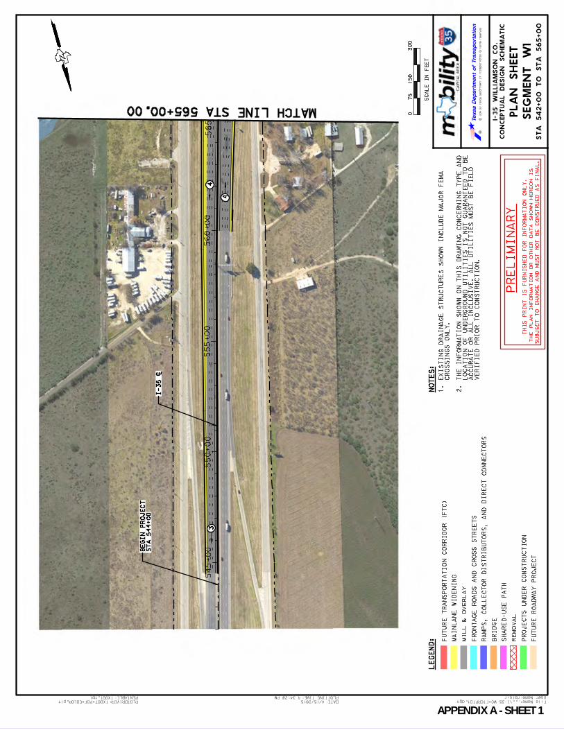
User Name: rblair
...\I-35 WC_FTCRPT01.dgn File Name:PLOTDRIVER:TXDOT_PDF_COLOR.plt
4:34:28 PM
4/15/2015 DATE:
TXDOT.tbl PENTABLE: PLOTTING TIME:
CO
NC
EP
TU
AL
DE
SIG
N S
CH
EM
AT
IC
I-3
5 W
IL
LIA
MS
ON
CO
.
RC
2014 by T
exas D
epartm
ent of T
ransportation all rights reserved
LE
GE
ND
:
075
30
0
SC
AL
E I
N F
EE
T
15
0
PL
AN
SH
EE
T
SE
GM
EN
T W
1
NO
TE
S:
FU
TU
RE
TR
AN
SP
OR
TA
TIO
N C
OR
RID
OR
(F
TC
)
MA
INL
AN
E W
IDE
NIN
G
MIL
L &
OV
ER
LA
Y
FR
ON
TA
GE
RO
AD
S A
ND
CR
OS
S S
TR
EE
TS
RA
MP
S, C
OL
LE
CT
OR
DIS
TR
IB
UT
OR
S, A
ND
DIR
EC
T C
ON
NE
CT
OR
S
BR
IDG
E
SH
AR
ED
-US
E P
AT
H
RE
MO
VA
L
PR
OJE
CT
S U
ND
ER
CO
NS
TR
UC
TIO
N
FU
TU
RE
RO
AD
WA
Y P
RO
JE
CT
1. E
XIS
TIN
G D
RA
IN
AG
E S
TR
UC
TU
RE
S S
HO
WN
IN
CL
UD
E M
AJO
R F
EM
A
CR
OS
SIN
GS
ON
LY
.
2. T
HE
IN
FO
RM
AT
IO
N S
HO
WN
ON
TH
IS
DR
AW
IN
G C
ON
CE
RN
IN
G T
YP
E A
ND
LO
CA
TIO
N O
F U
ND
ER
GR
OU
ND
UT
IL
IT
IE
S I
S N
OT
GU
AR
AN
TE
ED
TO
BE
AC
CU
RA
TE
OR
AL
L I
NC
LU
SIV
E.
AL
L U
TIL
IT
IE
S M
US
T B
E F
IE
LD
VE
RIF
IE
D P
RIO
R T
O C
ON
ST
RU
CT
IO
N.
PR
EL
IMIN
AR
Y
TH
IS
PR
IN
T I
S F
UR
NIS
HE
D F
OR
IN
FO
RM
AT
IO
N O
NL
Y.
TH
E P
LA
N I
NF
OR
MA
TIO
N O
R O
TH
ER
DA
TA
SH
OW
N H
ER
EO
N I
S
SU
BJE
CT
TO
CH
AN
GE
AN
D M
US
T N
OT
BE
CO
NS
TR
UE
D A
S F
IN
AL
.
545+
00
550+
00
555+
00
560+00
565+00
4
43
N
MATCH LINE STA 565+00.00
ST
A 5
42+
00 T
O S
TA
565+
00
ST
A 5
44+
00
BE
GIN
PR
OJE
CT
I-35 [
APPENDIX A SHEET 1

User Name: rblair
...\I-35 WC_FTCRPT02.dgn File Name:PLOTDRIVER:TXDOT_PDF_COLOR.plt
4:35:33 PM
4/15/2015 DATE:
TXDOT.tbl PENTABLE: PLOTTING TIME:
CO
NC
EP
TU
AL
DE
SIG
N S
CH
EM
AT
IC
I-3
5 W
IL
LIA
MS
ON
CO
.
RC
2014 by T
exas D
epartm
ent of T
ransportation all rights reserved
LE
GE
ND
:
075
30
0
SC
AL
E I
N F
EE
T
15
0
PL
AN
SH
EE
T
SE
GM
EN
T W
1
NO
TE
S:
FU
TU
RE
TR
AN
SP
OR
TA
TIO
N C
OR
RID
OR
(F
TC
)
MA
INL
AN
E W
IDE
NIN
G
MIL
L &
OV
ER
LA
Y
FR
ON
TA
GE
RO
AD
S A
ND
CR
OS
S S
TR
EE
TS
RA
MP
S, C
OL
LE
CT
OR
DIS
TR
IB
UT
OR
S, A
ND
DIR
EC
T C
ON
NE
CT
OR
S
BR
IDG
E
SH
AR
ED
-US
E P
AT
H
RE
MO
VA
L
PR
OJE
CT
S U
ND
ER
CO
NS
TR
UC
TIO
N
FU
TU
RE
RO
AD
WA
Y P
RO
JE
CT
1. E
XIS
TIN
G D
RA
IN
AG
E S
TR
UC
TU
RE
S S
HO
WN
IN
CL
UD
E M
AJO
R F
EM
A
CR
OS
SIN
GS
ON
LY
.
2. T
HE
IN
FO
RM
AT
IO
N S
HO
WN
ON
TH
IS
DR
AW
IN
G C
ON
CE
RN
IN
G T
YP
E A
ND
LO
CA
TIO
N O
F U
ND
ER
GR
OU
ND
UT
IL
IT
IE
S I
S N
OT
GU
AR
AN
TE
ED
TO
BE
AC
CU
RA
TE
OR
AL
L I
NC
LU
SIV
E.
AL
L U
TIL
IT
IE
S M
US
T B
E F
IE
LD
VE
RIF
IE
D P
RIO
R T
O C
ON
ST
RU
CT
IO
N.
PR
EL
IMIN
AR
Y
TH
IS
PR
IN
T I
S F
UR
NIS
HE
D F
OR
IN
FO
RM
AT
IO
N O
NL
Y.
TH
E P
LA
N I
NF
OR
MA
TIO
N O
R O
TH
ER
DA
TA
SH
OW
N H
ER
EO
N I
S
SU
BJE
CT
TO
CH
AN
GE
AN
D M
US
T N
OT
BE
CO
NS
TR
UE
D A
S F
IN
AL
.
565+
00
570+
00
575+
00
580+
00
585+
00
DRY BERRY CREEK
5
3
1
5
1
4
1
1
4
1
2
41
3
N
MATCH LINE STA 565+00.00
MATCH LINE STA 588+00.00
ST
A 5
65
+0
0 T
O S
TA
58
8+
00
WID
EN
ING
PR
OP
OS
ED
WID
EN
ING
PR
OP
OS
ED
I-35 [
APPENDIX A SHEET 2

User Name: rblair
...\I-35 WC_FTCRPT03.dgn File Name:PLOTDRIVER:TXDOT_PDF_COLOR.plt
4:36:38 PM
4/15/2015 DATE:
TXDOT.tbl PENTABLE: PLOTTING TIME:
CO
NC
EP
TU
AL
DE
SIG
N S
CH
EM
AT
IC
I-3
5 W
IL
LIA
MS
ON
CO
.
RC
2014 by T
exas D
epartm
ent of T
ransportation all rights reserved
LE
GE
ND
:
075
30
0
SC
AL
E I
N F
EE
T
15
0
PL
AN
SH
EE
T
SE
GM
EN
T W
1
NO
TE
S:
FU
TU
RE
TR
AN
SP
OR
TA
TIO
N C
OR
RID
OR
(F
TC
)
MA
INL
AN
E W
IDE
NIN
G
MIL
L &
OV
ER
LA
Y
FR
ON
TA
GE
RO
AD
S A
ND
CR
OS
S S
TR
EE
TS
RA
MP
S, C
OL
LE
CT
OR
DIS
TR
IB
UT
OR
S, A
ND
DIR
EC
T C
ON
NE
CT
OR
S
BR
IDG
E
SH
AR
ED
-US
E P
AT
H
RE
MO
VA
L
PR
OJE
CT
S U
ND
ER
CO
NS
TR
UC
TIO
N
FU
TU
RE
RO
AD
WA
Y P
RO
JE
CT
1. E
XIS
TIN
G D
RA
IN
AG
E S
TR
UC
TU
RE
S S
HO
WN
IN
CL
UD
E M
AJO
R F
EM
A
CR
OS
SIN
GS
ON
LY
.
2. T
HE
IN
FO
RM
AT
IO
N S
HO
WN
ON
TH
IS
DR
AW
IN
G C
ON
CE
RN
IN
G T
YP
E A
ND
LO
CA
TIO
N O
F U
ND
ER
GR
OU
ND
UT
IL
IT
IE
S I
S N
OT
GU
AR
AN
TE
ED
TO
BE
AC
CU
RA
TE
OR
AL
L I
NC
LU
SIV
E.
AL
L U
TIL
IT
IE
S M
US
T B
E F
IE
LD
VE
RIF
IE
D P
RIO
R T
O C
ON
ST
RU
CT
IO
N.
PR
EL
IMIN
AR
Y
TH
IS
PR
IN
T I
S F
UR
NIS
HE
D F
OR
IN
FO
RM
AT
IO
N O
NL
Y.
TH
E P
LA
N I
NF
OR
MA
TIO
N O
R O
TH
ER
DA
TA
SH
OW
N H
ER
EO
N I
S
SU
BJE
CT
TO
CH
AN
GE
AN
D M
US
T N
OT
BE
CO
NS
TR
UE
D A
S F
IN
AL
.
590+
00
595+
00
600+
00
605+
00
610+00
DRY
BERRY
CREEK
2 3
1
1
3
2
4
22
3
23
1
1
5
4
3
2
3 1
2
N
MATCH LINE STA 588+00.00
MATCH LINE STA 611+00.00
ST
A 5
88
+0
0 T
O S
TA
61
1+
00
MATC
H LI
NE S
H 195
WID
EN
ING
PR
OP
OS
ED
BR
IDG
E
I-35 [
APPENDIX A SHEET 3

User Name: rblair
...\I-35 WC_FTCRPT03A.dgn File Name:PLOTDRIVER:TXDOT_PDF_COLOR.plt
4:37:43 PM
4/15/2015 DATE:
TXDOT.tbl PENTABLE: PLOTTING TIME:
CO
NC
EP
TU
AL
DE
SIG
N S
CH
EM
AT
IC
I-3
5 W
IL
LIA
MS
ON
CO
.
RC
2014 by T
exas D
epartm
ent of T
ransportation all rights reserved
LE
GE
ND
:
075
30
0
SC
AL
E I
N F
EE
T
15
0
PL
AN
SH
EE
T
SE
GM
EN
T W
1
NO
TE
S:
FU
TU
RE
TR
AN
SP
OR
TA
TIO
N C
OR
RID
OR
(F
TC
)
MA
INL
AN
E W
IDE
NIN
G
MIL
L &
OV
ER
LA
Y
FR
ON
TA
GE
RO
AD
S A
ND
CR
OS
S S
TR
EE
TS
RA
MP
S, C
OL
LE
CT
OR
DIS
TR
IB
UT
OR
S, A
ND
DIR
EC
T C
ON
NE
CT
OR
S
BR
IDG
E
SH
AR
ED
-US
E P
AT
H
RE
MO
VA
L
PR
OJE
CT
S U
ND
ER
CO
NS
TR
UC
TIO
N
FU
TU
RE
RO
AD
WA
Y P
RO
JE
CT
1. E
XIS
TIN
G D
RA
IN
AG
E S
TR
UC
TU
RE
S S
HO
WN
IN
CL
UD
E M
AJO
R F
EM
A
CR
OS
SIN
GS
ON
LY
.
2. T
HE
IN
FO
RM
AT
IO
N S
HO
WN
ON
TH
IS
DR
AW
IN
G C
ON
CE
RN
IN
G T
YP
E A
ND
LO
CA
TIO
N O
F U
ND
ER
GR
OU
ND
UT
IL
IT
IE
S I
S N
OT
GU
AR
AN
TE
ED
TO
BE
AC
CU
RA
TE
OR
AL
L I
NC
LU
SIV
E.
AL
L U
TIL
IT
IE
S M
US
T B
E F
IE
LD
VE
RIF
IE
D P
RIO
R T
O C
ON
ST
RU
CT
IO
N.
PR
EL
IMIN
AR
Y
TH
IS
PR
IN
T I
S F
UR
NIS
HE
D F
OR
IN
FO
RM
AT
IO
N O
NL
Y.
TH
E P
LA
N I
NF
OR
MA
TIO
N O
R O
TH
ER
DA
TA
SH
OW
N H
ER
EO
N I
S
SU
BJE
CT
TO
CH
AN
GE
AN
D M
US
T N
OT
BE
CO
NS
TR
UE
D A
S F
IN
AL
.
STATE
HW
Y 195
CREEK DR
BERRY
2
2
23
3
2
1
N
SH
19
5 -
BE
RR
Y C
RE
EK
DR
.
MATCH LINE SH 195
2 2
APPENDIX A SHEET 4

User Name: rblair
...\I-35 WC_FTCRPT04.dgn File Name:PLOTDRIVER:TXDOT_PDF_COLOR.plt
4:38:47 PM
4/15/2015 DATE:
TXDOT.tbl PENTABLE: PLOTTING TIME:
CO
NC
EP
TU
AL
DE
SIG
N S
CH
EM
AT
IC
I-3
5 W
IL
LIA
MS
ON
CO
.
RC
2014 by T
exas D
epartm
ent of T
ransportation all rights reserved
LE
GE
ND
:
075
30
0
SC
AL
E I
N F
EE
T
15
0
PL
AN
SH
EE
T
SE
GM
EN
T W
1
NO
TE
S:
FU
TU
RE
TR
AN
SP
OR
TA
TIO
N C
OR
RID
OR
(F
TC
)
MA
INL
AN
E W
IDE
NIN
G
MIL
L &
OV
ER
LA
Y
FR
ON
TA
GE
RO
AD
S A
ND
CR
OS
S S
TR
EE
TS
RA
MP
S, C
OL
LE
CT
OR
DIS
TR
IB
UT
OR
S, A
ND
DIR
EC
T C
ON
NE
CT
OR
S
BR
IDG
E
SH
AR
ED
-US
E P
AT
H
RE
MO
VA
L
PR
OJE
CT
S U
ND
ER
CO
NS
TR
UC
TIO
N
FU
TU
RE
RO
AD
WA
Y P
RO
JE
CT
1. E
XIS
TIN
G D
RA
IN
AG
E S
TR
UC
TU
RE
S S
HO
WN
IN
CL
UD
E M
AJO
R F
EM
A
CR
OS
SIN
GS
ON
LY
.
2. T
HE
IN
FO
RM
AT
IO
N S
HO
WN
ON
TH
IS
DR
AW
IN
G C
ON
CE
RN
IN
G T
YP
E A
ND
LO
CA
TIO
N O
F U
ND
ER
GR
OU
ND
UT
IL
IT
IE
S I
S N
OT
GU
AR
AN
TE
ED
TO
BE
AC
CU
RA
TE
OR
AL
L I
NC
LU
SIV
E.
AL
L U
TIL
IT
IE
S M
US
T B
E F
IE
LD
VE
RIF
IE
D P
RIO
R T
O C
ON
ST
RU
CT
IO
N.
PR
EL
IMIN
AR
Y
TH
IS
PR
IN
T I
S F
UR
NIS
HE
D F
OR
IN
FO
RM
AT
IO
N O
NL
Y.
TH
E P
LA
N I
NF
OR
MA
TIO
N O
R O
TH
ER
DA
TA
SH
OW
N H
ER
EO
N I
S
SU
BJE
CT
TO
CH
AN
GE
AN
D M
US
T N
OT
BE
CO
NS
TR
UE
D A
S F
IN
AL
.
61
5+
00
62
0+
00
62
5+
00
63
0+
00
MARKET ST
2
3
3
1
1
3
3
3
2
2
3
3
1
2
3
N
MATCH LINE STA 611+00.00
MATCH LINE STA 634+00.00
ST
A 6
11
+0
0 T
O S
TA
63
4+
00
I-35 [
APPENDIX A SHEET 5
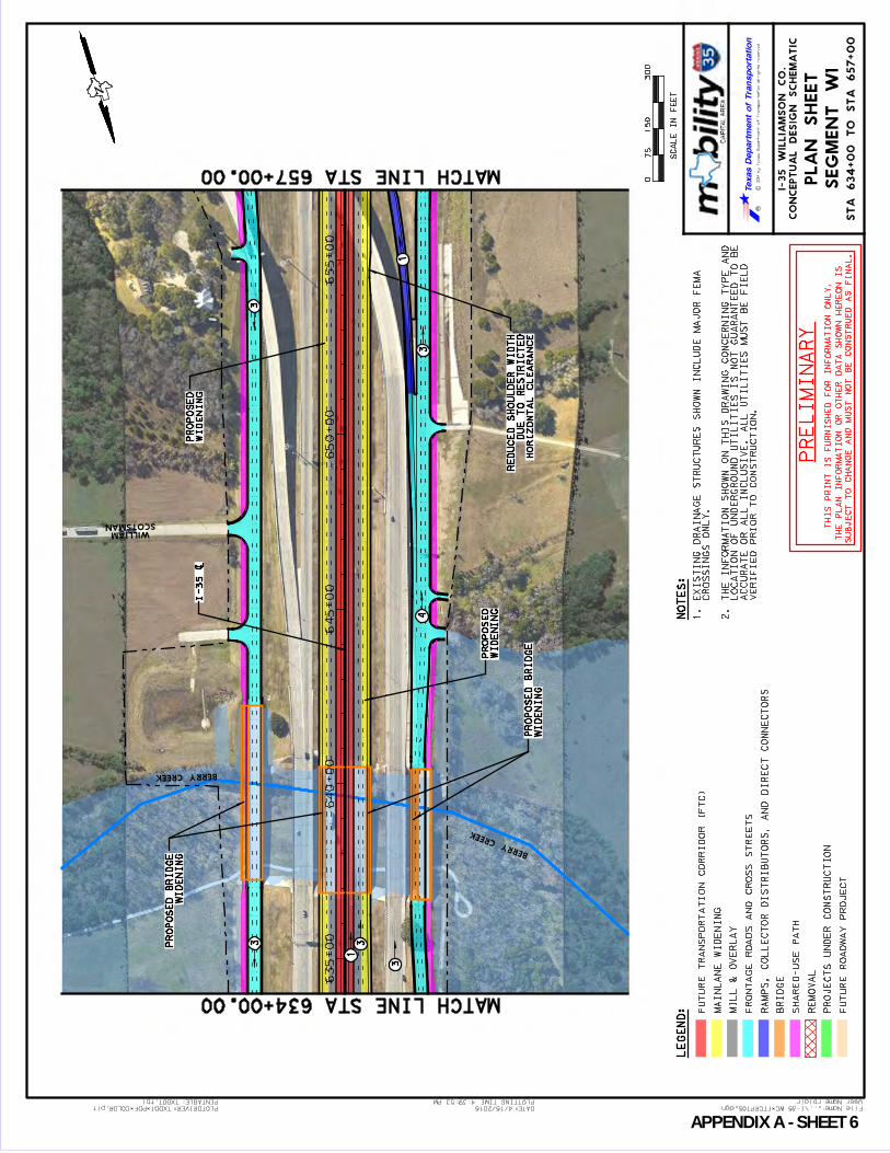
User Name: rblair
...\I-35 WC_FTCRPT05.dgn File Name:PLOTDRIVER:TXDOT_PDF_COLOR.plt
4:39:53 PM
4/15/2015 DATE:
TXDOT.tbl PENTABLE: PLOTTING TIME:
CO
NC
EP
TU
AL
DE
SIG
N S
CH
EM
AT
IC
I-3
5 W
IL
LIA
MS
ON
CO
.
RC
2014 by T
exas D
epartm
ent of T
ransportation all rights reserved
LE
GE
ND
:
075
30
0
SC
AL
E I
N F
EE
T
15
0
PL
AN
SH
EE
T
SE
GM
EN
T W
1
NO
TE
S:
FU
TU
RE
TR
AN
SP
OR
TA
TIO
N C
OR
RID
OR
(F
TC
)
MA
INL
AN
E W
IDE
NIN
G
MIL
L &
OV
ER
LA
Y
FR
ON
TA
GE
RO
AD
S A
ND
CR
OS
S S
TR
EE
TS
RA
MP
S, C
OL
LE
CT
OR
DIS
TR
IB
UT
OR
S, A
ND
DIR
EC
T C
ON
NE
CT
OR
S
BR
IDG
E
SH
AR
ED
-US
E P
AT
H
RE
MO
VA
L
PR
OJE
CT
S U
ND
ER
CO
NS
TR
UC
TIO
N
FU
TU
RE
RO
AD
WA
Y P
RO
JE
CT
1. E
XIS
TIN
G D
RA
IN
AG
E S
TR
UC
TU
RE
S S
HO
WN
IN
CL
UD
E M
AJO
R F
EM
A
CR
OS
SIN
GS
ON
LY
.
2. T
HE
IN
FO
RM
AT
IO
N S
HO
WN
ON
TH
IS
DR
AW
IN
G C
ON
CE
RN
IN
G T
YP
E A
ND
LO
CA
TIO
N O
F U
ND
ER
GR
OU
ND
UT
IL
IT
IE
S I
S N
OT
GU
AR
AN
TE
ED
TO
BE
AC
CU
RA
TE
OR
AL
L I
NC
LU
SIV
E.
AL
L U
TIL
IT
IE
S M
US
T B
E F
IE
LD
VE
RIF
IE
D P
RIO
R T
O C
ON
ST
RU
CT
IO
N.
PR
EL
IMIN
AR
Y
TH
IS
PR
IN
T I
S F
UR
NIS
HE
D F
OR
IN
FO
RM
AT
IO
N O
NL
Y.
TH
E P
LA
N I
NF
OR
MA
TIO
N O
R O
TH
ER
DA
TA
SH
OW
N H
ER
EO
N I
S
SU
BJE
CT
TO
CH
AN
GE
AN
D M
US
T N
OT
BE
CO
NS
TR
UE
D A
S F
IN
AL
.
63
5+
00
64
0+
00
64
5+
00
65
0+
00
65
5+
00
SCOTSMANWILLIAM
BERRY CREEK
BERRY CREEK
34
3
1
3
3
3
1
N
MATCH LINE STA 634+00.00
MATCH LINE STA 657+00.00
ST
A 6
34+
00 T
O S
TA
657+
00
WID
EN
ING
PR
OP
OS
ED
BR
IDG
E
WID
EN
ING
PR
OP
OS
ED
WID
EN
ING
PR
OP
OS
ED
BR
IDG
E
WID
EN
ING
PR
OP
OS
ED
HO
RIZ
ON
TA
L C
LE
AR
AN
CE
DU
E T
O R
ES
TR
IC
TE
D
RE
DU
CE
D S
HO
UL
DE
R W
IDT
H
I-35 [
APPENDIX A SHEET 6
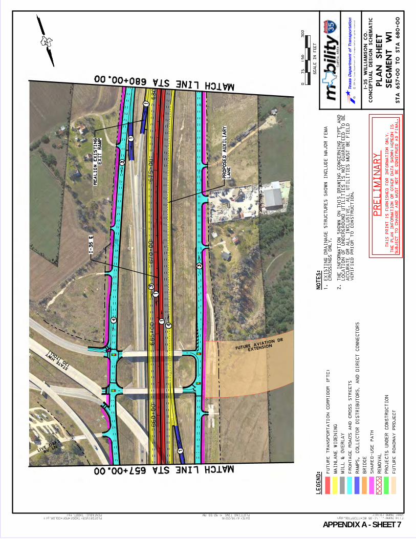
User Name: rblair
...\I-35 WC_FTCRPT06.dgn File Name:PLOTDRIVER:TXDOT_PDF_COLOR.plt
4:40:59 PM
4/15/2015 DATE:
TXDOT.tbl PENTABLE: PLOTTING TIME:
CO
NC
EP
TU
AL
DE
SIG
N S
CH
EM
AT
IC
I-3
5 W
IL
LIA
MS
ON
CO
.
RC
2014 by T
exas D
epartm
ent of T
ransportation all rights reserved
LE
GE
ND
:
075
30
0
SC
AL
E I
N F
EE
T
15
0
PL
AN
SH
EE
T
SE
GM
EN
T W
1
NO
TE
S:
FU
TU
RE
TR
AN
SP
OR
TA
TIO
N C
OR
RID
OR
(F
TC
)
MA
INL
AN
E W
IDE
NIN
G
MIL
L &
OV
ER
LA
Y
FR
ON
TA
GE
RO
AD
S A
ND
CR
OS
S S
TR
EE
TS
RA
MP
S, C
OL
LE
CT
OR
DIS
TR
IB
UT
OR
S, A
ND
DIR
EC
T C
ON
NE
CT
OR
S
BR
IDG
E
SH
AR
ED
-US
E P
AT
H
RE
MO
VA
L
PR
OJE
CT
S U
ND
ER
CO
NS
TR
UC
TIO
N
FU
TU
RE
RO
AD
WA
Y P
RO
JE
CT
1. E
XIS
TIN
G D
RA
IN
AG
E S
TR
UC
TU
RE
S S
HO
WN
IN
CL
UD
E M
AJO
R F
EM
A
CR
OS
SIN
GS
ON
LY
.
2. T
HE
IN
FO
RM
AT
IO
N S
HO
WN
ON
TH
IS
DR
AW
IN
G C
ON
CE
RN
IN
G T
YP
E A
ND
LO
CA
TIO
N O
F U
ND
ER
GR
OU
ND
UT
IL
IT
IE
S I
S N
OT
GU
AR
AN
TE
ED
TO
BE
AC
CU
RA
TE
OR
AL
L I
NC
LU
SIV
E.
AL
L U
TIL
IT
IE
S M
US
T B
E F
IE
LD
VE
RIF
IE
D P
RIO
R T
O C
ON
ST
RU
CT
IO
N.
PR
EL
IMIN
AR
Y
TH
IS
PR
IN
T I
S F
UR
NIS
HE
D F
OR
IN
FO
RM
AT
IO
N O
NL
Y.
TH
E P
LA
N I
NF
OR
MA
TIO
N O
R O
TH
ER
DA
TA
SH
OW
N H
ER
EO
N I
S
SU
BJE
CT
TO
CH
AN
GE
AN
D M
US
T N
OT
BE
CO
NS
TR
UE
D A
S F
IN
AL
.
660+00
665+00
670+00
675+00
680+00
RV LN
LIVE
OAKS
130 (T
OLL)
STATE
HW
Y
EX TENSIONFUTURE AVIATION DR
1
1
3
1
1
4
4
3
3
1
N
MATCH LINE STA 657+00.00
MATCH LINE STA 680+00.00
ST
A 6
57
+0
0 T
O S
TA
68
0+
00
EX
IT
RA
MP
RE
AL
IG
N E
XIS
TIN
G
LA
NE
PR
OP
OS
ED
AU
XIL
IAR
Y
I-3
5 [
APPENDIX A SHEET 7

User Name: rblair
...\I-35 WC_FTCRPT07.dgn File Name:PLOTDRIVER:TXDOT_PDF_COLOR.plt
4:42:05 PM
4/15/2015 DATE:
TXDOT.tbl PENTABLE: PLOTTING TIME:
CO
NC
EP
TU
AL
DE
SIG
N S
CH
EM
AT
IC
I-3
5 W
IL
LIA
MS
ON
CO
.
RC
2014 by T
exas D
epartm
ent of T
ransportation all rights reserved
LE
GE
ND
:
075
30
0
SC
AL
E I
N F
EE
T
15
0
PL
AN
SH
EE
T
SE
GM
EN
T W
1
NO
TE
S:
FU
TU
RE
TR
AN
SP
OR
TA
TIO
N C
OR
RID
OR
(F
TC
)
MA
INL
AN
E W
IDE
NIN
G
MIL
L &
OV
ER
LA
Y
FR
ON
TA
GE
RO
AD
S A
ND
CR
OS
S S
TR
EE
TS
RA
MP
S, C
OL
LE
CT
OR
DIS
TR
IB
UT
OR
S, A
ND
DIR
EC
T C
ON
NE
CT
OR
S
BR
IDG
E
SH
AR
ED
-US
E P
AT
H
RE
MO
VA
L
PR
OJE
CT
S U
ND
ER
CO
NS
TR
UC
TIO
N
FU
TU
RE
RO
AD
WA
Y P
RO
JE
CT
1. E
XIS
TIN
G D
RA
IN
AG
E S
TR
UC
TU
RE
S S
HO
WN
IN
CL
UD
E M
AJO
R F
EM
A
CR
OS
SIN
GS
ON
LY
.
2. T
HE
IN
FO
RM
AT
IO
N S
HO
WN
ON
TH
IS
DR
AW
IN
G C
ON
CE
RN
IN
G T
YP
E A
ND
LO
CA
TIO
N O
F U
ND
ER
GR
OU
ND
UT
IL
IT
IE
S I
S N
OT
GU
AR
AN
TE
ED
TO
BE
AC
CU
RA
TE
OR
AL
L I
NC
LU
SIV
E.
AL
L U
TIL
IT
IE
S M
US
T B
E F
IE
LD
VE
RIF
IE
D P
RIO
R T
O C
ON
ST
RU
CT
IO
N.
PR
EL
IMIN
AR
Y
TH
IS
PR
IN
T I
S F
UR
NIS
HE
D F
OR
IN
FO
RM
AT
IO
N O
NL
Y.
TH
E P
LA
N I
NF
OR
MA
TIO
N O
R O
TH
ER
DA
TA
SH
OW
N H
ER
EO
N I
S
SU
BJE
CT
TO
CH
AN
GE
AN
D M
US
T N
OT
BE
CO
NS
TR
UE
D A
S F
IN
AL
.
680+00
685+00
690+00
695+00
700+00
3
1
1
3
4
3
1
3
1
1
3
3
1
1
4
3
N
MATCH LINE STA 680+00.00
MATCH LINE STA 703+00.00
ST
A 6
80
+0
0 T
O S
TA
70
3+
00
EX
IT
RA
MP
RE
MO
VE
EX
IST
ING
EN
TR
AN
CE
RA
MP
PR
OP
OS
ED
EX
IT
RA
MP
PR
OP
OS
ED
I-3
5 [
APPENDIX A SHEET 8
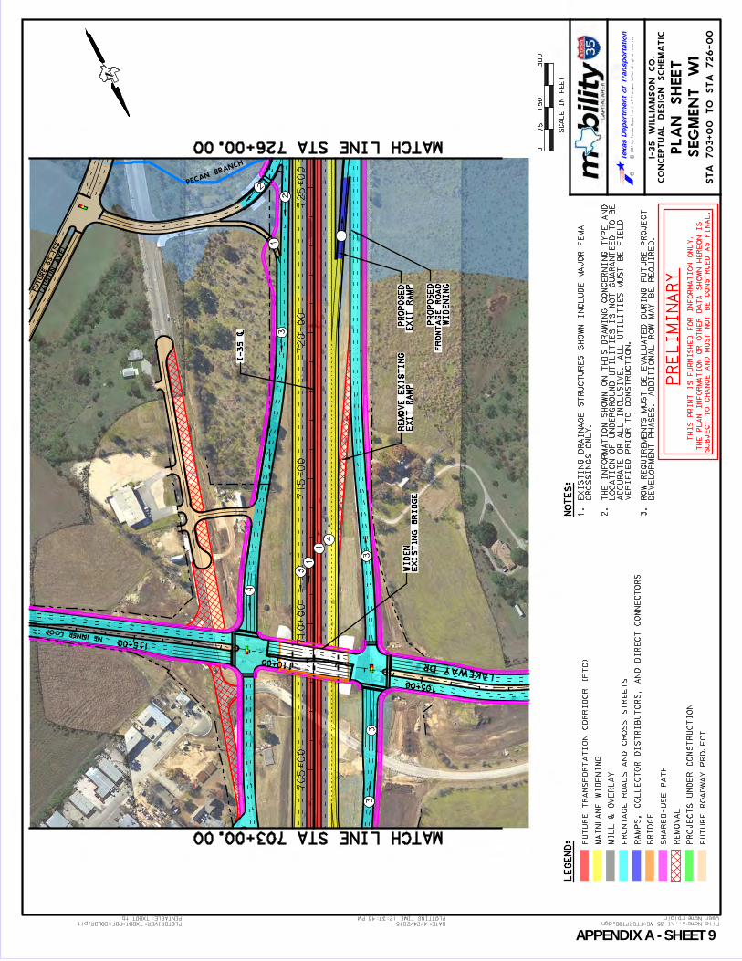
User Name: rblair
...\I-35 WC_FTCRPT08.dgn File Name:PLOTDRIVER:TXDOT_PDF_COLOR.plt
12:37:43 PM
4/24/2015 DATE:
TXDOT.tbl PENTABLE: PLOTTING TIME:
CO
NC
EP
TU
AL
DE
SIG
N S
CH
EM
AT
IC
I-3
5 W
IL
LIA
MS
ON
CO
.
RC
2014 by T
exas D
epartm
ent of T
ransportation all rights reserved
LE
GE
ND
:
075
30
0
SC
AL
E I
N F
EE
T
15
0
PL
AN
SH
EE
T
SE
GM
EN
T W
1
NO
TE
S:
FU
TU
RE
TR
AN
SP
OR
TA
TIO
N C
OR
RID
OR
(F
TC
)
MA
INL
AN
E W
IDE
NIN
G
MIL
L &
OV
ER
LA
Y
FR
ON
TA
GE
RO
AD
S A
ND
CR
OS
S S
TR
EE
TS
RA
MP
S, C
OL
LE
CT
OR
DIS
TR
IB
UT
OR
S, A
ND
DIR
EC
T C
ON
NE
CT
OR
S
BR
IDG
E
SH
AR
ED
-US
E P
AT
H
RE
MO
VA
L
PR
OJE
CT
S U
ND
ER
CO
NS
TR
UC
TIO
N
FU
TU
RE
RO
AD
WA
Y P
RO
JE
CT
1. E
XIS
TIN
G D
RA
IN
AG
E S
TR
UC
TU
RE
S S
HO
WN
IN
CL
UD
E M
AJO
R F
EM
A
CR
OS
SIN
GS
ON
LY
.
2. T
HE
IN
FO
RM
AT
IO
N S
HO
WN
ON
TH
IS
DR
AW
IN
G C
ON
CE
RN
IN
G T
YP
E A
ND
LO
CA
TIO
N O
F U
ND
ER
GR
OU
ND
UT
IL
IT
IE
S I
S N
OT
GU
AR
AN
TE
ED
TO
BE
AC
CU
RA
TE
OR
AL
L I
NC
LU
SIV
E.
AL
L U
TIL
IT
IE
S M
US
T B
E F
IE
LD
VE
RIF
IE
D P
RIO
R T
O C
ON
ST
RU
CT
IO
N.
3.
RO
W R
EQ
UIR
EM
EN
TS
MU
ST
BE
EV
AL
UA
TE
D D
UR
IN
G F
UT
UR
E P
RO
JE
CT
DE
VE
LO
PM
EN
T P
HA
SE
S.
AD
DIT
ION
AL
RO
W M
AY
BE
RE
QU
IRE
D.
PR
EL
IMIN
AR
Y
TH
IS
PR
IN
T I
S F
UR
NIS
HE
D F
OR
IN
FO
RM
AT
IO
N O
NL
Y.
TH
E P
LA
N I
NF
OR
MA
TIO
N O
R O
TH
ER
DA
TA
SH
OW
N H
ER
EO
N I
S
SU
BJE
CT
TO
CH
AN
GE
AN
D M
US
T N
OT
BE
CO
NS
TR
UE
D A
S F
IN
AL
.
70
5+
00
71
0+
00
71
5+
00
72
0+
00
72
5+
00
105+00
110+00
115+00
PECAN BRANCH
LAKEWAY DR
NE INNER LOOP
(A
USTIN
AVE)
FUTURE SS 15
8
3
1
1
4
1
33
2
23
4
1
3
N
MATCH LINE STA 703+00.00
MATCH LINE STA 726+00.00
ST
A 7
03+
00 T
O S
TA
726+
00
(A
USTIN
AVE)
FUTURE SS 15
8
EX
IT R
AM
P
RE
MO
VE
EX
IST
ING
WID
EN
ING
FR
ON
TA
GE
RO
AD
PR
OP
OS
ED
EX
IT
RA
MP
PR
OP
OS
ED
EX
IS
TIN
G B
RID
GE
WID
EN
I-35 [
APPENDIX A SHEET 9

User Name: rblair
...\I-35 WC_FTCRPT09.dgn File Name:PLOTDRIVER:TXDOT_PDF_COLOR.plt
12:33:44 PM
4/24/2015 DATE:
TXDOT.tbl PENTABLE: PLOTTING TIME:
CO
NC
EP
TU
AL
DE
SIG
N S
CH
EM
AT
IC
I-3
5 W
IL
LIA
MS
ON
CO
.
RC
2014 by T
exas D
epartm
ent of T
ransportation all rights reserved
LE
GE
ND
:
075
30
0
SC
AL
E I
N F
EE
T
15
0
PL
AN
SH
EE
T
SE
GM
EN
T W
1
NO
TE
S:
FU
TU
RE
TR
AN
SP
OR
TA
TIO
N C
OR
RID
OR
(F
TC
)
MA
INL
AN
E W
IDE
NIN
G
MIL
L &
OV
ER
LA
Y
FR
ON
TA
GE
RO
AD
S A
ND
CR
OS
S S
TR
EE
TS
RA
MP
S, C
OL
LE
CT
OR
DIS
TR
IB
UT
OR
S, A
ND
DIR
EC
T C
ON
NE
CT
OR
S
BR
IDG
E
SH
AR
ED
-US
E P
AT
H
RE
MO
VA
L
PR
OJE
CT
S U
ND
ER
CO
NS
TR
UC
TIO
N
FU
TU
RE
RO
AD
WA
Y P
RO
JE
CT
1. E
XIS
TIN
G D
RA
IN
AG
E S
TR
UC
TU
RE
S S
HO
WN
IN
CL
UD
E M
AJO
R F
EM
A
CR
OS
SIN
GS
ON
LY
.
2. T
HE
IN
FO
RM
AT
IO
N S
HO
WN
ON
TH
IS
DR
AW
IN
G C
ON
CE
RN
IN
G T
YP
E A
ND
LO
CA
TIO
N O
F U
ND
ER
GR
OU
ND
UT
IL
IT
IE
S I
S N
OT
GU
AR
AN
TE
ED
TO
BE
AC
CU
RA
TE
OR
AL
L I
NC
LU
SIV
E.
AL
L U
TIL
IT
IE
S M
US
T B
E F
IE
LD
VE
RIF
IE
D P
RIO
R T
O C
ON
ST
RU
CT
IO
N.
3.
RO
W R
EQ
UIR
EM
EN
TS
MU
ST
BE
EV
AL
UA
TE
D D
UR
IN
G F
UT
UR
E P
RO
JE
CT
DE
VE
LO
PM
EN
T P
HA
SE
S.
AD
DIT
ION
AL
RO
W M
AY
BE
RE
QU
IRE
D.
PR
EL
IMIN
AR
Y
TH
IS
PR
IN
T I
S F
UR
NIS
HE
D F
OR
IN
FO
RM
AT
IO
N O
NL
Y.
TH
E P
LA
N I
NF
OR
MA
TIO
N O
R O
TH
ER
DA
TA
SH
OW
N H
ER
EO
N I
S
SU
BJE
CT
TO
CH
AN
GE
AN
D M
US
T N
OT
BE
CO
NS
TR
UE
D A
S F
IN
AL
.
73
0+
00
73
5+
00
74
0+
00
74
5+
00
AIR
PORT
RD
PECAN BRANCH
PECAN BRANCH
3
3
1
1
3
34
1
4
N
MATCH LINE STA 726+00.00
MATCH LINE STA 749+00.00
ST
A 7
26
+0
0 T
O S
TA
74
9+
00
FUTURE SS 158
(A
USTIN
AVE)
WID
EN
ING
FR
ON
TA
GE
RO
AD
PR
OP
OS
ED
EX
IT
RA
MP
RE
MO
VE
EX
IST
ING
FR
ON
TA
GE
RO
AD
PR
OP
OS
ED
I-35 [
APPENDIX A SHEET 10
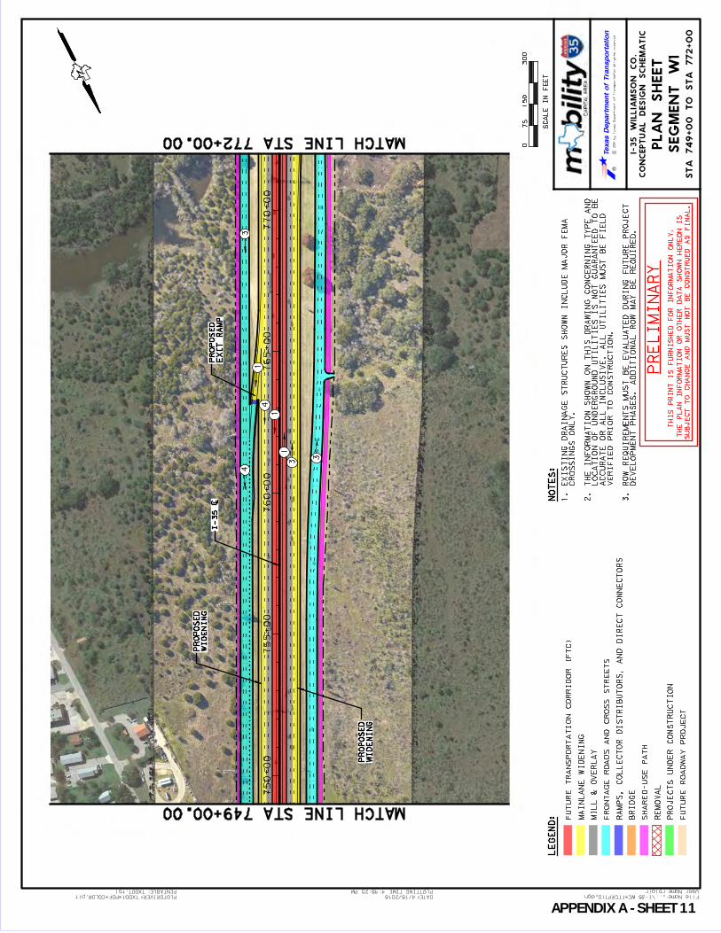
User Name: rblair
...\I-35 WC_FTCRPT10.dgn File Name:PLOTDRIVER:TXDOT_PDF_COLOR.plt
4:45:25 PM
4/15/2015 DATE:
TXDOT.tbl PENTABLE: PLOTTING TIME:
CO
NC
EP
TU
AL
DE
SIG
N S
CH
EM
AT
IC
I-3
5 W
IL
LIA
MS
ON
CO
.
RC
2014 by T
exas D
epartm
ent of T
ransportation all rights reserved
LE
GE
ND
:
075
30
0
SC
AL
E I
N F
EE
T
15
0
PL
AN
SH
EE
T
SE
GM
EN
T W
1
NO
TE
S:
FU
TU
RE
TR
AN
SP
OR
TA
TIO
N C
OR
RID
OR
(F
TC
)
MA
INL
AN
E W
IDE
NIN
G
MIL
L &
OV
ER
LA
Y
FR
ON
TA
GE
RO
AD
S A
ND
CR
OS
S S
TR
EE
TS
RA
MP
S, C
OL
LE
CT
OR
DIS
TR
IB
UT
OR
S, A
ND
DIR
EC
T C
ON
NE
CT
OR
S
BR
IDG
E
SH
AR
ED
-US
E P
AT
H
RE
MO
VA
L
PR
OJE
CT
S U
ND
ER
CO
NS
TR
UC
TIO
N
FU
TU
RE
RO
AD
WA
Y P
RO
JE
CT
1. E
XIS
TIN
G D
RA
IN
AG
E S
TR
UC
TU
RE
S S
HO
WN
IN
CL
UD
E M
AJO
R F
EM
A
CR
OS
SIN
GS
ON
LY
.
2. T
HE
IN
FO
RM
AT
IO
N S
HO
WN
ON
TH
IS
DR
AW
IN
G C
ON
CE
RN
IN
G T
YP
E A
ND
LO
CA
TIO
N O
F U
ND
ER
GR
OU
ND
UT
IL
IT
IE
S I
S N
OT
GU
AR
AN
TE
ED
TO
BE
AC
CU
RA
TE
OR
AL
L I
NC
LU
SIV
E.
AL
L U
TIL
IT
IE
S M
US
T B
E F
IE
LD
VE
RIF
IE
D P
RIO
R T
O C
ON
ST
RU
CT
IO
N.
3.
RO
W R
EQ
UIR
EM
EN
TS
MU
ST
BE
EV
AL
UA
TE
D D
UR
IN
G F
UT
UR
E P
RO
JE
CT
DE
VE
LO
PM
EN
T P
HA
SE
S.
AD
DIT
ION
AL
RO
W M
AY
BE
RE
QU
IRE
D.
PR
EL
IMIN
AR
Y
TH
IS
PR
IN
T I
S F
UR
NIS
HE
D F
OR
IN
FO
RM
AT
IO
N O
NL
Y.
TH
E P
LA
N I
NF
OR
MA
TIO
N O
R O
TH
ER
DA
TA
SH
OW
N H
ER
EO
N I
S
SU
BJE
CT
TO
CH
AN
GE
AN
D M
US
T N
OT
BE
CO
NS
TR
UE
D A
S F
IN
AL
.
75
0+
00
75
5+
00
76
0+
00
76
5+
00
77
0+
00
3
1
4
1
1
3
4
3
N
MATCH LINE STA 749+00.00
MATCH LINE STA 772+00.00
ST
A 7
49
+0
0 T
O S
TA
77
2+
00
WID
EN
ING
PR
OP
OS
ED
WID
EN
ING
PR
OP
OS
ED
EX
IT R
AM
P
PR
OP
OS
ED
I-35 [
APPENDIX A SHEET 11
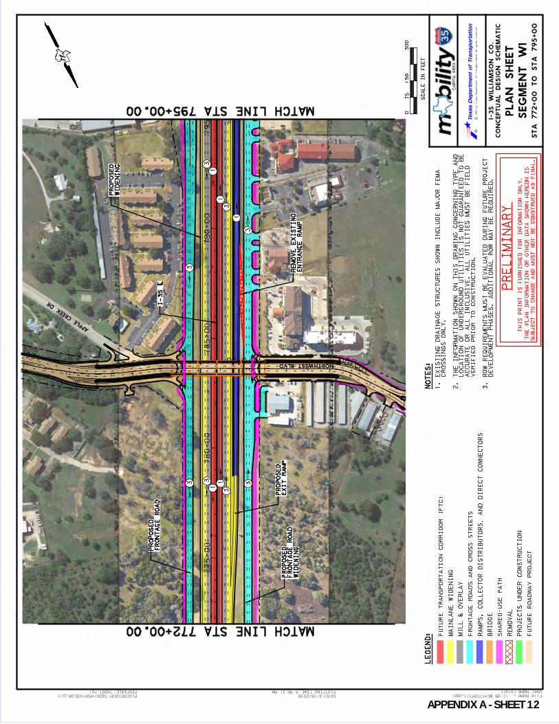
User Name: rblair
...\I-35 WC_FTCRPT11.dgn File Name:PLOTDRIVER:TXDOT_PDF_COLOR.plt
4:46:31 PM
4/15/2015 DATE:
TXDOT.tbl PENTABLE: PLOTTING TIME:
CO
NC
EP
TU
AL
DE
SIG
N S
CH
EM
AT
IC
I-3
5 W
IL
LIA
MS
ON
CO
.
RC
2014 by T
exas D
epartm
ent of T
ransportation all rights reserved
LE
GE
ND
:
075
30
0
SC
AL
E I
N F
EE
T
15
0
PL
AN
SH
EE
T
SE
GM
EN
T W
1
NO
TE
S:
FU
TU
RE
TR
AN
SP
OR
TA
TIO
N C
OR
RID
OR
(F
TC
)
MA
INL
AN
E W
IDE
NIN
G
MIL
L &
OV
ER
LA
Y
FR
ON
TA
GE
RO
AD
S A
ND
CR
OS
S S
TR
EE
TS
RA
MP
S, C
OL
LE
CT
OR
DIS
TR
IB
UT
OR
S, A
ND
DIR
EC
T C
ON
NE
CT
OR
S
BR
IDG
E
SH
AR
ED
-US
E P
AT
H
RE
MO
VA
L
PR
OJE
CT
S U
ND
ER
CO
NS
TR
UC
TIO
N
FU
TU
RE
RO
AD
WA
Y P
RO
JE
CT
1. E
XIS
TIN
G D
RA
IN
AG
E S
TR
UC
TU
RE
S S
HO
WN
IN
CL
UD
E M
AJO
R F
EM
A
CR
OS
SIN
GS
ON
LY
.
2. T
HE
IN
FO
RM
AT
IO
N S
HO
WN
ON
TH
IS
DR
AW
IN
G C
ON
CE
RN
IN
G T
YP
E A
ND
LO
CA
TIO
N O
F U
ND
ER
GR
OU
ND
UT
IL
IT
IE
S I
S N
OT
GU
AR
AN
TE
ED
TO
BE
AC
CU
RA
TE
OR
AL
L I
NC
LU
SIV
E.
AL
L U
TIL
IT
IE
S M
US
T B
E F
IE
LD
VE
RIF
IE
D P
RIO
R T
O C
ON
ST
RU
CT
IO
N.
3.
RO
W R
EQ
UIR
EM
EN
TS
MU
ST
BE
EV
AL
UA
TE
D D
UR
IN
G F
UT
UR
E P
RO
JE
CT
DE
VE
LO
PM
EN
T P
HA
SE
S.
AD
DIT
ION
AL
RO
W M
AY
BE
RE
QU
IRE
D.
PR
EL
IMIN
AR
Y
TH
IS
PR
IN
T I
S F
UR
NIS
HE
D F
OR
IN
FO
RM
AT
IO
N O
NL
Y.
TH
E P
LA
N I
NF
OR
MA
TIO
N O
R O
TH
ER
DA
TA
SH
OW
N H
ER
EO
N I
S
SU
BJE
CT
TO
CH
AN
GE
AN
D M
US
T N
OT
BE
CO
NS
TR
UE
D A
S F
IN
AL
.
77
5+
00
78
0+
00
78
5+
00
79
0+
00
79
5+
00
105+00110+00115+00120+00
FUTURE FO
NTA
NA
DR
APP
LE CREEK
D
R
NORTHWEST BLVD
3
1
1
3
1
3
33 3
1
1
3
3
N
MATCH LINE STA 772+00.00
MATCH LINE STA 795+00.00
ST
A 7
72+
00 T
O S
TA
795+
00
WID
EN
ING
FR
ON
TA
GE
RO
AD
PR
OP
OS
EDF
RO
NT
AG
E R
OA
D
PR
OP
OS
ED
EN
TR
AN
CE
RA
MP
RE
MO
VE
EX
IST
ING
WID
EN
ING
PR
OP
OS
ED
EX
IT R
AM
P
PR
OP
OS
ED
I-35 [
APPENDIX A SHEET 12

User Name: rblair
...\I-35 WC_FTCRPT12.dgn File Name:PLOTDRIVER:TXDOT_PDF_COLOR.plt
12:21:32 PM
4/24/2015 DATE:
TXDOT.tbl PENTABLE: PLOTTING TIME:
CO
NC
EP
TU
AL
DE
SIG
N S
CH
EM
AT
IC
I-3
5 W
IL
LIA
MS
ON
CO
.
RC
2014 by T
exas D
epartm
ent of T
ransportation all rights reserved
LE
GE
ND
:
075
30
0
SC
AL
E I
N F
EE
T
15
0
PL
AN
SH
EE
T
SE
GM
EN
T W
1
NO
TE
S:
FU
TU
RE
TR
AN
SP
OR
TA
TIO
N C
OR
RID
OR
(F
TC
)
MA
INL
AN
E W
IDE
NIN
G
MIL
L &
OV
ER
LA
Y
FR
ON
TA
GE
RO
AD
S A
ND
CR
OS
S S
TR
EE
TS
RA
MP
S, C
OL
LE
CT
OR
DIS
TR
IB
UT
OR
S, A
ND
DIR
EC
T C
ON
NE
CT
OR
S
BR
IDG
E
SH
AR
ED
-US
E P
AT
H
RE
MO
VA
L
PR
OJE
CT
S U
ND
ER
CO
NS
TR
UC
TIO
N
FU
TU
RE
RO
AD
WA
Y P
RO
JE
CT
1. E
XIS
TIN
G D
RA
IN
AG
E S
TR
UC
TU
RE
S S
HO
WN
IN
CL
UD
E M
AJO
R F
EM
A
CR
OS
SIN
GS
ON
LY
.
2. T
HE
IN
FO
RM
AT
IO
N S
HO
WN
ON
TH
IS
DR
AW
IN
G C
ON
CE
RN
IN
G T
YP
E A
ND
LO
CA
TIO
N O
F U
ND
ER
GR
OU
ND
UT
IL
IT
IE
S I
S N
OT
GU
AR
AN
TE
ED
TO
BE
AC
CU
RA
TE
OR
AL
L I
NC
LU
SIV
E.
AL
L U
TIL
IT
IE
S M
US
T B
E F
IE
LD
VE
RIF
IE
D P
RIO
R T
O C
ON
ST
RU
CT
IO
N.
3.
RO
W R
EQ
UIR
EM
EN
TS
MU
ST
BE
EV
AL
UA
TE
D D
UR
IN
G F
UT
UR
E P
RO
JE
CT
DE
VE
LO
PM
EN
T P
HA
SE
S.
AD
DIT
ION
AL
RO
W M
AY
BE
RE
QU
IRE
D.
PR
EL
IMIN
AR
Y
TH
IS
PR
IN
T I
S F
UR
NIS
HE
D F
OR
IN
FO
RM
AT
IO
N O
NL
Y.
TH
E P
LA
N I
NF
OR
MA
TIO
N O
R O
TH
ER
DA
TA
SH
OW
N H
ER
EO
N I
S
SU
BJE
CT
TO
CH
AN
GE
AN
D M
US
T N
OT
BE
CO
NS
TR
UE
D A
S F
IN
AL
.
795+00
800+00
805+00
810+00
815+00
100+00
105+00110+00115+00
W SPRI
NG ST
SS 158
WILLIAMS DR
MCCOY LN
AUSTIN
AVE
SS 158
CLAY ST
3
2
1
4
1
3
1
1
3
2
1
21
2
1
1
N
MATCH LINE STA 795+00.00
MATCH LINE STA 818+00.00
ST
A 7
95+
00 T
O S
TA
818+
00
WID
EN
ING
PR
OP
OS
ED
AU
ST
IN A
VE
RE
LO
CA
TIO
N
PR
OP
OS
ED
SIG
NA
L
WID
EN
ING
PR
OP
OS
ED
AU
ST
IN A
VE
EN
TR
AN
CE
RA
MP
RE
MO
VE
EX
IST
ING
WID
EN
ING
PR
OP
OS
ED
EN
TR
AN
CE
RA
MP
RE
AL
IG
N E
XIS
TIN
G
FO
R F
TC
PR
OP
OS
ED
WID
EN
ING
EX
IT R
AM
P
RE
AL
IG
N E
XIS
TIN
G
LA
NE
PR
OP
OS
ED
AU
XIL
IAR
Y
INT
ER
CH
AN
GE
DIV
ER
GIN
G D
IAM
ON
D
PR
OP
OS
ED
W
IL
LIA
MS
DR
I-35 [
APPENDIX A SHEET 13
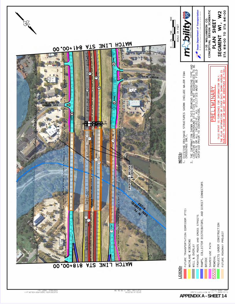
User Name: rblair
...\I-35 WC_FTCRPT13.dgn File Name:PLOTDRIVER:TXDOT_PDF_COLOR.plt
4:48:56 PM
4/15/2015 DATE:
TXDOT.tbl PENTABLE: PLOTTING TIME:
CO
NC
EP
TU
AL
DE
SIG
N S
CH
EM
AT
IC
I-3
5 W
IL
LIA
MS
ON
CO
.
RC
2014 by T
exas D
epartm
ent of T
ransportation all rights reserved
LE
GE
ND
:
075
30
0
SC
AL
E I
N F
EE
T
15
0
PL
AN
SH
EE
T
NO
TE
S:
FU
TU
RE
TR
AN
SP
OR
TA
TIO
N C
OR
RID
OR
(F
TC
)
MA
INL
AN
E W
IDE
NIN
G
MIL
L &
OV
ER
LA
Y
FR
ON
TA
GE
RO
AD
S A
ND
CR
OS
S S
TR
EE
TS
RA
MP
S, C
OL
LE
CT
OR
DIS
TR
IB
UT
OR
S, A
ND
DIR
EC
T C
ON
NE
CT
OR
S
BR
IDG
E
SH
AR
ED
-US
E P
AT
H
RE
MO
VA
L
PR
OJE
CT
S U
ND
ER
CO
NS
TR
UC
TIO
N
FU
TU
RE
RO
AD
WA
Y P
RO
JE
CT
1. E
XIS
TIN
G D
RA
IN
AG
E S
TR
UC
TU
RE
S S
HO
WN
IN
CL
UD
E M
AJO
R F
EM
A
CR
OS
SIN
GS
ON
LY
.
2. T
HE
IN
FO
RM
AT
IO
N S
HO
WN
ON
TH
IS
DR
AW
IN
G C
ON
CE
RN
IN
G T
YP
E A
ND
LO
CA
TIO
N O
F U
ND
ER
GR
OU
ND
UT
IL
IT
IE
S I
S N
OT
GU
AR
AN
TE
ED
TO
BE
AC
CU
RA
TE
OR
AL
L I
NC
LU
SIV
E.
AL
L U
TIL
IT
IE
S M
US
T B
E F
IE
LD
VE
RIF
IE
D P
RIO
R T
O C
ON
ST
RU
CT
IO
N.
PR
EL
IMIN
AR
Y
TH
IS
PR
IN
T I
S F
UR
NIS
HE
D F
OR
IN
FO
RM
AT
IO
N O
NL
Y.
TH
E P
LA
N I
NF
OR
MA
TIO
N O
R O
TH
ER
DA
TA
SH
OW
N H
ER
EO
N I
S
SU
BJE
CT
TO
CH
AN
GE
AN
D M
US
T N
OT
BE
CO
NS
TR
UE
D A
S F
IN
AL
.
820+00
825+00
830+00
835+00
840+00
RIVERY BLVD
VILLAGE BLVDSAN GABRIEL
FOREST ST
RIV
ER
SA
N
GA
BRIE
L
N FK.
3
1
1
3
4
1
3
N
MATCH LINE STA 818+00.00
MATCH LINE STA 841+00.00
ST
A 8
18
+0
0 T
O S
TA
84
1+
00
SEGMENT W1SEGMENT W2
SE
GM
EN
T W
1, W
2
45
3
3
1
1
3
WID
EN
ING
PR
OP
OS
ED
BR
IDG
E
4
I-3
5 [
APPENDIX A SHEET 14
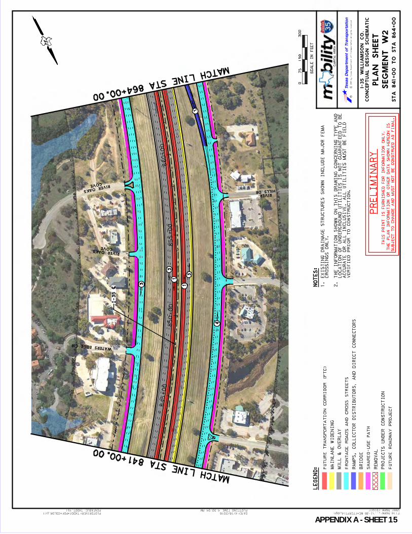
User Name: rblair
...\I-35 WC_FTCRPT14.dgn File Name:PLOTDRIVER:TXDOT_PDF_COLOR.plt
4:50:04 PM
4/15/2015 DATE:
TXDOT.tbl PENTABLE: PLOTTING TIME:
CO
NC
EP
TU
AL
DE
SIG
N S
CH
EM
AT
IC
I-3
5 W
IL
LIA
MS
ON
CO
.
RC
2014 by T
exas D
epartm
ent of T
ransportation all rights reserved
LE
GE
ND
:
075
30
0
SC
AL
E I
N F
EE
T
15
0
PL
AN
SH
EE
T
SE
GM
EN
T W
2
NO
TE
S:
FU
TU
RE
TR
AN
SP
OR
TA
TIO
N C
OR
RID
OR
(F
TC
)
MA
INL
AN
E W
IDE
NIN
G
MIL
L &
OV
ER
LA
Y
FR
ON
TA
GE
RO
AD
S A
ND
CR
OS
S S
TR
EE
TS
RA
MP
S, C
OL
LE
CT
OR
DIS
TR
IB
UT
OR
S, A
ND
DIR
EC
T C
ON
NE
CT
OR
S
BR
IDG
E
SH
AR
ED
-US
E P
AT
H
RE
MO
VA
L
PR
OJE
CT
S U
ND
ER
CO
NS
TR
UC
TIO
N
FU
TU
RE
RO
AD
WA
Y P
RO
JE
CT
1. E
XIS
TIN
G D
RA
IN
AG
E S
TR
UC
TU
RE
S S
HO
WN
IN
CL
UD
E M
AJO
R F
EM
A
CR
OS
SIN
GS
ON
LY
.
2. T
HE
IN
FO
RM
AT
IO
N S
HO
WN
ON
TH
IS
DR
AW
IN
G C
ON
CE
RN
IN
G T
YP
E A
ND
LO
CA
TIO
N O
F U
ND
ER
GR
OU
ND
UT
IL
IT
IE
S I
S N
OT
GU
AR
AN
TE
ED
TO
BE
AC
CU
RA
TE
OR
AL
L I
NC
LU
SIV
E.
AL
L U
TIL
IT
IE
S M
US
T B
E F
IE
LD
VE
RIF
IE
D P
RIO
R T
O C
ON
ST
RU
CT
IO
N.
PR
EL
IMIN
AR
Y
TH
IS
PR
IN
T I
S F
UR
NIS
HE
D F
OR
IN
FO
RM
AT
IO
N O
NL
Y.
TH
E P
LA
N I
NF
OR
MA
TIO
N O
R O
TH
ER
DA
TA
SH
OW
N H
ER
EO
N I
S
SU
BJE
CT
TO
CH
AN
GE
AN
D M
US
T N
OT
BE
CO
NS
TR
UE
D A
S F
IN
AL
.
845+00
850+00
855+00
860+00
COVE RIVER OAKS
COVE
RIVER OAKS
HILLS DRRIVER
WATERS EDGE CIR
N
MATCH LINE STA 841+00.00
MATCH LINE STA 864+00.00
ST
A 8
41
+0
0 T
O S
TA
86
4+
00
4
3
3
3
1
1
1
I-35 [
APPENDIX A SHEET 15

User Name: rblair
...\I-35 WC_FTCRPT15.dgn File Name:PLOTDRIVER:TXDOT_PDF_COLOR.plt
11:20:22 AM
4/24/2015 DATE:
TXDOT.tbl PENTABLE: PLOTTING TIME:
CO
NC
EP
TU
AL
DE
SIG
N S
CH
EM
AT
IC
I-3
5 W
IL
LIA
MS
ON
CO
.
RC
2014 by T
exas D
epartm
ent of T
ransportation all rights reserved
LE
GE
ND
:
075
30
0
SC
AL
E I
N F
EE
T
15
0
PL
AN
SH
EE
T
SE
GM
EN
T W
2
NO
TE
S:
FU
TU
RE
TR
AN
SP
OR
TA
TIO
N C
OR
RID
OR
(F
TC
)
MA
INL
AN
E W
IDE
NIN
G
MIL
L &
OV
ER
LA
Y
FR
ON
TA
GE
RO
AD
S A
ND
CR
OS
S S
TR
EE
TS
RA
MP
S, C
OL
LE
CT
OR
DIS
TR
IB
UT
OR
S, A
ND
DIR
EC
T C
ON
NE
CT
OR
S
BR
IDG
E
SH
AR
ED
-US
E P
AT
H
RE
MO
VA
L
PR
OJE
CT
S U
ND
ER
CO
NS
TR
UC
TIO
N
FU
TU
RE
RO
AD
WA
Y P
RO
JE
CT
1. E
XIS
TIN
G D
RA
IN
AG
E S
TR
UC
TU
RE
S S
HO
WN
IN
CL
UD
E M
AJO
R F
EM
A
CR
OS
SIN
GS
ON
LY
.
2. T
HE
IN
FO
RM
AT
IO
N S
HO
WN
ON
TH
IS
DR
AW
IN
G C
ON
CE
RN
IN
G T
YP
E A
ND
LO
CA
TIO
N O
F U
ND
ER
GR
OU
ND
UT
IL
IT
IE
S I
S N
OT
GU
AR
AN
TE
ED
TO
BE
AC
CU
RA
TE
OR
AL
L I
NC
LU
SIV
E.
AL
L U
TIL
IT
IE
S M
US
T B
E F
IE
LD
VE
RIF
IE
D P
RIO
R T
O C
ON
ST
RU
CT
IO
N.
PR
EL
IMIN
AR
Y
TH
IS
PR
IN
T I
S F
UR
NIS
HE
D F
OR
IN
FO
RM
AT
IO
N O
NL
Y.
TH
E P
LA
N I
NF
OR
MA
TIO
N O
R O
TH
ER
DA
TA
SH
OW
N H
ER
EO
N I
S
SU
BJE
CT
TO
CH
AN
GE
AN
D M
US
T N
OT
BE
CO
NS
TR
UE
D A
S F
IN
AL
.
865+00
870+
00
875+
00
880+
00
885+00
135+00
140+00
145+00
STATE HWY 29
HOLLOW
SPRING
NB FRO
NTA
GE RD
H.E.B
SB FRO
NTA
GE RD
N
MATCH LINE STA 864+00.00
MATCH LINE STA 887+00.00
ST
A 8
64+
00 T
O S
TA
887+
00
STATE HWY 29
4
4
3
53
34
35
4
1
1
1
3
1
1
LA
NE
IN
TE
RC
HA
NG
E
CO
NV
EN
TIO
NA
L 8
SH
-2
9 P
RO
PO
SE
D
LA
NE
PR
OP
OS
ED
AU
XIL
IAR
Y
I-35 [
APPENDIX A SHEET 16
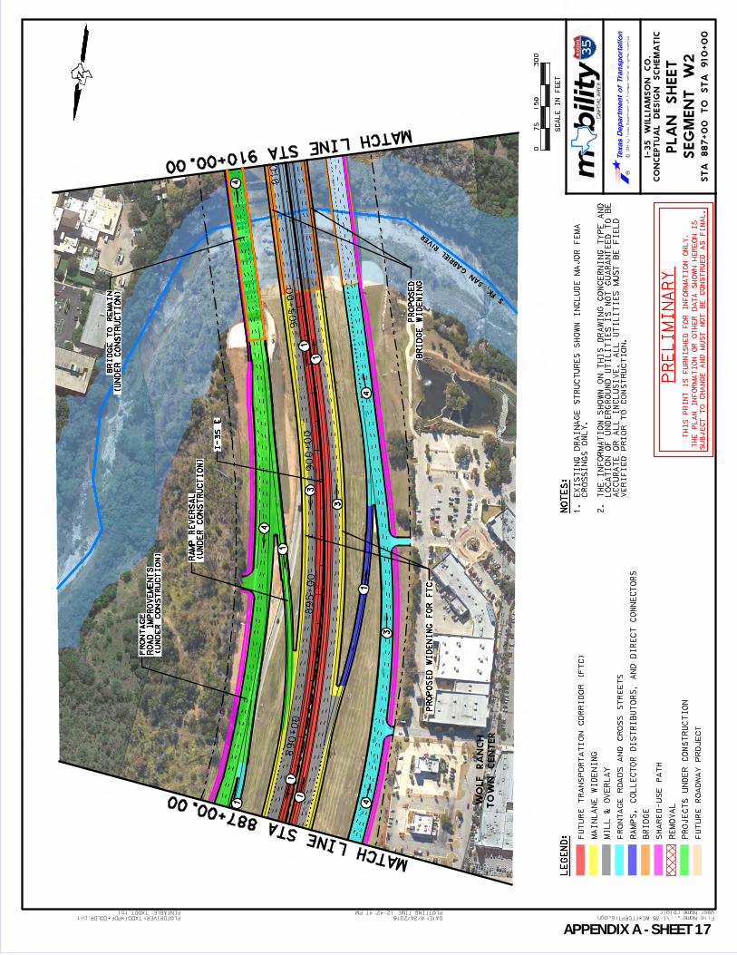
User Name: rblair
...\I-35 WC_FTCRPT16.dgn File Name:PLOTDRIVER:TXDOT_PDF_COLOR.plt
12:42:47 PM
4/24/2015 DATE:
TXDOT.tbl PENTABLE: PLOTTING TIME:
CO
NC
EP
TU
AL
DE
SIG
N S
CH
EM
AT
IC
I-3
5 W
IL
LIA
MS
ON
CO
.
RC
2014 by T
exas D
epartm
ent of T
ransportation all rights reserved
LE
GE
ND
:
075
30
0
SC
AL
E I
N F
EE
T
15
0
PL
AN
SH
EE
T
SE
GM
EN
T W
2
NO
TE
S:
FU
TU
RE
TR
AN
SP
OR
TA
TIO
N C
OR
RID
OR
(F
TC
)
MA
INL
AN
E W
IDE
NIN
G
MIL
L &
OV
ER
LA
Y
FR
ON
TA
GE
RO
AD
S A
ND
CR
OS
S S
TR
EE
TS
RA
MP
S, C
OL
LE
CT
OR
DIS
TR
IB
UT
OR
S, A
ND
DIR
EC
T C
ON
NE
CT
OR
S
BR
IDG
E
SH
AR
ED
-US
E P
AT
H
RE
MO
VA
L
PR
OJE
CT
S U
ND
ER
CO
NS
TR
UC
TIO
N
FU
TU
RE
RO
AD
WA
Y P
RO
JE
CT
1. E
XIS
TIN
G D
RA
IN
AG
E S
TR
UC
TU
RE
S S
HO
WN
IN
CL
UD
E M
AJO
R F
EM
A
CR
OS
SIN
GS
ON
LY
.
2. T
HE
IN
FO
RM
AT
IO
N S
HO
WN
ON
TH
IS
DR
AW
IN
G C
ON
CE
RN
IN
G T
YP
E A
ND
LO
CA
TIO
N O
F U
ND
ER
GR
OU
ND
UT
IL
IT
IE
S I
S N
OT
GU
AR
AN
TE
ED
TO
BE
AC
CU
RA
TE
OR
AL
L I
NC
LU
SIV
E.
AL
L U
TIL
IT
IE
S M
US
T B
E F
IE
LD
VE
RIF
IE
D P
RIO
R T
O C
ON
ST
RU
CT
IO
N.
PR
EL
IMIN
AR
Y
TH
IS
PR
IN
T I
S F
UR
NIS
HE
D F
OR
IN
FO
RM
AT
IO
N O
NL
Y.
TH
E P
LA
N I
NF
OR
MA
TIO
N O
R O
TH
ER
DA
TA
SH
OW
N H
ER
EO
N I
S
SU
BJE
CT
TO
CH
AN
GE
AN
D M
US
T N
OT
BE
CO
NS
TR
UE
D A
S F
IN
AL
.
890+00
895+00
900+00
905+00
910+00
TO
WN CENTER
WO
LF RA
NCH
S FK.
SAN
GA
BRIEL
RIV
ER
HOSPIT
AL
GEO
RGETO
WN
ST
DA
VID'S
N
MATCH LINE STA 887+00.00
MATCH LINE STA 910+00.00
ST
A 8
87+
00 T
O S
TA
910+
00
3
3
4
3
4
4
1
1
1
1
1
1
(UN
DE
R C
ON
ST
RU
CT
ION
)
RO
AD
IM
PR
OV
EM
EN
TS
FR
ON
TA
GE
(UN
DE
R C
ON
ST
RU
CT
ION
)
RA
MP
RE
VE
RS
AL
PR
OP
OS
ED
WID
EN
IN
G F
OR
FT
C
1
(UN
DE
R C
ON
ST
RU
CT
ION
)
BR
IDG
E T
O R
EM
AIN
BR
IDG
E W
IDE
NIN
G
PR
OP
OS
ED
4
I-35 [
APPENDIX A SHEET 17

User Name: rblair
...\I-35 WC_FTCRPT17.dgn File Name:PLOTDRIVER:TXDOT_PDF_COLOR.plt
12:47:38 PM
4/24/2015 DATE:
TXDOT.tbl PENTABLE: PLOTTING TIME:
CO
NC
EP
TU
AL
DE
SIG
N S
CH
EM
AT
IC
I-3
5 W
IL
LIA
MS
ON
CO
.
RC
2014 by T
exas D
epartm
ent of T
ransportation all rights reserved
LE
GE
ND
:
075
30
0
SC
AL
E I
N F
EE
T
15
0
PL
AN
SH
EE
T
SE
GM
EN
T W
2
FU
TU
RE
TR
AN
SP
OR
TA
TIO
N C
OR
RID
OR
(F
TC
)
MA
INL
AN
E W
IDE
NIN
G
MIL
L &
OV
ER
LA
Y
FR
ON
TA
GE
RO
AD
S A
ND
CR
OS
S S
TR
EE
TS
RA
MP
S, C
OL
LE
CT
OR
DIS
TR
IB
UT
OR
S, A
ND
DIR
EC
T C
ON
NE
CT
OR
S
BR
IDG
E
SH
AR
ED
-US
E P
AT
H
RE
MO
VA
L
PR
OJE
CT
S U
ND
ER
CO
NS
TR
UC
TIO
N
FU
TU
RE
RO
AD
WA
Y P
RO
JE
CT
PR
EL
IMIN
AR
Y
TH
IS
PR
IN
T I
S F
UR
NIS
HE
D F
OR
IN
FO
RM
AT
IO
N O
NL
Y.
TH
E P
LA
N I
NF
OR
MA
TIO
N O
R O
TH
ER
DA
TA
SH
OW
N H
ER
EO
N I
S
SU
BJE
CT
TO
CH
AN
GE
AN
D M
US
T N
OT
BE
CO
NS
TR
UE
D A
S F
IN
AL
.
91
0+
00
91
5+
00
92
0+
00
92
5+
00
93
0+
00
110+00
115+00
120+00
125+00
RM 2243 (LEANDER RD)
HOSPIT
AL
GEO
RGETO
WN
ST
DA
VID'S
N
MATCH LINE STA 910+00.00
MATCH LINE STA 933+00.00
ST
A 9
10
+0
0 T
O S
TA
93
3+
00
3
34
65
3
5
44
11
1
1
3
4
1
1
IMP
RO
VE
ME
NT
S
PR
OP
OS
ED
AC
CE
SS
AC
CO
MM
OD
AT
E F
TC
MO
DIF
Y G
OR
E T
O
U-T
UR
N B
RID
GE
RM
22
43
SO
UT
HB
OU
ND
U-T
UR
N B
RID
GE
NO
RT
HB
OU
ND
RM
22
43
PR
OP
OS
ED
LA
NE
PR
OP
OS
ED
AU
XIL
IAR
Y
IN
TE
RC
HA
NG
E (
CF
I)
CO
NT
INU
OU
S F
LO
W
RM
2243 P
RO
PO
SE
D
I-35 [
APPENDIX A SHEET 18

User Name: rblair
...\I-35 WC_FTCRPT18.dgn File Name:PLOTDRIVER:TXDOT_PDF_COLOR.plt
12:59:58 PM
4/24/2015 DATE:
TXDOT.tbl PENTABLE: PLOTTING TIME:
CO
NC
EP
TU
AL
DE
SIG
N S
CH
EM
AT
IC
I-3
5 W
IL
LIA
MS
ON
CO
.
RC
2014 by T
exas D
epartm
ent of T
ransportation all rights reserved
LE
GE
ND
:
075
30
0
SC
AL
E I
N F
EE
T
15
0
PL
AN
SH
EE
T
SE
GM
EN
T W
2
NO
TE
S:
FU
TU
RE
TR
AN
SP
OR
TA
TIO
N C
OR
RID
OR
(F
TC
)
MA
INL
AN
E W
IDE
NIN
G
MIL
L &
OV
ER
LA
Y
FR
ON
TA
GE
RO
AD
S A
ND
CR
OS
S S
TR
EE
TS
RA
MP
S, C
OL
LE
CT
OR
DIS
TR
IB
UT
OR
S, A
ND
DIR
EC
T C
ON
NE
CT
OR
S
BR
IDG
E
SH
AR
ED
-US
E P
AT
H
RE
MO
VA
L
PR
OJE
CT
S U
ND
ER
CO
NS
TR
UC
TIO
N
FU
TU
RE
RO
AD
WA
Y P
RO
JE
CT
1. E
XIS
TIN
G D
RA
IN
AG
E S
TR
UC
TU
RE
S S
HO
WN
IN
CL
UD
E M
AJO
R F
EM
A
CR
OS
SIN
GS
ON
LY
.
2. T
HE
IN
FO
RM
AT
IO
N S
HO
WN
ON
TH
IS
DR
AW
IN
G C
ON
CE
RN
IN
G T
YP
E A
ND
LO
CA
TIO
N O
F U
ND
ER
GR
OU
ND
UT
IL
IT
IE
S I
S N
OT
GU
AR
AN
TE
ED
TO
BE
AC
CU
RA
TE
OR
AL
L I
NC
LU
SIV
E.
AL
L U
TIL
IT
IE
S M
US
T B
E F
IE
LD
VE
RIF
IE
D P
RIO
R T
O C
ON
ST
RU
CT
IO
N.
PR
EL
IMIN
AR
Y
TH
IS
PR
IN
T I
S F
UR
NIS
HE
D F
OR
IN
FO
RM
AT
IO
N O
NL
Y.
TH
E P
LA
N I
NF
OR
MA
TIO
N O
R O
TH
ER
DA
TA
SH
OW
N H
ER
EO
N I
S
SU
BJE
CT
TO
CH
AN
GE
AN
D M
US
T N
OT
BE
CO
NS
TR
UE
D A
S F
IN
AL
.
93
5+
00
94
0+
00
94
5+
00
95
0+
00
95
5+
00
SB
FR
ON
TA
GE
RD
NB
FR
ON
TA
GE
RD
ROCKMOOR DR
OAKS BLVD THOUSAND
N
MATCH LINE STA 933+00.00
MATCH LINE STA 956+00.00
ST
A 9
33+
00 T
O S
TA
956+
00
3
3
34
1
1
1
1
EN
TR
AN
CE
RA
MP
RE
MO
VE
CH
AN
NE
L
DR
AIN
AG
E
EX
IS
TIN
G
RA
MP
RE
VE
RS
AL
PR
OP
OS
ED
RO
AD
WID
EN
ING
PR
OP
OS
ED
FR
ON
TA
GE
4
I-35 [
APPENDIX A SHEET 19

User Name: rblair
...\I-35 WC_FTCRPT19.dgn File Name:PLOTDRIVER:TXDOT_PDF_COLOR.plt
1:06:48 PM
4/24/2015 DATE:
TXDOT.tbl PENTABLE: PLOTTING TIME:
CO
NC
EP
TU
AL
DE
SIG
N S
CH
EM
AT
IC
I-3
5 W
IL
LIA
MS
ON
CO
.
RC
2014 by T
exas D
epartm
ent of T
ransportation all rights reserved
LE
GE
ND
:
075
30
0
SC
AL
E I
N F
EE
T
15
0
PL
AN
SH
EE
T
SE
GM
EN
T W
2
NO
TE
S:
FU
TU
RE
TR
AN
SP
OR
TA
TIO
N C
OR
RID
OR
(F
TC
)
MA
INL
AN
E W
IDE
NIN
G
MIL
L &
OV
ER
LA
Y
FR
ON
TA
GE
RO
AD
S A
ND
CR
OS
S S
TR
EE
TS
RA
MP
S, C
OL
LE
CT
OR
DIS
TR
IB
UT
OR
S, A
ND
DIR
EC
T C
ON
NE
CT
OR
S
BR
IDG
E
SH
AR
ED
-US
E P
AT
H
RE
MO
VA
L
PR
OJE
CT
S U
ND
ER
CO
NS
TR
UC
TIO
N
FU
TU
RE
RO
AD
WA
Y P
RO
JE
CT
1. E
XIS
TIN
G D
RA
IN
AG
E S
TR
UC
TU
RE
S S
HO
WN
IN
CL
UD
E M
AJO
R F
EM
A
CR
OS
SIN
GS
ON
LY
.
2. T
HE
IN
FO
RM
AT
IO
N S
HO
WN
ON
TH
IS
DR
AW
IN
G C
ON
CE
RN
IN
G T
YP
E A
ND
LO
CA
TIO
N O
F U
ND
ER
GR
OU
ND
UT
IL
IT
IE
S I
S N
OT
GU
AR
AN
TE
ED
TO
BE
AC
CU
RA
TE
OR
AL
L I
NC
LU
SIV
E.
AL
L U
TIL
IT
IE
S M
US
T B
E F
IE
LD
VE
RIF
IE
D P
RIO
R T
O C
ON
ST
RU
CT
IO
N.
PR
EL
IMIN
AR
Y
TH
IS
PR
IN
T I
S F
UR
NIS
HE
D F
OR
IN
FO
RM
AT
IO
N O
NL
Y.
TH
E P
LA
N I
NF
OR
MA
TIO
N O
R O
TH
ER
DA
TA
SH
OW
N H
ER
EO
N I
S
SU
BJE
CT
TO
CH
AN
GE
AN
D M
US
T N
OT
BE
CO
NS
TR
UE
D A
S F
IN
AL
.
960+00
965+00
970+00
975+00
SW BYPASS
FUTURE
CA
VERNS
SPA
CE
INNER
SB FRO
NTA
GE RD
SE IN
NER LOOP
SS 26
SS 26
N
MATCH LINE STA 956+00.00
MATCH LINE STA 979+00.00
ST
A 9
56
+0
0 T
O S
TA
97
9+
00
3
3
3
4
31
1
3
1
1
3
2
2
3
3
2
4
CH
AN
NE
L
EX
IST
ING
DR
AIN
AG
E
RE
AL
IGN
ME
NT
FR
ON
TA
GE
RO
AD
PR
OP
OS
ED
CH
AN
NE
L
EX
IST
ING
DR
AIN
AG
E
AC
CO
MM
OD
AT
E F
TC
TO
BE
RE
PL
AC
ED
TO
EX
IS
TIN
G B
RID
GE
CH
AN
NE
L
EX
IST
ING
DR
AIN
AG
E
RA
MP
RE
VE
RS
AL
PR
OP
OS
ED
4
LA
NE
PR
OP
OS
ED
AU
XIL
IAR
Y
LO
OP
IM
PR
OV
EM
EN
TS
PR
OP
OS
ED
SE
IN
NE
R
I-35 [
(B
Y O
TH
ER
S)
SE
IN
NE
R L
OO
P C
OR
RID
OR
PR
OP
OS
ED
SW
BY
PA
SS
/
APPENDIX A SHEET 20

User Name: rblair
...\I-35 WC_FTCRPT20.dgn File Name:PLOTDRIVER:TXDOT_PDF_COLOR.plt
12:16:56 PM
4/24/2015 DATE:
TXDOT.tbl PENTABLE: PLOTTING TIME:
CO
NC
EP
TU
AL
DE
SIG
N S
CH
EM
AT
IC
I-3
5 W
IL
LIA
MS
ON
CO
.
RC
2014 by T
exas D
epartm
ent of T
ransportation all rights reserved
LE
GE
ND
:
075
30
0
SC
AL
E I
N F
EE
T
15
0
PL
AN
SH
EE
T
NO
TE
S:
FU
TU
RE
TR
AN
SP
OR
TA
TIO
N C
OR
RID
OR
(F
TC
)
MA
INL
AN
E W
IDE
NIN
G
MIL
L &
OV
ER
LA
Y
FR
ON
TA
GE
RO
AD
S A
ND
CR
OS
S S
TR
EE
TS
RA
MP
S, C
OL
LE
CT
OR
DIS
TR
IB
UT
OR
S, A
ND
DIR
EC
T C
ON
NE
CT
OR
S
BR
IDG
E
SH
AR
ED
-US
E P
AT
H
RE
MO
VA
L
PR
OJE
CT
S U
ND
ER
CO
NS
TR
UC
TIO
N
FU
TU
RE
RO
AD
WA
Y P
RO
JE
CT
1. E
XIS
TIN
G D
RA
IN
AG
E S
TR
UC
TU
RE
S S
HO
WN
IN
CL
UD
E M
AJO
R F
EM
A
CR
OS
SIN
GS
ON
LY
.
2. T
HE
IN
FO
RM
AT
IO
N S
HO
WN
ON
TH
IS
DR
AW
IN
G C
ON
CE
RN
IN
G T
YP
E A
ND
LO
CA
TIO
N O
F U
ND
ER
GR
OU
ND
UT
IL
IT
IE
S I
S N
OT
GU
AR
AN
TE
ED
TO
BE
AC
CU
RA
TE
OR
AL
L I
NC
LU
SIV
E.
AL
L U
TIL
IT
IE
S M
US
T B
E F
IE
LD
VE
RIF
IE
D P
RIO
R T
O C
ON
ST
RU
CT
IO
N.
PR
EL
IMIN
AR
Y
TH
IS
PR
IN
T I
S F
UR
NIS
HE
D F
OR
IN
FO
RM
AT
IO
N O
NL
Y.
TH
E P
LA
N I
NF
OR
MA
TIO
N O
R O
TH
ER
DA
TA
SH
OW
N H
ER
EO
N I
S
SU
BJE
CT
TO
CH
AN
GE
AN
D M
US
T N
OT
BE
CO
NS
TR
UE
D A
S F
IN
AL
.
980+00
985+00
990+
00
995+00
1000+00
SW BYPASS
FUTURE
RV
OUTLET
MALL
SPRINGS BLVD.
BLUE
SS 26
N
MATCH LINE STA 979+00.00
MATCH LINE STA 1002+00.00
ST
A 9
79
+0
0 T
O S
TA
10
02
+0
0
SEGMENT W2 SEGMENT W3
SE
GM
EN
T W
2,
W3
4
3
3
3
3
3
1
1
1
RE
AL
IGN
ME
NT
FR
ON
TA
GE
RO
AD
PR
OP
OS
ED
4
LA
NE
PR
OP
OS
ED
AU
XIL
IAR
Y
I-35 [
(B
Y O
TH
ER
S)
SE
IN
NE
R L
OO
P C
OR
RID
OR
PR
OP
OS
ED
SW
BY
PA
SS
/
(UN
DE
R C
ON
ST
RU
CT
ION
)
CO
NN
EC
TIO
N
SS
26/A
US
TIN
AV
E
APPENDIX A SHEET 21

User Name: rblair
...\I-35 WC_FTCRPT21.dgn File Name:PLOTDRIVER:TXDOT_PDF_COLOR.plt
4:58:01 PM
4/15/2015 DATE:
TXDOT.tbl PENTABLE: PLOTTING TIME:
CO
NC
EP
TU
AL
DE
SIG
N S
CH
EM
AT
IC
I-3
5 W
IL
LIA
MS
ON
CO
.
RC
2014 by T
exas D
epartm
ent of T
ransportation all rights reserved
LE
GE
ND
:
075
30
0
SC
AL
E I
N F
EE
T
15
0
PL
AN
SH
EE
T
SE
GM
EN
T W
3
NO
TE
S:
FU
TU
RE
TR
AN
SP
OR
TA
TIO
N C
OR
RID
OR
(F
TC
)
MA
INL
AN
E W
IDE
NIN
G
MIL
L &
OV
ER
LA
Y
FR
ON
TA
GE
RO
AD
S A
ND
CR
OS
S S
TR
EE
TS
RA
MP
S, C
OL
LE
CT
OR
DIS
TR
IB
UT
OR
S, A
ND
DIR
EC
T C
ON
NE
CT
OR
S
BR
IDG
E
SH
AR
ED
-US
E P
AT
H
RE
MO
VA
L
PR
OJE
CT
S U
ND
ER
CO
NS
TR
UC
TIO
N
FU
TU
RE
RO
AD
WA
Y P
RO
JE
CT
1. E
XIS
TIN
G D
RA
IN
AG
E S
TR
UC
TU
RE
S S
HO
WN
IN
CL
UD
E M
AJO
R F
EM
A
CR
OS
SIN
GS
ON
LY
.
2. T
HE
IN
FO
RM
AT
IO
N S
HO
WN
ON
TH
IS
DR
AW
IN
G C
ON
CE
RN
IN
G T
YP
E A
ND
LO
CA
TIO
N O
F U
ND
ER
GR
OU
ND
UT
IL
IT
IE
S I
S N
OT
GU
AR
AN
TE
ED
TO
BE
AC
CU
RA
TE
OR
AL
L I
NC
LU
SIV
E.
AL
L U
TIL
IT
IE
S M
US
T B
E F
IE
LD
VE
RIF
IE
D P
RIO
R T
O C
ON
ST
RU
CT
IO
N.
PR
EL
IMIN
AR
Y
TH
IS
PR
IN
T I
S F
UR
NIS
HE
D F
OR
IN
FO
RM
AT
IO
N O
NL
Y.
TH
E P
LA
N I
NF
OR
MA
TIO
N O
R O
TH
ER
DA
TA
SH
OW
N H
ER
EO
N I
S
SU
BJE
CT
TO
CH
AN
GE
AN
D M
US
T N
OT
BE
CO
NS
TR
UE
D A
S F
IN
AL
.
10
05
+0
01
01
0+
00
10
15
+0
01
02
0+
00
1025+00
SIERRA
W
AY ST
N
MATCH LINE STA 1002+00.00
MATCH LINE STA 1025+00.00
ST
A 1
002+
00 T
O S
TA
1025+
00
4
3
1
1
1
3
1
LA
NE
PR
OP
OS
ED
AU
XIL
IAR
Y
3
4
34
EX
IT R
AM
P
PR
OP
OS
ED
4
LA
NE
PR
OP
OS
ED
AU
XIL
IAR
Y
3
I-35 [
APPENDIX A SHEET 22

User Name: rblair
...\I-35 WC_FTCRPT22.dgn File Name:PLOTDRIVER:TXDOT_PDF_COLOR.plt
4:59:11 PM
4/15/2015 DATE:
TXDOT.tbl PENTABLE: PLOTTING TIME:
CO
NC
EP
TU
AL
DE
SIG
N S
CH
EM
AT
IC
I-3
5 W
IL
LIA
MS
ON
CO
.
RC
2014 by T
exas D
epartm
ent of T
ransportation all rights reserved
LE
GE
ND
:
075
30
0
SC
AL
E I
N F
EE
T
15
0
PL
AN
SH
EE
T
SE
GM
EN
T W
3
NO
TE
S:
FU
TU
RE
TR
AN
SP
OR
TA
TIO
N C
OR
RID
OR
(F
TC
)
MA
INL
AN
E W
IDE
NIN
G
MIL
L &
OV
ER
LA
Y
FR
ON
TA
GE
RO
AD
S A
ND
CR
OS
S S
TR
EE
TS
RA
MP
S, C
OL
LE
CT
OR
DIS
TR
IB
UT
OR
S, A
ND
DIR
EC
T C
ON
NE
CT
OR
S
BR
IDG
E
SH
AR
ED
-US
E P
AT
H
RE
MO
VA
L
PR
OJE
CT
S U
ND
ER
CO
NS
TR
UC
TIO
N
FU
TU
RE
RO
AD
WA
Y P
RO
JE
CT
1. E
XIS
TIN
G D
RA
IN
AG
E S
TR
UC
TU
RE
S S
HO
WN
IN
CL
UD
E M
AJO
R F
EM
A
CR
OS
SIN
GS
ON
LY
.
2. T
HE
IN
FO
RM
AT
IO
N S
HO
WN
ON
TH
IS
DR
AW
IN
G C
ON
CE
RN
IN
G T
YP
E A
ND
LO
CA
TIO
N O
F U
ND
ER
GR
OU
ND
UT
IL
IT
IE
S I
S N
OT
GU
AR
AN
TE
ED
TO
BE
AC
CU
RA
TE
OR
AL
L I
NC
LU
SIV
E.
AL
L U
TIL
IT
IE
S M
US
T B
E F
IE
LD
VE
RIF
IE
D P
RIO
R T
O C
ON
ST
RU
CT
IO
N.
PR
EL
IMIN
AR
Y
TH
IS
PR
IN
T I
S F
UR
NIS
HE
D F
OR
IN
FO
RM
AT
IO
N O
NL
Y.
TH
E P
LA
N I
NF
OR
MA
TIO
N O
R O
TH
ER
DA
TA
SH
OW
N H
ER
EO
N I
S
SU
BJE
CT
TO
CH
AN
GE
AN
D M
US
T N
OT
BE
CO
NS
TR
UE
D A
S F
IN
AL
.
1025+00
1030+00
1035+
00
1040+
00
1045+00
STO
NE
TEX
AS CRUSHED
FOX D
R
N
MATCH LINE STA 1025+00.00
MATCH LINE STA 1048+00.00
ST
A 1
025+
00 T
O S
TA
1048+
00
3
4
1
1
CH
AN
NE
L
EX
IST
ING
DR
AIN
AG
E
4
33
3
4
1
1
4
1
3 RA
MP
PR
OP
OS
ED
EN
TR
AN
CE
LA
NE
PR
OP
OS
ED
AU
XIL
IAR
Y
I-35 [
APPENDIX A SHEET 23
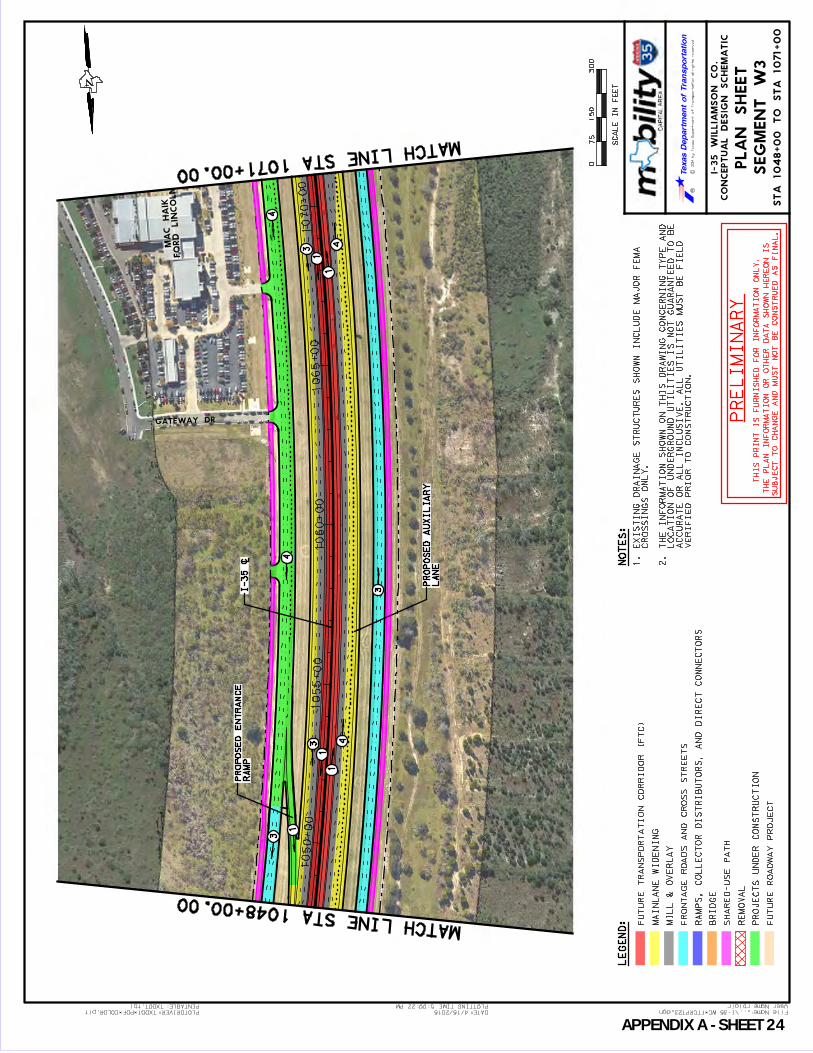
User Name: rblair
...\I-35 WC_FTCRPT23.dgn File Name:PLOTDRIVER:TXDOT_PDF_COLOR.plt
5:00:22 PM
4/15/2015 DATE:
TXDOT.tbl PENTABLE: PLOTTING TIME:
CO
NC
EP
TU
AL
DE
SIG
N S
CH
EM
AT
IC
I-3
5 W
IL
LIA
MS
ON
CO
.
RC
2014 by T
exas D
epartm
ent of T
ransportation all rights reserved
LE
GE
ND
:
075
30
0
SC
AL
E I
N F
EE
T
15
0
PL
AN
SH
EE
T
SE
GM
EN
T W
3
NO
TE
S:
FU
TU
RE
TR
AN
SP
OR
TA
TIO
N C
OR
RID
OR
(F
TC
)
MA
INL
AN
E W
IDE
NIN
G
MIL
L &
OV
ER
LA
Y
FR
ON
TA
GE
RO
AD
S A
ND
CR
OS
S S
TR
EE
TS
RA
MP
S, C
OL
LE
CT
OR
DIS
TR
IB
UT
OR
S, A
ND
DIR
EC
T C
ON
NE
CT
OR
S
BR
IDG
E
SH
AR
ED
-US
E P
AT
H
RE
MO
VA
L
PR
OJE
CT
S U
ND
ER
CO
NS
TR
UC
TIO
N
FU
TU
RE
RO
AD
WA
Y P
RO
JE
CT
1. E
XIS
TIN
G D
RA
IN
AG
E S
TR
UC
TU
RE
S S
HO
WN
IN
CL
UD
E M
AJO
R F
EM
A
CR
OS
SIN
GS
ON
LY
.
2. T
HE
IN
FO
RM
AT
IO
N S
HO
WN
ON
TH
IS
DR
AW
IN
G C
ON
CE
RN
IN
G T
YP
E A
ND
LO
CA
TIO
N O
F U
ND
ER
GR
OU
ND
UT
IL
IT
IE
S I
S N
OT
GU
AR
AN
TE
ED
TO
BE
AC
CU
RA
TE
OR
AL
L I
NC
LU
SIV
E.
AL
L U
TIL
IT
IE
S M
US
T B
E F
IE
LD
VE
RIF
IE
D P
RIO
R T
O C
ON
ST
RU
CT
IO
N.
PR
EL
IMIN
AR
Y
TH
IS
PR
IN
T I
S F
UR
NIS
HE
D F
OR
IN
FO
RM
AT
IO
N O
NL
Y.
TH
E P
LA
N I
NF
OR
MA
TIO
N O
R O
TH
ER
DA
TA
SH
OW
N H
ER
EO
N I
S
SU
BJE
CT
TO
CH
AN
GE
AN
D M
US
T N
OT
BE
CO
NS
TR
UE
D A
S F
IN
AL
.
1050+00
1055+00
10
60
+0
01065+00
1070+00
GATEW AY DR
FO
RD LIN
CO
LN
MA
C
HAIK
N
MATCH LINE STA 1048+00.00
MATCH LINE STA 1071+00.00
ST
A 1
04
8+
00
TO
ST
A 1
07
1+
00
3
1
1
1
43
3
4
4
41
1
3
RA
MP
PR
OP
OS
ED
EN
TR
AN
CE
LA
NE
PR
OP
OS
ED
AU
XIL
IAR
Y
I-35 [
APPENDIX A SHEET 24
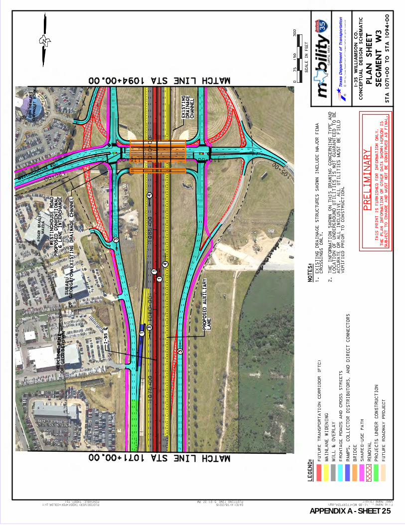
User Name: rblair
...\I-35 WC_FTCRPT24.dgn File Name:PLOTDRIVER:TXDOT_PDF_COLOR.plt
5:01:32 PM
4/15/2015 DATE:
TXDOT.tbl PENTABLE: PLOTTING TIME:
CO
NC
EP
TU
AL
DE
SIG
N S
CH
EM
AT
IC
I-3
5 W
IL
LIA
MS
ON
CO
.
RC
2014 by T
exas D
epartm
ent of T
ransportation all rights reserved
LE
GE
ND
:
075
30
0
SC
AL
E I
N F
EE
T
15
0
PL
AN
SH
EE
T
SE
GM
EN
T W
3
NO
TE
S:
FU
TU
RE
TR
AN
SP
OR
TA
TIO
N C
OR
RID
OR
(F
TC
)
MA
INL
AN
E W
IDE
NIN
G
MIL
L &
OV
ER
LA
Y
FR
ON
TA
GE
RO
AD
S A
ND
CR
OS
S S
TR
EE
TS
RA
MP
S, C
OL
LE
CT
OR
DIS
TR
IB
UT
OR
S, A
ND
DIR
EC
T C
ON
NE
CT
OR
S
BR
IDG
E
SH
AR
ED
-US
E P
AT
H
RE
MO
VA
L
PR
OJE
CT
S U
ND
ER
CO
NS
TR
UC
TIO
N
FU
TU
RE
RO
AD
WA
Y P
RO
JE
CT
1. E
XIS
TIN
G D
RA
IN
AG
E S
TR
UC
TU
RE
S S
HO
WN
IN
CL
UD
E M
AJO
R F
EM
A
CR
OS
SIN
GS
ON
LY
.
2. T
HE
IN
FO
RM
AT
IO
N S
HO
WN
ON
TH
IS
DR
AW
IN
G C
ON
CE
RN
IN
G T
YP
E A
ND
LO
CA
TIO
N O
F U
ND
ER
GR
OU
ND
UT
IL
IT
IE
S I
S N
OT
GU
AR
AN
TE
ED
TO
BE
AC
CU
RA
TE
OR
AL
L I
NC
LU
SIV
E.
AL
L U
TIL
IT
IE
S M
US
T B
E F
IE
LD
VE
RIF
IE
D P
RIO
R T
O C
ON
ST
RU
CT
IO
N.
PR
EL
IMIN
AR
Y
TH
IS
PR
IN
T I
S F
UR
NIS
HE
D F
OR
IN
FO
RM
AT
IO
N O
NL
Y.
TH
E P
LA
N I
NF
OR
MA
TIO
N O
R O
TH
ER
DA
TA
SH
OW
N H
ER
EO
N I
S
SU
BJE
CT
TO
CH
AN
GE
AN
D M
US
T N
OT
BE
CO
NS
TR
UE
D A
S F
IN
AL
.
1075+
00
1080+
00
1085+
00
1090+
00
105+00
110+00115+00
120+00
WESTIN
GHOUSE RD
OF
GEO
RGETO
WN
SUBA
RU
FO
RD LIN
CO
LN
MA
C
HAIK
CHEV
RO
LET BUIC
K
DO
N
HE
WLETT
MAZ
DA
RO
GER BEASLEY
OF
GEO
RGETO
WN
MERCEDES-BENZ
N
MATCH LINE STA 1071+00.00
MATCH LINE STA 1094+00.00
ST
A 1
071+
00 T
O S
TA
1094+
00
4
1
1
3
3
3
4
1
EX
IST
ING
DR
AIN
AG
E C
HA
NN
EL
6 L
AN
E I
NT
ER
CH
AN
GE
PR
OP
OS
ED
CO
NV
EN
TIO
NA
L
WE
ST
ING
HO
US
E R
OA
D
CH
AN
NE
L
DR
AIN
AG
E
EX
IS
TIN
G
LA
NE
PR
OP
OS
ED
AU
XIL
IAR
Y
I-35 [
APPENDIX A SHEET 25

User Name: rblair
...\I-35 WC_FTCRPT25.dgn File Name:PLOTDRIVER:TXDOT_PDF_COLOR.plt
5:02:43 PM
4/15/2015 DATE:
TXDOT.tbl PENTABLE: PLOTTING TIME:
CO
NC
EP
TU
AL
DE
SIG
N S
CH
EM
AT
IC
I-3
5 W
IL
LIA
MS
ON
CO
.
RC
2014 by T
exas D
epartm
ent of T
ransportation all rights reserved
LE
GE
ND
:
075
30
0
SC
AL
E I
N F
EE
T
15
0
PL
AN
SH
EE
T
SE
GM
EN
T W
3
NO
TE
S:
FU
TU
RE
TR
AN
SP
OR
TA
TIO
N C
OR
RID
OR
(F
TC
)
MA
INL
AN
E W
IDE
NIN
G
MIL
L &
OV
ER
LA
Y
FR
ON
TA
GE
RO
AD
S A
ND
CR
OS
S S
TR
EE
TS
RA
MP
S, C
OL
LE
CT
OR
DIS
TR
IB
UT
OR
S, A
ND
DIR
EC
T C
ON
NE
CT
OR
S
BR
IDG
E
SH
AR
ED
-US
E P
AT
H
RE
MO
VA
L
PR
OJE
CT
S U
ND
ER
CO
NS
TR
UC
TIO
N
FU
TU
RE
RO
AD
WA
Y P
RO
JE
CT
1. E
XIS
TIN
G D
RA
IN
AG
E S
TR
UC
TU
RE
S S
HO
WN
IN
CL
UD
E M
AJO
R F
EM
A
CR
OS
SIN
GS
ON
LY
.
2. T
HE
IN
FO
RM
AT
IO
N S
HO
WN
ON
TH
IS
DR
AW
IN
G C
ON
CE
RN
IN
G T
YP
E A
ND
LO
CA
TIO
N O
F U
ND
ER
GR
OU
ND
UT
IL
IT
IE
S I
S N
OT
GU
AR
AN
TE
ED
TO
BE
AC
CU
RA
TE
OR
AL
L I
NC
LU
SIV
E.
AL
L U
TIL
IT
IE
S M
US
T B
E F
IE
LD
VE
RIF
IE
D P
RIO
R T
O C
ON
ST
RU
CT
IO
N.
PR
EL
IMIN
AR
Y
TH
IS
PR
IN
T I
S F
UR
NIS
HE
D F
OR
IN
FO
RM
AT
IO
N O
NL
Y.
TH
E P
LA
N I
NF
OR
MA
TIO
N O
R O
TH
ER
DA
TA
SH
OW
N H
ER
EO
N I
S
SU
BJE
CT
TO
CH
AN
GE
AN
D M
US
T N
OT
BE
CO
NS
TR
UE
D A
S F
IN
AL
.
1095+
00
1100+
00
1105+
00
1110+
00
1115+
00
NB
FR
ON
TA
GE
RD
SB
FR
ON
TA
GE
RD
PAGE W HITNEY PKW Y
HEWLETT LOOP
VO
LKS
WA
GEN
HE
WLETT
CHEV
RO
LET
DO
N
HE
WLETT
N
MATCH LINE STA 1094+00.00
MATCH LINE STA 1117+00.00
ST
A 1
09
4+
00
TO
ST
A 1
11
7+
00
3
1
1
3
4
1
1
3
3
LA
NE
PR
OP
OS
ED
AU
XIL
IAR
Y
RA
MP
RE
VE
RS
AL
PR
OP
OS
ED
3
1
1
3
I-35 [
APPENDIX A SHEET 26

User Name: rblair
...\I-35 WC_FTCRPT26.dgn File Name:PLOTDRIVER:TXDOT_PDF_COLOR.plt
5:03:53 PM
4/15/2015 DATE:
TXDOT.tbl PENTABLE: PLOTTING TIME:
CO
NC
EP
TU
AL
DE
SIG
N S
CH
EM
AT
IC
I-3
5 W
IL
LIA
MS
ON
CO
.
RC
2014 by T
exas D
epartm
ent of T
ransportation all rights reserved
LE
GE
ND
:
075
30
0
SC
AL
E I
N F
EE
T
15
0
PL
AN
SH
EE
T
SE
GM
EN
T W
3
NO
TE
S:
FU
TU
RE
TR
AN
SP
OR
TA
TIO
N C
OR
RID
OR
(F
TC
)
MA
INL
AN
E W
IDE
NIN
G
MIL
L &
OV
ER
LA
Y
FR
ON
TA
GE
RO
AD
S A
ND
CR
OS
S S
TR
EE
TS
RA
MP
S, C
OL
LE
CT
OR
DIS
TR
IB
UT
OR
S, A
ND
DIR
EC
T C
ON
NE
CT
OR
S
BR
IDG
E
SH
AR
ED
-US
E P
AT
H
RE
MO
VA
L
PR
OJE
CT
S U
ND
ER
CO
NS
TR
UC
TIO
N
FU
TU
RE
RO
AD
WA
Y P
RO
JE
CT
1. E
XIS
TIN
G D
RA
IN
AG
E S
TR
UC
TU
RE
S S
HO
WN
IN
CL
UD
E M
AJO
R F
EM
A
CR
OS
SIN
GS
ON
LY
.
2. T
HE
IN
FO
RM
AT
IO
N S
HO
WN
ON
TH
IS
DR
AW
IN
G C
ON
CE
RN
IN
G T
YP
E A
ND
LO
CA
TIO
N O
F U
ND
ER
GR
OU
ND
UT
IL
IT
IE
S I
S N
OT
GU
AR
AN
TE
ED
TO
BE
AC
CU
RA
TE
OR
AL
L I
NC
LU
SIV
E.
AL
L U
TIL
IT
IE
S M
US
T B
E F
IE
LD
VE
RIF
IE
D P
RIO
R T
O C
ON
ST
RU
CT
IO
N.
PR
EL
IMIN
AR
Y
TH
IS
PR
IN
T I
S F
UR
NIS
HE
D F
OR
IN
FO
RM
AT
IO
N O
NL
Y.
TH
E P
LA
N I
NF
OR
MA
TIO
N O
R O
TH
ER
DA
TA
SH
OW
N H
ER
EO
N I
S
SU
BJE
CT
TO
CH
AN
GE
AN
D M
US
T N
OT
BE
CO
NS
TR
UE
D A
S F
IN
AL
.
1120+
00
1125+
00
1130+
00
1135+
00
1140+
00
NB
FR
ON
TA
GE
RD
BASS PRO
DR
SB
FR
ON
TA
GE
RD
TECO
N
MATCH LINE STA 1117+00.00
MATCH LINE STA 1140+00.00
ST
A 1
11
7+
00
TO
ST
A 1
14
0+
00
4
1
3
RA
MP
RE
VE
RS
AL
PR
OP
OS
ED
3
1
1
3
3
1
1
3
4
4
I-35 [
APPENDIX A SHEET 27

1140+
00
1145+
00
1150+
00
1155+
00
1160+
00
RM 1431
UNIVERSITY
BLVD.
RO
UN
D RO
CK
IKEA
User Name: rblair
...\I-35 WC_FTCRPT27.dgn File Name:PLOTDRIVER:TXDOT_PDF_COLOR.plt
5:05:03 PM
4/15/2015 DATE:
TXDOT.tbl PENTABLE: PLOTTING TIME:
CO
NC
EP
TU
AL
DE
SIG
N S
CH
EM
AT
IC
I-3
5 W
IL
LIA
MS
ON
CO
.
RC
2014 by T
exas D
epartm
ent of T
ransportation all rights reserved
LE
GE
ND
:
075
30
0
SC
AL
E I
N F
EE
T
15
0
PL
AN
SH
EE
T
SE
GM
EN
T W
3
NO
TE
S:
FU
TU
RE
TR
AN
SP
OR
TA
TIO
N C
OR
RID
OR
(F
TC
)
MA
INL
AN
E W
IDE
NIN
G
MIL
L &
OV
ER
LA
Y
FR
ON
TA
GE
RO
AD
S A
ND
CR
OS
S S
TR
EE
TS
RA
MP
S, C
OL
LE
CT
OR
DIS
TR
IB
UT
OR
S, A
ND
DIR
EC
T C
ON
NE
CT
OR
S
BR
IDG
E
SH
AR
ED
-US
E P
AT
H
RE
MO
VA
L
PR
OJE
CT
S U
ND
ER
CO
NS
TR
UC
TIO
N
FU
TU
RE
RO
AD
WA
Y P
RO
JE
CT
1. E
XIS
TIN
G D
RA
IN
AG
E S
TR
UC
TU
RE
S S
HO
WN
IN
CL
UD
E M
AJO
R F
EM
A
CR
OS
SIN
GS
ON
LY
.
2. T
HE
IN
FO
RM
AT
IO
N S
HO
WN
ON
TH
IS
DR
AW
IN
G C
ON
CE
RN
IN
G T
YP
E A
ND
LO
CA
TIO
N O
F U
ND
ER
GR
OU
ND
UT
IL
IT
IE
S I
S N
OT
GU
AR
AN
TE
ED
TO
BE
AC
CU
RA
TE
OR
AL
L I
NC
LU
SIV
E.
AL
L U
TIL
IT
IE
S M
US
T B
E F
IE
LD
VE
RIF
IE
D P
RIO
R T
O C
ON
ST
RU
CT
IO
N.
PR
EL
IMIN
AR
Y
TH
IS
PR
IN
T I
S F
UR
NIS
HE
D F
OR
IN
FO
RM
AT
IO
N O
NL
Y.
TH
E P
LA
N I
NF
OR
MA
TIO
N O
R O
TH
ER
DA
TA
SH
OW
N H
ER
EO
N I
S
SU
BJE
CT
TO
CH
AN
GE
AN
D M
US
T N
OT
BE
CO
NS
TR
UE
D A
S F
IN
AL
.
N
MATCH LINE STA 1140+00.00
ST
A 1
140+
00 T
O S
TA
1163+
50
3
1
1
3
4
2
3
1
1
3
2
2
3
(NA
RR
OW
SH
OU
LD
ER
S)
EX
IS
TIN
G C
-D
AC
CO
MM
OD
AT
E F
TC
MO
DIF
Y G
OR
E T
O
(UN
DE
R C
ON
ST
RU
CT
ION
)
INT
ER
CH
AN
GE
DIV
ER
GIN
G D
IAM
ON
D
RM
1431
3
I-35 [
ST
A 1
16
3+
50
EN
D P
RO
JE
CT
APPENDIX A SHEET 28

Appendix B:
Project Development Summary Sheets

PAGE INTENTIONALLY LEFT BLANK
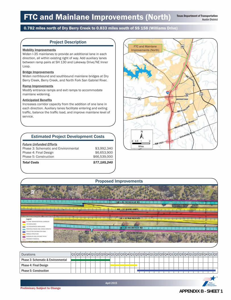
FTC and Mainlane Improvements (North)0.782 miles north of Dry Berry Creek to 0.833 miles south of SS 158 (Williams Drive)
Project Description
Mobility ImprovementsWiden I-35 mainlanes to provide an additional lane in each direction, all within existing right of way. Add auxiliary lanes between ramp pairs at SH 130 and Lakeway Drive/NE Inner Loop.
Bridge ImprovementsWiden northbound and southbound mainlane bridges at Dry Berry Creek, Berry Creek, and North Fork San Gabriel River.
Ramp ImprovementsModify entrance ramps and exit ramps to accommodate mainlane widening.
Anticipated Benefi tsIncreases corridor capacity from the addition of one lane in each direction. Auxiliary lanes facilitate entering and exiting traffi c, balance the traffi c load, and improve mainlane level of service.
Estimated Project Development Costs
Future Unfunded EffortsPhase 3: Schematic and Environmental $3,992,340Phase 4: Final Design $6,653,900Phase 5: Construction $66,539,000
Total Costs $77,185,240
Proposed Improvements
Durations Q1 Q2 Q3 Q4 Q1 Q2 Q3 Q4 Q1 Q2 Q3 Q4 Q1 Q2 Q3 Q4 Q1 Q2 Q3 Q4 Q1 Q2 Q3 Q4 Q1 Q2 Q3 Q4 Q1 Q2
Phase 3: Schematic & EnvironmentalPhase 4: Final DesignPhase 5: Construction
FTC and Mainlane Improvements (North)
LegendFUTURE TRANSPORTATION CORRIDOR
I-35 MAINLANES
I-35 RESURFACED MAINLAINES
FRONTAGE ROADS AND CROSS STREETS
COLLECTOR DISTRIBUTOR ROAD
BRIDGE STRUCTURE
SIDEWALKS AND/OR BIKE PATHS
PAVEMENT REMOVAL
Texas Department of TransportationAustin District
Preliminary Subject to Change
April 2015
APPENDIX B SHEET 1

SH 195/Berry Creek Road Intersection0.149 miles west of Berry Creek Drive to the I-35 Southbound Frontage Road
Project Description
Mobility ImprovementsWiden SH 195 to provide northbound left-turn storage and a bypass for through traffi c. Construct a right-turn lane from southbound SH 195 to Berry Creek Drive. Install traffi c signals at SH 195/Berry Creek Road intersections.
Bicycle and Pedestrian FacilitiesConstruct bicycle and pedestrian facilities to improve east-west connectivity.
Anticipated Benefi tsIncreases intersection effi ciency and reduces congestion. Enhances mobility and safety. Accommodates planned development.
Estimated Project Development Costs
Future Unfunded EffortsPhase 3: Schematic and Environmental $145,560Phase 4: Final Design $242,600Phase 5: Construction $2,426,000
Total Costs $2,814,160
Proposed Improvements
Durations Q1 Q2 Q3 Q4 Q1 Q2 Q3 Q4 Q1 Q2 Q3 Q4 Q1 Q2 Q3 Q4 Q1 Q2 Q3 Q4 Q1 Q2 Q3 Q4
Phase 3: Schematic and EnvironmentalPhase 4: Final DesignPhase 5: Construction
SH 195/Berry Creek Drive Intersection
LegendFUTURE TRANSPORTATION CORRIDOR
I-35 MAINLANES
I-35 RESURFACED MAINLAINES
FRONTAGE ROADS AND CROSS STREETS
COLLECTOR DISTRIBUTOR ROAD
FUTURE DIRECT CONNECTORS
SIDEWALKS AND/OR BIKE PATHS
PAVEMENT REMOVAL
Texas Department of TransportationAustin District
Preliminary Subject to Change
April 2015
APPENDIX B SHEET 2

I-35/SH 195 Direct Connectors0.249 miles west of Berry Creek Drive to 0.070 miles north of Berry Creek
Project Description
Mobility ImprovementsConstruct direct connectors from southbound SH 195 to southbound I-35 mainlanes and southbound SH 130 access road. Construct direct connector from northbound I-35 collector-distributor to northbound SH 195. All improvements are contained in the existing right of way.
Ramp ImprovementsRemove existing entrance ramp from southbound I-35 frontage road to SH 130 access road. Modify northbound I-35 collector-distributor and northbound exit ramps to the northbound I-35 frontage road.
Anticipated Benefi tsIncreases interchange effi ciency, reduces travel time, and eliminates out of direction travel.
Estimated Project Development Costs
Future Unfunded EffortsPhase 3: Schematic and Environmental $4,749,960Phase 4: Final Design $7,916,600Phase 5: Construction $79,166,000
Total Costs $91,832,560
Proposed Improvements
SH 195 Interchange Direct
Connect Ramps
Durations Q1 Q2 Q3 Q4 Q1 Q2 Q3 Q4 Q1 Q2 Q3 Q4 Q1 Q2 Q3 Q4 Q1 Q2 Q3 Q4 Q1 Q2 Q3 Q4
Phase 3: Schematic and EnvironmentalPhase 4: Final DesignPhase 5: Construction
Texas Department of TransportationAustin District
Preliminary Subject to Change
April 2015
LegendFUTURE TRANSPORTATION CORRIDOR
I-35 MAINLANES
I-35 RESURFACED MAINLAINES
FRONTAGE ROADS AND CROSS STREETS
COLLECTOR DISTRIBUTOR ROAD
FUTURE DIRECT CONNECTORS
SIDEWALKS AND/OR BIKE PATHS
PAVEMENT REMOVAL
APPENDIX B SHEET 3
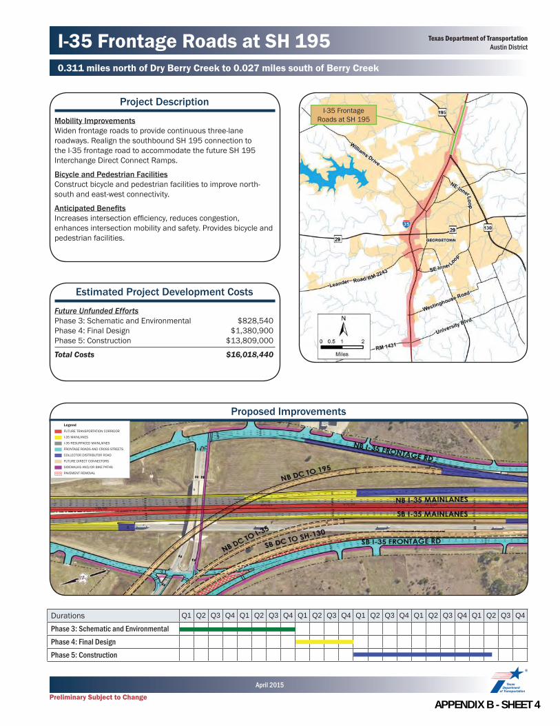
I-35 Frontage Roads at SH 1950.311 miles north of Dry Berry Creek to 0.027 miles south of Berry Creek
Project Description
Mobility ImprovementsWiden frontage roads to provide continuous three-lane roadways. Realign the southbound SH 195 connection to the I-35 frontage road to accommodate the future SH 195 Interchange Direct Connect Ramps.
Bicycle and Pedestrian FacilitiesConstruct bicycle and pedestrian facilities to improve north-south and east-west connectivity.
Anticipated Benefi tsIncreases intersection effi ciency, reduces congestion, enhances intersection mobility and safety. Provides bicycle and pedestrian facilities.
Estimated Project Development Costs
Future Unfunded EffortsPhase 3: Schematic and Environmental $828,540Phase 4: Final Design $1,380,900Phase 5: Construction $13,809,000
Total Costs $16,018,440
I-35 Frontage Roads at SH 195
Durations Q1 Q2 Q3 Q4 Q1 Q2 Q3 Q4 Q1 Q2 Q3 Q4 Q1 Q2 Q3 Q4 Q1 Q2 Q3 Q4 Q1 Q2 Q3 Q4
Phase 3: Schematic and EnvironmentalPhase 4: Final DesignPhase 5: Construction
Proposed Improvements
Texas Department of TransportationAustin District
Preliminary Subject to Change
April 2015
LegendFUTURE TRANSPORTATION CORRIDOR
I-35 MAINLANES
I-35 RESURFACED MAINLAINES
FRONTAGE ROADS AND CROSS STREETS
COLLECTOR DISTRIBUTOR ROAD
FUTURE DIRECT CONNECTORS
SIDEWALKS AND/OR BIKE PATHS
PAVEMENT REMOVAL
APPENDIX B SHEET 4

Lakeway Drive/NE Inner Loop Interchange0.027 miles south of Berry Creek to 0.402 miles south of Lakeway Drive
Project Description
Mobility ImprovementsImprove the existing conventional interchange. Widen Lakeway Drive and NE Inner Loop to accommodate additional lanes. Relocate SS 158 (Austin Avenue) east of its current location. Construct new northbound frontage road and widen existing frontage roads to provide continuous three-lane roadways.Bridge ImprovementsWiden the existing Lakeway Drive/NE Inner Loop underpass bridge to a 7-lane roadway with bicycle lanes and sidewalks.Ramp Modifi cationsReverse ramps to complete X-pattern interchange confi gurations. Modify entrance ramps and exit ramps to accommodate frontage road widening.Bicycle and Pedestrian FacilitiesConstruct bicycle and pedestrian facilities on frontage roads and cross roads to improve north-south and east-west connectivity.Anticipated Benefi tsIncreases intersection effi ciency, reduces congestion, enhances intersection mobility and safety. Provides bicycle and pedestrian facilities.
Estimated Project Development Costs
Future Unfunded EffortsPhase 3: Schematic and Environmental $1,432,500Phase 4: Final Design $2,387,500Phase 5: Construction $23,875,000
Total Costs $27,695,000
Lakeway Drive/NE Inner Loop Interchange
Durations Q1 Q2 Q3 Q4 Q1 Q2 Q3 Q4 Q1 Q2 Q3 Q4 Q1 Q2 Q3 Q4 Q1 Q2 Q3 Q4 Q1 Q2 Q3 Q4
Phase 3: Schematic and EnvironmentalPhase 4: Final DesignPhase 5: Construction
LegendFUTURE TRANSPORTATION CORRIDOR
I-35 MAINLANES
I-35 RESURFACED MAINLAINES
FRONTAGE ROADS AND CROSS STREETS
COLLECTOR DISTRIBUTOR ROAD
BRIDGE STRUCTURE
SIDEWALKS AND/OR BIKE PATHS
PAVEMENT REMOVAL
Proposed Improvements
Texas Department of TransportationAustin District
Preliminary Subject to Change
April 2015
APPENDIX B SHEET 5

SS 158 (Williams Drive) Interchange0.402 miles south of Lakeway Drive to 0.833 miles south of SS 158 (Williams Drive)
Project Description
Mobility ImprovementsReplace the existing interchange with a Diverging Diamond Interchange. Construct southbound and northbound collector-distributor roads. Construct new northbound frontage road and widen existing frontage roads to provide continuous three-lane roadways. Construct improvements at the Williams Drive/Austin Avenue intersection.Bridge ImprovementsReplace the SS 158 (Williams Drive) underpass bridge. Widen the southbound mainlane bridge at North Fork San Gabriel River.Ramp Modifi cationsReverse ramps to complete X-pattern interchange confi gurations. Modify entrance ramps and exit ramps to accommodate frontage road widening.Bicycle and Pedestrian FacilitiesConstruct bicycle and pedestrian facilities on frontage roads and cross roads to improve north-south and east-west connectivity.Anticipated Benefi tsIncreases intersection effi ciency, reduces congestion, enhances intersection mobility and safety. Accommodates Future Transportation Corridor. Provides bicycle and pedestrian facilities.
Estimated Project Development Costs
Future Unfunded EffortsPhase 3: Schematic and Environmental $2,797,140Phase 4: Final Design $4,661,900Phase 5: Construction $46,619,000
Total Costs $54,078,040
Williams Drive Interchange
Durations Q1 Q2 Q3 Q4 Q1 Q2 Q3 Q4 Q1 Q2 Q3 Q4 Q1 Q2 Q3 Q4 Q1 Q2 Q3 Q4 Q1 Q2 Q3 Q4
Phase 3: Schematic and EnvironmentalPhase 4: Final DesignPhase 5: Construction
LegendFUTURE TRANSPORTATION CORRIDOR
I-35 MAINLANES
I-35 RESURFACED MAINLAINES
FRONTAGE ROADS AND CROSS STREETS
COLLECTOR DISTRIBUTOR ROAD
BRIDGE STRUCTURE
SIDEWALKS AND/OR BIKE PATHS
PAVEMENT REMOVAL
Proposed Improvements
Texas Department of TransportationAustin District
Preliminary Subject to Change
April 2015
APPENDIX B SHEET 6
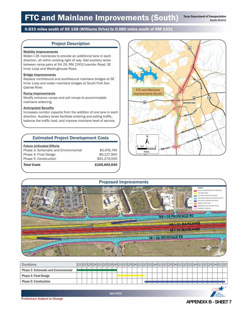
FTC and Mainlane Improvements (South)0.833 miles south of SS 158 (Williams Drive) to 0.080 miles south of RM 1431
Project Description
Mobility ImprovementsWiden I-35 mainlanes to provide an additional lane in each direction, all within existing right of way. Add auxiliary lanes between ramp pairs at SH 29, RM 2243/Leander Road, SE Inner Loop and Westinghouse Road.
Bridge ImprovementsReplace northbound and southbound mainlane bridges at SE Inner Loop and widen mainlane bridges at South Fork San Gabriel River.
Ramp ImprovementsModify entrance ramps and exit ramps to accommodate mainlane widening.
Anticipated Benefi tsIncreases corridor capacity from the addition of one lane in each direction. Auxiliary lanes facilitate entering and exiting traffi c, balance the traffi c load, and improve mainlane level of service.
Estimated Project Development Costs
Future Unfunded EffortsPhase 3: Schematic and Environmental $5,476,740Phase 4: Final Design $9,127,900Phase 5: Construction $91,279,000
Total Costs $105,883,640
Durations Q1 Q2 Q3 Q4 Q1 Q2 Q3 Q4 Q1 Q2 Q3 Q4 Q1 Q2 Q3 Q4 Q1 Q2 Q3 Q4 Q1 Q2 Q3 Q4 Q1 Q2 Q3 Q4 Q1 Q2
Phase 3: Schematic and EnvironmentalPhase 4: Final DesignPhase 5: Construction
LegendFUTURE TRANSPORTATION CORRIDOR
I-35 MAINLANES
I-35 RESURFACED MAINLAINES
FRONTAGE ROADS AND CROSS STREETS
COLLECTOR DISTRIBUTOR ROAD
BRIDGE STRUCTURE
SIDEWALKS AND/OR BIKE PATHS
PAVEMENT REMOVAL
Proposed Improvements
FTC and Mainlane Improvements (South)
Texas Department of TransportationAustin District
Preliminary Subject to Change
April 2015
APPENDIX B SHEET 7

SH 29 Interchange0.833 miles south of SS 158 (Williams Drive) to 0.549 miles south of SH 29
Project Description
Mobility ImprovementsConstruct a new conventional interchange at SH 29 that provides additional turn lanes. Widen frontage roads to provide continuous three-lane roadways. Modify the south-north turnaround transition to the northbound frontage road and the northbound exit ramp to SS 158 (Williams Drive). Relocate commercial access and signal east of I-35. Bridge ImprovementsReplace the SH 29 underpass bridge to allow mainlane widening and provide additional vertical clearance.Ramp Modifi cationsReverse ramps to complete X-pattern interchange confi guration. Modify entrance ramps and exit ramps to accommodate frontage road widening.Bicycle and Pedestrian FacilitiesConstruct bicycle and pedestrian facilities on frontage roads and cross roads to improve north-south and east-west connectivity.Anticipated Benefi tsIncreases intersection effi ciency, reduces congestion, enhances intersection mobility and safety. Accommodates Future Transportation Corridor. Provides bicycle and pedestrian facilities.
Estimated Project Development Costs
Future Unfunded EffortsPhase 3: Schematic and Environmental $1,220,640Phase 4: Final Design $2,034,400Phase 5: Construction $20,344,000
Total Costs $23,599,040
SH 29 Interchange
Durations Q1 Q2 Q3 Q4 Q1 Q2 Q3 Q4 Q1 Q2 Q3 Q4 Q1 Q2 Q3 Q4 Q1 Q2 Q3 Q4 Q1 Q2 Q3 Q4
Phase 3: Schematic and EnvironmentalPhase 4: Final DesignPhase 5: Construction
LegendFUTURE TRANSPORTATION CORRIDOR
I-35 MAINLANES
I-35 RESURFACED MAINLAINES
FRONTAGE ROADS AND CROSS STREETS
COLLECTOR DISTRIBUTOR ROAD
BRIDGE STRUCTURE
SIDEWALKS AND/OR BIKE PATHS
PAVEMENT REMOVAL
Proposed Improvements
Texas Department of TransportationAustin District
Preliminary Subject to Change
April 2015
APPENDIX B SHEET 8
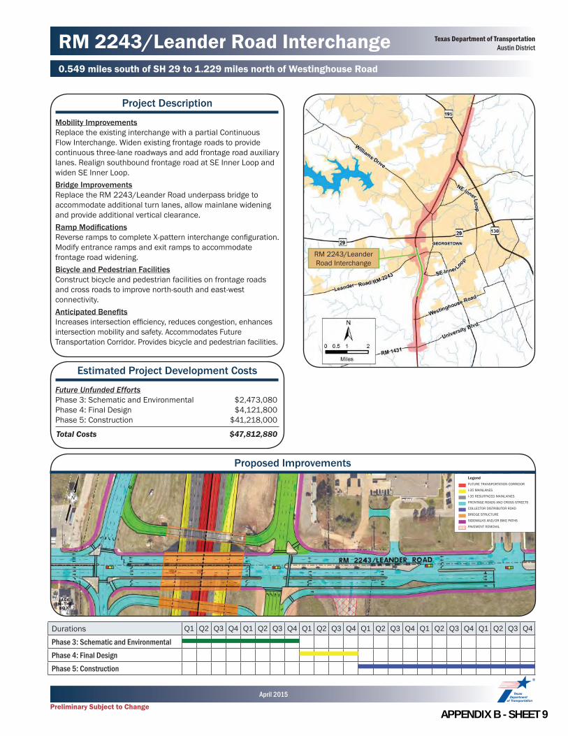
RM 2243/Leander Road Interchange0.549 miles south of SH 29 to 1.229 miles north of Westinghouse Road
Project Description
Mobility ImprovementsReplace the existing interchange with a partial Continuous Flow Interchange. Widen existing frontage roads to provide continuous three-lane roadways and add frontage road auxiliary lanes. Realign southbound frontage road at SE Inner Loop and widen SE Inner Loop.Bridge ImprovementsReplace the RM 2243/Leander Road underpass bridge to accommodate additional turn lanes, allow mainlane widening and provide additional vertical clearance.Ramp Modifi cationsReverse ramps to complete X-pattern interchange confi guration. Modify entrance ramps and exit ramps to accommodate frontage road widening.Bicycle and Pedestrian FacilitiesConstruct bicycle and pedestrian facilities on frontage roads and cross roads to improve north-south and east-west connectivity.Anticipated Benefi tsIncreases intersection effi ciency, reduces congestion, enhances intersection mobility and safety. Accommodates Future Transportation Corridor. Provides bicycle and pedestrian facilities.
Estimated Project Development Costs
Future Unfunded EffortsPhase 3: Schematic and Environmental $2,473,080Phase 4: Final Design $4,121,800Phase 5: Construction $41,218,000
Total Costs $47,812,880
RM 2243/Leander Road Interchange
Durations Q1 Q2 Q3 Q4 Q1 Q2 Q3 Q4 Q1 Q2 Q3 Q4 Q1 Q2 Q3 Q4 Q1 Q2 Q3 Q4 Q1 Q2 Q3 Q4
Phase 3: Schematic and EnvironmentalPhase 4: Final DesignPhase 5: Construction
LegendFUTURE TRANSPORTATION CORRIDOR
I-35 MAINLANES
I-35 RESURFACED MAINLAINES
FRONTAGE ROADS AND CROSS STREETS
COLLECTOR DISTRIBUTOR ROAD
BRIDGE STRUCTURE
SIDEWALKS AND/OR BIKE PATHS
PAVEMENT REMOVAL
Proposed Improvements
Texas Department of TransportationAustin District
Preliminary Subject to Change
April 2015
APPENDIX B SHEET 9

Westinghouse Road Interchange1.229 miles north of Westinghouse Road to 0.080 miles south of RM 1431
Project Description
Mobility ImprovementsConstruct a new conventional interchange that provides additional lanes for turning movements and through traffi c. Realign frontage roads at Westinghouse Road, widen existing frontage roads to provide continuous three-lane roadways and add frontage road auxiliary lanes.Bridge ImprovementsReplace the Westinghouse Road underpass bridge to accommodate additional lanes, allow mainlane widening and provide additional vertical clearance.Ramp Modifi cationsReverse ramps to complete X-pattern interchange confi guration. Modify entrance ramps and exit ramps to accommodate frontage road widening.Bicycle and Pedestrian FacilitiesConstruct bicycle and pedestrian facilities on frontage roads and cross roads to improve north-south and east-west connectivity.
Anticipated Benefi tsIncreases intersection effi ciency, reduces congestion, enhances intersection mobility and safety. Accommodates Future Transportation Corridor. Provides bicycle and pedestrian facilities.
Estimated Project Development Costs
Future Unfunded EffortsPhase 3: Schematic and Environmental $2,335,680Phase 4: Final Design $3,892,800Phase 5: Construction $38,928,000
Total Costs $45,156,480
Westinghouse Road Interchange
Durations Q1 Q2 Q3 Q4 Q1 Q2 Q3 Q4 Q1 Q2 Q3 Q4 Q1 Q2 Q3 Q4 Q1 Q2 Q3 Q4 Q1 Q2 Q3 Q4
Phase 3: Schematic and EnvironmentalPhase 4: Final DesignPhase 5: Construction
LegendFUTURE TRANSPORTATION CORRIDOR
I-35 MAINLANES
I-35 RESURFACED MAINLAINES
FRONTAGE ROADS AND CROSS STREETS
COLLECTOR DISTRIBUTOR ROAD
BRIDGE STRUCTURE
SIDEWALKS AND/OR BIKE PATHS
PAVEMENT REMOVAL
Proposed Improvements
Texas Department of TransportationAustin District
Preliminary Subject to Change
April 2015
APPENDIX B SHEET 10
Appendix C:
Preliminary Cost Estimates

PAGE INTENTIONALLY LEFT BLANK
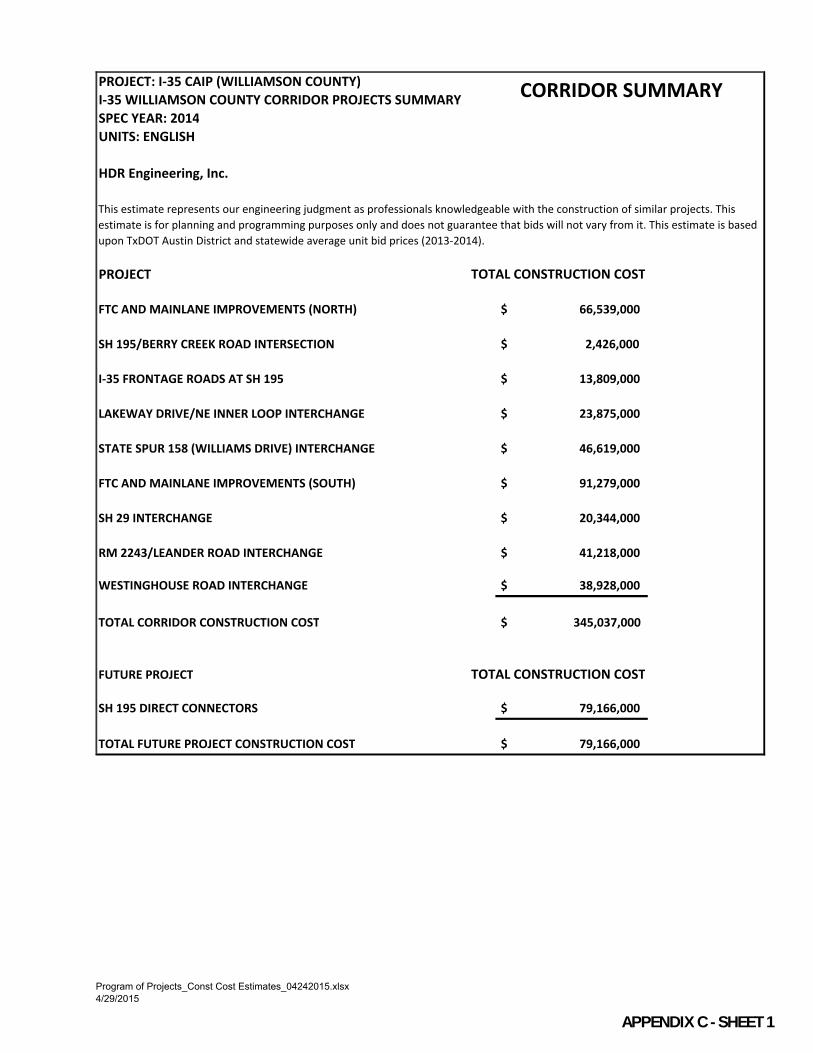
PROJECT: I-35 CAIP (WILLIAMSON COUNTY)
I-35 WILLIAMSON COUNTY CORRIDOR PROJECTS SUMMARY
SPEC YEAR: 2014
UNITS: ENGLISH
HDR Engineering, Inc.
PROJECT
FTC AND MAINLANE IMPROVEMENTS (NORTH) $ 66,539,000
SH 195/BERRY CREEK ROAD INTERSECTION $ 2,426,000
I-35 FRONTAGE ROADS AT SH 195 $ 13,809,000
LAKEWAY DRIVE/NE INNER LOOP INTERCHANGE $ 23,875,000
STATE SPUR 158 (WILLIAMS DRIVE) INTERCHANGE $ 46,619,000
FTC AND MAINLANE IMPROVEMENTS (SOUTH) $ 91,279,000
SH 29 INTERCHANGE $ 20,344,000
RM 2243/LEANDER ROAD INTERCHANGE $ 41,218,000
WESTINGHOUSE ROAD INTERCHANGE $ 38,928,000
TOTAL CORRIDOR CONSTRUCTION COST $ 345,037,000
FUTURE PROJECT
SH 195 DIRECT CONNECTORS $ 79,166,000
TOTAL FUTURE PROJECT CONSTRUCTION COST $ 79,166,000
CORRIDOR SUMMARY
This estimate represents our engineering judgment as professionals knowledgeable with the construction of similar projects. This
estimate is for planning and programming purposes only and does not guarantee that bids will not vary from it. This estimate is based
upon TxDOT Austin District and statewide average unit bid prices (2013-2014).
TOTAL CONSTRUCTION COST
TOTAL CONSTRUCTION COST
Program of Projects_Const Cost Estimates_04242015.xlsx
4/29/2015
APPENDIX C SHEET 1

PROJECT: I-35 CAIP (WILLIAMSON COUNTY)
SPEC YEAR: 2014
UNITS: ENGLISH
HDR Engineering, Inc.
DESCRIPTION
ITEMS ITEM DESCRIPTION UNIT UNIT PRICE QUANTITY COST
100 PREP ROW STA 2,000$ 309 618,000$
110 EXCAVATION (ROADWAY) CY 10.00$ 77,700 777,000$
132 EMBANKMENT CY 9.00$ 36,600 330,000$
260 LIME TREATMENT SY 3.00$ 161,300 484,000$
260 LIME TON 175$ 5,450 954,000$
340 D - GR HMA (SQ) TY - A TON 80$ 106,500 8,520,000$
340 D - GR HMA (SQ) TY - B TON 85$ 71,400 6,070,000$
340 D - GR HMA (SQ) TY - C TON 95$ 18,100 1,720,000$
340 D - GR HMA (SQ) TY - C (SURF) TON 110$ 34,800 3,830,000$
4XX BRIDGES (CONC) SF 80$ 35,300 2,830,000$
4XX BRIDGES (STEEL) SF 130$ - -$
354 PLANE ASPH CONC PAV SY 1.80$ 148,300 267,000$
423 RETAINING WALLS (MSE) SF 42$ - -$
432 RIPRAP (DRAINAGE CHANNEL) CY 350$ - -$
450 RAIL (TY SSTR) LF 55$ 10,860 598,000$
462 CONC BOX CULV LF -$ - -$
529 CONC CURB & GUTTER (TY II) LF 15$ - -$
531 CONC SIDEWALKS (5") SY 48$ - -$
536 CONC MEDIAN (RAISED MEDIAN) SY 55$ - -$
540 MBGF LF 20$ 6,900 138,000$
ITEMIZED COST SUBTOTAL 27,136,000$
UNIT PERCENTAGE COST
100 REMOVALS AND DEMOLITION % 5.0% - 1,360,000$
46X DRAINAGE % 10.0% - 2,720,000$
502 BARRICADES, SIGNS AND TRAFFIC HANDLING % 14.0% - 3,800,000$
666 PAVEMENT MARKINGS % 1.0% - 272,000$
6XX SIGNING % 5.0% - 1,360,000$
6XX TRAFFIC SIGNALS & LIGHTING % 5.0% - 1,360,000$
UTILITIES % 5.0% - 1,360,000$
PERCENTAGE BASED COST SUBTOTAL 12,232,000$
UNIT UNIT PRICE QUANTITY COST
MOBILIZATION % 10.0% - 3,937,000$ 1MISCELLANEOUS % 20.0% 7,874,000$
MISCELLANEOUS COST SUBTOTAL 11,811,000$
CONSTRUCTION COST SUBTOTAL 51,179,000$ 230% CONTINGENCY 15,360,000$
3TOTAL CONSTRUCTION COST 66,539,000$
NOTES
1. 20% has been added to account for miscellaneous items such as: ITS, SW3P; landscaping; irrigation; seeding; and aesthetics
2. 30% contingency was also included to account for planning level of detail.
3. Construction cost only. Right of Way and other Program costs are not included.
FTC AND MAINLANE IMPROVEMENTS (NORTH)
This estimate represents our engineering judgment as professionals knowledgeable with the construction of similar projects. This estimate is for planning
and programming purposes only and does not guarantee that bids will not vary from it.
This estimate is based upon TxDOT Austin District and statewide average unit bid prices (2013-2014).
I-35 CAIP
QUANTIFIED ITEMS
PERCENTAGE ITEMS
MISCELLANEOUS ITEMS
Mainlane widening to accommodate FTC; widen mainlane bridges at Dry Berry Creek, Berry Creek, and North Fork San Gabriel River; construct auxiliary
lanes.
LIMITS : 0.782 MI N OF DRY BERRY CREEK TO 0.833 MI S OF SS 158 (WILLIAMS DR)
Program of Projects_Const Cost Estimates_04242015.xlsx
4/29/2015
APPENDIX C SHEET 2

PROJECT: I-35 CAIP (WILLIAMSON COUNTY)
LIMITS : 0.149 MI W OF BERRY CREEK DR TO THE I-35 SOUTHBOUND FRONTAGE RD
SPEC YEAR: 2014
UNITS: ENGLISH
HDR Engineering, Inc.
DESCRIPTION
ITEMS ITEM DESCRIPTION UNIT UNIT PRICE QUANTITY COST
100 PREP ROW STA 2,000$ 26 52,000$
110 EXCAVATION (ROADWAY) CY 10.00$ 2,700 27,000$
132 EMBANKMENT CY 9.00$ 7,900 72,000$
260 LIME TREATMENT SY 3.00$ 6,000 18,000$
260 LIME TON 175$ 140 25,000$
340 D - GR HMA (SQ) TY - A TON 80$ 2,700 216,000$
340 D - GR HMA (SQ) TY - B TON 85$ 1,300 111,000$
340 D - GR HMA (SQ) TY - C TON 95$ 700 67,000$
340 D - GR HMA (SQ) TY - C (SURF) TON 110$ 800 88,000$
4XX BRIDGES (CONC) SF 80$ - -$
4XX BRIDGES (STEEL) SF 130$ - -$
354 PLANE ASPH CONC PAV SY 1.80$ 10,100 19,000$
423 RETAINING WALLS (MSE) SF 42$ - -$
432 RIPRAP (DRAINAGE CHANNEL) CY 350$ - -$
450 RAIL (TY SSTR) LF 55$ - -$
462 CONC BOX CULV LF -$ - -$
529 CONC CURB & GUTTER (TY II) LF 15$ 3,200 48,000$
531 CONC SIDEWALKS (5") SY 48$ 2,100 101,000$
536 CONC MEDIAN (RAISED MEDIAN) SY 55$ - -$
540 MBGF LF 20$ - -$
ITEMIZED COST SUBTOTAL 844,000$
UNIT PERCENTAGE COST
100 REMOVALS AND DEMOLITION % 5.0% - 43,000$
46X DRAINAGE % 10.0% - 85,000$
502 BARRICADES, SIGNS AND TRAFFIC HANDLING % 8.0% - 68,000$
666 PAVEMENT MARKINGS % 1.0% - 9,000$
6XX SIGNING % 5.0% - 43,000$
6XX TRAFFIC SIGNALS & LIGHTING LS - - 300,000$
UTILITIES % 5.0% - 43,000$
PERCENTAGE BASED COST SUBTOTAL 591,000$
UNIT UNIT PRICE QUANTITY COST
MOBILIZATION % 10.0% - 144,000$ 1MISCELLANEOUS % 20.0% 287,000$
MISCELLANEOUS COST SUBTOTAL 431,000$
CONSTRUCTION COST SUBTOTAL 1,866,000$ 230% CONTINGENCY 560,000$
3TOTAL CONSTRUCTION COST 2,426,000$
NOTES
1. 20% has been added to account for miscellaneous items such as: ITS, SW3P; landscaping; irrigation; seeding; and aesthetics
2. 30% contingency was also included to account for planning level of detail.
3. Construction cost only. Right of Way and other Program costs are not included.
SH 195/BERRY CREEK ROAD INTERSECTION
This estimate represents our engineering judgment as professionals knowledgeable with the construction of similar projects. This estimate is for planning
and programming purposes only and does not guarantee that bids will not vary from it.
This estimate is based upon TxDOT Austin District and statewide average unit bid prices (2013-2014).
I-35 CAIP
QUANTIFIED ITEMS
PERCENTAGE ITEMS
MISCELLANEOUS ITEMS
Improve SH 195/Berry Creek Drive intersection by constructing "high-T" intersection, added lanes, and install signals; construct bicycle and pedestrian
improvements.
Program of Projects_Const Cost Estimates_04242015.xlsx
4/29/2015
APPENDIX C SHEET 3

PROJECT: I-35 CAIP (WILLIAMSON COUNTY)
LIMITS : 0.311 MI N OF DRY BERRY CREEK TO 0.027 MI S OF BERRY CREEK
SPEC YEAR: 2014
UNITS: ENGLISH
HDR Engineering, Inc.
DESCRIPTIONWiden frontage roads; widen frontage road bridges; construct bicycle and pedestrian improvements.
ITEMS ITEM DESCRIPTION UNIT UNIT PRICE QUANTITY COST
100 PREP ROW STA 2,000$ 85 170,000$
110 EXCAVATION (ROADWAY) CY 10.00$ 7,500 75,000$
132 EMBANKMENT CY 9.00$ 28,500 257,000$
260 LIME TREATMENT SY 3.00$ 13,500 41,000$
260 LIME TON 175$ 320 56,000$
340 D - GR HMA (SQ) TY - A TON 80$ 6,300 504,000$
340 D - GR HMA (SQ) TY - B TON 85$ 3,300 281,000$
340 D - GR HMA (SQ) TY - C TON 95$ 1,500 143,000$
340 D - GR HMA (SQ) TY - C (SURF) TON 110$ 7,800 858,000$
4XX BRIDGES (CONC) SF 80$ 23,700 1,900,000$
4XX BRIDGES (STEEL) SF 130$ - -$
354 PLANE ASPH CONC PAV SY 1.80$ 55,900 101,000$
423 RETAINING WALLS (MSE) SF 42$ 8,670 365,000$
432 RIPRAP (DRAINAGE CHANNEL) CY 350$ - -$
450 RAIL (TY SSTR) LF 55$ - -$
462 CONC BOX CULV LF -$ - -$
529 CONC CURB & GUTTER (TY II) LF 15$ 23,900 359,000$
531 CONC SIDEWALKS (5") SY 48$ 14,200 682,000$
536 CONC MEDIAN (RAISED MEDIAN) SY 55$ 110 7,000$
540 MBGF LF 20$ 3,800 76,000$
ITEMIZED COST SUBTOTAL 5,875,000$
UNIT PERCENTAGE COST
100 REMOVALS AND DEMOLITION % 5.0% - 294,000$
46X DRAINAGE % 10.0% - 588,000$
502 BARRICADES, SIGNS AND TRAFFIC HANDLING % 8.0% - 470,000$
666 PAVEMENT MARKINGS % 1.0% - 59,000$
6XX SIGNING % 5.0% - 294,000$
6XX TRAFFIC SIGNALS & LIGHTING % 5.0% - 294,000$
UTILITIES % 5.0% - 294,000$
PERCENTAGE BASED COST SUBTOTAL 2,293,000$
UNIT UNIT PRICE QUANTITY COST
MOBILIZATION % 10.0% - 817,000$ 1MISCELLANEOUS % 20.0% 1,634,000$
MISCELLANEOUS COST SUBTOTAL 2,451,000$
CONSTRUCTION COST SUBTOTAL 10,619,000$ 230% CONTINGENCY 3,190,000$
3TOTAL CONSTRUCTION COST 13,809,000$
NOTES
1. 20% has been added to account for miscellaneous items such as: ITS, SW3P; landscaping; irrigation; seeding; and aesthetics
2. 30% contingency was also included to account for planning level of detail.
3. Construction cost only. Right of Way and other Program costs are not included.
I-35 FRONTAGE ROADS AT SH 195
This estimate represents our engineering judgment as professionals knowledgeable with the construction of similar projects. This estimate is for planning
and programming purposes only and does not guarantee that bids will not vary from it.
This estimate is based upon TxDOT Austin District and statewide average unit bid prices (2013-2014).
I-35 CAIP
QUANTIFIED ITEMS
PERCENTAGE ITEMS
MISCELLANEOUS ITEMS
Program of Projects_Const Cost Estimates_04242015.xlsx
4/29/2015
APPENDIX C SHEET 4

PROJECT: I-35 CAIP (WILLIAMSON COUNTY)
LIMITS: 0.027 MI S OF BERRY CREEK TO 0.402 S OF LAKEWAY DR
SPEC YEAR: 2014
UNITS: ENGLISH
HDR Engineering, Inc.
DESCRIPTION
ITEMS ITEM DESCRIPTION UNIT UNIT PRICE QUANTITY COST
100 PREP ROW STA 2,000$ 125 250,000$
110 EXCAVATION (ROADWAY) CY 10.00$ 33,800 338,000$
132 EMBANKMENT CY 9.00$ 31,100 280,000$
260 LIME TREATMENT SY 3.00$ 52,800 159,000$
260 LIME TON 175$ 1,300 228,000$
340 D - GR HMA (SQ) TY - A TON 80$ 25,600 2,050,000$
340 D - GR HMA (SQ) TY - B TON 85$ 13,800 1,180,000$
340 D - GR HMA (SQ) TY - C TON 95$ 5,900 561,000$
340 D - GR HMA (SQ) TY - C (SURF) TON 110$ 13,100 1,450,000$
4XX BRIDGES (CONC) SF 80$ 7,700 616,000$
4XX BRIDGES (STEEL) SF 130$ - -$
354 PLANE ASPH CONC PAV SY 1.80$ 83,600 151,000$
423 RETAINING WALLS (MSE) SF 42$ 5,700 240,000$
432 RIPRAP (DRAINAGE CHANNEL) CY 350$ - -$
450 RAIL (TY SSTR) LF 55$ 900 50,000$
462 CONC BOX CULV LF 600$ 440 264,000$
529 CONC CURB & GUTTER (TY II) LF 15$ 49,600 744,000$
531 CONC SIDEWALKS (5") SY 48$ 27,300 1,320,000$
536 CONC MEDIAN (RAISED MEDIAN) SY 55$ 3,600 198,000$
540 MBGF LF 20$ 4,000 80,000$
ITEMIZED COST SUBTOTAL 10,159,000$
UNIT PERCENTAGE COST
100 REMOVALS AND DEMOLITION % 5.0% - 508,000$
46X DRAINAGE % 10.0% - 1,020,000$
502 BARRICADES, SIGNS AND TRAFFIC HANDLING % 8.0% - 813,000$
666 PAVEMENT MARKINGS % 1.0% - 102,000$
6XX SIGNING % 5.0% - 508,000$
6XX TRAFFIC SIGNALS & LIGHTING % 5.0% - 508,000$
UTILITIES % 5.0% - 508,000$
PERCENTAGE BASED COST SUBTOTAL 3,967,000$
UNIT UNIT PRICE QUANTITY COST
MOBILIZATION % 10.0% - 1,413,000$ 1MISCELLANEOUS % 20.0% 2,826,000$
MISCELLANEOUS COST SUBTOTAL 4,239,000$
CONSTRUCTION COST SUBTOTAL 18,365,000$ 230% CONTINGENCY 5,510,000$
3TOTAL CONSTRUCTION COST 23,875,000$
NOTES
1. 20% has been added to account for miscellaneous items such as: ITS, SW3P; landscaping; irrigation; seeding; and aesthetics
2. 30% contingency was also included to account for planning level of detail.
3. Construction cost only. Right of Way and other Program costs are not included.
LAKEWAY DRIVE/NE INNER LOOP INTERCHANGE
This estimate represents our engineering judgment as professionals knowledgeable with the construction of similar projects. This estimate is for planning
and programming purposes only and does not guarantee that bids will not vary from it.
This estimate is based upon TxDOT Austin District and statewide average unit bid prices (2013-2014).
I-35 CAIP
QUANTIFIED ITEMS
PERCENTAGE ITEMS
MISCELLANEOUS ITEMS
Widen Lakeway/NE Inner Loop underpass to construct conventional interchange; relocate Austin Ave.; widen frontage roads; construct mainlane and
frontage road auxiliary lanes; reverse ramps; construct bicycle and pedestrian improvements.
Program of Projects_Const Cost Estimates_04242015.xlsx
4/29/2015
APPENDIX C SHEET 5
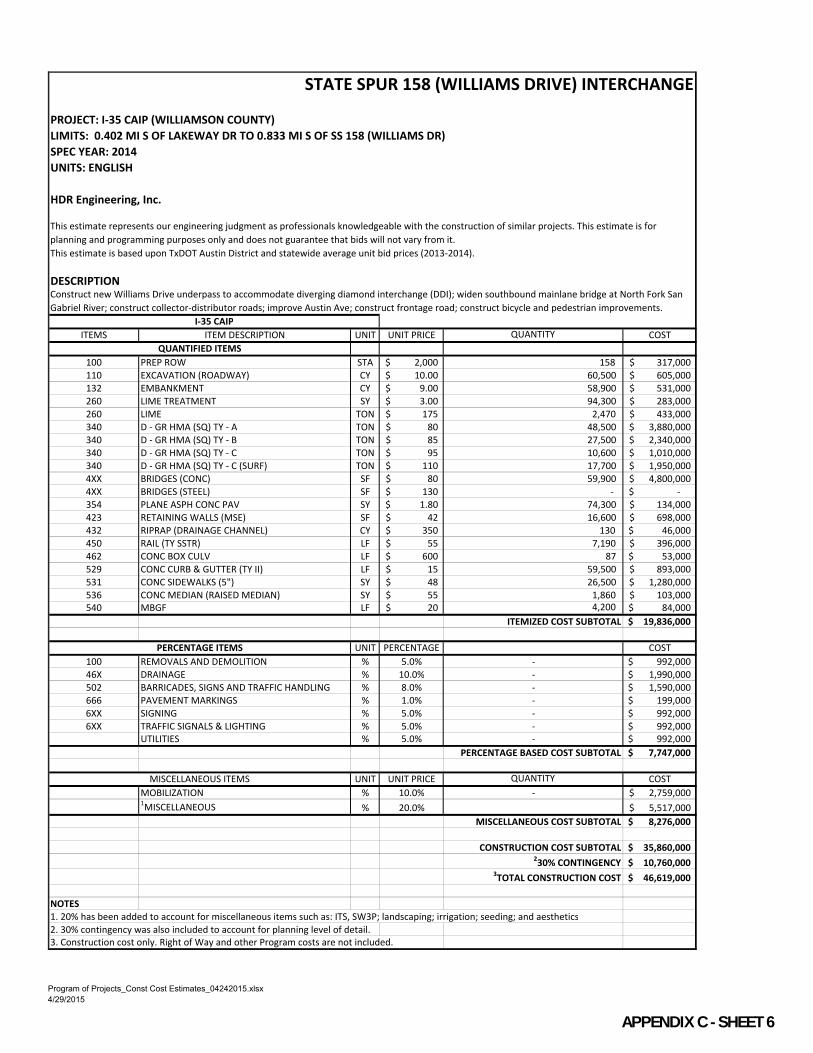
PROJECT: I-35 CAIP (WILLIAMSON COUNTY)
LIMITS: 0.402 MI S OF LAKEWAY DR TO 0.833 MI S OF SS 158 (WILLIAMS DR)
SPEC YEAR: 2014
UNITS: ENGLISH
HDR Engineering, Inc.
DESCRIPTION
ITEMS ITEM DESCRIPTION UNIT UNIT PRICE QUANTITY COST
100 PREP ROW STA 2,000$ 158 317,000$
110 EXCAVATION (ROADWAY) CY 10.00$ 60,500 605,000$
132 EMBANKMENT CY 9.00$ 58,900 531,000$
260 LIME TREATMENT SY 3.00$ 94,300 283,000$
260 LIME TON 175$ 2,470 433,000$
340 D - GR HMA (SQ) TY - A TON 80$ 48,500 3,880,000$
340 D - GR HMA (SQ) TY - B TON 85$ 27,500 2,340,000$
340 D - GR HMA (SQ) TY - C TON 95$ 10,600 1,010,000$
340 D - GR HMA (SQ) TY - C (SURF) TON 110$ 17,700 1,950,000$
4XX BRIDGES (CONC) SF 80$ 59,900 4,800,000$
4XX BRIDGES (STEEL) SF 130$ - -$
354 PLANE ASPH CONC PAV SY 1.80$ 74,300 134,000$
423 RETAINING WALLS (MSE) SF 42$ 16,600 698,000$
432 RIPRAP (DRAINAGE CHANNEL) CY 350$ 130 46,000$
450 RAIL (TY SSTR) LF 55$ 7,190 396,000$
462 CONC BOX CULV LF 600$ 87 53,000$
529 CONC CURB & GUTTER (TY II) LF 15$ 59,500 893,000$
531 CONC SIDEWALKS (5") SY 48$ 26,500 1,280,000$
536 CONC MEDIAN (RAISED MEDIAN) SY 55$ 1,860 103,000$
540 MBGF LF 20$ 4,200 84,000$
ITEMIZED COST SUBTOTAL 19,836,000$
UNIT PERCENTAGE COST
100 REMOVALS AND DEMOLITION % 5.0% - 992,000$
46X DRAINAGE % 10.0% - 1,990,000$
502 BARRICADES, SIGNS AND TRAFFIC HANDLING % 8.0% - 1,590,000$
666 PAVEMENT MARKINGS % 1.0% - 199,000$
6XX SIGNING % 5.0% - 992,000$
6XX TRAFFIC SIGNALS & LIGHTING % 5.0% - 992,000$
UTILITIES % 5.0% - 992,000$
PERCENTAGE BASED COST SUBTOTAL 7,747,000$
UNIT UNIT PRICE QUANTITY COST
MOBILIZATION % 10.0% - 2,759,000$ 1MISCELLANEOUS % 20.0% 5,517,000$
MISCELLANEOUS COST SUBTOTAL 8,276,000$
CONSTRUCTION COST SUBTOTAL 35,860,000$ 230% CONTINGENCY 10,760,000$
3TOTAL CONSTRUCTION COST 46,619,000$
NOTES
1. 20% has been added to account for miscellaneous items such as: ITS, SW3P; landscaping; irrigation; seeding; and aesthetics
2. 30% contingency was also included to account for planning level of detail.
3. Construction cost only. Right of Way and other Program costs are not included.
STATE SPUR 158 (WILLIAMS DRIVE) INTERCHANGE
This estimate represents our engineering judgment as professionals knowledgeable with the construction of similar projects. This estimate is for
planning and programming purposes only and does not guarantee that bids will not vary from it.
This estimate is based upon TxDOT Austin District and statewide average unit bid prices (2013-2014).
I-35 CAIP
QUANTIFIED ITEMS
PERCENTAGE ITEMS
MISCELLANEOUS ITEMS
Construct new Williams Drive underpass to accommodate diverging diamond interchange (DDI); widen southbound mainlane bridge at North Fork San
Gabriel River; construct collector-distributor roads; improve Austin Ave; construct frontage road; construct bicycle and pedestrian improvements.
Program of Projects_Const Cost Estimates_04242015.xlsx
4/29/2015
APPENDIX C SHEET 6

PROJECT: I-35 CAIP (WILLIAMSON COUNTY)
LIMITS: 0.833 MI S OF SS 158 (WILLIAMS DR) TO 0.080 MI S OF RM 1431
SPEC YEAR: 2014
UNITS: ENGLISH
HDR Engineering, Inc.
DESCRIPTION
ITEMS ITEM DESCRIPTION UNIT UNIT PRICE QUANTITY COST
100 PREP ROW STA 2,000$ 311 621,000$
110 EXCAVATION (ROADWAY) CY 10.00$ 97,100 971,000$
132 EMBANKMENT CY 9.00$ 105,200 947,000$
260 LIME TREATMENT SY 3.00$ 148,900 447,000$
260 LIME TON 175$ 5,020 879,000$
340 D - GR HMA (SQ) TY - A TON 80$ 98,300 7,870,000$
340 D - GR HMA (SQ) TY - B TON 85$ 65,800 5,600,000$
340 D - GR HMA (SQ) TY - C TON 95$ 16,700 1,590,000$
340 D - GR HMA (SQ) TY - C (SURF) TON 110$ 50,400 5,550,000$
4XX BRIDGES (CONC) SF 80$ 150,000 12,000,000$
4XX BRIDGES (STEEL) SF 130$ - -$
354 PLANE ASPH CONC PAV SY 1.80$ 299,900 540,000$
423 RETAINING WALLS (MSE) SF 42$ - -$
432 RIPRAP (DRAINAGE CHANNEL) CY 350$ - -$
450 RAIL (TY SSTR) LF 55$ - -$
462 CONC BOX CULV LF -$ - -$
529 CONC CURB & GUTTER (TY II) LF 15$ - -$
531 CONC SIDEWALKS (5") SY 48$ - -$
536 CONC MEDIAN (RAISED MEDIAN) SY 55$ - -$
540 MBGF LF 20$ 9,900 198,000$
ITEMIZED COST SUBTOTAL 37,213,000$
UNIT PERCENTAGE COST
100 REMOVALS AND DEMOLITION % 5.0% - 1,870,000$
46X DRAINAGE % 10.0% - 3,730,000$
502 BARRICADES, SIGNS AND TRAFFIC HANDLING % 14.0% - 5,210,000$
666 PAVEMENT MARKINGS % 1.0% - 373,000$
6XX SIGNING % 5.0% - 1,870,000$
6XX TRAFFIC SIGNALS & LIGHTING % 5.0% - 1,870,000$
UTILITIES % 5.0% - 1,870,000$
PERCENTAGE BASED COST SUBTOTAL 16,793,000$
UNIT UNIT PRICE QUANTITY COST
MOBILIZATION % 10.0% - 5,401,000$ 1MISCELLANEOUS % 20.0% 10,802,000$
MISCELLANEOUS COST SUBTOTAL 16,203,000$
CONSTRUCTION COST SUBTOTAL 70,209,000$ 230% CONTINGENCY 21,070,000$
3TOTAL CONSTRUCTION COST 91,279,000$
NOTES
1. 20% has been added to account for miscellaneous items such as: ITS, SW3P; landscaping; irrigation; seeding; and aesthetics
2. 30% contingency was also included to account for planning level of detail.
3. Construction cost only. Right of Way and other Program costs are not included.
FTC AND MAINLANE IMPROVEMENTS (SOUTH)
This estimate represents our engineering judgment as professionals knowledgeable with the construction of similar projects. This estimate is for planning
and programming purposes only and does not guarantee that bids will not vary from it.
This estimate is based upon TxDOT Austin District and statewide average unit bid prices (2013-2014).
I-35 CAIP
QUANTIFIED ITEMS
PERCENTAGE ITEMS
MISCELLANEOUS ITEMS
Mainlane widening to accommodate FTC; reconstruct mainlane bridges at SE Inner Loop; construct auxiliary lanes; widen mainlane bridges at South Fork
San Gabriel River.
Program of Projects_Const Cost Estimates_04242015.xlsx
4/29/2015
APPENDIX C SHEET 7

PROJECT: I-35 CAIP (WILLIAMSON COUNTY)
LIMITS: 0.833 MI S OF SS 158 (WILLIAMS DR) TO 0.549 MI S OF SH 29
SPEC YEAR: 2014
UNITS: ENGLISH
HDR Engineering, Inc.
DESCRIPTION
ITEMS ITEM DESCRIPTION UNIT UNIT PRICE QUANTITY COST
100 PREP ROW STA 2,000$ 88 177,000$
110 EXCAVATION (ROADWAY) CY 10.00$ 25,900 259,000$
132 EMBANKMENT CY 9.00$ 15,700 142,000$
260 LIME TREATMENT SY 3.00$ 25,300 76,000$
260 LIME TON 175$ 640 112,000$
340 D - GR HMA (SQ) TY - A TON 80$ 12,500 1,000,000$
340 D - GR HMA (SQ) TY - B TON 85$ 6,900 587,000$
340 D - GR HMA (SQ) TY - C TON 95$ 2,800 266,000$
340 D - GR HMA (SQ) TY - C (SURF) TON 110$ 8,500 935,000$
4XX BRIDGES (CONC) SF 80$ 36,100 2,890,000$
4XX BRIDGES (STEEL) SF 130$ - -$
354 PLANE ASPH CONC PAV SY 1.80$ 64,000 116,000$
423 RETAINING WALLS (MSE) SF 42$ 12,930 544,000$
432 RIPRAP (DRAINAGE CHANNEL) CY 350$ - -$
450 RAIL (TY SSTR) LF 55$ 900 50,000$
462 CONC BOX CULV LF -$ - -$
529 CONC CURB & GUTTER (TY II) LF 15$ 29,700 446,000$
531 CONC SIDEWALKS (5") SY 48$ 17,600 845,000$
536 CONC MEDIAN (RAISED MEDIAN) SY 55$ 3,480 192,000$
540 MBGF LF 20$ 1,100 22,000$
ITEMIZED COST SUBTOTAL 8,659,000$
UNIT PERCENTAGE COST
100 REMOVALS AND DEMOLITION % 5.0% - 433,000$
46X DRAINAGE % 10.0% - 866,000$
502 BARRICADES, SIGNS AND TRAFFIC HANDLING % 8.0% - 693,000$
666 PAVEMENT MARKINGS % 1.0% - 87,000$
6XX SIGNING % 5.0% - 433,000$
6XX TRAFFIC SIGNALS & LIGHTING % 5.0% - 433,000$
UTILITIES % 5.0% - 433,000$
PERCENTAGE BASED COST SUBTOTAL 3,378,000$
UNIT UNIT PRICE QUANTITY COST
MOBILIZATION % 10.0% - 1,204,000$ 1MISCELLANEOUS % 20.0% 2,408,000$
MISCELLANEOUS COST SUBTOTAL 3,612,000$
CONSTRUCTION COST SUBTOTAL 15,650,000$ 230% CONTINGENCY 4,695,000$
3TOTAL CONSTRUCTION COST 20,344,000$
NOTES
1. 20% has been added to account for miscellaneous items such as: ITS, SW3P; landscaping; irrigation; seeding; and aesthetics
2. 30% contingency was also included to account for planning level of detail.
3. Construction cost only. Right of Way and other Program costs are not included.
SH 29 INTERCHANGE
This estimate represents our engineering judgment as professionals knowledgeable with the construction of similar projects. This estimate is for planning
and programming purposes only and does not guarantee that bids will not vary from it.
This estimate is based upon TxDOT Austin District and statewide average unit bid prices (2013-2014).
I-35 CAIP
QUANTIFIED ITEMS
PERCENTAGE ITEMS
MISCELLANEOUS ITEMS
Replace SH 29 underpass; construct new conventional interchange; improve frontage roads; reverse ramps; construct bicycle and pedestrian facilities.
Program of Projects_Const Cost Estimates_04242015.xlsx
4/29/2015
APPENDIX C SHEET 8

PROJECT: I-35 CAIP (WILLIAMSON COUNTY)
LIMITS: 0.549 MI S OF SH 29 TO 1.229 MI N OF WESTINGHOUSE RD
SPEC YEAR: 2014
UNITS: ENGLISH
HDR Engineering, Inc.
DESCRIPTION
ITEMS ITEM DESCRIPTION UNIT UNIT PRICE QUANTITY COST
100 PREP ROW STA 2,000$ 115 230,000$
110 EXCAVATION (ROADWAY) CY 10.00$ 36,400 364,000$
132 EMBANKMENT CY 9.00$ 358,400 3,230,000$
260 LIME TREATMENT SY 3.00$ 64,900 195,000$
260 LIME TON 175$ 1,640 287,000$
340 D - GR HMA (SQ) TY - A TON 80$ 32,200 2,580,000$
340 D - GR HMA (SQ) TY - B TON 85$ 17,700 1,510,000$
340 D - GR HMA (SQ) TY - C TON 95$ 7,300 694,000$
340 D - GR HMA (SQ) TY - C (SURF) TON 110$ 11,300 1,250,000$
4XX BRIDGES (CONC) SF 80$ 42,500 3,400,000$
4XX BRIDGES (STEEL) SF 130$ - -$
354 PLANE ASPH CONC PAV SY 1.80$ 49,200 89,000$
423 RETAINING WALLS (MSE) SF 42$ 23,350 981,000$
432 RIPRAP (DRAINAGE CHANNEL) CY 350$ - -$
450 RAIL (TY SSTR) LF 55$ 900 50,000$
462 CONC BOX CULV LF 600$ 438 263,000$
529 CONC CURB & GUTTER (TY II) LF 15$ 44,700 671,000$
531 CONC SIDEWALKS (5") SY 48$ 31,400 1,510,000$
536 CONC MEDIAN (RAISED MEDIAN) SY 55$ 2,680 148,000$
540 MBGF LF 20$ 5,800 116,000$
ITEMIZED COST SUBTOTAL 17,568,000$
UNIT PERCENTAGE COST
100 REMOVALS AND DEMOLITION % 5.0% - 879,000$
46X DRAINAGE % 10.0% - 1,760,000$
502 BARRICADES, SIGNS AND TRAFFIC HANDLING % 8.0% - 1,410,000$
666 PAVEMENT MARKINGS % 1.0% - 176,000$
6XX SIGNING % 5.0% - 879,000$
6XX TRAFFIC SIGNALS & LIGHTING % 5.0% - 879,000$
UTILITIES % 5.0% - 879,000$
PERCENTAGE BASED COST SUBTOTAL 6,862,000$
UNIT UNIT PRICE QUANTITY COST
MOBILIZATION % 10.0% - 2,443,000$ 1MISCELLANEOUS % 20.0% 4,886,000$
MISCELLANEOUS COST SUBTOTAL 7,329,000$
CONSTRUCTION COST SUBTOTAL 31,530,000$ 230% CONTINGENCY 9,459,000$
3TOTAL CONSTRUCTION COST 41,218,000$
NOTES
1. 20% has been added to account for miscellaneous items such as: ITS, SW3P; landscaping; irrigation; seeding; and aesthetics
2. 30% contingency was also included to account for planning level of detail.
3. Construction cost only. Right of Way and other Program costs are not included.
RM 2243/LEANDER ROAD INTERCHANGE
This estimate represents our engineering judgment as professionals knowledgeable with the construction of similar projects. This estimate is for
planning and programming purposes only and does not guarantee that bids will not vary from it.
This estimate is based upon TxDOT Austin District and statewide average unit bid prices (2013-2014).
I-35 CAIP
QUANTIFIED ITEMS
PERCENTAGE ITEMS
MISCELLANEOUS ITEMS
Replace RM 2243/Leander Road underpass; construct new continuous flow interchange (CFI); construct turnaround; improve frontage roads and SE
Inner Loop crossing; reverse ramps; construct bicycle and pedestrian facilities.
Program of Projects_Const Cost Estimates_04242015.xlsx
4/29/2015
APPENDIX C SHEET 9

PROJECT: I-35 CAIP (WILLIAMSON COUNTY)
LIMITS: 1.229 MI N OF WESTINGHOUSE RD TO 0.080 MI S OF RM 1431
SPEC YEAR: 2014
UNITS: ENGLISH
HDR Engineering, Inc.
DESCRIPTION
ITEMS ITEM DESCRIPTION UNIT UNIT PRICE QUANTITY COST
100 PREP ROW STA 2,000$ 157 313,000$
110 EXCAVATION (ROADWAY) CY 10.00$ 26,500 265,000$
132 EMBANKMENT CY 9.00$ 109,100 982,000$
260 LIME TREATMENT SY 3.00$ 70,100 211,000$
260 LIME TON 175$ 1,830 321,000$
340 D - GR HMA (SQ) TY - A TON 80$ 35,800 2,870,000$
340 D - GR HMA (SQ) TY - B TON 85$ 20,200 1,720,000$
340 D - GR HMA (SQ) TY - C TON 95$ 7,900 751,000$
340 D - GR HMA (SQ) TY - C (SURF) TON 110$ 16,800 1,850,000$
4XX BRIDGES (CONC) SF 80$ 36,900 2,960,000$
4XX BRIDGES (STEEL) SF 130$ - -$
354 PLANE ASPH CONC PAV SY 1.80$ 82,000 148,000$
423 RETAINING WALLS (MSE) SF 42$ 13,880 583,000$
432 RIPRAP (DRAINAGE CHANNEL) CY 350$ 160 56,000$
450 RAIL (TY SSTR) LF 55$ 900 50,000$
462 CONC BOX CULV LF 600$ 1,440 864,000$
529 CONC CURB & GUTTER (TY II) LF 15$ 53,400 801,000$
531 CONC SIDEWALKS (5") SY 48$ 35,100 1,690,000$
536 CONC MEDIAN (RAISED MEDIAN) SY 55$ 170 10,000$
540 MBGF LF 20$ 5,500 110,000$
ITEMIZED COST SUBTOTAL 16,555,000$
UNIT PERCENTAGE COST
100 REMOVALS AND DEMOLITION % 5.0% - 828,000$
46X DRAINAGE % 10.0% - 1,660,000$
502 BARRICADES, SIGNS AND TRAFFIC HANDLING % 8.0% - 1,330,000$
666 PAVEMENT MARKINGS % 1.0% - 166,000$
6XX SIGNING % 5.0% - 828,000$
6XX TRAFFIC SIGNALS & LIGHTING % 5.0% - 828,000$
UTILITIES % 5.0% - 828,000$
PERCENTAGE BASED COST SUBTOTAL 6,468,000$
UNIT UNIT PRICE COST
MOBILIZATION % 10.0% - 2,310,000$ 1MISCELLANEOUS % 20.0% 4,610,000$
MISCELLANEOUS COST SUBTOTAL 6,920,000$
CONSTRUCTION COST SUBTOTAL 29,950,000$ 230% CONTINGENCY 8,985,000$
3TOTAL CONSTRUCTION COST 38,928,000$
NOTES
1. 20% has been added to account for miscellaneous items such as: ITS, SW3P; landscaping; irrigation; seeding; and aesthetics
2. 30% contingency was also included to account for planning level of detail.
3. Construction cost only. Right of Way and other Program costs are not included.
WESTINGHOUSE ROAD INTERCHANGE
This estimate represents our engineering judgment as professionals knowledgeable with the construction of similar projects. This estimate is for
planning and programming purposes only and does not guarantee that bids will not vary from it.
This estimate is based upon TxDOT Austin District and statewide average unit bid prices (2013-2014).
I-35 CAIP
QUANTIFIED ITEMS
PERCENTAGE ITEMS
MISCELLANEOUS ITEMS
Replace Westinghouse Road underpass; construct new conventional interchange; construct turnaround; improve frontage roads; reverse ramps;
construct bicycle and pedestrian facilities.
Program of Projects_Const Cost Estimates_04242015.xlsx
4/29/2015
APPENDIX C SHEET 10

PROJECT: I-35 CAIP (WILLIAMSON COUNTY)
LIMITS: 0.249 MI W OF BERRY CREEK DR TO 0.070 MI N OF BERRY CREEK
SPEC YEAR: 2014
UNITS: ENGLISH
HDR Engineering, Inc.
DESCRIPTIONConstruct Direct Connectors between I-35 and SH 195.
ITEMS ITEM DESCRIPTION UNIT UNIT PRICE QUANTITY COST
100 PREP ROW STA 2,000$ 55 110,000$
110 EXCAVATION (ROADWAY) CY 10.00$ 15,500 155,000$
132 EMBANKMENT CY 9.00$ 63,100 568,000$
260 LIME TREATMENT SY 3.00$ 23,300 70,000$
260 LIME TON 175$ 790 139,000$
340 D - GR HMA (SQ) TY - A TON 80$ 15,400 1,240,000$
340 D - GR HMA (SQ) TY - B TON 85$ 10,300 876,000$
340 D - GR HMA (SQ) TY - C TON 95$ 2,600 247,000$
340 D - GR HMA (SQ) TY - C (SURF) TON 110$ 3,400 374,000$
4XX BRIDGES (CONC) SF 80$ - -$
4XX BRIDGES (STEEL) SF 130$ 217,274 28,250,000$
354 PLANE ASPH CONC PAV SY 1.80$ 23,282 42,000$
423 RETAINING WALLS (MSE) SF 42$ 27,140 1,140,000$
432 RIPRAP (DRAINAGE CHANNEL) CY 350$ - -$
450 RAIL (TY SSTR) LF 55$ 5,590 308,000$
462 CONC BOX CULV LF -$ - -$
529 CONC CURB & GUTTER (TY II) LF 15$ 9,300 140,000$
531 CONC SIDEWALKS (5") SY 48$ - -$
536 CONC MEDIAN (RAISED MEDIAN) SY 55$ 290 16,000$
540 MBGF LF 20$ - -$
ITEMIZED COST SUBTOTAL 33,675,000$
UNIT PERCENTAGE COST
100 REMOVALS AND DEMOLITION % 5.0% - 1,690,000$
46X DRAINAGE % 10.0% - 3,370,000$
502 BARRICADES, SIGNS AND TRAFFIC HANDLING % 8.0% - 2,700,000$
666 PAVEMENT MARKINGS % 1.0% - 337,000$
6XX SIGNING % 5.0% - 1,690,000$
6XX TRAFFIC SIGNALS & LIGHTING % 5.0% - 1,690,000$
UTILITIES % 5.0% - 1,690,000$
PERCENTAGE BASED COST SUBTOTAL 13,167,000$
UNIT UNIT PRICE QUANTITY COST
MOBILIZATION % 10.0% - 4,685,000$ 1MISCELLANEOUS % 20.0% 9,369,000$
MISCELLANEOUS COST SUBTOTAL 14,054,000$
CONSTRUCTION COST SUBTOTAL 60,896,000$ 230% CONTINGENCY 18,270,000$
3TOTAL CONSTRUCTION COST 79,166,000$
NOTES
1. 20% has been added to account for miscellaneous items such as: ITS, SW3P; landscaping; irrigation; seeding; and aesthetics
2. 30% contingency was also included to account for planning level of detail.
3. Construction cost only. Right of Way and other Program costs are not included.
SH 195 DIRECT CONNECTORS
This estimate represents our engineering judgment as professionals knowledgeable with the construction of similar projects. This estimate is for planning
and programming purposes only and does not guarantee that bids will not vary from it.
This estimate is based upon TxDOT Austin District and statewide average unit bid prices (2013-2014).
I-35 CAIP
QUANTIFIED ITEMS
PERCENTAGE ITEMS
MISCELLANEOUS ITEMS
Program of Projects_Const Cost Estimates_04242015.xlsx
4/29/2015
APPENDIX C SHEET 11