i. global winds and ocean currents. a. origin of ocean currents 1.drag exerted by winds flowing...
TRANSCRIPT
I. Global Winds and Ocean I. Global Winds and Ocean CurrentsCurrents
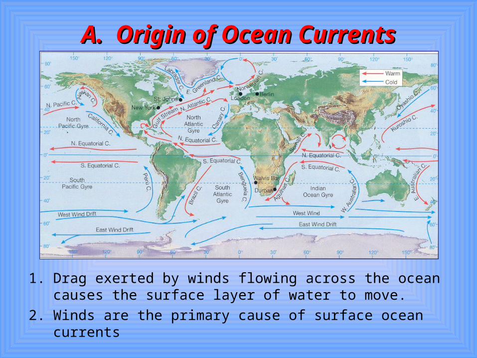
A. Origin of Ocean CurrentsA. Origin of Ocean Currents
1. Drag exerted by winds flowing across the ocean causes the surface layer of water to move.
2. Winds are the primary cause of surface ocean currents
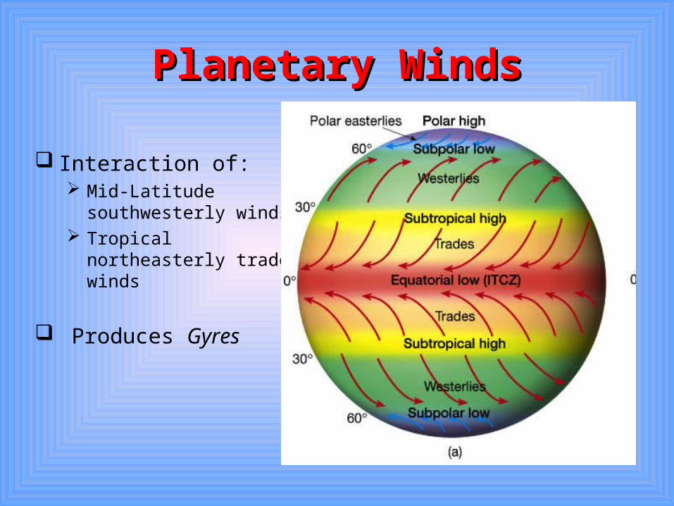
Planetary WindsPlanetary Winds
Interaction of: Mid-Latitude
southwesterly winds Tropical northeasterly
trade winds
Produces Gyres
B. Relationship Between B. Relationship Between Oceanic Circulation and Oceanic Circulation and
General Atmospheric General Atmospheric CirculationCirculation
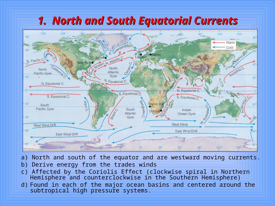
1. North and South Equatorial Currents1. North and South Equatorial Currents
a) North and south of the equator and are westward moving currents.b) Derive energy from the trades windsc) Affected by the Coriolis Effect (clockwise spiral in Northern Hemisphere and
counterclockwise in the Southern Hemisphere)d) Found in each of the major ocean basins and centered around the
subtropical high pressure systems.
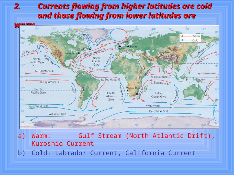
2.2. Currents flowing from higher latitudes are cold Currents flowing from higher latitudes are cold and those flowing from lower latitudes are warm.and those flowing from lower latitudes are warm.
a) Warm: Gulf Stream (North Atlantic Drift), Kuroshio Current
b) Cold: Labrador Current, California Current
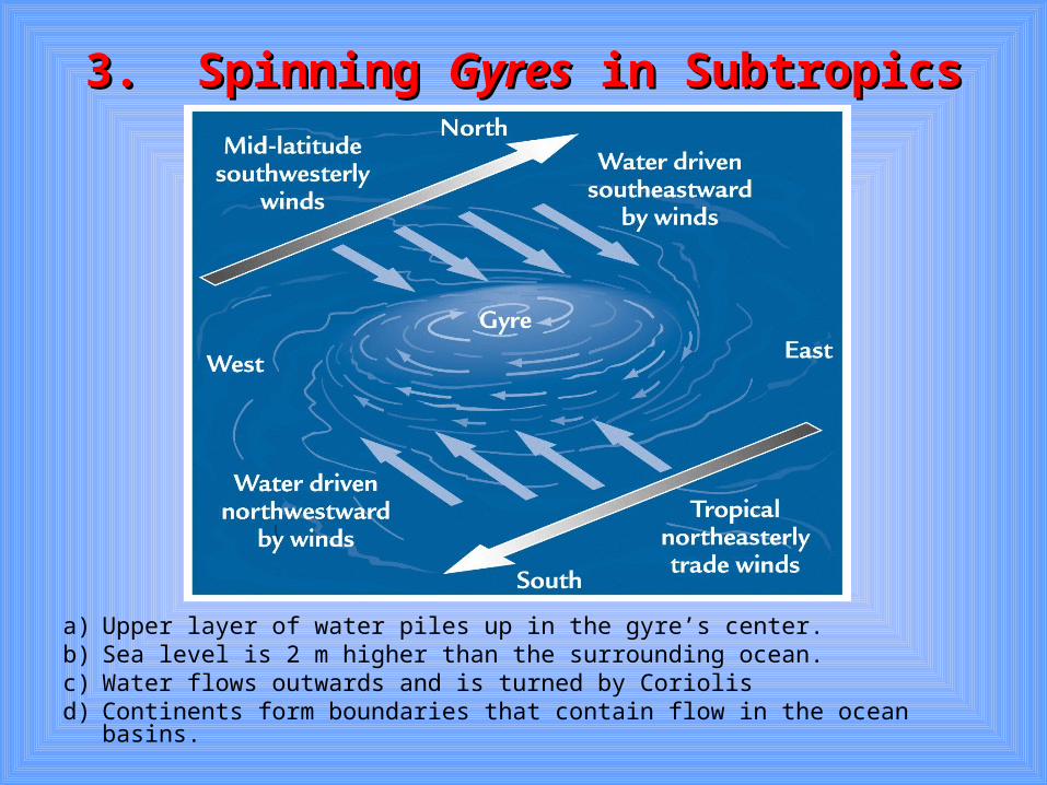
3. Spinning 3. Spinning GyresGyres in Subtropics in Subtropics
a) Upper layer of water piles up in the gyre’s center.b) Sea level is 2 m higher than the surrounding ocean.c) Water flows outwards and is turned by Coriolisd) Continents form boundaries that contain flow in the ocean basins.
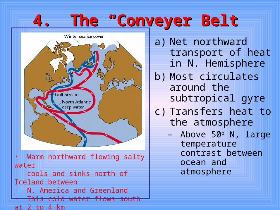
4. The “Conveyer Belt4. The “Conveyer Belt”a) Net northward
transport of heat in N. Hemisphere
b) Most circulates around the subtropical gyre
c) Transfers heat to the atmosphere– Above 50o N, large
temperature contrast between ocean and atmosphere
• Warm northward flowing salty water cools and sinks north of Iceland between N. America and Greenland• This cold water flows south at 2 to 4 km depths.
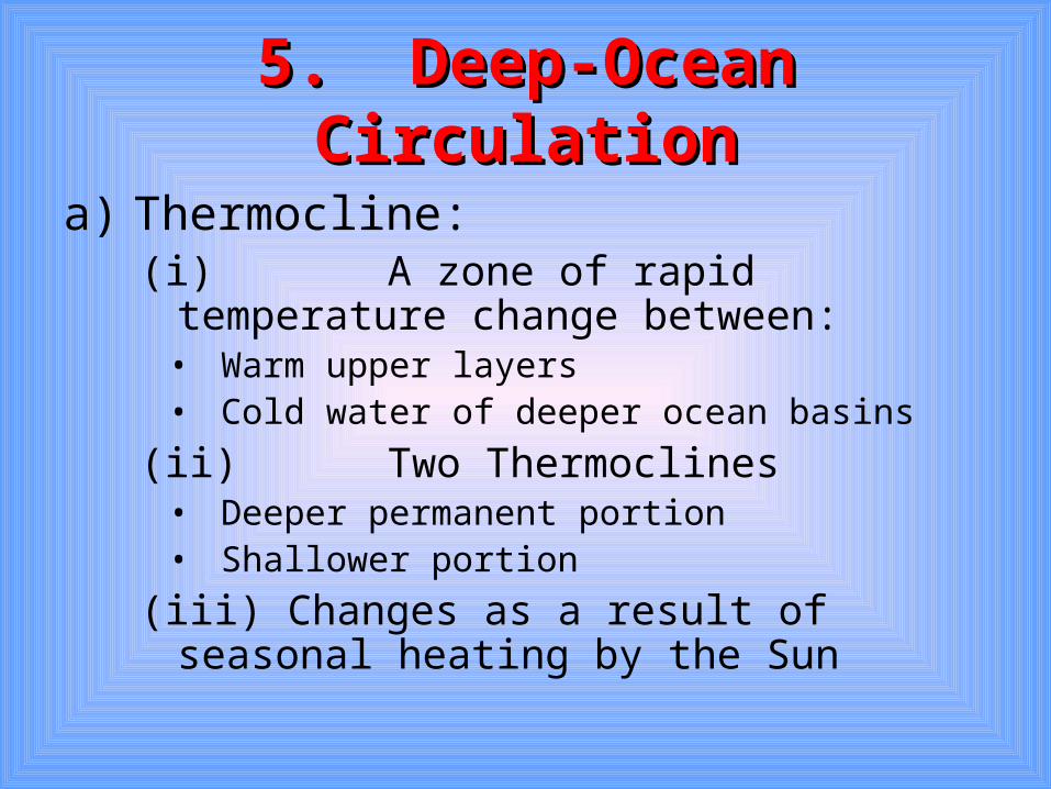
5. Deep-Ocean Circulation5. Deep-Ocean Circulation
a) Thermocline: (i) A zone of rapid temperature change
between:• Warm upper layers• Cold water of deeper ocean basins
(ii)Two Thermoclines• Deeper permanent portion• Shallower portion
(iii) Changes as a result of seasonal heating by the Sun
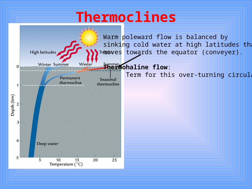
ThermoclinesWarm poleward flow is balanced by sinking cold water at high latitudes thatmoves towards the equator (conveyer).
Thermohaline flow: Term for this over-turning circulation
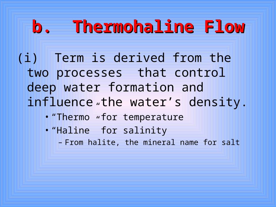
b. Thermohaline Flowb. Thermohaline Flow
(i) Term is derived from the two processes that control deep water formation and influence the water’s density.
• “Thermo” for temperature• “Haline” for salinity
– From halite, the mineral name for salt
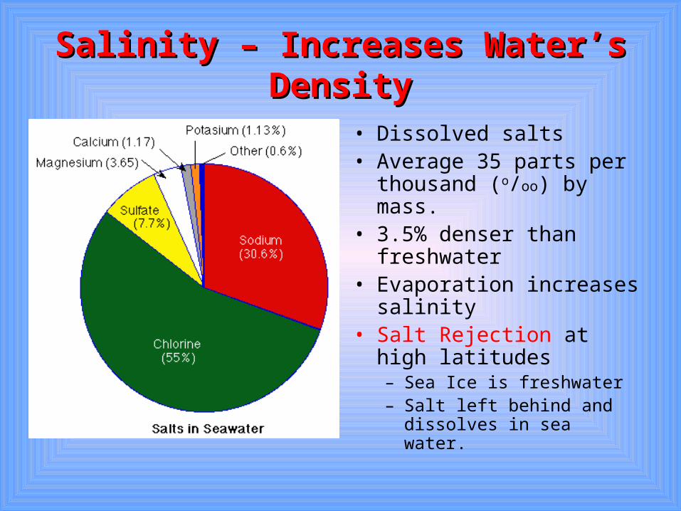
Salinity – Increases Water’s DensitySalinity – Increases Water’s Density
• Dissolved salts• Average 35 parts per
thousand (o/oo) by mass.• 3.5% denser than
freshwater• Evaporation increases
salinity• Salt Rejection at high
latitudes– Sea Ice is freshwater– Salt left behind and
dissolves in sea water.
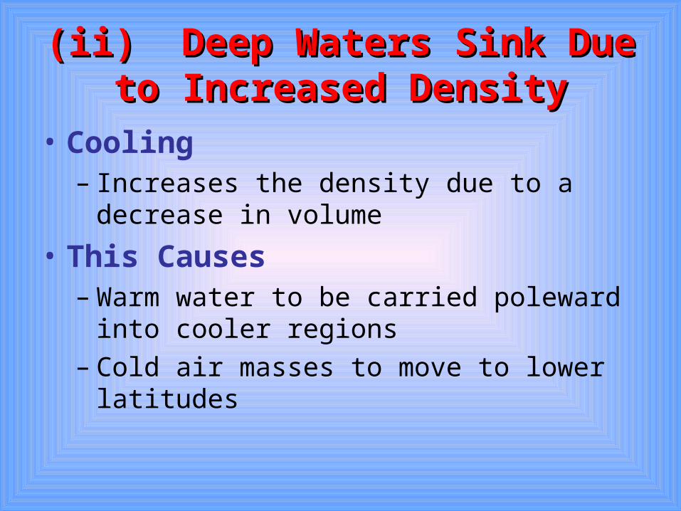
(ii)(ii) Deep Waters Sink Due to Deep Waters Sink Due to Increased DensityIncreased Density
• Cooling– Increases the density due to a decrease in
volume
• This Causes– Warm water to be carried poleward into cooler
regions– Cold air masses to move to lower latitudes
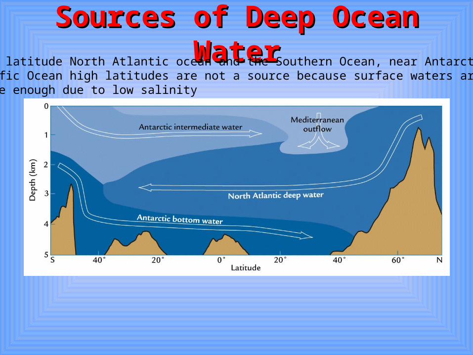
Sources of Deep Ocean WaterSources of Deep Ocean Water• High latitude North Atlantic ocean and the Southern Ocean, near Antarctica• Pacific Ocean high latitudes are not a source because surface waters are not dense enough due to low salinity
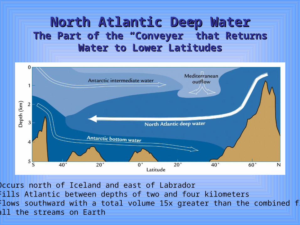
North Atlantic Deep WaterNorth Atlantic Deep WaterThe Part of the “Conveyer” that Returns Water to The Part of the “Conveyer” that Returns Water to
Lower LatitudesLower Latitudes
• Occurs north of Iceland and east of Labrador• Fills Atlantic between depths of two and four kilometers• Flows southward with a total volume 15x greater than the combined flow of all the streams on Earth
C. Effects on ClimateC. Effects on Climate
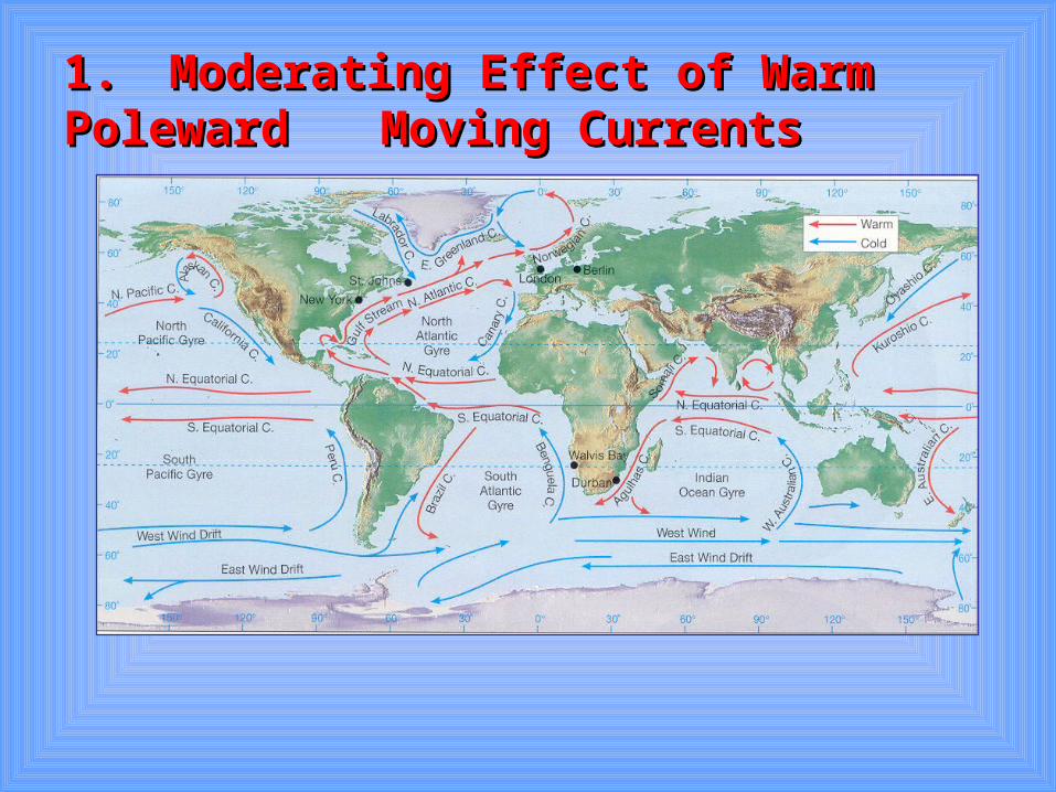
1.1. Moderating Effect of Warm Poleward Moderating Effect of Warm Poleward Moving CurrentsMoving Currents
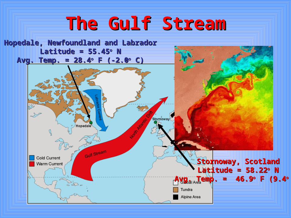
The Gulf StreamThe Gulf Stream
Stornoway, ScotlandStornoway, ScotlandLatitude = 58.22Latitude = 58.22oo N N
Avg. Temp. = 46.9Avg. Temp. = 46.9oo F (9.4 F (9.4oo C) C)
Hopedale, Newfoundland and LabradorHopedale, Newfoundland and LabradorLatitude = 55.45Latitude = 55.45oo N N
Avg. Temp. = 28.4Avg. Temp. = 28.4oo F (-2.0 F (-2.0oo C) C)
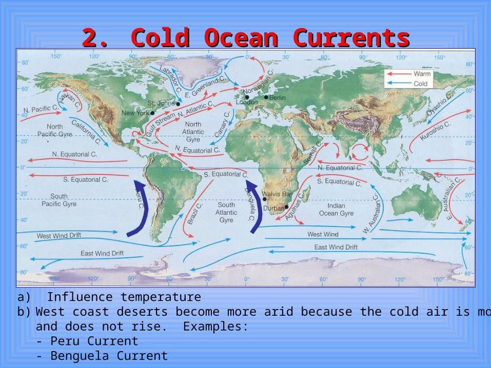
2.2. Cold Ocean CurrentsCold Ocean Currents
a) Influence temperatureb) West coast deserts become more arid because the cold air is more stable
and does not rise. Examples:- Peru Current- Benguela Current
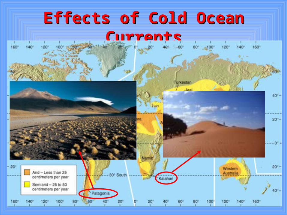
Effects of Cold Ocean CurrentsEffects of Cold Ocean Currents
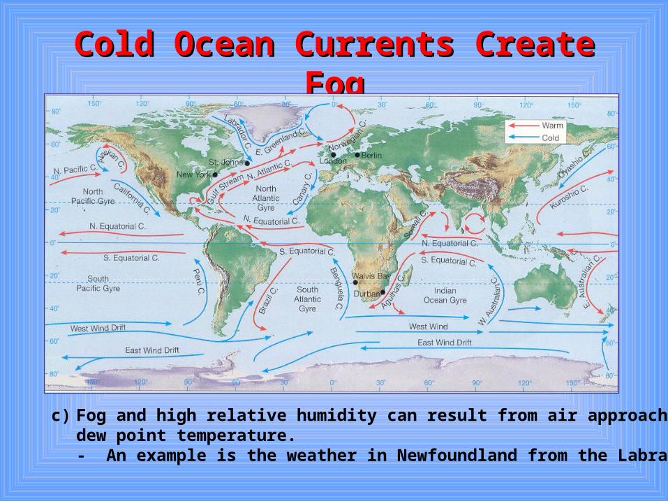
Cold Ocean Currents Create FogCold Ocean Currents Create Fog
c) Fog and high relative humidity can result from air approaching it’s dew point temperature. - An example is the weather in Newfoundland from the Labrador Current.
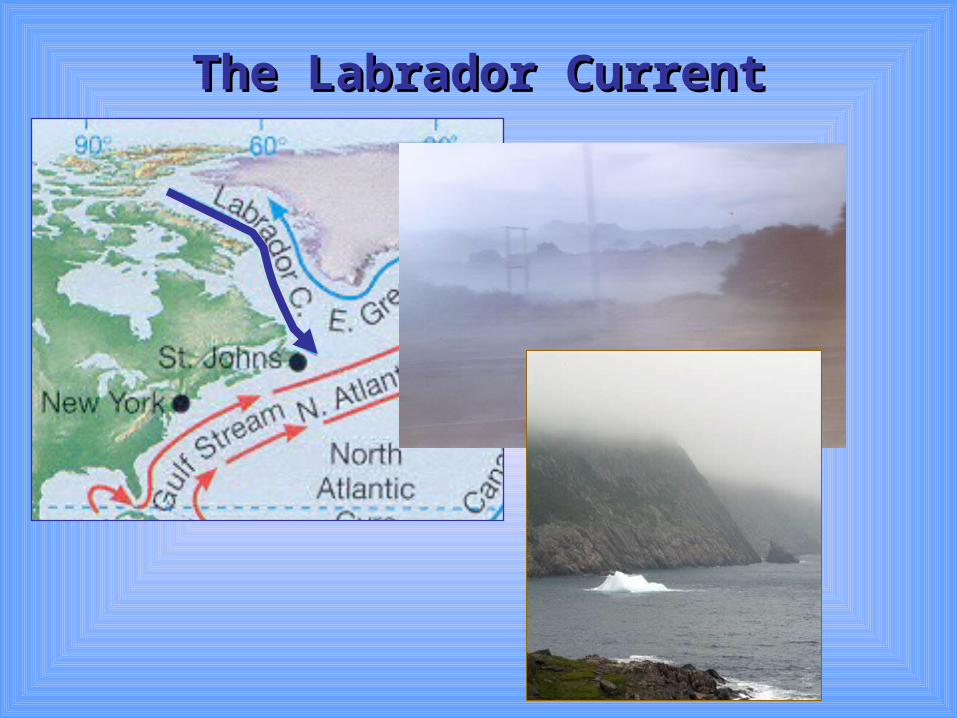
The Labrador CurrentThe Labrador Current
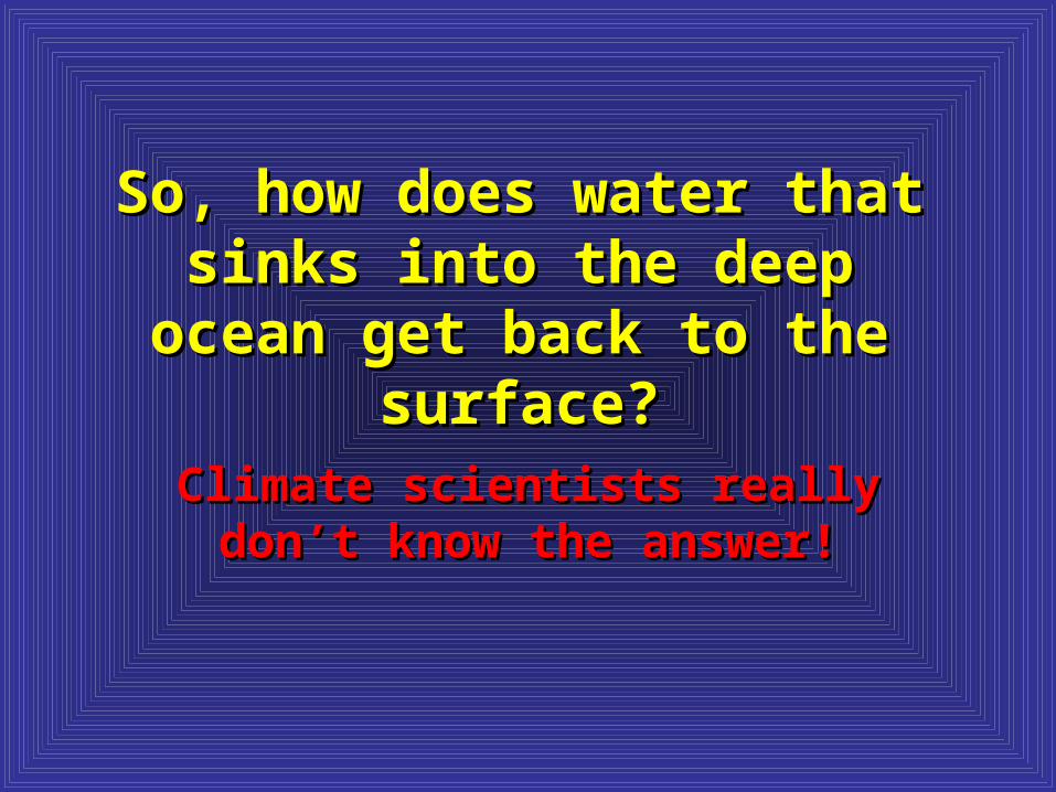
So, how does water that sinks So, how does water that sinks into the deep ocean get back to into the deep ocean get back to
the surface?the surface?
Climate scientists really don’t Climate scientists really don’t know the answer!know the answer!
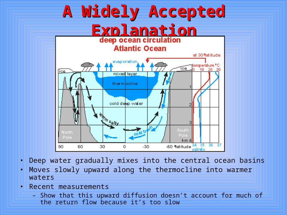
A Widely Accepted ExplanationA Widely Accepted Explanation
• Deep water gradually mixes into the central ocean basins• Moves slowly upward along the thermocline into warmer waters• Recent measurements
– Show that this upward diffusion doesn’t account for much of the return flow because it’s too slow
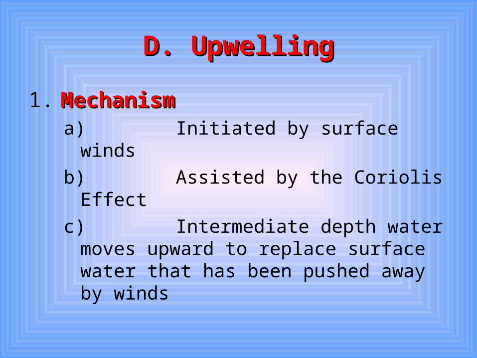
D. UpwellingD. Upwelling
1. MechanismMechanism a) Initiated by surface winds
b) Assisted by the Coriolis Effect
c) Intermediate depth water moves upward to replace surface water that has been pushed away by winds
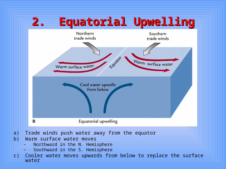
2. Equatorial Upwelling2. Equatorial Upwelling
a) Trade winds push water away from the equatorb) Warm surface water moves
– Northward in the N. Hemisphere– Southward in the S. Hemisphere
c) Cooler water moves upwards from below to replace the surface water
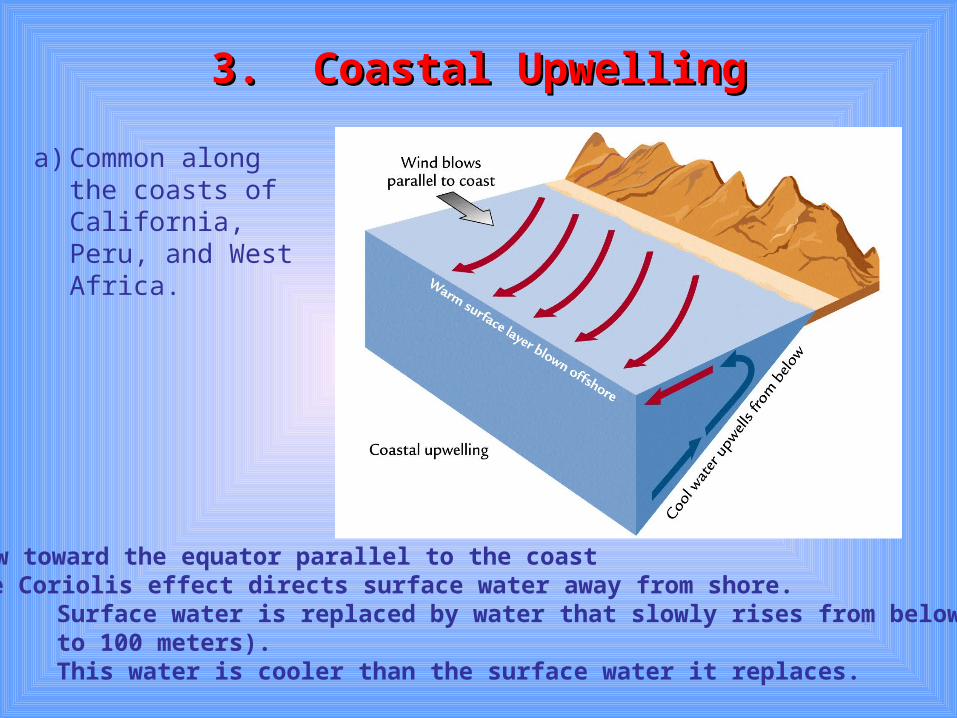
3. Coastal Upwelling3. Coastal Upwelling
a) Common along the coasts of California, Peru, and West Africa.
b) Winds flow toward the equator parallel to the coast(i) The Coriolis effect directs surface water away from shore.
(ii) Surface water is replaced by water that slowly rises from below (from 50 to 100 meters). (iii) This water is cooler than the surface water it replaces.
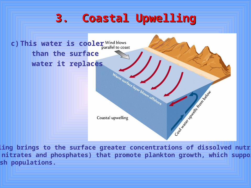
3. Coastal Upwelling3. Coastal Upwelling
d) Upwelling brings to the surface greater concentrations of dissolved nutrients(i.e. nitrates and phosphates) that promote plankton growth, which supports
fish populations.
c) This water is cooler
than the surface
water it replaces
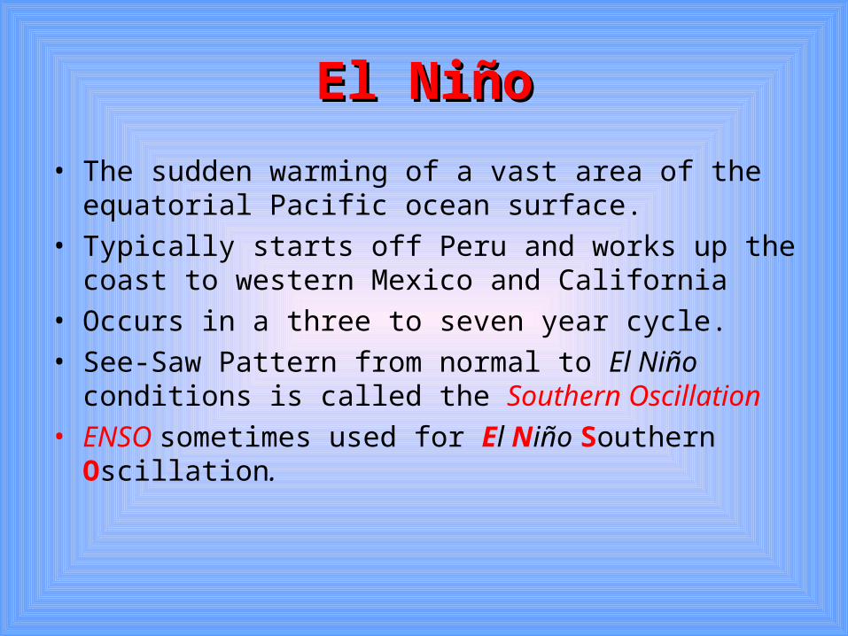
El NiñoEl Niño
• The sudden warming of a vast area of the equatorial Pacific ocean surface.
• Typically starts off Peru and works up the coast to western Mexico and California
• Occurs in a three to seven year cycle.• See-Saw Pattern from normal to El Niño conditions is
called the Southern Oscillation • ENSO sometimes used for El Niño Southern Oscillation.
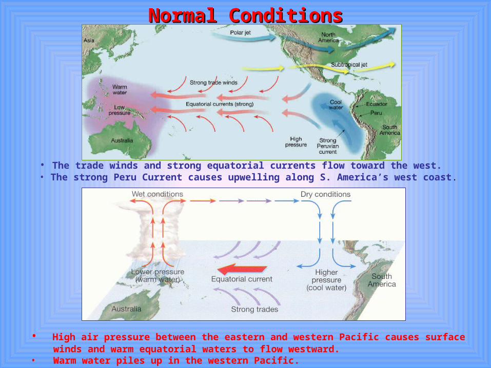
Normal ConditionsNormal Conditions
• The trade winds and strong equatorial currents flow toward the west.• The strong Peru Current causes upwelling along S. America’s west coast.
• High air pressure between the eastern and western Pacific causes surface winds and warm equatorial waters to flow westward.• Warm water piles up in the western Pacific.
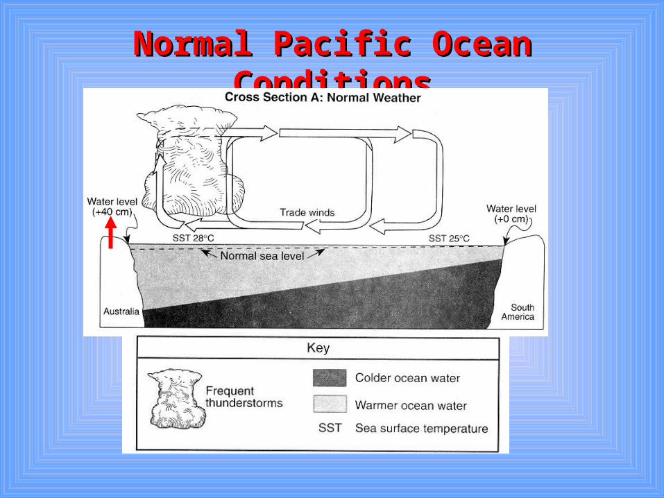
Normal Pacific Ocean ConditionsNormal Pacific Ocean Conditions
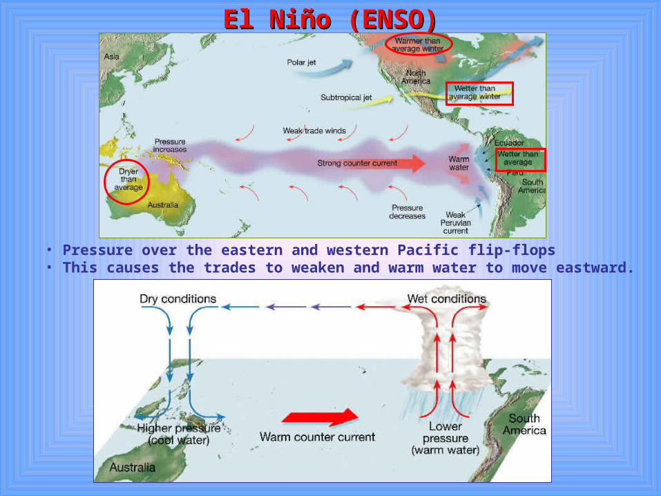
El Niño (ENSO)El Niño (ENSO)
• Pressure over the eastern and western Pacific flip-flops• This causes the trades to weaken and warm water to move eastward.
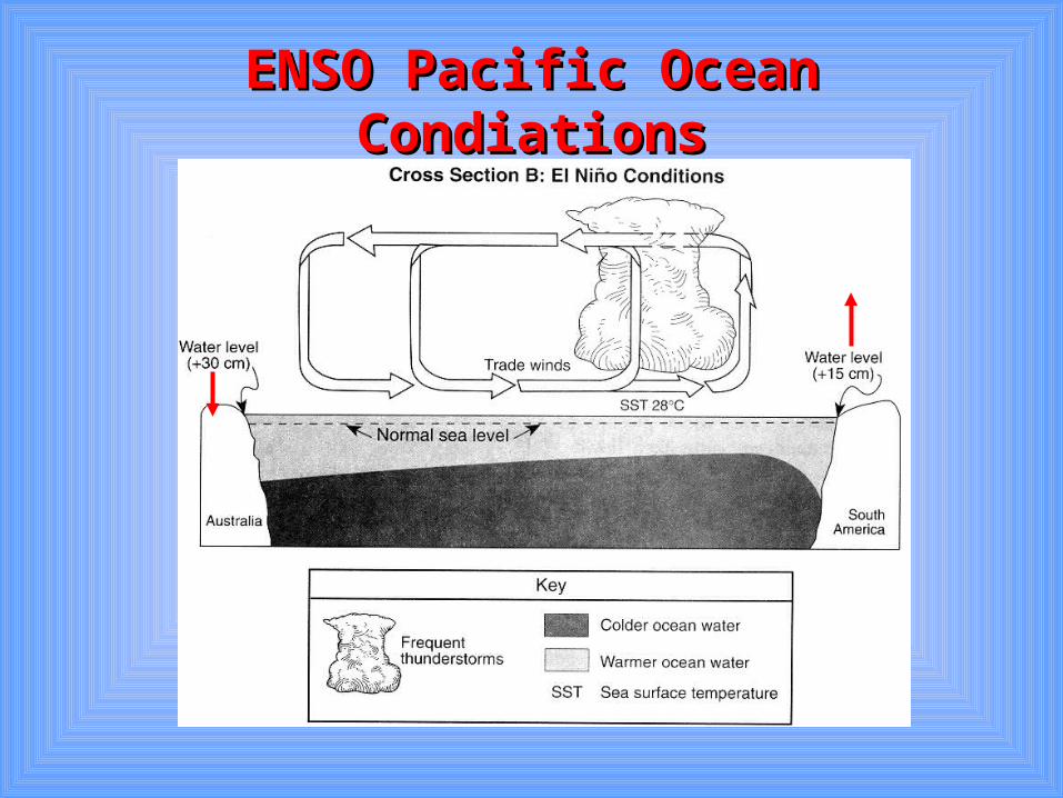
ENSO Pacific Ocean CondiationsENSO Pacific Ocean Condiations
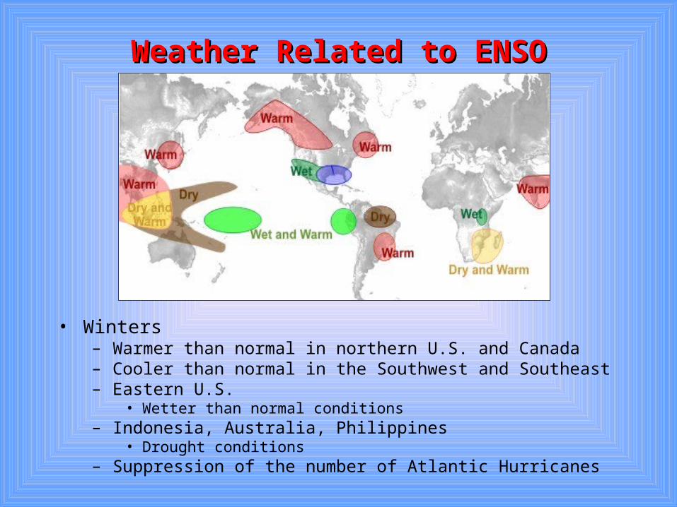
Weather Related to ENSOWeather Related to ENSO
• Winters– Warmer than normal in northern U.S. and Canada– Cooler than normal in the Southwest and Southeast– Eastern U.S.
• Wetter than normal conditions– Indonesia, Australia, Philippines
• Drought conditions– Suppression of the number of Atlantic Hurricanes
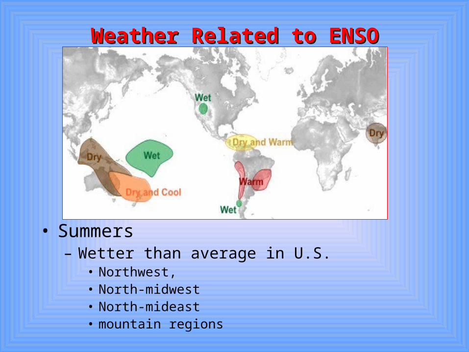
Weather Related to ENSOWeather Related to ENSO
• Summers– Wetter than average in U.S.
• Northwest, • North-midwest• North-mideast• mountain regions
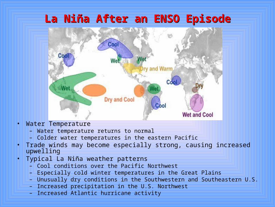
La Niña After an ENSO EpisodeLa Niña After an ENSO Episode
• Water Temperature– Water temperature returns to normal– Colder water temperatures in the eastern Pacific
• Trade winds may become especially strong, causing increased upwelling • Typical La Niña weather patterns
– Cool conditions over the Pacific Northwest– Especially cold winter temperatures in the Great Plains– Unusually dry conditions in the Southwestern and Southeastern U.S.– Increased precipitation in the U.S. Northwest– Increased Atlantic hurricane activity
III. Global Distribution of III. Global Distribution of PrecipitationPrecipitation
A. A. Precipitation on a “uniform” Earth Precipitation on a “uniform” Earth without considering variations caused without considering variations caused by by land and waterland and water
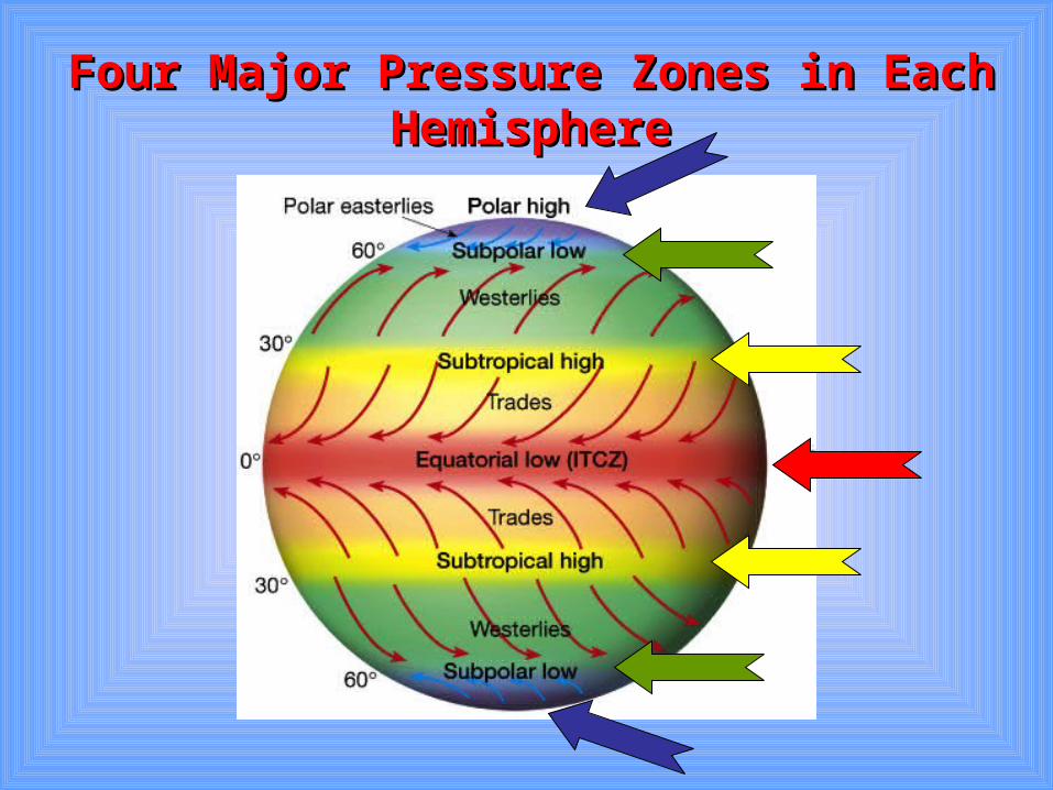
Four Major Pressure Zones in Each Four Major Pressure Zones in Each HemisphereHemisphere
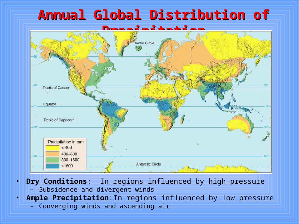
Annual Global Distribution of PrecipitationAnnual Global Distribution of Precipitation
• Dry Conditions: In regions influenced by high pressure– Subsidence and divergent winds
• Ample Precipitation: In regions influenced by low pressure– Converging winds and ascending air
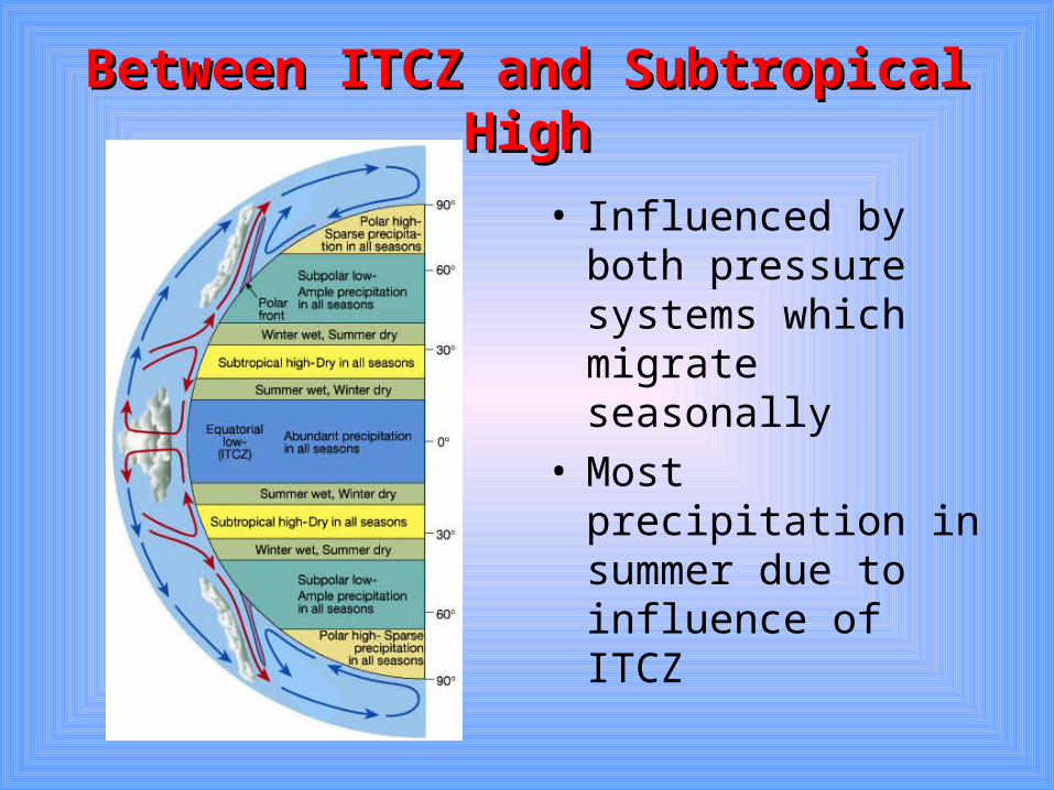
Between ITCZ and Subtropical HighBetween ITCZ and Subtropical High
• Influenced by both pressure systems which migrate seasonally
• Most precipitation in summer due to influence of ITCZ
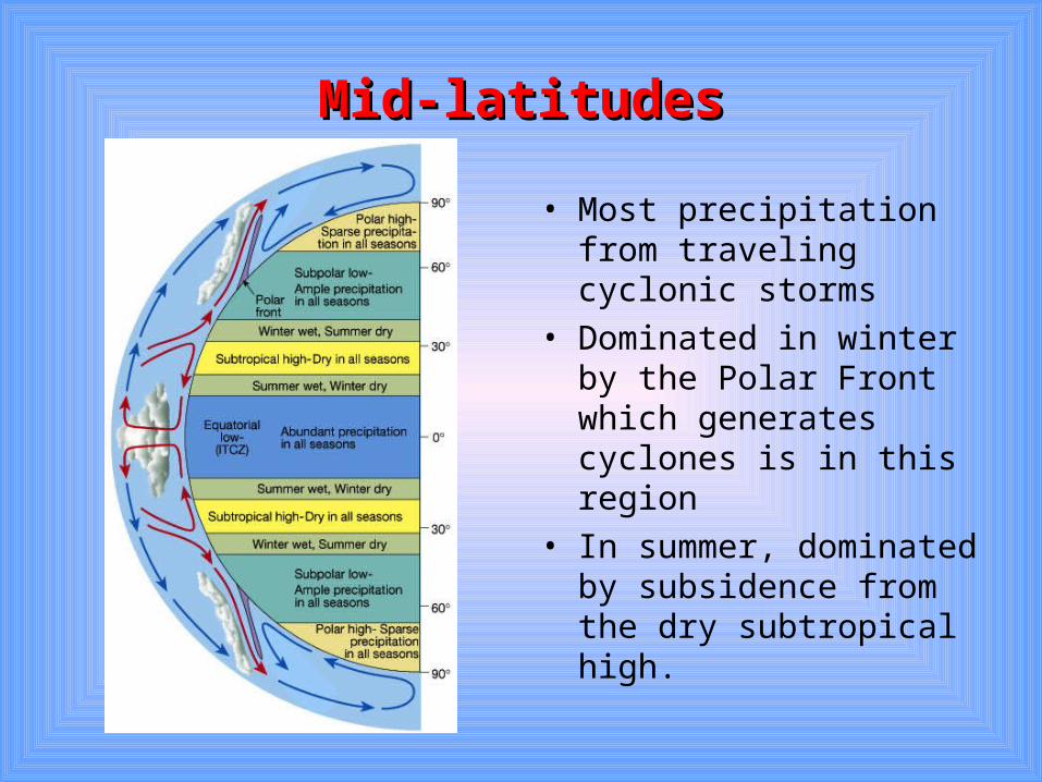
Mid-latitudesMid-latitudes
• Most precipitation from traveling cyclonic storms
• Dominated in winter by the Polar Front which generates cyclones is in this region
• In summer, dominated by subsidence from the dry subtropical high.
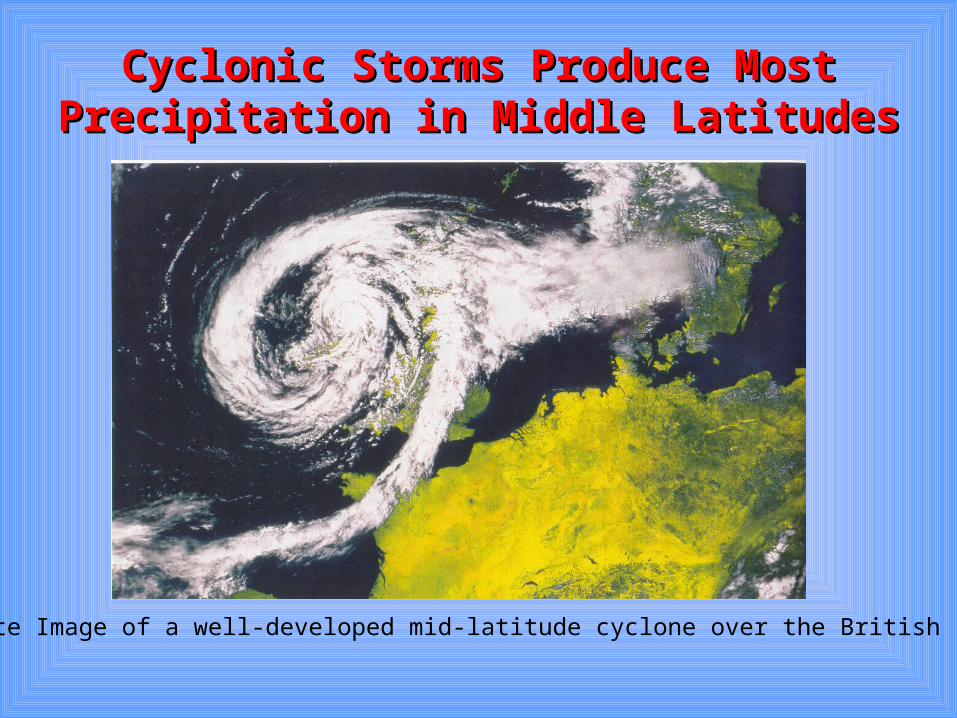
Cyclonic Storms Produce Most Cyclonic Storms Produce Most Precipitation in Middle LatitudesPrecipitation in Middle Latitudes
Satellite Image of a well-developed mid-latitude cyclone over the British Isles.
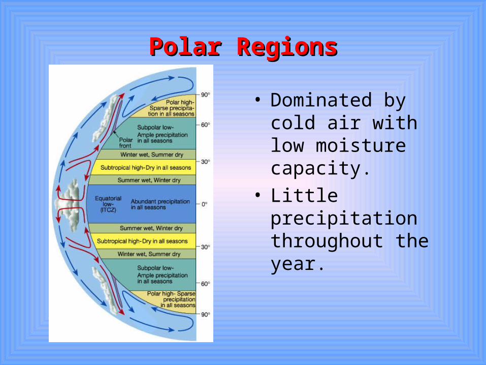
Polar RegionsPolar Regions
• Dominated by cold air with low moisture capacity.
• Little precipitation throughout the year.
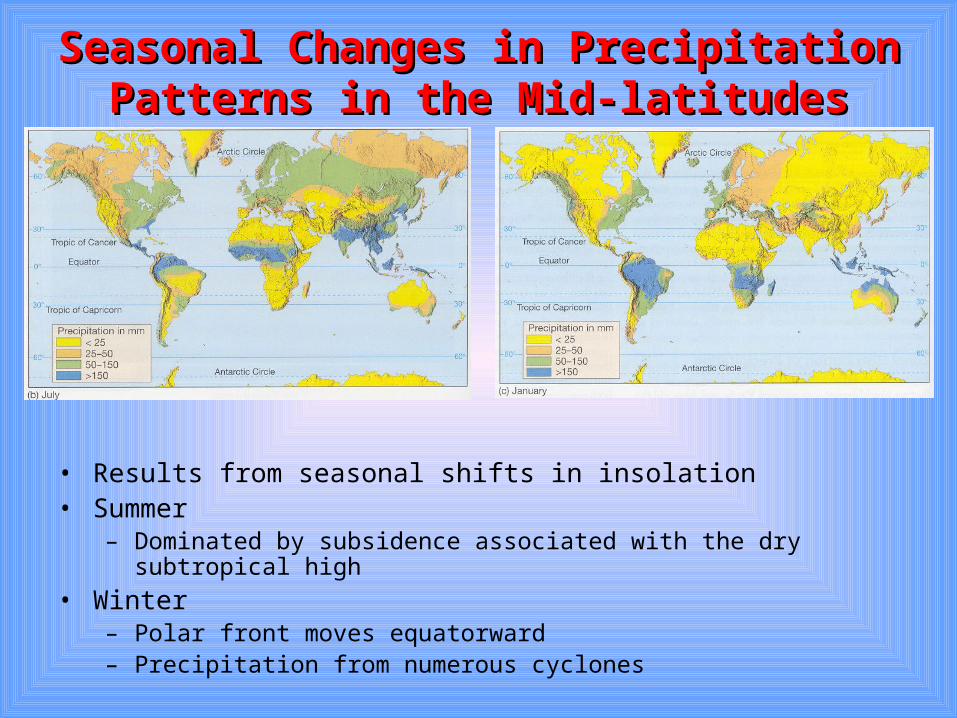
Seasonal Changes in Precipitation Patterns Seasonal Changes in Precipitation Patterns in the Mid-latitudesin the Mid-latitudes
• Results from seasonal shifts in insolation• Summer
– Dominated by subsidence associated with the dry subtropical high
• Winter– Polar front moves equatorward– Precipitation from numerous cyclones
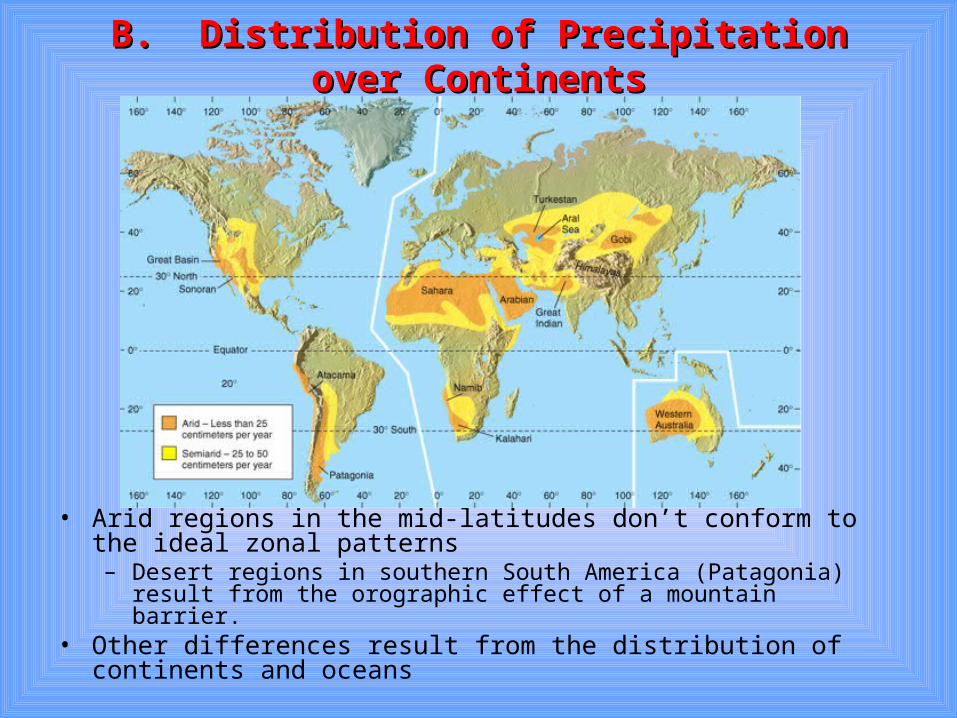
B. Distribution of Precipitation over ContinentsB. Distribution of Precipitation over Continents
• Arid regions in the mid-latitudes don’t conform to the ideal zonal patterns– Desert regions in southern South America (Patagonia) result from the
orographic effect of a mountain barrier.• Other differences result from the distribution of continents and
oceans
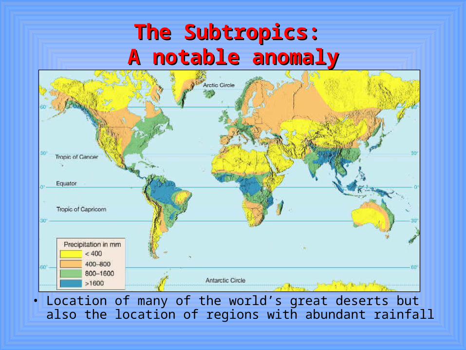
The Subtropics: The Subtropics: A notable anomalyA notable anomaly
• Location of many of the world’s great deserts but also the location of regions with abundant rainfall
The Cause . . .The Cause . . .Subtropical High Pressure Subtropical High Pressure
CentersCentersHave Different Characteristics Have Different Characteristics on Eastern and Western Sideson Eastern and Western Sides
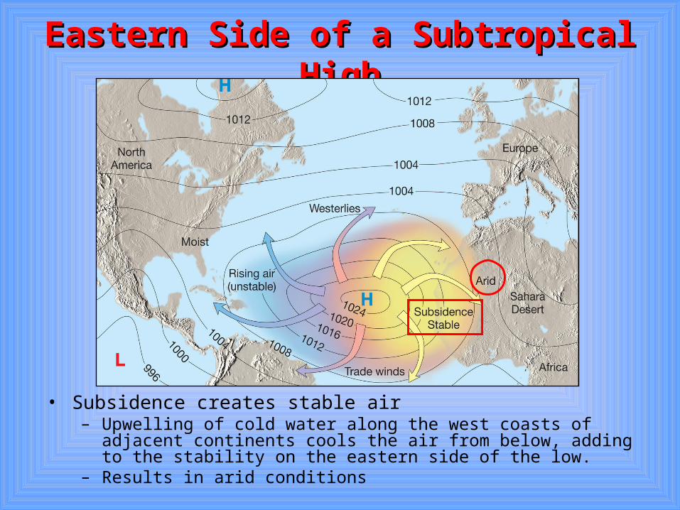
Eastern Side of a Subtropical HighEastern Side of a Subtropical High
• Subsidence creates stable air– Upwelling of cold water along the west coasts of adjacent continents
cools the air from below, adding to the stability on the eastern side of the low.
– Results in arid conditions
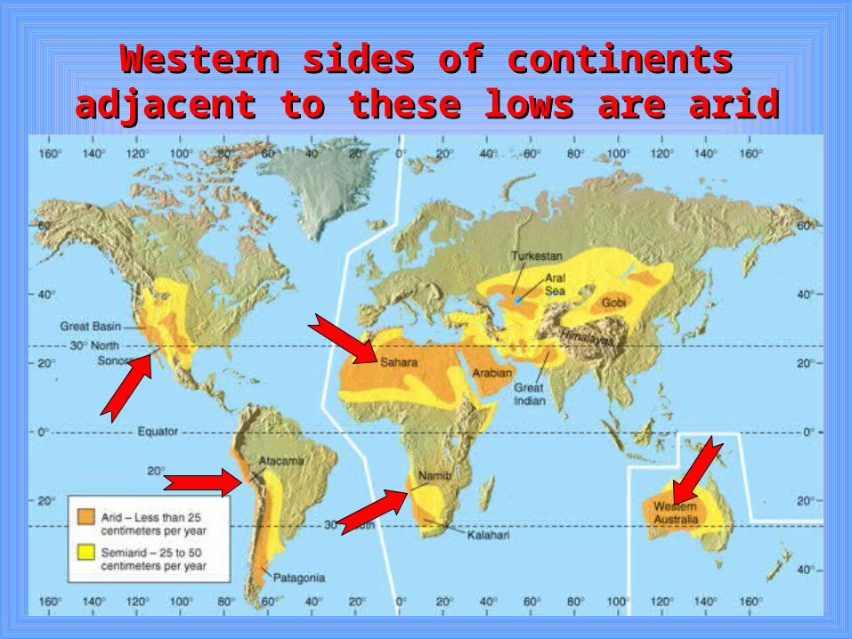
Western sides of continents adjacent to Western sides of continents adjacent to these lows are aridthese lows are arid
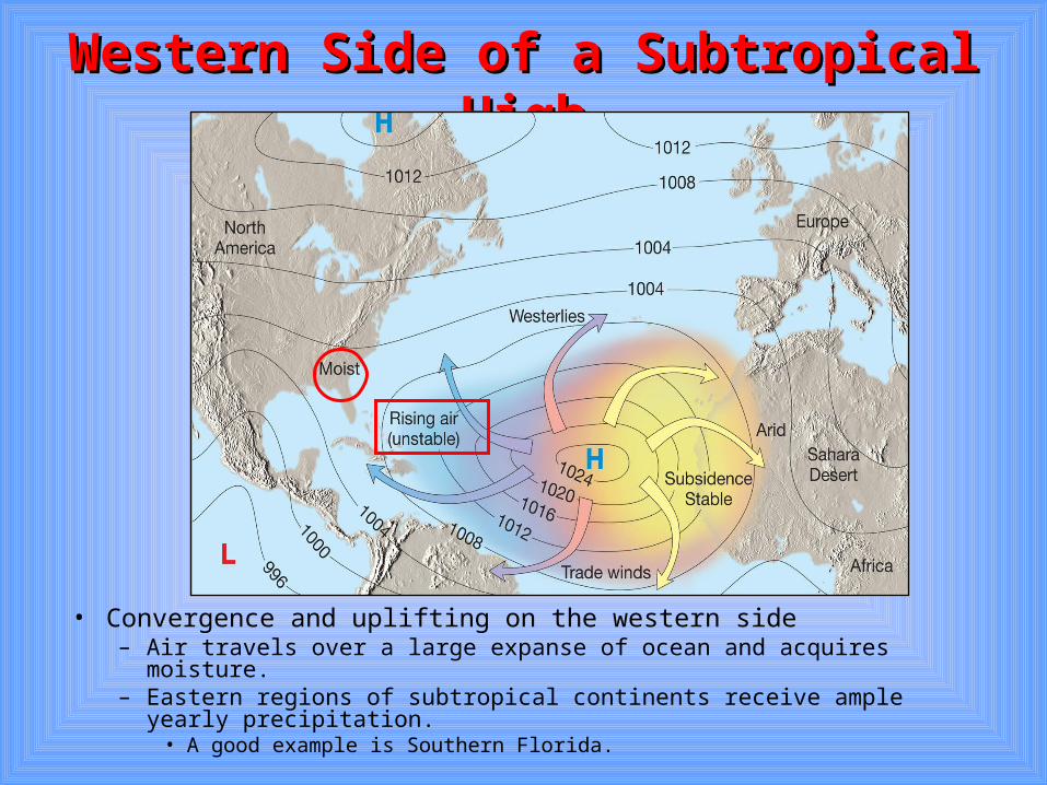
Western Side of a Subtropical HighWestern Side of a Subtropical High
• Convergence and uplifting on the western side– Air travels over a large expanse of ocean and acquires moisture.– Eastern regions of subtropical continents receive ample yearly
precipitation.• A good example is Southern Florida.