i a quantifying lobster fishing effort · quantifying lobster fishing effort ... a6riennes wild 2...
TRANSCRIPT

I "A Remote Sensing Technique For Quantifying Lobster Fishing Effort
J.D. Pringle and R.E. Duggan
Fisheries Research Branch Scotia-Fundy Region Hal ifax Fisheries Research Laboratory Department of Fisheries and Oceans Halifax, N.S. B3J 2S7
b
October 1983
Canadian Technical Report of Fisheries and Aquatic Sciences 1217
. -dCanada -du- I+ F-andOceans PBdesetOcBam ,
I -. . - . F'. . . . I
= . . . a =Am : - 1 r '

Canadian Technical Report of
Fisheries arid A q u a t i c Sciences 1217
October 1983
A REMOTE SENSING TECHNIQUE FOR
QUANTIFYIldG LOBSTER FISHING EFFORT
3,D, PringSe and R,E. Duggan
Fisheries Research Branch
Scot ia-Fundy Region
Halifax Fisheries Research Laboratory
Department of Fisheries and Oceans
Halifax, N.S. R3J 2S7


( c ) M i n i s t e r of Supply and S e r v i c e s Canada 1983
C a t . N o . F s 97-5/1217 f S S N 0706-6457
C o r r e c t c i t a t i o n f o r t h i s p u b l i c a t i o n :
P r i n g l e , J . D . and R.E. Duggan, 1983. A remote s e n s i n g t e c f ~ n i q u e f o r q u a n t i f y i n g l o b s t e r f i s h i n g e f f o r t . Can. Tech. Rep. F i s h . A q u a t . S c i . 1217: v + 16 p.


iii
. . . ~bstract/~&sum&
. . . . Introduction
Materials and Methods
. . . . Experiments
Fishery . . * . . . . . . . . Results
. . . . . Discussion
Acknowledgements . . References . . . .
CONTENTS
. . . . . . . . . . . . . . . . , i v


ABSTRACT
Pringle, .J.D. and R.E. Duggan. 19f33, A remote sensing technique for guantifytng fishing e f f o r t , Can* Tecl-i, Rep. Fish, Aquat, Sci , 1217: v i 16 p.
There i s a paucity of data on both the geographic
d is t r ibut ion and amount of e f fo r t expended i n the eastern
Canadian inshore Lobster fishery. Mandatory logbooks were
deemed impractical; consequently, remote sensing techniques were
investigated, Both color-posit i v e (Kodak N o . 2448) and black
a n d white infrared { ~ o d a k N o . 2 4 2 4 ) films were employed i n Wild
a e r i a l cameras from a fixed-wind a i r c r a f t a t heights of 305 m ,
458 m, 763 m, and 9,220 rn. Lobster buoys of t rad i t iona l
material, s ize , and color it~ere distinguished with 100% accuracy
(based on ground truthing) a t the lower three heights, Color
F i l m was superior to infrared,
The e f fo r t expended i n lobster grounds along 2 krn of shore
was assessed w i t b color F i l m from a height of 315 rn, The er ror
recorded i n assessing lobster buoys was ll - 3 % . The use of
a e r i a l photography for assessing t rap dis t r ibut ion and number i s
recommended.
Key words: Infrared, color f i l m , lobsters, fishing e f fo r t , buoys , camera, airplane,
Pringle, J . D . and R.E. Duggan * 19P3. A remote sensing technique f o r quantifying lobster fishing e f fo r t . Can. Tech. Rep. Fish. Aquat. 3ci . 1217: v c 16 p,

II y a un lnanque de donn&es c o n c e r n a n t l a r 6 p a z t i t i o n
g 6 o g r a p h i q u e ains i que l Y m p o r t a n c e d e s e f f o r t s c o n s a c r 6 s P a
pG&e cGti&re dil "nornard daris ikest ciu Canada. On a jug6 peu
p r a t i q u e s lles i i v r e s de bord o b l i g a t o i r e s et on a p a r c o n s g q u e n t
& t u d i & ies rnkthodes de t & l & d & t e c t i o n . On a u t i l i s g d e s f i l m s
p o s i t i f s c o u l e u r (Kodak no 2448) et i n f r a r o u g e n o i r e t b l a n c
(Kodak n@ 2424) dans d e s chanbres de prises de vues
a 6 r i e n n e s Wild 2 b o r d d%appareils 2 v o i l u r e f i x e $ d e s
a l t i t u d e s de 305 rn, 458 rn, 7 6 3 rn, et 1 , 2 2 0 m . L e s b s u 6 e s de
t r a p p e s homards de f a b r i c a t i o n , d e e a i l f e e t de c o u l e u r
c l a s s i q u e s G t a i e n t d i s t i n g u g e s a v e e une p r 6 c i s i o n d e 100%
i d h a p r & s une v 6 r i f i e d t i o ~ sur p l a c e ) a u x t r o i s p l u s f a i b l e s
a l t i t u d e s . Le f i l m c o u l e u r donnait dc m e i l l l e u r s r b s u l t a t s que
l e f i l m i n f r a r o u g e .
L"effort de psche e o n s a c r 6 a u x b a n c s de homards le l o n g
dkun segment de cate de 2 km a &t& & v a l u & au moyen du f i l m
c a u l e u r dbune a l t i t u d e de 915 rn. L k e r r e u rau n i v e a u de
i % v a i u a l i o n d e s bau&es de trappes & homards 6 t a i t d e l l . 3 & . Qn
recsmmande i b u t i l i s a l i o n de l a p h o t o g r a p h i e a 6 r i e n n e pour
l " v a l u a t i o n de l a r & p a r t i t i o n e t 2es nombres d e s t r a p p e s 5
homards .

INTRODUCTION
The lobster f i s h e r y in t h e Scotia-Fundy Region i s carried out over t-housands o f miles of coastl ine, making i t d i f f i c u l t for biologists to make independent assessments of abundance throuqk; t rad i t iona l research techniques, Frequently the l a t t e r i s a problem i n f inf ish assessment whick: has been circumvented, t o a certain extent, by employing good catch and e f fo r t data ( ~ i c l c e r 1975). Tke l a t t e r are recorded hy fishemen i n dai ly logbooks . Canadian lobster landings have been recorded since lR59 (Prince l899), and recently the system was upgraded (Cornier l98C). Nevertheless, parameters required by f isher ies sc i en t i s t s such as location o f harvest, t rap number, soak time, ba i t type, and so on a re no t recorded. The lack of these types of data was noted i n the proceedings of a ~ . ~ . / ~ a n a d a lobster workshop (p. 92 - Antbony and Caddy l9P0). Here the delegates appealed for a s t a t i s t i c a l reporting system that r e f l ec t s the needs of sc i en t i f i c resource management, They highlighted the need for e f for t data. The introductien of mandatory logbooks was deemed impractical by both the delegates a t the l a t t e r workshop and by Conan and Maynard (1983).
Effort assessrnent via remote sensing (ae r i a l recoi~naisanee and ae r i a l motography) has been employed i n the following Canadian Atlantic f isher ies : I r i sh moss (Pringle and Sernple 1380; 6.9. Sharp and DaL, Roddick pers. comrn.l), herring (Messieh and IvracPherson l Q D l ) , scallop (Jamieson -- e t a l . 1981; Robert e t a l . 1982), and lobster (Conan and Maynard 1 9 E 3 ) .
-7
Miller and Colodey (1983) employed helicopters t o monitor sea urchin diebacks. Conan and Maynard (1983) counted and photographed lobster buoys i n Northurrinerlad S t r a i t from a fixed-win? a i r c r a f t , They found, however, t ha t black and white photographs did not y i e l d suff ic ient resolution, par t icular ly during wind-swept seas. Color photography gave good resu l t s , but the airplane was not equipped t e routinely handle it. Reported here are the resu l t s of experiments carried out t o determine the usefulness of color and black and white infrared photograp- to discriminate various colored lobster buoys from various camera heights, The resu l t s ef the technique applied to a small portion of the S t . Margarets Ray, Halifax Co., lobster fishery a re given as well.
MATERIALS AE;JD METHODS
EXPERIMENTS
Rectangular wooden buoys 35 crn x 10 cm x 10 cm and Downey's Plast ics No. 4 styrofoarn buoys 15 em high x 18 cm d ia , with tKe bottom half tapering t o 10 cm dia., were painted i n colors and color combinations used by lobster fishemen (Table 5 ) . Each
G J a a r p and D . L , Roddick, Fisheries Research Branch, Scotia-F'undy Region, H a l i f a x Fisheries Research Laboratory, Department of Fisheries and Oceans, H a l i f a x , N - S . B 3 J 2S7


color scheme was repeated four times for each type of buoy construction. Tllree repl icate s t r ings using each buoy type and color scheme were prepared, Buoys were spaced a t 5 m in tervals along a l i ne anchored a t both ends, The remaining buoys were attached t o l ines w i t h individual anchors.
S t . Margarets Bay, Halifax Co., was chosen as an experimental area ( F i g . I ) , T h e area south sf Bouti l ier Point and to the east of Strawberry, Wood, and Croucher Islands was chosen as a test s i t e . Tne area provided a ready reference t o land masses for charting buoy locations, a variety of depths i n a small area, and availabi lity of a workboat already under charter for f isher ies research. Roth the repl icate s t r ings of buoys and -the i n ~ d i v i d u a l buoys were placed haphazardly throughout site. The sea-based c r e w recorded buoy Locations i n re la t ion t o landmarks t o permit an assessment of the accuracy of the ae r i a l p-I~otograpkty.
Aerial photography was performed from a 'twin-engine Piper Aztec ( P A - 2 3 ) chartered from Atlantic Canada Airborne Sensing, Chatham, Hen. The a i r c r a f t had a Wild RC-8 ae r i a l camera mounted i n a vertical convex port, The camera was equipped with a 15 .24 em lens and a navigational sight which could be adjusted for tilt and d r i f t angles, Pkotographs were taken t o provide 60% forward overlap. Two types of films were employed: Kodak No. 2 4 2 4 black and white infrared and Kodak No. 2448 color- posit ive. Photographs were taken from a l t i tudes of 305 m , 458 rn, 763 m, and 1,220 rn t o give scales of l:2,000, l:3,000, 1: 5,000, and 1: @ , Q O O respectively, The f i r s t f l i g h t was conducted November 2 8 , 19P2. Clear skies, l i gh t winds, and calm seas prevailed,
The film was sent t o the manufacturer for processing. The returned pr in ts were examined by a professional photographic in te rpre te r using 2 %land lens ( x 8 ) . Interpretat ion of color p r in t s was further erhanced by placing them on a l igh t table during examination. The color of the pr in ts was adversely affected by the type of f i l t e r used [Kodak Wratten l 2 ( 5 2 0 n m ) ] ; however, interpretat ion was not affected. The in te rpre te r was able t o detect and identify buoys on both kinds of p r in t s a t scales of 1:2,000, l:3,000, and l:5,000 but f e l t the color p r in t s were superior to the infrared. A l l buoys could not be detected a t the 1:8,000 scale . This was thought t o be due t o insuff ic ient resolving power of the camera a t 1 , 2 2 0 m. A mosaic was made of the color prints and a d ig i t i ze r was employed to quantify the buoys and plot t h e i r dis t r ibut ion i n re la t ion t o the islands, The M R M S ~ Geobased Mapping System was employed t o prepare the maps,
- u-
2~~~~ (Maritime Resource Management Service), P , O . Box 310, Amherst, N.S. B4H 325+.


HALIFAX
AREA ENLARGED V
" " PEGG$S COVE
AREA ENLARGED
FIG 3
F i g u r e 1. Loea t i ons of test sites,


Rased on the resu l t s of the above t r i a l s it was decided to adopt the color-positive t e c h n i q u e f r o m an a l t i t r ~ d e of 915 m giving a hotoqraph a t a scale of 1:6,000 and a coverage of E 1,840.2 rn . To t es t the technique i n the lobster fishery a 2 km stretch of coastlirle along S t . Marljarets Bay from Paddys Head t o Peggys Point was chosen. A f l igh t over t h i s s i t e was flown December 14, 1 9 8 2 , u s i n g a Fairchild K - 1 7 a e r i a l camera with capabi l i t ies similar t o a Wild Re--8, and a Kodak HF-3 ( 4 2 5 nm) f i l t e r . The following day, Department of Fisheries and Oceans personnel conducted a surface count of buoys i n the area, Because of sea conditions a t the time, exact locations of buoys i n re la t ion to nearest land was not determined. A map of observed buoy locations was made using the MRPS Geobase mapping system.
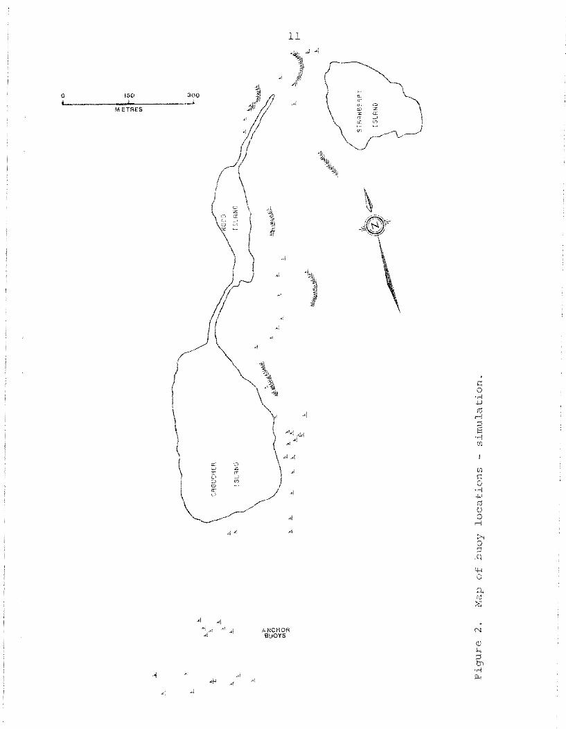
The techniques employed were successful hut it is recommended khat F u t u r e ' l ights he done with a s u n angle of 25" or less . Al l buoys ~laecld on the t e s t s i t e were located on both the color-positive and black a n d white infrared photographs (Fig. 2 ) from heights of 305 m, 45€? m , and 763 m. However, 18 buoys used by fishermen to mark f i sh t rap anchors were a lso Poeated and plotted, These appear as a c lus te r off the south end of Croucher Island ( F i g , 3 ) and apparently are indistinguishable frorn t e s t buoys. The photography also revealed a herring net, eas i ly recognizable because of the buoy configuration, which was not recorded.
Results of the second f l igh t are shown on Figure 3 , There was d i f f i cu l ty i n conducting tbe ground truthing due t o poor weather conditions. Buoys were 3iff ieuPt t o see and the area photographed was larger than that covered by boat, T"ne total- count frorn surface was 404 and from ae r i a l photography was 565, an error of 2 P . 5 % . However, there was one enclosed area, Indian Harbour, where ground truthing recorded a t o t a l of 69 buoys: 63 lobster huoys, 2 mooring buoys, and 4 channel markers; 7 1 buoys were recorded by the interpreter . Again, buoy types were not distingilishable; thus, an error of 11.3% was noted for lobster huoys.
DISCUSSION
Aerial color photoqraphy using a Wild RC-8 or a Fairchild K-17 a e r i a l camera, a 15,24 cm lens, Kodak No- 2448 color-positive film, and a Kodak HF-3 f i l t e r from a maximum height of 915 rn gives suf f ic ien t resolution t o detect lobster

0 150 300 L 8 1
Ah ETRES


500 1000
M E T R E S
Figure fishery,
D


buoys constructed of t r a d i t i o n a l rvaterials and painted t r a d i t i o n a l co lo r s . To enhance i n t e r p r e t a t i o n t h e sun should be Low angled. The he ight of 915 m permits a l i n e a r coverage of L,840.2 m. The cos t per ki lometer i s approximately $17. This f i g u r e i s fo r t h e f l i g h t time and photography only and does not include f ly ing time t o t h e research area or photograph i n t e r p r e t a t i o n , ??be cos t of d i r e c t v isua l counts employed by -6, Conan and D, Maynard (pers . cmm, ) would be approximately $'1.5O/km, The major advantage of using a e r i a l pkiotoaraphy versus a e r i a l v i sua l counts i s chat a f l i g h t plan can be given t o a cont rac tor such as MPMS; t h e r e need be no f u r t h e r involvement on "clle p a r t of t h e cont rac tee u n t i l da ta a r e presented. During prepara t ion of t h i s paper t h e con t rac to r acquired a new Zeiss a e r i a l (RMK 1 5 / 2 3 ) camera which they f e e l can provide sirrlilar r e so lu t ion f r o m h igher a l t i t u d e s . This capabil i t y would r e s u l t i n lower cos t s (approximately $15/km) t o conduct sirv-llar programs.
There a r e drawbacks w i t h a e r i a l photography, however. F l i g h t s can only be made during calm weather condi t ions and a t low sun angle (~axirnvm 30" ) or elo~lr ly periods. A s we l l , i f o t h e r f i s h e r i e s i n t h e a rea employ a la rge number of su r face buoys thee -toe e r r o r component may be la rge . Fortunately, most inshore f isherpen a r e l o b s t e r fishermen; consequently, during t h e l o b s t e r season i n most a reas the re would only be a minor amount of o ther buoyed gear . Nevertheless, p r i o r to any a e r i a l survey it i s recommended t b a t an assessment be made of t h e l a t t e r .
The authors thank C.A. Speiqslt and 1 i . A . Sharples of MRMS for photoqraph i n t e r p r e t a t ion and map prepara t ion , I-J. 7". Ripley of At1 a n t i c Canada Airhorne Sensing far a s s i s t a n c e in developing t e s t procedures, P . J . Mi l le r and ? . K . Mob= f o r cons t ruc t ive c r i t i c i s m of t h e t e x t , and S.P. LeBLanc f o r h e r a s s i s t a n c e i n preparing t h e paper.
REFE REFICES
Anthony, V . C . and J,F. Caddy (ed,), 19@0. Proceedings of t h e C a n a d a / ~ .s. workshop on s t a t u s of assessment sc ience f o r northwest A t l a n t i c l o b s t e r Homarus americanus s tocks -- ( S t . Andrew~, N.R., Oct. 24-26, 197 Tech. Rep, Fish. Aquat. Sc i . 932, 186 p.
Conan, G . Y . and D.R. Maynard. 1983. Aer ia l survey of s p a t i a l d i s t r i b u t i o n of e f f o r t i n Lobster f i she ry of souther= Gulf of S t . Lawrence. ICES C,M.19@3/~:13, 1 3 p.

C o r m i e r , M.C. 1980, Canadian s t a t i s t i c a l r e p o r t i n g sys tem, p. 107-123. I n Anthony, V .C. and 'J .Pa Caddy ( e d , f P r o c e e d i n g s o F t h e e a n a d a / ~ . S . workshop on s t a t u s of a s s e s s m e n t s e i e n c e f o r n o r t h w e s t A t l a n t i c l o b s t e r Homarus amer icanus s t o c k s ( S t . Andrews, N I B , , Oct. 24-26, Can. Tech, R e p . F i s h . Aquat. S e i , 932.
' Jarnieson, 'G . S. , M:J . Lundy, and N .B .. Wikherspoon - 1981. F i skneq c h a r a e t e r i s t i e s and s t o c k s t a t u s of -6eorges Bank s c a l l o p s . CAFSAC R e s . Doc. 81/70 , 40p.
Messieh , S,N, and P. MacPherson. 1981. A e r i a l s u r v e y o f h e r r i n g g i l l . n e t s i n the s o u t h e r n 7 G u l f of S t . Lawrence. CAFSAC Res. DOG. 81/13 , 29 p.
Miller , R.'J. and A.G. Colodey. 1983. FJidespread m a s s mor t a l i t i e s o f t h e g r e e n sea u r c h i n i n Nova S c o t i a , Canada. Mar. B i o l . 73, 663-267,
P r i n c e , E.E. 1899. Repor t of t h e Canadian L o b s t e r Commission, 1898. - I n 3 1 s t Ann. Rep. Dept . Mar. F i s h . , Supp. 1, 4 1 pp.
P r i n g l e , ' J . D . and R . E . Sernple. 19130. The b e n t h i c a l g a e biomass, commercial h a r v e s t i n g , and Chondrus growth and c o l o n i z a t i o n o f f s o u t h w e s t e r n PTova S c o t i a , p. 144-169. I n P r i n g l e , 'J.D., G. 'J . Sha rp , and "J.F* Caddy ( e d . ) ~ r o c e e d i n ~ s o f t h e workshop on t h e r e l a t i o n s h i p h e t v ~ e e n sea urchin g r a z i n g and commercial p i a n t l a n i m a l h a r v e s t i n g * Can. Tech. R e p . Fish. Aquat . S c i . 954.
R i c k e r , W.E. 1975. Computat ion and i n t e r p r e t a t i o n of b i o l o g i c a l s t a t i s t i c s o f f i s h p o p u l a t i o n s . B u l l . F i s h . R e s . Board Can. 171, 382 p,
R o b e r t , * G e , ' G . S e ' Jamieson, and M:J Lundy. 1982. Profile of -the? Canadian o f f s h o r e seal lop f i s h e r y on -Georges Bank, 1978 t o 1981. CAFSAC R e s . Doc. 82/15, 33 p.