i: 3-working-files0physman18novnew00ph...
TRANSCRIPT

GE-101 Physical Geology
Laboratory Manual
Printed by
The QCC Press


page 1 OUT
QUEENSBOROUGH COMMUNITY COLLEGEPhysical Geology The City University of New York GE-101
LABORATORY OUTLINE
Text: Laboratory Manual for GE-101 : Frishman, Rance, Scal
COMMON ROCK FORMING MINERALS AND ROCKS page
1 Physical properties of common rock forming minerals 3
2 Quiz 1Igneous rocks 17
3. Quiz 2Sediments and sedimentary rocks 29
4. Quiz 3Metamorphic rocks 43
5. Quiz 4Review of common minerals and rocks 55
6. TEST 1 minerals and rocks
TOPOGRAPHIC MAPS
7. Contour lines and topographic profiles 55Film and Quiz 9: “Beach - a river of sand” 64Homework 66
8. Quiz 10Topographic maps, Areal photographs 67Homework
9. TEST 2 Areal photographs topographic maps and profiles 72
ORE MINERALS
10. Quiz 5Ore minerals, physical properties 73
11. Quiz 6Ore minerals, chemical properties 87
Homework: Collection of soil sample for Soil Science laboratories 12 and 13 98
SOIL SCIENCE
12. Quiz 7Soil science, physical 99
13. Quiz 8Soil science, chemical 109
Please note: Bring a pencil to every laboratory. Laboratory results may be refused unless they are inpencil. The last laboratory period 14 is omitted in lieu of the required field trip. Laboratory quizzes will begiven at the beginning of the laboratory. Missed quizzes cannot be made up.
This MANUAL will be collected and graded at the end of the term.

page 2 INT
THE ROCK CYCLE
There are three types of rocks. They are: igneous, sedimentary, and metamorphic. These types ofrock have different origins. One type of rock can become another type. The Rock Cycle (Figure 1) is adescription of how Earth’s materials can be cycled. On Earth, rocks do not last forever but their materialcan be cycled into forming other rocks and this can happen again, and again, in several ways.
Figure 1
A simple description of the rock cycle is: An igneous rock, such as a granite, becomes exposed atEarth’s surface. Mechanical weathering breaks up the granite into rock fragments and mineral grains.This process is aided by chemical weathering that changes feldspar and ferromagnesian minerals, but notquartz, to clay and dissolved salts. These materials together are the components of soil. Soil is eroded(removed by denudation and leaching) and its components are separated and sorted as they aretransported to where they accumulate as sediments such as: gravel, sand, mud, and salt deposits. In time,sediments lithify (harden) to sedimentary rock such as: conglomerate, sandstone, shale, and limestone.Burial causes the temperature of the sedimentary rock, and the pressure on it, to increase. The rockrecyrstallizes, but it does not melt in doing so, and with a new appearance it is called a metamorphic rocksuch as: quartzite, slate, schist, gneiss, and marble. Deeper burial and radioactive heating can cause rockto melt to a magma. Magma is buoyant and so it will rise to intrude at higher levels or erupt at Earth’ssurface as a lava. In both places, it cools and hardens to an igneous rock.
Other pathways are given in Figure 1 for the cycling of Earth’s materials from one rock type toanother or as a replacement of itself.
Sun’s radiant energy drives the rock cycle at Earth's surface. Within Earth, primordial andradioactive-mineral’s emitted heat drives the rock cycle.

page 3 MIN
GE-101 Sect: QUEENSBOROUGH COMMUNITY COLLEGEPhysical Geology The City University of New York Date: / /
Instructor: Your name:
Laboratory module: Physical properties of rock forming minerals
Objectives: After completing this laboratory you should be able to:
1. Distinguish between minerals and non-minerals.
2. Understand the difference between crystal faces and crystal cleavages..
3. Recall several or the most common rock forming minerals.
EQUIPMENT CHECK LIST (Report any missing items to the laboratory proctor)
Material Description perStudent
perTable
MINERALS Mineral hand specimens without crystal faces.A reference collection of 6 identified museum specimens with crystal faces 1
1 set
CHEMICALS Dilute (5%) hydrochloric acid in a dropper bottle 2
GEOLOGICALEQUIPMENT
Window glass, 3" square plate with beveled edges (for hardness tests) Calcite cleavage blocks (for hardness tests)Streak plate (unglazed porcelain plate)Pocket knife (blades blunted)Hand lens
1
11
2
1 Ask proctor for location and handling procedure

page 4 MIN
Section I MINERALS
Minerals are defined to be naturally occurring, inorganic, crystalline substances. A mineral's nameis a class name that refers simultaneously to two criteria: chemical composition and symmetry of internalcrystal structure. Symmetry of internal crystal structure is fixed for each mineral. Chemical compositioncan either be fixed or can have any value within a range: limited by the crystal structure and therequirement that the symmetry of the crystal structure remains unchanged. Minerals can be distinguishedless specifically by their physical and chemical properties. Procedures, either elementary or advanced,exist whereby the composition, physical properties or chemical properties of a mineral can be determined.Determinations of the symmetry of internal crystal structure and the arrangement of component atoms canbe obtained by advanced X-ray methods.
A mineral's symmetry of internal structure can be partly discerned in the external geometric formof its crystals, when these are found, or in the way some can be found to break in a regular manner.
A mineral is said to exhibit crystal faces when it is bounded by smooth, flat, surfaces which can beargued to be a product of unrestricted crystal growth. A crystal grows by the orderly bonding of compatiblematerial to its exterior surfaces. Crystal faces will not be present when a crystal has grown to fill anunyielding preexisting space or when the crystal faces have subsequently been broken away.
A mineral is said to exhibit crystal cleavage when smooth, planar parting surfaces are found wherea portion of a crystal has been broken away or can be seen to divide it internally. Not all minerals exhibitcleavage. When a mineral is broken in a direction other than that of cleavage the resulting irregular surfaceis called a fracture surface.
As early as 1600, R. J. Haüy (Ah-you-ee) recognized the existence of crystal faces and cleavage,when present, could be explained if each mineral crystal is made from a systematic arrangement andholding together of building blocks (see Figure 2). In 1920, W. L. Bragg showed that crystalline substancesdiffract X-rays in a way that is consistent with the idea that all minerals are constructed of building blocks(later called unit-cells) of a definable symmetry. In principle, a unit-cell constitutes the smallest possiblesample of a mineral.
Figure 2
page 5 MIN
Exercise 1 EVALUATION QUESTIONS
What by definition is necessarily true of a mineral?
Summarize (after discussion with your laboratory instructor) why each of the following substances is or isnot a mineral:
Synthetic ruby Potassium
Garnet Native Silver
Coal Crude oil
Graphite Glacial ice
Flint Natural volcanic glass
Quartz Granite
Can differently named minerals have the same composition? (yes, no) Explain.
What can be said to be the same, and unvarying, in all samples of the same mineral?
What are crystal faces?
How do crystals grow?
Give two reasons why mineral species need not be bounded by crystal faces.
What is crystal cleavage?
Do all minerals exhibit cleavage? (yes, no) Explain.
Can crystals be divided into smaller and smaller pieces indefinitely? (yes, no) Explain.
page 6 MIN
Section II
Exercise 2 CLEAVAGE AND FRACTURE
The given minerals are fragments broken out of larger specimens. As a result they are not bounded bycrystal faces. Your problem is to examine the given set of identified minerals with the purpose ofclassifying them by the way they have broken.
Procedure: Work with one specimen at a time. Record your results in Table 1.
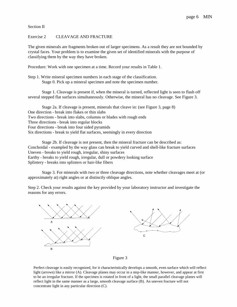
Step 1. Write mineral specimen numbers in each stage of the classification. Stage 0. Pick up a mineral specimen and note the specimen number.
Stage 1. Cleavage is present if, when the mineral is turned, reflected light is seen to flash offseveral stepped flat surfaces simultaneously. Otherwise, the mineral has no cleavage. See Figure 3.
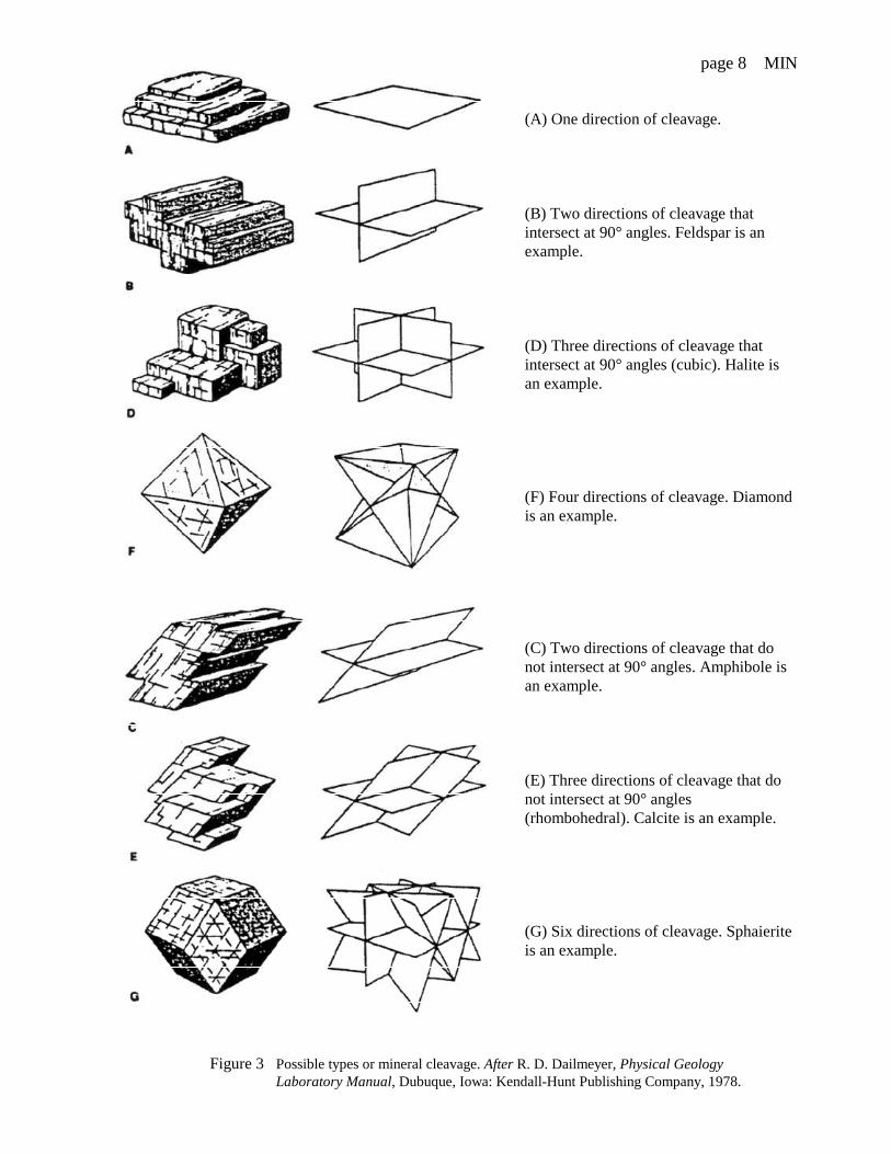
Stage 2a. If cleavage is present, minerals that cleave in: (see Figure 3, page 8) One direction - break into flakes or thin slabsTwo directions - break into slabs, columns or blades with rough endsThree directions - break into regular blocksFour directions - break into four sided pyramidsSix directions - break to yield flat surfaces, seemingly in every direction
Stage 2b. If cleavage is not present, then the mineral fracture can be described as: Conchoidal - exampled by the way glass can break to yield curved and shell-like fracture surfaces Uneven - breaks to yield rough, irregular, shiny surfacesEarthy - breaks to yield rough, irregular, dull or powdery looking surfaceSplintery - breaks into splinters or hair-like fibers
Stage 3. For minerals with two or three cleavage directions, note whether cleavages meet at (orapproximately at) right angles or at distinctly oblique angles.
Step 2. Check your results against the key provided by your laboratory instructor and investigate thereasons for any errors.
Figure 3
Perfect cleavage is easily recognized, for it characteristically develops a smooth, even surface which will reflectlight (arrows) like a mirror (A). Cleavage planes may occur in a step-like manner, however, and appear at firstto be an irregular fracture. If the specimen is rotated in front of a light, the small parallel cleavage planes willreflect light in the same manner as a large, smooth cleavage surface (B). An uneven fracture will notconcentrate light in any particular direction (C).
page 7 MIN
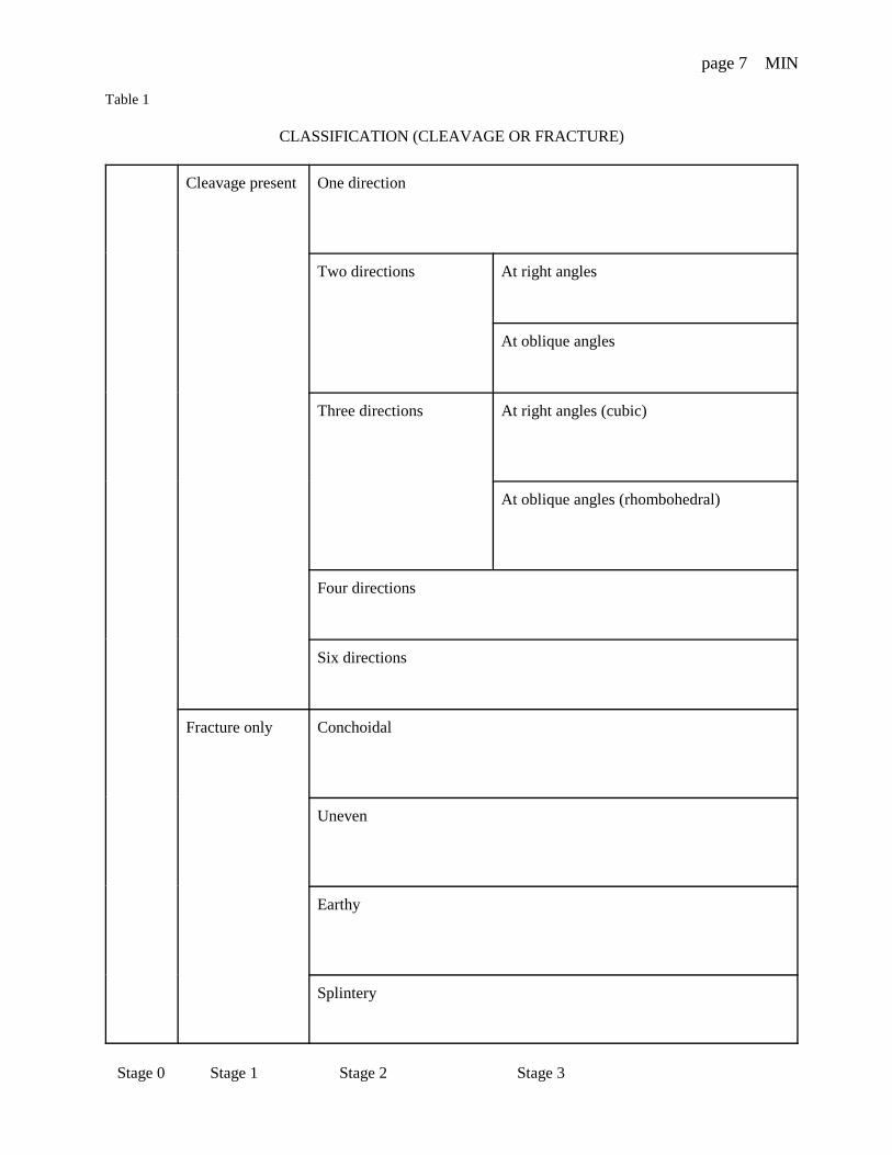
Table 1
CLASSIFICATION (CLEAVAGE OR FRACTURE)
Cleavage present One direction
Two directions At right angles
At oblique angles
Three directions At right angles (cubic)
At oblique angles (rhombohedral)
Four directions
Six directions
Fracture only Conchoidal
Uneven
Earthy
Splintery
Stage 0 Stage 1 Stage 2 Stage 3
page 8 MIN
(A) One direction of cleavage.
(B) Two directions of cleavage thatintersect at 90° angles. Feldspar is anexample.
(D) Three directions of cleavage thatintersect at 90° angles (cubic). Halite isan example.
(F) Four directions of cleavage. Diamondis an example.
(C) Two directions of cleavage that donot intersect at 90° angles. Amphibole isan example.
(E) Three directions of cleavage that donot intersect at 90° angles(rhombohedral). Calcite is an example.
(G) Six directions of cleavage. Sphaieriteis an example.
Figure 3 Possible types or mineral cleavage. After R. D. Dailmeyer, Physical Geology Laboratory Manual, Dubuque, Iowa: Kendall-Hunt Publishing Company, 1978.

page 9 MIN
Exercise 3 HARDNESS
A mineral's hardness is a measure of its ability to withstand abrasion and scratching by other substances. InMohs hardness scale, materials are ordered according to increasing relative hardness on a scale that runsfrom 1 (talc) through 10 (diamond). In terms of this scale, the hardness of skin is about 1.5, a finger nail isup to 2.5, a knife blade is near 6.5, window glass is 5.5 and a streak plate is near 6.5.
Your problem is to determine the relative hardness of the given minerals by comparison to window glass.
Procedure: Work with one specimen at a time. Record your results in Table 2.Step 1. Write mineral specimen numbers in each stage of the classification.
Stage 0. Pick up a mineral specimen and note the specimen number.Stage 1. Place a glass slab on the table (CAUTION: do not hold it in your hand) and see if
you can scratch 1 it with the mineral. If you cannot, the mineral's hardness is less than 5.5 but if you can itshardness is 5.5 or more. (Your instructor may ask you to skip stages 2 and 3 at this time.)
If time permits: further subdivide the soft minerals by testing their relative hardeness first with your fingernail and then against the mineral calcite (hardness 3).
Stage 2. Try scratching the specimen with your finger nail using a cutting (do not pull yournail towards you but use a side to side) motion. If the specimen can be so scratched, it is softer than afinger nail. If the specimen cannot be so scratched proceed to Stage 3.
Stage 3. See if the smooth cleavage surface of a calcite crystal can be scratched by a sharpedge of the mineral. If the mineral does not leave a scratch its hardness is less than 3 but if it does itshardness is 3 or more.
Step 2. Check your results against the key provided by your laboratory instructor and investigate thereasons for any errors.
1 Rub any powder away with your finger tip. If there is a scratch, it should be deep enough for you to catch yourfinger nail in it.
Table 2
H. less than 5.5 (SOFTER THAN GLASS)
H. less than 2.5
H. 2.5 or more H. between 2.5 and 3
H. more than 3 and less than 5.5
H. more than 5.5(HARDER THAN GLASS)
Stage 0 Stage 1 Stage 2 Stage 3

page 10 MIN
Exercise 4 LUSTER and COLOR TONE
The color tone of some of the common rock forming minerals is light and for others it is dark. None of thecommon rock forming minerals look metallic and their luster is described as nonmetallic. Your problem isto sort these specimens according to their color tone. Any which look like metals, or which look dull orearthy, will not be common rock forming minerals, and these are identified differently according to theirstreak (see page 14).
Procedure: Work with one specimen at a time. Record your results in Table 3.
Step 1. Write mineral specimen numbers in each stage of the classification. Stage 0. Pick up a mineral specimen and note the specimen number.
Stage 1. Decide whether the mineral is:Nonmetallic in its luster (if it is, go to Stage 2),
Metallic in its luster (looks unquestionally like what one might buy as a metal), or is Earthy (dull)
Stage 2. If the mineral is nonmetallic, decide if it is:Leucocratic - meaning: light colored (specifically in geology this most oftenmeans: colorless, white, light gray, pink, orange, yellow, blue)
Melanocratic - meaning: dark colored (specifically in geology this most oftenmeans: black, brown, brownish red, green)
Step 2. Check your results against the key provided by your laboratory instructor and investigatethe reasons for any errors.
Table 3
Nonmetallic Leucocratic
Melanocratic
Metallic or Earthy (dull)
Stage 0 Stage 1 Stage 2
page 11 MIN
Section III
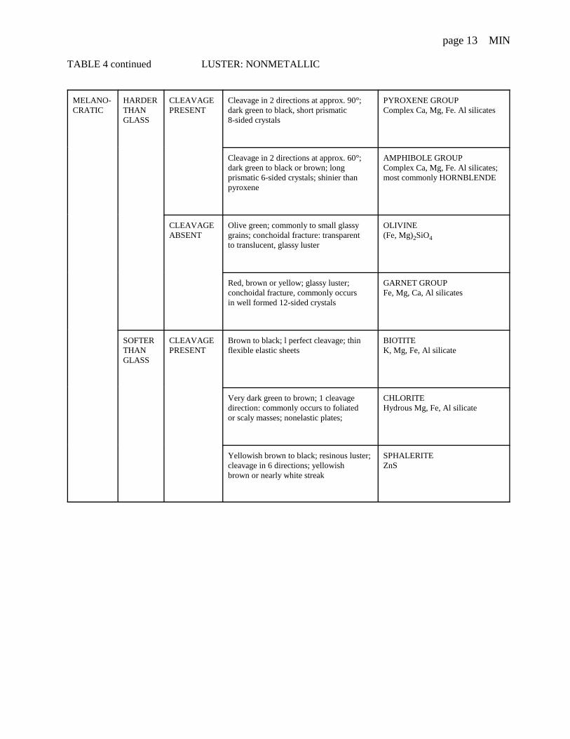
Exercise 5 IDENTIFICATION OF THE COMMON ROCK FORMING MINERALS
You have examined the given common ruck forming minerals for luster, color tone, relative hardness, andthe presence or absence of cleavage. These few physical properties can go a long way towarddistinguishing the several common rock forming minerals. Your problem is to name each of them.
Procedure: Work with one specimen at a time.Step 1. Refer to your data in Tables 1, 2 and 3.
Write mineral specimen numbers in each stage of:
Table 4 for identification of minerals with nonmetallic luster (pages 12, and 13), and in
Table 5 for identification of minerals with metallic luster or with an earthy (dull) luster(page 14).

page 12 MIN
TABLE 4 LUSTER: NONMETALLIC
LEUCO-CRATIC
HARDERTHANGLASS
CLEAVAGEPRESENT
Good cleavage in 2 directions at approx. 90°;pearly to vitreous luster
FELDSPAR GROUP
Potassium feldsparsKAISi3O8 - Pink, white orgreen
Plagioclase feldsparsNaAISi3O8 to CaAl7SiO2White, blue-gray; striationson some cleavage planes
CLEAVAGEABSENT
Conchoidal fracture; transparent to translucent;vitreous luster; when present, 6-sided prismaticcrystals
QUARTZ SiO2 (silica)Varieties: Milky: white and opaque Smoky: gray to black Rose: light pink Amethyst: violet
Conchoidal fracture; waxy luster CRYPTOCRYSTALLINEQUARTZ, SiO2 Agate: banded Flint: dark color Chert: light colored Jasper: red Opal: waxy luster
SOFTERTHANGLASS
CLEAVAGEPRESENT
Perfect cubic cleavage; colorless to white;soluble in water; salty taste
HALITENaCl
Perfect cleavage in 1 direction; poor in 2 others GYPSUM CaSO, • 2H,0
Perfect cleavage in 1 direction, producing thinelastic sheets;
MUSCOVITEKAl 2(AISi3O10)(OH)2
Perfect cleavage in 3 directions at approx. 75 º,effervesces in HC1
CALCITECaCO3
Cleavage as in calcite; effervesces in HCl only ifpowdered
DOLOMITECaMg(CO3)2
Good cleavage in 4 directions; colors: yellow,blue, green, or violet; transparent to translucent;cubic crystals
FLUORITECaF
Green to white; soapy feel; pearly luster, H =1; foliated or compact masses; one direction ofcleavage, forms thin scales and shreds
TALCMgAl2,Si3O10)(OH)2
CLEAVAGEABSENT
White to red; earthy mimics; crystals so small nocleavage; becomes plastic when moistened,earthy odor
KAOLINITE Al6Si4O10(OH)3
page 13 MIN
TABLE 4 continued LUSTER: NONMETALLIC
MELANO-CRATIC
HARDERTHANGLASS
CLEAVAGEPRESENT
Cleavage in 2 directions at approx. 90°;dark green to black, short prismatic8-sided crystals
PYROXENE GROUPComplex Ca, Mg, Fe. Al silicates
Cleavage in 2 directions at approx. 60°;dark green to black or brown; longprismatic 6-sided crystals; shinier thanpyroxene
AMPHIBOLE GROUP Complex Ca, Mg, Fe. Al silicates;most commonly HORNBLENDE
CLEAVAGEABSENT
Olive green; commonly to small glassygrains; conchoidal fracture: transparentto translucent, glassy luster
OLIVINE(Fe, Mg)2SiO4
Red, brown or yellow; glassy luster;conchoidal fracture, commonly occursin well formed 12-sided crystals
GARNET GROUPFe, Mg, Ca, Al silicates
SOFTERTHANGLASS
CLEAVAGEPRESENT
Brown to black; l perfect cleavage; thinflexible elastic sheets
BIOTITEK, Mg, Fe, Al silicate
Very dark green to brown; 1 cleavagedirection: commonly occurs to foliatedor scaly masses; nonelastic plates;
CHLORITEHydrous Mg, Fe, Al silicate
Yellowish brown to black; resinous luster;cleavage in 6 directions; yellowishbrown or nearly white streak
SPHALERITE ZnS

page 14 MIN
The following minerals are usually not volumetrically abundant. But when they are, they are conspicuous.
TABLE 5 LUSTER: METALLIC OR EARTHY (DULL)
METALLIC OR EARTHY (DULL)
REDSTREAK
Red to black to steel grey. Earthy, sometimes oolitic orbotryoidal masses.
HEMATITE Micaceous variety - specular
YELLOWto BROWNSTREAK
Yellow brown, brown to black. Often in radiating forms. GOETHITE Fe2O3• nH2OBog iron ore.
GREEN Green. Earthy, sometimes botryoidal masses. MALACHITECu2CO3(OH)2
BLACK STREAK
Black. Strongly magnetic. Cubic crystals but usually ingranular masses.
MAGNETITE FeO-Fe203
Lead grey. Cubic crystals. H =2.5.Sp. Gr.=7.4-7.6. Cleavageperfect cubic. Luster bright silver metallic. Easily recognizedby good cubic cleavage, high specific gravity, and softness.
GALENA PbS
Steel grey to black. Cleavage, perfect, one direction. H =1-2,so greasy feel and writes on paper.
GRAPHITEC
Pale brass yellow. Cubic crystals. H =6-6.5. Fracture uneven.Crystals have striated faces. Also massive. ‘Fool's Gold.’
PYRITE FeS2
Brass yellow, often tarnished to bronze or purple. Brittle.Tetragonal crystals. H =3.5-4.
CHALCOPYRITECuFeS2
DISCUSSION: TO DISTINGUISH BETWEEN CRYSTAL FACES AND CLEAVAGE OR FRACTURE SURFACESThe museum collection of identified minerals shows the unbroken crystal form of several of the minerals with which you have beenworking. Discuss with your laboratory instructor what features can distinguish a crystal face from a cleavage or fracture surface.

page 15 MIN
MINERALS Your name:
Multiple choice questions date:
Petrology is the scientific study ofa. the earth.b. minerals.c. rocks.d. oil and gas.
A mineral can be a. a liquid.b, chert. c. naturally occurring.d, organic.
All minerals with the same name have the same a. composition.b. internal crystal structure.c. crystal form.d. solid solution.
The volume of the Earth's crust which is made ofsilicates is about a. 5%b. 10%c. 40%d. 90%
The volume of the Earth's crust which is made ofnonsilicates is a. 5%b. 8%c. 39%d. 92%
The geometric arrangement of atoms in crystals isbecause a. these are solids.b. of chemical bonds.c. of the atom's sizes.d. all of the above except (a).
An amorphous solid is not a. flint.b. obsidian.d. coal.e. calcareous shell.
Crystal faces result from a. crystal growth.b. the complete infi1ling of a geode.c. cleavage.e. none of the above.
The law of constancy of interfacial angles is truebecause a. the size of the crystal faces are equal.b. the shape of the crystal is unvaried.c. the internal. geometric arrangement of thecomponent atoms is fixed. d. none of the above.
The habit (shape due to growth) of garnet or pyroxeneisa. columnar.b. granular, eight sided.c. blade shaped.d. fibrous, felted.
Abraham Werner's mineral classification system is a. natural, as it is based on composition and crystalstructure. b. artificial, as it is based on only easily observedpbysica1 properties. c. quantitative, as it is based on S.G. and hardness.d. alchemy based on solubility.
Werner's mineral classification system does not use a. luster.b. smell.c. fusibility.e. sound.
A mineral's luster is judged to be metallica. subjectively, based on familiarity with the look ofmetals. b. objectively. based on the color of highlights.c. because it is opaque and shiny,d. because it is a good conductor of electricity.
Tbe terms adamantine. glassy, resinous, or earthyapply to minerals that are a. metallic.b. organic.c. non-metallic.d. amorphous.
A mineral's specific color can not bea. diagnostic.b. reflection.c. very varied.d. an indication of composition.
page 16 MIN
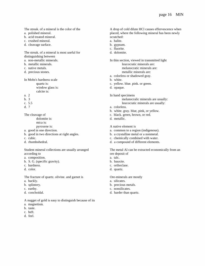
The streak. of a mineral is the color of the a. polished mineral.b. acid treated mineral.c. crushed mineral.d. cleavage surface.
The streak. of a mineral is most useful fordistinguishing between a. non-metallic minerals.b. metallic minerals.c. native metals.d. precious stones.
In Mobs's hardness scale quartz is: window glass is: calcite is:
a. 2b. 3c. 5.5d. 7
The cleavage of dolomite is: mica is: pyroxene is:
a. good in one direction.b. good in two directions at right angles.c. cubic.d. rhombohedral.
Student mineral collections are usually arrangedaccording to a. composition.b. S. G. (specific gravity).c. hardness.d. color.
The fracture of quartz. olivine. and garnet is a. hackly.b. splintery.c. earthy.d. conchoidal.
A nugget of gold is easy to distinguish because of itsa. magnetism.b. taste.c. heft.d. feel.
A drop of cold dilute HCl causes effervescence whenplaced, where the following mineral has been newlyscratched: a. halite.b. gypsum.c. fluorite.d. dolomite.
In thin section, viewed in transmitted lightleucocratic minerals are: melanocratic minerals are: metallic minerals are:
a. colorless or shadowed gray.b. white.c. yellow. blue. pink. or green.d. opaque.
In hand specimens melanocralic minerals are usually: leucocratic minerals are usually:
a. colorless.b. white. gray. blue, pink, or yellow.c. black. green, brown, or red.d. metallic.
A native element is a. common to a region (indigenous).b. a crystalline metal or a nonmetal.c. chemically combined with water.d. a compound of different elements.
The metal Al can be extracted economically from anore deposit of a. talc.b. bauxite.c. orthoclase.d. quartz.
Ore-minerals are mostly a. silicates.b. precious metals.c. nonsilicates.d. harder than quartz.
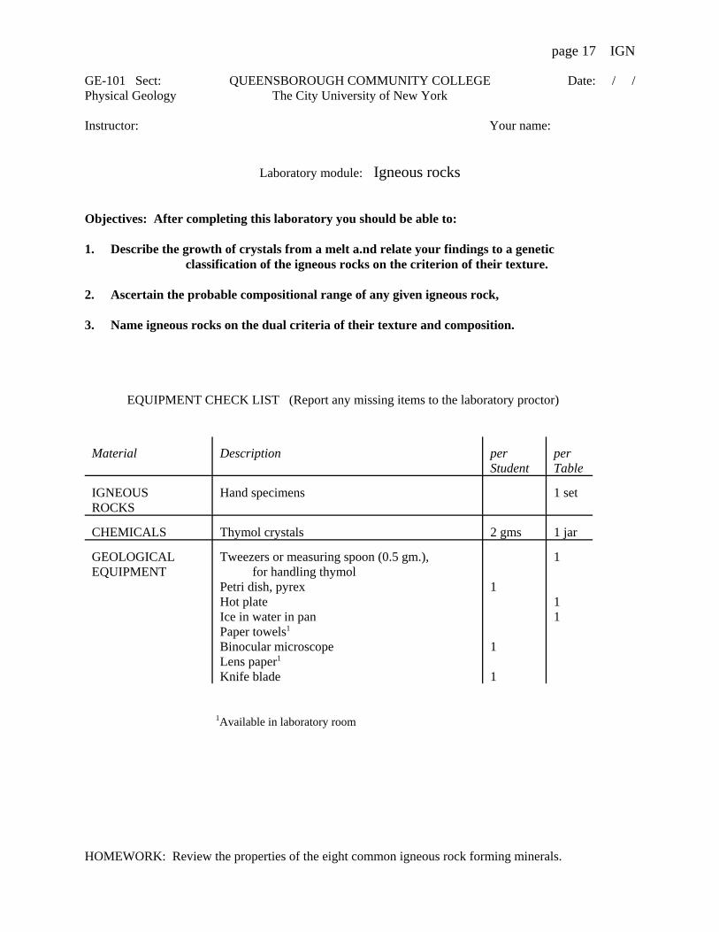
page 17 IGN
GE-101 Sect: QUEENSBOROUGH COMMUNITY COLLEGE Date: / /Physical Geology The City University of New York
Instructor: Your name:
Laboratory module: Igneous rocks
Objectives: After completing this laboratory you should be able to:
1. Describe the growth of crystals from a melt a.nd relate your findings to a genetic classification of the igneous rocks on the criterion of their texture.
2. Ascertain the probable compositional range of any given igneous rock,
3. Name igneous rocks on the dual criteria of their texture and composition.
EQUIPMENT CHECK LIST (Report any missing items to the laboratory proctor)
Material Description perStudent
perTable
IGNEOUSROCKS
Hand specimens 1 set
CHEMICALS Thymol crystals 2 gms 1 jar
GEOLOGICALEQUIPMENT
Tweezers or measuring spoon (0.5 gm.), for handling thymolPetri dish, pyrexHot plateIce in water in panPaper towels1
Binocular microscopeLens paper1
Knife blade
1
1
1
1
11
1Available in laboratory room
HOMEWORK: Review the properties of the eight common igneous rock forming minerals.
page 18 IGN
Section I IGNEOUS ROCKS
Igneous rocks originate from the solidification of magmas or lavas (molten or partially moltenportions of the earth). At depth: magmas rise under the force of gravity when their density is less thanthat of the overlying column of rock. Emplaced at higher levels within the earth: intrusive magmassolidify to form plutonic rocks. Erupted by volcanism at the earth's surface: extrusive magmas arereferred to as lavas. Volcanism is aided by the expansion of gases evolved from a magma under reducedpressure near the earths surface and because of partial crystallization (water is left out of the hightemperature minerals). Lavas solidify (congeal) to form volcanic rocks.
Textural varieties of igneous rocks can be related to variations in the solidification history ofparent magmas or lavas.
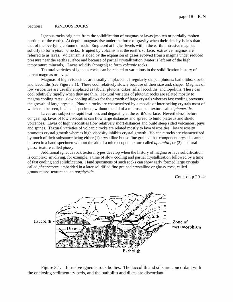
Magmas of high viscosities are usually emplaced as irregularly shaped plutons: batholiths, stocksand laccoliths (see Figure 3.1). These cool relatively slowly because of their size and, shape. Magmas oflow viscosities are usually emplaced as tabular plutons: dikes, sills, laccoliths, and lopoliths. These cancool relatively rapidly when they are thin. Textural varieties of plutonic rocks are related mostly tomagma cooling rates: slow cooling allows for the growth of large crystals whereas fast cooling preventsthe growth of large crystals. Plutonic rocks are characterized by a mosaic of interlocking crystals most ofwhich can be seen, in a hand specimen, without the aid of a microscope: texture called phaneritic.
Lavas are subject to rapid heat loss and degassing at the earth's surface. Nevertheless, beforecongealing, lavas of low viscosities can flow large distances and spread to build plateaus and shieldvolcanoes. Lavas of high viscosities flow relatively short distances and build steep sided volcanoes, puysand spines. Textural varieties of volcanic rocks are related mostly to lava viscosities: low viscositypromotes crystal growth whereas high viscosity inhibits crystal growth. Volcanic rocks are characterizedby much of their substance being either (1) crystalline but so fine grained that component crystals cannotbe seen in a hand specimen without the aid of a microscope: texture called aphanitic, or (2) a naturalglass: texture called glassy.
Additional igneous rock textural types develop when the history of magma or lava solidificationis complex; involving, for example, a time of slow cooling and partial crystallization followed by a timeof fast cooling and solidification. Hand specimens of such rocks can show early formed large crystalscalled phenocrysts, embedded in a later solidified fine grained crystalline or glassy rock, calledgroundmass: texture called porphyritic.
Cont. on p.20 –>
Figure 3.1. Intrusive igneous rock bodies. The laccolith and sills are concordant with the enclosing sedimentary beds, and the batholith and dikes are discordant.

page 19 IGN
Exercise 1 EVALUATION QUESTIONS
Define magma.
At depth, what can cause a magma to rise?
What are igneous rocks called that are inferred to have solidified from intrusive magmas?
What can aid the eruption of lavas?
What are solidified lavas called?
Describe igneous rock textures called:
phaneritic
aphanitic
glassy
What two factors can influence crystal size in igneous rocks?
Are all igneous rocks crystalline? (yes, no) Explain.
In porphyritic igneous rocks, are phenocrysts:
the first formed or the last formed crystals?
noticeably larger or smaller than any ground mass crystals?
Can the groundmass of a porphyritic rock be phaneritic, aphanitic or a glass? (yes, no) Explain.

page 20 IGN
Only eight of all the known elements are abundant in the earth's crust. Igneous rocksmade from these elements occur wherever a magma (a wholly or partially molten portion of theearth) has solidified. The eight elements: oxygen, silica, aluminum, potassium, sodium,calcium, iron and magnesium, occur in different proportions in different igneous rocks. Someigneous rocks are natural glasses, others are aggregates of mineral crystals in which the elementsexist in chemical combinations with each other. Crystalline igneous rocks are usually made ofmore than one type of mineral. This is because the chemical composition of any one mineral isnarrowly limited by its crystalline structure.
Eight igneous rock forming minerals are common: quartz, white mica, K-feldspar,plagioclase, dark mica, hornblende, pyroxene, olivine. No one igneous rock, however, containsall of these minerals. Minerals which coexist in any one igneous rock are determined by thepercentage abundance of silica in the whole rock. The suggestion here is that in the originalmagma, the metalloids silica and aluminum and the nonmetal oxygen combine to behave as anacid in the presence of metals (potassium, sodium, calcium, iron, magnesium) which behave asbases. Acids and bases react to build the rock minerals. While such reasoning is by way ofanalogy only, a rock that contains much silica is called "acidic" (60 to 100 % SiO2)*, and onethat contains relatively little is called "basic" (40 to 50% SiO2). Igneous rocks of "intermediate"(50 to 60% SiO2) and of "ultrabasic" (0 to 40% SiO2) composition are also recognized.
In order to divide crystalline igneous rocks into groups of similar chemical composition,it is usually sufficient either to compare the percentage abundance of common rock formingminerals in each or, alternatively, to recognize the presence or absence of one of those minerals. Not counted are minerals which make up less than one percent of the rock. These are calledaccessory minerals. For example, quartz (a major component of acidic igneous rocks) can occurin a basic igneous rock only as an accessory mineral. Also, garnet, atypical of most igneousrocks, sometimes occurs as an accessory mineral in felsic igneous rocks.
Common igneous rock accessory minerals which are invariably present, but which areusually hard to see without a microscope, are: magnetite, ilmenite, rutile, and zircon.
*In reporting the chemical composition of a rock, element abundances are quoted as their oxide abundances as are determined by quantitative chemical analysis.

page 21 IGN
List the eight most abundant elements in the earth's crust:
Why does a crystalline igneous rock usually contain more than one type of mineral?
Can all eight common igneous rock forming minerals coexist in a single rock? (yes, no) Explain.
Which of the eight most abundant crustal elements are nonmetals or metalloids?
Define "acidic" igneous rock:
Can an ultrabasic igneous rock have no silica? (yes, no) Explain.
To divide crystalline igneous rocks into groups of similar chemical composition, is it necessaryto obtain a quantitative chemical analysis of each rock? (yes, no) Explain.
Define accessory mineral:

page 22 IGN
Section II
Exercise 2 CRYSTALLIZATION OF A MELTIgneous rocks melt at very high temperatures. In this exercise, thymol, an organic
crystalline solid, substitutes for igneous rock because it melts at just above normal roomtemperature and, therefore, it can be easily and safely studied. Your problem is to determinewhat textural features of a crystalline solid would indicate a history of slow crystallization or offast crystallization of a melt.
Step 1. TO OBSERVE SLOW CRYSTALLIZATIONTurn on a hot plate and set to lowest heat. Locate a petri dish (pyrex) and place about 2
gms. of thymol crystals in it. (CAUTION: use measuring spoon or tweezers to handle thymol foralthough it is not poisonous, it can irritate the eyes and skin.)
Place the petri dish containing the thymol on the hot plate. Tilt the dish from side to sideoccasionally so the melting thymol spreads evenly. (Note: if the thymol fumes excessively, thehot plate was not set to its lowest heat.) Remove the petri dish when a few specks of crystalremain. (Note: if you have completely melted the thymol add a tiny bit more.) Place the petridish on the stage of a binocular microscope and observe at low magnification. When you seecrystals begin to grow, increase the magnification, adjust the focus and the light, and study, indetail, the order and manner of crystal growth. (Note: you can repeat the experiment by simplyreheating the petri dish.)
Step 2. TO OBSERVE FAST CRYSTALLIZATIONPartly fill a bowl with water and some ice cubes. Place a paper towel flat on the table
nearby. Heat the petri dish containing the thymol as before. When only a few specks of crystalthymol remain, remove the petri dish immediately and float it on the top of the iced water in thebowl. The thymol should crystallize rapidly. Remove, dry base of petri dish on the paper toweland set it on the microscope stage.
Clean up: Do not try to wash the petri dishes: thymol is insoluble in water. Simply cover andstack the used dishes.
EVALUATIONDescribe in your own words what textural features of a crystal aggregate that has solidified froma melt, indicates a history of:
Slow crystallization
Fast crystallization
First formed crystals in the aggregate tend to be (circle those which are true):
larger
smaller
anhedral (irregular shape)
euhedral (exhibits crystal form)

page 23 IGN
Exercise 3 IDENTIFICATION OF IGNEOUS ROCK TEXTURES
Igneous rocks result from the solidification of magma or lava. A continuum of possibletextures exists that can be broadly related to the circumstances of solidification. Your problem isto sort the given igneous rocks according to the identification scheme given in Table 1 and tolearn their textural class names.Procedure: Work with one hand specimen at a time. Record your results in Table 1. Step 1. Write the hand specimen number in each stage of the identification. Read thefootnotes to Table 1 as you proceed.
Igneous rocks composed of crystals that can be seen with the naked eye (generally 1-10mm) are said to have a phaneritic texture (from the Greek word for visible). Phaneritic igneousrocks with very large grains (generally larger than 1 cm) have a pegmatitic texture. Igneousrocks composed of crystals too small to be seen with the naked eye (generally less than 1 mm)have an aphanitic texture (from the Greek word for invisible).
Igneous rocks composed of volcanic glass have a hyaline texture (from the Greek wordfor glass) or glassy texture.
Some igneous rocks have two distinct sizes of crystals: these have a porphyritic texturein which the large crystals are called phenocrysts, and the smaller, more numerous crystals arecalled the matrix, or groundmass. There are also porphyritic-aphanitic textures, meaning that thephenocrysts occur in an aphanitic matrix, and porphyritic-phaneritic textures, meaning that thephenocrysts occur in a phaneritic matrix.
Vesicles are gas bubbles trapped in a rock. Igneous rocks with vesicles have a vesiculartexture. Occasionally, lavas contain so many vesicles that they are frothy, like whipped eggwhites. Upon cooling, a frothy texture can result in the occurrence of scoria (dark color) orpumice (light color). Pumice has so many tiny vesicles that it floats on water!
Pyroclasts (from the Greek, "fire broken") are fragmented rocky materials that have beenmechanically transported during explosive volcanic eruptions. They include fragments ofvolcanic ash (pyroclasts <2 mm), lapilli or cinders (pyroclasts 2-64 mm), and volcanic bombs(pyroclasts >64 mm. Igneous rocks composed of pyroclasts have a pyroclastic texture. Theyinclude tuff (composed of volcanic ash) and volcanic breccia (composed chiefly of cinders andvolcanic bombs). Step 2. Check your results against the key provided by your laboratory instructor andinvestigate the reasons for any errors.
Footnotes to Table 1 (1) Each visible crystal (mineral grain) will be fairly uniform in color: its outline may beirregular or geometric. In a rock, minerals of different color are easily distinguished. When arock has a uniform color, rotate it in the light and look for small flat reflective surfaces. If seen,these are cleavage surfaces of individual crystals (mineral grains). (2) The smaller crystals (if these exist in the hand specimen) may have geometric outlines. (3) The smaller crystals have irregular outlines. The rock is made of
(a) some large crystals set in a groundmass small crystals, or(b) crystals of not greatly contrasting sizes.
(4) The crystals that can be seen, have geometric outlines. (5) The rock is uniform in color and dull and:
(a) is solid throughout(b) has spherical voids in it but is relatively heavy (some of the voids may have been
filled with a secondary mineralization—the fillings are called amygdales)(c) is shiny(d) has finely alternating dull light colored and shiny dark colored layers(e) is frothy and noticeably light in weight.

page 24 IGN
Table 1 IDENTIFICATION SCHEME TEXTURAL PROBABLE
TYPE ORIGIN
Mineral grainscan be seen bythe unaided eye. These crystalsmake up morethan 1 percent ofthe volume ofthe hand-specimen.(1)
one or a few very large crystals makeup most of the hand specimen(2)
PegmatiticPhaneritic
P L U T O N I C
V O L C A N I C
Many crystals: the rock is seeneverywhere tobe made ofcrystals(3)
Crystals of greatlycontrasting size(3a)
PorphyriticPhaneritic
Crystals are ofapproximatelyequant size(3b)
Phaneritic
Crystals seen are separated by rockin which crystals cannot be seen(4)
PorphyriticAphanitic
Mineral grainscannot be seenor any crystalsthat can be seenmake up lessthan 1 percent ofthe volume ofthe handspecimen.
Rock is solid throughout. Dull inappearance.(5a)
Aphanitic
Rock has rounded voids oramygdales in it and is heavier thanwater(5b)
Vesicular
Rock is shiny and fracturesconchoidally(5c)
Glassy
Rock is finely layered(5d)
Glassy
Rock looks frothy and is lighter thanwater(5e)
Vesicular
Rock is composed of fragments Pyroclastic
Stage 0 Stage 1 Stage 2 Stage 3
page 25 IGN
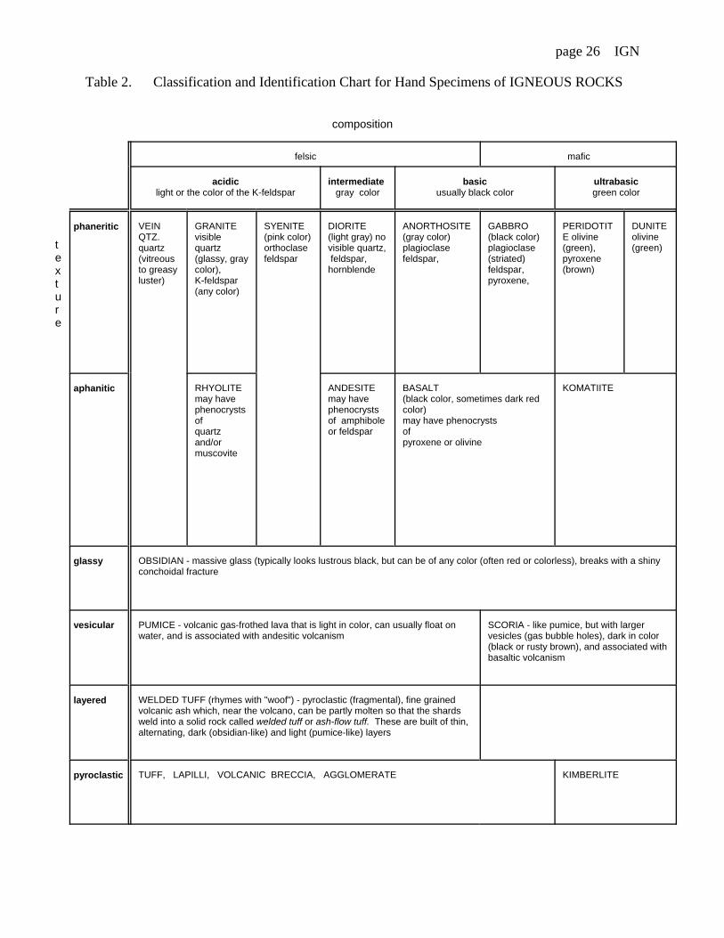
Section III IGNEOUS ROCK NAMES
Exercise 4Igneous rocks are classified using the dual criteria of texture and composition (for the
latter, a color index is used when no minerals can be seen).
Procedure: Work with one hand specimen at a time. Record your results in Table 2. Step 1. Write the hand specimen number in each stage of the identification.
Stage 1. For each specimen, you have already identified the texture. This gives you therow in Table 2 in which the rock's name will occur.
Stage 2. Decide on the column in Table 2 in which the rock's name will occur.
Igneous rocks composed mostly of quartz, potassium feldspar, and plagioclaseare classified as felsic (light-colored).
Igneous rocks composed mostly of the dark-colored ferromagnesian minerals(i.e., minerals containing much iron and magnesium) are classified as mafic(usually black, brown, or deep red in color).
Igneous rocks composed equally of felsic and mafic minerals are classified as intermediate (gray).
Igneous rocks are composed entirely of ferromagnesian minerals are classifiedas ultramafic (usually green or brown in color).
Also, mineral composition of an igneous rock can be approximated using a color index,which is the percentage (by visual estimation) of dark minerals in the rock:
Fine grained felsic rocks tend to be pink, white, or pale brown
Fine-grained intermediate rocks tend to be greenish-gray
Fine-grained mafic rocks tend to be dark-gray-to-black.
Step 2. The igneous rock's name is where the row and column cross (Step 1). Also note:
Textural terms such as porphyritic and vesicular can be used as adjectives. For example,one might identify a pinkish, fine-grained, igneous rock as a rhyolite. However, if it containsscattered phenocrysts, it is a porphyritic rhyolite. Similarly, a basalt with vesicles is a vesicularbasalt.
An igneous rock which has a pegmatitic texture is named, for example: granitepegmatite, syenite pegmatite, and so on.
page 26 IGN
Table 2. Classification and Identification Chart for Hand Specimens of IGNEOUS ROCKS
composition
texture
felsic mafic
acidiclight or the color of the K-feldspar
intermediategray color
basicusually black color
ultrabasicgreen color
phaneritic VEINQTZ.quartz(vitreousto greasyluster)
GRANITE visiblequartz(glassy, graycolor), K-feldspar(any color)
SYENITE(pink color)orthoclasefeldspar
DIORITE(light gray) novisible quartz, feldspar,hornblende
ANORTHOSITE(gray color)plagioclasefeldspar,
GABBRO(black color)plagioclase(striated)feldspar,pyroxene,
PERIDOTITE olivine(green),pyroxene(brown)
DUNITEolivine(green)
aphanitic RHYOLITEmay havephenocrystsofquartzand/ormuscovite
ANDESITEmay havephenocrystsof amphiboleor feldspar
BASALT(black color, sometimes dark redcolor)may have phenocrystsofpyroxene or olivine
KOMATIITE
glassy OBSIDIAN - massive glass (typically looks lustrous black, but can be of any color (often red or colorless), breaks with a shinyconchoidal fracture
vesicular PUMICE - volcanic gas-frothed lava that is light in color, can usually float on water, and is associated with andesitic volcanism
SCORIA - like pumice, but with largervesicles (gas bubble holes), dark in color(black or rusty brown), and associated withbasaltic volcanism
layered WELDED TUFF (rhymes with "woof") - pyroclastic (fragmental), fine grainedvolcanic ash which, near the volcano, can be partly molten so that the shardsweld into a solid rock called welded tuff or ash-flow tuff. These are built of thin,alternating, dark (obsidian-like) and light (pumice-like) layers
pyroclastic TUFF, LAPILLI, VOLCANIC BRECCIA, AGGLOMERATE KIMBERLITE

page 27 IGN
BOWEN'S REACTION SERIES
Bowen studied the order in which minerals crystallize from a basaltic melt. In this, athigh temperature, two sequences of minerals coexist (Figure 3.2). The minerals which exist, astemperature is lowered, is determined by reactions with the melt. In one sequence, a polymer[SiO4]
4- in the presence of Fe3+ and Mg2+ ions with lowering temperature gives Bowen'sdiscontinuous reaction series. In the other sequence, the polymer [Si2Al2O]2- becomes thepolymer [Si3AlO8]
1- anwith a substitution of Na1+ for Ca2+ ions with lowering temperature givesBowen's continuous reaction series.
In the discontinuous series (olivine6pyroxene6amphibole6biotite), each mineral has adifferent structure. The higher temperature mineral in each case dissolves upon thecrystallization of the lower temperature mineral in the sequence.
In the continuous series, the plagioclase structure stays the same but its compositionchanges, through a continuum, from being calcium rich at high temperature to being sodium richat low temperature.
HIGH
LOW
11250C T E M P E R A T U R E6000C
Olivine (monomer, first to crystallize)` Ca-plagioclase (3-D open)
Pyroxene (chain) b` Ca,Na-plagioclase (3-D open)
Amphibole (double chain) b ` Na-plagioclase (3-D open)
Biotite mica (sheet` b
K-feldspar (3-D open)9
Muscovite mica (sheet)9
Quartz (3-D solid, last to crystallize)
Figure 3.2 Bowen's reaction series
MAGMATIC DIFFERENTIATION
Bowen realized that any igneous rock could be derived by a process of magmaticdifferentiation of basaltic magma. As this mafic magma cools the first formed crystals areolivine. These minerals are rich in iron and magnesium and relatively poor in silicon. Withrespect to these elements, the remaining uncrystallized melt is depleted in the first two and isenriched in the third and so it will be more felsic than the original magma. If the olivine isremoved from contact with the remaining liquid, either by settling out as a layer of olivine or bythe a mechanism of filter pressing whereby the remaining liquid is forced away to accumulate byitself elsewhere, the olivine cannot change to pyroxene because there is no liquid with which itcan react at lower temperatures and an igneous rock made of olivine (called dunite), close incomposition to peridotite, persists. If the remaining liquid continues to cool, minerals ofpyroxene and calcium rich plagioclase will crystallize. The remaining melt becomes even morefelsic. Again this liquid can be separated leaving behind a rock close to gabbro in composition. In short, by continuing this process, nature can produce diorite and ultimately granite.
Alternatively, the partial melting of peridotite will produce a melt of basalticcomposition. In short, the partial melting of an igneous rock will produce a magma which ismore felsic than the whole rock. In this way the partial melting of continental crustal rocks(which on average have an andersitic composition) can yield granitic magmas.

page 28 IGN
Igneous rock classification (modern simplified)

page 29 IGN
IGNEOUS ROCKS Your name:
multiple choice review questions Date:
A magma isa. a stone.b. an igneous rock.c. partly molten stony earth material.d. hardened earth material.
Lava can bea. intrusive.b. extrusive.c. a volcano.d. plutonic.
Natural glass rarely forms when a melt hasa. cooled and crystallized quickly.b. a low viscosity.c. a high silica content.d. degassed.
Aphanitic is a description of the texture ofa. natural glass.b. crystalline volcanics.c. lava.d. granite.
Vesicles originate when the volatile contentof a lavaa. dissolves.b. bubbles out of solution.c. forms pipes at the base of a flow.d. none of the above.
Plutonic igneous rocks area. a mythical Gr. god.b. intrusive.c. extrusive.d. chilled country rock.
Plutonic igneous rock is characterized bya. glassy interiors and coarse grained
marginsb. vesiclesc. veins formed from residual liquidsd. pillows
The composition of igneous rock isindicated bya. its temperature.b. the coexistence of quartz and olivine.c. its color.d. the size of its crystals.
An igneous texture is "granitic" when ita. is unlayered.b. has oriented crystals.c. is an interlocking mosaic of crystals.d. all of the above.
The texture of an igneous rock withphenocrysts isa. glassy.b. phaneritic.c. aphanitic.d. porphyritic.
Felsic igneous rocks are mostlya. K-feldspar (orthoclase).b. Ca-Na-plagioclase.c. plagioclase feldspar and ferromagnesians.d. ferromagnesians.
An igneous rock composed of 25% quartz,50% orthoclase, and 5% Na-plagioclase is a. granite.b. diorite.c. gabbro.d. peridotite.
Plagioclase in a gabbro is typicallya. minor.b. 25%c. 40%d. 60%
An igneous rock composed of 80% olivine,20% pyroxene and plagioclase isa. granite.b. diorite.c. gabbro.d. peridotite.
page 30 IGN
The silica content of diorite or andesite issaid to make ita. acidic.b. intermediate.c. basic.d. ultrabasic.
The color of gabbro or basalt ischaracteristicallya. white.b. gray.c. black.d. green.
An example of an igneous rock made ofmore than one mineral isa. syenite.b. basalt.c. dunite.d. vein quartz.
Visible quartz is always present ina. granite.b. diorite.c. gabbro.d. rhyolite.
Olivine phenocrysts are often present ina. rhyolite.b. andesite.c. basalt.d. all of the above.
Amphibole phenocrysts identify an igneousrock to be aa. rhyolite.b. andesite.c. basalt.d. komatiite.
Scoria is different from obsidian because itisa. a welded tuff.b. vesicular.c. dark in color.d. pumice.
Obsidian is typicallya. dull black.b. conchoidally fractured.c. vesicular, and floats on water.d. a thin flow.
A sill is aa. dome shaped extension of a batholith.b. tabulate pluton that cuts across structuresin the country rock.c. tabulate pluton that is conformable with structures in the country rock.d. large spoon shaped pluton.
Extensive fissure flows of basalt builda. plateau basalts.b. composite volcanoes.c. puys.d. basaltic cinder cones.
Alternating flows of andesite and layers ofash, are characteristic ofa. plateau basalts.b. shield volcanoes.c. composite volcanoes.d. puyes.
Magmatic differentiation can involvea. partial melting.b. removal of first formed crystals.c. cooling.d. all of the above.
The partial melting of andesite can producea magma with the composition ofa. peridotite.b. gabbro.c. diorite.d. granite.

page 31 SED
GE-101 Sect: QUEENSBOROUGH COMMUNITY COLLEGEPhysical Geology The City University of New York Date: / /
Instructor: Your name:
Laboratory module: Sediments and sedimentary rocks
Objectives: After completing this laboratory you should be able to:
1. Explain how the composition and texture of sedimentary rocks can be indicative of their origin.
2. Describe and name a variety of detrital sediments and sedimentary rocks.
3. Describe and name a variety of chemical sediments and sedimentary rocks.
EQUIPMENT CHECK LIST (Report any missing items to the laboratory proctor)
Material Description perStudent
perTable
SEDIMENTS
ANDSEDIMENTARYROCKS
Hand specimens (A) detrital
(B) chemical(sterilized: anhydrite, bittern salt, halite chips)1
1 set1 set
CHEMICALS Dilute (5%) hydrochloric acid in a dropper bottle 2
GEOLOGICALEQUIPMENT
Window glass, 3" square plate with beveled edges (for hardness test) Streak platePocket knife (blades blunted)Hand lens
1
122
SPECIALEQUIPMENT
Wood matchesAlcohol burnerWire (steel, thin gauge), 1 roll1
Wire holder1
Pliers (wire cutting and shaping)1
1 box2
42
1Available in laboratory room

page 32 SED
Section I SEDIMENT, SEDIMENTS AND SEDIMENTARY ROCKS
Sediment. In the singular the word is usually applied to material in suspension in water or recentlydeposited from suspension. In the plural, the word is applied to all kinds of deposits from the water ofstreams, lakes, or seas, and in a more general sense to deposits of wind and ice. Such deposits that have beenconsolidated are called sedimentary rocks. (Bryan)
Weathering produces the materials of sediments: the dissolved salts and particulate components of soils. In the zone of weathering, accumulations of these products are soils or colluvium1. These are not consideredto be sediments because, by definition: a sediment is an accumulation of any materials that can be argued tohave undergone significant, prior, transportation by wind, moving water, moving ice or gravity.
Sediments whose material originated as dissolved weathering products are called chemical sediments. Dissolved materials can be removed from solution: by evaporation of the dissolving medium, by chemicalprecipitation or by biochemical mechanisms. In order for a chemical sediment to accumulate, its substancecan be removed from solution either during transportation or at the site of sedimentation.
Sediments whose material originated as particulate weathering products are called detrital sediments. Inorder for a detrital sediment to accumulate, its substance must be eroded from the zone of weathering and betransported, without being wholly dissolved, and be deposited by settling or coming to rest at the site ofdeposition.
Particles of any size that have undergone transportation as solid particles are called clasts2. Class namesfor clast size ranges are: boulder, cobble, pebble, granule, sand, silt and clay:
Size range (millimeters) Clast size
>256 64 - 256 4 - 64 2 - 4
Boulder Cobble Pebble Granule
1/16 - 2 Sand
1/256 - 1/16 <256
Silt Clay
Sedimentary rocks are divided into two categories: detrital and chemical. Detrital sedimentary rocksoriginate by the lithification of detrital sediments. Lithification can result from: the compaction of clasts,interlocking of clast boundaries (by their recrystallization) or the precipitation between clasts of cementingmaterial from circulating ground waters. Chemical sedimentary rocks originate: by the direct crystallizationof transported, dissolved, material on a substrate, by the replacement and concomitant lithification of asediment by transported, dissolved, material or by the lithification of chemical sediments.
Chemical sedimentary rocks that are not accumulations of clasts have a nonclastic (crystalline oramorphous) texture. Other chemical sedimentary rocks, for example a collection of shells, and all detritalsedimentary rocks have a clastic texture.
1Colluvium, for example talus, is not a sediment because it is material that is currently undergoingtransportation by mass wasting (ongoing downslope movement caused by gravity that acts as a body force).
2A clast, by definition, must have undergone prior transportation. A crystal which grows and stays in placeis not, for example, called a clast.
page 33 SED
Sedimentary rocks visible in hand specimens or outcrops give the geologist clues to the rock's origin andenvironment of deposition. A list of some of the more common features is given below:
a. Particle Size: The size of the particles is an indication of the energy of the transportingmedium. For example, swift streams carry cobbles; wind and waves transport sand
grains; and gentle currents carry, in suspension, clay particles far out to sea.b. Stratification: Strata, beds, or layers are formed by repeated depositional events, or by a change in the material supplied to the depositional site. Stratification is the most common feature of
sedimentary rocks.c. Cross-Bedding: Each stratum is built of beds that are steeply inclined to the horizontal. These form where a prograding depositional surfaces are at an angle to the
accumulating stratum, such as on the foreset face of a sand dune, river bar, or delta, or where sediment isdelivered from different directions as runnel infillings of a braided stream.
d. Concretions: A localized concentration of cementing material, these are usually resistant to erosion and may stand out from the rock surface as lumps or bulges.e. Jointing: A regular pattern of cracks usually perpendicular to bedding planes caused by breakage due to the weight of overlying rocks.f. Ripple Marks: Small waves or ripples formed by the movement of water or wind over the surface of the sediment prior to solidification.g. Fossils: Any evidence of past life preserved in the rock. May be bone or shell
fragments, footprints, leaf imprints, or organic materials replaced by silica or otherchemicals.
h. Color: Most colors, including red, brown, ochre, green, and purple, are due to variousiron compounds. Black is commonly caused by organic material, and white usuallyindicates some salt, clay (i.e., kaolinite), or silica.
i. Cements: Precipitated calcium carbonate, iron oxides (as hematite and limonite), and colloidalsilica (as chert and drusy quartz), are the most common cements in clastic sedimentary rocks
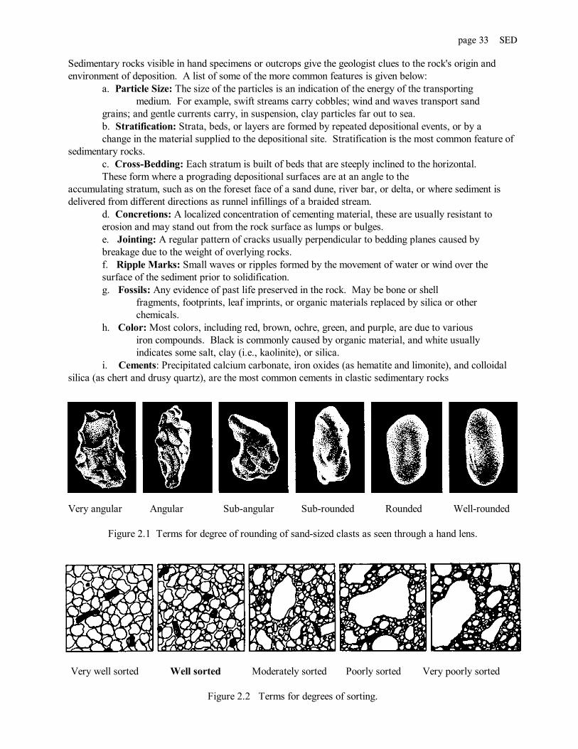
Very angular Angular Sub-angular Sub-rounded Rounded Well-rounded
Figure 2.1 Terms for degree of rounding of sand-sized clasts as seen through a hand lens.
Very well sorted Well sorted Moderately sorted Poorly sorted Very poorly sorted
Figure 2.2 Terms for degrees of sorting.

page 34 SED
Exercise 1 EVALUATION QUESTIONS
What are sediments?
What is a clast?
What is the size range of clasts in pure sand?
Describe three ways that dissolved material can be removed from solution.
What are detrital sediments?
Shell fish can remove dissolved calcium carbonate from water to build their shells. Later some shells can bemoved by water currents to accumulate as sediments. Would such sediments be chemical or detrital?
Describe three lithification mechanisms.
Is it possible to have a chemical sedimentary rock that is not a lithified accumulation of clasts? (yes, no)Explain.
Do all detrital sedimentary rocks have a clastic texture? (yes, no) Explain.
page 35 SED
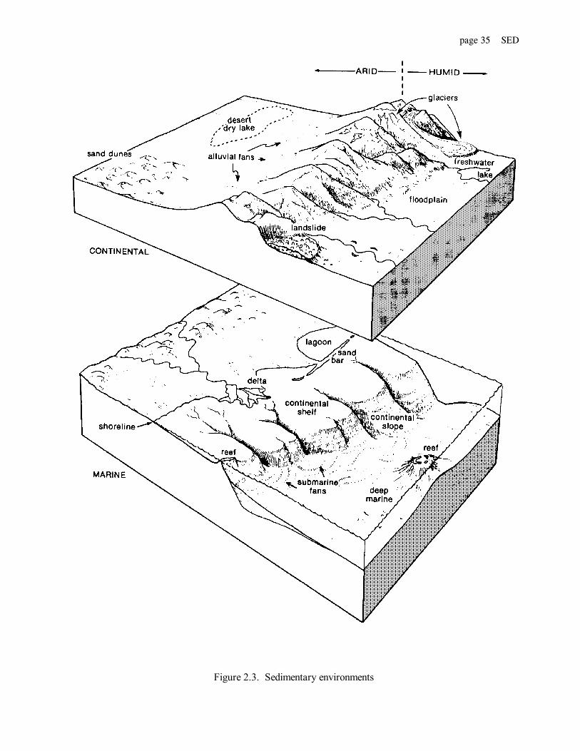
Figure 2.3. Sedimentary environments

page 36 SED
Section II DETRITAL SEDIMENTARY ROCKS
Exercise 2
Detrital sedimentary rocks are aggregates of transported, broken, former rocks or silicate mineral fragments. All have a clastic texture, therefore. Their composition can be simple or complex. Detrital sedimentaryrocks are classified by dividing them into textural types and further subdividing them into compositionalvarieties. Each type or variety within a type is named. Your problem is to name each detrital sedimentaryrock specimen in the given set A..
Procedure: Work with one specimen at a time. Record your results in Table 2. Step 1. Write rock specimen numbers in each stage of the classification.
Stage 0. Pick up a detrital sedimentary rock specimen and note, the specimen number.
Stage 1. Decide what sized clast (Figure 2.4) makes up most of the rock's volume. If these are:Larger than sand sized - textural type is:
conglomerate if the clasts are sub-rounded to well rounded (Figure 2.1) or breccia if the clasts are sub-angular to angular (Figure 2.1).
Sand sized - textural type is:sandstone. If gravel sized clasts are present, they must make up less than 50% ofthe rock's volume.
Silt sized - grains are too small to be seen individually, but when a smooth looking part of the specimen, is rubbed with the finger tip, it has a gritty feel. Textural type is;
siltstone.Clay size - grains are too small to be seen individually and when a smooth looking part of the specimen is rubbed with the finger tip, it feel smooth. Textural type is;
mudstone (if the specimen exhibits little tendency to break into thin sheets) or shale (if it does tend to break into thin sheets).
Stage 2. Read in Table 2 the compositional varieties listed beside the specimen's texturaltype. Decide which one best describes the specimen.
Step 2. Check your results against the key provided by your laboratory instructor and investigate the reasonsfor any error.
Clast diameter 1/16 mm 2 mm
Clay sized (smooth feel) Fine sand Sand Coarse sand Gravel Boulders> to silt sized (gritty feel)
Figure 2.4
page 37 SED
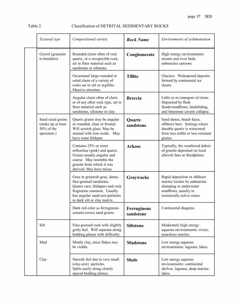
Table 2. Classification of DETRITAL SEDIMENTARY ROCKS
Textural type Compositional variety Rock Name Environments of sedimentation
Gravel (granulesto boulders)
Rounded clasts often of veinquartz, or a recognizble rock,set in finer material such assandstone or siltstone.
Conglomerate High energy environments:stream and river beds,submarine canyons.
Occasional large rounded orsoled clasts of a variety ofrocks set in silt or argillite. Massive structure.
Tillite Glaciers. Widespread depositsformed by continental icesheets.
Angular clasts often of chert,or of any other rock type, set infiner material such assandstone, siltstone or clay.
Breccia Little or no transport of clasts. Deposited by flashfloods/mudflows, landsliding,and limestone cavern collapse.
Sand sized grains(make up at least50% of thespecimen.)
Quartz grains may be angularor rounded, clear or frosted. Will scratch glass. May bestained with iron oxide. Mayhave some feldspar.
Quartzsandstone
Sand dunes, beach faces,offshore bars. Settings wheredurable quartz is winnowedfrom less stable or less resistantgrains.
Contains 25% or moreorthoclase (pink) and quartz. Grains usually angular andcoarse. May resemble thegranite from which it wasderived. May have micas.
Arkose Typically, the weathered debrisof granite deposited on localalluvial fans or floodplains.
Gray or greenish-gray, dense,fine-grained sandstone. Quartz rare; feldspars and rockfragments common. Usuallyhas angular sand-size particlesin dark silt or clay matrix.
Graywacke Rapid deposition in offshoremarine locales by submarineslumping or underwatermudflows, usually intectonically active zones.
Dark red color as ferruginouscement covers sand grains.
Ferruginoussandstone
Continental diagenic.
Silt Fine-grained rock with slightlygritty feel. Will separate alongbedding planes with difficulty.
Siltstone Moderately high energyaqueous environments: rivers,nearshore marine.
Mud Mostly clay, mica flakes maybe visible.
Mudstone Low energy aqueousenvironments: lagoons, lakes.
Clay Smooth feel due to very small (clay-size) particles.Splits easily along closelyspaced bedding planes.
Shale Low energy aqueousenvironments: continentalshelves, lagoons, deep marine,lakes.

page 38 SED
Section III CHEMICAL SEDIMENTARY ROCKSExercise 3
Chemical sedimentary rocks, made from material formerly in aqueous solution, characteristically havesimple, non-silicate, chemical compositions. Their textures can show great variations and can be either clasticor nonclastic. Chemical sedimentary rocks are classified by dividing them into compositional types and furthersubdividing them into textural varieties. Each type or variety within a type is named. Your problem is toname each chemical sedimentary rock specimen in the given set B.
Procedure: Work with one specimen at a time. Record your results in Table 3.Step 1. Write rock specimen numbers in each stage of the identification.
Stage 0. Pick up a chemical sedimentary rock specimen and note the specimen number.
Stage 1. Work progressively through the following and stop when the composition is positivelyidentified. Then go to Stage 2.
a) Place one drop of dil. HCl (dilute hydrochloric acid) on the specimen. Look carefully at the drop tosee if there is any effervescence (bubbling). If effervescence is seen the composition is Calcite.
b) With the point of a knife, scratch the specimen in a small area so that a little powder is produced onthe specimen where it was scratched (if you cannot scratch the specimen, go to (f). Place one drop of dil. HClon the specimen where it was scratched. Look carefully to see if there is any effervescence. If effervescence isseen the composition is Dolomite.
c) If the color of the specimen is black or dark brown [if not go directly to (d)] see what happens whena small chip of it (chips will be provided and are obtained by breaking a specimen with a hammer) is heated bya flame. Method: Light an alcohol burner. Place 3 inches of wire in a wire holder and with pliers twist a smallloop at the free end. Place the chip on the loop and hold it just above the tip of the alcohol burner flame. If thechip ignites and burns to an ash, or if it melts and gives off a bituminous odor, the composition is Hydrocarbon.
d) Rub the specimen on a streak plate. If the streak is black the composition is Pyrolusite. If the streakis red or reddish brown, the composition is Hematite. If the streak is deep yellow or yellowish brown,thecomposition is Limonite.
e) Scratch the specimen with your finger nail, If it can be gauged easily it is: i) Hydrated Silica if a dropof dil. HCl soaks in rapidly without effervescing, or ii) Gypsum if a drop of dil. HCl does not soak in and thereis no effervescence. If you cannot scratch it with you finger nail, go to (f).
f) Rub the specimen (press it down hard) on a piece of plate glass held flat on the table. Examine theresult and accordingly go A, B or C:
A) If the sharp edges or points on the specimen cannot scratch the glass (that is, any powderof the specimen left on the glass can be rubbed away with your finger tip without the glass beneath showing anyscratch marks) then taste a (sterilized) chip of the specimen (WARNING: do not attempt to chew it). If the chiphas no distinct taste, the composition is Anhydrite. If the chip tastes like common table salt, the compositionis Halite. If the chip tastes bitter, its composition is one of the Bittern Salts.
B) If the specimen scratches glass with difficulty the composition is Hydrated silica (if thespecimen looks opaline), Colophane (if dull, concentrically banded and too fine grained for individual grainsto be seen) or Apatite (if individual grains can be seen).
C) If the specimen scratches glass making a grating sound and leaving pronounced scratchesin the surface of the glass, the composition is Chalcedony (where the specimen in too fine grained for individualgrains to be seen) or Quartz (where individual crystal grains can be seen).
Stage 2. Read in Table 3 the textural varieties listed beside the specimen's compositional type. Decidewhich one best describes the apecimen.

page 39 SED
Table 3 Classification of CHEMICAL SEDIMENTARY ROCKS
Compositional type Textural variety Name
CalciteCaCO3reacts with HCl
Chalk-like, fine grained, noticeably light heaft (easilygouged by finger nail)
Chalk
Uniformly fine grained (harder than finger nail) Lithographic limestone
Fine grained, looks powdery, may be nodular, hasirregular small openings
Calcareous tufa
Distinctly layered, may have small openings Travertivne
Cemented shell hash Coquina
Some shells, mostly unbroken, embedded in the rock Shelly limestone
Spherules, sand sized, embedded in the rock. May makeup most of the rock.
Oolitic limestone
Spherules, larger than sand sized, (commonly pea-sized)make up most of the rock.
Pisolitic limestone
Irregularly shaped, interlocking, crystal grains in anotherwise fine grained rock
Common limestone
Dolomite (Ca, Mg)CO3reacts with HClwhere scratched
Fine to medium grained, no shells Dolostone
Fine to medium grained, shells visible Dolomitized limestone
Hydrocarbon Hx , Cy
Pitch-like (melts on heating giving off bituminous odor) Asphalt
Matted plant fragments and organic muck, pliable whendamp (burns, smokily, to ash without melting)
Peat
Coaly, plant fragments visible, dull luster, not pliablewhen wet (burns smokily to ash without melting)
Lignite
Coaly, locally shiny where broken, dirties hands (burnsto ash without melting)
Bituminous coal
Pyrolusite MnO
Earthy luster, not well layered Wad
Earthy luster, concentrically layered Manganese nodule
continued over >

page 40 SED
Table 2 continued CHEMICAL SEDIMENTARY ROCKS
Hematite Fe2O3
Earthy luster, may be oolitic Sedimentary hematite
Limonite Fe2O3 • H2O
Earthy luster Bog iron ore
Gypsum CaSO4• H2O
Massive or visibly crystalline Rock gypsum
Anhydrite CaSO4
Massive Rock gypsum
Halite NaCl
Massive or visibly crystalline Rock salt
Bittern salts Massive or visibly crystalline Bittern salts
Collophane Ca3(PO4)2 • H2O
Massive, may be colloform, commonly oolitic Phosphorite
Hydrated silica SiO2 • H2O
Chalk-like, fine grained, noticeably light heaft(easily gouged by finger nail)
"Diatomite"
Massive, opaline (harder than finger nail) Opal
Chalcedony SiO2
Massive, not banded Chert
Massive, concentrically banded Agate
Quartz SiO2
Visibly crystalline Drusy quartz
Stage 0 Stage 1 Stage 2
Step 2. Check your results against the key provided by your laboratory instructor and investigate the reasonsfor any error.
Photo essay
page 41 SED
SEDIMENTARY ROCKS Your Name:
multiple choice review questions Date:
Sediments area. sediment in transportation.b. the accumulated product of weathering.c. the deposited product of erosion.d. none of the above.
Accumulations of transported clasts area. soils.b. detrital sediments.c. sedimentary rocks.d. chemical sediments.
Chemical sediments can be a. residual soils.b. sea water.c. hard water.d. precipitates.
Detrital sediments are immature if they are made ofclasts which area. sorted.b. rounded.c. easily weathered.d. geologically young.
A detrital sedimentary rock is mature ifa. the source of its clasts can be traced.b. it is geologically old.c. it contains easily weathered clasts.d. its clasts are well rounded.
A detrital sedimentary rock that is made of claststhat are mostly larger than 2 mm in diameter is aa. conglomerate.b. sandstone.c. siltstone.d. mudstone.
Sand sized clasts have a diameter that is larger thana. 4 mmb. 2 mmc. 1/16 mmd. 1/256 mm
Arkose sand is characterized by clasts ofa. quartz.b. quartz, potassium feldspar, muscovite.c. mafic volcanic rock, clay.d. volcanic rock, silt, clay, glauconite.
Silt can be distinguished from clay because ita. can be seen to be dust.b. feels gritty between the fingers.c. the clasts are smaller than 1/16 mm.d. it cannot hold water.
In classifying a given chemical sedimentary rocks thecharacteristic first considered isa. clast size.b. composition.c. origin.d. fabric.
Chemical sediments can have a fabric which is:origin which is:composition which is:
a. carbonate, sulphate, chloride.b. evaporation, chemical precipitation, organic extraction.c. crystalline, dense, bioclastic.d. none of the above.
Lithification is never due to a. cementation.b. compaction.c. dissolution.d. recrystallization.
The age of a sedimentary rock is when it wasa. lithified.b. sedimented.c. exposed by erosion.d. buried.
A breccia is like a conglomerate except ita. is a broken fragment.b. contains large angular clasts.c. contains angular small clasts and rounded large clasts.d. is a gritty sandstone.
Visible cement in detrital sedimentary rock isa. washed in mud.b. a chemical precipitate.c. the matrix.d. fine grained.

page 42 SED
Clay lithifies to shale by beinga. cemented.b. desiccated.c. compacted.d. recrystallized.
Buried sand does not lithify to sandstone bya. cementing.b. compaction.c. partial recrystallization.d. any of the above.
Evaporite chemical sediments lithify bya. cementation.b. compaction.c. recrystallization.d. evaporation.
The most characteristic feature of sedimentary rockseen in outcrop is theira. stratification.b. layers of different composition.c. fossil content.d. horizontality.
Sedimentary strata and layered igneous andmetamorphic rocks never have a commona. composition.b. texture.c. resistance to weathering.d. fossil content.
Every sedimentary bed which is part of a stratuma. is parallel to the stratum.b. is at an angle to the stratum.c. was eroded before burial or it is separated.
from the next by a paleosoil.d. was once the surface of the earth.
Rare bedding plane features area. paleosoils.b. ripple marks.c. tracks and trails of animals.d. desiccation mud-cracks.
Sand can be transported by winda. by sliding, rolling, and saltating.b. in suspension.c. by eolian floatation.d. in solution.
Loess isa. dune sand.b. a mixture of sand and silt.c. a blanket of dust.d. a lag deposit.
Oscillation ripples can be founda. on dunes.b. in shallow water environments.c. in deep water environments.d. on dune, or on submarine bar, slip faces.
Current ripplesa. are diagnostic of shallow water
depositional environments.b. are symmetrical in transverse cross section.c. have crests that are transverse to the
current that forms them.d. have crests that are parallel to the current
that forms them.
Large scale cross bedding is an internal feature ofa. stream bars.b. dune sands.c. loess.d. turbidity current deposits.
Graded bedding is characteristic of a. shallow water deposits.b. deep water turbidites.c. density inversions.d. stream gradients.
Oolitesa. are detrital.b. have the appearance of sandstones.c. indicate deep water deposition.d. are fossilized fish eggs.
Limestone is changed to dolostone bya. prolonged weathering.b. low temperature and pressure.c. diagenesis.d. micrite recrystallization.
page 43 MET
GE-101 Sect: QUEENSBOROUGH COMMUNITY COLLEGE Date: / / Physical Geology The City University of New York
Instructor: Your name:
Laboratory module: Metamorphic rocks
Objectives: After completing this laboratory you should be able to
1. Discuss the process of rock change called metamorphism.
2. Understand that the texture of a metamorphic rock is related to its origin.
3. Describe and name a variety of metamorphic rocks.
EQUIPMENT CHECK LIST (Report any missing items to the laboratory proctor)
Material Description perStudent
perTable
METAMORPHICROCKS
Hand specimens 1 set
CHEMICALS Dilute (5%) hydrochloric acid in a dropper bottle 2
GEOLOGICALEQUIPMENT
Window glass, 3" square plate with beveled edges (for hardness test) Streak platePocket knife (blades blunted)
1
12

page 44 MET
Section 1 METAMORPHIC ROCKS
Rocks are chemical systems which at the time they originate are essentially in equilibrium with ambienttemperatures and pressures. Subsequently, ambient temperatures and pressures may change because of avariety of causes such as: burial, heating, fold-mountain building, erosion of overburden, cooling, etc. As aresult, a rock may be caused to change. Rocks which can be argued to have changed within the earthtowards new equilibrium with such subsequently established conditions of temperature and pressure arecalled metamorphic rocks: the process of change is called metamorphism. During metamorphism, a rock isrecrystallized without, or with, deformation while it remains essentially a solid: its bulk composition neednot change (if there is evidence that it has, the process is properly referred to as metasomatism) but itssubstance must undergo physical rearrangements and chemical recombinations. Such adjustments arepromoted by the existence in the rock of pore fluids which allow solution, redistribution, mixing andprecipitation of mineral substances, and applied stresses which can change or rearrange chemical bonds inminerals or plastically deform the rock.
Metamorphism which does not involve the plastic deformation of the effected rock is called contactmetamorphism. Metamorphism which does involve the plastic deformation of the effected rock is calledregional metamorphism.
page 45 MET
Exercise 1 EVALUATION QUESTIONS
Do rocks originate essentially in, or out, of equilibrium with ambient temperatures and pressures?
Can metamorphic rocks originate, by definition, at Earth’s surface? (yes, no) Explain.
Name several causes of metamorphism.
Can metamorphism be recrystallization of a rock only? (yes, no) Explain.
What distinguishes metasomatism?
If heating, alone, evidently has caused a rock to recrystallize, what is the metamorphism called?
If plastic deformation is evident in a rock, what is the metamorphism called?
page 46 MET
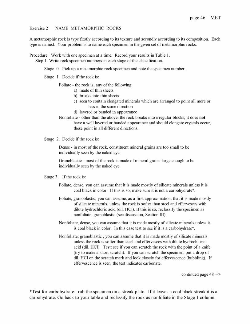
Exercise 2 NAME METAMORPHIC ROCKS
A metamorphic rock is type firstly according to its texture and secondly according to its composition. Eachtype is named. Your problem is to name each specimen in the given set of metamorphic rocks.
Procedure: Work with one specimen at a time. Record your results in Table 1. Step 1. Write rock specimen numbers in each stage of the classification.
Stage 0. Pick up a metamorphic rock specimen and note the specimen number.
Stage 1. Decide if the rock is:
Foliate - the rock is, any of the following:a) made of thin sheetsb) breaks into thin sheetsc) seen to contain elongated minerals which are arranged to point all more or
less in the same directiond) layered or banded in appearance
Nonfoliate - other than the above: the rock breaks into irregular blocks, it does not have a well layered or banded appearance and should elongate crystals occur, these point in all different directions.
Stage 2. Decide if the rock is:
Dense - in most of the rock, constituent mineral grains are too small to be individually seen by the naked eye.
Granoblastic - most of the rock is made of mineral grains large enough to be individually seen by the naked eye.
Stage 3. If the rock is:
Foliate, dense, you can assume that it is made mostly of silicate minerals unless it is coal black in color. If this is so, make sure it is not a carbohydrate*.
Foliate, granoblastic, you can assume, as a first approximation, that it is made mostly of silicate minerals. unless the rock is softer than steel and effervesces with dilute hydrochloric acid (dil. HCl). If this is so, reclassify the specimen as nonfoliate, granoblastic (see discussion, Section III)
Nonfoliate, dense, you can assume that it is made mostly of silicate minerals unless it is coal black in color. In this case test to see if it is a carbohydrate*.
Nonfoliate, granoblastic , you can assume that it is made mostly of silicate minerals unless the rock is softer than steel and effervesces with dilute hydrochloric acid (dil. HCl). Test: see if you can scratch the rock with the point of a knife (try to make a short scratch). If you can scratch the specimen, put a drop ofdil. HCl on the scratch mark and look closely for effervescence (bubbling). Ifeffervescence is seen, the test indicates carbonate.
continued page 48 6>
*Test for carbohydrate: rub the specimen on a streak plate. If it leaves a coal black streak it is acarbohydrate. Go back to your table and reclassify the rock as nonfoliate in the Stage 1 column.

page 47 MET
Table 1 Classification of METAMORPHIC ROCKS
Rock Name
Foliate Dense Silicate Dull luster Slate
Satiny luster Phyllite
Granoblastic Silicate Fissile Schist
Layered or banded Gneiss
Nonfoliate Dense Silicate Softer than glass Serpentinite
Harder than glass Hornfels
Carbohydrate Anthracite
Granoblastic SilicateRed and greenminerals
Eclogite
Mostly greenminerals
Tactite
Mostly quartz Metaquartzite
Pebbles in matrix Metaconglomerate
Two or moreminerals
Granulite
Carbonate Marble
Stage 0 Stage 1 Stage 2 Stage 3 Stage 4

page 48 MET
Stage 4. If the rock is:
Foliate, dense, silicate, decide if it is:
Dull in luster
Satiny in luster (the rock has a sheen)
Foliate, granoblastic, silicate, decide if it is:
Fissile - exhibits a tendency to break into thin, but not necessarily even, sheets orinto splintery blocks. Any porphyroblasts (crystals noticeably larger than theaverage sized crystal in the rock) present tend to protrude or break free from therock's surface.
Nonfissile - exhibits little tendency to break into sheets or splinters. Any porphyroblasts present do not tend to protrude or break free from the rock's surface.
Nonfoliate, dense, silicate, decide if it is softer or harder than glass. Test: Lay a glass plate on the table and pressing down on it with a point on the specimen see if you can scratch it. Note: if the specimen slides greasily on the glass
and does make a grating sound, it is softer than the glass.
Nonfoliate, granoblastic, silicate, decide if it is made of:
Mostly green minerals.
Mostly quartz - glassy, fused looking grains, the rock as a whole has a greasy luster where freshly broken.
Recognizable pebbles (Figure ) in a finer grained matrix.
Two or more minerals of not greatly dissimilar size.
Section III
Discussion: NAMING THE VARIETIES OF METAMORPHIC ROCKS
Each type of metamorphic rock can be expected to contain certain minerals. For example,silicate metamorphic rocks such as slate, phyllite, schist, gneiss, granulite, hornfels and so on,commonly contain quartz and feldspar(s). These rocks can also contain other minerals such asandalusite, biotite, chlorite, garnet, graphite hornblende, kyanite, muscovite, olivine, pyroxene,sillimanite, staurolite, talc and others.
Varieties of metamorphic rock types are distinguished by prefixing the type name with thenames of minerals present which are not common to the type. For example, a schist whichcontains biotite is called a biotite-schist or a gneiss which contains, say, biotite and garnet is calleda biotite-garnet-gneiss. The presence of quartz and feldspar is not mentioned because they arecommonly in these rocks. Also, in this regard, the absence of quartz and feldspar is notmentioned. For example, a schist which is made only of talc is called a talc-schist.

page 49 MET
METAMORPHIC ROCKS Your name:
Metamorphic rock multiple choice review questions Date:
Sediments have accumulated in places tothicknesses of as much asa. 12 km.b. 30 km.c. 100 km.d. 700 km.
Sediments have evidently been subducted todepths ofa. 2 km.b. 30 km.c. 100 km.d. 700 km.
Crustal temperatures can be accounted forbya. heat from the mantle.b. internal radioactive sources.c. radiant heat from the sun.d. (a) and (b).
Coal buried to a depth of 12 kilometersbecomesa. china.b. compacted.c. graphite.d. diamond.
Metamorphism changes a rock'sa. temperature.b. pressure.c. texture.d. state.
Metamorphic rocks originate by thecrystallization or recrystallization of rocksthat werea. igneous.b. sedimentary.c. metamorphic.d. all of the above.
Minerals of metamorphic rocks are more variedthan those of igneous rocks becausea. the chemical composition of metamorphic
rocks is not as limited as it is forigneous rocks.
b. the temperature of metamorphism iscontrolled by pressure.
c. the range of pressure is greater than that to which igneous rocks are subjected.
d. all of the above.
The texture of a fine-grained metamorphic rockis described asa. dense.b. granoblastic.c. nonfoliated.d. foliated.
Metasomatism is different from metamorphismbecause the rock that results hasa. an unchanged texture.b. a mineralized appearance.c. the same composition as the original rock.d. a different composition than the original rock.
A rock that is changed by metamorphism hasa. an unchanged texture.b. a mineralized appearance.c. the same composition as the original rock.d. a different composition than the original rock.
An example of a dense contact metamorphicrock isa. hornfels.b. meta-conglomerate.c. marble.d. skarn.

page 50 MET
An example of a granoblastic foliated regionalmetamorphic rock isa. slate.b. phyllite.c. gneiss.d. greenstone.
Progressively higher metamorphic grade isa. gneiss 6 schist 6 slate.b. slate 6 schist 6 gneiss.c. slate 6 gneiss 6 phyllite.d. schist 6 phyllite 6 slate.
In contact metamorphism, the sequence ofindex minerals: chlorite, biotite, almandine,staurolite, kyanite, and sillimanite, indicatesa. decreasing grade at constant pressure.b. increasing grade at constant pressure.c. increasing grade with decreasing pressure.d. none of the above.
Andalusite, kyanite, and sillimanite area. index minerals for high temperature and pressure.b. polymorphs.c. found in blue schist.d. all of the above.
Cataclastic metamorphic rock is typicallya. low grade.b. high grade.c. mylonite.d. tectonically fragmented.

page 51 REV
GE-101 Sect: QUEENSBOROUGH COMMUNITY COLLEGE Date: / / Physical Geology The City University of New York
Instructor: Your name:
MINERALS
1
2
3
4
5
6
7
8
9
10
11
12
13
14
15
16
17

page 52 REV
GE-101 Sect: QUEENSBOROUGH COMMUNITY COLLEGE Date: / / Physical Geology The City University of New York
Instructor: Your name:
IGNEOUS ROCKS
20
21
22
23
24
25
26
27
28
29
30
31
32
33
page 53 REV
GE-101 Sect: QUEENSBOROUGH COMMUNITY COLLEGE Date: / / Physical Geology The City University of New York
Instructor: Your name:
SEDIMENTARY ROCKS
36
37
38
39
40
41
42
43
44
45
46
47
48
49
50
51
52
53

page 54 REV
GE-101 Sect: QUEENSBOROUGH COMMUNITY COLLEGE Date: / / Physical Geology The City University of New York
Instructor: Your name:
METAMORPHIC ROCKS
56
57
58
59
60
61
62
63
64

page 55 TOP
GE-101 Sect: QUEENSBOROUGH COMMUNITY COLLEGEPhysical Geology The City University of New York Date: / /
Instructor: Your Name:
Laboratory: Contour lines and topographic maps
Objectives: After completing the following two laboratory periods you should be able to:
1. Construct contour lines and topographic sections.
2. Visualize the scenery portrayed by features and contours and in a topographic map.
3. Anticipate several ways you might use a topographic map.
EQUIPMENT CHECK LIST
Material Description perStudent
perTable
TOPOGRAPHIC MAPS ANDAERIAL PHOTOGRAPHS
USGS quadrangle maps
Book of aerial photographs
1
1
EQUIPMENT Stereoscope 1

page 56 TOP
TOPOGRAPHIC MAPS
A planimetric map gives a two dimensional view of the land that shows the position of naturalfeatures such as rivers and lakes, and artificial features such as buildings and roads. The United StatesGeological Survey (USGS) is the government agency responsible for preparing maps for landdevelopment of the United States. To aid geological mapping, there are Landsat images, arealphotographs, and topographic maps.
A topographic map is a planimetric map that also shows the relief of the land surface bycontours: this three dimensional aspect is sometimes enhanced by hachures, tints and shadings. Figure 1 illustrates how various features are depicted on a topographic map.
B from USGS publication
Figure 1. The upper illustration (A) is a perspective view of a river valley and the adjoining hills.The river flows into a bay which is partly enclosed by a hooked sandbar. On either side of the valley areterraces through which streams have cut gullies. The hill on the right has a smoothly eroded form and gradualslopes, whereas the one on the left rises abruptly in a sharp precipice from which it slopes gently, and forms aninclined tableland traversed by a few shallow gullies. A road provides access to a church and two housessituated across the river from a highway which follows the seacoast and curves up the river valley.
The lower illustration (B) shows the same features represented by symbols on a topographic map. Aspot height is marked by an X. The contour interval (the vertical distance between adjacent contours) is 20 feet.
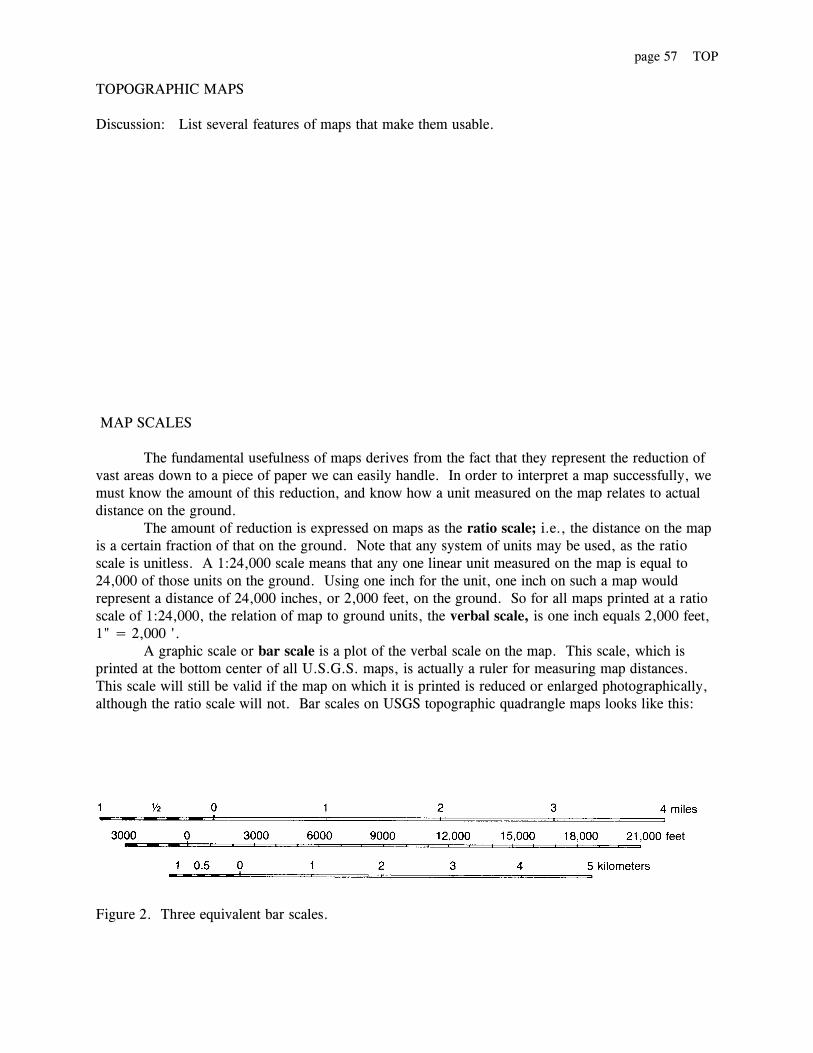
page 57 TOP
TOPOGRAPHIC MAPS
Discussion: List several features of maps that make them usable.
MAP SCALES
The fundamental usefulness of maps derives from the fact that they represent the reduction ofvast areas down to a piece of paper we can easily handle. In order to interpret a map successfully, wemust know the amount of this reduction, and know how a unit measured on the map relates to actualdistance on the ground.
The amount of reduction is expressed on maps as the ratio scale; i.e., the distance on the mapis a certain fraction of that on the ground. Note that any system of units may be used, as the ratioscale is unitless. A 1:24,000 scale means that any one linear unit measured on the map is equal to24,000 of those units on the ground. Using one inch for the unit, one inch on such a map wouldrepresent a distance of 24,000 inches, or 2,000 feet, on the ground. So for all maps printed at a ratioscale of 1:24,000, the relation of map to ground units, the verbal scale, is one inch equals 2,000 feet, 1" = 2,000 '.
A graphic scale or bar scale is a plot of the verbal scale on the map. This scale, which isprinted at the bottom center of all U.S.G.S. maps, is actually a ruler for measuring map distances. This scale will still be valid if the map on which it is printed is reduced or enlarged photographically,although the ratio scale will not. Bar scales on USGS topographic quadrangle maps looks like this:
Figure 2. Three equivalent bar scales.

page 58 TOP
Most United States topographic maps are published by the U.S. Geological Survey in the formof topographic quadrangle maps. A quadrangle is a section of the Earth's surface that is bounded bylines of latitude on the north and south and by lines of longitude on the east and west .
The two most common sizes of quadrangle maps are 15-minute quadrangle maps and 71/2-minute quadrangle maps; the numbers refer to the amount of area (in degrees of latitude and longitude)that the maps depict. A 15-minute topographic map represents an area that measures 15 minutes oflatitude by 15 minutes of longitude. A 71/2-minute topographic map represents an area that measures71/2 minutes of latitude by 71/2 minutes of longitude. Each 15-minute map can be divided into four71/2-minute maps.
The direction of true geographic north is toward the top of the map (and it is always parallel tothe lines of longitude). Unfortunately, magnetic compasses are not attracted to the geographic NorthPole (true north pole), but rather to the magnetic north pole, which is located just west of Hudson Bayin northern Canada. The angle formed between the direction of true geographic north and the di-rection of magnetic north is known as the magnetic declination. It is usually indicated indiagrammatic form in the margin of a topographic map for a specific year.
The magnetic pole moves very slowly through time, so the declination is exact only for theyear listed on the map. Tables are available from which you can calculate correct declination for anyquadrangle and year.
Notes:
LATITUDE AND LONGITUDE
1. Latitude lines, or parallels, are parallel to the Equator and measure distances north and south ofthe Equator.
2. Longitude lines, or meridians, pass through the North and South Poles. They measure distanceseast and west of the Prime Meridian, which passes through Greenwich, England.
3. Any point on the Earth's surface can be represented as an intersection of a line of latitude and aline of longitude.
4. Since all of North America is north of the Equator and west of the Prime Meridian, all latitudesin the continental United States are north and all longitudes are west.
5. Latitude and longitude are expressed in degrees, minutes, and seconds.
1 degree (0) = 60 minutes (')
1 minute = 60 seconds (")
3600 makes a complete circle.

page 59 TOP
The Public Land Survey System (PLS) was initiated in the late 1700s, and all but the originalthirteen states, and a few states derived from them, are covered by this system. Exceptions also occur insome areas of the southwestern United States, where land surveys may be based upon Spanish landgrants, or in areas of rugged terrain, where surveys were never made.
The PLS system was established in each state by surveying one or more base lines, which areeast-west lines, and one or more principal meridians, which are north-south lines (see A in Figure 3). Once the initial principal meridian and base lines were established, additional lines parallel to these weresurveyed with a six-mile spacing. This created a grid of squares with each square being six miles on aside.
Squares along each east-west strip of the grid are referred to as townships and are numbered rel-ative to the base line (Township I North, Township 2 North, etc.)
Figure 3. Standard land divisions used in the United States and Canada.
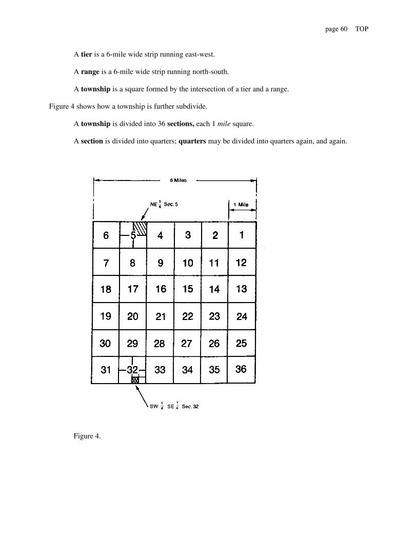
page 60 TOP
A tier is a 6-mile wide strip running east-west.
A range is a 6-mile wide strip running north-south.
A township is a square formed by the intersection of a tier and a range. Figure 4 shows how a township is further subdivide.
A township is divided into 36 sections, each 1 mile square.
A section is divided into quarters; quarters may be divided into quarters again, and again.
Figure 4.
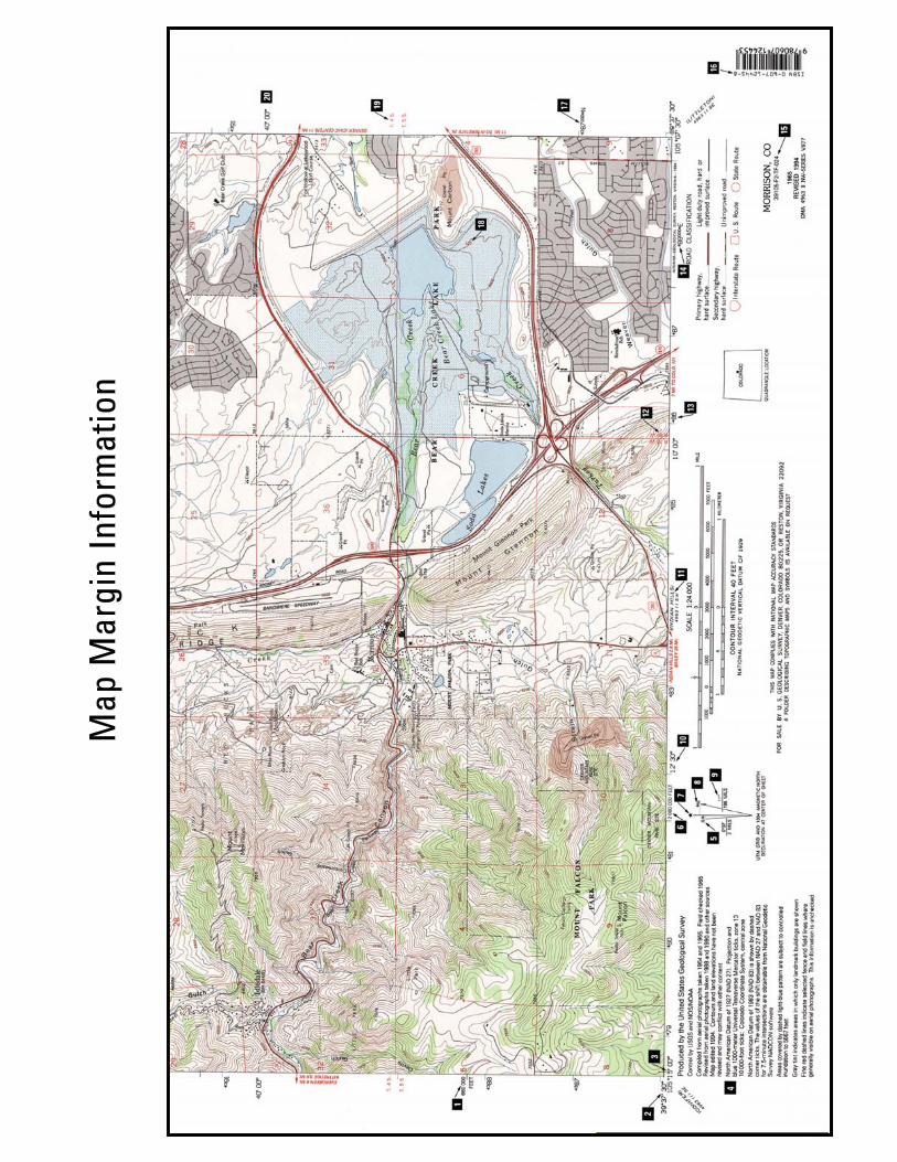
Map
Mar
gin
I nfo
rmat
ion
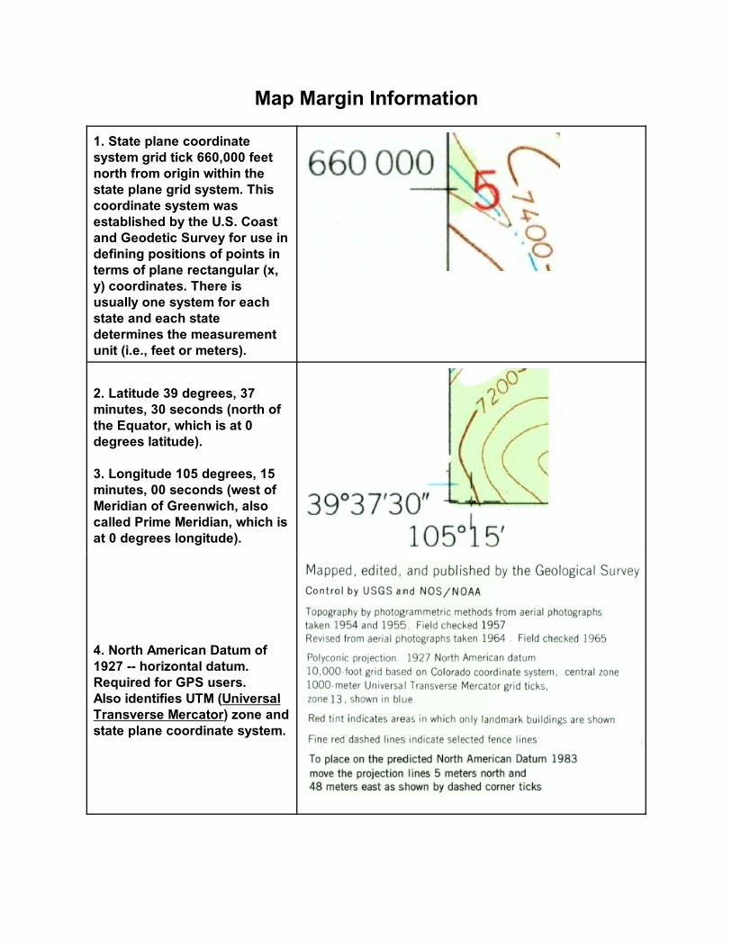
Map Margin Information
1. State plane coordinatesystem grid tick 660,000 feetnorth from origin within thestate plane grid system. Thiscoordinate system wasestablished by the U.S. Coastand Geodetic Survey for use indefining positions of points interms of plane rectangular (x,y) coordinates. There isusually one system for eachstate and each statedetermines the measurementunit (i.e., feet or meters).
2. Latitude 39 degrees, 37minutes, 30 seconds (north ofthe Equator, which is at 0degrees latitude).
3. Longitude 105 degrees, 15minutes, 00 seconds (west ofMeridian of Greenwich, alsocalled Prime Meridian, which isat 0 degrees longitude).
4. North American Datum of1927 -- horizontal datum.Required for GPS users.Also identifies UTM (UniversalTransverse Mercator) zone andstate plane coordinate system.

6. State plane coordinatesystem grid tick2,080,000 feet east of origin.
5. GN – UTM grid north (at thecenter of the map).
7. * true or geographic north– points to the north geographicpole.
8. MN – magnetic north – theapproximate direction (at thecenter of the map) to the northmagnetic pole at the dategiven, in this case 1980. Thedirection to which a magneticcompass needle points.
9. 12 ½ o east – magneticdeclination or variation of thecompass – the number ofdegrees a compass needle at aparticular location bears awayfrom true north and points tothe north magnetic pole. 196 MILS – military angularmeasurement.
10. Longitude again – this is a 2.5 minutegeographic grid tick at 105 degrees (understood),12 minutes, 30 seconds west.

11. Adjoining USGSquadrangle name “IndianHills.”The notation “4963 II SW” isthe NGA (NationalGeospatial-IntelligenceAgency, the Department ofDefense mapping agency)sheet designator for the samemap.
12. Range 69 West – 69 thrange west of 6th PrincipalMeridian (which is at MeadesRanch, Kansas). Public LandSubdivisions: In 1785Congress adopted a plan forsurveying public lands.According to this plan, landwas divided into townshipsapproximately six milessquare, which were furthersubdivided into 36 sectionsapproximately one milesquare. Principal meridiansand base lines wereestablished as a referencesystem for the townshipsurveys.
13. UTM (Universal Transverse Mercator) eastingvalue – 486,000 meters false easting (last 3 zeroesomitted for brevity) (Zone13)
14. UTM easting value –487,000 meters false easting(Zone 13).
15. Map reference code: 39 – degrees north latitude 105 – degrees west longitude
[[Topographic map withcontour values in Feet 024 –1:24,000 scale]]

16. ISBN – InternationalStandard Book Number. [is not included on this map]
17. UTM northing value– 4,386,000 meters north fromthe Equator.
“Northings” in the southernhemisphere begin with theEquator value = 10,000,000meters and decrease in value.
18. Section number 5. See Public Land Subdivisions.
19. Township 4 South -- 4townships south of base line(Base Line of 1855, in thiscase). See Public Land Subdivisions.
20. Latitude again – another 2.5 minute latitudegrid tick at:39 degrees (understood), 40 minutes,00 seconds (understood).
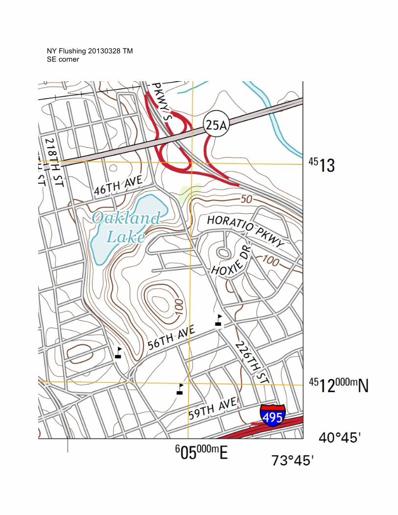
NY Flushing 20130328 TMSE corner

page 61 TOP
CONTOUR LINES
Contour lines are used to depict three-dimensional features on a flat piece of paper. Contoursshow the shape of hills, mountains, and valleys, as well as their altitude. A contour is an imaginary lineon the ground, all points of which are at the same altitude or, put another way, a contour line is a lineconnecting all points of equal elevation. The zero contour is the shoreline of the ocean halfway betweenhigh tide and low tide (mean sea level). All points 10 feet above sea level would lie on the 10-footcontour line; all points 20 feet above sea level would lie on the 20-foot contour line, and so on. In thisexample the contour interval, which is the difference in elevation between two adjacent contours, is 10feet. A contour interval is chosen to fit the relief of the landscape and the scale of the map; to show asmuch relief as possible without cluttering the map with lines bunched too closely together. Commonlyused intervals are 5, 10, 20, 25, 40, 50, 80, and 100 feet.
Figure 5 shows contour lines drawn on a natural landscape. If this imaginary area complete withcontour lines were photographed from above, the resulting photo would be a topographic map. In fact,modern topographic maps are created by sophisticated computer processing of vertical aerialphotographs. Listed below are some rules summarizing the basic nature of contour lines which should be used whenconstructing or interpreting a topographic map:
1. Contour elevations are exact multiples of the contour interval above the zero sea-level elevation.2. The spacing of contours reflects the gradient or slope:
a. contour lines that are far apart indicate a gentle slopeb. contours that are close together indicate a steep slopec. contours that merge indicate a vertical slope
3. Contours never cross, never branch, and never terminate.4. All solid-line contours are multiples of the contour interval; e.g., if the contour interval is 10 feet,
the contours will be 10, 20, 30, 40, 50, etc. Usually every fifth contour, called an indexcontour, is printed heavier for ease of reference.
5. Dashed contours represent elevations of half the normal interval, and are added in areas of lowrelief to increase detail.
6. Contour lines crossing stream valleys or other channels form a "V" pointing upstream.7. Jagged topography will make sharp angles in the contour lines; low, rolling landscapes will have
gently curving lines.8. Contour lines will eventually close on themselves, although demonstrating this may require
consulting adjacent maps.9. Normal contours enclose an area that is higher than the contour; i.e., all points that lie within such
a closed contour are above the level of that contour.10. Depression contours enclose areas that have no outlet-closed basins. They are marked by
hachures on the inside.11. Depression contours have the same elevation as the adjacent normal contour which encloses the
depression.12. Contours must be counted consecutively, and none can be skipped; repeated contours adjacent to
one another indicate a change in slope direction, such as into a depression or across a stream.13. Bench marks, points on contours, and spot elevations are exact.14. Hilltop elevations may be estimated as being greater than the highest contour shown but less
than the next contour (imaginary) above. Similarly, the bottoms of drainages will be belowthe lowest contour shown in the immediate area, as will the bottoms of depressions.
15. The elevation points between contours may be estimated by the position of the point. If thepoint is midway between two contours, the elevation will be read as halfway between the values of the two bracketing lines. The nearer the point is to a contour, the closer it is to theelevation of that contour.

page 62 TOP
Figure 5. Vertical exaggeration = ___________________
page 63 TOP
Figure 6.
Exercise 1. To practice drawing contour lines:
Stage 1 The map shown in Figure 6 shows spot elevations and drainage lines. Your problem isto draw contours with a contour interval that will reveal the topography and allow the spot heights to beeliminated.
Discussion: Why is a contour interval of 10 feet reasonable?
Map Scale: ½ inch = 1000 feet. Vertical exaggeration of topographic profile = ____________

page 64 TOP
GE-220 Physical GeologyInstructor: Your name Seat no:
Film: "Beach - a river of sand"Objectives, questions and essays
CONSIDER THE MATERIALS OF BEACHES
Are beaches found to be made of any locally available material that can be moved by the surf? (yes, no) For example:
What sized material (boulders, sand, clay), abundantly transported by streams, most often
accumulates on the beach? ____________
drifts out to sea? ____________
DESCRIBE THE BEACH SLOPE
What process shapes (restores) the beach profile? (Hint: what removed the sand castle?)
Define the terms:beach face
surf zone
How did the beach look in the: summer
winter
In what respects do waves differ from summer to winter?
ACCOUNT FOR THE DISTRIBUTION OF SAND ALONG A BEACH
Why do waves, on most days, pass through the surf zone at an angle?
Can sand be moved along the beach face by wave action? (yes, no)

page 65 TOP
Can sand be moved only back and forth by wave action in the surf zone? (yes, no)
Is the longshore current found to be almost entirely within the surf zone? (yes, no)
ILLUSTRATE THE EVIDENCE OF LONGSHORE TRANSPORT
How does sand trapped by groins (walls built out into the sea) indicate the direction of longshoretransport?
In general, does sand move north, or south, along the U. S.'s east and west coasts?
Why must a dredge work the year round:in the Santa Barbara harbor
behind the breakwater at Santa Monica
ACCOUNT FOR THE DISAPPEARANCE OF "RIVERS OF SAND"
Why does the sand beach terminate 120 miles down tho coast from Santa Monica?
How can the construction of river dams affect the California sand beaches?

page 66 TOP
HOMEWORK Choose a contour interval to be __________ and draw contour lines in the map.
Figure 7.
page 67 TOP
Exercise 2. Map for construction of topographic profiles
Map scale 1 inch = 1000 feet
Figure 8 Vertical exaggeration: ________________
page 68 TOP
Exercise 3. Hand in Your name: ______________________________ date: / /
Refer to the topographic map on page 69. Complete this page
Locate: (1) a hill, (2) valleys, (3) ridges, (4) a depression, (5) a saddle or pass. (To record yourdecisions, put the numbers in the map )
Write in spot height values for a, b, c, d, and e.
Shade the area which is lower than 460 feet elevation.
Draw streams (with a solid line or a blue pencil) in the valleys and draw an arrow beside each stream toindicate its direction of flow.
Draw in ridge crests (with a dashed line or a brown pencil).
What is the elevation of the school (square block with flag)? ____________
What is the elevation of the house (square block)? ____________
What is the elevation of the top of the hill? ____________
What is the elevation of lake shore? ____________
What is the relief of the terrain in the map? ____________
How high is the hill above the adjacent ridge? ____________
What is the elevation of the bottom of the depression? ____________
How deep is the depression? ____________

page 69 TOP
GE-220 Your name: Date: / /
Exercise 4. A) Write in the contour elevations.
B) Draw a topographic profile across the map though the spot height and the dot labeled x.
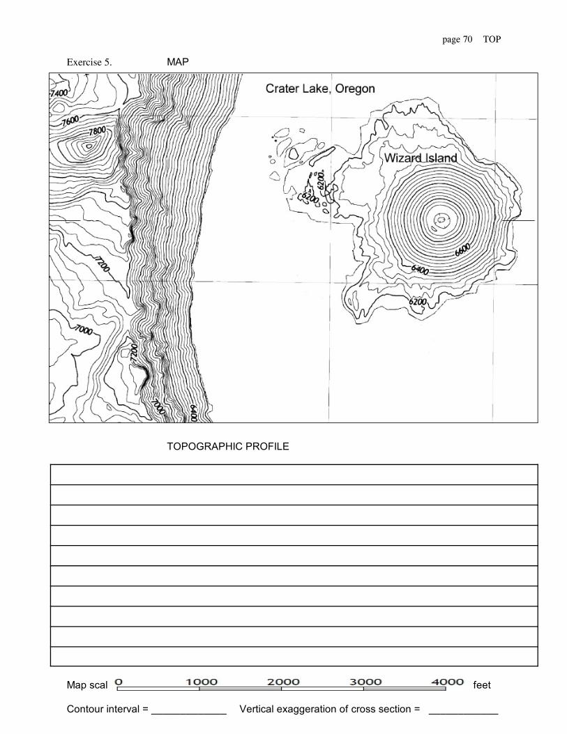
page 70 TOP
Exercise 5. MAP
TOPOGRAPHIC PROFILE
Map scale feet
Contour interval = _____________ Vertical exaggeration of cross section = ____________

page 71 TOP
Exercise 6.

page 72 TOP
TEST 1 Topographic maps and profile Your name:
Date:
Part I QUESTIONS
1 Using the elevations and streams given in the supplied figure, constructa topographic map with a contour :interval of 20 feet.
2 Indicate-with arrows on the map in which direction the streams flow.
3 What is the maximum relief in the area? ___________
4 What is the average gradient of the indicated stream? ___________
5 If standing at point A could one see point B? ___________
6 If standing at point A could one see point C? ___________
7 If standing at point C could one see point D? ___________
8 Construct a topographic profile along an east west line you label X-Y.
Part II (refer to quadrangle map supplied in laboratory) The name of the quadrangle is: __________________________
9 Why is the map called a quadrangle and not a rectangle?
___________________________________________________
10 What is the scale of the map in fractional form? ___________
11 What is the scale of the map in inches-per-mile? ___________
12 How many feet on the ground does one inch on the map represent? ___________
13 What is the distance between the two places indicated on the map (see information on blackboard) ___________
14 What is the elevation of the lowest of these two places? ___________
15 What is the elevation of the lowest place anywhere in the map? ___________

page 73 OPH
GE-101 Sect: QUEENSBOROUGH COMMUNITY COLLEGE Date: / /Physical Geology The City University of New York
Instructor: Your name:
Laboratory module: Ore minerals, physical properties
Objectives: After completing this laboratory you should be able to:
1. Evaluate how well color, streak and luster characterize mineral species.
2. Measure the hardness and specific gravity of minerals.
3. Use mineral identification tables.
EQUIPMENT CHECK LIST (Report any missing items to the laboratory proctor)
Material Description perstudent
pertable
MINERALS 8 unknown hand specimens* and chips+ forspecific gravity determination
1 set
GEOLOGICALEQUIPMENT
Streak plates+Calcite cleavage plates+Glass plates (beveled edges)+Jolly specific gravity balances (fitted withheavy gauge springs)
111
1
SPECIALEQUIPMENT
Beakers, 250 ml, glass 1
*Selected from the following ore minerals:arsenopyrite, azuritebauxite, beryl, barite celestite, cinnabar, cassiterite, cerussite, chalcopyrite, chalcosite, columbite, chromite,cupritegalena, goethitehematitelimonite malachite, magnetite, magnesite orpiment pyrolusite, (pyrite), (pyrrhotite) realgar, rutile, rhodochrosite sphalerite, siderite, spodumene, stibnite, strontianitezircon
+Expendable
page 74 OPH
Section 1 Ore Minerals, physical properties
Practical workers had distinguished and named many hundreds of minerals using suchphysical criteria as: color, hardness and specific gravity (heft), before it was determined that thetwo criteria essential for the definition of a mineral species are chemical composition andsymmetry of internal crystal structure. Neither of these latter criteria, however, can be observedat first hand. Not surprisingly, therefore, the geologist today, in the role of prospector, or even asa guest in a friend's house, should still possess the facility of identifying most common mineralsby the direct inspection of hand specimens.
The founder of systematic mineralogy was Abraham Gottlob Werner (1749-1817). Heassembled a great body of information concerning all minerals and demonstrated to thesatisfaction of the mining world the utility of a systematic classification of minerals based upontheir easily observed physical properties.
A mineral's physical properties are those of its characteristic that affect our senses, whichare: sight, touch, smell, taste and hearing. Sight can give us a quick measure of a mineral's color,streak and luster. Observation of crystal form or cleavage, when present, requires that individualcrystals can be seen. Streak is the color of a mineral after it has been crushed to a powder. Inmany instances, the color of the streak is quite different from the color of the uncrushed mineral. Minerals, that are granular on the scale of a powder, will have a dull or earthy luster unless theyare native metals in which case they will have a metallic luster where freshly broken. Mineralsthat are visibly crystalline and show fresh (unweathered, untarnished) crystal faces, cleavagesurfaces or fracture surfaces, will have a non-metallic luster if they are transparent or evenslightly translucent, and a metallic luster if they are thoroughly opaque (even at their thinnestedge). Touch is related to a mineral's hardness and specific gravity. Smell, hearing and taste,though of more restricted application in the physical classification of minerals, can be decisive.
Color, streak and luster, cannot be used to distinguish between all minerals equally well,nevertheless, these characteristics are so obvious that it is often advantageous to use them inmineral identification as initial criteria. From one specimen to another of the same mineral:color varies least if the mineral has a distinctly colored streak (included are most minerals thatcan have a metallic luster), and color varies most if the mineral has an uncolored, pale gray orwhite streak (included are most minerals of non-metallic luster).
Further subdivision of minerals in standard identification table can involve: hardness, acharacteristic readily measured in the field with little specialized equipment, and specificgravity, a characteristic that is easy to measure in the laboratory.

page 75 OPH
Exercise 1 EVALUATION QUESTIONS
What two criteria are necessary and sufficient for the definition of mineral species?
Why is it important for geologists to try to distinguish between mineral species by observingtheir physical properties?
Who has been credited with being the founder of mineralogy?
Define streak:
Is the color and the streak of a mineral usually the same? (yes, no) Explain.
Describe the luster of crushed minerals which are not native metals:
Can only native metals have a metallic luster? (yes, no) Explain.
Can a mineral with metallic luster have a non-metallic streak? (yes, no) Explain.
Do all minerals of non-metallic luster have an uncolored, pale gray or white streak? (yes, no) Explain.
Name two physical properties of minerals which can be measured easily.

page 76 OPH
Section II
Exercise 2 COLOR AND STREAK
In order to distinguish one mineral from another, care must be taken not to place toomuch reliance on color although the specific color can be diagnostic. Also, the color of thestreak is mostly uniform from one specimen to another of the same mineral. For minerals whichlook like metals, but which are not, the streak is very different from the color of the uncrushedmineral and this helps in their identification. For the common rock forming minerals, the streakis uncolored, white or pale gray. Your problem is to describe the color and the streak of thegiven minerals.
Procedure: Work with one mineral at a time. Record your results in Table 1. List specimennumbers in order from smallest to largest.
Step 1. Characterize the overall color of the mineral as: black, dark gray, yellow, brown,red, blue, green, uncolored, light gray or white and then go on to describe the specific color*.
Step 2. There are several common methods for testing the streak of a mineral: first bycrushing to a powder with a hammer, second by scratching it with a knife blade or file, third byrubbing it on what is known as a streak plate (a piece of unglazed porcelain). Use the thirdmethod as the streak is preserved on the streak plate and can be compared with those of otherminerals whose streaks can be made close to each other. Press the mineral firmly against thestreak plate and rub it back and forth several times along the same short line in order to developthe full tone of the streak. In that way, if the mineral has a dark streak, you will not mistake itthrough lack of rubbing for one that has a light streak. (Minerals, whose hardness exceeds thatof the streak plate, must be powdered.)
Describe the mineral streak as: black, dark gray, yellow, brown, red blue, green,uncolored, light gray, or white and then go on to describe the specific streak*.
*Hint. Choose from the following possibilities:
Color, streak
BLACK
DARK GRAY
YELLOW
BROWN
RED
continued –>
Specific color, Specific streak
black, pitch-, velvet-, iron-, yellowish-,brownish-, reddish-, purplish or iridescent metallic-, grayish-
dark gray, lead gray, bluish lead gray, dark steel gray.
grayish-, pale-, light-, lemon-, canary-, honey-, straw-, wax-, wine-, sulfur-,metallic golden-, brassy-, brownish-, orange-, reddish-.
blackish-, dark-, dirty-, hair-, smokey-, grayish-, yellowish-, bronze,reddish-, cinnamon-, clove-.
blackish-, ruby-, dark-, yellowish-, aurora-, flesh-, peach-, orange-, brick-, brownish-, maroon, copper-, light copper-, rose-, bright-, cochineal-, cherry-, blood-, crimson-, scarlet-, purplish-, vermilion-, hyacinth-, red violet, pink.

page 77 OPH
BLUE
GREEN
LIGHT GRAY
WHITE
UNCOLORED
blackish metallic-, indigo, deep-, grayish-, smoky-, lavender, lilac, violet,amethystine, azure-, sky-, greenish-, light-.
blackish-, dark-, olive-, yellowish-, brownish-, bluish-, apple-, emerald-, grass-, pea-, leek-, pale-.
pearl-, pale-, yellowish-, brownish-, reddish-, pinkish,lavender-, bluish-,light lead-, silver.
milky-, tin-, milk-, snow-.
uncolored.
Table 1
Mineralspecimen
no.
Color Specific color Streak Specific streak
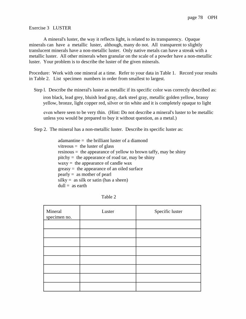
page 78 OPH
Exercise 3 LUSTER
A mineral's luster, the way it reflects light, is related to its transparency. Opaqueminerals can have a metallic luster, although, many do not. All transparent to slightlytranslucent minerals have a non-metallic luster. Only native metals can have a streak with ametallic luster. All other minerals when granular on the scale of a powder have a non-metallicluster. Your problem is to describe the luster of the given minerals.
Procedure: Work with one mineral at a time. Refer to your data in Table 1. Record your results in Table 2. List specimen numbers in order from smallest to largest.
Step l. Describe the mineral's luster as metallic if its specific color was correctly described as:
iron black, lead grey, bluish lead gray, dark steel gray, metallic golden yellow, brassyyellow, bronze, light copper red, silver or tin white and it is completely opaque to light
even where seen to be very thin. (Hint: Do not describe a mineral's luster to be metallic unless you would be prepared to buy it without question, as a metal.)
Step 2. The mineral has a non-metallic luster. Describe its specific luster as:
adamantine = the brilliant luster of a diamondvitreous = the luster of glassresinous = the appearance of yellow to brown taffy, may be shinypitchy = the appearance of road tar, may be shinywaxy = the appearance of candle waxgreasy = the appearance of an oiled surfacepearly = as mother of pearlsilky = as silk or satin (has a sheen)dull = as earth
Table 2
Mineralspecimen no.
Luster Specific luster
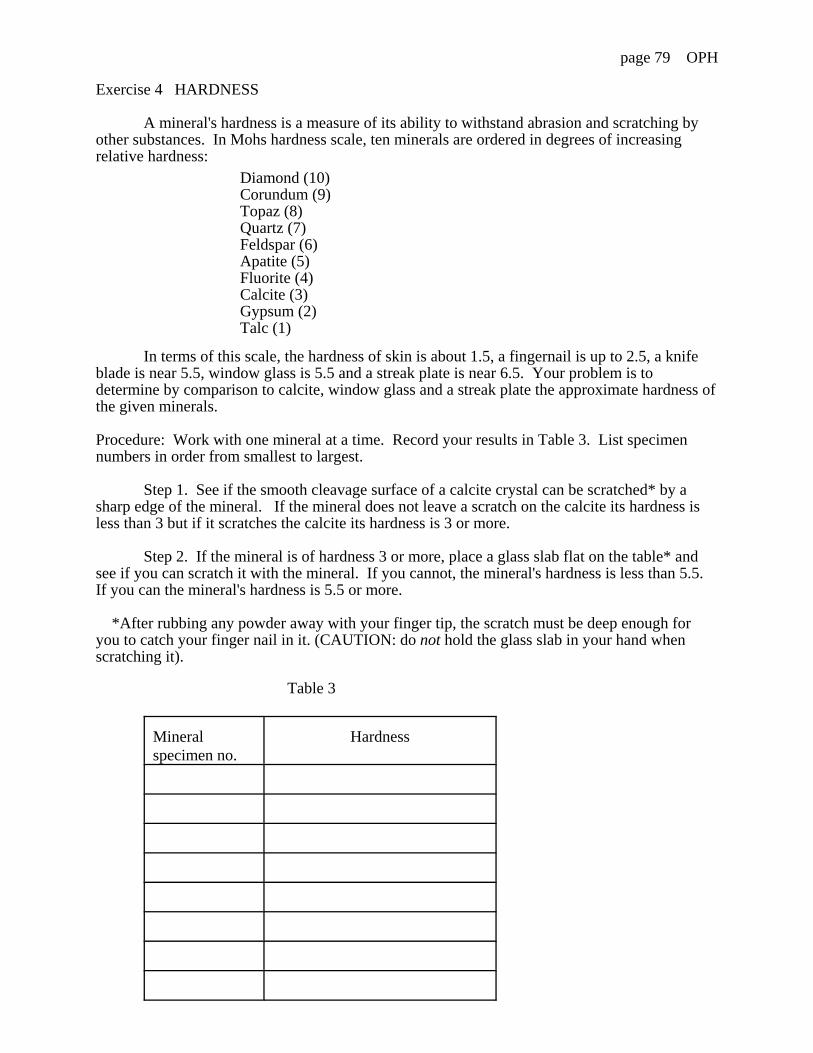
page 79 OPH
Exercise 4 HARDNESS
A mineral's hardness is a measure of its ability to withstand abrasion and scratching byother substances. In Mohs hardness scale, ten minerals are ordered in degrees of increasingrelative hardness:
Diamond (10)Corundum (9)Topaz (8)Quartz (7)Feldspar (6)Apatite (5)Fluorite (4)Calcite (3)Gypsum (2)Talc (1)
In terms of this scale, the hardness of skin is about 1.5, a fingernail is up to 2.5, a knifeblade is near 5.5, window glass is 5.5 and a streak plate is near 6.5. Your problem is todetermine by comparison to calcite, window glass and a streak plate the approximate hardness ofthe given minerals.
Procedure: Work with one mineral at a time. Record your results in Table 3. List specimennumbers in order from smallest to largest.
Step 1. See if the smooth cleavage surface of a calcite crystal can be scratched* by asharp edge of the mineral. If the mineral does not leave a scratch on the calcite its hardness isless than 3 but if it scratches the calcite its hardness is 3 or more.
Step 2. If the mineral is of hardness 3 or more, place a glass slab flat on the table* andsee if you can scratch it with the mineral. If you cannot, the mineral's hardness is less than 5.5. If you can the mineral's hardness is 5.5 or more.
*After rubbing any powder away with your finger tip, the scratch must be deep enough foryou to catch your finger nail in it. (CAUTION: do not hold the glass slab in your hand whenscratching it).
Table 3
Mineralspecimen no.
Hardness

page 80 OPH
Exercise 5 SPECIFIC GRAVITY
The specific gravity of a substance is its weight in air compared to the weight of an equalvolume of water. A mineral's specific gravity lies within a range limited by the possiblecompositional variation. Minerals with otherwise similar physical properties can have specificgravities that differ materially. Your problem is to determine the specific gravity of the givenminerals.
Procedure: CAUTION: Never touch the spring on the Jolly balance as this can be easilydamaged.Work with one mineral at a time. Record your results in Table 4. List specimen numbers inorder from smallest to largest.
Step 1. Fill a 250 ml beaker with water. Place it on the beaker stand (see Fig. 12).
Step 2. Hold the pan hook (not the coiled part of the spring just below the whiskers andwith your free hand carefully straighten the whiskers so that they are level and parallel thegraduated mirror face.
Step 3. Raise beaker stand and beaker until pan 2 floats on the water. Push pan 2 intothe water with your finger tip. Raise the beaker stand a little more so that pan 2 is completelyimmersed up to the vertical support wire below pan 1. (Note: pan 1 should not become wetduring this process. If at any time pan 1 does become wet, hold the pan, not the spring, anddry it with a paper towel.)
Step 4. Look for the image of the whisker in the graduated mirror. Raise or lower yourlevel of sight until the whisker hides its own image in the mirror. Keeping that position, read thelevel (to an 0.1 accuracy) of the whisker on the graduated mirror. Record this reading. Lowerthe beaker stand and beaker to the base of the stand. Pan 2 will be left clear of the water. Do notmind if some water splashes around.
Step 5. Hold pan 1 and place the dry mineral chip(s), on it. Support pan 1 beneath withyour finger tips and gently lower until the pan lifts away. Repeat Step 3. Repeat Step 4.To achieve greatest accuracy, add or remove chips to bring the whisker near the bottom of thegraduated mirror. Repeat steps 3 and 4. Do not repeat step 5. Go to step 6.
Step 6. Hold pan 1 and take the mineral chip(s) off it. We these chips in the water in thebeaker. Hold pan 2 and place the wet mineral chips on it. Repeat steps 3 and 4. Hold pan 2 andtake the mineral chip(s) off it.
Note:For the next determination, start again at Step 5.
Step 7. Calculate the specific gravity for each mineral according to:
A = initial reading without mineral in pan 1 or pan 2.
B = reading with mineral in pan 1 in air.
C = reading with mineral in pan 2 in water.
D = weight of the mineral in air = B - A.
E = weight of an equal volume of water = B - C.
Specific Gravity = D/E.
page 81 OPH
Table 4
Mineralspecimenno.
Readings Calculations
A B C D E Specific gravity

page 82 OPH
Section III
Exercise 6 IDENTIFICATION OF MINERALS BY THEIR PHYSICAL PROPERTIES
You have examined the given minerals for color, streak, luster, hardness and specific gravity. The same minerals could have been examined for crystallization, structure, cleavage, fracture,tenacity and special characteristics such as taste, odor, magnetism and fluorescence. Yourproblem is to name the given minerals.
Procedure: Refer to your data in Tables 1, 3 and 4. Work with one mineral at a time. Recordyour results in Table 5. List specimen numbers in order from smallest to largest.
Step 1. Use the accompanying identification table (p. 77- 79) to narrow the choice of thepossible name(s). List these.
Step 2 (optional). If there is a choice between several minerals, read fuller descriptionsof their physical characteristics in a reference provided by your instructor. In column 2 of Table5, underline the mineral name you finally choose and in column 3 record the physicalcharacteristics by which it is distinguished.
Table 5
Mineralspecimen no.
Possible minerals Distinguishing physical characteristics
page 83 OPH
ORE MINERAL IDENTIFICATION TABLE Note: minerals that can have ametallic luster are italicized 1
Color Streak H. S.G. Possible ore minerals(s)1
dark grayto black
dark grayto black
1 - 3 4.3 - 5.45.5 - 5.86.4 - 6.67.2 - 7.6
tetrahedrite, stibnite, pyrolusitechalcocitebismithiniteargentite, galena
3 - 5.5 4.1 - 4.34.9 - 5.28.0 - 10.0
chalcopyriteborniteuraninite
5.5 - 10 4.5 - 5.55.4 - 6.47.1 - 7.5
ilmenite, magnetite, franklinitecolumbitewolframite
brown to red
1 - 3 3.9 - 4.24.3 - 5.45.7 - 6.18.5 - 9.0
sphaleritetetrahedrite, hematitecupritecopper
3 - 5.5 4.2 - 6.47.1 - 7.5
manganite, chromite, ilmenite,franklinite, columbitewolframite
yellow 1 - 3 3.4 - 4.0 limonite
3 - 5.5 3.7 - 4.4 siderite, sphalerite, goethite
uncolored,white, orlight gray
3 - 5.5 2.9 - 3.1 magnesite
brown tored
dark grayto black
1 - 3 4.5 - 4.64.9 - 5.27.1 - 7.5
pyrrhotitebornitewolframite
brown tored
1 - 3 2.5 - 2.64.9 - 5.38.0 - 8.28.5 - 9.0
bauxitehematitecinnabarcopper
3 - 5.5 3.3 - 3.54.2 - 4.35.4 - 5.75.7 - 6.17.1 - 7.58.0 - 10.0
hematiterutilezincitecupritewolframiteuraninite
5.5 - 10 3.3 - 3.54.2 - 4.3
hematiterutile

page 84 OPH
brown toredcontinued
yellow 1 - 3 3.4 - 4.0 limonite
3 - 5.5 3.7 - 3.93.9 - 4.2
sideritesphalerite
5.5 - 10 4.2 - 4.36.8 - 7.6
rutilecassiterite
Uncoloredwhite orlight gray
1 - 3 2.5 - 2.64.3 - 4.7
bauxitebarite
3 - 5.5 3.3 - 3.63.9 - 4.05.9 - 6.2
rhodochrositecelestitescheelite
5.5 - 10 2.6 - 2.84.2 - 4.34.4 - 5.8
berylrutilezircon
yellow dark grayto black
3 - 5.5 4.1 - 4.34.5 - 4.64.6 - 5.2
chalcopyritepyrrhotitepentlandite, bornite
5.5 - 10 4.9 - 5.2 pyrite
yellow 1 - 3 3.4 - 4.015.6 - 19.3
orpiment, realgar, limonitegold
3 - 5.5 3.9 - 4.44.9 - 5.05.4 - 5.7
sphalerite, goethitegreenockitezincite
uncoloredto white
1 - 3 1.9 - 2.0 cerussite
3 - 5.5 2.9 - 3.13.3 - 3.63.6 - 3.83.9 - 4.04.1 - 4.55.9 - 6.2
magnesiterhodochrositestrontianitecelestitesmithsonitescheelite
5.5 - 10 2.6 - 2.84.4 - 4.8
berylzircon

page 85 OPH
blue orgreen
dark grayto black
1 - 3 4.6 covellite
red 1 - 3 8.5 - 9.0 copper
blue orgreen
1 - 3 3.0 - 3.14.65.5 - 5.8
annabergitecovellitechalcocite
3 - 5.5 3.7 - 4.16.0 - 8.0
azurite, malachiteuraninite
uncoloredwhite orlight gray
3 5.5 2.0 - 2.23.1 - 3.23.9 - 4.04.1 - 4.55.9 - 6.2
anglesitespodumenecelestitesmithsonitescheelite
5.5 10 2.6 - 2.84.4 - 4.8
berylzircon
uncoloredwhite orlight gray
dark grayto black
1 - 3 4.6 - 4.76.4 - 6.67.3 - 7.6
stibnitebismuthinitegalena
3 - 5.5 5.9 - 6.46.4 - 6.6
asenopyrite, cobaltsmaltite
uncoloredwhite orlight gray
1 - 3 2.510.0 - 12.0
bauxitesilver
3 - 5.5 2.6 - 2.82.9 - 3.13.6 - 3.83.9 - 4.04.1 - 4.55.9 - 6.46.4 - 6.6
berylmagnesitestrontianitecelestitesmithsonite, witheritescheelite, anglesitecerussite
5.5 - 10 4.4 - 4.86.0 - 7.0
zirconspodumene
page 86 OPH
APPENDIX Setting up the Jolly Balance
Selected references for the identification of minerals:

page 87 OCH
GE-101 Sect: QUEENSBOROUGH COMMUNITY COLLEGE Date: / /Physical Geology The City University of New York
Instructor: Your name:
Laboratory module: Ore minerals, chemical properties
Objectives: After completing this laboratory you should be able to:
1. Describe a method for grouping minerals by the way they can be made to dissolve.
2. Name and follow chemical procedures that indicate the presence of certain metal elements in mineral solutions.
3. Describe the difference between a mineral's physical and its chemical properties.
EQUIPMENT CHECK LIST (Report any missing items to the laboratory proctor
Material Description per pairStudents
perTable
SOILS 4 crushed unknowns* in bottles labeled byspecimen number. Each bottle contains a 0.25gm measuring spoon.
1 set
CHEMICALS Concentrated hydrochloric acid in half lidded 50 ml stoppered bottle in safety dish.Reagents: Ammonium carbonate and potassium iodine in dark bottles.Distilled water in dropper bottle. 1
1
1
SPECIAL EQUIPMENT
Test tubes (pyrex) Test tube stand Test tube holder 50 ml beakers 200 ml beaker Glass rod (stirrer) Pippets (droppers) Filter funnels Filter papers1
Alcohol burner Spot test plate Wire (steel, thin gauge)1
Wire holder1
Pliers (wire-cutting)1
41141154
11
*Selected from the following minerals: anhydrite, azurite, braunite, calamine, calcite, chrysocolla, cuprite, forsterite, galena, goethite, greenockite, gypsum, halite, hematite, limonite, magnesite, malachite, pyrolusite, rhodonite, scheelite, serpentine, siderite, smithsonite, sphalerite, stibnite, strontianite, sylvite, trona, willemnite- witherite, wollastonite, zincite.1Available in laboratory room.

page 88 OCH
Section I
Minerals are known to be composed either of one or of several elements. Amongst the latter,composition is fixed for some and for others it can vary, with respect to some of its components, througha range limited only by the condition that the symmetry of internal crystal structure remains unchanged.
Museum mineral collections, for display and research, are usually arranged according to the onecriterion: composition. A classification scheme devised by Dana (see Appendix ) is commonly followed.
When presented with an unfamiliar mineral for identification, we are quite often apt to forget totest for its chemical properties which yield, qualitatively, a partial chemical analysis. This may bebecause our experience with minerals is such that, under natural conditions, they mostly seem toeffectively withstand rapid decomposition or dissolution (both are chemical properties) and because weknow chemical tests usually require that a substance first be got into solution. The cardinal point toremember is that all minerals can be got into solution and most so relatively easily. This is particularlytrue of the ore minerals. For practical reasons, the only ore minerals that 1) cannot be easily dissolved or 2) have complex compositions, are those for which no alternative is known or is available.
Minerals can be grouped according to the way they can be made to dissolve. We find minerals that are:
(A) partially or completely dissolved in hydrochloric acid.(B) not soluble in hydrochloric acid but dissolve in nitric acid.(C) not soluble in hydrochloric or nitric acid but are at least partly decomposed and
dissolved by nitric acid(D) not dissolved by any of the common acids but can be fused with soda or potassium bisulfate.
In (A) are found those minerals that are water soluble; most of the phosphates, sulfates, boratesand tungstates: the metallic ore carbonates and most oxides, and many of the less stable silicates. In (B)will be found a majority of the heavy metallic ore sulfides, while in (C) and (D) are most silicates and afew metallic ore oxides.
For illustrative purposes in this module, minerals have been selected which occur in group (A)and which have only one metal in their composition.
page 89 OCH
Exercise 1 EVALUATION QUESTIONS
Can a mineral be composed of only one element? (yes, no) Explain.
In a museum display, would you expect minerals to be arranged according to their composition,symmetry of internal crystal structure, physical properties or chemical properties?
What is quantitative chemical analysis?
Describe two desirable characteristics of minerals which are ores.
Is the way a mineral can be made to dissolve a physical property or a chemical property?
What groups of metallic ore minerals characteristically dissolve in:
hydrochloric acid
nitric acid
Are some oxides insoluble in the common acids? (yes, no) Explain.
WARNING: WHEN YOU ENTER THE LABORATORY ROOM THERE WILL BECONCENTRATED ACID ON THE TABLE.
DO NOT PICK UP THE ACID BOTTLE. DO NOT REMOVE IT AT ANY TIME FROM ITSSAFETY DISH.

page 90 OCH
Section II CHEMICAL PROPERTIES
Exercise 2 SOLUBILITY OF MINERALS IN HYDROCHLORIC ACID
Not all minerals are soluble in hydrochloric acid. The (crushed) minerals you have been given,however, are known to be. Your problem is to observe under what conditions the given minerals can bemade to dissolve. (Note: If a mineral is soluble in water, it will also be soluble in hydrochloric acid. However, minerals not soluble in water may yet be soluble in hydrochloric acid.)
Procedure: Work with the four crushed minerals. Keep them organized in order of increasing specimennumber. Record your results in Table 1.
Step 1. Hold a thoroughly clean test tube with a test tube holder clamped near its open end. Witha measuring spoon marked 0.25 gms, introduce one level measure of the finely crushed mineral into thetest tube. Return the measuring spoon to the same ar it came from. Concentrate on workingsystematically (the spoon is inside the jar with the crushed mineral).
Step 2. Add 20 drops of water to the test tube, (A drop is an exact measure. Work accurately.) Shake the test tube from side to side to mix contents while holding it with the holder. (Note: to preventspillage, only the bottom of the test tube should move vigorously from side to side.) If the contents of thetest tube looks muddy or opaque, solution of the mineral has not occurred. If solution has occurred, theliquid should be transparent (colorless or colored) and not cloudy and there should be no (or very little)powder left. If it did not dissolve, go to step 3, otherwise go to step 6.
Step 3. (CAUTION: do not pick up the acid-bottle.) Firmly hold the acid bottle down in itssafety dish and with your free hand, twist and lift out its stopper. The stopper also acts as a dropper.(CAUTION: should you get any acid on your skin or clothes, you have five minutes to avoid seriousdamage. Flood area with water and inform proctor without delay.)
Step 4. If the mineral did not dissolve in Step 2, add (to the contents of the same test tube) tendrops of concentrated hydrochloric acid. In the diluted hydrochloric-acid, if the contents immediatelystarts to effervesce (bubble), the gas evolved is carbon dioxide and the mineral will soon be dissolved. Otherwise, go to Step 5.
Light an alcohol burner (or a gas burner).
Step 5. Add (to the contents of the same test tube) twenty drops of concentrated hydrochloricacid. Bring to boil while shaking the test tube continuously as before for one minute. If while boiling afetid (rotten egg, stink bomb) odor is noticed, hydrogen sulfide gas is evolved. Remove the test tube fromthe flame and after the boiling has died down note whether there is a residue in the bottom of the testtube. If there be, look at it carefully to see whether slow bubbling can be seen. If so, chlorine gas isevolved. Otherwise (and only an acrid smell can be noticed), no gas is evolved. If there is a residue, boilcontents again for one more minute as before. Note if the mineral is wholly or partly dissolved. Whenpartly dissolved, describe the residue as: some (of the original material), yellow (WO3), white (PbCl2) orgelatinous (SiO2).
Step 6. Note the color of each solution obtained. Do not throw these solutions away. Keepthem for exercises 4 and 5.
Extinguish the alcohol (or turn off the gas) flame.

page 91 OCH
Table 1
MINERAL SOLUBILITY
Mineralspecimenno.
Solublein1
Gasevolved2
Degree ofsolution3
Residue4 Color ofsolution
1water, dilute HCl (hydrochloric acid) step 2, concentrated HCI step 4.
2CO2- carbon dioxide (effervescence in dil. HC1), H2S - hydrogen sulfide (fetid odor), Cl2- chlorine (slow effervescence in conc. HCl), none (no gas evolved).
3wholly dissolved, partly dissolved
4none, some (of the original), yellow (WO3), white (PbC12), gelatinous (SiO2)

page 92 OCH
Exercise 3 USE OF SOLUBILITY DATA All the minerals you were given are wholly or partly soluble in hydrochloric acid. Your problem
is to further narrow down the choice of a possible mineral name for each unknown by using the dataobtained in exercise 2.
Procedure: Refer to Table 1. Work with data obtained for one specimen at a time. Classify eachmineral by writing its specimen number appropriately in each stage (1 to 4) of the scheme given in Table2.
Table 2
Mineralsoluble in
Gasevolved
Residue Solution Possible mineral and composition
water none none colorless Halite, NaClSylvite, KCl
dil. HCl CO2 none colorless Trona, Na2CO3.NaHCO3.2H20Witherite, BaCO3
Strontianite, SrCO3
Calcite, CaCO3
Smithsonite, ZnCO3
Magnesite, MgCO3
color Malachite, CuCO3.Cu(OH)3
Azurite, 2CuCO3.Cu(OH)3
Siderite, FeCO3
conc. HCl Cl2 none orsome
color Pyrolusite, MnO2
SiO2 color Braunite, 3Mn2O3.MnSiO3
H2S none orsome
colorless Sphalerite, ZnS
color Greenockite, CdS
PbCl color Galena, PbS
none none orsome
colorless Anhydrite, CaSO4
Gypsum, CaSO4.2H20Zincite, ZnOWillemnite, ZnSiO4
color Stibnite, Sb2S3
Hematite, Fe2O3
Goethite, Fe2O3.H20Limonite, Fe2O3.3H20Cuprite, Cu2OChrysocolla, CuSiO3.2H20Rhodonite, MnSiO3
WO3 colorless Scheelite, CaWO3
SiO2 colorless Wollastonite, CaSiO3
Calamine, 2ZnO.SiO2.H20Serpentine, 3MgO.sao2.H20Forsterite, Mg2SiO4
Stage 1 Stage 2 Stage 3 Stage 4

page 93 OCH
Section IIIExercise 4 SPOT TESTS
Once a mineral is in solution, spot can be made tests to distinguish directly between minerals andgroups of minerals on the chemical property of their metal content. The advantage is speed and economyof materials used. In addition, during the complete qualitative chemical analysis of a mineral, virtually allof the different specific reactions of the elements and many group tests can be carried out using drops ofthe solutions obtained and reagents. Your problem is to test for the chemical properties of the mineralsolutions you obtained in Exercise 2 using the two reagents: ammonium carbonate and potassiumiodide.
Procedure: Work with the four mineral solutions. Keep them organized in order of increasing specimennumber. Record your results in Table 3.
Step 1. Dilute each mineral solution that was kept from Exercise 2 by adding twenty drops ofwater to each test tube.
Step 2. Into 5 ml beakers, from each solution, filter (see over, page 88) off any residue and keepthe clear solutions that collect in the beakers. Label each beaker carefully. Place a clean dropper in eachbeaker. After use (in the following) always return dropper to same beaker.
Step 3. Fill a large beaker with clean water. Place a clean glass stirring rod in it and a papertowel nearby.
Step 4. Work in turn with each filtered solution. On a spot test plate, place three drops of thesolution into each of two side by side depressions: three drops in each depression. (Concentrate onworking systematically so that you can later recall where the various drops have been placed.)
Step 5. Place one drop of ammonium carbonate in the depression with one of the solutions. If aprecipitate (an opaque, muddy, deposit) is obtained, stir with a clean glass rod to mix and record it color. If no precipitate has been obtained, carefully add one more drop of reagent. Again, if no precipitate isobtained, add one more drop until 5 have been added. Add no more. Record the color of the precipitateor solution (be sure to say which) after stirring.
Step 6. Repeat step 5 using the reagent potassium iodide in the place of ammonium carbonate. Return to step 4 for next solution.
Table 3
Mineralspecimenno.
Color of precipitate (ppt) or solution (sol). See below :-
Mineral solution with ammonium carbonate Mineral solution with potassium iodide
*always indicate: ppt (for precipitate) or, sol (for solution) and describe the color choosing from:black, brown, dark brown, yellow brown,yellow, curdy yellow, pale yellow, bright yellow, reddish yellow, orange yellow, red, dark red, yellow pink, pink, orange, orange red, green, brown green, olive green, apple green, amethyst, blue, dark blue,white, dirty white, pinkish white, colorless
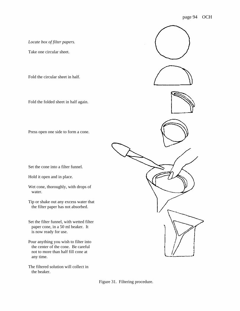
page 94 OCH
Locate box of filter papers.
Take one circular sheet.
Fold the circular sheet in half.
Fold the folded sheet in half again.
Press open one side to form a cone.
Set the cone into a filter funnel.
Hold it open and in place.
Wet cone, thoroughly, with drops of water.
Tip or shake out any excess water that the filter paper has not absorbed.
Set the filter funnel, with wetted filter paper cone, in a 50 ml beaker. It is now ready for use.
Pour anything you wish to filter into the center of the cone. Be careful not to more than half fill cone at any time.
The filtered solution will collect in the beaker.
Figure 31. Filtering procedure.

page 95 OCH
Exercise 5 FLAME TESTS
Some minerals are found to impart a characteristic color to an otherwise colorless flame when heated inthat flame. This effect can be caused by any of several metals present in the mineral.The flame test, as this is called can be used to analyze for any of these metals in a mineral. The flame testis not effected by a mineral's solubility. Your problem is to carry out a flame test on each of the givencrushed minerals.
Procedure: Work with the filtered solution of one mineral at a time. Record your results in Table 4. Listspecimen numbers in order from smallest to largest.
Step 1. Locate the wire cutting and shaping pliers and a roll of thin gauge steel wire. Cut off athree inch length of wire and clamp one end firmly into a wire holder. Light the alcohol (or gas) burner.
Step 2. Heat end of the wire to glowing in the colorless part of the alcohol burner (or gas) flame. Hold it in the invisible flame until no color (yellow) is imparted to the invisible flame when the tip of thewire glows.
Step 3. Dip the tip of the wire into one of the solutions saved from Exercise 2. Then hold the tipof the wire in the flame again. Note if a colored flame appears*. Repeat Step 2 and step 3 for eachsolution. Record your results in Table 4.
Table 4
Mineralspecimen no
Flame color
Fig. 15
*Describe the color choosing from: None, orintense yellow, orange, yellowish red, carmine, crimson, pale violet, livid blue, azure blue, bluish green, pale green, yellowish green, pale greenish white.

page 96 OCH
Exercise 6 USE OF SPOT TEST AND FLAME TEST DATA
When a mineral contains only one metal in its composition, spot test and/or flame test data canoften indicate that metal directly. When a mineral contains several metals in its composition, a detailedanalytical procedure must be followed in order to separate out each-one. The crushed minerals you weregiven have only one metal in their composition. Many ore minerals have this feature. Your problem is touse the data obtained in exercises 4 and 5 to identify the metal component of each of the given minerals.
Procedure: Refer to Table 5 and by direct comparison of your data in Tables 3 and 4 determine the metalin each mineral specimen. Write the specimen number beside the metal indicated in Table 5.
Table 5
Spot test Flame test Metalindicated
Mineralspecimenno.ammonium carbonate potassium iodide
brown ppt. deep red sol none ferric iron, Fe
yellow orange sol. none manganicmanganese,Mn
green ppt. or ablue ppt. or sol.
dirty greento brown ppt
azure blue withgreen outline
copper,Cu
dirty white ppt. deep red sol. none ferrous iron,Fe
white ppt. orange sol. none cadmium,Cd
yellow sol. none manganousmanganese,Mn
colorless orpale yellow sol.
bluish green zinc,Zn
colorless sol. colorless orpale yellow sol.
pale green stibnite,Sb
yellowish green barium,Br
intense yellowor orange
sodium,Na
yellowish red calcium,Ca
crimson strontium,Sr
pale violet potassium,K

page 97 OCH
Exercise 7 IDENTIFICATION OF MINERALS BY THEIR CHEMICAL PROPERTIES
In Exercise 3, you narrowed the choice of possible mineral names and compositions for each of the givencrushed mineral specimens. Your problem is to further narrow down this choice knowing the metal thateach has in its composition.
Procedure: List the minerals in order of increasing specimen number in Table 6. Consider one at a time: Table 5 tells you the metal it contains. Then go to Table 2 and note which possible mineral(s) it couldbe. Record your results in .
Table 6
Mineralspecimen no.
Possible mineral(s)

page 98 SPH
GE-101 Sect: QUEENSBOROUGH COMMUNITY COLLEGE Date: / /Physical Geology The City University of New York
Instructor: Your name:
HOMEWORK: Collection of soil sample

page 99 SPH
GE-101 Sect: QUEENSBOROUGH COMMUNITY COLLEGE Date: / /Physical Geology The City University of New York
Instructor: Your name:
Laboratory module: Soil science, physical
Objectives: After completing this laboratory you should be able to:
1. Describe the physical characteristics of soil.
2. Classify soils on the criterion of their texture.
3. Measure the porosity, permeability and capillarity of loose soils.
EQUIPMENT CHECK LIST (Report any missing items to the laboratory proctor
Material Description perStudent
perTable
SOILS 1/2 lb sample (either to be collected and dried by student - see Appendix E - or to be provided)
1
CHEMICALS Dispersing reagent in dropper bottleFlocculating reagent in dropper bottle
11
GEOLOGICAL EQUIPMENT
Soil separation tubes graduated in mlsStand to hold tubes 1
SPECIAL EQUIPMENT
Beaker, 100 ml1Funnel, 4" upper diameter, plastic, narrow stemStand to hold funnelWater bottle with dropper, 500 mlStop watch*Cotton wool*Calculator
11
11111
1Cut off stem, short and at an angle, so that liquid does not become caught in it when used in theseexercises
*Available in laboratory.
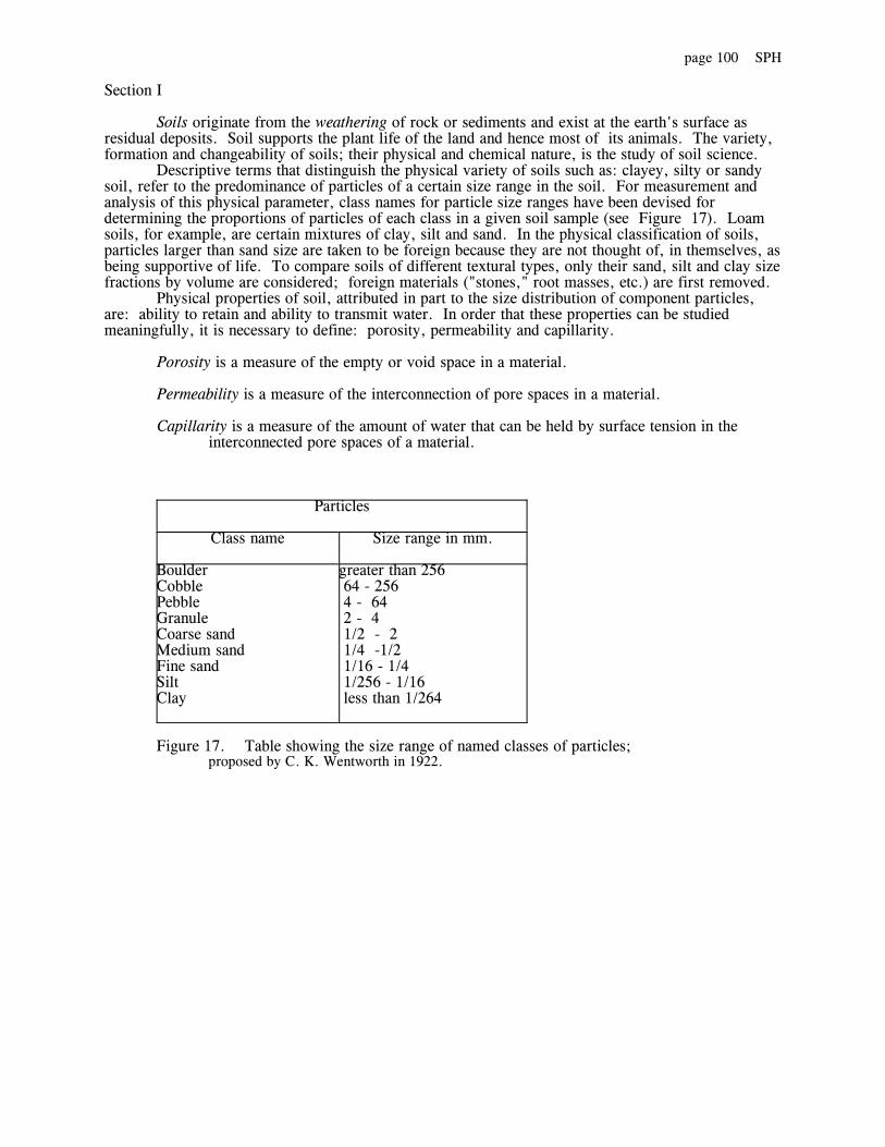
page 100 SPH
Section I
Soils originate from the weathering of rock or sediments and exist at the earth's surface asresidual deposits. Soil supports the plant life of the land and hence most of its animals. The variety,formation and changeability of soils; their physical and chemical nature, is the study of soil science.
Descriptive terms that distinguish the physical variety of soils such as: clayey, silty or sandysoil, refer to the predominance of particles of a certain size range in the soil. For measurement andanalysis of this physical parameter, class names for particle size ranges have been devised fordetermining the proportions of particles of each class in a given soil sample (see Figure 17). Loamsoils, for example, are certain mixtures of clay, silt and sand. In the physical classification of soils,particles larger than sand size are taken to be foreign because they are not thought of, in themselves, asbeing supportive of life. To compare soils of different textural types, only their sand, silt and clay sizefractions by volume are considered; foreign materials ("stones," root masses, etc.) are first removed.
Physical properties of soil, attributed in part to the size distribution of component particles,are: ability to retain and ability to transmit water. In order that these properties can be studiedmeaningfully, it is necessary to define: porosity, permeability and capillarity.
Porosity is a measure of the empty or void space in a material.
Permeability is a measure of the interconnection of pore spaces in a material.
Capillarity is a measure of the amount of water that can be held by surface tension in the interconnected pore spaces of a material.
Particles
Class name Size range in mm.
BoulderCobblePebbleGranuleCoarse sandMedium sandFine sandSiltClay
greater than 256 64 - 256 4 - 64 2 - 4 1/2 - 2 1/4 -1/2 1/16 - 1/4 1/256 - 1/16 less than 1/264
Figure 17. Table showing the size range of named classes of particles; proposed by C. K. Wentworth in 1922.
page 101 SPH
Exercise 1 EVALUATION QUESTIONS
How do soils originate?
To human life, what is the most important aspect of soils?
According to Wentworth's scale:
How large can a sand sized particle be?
How small can a sand sized particle be?
Are clay sized particles necessarily the mineral clay? (yes, no) Explain.
What is loam?
Why is soil texture defined as the size distribution of particles in the soil which are less than 2 mm insize?
Define:Porosity
Permeability
Capillarity
This week: start exercises 2, 4complete exercises 1, 5, 6
Next week: complete exercises 2, 3, 4

page 102 SPH
Section II SOIL TEXTURE
Exercise 2 ELUTRIATION
Soil texture is defined as the size distribution of particles less than 2 mm in size in the soil. Severalmethods exist called elutriation for performing wet mechanical analysis to determine a soil's texturaltype. All are based on Stoke's Law which determines the velocity at which a spherical particle of agiven diameter and weight settles in a still liquid. Appendix F gives information on the time neededfor different sized soil particles to settle through 10 cm of water. Your problem is to separate byelutriation the soil you collected, or that provided, into particle size classes: sand, silt, and clay.
Procedure: Note: the soil separation tubes are graduated in milliliters (ml). Record your results inTable 1.
Step 1. Label the three soil separation tubes, or their caps, A through C and stand them in therack provided. Remove the caps.
Step 2. Add soil to tube A up to line 15. Note: gently tap thebottom of the tube on a firm surface to pack and level the soil and eliminate air spaces.
Step 3. Locate a stop watch and practice timing 30 seconds.
Step 4. Using the graduated dropper in the Soil Dispersing Reagent add 1.0 ml of reagent tothe sample in tube A. Fill soil separation tube A up to line 50 with tap water, cap and shake for twominutes to thoroughly mix the soil with the water.
Step 5. Simultaneously stop shaking tube and start stop watch. Remove the cap and placetube A in the rack and leave undisturbed.
Step 6. After 30 seconds has elapsed on the stop watch, immediately, pour into tube B all themuddy water off the sand settled in tube A. Place tubes A and B in stand and leave undisturbed.
Step 7. After 30 minutes (take a break or start work on exercise 5) has elapsed on the stopwatch, immediately pour into tube C all the muddy water off the slit settled in tube B. Place tubes Band C in stand. Measure the volume of sand in tube A.
Step 8. To tube C, add 1 measure (1 ml) of Soil Flocculating Reagent cap tube and shake for1 minute. Initial label and return capped tube to stand. Measure the volume of silt in tube B. Washout tubes A and B (see page 76).
Step 9. At any time after 24 hours (next week, for example), carefully measure, withoutdisturbing contents, the volume of the clay in tube C.
Table 1
Soil sample no.
Size fraction by volume (ml)
Sand in tube A Silt in tube B Clay in tube C
page 103 SPH
Exercise 3 NAMING A SOIL'S TEXTURAL TYPE
The classification of soil textural types is based on their sand, silt and clay fractions by volume. Whenadded, these three fractions have a total volume which is greater than that of the original soil sample.This is because when mixed together in the soil, the smaller particles can fit between the largerparticles. Also, clay has a tendency to swell when wet. Your problem is to use the U. S. Departmentof Agriculture's scheme (see Figure 32) to classify and name the textural type of the soil you collected,or that provided.
Procedure: Refer to data recorded in Table 1 and to Figure 32. Record your results in Table 2.Step 1. Calculate the following (show working):
Total volume of the sand, silt and clay separated by elutriation:
volume sand + volume silt + volume clay = Z
Percentage sand by volume separated by elutriation:
volume sand x 100 = XZ
Percentage silt by volume separated by elutriation:
volume silt x 100 = YZ
Step 2. Mark the calculated percentage sand (X) on the bottom side of the diagram in Figure 32 and draw a vertical line into the diagram from that point.
Step 3. Mark the calculated percentage silt (Y) on the left side of the diagram in Figure 32and draw a horizontal line into the diagram from that point.
Step 4. Note in which named area of the diagram in Figure 32 the vertical and horizontal linesthat you have drawn meet. This gives the soil's textural type name.
Table 2
Soil sample no
Z X Y Textural type name

page 104 SPH
Figure 32. Classification of soil textural types

page 105 SPH
Section III
Exercise 4 POROSITY
The volume of pore space expressed as a percentage of the total volume of a material is calledporosity. Your problem is to measure the porosity of a loose soil.
Procedure: Record your results in Table 3.Step 1. Label a clean, dry, soil separation tube with your name and soil sample number.
Place approximately 25 ml of the soil in the tube
Step 2. Pour approximately 25 ml of water into a second soil separation tube. Hold the tubevertically and exactly measure the volume (V1) of the water (see Figure 33a).
Step 3. Very slowly pour the measured volume of water onto the soil in the first tube. Thesoil should first become wetted and then flooded without being stirred up. Gently tap the base of thetube against the table to level soil but again not stir up. Cap the tube and place it where it will not bedisturbed.
Step 4. At any time after 24 hours (next week for example) carefully measure the volume (V2)of the water-saturated soil (eliminate air pockets in the soil by tapping the base of the tubestraight down onto the table surface) and the volume (V3) of the saturated soil plus excess water (seeFigure 33b).
Figure 33
Step 5. Calculate the following (show working):
Volume of excess water: V3 - V2 = V4
Volume of water in soil pores: V1 - V4 = V5
Percentage porosity: (V5 / V2) x 100
Table 3
Soil sample no.
Measurements Calculations
V1 V2 V3 V4 V5 % Porosity
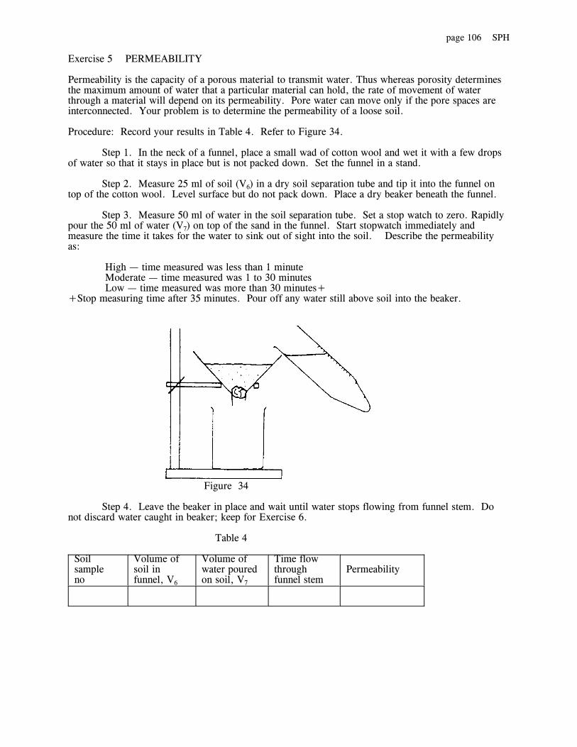
page 106 SPH
Exercise 5 PERMEABILITY
Permeability is the capacity of a porous material to transmit water. Thus whereas porosity determinesthe maximum amount of water that a particular material can hold, the rate of movement of waterthrough a material will depend on its permeability. Pore water can move only if the pore spaces areinterconnected. Your problem is to determine the permeability of a loose soil.
Procedure: Record your results in Table 4. Refer to Figure 34.
Step 1. In the neck of a funnel, place a small wad of cotton wool and wet it with a few dropsof water so that it stays in place but is not packed down. Set the funnel in a stand.
Step 2. Measure 25 ml of soil (V6) in a dry soil separation tube and tip it into the funnel ontop of the cotton wool. Level surface but do not pack down. Place a dry beaker beneath the funnel.
Step 3. Measure 50 ml of water in the soil separation tube. Set a stop watch to zero. Rapidlypour the 50 ml of water (V7) on top of the sand in the funnel. Start stopwatch immediately andmeasure the time it takes for the water to sink out of sight into the soil. Describe the permeabilityas:
High — time measured was less than 1 minute Moderate — time measured was 1 to 30 minutes Low — time measured was more than 30 minutes++Stop measuring time after 35 minutes. Pour off any water still above soil into the beaker.
Figure 34
Step 4. Leave the beaker in place and wait until water stops flowing from funnel stem. Donot discard water caught in beaker; keep for Exercise 6.
Table 4
Soil sample no
Volume of soil in funnel, V6
Volume of water poured on soil, V7
Time flow through funnel stem
Permeability

page 107 SPH
Exercise 6 CAPILLARITY
Water will not drain completely from a permeable material if the water supply is cut off. The materialwill remain damp. When interconnected pore spaces are only partly filled with water, surface tensionholds the water back. Capillarity is a measure of how much water a permeable material can retain. Your problem is to determine the capillarity of a loose soil.
Procedure: Record your results in Table 5. Refer to data in Table 4.
Step 1. Pour the water caught in the beaker during exercise 5 into a soil separation tube andaccurately measure its volume (V8).
Step 2. Calculate the volume of capillarity water held in soil:
V7 - V8 = V9
Step 3. Calculate the capillarity expressed as a percentage:
( V9 / V6 ) x 100
Table 5
Soil sample no.
V8 V9 % Capillarity
Clean up procedure to be followed when discarding soil
Tap out as much soil into plastic garbage bin as you can.
Rinse tube in deep plastic bin filled with water.Please do not allow any soil to get into sink as this will clog it.
Soak tubes in shallow plastic bin filled with hot water.Return after 10 minutes to remove label and rinse off the gum under running water.
Stand washed tubes inverted in stand to drain.
page 108 SPH
Clean up procedure to be followed when discarding soil
Tap out as much soil into plastic garbage bin as you can.
Rinse tube in deep plastic bin filled with water.Please do not allow any soil to get into sink as this will clog it.
Soak tubes in shallow plastic bin filled with hot water.Return after 10 minutes to remove label and rinse off the gum under running water.
Stand washed tubes inverted in stand to drain.
page 109 SCH
GE-101 Sect: QUEENSBOROUGH COMMUNITY COLLEGE Date: / / Physical Geology The City University of New York Instructor: Your name:
Laboratory module: Soil science. chemical
Objectives: After completing this laboratory you should be able to:
1. Discuss why plants cannot be expected to grow well in any soil.
2. Decide on what proportions of fertilizer to apply to nutrient deficient soils.
3. Understand how and under what circumstances to adjust a soil's pH.
EQUIPMENT CHECK LIST (Report any missing items-to the laboratory proctor)
Material Description perstudent
per table
SOILS 2 ounce sample (either to be collected and dried bystudent - see Appendix E - or to be provided). Unknowns set of 3 in bottles: labeled: high Utility, A, and B.
1
1 set
LaMOTTE CHEMICALSOIL TEST EQUIPMENT
Nitrogen extracting solution Nitrogen indicator powder Nitrogen color chart
Phosphorus extracting solutionPhosphorus indicator solutionPhosphorus tabletsPhosphorus color chart
Potassium extracting solutionPotassium indicator tabletsPotassium test solutionPotassium color chart
pH indicator solutionpH color chart
Measuring spoons, 0.5 g. and 0.2 g.Test. tubes, flat bottomed, graduated in rnl. Test tube capsPipette (eye dropper)
2661
111
1111
1111
11

page 110 SCH
Section I
Soil originates where weathering keeps ahead of erosion or burial. Weathering involves progressive fragmentation and chemical adjustment of rock or sediment to air and water at the earth's surface. The rate of chemical adjustment at surface temperatures and pressures is slow on all but a ecological time scale. During weathering, elements enter idol' aqueous solution in a soil's moisture where they become available to plants for their nutrition. Plants are adapted to utilize or cope with such elements in the proportions that are naturally available in their native habitat.
Primary elements for plant nutrition are: nitrogen, phosphorus and potassium. Where crops. lawn clippings. cut flowers, etc., are removed from an area, depletion of the primary elements will exceed the natural rate at which these elements enter the soil's moisture. Unless plants are allowed to grow and die in their natural setting it is necessary to artificially fertilize the soil with soluble salts of the primary elements in the proportions that they are used by the plants.
Secondary elements for plant nutrition are: sulfur, iron, calcium and magnesium. The availability of these elements to plants is determined by a soil's pH which is the acidity or alkalinity of the soil's moisture measured on a scale that runs from: 1 for extremely acid, to 7 for neutral, to 14 for extremely alkaline. Usually, sulfur and iron are abundantly available to plants in acidic (sour) sons, whereas, calcium and magnesium are abundantly available in alkaline (sweet) soils. Because plants utilize these elements in relatively small quantities, it is tardy necessary to fertilize for these elements as weathering can keep pace with their depletion. However, if the natural soil is acid and one desires to grow plants adapted to, say, alkaline soils, the soil's pH must be adjusted on a year to year basis by the artificial addition of suitable compounds to the soil.
page 111 SCH
Exercise 1 EVALUATION QUESTIONS
In human terms, can the ongoing, natural, forming of soils be viewed as a rapid or a slow process?
Under what circumstances are elements in soils available to plants for their nutrition?
Why is it that the chemistry of soil moisture will strongly influence which given plant will best grow?
Name the three primary elements of plant nutrition.
How is it possible for plats to live naturally without our aid?
Does a plant, in order to thrive, necessarily need each of the three primary elements in the same amounts? (yes, no) Explain.
What will usually determine the proportions of secondary elements available for plant's nutrition?
Will plants adapted to sour soils require calcium and magnesium in abundance? (yes, no) Explain.
If a soil's pH is adjusted to make sulfur and iron abundantly available in the soil's moisture, would plantsadapted to sweet soil thrive? (yes, no) Explain.

page 112 SCH
Section II PRIMARY ELEMENTS
Exercise 2 TO TEST FOR SOIL NITROGEN, PHOSPHORUS AND POTASSIUM
Plants use, in various amounts bar their growth. nitrogen, phosphorus, and potassium more than any other elements in soil moisture. Your problem is to measure the availability of these elements to plants in the soil you collected by comparison to a given hip fertility soil.
Procedure: Work with two soils: the given High Fertility Soil (in labeled glass jar) and yours. Dothe following tests: A (page 113), B (page 114), and C (page 115). Take test materials for one test at a timeand return these before proceeding to the next test. Note: the tests A, B, or C can be done in any order.
Record your results in Table 1.
Table 1
Soil sample
Primary elements available to plants
Nitrogen level Phosphorus level Potassium level
High Fertility Soil
Your soil

page 113 SCH
A) NITROGEN TEST. For each soil sample:
Step 1. Select a graduated test tube and add Nitrogen Extracting Solution to line 7. Note: Squeeze the bottle gently to insure a uniform flow of solution.
Step 2. Using the measuring spoon marked 0.5 g, add one measure of the soil to the test tube.
Step 3. Replace the cap on the test tube and gently shake the mixture of soil and extracting solution for one minute.
Step 4. Without removing the cap, allow the tube to stand undisturbed for several minutes. This allows soil particles to settle so that the liquid above the soil layer becomes reasonably clear.
Step 5. A pipette (eye dropper) is provided to transfer this clear solution to a second graduated test tube. To accomplish this, squeeze the bulb of the pipette before insertion in the first test tube (this prevents agitation of the clear solution). After insertion, release the pressure on the bulb and so draw up a portion of the clear solution. Transfer this amount to the second test tube. Continue this procedure until the levy of solution is even with line 3 of the second test tube.
Step 6. Use a clean measure spoon 0.25 g and add one measure of Nitrogen Indicator Powder to the soil extract in the second test tube.
Step 7. Cap the test tube and gently shake this to agitate until the powder is dissolved. Allow three minutes for the full color to develop.
Step 8. Compare the color of the liquid in the tube with the color printed on the Soil Nitrogen Color Chart. Record the soil's nitrogen level accordingly as: high, medium, or low. .

page 114 SCH
B) PHOSPHORUS TEST. For each soil sample: Step 1. Select a graduated test tube and add Phosphorus Extracting Solution to line 6. Note: Squeeze the bottle gently to insure a uniform flow of solution.
Step 2. Use the measuring spoon marked 0.5 g, add one measure of the soil to the test tube.
Step 3. Replace the cap on the test tube and gently shake the mixture of soil and extracting solution for one minute.
Step 4. Without remove she cap, allow the tube to stand undisturbed for several minutes. This allows soil particles to settle so that the liquid above the soil layer becomes reasonably clear.
Step 5. A pipette (eye dropper) is provided to transfer this clear solution to a second graduated test tube. To accomplish this, squeeze the bulb of the pipette before insertion in the first test tube (this prevent agitation of the clear solution). After insertion, release the pressure on the bulb and so draw up a portion of the clear solute. Transfer this amount to the second test tube. Continue this procedure until the level of solution is even with line 3 of the second test tube.
Step 6. Add six drops of the Phosphors Indicator Solution to the soil extract in the second test tube. Recap and shake the test tube to mix.
Step 7. Add one Phosphorous Tablet to the mixture in the test tube.
Step 8. Recap the test tube and shake the mixture until the tablet dissolves.
Step 9. Compare the color of the liquid in the test tube with the colors printed on the Soil Phosphorus Color Chart. Record the soil's phosphorus level accordingly as: high. medium. or low.

page 115 SCH
C) POTASSIUM TEST. For each soil sample:
Step 1. Select a graduated test tube and add Potassium Extracting Solution to line 8. Note: Carefully direct the flow of solution into the test tube. Squeeze the bottle gently to insure a uniformflow of the solution.
Step 2. Using the measuring spoon marked 0.5 g, add two measures of the soil to the test tube.
Step 3. Replace the cap on the test tube and gently shake the mixture of soil and extracting solution for oneminute.
Step 4. Without removing the cap, allow the tube to want undisturbed for several minutes. This allows soilparticles to settle so that the liquid above the soil layer becomes reasonably clear.
Step 5. A pipette (eye dropper) is provided to transfer this clear solution to a second graduated test tube.To accomplish this, squeeze the bulb of the pipette before insertion in the first test tube (this preventsagitation of the clear solution). After insertion, release the pressure on the bulb and so drew up a portion ofthe clear solute. Transfer this amount to the second test tube. Continue this procedure until the levy ofsolution is even with line 5 of the second test tube.
Step 6. Add one Potassium Indicator Tablet to the soil extracting the second test tube. Recap and shake thetest tube until the tablet dissolves. The solution should have the pill’s pale-purple color.
Step 7. The Potassium Test Solution is in a drop dispensing bottle. Carefully add five drops of thePotassium Test Solution to the mixture in the test tube. Recap the test tube and shake to mix contents. Seeif all the liquid in the test tube has changed to a blue color similar to the color chart. If not, add five moredrops of the Potassium Test Solution, shake to mix and see if the color change has taken place. Continuethis procedure until the color change does take place or you have added twenty five drops. Record thepotassium level of the sample as:
high— (5 or 10 drops needed for color change), medium—(15 or 20 drops needed for color change) or low—(25 drops needed for color change or no color change).

page 116 SCH
DISCUSSION
Nitrogen stimulates rapid, lush green growth. Lawn grass requires high soil nitrogen levels. On the other hand, slow growing plants (for example. perennials) are adapted to low levels of soil nitrogen. Phosphorus builds strong roots and stems and richly colored foliage and flowers. Potassium helps plants resist diseases and cold.
Exercise 3
The percentage of nitrogen, phosphorus and potassium salts in commercial fertilizers is identified (in the same order) by three numbers (for example: a fertilizer labeled 5-10-5 contains 5 per cent nitrogen, 10 per cent phosphorus. and 5 per cent potassium). To fertilize an area spread 3 to 4 pounds fertilizer per 100 square feet.
Given two fertilizers labeled 5-10-5 and 0-20-20. which would you use to provide optimum nutrients for:
grass _______________________ (explain)
perennials _______________________ (explain)
page 117 SCH
Section III SECONDARY ELEMENTS
Exercise 4 TO TEST FOR SOIL pH
Plants are adapted to the soil pH of their native habitat. That is to say they need those secondary elements which become abundantly available at a given pH level. Your problem is to test the two given soils: labeled A and B soil and the soil you collected. Procedure: Work with three soils: the given soils A and B and your soil. Record your results in Table 2.
Step 1. Select a graduated test tube and add pH Indicator Solution to line 4; Note; Carefully direct the flowof solution into the test tube. Squeeze the bottle gently to insure a uniform flow of solution.
Step 2. Using the measuring spoon marked 0.5 g, add two measures of the soil to the test tube.
Step 3. Replace the cap on the test tube and gently shake the mixture of soil and pH indicator for oneminute.
Step 4. Without removing the cap, allow the tube to stand undisturbed for several minutes. This allows thesoil particles to settle so that the color of the liquid above the soil layer can be seen.
Step 5. Compare the color of the liquid layer with the colors of the pH Color Chart. Record the soil pH toan accuracy of half a unit (for example, if the color is between pH 4.0 and 5.0, record the soil pH as 4.5).
Table 2
Soil sample no. pH level
A
B
Your soil
DISCUSSION
A soil's pH determines the types and proportions of secondary elements available for plant nutrition. Plants are adapted to require a soil's pH to be within certain, narrow, ranges. When a soil's natural pH is artificially altered, in order to grow plants which require a soil of different pH, care must be taken to use substances that not only adjust pH but which also add the necessary secondary elements to the soil's moisture. For example:
to raise the soil's pH by I unit, add 5 pounds of crushed dolomite - CaMg(CO3)2 - per 100 square feet of urea;
to lower the soil's pH by 1 unit, add 3 pounds of iron sulfate - FeSO4 - per 100 square feet of area.

page 118 SCHExercise 5.
Examine the following list of plants and circle three which are adapted to the pH of the soil you collected.
Plant Required soil pH
Asparagus
Babies' .breath
Beans
Blueberry
Canna
Clematis
Dahlia
English wall flower
Gentian
Heath
Lettuce
Louisiana iris
Pea
Penstemon
Welsh poppy
7.0 - 8.0
6.5 - 7.5
7.0 - 8.0
4.0 - 5.0
7.0 - 8.0
6.0 - 7.0
7.0 - 8.0
6.0 - 8.0
5.0 - 6.5
4.0 - 5.0
7.0 - 8.0
5.5 - 6.5
7.0 - 8.0
5.5 - 6.5
5.5 - 6.5
Exercise 6.
Explain ONE of the following (show your calculations); i) If the soil you collected is neutral or alkaline, how could you adjust its pH in order to
grow blueberries? ii) If the soil you collected is acid, how could you adjust its pH in order to grow peas?
___________________________________________________________________________________
___________________________________________________________________________________
___________________________________________________________________________________
BEFORE YOU LEAVE PLEASE CLEAN ALL Equipment:
a) Sort the used testing materials (tubes, caps, etc.) and put in proper place at front table.
b) Place conical tubes from last week's laboratory in one of the two wire mesh bins (by thesink) and the caps in the other bin.
c) Wipe the worktable top with a paper towel.
d) Push chairs under tables
page 119
How a white lie has caught up with seismologists
Much to their dismay, people are learning that seismologists typically do not use the Richter scale to judge quake size.
"We're just recovering from decades of telling a white lie, that's all," says seismologist Thomas H. Heaton (president of the Seismological
Society of America and a USGS researcher in Pasadena, Calif.)
While seismologists generally do not use the original Richter magnitude scale, the measuring systems currently in vogue represent extensions of
the type that Charles Richter developed nearly 60 years ago. "[Richter] introduced it because he was tired of the newsman asking him about the
relative size of earthquakes," recalls veteran seismologist Bruce A. Bolt from the University of California, Berkeley. That explains why some
seismologists continue to use the term when addressing the press.
Prior to Richter's work, researchers in the United States had no way of judging an earthquake's absolute size, which remains the same no matter
where it is measured. Instead, they dealt with a concept called intensity, which describes the strength of shaking at a particular location.
In the early 1930s, Japanese seismologist Yiyoo Wadati devised a method of comparing the sizes of quakes. He would take seismic recordings
of various shocks and set them on an equal footing by factoring in the distance between the recording station and the earthquake. But this method
was not easily grasped by lay people, especially the reporters of quake-plagued southern California.
In 1935, Richter dressed up the Japanese method to create an earthquake index. Richter defined seismic magnitude in terms of a particular type
of recording device, called a Wood-Anderson seismograph, situated at a standard distance of 100 kilometers from an earthquake's epicenter.
Richter appropriated from astronomy the idea of a logarithmic scale - based on powers of 10 - to accommodate the incredible range of
earthquake sizes. (The smallest detectable tremors equal the energy of a brick dropped off a table, while monster quakes surpass the largest
nuclear explosions) By Richter's original definition, a shake of magnitude 1.0 would cause the arm of the Wood-Anderson machine to swing
one- thousandth of a millimeter. A magnitude 2.0 temblor would make the arm swing 10 times as much, or one- hundredth of a millimeter.
In theory, the scale had no upper limit. But in practice, magnitudes could not top 7.0. "You would never see an earthquake bigger than
magnitude 7 [on the original magnitude scale], or at least we hope you never would because everything would be dead," Heaton says.
Of course, scientists rarely had a Wood-Anderson seismograph stationed exactly 100 kilometers from an earthquake. But by comparing the
arrival of slow versus fast seismic waves at a recording station, they could calculate what one of the devices would have detected at the standard
distance.
The magnitude index, as originally defined, could only measure southern California earthquakes because Richter calibrated the scale for the
crust there. What's more, it only worked for jolts within a few hundred kilometers of a Wood-Anderson seismograph. This original magnitude
scale was based on waves with periods of 0.1 to 3.0 seconds became known as ML or local magnitude, when a more general magnitude
measurement, denoted as MS. was devised by Caltech's Beno Gutenberg and Richter to handle distant earthquakes. M, depends on measurements
of surface waves rippling through Earth's crust with a period of about 20 seconds.
Even the new and improved magnitude formula had problems, however, because deep earthquakes do not produce many surface waves. So
Gutenberg and Richter invented MB, measured from body waves, which travel through the planet's interior. This yardstick proved helpful in
distinguishing nuclear explosions from actual earthquakes.
In the 1970s, seismologists realized that all existing magnitude methods underestimated the energy of truly large earthquakes. To circumvent
this limitation, Hiroo Kanamori, a successor of Richter and Gutenberg at Caltech, created a magnitude scale, MW, that quantifies the total
amount of seismic wave energy released in an earthquake.
But because such calculations are difficult, scientists usually approximate the energy by computing a quantity called "seismic moment,"
determined from long period vibrations. In the case of great earth- quakes, these vibrations have cycles longer than 200 seconds. Seismologists
therefore refer to MW as the moment magnitude.
MW differs from all other types of magnitude in that it measures the earthquake source, Kanamori says. The Richter magnitude and most others
gauge only the strength of vibrations sensed at Earth's surface. But to calculate moment magnitude, seismologists use the long-period waves to
decipher the dimensions of the fault rupture that produced the quake. [seismic moment - the length of the fault rupture multiplied by the amount
of rock movement and then again by the stiffness of the rock] In other words, moment magnitude measures the cause rather than the effect.

page 120
Although researchers have developed more than a dozen other ways of calculating earthquake magnitude, moment magnitude remains the figure
of choice among seismologists, especially for earthquakes larger than magnitude 6.5.
Confused?
With ML, MS, MB, MW and a litany of other M, floating around, it's no wonder that many seismologists took the easy way out over the years by
giving reporters what they thought the media wanted. When pressed for details, researchers typically simplified the issue by calling any
magnitude a Richter magnitude, even though this term applies only to the local (ML) magnitudes determined by Richter's original formulation.
"The problem is that seismologists have used the term 'Richter scale' in a very loose way, and now it's catching up with them. We didn't use it
among ourselves because it doesn't mean anything," Heaton says.
Immediately after an earthquake, the USGS National Earthquake Information Center in Golden, Colo., releases a preliminary measurement,
which could be a surface wave magnitude, a body wave magnitude, or even a local magnitude (similar to Richter's original formulation except
that modern seismographs have replaced Wood-Anderson ones.) After determining the moment magnitude, they release this number, which may
fall above or below the preliminary one.
As for the use of the term "Richter scale," the USGS has dodged any decision. "The question of labeling these magnitudes as 'Richter scale' is a
matter of tradition, semantics, and personal perspective.
The USGS has no official scientific position on the use of the term," declares the July statement. The USGS' Heaton, who works across the
street from Richter's old Pasadena office, says he wants to avoid the term entirely. "You probably wouldn't catch us using the term 'Richter
magnitude' around here, even though this was the home of Richter."
As journalists get more seismically sophisticated, they may head off some of the confusion. The Associated Press recently retired the term
"Richter scale" in favor of the phrases "preliminary magnitude" and "moment magnitude. "
But simply tidying the terminology will not, on its own, help people better understand the size of an earthquake. After all, how can one number
convey the power of something equivalent to a colossal nuclear explosion?
Even moment magnitude does not suffice, says its inventor. "The problem is everyone thinks that a single number determines everything. It's
almost like asking how big you are," says Kanamori. "The question is whether you are asking height, weight, or width. Depending on how you
measure a person, the answer can be very different. In the case of earthquakes, it's even more complex.
Excerpted from ''Abandoning Richter" by Richard Monastersk in Science News, vol. 146, Oct. IS, 1994.
_________________________________________________________________________________________________________________
Quake comparisons
It is true that the Richter magnitude scale is logarithmic, but this does not mean a magnitude 8 quake is 10 times stronger than a magnitude 7.
One should estimate seismic energy E released by calculating:
log E = 11.8 + 1.5 M8
where M8 is the surface wave magnitude. Thus a magnitude 8 earthquake is not 10 times stronger than a magnitude 7, but rather about 30 times
stronger.
Bemhardt Saint-Eidukat in Science News p.58, vol.137, No.4, Jan. 27, 1990.
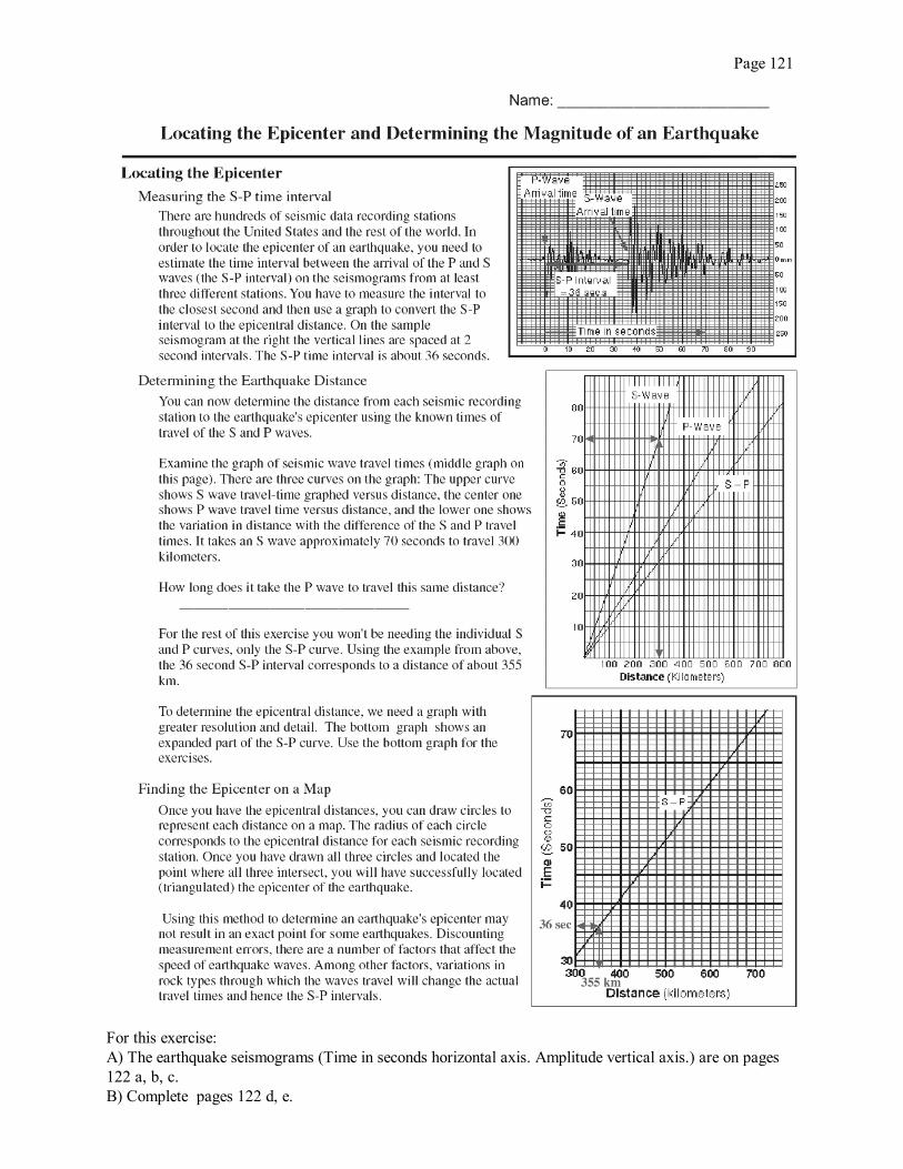
Page 121
For this exercise:A) The earthquake seismograms (Time in seconds horizontal axis. Amplitude vertical axis.) are on pages122 a, b, c. B) Complete pages 122 d, e.

page 122 a
Eureka, CA seismograph station

page 122 bElko. NV seismograph station

page 122 cLas Vegas, NV seismograph station
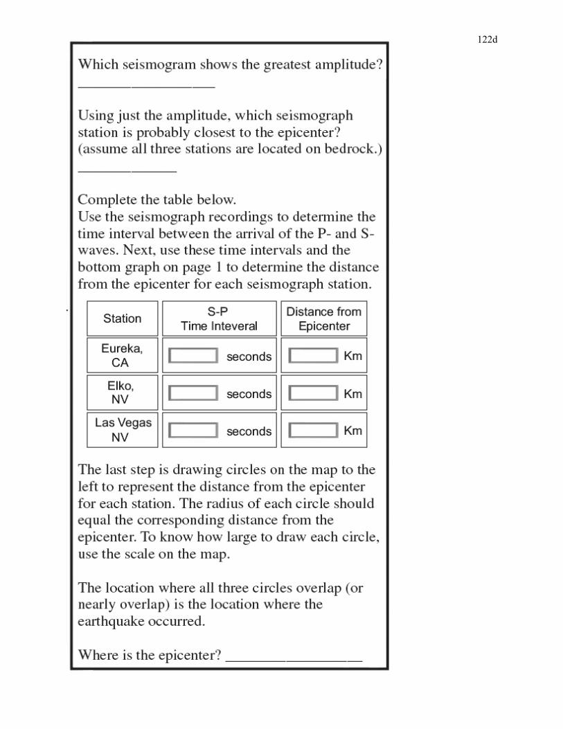
122d
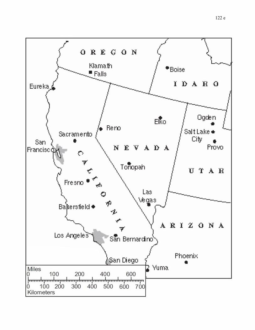
122 e
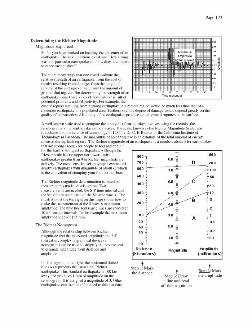
Page 123
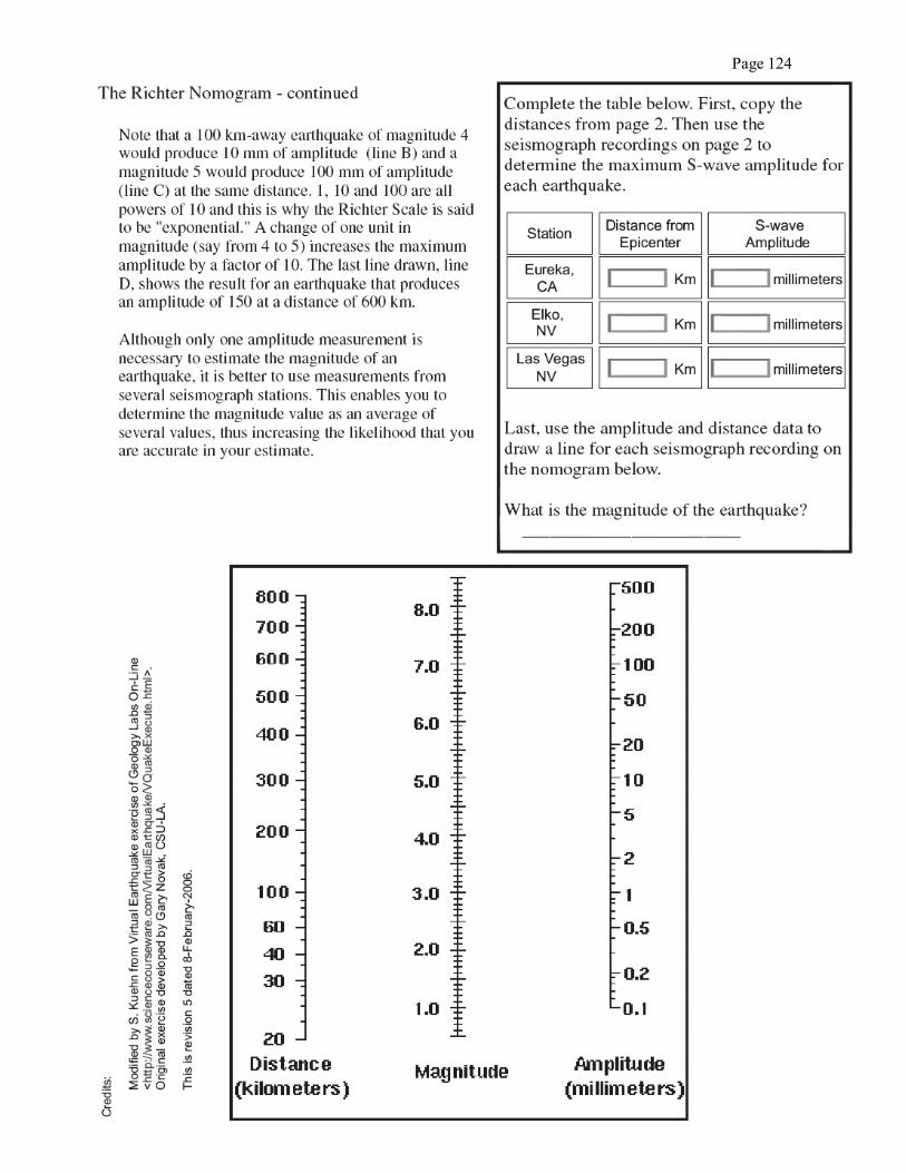
Page 124
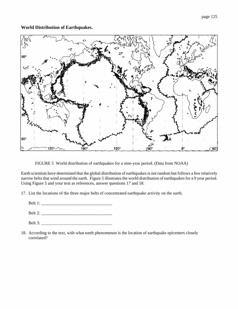
page 125
World Distribution of Earthquakes.
FIGURE 5 World distribution of earthquakes for a nine-year period. (Data from NOAA)
Earth scientists have determined that the global distribution of earthquakes is not random but follows a few relativelynarrow belts that wind around the earth. Figure 5 illustrates the world distribution of earthquakes for a 9 year period. Using Figure 5 and your text as references, answer questions 17 and 18.
17. List the locations of the three major belts of concentrated earthquake activity on the earth.
Belt 1: _________________________________
Belt 2: _________________________________
Belt 3: _________________________________
18. According to the text, with what earth phenomenon is the location of earthquake epicenters closely correlated?
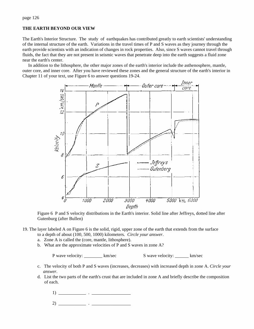
page 126
THE EARTH BEYOND OUR VIEW
The Earth's Interior Structure. The study of earthquakes has contributed greatly to earth scientists' understandingof the internal structure of the earth. Variations in the travel times of P and S waves as they journey through theearth provide scientists with an indication of changes in rock properties. Also, since S waves cannot travel throughfluids, the fact that they are not present in seismic waves that penetrate deep into the earth suggests a fluid zonenear the earth's center. In addition to the lithosphere, the other major zones of the earth's interior include the asthenosphere, mantle,outer core, and inner core. After you have reviewed these zones and the general structure of the earth's interior inChapter 11 of your text, use Figure 6 to answer questions 19-24.
Figure 6 P and S velocity distributions in the Earth's interior. Solid line after Jeffreys, dotted line afterGutenburg (after Bullen)
19. The layer labeled A on Figure 6 is the solid, rigid, upper zone of the earth that extends from the surfaceto a depth of about (100, 500, 1000) kilometers. Circle your answer.a. Zone A is called the (core, mantle, lithosphere).b. What are the approximate velocities of P and S waves in zone A?
P wave velocity: ________ km/sec S wave velocity: ______ km/sec
c. The velocity of both P and S waves (increases, decreases) with increased depth in zone A. Circle your answer.d. List the two parts of the earth's crust that are included in zone A and briefly describe the composition of each.
1) ____________ . _________________
2) ____________ . _________________
page 127
20. Zone B is the part of the earth's upper mantle that extends from the base of zone A to a depth of up to (100, 700, 2000) kilometers in some regions of the earth. Circle your answer.
a. Zone B is called the (crust, asthenosphere, core).
b. The velocity of P and S waves (increases, decreases) immediately below zone A in the upper part of zone B.
c. According to the text, the change in velocity of the S waves in zone B indicates that it consists of (partially molten, entirely liquid) material.
21. Zone C (which includes the lower part of zone A and zone B) extends to a depth of __________ kilometers.
a. Zone C is called the earth's ________________ .
b. What fact concerning S waves indicates that zone C is not liquid?
_____________________________ .
c. What is the probable composition of zone C? ______________________________________________.
22. Zone D extends from 2885 km to about (5100, 6100) kilometers.
a. Zone D is the earth's __________________________________________
b. What happens to S waves when they reach zone D and what does this indicate about the zone? ___________________________________________________________________________________
c. The velocity of P waves (increases, decreases) as they enter zone D. Circle your answer.
23. Zone E is the earth's ____________ ____________
a. Zone E extends from a depth of ____________ km to the ____________ of the earth.
b. What change in velocity do P waves exhibit at the top of zone E and what does this suggest about thezone?
___________________________________________________________________________________
c. What is the probable composition of the earth's core?
_______________________________________
24. Label Figure 6 by writing the name of each interior zone at the appropriate letter.
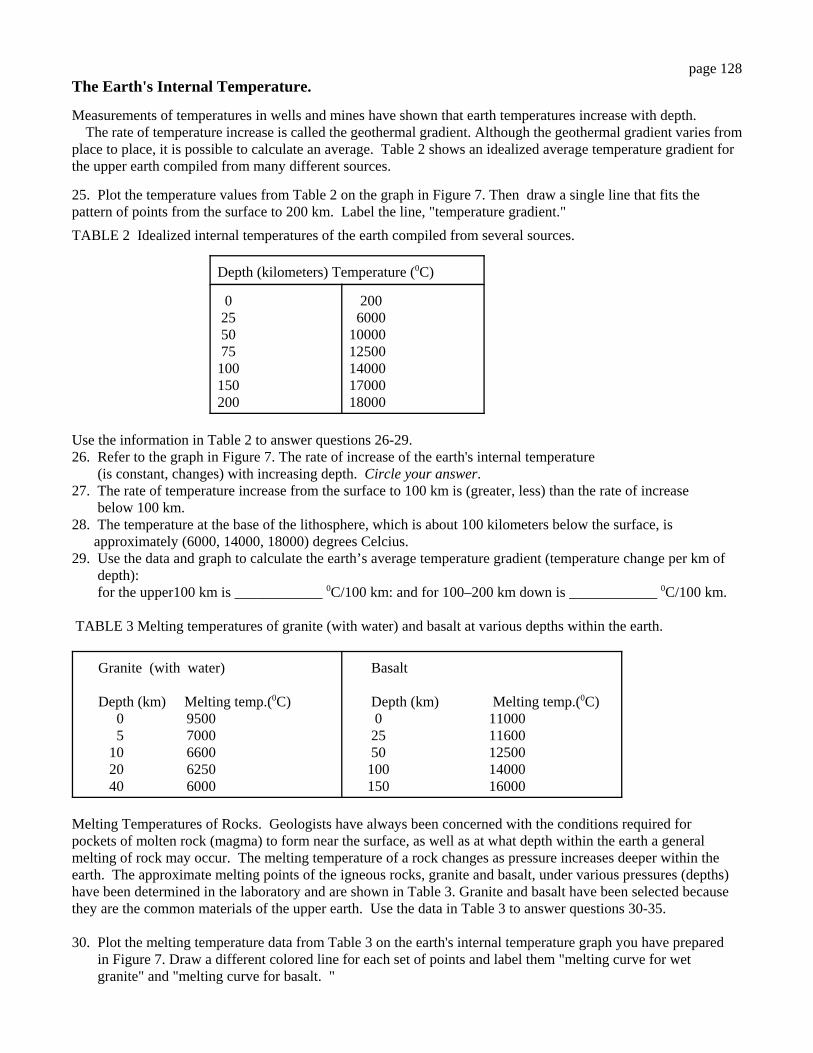
page 128The Earth's Internal Temperature.
Measurements of temperatures in wells and mines have shown that earth temperatures increase with depth. The rate of temperature increase is called the geothermal gradient. Although the geothermal gradient varies fromplace to place, it is possible to calculate an average. Table 2 shows an idealized average temperature gradient forthe upper earth compiled from many different sources.
25. Plot the temperature values from Table 2 on the graph in Figure 7. Then draw a single line that fits thepattern of points from the surface to 200 km. Label the line, "temperature gradient."
TABLE 2 Idealized internal temperatures of the earth compiled from several sources.
Depth (kilometers) Temperature (0C)
0 25 50 75100150 200
200 6000 1000012500140001700018000
Use the information in Table 2 to answer questions 26-29.26. Refer to the graph in Figure 7. The rate of increase of the earth's internal temperature (is constant, changes) with increasing depth. Circle your answer.27. The rate of temperature increase from the surface to 100 km is (greater, less) than the rate of increase below 100 km.28. The temperature at the base of the lithosphere, which is about 100 kilometers below the surface, is approximately (6000, 14000, 18000) degrees Celcius.29. Use the data and graph to calculate the earth’s average temperature gradient (temperature change per km of depth): for the upper100 km is ____________ 0C/100 km: and for 100–200 km down is ____________ 0C/100 km.
TABLE 3 Melting temperatures of granite (with water) and basalt at various depths within the earth.
Granite (with water) Depth (km) Melting temp.(0C) 0 9500 5 7000 10 6600 20 6250 40 6000
Basalt
Depth (km) Melting temp.(0C) 0 11000 25 11600 50 12500 100 14000 150 16000
Melting Temperatures of Rocks. Geologists have always been concerned with the conditions required forpockets of molten rock (magma) to form near the surface, as well as at what depth within the earth a generalmelting of rock may occur. The melting temperature of a rock changes as pressure increases deeper within theearth. The approximate melting points of the igneous rocks, granite and basalt, under various pressures (depths)have been determined in the laboratory and are shown in Table 3. Granite and basalt have been selected becausethey are the common materials of the upper earth. Use the data in Table 3 to answer questions 30-35.
30. Plot the melting temperature data from Table 3 on the earth's internal temperature graph you have prepared in Figure 7. Draw a different colored line for each set of points and label them "melting curve for wet granite" and "melting curve for basalt. "
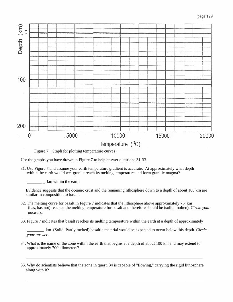
page 129
Figure 7 Graph for plotting temperature curves
Use the graphs you have drawn in Figure 7 to help answer questions 31-33.
31. Use Figure 7 and assume your earth temperature gradient is accurate. At approximately what depth within the earth would wet granite reach its melting temperature and form granitic magma?
_______ _ km within the earth
Evidence suggests that the oceanic crust and the remaining lithosphere down to a depth of about 100 km are similar in composition to basalt.
32. The melting curve for basalt in Figure 7 indicates that the lithosphere above approximately 75 km (has, has not) reached the melting temperature for basalt and therefore should be (solid, molten). Circle your answers.
33. Figure 7 indicates that basalt reaches its melting temperature within the earth at a depth of approximately ________ km. (Solid, Partly melted) basaltic material would be expected to occur below this depth. Circle your answer.
34. What is the name of the zone within the earth that begins at a depth of about 100 km and may extend to approximately 700 kilometers?
____________________________________________________________________________________
35. Why do scientists believe that the zone in quest. 34 is capable of "flowing," carrying the rigid lithosphere along with it?
____________________________________________________________________________________

page 130
EARTHQUAKES AND EARTH TEMPERATURES - A PRACTICAL APPLICATION
The study of earthquakes and the earth's internal temperature has contributed greatly to the understanding of platetectonics. One part of the theory is that large, rigid slabs of the lithosphere are descending into the mantle wherethey break up and melt, generating deep focus earthquakes during the process. Using earthquakes and earthtemperatures, earth scientists have confirmed that this major earth process is currently taking place near the island ofTonga in the South Pacific and elsewhere.
Figure 8 Distribution of earthquakefoci in 1965 in the vicinity of Tonga Island. (Data from B. Isacks,J. Oliver,and L. R. Sykes)illustrates the distributionof earthquake foci during aone-year period in the vicinityof Tonga Island.
Use the figure to answer questions 36-40.
36. At approximately what depth do the deepest earthquakes occur in the area represented on Figure 8?
_____________ kilometers
37. The earthquake foci in the area are distributed (in a random manner, nearly along a line). Circle your answer.
38. Draw a line on Figure 8 that outlines the area of earthquakes within the earth.
39. Using previous information from this exercise, draw a line on Figure 8 at the proper depth that indicates the top of the asthenosphere-the zone of partly melted or plastic earth material. Label the line you draw "top of asthenosphere."
40. Remember that earthquakes only occur in solid, rigid material and refer to Figure 8. Why have earth scientists been drawn to the conclusion of a descending slab of solid lithosphere being consumed into the mantle near Tonga?
____________________________________________________________________________________
____________________________________________________________________________________
____________________________________________________________________________________