i-295/i-76/route 42 direct connection
TRANSCRIPT

Agency Coordination Meeting #7Agency Coordination Meeting #7
II--295/I295/I--76/Route 4276/Route 42Direct ConnectionDirect Connection
October 15th, 2003
www.state.nj.us/transportation/works/studies/rt295www.state.nj.us/transportation/works/studies/rt295Visit us at:
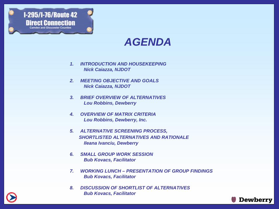
AGENDA
1. INTRODUCTION AND HOUSEKEEPINGNick Caiazza, NJDOT
2. MEETING OBJECTIVE AND GOALSNick Caiazza, NJDOT
3. BRIEF OVERVIEW OF ALTERNATIVES Lou Robbins, Dewberry
4. OVERVIEW OF MATRIX CRITERIALou Robbins, Dewberry, Inc.
5. ALTERNATIVE SCREENING PROCESS, SHORTLISTED ALTERNATIVES AND RATIONALE
Ileana Ivanciu, Dewberry
6. SMALL GROUP WORK SESSIONBub Kovacs, Facilitator
7. WORKING LUNCH – PRESENTATION OF GROUP FINDINGSBub Kovacs, Facilitator
8. DISCUSSION OF SHORTLIST OF ALTERNATIVESBub Kovacs, Facilitator

MEETING OBJECTIVESNick Caiazza, NJDOT

Draft EnvironmentalImpact Statement
Distribution/Public HearingUSACOE Section 404
Conceptual Permit Application
TechnicalStudies/
AlternativesAnalysis
DevelopAlternativesPurpose & Need
ConstructionDesignFinal EnvironmentalImpact Statement/
Record ofDecision
20052005 2006 2006 -- 20082008 2008 2008 -- 20112011
PROJECT SCHEDULEPROJECT SCHEDULE
20032003COMPLETECOMPLETE 20042004 20042004
Shortlisting ofAlternatives
Summer/Fall 2003Summer/Fall 2003Concurrence Point
Concurrence Point
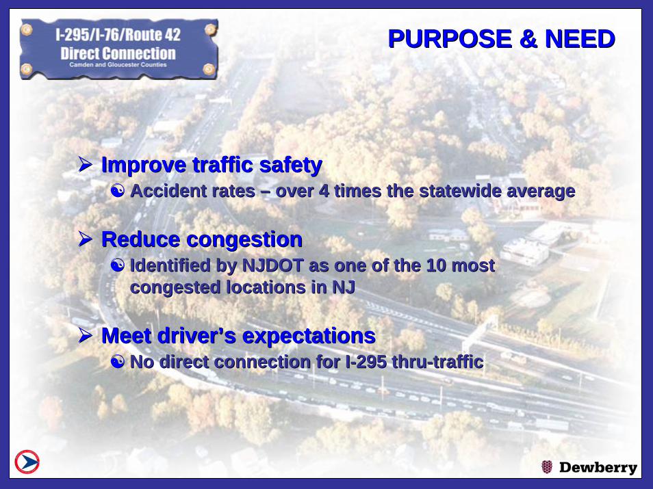
PURPOSE & NEEDPURPOSE & NEED
Improve traffic safetyImprove traffic safety☯☯ Accident rates Accident rates –– over 4 times the statewide averageover 4 times the statewide average
Reduce congestionReduce congestion☯☯ Identified by NJDOT as one of the 10 most Identified by NJDOT as one of the 10 most
congested locations in NJcongested locations in NJ
Meet driverMeet driver’’s expectationss expectations☯☯ No direct connection for INo direct connection for I--295 thru295 thru--traffictraffic

ALTERNATIVESALTERNATIVES
26 alternatives were developed to provide a direct connection 26 alternatives were developed to provide a direct connection for Ifor I--295 through traffic. Features common to all are:295 through traffic. Features common to all are:
☯☯ 3 lanes on NB & SB I3 lanes on NB & SB I--295295
☯☯ Full right and left shouldersFull right and left shoulders
☯☯ 2 lane ramps2 lane ramps
☯☯ II--76/Route 42 express/local configuration removed76/Route 42 express/local configuration removed
☯☯ II--295 speed limit: 55 MPH295 speed limit: 55 MPH
☯☯ Ramps speed limit: 40 MPHRamps speed limit: 40 MPH

SHORTLISTING PROCESSSHORTLISTING PROCESS
Screen long list of alternatives and compare Screen long list of alternatives and compare using matrix criteriausing matrix criteria
Use workshop approach to select a short list Use workshop approach to select a short list of alternatives to be fully assessed in the of alternatives to be fully assessed in the DEIS.DEIS.☯☯ Gain consensus on short listGain consensus on short list
Partnering meeting will be final opportunity to Partnering meeting will be final opportunity to confirm the short listconfirm the short list
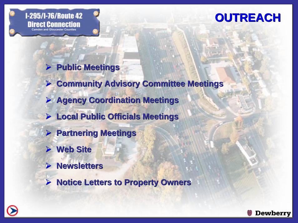
OUTREACHOUTREACH
Public MeetingsPublic Meetings
Community Advisory Committee MeetingsCommunity Advisory Committee Meetings
Agency Coordination MeetingsAgency Coordination Meetings
Local Public Officials MeetingsLocal Public Officials Meetings
Partnering MeetingsPartnering Meetings
Web Site Web Site
NewslettersNewsletters
Notice Letters to Property OwnersNotice Letters to Property Owners

CONSTRAINTSCONSTRAINTS

Overview of AlternativesLou Robbins, Dewberry

Alternative AAlternative A

ALTERNATIVE A1ALTERNATIVE A1

ALTERNATIVE A2ALTERNATIVE A2

Alternative B2Alternative B2

Alternative C2Alternative C2

Alternative DAlternative D

Alternative D1Alternative D1

Alternative EAlternative E

Alternative E2Alternative E2
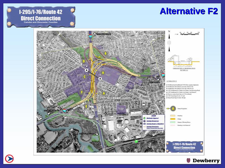
Alternative F2Alternative F2

Alternative G2Alternative G2

Alternative HAlternative H
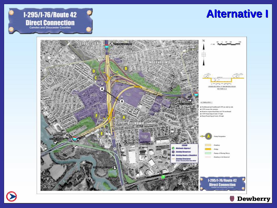
Alternative IAlternative I

Alternative LAlternative L

Alternative JAlternative J

Alternative KAlternative K

OVERVIEW OF SCREENING CRITERIA
Lou Robbins, Dewberry

Alternatives Screening
OBJECTIVE - Select a shortlist of feasible alternatives that satisfy the project purpose and need with minimal impacts to the natural and built environment to be studied through the EIS process

CONSTRUCTIBILITYFor this criterion the alternatives will be reviewed to determine probable construction or constructability issues. Evaluation factors include impacts to the local residents and motoring public during construction with an emphasis on traffic delays, impact of detours/diversions and duration of construction duration. Evaluation of the alternatives for constructibility would be quantified as High Impact, Moderate Impact, or Low Impact.
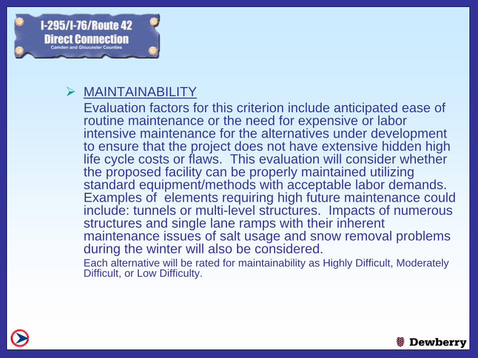
MAINTAINABILITYEvaluation factors for this criterion include anticipated ease of routine maintenance or the need for expensive or labor intensive maintenance for the alternatives under development to ensure that the project does not have extensive hidden high life cycle costs or flaws. This evaluation will consider whether the proposed facility can be properly maintained utilizing standard equipment/methods with acceptable labor demands. Examples of elements requiring high future maintenance could include: tunnels or multi-level structures. Impacts of numerous structures and single lane ramps with their inherent maintenance issues of salt usage and snow removal problems during the winter will also be considered. Each alternative will be rated for maintainability as Highly Difficult, Moderately Difficult, or Low Difficulty.

COMPARISON OF ESTIMATED CONSTRUCTION COSTThe relative relationship of Construction Costs for each alternative will be developed utilizing a comparison of roadway and bridge lengths for each alternatives. The length of new bridge or tunnel lane construction required will be multiplied by a factor of 2 and added to the length of new roadway lanes to determine the relative cost required to construct each alternative. In a similar fashion, the length ofnew tunnel lane construction will be multiplied by a factor of 90. The effective lane length shown on the matrix is the sum of the actual lane length of roadway in feet plus the equivalent lane length of bridges, plus the equivalent lane length of tunnel.

COMPLIANCE WITH DESIGN CRITERIAEach alternative would be evaluated for compliance with applicable design standards (NJDOT-Design Manuals or AASHTO 2001 – A Policy on Geometric Design of Highways and Streets). The number of undesirable design features not requiring design exceptions, such as left exits or entrances, will be counted. The number of conflict points present in each of the alternatives will also be identified. This criteriawill show the number of undesirable design features as well as the number of proposed conflict points.

RIGHT-OF-WAYFor ROW, each of the following impacts will be considered to quantify the relocation and/or proximity impacts due to the individual Alternative.
• Residential Property Impacts• Impacts to residents will be evaluated for each of the alternatives by counting the
number of discrete residential structures that could require taking and are therefore considered as a relocation. Residential structures that are located within 50 feet of the alignment will be less likely to incur relocation but will have proximity impacts and will therefore also be counted. For the Bellmawr Park area and other multifamily structures, each individual residential unit will be counted separately.
• Commercial Property Impacts• Impacts to commercial properties will be evaluated for the alternatives in the same
manner as the residential properties.

RIGHT-OF-WAY (cont’d.)• Institutional Properties• There are several institutional properties such as churches, schools cemeteries,
etc. that may potentially be impacted. The impacts to these facilities will be shown the same as residential above except that the categories will be the number of facilities impacted severely, moderately, or only slightly.
• Recreational Properties• There are several recreational properties that may potentially be impacted. The
evaluation of the impacts will be performed in the same manner as the institutional properties. A probable relocation, and therefore a severe impact, would be where the impacts are extensive enough to make the facility nonfunctional. An example of a moderate property impact might be rearrangement of the layout of some ball fields. No differentiation will be made for recreational properties having or lacking protected 4(f) status.

Alternative A - 49 ResidencesBusinesses – 9
Potential Residential and CommercialPotential Residential and CommercialROW ImpactsROW Impacts

Alternative B2 - 73 ResidencesBusinesses - 10
Potential Residential and CommercialPotential Residential and CommercialROW ImpactsROW Impacts

WETLANDSWetlands can be broken into 2 categories - tidal and non-tidal. For this evaluation each type of wetland will be evaluated separately. The total wetlands impacted in acres for each alternative will be determined from existing published wetland mapping and confirmed by limited field observations.
The wetlands have been identified through the use of Department of Environmental Protection and Army Corps of Engineer maps. Each alternative will be evaluated on the basis of total wetland acreage impacted for each category.

Alternative C1 – 16 Acres
Potential Wetlands ImpactsPotential Wetlands Impacts

Alternative D – 8 Acres
Potential Wetland ImpactsPotential Wetland Impacts

Alternative F
Potential Residential and CommercialPotential Residential and CommercialROW ImpactsROW Impacts

Alternative F1
Potential Residential and CommercialPotential Residential and CommercialROW ImpactsROW Impacts
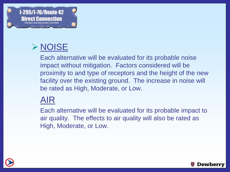
NOISEEach alternative will be evaluated for its probable noise impact without mitigation. Factors considered will be proximity to and type of receptors and the height of the new facility over the existing ground. The increase in noise will be rated as High, Moderate, or Low.
AIREach alternative will be evaluated for its probable impact to air quality. The effects to air quality will also be rated as High, Moderate, or Low.

Air and Noise AnalysisAir and Noise Analysis

SOCIOECONOMICSThe study area consists of residential, industrial, commercial, recreational and public/quasi-public land uses. The only vacant land in the project area consists of wetlands and floodplains. Community facilities located in the project area also have been identified. Each alternative will be assessed for its’impact to the quality of life of the community, including impacts to public and community facilities. The subjective evaluation will include impacts to community cohesion, (i.e. division of existing neighborhoods). The impacts will be identified as High, Moderate, and Low. .

Alternative D1
Community Cohesion Community Cohesion

Alternative E
Community Cohesion Community Cohesion

ENVIRONMENTAL JUSTICEPreliminary data regarding environmental justice (EJ) populations has been gathered through Census data and initial public outreach in the study area. Since impacts to EJ populations may include impacts resulting from displacement of residences or community facilities, disruption of community cohesion, air quality impacts, noise impacts, etc., data evaluated included census blocks or census block groups located within 100 feet of the alignment for each alternative. Based on the preliminary evaluation conducted, there are no significant differences between alternatives; therefore, EJ was not used as a screening criterion.

ARCHAEOLOGICALWithin the project study area there are current areas of archeological resources that have not yet been evaluated for significance. The potential level of sensitivity of the sites has been determined and mapped as: low, moderate or high. Criteria used to determine the level of sensitivity of the impact is: the level of current disturbance, the degree of the slope ofthe land, the site’s proximity to water, the soil type, the level to which the sites are disturbed under current conditions and artifacts found during excavations. This level of sensitivity is used to determine the probability level of the existence of an archaeological site. The alternatives will be evaluated based on the total acreage impacts to either the low, moderate, or high sensitivity sites.
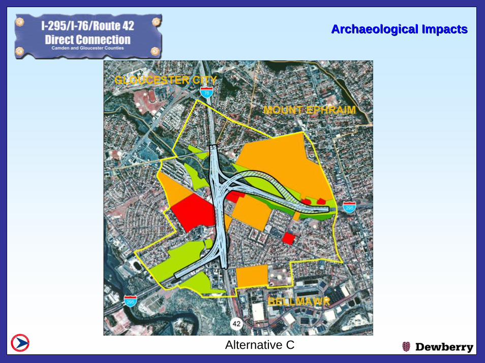
Alternative C
Archaeological ImpactsArchaeological Impacts

Alternative D
Archaeological ImpactsArchaeological Impacts

HAZARDOUS/CONTAMINATED SITESSeveral sites have been identified as potentially hazardous/contaminated sites in the project area. However, based upon the preliminary review conducted, there are no significant differences between alternatives; therefore,hazardous waste was not used as a screening criterion.

HISTORIC RESOURCESWithin the project study area there are resources of varying historic significance. The number of cultural resources potentially impacted physically, visually, or audibly for each degree of impact – High, Moderate or Low will be identified. Field studies have not been conducted to confirm the potential impacts of the proposed alternatives on resources within or near the study area. In addition, many resources within the study area have not yet been evaluated for National Register eligibility, and it is possible that one or more of the proposed alternatives could impact a resource not listed in the matrix. The results in the matrix are preliminary and are based on the alternatives mapping provided to date, as well as a GIS map of identified historic architectural resources prepared by A.D. Marble & Company.