hypermedia for prototyping and system integration in
TRANSCRIPT

Hypermedia For Prototyping and
System Integration In
Information Systems Development
Lesley Ann Gardner
The London School of Economics and Political Science
Thesis submitted in Fulfilment of the Requirement
for the Degree of Doctor of Philosophy
at the
London School of Economics and Political Science, University of
London
August, 1991

UMI Number: U047868
All rights reserved
INFORMATION TO ALL USERS The quality of this reproduction is dependent upon the quality of the copy submitted.
In the unlikely event that the author did not send a complete manuscript and there are missing pages, these will be noted. Also, if material had to be removed,
a note will indicate the deletion.
Dissertation Publishing
UMI U047868Published by ProQuest LLC 2014. Copyright in the Dissertation held by the Author.
Microform Edition © ProQuest LLC.All rights reserved. This work is protected against
unauthorized copying under Title 17, United States Code.
ProQuest LLC 789 East Eisenhower Parkway
P.O. Box 1346 Ann Arbor, Ml 48106-1346

T
6S£3

Acknowledgem ents
My thanks are extended to the Norfolk and Suffolk Broads Authority without
whose help this thesis would not have been possible.
I would like to thank my supervisor, Dr. R. J. Paul, for his endless patience and
excellent supervision throughout this research.
I am grateful to Jean Mak and Karen Reddington for their friendship and never
ending sense of humour and laughter. I would especially like to thank Dr. Lizza
Domingo for her help and understanding throughout the past months.
I am grateful to my parents for their constant support and encouragement, especially
to my father Dr. Roy Gardner for his many tireless hours reading this work.
My greatest debt and my fondest thoughts are towards Mr. Craig Whitehead
without whose help and encouragement this thesis would never have been finished
on time.
2

Abstract
This thesis investigates information systems development with special regard to the
area of Geographical Information Systems. It addresses the area through the
investigation of the software life-cycle development model and its augmentation by the
use of prototyping. Observations are made on empirical experiments conducted to assess
the usefulness of the new techniques of hypertext and hypermedia and their suitability
within this field of study.
This investigation is complemented by a case study, the Norfolk and Suffolk
Broads Authority. The Norfolk and Suffolk Broads are designated by statute with similar
status to the National Parks of Great Britain, and are managed by the Norfolk and Suffolk
Broads Authority. Through cooperation with the Norfolk and Suffolk Broads Authority,
a prototype information system was created. This system makes use of geographical data
from the Broads Authority. The development stages of this system were used to conduct
experiments for this thesis.
The tools and techniques used for the development of this system are described.
These include a hypertext tool called FIELD (Fully Integrated Environment for Layered
Development) which has been especially designed for the complete storage of all
information for each stage throughout this development. The use of this tool and
hypertext for the development of the geographically based information system for the
Norfolk and Suffolk Broads Authority are discussed.
3

Table of Contents
Title page 1
Acknowledgements 2
Abstract 3
Table of Contents 4
Table of Contents: Diagrams, Maps and Tables 7
Chapter 1 Introduction 9
1.1 Information Systems 9
1.2 Hypertext 15
1.3 The Case Study 19
1.4 Objectives of the Thesis 21
1.5 Structure of the Thesis 22
1.6 Research Methods 23
1.7 Conclusions 23
Chapter 2 Information Systems and Hypertext 25
2.1 Information Systems 25
2.2 Participation and Prototyping 28
2.3 Hypertext 33
2.4 The Architecture of Hypertext Systems 37
2.5 Components of a Hypertext System 41
2.6 Applications of Hypertext 46
2.7 Conclusions 49
Chapter 3 Geographical Information Systems 51
3.1 Geographical Information Systems 51
3.2 Data for Input to a GIS 54
3.3 Data Management 5 8
3.4 Data Retrieval 64
3.5 Data Manipulation 66
4

3.6 Data Display 72
3.7 GIS Design and Implementation 73
3.8 Conclusions 75
Chapter 4 The Broads Authority 77
4.1 Introduction 77
4.2 Background 77
4.3 History and Background of the Broads Authority 84
4.4 The Functions and Responsibilities of the Broads Authority 93
4.5 The Internal Structure of the Broads Authority 100
4.6 Summary 111
Chapter 5 Analysis and Specification of the Information System 113
5.1 Introduction 113
5.2 Methods of Initial Data Collection 113
5.3 The Systems Observed 116
5.4 Data Flow and Organisation Diagraming 135
5.5 Specification of the Broads Authority Information System 139
5.6 Critique 148
5.7 Conclusions 151
Chapter 6 The Development of The Broads Authority Prototype 153
6.1 Introduction 153
6.2 Software Used for the Implementation 153
6.3 Design Specification for the Prototype 156
6.4 The Prototype 164
6.5 Methodological Implications 170
6.6 Conclusions 171
Chapter 7 Summary and Conclusions 174
7.1 Summary 174
7.2 Conclusions 174
7.3 Future Work 178
5

180
183
183
183
184
187
187
188
189
189
190
193
209
216
217
6
Hypertext Packages
Applications of Hypertext
Computer Applications
On-line Documentation
Software Engineering
Auditing
Trade Shows and Advertising
Idea Organisation and Brain-Storm Support
Journalism
Educational Applications
Entertainment and Leisure
The Broads Authority’s Policies
Example screens from the FIELD System
Entity-Relationship Diagram for the Navigation Database

Table of Contents: Diagrams, Maps and Tables
Diagram 1.1 Information System Development Life-Cycle 11
Diagram 2.1 The PUSH Classification 31
Diagram 2.2 A Graphical Example of Hypertext 34
Diagram 2.3 The Theoretical Levels of Hypertext Architecture 38
Diagram 3.1 Vector Data 56
Diagram 3.2a A Schematic Map (M), showing two polygons 60
Diagram 3.2b The Network Linkages within the Polygons of Map (M) 60
Diagram 3.2c The Hierarchical Data Structures of a GIS 61
Diagram 3.2d The Relational Data Structures for GIS 61
Diagram 3.3 Data Retrieval Techniques 65
Diagram 3.4 Illustrations of Map Generalization Techniques 67
Diagram 3.5 Techniques of Map Abstraction 68
Diagram 3.6 Map Sheet Manipulation Techniques 70
Diagram 3.7 Buffering Techniques 71
Map 4.1 A Map of the Norfolk and Suffolk Broads 78
Diagram 4.1 The Committee Structure of the Broads Authority 97
Diagram 4.2 The Internal Organisation of the Broads Authority 99
Diagram 5.1 The Functions and Responsibilities of the Broads Authority 114
Diagram 5.2 A Detailed View of the Planning Department 120
Diagram 5.3 A Detailed View of the Information and Interpretation Department 123
Diagram 5.4 A Detailed View of the Conservation Department 128
Diagram 5.5 A Detailed View of the Navigation Department 132
Diagram 5.7 The Components of a Data Diagram 136
Diagram 5.8 The Top Level Data Flow Diagram of the Broads Authority 136
Diagram 5.9 A Second Level Data Flow Diagram of the Broads Authority 137
Diagram 6.1 The Structure of HyperCard 155
Diagram 6.2 The Basic Design of the User System Interface 158
7

Diagram 6.3 The Planned Navigation Tools
Diagram 6.4 The Basic Needs of the User System Interface
159
163
Table A 1.1 Hypertext Systems and their Features 182
Diagram A4.1 A Second Level Data Diagram from the Administration Department 210
Diagram A4.2 A Third Level Data Diagram from the Administration Department. 211
Diagram A4.3 A Third Level Data Diagram from the Administration Department. 212
Diagram A4.4 A Process Specification for the Administration Department. 213
Diagram A4.5 A Process Specification for the Administration Department. 214
Diagram A4.6 A Process Specification for the Administration Department. 215
Diagram A5.1 The Structure of the Navigation Vessel Registration Database 216
8

Chapter 1 Introduction
1 .1 Information Systems
Information systems analysis, design and implementation has progressed through
the last 20 years. Great evolutionary strides have been made in the practices which are
now recognised as the software development life cycle. Such techniques now bring this
discipline to the verge of a new age of information systems development. As with many
areas of interest there is much debate concerning the precise definition of an information
system. An information system has been defined as follows:
“An information system, therefore, is designed to transform data
into information and make it available to decision makers in a
timely fashion. There are many components of an information
system. These are simply parts that can be identified -
hardware, software, data, and finally people” (Mandell 1987).
The process of information systems development is in many cases iterative and is
best illustrated in the software life-cycle model (Diagram 1.1). This shows that there are
several points at which feedback from any point in production can flow to another part.
Thus the developer could return to the systems analyst for clarification of a system
specification, and so on.
Diagram 1.1 indicates several stages: definitional; developmental and
implementational. The definition stage can be sub-divided into 3 areas: requirements
analysis; specification; and systems design (Davis and Olson 1987). During this stage the
analyst is trying to assess the user requirements. From these the analyst is able to create a
specification from which the developer can successfully produce a system. This process
9

can take several iterations until the user, analyst and developer are able to communicate
effectively in order for a successful product to be created (Boehm 1976, Agresti 1986).
Much time and effort has been invested in devising better ways of creating software
specifications through the process of specialised methodologies (Avison and Fitzgerald
1988). There are a large number of methods which use approaches that range from data
flow diagrams, entity-relationship models, to more practical methods such as
prototyping. However since the 1970’s, during the period when Royce and others
(Royce 1970, Boehm 1976) began to develop methodologies for systems analysis and
design, there has been an ever growing debate about the appropriateness of these methods
(this is further discussed in chapter 2). Design methodologies and the information
systems produced by them have been criticised for their inherent limitations which render
these systems open to a high level of failure. Several problems are apparent. These can
be sub divided into three areas: firstly those relating to the time elements of development;
secondly, those where there is a direct causal relationship between the defects of the
information system and the methodology used; and finally those where mis-
implementation and low confidence cause product failure (Avison and Fitzgerald 1988,
Davis and Olson 1987, Pressman 1987). These three areas are discussed in more detail
in the following paragraphs.
Time delay is an important factor in the development of information systems. There
are two major problems which can be directly attributed to time delays. These are cost
and the functional usefulness of the delivered system. The extra costs of delays can
exceed the budget of an information system considerably (Pressman 1987). As well as
this penalty, there is also the danger that the functional requirements of the system may no
longer match those of the organisation, as their objectives have evolved and changed.
This gives rise to a delivered system that only has limited functionality and low flexibility
for the organisation and hence the need for further program 'fixes' to allow the system to
function with a reasonable level of success (Land 1987).
10

Definition Stage
fDevelopment Stage
TInstallation and Operation
Conversion
Operation and Maintenance
Post Audit
Physical System Design
Physical Database Design
Program Development
Procedure Development
m m sm mwmmm
Proposal Definition
Feasibility Assessment
Information Requirements Analysis
Conceptual Design
<utoa
cd
JOt / ia scd
u
Diagram 1.1 Information System Development Life-Cycle(Davis and Olson 1987)
11

From the causal point of view, there are several factors which may affect the design
and implementation of information systems. These fall into three categories:
misinformation; misinterpretation; and omission (Avison and Fitzgerald 1988, Pressman
1987). Several important factors relate to information systems, as perceived by the non
specialist user. In many instances there is a general fear of computers and the generic
term “information systems” and it is also possible that this “fear” extends to those people
commissioning new information systems. Regardless of the intent of the systems
analyst, this may make the user feel nervous or intimidated (Mumford 1983) and incorrect
information may be passed from the user to the analyst. The information received by the
analyst may be partially or wholly incorrect so that the design and creation of the system
may be compromised (Avison and Fitzgerald 1988). Valusek and Fryback (1987)
categorize these factors into three main areas: obstacles within; amongst; and between.
Obstacles within suggest that users are limited by their own cognition and judgement of
the situation. Obstacles amongst users are found where conflicts in preliminary
information from different users are identified. Finally Obstacles between users and
analysts are found where communication is hampered by the lack of a common
framework.
Ciborra (1987) states that much of the understanding of information systems within
organisations focuses on human computer interaction and exchange of information rather
than on the individual decision making process. In this light it is possible that the
systems analyst may misunderstand the requirements of the users. This could be the
result of either incorrect information being given to the systems analyst or by error on the
part of the analyst. If the latter is the case this may be for a number of reasons, ranging
from lack of interest to insufficient time spent with the user (Avison and Fitzgerald 1988,
Mumford 1983). Finally, information system development may be compromised by the
user and or/the analyst omitting part of the requirements during the requirements analysis
stage. If misunderstandings or omissions occur during the requirements analysis stage of
the process then the design and implementation of the system may be compromised from
12

the outset. This can result in time delays and a possible rewrite of the system (Avison and
Fitzgerald 1988).
Finally, it is possible that during the coding stages of the systems development the
system may be poorly implemented. Employing inefficient methods of creating the
system may render some features inoperative, thereby stopping the system from
functioning according to its original design. Although the employment of inefficient
methods is a primary cause of system failure, there is also a more fundamental cause.
This is poor coding. The major problem caused by poor coding is that the code will be
inefficient and the resultant system slow. Because of these obstacles the user is inhibited
from using the system to the full. This inefficiency may in turn give rise to a low initial
use and confidence in the new system and therefore it will be less likely to succeed
regardless of later improvements. As a direct result of the inefficiency of these systems it
is probable that the organisation will suffer (Avison and Fitzgerald 1988, Pressman
1987).
Given the myriad of problems which can befall the development of an information
system, it is desirable to find appropriate methods to attempt to alleviate eventual
shortcomings. An area of approach for designing information systems relevant to this
research is that of prototyping, that is of creating a dummy system to elicit from the user
the nature of the systems requirement (Hekmatpour and Ince 1986, Davis and Olson
1987). These methods can be extremely useful in providing information to aid systems
development and are good mechanisms for allowing the user greater involvement in the
development process (Hekmatpour and Ince 1986, Davis and Olson 1987). A discussion
of the advantages and disadvantages of prototyping as a development tool is appropriate
given the nature of this thesis (outlined in section 1.5) and its emphasis on practical
information systems development techniques. This discussion is pursued below.
13

Prototyping is the term given to a group of practical methods for the design and
development of information systems which attempt to comply closely with the ideas of
the user. These methods give the systems analyst a good understanding of the user’s
requirements through the structure of the developed prototype system (Pressman 1987).
A prototype is iteratively modified until it complies closely with the user’s actual
requirements. This system is then analysed, formally specified and implemented. The
user is able to participate in the design of the system and therefore misunderstandings can
be reduced before the system is fully developed (Avison and Fitzgerald 1988,
Hekmatpour and Ince 1986). In the context of information systems there is much
discussion within the field of prototyping (Hekmatpour and Ince 1986), and this is
pursued further in chapter 2.
Although there are many positive features of prototyping this does not imply that
there are no problems concerning the design and use of prototypes. These can be
classified as: inefficient systems; incomplete functionality; temporally based problems and
finally general mis-implementation (Avison and Fitzgerald 1988). Due to the iterative
nature by which these prototypes are constructed there is a tendency for these systems to
become inefficient. It is also possible that these inefficiencies may be transferred to the
final system (Pressman 1987). Since prototype systems are designed in an incremental
manner, it is possible that functionally the system may be incomplete. Finally there is a
tendency for each new system to be developed to deal with a direct problem. This leads
to a tendency for new systems to be poorly integrated with core systems (Avison and
Fitzgerald 1988).
The iterative nature of prototyping may also cause time delays. This in turn may
lead to problems of user dissatisfaction with the lack of progress. These frustrations may
be expressed as a lack of interest in further refinements and insistence that the prototype,
not a full system, be implemented immediately it is agreed upon. This, through its poor
construction, may lead to a lack of confidence in the delivered product (Pressman 1987).
14

There has been much negative discussion concerning the implementation of systems
developed as prototypes due to poor code and construction being transferred into the final
system. These are problems created by the use of development approaches for ease rather
than for the robustness of the system (Avison and Fitzgerald 1988).
Despite these shortcomings prototyping remains one of the most powerful methods
of information systems development. However, with the increasing concern over high
levels of system failures, it appears prudent to search for solutions to its deficiencies. It
is recognised that there are many other processes of analysis, design and implementation
of information systems, but on inspection many faults may be found within all of these
methods. In the search for solutions to these problems, the use of relatively new
environments such as hypertext and hypermedia may offer a way forward for systems
development in the future. Hypertext and hypermedia are discussed next in section 1.2.
It is the intention of this thesis to investigate the potential of these environments to aid in
the development of information systems. For the purpose of demonstrating this potential,
a case study of the Norfolk and Suffolk Broads Authority will be used (see section 1.3).
Section 1.4 discusses the objectives of the research described in this thesis followed by
the thesis structure and research method in section 1.5 and 1.6 respectively. Section 1.7
concludes this chapter.
1 .2 Hypertext: A Different Approach
Hypertext is the storage of information in a non-linear fashion. It is claimed that
hypertext allows the user to store information in a manner analogous to the way in which
the human mind works, i.e., by association (Jong 1988, Tsai 1988). These systems
impose very few constraints on the way in which the user may access and store
information. Along with these capabilities, the user can make associations or links
between ‘chunks’ of information. This linking facility allows users to move freely
15

between chunks of information, in a manner which best suits their purpose, whether this
need is of a structured or browsing nature (Conklin 1987).
Much empirical work has been carried out in connection with the structure in which
these hypertext systems can be created (Halasz and Schwatz 1990). In some ways these
structures can be likened to an expert systems shell. The designer of an expert system
encodes rules and information. The user of a hypertext system encodes the nodes and the
information which is placed within the node and the linkages (although this may also be
carried out automatically). In both cases, once information has been encoded, some form
of inference or movement engine is invoked to carry out administration and interrogation.
1 .2 .1 History
The majority of hypertext inventions and developments can be traced to four
people. These are: Vannevar Bush; Douglas Engelbart; Ted Nelson; and Randal Trigg.
In 1945 Vannevar Bush wrote the first article on hypertext “As We May Think” (Bush
1945). In this article he outlined his idea of having a complete literary system for
accessing all literature by machine. This system was called Memex. His system was
designed before the invention of the digital computer and was intended to operate using
microfilm and photocells.
Some eighteen years later Douglas Engelbart, whilst researching at the Stanford
Research Institute (SRI), was influenced by Bush’s ideas and wrote “A Conceptual
Framework for the Augmentation of Man’s Intellect” (Engelbart 1963). His ideas were
eventually to lead to the design of NLS (oN Line System) and to several pieces of
hardware including the mouse (Conklin 1987, Engelbart 1963, Jong 1988).
At the same time as Engelbart was developing his ideas of NLS, Ted Nelson was
also developing ideas about augmentation. It was indeed Nelson who coined the term
16

“hypertext” and it is his thinking and writing which are the most extravagant of the early
work in this field (Conklin 1987). His idea was to create a system which had an
emphasis on creating a unified literary environment on a global scale (the Xanadu
System). (Nelson 1981, Conklin 1987).
The final part of the history of hypertext was brought about by Randal Trigg. He
wrote the first Ph. D thesis on hypertext, describing his TextNet system (Trigg 1983).
After finishing his thesis Trigg joined Xerox PARC and was one of the principal
architects of the Xerox NoteCards System.
It has been only over the past few years that there has been a sudden increase in the
uptake and use of ideas such as hypertext for the storage of documentation in a much
richer structure than the conventional “flat files” and “directory hierarchies” (Conklin
1987). It is only more recently, since 1986, that these ideas have reached the eyes and
ears of the general public. There are several reasons for this. First, there has been a
phenomenal increase in the power of computers at vastly reduced prices which are within
the reach of the general public. These machines are capable of supporting hypertext
ideas. Second, general computing has now progressed far beyond the rigidity and
formalism of the bespoke program. People now want a richer structure in which to store
other forms of information which are not already provided. People want to use these
much richer structures for browsing as well as to store and access information.
The most prevalent literature so far has been written on the use of these systems for
the integration of online information systems in illogical as well as logical manners.
These systems began to be developed by people like Ted Nelson who was frustrated by
the structures within which people were supposed to work. Since the 1960’s a myriad of
systems have been developed which meet the above needs.
17

Wide public interest was first aroused during 1987 with the introduction of the first
HyperCard system from Apple Computers Inc. Although this system is not a full
implementation of hypertext, it can be placed in the chronology of computer history as
one of the systems which brought the ideas of hypertext into the public eye. Since that
time interest within this field has grown and the general area for research and
development has increased exponentially.
It has been recognised that the use of hypertext has already influenced the
development of software. This has been most notable in the design of human computer
interaction and the personal usability of software (Doland 1989). The speed at which
these prototypes can be created means that the final product can also be produced in a far
shorter period and at a reduced cost. This reduction occurs because the system is closer to
the user requirements.
1 .2 . 2 Structure of Hypertext
The basic theoretical structure of hypertext is a network of nodes stored within the
computer with links between each of the nodes providing an interconnected whole. The
nodes are the areas where information is stored, with each node being linked to as many
other nodes as necessary. The user can look at a node and follow a trend of thought by
traversing the system to look at different chunks of information which have been linked
together. This permits the users to benefit from the richness of the structure that
hypertext can create. Many more areas of information which were not ideally suited to
more conventional means of information storage can now be fruitfully accessed by
hypertextual means so making the dreams of Vannevar Bush a reality (Bush 1945,
Conklin 1987, Jong 1988, Tsai 1988).
18

1 . 2 . 3 Hypermedia
Because the area of non-sequential text linking has been thoroughly developed and
because computing power and connectivity have increased to such a degree, (i.e. the
ability to network machines together to provide conferencing facilities and linking
machines to other peripheral devices to allow information to flow from one form of media
to another), it was only a matter of time before hypertext expanded to include different
forms of media. These facilities allow the incorporation of any form of information
storage from sound and pictures, information on CD-ROM, laser disks and image and
text scanners. These systems enable the user to access information from all sources and
store it in an enormous data structure. The potential for such tools as these has already
been seen in the sphere of computer aided learning (Allinson and Hammond 1990). The
potential of this tool for use in the general working place is also apparent.
The extension of hypertext from the non-linear storage of information to incorporate
all media of communication and sources of information, means that it has enormous
potential which is only just beginning to be explored. To aid the discussion on the
relevance of information systems development through the medium of hypertext and
hypermedia a case study will be used to illustrate the relevant gains to be made from these
environments. The case study is the Norfolk and Suffolk Broads Authority and is briefly
discussed below.
1 .3 The Case Study
The information system environment chosen for research in this thesis is the
management of important environmentally sensitive areas. The particular area of
application of this study is the Broads Authority, the Norfolk and Suffolk Broads. This
has been chosen for a number of reasons. First, it is an environmentally sensitive area.
Second, this area has recently been designated a similar status to a National Park. The
Norfolk and Suffolk Broads Act (HMSO 1988) gave the Authority powers and set out its
19

statutory responsibilities. Third, the Broads Authority has limited in-house computing
experience. Fourth, the Broads Authority is legally responsible for four activities, the
policies for which may be in conflict to some extent. These activities are tourism,
planning, environment and navigation.
The diversity of the information handled by the Broads Authority, the newness and
extra responsibilities of this Authority plus its inherent lack of a substantial computer base
or computer experience makes it an appropriate case study for this thesis. The obligations
of the Broads Authority require the coordination of information from each functional area.
This may best be served by using an integrated information system which is capable of
supporting the full range of the Broads Authority’s responsibilities.
The responsibility of the Broads Authority is to oversee the land and water uses
within the Broads Area. According to the Norfolk and Suffolk Broads Act (HMSO
1988) there are several criteria which the Broads Authority must fulfil. In particular the
Broads Authority must pay attention to the conservation and enhancement of the natural
beauty of the Broads Area; promote the enjoyment of the Broads; protect the interests of
navigation and continue with the planning functions of the local authority. The Authority
must also protect the local interests and needs of agriculture, forestry and the inhabitants
and users of the waterways (HMSO 1988).
Arising from the Broads Authority functions there are many forms of information which
are flowing through the Broads Authority. This information may be used individually
and in conjunction with other information sources. Any information system provided
must make allowance for these factors in its design. This information ranges from facts
and figures about water quality and levels of phosphates within the Broads to pay-roll
information for the Broads Authority staff. Each of these administrative roles create
different types of information all of which must be stored within one system. The
magnitude of the problem can be seen. Any information system must allow the Broads
20

Authority to handle this information in an integrated manner to enable the overall
management of the Broads Area in a sympathetic and efficient manner. This in itself
provides an immensely complex management task, both to store this information in a
logical but also useful manner, and also to ensure that the system can cope with the
management ideals and goals of the Broads Authority.
Given these complex management issues, it is likely that there will be conflicts of
interest. These bring forward more managerial problems for the Authority. One of the
more obvious conflicts is that of the conservation of natural beauty versus general public
enjoyment. There is a need, therefore, for an information system that is capable of aiding
the Broads Authority management over both the short (public pleasure) and the long
(conservation) terms. It is possible to provide individual software packages that would
be able to cope with each of the individual needs of the Authority, but it is questionable
whether this approach would help the overall cohesion of the Authority and its ability to
manage as it moves forward through the 1990’s. The Broads Management needs would
best be served by an integrated management system. The development of such a complex
information system may be improved by the use of hypertext.
The use of hypertext to develop this type of information system has not been
reported on before. It is the intention of this thesis to design and implement a prototype
system and thereby investigate its ability to cope efficiently with the information
management needs of the Broads Authority. Hence inferences about the appropriateness
of these ideas and their implementation in general application will be drawn.
In this first chapter only preliminary information has been given about the Broads
Authority. More detail will be given in Chapter 4.
21

1.4 Objectives of the Thesis
This thesis examines mechanisms that may improve the development of information
systems, particularly analysis and design. The information systems considered are
limited to those which are computer based.
This thesis looks at ways in which systems analysis and design, through the
medium of prototyping, can be further developed and made more effective, thereby
reducing the amount of time and effort needed to structure the relevant information for the
design of these systems. In particular, the environments of hypertext and hypermedia are
examined to determine their potential. The particular application area of Geographic
Information Systems (GIS) is taken since it has many features common to information
systems, with complex additional features such as spatial analysis.
To accomplish these objectives, a case study is employed to illustrate the use of
these tools in a particularly complex and real GIS environment. The results of this are
reported. The case study adopted for this particular problem is the Norfolk and Suffolk
Broads Authority. Since the approaches of hypertext and hypermedia are investigated to
ascertain the usefulness of these tools within this framework, this thesis also investigates
areas related to this topic. These include: information systems; hypertext and hypermedia;
and where these relate to the case study and Geographical Information Systems (GIS).
It is anticipated that the use of hypertext may allow a more rapid turn-around of
information systems. It may allow the development of a flexible tool which may facilitate
the systems analysts and programmers getting closer to the true user requirements and the
functionality of the systems. Hence the traditional costs of rewriting - in time, confidence
and money-may be lowered considerably. In addition to this, greater understanding may
lead to a lower failure rate of information systems.
22

1.5 Structure of the Thesis
The aim of this thesis is to look into mechanisms to aid the development of
information systems using the flexible properties of hypertext and hypermedia in
conjunction with a case study of the Broads Authority. Information Systems, hypertext,
hypermedia and environmental management are discussed in the following chapters.
Chapter 2 discusses the ideas and development issues of IS and hypertext. Chapter 3
discusses Geographic Information Systems. Chapter 4 discusses the case study, the
Broads Authority and its information needs in broad terms. Chapter 5 describes and
discusses the analysis and specification of an information system for the Broads
Authority using Hypertext. Chapter 6 describes the design and implementation of the
prototype information system, giving a description of progress, development of the
system, its problems and advantages and its broader methodological implications.
Chapter 7 summarises the previous six chapters and draws conclusions from them.
1 .6 Research Methods
Several methods of observation and development are used. First, this thesis gives a
review of the current thinking in the fields of information systems development, hypertext
and hypermedia.
Second, a practical method of data collection is used. The majority of the data for
the case study is dealt with empirically. A considerable amount of time was spent actually
working with the Broads Authority. This allowed first hand insight into the structure and
information flows within the organisation. This is combined with an assessment of the
structure of the organisation, covering the theory of how decisions and information
should flow and the reality of how information is actually passed from person to person
to decision maker. From the data collected a prototype information system has been
created that is capable of serving the needs of the Broads Authority and may possibly in
the longer term serve other similar organisations. From this development, inferences to
23

general systems analysis and information systems are drawn shedding light on the
problems of information systems development.
Within the context of the prototype development it is recognised that no specific
method currently exists which is able to cope with the fuzziness of information which is
being handled or the hypertext mechanisms which are being used to handle it. The
resolution of this problem and the results of the case study are discussed in chapter 4.
Therefore the creation of a mechanism or set of guide-lines attempts to meet this thesis’
objectives.
1 .7 Conclusions
It is the aim of this thesis to inquire into mechanisms which may aid the
development of information systems through the medium of prototyping. As described
above there are several shortfalls to these types of methods and it is hoped that by the use
of hypertext and hypermedia it may be possible to alleviate these problems. To illustrate
this inquiry this thesis describes the design and implementation of a prototype information
system for the case study of the Norfolk and Suffolk Broads Authority. The results of
this inquiry are discussed.
24

Chapter 2 Information Systems and Hypertext
2 .1 Information Systems
This chapter discusses the potential problems of the development of information
systems. It endeavours to present some approaches that attempt to tackle these problems.
These approaches and solutions are then discussed in the light of alternatives that may
provide useful contributions to this debate.
The history of information systems development stems from the mid 1950’s. At
that time development was carried out in an ad hoc manner. Most applications were small
and few were used in the private, commercial sector of the economy. When the
application of software began to infiltrate the business sector pressure grew for new
approaches because the development of software projects was costly, the projects
frequendy arrived late and were often over budget, inefficiendy coded and accompanied
by poor if not outdated documentation. Much of the blame for this was placed on poor
specification.
As previously stated in Chapter 1 much time and effort has been put into designing
better ways of creating software specifications, enabling sufficient planning during the
development of information systems. According to Avison and Fitzgerald (1988) there
has been a growing appreciation of that part of systems development that concerns
analysis and design and therefore of the role of the systems analyst as well as that of the
programmer. There has been a realisation that as organisations are growing in size and
complexity, it is desirable to move away from one-off solutions to a particular problem
and towards a more integrated information system.
At present there is no agreed correct method for the design and development of
information systems. In many ways each method has differing objectives. Although
they all aim to record accurately the requirements of the information systems, the
25

techniques used to accomplish this recording highlight important features and problem
areas early in the development process. By using information systems development
methodologies it is possible to produce information systems which are well documented,
easy to maintain and cost effective within an appropriate time scale.
The most well known of the information systems development methodologies is the
conventional software development life cycle. Detailed descriptions of this can be found
in Boehm (1976) and Agresti (1986). The method is broken down into six stages:
Feasibility study; System investigation; System analysis; System design; Implementation;
Review and Maintenance.
The feasibility study looks at the existing system, probably manual, and
recommends a solution. A management decision is made using this study as its basis.
Once a successful decision has been reached a detailed fact finding systems investigation
begins. This phase investigates the functional requirements of the existing system and
any constraints that must be considered. The main techniques employed in this phase are:
observation, interviewing, questionnaires and searching. A fuller description of these
techniques can be found in Avison and Fitzgerald (1988).
On completion of data collection the systems analysis phase begins. This phase
analyses the present methods of working and the current system. The systems design
phase encompasses the design and documentation of the system. It is at this stage that
any emerging facts may lead to modification of the system design. At this point the
information system is implemented. During this phase all program coding is completed
and tested as far as possible. This is an important aspect as failure can cause a lack of
confidence in the system. The system is then put into operation. Throughout the
development process there are likely to be reviews of the system to ensure that the
requirements and development cost targets are being met.
26

This conventional system analysis methodology has many features to commend it.
It has been well tried and tested. The use of documentation standards help to ensure that
specifications are complete and that they are communicated to systems development staff,
the users in the respective department and the computer operations staff. It also ensures
that these people are trained to use the system. Following this methodology also helps to
prevent missed cut-over dates (the date when the system is due to become operational)
and unexpectedly high costs.
There are several criticisms of the conventional approach. The resultant systems
may fail to meet the needs of management and therefore will not fulfil the full purposes
for which they were originally designed. The system design may be considered
unambitious since this approach has been applied only to the design problem in hand.
Sometimes these systems may be incomplete because the software has not been
developed fully. This may mean that the future prospects of the system have not been
planned for in the implementation of the present system. These methods may lead to
instability with the system not being robust enough for the job in hand. The system may
be inflexible since the information system has been designed for a specific purpose and it
may not be possible to alter the uses of the system. There may be problems with
documentation; it is likely in some instances that documentation for developed systems
may be poor. As a direct result of this there may be a high maintenance workload for the
systems’ programmers which in turn leads to an application backlog. These problems
may lead to user dissatisfaction which may in turn cause the failure of the system.
It is widely agreed that there is no panacea that will solve the criticisms listed above.
There are, however, some developmental approaches that may be beneficial. The ideals
of the systems theory and planning approaches, systems analysis and software
engineering have been well discussed and documented by many authors (Avison and
Fitzgerald 1988 and Senn 1985). It is not proposed to discuss them further here because
this thesis concentrates on a particular approach to improve the situation. Further
27

discussion of development techniques or strategies will be limited to participative and
prototyping techniques.
2 .2 Participation and Prototyping
2 .2 .1 Participation
In conventional systems analysis methodologies, the importance of user
involvement is stressed frequently. However, it is the computer professional who more
often makes the real decisions and drives the development process. Systems analysts are
trained in, and knowledgeable of, the technological and economic aspects of computer
applications but far more rarely in the human aspects that are at least as important. The
systems analyst may be happy with the system when it is implemented. However this is
of little significance if the users are not satisfied with the product. It is well documented
that end users have frequently been resentful of the little part that they have played in the
development of a new system while it is recognised that top management often do little
more than pay lip-service to these computing methods (Mumford 1983).
Reactions against a new computer system may stem from several factors some of
which maybe largely historical. Participative approaches involving the end users of the
new system can do much to overcome the problems and concerns that may generate
negative attitudes. The proponents of participation would argue that attitudes to the
relationship between the analyst and users need to be modified if future computer
applications are going to succeed. It is often said that the users may regard the computer
department as having too much power and control over other departments through the use
of technology. It is also often noted that poor communications between people in the
organisation may be related to the use of computer jargon. It is recognised that training
and education for both users and computer people can address this and avoid this cultural
clash.
28

Somehow these barriers have to be broken down if computer applications are really
going to succeed. One way to do this is to involve those people who are to be affected by
the new computer system. This is discussed in greater detail in Mumford (1983).
The advocates of the participation approach recommend a working environment
where the analysts and users cooperate as a team. Although the technologist might be
more expert in computing matters, the user has knowledge of the application area and it
can be argued that the latter is the more important. Where the users and technologists
work closely, it is less likely that there will be misunderstandings that might result in a
badly designed system. The user will also know how the new system operates when it is
implemented. Therefore it is probable that there will be fewer problems with the new
system. It is likely that this will increase commitment to the information system when
operational and increase the likelihood of its success (Avison and Fitzgerald 1988).
In the participative approach the role of the computer analyst is that of facilitator,
advising on the possibilities from which the user chooses. This movement can be aided
by application packages that the users can try out and subsequently select from (Mumford
1983). A further option is to develop a prototype. This is discussed in the following
section.
2 .2 .2 Prototyping
As stated previously in section 1.1, much time and effort has been put into better
ways of creating software specifications. One of these mechanisms is prototyping.
Prototyping is common in other areas such as engineering, where before production can
occur, it is imperative that the design has been tested thoroughly. Within the area of
information systems development, the rapid development of systems can assist the user
and analyst to express and attain knowledge about each others, ideas of the system. In
addition to its contribution to design, prototyping can therefore be seen as a much
29

improved form of systems investigation and analysis. It is particularly useful where the
application area is not well defined and where there is a requirement to assess the impact
of the proposed system. This technique is also useful where user participation needs to
be encouraged and where avoidance of user rejection is critical.
Prototyping can be described in many ways and can be used for many differing
purposes. Mayhew and Deamley (1987) developed a taxonomy by extending the
classifications of Floyd (1984) and Law (1985). This classification is called the PUSH
pyramid classification. This pyramid describes the relationship between the following
players in the prototyping scenarios: the prototyper (P); the user (U); the software (S) and
the hardware (H). Each component interacts with all other components and can therefore
be displayed diagrammatically as a pyramid (Diagram 2.1). It is the relationship between
these elements within the pyramid that gives an insight into the different levels of
prototyping illustrated in diagram 2.1, i.e.: Exploratory; Experimental; Organisational.
These are discussed below.
Experimental prototyping gives the opportunity to determine the adequacy of a
proposed solution to a particular problem. The essential components of this are the
prototyper, the software and the hardware (Diagram 2.1). It can be seen as a mechanism
for testing the feasibility and acceptability of proposed hardware and software solutions.
Within this context, experimental prototyping is also constructed to validate some
elements of software design. This is represented by the PS edge of the pyramid.
Performance interaction between the software and hardware is represented by the edge
SH and is the central concern for judgement of a prototype’s effectiveness.
Organisational prototypes are often used to target the environment in order to clarify
the wider system requirements and implications. The major participants within this class
of prototyping are the user, the software and the hardware (Diagram 2.1). The aims of
this are twofold: firstly, to ensure that the user requirements will be met and secondly, to
30

clarify the needs of the surrounding organisation. The prototype may concentrate on the
interaction between the user and the hardware represented by the line UH or alternately it
may concentrate on the interaction between the user and the software (US) edge.
Functional Performance
Ergonomic Experimental
HardwareExploratory p
PUSH Pyramid
S
________________ P__________Exploratory Prototyping
Diagram 2.1 The PUSH Classification(Mayhew and Dearnley 1987)
Within the category of exploratory work, prototyping is often seen to be helpful in
the elicitation and validation of user requirements. The prototyping stage is seen as a
catalyst for encouraging the user to participate creatively. It is seen as an aid to
communication during development because the system is designed through user/analyst
interaction. Exploratory prototyping can be described as prototyping the specification.
Predominantly this involves the prototyper, the user and software components (Diagram
2.1). In this thesis the approach used is most accurately described by the exploratory
prototyping category from the PUSH classification (Mayhew and Dearnley 1987).
31
Experimental Prototyping
Organisational prototyping

Prototyping can be more than just another tool available to the analyst. It can be
used as a basis for a methodology of systems development in the organisation. The
methodology may have an analysis phase that is designed to understand the existing
system and suggest the functional requirements of an alternative system. This may lead
to a prototyping phase to construct a working model for the users to evaluate. This may
then lead to a full evaluation phase where any modifications to the model are recognised
and implemented. After this there may be a set of design and development phases to
allow the finalization of the target system using the prototype as a part of the
specification.
Many prototypes are intended to be discarded. This is because they are not
designed to be used as operational systems since there are likely to be several
disadvantages in using them. These disadvantages fall into several categories and in
some ways mirror the criticisms of the conventional life-cycle methodology. Prototypes
are often incomplete as they only perform some of the overall tasks. As the
implementation of a series of prototypes occurs, often little or no attention is paid to
documentation. These systems therefore are often very poorly documented and are often
unsuitable for integration with other operational systems since during the completion of
new prototypes several fixes are included. It is likely that these will be machine specific
and thus the portability of the prototype from machine to machine is lost. Finally the
performance of these systems is criticised in several ways. The systems are inefficient
often due to the rapidity at which they were developed. It is plausible that the coding is
not highly efficient and therefore the system will be slow. Moreover, due to the nature of
the prototype it is likely that it will lack security features and be incapable of operating
with the load capacity needed for the system. Finally these systems are criticised for their
inadequacy and are often designed for one type of user only. It is possible that those
involved in the development may represent a small number of those who are involved in
the data and information processing (Avison and Fitzgerald 1987, Galliers 1987).
32

Prototypes are most often used as development tools, and as learning vehicles.
They may lack many features that are essential in an operational system. This needs to be
stressed to the users who may expect the target system to be developed at the same time
as the prototype. In information systems development the value gained from prototyping
is undoubtedly high. The criticisms against prototyping might be considered a major
obstruction to their more widespread use. The introduction of the ideas of hypertext may
alleviate these problems and hence the possibilities of this technology and its use within
information system development are described below in the next section.
2 .3 Hypertext
Hypertext originates from ideas concerning computer based information storage.
The concepts of information storage have been applied successfully for many years, but,
in the last few years as computers have increased in speed and memory, it has become
possible to be more ambitious. Some of these more adventurous forms support the
capability to store information in a non-linear manner. It is these that have been called
Hypertext (Shneiderman and Kearsley 1989).
“Hypertext, or non-sequential writing with free user movement
along links, is a simple and obvious idea. It is merely the
electronification of literary connections as we already know
them.” (Nelson 1987)
Hypertext allows the user to store information in a manner analogous to the way in
which the human mind works i.e. by association (Bush 1945). These systems impose
very few constraints on the way in which the user stores information. Along with the
ability to store information it also allows the user to link chunks of information together
(Oren 1987). In Diagram 2.2 below, assume that the reader starts by reading the piece of
text marked A. Instead of following a single route through the document, this hypertext
33

node has three options for the reader: B, D, or E. If route B is taken then the reader has
two further options to go to either E or C and so on. Hypertext presents several different
options to readers and the individual reader determines which route is followed at each
point. Therefore there are a number of alternatives for readers to explore rather than a
single stream of information.
Diagram 2.2 A Graphical Example of Hypertext
In this instance hypertext is taken to mean a form of non-linear storage that is
accessible by computer technology rather than a paper-based medium. Diagram 2.2
illustrates two important features of computer based hypertext: nodes and links. Each of
the boxes (A-F) represents the computer screens or windows within computer screens.
Each of these contain chunks of text or other media. These chunk holders are called
nodes (this is discussed in section 2.5). Within each node there can be one or more
pointers to other nodes within the hypertext system. These pointers are called links (see
section 2.5). They are designed to provide pathways to join or link items together.
These may be links of association to extra information or to whatever the author of the
hypertext system wishes. There is no finite limit to the number of links, more can be
added at any time throughout and after the development of the system, although this34

usually will depend on the context of the node (Nielsen 1990, Conklin 1987). These
hypertexts allow the evolution of node/link networks. These networks are often referred
to as webs.
Since the popular advent of hypertext there have been many different and some
unusable definitions of a hypertext system. A hypertext system is a storage mechanism
within which information is stored as nodes. It is also a navigation mechanism that
handles the linking and other exploratory mechanisms (Nielsen 1990). Further, it is a
user interface mechanism that handles the interaction between the system and the user (to
be explained in section 2.4). There are also some features that characterise these systems
as opposed to other types of programs. It has been stipulated that any hypertext should
have a graphical view finder. Any hypertext system will form a network of nodes and
links but in most current systems that network is only represented inside the computer
(Conklin 1987, Zellweger 1989). At any given time the user only sees the current node
and links leading out from that node. It is therefore up to the user’s imagination to picture
how the entire network is structured. Hypertext system developers such as Halasz
(1988) emphasise the need to have a dynamic display feature to show the structure of the
web that has been built. Such facilities are not usually included within systems of this
type because it is difficult to represent all the dimensions of large systems on a
conventional computer screen. Some systems have compromised by only showing the
local neighbourhood of the current node being interrogated. It is also recommended that
systems such as these should be able to nest nodes within nodes and be able to support a
hierarchical structure (Conklin 1987, Halasz 1987).
2 .3 .1 Hypermedia: Multimedia Hypertext
The traditional definition of hypertext implies that it is a system for dealing with
plain text. Technological advances have been such that many current systems now
include the possibility for working with graphics and various other media. The word
35

‘hypermedia’ is often used in place of hypertext to illustrate the difference. However,
these two terms are often used interchangeably. It may also be noted that hypertext is
considered to be a more intuitive technique for supporting multimedia interfaces since it is
based on the interlinking of nodes that contain different media. Typical media in
hypermedia nodes are text, graphics, video and sound. The area of hypermedia is further
discussed in Sherman et al (1990), Puttren and Guimeraes (1990) and Ogawa et al
(1990).
2 .3 .2 A Comparison between Hypertext and Other Packages
It is true that hypertext has some similarities to databases. There is a need for some
form of database underlying a hypertext system to store and retrieve the text and other
media contained within the nodes. From the perspective of the user, however, hypertext
is fundamentally different from traditional databases. For example, a normal database has
an extremely regular structure often defined by a high-level data definition language. All
the data follows this single structure, so that all records have the same fields for attribute.
A hypertext information base lacks a central definition and no regular structure. Some
nodes will be very extensive, with much information, and others relatively sparse.
Linkages may also be made to indicate many different relationships as well as other
information. Other links are also put in because of the semantic nature of the relationship
of the data held within the two nodes linked (Schiitt and Streitz 1990).
Similarly hypertext systems are likened to out-liner programs. Out-liners are
normally used to construct the outlines of reports or presentations in a hierarchical
manner. They are similar to hypertext in that they connect units of text in a user-defined
format. However, that format is typically restricted to a hierarchy. Sections can only be
viewed as having downward or local pointers to sections and subsections. For example,
a chapter heading in an out-liner cannot have a pointer to a subsection in another chapter
even though that subsection may be very relevant to its topic (Neilsen 1990).
36

A multi-windowed system is often categorised as hypertext but technically this is
also incorrect. In fact, some hypertext systems, like HyperCard (Apple Computers Inc),
and KMS (Akscyn et al 1987) do not make use of windowing. A traditional multi
window editor may allow the user to move among several units of information and
compare them on the screen but the users themselves must physically access these extra
windows. The basic concept of hypertext implies that the computer locates and presents
the information for the user.
A mixture of text and graphics is not enough in itself for a hypermedia system.
Many multimedia systems are based mostly on displaying various film clips to a passive
user who does not navigate an information space. Only when the user interactively takes
control of a set of dynamic links among units of information does a system become
hypertext (Sherman et al 1990). One type of multimedia system that is often confused
with hypermedia is interactive video. Again, it is possible to show interactive video
inputs in a hypermedia interface to good effect, but many so-called interactive video
systems are not really interactive enough to classify as hypermedia. The real issue is the
extent to which the user is allowed to determine the activities of the system. Many
interactive video systems reduce the user to the role of a passive television viewer who is
only allowed to select the video clips from menus. The user has no way to interact with
the video clip once it starts playing. The granularity of the interaction is too coarse to
provide the user with the feeling of being in control and able to explore an information
space (Conklin 1987, Zellweger 1989).
2 .4 The Architecture of Hypertext Systems
There are three levels of a hypertext system as shown in diagram 2.3: presentation
level - user interface; Hypertext Abstraction Machine (HAM) level - nodes and links;
database level - storage, shared data and network access (Campbell and Goodman 1987).
The basic concept of a hypertext system is described in the following sections.
37

User Interface Level
User Access tonodes and Links
The Hypertext Abstraction MachinHypertext
Nodes Links Import/ExportA A formats
D iagram 2.3 The Theoretical Levels of Hypertext Architecture (Campbell and Goodman 1987, Halasz and Schwatz 1990)
2 .4 .1 The Database Level
As with many types of database, those relating to hypertext are machine dependent
(see Appendix 1). The database level is at the bottom of the three-level model and deals
with all the traditional issues of information storage that do not really have anything
specifically to do with hypertext. According to Schtitt and Streitz (1990), the creation of
the database layer is important because it simultaneously defines the database and the data
model which is application independent along with the development of a query language
with respect to this data model. It is often necessary to store large amounts of
information on various computer storage devices such as hard or optical disks and it may
be necessary to keep some of the information stored on remote servers accessed through a
network. No matter how or where the information is stored it should be possible to
retrieve a specified small chunk in a short period of time. Furthermore, this database
level should be able to handle other traditional database issues such as multi-user access
38

to the information or security considerations. Ultimately it will be a function of the
database level to enforce the access controls which may be defined at the upper levels of
the architecture.
Within the database specification, hypertext nodes and links are data objects with no
particular meaning. Each of these forms a unit that only one user can modify at any time
and that takes up so many bits of storage space. In reality, it may be advantageous for the
database level to have more information about its data objects to enable it to provide a fast
response time and manage storage space efficiently (Neilsen 1990).
2 .4 .2 The Hypertext Abstract Machine (HAM) Level
The Hypertext Abstract Machine is the second level of this model. It is situated
between the database and the user-interface levels. This central level is where the
hypertext system determines the basic nature of its nodes and links. Practically as well as
theoretically it is here where all relations between these units are maintained. The HAM
has the programmed knowledge of the form of the nodes and their attributed links.
The HAM is able to recognise the forms of nodes and links and interpret their
related attributes. There is a basic need to allow the import and export of data freely to
and from all sources of raw data or other hypertexts systems. As mentioned above the
database level of hypertext tends to be machine dependent. Similarly the User System
Interface for each hypertext will be application dependent. Therefore, both of these levels
are unsuitable for the development of standardised import-export formats.
Import/export of hypertext is more complex than that of the traditional information
system. Hypertext interchange also requires the transfer of linking information. The
possibilities of transferring basic links (e.g. from point ‘a’ to point ‘b’ links) are simple to
comprehend. However major problems are now being encountered with more complex
39

linking (Campbell and Goodman 1987). Where linking is either bidirectional or complex
in nature it is increasingly more difficult to transfer such information from one hypertext
format to another.
Hypertext interchange formats were initially developed through informal meetings
of the Dexter Group that consisted of many designers of early hypertext systems (Halasz
and Schwatz 1990). Further development now continues through the more formal
activities of the U.S. National Institute of Standards and Technology. Hypertext
interchange formats are, however, still a major research area within the field of hypertext
(Nielsen 1990).
2 .4 .3 The User Interface Level
The user-interface level deals with the presentation of the information in the
Hypertext Abstract Machine including issues such as the commands that should be made
available to the user, how to show nodes and links and whether to include overview
diagrams. Many of the decisions relating to these issues are decided by a mixture of the
flexibility of the Hypertext Abstract Machine and the user-interface designer (Campbell
and Goodman 1987). Therefore the user interface may display differing levels of
information depending on the skill of the individual user, for example less information for
a novice and gradually increasing for more experienced users.
Within the user-interface there may also be several display modes such as data entry
and retrieval. The distinction between these activities is a major question for designers.
Secondly there are questions about how linkages may be displayed. There are many
different designs that can be used, for example Guide (Brown 1987a) changes its cursor
style to indicate links, while NoteCards (Halasz 1988) indicate links by changing the
representation of the text or icon by a differing shading or line pattern. These user-
interface decisions must be made whilst considering the likely data-forms that are to be
40

displayed. The style of the user-interface will also be dependent on the number of link
types required and finally whether the hypertext system will support colour (Shneiderman
1987, Walker 1987).
2 .5 Components of a Hypertext System
2 .5 .1 N odes
Nodes are the fundamental units of hypertext (Halasz and Schwatz 1990).
However, there is no general agreement as to what constitutes a “node”. There are two
main categories, the main distinction being between frame-based systems and window-
based systems.
Frames take up a specific amount of space on the computer screen regardless of the
amount of information they contain. Typical examples of these are KMS frames (Akscyn
et al 1988) and HyperCard cards (Apple Computer Inc) (further information is given in
Appendix 2). Often the size of the frame is defined as the size of the computer screen
although that determination may not hold for all systems. The frame has a fixed size and
thus the user may have to use several frames to display a given amount of information.
The advantage of frames is that all user navigation takes place using whatever hypertext
mechanisms are provided by the system. The user is not burdened with having to search
the unexposed areas of each node in order to navigate fully as the system navigation takes
them to the actual point required, not the just the node entry point (Neilsen 1990).
In contrast, window-based systems require the user to scroll in order to get the
desired part of the node displayed in the window. As the system needs only to display a
part of the node through the window at any given time, the node may be as large as
needed and the need for the distribution of text over several nodes is eliminated. Guide
and Intermedia are typical window-based systems (Brown 1987b, Meyrowitz 1986).
41

The windows may be of different sizes depending on the importance and nature of
information within them. This may prove to be advantageous in the design and display of
these windows within the User System Interface. These windows, however, have the
disadvantage that the designer has no control over how the node will appear when the
user accesses it since they can be scrolled in many directions.
There also some systems that incorporate both windows and frames into their
design. For example, HyperCard is mostly frame-based but also allows the possibility of
having scrolling text fields as part of a card. ‘Hyperties’ (Shneiderman 1987) uses a full
screen display without scrolling but permits the users to page back and forth through a
sequence of screens in cases where the node is too big to fit on a single screen
(Kreitzberg and Shneiderman 1988, Neilsen 1990).
Most current hypertext systems provide fixed information in the nodes as written by
the original author. In computational hypertext systems like KMS and HyperCard (with
embedded programming languages) or NoteCards (Halasz 1988) (with an interface to a
programming language), it is possible to have computed nodes generated for the reader.
For example a node may be capable of importing data and completing calculations for
investigation for examples.
2 .5 .2 Links
Links are the other fundamental units of hypertext. They are almost always
anchored at their departure points to provide the user with some explicit object to activate
to follow the links. Most often, this anchoring takes the form of “embedded menus”
where part of the primary text or graphics does double duty as being both information in
itself and the link anchor. It is also possible to have the hypertext anchors listed as
separate menus. (However, it is considered that this reduces the “hypertext feel” of the
42
design.) The result of activating the anchor is to follow the link to its destination node
(Conklin 1987, Neilsen 1990).
Almost all current hypertext systems are limited to providing uni-directional links.
This means that the system can show the users the links that have the current node as their
departure point but not the ones that have it as their arrival point. Hewett (1987)
advocated the use of bi-directional links in hypertext. This means that the system should
also be able to display a list of incoming links. From a computing point of view this is a
trivial task but it is rarely implemented.
A hypertext link connects two nodes and is normally directed in the sense that it
points from one node (called the anchor node) to another node (the destination node).
Hypertext links are frequently associated with specific parts of the nodes that they connect
with rather than with the nodes as a whole (Diagram 2.3 on page 37). Links can be made
general or specific to the extent of relating to a relevant word.
Most links are explicit in the sense that they have been defined by somebody as
connecting the departure node with the destination node. Some systems also provide
“implicit” links, which are not defined but follow from various properties of the
information. For example, an automatic glossary look-up is possible when using the
application Intermedia (Meyrowitz 1986). It provides a link from any word in any
Intermedia document to the definition of that word in the dictionary. However, it would
be inefficient to have to store all these links explicitly. Only when the user requests the
definition of a word does the system need to find the implicit destination for the link.
A hypertext link has two ends. Even if a link is not bi-directional there may still be
a need to anchor it explicitly at the destination node. Most frame-based hypertext systems
only have links that point to an entire node, but where the destination node is large it may
be an advantage for the user to have the system point out the relevant information more
43

precisely. In general, a hypertext should be designed so that it is able to tell the user why
the destination for a link is an interesting place to jump to by relating it to the point of
departure and following a set of conventions for the “rhetoric of arrival” (Landow 1987).
In addition to standard links connecting two nodes, some hypertext systems also
have super-links to connect several nodes. This is where a single anchor is a gateway to
several destinations. There are several mechanisms for displaying these super-links. The
two simplest options are either to show a menu of the links or to go to all the destinations
at the same time. For example Intermedia uses the menu option and allows the user to
choose only a single destination. This obviously will be dependent on the node
architecture of the system. Users of NoteCards can implement a “fat link” type that
simultaneously opens windows on the screen for all the destination nodes (Trigg and
Irish 1987).
An alternative would be for the system to choose for the user in some way. The
choice could be based on the system’s model of the user’s needs or some other estimate
of the best destination or it could simply be random. The latter choice is not
recommended (Landow 1987).
Link anchors present special problems for layered hypertext architectures. Principal
links belong at the hypertext abstract machine (HAM) level but the location of the anchor
in the node is dependent on the storage structure of the node media. In a text-only node,
an anchor position can be described as a sub-string whereas an anchor in a film clip needs
both sub-string information and a graphic location. Therefore the actual anchoring of the
link cannot be handled by the hypertext abstract machine. The Dexter model defines an
explicit interface between the hypertext abstract machine and the database level as a
potential solution to this problem. Anchors become indirect pointers and the anchoring
interface provides a translation between anchor identifiers in the hypertext abstraction
machine and actual anchor values in the node data (Halasz and Schwatz 1990).
44

Annotation has also been singled out for comment by several authors. These are a
special type of link that allows the author to place a link to a small additional amount of
information. By analogy they are quite similar to footnotes in traditional text and can be
implemented for example as mouse controlled pop-up windows. However the most
interesting use of annotations in hypertext is for the users. Many hypertext systems allow
users to add new links to the primary material but not to change the original node and link
structure. Users can employ these facilities to customize the information space for their
needs (Neilsen 1990, Meyrowitz 1986).
There is much debate about whether or not to make anchors especially prominent
within the node context. It is generally agreed that this must be related to the percentage
of the information within a node that serves as link anchors. Shneiderman and Kearsley
(1989) have stated that where up to 10% of the nodes are anchors then it is beneficial to
emphasise the anchors. However as this percentage increases in more anchor rich
hypertexts it is better to remove any special emphasis from the anchors.
There are several different ways of indicating anchor points rather than having them
on the screen. Most current hypertext systems have plain links which are just
connections between nodes. The advantage of that approach is its simplicity for both the
author and the reader. The link appears transparent to the user and navigation can be
achieved by a mouse click or similar action (Brown 1987a).
Alternatively, a link can be tagged with a keyword or semantic attribute such as the
name of the creator or the date it was created. These tags allow the complexity of
hypertext to be reduced through filter queries e.g. to show only links created after a
certain date or by a certain person. Links can also be typed to distinguish between
different forms of relationship between nodes. Trigg (1983) presented an elaborate
taxonomy of 75 different link types including abstraction, simplification, refutation and
data.
45

2 . 5 . 3 Hypertext Engines
Most of the hypertext systems commercially available or under development are
really engines that can display many different hypertext documents. Other hypertext
systems are built specifically to display a single document and can therefore provide a
much richer interaction with the content of that document. Hypertext engines have the
advantage that they provide a user-interface common to many documents. Users who
already know how to access one system can immediately start exploring a new document
written in the same system.
Some hypertext system such as Guide and Hyperties are truly plain engines. The
author includes text and graphics and the system manages the data. The author does not
have to make any user-interface decisions except for a few low-level details such as text
format. Other hypertext engines allow the hypertext designer to customize the user-
interface to a document within a certain framework. HyperCard is a prime example of
such a system. It allows the designer to change the location of fields and add background
graphics. Even so the designer is constrained by the basic HyperCard framework of
being a frame-based system with individually fixed size monochrome cards. There are
certain user-interface facilities available in a kind of construction kit for the designer, but
it is not possible to add new interaction techniques (Sherman et al 1990, Puttren and
Guimaraes 1990).
2 .6 Applications of Hypertext
Hypertext is not suitable for all applications. To determine whether an application is
suited to hypertext, Shneiderman and Kearsley (1989) proposed three golden rules for
hypertext.
i) A large body of information is organized into numerous fragments.
ii) The fragments relate to each other.
46

iii) The user needs only a small fraction at any time.
This is further extended by Nielsen (1990) who states:
“do not use hypertext if the application requires the user to be
away from the computer”.
These differing types of hypertext applications are summarised in Appendix 2;
those most relevant to this thesis are discussed in the following section.
2 .6 .1 Software Engineering
During the software development life-cycle a large number of specification and
implementation documents are produced and hypertext has great potential for providing
links between them. It is therefore possible to create links between relevant parts of a
document, for example a requirements document, to enhance understanding (Garg and
Scacchi 1987). It is also possible to use hypertext in a less life-cycle oriented approach
by including facilities in structure-oriented editors for program code. For example, it is
possible to click on a variable to see its definition and associated comments or to link
from a procedure call to opening a window with the text of the procedure. The Smalltalk
Browser links related pieces of code together in a manner similar to this.
Since much of the software engineering process is spent on designing systems
rather than coding there is interest in specialized tools to support the design phase of the
life-cycle. Software design is usually a collaborative process involving many people.
The participants in the design process argue about these issues by suggesting positions
(ways to resolve the issue) and arguments for and against those positions within a
hypertext system. The gIBIS system has been used for this purpose very effectively
(Conklin 1987).
47

2 . 6 . 2 Operating Systems
Current personal computers are fundamentally based on a file paradigm where the
user manipulates discrete (but large) units of information as files. Each file can be
typically found only in a single location in the file system and it is typically best suited for
use by a single application program.
This model had a good fit with early personal computers which were rather small
and limited in many ways. They operated on limited data types (often numbers and text).
Each user attempted only a small number of applications because they were difficult to
learn and the file storage was limited by the capacity of small hard disks. Modem
personal computers are intended for multimedia data. They support sufficiently user-
friendly interfaces to allow users to learn and attempt many different applications.
Furthermore, these machines are often connected to large storage media either directly or
by network and have to access a large number of files. Hypertext has the potential to
revolutionize the user-interface of personal computers bringing closer the possibility of a
task-integrated working environment (Neilsen 1989). Further examples of applications
of Hypertext are given in Appendix 2.
Most current systems organise files in a hierarchy and require the user to navigate
through multiple levels of subdirectories to reach individual files. It is not surprising that
users often have difficulty locating stored information and are aided only by limited
searching abilities. These facilities are primitive compared to the navigational facilities
offered by some hypertext systems. It would be possible to extend future operating
systems with a system-based hypertext service. Preliminary research has resulted in the
Sun Link Service (Pearl 1989). This extension would allow different applications to link
transparently to information generated by other applications and stored elsewhere. Within
such systems users would only need to make initial connections between items. After
this the system is able to switch from one to another seamlessly. This would avoid the
48

need to drop into the operating system to carry out searching tasks. Users could
concentrate on their tasks while allowing the computer to integrate its applications and
data to fit those tasks.
These new interesting mechanisms of integration have enormous potential for
software development and operating systems. There is also the potential to use these
systems as prototyping tools. It is ideas concerning hypertext that are of the most interest
within the context of this thesis and its investigation of information system prototyping
and integration.
2 .7 Conclusions
This chapter has discussed the development of information systems and its
problems. The methods of prototyping appear to offer facilities to improve the elicitation
and validation of system specifications. They provide mechanisms for testing new
products and for extending existing organisational systems. Through these iterative
processes prototyping offers opportunities for greater commitment to the new system
through user involvement, as well as achieving system specifications that are closer to the
true user requirements than would be possible through traditional systems analysis.
As described in sections 1.1 and 2.2.2, prototyping is often criticised because of
the extra development time that these methods take, the incompleteness from which these
systems suffer and the inefficient nature by which they operate given the rapidity with
which these are developed. For these reasons they are mainly used as learning vehicles,
and the emphasis of these methods must now rest on the speed in which prototypes can
be developed and the amount of information that can be gleaned through these methods.
Hypertext may potentially facilitate prototyping by giving the prototyper an
environment in which to collect both the information and to build the prototype. As can
49

be seen by the work of Fletton (1990), program documentation is already carried out in a
retrospective manner. It is postulated that hypertext may be exploited throughout the
whole prototyping and information systems development process.
Before testing these assumptions on the Norfolk and Suffolk Broads Authority
Case Study in chapter 4, the topic of Geographic Information Systems (GIS) is
introduced in chapter 3, so that the general natural of these systems and their particular
complexities are understood.
50

C hapter 3 Geographical Information Systems
3 .1 Geographical Information Systems
This chapter describes Geographical Information Systems (GIS). It discusses the
traditions of GIS, and the individual functions and components that comprise a GIS.
This chapter will briefly describe the criteria that are employed during the design and
implementation of GIS. The spatial analysis techniques and the applications to which
they are applied are also discussed.
These systems were first developed during the 1960’s starting with the Canada
Geographical Information System. Despite previous technical limitations, it has been
clearly recognised that certain types of map analysis and inventory, particularly overlays
and measurement of area, can be carried out much more efficiently by computer than by
hand. This idea of automated map analysis remains a key justification of GIS (Griffiths
and Lynch 1987). The evolution of these systems into that which are now recognised as
GIS has taken place because of the technical and analytical skills of interested parties.
This has come about because of the interest of cartographers, surveyors and
photogrammetrists, spatial analysts and geographers. They recognise GIS as a
mechanism for efficient mapping, larger and better spatial data storage and analysis
(Tomlinson 1990).
The growth in GIS has caused much interest over the past few years. The first
publication of the International Journal of GIS was in 1987 and included a review of
spatial data handling (Chorley 1987). In the light of the continuous reduction in computer
costs it is easy to postulate that there is likely to be growth in this area. The development
of GIS packages for personal computers and workstations has brought the cost of GIS
within the grasp of both the private and public sectors. With the emergence of these
systems and the technological platforms on which they are based it is necessary to define
GIS in terms of its technical and actual potential.
51

GIS is a branch of information systems. It deals with the analysis and storage of
geographically distributed or spatial data using computer systems. The term
‘Geographic’ is used to mean spatial phenomena. A GIS is, therefore, a software
package that contains a unified set of tools and concepts for handling and displaying
spatial data. As with other software packages, GIS can be applied in many different
spheres with different aims and abilities as well as running on different hardware
platforms (Butler 1988).
These systems provide many benefits in both the short and long term. GIS have
the ability to provide access quickly and easily to large volumes of data. Such systems
can also provide more flexible forms of output such as maps, graphs and summary
statistics that can be tailored to individual requirements. GIS also facilitates analysis for
long term strategic planning, for example, the US Bureau of Census. The use of GIS
allows the analysis of spatial data in ways that previously were inconceivable because of
the amount of manual effort needed. The data in a GIS can be thought of as a
representative model of the real world. These data can be accessed, transformed and
manipulated interactively in a GIS. Such data can, therefore, serve as a test bed for
studying new trends. For example, for analysing the results of the trends, or of
anticipating the possible results of a planning decision. These are discussed further in the
following section.
It is necessary to define geographical information and the technical details that are
commonly associated with Geographical Information Systems. Geographical information
is defined by Chorley (1987) as:
“Information which can be related to specific locations on the
earth.”
52

Geographical information is most commonly thought of as having three basic
characteristics. Firstly, that there is an actual phenomenon or characteristic, such as a
variable, its classification, value or name. Secondly, that it has a spatial location, for
example, the location within the geographic space where it resides. Finally, that the data
has a temporal dimension (Dangermond 1990a). (Spatial data is further discussed in
section 3.2). Locational data may also have attributes assigned to it. Within the GIS data
system, therefore, there are three data elements of locational and non-locational (attribute)
data and time (Dangermond 1990a, Peuquet 1990).
Geographic information, or spatial data, can be considered as the main functional
component in the study of GIS. There are several differing definitions of GIS. These
have appeared because of the different terms by which these systems are known, for
example, ‘geo-based information systems’, ‘natural resource information systems’ and
‘spatial information systems’ (Clarke 1986). This has lead to the definition of GIS by its
particular function. For example, Smith et al (1987) define GIS as:
“A database system in which most of the data are spatially
indexed, and upon which a set of procedures operates in order to
answer queries about spatial entities in the database.”
Whereas Ozemoy et al (1981) describe GIS as:
“An automated set of functions that provides professionals with
advanced capabilities for the storage, retrieval, manipulation and
display of geographically located data”
53

It is helpful to have a global definition of Geographical Information Systems.
Clarke’s (1986) definition is widely accepted as a good universal definition. He
describes GIS as:
“Computer-assisted systems for the capture, storage, retrieval,
analysis and display of spatial data”.
Clarke (1986) has outlined several elements that GIS must incorporate. A GIS
must hold a large body of data that have spatial properties. Secondly, a GIS should not
consist of a series of stand-alone exploratory programs but should be a complete
application. Thirdly it should have a common set of sub-components that perform
functions necessary for the system. These sub-components fall into five categories: Data
Input, Maintenance, Retrieval, Manipulation and Output. These are discussed in the five
sections 3.2 - 3.6 below.
Two distinct classes of GIS may be distinguished. The first class uses map-based
data (particularly in vector format) and finds applications in, for example, engineering,
boundary analysis and thematic representations. The second class uses image-based data
(particularly in raster format) and finds applications in image analysis and remote sensing.
Griffiths and Lynch (1987) add two further categories to this classification. These are the
traditional manual GIS and expert, knowledge-based systems. Most research so far has
involved GIS based on map-type data (Smith et al 1987). This thesis discusses the
categories of vector and raster based GIS only.
3 .2 Data for Input to a GIS
Geographical Information is often obtained in a variety of formats. These include
graphic data, non-spatial information from both printed and digital files, as well as digital
spatial data types such as remotely-sensed data, for example, LANDSAT or SPOT
54

satellite remote sensing images. These data require manual or automated pre-processing
before encoding. There is no single method of entering spatial data. There are several
mutually compatible methods that can be used alone or in combination. The choice of
which method to use is based on the application, the available budget and the type of data
being input. The method of data input used is also dependent on the structure of the GIS
database and whether the data is to be handled in raster or vector format.
During data acquisition, relevant information for each data type should be obtained
which as far as possible, describes the accuracy, precision, currency and spatial
characteristics of data (Smith et al 1987). There are a variety of pre-processing
procedures and these are described in the following paragraphs. With vector data the
source of data is envisaged as points, lines or areas (see Diagram 3.1). If the data is to be
encoded manually, the coordinates of the data are obtained from the reference grid already
on the map or from a reference to a graticule or overlay grid. They can then be simply
typed into a file or input into a program (Burrough 1986).
Raster data is input in a different manner. All points, lines and areas are envisaged
as sets of cells. Factors such as the size of the grid squares and the method of encoding
may be decided by the individual (Dangermond 1990a). Each cell must be separately
recorded and entered. The storage of this type of grid data may be completed manually or
by using run-length codes. Run-length codes can save considerable time during the data
encoding process. These make use of the fact that many adjacent cells have the same
value. Consequently it is only necessary to enter the data for each row, or run,
specifying a cell range and a value (Burrough 1986).
55

Points
© #Lines
"m—Polygons Line Networks
Diagram 3.1 Vector Data: Points, Lines and Polygons
One important method of encoding vector data is to use a digitizer. Digitising
automates the process of manual recording of vector coordinates. A digitizer is an
electronic or electromagnetic device consisting of a tablet upon which the map or
document is placed. These machines function by either using an electrical-orthogonal
fine-wired grid or electrical-wave phase. Both kinds of digitizers can be supplied in
formats up to 3m^. The coordinates of a point on the surface of the digitizer are sent to
the computer by a hand-held magnetic pen. This is a simple device called a ‘puck’. The
puck consists of a coil embedded in plastic with an accurately located window with cross
hairs. The coordinates of a point are digitized by placing the cross-hairs over it and
pressing a control button on the puck. A fuller discussion of digitizing may be found in
Dangermond (1990a).
56

There are also several forms of automated scanning procedures. These tools are
available to scan both raster and vector images. Raster scanners are fairly common and
rely on low-powered laser technology to create the pixel image from the original. It is
possible to convert images that are created by raster scanning into vectors. There is also
technology available to vector scan images, but vector scanners are more complex. The
process involves the production of a transparent copy of the map to be digitized. This is
then projected onto a screen in front of the operator. Using a light cursor, the operator
guides a laser beam to the start of a line. The laser then follows the line until it arrives at a
junction or back at the start point. This is repeated for all lines to create the final image
(Howman and Woodsford 1978).
The inclusion of non-spatial attributes may be carried out quite simply by typing the
data values with a common identifier into the spatial data file. Therefore although
attribute and spatial data are encoded separately, they can be linked within the GIS
database. Vector data that has already been encoded may be simply linked as the
digitizing process allocates individual codes to each data entity. Raster data is more
difficult to link. At present there are no methods to identify uniquely raster data and
automatically associate it with a geographical entity. The attachment of unique identifiers
must be completed manually.
Where data (both spatial and attribute) is received in machine readable form it is
possible that the data will be either input straight into the GIS or it may have to undergo
some format conversion. This could mean that the data is either vector or raster, or that
the data does not conform to the input regulations of the GIS software. The format of the
data must therefore be transformed into the correct pattern for the system. Once the data
is in the correct format for use by the system the appropriate level of spatial data
resolution must be created. This can mean that the spatial data points must either be
reconstructed or generalised from other spatial data units. The reconstruction of these
data points may be carried out by the amalgamation of data from higher and lower levels
57

of abstraction of the data for the spatial area needed. Further details on spatial data
manipulation are given in section 3.5.
As with all data entry there is a possibility of encoding errors within the data entry
part of the system. Spatial and attribute data is often input manually, a time consuming,
repetitive task and it is likely that errors may be present within such data sets. However,
the encoding of these data points can be checked both manually and by error detection
processes within the GIS. Where errors are found it is normally possible to edit the data
to rectify the problem. A fuller description of error detection and editing can be found in
Chrisman (1990).
The data can either be stored as points, lines or polygons (see Diagram 3.1 on page
55). For different types of analysis it may be beneficial to merge points into lines and
lines into polygons. This merging procedure may also be carried out when spatial data is
input into the system as part of the format conversion. Polygons, which were originally
digitised separately, may be input together to form a single map. Since it is possible that
lines which are common to both polygons may have been digitised differently these edges
may be mismatched. To overcome this and to remove any mismatches, an edge-matching
data management technique is used. These are discussed in section 3.5.
Throughout these processes the spatial data units are registered within the system so
that the use of these units as objects and layers can be more easily completed. The spatial
data handling side of the GIS completes all the above tasks.
3 .3 Data Management
Data management allows a database to be used through a combination of hardware
and software facilities and operations. A GIS should include integrated database
management software designed to support multiple users and multiple databases. With
58

the increased use of micro-computers has come the ability to use individual personal
computer-based GIS over a network attached to a centralised database (Whitehead and
Hershey 1991).
The data management of GIS must also allow for the efficient storage, retrieval and
update of spatial data. Within the machine many different data structures may be used as
well as simple files. The most commonly used of these structures are the hierarchical,
network and relational database structures. These structures are shown in diagram 3.2a -
d (Burrough 1986).
Due to the nature of spatial data, large amounts of storage space are often occupied.
It must be possible to access these data sets in a timely fashion for analyses. The data
management of the system must be able to store the information in ways that are both
storage and access time efficient. Finally, due to the changing nature of GIS, data
management must also be able to accommodate updating and editing of spatial and non-
spatial data. This may usually help to eliminate redundant data. Thus, information may
be stored at the most detailed spatial level to allow the access to all levels of spatial detail.
The security and integrity of the data must always be ensured. The manager therefore
must be able to support several of these functions to ensure the safe running of the GIS
(Burrough 1986).
Data management is governed by the type of data being stored. Diagram 3.2 a - d
below illustrates the data structures that are most commonly used in GIS. Where the data
have a one - to - many relationship, hierarchical methods provide quick access to the data.
These systems assume that each part of the hierarchy can be reached using a set of
discriminating criteria that fully describes the data structure. These systems of data
storage have the advantage that they are easy to understand, update and expand.
59

Diagram 3.2a A Schematic Map (M), showing two polygons(Burrough 1986)
Diagram 3.2b The Network Linkages within the Polygons of Map (M)(Burrough 1986)
60
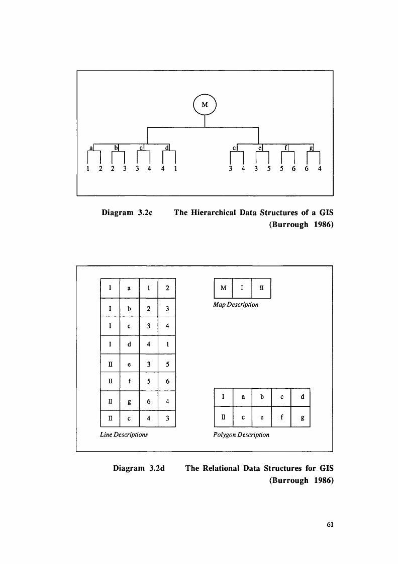
1 2 2 3 3 4 4 1 3 4 3 5 5 6 6 4
Diagram 3.2c The Hierarchical Data Structures of a GIS(Burrough 1986)
I a 1 2
I b 2 3
I c 3 4
I d 4 1
n e 3 5
n f 5 6
n g 6 4
n c 4 3
Line Descriptions
M n
Map Description
I a b c d
n c e f g
Polygon Description
Diagram 3.2d The Relational Data Structures for GIS(Burrough 1986)
61

Data access to key attributes is simple but it is more difficult to access associated
attributes. Hierarchical systems are good for data retrieval if the structure of all possible
queries is already known. This provides limitations when using spatial data. An
associated problem with hierarchical structured databases is that they have large index
files that must be maintained and certain attributes may be repeated often. This causes
redundancy (Peuquet 1990, Date 1976).
Network systems make some inroads into solving this problem. In hierarchical
systems, travel within the database is restricted to paths up and down. In many situations
much more rapid linkage is required, particularly in data structures for graphic features
where adjacent items in a map or figure need to be linked. Network systems are very
useful when the relations or linkages can be specified before. They avoid data
redundancy and make good use of the available data. They have the disadvantage that the
database is enlarged by the overhead of these pointers which in complex systems can be
substantial (Burrough 1986).
The relational database structure in its simplest form stores no pointers and has no
hierarchy. Instead, the data are stored in simple records. These are known as tuples.
These tuples contain an ordered set of attribute values that are grouped together into two-
dimensional tables. These are known as relations. Each table or relation is usually a
separate file. The pointer or key structures are replaced by identification codes that are
used as unique keys to identify the records in each file. Relational databases have the
advantage that the structure is very flexible. They have the disadvantage that many
operations involve sequential searches through the files to find the required data (Peuquet
1990, Date 1976).
There are several data structures that must be outlined. These can be subdivided
into raster and vector data structures. The simplest raster structures consist of an array of
grid cells or pixels. Each grid cell is referenced by row and column number and it
62

contains a number representing a value of the attribute being mapped. Raster
representation assumes that the geographical space can be treated as though it is a flat
Cartesian surface. Each pixel is then by implication associated with a square parcel of
land. The resolution, or scale of the raster data is then the relation between the cell size in
the database and the size of the cell on the ground.
As each cell in a two-dimensional array can only hold one number, different
attributes must be represented by separate sets of Cartesian arrays. These are known as
overlays. The idea of overlays is realised by attaching two-dimensional arrays. This
results in a three-dimensional structure. The vector representation of an object is an
attempt to represent the object as exactly as possible. The coordinate space is assumed to
be continuous which allows all positions and lengths to be defined precisely. Methods of
storing vector data tend to use implicit relations that allow the data to be stored in
minimum space. Such data can be stored in points, lines, networks and polygons.
Points are defined by their X,Y coordinate pair and its related information. Line entities
are defined as linear features built up from straight line segments made up of two or more
coordinates. The simplest line requires the storage of a start point and an end point plus
a record indicating the display symbol to be used. Simple lines and chains carry no
inherent spatial information about connectivity such as might be required for a drainage
network.
To build a network of lines that can be traced by the computer, it is necessary to
include ‘pointers’ into the data structure. The pointer structure is built by the nodes. The
nodes carry pointers to the lines and carry data records indicating the angle at which each
chain joins the node and thereby defining the topology of the network. Areas or regions
of polygons can be represented in various ways in a vector database. Each polygon has a
unique shape, perimeter and area. The aim of a polygon data structure is to be able to
describe the topological properties of area. This is so that the associated properties of
these basic spatial building blocks can be displayed and manipulated as thematic map
63

data. Geographical analyses require the data structure to be able to record the neighbours
of each polygon in the same way that the stream network requires connectivity. Polygons
need not all be at the same level or digitised to the same level of accuracy.
Vector database structures may also contain layers similar to the raster database
structures. In principle the number of layers that can be created is unlimited. However,
limitation is imposed by the amount of hardware storage space. For data manipulation,
the type of data being stored, and the amount and the detail that is to be stored, are
important. It is important to select the correct database model for implementation.
Therefore for the successful retrieval and manipulation of data from GIS databases it is
important that these factors be considered.
3 .4 Data Retrieval
Data retrieval involves the basic extraction, query and Boolean manipulation of
information contained in an organised GIS. These retrieval functions can be categorised
into: browsing; windowing, query window generation; multiple map sheet spatial
querying; Boolean attribute retrieval and statistical summary (see Diagram 3.3).
Browsing consists of using a computer monitor to browse through the graphic and
non-graphic data files associated with various maps and groupings of maps. Windowing
relies on the ability of the user to specify windows either by X,Y coordinate or by textual
information. Spatial database management typically calls for the organisation of map
sheets into some form of modular relational structure which creates the illusion to the user
that a continuous map is contained within the computer (See Diagram 3.3).
64

Browsing
PointWindowing
Irregular Polygon
Square
Circle
Corridor
Query Generation Window Multiple Map Sheet Spatial Query
D iagram 3.3 Data Retrieval Techniques (Dangermond 1990a)
Query window generation involves the ability to generate points of irregular shaped
polygons, squares, circles and corridors for interactively overlaying with data planes
contained within the geographic file. These windows are typically used to perform spatial
retrieval of spatial data from various map layers that coincide in the space with these
generated query windows. Where this is carried out over several map sheets it is called
multiple map sheet spatial querying. The data retrieval software, therefore, must have the
ability to create a polygon across several map layers (see Diagram 3.3). Finally, the
retrieval of attributes involves the specification of Boolean criteria for extraction of
information based on non-graphic attribute data. The production of statistical summaries
of data attributes is also possible.
65

3 . 5 Data Manipulation
Most modem GIS include complete sets of functions for entering, storing and
retrieving spatially indexed information. The methods of analysis that are usually
included in standard GIS are often based on Boolean operations on the attributes of
spatial entities. These operations are carried out on all spatial entities and are used to
compute various statistics or to create new spatial data, for example, isomorphic buffer
zones. In raster systems the analysis methods often include options for “Cartographic
Algebra” such as addition and subtraction of layers, computation of slopes and aspect,
sun intensity and filtering.
Users often wish to re-classify attribute data and carry out analysis that entails the
aggregation of that data into different spatial levels. Often the user may wish to present
data in different projections and these might entail geometric operations such as the
rotation, translation and scaling of coordinates. These may also entail the conversion of
geographic coordinates to specific map projections, rectification, registration and removal
of distortion. Within these types of analysis the user may wish to locate the centres or
centroids of polygons and areas. He or she may also wish to allocate values to lines
(Smith et al 1987). Data manipulation operations typically needed by users and found in
many GIS are described in the following sub-sections 3.5.1 - 3.5.6.
3 . 5 . 1 Map Generalization
As shown in diagram 3.4, map generalization is a series of techniques that allows
maps to be created at the correct level of detail for the display scale required. There are
four basic types of map generalization: line coordinate thinning; dropline; edge-matching;
and polygon thinning. These tools are most frequently used when map scales are
changed. Line coordinate thinning is a technique for reducing the number of coordinate
pairs that define a given line. The technique of dropline is used where a polygon
66

boundary that separates two polygons of similar characteristics can be deleted. The
remaining line segments of the two polygons are then joined to form a new polygon unit.
Line Coordinate Thinning
Polygon Coordinate Thinning
Edge MatchingDrop Line
D iagram 3.4 Illustrations of Map Generalization Techniques(Dangermond 1990a)
Edge-matching is a series of procedures for bringing together a number of map
sheets and compositing them into one continuous map. There are several problems that
can occur during this process. These problems occur when joining lines and polygons
from adjacent maps together. Further difficulties are encountered when lines that separate
polygons having the same characteristics are dissolved or dropped. Although automated
techniques are available for this process, basic errors made on the cartographic
manuscripts input into the systems often make clean edge-matching difficult to achieve.
67

3 . 5 . 2 Map Abstraction
The technique of map abstraction is closely associated with map generalisation, but
it involves five different techniques (see diagram 3.5). These are the calculation of
centroids, automatic contouring, proximal mapping, reclassification, and finally
conversion to grid.
Calculation of Centroids
AutomaticContouring
ProximalMapping
Reclassification Conversion to Grid
Diagram 3.5 Techniques of Map Abstraction(Dangermond 1990a)
The calculation of centroids involves the computation of either the mathematical or
visual centre of the polygon. The technique of automatic contouring allows the threading
of lines, which represent equal value, through randomly spaced data. For example
68

contours are often used on maps to represent height above sea level. Proximal mapping
is carried out by the calculation of Thiessen or Voronoi polygons. This technique
calculates the mid-points between each pair of coordinate points mapped, and draws
polygons based on these calculations (Peuquet 1990). Map abstraction often involves the
reclassification of polygons. This reclassification allocates a new value to a polygon to
show a different perspective on a map. The final technique of map abstraction is x,y
coordinate location data conversion. This technique is used to convert data from either
remotely sensed sources or different map projections to a uniform grid. (Dangermond
1990a)
3 . 5 . 3 Map Sheet Manipulation
Map sheet manipulations are carried out where digitally encoded maps require
changes. These features are illustrated in Diagram 3.6. These techniques manipulate the
X,Y coordinates for a given map sheet. The most commonly used of these techniques
are: scale changes; distortion removal; projection changes; coordinate rotation and
translation.
Scale changes involve the use of map generalisation tools in connection with an
actual scale modification. Distortion Removal is carried out by both linear transformation
and discriminatory stretching (this is often called rubber sheeting). Projection changes
allow any digitally encoded map to be converted to any other type of grid coordinate
system or projection. Finally coordinate rotation and translation are functions that involve
the alteration of the coordinate sets either through their rotation or shifting to match
correctly overlapping or sets of adjacent coordinates.
69

Scale Change Distortion Removal Projection change
Coordinate Rotation and translation
Diagram 3.6 Map Sheet Manipulation Techniques(Dangermond 1990a)
3 .5 .4 Buffer Generation
Buffer generation involves the creation of new polygons from points, lines, and
polygon features within the database (see Diagram 3.7). Circular as well as square
buffers can be calculated, from a given point or series of points. Similarly with a string
of points both narrow and broad buffers can be calculated and in cases where these line
buffers overlap, new polygons can be formed. Polygons can be generated both around
the exterior perimeter of an existing polygon and also within the interior of a polygon.
This results in a dual set of polygons measuring horizontal distance relationships relative
to a given geographic element.
70

Square Buffer Circle Buffer
Narrow line BufferBroad Line Buffer
Interior Polygon BufferExterior Polygon Buffer
Diagram 3.7 Buffering Techniques(Dangermond 1990a)
3 . 5 . 5 Polygon Overlay and Dissolve Techniques
Polygon overlay and dissolve techniques involve the compositing or extracting of
multiple maps to create a new data set. These techniques can be broken down into three
main techniques. These are: polygon overlays; map dissolve; and finally map overlay for
area calculation. For polygon overlay a new data set is created containing new polygons
created from the intersection of the boundaries of the separate polygon layers. Besides
creating new polygons based on the overlay of multiple layers, these polygons are
assigned multiple attributes. The mathematical overlay of these maps is performed for the
area and measurement as well as multiple attribute modeling. Map dissolve functions
involve the converse of polygon overlaying. It is the ability to extract from a multiple
71

attribute polygon file a single attribute, both by attribute description as well as locational
definition. A second type of polygon overlay is typically performed when the areas for a
given data layer need to be calculated and summarized within a second layer of polygons.
The resulting output is the summary of statistics. Such statistical analysis can include
histogramming or frequency counts, regression, correlations and cross-tabulation, and
file generation to interface with a standard statistical package (Knapp 1978).
3 . 5 . 6 Measurement
The four most common types of measurement tasks involve points, lines, polygon
and volumes. The two most typical measurement activities associated with points are the
display of a given set of points and the enumeration of the total number of points falling
within a polygon. Line measurements also take two basic forms. These are the
measurement from point-to-point and the measurement along a curvilinear line.
Measurement of areas consists of the measurement of the area of and the perimeter of
polygon areas. Finally, volume involves the measurement that is performed either
through a cross-section technique or through overlays or multiple surfaces (Green et al
1985).
3 .6 Data Display
A GIS should include software for the display of maps, graphs and tabular
information in a variety of output media. Software should exist for the production of
maps that depict the spatial or aerial abstraction of various objects and phenomena. The
choice of which type of mapping is to be used depends upon several factors relating to the
nature of the data and the use to which the map will be put (Green et al 1985).
The components of a geographical information system are divided into software and
hardware. Whilst the software and hardware for data input and manipulation have been
described in the previous sections it is important to outline the variety of output devices
72

and styles. Output from a GIS can take many forms and does not simply occur after the
analysis. Whilst the user is interrogating the database the results from these queries can
be output to the screen or (VDU) in several forms, for example, text, statistical summary
and graphics. Output can also be processed through several other output routes. Display
media includes both hard copy materials and hardware devices for the production of
temporary and permanent graphics. Hardware devices for output displays include line
printers, electrostatic printers and plotters, ink jet plotters, cathode ray tubes, colour fill
recorders and computer output microfilm devices (Butler 1988, Smith et al 1987). Most
GIS will support the more usual forms of information system output such as laser and dot
matrix printers. Data must also be exportable in electronic format (Burrough 1986).
3 .7 GIS Design and Implementation
Based on recent research concerning the design and implementation of GIS, it can
be inferred that any GIS should incoiporate several design and implementation principles.
Although in a separate sub-division of the field of computer science and information
systems, GIS is still part of the computer science and information systems disciplines.
The systematic application of techniques and approaches developed in a variety of other
sub-fields of computer science can be applied to this problem. Thus main-stream
integrated approaches and procedures such as those developed in computer vision, image
understanding, digital cartography and remote sensing may play a beneficial role in the
development of GIS. It is recognised that the use of interdisciplinary tools and
experience may prove beneficial within this context (Smith et al 1987).
Research also suggests that there are several general requirements that should be
satisfied in the design and implementation of most GIS. Initially there must be an ability
to handle large, multi-layered, heterogeneous databases of spatially indexed data. This is
a necessary requirement so that the user is able to access information in a timely and
efficient manner. The users must also have the ability to query the database about the
73

existence, location and properties of a wide range of spatial objects. The efficiency of
this querying part of the system is paramount in allowing the user to exploit the system in
real time and therefore permit the system to be fully interactive (Smith et al 1987).
The application of efficient and versatile searching and processing algorithms is
desirable to allow the maximum gain of information from the minimum amount of effort
Therefore during the design of a GIS the ability to incorporate these procedures into the
system allows the system to be sufficiently configurable to accommodate a variety of
specific users and needs.
The use of a GIS to satisfy the needs of a given user is called an application. Most
GIS applications involve some form of geographical or spatial analysis. There has been a
movement away from the application of GIS technology for simple map overlay and
comparison towards more complex spatial analyses. GIS systems are now employed to
trace containment movement though the environment, to predict crop yields, to follow
financial flows and to automate mapping and the management of facilities.
Currently most users involved in geographical analyses require maps as output.
Along with significant national and local requirements for thematic products, the business
community has definite requirements for thematic mapping. In particular, private
businesses that supply information derived from remotely-sensed data have found that
almost all their clients’ requirements are cartographic in nature (Burrough 1986).
An important principle relating to the design and implementation of GIS involves
the integration of approaches and procedures developed in a variety of disciplines that are
related to GIS. These disciplines include computer vision, image understanding and
digital cartography. There are two reasons for this integration. Firstly, these disciplines
all study the same basic problem of recognising and reasoning about spatial objects
implicitly encoded in spatially-indexed data sets. Since their evolution has been
74

somewhat independent, research on GIS would benefit from the integration of
approaches and procedures developed in these other disciplines. Secondly, there has
been a recent and growing realisation that it is often of practical necessity to merge image
datasets such as a LANDS AT remotely sensed images, with more traditional datasets of
GIS such as digitized maps and vectorized representations of map features. Computer
vision and image understanding have developed techniques that will allow the integration
of such capabilities into GIS. Such systems must be able to integrate both raster and
vector-based approaches to spatial data analyses (Ballard and Brown 1982, Jackson
1985).
The integration of map and image data within a single system is currently the focus
of work at several research centres. The main thrust of current work in this integration
has involved the use of both hierarchical data structures and knowledge-based approaches
to search and analysis.
3 .8 C onclusions
There has been a significant increase in the generation of spatially-indexed data
from a large variety of sources leading to huge volumes of data for storage retrieval and
analysis. Similarly the demand for GIS to handle such volumes of data in a large variety
of decision-making situations has also begun to increase dramatically.
Given these trends, it is important that the design, implementation and use of GIS
be placed on a more systematic and scientific basis than has generally been the case until
now. Such a basis involves the application of the theory and the techniques of several
sub-fields of computer science and information systems and the integration of techniques
developed in computer vision and image processing in the design and implementation of
GIS. In particular there is still a great deal of investigation to be undertaken concerning
75

appropriate data structures and computational procedures for the storage, retrieval and
analysis of spatially-referenced data in large scale GIS.
In this chapter GIS have been seen to encompass a set of basic components. These
components are: The mechanisms of spatial data entry and management; those
mechanisms of data retrieval and the procedures employed to manipulate this spatial data
entry and management; and finally the output and display of such data. It has been seen
that the major element that distinguishes a Geographic Information System from a more
traditional information system is that all the data are spatially indexed to a point in the
Earth’s surface. Secondly, that the mechanisms of input, for example, digitizing, and
output through plotters, mean that these systems encompass more than a traditional
Information System. Therefore, the particular needs of a GIS can be described by the
following. A GIS must be able to handle large multi-layered databases of spatially
indexed data. Access to data within a GIS must occur in a timely fashion. The query of
the system must be efficient to allow the individual user to inquire about the existence and
properties of a wide range of spatial objects. Since the primary source of output from
GIS are maps there is a need for a high quality output device, for example, a plotter and
efficient built in programs (drivers) to “drive” the device.
This chapter has outlined the nature of GIS, their generally relationships to
information systems, and their particular differences. The next chapter describes the
particular GIS case study which forms the basis for the empirical research of chapters 5
and 6. Clearly, the general nature of GIS makes GIS development at least as difficult as
that for any information system. Hence the prototyping theme of this thesis. The
particular spatial characteristics of GIS also point to a hypertext medium as a natural
development environment.
76

Chapter 4 The Broads Authority
4 .1 Introduction
The Area of the Norfolk and Suffolk Broads in East Anglia is unique in its
environmental and ecological characteristics. It has been classified as an Environmentally
Sensitive Area (ESA) by the Dept of Environment. It contains areas variously designated
by the Countryside Commission and the Nature Conservancy Council. It is managed by
a statutory body, having a status similar to that of the National Parks authorities, which
was established in 1989 by the Norfolk and Suffolk Broads Act (HMSO 1988). This
statutory Body was created out of an existing organisation, the Broads Authority, and has
retained this title. The terms Norfolk Broads, Broads and Broadland are all in common
usage to describe this area. They are used within this chapter interchangeably and are
syonymous with the executive area specified under the 1988 Act (HMSO 1988) (see map
4.1). This chapter describes the Broads Authority as used for a case study in this thesis
and includes: background information and historical aspects of the Authority; its present
obligations under the Norfolk and Suffolk Broads Act (HMSO 1988); and the
management problems and information needs of the Authority. These aspects will be
described in terms both of the Broadland region and the administrative structure of the
Broads Authority.
4 .2 Background
Geographically the Broads extends over the lower valleys of the Rivers Waveney,
Yare and Bure, together with the two tributaries of the Bure, the Ant and the Thume.
These rivers and their tributaries drain 3600 km2 - an area equivalent to two thirds of
Norfolk and much of Northern Suffolk. The low lying land in these valleys consists of
shallow lakes (the broads), rivers and drainage systems (dykes), fens (undrained marsh),
77

Map 4.1 A Map of the Norfolk and Suffolk Broads(Ordnance Survey 1986)
78

Norfolk and Suffolk Broads
cv syfc*;®
m Area of the Broads Authonty shown coloured pink
I m i ,
g< 7; ^
mi
, ->
Department of the Environment Cartographic Services November 1986 Base map reproduced from the Ordnance Survey map © Crown copyright 1986

woodland and drained marshlands (Broads Authority 1987). It is renowned for its
individual beauty:
“Reed-fringed rivers and Broads, its gentle farmed contours, its
brick, flint and thatched buildings and its wide horizons and
skies.” (Broads Authority 1987)
Within the Broads there are several, often competing interests for land and water
use. There is the farming community who depend for their living on the fertile (grade 1
and 2) land present in the Broads. Secondly, there is a recreational aspect to the Broads.
Broadland provides opportunities for fishing, sailing, walking and tourism. This
supports a large tourist and other related industries, such as boat building. Thirdly, for
many people the Broads harbours ecosystems where diverse meadow and dyke flora and
fauna can be observed. Finally, the Broadland area is a populated area with a thriving
economy. The population, although valuing the surroundings and environment as adding
to their quality of life, must also consider their personal economic prosperity. For the
Broads Authority this means the reconciliation of these competing uses in a way that is
compatible with the management policies that the Authority seeks to pursue.
4 . 2 . 1 Environmental Importance
The Broadland area is largely the product of past cultural and economic exploitation
of the land and waterways. In recent years many features of this traditional management
have declined and disappeared. With the change in agricultural practice and the economy
of the region many of the features of the more traditional farming management have
disappeared. It is because of this decline and other factors, such as the increase in river
water pollutants, that the Broads have deteriorated (see section 4.2.3). The fens are
notable for their reed and sedge beds and also grazing marshes which support important
populations of rare birds (e.g. Marsh Harrier, Bittern and Reed Warbler). The dykes
79

contain over one hundred species of freshwater aquatic plants as well as rich invertebrate
populations. These areas are now in serious danger (Broads Authority 1987).
The Broads area is a wetland of considerable significance. Within the area there are
three national nature reserves: at Bure Marshes (456 hectares (ha)), Hickling Broad (1380
ha) and Ludham Marshes (69 ha). Both Bure Marshes and Hickling Broad are
recognised to be two of the thirteen wetlands which are internationally important for
nature conservation. In addition there are 24 sites of special scientific interest (SSSI)
covering 880 ha, with another 156 ha that are proposed to be scheduled as SSSI by the
Nature Conservancy Council.
The Broads is not a series of isolated habitats: it is an integrated landscape within
which its wildlife features produce a peculiar distinctiveness. It is because of the
combination of nature conservation and its landscape character that the Broads is
considered a national asset.
4 . 2 . 2 Economic and Recreational Importance
The economy of Broadland is very much based around farming, tourism and light
industry. Agricultural land occupies a substantial part of the Broads Area and the
management of this land plays a fundamental role in influencing the character of the area.
Modem agricultural practices are very different from traditional approaches. Since the
environment is such an significant part of all other aspects of the Broadland economy it is
important for the Broads area to retain key elements of its ecology and landscape. Recent
changes in government policy have made it possible for some farmers to retain their
established agricultural practices by means of a subsidy. In this way, it is possible to
protect the environment without disadvantaging the farming industry.
80

The maintenance of traditional farming and management practices help to protect the
wildlife and landscape characteristics of the Broads. These combined with the many
historic features of the Broads area, for example, St. Bennetts Abbey, provide interest for
tourists who visit the Broads. The close proximity of the Broads to Norwich and to the
major coastal resorts of Great Yarmouth and Lowestoft makes it a popular destination for
day-trippers as well as longer-stay visitors. The primary attractions are the rivers and
Broads, together with opportunities for a wide range of leisure activities including motor-
boating, sailing, rowing and fishing. The Norfolk boat-building industry is also of
international importance, constructing craft for the national and international markets as
well as for local use. The thousands of holiday makers who hire pleasure craft boost the
local economy through their riverside spending. The tourist industry that has been
developed around these activities is an important part of the local economy employing
people to build, maintain and service boats of many kinds.
Heavy industry within this area is limited to a few primary extraction sites and
processing plants and the introduction of new heavy industry into this area is now
discouraged. Light industry, however, supporting the tourist, boat-building and farming
industries as well as producing goods for the national and international market is
encouraged to improve the overall economic base of the region.
4 . 2 . 3 Environmental Change and Economic Consequences
It is widely maintained that the future survival of this area lies in the combination of
conservation and development. Careful planning is aimed at producing no conflict
between these but one factor is of overwhelming importance. If mistakes are made and
these fragile ecosystems disrupted, it may take many years and high levels of investment
to restore the balance. Since the health of the ecosystem is a vital part of the economy,
careful planning judgements must be made.
81

Over the past 45 years the Broads has undergone many environmental changes,
mostly to the detriment of the area. Moreover, experimental restoration projects are
costly and time consuming (Broads Authority 1990). The main features of the Broads
decline are as follows. There has been a wholesale loss of the Broads special habitat,
which has caused a most notable decline in the variety of water plants in the rivers and the
Broads. The impoverishment of fenland plant communities is the result of neglect and the
alteration of water regimes where fens have been converted to drained arable agriculture,
which was encouraged by the EEC agricultural grant initiatives. The effects of boat
wash, uncontrolled moorings and anglers have caused the progressive erosion of the river
banks and protective flood walls. River bank erosion is accelerated by the exposure of
the vulnerable river margins caused by the decline of protective reed buffers. This loss of
the fringing reed growth is in part due to the enrichment of the water by nutrients
discharged from sewage treatment works and as a result of modem intensive agricultural
practices. Reed loss is also caused by wash from speeding boats.
These changes place both an environmental and economic burden on the economy
of the area. It is already proving costly to maintain the Broads ecosystems as they are,
whilst restorative costs are increasing (Broads Authority 1990). If the forces of
ecological simplification are not halted, the cost of repairing floodwalls, piling eroded
river banks and protecting key habitats will accelerate exponentially. The alternative is to
let the Broads deteriorate. This will have devastating consequences for the boating and
tourist industries as well as for the environmentalists, the marsh farmers and local
inhabitants of the area. A scientifically-based programme of restorative investment for the
Broads is in the interests of everybody. Investment in the restoration of the Broads is
necessary to stop deterioration.
The management of such a programme is the responsibility of the Broads
Authority. The Authority was created in April 1988 with wide-ranging powers and an
82

ability to plan in the long term for a necessary restorative program. This will be further
discussed in sections 4.4.
4 . 2 . 4 Physical Formation of the Broads
The Broads are man-made. They are the result of medieval peat digging. Large
pits were excavated by the inhabitants for fuel and to provide energy for the prospering
cathedral city of Norwich. Most of the pits were about 4 metres deep although some
deeper workings did take place, for example at Fritton Lake.
In the fourteenth century the sea level gradually began to rise and the pits flooded.
Peat diggings then became uneconomic and were abandoned. These flooded pits are the
present Broads. Some working of the peat did continue into the nineteenth century.
These were shallow workings which were subsequently flooded and are now known as
turf ponds, as for example at Barton Turf.
Natural processes have gradually infilled these shallow lakes with dead vegetation
and sediment. Little is known of the original size of each of the Broads although
estimates at the time of the Tithe maps in the 1840’s give a total area of approximately
1200 hectares. The Authority’s aerial photographic survey in 1980 showed an existing
area of little over 600 hectares indicating that half the area of the Broads has been
reclaimed by natural processes (Broads Authority 1987).
The Broads can be divided into two main categories:
(i) Main valley Broads - those that lie in the main river valleys and are usually
connected by cuts or dykes to the river, for example, Cockshoot and Ranworth
Broads.
83

(ii) Side valley Broads - those that lie in side valleys and although connected to the
rivers by streams are not directly influenced by river water, for example Alderfen
and Upton.
4 .3 History and Background of the Broads Authority
Following the Dower Report, the Hobhouse Committee (Dower 1945, Hobhouse
1947) proposed twelve national parks for England and Wales: Broadland was one. Only
10 national parks were finally created but Broadland was not included. There was,
however, concern that Broadland should have some form of special status to aid
planning, and the idea of a Broads Joint Advisory Planning Committee emerged from a
Broads Conference in 1949 and was formally constituted in 1950. The county, borough
and rural district councils provided 23 of the 34 members of the Committee, the rest being
made up of water, navigation, boating, farming and naturalists’ interests. This
Committee’s structure and ethos was based on the Town and Country Planning Act 1949.
It was considered as a coordinating mechanism for reviewing planning applications in
order to control development. It did not operate using criteria based either on scientific or
environmental protection principles. It had no plan or set of policies on which to base
specific judgments and it exercised no powers over planning authorities, except the
influence of persuasion. This was an ineffectual method for managing the Broads but it
reflected the mood of the times. Planning control was the primary consideration. At that
time environmental science had not been established as a discipline, the Natural
Conservancy Council was in its infancy and inter-organisational co-ordination on a
systematic and effective basis had never been tried anywhere in the country.
It has been argued that the formation of the Broads Joint Advisory Committee
probably helped to accelerate the deterioration of the Broads (O’Riordan 1991). By
prompting a policy of village expansion, planners and district council public health
officers positively encouraged the construction of sewage treatment works instead of
84

septic tanks and soakways. The eutrophication that has been such a dominant feature of
the ecological decline of the Broads since the 1950’s was inadvertently fostered by the
very organisation designed to safeguard the environmental quality of the region. This
pattern of counter productive good intent continued through to the middle 1970’s.
In 1958 the Committee of Enquiry into Inland Waterways (Ministry of Transport
1958) recommended that the Broadland area should be given special recreation status and
that it should be administered by a reconstituted body, the Great Yarmouth Port and
Haven Commissioners. Throughout the history of the Broads, navigation interests have
always been paramount and in this case proved to be no exception. This situation was a
compromise as the Joint Advisory Committee was adamant that the area should not be
made a National Park. In the early 1960’s Broadland was seen as simply not appropriate
for membership of the National Park “club” and this was confirmed in 1961 when the
Broads Sub-committee of the Standing Committee on National Parks rejected designation
as a National Park. The area was regarded as inaccessible by foot, as well as having
enormous difficulties for securing public access over so many private land holdings. The
growth of commuter populations in Broadland villages meant, for the National Park
visionaries, too little space and too many complicated and possibly controversial planning
decisions regarding amenity and public access. They felt that the local planning
authorities would not show the same sympathy to the needs of the wilderness and
freedom to roam that was characteristic of the upland parks. There was also enormous
local opposition to the National Park idea from a wide cross-section of local public
opinion. This was partially induced by a belief that National Park status would result in a
loss of local autonomy to external domination by either the existing National Parks
Commission or eventually by central government.
In 1965 following a Consultative Document in 1963, the Report on Broadland was
published by the Nature Conservancy Council (Nature Conservancy Council 1963,
1965). This was the output of a working group of planners, ecologists, water managers,
85

boat owners, landowners, naturalists and local government members who considered the
state of scientific evidence on the changing character of Broadland. Unusually for a
nature conservation report, the panel also considered possible administrative reforms
needed to put the area to right. The study pointed out clearly that the Broads were
becoming shallower, that fens were slowly becoming drier and susceptible to willow and
alder tree invasion and that the ecological tendency in Broadland favours Carr woodland.
The group committed itself firmly to a future of fen and marsh management that would
maintain an ecologically healthy Broadland through the principles of sound nature
conservation. This meant that Broadland was committed to something akin to a return to
the ecological status-quo of the mid-nineteenth century at least for the major fen areas. It
was also recognised that this would involve significantly larger numbers of trained people
and larger amounts of money than had been available before.
It was not apparent that the working group as a whole recognised this dilemma. A
minority favoured the establishment of a single management authority that was separated
from the local authority machinery and had a commitment to recreation on both land and
water and to nature conservation. This group also believed that the new agency should be
vested with the necessary financial resources and should be required to prepare a long
term strategic plan. It called for a unified perspective on land and water management that
rested on a solid foundation of scientific discovery and aimed to protect the rich wetland
ecosystems. This management was to be based within a framework of government that
would be sympathetic to the safeguarding of the environment.
As a compromise, a consortium of local interests was suggested, combining the
local authorities, the water authority (the then East Suffolk and Norfolk River Authority)
and the navigation body (the Great Yarmouth Port and Haven Commissioners). In 1966
the Broads Consortium Committee was established to improve liaison between planning,
water management and navigation.
86

In 1970 the then Chief Planning Officer of Norfolk, R.E. Maxwell, argued that a
single executive agency should have control over both planning and navigation. This was
rejected. An alternative proposal that the navigation function of the Broads and rivers
should be taken out of the hands of the Rivers Committee of the Great Yarmouth Port and
Haven Commissioners and vested in the River Authority was put forward but was also
disregarded. The Broads Consortium Committee completed its task of producing a form
of strategic plan and published its report “The Broadland Study and Plan” (Broads
Consortium Committee 1971). This was the first composite official review of
Broadland's needs. It was primarily a planning analysis with little attention given to
environmental matters. The Great Yarmouth Port and Haven Commissioners (1971)
submitted a minority report seeking to retain their control over all aspects of navigation.
In 1971 the Consortium disbanded leaving the three authorities to manage the steady
deterioration of the ecological health of the Broads.
4 .3 .1 The First Broads Authority
The trigger to the formation of a more unified body was the publication of a report
by Mason and Bryant (1975). This showed that only 6 out of the 28 broads surveyed
were in even a modest state of ecological health. What was particularly disturbing was
the evidence of very rapid eutrophication since the publication of the “Report on
Broadland” (Nature Conservancy Council 1965) ten years previously. The Norfolk
Naturalists Trust, being a major landowner in the region, lobbied hard for a much tougher
conservation regime. This was supported by the Countryside Commission (1977), and
the Nature Conservancy Council (1977) who initiated a major programme of research at
the University of East Anglia.
With the backing of the Countryside Commission (Countryside Commission 1977)
the Norfolk Branch of the Association of District Authorities proposed a Joint Committee,
to be established under section 101 and 102 of the 1972 Local Government Act, that
87

would serve as a locally dominated version of a National Park Authority. This body,
known as the Broads Authority, was subsequently formed in 1978 (Countryside
Commission 1979) and was formally inaugurated on 1 April 1979. It was essentially a
joint standing committee of the two county Councils and the six district councils, to
which two members from the Great Yarmouth Port and Haven Commissioners and two
members of the Anglian Water Authority (formed in 1974 under the 1973 Water Act)
were co-opted. In addition the Countryside Commission was invited to nominate three
members to reflect national interests in Broadland management (Countryside Commission
1983). The co-optive status of these seven individuals was reinstated at every annual
meeting when the local government members voted to invite their presence.
The creation of the Broads Authority was a major step forward but its structure and
financing was unsatisfactory. The Authority had delegated powers granted to it by the
local authorities over all local government matters including planning and development
control, litter and recreation management. The county council also ceded some minor
powers over highways and footpath maintenance. The essential support services of
planning, property, legal and financial management were handled by quasi-voluntary co
operative arrangements between the various responsible officers in local government
departments and the Broads Authority.
The co-operative arrangements worked particularly well in planning matters where
the district council officers handled much of the paperwork. The Authority’s Planning
Committee consisted for the most part of the chairmen or vice-chairmen of the local
planning committees. The Authority’s planning adviser was seconded from the Norfolk
County Council’s planning staff. Similar arrangements, involving the commissioning of
local authority officers for specialised advice on legal matters, property deals and
management agreements, highway and conservation issues were also efficient and good
humoured.
88

One of the greatest achievements of the Broads Authority was the production of a
comprehensive management plan. The final version appeared in 1987 only a year before
the Authority ceased to exist (Broads Authority 1987). The process of preparing this
non-statutory but highly influential document involved widespread consultation, the
establishment of three panels on ecology, landscape and recreation and an enormous
amount of scientific research. The Authority published ten scientific reports, produced
many unpublished reports and invested some 25% of its total budget in scientific
research. These panels provided interested parties with direct access to the Authority’s
policy making machinery. The Authority in many ways acted as a catalyst to enable grant
aided bodies to collaborate.
The Authority also established a series of local environmental improvement
schemes, notably on public staithes, to help make riverside areas where people
congregate more accessible and scenically attractive. It built and staffed four public
information centres at strategic points throughout the area and ran several publicised
events aimed at attracting public interest in the area and its natural beauty. It collaborated
with private enterprises to promote conservation values and to stimulate environmental
education, notably by purchasing 180 hectares (ha) of prime marshland and fen at How
Hill, near Ludham, to help create the How Hill Education Centre.
Possibly its most remarkable achievement was to encourage the change in
Government Policy over agriculture and environmental protection. It did this in 1985 by
stimulating the idea of Environmentally Sensitive Areas (ESAs). These designations,
formally incorporated in the Agricultural Act of 1986, permitted the Ministry for
Agriculture, Fisheries and Food (MAFF) to offer payments to land occupiers in
compensation for retaining practices that enhance the scenic amenity and nature
conservation values of key landscapes in the UK. In 1987 the whole of the Broads
executive area (the area covered by the Broads Authority) was designated as an ESA.
Within the Broads ESA participating farmers received £125 per ha per annum (tier 1) for
89

accepting restrictions on farming practices that aim to maintain the nature conservation
value of their marshes and dykes. Payments of £200 per ha per annum (tier 2) may be
made where the land is of particularly high conservation value or the farmer agrees to
manage his land to enhance its ecological interest.
About 12400 ha of marshland have been covered by agreements (O’Riordan 1991)
including 90% of the eligible grazing marsh. About a third of this land is covered by tier
2 agreements and the remainder by tier 1. Over 80% of farmers have voluntarily
participated and the conservation status of about one quarter of the eligible land has been
upgraded either by raising the water table and/or by special dyke management. Through
these designations of tier 1 and 2 about 400 ha of arable land have already been returned
to grass. The scheme therefore has enabled a collective sense of goodwill and concern
about the Broadland environment to develop.
The Broads Authority is unique in the “National Park” community in enjoying ESA
status throughout its entire area. It is also unusual to have such a high proportion of
landowners adopting the more conservation-orientated management regime. This means
that the Authority pays very little for conservation-based management agreements (about
£5000 per year compared with over £100,000 annually in Dartmoor and the Peak District
National Parks (O’Riordan 1991). Clearly a powerful precedent has been set for central
government agricultural money being spent to further a National Park’s interest.
Although a cost effective solution was produced, during the whole of its ten years
of existence the Broads Authority staff never exceeded 25 (less than the planning
department alone of most major national parks). The Broads Authority was never in a
secure position. Its financing was based on the support of local authorities any one of
which could leave the arrangement at any time. The dependency on participating member
contributions and on Countryside Commission grant aid meant much lobbying and
90
paperwork. The Authority survived by good will but it could never guarantee that it
would be able to invest in the necessary remedial measures over a long planning period.
4 .3 .2 The New Broads Authority
Despite these achievements, the first Broads Authority was in many respects
ineffectual. It had no power over water matters, drainage or navigation. It was not
notified of any changes affecting the landscape that fell outside the Planning Acts unless
landowners did so voluntarily. It was unable to allocate resources on long term
budgetary plans for restoration and it was also subject to political accountability through
the membership of its Committee.
In 1984 the Countryside Commission launched a bid for a special statutory
authority with powers over navigation and 75% grant aid from the Treasury on a
continuing basis. The Government then supported a Public Act that created the new
Norfolk and Suffolk Broads Authority with a reformulated membership and budget in
April 1989.
The new Authority consists of 35 members of whom two are co-opted from
navigation interests via the Authority’s Navigation Committee and 18 are appointed by
local authorities, with 12 of these coming from the six district councils. The Countryside
Commission nominates two members, the Nature Conservancy Council one member, the
National Rivers Authority one member, and part of the Great Yarmouth Port and Haven
Commissioner (now confined to the Port of Great Yarmouth) two members. The
Secretary of State for the Environment appoints nine members two of whom must
represent farming interests and three boating interests.
From empirical observation this body of people has already established itself as a
cohesive group. The expected conflict between navigation and conservation interests has
91

not so far materialised. Indeed, the Authority’s Navigation Committee is proposing
tough speed restrictions and boat-user educational material designed to reduce boat wash
damage even further. Work is already under way to rewrite the “Broads Plan” (Broads
Authority 1987) as is required by the legislation, based on sustainable economics. The
Authority is now discussing with the National Rivers Authority common guide-lines for
river quality objectives and for the financing of flood protection measures. This will
commit long term investment in sewage treatment, mud pumping, biomanipulation of fish
and aquatic flora restoration for the future.
The major problems facing the new Authority lie in government financing policy
and in the sheer scientific difficulty of knowing how to manipulate a degraded ecosystem
into a steady state.
On the matter of financing, the Authority still cannot guarantee a roll-over budget
from year to year, nor sufficient money from the Treasury to meet its genuine needs. In
addition, other authorities, such as the National Rivers Authority, responsible for land
drainage, cannot borrow beyond very narrow limits. Therefore capital investment in
flood wall protection, reed bed regeneration and washlands cannot be undertaken on a
systematic long term basis.
Similarly agricultural policy is also in a state of flux. There may not be sufficient
funding to ensure that all current participatory farmers remain in the ESA after the five
years of the initial commitment ends in 1992. Extra “top-up” money for farm
conservation investment may not be sufficient to encourage those farmers, whose real
income is falling, to spend money on farm conservation measures. Local authorities are
also financially “squeezed” and may be unable to provide the funding for flood protection
that is necessary for Broadland.
92

Meanwhile the mechanism for restoration is still far from being resolved. It is
possible that only a few of the smaller broads can be fully restored with clear water and
even then constant surveillance will be necessary. Fen management requires much
labour, and funds for labour supported Community Programmes that employed the
equivalent of 40 people per year, are no longer available. Volunteer armies will still be
desperately required but they cannot do the job alone. A Broadland Conservation Task
Force which is as much an agency as it is a labour unit has been established by the
Broads Authority. This is funded by the Authority but works on an enterprise basis.
This is an efficient and encouraging arrangement, although more will be needed if the
fens, which are one of the most critical habitats in conservation terms, are to be
substantially restored.
The return to the new economics of the green age and to some form of European
interest have added a new interesting dimension to the National Park status in the 1990s.
It is possible that the kind of environmental service economics started by the old Broads
Authority in 1985 will be swept up in the changing Treasury and Department of
Environment thinking, that is currently at an early stage. The Authority will have to
prove its case by developing a sustainable economic audit in its new plan. This will have
to show that investment in flood protection and nutrient removal now, will save
enormous amounts of expenditure in future years that would be needed to remedy the
environmental damage that would otherwise occur (O’Riordan 1991).
4 .4 The Functions and Responsibilities of the Broads Authority
The commitment of the present government to the creation of a special statutory
authority, which assumed office in April 1989, shows an important step forward in the
comprehensive management of the Broads. The Authority has wide ranging powers and
an ability to plan long term investments and embark upon vital experimental projects.
93

The Broads Authority Management Plan and Strategy is based upon four guiding
principles:
“(1) Broads restoration involves people, not just ecosystems:
action must be based on consensus, informed support and
competent advice.
(2) Ecology and economy fuse into unity through the application
of the principle of sustainable development: sustainable
development means applying environmental science laws to
programmes of economic investment and ensuring that decision
making organisations are geared to that relationship.
(3) Scientific understanding of fundamental environmental
processes is an essential prerequisite to planned investment.
(4) Where the necessary scientific knowledge cannot provide an
answer, carefully monitored experiments can indicate how best to
proceed.” (Broads Authority 1987)
This section describes the legal obligations of the Broads Authority under the
Norfolk and Suffolk Broads Act (HMSO 1988). In addition to the employees of the
Broads Authority the Act makes provision for a committee of 35 members (see Section
4.3.2). These 35 members make up the statutory Broads Authority, and the committee is
the major decision making body for the Broads Authority.
4 . 4 . 1 The General Functions of the Broads Authority
Section 2 of the Act (HMSO 1988) provides that the Authority's general duty will
be to manage the Broads for the purpose of: “Conserving and enhancing the natural
94

beauty of the Broads; Promoting the enjoyment of the Broads by the Public; and
protecting the interests of navigation.”
In discharging its functions the Authority must have regard to:
“ (a) The national importance of the Broads as an area of
natural beauty and one which affords opportunities for open air
recreation;
(b) The desirability of protecting the natural resources of the
Broads from damage;
(c) The needs of agriculture and forestry and the economic and
social interests of those who live or work in the Broads.”
(Broads Authority 1989)
Within the provisions of the Act the Broads Authority also has certain powers,
which fall into four categories: Planning; Recreation; Conservation; Navigation. These
categories are discussed in sections 4.5.1 - 4.5.4 below, with administration discussed in
section 4.5.5.
4 . 4 . 2 Management Issues for the Broads Authority
The Norfolk and Suffolk Broads Act (HMSO 1988) provides for a division of the
managerial tasks which the Authority is legally obliged to carry out. These generally fall
into five areas: Planning; Recreation; Conservation; Navigation; and Internal
Management. There are many potentially conflicting issues that the Broads Authority
may have to contend with while carrying out its duties. These are discussed in sections
below. This is due to the integrated management regime which the Broads Authority has
adopted. However, this management system is very much dependent on goodwill and
the information collected by the Authority from the public, the registration of applications
for planning and water-bome vessel licence registration. It is recognisable that there is
95

also more specialised information gathering from the conservation and recreation side of
the Broads Authority which also play their part in the overall management of the
Broadland Region. It is necessary to discuss the information requirements of the Broads
Authority so that the Authority can carry out their Brief most efficiently, and section 4.5
below covers this.
Within its management Brief the Authority has powers to make byelaws. These
byelaws can relate to land owned or supervised by the Broads Authority, or to land on
which it has public right of access or if the land is common land. The purpose of these
byelaws is to restrict public activities to those that do not damage the land and to ensure
that any activity does not interfere with another person's enjoyment of the land.
The Authority also has the power to make byelaws for the good management of the
waterways, the conservation of their natural beauty and amenities and for the promotion
of their use for recreation purposes.
“Specific byelaw making include: the speed of vessels, the
enforcement of Safety provisions; the prevention of pollution or
excess noise on vessels; and finally the regulation of the provision
and use of the moorings.”(Broads Authority 1989)
So the information needs are quite considerable as the Broads Authority needs to
keep records of the byelaws created and of offences committed on these lands.
4 . 4 . 3 The Committee Structure of the Broads Authority
The Broads Authority is governed by a series of committees which report to the
Broads Authority Committee. Each of the departments, with the except of the
Information and Interpretation and the Administration Departments of the Broads
96

Authority, has a committee bearing the same name (see Diagram 4.1). To each of these
committees representatives of all interested parties are elected. When controversial or
new decisions must be taken these committees must be consulted and their views either
acted upon or considered when drawing up plans or documentation. In certain instances
there are consultative panels which provide advice for certain departments. Any decisions
arrived at must be reported to the governing committee, the Broads Authority Committee.
Similarly, where decisions can not be reached, the case may be taken to the Broads
Authority Committee for their judgement. Where agreement is not forthcoming these may
be taken before the Secretary of State.
Conservation and Recreation
Visitors ServicesPlanning
CommitteeNavigationCommittee
Policy and Resources Committee
BroadsAuthority
Committee
Diagram 4.1 The Committee Structure of the Broads Authority
4 . 4 . 4 Interactions within the Broads Authority Organisation
There are 35 full time employees working for the Broads Authority. Diagram 4.2
shows the internal organisation of the Broads Authority. Although there is a formalised
management structure, it is evident from first hand experience gained during this
investigation that the Authority functions in a very informal manner, in which much of the
formal hierarchy is by-passed. There is evidence of much interdepartmental co-operation
which is positively encouraged by the Authority. The general cohesion of the Authority97

is reinforced by a general meeting of all officers bi-weekly or more frequently when
necessary. It is postulated that this internal cohesion generally aids the overall
management of the Broads region.
98

RiverPolice
FieldWorkers
ProjectsOfficer
CountrysideWarden
GraphicsDesigners
FinanceOfficer
NavigationWardens
How Hill Estate
Workers
AssistantPlanning
Officer
AdministrativeOfficer
(Committees)
AssistantBroadsOfficer
(Navigation)
Assistant Broads Officer
(Planning)
Information and Interpretation
Officer
Assistant Broads Officer
(Administration)
Assistant Broads Officer
(Conservation)
Principle Adviser and Chief Executive
Diagram 4.2 The Internal Organisation of the Broads Authority
VOVO

4 .5 The Internal Structure of the Broads Authority
For the good management of the Broads Executive Area, the Broads Authority has
several activities and functions which it needs to maintain and increase information flows
into the organisation. This section discusses the Broads Authority’s duties under the
provisions of the Norfolk and Suffolk Broads Act (HMSO 1988) and the information
needs associated with them. To satisfy the terms of the Act the Broads Authority must at
minimum cover its five major functions. The Broads Authority however, also carries out
many activities that are not within their Brief but which are intended to promote the
Broadland region. These activities and projects create goodwill between the local
population and the Authority. To this end, section 4.5.1 below describes the function of
the Planning Department, section 4.5.2 describes those features relating to the recreational
side of the Broads, section 4.5.3 describes those relating to the Conservation Department
of the Broads area, section 4.5.4 looks at this in relation to the Navigation Department of
the Broads, section 4.5.5 discusses the internal Administration Department of the Broads
Authority.
4 . 5 . 1 The Planning Department
The Norfolk and Suffolk Broads Act outlines the following duties for the Planning
Authority. A fuller description of these functions and provisions for planning is found in
schedule 3 of the Act (HMSO 1988). This states that the Authority is the sole District
Planning Authority for the Broadland area. It is therefore the Authority that:-
(a) Determines planning applications (apart from those relating to mineral
extraction and waste disposal which will be decided by the relevant County
Council);
(b) Takes planning enforcement action;
(c) Prepares local plans;
(d) Controls advertisements;
100

(e) Protects listed buildings;
(f) Takes action in respect of "Planning Act" conservation areas.
The Authority however shares with the local authorities existing powers relating to
the control of:-
(a) Tree planting and tree preservation;
(b) Historic buildings;
(c) Ancient monuments;
(d) Derelict land;
(e) Litter.
Finally the Authority also has the power to undertake conservation or restoration
work in respect of a building or vessel in the Broads and to make grants or loans to other
bodies for that purpose.
As the sole planning authority for the area of the Broads, the Planning Department
is assumes the planning powers from the six local authorities within the area. All the
local authorities forward planning applications for this area to the Planning Department.
Compared with the Local Authorities, the Planning Department of the Broads Authority
has stricter criteria for planning control in the Broadland region. Thus the quality of the
environment may be maintained and possibly improved. Routine non-controversial
applications are normally processed by the Broads Authority Planning Department.
Where planning applications are of a less than routine nature or where the application is
likely to be controversial the application must be presented to the Planning Committee for
its judgement. Further to these requirements the Planning Department must notify other
departments and where necessary their committees within the authority where planning
permission is likely to affect their activities. Most often the Planning Authority must
contact the Navigation and Conservation departments within the authority. In certain
101

controversial cases where no decision can be reached at the Planning Committee the
applications may be considered by the full Broads Authority Committee.
The planning policy of the Broads Authority is based upon planning regulations
used by local government and therefore is legally binding once planning permission has
been granted. Where a planning application is refused the applicant may re-apply for
planning permission after twelve months, so that the application may be reconsidered.
Planning permission is often granted only on condition that certain criteria are fulfilled.
These criteria range from a change in the building materials to be used to fit in with the
local area, to a change in the style of the building or development being planned. Where
the application is not granted the applicant may appeal to the Secretary of State who will
make a decision for all people concerned in the matter.
The Planning Department and Committee have several criteria on which planning
decisions are made. These fall into two guide-line areas: the right activity for the area,
and the appropriate building style and materials for the project. To carry out such a
decision making process the Planning Department needs to have information on the
following: the planning application itself; the area that the application will affect; any other
issues, for example information from other Departments that may affect the decision
(such as conservation). Therefore the decision making process is highly influenced by
the information available.
Although the primary concern of the Planning Department is the process of
determining planning applications, it has several other responsibilities. These are
discussed below, and fall into the categories of further development controls and
additional powers which it shares with each local authority. With regard to the first
category, the Department is required to: carry out enforcement action; control
advertisements; and protect listed buildings. Additionally, in conjunction with the local
authority, it may: serve tree planting and preservation orders; and preserve ancient
102

monuments and historic buildings. It may also place orders for the use of derelict land
and the preservation of common land.
4 . 5 . 2 Information and Interpretation Department
Recreation is handled by a section of the Broads Authority called the Information
and Interpretation Department which reports to its respective committee. The department
is responsible for the public relations of the Broads Authority and for the provision of
information about the Norfolk and Suffolk Broads. Its brief comes directly from a
section of the Norfolk and Suffolk Broads Act (HMSO 1988) which states that:
“It shall be the general duty of the Authority to manage the Broads
for the purposes of:
(a) .......
(b) Promoting the enjoyment of the Broads by the public.”
and
“In discharging its functions, the Authority shall have regard to:
(a) The national importance of the Broads as an area of natural
beauty and one which affords opportunities for open-air
recreation.”
(HMSO 1988)
The land-based recreational powers of the Authority are also contained in schedule
3 to the Act (HMSO 1988). The Authority shares the following main powers with the
local authorities in the area:-
(a) The provision and management of open spaces;
(b) The provision of accommodation, meals, refreshments and toilets;
(c) The provision of camping sites;
103

(d) The provision of caravan sites;
(e) The provision of country parks;
(f) The provision of study centres and other facilities for learning about the
Broads;
(g) The encouragement of tourism;
(h) The creation, diversion, extinguishment, widening and maintenance of
footpaths and bridleways;
(i) The protection, maintenance and improvement of staithes;
(j) The protection of common land and village greens.
When any of these functions require planning permission this must be gained from
the Broads Authority Planning Department (see section 4.5.1 above).
The publicity of areas within the Broads which are likely to fulfil these recreational
requirements must be framed within the criteria of the Act. The Information and
Interpretation Department of the Broads Authority therefore coordinates information about
the Broads region, making it available to the public. Some information collection for this
purpose is informal, for example relying on the good will of the public to inform them of
future events.
For the purpose of publicity the Broads Authority produces a leaflet every two
months called “Fun in the Broads”. In addition the Broads Authority also produces other
information packs and long term information about permanent activities and places of
interest in the Broads Area. Publications in general are available from the Broads
Authority offices, Broads Authority Information Centres, Tourist Information Centres
and other interested bodies. The Broads Authority runs four information centres
throughout the region. These distribute information about the Broads Area as well as
providing an educational service. Many publications about the Broads are available free
of charge and provide useful information about the area and places to visit. The Broads
104

Authority also provides other more detailed material on the region which are priced
accordingly.
The Information and Interpretation Department is also responsible for the
educational concerns for the Broads Region. It is responsible for projects such as the
How Hill residential Study Centre where school children may learn about important
aspects of the Broads.
The Information and Interpretation Department has implemented these measures in
an integrated and organised manner. Projects which fulfil the Broads criteria are funded
through the Broads Authority. These projects are open to the public (e.g., Toad Hole and
the Electric Eel). It is the deliberate policy of the Broads Authority Information and
Interpretation Department to release information about certain features of the Broads while
safeguarding some of the more environmentally sensitive areas.
4 . 5 . 3 Conservation Department
This section discusses the information needs of the Conservation Department of the
Broads Authority. The brief of the Conservation Department of the Broads Authority is
wide. The Broads Area has deteriorated badly from a lack of environmental awareness
and a laissez-faire approach by local authorities, and there is much restorative work to be
done.
This department has the responsibility for grant-aided land improvements,
restoration and conservation of the broads, improvement in water quality, and the
provision of ‘nature resources’ for the public and further research. There are several
provisions made with regard to conservation. These may be seen more fully in section 3
of the Act (HMSO 1988) and are briefly discussed below.
105

The Conservation Department is concerned with the monitoring of flora and fauna
within the Broads Executive Area. To this end, records of species cover and density are
recorded and used as indicators of the Broads health and for planning the conservation
and restoration of the Broads Area.
The Authority is able to carry out works or make grants and loans to improve water
quality within the region. To this end, Anglian Water Pic must consult the Conservation
Department before implementing any proposals that are likely to affect water quality in the
Broads. The Department must also be consulted when Anglian Water Pic have received
any applications for discharge of trade and sewage effluent into the Broads Executive
Area. The monitoring of chemical concentrations is important. In practice the
Conservation Department negotiates with the Water Authority (Anglian Water Pic) to
restrict the amount of pollutant discharge into the water and where necessary to remove
such pollutants from the water before discharge. This information is needed so that
preventive as well as restorative measures can be successfully carried out in the Broads.
The Authority presides over a code of practice for carrying out and maintaining
drainage works within the Broads, so as to limit the environmental impact of this type of
work. Since all new drainage work must be licensed by the Conservation Department,
environmental damage can be reduced. If there is any major disagreement between the
Conservation Department and anyone carrying out drainage work under this code,
arbitration is determined by the Minister of Agriculture, Fisheries and Food.
Section 5 of the Act (HMSO 1988) allows Ministers to make orders controlling the
carrying out of specified damaging agricultural operations. These orders are restricted to
areas of grazing marsh, reed bed or broadleaved woodlands. Where landowners intend
to carry out operations which fall under these categories they must apply to the Authority.
If the Authority objects then the proposed operations may be banned for twelve months.
Within this time the Broads Authority is allowed to negotiate a management agreement or
106

compulsorily purchase the land. The Authority is able to enter into management
agreements for the purposes of conserving or enhancing the natural beauty or amenity
value of land in the Broads or for promoting its enjoyment by the public. As well as
these specific powers the Authority will be able to provide resources for the appreciation
of nature and make byelaws for general management.
As well as these mandatary powers the Conservation Department must also create
and maintain a map showing any areas of land within the Broads, the natural beauty of
which is particularly important for conservation. The map is to be kept under review.
The Conservation Department supports applications for the restoration and
improvement of the ground. This is done by applications for money being presented to
the Broads Authority and grants being given to individual projects on their merit. The
Conservation Department must keep control of these expenditures and needs information
on these to coordinate a coherent grant strategy.
4 . 5 . 4 Navigation Department
The Navigation Department did not exist within the previous Broads Authority. Its
original functions were carried out by the Great Yarmouth Port and Haven
Commissioners. These functions were incorporated into the Broads Authority in 1989 as
part of the Broads Authority by the Norfolk and Suffolk Broads Act (HMSO 1988).
The Navigation Department has assumed responsibility from the Great Yarmouth
Port and Haven Commissioners as the Navigation Authority for all the public waterways
in the area of Broads Authority jurisdiction except for Breydon Water, the lower Bure in
Great Yarmouth and the lower Waveney to a point just upstream of the Burgh Castle
marina. The Authority has to maintain their navigation area to an appropriate standard
and take essential steps to improve it.
107

The Navigation Department has a statutory Navigation Committee comprising
thirteen members. Six of these members are appointed from the membership of the
Authority (including one of the two members appointed by the Great Yarmouth Port and
Haven Commissioners) and the remaining seven are co-opted onto the Committee
following consultation with bodies representing navigation interests and users of the
Broads waterways.
Section 3 of the Act provides a detailed account of the provisions for navigation
made for the Broads Authority (HMSO 1988). The Act provides for the appointment of
two Navigation Officers, one for the River Yare and one for the rest of the Broads. The
Broads Authority has chosen to appoint only one for the whole area. The Navigation
Officer has several specific powers for controlling and directing vessels.
The Act contains a number of provisions for the protection of sea-going freight
shipping:
“(a) In discharging its functions on the Yare the Authority must
have particular regard to the interests of sea-going vessels.
(b) The Authority must provide a communications service to
enable such vessels to move between the Yare and the Haven in
Great Yarmouth, and also operate patrols along the Yare.
(c) The Navigation Officer for the Yare must exercise his powers
with a view to ensuring the safe passage of sea-going freight
vessels and in appropriate circumstances to comply with
directions given by the Port and Haven Commissioners’ Harbour
Master.” (HMSO 1988, Broads Authority 1989)
There are provisions for the protection of the Great Yarmouth Port and Haven
Commissioners, for example:-
108

“(a) The Authority must at the commissioners expense carry out
dredging works in the Broads which are necessary to prevent a
reduction in the flow of water in the Haven at Great Yarmouth.
(b) The Commissioners’ consent will be required for dredging
works which the Authority proposes to carry out or licence and
which might materially affect the flow of water in the Haven.”
(HMSO 1988, Broads Authority 1989).
The Authority is given a number of Navigation powers:-
(a) To provide and control moorings.
(b) To control any works or dredging within or adjoining the waterways by
licence.
(c) To require the repair of landing places, embankments and private
moorings which become a potential danger to users of the Broads waterways.
(d) To remove sunken, stranded and abandoned vessels.
(e) To maintain, improve and dredge the Broads waterways.
(f) To operate a vessel registration service (as the Great Yarmouth Port and
Haven Commissioners currently do).
(g) To create new rights of public navigation.
(h) To close parts of the waterways for navigation purposes.
(Broads Authority 1989).
The Navigation Department is obliged to operate a vessel registration service. In
conjunction with this, it must collect license fees from all vessel owners. The Department
also has the power to levy tolls on users of the Broads waterways. All these fees may be
used for Navigation purposes only. The Navigation Department is obliged to balance its
navigation budget, although capital expenditure and expenditure incurred in connection
109

with conservation are exempted, because funds for these categories are provided from
central government and the local authorities.
The maintenance of the Broads navigation channels is the biggest of the concerns of
the Navigation Department of the Broads Authority. It is responsible for the maintenance
of the navigation area to Broads Authority standards. It must make provision for
protection of sea-going freight shipping and make byelaws for the control of navigation
throughout the Broads. There are several functions that it must carry out. It must
maintain, improve and dredge Broads waterways so that river traffic are not hindered.
The Department must allow such sea-going vessels safe passage from the River Yare to
the Haven at Great Yarmouth and must provide police patrols for such duties. The
Navigation Department is also responsible for the removal of sunken, stranded and
abandoned vessels. Within these maintenance functions the Navigation Department is
responsible for overseeing the provision of mooring places within the Broads for vessels.
It is responsible for regulating the provision and use of moorings in this area. This is
potentially controversial since the provision of additional river or Broad side mooring is
now prohibited.
The Navigation Department is responsible for making byelaws. These may control
the following problems: damage to land; creation of new rights of public navigation; the
control of vessels using the Broads to regulate speed and prevent pollution; excess noise;
and to regulate safety precautions. It is also responsible for byelaws for regulation of
disturbance.
From this brief description of the functions of the Navigation Department it is clear
that its needs are complex. These activities and their information needs are further
discussed in chapters 5.
110

4 . 5 . 5 Administration
The administration of the Broads Authority must deal with the provisions of all the
Broads Authority’s water and land based department functions described in sections
4.5.1 to 4.5.5. The functions for which this department is responsible can be classified
as follows: personnel; accounting; and coordination of committee meetings, staff
meetings and inter departmental coordination meetings. It is also the function of this
Department to provide secretarial support and maintain office supplies at working levels.
The final role of the Administration department is the resolution of conflict situations,
whether these are personal or between departmental interests.
4 .6 Summary
This chapter has described in detail the history and present position of the
Broadland region and the Broads Authority. The legal provisions and observable
structure have enabled the information needs of each department within the Authority to
be outlined briefly. Chapter 3 introduced the nature of a Geographic Information System
as distinct from a general Information System. In this chapter the particular features of
the Norfolk and Suffolk Broads Authority have been drawn out. The main distinguishing
features of this case study are the diversity of information which must be handled for
decision making and the wide range of functions that must be served. Decision making
has to be balanced against the constraints of a budget, and current needs against future
problems and opportunities.
These features are difficult to handle very easily by the conventional static methods
of information system development because of the wide range of data, the diversity of
information flows within the Broads Authority and the many different functional levels at
which this organisation operates. As described in chapter 2 above, prototyping and
hypertext offer particular solutions to some of these problems, in that hypertext allows the
storage of a wide range of information types and facilitated dynamic access of this
111

information through its web structure. Therefore by using hypertext as a prototyping
environment for such an information system development, the dynamic nature of a
hypertext environment may be employed to the fullest advantage in the analysis,
specification, design and implementation of a prototype information system. In the next
chapter these approaches are applied to the analysis and specification of the case study
with a view to developing a prototype system in chapter 6.
112

Chapter 5 Analysis and Specification of the Inform ation
System
5 .1 Introduction
This chapter describes the analysis and specification of the Norfolk and Suffolk
Broads Authority Information System. It discusses the techniques of data collection and
documentation used and examines the existing information system of the Broads
Authority. Finally it seeks to outline the information system specifications for the Broads
Authority. Throughout this discussion references are made, where necessary, to
traditional techniques of specification although emphasis is placed on the use of hypertext
to aid these processes of analysis and specification.
5 .2 Methods of Initial Data Collection
While investigating the Broads Authority for this study, emphasis was placed on
informal interviewing, where the observer gained insight into the internal mechanisms by
talking informally to members of the organisation. This technique was carried out in
parallel with two other requirements gathering techniques, namely observation and
documentation review. These three methods are discussed below.
Although the Broads Authority is in the main part without a computer system a
small part of their operation is computer based. This part of the system was also studied,
see appendix 4. The initial results of these data collection methods are illustrated by
diagram 5.1.
113

InfluentialOrganisations
C1,C2,C4,C5
C5
C1,C2 ----------
C1,C2,C6
C5 ----------
Responsibilities Department
Control of Types of Land
Improvement of Water Quality
Maintenance of Staithes
Maintenance of Footpaths and Bridalways______
Maintenance of Landing Places
Nature Conservation
Maintenance and Improvement of Waterways/Management
Dredging
Removal of Wrecks
Caravan Sites
Provision of Facilities
New Buildings
Provision of Centres for Study and Learning
Conservation of Buildings
Public Information
Common Land
Open Spaces
Derelict Land
Refuse Disposal
Tree Preservation
Conservation
Information and
Interpretation
Navigation
Planning
Key to Influencial Organisations
C l:- Countryside Commission C2:- Nature Conservancy Council C3:- Department of Environment C4:- MAFF C5:- Anglian Water pic C6:- Owners o f Land
Diagram 5.1 The Functions and R esponsibilities o f the Broads Authority
114

5 . 2 . 1 Informal Interviewing
Whilst observing the day-to-day operations of the Broads Authority, it was possible with
key people within the organisation of the Authority. These discussions were broad-
ranging and often very detailed. From these it was possible to compile a picture of the
day-to-day running of the Authority, typical movements of officers, routines of
departments and the aims of the Authority.
5 . 2 . 2 Observation
This activity entailed watching and monitoring the activities conducted by
employees within each department of the Authority. The method of observation was
limited in some ways because the observer was obliged to be unobtrusive since the
Broads Authority is an extremely busy organisation. Nevertheless observations were
enhanced by the cooperation of many Authority members. Since the Broads Authority
has a limited computer-based information system, it was necessary to adopt alternative
methods of enquiry. Observation and monitoring had a useful additional benefit because
it allowed the identification of peaks and troughs in work-loads within particular
departments over certain periods of time. Observation confirmed the anticipated pattern
of communication within the Authority. Informal channels of communications exist
within the Authority and the organisation operates more through a cell structure than
through its formal hierarchy. Observation also made it possible to identify key patterns of
document access.
5 . 2 . 3 Document Reviewing
Since the Broads Authority does not have an existing integrated computer-based
information system alternative sources of information were found. The documentation,
job descriptions, internal and external circulars, committee reports, publicity and
promotional material were studied, in an attempt to gain a fuller impression of the system
in operation at present.115

5 .3 The Systems Observed
The organisational systems and information flows of the Broads Authority were
studied. Diagrams and descriptions were created as a method of attempting to understand
the systems. These are oudined below. The descriptions at this stage are a representation
of the basic organisational structure and the data and information flows within the Broads
Authority and its constituent Departments.
The description of the subject matter for use within a hypertext system does easily
lend itself to the sequential written word. Proper understanding is gained by viewing the
hypertext system itself. The results of this analysis of the Authority are summarised in 5
subsections, based on the 4 Departments and the Administration of the Authority.
The structure of the Authority can be more easily understood from diagram 5.1
above which outlines the relative positions of each of the Departments within the
Authority. The Authority has a very hierarchical formal structure, although, through
observation, it has been noted that there are well established mechanisms of informal
communication.
The existing structure of the Broads Authority, except the Navigation Department,
is paper-based. From a mixture of formal documentation sources and the data collected,
the needs and functions of each department were elicited and are set out in sections 5.3.1
to 5.3.5 below.
5 . 3 . 1 The Planning Department
The Planning Department is responsible for the ‘determination’ of planning
applications within the Broads Authority Executive Area and has influence in those areas
that bound this. The activities and the information used in planning application decision
making is briefly outlined in the following paragraph.
116

The Planning Department receives approximately 200 applications for planning
permission per month. These are forwarded from the six local authorities within the
Broads Executive Area. These forms hold the name and address of the applicant, the
location or address and a brief description of the item or task for which permission has
been sought. Applications may have additional items of information attached to them.
These are usually additional descriptions, maps, sketches, plans and architectural
drawings. In addition each application has an individual planning code number. These
numbers are allocated to the applications by the local Authorities before they are
forwarded to the Broads Authority.
Once received by the Planning Department, each application is checked to make
sure that no extra details are needed, and where necessary, a member of the Planning
Department may contact the applicant to provide additional information. After this
process applications are sorted into those that may be routinely processed by the Planning
Officer and those that must be refered to the Planning Committee for decision.
Throughout the application process the Planning Officer uses certain types of
information. These are the policy documents of the Broads Authority which relate to
planning. Maps of the area are used to ascertain the location, local features, the
infrastructure and any zoning information which applies to the area, for example, whether
the area is a site of special scientific interest. Where there are zoning influences to be
considered the Department must contact the Conservation Department to ask for their
advice. Whilst completing this decision making process the Department also uses the
Broads Authority and County structure plans.
For routine applications this process may be completed by the the Planning Officer,
and the Notification of Decision sent to the applicant. Where the application must be
viewed by the Planning Committee, notification of this is sent to the applicant. The
Planning Committee meets once a month where applications are viewed and decisions are
117

made. This process uses the information gained by the Planning Officer. The
summarized information is presented to the Planning Committee. During this part of the
decision making process the Committee may request additional information from the
Planning Department and from other Departments and Committees within the Broads
Authority. It may also request additional information from the applicant. In unusual
cases the Committee may request a site visit by either the Planning Officer, some
members of the Committee, the whole committee or, in rare cases, the whole Broads
Authority Committee. Under these circumstances arrangements are made by the Broads
Authority’s Administration Department for the site visit. In such cases the hearing of the
application is resheduled until the information has been collected, and where this may
mean that the time for the planning decisions may expire, (planning decisions must be
made within 6 weeks) appropriate restraining and enforcement action may be taken to
stop the applicant carrying out the task for which permission was requested.
Once a decision has been agreed by the Planning Committee in the light of all the
evidence, the applicant is notified of the decisions by the Planning Department. In cases
where no agreement can be reached the application is refered to the Broads Authority
Committee for consideration by the whole of the Broads Authority. If the applicant is
unsuccessful then s/he may appeal to the Secretary of State for final judgement. If this
course of action is carried out then the Planning Department must prepare a report for the
Secretary of State. After this process is completed the planning application is archived at
the Broads Authority, and the individual Local Authority is sent notification of the
planning decision for their records.
As mentioned in section 4.5.1 above, the Broads Authority Planning Department
also has responsibilities to carry out other functions. The Planning Department must
identify buildings which are worthy of listed status. It must liaise with the Local
Authority for this purpose, whereby it must request the addition of the building and its
118

description to the register. Information generally used for this process are, the address
and description of the Building, a map of the area, and the Broads Authority’s policies.
There are also certain instances where it is necessary for the Department to take
enforcement action. This usually occurs where information is received about an illegal
development, or where application for planning permission is made retrospectively, or
where planning decisions are delayed. The information used here are the details of the
planning violation, its location and address, the people involved in the activity, and the
policy documents of the Broads Authority. Enforcement is usually carried out in
conjunction with the legal advisers to the Broads Authority, and therefore the case
information is passed to the Broads Authority Solicitors.
It is the responsibility of this Department, along with the other departments within
the Broads Authority, to develop and revise the structural plan for the Broads Executive
Area. The first of these plans was published in 1987 and set out the Broads Authority’s
policies regarding planning, conservation, navigation and recreation of the Broads
Authority. In constructing this plan the Department uses the policies of the Broads
Authority and any modifications that may have been made to these through the committee
meetings. Ideas and information from interested organisations and people are also taken
into consideration during this process. During the Draft stages of this process the
document is circulated to the Broads Authority Committee and all interested parties.
This department receives and processes planning applications, but it is also has
several other duties that it must perform. Diagrams 5.2 shows the schematic
organisational flows of the Planning Department encompassing all duties.
119

Planning Department
Responsibilities Frames of Reference
Specialist Planning Advice
Control of Litter
Downgrading of Highways for
Amenity Purposes
PlanningPermission
ConservationAreas
TreePreservation
Removal of Abandoned
Motor Vehicles
Advertisements
Ancient Monuments and Listed Buildings
Policies of the Broads Authority Local PlansNational Planning Regulations Local Studies Local Authorities Other Broads Departments
DevelopmentControl
HazardousWastes Exploration Change of Use
Transportation & Roads
Design Guides
Landscaping Buildings
Diagram 5.2 A Detailed View of the Planning Department
120

5 . 3 . 2 The Information and Interpretation Department
The main functions of the Information and Interpretation Department have been
described in section 4.3.2. The activities of the Department and their information needs
are described briefly in this section.
The main undertaking of this department is the provision of information to the
public. This is carried out by means of publications and by the provision of amenities
within the Broads Area.
The publication activities of the Department require the collection and amalgamation
of information throughout the Broads Region. Such information is derived from several
sources, mainly from the Public. The Department, therefore, relies on the goodwill of the
public for much of its information input. From these information sources it produces the
publication “Fun in the Broads”. The activities within the Department involve the graphic
design section of the department as well as the information gathering service. The
graphic designers are responsible for the layout and typesetting of the publication and for
any graphics or maps which are included within it. This process involves the planning of
the layout, and the production of graphics by hand. Once the graphics have been drawn
and the layout word processed, the publication is sent to a typesetter within the City of
Norwich, the proofs are returned and, on approval, the document is printed. This
process is completed for all the publications which are handled by this Department. There
are some educational publications known as “fact packs” which are created in conjunction
with other departments within the Authority especially the Conservation Department.
The Information and Interpretation Department is also responsible for the provision
of information offices, Broads Shops and interpretive sign posting throughout the Broads
Executive Area. In many places shops and information offices have been combined to
allow visitors the opportunity to purchase items as well as leam more about the Broads.
121

These shops sell a range of items from confectionery to environmentally friendly
detergents. On the information side these points provide information on local attractions
and activities, and provide publications about the area and maps. There is also an
interpretive side to these offices or shops that allows the visitor to look at the
environmental aspects of the Broads from the point of view of pollution and of the
wildlife. These centres are administered by the Information and Interpretation
Department. The information that they require relates to the information which they
provide for display and sale within these shops. The financial side of this is administered
by the Broads Authority Administration Department, who administer invoices and
purchases and the pay roll of the employees of these enterprises.
The Department also considers applications for grants for the purpose of providing
interpretive materials. These projects are considered by the department and its committee
for advice and funding. The information required to evaluate these projects are: the name
and address of the project applicant and, if different, the location of the project; the nature
of the project and the amount of funding sought; the appropriateness of the project and
level of funding is decided. Projects which are funded by the Broads Authority are
opened to the public, therefore the Department has a role to play in the supervision and
erection of notices and displays for public information. Therefore the information needs
for these activities are the location, the details of the project, and the update reports for the
project.
The information and interpretation department is obliged to give advice and
information to all departments and committees which make requests of it. Such
information may take several forms; such as formal reports or a written summaries, both
of which may be accompanied by graphics. Diagram 5.3 is a schematic representation of
the duties and functions of this Department.
122

Information and Interpretation Department
Responsibilities
Providing Study Centres
Promoting the enjoyment of the Broads
EnvironmentalInterpretation
Publishing & Education
Exhibitions & Events
Info. Centres & Shops
NatureTrails
Providing and managing open spaces
Protecting Common Land
MaintainStatues
Create Country Parks
Create & Manage Paths &
Bridleways
ToiletsProvision
Caravan & Camping Sites
Responsibilities shared with Local Authorities
Diagram 5.3 A Detailed View of theInformation and Interpretation Department
123

5 . 3 . 3 The Conservation Department
The Functions of the Conservation Department have been described in section
4.5.3. The activities of the Department and their information requirements are briefly
discussed in the following paragraphs.
Monitoring is one of the key activities of the Conservation Department. These
monitoring activities concern the levels of pollution, and the diversity of species of flora
and fauna within the Broads. Each of these types of monitoring is carried out in a similar
manner. Monitoring points are sited throughout the broads for items such as water
quality, and are sampled at regular intervals throughout the year. For items such as flora
and fauna monitoring is carried out by a field worker visiting each of the Broads and
rivers, and physically recording the amount and types of vegetation or the number of a
species found throughout the Broads. This data is recorded and used for further
conservation and restorative planning. It is also used as a mechanism to measure the
success of a restoration project. For example the restoration of Cockshoot Broad now
shows higher levels of water plant life than previously recorded.
The Conservation Department is responsible for the implementation of restoration
projects. These projects are firstly created by the identification of areas that are in need of
restoration or conservation. This may occur as a direct result of the monitoring program
conducted by the Conservation Department or by an application from a member of the
public for advice and funding. In both instances the projects are considered by the
Conservation Committee for their feasibility and, where appropriate, funding will be
allocated from the Conservation Department Budget. Where large restorative projects are
undertaken over several years by the Broads Authority, updates of the progress of these
projects are presented to the Committee. For each project conducted by the Broads
Authority, detailed records are kept by the Department. In certain instances there may be
the need to apply to other departments for licences and planning permission to allow the
124

completion of the project (e.g., the Cockshoot Broad applied to the Navigation
Department and Committee to close the Broad permanently to navigation). Therefore the
information generally used during this process is the location of the project, the name and
address of the applicant, the type of project, the evidence and justification for the project,
an estimate of the cost of the project, and information and advice from the Planning and
Navigation Departments and Committees.
Under the conditions of the Norfolk and Suffolk Broads Act (HMSO 1988),
Anglian Water Pic must seek the advice of the Department when they wish to issue
licenses for the discharge of either trade or industrial effluent within the Broads
Authority’s Executive Area. Therefore the Department receives information of the
location and nature of the discharge. In the Department’s deliberations it may consider
the water quality of the area, whether the site for discharge is in a sensitive area, and thus
whether it is appropriate for the license to be granted. For large projects the application
may be taken to the Conservation Committee for their experience and advice. The
Department sends its views on the application to Anglian Water Pic, with its
recommendations.
Where damaging agricultural activities occur in land that contains broad leaved
woodland, grazing marshes or reed beds, the Conservation Department can make orders
to ban these activities. Since the landowner must apply to the Conservation Department
before carrying out these activities, on receipt of this information the Broads Authority
can issue the relevant banning order. Such a ban lasts for 12 months during which time
the Department may attempt to reach a management agreement with the landowners.
The Department is allowed to attempt to create management agreements with land
owners. These may take the form of applications for ESA designation and practice
agreements. The Department is able in extreme conditions to compulsorily purchase land
from land owners where no agreement can be reached. The information generally used
125

for these purposes is that of location of the land, the classification of the land type and its
environmental importance, the nature of the practices which are at present being used on
the land or applied for, records of attempts to create agreement, the final outcome, and
whether application is made from compulsory purchase.
The Department is responsible for the introduction and use of a code of practice for
drainage within the Broads Authority. Therefore, when drainage organisations apply for
drainage licenses, the Conservation Department issues a code of practice along with the
license. Where, on inspection, the organisation is breaking the code, then the
Conservation Department can order them to complete the work in a different manner.
Therefore, the information needed for this activity are, the drainage code of practice, the
application for drainage works, the location of the intended works, the type of drainage,
whether this location is in a sensitive area, records of the inspection of drainage and any
orders that may be issued.
To allow the Conservation Department to complete its work most efficiently, it must
maintain a map of the areas of natural beauty which are most important. This is originally
created by the use of remotely sensed information gathered by aerial photography. From
this data categories of land can be identified and therefore a map completed. The use of
this map is highly appropriate throughout most of the work of the Conservation
Department.
The Department has an obligation to provide nature resources to the public. In
many respects this is completed in conjunction with the Information and Interpretation
Department. These provisions allow the public to see the environmental importance of
the Broads at first hand. These nature provisions are completed in the form of nature
walks and activities such as a trip on the Electric Eel, which is an Edwardian Boat
powered by electricity which takes visitors on a silent visit through some of the the reed
beds on the River Ant. Such provisions are dealt with on a project basis, the general
126

information needs of which are described above. There is a high level of communication
between the Information and Interpretation and Conservation Departments, both to plan
the level of access to these resources and the explanation which is to be shown to the
visitor. In conjunction with the provision of these resources the Department may make
bye-laws to restrain the publics’ activities with respect to litter, public nuisance or where
damage is being inflicted on the land.
Finally the Conservation Department has a duty to advise the other departments of
the Broads Authority and all interested committees of facts that might influence their
respective decision-making. Therefore the major organisational and system flows of this
department are centred around the monitoring of ecological data, report generation for
other departments and committees, and finally project information. (See diagram 5.4.)
127

Conservation Department
Responsibilities
Education
Effects of Boatwash
LearningCentres
Land Use Control
Land Drainage Code of Practice
Reed, Sedge & Fen
Conservation
ManagementAgeements
Compulsory Land Purchase
Conservation & Restoration of
Broads
Mud PumpingBiotic Water Restoration of Research
Cleaning Projects aquatic biota Projects
Maintaining Rivei & Broads Water
Quality
Chemical Load Phosphate & EffluentMonitoring Nitrate Reduction Regulation
Liason with Water Authorities & National Rivers Authority
Diagram 5.4 A Detailed View of the Conservation Department
128

5 . 3 . 4 The Navigation Department
The main functions of the Broads Authority Navigation Department have been
outlined in section 4.5.3. These activities and the information that is needed to complete
these tasks is discussed in the following paragraphs.
The Department is responsible for the maintenance, improvement and dredging of
the Broads waterways. These duties must be completed to a standard which is approved
by the Department and that will allow sea-going vessels unhindered access to the Broads
through the River Yare. There are several activities which are associated with this
maintenance. These are: the regular checking of the depth of channels; the identification
of areas that have reached the minimum depth for safety; the application for dredging and
restrictive navigation access licenses, advertising of the commencement of works, and
finally the completion of the work.
The channel depths are measured regularly at low tide. These are then compared
with the agreed minimum depth that is considered safe for navigation. Where these
measurements begin to get close to the minimum depth these areas are notified to the
Navigation Department. The Norfolk and Suffolk Broads Act (HMSO 1988), states that
the Navigation Department must issue licenses for all dredging works which are carried
out on the Broads waterways. The Act also states that where any work may restrict
navigation access, then an advertisement announcing these details must be posted in the
local newspaper and sent to the Great Yarmouth Port and Haven Commissioners. In both
these respects, the Navigation Department is responsible for the issue of the works
license and advertisement. For this the Department needs information regarding the
location of the dredging works, duration time of the works, where necessary how long
the channel is likely to be blocked, and the name and address of the dredging contractors.
Once the work has been completed a member of the Navigation Department inspects the
129

dredging and reports back to the Department. Once a satisfactory report on the workings
is received by the Department, payment is authorised.
Further to these functions the Navigation Department also has the responsibility to
maintain and repair landing places, embankments and private moorings which may
become dangerous. This information is received by the Department either from the river
police or from the Public. In order to carry out the maintenance of these places the
Department needs to know the location, the type of landing place, its function and
whether it is private or public. If the landing place is privately owned the Navigation
Department attempts to request the land owner to complete the repair. If they are
unwilling, then the Department has the power under the Act to carry out such repair work
in the interest of public safety. Again the Department must issue a works license and
advertisements where such work may interfere with the navigation of the area. For this
work the department needs the location of the dangerous point, the type of point that it is,
(e.g. landing place, embankment or private mooring), the extent of the damage and an
estimate of the cost to repair.
In the interests of safety the Department must also remove all vessels that have been
sunk or abandoned. Where the vessel is not an immediate danger to navigation then in
the first instance the Department will attempt to contact the owner of the vessel using the
vessel registration painted on the vessel. The Department will request the immediate
removal of the vessel. If there is no compliance with this request the Navigation
Department will remove the vessel themselves. If the vessel is an immediate danger to
navigation then the Department will remove the vessel first and then contact the owners
afterwards. Where vessel extraction is not possible for several days then avoidance
barrages and lights are placed around the vessel. To complete this task the Department
needs to know the name and registration number of the vessel, the type of the vessel,
whether the vessel is sunk or abandoned and whether it is able to be towed. Each of
these will affect the severity of the task which has to be undertaken.
130

To enable the smooth operation of the Broads Navigation and to provide the
funding for much of the Broads Navigation Department, the Department operates a vessel
registration service. This is currently the only computerised part of the Broads Authority
except word processing. This database holds the registration details of all vessels in the
Broads Executive Area and charges a license fee to each owner proportional to the size
and type of vessel owned. The information currently held in this database is shown in
Appendix 4, but can be summarised in the following manner: owner's name and address;
the vessel's name; registration number and type; the type of engine or sail craft; when it
was first registered; where it is usually moored; and fee payment details. This database
also holds details of the number of previous convictions and whether the owners have
removed the vessel from the Broads.
As well as charging license fees the Department also charges tolls for access to the
Broads Area. These are mainly charged to sea-going vessels which are escorted from the
River Yare to the Haven at Great Yarmouth. For this purpose the Department relies on
the services of the Great Yarmouth Port and Haven Commissioners to collect the tolls.
The tolls and details are sent to the Department. These details include the name and
registration and size details of the vessel, the cargo, the length of stay in the Broads
system and the returning date to the Haven.
The final activity of the Department is that of attempting to secure new rights of
access for the public to private navigation areas. In completing these tasks the
Department identifies the areas that it would like access right to. It makes a request to the
landowner for access. The landowner either grants or denies access. If the access is
denied then no further action is taken. If the landowner grants access then an agreement
is drawn up between the Broads Authority and the land owner.
131

Navigation Department
Responsibilities
VesselRegistration
Licence Fee Collection
Maintenance of Rivers & Broads
Removal of Sunken, Stranded
or Abandoned Vessels
Licencing of all works and
dredgingDredging Rights of Passage
provision
Waterway Closure for Navigation
Creation of Byelaws
Public Nuisance Noise & Pollution Control
Regulation of Moorings Speed Limits Prevention
of Damage
Creating rightsof public
Navigation
Diagram 5.5 A Detailed View of the Navigation Department
5 . 3 . 5 Administration
The functions of this department have been described in section 4.5.5. This section
describes the activities and information needs of this department. Although the nature of
this department is administrative, like all departments within the Authority it is necessary
for the Administration Department to provide information to all the relevant committees
and departments on request. A member from the Administration Department is obliged to
attend all the meetings of the Broads Authority committees.
132

It is the duty of the Authority’s Administration Department to ensure the smooth
running of the Authority. Within this remit this Department must administer items such
as the payment of staff and the maintenance of staff information and records. Pay roll is
currently undertaken by Norfolk County Council but it is envisaged that it will be taken
over by the Administration Department of the Broads Authority. To complete this activity
the department will need the following information; the name and address of the
employee; the name and address of the bank or building society account; the employee's
national insurance number; the salary level of the employee; and any tax/national
insurance exemptions which apply to that person. With the following information the
Tax, National Insurance, union and pension contributions and resulting salary may be
calculated. These are then paid into the relevant bank account and notification sent to the
employee. Where the employee has no bank account the employee is paid in cash and
notification is issued at the same time as payment.
Staff information and records are presently handled by the Administrative Officer of
the Broads Authority and are securely stored within the Broads Authority. The
information handled here relates to the personal details of the Broads Authority
employees. These are the name and address of the employee, their national insurance
number, title and job description for which they are employed, their work reports and
records, health records and recorded level of fitness for work, and number of days taken
on sick leave. Within these reports are stored any disciplinary cautions or warnings
which may be given with regard to the behaviour or working standard of any member of
staff.
This department also handles items such as inventory supplies, (e.g., paper and
working materials), which have to be maintained at reasonable levels, as do building and
maintenance items. The information required for these are the type of supplies, the
supplier and the Broads Authority’s order numbers, and the name and address of the
supplier. Once the supplier has delivered the materials, authorisation for the invoice to be
133

paid is made and this payment is processed. The information needed for this activity to
be completed is the order number, the invoice, the name and address of the supplier, the
amount to be paid and the account name and number from which the payments may be
made.
This Department also organises the distribution of incoming mail (e.g. planning
applications) and other secretarial activity. These other activities include word processing
and the filing of communication documents. Secretarial support is administered centrally
through this Department, as is the completion of document filing. There are, however,
some documents which are stored by department. These are mainly concerned with the
Planning Department. This in itself means that the central filing system must be
efficiently categorised. The Administration also maintains a small library of key
references and useful texts for use by the Broads Authority staff.
134

5 .4 Data Flow and Organisation Diagraming
During the investigation of the Broads Authority’s organisation, data flow
diagraming (DeMarco 1978) was used as a tool to aid the analysis. The nature of data
flow diagraming and the methods employed in this context are discussed briefly in the
following sections.
5 . 4 . 1 Data Diagraming
Data Diagraming is a technique which allows the analyst to gain pictorial insight
into the way that data and information flows through an organisation. Data Flow
Diagrams consist of four components: Data Flows, Processes, Data Stores and
Terminators, and these are represented in diagram 5.10. Data Flows trace the flow of data
through a system. Processes show the procedures and transformation points of data.
Data Stores represent logical files or databases. Terminators show the origin and ultimate
recipient of data, and are respectfully often called sources and sinks (Martin and McClure
1985, DeMarco 1978).
Since the flows of information within an organisation are often very complex, it is
necessary to create data flow diagrams at different levels. This is done by creating layers
of diagrams, where each successive layer provides a more detailed view than the last.
Each of the processes in a data flow diagram may have a corresponding full data diagram
at a lower level. For example, the process 1.3 in diagram 5.8, is expanded in diagram
5.9.
135

Data Flows
Processes
Data Stores
Terminators / Sources and Sinks
The Components of a Data DiagramDiagram 5.7
Information and File StorageCustomer
Information
Reception
Administration1.2
Navigation1.4 Planning
Conservation
Diagram 5.8 The Top Level Data Flow Diagram of the BroadsAuthority
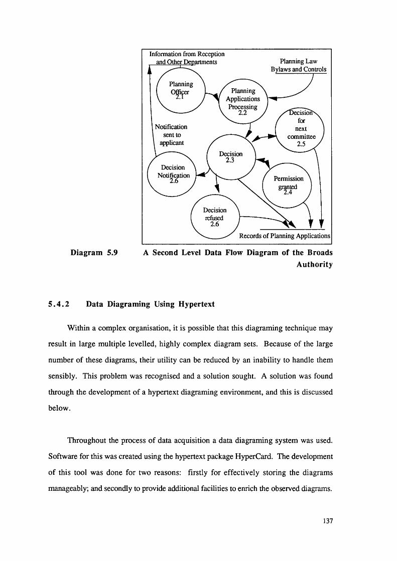
Information from Reception and Other Departments Planning Law
Bylaws and Controls
PlanningOJppr Planning
ApplicationsProcessing
2.2 lsion for
next committee
2.5
Notification sent to
applicant
Decision 2.3
DecisionNotification
2.6 Permission
Decision refused
2.6
Records of Planning Applications
Diagram 5.9 A Second Level Data Flow Diagram of the BroadsAuthority
5 . 4 . 2 Data Diagraming Using Hypertext
Within a complex organisation, it is possible that this diagraming technique may
result in large multiple levelled, highly complex diagram sets. Because of the large
number of these diagrams, their utility can be reduced by an inability to handle them
sensibly. This problem was recognised and a solution sought. A solution was found
through the development of a hypertext diagraming environment, and this is discussed
below.
Throughout the process of data acquisition a data diagraming system was used.
Software for this was created using the hypertext package HyperCard. The development
of this tool was done for two reasons: firstly for effectively storing the diagrams
manageably; and secondly to provide additional facilities to enrich the observed diagrams.
137

This system consists of work space, palettes containing diagraming components,
linking facilities and additional text processing. The system aids the analyst by allowing
the storage of diagrams levels. These facilities offer the ability to create diagrams with the
minimum of drawing time. This is possible because individual components of the
diagram can be copied and pasted into the diagram work space from the system’s in-built
palettes.
The Data Flow Diagraming Techniques of DeMarco (1978) and Gane and Sarson
(1979) were used. Certain minor modifications were made to the method to allow for the
use of hypertext links and text processing. Data stores, especially the database aspects of
the system, are represented using Chen’s (1976) entity-relationship database diagraming
notation. The components of this notation were also included within the palettes of the
system.
Moreover, the system allows the ability to enrich the diagrams by creating links
between chunks of information, to link processes with their lower level diagrams. This
function itself enables the analyst to gain more from the diagrams purely by the ease of
access. Therefore hypertext aids one of the major problems of data diagraming.
The developed system also provides enrichment of the data collected. This is
provided by the ability to add pop-up text fields throughout the system. These allow the
analyst to attach notes wherever s/he feels that additional information is warranted.
Examples of these system diagrams can be seen in Appendix 4.
In many ways the development of this tool can be seen to take Fletton’s (1990)
ideas of retrospective software documentation one stage further (backwards). This is
facilitated since the system provides the basis for self documentation during the
development of the system. Therefore as well as providing a tool for enhancing the
138

productivity of data diagraming, a second aspect of self documentation is also provided
by this system.
A versatile on-line tool was developed to aid the analysis of the Broads Authority’s
Organisation. Further to these achievements the values of this system were not forgotten
during the further stages of the specification and design of the Broads Authority
Information System Prototype. The diagraming System was extended to allow it to be
used during these stages. This system and the specification of the Broads Authority
Information System are described in section 5.5 below.
5 .5 Specification of the Broads Authority Information System
This section describes the specification of the Broads Authority Information
System. Whist completing this stage of the development, specification methods and on
line information storage tools were used. Again the description of the subject matter for
use within a hypertext system does easily lend itself to the sequential written word. A
fuller understanding is gained by viewing the hypertext system itself.
Specification is the translation of the informal user requirements into an
unambiguous form so it is understandable by the information systems development team.
For the Broads Authority Information System the specification is translated from the data
captured in the data flow diagrams using Structured English. Structured English is a
reduced vocabulary set of the English Language, where all words that create ambiguity
are removed. The system is then described using this vocabulary (DeMarco 1978).
The objective of this specification stage was to derive a specification for the Broads
Authority. At this point the questions concerning hardware specification were ignored. It
was hoped that this specification stage lay the foundations for an integrated solution in the
design stages of the development of this Information System. To aid this specification
139

stage, the data diagraming system was extended for use throughout this stage of the
information system development.
The diagraming system, described in section 5.4 above, was extended to
incorporate a specification styled interface. The abilities to link and annotate this interface
were implemented as before. This diagraming and specification system was used
throughout the specification of the information system to aid the storage of the
specification and documentation of the resulting information system.
For discussion purposes the specification has been divided into five main topics,
each of which covers a department of the Broads Authority. These topics cover,
Conservation, Navigation, Planning, Information and Interpretation, and finally
Administration. The specifications for each of these departments are described in the
following sections 5.5.1 to 5.5.5, although a further details of the specification are
shown in Appendix 4.
5 . 5 . 1 The Software Requirements of the Planning Department
Section 5.3.1 above describes the activities and the information needs of the
Planning Department. This section describes the software requirements that are necessary
to successfully support these activities. These requirements must completely encompass
the planning application processing function. To do this, applications and extra
information which relate to them must be stored electronically. For some applications it is
recognised that there will be items of information that will be difficult to store in this
manner and therefore within this system there must be a mechanism for locating
information which is stored externally. It is probable that it will be necessary to keep and
store the original planning application, and it is logical that other such materials, for
example technical drawing, may be stored similarly. The planning applications and
details relating to these features should be stored within a data retrieval mechanism similar
140

to a database. Further to the storage of the applications, additional information is often
used in the decision making process (e.g., the Broads Authority policies, and the area and
town structure plans). The information system is likely to be more successful if the user
is able to access all documentation on-line. Therefore, the system should at least include
summaries of these policy documents, if not the whole items, or references to where the
physical document may be located. It is recognised that the Planning Officers will be well
served if they are able to access an on-line set of maps for purposes of showing location,
infrastructure and zoning. Within this section, therefore, there will be the need to have
some interrogative techniques. For example, the planner may wish to overlay the zoning
maps with the ordnance survey plan bases.
The user must be able to access the details of the planning application and relevant
details about planning regulations, Broads policies and other relevant information in
forms such as maps. Where enforcement action is necessary it is appropriate that on-line
records of these activities are also kept. For enforcement on existing planning
applications or where planning permission is sought retrospectively, pointers can be
included in the records of the application to the enforcement records where further details
can be encoded. Where enforcement is necessary for illegal activities these may be
directly encoded into the enforcement records.
The listed buildings register is also a part of the Planning Department duties.
Although local authorities must keep a complete list, it is practically necessary for the
Broads Authority Planning Department to also maintain a register of these properties, for
reference during the consideration of planning applications. An on-line storage
mechanism is also appropriate here.
Finally the Planning Department is responsible for the development and update of
the structure plan for the Broads Authority’s Executive Area. The detail of these plans
and ideas for future developments may be stored on-line within a discussion section of
141

the system. During the creation and modification of these plans, a hypertext discussion
board may be a good mechanism from members interaction and full information storage.
Members of the whole Broads Authority are able to include their comments about the
proposals. Once this stage in the discussion of the plans is completed the whole plan may
be held on-line for use by the Broads Authority. Similarly a hypertext can be considered
as a good mechanism for users to access the final plans. The user then can navigate
directly to the specific section of the text which needs to be viewed.
It has been seen in sections 5.3.1 and 4.5.1 that the Planning Department reports to
a committee bearing the same name. It is necessary for the records of this Department’s
Committee to be stored on-line. These must be stored in a manner which is accessible to
the Planning Department and to the Administration Department, whose duty it is to
provide the agendas and the minutes of the proceedings.
Throughout the discussion of this Department it is clear that there is a need to build
in interdepartmental communications. It is recognised that the close community and
informal practices of the Broads Authority will be duplicated by the development of
interdepartmental communications, but if the Broads Authority is likely to grow in size
and nature, a formal communications system should be included. Further to this
interdepartmental record, a look up mechanism should be implemented. This will enable
an individual user in one department to search for record entries in any of the other
departments so that the whole information may be assimilated for reference and decision
making.
142
5 . 5 . 2 The Software Requirements of the Information and
Interpretation Department
The activities and information needs of the Information and Interpretation
Department have been briefly described above in section 5.3.2. This section describes
the software requirements of the Information and Interpretation Department.
One of the primary obligations of the Information and Interpretation Department is
that of publication. It would be most useful to the Department to have its own document
processing system to allow complete control over graphics, layout and final typesetting of
the documents. In conjunction with this document processing system the use of a
compatible high quality graphics capability is necessary to make full use of this system.
The Department like those of Conservation, Navigation and Planning may make use
of a map based system to determine the location of projects and information sign posts to
be elicited.
Finally the Department needs a form of flexible on-line record storage for the
storage of project information and information connected with the activities within the
Broads Executive Area. Such an on-line system could be used in conjunction with a
mapping system to add greater value to the information obtained.
5 . 5 . 3 The Software Needs of the Conservation Department
The main functions of the Conservation Department have been outlined in section
5.3.3. This section describes the software requirements that are necessary to successfully
support these activities. Since the work of the Conservation Department is so diverse it is
necessary to address the requirements that best suit the Department needs.
143

Throughout the whole of the Department’s work there is a definite need to use
maps. The Department must create its own map of the area and within every activity that
it carries out it is possible to see where the use of this and other map information could
prove to be very useful. Therefore the Department of Conservation would benefit greatly
from the use of map-based information interrogation throughout the whole of its
practices.
The Department also keeps several types of records, which range from applications
for drainage works licences to the storage of project data and reports. Each of these types
of information needs to be handled by this information system. It is thought that some
form of flexible on-line storage mechanism would be most appropriate for this type of
problem. Thereby the details and information for each type of record may be held within
the software structure.
Therefore the software functions of the Broads Authority may be completed by the
use of a map based interrogative tool, and a flexible records storage system.
5 . 5 . 4 The Software Requirements of the Navigation Department
The activities carried out and the information used by the Navigation Department
have been outlined in sections 4.5.4 and 5.3.4. This section describes the software
functions which must be incorporated into an information system to enable the efficient
running of this Department. These software functions are divided into two sections:
those that relate to the registration of vessels and their management within the Broads; and
those that relate to the physical maintenance and management of the Broads waterways.
Vessel management may be most usefully managed by using a database. At present
vessel registration is stored by means of a database. It is felt that this should be extended
to allow information such as the removal of obstructive vessels (sunken and abandoned)
144

and charges made for this purpose. The existing database features are depicted in
appendix 5.
The physical management and maintenance of the Broads is a very complex
problem, as described in section 5.3.4. There are several procedures which must be
followed whenever any maintenance must be completed. The features of maintenance are
all in the first instance map based, therefore this section of the information system must
have a map based element to allow the Department to plan the necessary licenses and
other items routinely carried out in connection with these problems.
Although severely curtailed by the policies of the Broads Authority, the Navigation
Department has responsibilities to make sure that all mooring provisions are located in
places where they are not a hindrance to navigation, and that these are not in areas where
there are high densities of other mooring places. The provision and the subsequent
maintenance of mooring places may be aided by the use of a map based interface, with
accompanying text information records. The user will therefore be able to see the level of
mooring provisions within the area and from this allow the update and management of the
mooring provisions. An underlying text information storage will enable the user to
access data as well as viewing these maps.
These map features may also be used to enable the maintenance of the Broads
Region. In the same way that the maps may show the location of moorings, they may
also display the licensing of works and maintenance. This may allow the coordination of
works enabling the minimisation of disruption to certain areas. It is possible that these
features may be augmented by the use of a mechanism for storing records attached to
these areas. By coordinating management, the application and issue of works licenses
and notices for the closure or the restriction of these waterways may be automatically
generated from the initial records of the maintenance problem.
145

Such a map-base section may also allow for the storage of accurate records for
items such as bye-law provisions and traffic speed limits throughout the Broads
Waterways, thus enabling the policing of these bye-laws by the river police.
Therefore the software functions for the Navigation Department comprise a pure
database and a map-based information system. The database mechanism would be used
for the routine management and administration of the vessels. The use of the second set
of management tools enables the effective overall management of the Broads Waterways
and the automation of many features. The design and implementation of these features
are discussed in chapter 6.
5 . 5 . 5 Software Functions for the Administration of the Broads
Authority
It is important that the needs of administration must also be integrated. To a certain
extent this is a more traditional problem in that the system can provide more
administrative functions at a more fundamental administrative level than the other
functions. These functions are more fundamental to the running of the Authority than the
management roles the system performs.
The functions of Administration are as follows: financial spread sheets and balance
sheets for accounting and audit; and stock control of vital commodities that the authority
uses, for example, stationary, photographic, field working equipment and similar items.
For these purposes a simple stock-control system is needed. It is also necessary to note
the word processing needs of the Broads Authority. At present word processing is only
carried out by secretarial staff and within the designed system there is a need for
compatible centralised word processing and printing facilities. Since it is seen that these
functions are vitally important to the development of the Broads Authority IS, these
functions have been specified.
146

5 . 5 . 6 The Overall Specification for the Broads Authority Information
System
Throughout the specification of the departments’ functions, (except the
Administration Department), it has been noted that there is a need to have a form of
geographical referencing of locations of projects and therefore there is also a need for a
mapping system. This has been specified. This facility will allow the Authority the
ability to see in map form, the location of, for example, a project, or planning application
or mooring point
It also became apparent that the ability of the system to allow the inclusion of
additional annotation information fields that provide additional comments and
documentation about an item, for example, a project, would also be useful. This was
also specified.
A specialised Geographic Information System (GIS), therefore, was considered to
be beneficial to the Broads Authority. A GIS certainly possesses the capabilities to use
map-based information and there is a functional ability to access data in many ways. It is
also possible for these systems to access and keep records for items attached to particular
spatial references. Therefore information can be stored and referenced by postcode or by
other indicators. It is interesting, however, that GIS, although having the functionality of
databases that can access data in a spatially referenced manner, are unlikely to be able to
allow for the diverse range of information stored within each field for each data item.
Depending on the region and the item in question there may be as little as a few lines on
an item or as much as twenty pages. It is unlikely that a conventional database, with
inherent rigid structures, will be able to handle this range. It is postulated that hypertext
may be able to provide augmentation for such facilities and provide links to other
important information about the region. For example, when the Planning Department
wishes to assess a planning application within an area of the Broads, the relevant data
147

may be retrieved from the system, a map appear next to the data and extra links may show
that there is additional important information about the area in the Conservation
Department. The planning application can then be considered in the light of the new
information. This is advantageous for both departments and the aims of the Broads
Authority, as well as providing a safety net to eliminate the embarrassment of a wrong
decision.
5 .6 Critique
Within each of the stages of data collection, documentation, data diagraming and
specification there have been many questions and criticisms that could have been
considered. These are included within this section.
The methods of data collection used during the study of the Broads Authority’s
organisation have been described in section 5.2. They are summarised as informal
interviewing, observation and document reviewing. It is recognised that each of these
techniques has its limitations. Informal interviewing allows access to the normal working
practices within the organisation. However this technique may lead to some of the less
usual practices being omitted and in some ways may give a distorted view since some
people with differing tasks may not be interviewed. General observation suffers not only
from these problems but also from the observer only being allowed to see selected aspects
of the organisation that is under scrutiny. In this light it is advantageous for the third
method of document review to be used. Here all the full mechanisms by which the
organisation is intended to be run may be formally reviewed by the analyst. It must,
however, be recognised that the formal system may not be used by the employees in its
specified manner at all times.
The use of each of these techniques is justified as they individually provide
information and insights into the system and together provide a comprehensive view of
148

the organisation. It is recognised that there is some overlap between each of the data
collection techniques but this is considered advantageous rather than redundant. The
overlap allows for cross-checking of information from different sources and therefore
enables a more complete study to be carried out. It is noted that these forms of data
collection individually will not be able to cover completely the whole organisation. The
use of the three methods together however may facilitate the collection of data on most of
the organisation’s functions.
Throughout the analysis of the Broads Authority all observations were documented.
Much of the initial data collection was completed and recorded in notebooks for further
study during this research. Once the initial data collection had been made, it was
documented and stored within a hypertext system (see sections 5.4 and 5.5). The main
organisational parts of the system were described pictorially and extra annotation
provided for each individual section of these diagrams.
This form of diagram documentation can be criticised as it is a summary of the
information within the documentation stage. This may result in the loss of some of the
detail. It is possible within the documentation stage that oversimplification of the data
may occur, although the prudent use of annotation fields may have prevented much of
this loss. This simplification may cause major problems during the specification and
design stages of the system’s development. To prevent further data loss, the use of the
linkage mechanism was extended to link between the diagraming and specification layers
within the system developed to contain this information. This method, as well as
providing a mechanism for documentation and information trapping, also provided a data
hiding mechanism by allowing pop-up text fields and inter-diagram and level linking.
During this first stage several questions had to be answered. These ranged from the
type of graphics to be used in the display of the diagrams, the method of including text
149

within the system, the methods of linking from item to item in the document system, and
finally how to handle the growing size of the document stacks.
With regard to the diagram graphics, two options were considered in the first
instance. These were either to use button icon objects or to use HyperCard’s graphics.
The simplest solution would have been to use button objects, it was found however that it
is not possible to display icons at the correct screen scale to be useful for this inquiry.
The second solution to the use graphics to display these diagrams was devised. It became
apparent that the amount of time it took to draw these diagrams using these graphics was
unreasonable. To solve this problem a range of palettes were created. The idea of these
palettes was to hold all the components of data and system diagrams in both button icon
objects and graphics format, so that the user has the choice. The use of these palettes is
facilitated by copying and pasting the graphics required onto the work space. By doing
this, diagraming was made more efficient.
The chosen method for showing text was that of the HyperCard text field. The
advantages of this are that these fields can be displayed and removed from the screen at
the request of the user. There was, however, one problem that was encountered. This is
that these text fields can only hold a maximum of 32K of information. The solution
employed for this problem was that of duplicate fields. The user requests more writing
space and the system creates another text field related to the first. Although this is not an
optimal solution to the problem it is an efficient temporary solution.
The mechanism of linking individual items together within these documents allows
extra functionality and information to be built into the system. The appropriate
mechanisms to complete this linking process are always available within hypertext
systems. At this point it seemed efficient to develop a mechanism that allows the user to
avoid having to use the hypertext systems that are hidden in every button. This was done
150

by use of a specially created link facility, which creates a link anchor and prompts the
user to set its destination by going to that destination.
Finally there appeared to be a problem that these documents are to be storage
inefficient. It is recognised that part of this problem is caused by using bit-mapped
images, which are storage intensive. This problem was kept to a minimum. By the
inclusion of a compacting routine in each document which compresses each document as
it is stored.
5 .7 C onclusions
In this chapter hypertext has been used for the analysis and specification of the
Norfolk and Suffolk Broads Authority case study. We have observed that hypertext has
fulfilled the following assertions made concerning its contribution in this area.
Throughout the data collection phase of this study hypertext was used as the vital
information storage mechanism. This storage mechanism was used for data diagrams.
As well as data diagraming the system also includes comment text and system diagrams
within it. By using this system it was felt that the consistency of document input and
storage aided the consistency of the data collection process. So the consistency and the
completeness of the information collected was better established. The visual nature of the
hypertext system, as well as the information storage structure, added to a greater
understanding of the problem, and therefore a clearer, technically valid specification.
However, the following difficulties were also encountered whilst attempting to
make the documentation system as simple to use as possible. These problems concern
graphics, the size of documentation documents, text input fields and item to item
hypertext linking.
151

Whilst engaged in using hypertext in this case study the following innovative
methods were employed. To facilitate inter-documentation linking a special linking
facility has been created. In an attempt to save time in the particularly laborious task of
creating the diagraming graphics, graphically based palettes containing documentation
diagram components were constructed. Each individual component can be copied and
pasted into the document diagram. To avoid a large increase in document size, an
automatic compacting routine was encoded into all projects. This means that as any
document is closed the hypertext system automatically compacts the document to its
smallest dimensions. It is unfortunate that this hypertext environment, HyperCard, is
only able to hold a maximum of 32 K in a text field. The documentation system avoids
this problem by the user requesting further writing space and another field being attached
to the same pop-up button. Finally, to make the user’s job of using this system as simple
as possible, the system has been programmed to open the HyperCard development
toolbox automatically so that the user can select tools at will without any extra learning
burden.
This chapter has described the analysis and specification stages of the development
of the Norfolk and Suffolk Broads Authority Geographic Information System. Chapter 6
describes the design and implementation of this system.
152

Chapter 6 The Development of The Broads
Authority Prototype
6.1 Introduction
This chapter describes the design and development of a prototype information
system for the Broads Authority. It attempts to look into the use of the development
media hypertext and through this experiment gauge its effectiveness as a prototyping
mechanism. It is intended that the design and implementation of the prototype will be
completely documented and analysed for comment in this chapter and chapter 7.
6 .2 Software Used for the Implementation
During this stage of rapid prototyping the appropriate software tools had to be
selected. The choice of software was initially constrained to those implemented on the
Macintosh hardware platform. This choice was made as more software products in this
field have been developed for the Macintosh and it is generally considered that this is a
superior development platform in this field. A short-list of 4 packages was drawn up,
these being SuperCard, HyperCard, Intermedia and Plus. HyperCard was selected for
the purposes of these experiments. There were several reasons for this choice. Firstly
Intermedia is unable to support a programming language, a critical criterion for these
experiments. From the remaining choice, HyperCard was chosen because of the greater
availability of documentation, both proprietorial and third party, and the availability of
reusable code in terms of stackware (proprietorial and third party systems). HyperCard
was also considered the most robust package and the best common denominator since
both SuperCard and Plus are able to convert HyperCard Stacks to their own format.
The software for use within this project is HyperCard 2.0 which is a recently
released version of this object based hypertext system. It is the most well established
hypermedia system so far developed. It offers hypermedia linking, large screen format,
153

colour and a static frame metaphor for the node interface. Several descriptions of this
software can be found in the relevant literature (Williams 1987, Gardner and Paul 1991)
but it is sufficient to say that HyperCard is a frame-based hypertext system. A brief
description is given below.
HyperCard is made up of stacks which contain cards, and these contain fields and
buttons. In conventional computing terms stacks can be broadly likened to files; cards
and backgrounds to records; and fields and buttons to objects within each record. All the
items listed above are objects and it is possible to place programmed codes behind each of
these to perform a series of functions. These functions are supported by messages
passing through the whole system from buttons and fields, to cards, to stacks and
backgrounds and finally to the home stack (see Diagram 6.1 below). The Home Stack is
a very important part of the HyperCard system. It administers all the “housekeeping” for
the system and acts as a final message handler. It is to the Home Stack that messages that
fail to activate a message handler are passed to the HyperCard Program system for error
handling. The Home Stack also deals with the storage of path names and other
administration. The Home Stack is often used as the top class of the inheritance
structure. It is here that much of the system code is stored for this system development.
HyperCard has an English-like programming language called HyperTalk. It is with
this language that all the objects of HyperCard are programmed and through this that
much of the functionality of HyperCard is achieved. HyperTalk is a very basic
programming language. It has 46 commands, 6 control structures, 58 properties, 11
constants, 49 functions and 21 operators. The language is extensible by the addition of
external
154

HyperCard
MOUSE
MENUFields, Buttons, Graphics
HyperTalk and External Commands
KEYBOARD
JLJtBackground
Foreground(s)Cards
MESSAGE BOX
fFields, Buttons, Graphics
HyperTalk Programs for this Card
Card Script
Background Script
IStack Script
ISystem Resources
(XCMDs and XFCNs)
Button or Field Script
ICard Script
Background Script
iStack Script
IStack Resources
(XCMDs and XFCNs)
IHome Stack Script
IHyperCard Resources (XCMDs and XFCNs)
Ilome Stack Resources
(XCMDs and XFCNs)
IStack Resources
(XCMDs and XFCNs)
IHyperCard
Diagram 6.1 The Structure of HyperCard (Poole 1988)
155

commands or functions (XCMDS and XFNS) that can be written in either Pascal or C.
These external software items can perform the extra functions that the initial functionality
lacks. This extensibility of language has become a regular feature of hypertext
development environments. This is all summarised in Diagram 6.1 above, which shows
all the detailed levels, hierarchies and inheritance structures within the application.
The limitations of HyperCard are again well documented and a full discussion of
these shortcomings can be found in Conklin (1987) and Gardner and Paul (1991).
HyperCard is not a full hypertext implementation. Although HyperCard has nodes and
links and has a standard hierarchy of objects ranging from the Home Stack to buttons and
fields, it does not have a general mechanism for hierarchically structuring cards. Stacks
cannot be nested, which in effect makes the hierarchy only one layer deep. There is no
standard text formatting in the sense that link anchors from text to other node points are
not an inherent design feature. There is also no graphical browser for showing the local
or global arrangements of cards within the webs. This means that the user is unable to
gain a general picture of the system or to use the advantages that these facilities would
offer. The lack of these features prevents HyperCard from having the status of a true
hypertext, but from a prototype development point of view it does not detract greatly from
the functionality of the system.
6 .3 Design Specification for the Prototype
The specifications discussed in chapter 5 were incorporated into the design of the
prototype system. The specifications were translated into drawings and commands that
were implementable with the prototyping software used. At present there do not appear
to be any robust methods for designing information systems within hypertext systems.
The design guidelines of Riley (1990) and Shaffer (1987) were used. Riley (1990)
details guidelines for user system interface design and Shaffer (1987) details guidelines
for stack development. From these sources of information a design method was devised.
156

To this end the user system interface is discussed in section 6.3.1 and the overall
structure of the system is discussed in section 6.3.2. The implementation of the
prototype is described in section 6.4. It is worth reiterating that the description of the
subject matter for use with a hypertext system does not easily lend itself to the sequential
written word. Proper understanding is gained by viewing the system itself.
6 . 3 . 1 User Interface
The design of the user interface was carried out using the guidelines of Riley
(1990). The interface was designed to provide functionality with the lowest possible
learning overhead to the user. The mechanisms by which the user may interact with the
system reflect this factor. The use of a command line interface was disregarded in favour
of a command palette, pop-up menus and buttons. The mechanism of a palette of
commands was designed (see diagram 6.2). Such palettes are becoming a standard in
user system interface design. It is defined in terms of a tear-off menu which may be
placed anywhere on the screen. The commands on this palette are those which are used
often. These are depicted as icons and words. This palette is always available. The use
of such a palette is beneficial to the design in terms of reduced code duplication. The
functions defined for the palette are: move to the previous hierarchical section; move to
the previous screen; move to the next screen; open the mapping section; open a help
facility; move to the top of the hierarchy; search the database and finally quit the system.
This palette will be refered to as the navigation palette throughout the rest of this thesis.
Pop-up menus are employed in certain instances where the user must make a choice
from several options. This allows the user to make choices simply avoiding screen
clutter. Buttons are appropriately placed throughout the system were additional (one-off)
features and functions are necessary.
157

Riley (1990) outlines basic guidelines for the layout of screens, (e.g., for the
placement of text, dialogue boxes and graphics). This design was carried out in the
following manner. The screen layouts were planned according to these rules. The actual
depiction of the screen layout is shown in diagram 6.2. The pictorial view of the screen
layout shows that the interface is divided into three sections diagonally with command
characters placed in the bottom right hand and top left hand corners. The command
features are permanent throughout the system and may be accessed at any time.
Activate Navigation
Palette ~
Data and Information Interrogation
MapArea
Add Extra Annotation
t - Field Throughout the System.
Diagram 6.2 The Basic Design of the User System Interface
The first decision within this stage of design was the choice of screen size. The
size of the monitor on the machine used to develop the system was chosen to be the most
functionally suitable for the end use of the system. The size of an Apple Macintosh II
standard colour monitor is 440 by 640 pixels (this does not, however, entirely preclude
the use of smaller monitors for running the system, as the rest of the node may be viewed
158

by using view/selection panels). The use of this standard sized monitor also provides a
good basis for portability of the final product to other systems (see diagram 6.3 below).
Secondly, HyperCard is able to support windowing, and because of the greater
functionality that is afforded, windows were implemented. It was decided to use a range
of window sizes, each compatible with the function of that part o f the system. It was
decided that the maximum size of these windows should match the size of the Apple
M acintosh Computer Screen, that is 640 by 400 pixels. With the exception of the
navigation palette, a minimum window size of 512 by 342 pixels was also set (the size of
an Apple Macintosh Plus Screen). For this prototype system it was felt that functionality
would be greatly reduced below the size of an Apple Macintosh Plus Screen.
640 pixels
Movable ' Pop-up
menucx
grid for use of
activation of areas
Separate repositionable
tear-off menu for navigation purposes
Add extra annotation
field throughout the system.
Diagram 6.3 The Planned Navigation Tools
159

Finally, the use of a special type of link known at this stage as the annotation link is
available for use. This gives the Broads Authority the ability to attach extra information
fields throughout the system to give additional detail about areas of the Broads and special
regulations that refer to that feature. The ability to create personal annotation facility is
also planned. These features are constant throughout the system (see Diagram 6.3 above).
6 . 3 . 2 Overall Structure
The process of structural design is broken down firstly into functional requirements
and then by technical components.
The observed everyday functions of each department identified in the data diagrams
have been included in the design of the Broads Authority Information System. The
common components of these departmental needs were extracted and used as the principal
design template. It is recognised that this template is not sufficient for the needs of each
department of the Broads Authority. Additional features for individual departments were
also prepared. The designs of these departmental systems are described in the following
paragraphs and in diagram 6.4.
Functional support for common facilities for word processing, database access,
spread sheets and graphics were designed so that the system is extensible and able to
access directly commercial software packages. These facilities are available throughout
the system.
The final facilities which are common to most departments are the reliance on
interrogation of maps of the Broads Authority’s Executive Area and the adjacent areas of
the surrounding boundaries. There are several design points that must be noted. Firstly,
the use of maps is both for visual and data interrogation. The system must be able to
show the maps clearly and at the correct scale. The user must be able to click on the
160

screen map at any point and go to the next more detailed map. The resolution of the maps
was designed to ensure access to the highly detailed maps. The user must also be able to
interrogate the database that is attached to these maps in a logical manner and accordingly
the location of the maps must be referenced in the database. Thus the user interrogating a
map will also be able to access, intelligently, any data related to any location or area of the
Broads.
In common with many conventional paper maps and GIS it is not possible to store a
complete seamless map within this prototype. The mapping section therefore controls
maps by using a tiling mechanism. The map is segmented and displayed as individual
pieces of a mosaic. Navigation around this section of the system is controlled by
command keys and buttons. From these, the real location can be derived and the correct
map displayed.
It was recognised that problems would occur at the boundaries of map tiles. It is
possible that locations that physically appear at the edge of map sheets could be difficult
to access. This problem is well recognised from the experiences of the maps of the
Doomsday System. The coarseness of interaction and a lack of overlapping of the map
sheets can cause the locations on the edges of maps to be difficult to interrogate in a
useful manner. This prototype includes an element of duplication for 10 mm (an area up
to 0.5 km in width, depending on the map scale) around the edge of each map sheet.
This means that each map at the same level will store 10 mm of the surrounding edge of
the map sheets on all sides of it. The incorporation of map overlapping inevitably
involves a degree of redundancy. To maintain the functionality of the system, however,
it is necessary to incorporate this into the design. The choice of 10 mm gives the user the
ability to see clearly where locations are.
HyperCard is a raster based software package, therefore all maps included within
this system must be scanned raster images. Spatial data in vector format (e.g. Ordnance
161

Survey digital outlines) may be appropriate at a later stage of development, but for this
prototype all spatial referenced data is displayed solely in raster format.
Individual departments all have functional requirements which are different, for
example, the Administration Department is the only department which needs access to
accounting software. Therefore, where necessary, additional functions are included for
each department.
The technical requirements were planned to take maximum advantage of
HyperCard’s Object features (see section 6.2 above). A modular design was adopted
which takes advantage of these message handling capabilities. Since messages may be
“passed” through the object hierarchy it is logical to attach all common features handling
code to the Home Stack, which occupies the highest class position. The number of
backgrounds was also minimised in order to limit the number of classes within the
prototype.
162

Each LeadsGridding for Zooming to a Different
on Map Details Function for theBroads Authority
Search
Information Retrieval
Data Entry
Word Processing
Report Generation
Get all Information on this Grid Square
Each Function has a Different Screen
and Different Background (Class)
Diagram 6.4 The Basic Needs of the User System Interface
Within the hypertext system the hypertext file handling structure requires no outside
handling. Where specific file handling functions of the system are designed to import and
export data and to write command or data files for the system, these file handling
capabilities have been included. File handling with regard to other commercial
applications software allows the user to open a specified document by name from within
the system or by indirect access once the program has been activated. This design,
therefore, takes full advantage of the features of hypertext systems considered in chapter
2 above.
163

6 .4 The Prototype
To explore the effectiveness of this hypertext system for the ideas of rapid
prototyping, a partial prototype Information System for the Broads Authority was
developed. The implementation was carried out in the following manner. Firstly the
basic web structure was developed. This involved the construction of stacks, cards and
the navigation (movement) system. Secondly all common functions were encoded into
the Home Stack and departments. Finally all specialist functions were encoded. These
functions and facilities are discussed further in the following sections.
6 . 4 . 1 Aspects of System Design
The prototype system has been created as close to the initial design as possible.
There have however been some small modifications made to accommodate the removal of
errors and to aid the efficiency of the system. These changes include the modularisation
of the map section into a stand alone section which is accessible by all departments. This
change was made to reduce redundancy within the system. Secondly the use of a pull
down menu is implemented constantly throughout the system. This menu enables
annotation, the access to the navigation palette and find facilities which were originally
located as buttons on cards. By placing these in a pull-down menu, this aids the
efficiently of the system, the consistency of the interface and reduces redundancy. For
ease of construction and maintenance a modular development approach has been
employed. For this reason all departments and major features are individual modules, or
in this instance, stacks. The system is described in terms of its user system interface,
navigation or interaction and functionality.
The user system interface was implemented in a manner functionally similar to the
planned interface. There were two variations to this interface. These were that constant
buttons such as annotation, palette access and find facilities were moved to a pull-down
164

menu. Secondly, departments were given different background patterns so that the parts
of the system could be recognised.
The system navigation has been implemented in 3 complementing ways. These are
the navigation palette, buttons and windows. The navigation palette provides basic
interaction facilities. It allows the user to proceed to the next or previous sequential
screens. It also allows the user to step up through the hierarchy of the system to the
previous system section. The palette also allows access to the mapping and database
sections of the systems. It also provides fast access to the introductory screen of the
Broads Information System. Finally the palette provides a mechanism to quit the system
completely. During this stage it was recognised that the specification and execution of
this palette design had to be clear to avoid poor user interaction with the system.
The second navigation technique is that of buttons. The function of buttons is to
carry out actions which are only needed in either one section or one card. These are
therefore included as and when necessary throughout the system.
Finally since the system is based on a windowing environment, this further aids the
user. Sections are opened in individual windows. Therefore, if the user wishes to go
back to a previous section, s/he simply clicks on the required window.
6 . 4 . 2 Features of the System
The functionality of the system is divided into departmental functions, maps, a
database, and annotation.
It must be noted that access to each department is completed by correctly entering
the password for that department. Functions which are common to all departments have
been included in two ways. Access to the mapping and database sections of the system
165

have been included under the navigation palette mechanism. As described above this
mechanism allows the user to select an item from the palette that is to be opened. Further
features such as access to word processing, spreadsheets and graphics packages may be
gained by use of the Broads Authority pull-down menu. This menu accesses all software
packages without the user having to have knowledge about the underlying operating
system. On the selection of a package, the system prompts the user for the name of the
file or whether it is a new file, either of which is subsequently opened.
The map module of this system has the functionality of allowing the access and
display of data at three levels. The navigation mechanism for this section, its advantages
and disadvantages are discussed in sections 6.4.3 and 6.4.4.
The database system used for this experiment is Oracle for the Macintosh (Oracle
Corporation). The database is accessed through a proprietorial HyperCard front-end,
which has been modified to integrate into this information system. Oracle is a relational
database and operates by using a query language called SQL (Structured Query
Language). The HyperCard front-end uses a modified version called HyperSQL.
Therefore the interrogation of the database within this information system is controlled by
the HyperSQL language. The database created for this information system can, therefore,
be tailored to suit the Broads Authority. Data stored within the database can be exported
so that the map module or other software packages may display the coordinate data.
As mentioned in section 6.3, the system is further enhanced by giving the user the
ability to annotate the system with text. This provision is enabled by the user selecting
public annotation from the Broads Authority Menu. This function provides a pop-up text
field which may be dragged to any point on the screen. The existence of the text field is
marked by a special button. This button opens and closes the pop-up text field. Such
text fields can be viewed by anybody and are called public annotations.
166

The system also includes a feature for individual annotations, when an individual
selects this option, the system provides a password protected small note pad for the user
to write comments on. These note pads provide the ability to use text and graphics.
Links can be made between these comments and the particular sections of the system that
they refer to.
Within each of the departmental sections there are points where information can be
included and linked with other pieces of information to gain a complete image of the
features of a particular problem. These features are made available within the individual
sectors of the departments. Although there is the need for confidentiality, it is also
recognised that there is also the need for cross-departmental cooperation. This
cooperation can be enhanced by the making of links within these departments’ texts on
certain issues. For example, where there is a planning application that involves an SSSI,
it may be useful to cross-reference the data held by the other departments to provide
insight into the true nature of the problem.
This section has discussed systems features in broad detail. The next section looks
in more detail at the geographic features of this information system.
6 . 4 . 3 Mapping and GIS Functionality
The development of geographically-based information interrogation tools was
constrained in two main areas. These were, firstly, by the types of tools which are
considered appropriate for the Broads Authority and secondly, by some technical
problems which are discussed later in section 6.4.4. Each of these constraints has limited
the number of features that the developed system contains.
The map module of the system is based on the Ordnance Survey maps of the
Broads Authority’s Executive Area. There are three levels of maps stored within the
167

system. These are accessed by use of the mouse: if the command-key is held down the
user may access a more detailed map; if the option-key is held down, then the user can
access a less detailed map; if a mouse click is used by itself, then the user can explore
surrounding map sheets at the same level. This is done by clicking on the side of the map
that the user wishes to explore next. (Note: the command and option keys are specialised
keyboard keys found on all Apple Macintosh Computers).
The medium for map display used in this system was bit-mapped images. There
are many advantages and disadvantages of using these, and these are discussed below in
section 6.4.4. Map images are displayed on the background of each card. These images
were scanned from Ordnance Survey maps using a package called HyperScan (Apple
Computers Inc). Data to be shown on these cards is then displayed in the foreground.
Geo-referencing for the area of Norfolk and Suffolk is based on grid referencing
and postcodes which have been assigned grid references. This referencing system
operates by taking the the grid coordinates and generating a small dot that appears on the
screen map at the point at which the information relates to the map. During the
interrogation of these points the coordinates can be mapped onto the relevant scale map to
show the distribution of the data. Further functionality is encoded into this system giving
it the functionality of being able to display the prepared polygons and line data. This data
is displayed in a similar manner to the way in which point data is displayed on the screen.
Geo-referencing is the key to this GIS’s functionality and aids the maximum utility of the
system to be gained.
The GIS functions of this information system enable the user to produce new maps
from the originals by overlaying an existing map with a data or map plane. These maps
and planes may be held as polygon or raster units. The system devised for the Broads
Authority holds all information in graphical representation in raster format. The overlays
in this instance may be prepared as a painting operation on the computer screen.
168

The system also handles the calculation of lengths, which is carried out by a
conversion from screen point to point. If the road bends, then the length of the road must
be measured in sections to take account of this. The calculation of road lengths within
this system is carried out in this way because of the functionality of the software
environment used to create this Information System. It is not possible to create and
measure vectors within this software, as all images are handled in raster format. A grid-
to-grid measurement can be created. The limitations of this are discussed in section
6.4.4.
6 . 4 . 4 System Limitations
This system is a prototype and in no way is it intended to be a fully constructed
system. As with the development of any prototype system it has its limitations. There
have been several changes to the specification where mistakes have been rectified. These
limitations fall into several categories: screen and image problems and the resolution of
the software screen.
During the development of the map module there were several problems, mainly
connected with the inclusion of graphics into the system. The intended method of
graphics inclusion was to be high quality colour graphics, in Macintosh terminology
“PICT2” files. HyperCard only supports colour graphics through extemal-commands
which have been written to complete this task. These graphics can be displayed into
HyperCard, but it is not possible to superimpose HyperCard paint layers on top of these
images. Therefore it was impossible to use this method of graphics display. A substitute
was found. These were bit-mapped images. The quality of the images is poor and makes
the use of the system harder. But by using these maps the functionality of the system can
be fulfilled more fully than by using “PICT2” images.
The development of this prototype encountered several problems connected with the
screen resolution controlled by HyperCard. Many products support a high screen169

resolution but HyperCard limits the screen resolution to 72 pixels per inch, which
therefore make image handling difficult and calculations based on screen coordinates
inaccurate.
Further limitations of the system lie in the problem of the software used for the
design of this prototype. This relates to the images handled and the calculations in maps
and on the analysis side of the system that are carried out in a raster format. All the map
images within the system calculate their grid coordinates and other functions from the
resolution of the pixel level of the data stored. Where calculations and analysis are solely
dependent on the pixel level of the data the accuracy of the analysis is governed by the
coarseness of the data available. There is an enforced low level of data display accuracy
as coordinates must be displayed to the nearest pixel. Thus the calculations of buffering
and corridoring, as well as area and length are likely to incur minor measurement errors
which may be higher than normally tolerated in such circumstances.
6 .5 Methodological Implications
From the point of view of the design and implementation of system prototypes
using these environments, there have been several lesson leamt. These point to ways in
which these systems must be enhanced in order to be able to handle these implementation
problems well. These systems must be able to handle high resolution graphics, and they
must also support high level screen resolution. The range of objects available in
hypertext should also include graphics to enhance the functionality of these systems.
Numerous criticisms of the methods used in information systems development
prototyping have been made. These have made it difficult to condone this approach to
systems design. It is possible that with the ideas developed in chapter 5 and this chapter
using hypertext there may be a radical improvement in the time savings for the design and
implementation of software systems. With the ideas of hypertext and development
170

environments there are large time savings to be made within the development life-cycle
process. There are also the added advantages of the extra capabilities that these types of
systems are able to contribute to the notation and information enrichment of the data
available to the information system user. With the introduction of hypertext there is also
the incentive to encourage the user to express his/her wishes about the system and for the
user to gain the maximum benefit from the new system.
Compared to the traditional software development life cycle, it is possible to see that
there are likely to be great advantages from these methods. The use of these processes
can assist in the creation of better documentation of the systems developed. This was
done in three stages. As described in Chapter 5 the stages of system development, data
flow diagraming and specification can be created and stored within a hypertext web in the
system. This allows all users accessing the system to have a complete working and
constantly updateable model of the system that is being designed. This is useful where
the system is being designed by many people who may at different times all need access
to different aspects. Having an on-line system available for all the designers to see will
allow the consistency of design and annotation structures within the designed system to
be more rigourously enforced. Secondly, with a complete understanding of the data and
information flows of the system there is a much greater insight into system
documentation, and thus the ability to produce good rigourously designed system
documentation before and during the implementation is greatly enhanced. From this it is
possible to see that these systems may provide the basis for self documentation.
6 .6 Conclusions
This chapter has described how hypertext has been used for the design and
implementation of a partial Broads Authority prototype information system. We have
observed that hypertext has fulfilled the following assertions made concerning its
contribution in this area. The creation of a multi-layered hypertext document storage
171

facility to aid the storage of information connected with this project, from data flow
diagrams to system implementation documentation. Secondly, the design of the
information system and the storage of its pre-implementational documentation. Thirdly,
the implementation of the prototype information system has been carried out using
hypertext as its implementation medium.
Despite these problems using HyperCard in this manner, throughout the
development of this prototype it was necessary to repeatedly refocus the development
towards the issue that this experiment was only to produce a prototype. The versatility of
hypertext systems may allow the developer the luxury of creating a fully operational
information system within this environment. It is important to state that the implemented
prototype is an example of what might be considered as a Fully Integrated Environment
for Layered Development (FIELD) approach to Information Systems Development. The
analysis to implementation stages are combined within the one environment, and
explicitly linked in that the various layers, analysis, specification, design and
implementation are logically connected. Not only does this assist in understanding what,
how and why the system functions but it means that subsequent adaptation is no longer
sub-divided in an unnatural way to the previous steps. The full power of the FIELD
concept is amply demonstrated in the case study prototype.
The following problems were, however, encountered. The resolution of raster map
image storage was considered to be inappropriate for the detail of visual interrogation and
analysis at which the system was designed to operate. Secondly, the nature of
HyperCard’s display was considered to be critical in the limitation of the number of
functions which could be included in this section of the system. The final problem that
was encountered was that of the screen resolution. Since all coordinates are displayed in
screen coordinates which have been converted from Ordnance Survey, the resolution of
the screen becomes vital. In some of the larger scale maps the accuracy of the map
analysis is much lower than is acceptable.
172

Whilst engaged in using hypertext in this prototype development, the following
innovative methods were employed. In the case of the quality of the maps it was
considered prudent to employ the use of bit-mapped images instead of high resolution
graphics in the background of cards and allow a transparent card to act as a layer on top
of it. On this layer all the raster graphics and analysis can be completed. It is unfortunate
that the nature of the display of HyperCard is limited by the resolution of the screen. It
was possible to limit the inaccuracy of these systems where possible by displaying data at
the correct scale in terms of maps and data.
This chapter has described the design and implementation of the Norfolk and
Suffolk Broads Authority information system prototype. It illustrates the versatility of
hypertext within this field and shows its potential for future developments in software
engineering. The implications that these new tools will have for the development of
future software will be discussed in Chapter 7.
173

Chapter 7 Summary and Conclusions
7 .1 Summary
This chapter summarises the results and findings of this thesis. It draws out the
major conclusions and discusses their relevance to information systems development.
Finally it looks to the future and discusses possible trends within the fields of software
development and hypertext.
As outlined in Chapter 1 this thesis has aimed to explore and experiment with
information system development prototyping through the medium of hypertext. It has
used the Norfolk and Suffolk Broads Authority and the development of Geographic
Information Systems to suit their needs as a case study. In this context Chapter 1
provided an introductory overview to this thesis area. Chapter 2 provided a detailed
overview of hypertext and hypermedia. Chapter 3 provided a detailed description of
Geographic Information Systems both in terms of their technical details and potential
applications. Chapter 4 described the Norfolk and Suffolk Broads Authority, its history
and functions. Chapter 5 described the systems analysis and documentation of the
Norfolk and Suffolk Broads Authority Information System. Chapter 6 described the
design and implementation of the prototype Norfolk and Suffolk Broads Authority
Information System and discussed the methodological implications of these experiments
for information system development.
7 .2 Conclusions
This thesis has discussed hypertext, Geographic Information Systems and
information system development. It has examined information systems development. It
has also examined mechanisms which offer substantial improvements to these techniques,
especially prototyping. It has addressed a case study, the Norfolk and Suffolk Broads
174

Authority and with respect to the geographical nature of this case study the area of
Geographic Information Systems is also addressed.
The main contributions to research in information system development are as
follows. Hypertext can be successfully employed in the field of information systems
prototyping. Moreover, hypertext can be usefully employed throughout the whole
information systems development process. As well as a software development tool, extra
benefits can be obtained from its use, by using hypertext as the development environment
it may also be further possible to extend the use of hypertext to include the final fully
operation information system. These benefits are namely in the fields of system analysis,
documentation and data diagraming.
The mechanisms that have been outlined throughout this thesis allows the process of
systems dynamics to be seen more clearly, so leading to a greater understanding of the
system observed. This facilitates the inclusion of further organisational information
flows more effectively by using the web techniques. Greater understanding of the
systems dynamics and organisation as a whole may be gathered and thus a closer fit to the
final needs of the organisation may be created.
Such techniques provide the developer with the ability to build a prototype. Moreover the
developer is able to build a model of what s/he thinks represent the dynamic systems of
the organisation. The developer may continue to experiment with the model created by
the prototype until s/he is satisfied that the model represents closely the system observed.
Such facilities may allow the creation of an information system which is closer to the
users' requirements, and through these will allow the developer to alter the final system
more effectively by using the model of the system.
Through the development stages of these models an information system prototype
may be useful to improve the efficiency by providing management information regarding
175

the structure of the organisation, the flows of information and control. Such information
may be invaluable when reorganisation is proposed.
This research demonstrates that systems analysis and documentation can be
efficiently enhanced by using hypertext technology. This aids the understanding and the
consistent documentation of an existing information system or process. These systems
store the documentation in one place and in a consistent format. Since the whole system
may be documented using this technology, this facilitates annotation and allows
information linkages to be performed. This enables extra contextual information to be
included within the system. Hypertext systems enable the complete diagraming of a
potential information system. Hence it is possible to include more hidden information in
each diagram. For example it is possible to store each process in a diagram and to store a
detailed description of the actual features that are proposed for the process.
The use of a documenting system during the development of this prototype has
demonstrated the creation of linkages and therefore relationships to the original systems
analysis and specification. In general when using such capabilities, more of the systems
analyst’s original reasoning for data and systems design can be traced back to the system
that was originally observed. This is useful in two ways. Firstly, it improves the overall
design of information systems since all the diagrams are present within the system. Thus
the analyst can refer easily to the correct part of the diagram and, as a result of this
continuity, fewer errors will appear in the final system. Secondly, because of the nature
of the environment, these systems free up analysts time once the system goes to the
coding stage. For example, this may occur when a programmer discovers a problem.
The system may be used as a first stage problem solver thus allowing the analyst to be
called upon only at a secondary stage. Considerable time savings may occur both in
terms of the project and of the individual analysts’ time.
176

For documentation support, hypertext is a valuable tool for the software developers
tool-box. Its benefits do not however stop there. Hypertext environments such as
HyperCard have their place in the development of prototypes. The prototypes developed
for this thesis were those connected with software documentation systems and the
development of a prototype information system for the Norfolk and Suffolk Broads
Authority. Chapters 5 and 6 have described in detail the systems analysis, design and
implementation of this system. In terms of its proficiency of development the critical
development time was remarkably small, approximately 2 months. The inclusion of a
proprietorial database allied with the more fluid data handling of hypertext is beneficial.
The development of geographic data handling proved to be straight forward. Although
the implementation of a GIS is not a mainstream problem in terms of information systems
development, it is an extremely difficult and worthy test for such an experiment.
The development of an information system for the Norfolk and Suffolk Broads
Authority proved to be a successful experiment in the development of information
systems using hypertext technology. That it has to date been impractical to return to the
Broads Authority to ascertain their feedback about the system prototype design and its
appropriateness to their working practices. It is foreseen that their future participation and
comments will be included in further design and implementation iterations of this
prototype development and its completion and documentation. The development of this
prototype information system reflects the benefits of techniques in information systems
development and may be considered as an extension to the software development life
cycle.
The main contribution of this research has been in the development of the Fully
Integrated Environment for Layered Development (FIELD) concept. It has been shown
in the development of this system that the FIELD concept can be implemented
successfully, and that its contributions to enhance development speeds, reliability,
understanding and knowledge sharing are extensive. As well as storing and linking the
177

analysis, specification, design and implementation layers in one environment, the FIELD
approach to information systems development also encourages the addition of new aids.
Inter-layer linking provides the ability to follow changes to the system through to all
layers in the environment. Hence, for any particular design attribute, proposed
modifications can be investigated by pursuing the attribute linkages.
7 .3 Future Work
The future of hypertext software development is promising. The future of
applications of hypermedia in software development is categorised by the widespread
adoption of these techniques in software development and the development and adoption
of hypermedia to enrich information systems once developed with its abilities to provide
new features.
It is interesting to imagine future research within this area. There are three main
strands of research which are brought forward by this thesis. These are: the further
testing of the FIELD concept; the assessment of the potential for creating a complete
information system within a hypermedia environment, and finally investigation into the
appropriateness of the inclusion of hypermedia aspects within a traditionally created
information system.
The FIELD concept has been implemented as a prototype. It will be necessary to
implement a complete robust version of this development tool to enable further work to be
completed. This concept must be further tested to evaluate fully its usefulness as a
development aid throughout the sphere of information systems development. It is
postulated that in the fullness of time such development tools will provide utility
throughout information systems development.
178

As mentioned in Chapter 6, the potential for information systems development
within a hypermedia environment is very clear. The use of hypermedia as an overall
operating system which enables the seamless control of multiple media sources must be
investigated. In addition to this the potential for information systems development within
a hypermedia environment is recognised. It is imperative that further research into this
area must be carried out to ascertain the full viability and the additional benefits over
traditional approaches that might be offered by such environments. Further to this it
would be interesting to see how traditionally developed information system may benefit
from the inclusion of hypermedia facilities. It is postulated that from these humble
beginnings great benefits may follow.
The benefits from these areas will provide “food for thought” for the software
production industry. FIELD is a very positive mechanism to ensure stability of design
mechanisms. It is predicted that the world of software development will embrace the
technology of hypertext throughout the complete design and implementation of
information systems. It is plausible to expect that the stages of information systems
development may be considerably enhanced by the constant use of hypermedia. Errors
caused by incomplete changes in the design of the information system may be kept to a
minimum through use of the FIELD concept, additional benefits may be gained through
hypertext environments being used as additional features within information systems or
as developments environments.
179

Appendix 1 Hypertext Packages
The majority of hypertext system use work-stations or personal computers as their
hardware platform. Therefore the description of hypertext packages will be based around
these platforms. Work-stations on which most of the early hypertext system were based
on work-stations such as Sun, Symbolics and Xerox Lisp machines (see Table A l.l
below). Personal computers such as IBM and Macintosh machines have been the
preferred platform for many of the more recent developments within the sphere of
hypermedia. Packages for all the above mention hardware platforms and their features
are summarised in Table A l.l.
There are some clarifications which must be made to the definitions of each of the
columns of Table A l.l. These are:
Hierarchy Specific hierarchical structures supported.
Graph-based System support for non-hierarchical (cross-reference)links.
Link Types Linking ability to have categories.
Attributes Ability to support user-designated attribute/value pairs inassociation with nodes or links.
Paths Ability to support for many links to be strung together intoa persistent object.
Versions Ability to support more that one version for nodes andLinks.
Procedural attachment Support for arbitrary executible procedures to be attachedto events at nodes and links.
String search Ability to support hypertext searches for strings.
Text editor Type of editor supported for creating and modifying thecontents of nodes.
Concurrent multi-users Ability to support several users editing the same hyperdocument at the same time.
180

Pictures or Graphics Ability to support pictorial or graphical information inaddition to text.
Graphical browser Support for a browser which graphically represents thenodes and links in hyper-documents.
Platform The hardware platforms on which these systems arecommercially available.
The data for Table A l.l below is mainly taken from Conklin (1987), but has been
augmented for the purposes of this thesis. This table dose not include some of the more
recent systems which purport to be hypertext systems, as these systems are found not to
incorporate many of the desired features for hypertext systems.
181

Hierarchy Graph based Link Types
Attributes Paths Version
Boxer Yes Yes Fixed1 No1 No NoCREF Yes Yes Yes No No By linkEmacs INFO Yes No No No No NoIBIS Yes Yes Yes No No By Link
Intermedia Yes Yes Yes Yes No2 NoKMS Multiple Yes Fixed No No1 YesNeptune Yes Yes Yes Yes No YesNLS/Augment
Yes Yes Yes Yes Yes Yes
NoteCards Multiple Yes Yes Nodes No No
OutlineProcessors
Yes No No No No No
Plane-Text Unix File sys.
Yes No No No No
SymbolicsDocumentExaminer
Yes Yes No No Yes No
SynView Yes No No No No No
TextNet Multiple Yes Yes Yes Yes NoHyperties No Yes No No No No
WE Yes Yes No Fixed No2 No2
Xandau No Yes Yes Yes Yes YesZDG Yes No No No No NoTable A l . l Hypertext Systems and their Features
Procedural Keyword Text Concurrent Pictures Graphical PlatformAttach-ment or
StringSearch
Editor Multi-Users or Graphics Browser
Yes Yes Emacs No Yes Yes ★No Yes Zmacs No Yes No *No No Emacs No No No *No No Basic
Texteditor
Yes No No AppleSun
No2 Yes Custom Yes Yes Yes IBM 2250Yes Yes Wysiwyg Yes Yes No *
Yes Yes Custom Yes Yes Yes UnixYes Yes Small-
Talk80editor
Yes Yes Yes *
Yes Yes Interlisp Yes Yes Yes XeroxSun
No Yes SunView
Yes Yes Yes *
No Unix/grep
SunView
Yes Yes Yes *
No Yes None No No No *
No No Line ed/ Unix
No No No *
No Keywd Any No No No IBMNo No2 Basic
Texteditor
No Yes No IBM
No2 No Smalltalkeditor
No2 Yes Yes *
No No Any No Yes No SunYes Full Text * Yes No No
Appendix 2 Applications of Hypertext
Within the area of hypertext there are several overlapping spheres where hypertext
can be and is applied in the modem world. This appendix outlines briefly the types of
hypertexts and their applications.
2 .1 Computer Applications
Hypertext can be used to prototype the user interface for other computer programs
because most initial prototyping consists of linking together screen designs and
presenting them to the user in an order determined by simple user actions. Extremely
simple prototypes can be constructed in any hypertext system by linking together screen
designs in an appropriate order. As the prototyping work advances beyond the story
board stage, the need for more application functionality increases, but computational
hypertext systems with access to a programming language can be efficiently used in many
cases. For example HyperCard has been frequently used for this purpose.
2 .2 On-line Documentation
On-line documentation may be the most natural of all hypertext application; it was
the purpose of the first real world hypertext application, the symbolic Document
Examiner.
It is often the case that users do not read computer manuals. When they do it is
usually because they have encountered some difficulty. Given this situation they often
find that the manual has been borrowed or lost. This situation does not apply with an on
line manual. Since use of these manuals will most likely relate to individual problems
such systems require good retrieval mechanisms. Hypertext is the obvious method for
helping users in this situation. Many recent software packages have been delivered with
183
on-line manuals or on-line help systems in hypertext form. These types of hypertext are
often subdivided into User Assistance Hypertexts and Dictionary References.
Where users need more assistance than a manual can provide it is useful to note that
hypertext provides a mechanism for integrating several forms of user assistance,
including introductory tutorials, on-line help systems and error messages. In an
integrated user-assistance facility based on hypertext, it may be possible for the user to
link from an error message to the location in the help system that gives further assistance
on the problem. Similarly if the user’s difficulty was not the error situation in general but
a single incomprehensible word in the message, it may be possible to link from that word
to the location in the on-line manual where it was defined. If the user needs further
assistance than could be provided by the help system or the manual, it may be possible to
link further, to the appropriate location in the tutorial component, to get a computer aided
instruction lesson.
Dictionaries and reference Hypertexts provide an extension of the manual system
can be seen in the development of dictionaries and reference books. Several dictionaries
and large reference works have been converted from a traditional paper format to a
hypertext format.
Systems such as the DRUID (Dynamic Rules for User Interface Design) and IBM’s
Navitext SAM have in general only begun to experiment with these ideas and as yet have
not produced any comparable data.
2 .3 Software Engineering
As mentioned in Section 2.6 of chapter 2 there are a large number of specification
and implementation documents have been produced. There is a great potential of the use
of Hypertext within this field to provide links between each of these individual
184

documents. It would be possible to start from a requirements document and link to that
part of the design specification that meets a given requirement in a similar manner to
FIELD. It could then be linked from the design specification to the actual code to see
how that design is implemented or the links could be followed in the reverse direction,
starting from the source code to see what customer requirements lay behind a certain code
element.
To benefit fully from this form of hypertext linking among the various documents
in the software life-cycle, a development organisation would need to follow a software
engineering methodology supported by an integrated set of computerized tools in a
complete CASE (Computer Aided Software Engineering) environment. A system which
fits this type of pattern is the Dynamic Design project at tektronix which supports version
control for various reports, documents, and code objects by using the Neptune hypertext
abstract machine.
It is also possible to use hypertext in a less life-cycle oriented approach by including
facilities in structure-oriented editors for program code. For example it is possible to
click on a variable to get to see its definition associated comments or to link from a
procedure call to opening a window with the text of the procedure. The Smalltalk
Browser links related pieces of code together in a manner similar to this.
Since much of the software engineering process is spent on designing systems
rather than coding, there is interest in specialized tools to support the design phase of the
life-cycle. gIBIS (graphical Issue Based Information System) from MCC
(Microelectronics and Computer Technology Corporation) is intended as a design journal,
which aims to capture the rationale for software design.Since software design is usually a
collaborative process involving many people gIBIS is a multi-user hypertext system. It is
based on a theoretical model of the design process as a conversation among “Stake
holders” who bring their respective expertise and viewpoints to bear on a number of
185

design issues. The participants in the design process argue about these issues. The
participants in the design process argue about these issues by suggesting positions (ways
to resolve the issue) and arguments for and against those positions. All of this is
represented in a hypertext structure.
2 .3 .1 Operating Systems
Hypertext has the potential for revolutionizing the user interface of personal
computers, so bringing closer the possibility of a task-integrated working environment.
Current personal computers are fundamentally based on a file paradigm, where the user
manipulates discrete (but large) units of information in the form of files. Each file can be
found typically only in a single location in the file system and it is typically best suited for
use by a single application program.
Most current file systems organise files in a hierarchy and require the user to
navigate through multiple levels of subdirectories to reach individual files. It is not
surprising that users often have difficulty locating stored information and are aided only
by limited searching abilities. These facilities are primitive compared to the navigational
facilities offered by some hypertext systems. It would be possible to extend future
operating systems with a system-based hypertext service and preliminary research has
resulted in the Sun Link Service (Pearl 1989). This extension would allow different
applications to link transparently to information generated by other applications and stored
elsewhere. Within such systems users would only need to make initial connections once
between items: after this the system is able to switch from one to another seamlessly.
This would avoid the need to use the operating system to carry out searching tasks
Users therefore could concentrate on their tasks, while allowing the computer to integrate
its applications and data to fit those tasks.
186

2 .4 Auditing
Auditing is another natural application for hypertext because it is based on relating
information from various sources and checking for consistency. The audit task includes
gathering and producing large numbers of documents and linking them together to
substantiate the accuracy of the information they contain. From this process large
amounts of information are distiled into a single financial statement, so links are needed
between the conclusions and the source data. It is possible to scan original documents
from the client and it might conceivably be possible in the future to link directly into the
client’s own computer system. Furthermore, the audit of an international company
involves a large audit team distributed over several countries. There are therefore several
advantages in using various forms of computer support such as electronic mail and
hypertext links among documents produced in different areas of the world.
2 .5 Trade Shows and Advertising
Many kinds of advertising and communication to customers can be improved by
hypertext. At present hypertext has only a novelty value which can be seen as an
advantage in some types of advertising.
Hypertext can also be used to provide information about an entire trade show and
help people find those exhibitors that would interest them; this has been successfully done
at the Mac World Show (London Feb 1990).
In the long term, the novelty value of hypertext will disappear and one will have to
rely on the intrinsic advantages of hypertext in an advertising context. One of these
advantages is the general ability of hypertext to provide access to large amounts of
information but to show the user only those small parts that interest him or her. This
property of hypertext is important for applications like product catalogues. A hypertext
product catalogue can reduce the complexity of choosing among a large number of
187

options by showing only those that are relevant for the individual customer. It can also
offer help in placing the order and might even place it by an on-line mechanism.
Hypertext advertising can also benefit from other properties of computer medium.
For example Buick have released their car catalogue in hypertext form for several years
and now includes driving simulations and other games to attract attention. In a hypertext
form for comparative advertising, the screen allows the user to compare these cars with
several competing alternatives. Users can click on the one other car they might consider
buying instead and then see a detailed comparison. A printed catalogue might have had to
compare all the cars in a single confusing table.
2 .6 Idea Organisation and Brain-Storm Support
Some enthusiasts claim that hypertext is the most natural way to organise human
ideas because its semantic network-like structure matches the human brain. It is also
recognised that although difficulties still exist with hypertext, it is still more appropriate
than the linear text format used by word processors.
As hypertext allows the coordinating of many disparate pieces of text it can be used
to organise the ideas of groups of people. Besides allowing regular multi-author support,
hypertext can also help coordinate ideas by its basic capability by having any user add
new annotations and links to any node. Hypertext can also enhance collaboration taking
place via electronic mail or computer conferences. For example the Team Workstation
(Nippon Telegraph and Telephone Corporation) allows several users to interact with the
same multimedia work-space at the same time, although at present many computer
conferencing systems use asynchronous changes. Hypertext links connect a message
both forwards and backwards in time with all those other messages in the same stream of
comments.
188

2 .7 Journalism
In addition to the long term possibility of having newspapers and television news in
an integrated system, it is also possible to use hypertext in the current way of conducting
journalistic research. Much of this work is the gathering of information and facts and the
writing of articles. Hypertext mechanisms are very good for this type of organisation
problem.
For the collection of information it would also be possible to use large hypertext
collections of previously published news material. Newspapers like the New York Times
already provide information services with on-line access to databases with “old news”,
but the information is currently not in hypertext form.
2 .8 Educational Applications
Many of the applications outlined above have an educational slant. However there
have been many hypertext systems produced specifically for educational use. Hypertext
is well suited for open learning applications where the student is allowed freedom of
action and encouragement to take the initiative (Gardner and Paul 1991). An example of
one specialized educational hypertext is the Palenque system from Bank Street College of
Education (Wilson 1988). The purpose of the system is to teach Mexican archaeology to
children aged between 8 - 14 by letting them take a tour of the Palenque ruins. The
system is implemented in DVI (Digital Video Interactive) on a CD-ROM and allows
surrogate travel among the ruins in a practical application of methods pioneered by the
MIT Aspen Movie Map Project.
A different kind of educational use of hypertext is to support the teachers side of the
process. John Leggett (Texas A&M University) experimented with hypertext support for
teachers as a part of a course he taught on hypertext. Students were asked to turn in their
assignments on the KMS hypertext system at the University, they were graded and
189

annotated on the system and then returned by use of the multi-user system, the system
also included a cross-reference from one student to another so that students could see
how they had done against the rest of the class.
2 .8 .1 Museums
A special case of educational hypertext is the museum information system since
most people do not go the museums specifically to study. It is impossible to present
museum-goers with all the relevant information about the exhibitions in a printed form. It
is however difficult to known the extent of a hypertext information space is actually an
advantage in this application.
There is always the underlying problem that museum systems require a : “walk-up-
and-use” usability in the sense that users will not be willing to go through a special initial
period of training to be able to use the system. The need to pull the Museum-goer into the
hypertext information space also impels the use of attractive initial displays. Simple
systems like Hyperties without difficult navigational options are very suitable for this
application.
2 .9 Entertainment and Leisure
Hypertext provides several opportunities for pure enjoyment. Unfortunately there
has been little research conducted in this area, but there have still been some pioneering
research as well as a few commercial examples.
2 .9 .1 Tourist guides
Tourist information achieve a good match with Shneiderman’s “Golden Rules” of
hypertext since tourists typically want to read only a small part of the information
available about a given city or country. Furthermore the information can be reasonably
190

easily divided into nodes for each attraction, tourist service, historical era or geographical
location. The problem with traditional tourist guides is that they need to structure all this
information according to a single principle whereas the tourist has multiple varying needs.
Most tourist guides structure their information according to the type of information
and have separate chapters on hotels, restaurants, shopping and museums and sights.
Although some systems use geographical location as their design metaphor.
An example of the former type of system is Glasgow Online, (Baird and Percieval
1989). It is a hypertext tourist guide that combines the best of both types of guide. The
front screen of the system has the traditional subject-oriented view of the city and allows
the user to find, say, a hotel in a certain price range. From the description of the hotel,
the user can jump to a map of Glasgow with a highlighted icon for the chosen hotel. The
user can then click on other icons in the neighbourhood to see what other facilities are
nearby.
2 .9 .2 Libraries
Some library applications are for the retrieval of technical or scientific information
and are very similar to the application for dictionaries and information retrieval
techniques. Libraries need to include electronic publication links of hypertext if they want
to keep up with modem technology. In the future, a “library” might well be a computer
network service rather than a building.
2 .9 .3 Interactive Fiction
There is very little to be gained from converting traditional forms of fiction to the
on-line medium. It is only when new forms of fiction are invented that benefit will be
derived from putting them into hypertext. The reader needs to be able to interact with the
fictional universe instead of just turning the pages (Neilsen 1990).
191

One possibility for on-line fiction would be the shared universe type of story that
has recently become popular in the science fiction genre. The basic idea is that several
authors write stories set in the same fictional universe with the same general background
and many of the same characters. One could potentially collect several hundred such
stories together in a hypertext on a single CD-ROM and let readers pursue the type of plot
and character each of them found interesting.
It is also possible to have interactive fiction in works by a single author (Howell
1990). There are several examples of this, the most famous being that of the Manhole a
non-verbal interactive fiction for all ages. It contains 753 nodes and takes up 23
megabytes on a CD-ROM. It takes place in a fantasy world. This world is displayed to
the user in a first-person perspective, graphically showing what you would actually see if
you were positioned at the current location in the world and users move through the
world by clicking on the place they want to go to. It should be noted that the Manhole is
not completely non-verbal but contains messages from various characters to the user.
These messages are printed on the screen in a cartoon-like speech-bubbles and are also
read out loud by the system.
With this diversity in the nature and the use of hypertext systems it becomes very
easy to see the great range of potential that these systems will have in the future.
192

Appendix 3 The Broads Authority’s Policies
This appendix holds a summarised copy of the Broads Authority’s Policies (Broads 1987).
Policy 1 Broads Research Advisory PanelThe Authority will continue to co-ordinate and analyse existing and future research
through the Broads Research advisory Panel.
Policy 2 Protecting Broads that Retain Important Aquatic LifeIn the Broads that retain important plant and animal life the Authority will seek to
ensure that water quality and plant life are regularly monitored, and that discharges of nutrient-rich waters are not allowed to reduce the quality of the water.
Policy 3 Discharge of Ochre into Sensitive WaterwaysThe Authority will oppose drainage schemes which will or may lead to discharge of
significant amounts of Ochre and/or acidity into the Broads, rivers and drainage systems which contain important plant and animal life.
Policy 4 Reduction of OchreThe Authority will encourage the water Authority, drainage authorities and
individual landowners to implement schemes to reduce the level and extent of ochre discharge which is pumped into the Broads waterways.
Policy 5 Protecting the Margins of the Upper Thurne BroadsThe Authority, in conjunction with other agencies, will investigate various
techniques for protecting the margins of the Upper Thurne Broads from damage and disturbance by boats.
Policy 6 Voluntary ’Wildlife Zones' on Upper Thurne BroadsWhilst recognising the importance of the Upper Thurne Broads for boating the
Authority will consider the need for limited voluntary zoning, to ensure that certain birds are not seriously disturbed.
193

Policy 7 Boating Facilities on the Upper ThurneNo further development of facilities for boating of any kind will normally be
permitted in the area of the Upper Thurne Broads, including Potter Heigham and all areas upstream of the old Bridge.
Policy 8 Water Quality Improvements - River AntThe Authority will ask the water Authority to continue its phosphate removal
operations on the River Ant and, in conjunction with other agencies, will carry out other works to encourage aquatic plant recolonisation of Barton Broad.
Policy 9 Water Quality Improvements -River BureThe Authority will seek the continuation of phosphate removal on the River Bure
and when improvements are evident from the first phase, will ask the water Authority to start a programme of phosphate reduction on the lower Bure.
Policy 10 Recolonisation of Plants in the River Bure and its BroadsOnce the water quality of the Bure has improved, the Authority, in conjunction with
other species, will carry out work to encourage aquatic plant recolonisation of the Bure Valley Broads, rivers and river banks.
Policy 11 Nutrient Budgets - River Waveney and YareThe Authority will request the water Authority to prepare nutrient budgets for the
Rivers Waveney and Yare, to determine the feasibility of water quality improvements.
Policy 12 Weed CuttingThe Authority will liaise with the navigation Authority on weed cutting programmes
in the Broads in accord with ecological conditions and conservation advise.
Policy 13 General Water QualityThe Authority will ask the water Authority to:
1) Ensure that the general quality of effluent from sewage treatment worked is
maintained at a level which is adequate to protect the aquatic environment and
2) Carry out a review of water quality objectives in the Broads in consultation
with the Broads Authority.
194

Policy 14 River flows and Ground Water LevelsThe Authority will ask the water Authority to consult them on minimum acceptable
river flows and ground water levels for the Broads and its river catchments.
Policy 15 Lead Poisoning in SwansThe Authority will investigate alternative measures to reduced the severity of lead
poisoning in swans.
Policy 16 Natural Bank ProtectionThe Authority investigate methods of re-establishing natural bank protection.
Policy 17 Environmentally Acceptable Artificial Bank ProtectionThe Authority will investigate more environmentally acceptable forms of artificial
bank protection.
Policy 18 Dredging TechniquesThe Authority will investigate, with the navigation Authority, the impact of different
dredging techniques to ensure that those used do not adversely affect bank stability and aquatic flora an fauna.
Policy 19 Provision of Anglers' StagingsThe Authority will encourage the provision of anglers' staging in appropriate
locations, to prevent damage to sensitive river banks.
Policy 20 Provision of Temporary Mooring FacilitiesThe Authority will encourage the provision of alternative temporary moorings in
areas where bank erosion, caused by mooring against unprotected banks, is a serious problem.
Policy 21 Speed LimitsThe Authority will ask the navigation Authority to undertake a complete review of
speed limits and to consider the revision of bye-laws in general, with a view to reducing erosion of boat speed and wash.
195

Policy 22 Monitoring of Bank ErosionThe Authority, in conjunction with the water Authority and navigation Authority,
will initiate a programmed of regular monitoring of bank erosion throughout the river system.
Policy 23 Wash Free ZonesThe Authority, in conjunction with the navigation Authority will investigate the
practicality and effectiveness of establishing wash-free zones as a methods of reducing river bank erosion.
Policy 24 Research into Hull DesignThe Authority will:
1) support investigation of possible design approaches to produce low-wash
hulls for the future, and
2) Considered, in conjunction with the navigation Authority, ways of
encouraging hire operators and other boat users to use low wash hulls.Policy 25 Control of Motor Craft Numbers
1) The Authority will allow no further development that would permit any
increase in numbers of motor hire craft on the rivers. Further development of
existing boat-yards will only be permitted when the number of boats operated
from that yard is limited by a legal agreement under section 52 of the town
and country Planing Act.
2) Further development of permanent moorings for private motor craft will
not be permitted.Policy 26 Conversion of Boat-Yards to Other Uses
The Authority will normally permit the conversion of boat-yards to other waterside uses. Where such uses are not feasible, the development of holiday accommodation or tourist facilities may be permitted.
Policy 27 Removal of Sediment from the BroadsThe Authority will support the removal of sediment from Broads of conservation or
recreation importance which re threatened by silting up.
196

Policy 28 Management of the Fens
The Authority will encourage the management of open fen areas for
conservation,by:
1) Providing advice and management assistance and coordinating volunteer
employment scheme labour,
2)supporting initiatives aimed at stimulating the market for the products of fen
management;
3)Providing specialist equipment for fen management.Policy 29 Acquisition of Fens
Where advice and management assistance are not sufficient to ensure the retention of important fen areas the Authority will seek to purchase or lease the area, either by itself or by providing financial assistance to an appropriate agency.
Policy 30 Rehabilitation of Reed and Sedge BedsThe Authority will encourage the rehabilitation of reed and sedge beds for
commercial exploitation.
Policy 31 Bore Hole Water AbstractionThe Authority will request the water Authority to refuse any applications of bore
hole or other abstraction likely to affect adversely the water supply to fen areas of ecological importance.
Policy 32 Drainage of FensThe Authority will oppose the drainage of any area of fen recognised as being of
conservation value. It will also oppose the drainage of adjacent marshes, where this is likely to affect adversely the water supply of an important fen. Where appropriate, the Authority will seek to safeguard the site by a management agreement or by purchase.
Policy 33 Management of Carr WoodlandThe Authority will provide assistance with the management of Carr Woodland of
landscapes and conservation importance.
197

Policy 34 Development of Fens and Carr WoodlandThe Authority will not permit development which would directly or indirectly affect
fens and carr woodland of conservation importance.
Policy 35 Pollution of Marsh Dyke SystemsThe Authority will encourage farmers to provide suitable waste disposal facilities
for silage effluent and livestock slurries and to practise appropriate care when spreading on the marshes. Where necessary the Broads Authority will request the water authorities to take the appropriate legal action to prevent the discharge of slurry into the dyke systems.
Policy 36 Management of Marsh DykesThe Authority will encourage farmers and landowners to manage their dykes by
methods that will enhance their wildlife value.
Policy 37 Creation of Small WashlandsIn selected locations the possibility will be investigated of creating flooded areas on
the marsh in the winter months to enhance their bird life potential.
Policy 38 Environmental Safeguarding Arrangements for MarshlandsThe Authority will, in view of designation of its area as an Environmentally
Sensitive Area, discuss with all relevant agencies the most appropriate form of support for permanent livestock to ensure continued maintenance of features of environmental importance in the grazing marshes.
Policy 39 Wildlife and Countryside Act 1981 Management AgreementsThe Authority will object to farm capital improvement grant applications which are
likely to result in changes that will adversely affect environmentally important grazing marshes. The Authority will seek to safeguard such areas by management agreements or other appropriate mechanisms.
Policy 40 Land AcquisitionThe Authority in conjunction with voluntary conservation groups and other
interested agencies, identify environmentally important marshes and assist id their purchase, or where appropriate, purchase land directly itself.
198

Policy 41 Safeguarding Environmentally Important AreasThe Authority will seek last resort powers for the Broads, through Landscape
Conservation orders, to be used to prevent damage to important sites where negotiations have failed. Until these orders are available for use the Authority will use Article 4 where necessary.
Policy 42 Land Drainage and Flood ProtectionThe Authority will seek to establish an agreement with the Ministry of Agriculture,
the water Authority and the drainage authorities, which provides for future investment in land drainage and flood protection that is compatible with the environmental importance of the grazing marshes.
Policy 43 New LandscapesIn areas where the traditional landscape character has been lost the Authority will
encourage the development of an attractive new landscape, based on traditional features.
Policy 44 Preservation of WindpumpsThe Authority will continue its programme of preserving the existing remains of
wind pumps in the Broads area by providing assistance to private owners and historic trusts.
Policy 45 Restoration of WindpumpsThe Authority will continue to support the full restoration and future maintenance os
selected windpumps by offering assistance to private owners and historic trusts.
Policy 46 Conversion of Windpumps to Other UsesThe Authority will only encourage the conversion of windpumps to other uses
where this will involve preservation of the original form of the building and restoration of authentic features. The Authority will not permit the windpumps identified in its programme for restoration to be converted to other uses.
Policy 47 Woodland Management and PlantingThe Authority will support and encourage the management and replanting of
woodlands on valley sides and also promote new planting of small areas to restore some of the tree cover lost by hedgerow clearance.
199

Policy 48 Development on the MarshesThe Authority will not generally permit development on the open marshes or on
adjacent sites where it will be visually intrusive. Where development is essential for agricultural purposes locations on the valley sides will usually be preferred.
Policy 49 Control of Agricultural BuildingsThe Authority will seek designation of its executive area under the town and
Country planning act (landscape Areas Special Development Order) as a means of influencing development of agricultural buildings.
Policy 50 Overhead Power LinesThe Authority will normally oppose proposals to erect overhead power lines
through are of grade 1 and 2 landscape and other areas of attractive landscape where they would be intrusive, and will encourage the undergrounding of these lines wherever possible. The Authority will also press Eastern Electricity to review its current networking in the Broads area with a view to removing any lines not in use and unlikely to be required in the future.
Policy 51 Building Preservation NoticesWhere a building considered to be of historic or special interest to the Broads area is
threatened by unsympathetic changes or demolition, the Authority will protect it byservice of a Building Preservation Notice.
Policy 52 Grant Aid for Restoration of Historic BuildingsThe Authority will provide grant aid, where appropriate, towards the repair and
restoration of buildings of historic or other special interest.
Policy 53 Assistance to Historic Buildings TrustsThe Broads Authority will encourage and assist the Historic Buildings Trusts to
restore buildings within the Broads area.
Policy 54 Alternative Uses for Historic BuildingsThe Authority will generally permit the change of use and alteration of redundant
historic buildings provided that this is compatible with the character and setting of the building and retains the features of historic interest.
200

Policy 55 Designation of Conservation AreasThe Authority, in conjunction with the local authorities, will review the settlements
in the Broads and, where appropriate, designate further conservation areas.
Policy 56 Enhancement of Conservation AreasThe Authority, in conjunction with local authorities and local residents, will seek to
enhance the character and appearance of the conservation areas in the Broads.
Policy 57 Conservation of Ancient Monument and Archaeological SitesThe Authority will assist in the conservation of ancient monuments and
archaeological sites in the Broads area and will not normally permit development which would be detrimental to these important historic features. The Authority will, where appropriate, support archeological excavations.
Policy 58 Design GuidanceThe Authority will provide detailed guidance on the design of buildings in the
Broads context, both through published material and advice.
Policy 59 Control of DesignThe Authority will only permit new and replacement building in the area which are
well designed, with form character, materials and colour appropriate to their settings.
Policy 60 Local Plan StudiesThe Authority will review each of the settlements in the Broads area to determine
which approach is appropriate to its future planning and management. The Authority, in conjunction with the District councils, will carry out special studies or local plans of Broads settlements where necessary.
Policy 61 Environment Improvement SchemesThe Authority Will initiate schemes to improve the visual appearance of Broads
settlements and developed areas.
Policy 62 Development in Riverside AreasThe Authority will normally only permit new riverside development within existing
centres.
201

Policy 63 Clearance of Unattractive Riverside DevelopmentThe Authority will seek to achieve the removal of unattractive and intrusive
development in riverside areas.
Policy 64 Off-River Overnight MooringsThe Authority will ask the navigation Authority to ensure that any new overnight
mooring are, wherever possible, located in off-river cuts or mooring basins.
Policy 65 Mooring at Bridges for Sailing CraftThe Authority will support the navigation Authority in their Policy of seeking to
provide areas of moorings, reserved for sailing craft at Wroxham and Potter Heigham bridges.
Policy 66 Conditions Relating to New Bridge ConstructionWhere new bridges are proposed, the Authority will support the navigation
Authority in their Policy of requesting that the highway Authority:
1) Provides moorings on both sides of any new bridge for sailing craft to
lower their masts.
2) Construct the bridge with sufficient clearance to allow passage for present
Broads motor craft.Policy 67 Improved Temporary Mooring Facilities
The Authority will encourage the Navigation Authority and others, to increase the number of short-stay moorings at the riverside centres, particularly off-river facilities.
Policy 68 By-pass ChannelsThe Authority, in conjunction with the navigation Authority, will investigate the
feasibility of by-pass channels to reduce congestion in heavily-used riverside area.
Policy 69 Development for Sailing UsesThe Authority will normally permit development relating to sailing on the main
Broads rivers, except the middle and lower reaches of the river Bure, the lower reached of the River Ant and the Upper reaches of the River Thume, upstream of the old Potter Heigham Bridge.
202

Policy 70 Use of the Broads Not Open to Public NavigationThe Authority will examine the potential of the Broads not open to public navigation
for certain types of boating use, taking into account the environmental sensitivity of these Broads and the interest of existing recreation users.
Policy 71 Mineral WorkingsThe Authority will consider applications for mineral workings in selected Broads
sites, with a view to creation of new Broads, subject to the following conditions:
1) That sites correspond with the appropriate county’s structure plan or other
mineral policies.
2)That the areas would not result in the loss of good quality agricultural land
(grades 1, 2, and upper 3).
3) That the areas involved are not of nature conservation or landscape
importance.
4) That satisfactory access can be provided to an adequate highway and that
the traffic generated would not be materially harmful to the environment.
5) The Effective measures can be taken to reduce visual and noise disturbance
to nearby residential areas.Policy 72 Water Recreation Liaison Panel
The Authority will examine the opportunities for overcoming problems between different water user groups through the water recreation liaison panel.
Policy 73 ZoningThe Authority will undertake a detailed examination of the possibilities for zoning
certain areas of the Broads for different water activities.
Policy 74 Use of Isolated Lakes and WaterspacesThe Authority will encourage the use of isolated lakes and waterspaces throughout
the counties of Norfolk and Suffolk for water recreation uses.
203

Policy 75 Board-SailingThe Authority will encourage local sailing clubs to integrate board-sailing into their
organised activities.
Policy 76 Mooring Provision at Norwich and Great YarmouthThe Authority will encourage the Norwich city council, great Yarmouth Borough
Council and the navigation Authority to increase provision of moorings and related facilities in Norwich and Great Yarmouth.
Policy 77 Overnight Mooring at Boat-YardsThe Authority will encourage improvements in the appearance and facilities in boat
yards so as to encourage greater use of their moorings for overnight and other temporary mooring use.
Policy 78 Access for Land-Based VisitorsThe Authority will seek to improve car parking and other visitor facilities at
riverside access points in the middle Bure area.
Policy 79 Access to Upper YareThe Authority will consider what improvements in capacity can be made to each of
the existing access points in the Upper River Bure.
Policy 80 Informal Recreational Use - Restored Gravel PitsThe Authority will encourage the local Authority responsible to make some
provision for informal recreation facilities within restoration schemes for gravel workings.
Policy 81 Local Study of HicklingThe Authority will continue to initiate and implement measures to resolve the
problems at Hickling in close cooperation with all concerned.
Policy 82 Access - Trinity BroadsThe Authority will negotiate with the riparian owners with a view to implementing
the informal access proposals identified in the Trinity Broads Study.
204

Policy 83 General Access ImprovedThe Authority will seek to improve the management and layout of riverside areas
throughout the Broads in a way which maintains the natural character of the area as far as possible.
Policy 84 Circular Footpath RoutesThe Authority will establish and maintain a network of circular footpath routes in
the Broads Area.
Policy 85 Public ToiletsThe Authority, in conjunction with the District Councils, will seek to provide public
toilets at popular riverside locations and to improve toilet facilities for the disabled within the Brads area.
Policy 86 Litter and Refuse Collection ServicesThe Authority will ask each district council to review its litter and refuse collection
services in the Broads area with the objective of ensuring that frequency of collection is adequate.
Policy 87 Investigation of Litter ProblemsThe Authority, in conjunction with the District Councils, will investigate ways of
overcoming litter problems throughout the Broads.
Policy 88 Development of Commercial FacilitiesThe Authority will favourably consider the development and redevelopment of
commercial facilities within recognised commercial areas, provided that these developments enhance the appearance of the area concerned and are compatible with planning criteria.
Policy 89 New Permanent Holiday AccommodationThe Authority will only permit new holiday accommodation where:
1) The proposals are within or adjacent to exiting areas of development and
are of a scale that is acceptable in relation to the size of the existing
development.
205

2) There are adequate mains services and suitable road access.
3) The site does not involve the use of high grade agricultural land.
4) The development does not affect areas of landscape or ecological
significance.
5) The development proposed is of a high quality of design sympathetic with
it Broads Setting.Policy 90 Landscaping Holiday Sites
The Authority will seek improvements in the appearance of areas of holiday accommodation and may offer grants for approved landscaping schemes.
Policy 91 Permanent Static Caravan SitesNo new permanent static caravan sites or extensions to existing sites will normally
by permitted.
Policy 92 Touring Caravan and Camping SitesThe Authority will favourably consider proposals for small scale touring caravan
and camping sites provided that:
1) The sites considered are well landscaped.
2) The sites do not affect or intrude on areas of landscape or ecological
importance.
3) The sites have adequate mains services and suitable road access.Policy 93 Houseboats
No further houseboats will normally be permitted in the Broads.
Policy 94 Holiday Accommodation - Occupancy ConditionsWhere new permanent holiday accommodation is permitted in locations considered
inappropriate for permanent housing, the use f that accommodation will be restricted to holiday uses only, by a specific condition.
Policy 95 Leisure PlotsThe Authority will oppose the sub-division and change of land for the creation
leisure plots.
206

Policy 96 Integrate Information and Interpretation ProgrammeThe Authority will adopt an integrated approach to the provision of information and
interpretation using varied and imaginative media.
Policy 97 E xpansion and C o-ord ination of Inform ation and Interpretation Services
The Authority will seek to encourage an expansion of information and interpretation either by involvement or by providing assistance and co-ordinating the activities of other organisation.
Policy 98 The D esign and P resentation of Inform ation and Interpretation Services
The Authority will encourage a high standard of design and presentation in information and interpretation and will offer financial assistance, where appropriate, to those providing these services. The Authority will also advise on the planning, design, construction and management of information and interpretation services.
Policy 99 Broads Information Centres and PointsThe Authority will establish Information Centres or Points at various key locations
throughout the Broads.
Policy 100 Networking the Broads Information CentresThe Authority will work closely with the East Anglian Tourist Boar and where
appropriate will seek inclusion of the Broads Information Centres in the National network of Tourist Information Centres.
Policy 101 Addition Information and Interpretation ServicesThe Authority will extend the provision of information and interpretation through it
warden service and will investigate the potential of other outlets.
Policy 102 Tourist Information SignsThe Authority will work with the navigation and highways authorities and the
Tourism Board to provide tourist information signs which are helpful and appropriate to the Broads environment.
207

Policy 103 Public Relations and ConsultationThe Authority will encourage public interest in its work and will set out to inform
and consult local people and visitors about its policies and the implementation of those policies.
Policy 104 Environment EducationThe Authority will encourage the use of the Broads area as a resource for
environmental education.
208

Appendix 4 Example screens from the FIELD System
This appendix shows example screens from the document storage system refered to
in this thesis as FIELD. For continuity all screens are taken from one department, the
Administration Department. Each screen shows a different aspect of the Administration
problem while being complemented by the relevant specifications.
209

Personnel2.2
Interdepartmental Secretarial Support V 2.5 )
Stock Control 2.4
Accounting2.3
GroupMoueCopyP a s t eEraseAlignAdjust
Central record Storage
Broads Authority 1------
Information from other
Departments and “
▼Database Rc System RecordsCXitside Producers
Diagram A4.1 A Second Level Data Diagram from the Administration Deportment.

Analysis, Broads Authori tyGovernment
Guidelines
«
Maintain Policy
3.2
Formal Guidelines
3.1
htroduce Ammendements
3.3
Legal Policy Maintenance
3.5
GroupMoueCopyP a s t eEraseAliynAdjust
Formal Written Policy
Broads Authority Act 1988
!!□ ;* L
_____________________ 1Diagram A4.2 A Third Level Data Diagram from the Administration Department
K >

212
GroupMoue
Stock Take 3.1
DiscontinueItems3.3
OrderItems3.2
TakeDelivery
3.4
ProcessPayments
3.5
Pa s t eErase
Rdius t
OutsideProducer
Diagram A 43 A Third Level Data Diagram from the Administration Department

Stock Take- re tr iev e inven tory- check and count stock against inventory- if item s < critical threshold
then order new stock- if item s > critical th reshold and rem ain static
over m any m onthsthen discontinue stock
- record stock levels on inventory end Stock Take

Order Item- receive inform ation from stock take
for new o rder- iden tify producer- com pete o rder invoice- send invoice of order- log invoice num ber and details
End Oder Item

Diagram A4.6 A Process Specification for the Administration Department

Appendix 5 Entity-Relationship Diagram for the Navigation
Department
The Norfolk and Suffolk Broads Authority Navigation Database at exists in electronic
format. The structure of this database is shown in diagram A5.1. The notation used in
this diagram is derived from Chen (1976) and Martin and Me Me lure (1985).
1:N
N:MM:N
N:M
N:M
N:MNo Convictions
N:1 Suspended
Status
Date Paid
N:1
N:1
Fee
Fee
Hire
Postcode
Private
Address
Status
Boat Type
Number
Number
Mooring_Point
Date Paid
Boats OwnersSerial No
Engine
Sail No
Class
Boat_Name
Date 1st reg.
Owners Name
Current Licence
Measurements
Last Year Licence
Removed_from_Broads
Mooring_Point_Coords
Navigation Department
Diagram A5.1 The Structure of the Navigation VesselRegistration Database.
216

References
/A gresti W.W., 1986, New paradigms for Software Development, IEEE Computer
Society Press, Washington.
Akscyn R., McCracken D. and Yoder E., 1987, “KMS: A Distributed Hypermedia
System for Managing Knowledge in Organisations”, Hypertext’87
Proceedings, November 13-15, Chapel Hill, North Carolina, pp 1 - 20.
Akscyn R., McCracken D. and Yoder E., 1988, “KMS: A Distributed Hypermedia
System for Managing Knowledge in Organisations”, Communications of the
ACM, Vol 31, No 7, pp 820 - 834.
Allinson L. and Hammond N., 1990, “Learning Support Environments: Rationale and
Evaluation”, in Computer Assisted Learning Selected Proceedings from the
CAL’89 Symposium, Kibby M.(ed), Pergamon Press, Oxford, pp 137 -
144.
Apple Macintosh, Apple Computers Inc, Cupertino, CA, USA.
^ Avison D.E. and Fitzgerald G., 1988, Information Systems Development
Methodologies, Techniques and Tools, Blackwell Scientific Publications,
Oxford.
Ballard D. H. and Brown C. M., 1982, Computer Vision, Prentice Hall, New Jersey.
/Boehm B. W., 1976, “Software Engineering” IEEE Transactions on Computers, Vol C-
25, No 12, pp 1226-1241.
217

Broads Authority, 1987, Broads Plan, Witley Press, Hunstanton.
Broads Authority, 1989, The Norfolk and Suffolk Broads Act 1988 - Summary of Main
Provisions, Broads Authority Internal Document.
Broads Authority, 1990, Broads Authority Budget Report 1989 - 1990, Broads
Authority Internal Document.
Broads Consortium Committee, 1971, “Broadland Study and Plan: Report to the Broads
Consortium”, The Broads Consortium.
Brown P.J., 1987a, “Presenting Documents on Workstation Screens”, in Workstations
and Publication Systems, Eamshaw R.A.(ed), Springer-Verlag.
Brown P.J., 1987b, “Turning Ideas into Products: The Guide System”, Hypertext’87
Proceedings, November 13-15, Chapel Hill, North Carolina, pp 33 - 56.
Burrough P.A., 1986, Principles of GIS for Land Resources Assessment, Clarendon
Press.
Bush V., 1945, “As We May Think”, Atlantic Monthly, Vol 176, No 1, pp 101 - 108.
Butler R., 1988, “GIS - Geographical Information Systems - An Introduction”, Mapping
Awareness, Vol 2, No 2, pp 31-34.
Campbell B. and Goodman J.M., 1987, “HAM: A General-Purpose Hypertext
Abstraction Machine”, Hypertext’87 Proceedings, November 13-15, Chapel
Hill, North Carolina, pp 21-32.
218

Chen P., 1976, “The Entity-Relationship Model - Towards a Unified View of Data”,
ACM, Transactions on Database Systems Vol 1, No 1, pp 9 - 36.
Chorley Lord, 1987, Handling Geographical Information (Report of the Committee of
Enquiry Chaired by Lord Chorley), HMSO, London.
Chrisman N.R., “Efficient Digitizing Through the Combination of Appropriate Hardware
and Software for Error Detection and Editing” in Introductory Readings in
Geographic Information Systems, Peuquet D.J. and Marbles D.F. (eds),
Taylor and Francis, pp 233 -246.
Ciborra C.U., 1987, "Management Information Systems: A Contractual View", in
Information Analysis, Galliers R.(ed), Addison-Wesley Publishing
Company, Sydney, pp 125 - 138.
Clarke K.C., 1986, “Advances in Geographic Information Systems” Computers,
Environment and Urban Systems, Vol 10, No 3, pp 175 - 184.
^ Conklin J., 1987, “A Survey of Hypertext” MCC Technical Report, No STP 356-86
Rev 2.
Countryside Commission, 1977, The Broads: Possible Courses of Action”, The
Countryside Commission, Cheltenham.
Countryside Commission, 1979, The Broads: Comment and Decision, The Countryside
Commission, Cheltenham.
Countryside Commission, 1983, The Broads: A Review, A Consultation Document”,
The Countryside Commission, Cheltenham.
219

Dangermond J., 1990, “A Classification of Software Components Commonly Used in
Geographic Information Systems” in Introductory Readings in Geographic
Information Systems, Peuquet D.J. and Marbles D.F. (eds), Taylor and
Francis, London, pp 30 - 51.
Date C.J. 1976, An Introduction to Database Systems, Addison-Wesley, Reading.
Davis G.B. and Olson M.H., 1985, Management Information Systems, Conceptual
Foundations, Structure and Development, McGraw-Hill, New York.
DeMarco T., 1978, Structured Analysis and System Specification, Prentice-Hall, New
Jersey.
Doland V.M., 1987, “Hypermedia as an Interpretive Act”, Hypermedia, Vol 1, No 1, pp
6 - 19 .
Dower Report, 1945, National Parks in England and Wales, Cmd. 6628, HMSO.
Engelbart D.C., 1963, "A Conceptual Framework for the Augmentation of Man's
Intellect" in Vistas in Information Handling Vol 1, Howerton P.W. and
Weeks D.C. (eds), Spartan Books, Washington.
Fairley R.E., 1985, Software Engineering Concepts, MaGraw-Hill, New York.
Fletton N.T., 1990, “A Hypertext Approach to Browsing and Documenting Software”,
in Hypertext State of the Art, Ablex Publishing Corporation, Green C. and
McAleese R. (eds), pp 193 - 204.
220
Floyd C., 1984, “A Systematic look at prototyping”, In Approaches to Prototyping,
Budde R., Kuhlenkamp K., Mathiassen L. and Ziillighoven H. (eds), pp 1 -
18.
Gane G. and Sarson T., 1979, Structured Systems Analysis: Tools and Techniques,
Prentice-Hall, New Jersey.
Gardner L.A. and Paul R. J., 1991, “Teaching Cartographic Design Using HyperCard”,
INFOR, Vol 29, No 3, (Forthcoming).
Garg P. K., and Scacchi W., 1987, “On Designing Intelligent Hypertext Systems for
Information Management in Software Engineering”, Hypertext’87
Proceedings, November 13-15, Chapel Hill, North Carolina, Pages 409 -
432.
GIBIS, MCC, Austin, Texas, USA.
Great Yarmouth Port and Haven Commissioners, 1971, Broadland: Memorandum of the
Great Yarmouth Port and Haven Commissioners on the Report of the Broads
Consortium, Great Yarmouth Port and Haven Commissioners, Great
Yarmouth.
Green N.P., Finch S. and Wigins J., 1985, “The ‘State of the Art’ in Geographical
Information Systems”, Area Vol 17 No 4, pp 295-301.
Griffiths A. and Lynch M., 1987, Geographical Information Systems A Library
Perspective, British Library Research and Development Department,
Department of Information Studies, University of Sheffield, Project Ref.
5 l/G/700.
221

Guide, Office Workstations Ltd, Glasgow, Great Britain.
Halasz F. and Schwatz M., 1990, “The Dexter Hypertext Reference Model”,
Proceedings of the Hypertext Standardisation Workshop, January 16-18,
1990, National Institute of Standards and Technology Gaithersburg USA,
pp 95-134.
Halasz F.G., 1987, “Reflections on NoteCards: Seven Issues for the Next Generation of
Hypermedia Systems”, Hypertext’87 Proceedings, November 13-15, Chapel
Hill, North Carolina, pp 345-366.
Halasz F.G., 1988, “Reflections on NoteCards: Seven Issues for the Next Generation of
Hypermedia Systems”, Communications of the ACM, Vol 31, No 7, pp 836
- 852.
//
Hekmatpour S. and Ince D.C., 1986, “Rapid Software Prototyping” Oxford Surveys
Information Technology, Vol 3, pp 37-76.
Hewett T.T., 1987, “The Drexel Disk: An Electronic ‘Guidebook’ ”, in People and
Computers HI, Diaper D. and Winder R. (eds), Cambridge University Press,
Cambridge, pp 115-129.
HMSO 1988, The Norfolk and Suffolk Broads Act, HMSO, London.
Hobhouse Committee, 1947, Report of the National Parks Committee (England and
Wales) Cmd 7121, HMSO, London.
222

Howell G., 1990, “Hypertext Meets Interactive Fiction: New Vistas in Creative Writing”,
in Hypertext: State of the Art, Green C and McAleese R. (eds), INTELLECT
Press, pp 136 - 141.
Howman C. and Woodsford P.A., 1978, “The LaserScan Fasttrack Automatic Digitizer
System”, Proceedings of the 9th Conference of the International Cartographic
Association, Maryland.
HyperCard, Apple Computers Inc, Cupertino, CA, USA.
Hyperties, University of Maryland, MD, USA.
Intermedia, Institute for Research in Information and Scholarship, Brown University,
Rhode Island, USA.
Jackson M. J., 1985, “The Development of Integrated Geo-Information Systems”,
International Journal of Remote Sensing, Volume 7, pp 723.
Jong S., 1988, “The Challenge of Hypertext” Proceedings International Technical
Communication Conference Philadelphia Pennsylvania, pp 1-10.
Knapp E., 1978, “Landsat and Ancillary Data Inputs to an Automated Geographic
Information System”, Report No CSC/TR78/6019, Computer Science
Corporation, Silver Springs, Maryland.
Knowledge Systems Incorporated (KMS), Murrysville, PA, USA.
223

Kreitzberg C.B. and Shneiderman B., 1988 “Restructuring Knowledge for an Electronic
Encyclopedia”, Proceedings of the International Ergonomic Association 10th
Congress, Sydney, Australia, Aug 1- 5, pp 615 - 620.
^ L a n d F.F., 1987, "Adapting to Changing User Requirements", in Information Analysis,
Galliers R.(ed), Addison-Wesley Publishing Company, Sydney, pp 203 -
232.
Landow G.P. 1987, “Relationally Encoded Links and the Rhetoric of Hypertext”,
Hypertext’87 Proceedings, November 13-15, Chapel Hill, North Carolina,
Pages 331-344.
Law D., 1985, “Prototyping: A State of the Art Report”, NCC, Manchester.
Layzell P.J. and Loucopoulos P., 1987, Systems Analysis and Development, Chartwell-
Bratt Student Text, Bromley.
Mandell S.L. 1987, Computers in Information Processing, St. Pauls West Publishing
Company.
Martin J. and McMclure C., 1985, Diagraming Techniques for Analysts and
Programmers, Prentice Hall, New Jersey.
Mason C.F. and Bryant R.J., (1975), “Changes in the ecology of the Norfolk and
Suffolk Broads”, Freshwater Biology, Vol 5, pp 257 - 270.
/ Mayhew P.J. and Deamley P.A., 1987, “An Alternative Prototyping Classification”, The
Computer Journal, Vol 30, No 6, pp 481-484.
224

Meyrowitz N., 1986, “Intermedia: The Architecture and Construction of an Object
Oriented Hypermedia System and Applications Framework”, OOPSLA’86
Proceedings, pp 1 - 19.
Mumford E., 1983, “Designing Human Systems for New Technology: The ETHICS
Method”, unpublished internal document of the Manchester Business School.
Nature Conservancy Council, 1963, A Survey of the Broads and Their Current
Problems, The Nature Conservancy Council, London.
Nature Conservancy Council, 1965, Report on Broadlands, The Nature Conservancy
Council, London.
Nature Conservancy Council, 1977, The Future of Broadland, The Nature Conservancy
Council, London.
Nelson T.H., 1981, Literary Machines: The Report On and of Project Xanadu,
Concerning Word Processing, Electronic Publishing, Hypertext,
Thinkertoys, Tomorrow's Intellectual Revolution and Certain Other Topics
Including Knowledge, Education and Freedom, Microsoft Press,
Washington.
Nelson T.H., 1987. “All for One and One for All”, Hypertext’87 Proceedings,
November 13-15, Chapel Hill, North Carolina, pp 5 - 7.
Nielsen J., 1989, “The Matters that Really Matter for Hypertext Usability”, Hypertext’89
Proceedings, Pittsburgh, Pennsylvania, Nov 5 - 8, pp 239 - 248.
Nielsen J., 1990, Hypertext and Hypermedia, Academic Press Inc, London.
225

NoteCards, Xerox Parc, Palo Alto, CA, USA.
O’Riordan T., 1991, “Managing the Broads For a Sustainable Future”, in Management
of Estuaries, McCombe A J. (ed), Murdock University Press, in Press.
^ Ogawa R., Harada H. and Kameko A., 1990, “ Scenario-Based Hypermedia: A Model
and a System”, Hypertext: Concepts, Systems and Applications, Proceedings
of the First European Conference on Hypertext, INRIA, France, Nov 1990,
pp 38 - 51.
Oren T., 1987, “The Architecture of Static Hypertexts”, Hypertext’87 Proceedings,
November 13-15, Chapel Hill, North Carolina, pp 291 - 306.
Ozemoy V.M., Smith D. R. and Sicherman A., 1981, “Evaluating Computerised
Geographic Information Systems Using Decision Analysis”, Interface, Vol
11, No 2, pp 92 - 98.
Pearl A., 1989, “Sun’s Link Service: A Protocol for Open Linking”, Hypertext’89
Proceedings, Nov 5-8, Pittsburg, Pennsylvania, pp 137-146.
Peuquet D.J., 1990, “A Conceptual Framework and Comparison of Spatial Data
Models”, in Introductory Readings in Geographic Information Systems,
Peuquet D.J. and Marbles D.F. (eds), Taylor and Francis, London, pp 250 -
285.
Plus 2.0, Format Software GmBh, Germany.
Poole L., 1988, Hypertalk, Programmers Quick Reference Series, Microsoft Press,
Washington.
226

Pressman R.S., 1987, Software Engineering, A Practitioner's Approach, McGraw-Hill,
New York.
U" Puttren J. and Guimaraes N.M., 1990, “The Toolkit Approach to Hypermedia”,
Hypertext: Concepts, Systems and Applications, Proceedings of the First
European Conference on Hypertext, INRIA, France, Nov 1990, pp 25 -
37.
Riley D., 1990, Design for Active Learning with HyperCard, Reference Manual, Kings
College, London.
Royce W.W., 1970, "Managing the Development of Large Software Systems: Concepts
and Techniques" Proceedings WESCON.
Schiitt H. and Streitz N., 1990, “HyperBase: A Hypermedia Engine Based on a
Relational Database Management System”, Hypertext: Concepts, Systems
and Applications, Proceedings of the First European Conference on
Hypertext, INRIA, France, Nov 1990, pp 95 - 108.
Senn J.A., 1985, Analysis and Design of Information Systems, McGraw-Hill, New
York.
Shaffer D., 1987, Hypertalk Programming, Hayden Books, Indianapolis.
Sherman M., Hansen W.J., Mclnerny M. and Neuendorffer T., 1990, “Building
Hypertext on a Multi-Media Toolkit: An Overview of the Andrew Toolkit
Hypermedia Facilities”, Hypertext: Concepts, Systems and Applications,
Proceedings of the First European Conference on Hypertext, INRIA, France,
Nov 1990, pp 13 - 24.
227

Shneiderman B., 1987, “User Interface Design for the Hyperties Electronic
Encyclopedia”, Hypertext’87 Proceedings, November 13-15, Chapel Hill,
North Carolina, pp 189-194.
Shneiderman B., and Kearsley G., 1989, Hypertext Hands-on! An Introduction to a
New Way of Organising and Accessing Information, Addison-Wesley,
Reading.
Smith T., Menon S., Star J.L. and Estes J.E., 1987, “Requirements and Principles for
the Implementation and Construction of Large Scale Geographical
Information Systems”, International Journal of Geographical Information
Systems, Vol 1, No 1, pp 13-31.
SuperCard, Silicon Beach Software Inc, CA, USA.
Tomlinson R.F., 1990, “Current and Potential Uses of Geographic Information Systems:
The North America Experience”, in Introductory Readings in Geographic
Information Systems, Peuquet D.J. and Marbles D.F. (eds), Taylor and
Francis, London, pp 142 - 158.
Trigg R. H. and Irish P.M., 1987, “Hypertext Habitats: Experiences of Writers in
NoteCards”, Hypertext’87 Proceedings, November 13-15, Chapel Hill,
North Carolina, pp 89-108.
Trigg R.H., 1983, “A Network-Based Approach to Text Handling for the Online
Scientific Community”, Unpublished Ph. D. thesis, Department of Computer
Science, University of Maryland.
228

Tsai C J . 1988, "Hypertext, Applications and Research Issues" Journal of Educational
Technology Systems Vol 17, No 1, pp 3 -14.
Valusek J.R. and Fryback D.G., 1987, "Information Requirements Determination:
Obstacles within, Among and Between Participants", in Information
Analysis, Galliers R.(ed), Addison-Wesley Publishing Company, Sydney,
pp 139 - 152.
Walker J.H., 1987, “Document Examiner: Delivery Interface for HyperText
Documents”, Hypertext’87 Proceedings, November 13-15, Chapel Hill,
North Carolina, pp 307 - 324.
Whitehead D.C. and Hershey R.R., 1991, GIS in Social Services: Child Protection in
the London Borough of Southwark, EGIS’91, Second European Conference
on Geographical Information Systems, Brussels, Belgium, April 2 - 5, pp
1238 - 1240.
Williams G., 1987, “HyperCard”, Byte, December, pp 109-117
Zellweger P.T., 1989, “Scripted Documents: A Hypermedia Path Mechanism”,
Hypertext’89 Proceedings, Nov 5-8, Pittsburg, Pennsylvania, pp 1-14.
229