hydrologic/hydrogeologic evaluation - rexton...
TRANSCRIPT

Report
Hydrologic/Hydrogeologic
Evaluation
Proposed Rexton Project
Rexton, Michigan
Prepared for:
Graymont (MI) LLC
Project I.D.: 14W777
May 2014

1
EXECUTIVE SUMMARY The Rexton Project is a limestone quarrying and mining operation proposed to be conducted on lands proposed to be acquired from the state of Michigan Lands in the upper peninsula of Michigan. Foth Infrastructure & Environment, LLC (Foth) has been retained to complete a review of surface water and groundwater conditions within the Project area to address potential effects to hydrologic resources on and near the Nominated Lands. As the project is still in the land acquisition stage, the review is based on a site inspection and existing site information, including information on wells in the area and from an initial exploratory drill program conducted by Graymont in 2012. The project would consist of surface quarry operations where the limestone is close to the surface and an underground component down-dip of the surface operations. In the vicinity of the project, bedrock with low permeability near the surface coupled with large amounts of recharge from precipitation has resulted in the occurrence of wetlands and other surface water features. Local residents in the area obtain their domestic water supply from individual shallow wells. This report reviews and analyzes the potential effects of quarrying and mining on water resources and domestic water supplies. Based on the position of the project with respect to adjacent water resources, the low permeability of the geologic/hydrologic rock, the location of water supply wells, and the significant amount of recharge from precipitation, material effects to the hydrologic/hydrogeologic regime are not expected. 1 Proposed Project Overview
The Graymont (MI) LLC (Graymont) Rexton Project (Project) is a proposed limestone quarrying and mining operation located in Mackinac, Luce, and Chippewa Counties of the Upper Peninsula of Michigan (See Figure 1).
Figure 1
Project Location
Graymont has applied to the Michigan Department of Natural Resources (MDNR) to acquire land for limestone quarrying and mining activities. The land intended for quarrying and mining are referred to as the “Nominated Lands” and are located within three separate areas in the proximity of Rexton, Michigan as follows:

2
Hendricks Surface Quarry Area (HSQA)
Eastern Surface Quarry Area (ESQA)
Underground Mining Area (UMA) Figure 2 shows the Nominated Lands and associated, proposed quarrying and mining areas. The actual quarrying and mining footprint and associated surface disturbance considered in this report are within the extent of the Nominated Lands. The project may be extended to certain private and federal lands in the area at a later time. While this report does not consider those lands, it does contain comments about the hydrogeologic conditions in the general area.
Figure 2
Nominated State Land Quarrying and Mining Areas
The Nominated Lands and adjacent vicinity can be characterized as an area of shallow glacial till overlaying several sequences of carbonate bedrock. The objective of the project is the quarrying and mining of one of these sequences which exhibits chemical characteristics suitable for commercial processing, the “target limestone”. The area contains some relatively expansive wetland areas and surface water features due to the presence of shallow groundwater overlaying comparatively impermeable, shallow bedrock. The system is recharged by significant quantities of annual precipitation. Although the physical land relief is subtle, the proposed surface quarrying operations are located at the very top of three drainage divides. Groundwater in the vicinity generally occurs at shallow depths commonly within a few feet of ground surface with the exception of areas where the more-resistant target limestone outcrops as topographic

3
highs where groundwater may be deeper. Carbonate bedrock formations generally exhibit very low permeability in the horizontal direction and virtually no permeability vertically due to the crystalline composition and the depositional bedding planes as presented in in Section 6. This characteristic is visually evident at the nearby Port Inland Quarry operation near Gulliver, Michigan where Lake Milakokia is situated approximately 350 feet away and apparently does not drain into the currently operating Quarry as illustrated in Figure 3.
Figure 3
Milakokia Lake Proximity to Port Inland Quarry near Gulliver, Michigan
No domestic water supply wells are located within the Nominated Lands as detailed in Section 7 of this report. Domestic water is supplied by shallow, individual well systems in the area. Most water supply wells produce from the till and upper several feet of the first bedrock encountered and demonstrate relatively low production rates. 2 Purpose and Scope of Report
The purpose of this evaluation is to review available exploratory, geologic, and hydrogeologic information and provide an assessment regarding the potential for surface and underground mining activities to affect surrounding groundwater and surface water resources, including domestic water supplies. The analysis relies on the utilization of existing information and did not involve the collection of additional hydrological data. Analysis of the available information is considered an initial assessment and a means to disseminate information appropriate at the current stage of project development. This report provides the findings of the subject hydrological/hydrogeological evaluation. 3 Geologic Setting
The target limestone is part of the Hendricks Formation within the Burnt Bluff group, from the Niagaran stage of the middle Silurian period. The bedrock in this group is approximately 450 million years old. The deposit is part of the larger Niagara escarpment which forms a continuous arc of carbonate rock from Wisconsin stretching northeast through the Upper Peninsula of Michigan and then southeast through Canada, and east into New York most famously forming the bedrock of Niagara Falls.

4
The bedrock in the Rexton area dips to the south at approximately 50 feet per mile resulting in bands of surface outcropping bedrock that are progressively older as one moves north. The proposed surface quarrying areas are situated in topographically high areas where the target limestone outcrops as a series of discontinuous, subtle ridges. The underground mining area is located south of the outcrop where the approximate 50 feet per mile dip of the formation causes the top of the target limestone to be situated up to approximately 300 feet below the ground surface as presented in Figure 4.
Figure 4
Sloped Target Limestone and Dolomite Bedding
The target limestone is part of the Hendricks Formation. This formation is typically 60 to 120 feet thick and consists of gray and buff dolomitic and lime mudstone and wackestones. The target limestone is typically 20 to 60 feet thick and is characterized by buff colored, highly pure lime mudstones and wackestones with some calcite crystals. This zone is targeted for its suitability for industrial mineral needs and is found at the top of the Hendricks Formation. The joint systems are very irregular and poorly developed where the stone exhibits fractures. In the absence of secondary permeability (enhanced permeability caused after deposition by fracturing and solution expansion), the target limestone exhibits very limited horizontal permeability (as indicated by the Port Inland/Lake Milakokia lack of communication) and virtually no vertical permeability. The target limestone is overlain by glacial till in the areas of the proposed surface quarries and younger relatively impermeable dolomite sequences in the underground mine area. The target limestone is underlain by relatively impermeable older dolomite. 4 General Area Hydrology and Hydrogeology
Regionally, groundwater is comparatively shallow and found within a few feet of the ground surface to about 30 feet below the ground surface. Wells tapping deeper formations to the east and south of the Nominated Lands exhibited confined and flowing artesian characteristics. The topography of the region is relatively flat with subdued ridges exhibiting higher topography. The region is poorly drained and is characterized by several wetland areas. As shown in Figure 5, surface quarrying operations, due to their higher elevation, would not be expected to materially affect the adjacent water table or the surrounding surface water features during quarrying. Post-quarrying hydrologic

5
conditions would be expected to return to pre-quarrying conditions with potential shallow ponds and wetlands forming in portions of the quarries situated beneath the water table.
Figure 5
Conceptual Surface Quarry/Hydrologic Section
Groundwater movement within the crystalline rock portion of the area limestones and dolomites is very limited due to the lack of interconnected pore space. Groundwater movement through the bedrock can only come from secondary permeability features such as fracture flow within localized networks of joints and fractures. Based on available information, this type of flow path is uncommon in the area and where it does occur is discontinuous and irregular. One such feature is the karst development near the Fiborn Quarry where fracture enlargement and rock dissolution have created secondary permeability in the form of caves and sink holes. This occurrence appears to be only present above local water table and has not been witnessed anywhere else in the vicinity adjacent to the Nominated Lands. The flow predominantly occurs as irregular, non-continuous thin zones of low permeability rock. The majority of the limestone and dolomite rock sections display negligible permeability with virtually no vertical permeability due to bedding and crystalline deposition as illustrated in Figure 6. The hydrology of the area is characterized by small, shallow lakes, creeks, and rivers which are likely connected to the groundwater system and recharged by the large amount of annual precipitation. Surface water is poorly drained due to low topographical relief, shallow/impermeable bedrock, and high recharge rates with many wetland areas adjacent to the project areas. The Nominated Lands are located at the conjunction of three sub-basins draining to Lake Michigan, Lake Huron, and Lake Superior. The HSQA is located primarily in the Tahquamenon watershed, the northern half of the UMA is located in the Tahquamenon Watershed, the southern half of the UMA is in the Brevoort-Millecoquins Watershed, and a small portion of the UMA is in the Carp-Pine Watershed. The ESQA is located in the Tahquamenon Watershed and the Carp-Pine Watershed. The drainage basins and sub-watersheds are shown on Figure 7.

6
Figure 6
Formation Permeability Distribution
Figure 7
Drainage Basins/Surface Water Bodies

7
The Tahquamenon sub-basin drains surface water north primarily via the Tahquamenon River into Tahquamenon Bay in Lake Superior. The Brevoort-Millecoquins sub-basin drains surface water south primarily via the Black River to Lake Michigan using a series of rivers and creeks and the Carp-Pine sub-watershed drains surface water primarily via the Carp River south and east to Saint Martin Bay in Lake Huron using a series of rivers and creeks. The Nominated Lands area contains a number of small, shallow lakes, the largest being Trout Lake (560 acres, 20 feet deep) and Strouble Lake (319 acres, 6 feet deep). Other lakes in the Nominated Lands area include Frenchman Lake, Wegwaas Lake, Big Dollar Lake, and Garnet Lake.
Figure 8
National Wetlands Inventory Map
As shown on Figure 8, wetland areas have been identified in the area characteristic of Quaternary glaciated areas. Both the shallow lakes and wetlands in the region are the result of relatively flat topography, very large amount of recharge from precipitation, and shallow, generally impermeable bedrock, which maintain a high elevation water table. Given the natural characteristics that have created the surface water features and wetlands and the topographic position of the proposed limestone quarrying and mining activities, effects to the hydrologic system are not anticipated to be material. 5 Proposed Quarry/Mine Operations
The Rexton Project involves conducting limestone quarrying and mining activities within the HSQA, ESQA, and UMA. It should be noted that the boundaries presented for each of the three areas represents the current proposed maximum extent of quarrying and mining associated with the Nominated Lands. Actual surface disturbance and target limestone extraction may be further limited within each of the quarrying/mining area boundaries to account for wetlands, lakes, streams, and water supply wells immediately adjacent to the Nominated Lands. Buffer zones and surface exclusion zones may further reduce the surface disturbance and quarrying/mining footprint.
8
Hendricks Surface Quarry Area
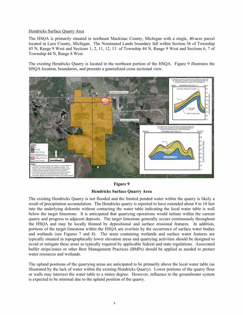
The HSQA is primarily situated in northeast Mackinac County, Michigan with a single, 40-acre parcel located in Luce County, Michigan. The Nominated Lands boundary fall within Section 36 of Township 45 N, Range 9 West and Sections 1, 2, 11, 12, 13 of Township 44 N, Range 9 West and Sections 6, 7 of Township 44 N, Range 8 West. The existing Hendricks Quarry is located in the northeast portion of the HSQA. Figure 9 illustrates the HSQA location, boundaries, and presents a generalized cross sectional view.
Figure 9
Hendricks Surface Quarry Area
The existing Hendricks Quarry is not flooded and the limited ponded water within the quarry is likely a result of precipitation accumulation. The Hendricks quarry is reported to have extended about 8 to 10 feet into the underlying dolomite without contacting the water table indicating the local water table is well below the target limestone. It is anticipated that quarrying operations would initiate within the current quarry and progress to adjacent deposits. The target limestone generally occurs continuously throughout the HSQA and may be locally thinned by depositional and surface erosional features. In addition, portions of the target limestone within the HSQA are overlain by the occurrence of surface water bodies and wetlands (see Figures 7 and 8). The areas containing wetlands and surface water features are typically situated in topographically lower elevation areas and quarrying activities should be designed to avoid or mitigate these areas as typically required by applicable federal and state regulations. Associated buffer strips/zones or other Best Management Practices (BMPs) should be applied as needed to protect water resources and wetlands. The upland positions of the quarrying areas are anticipated to be primarily above the local water table (as illustrated by the lack of water within the existing Hendricks Quarry). Lower portions of the quarry floor or walls may intersect the water table to a minor degree. However, influence to the groundwater system is expected to be minimal due to the upland position of the quarry.

9
Given the upland position of the HSQA topographically with respect to surface water/wetland features, effects to surface water resources are expected to be negligible. Minor quarry seepage may occur but is expected to achieve equilibrium rapidly, re-establishing the pre-quarrying hydrologic conditions. Quarrying methods are expected to include typical blasting, truck/shovel material handling, and conveyor transport of target limestone. Water use is anticipated to be minimal and would likely include:
Dust suppression on haul roads In-quarry crushers/screens Rock washing Equipment washing
It is expected that the water needed to support quarry operations will be supplied by precipitation and pit seepage. Before commencement of quarry operations, supplemental data, quarry planning, engineering, and operational details will be required to determine the site-specific aspects of the final proposed HSQA limestone quarrying operation. Eastern Surface Quarry Area
The ESQA is situated in eastern Mackinac County, Michigan and western Chippewa County, Michigan. The Nominated Lands boundary is located within Section 24 of Township 44 N, Range 7 West and Sections 17, 18, 19, of Township 44 N, Range 6 West. The ESQA is also located within the Niagara Escarpment where the Hendricks Formation outcrops. The existing, inactive Fiborn Quarry is positioned west of the ESQA and the target limestone at the top of the Hendricks Formation can be seen in the Fiborn Quarry. Although most of the quarry floor is dry, shallow ponding in the Fiborn Quarry indicates that the local water table is likely positioned slightly above portions of the quarry floor. Water within the quarry may occur as seepage from portions of the quarry wall face, quarry floor, and/or precipitation accumulation. Figure 10 illustrates the ESQA location, boundaries, and generalized cross sectional view.
Figure 10
Eastern Surface Quarry Area

10
It is anticipated that quarrying operations would initiate near the eastern edge of the target limestone and progress to adjacent economic deposits. The target limestone is anticipated to occur relatively continuously throughout the ESQA and is likely locally thinned and overlain by surface water bodies and wetlands as a result of glacial erosion and deposition. As with the HSQA, wetlands and surface water should be avoided or mitigated as appropriate and required by applicable federal and state regulations. The upland positions of the quarrying areas are anticipated to marginally intersect the local water table (as illustrated by the limited occurrence of water within the Fiborn Quarry). Similar to the HSQA, quarry seepage, hydrologic equilibrium, and eventual return to pre-quarrying hydrological conditions are expected. Quarrying methods are expected to be similar to those used at the HSQA and supplemental data acquisition, quarry planning, and engineering will define the final ESQA operation. Underground Mining Area
The UMA is situated in northeast Mackinac County, Michigan. The mine boundary falls within Sections 20-23, 25-29 and 32-36 of Township 44 N, Range 8 West and Sections 28-34 of Township 44 N, Range 7 West and Sections 3-6 of Township 43 N, Range 7 West. The UMA is located within a down-dip area south of the proposed surface quarry areas. The target limestone to be mined in the UMA also consists of the same target limestone at the top of the Hendricks Formation previously described. The geologic bedding slopes approximately 50 feet per mile towards the south resulting in the target limestone ranging from an estimated 150 to 300 feet in depth at the proposed UMA. Figure 11 illustrates the UMA location, boundaries, and portal schematic. Figure 12 illustrates two generalized cross sectional views.
Figure 11
Underground Mining Area (1 of 2)
It is anticipated that mining operations would initiate with the construction of portals/declines to access the target limestone (see Figure 11). The location of the portals within the UMA boundary is not yet known and the design should entail typical sound engineering and environmental mitigation practices. Surface disturbance and mining activities including portal infrastructure, roads, ventilation/utility conduits, etc. should be designed to avoid or mitigate effects associated with surface water features and wetlands as typically required by applicable federal and state regulations. Portals/declines, air ventilation

11
shafts, and utility conduits should be cased and sealed to maintain hydrologic integrity as dictated by site-specific conditions and sound mining engineering practices.
Figure 12
Underground Mining Area (2 of 2)
Groundwater in the mine is anticipated to be encountered as a confined aquifer (an aquifer capped with impermeable layers which cause water pressure levels to rise above the top of the aquifer with increasing depth and confinement) exhibiting hydraulic head (the amount of confined water pressure expressed as pressure above the top of the confined aquifer) of 250 feet plus. However, due to the low expected permeability of the target limestone and the employment of grouting as needed in areas of secondary permeability, seepage into the open workings is expected to be very small. The mine is expected to undergo dewatering via pumping to completed portions of the mine or holding facilities as needed. Upon mine completion, the portals are expected to be sealed and the underground mine is expected to gradually fill with groundwater. Mining methods are expected to include typical underground blasting, truck/shovel material handling, and conveyor or truck transport of target limestone. The underground mine will employ “Room and Pillar” methodologies where approximately 50 percent of the target limestone will be left as pillars to support the mine roof. Water use will be minimal and will include:
Dust suppression on haul roads Portable on-site crushing/screening Rock washing Equipment washing
It is expected that the water needed to support mine operations will be supplied by mine dewatering. Before commencement of mining, supplemental data, mine planning, engineering, and operational details will be needed to determine the site-specific aspects of the final proposed UMA limestone mining operation. Post-quarrying/Mining Hydrology
Based on the upland position of the proposed surface quarry areas, the significant recharge from precipitation to the system, and the hydrologic characteristics of the proposed underground operation; post-quarrying/mining surface hydrologic conditions are expected to return to pre-quarrying/mining

12
characteristics and functions. To the degree the surface quarrying operations advance below the local groundwater table, ponds and wetlands may form in the lower portions of the quarries. These ponds and wetlands will be allowed to develop as hydrologic equilibrium is achieved. Once the surface quarry areas re-saturate to correspond to the surrounding topographically controlled elevations, bedrock boundaries, and corresponding groundwater table, the hydrological regime will return to approximate pre-quarrying conditions. The shallow position of the bedrock/glacial till interface and the lack of vertical permeability of the bedrock will result in groundwater and surface water discharge relationships that approximate pre-mining conditions once any sub-groundwater excavations are recharged with water. The underground mine will gradually fill with groundwater once mining activities and associated dewatering is terminated. Once the underground mine fills with water, the hydrogeologic flow regime is also expected to return to approximate pre-mining conditions. 6 Natural Hydrogeologic Controls
A combination of three primary factors influence and control how quarrying and mining activities may affect the hydrology adjacent to the proposed quarrying and mining areas:
Permeability of the geologic materials.
The structural disposition of the target limestone and adjacent features.
The amount of natural recharge induced into the hydrologic system through annual precipitation. Permeability
Permeability (or hydraulic conductivity) is the relative amount and size of interconnected pore space in the host rock available to transmit groundwater. On the high end of the permeability spectrum, sand and gravel exhibit a large amount of interconnected pore space and the capability to transmit or convey large amounts of groundwater. The target limestone and adjacent dolomite beds fall on the other end of the range and offer little connected pore space to transmit groundwater. The lack of groundwater transmitting capability of the dolomites and target limestone in the Nominated Lands area is best demonstrated by the Port Inland Quarry/Lake Milakokia example. The rock formations at the Port Inland facility are the same specific formations proposed for quarrying and mining within the Rexton Project Nominated Lands. As presented in Figure 13, the Port Inland Quarry is up to approximately 75 feet deep and exhibits the removal of similar limestone as the target limestone for the project. Lake Milakokia is situated about 350 feet away from the edge of the Port Inland Quarry. The lack of drainage from Lake Milakokia into the quarry supports the assessment regarding the impermeable nature of the dolomites and limestone and the limited nature of secondary permeability. In the project area, the very low horizontal permeability and the virtual lack of vertical permeability will significantly limit the extent of drawdown associated with quarry/mine dewatering. Limestone and dolomite formations can exhibit higher permeability through the development of secondary permeability (fracturing and solution channeling). These conditions are not apparent in the Nominated Lands area and often times are localized and discontinuous based on observations of the Hendricks Quarry and other information reviewed. Structural Disposition
The target limestone proposed for surface quarrying is positioned at an elevation where most of the extraction activities will occur above the water table or advance into the water table to a minor degree. Since the degree of water table lowering during quarrying is limited to the depth the quarry advances below the water table, adjacent effects to groundwater, surface water bodies, and wetlands are also expected to be limited. In the UMA, the target limestone is confined as one moves southerly or down-dip due to the impermeable layers above the target limestone. In the UMA, the groundwater pressure head

13
will rise to the elevation of the approximate outcrop/recharge area under confined hydrologic conditions and is described as the potentiometric surface. In areas where the land surface falls below this pressure head (such as some of the domestic wells south and east of the quarrying and mining areas previously described), flowing artesian conditions can occur. However, the lack of sufficient pressure and permeability apparently precludes this mechanism from happening in the underground mine area. Recharge
Very significant quantities of water are introduced to the hydrologic system each year in the form of snow melt and rainfall. This water replenishment, coupled with the impermeable nature of the bedrock, glacial features, and the bedrock proximity to the surface, will naturally result in a poorly drained surface water system where groundwater and surface water recharge is maximized. Small reductions in water table and potentiometric surfaces during mining from quarry and mine dewatering are easily off-set by the annual recharge amount. Drawdown
Drawdown associated with the surface quarries can be described as the decline in water table at some prescribed distance from a well (or other groundwater extraction mechanism – such as quarry dewatering). In the case of quarry dewatering, the groundwater level is reduced to a level equal to the bottom of the quarry and extends laterally outward from the quarry. In the case of a domestic well within this cone of depression, the drawdown can reduce the pumping level in that well. Once the dewatering is terminated, the groundwater levels recover to the pre-pumping level. Drawdown associated with the underground mine is described as a reduction in the pressure head associated only with the confined target limestone. Mine dewatering would result in a laterally extending cone of depression of the potentiometric pressure head surface. Domestic wells tapping the target limestone within this cone of depression also could have the water levels in those wells reduced. Wells producing from above the target limestone would not be affected as they are hydraulically isolated from the confined target limestone. Once dewatering ceases, the potentiometric surface would return to pre-mining levels. Cone of Depression
The cone of depression can be described as the groundwater surface (or pressure head) as it declines from the natural water table (or potentiometric surface) elevation in an arc to the pumping point (domestic well or quarry/mine dewatering station). The shape, distance, and decline in water level associated with the cone of depression are all dependent on a number of interrelated factors, primarily permeability, degree of confinement, leakage, pumping rate, and pumping duration. Drawdown due to dewatering of the HSQA and ESQA was estimated using an analytical solution for a pumping well. The computer program, AQTESOLV Version 4.5 (HydroSOLVE, 2007), was used to run the analytical solution. The program requires aquifer characteristic and pumping rate information as inputs, and then calculates drawdown versus time and distance. The Neuman solution for a pumping test in an unconfined aquifer (Neuman, 1972) was used in the analysis. The saturated thickness was taken to be the depth from the water table to the surface of the quarry floor. The solution was run for thicknesses of both 25 and 50 feet. Hydraulic conductivity was extrapolated from a University of Wisconsin-Oshkosh study on Silurian dolomite in Door County, Wisconsin (Muldoon, 2005) and aquifer test data obtained from recent dolomite bedrock testing in New Mexico. Values of both 0.26 and 1.90 feet per day (ft/day) were used as lower and upper estimates, respectively. A specific yield of 0.10 was used based on literature values (Anderson and Woessner, 2002). Pumping rates varied from 2 to 20 gallons per minute (gpm) depending on the combination of aquifer parameters used in each solution scenario. The pumping rate approximates the values reported in well logs for the area. For most solutions, pumping rates were adjusted until the maximum allowable drawdown was

14
obtained (either 25 or 50-foot saturated thickness). Distances to an expected 5-foot decrease in the water table were then calculated. The 5-foot drawdown extent was used as the boundary at which domestic wells could reasonably expect a noticeable effect. Results of the Neuman analytical drawdown solution are presented in Figure 13 and show that for the scenarios that maximized drawdown at the well, the distance to the 5-foot drawdown radius varied from 200 to 1,000 feet, depending on the hydraulic conductivity, saturated thickness, and pumping rate used. Using very conservative values of b=25 feet, Q=5 gpm, and a hydraulic conductivity of 1.9 ft/day, the resulting maximum distance to a 5-foot drawdown limit would be 350 feet. Accordingly, any water supply well (or other hydrologic feature) outside of 350 feet away from the edge of the quarry would not be expected to be materially affected.
Figure 13
Conceptual Drawdown Analysis – Surface Quarry Areas
As illustrated in Figure 13, the water level in well “A” would be lowered to the level of the simulated cone of depression. Wells at a distance greater than 350 feet away would be outside the simulated cone of depression. To predict a representative cone of depression/drawdown profile due to dewatering of the UMA, the Theis analytical solution for a pumping well in a confined aquifer (Theis, 1935) was used. The solution was run using a model from the Michigan Land and Water Management Division (Michigan LWMD, 2010). The Theis solution requires the same inputs as for the unconfined aquifer solution, except that storativity is used in place of specific yield. Saturated thickness was taken to be the thickness of the limestone target, which was estimated to be 40-feet thick. The same hydraulic conductivity values were used as in the unconfined solutions (0.26 and 1.90 ft/day). A storativity of 0.01 (unitless) was used based on literature values (Anderson and Woessner, 2002). Pumping rates varied from 0.4 to 11 gpm depending on aquifer parameters used in each solution scenario. Pumping rates were again varied in each solution until the maximum allowable drawdown was obtained (either 20 or 40-foot saturated thickness). Distances to an expected 5-foot decrease in the water table were then calculated. The 5-foot drawdown extent was used as the boundary at which domestic wells (or other hydrologic features) could reasonably expect a noticeable effect.

15
Figure 14
Drawdown Analysis – Underground Mine Area North / South Cross Section
Results of the Theis analytical drawdown solution is illustrated in Figure 14. Results show that the distance to the 5-foot drawdown radius varied from 175 to 1,875 feet, depending on the hydraulic conductivity, saturated thickness, and pumping rate used. Using very conservative values of b=40 feet, Q=1.5 gpm, and a hydraulic conductivity of 0.26 ft/day, the resulting maximum distance to a 5-foot drawdown limit would be expected to be 690 feet. Accordingly, any water supply well tapping only the target limestone further than 690 feet away from the edge of the mine would not be expected to be affected. As illustrated in Figure 14, the water level in well “B” would be lowered to the level of the simulated cone of depression. Wells at a distance greater than 690 feet away from the mine would be outside the simulated cone of depression. Wells producing from zones above the target limestone would not be affected by a cone of depression caused by dewatering the mine. The calculated values of 350 feet from the surface quarries and 690 feet from the underground mine were then used to assess potential groundwater effects. 7 Topics of Interest – Domestic Water Supply Wells
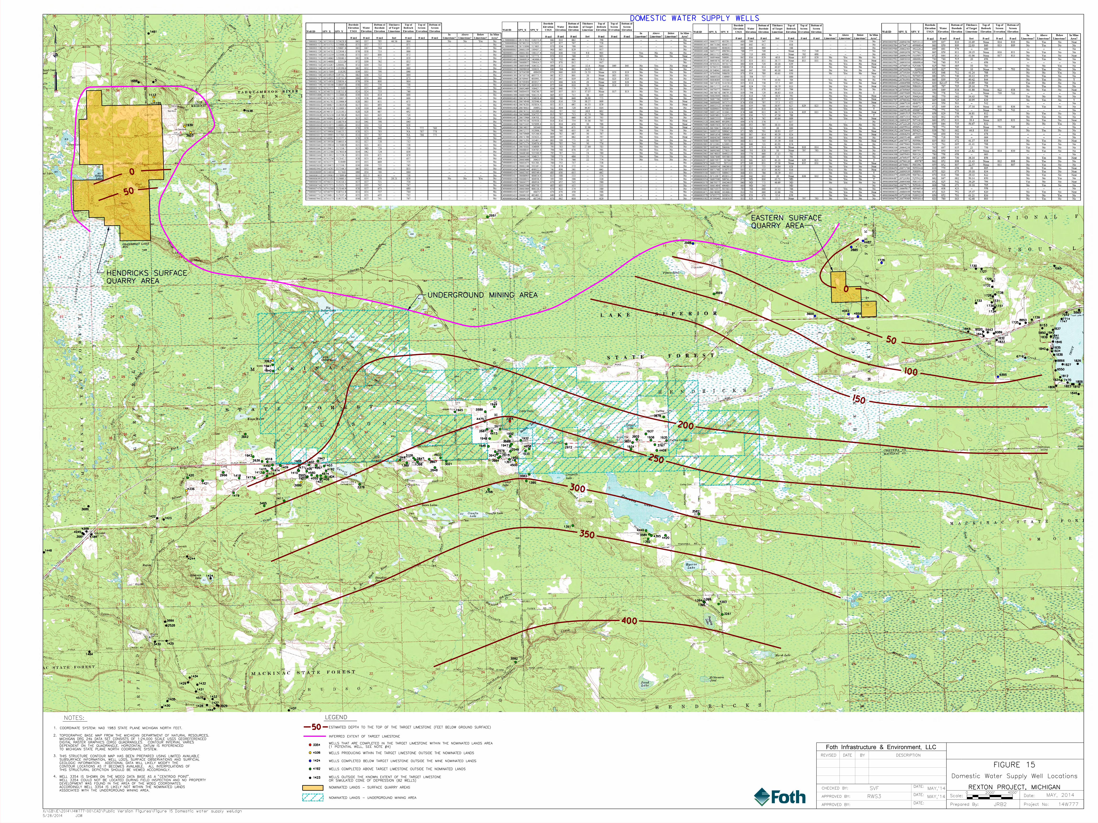
Well records for water supply systems in the vicinity of the three proposed quarrying and mining areas (approximately within four miles of the Nominated Lands) were researched to determine individual well locations along with pertinent well construction and production information. The records were obtained from the Michigan Department of Environmental Quality’s (MDEQ) Wellogic online database. Not all the well records were complete – portions of the data were either lacking or set to a default value not representative of actual conditions. Missing surface elevations were supplemented using U.S. Geological Survey (USGS) topographic data. Any wells not reported to or entered into the MDEQ database were not included in this analysis. A total of 195 wells were documented and superimposed on base maps. Figure 15 presents the well locations and is provided as a large scale map attached at the end of the report to facilitate legibility. The well depth, groundwater depth, and well production zone were assessed versus proposed quarrying and mining activities. The well locations were compared to the extent of the Nominated Lands and the well

16
completion depth/production zone versus the quarrying/mining depth. This analysis provides insight regarding the potential for existing wells to be effected by quarrying/mining activities. Five well completion types are evident: Category 1 After a reconnaissance field inspection, no wells were found within the Nominated
Lands. The MDEQ database had showed 8 wells completed within the Nominated Lands boundary completed above or within quarrying/mining areas. All 8 Category 1 wells were actually found to be situated outside the Nominated Lands extent
Category 2 8 Wells are outside the Nominated Lands completed in the target limestone Category 3 8 Wells are outside the Nominated Lands and completed in zones below the target
limestone (wells physically isolated from quarrying and mining impacts) Category 4 97 Wells are completed outside the Nominated Lands and above the target limestone
(wells physically isolated from quarrying and mining impacts) Category 5 82 Wells are outside of known target limestone extent (wells physically isolated from
quarrying and mining impacts) Category 2 wells are completed in the same well depth interval that is targeted for quarrying/mining but are located outside the Nominated Lands. Depending how close these wells are to the edge of the quarries or mine workings, reductions in water levels in the well could be seen in these wells. An analysis was completed to predict how far from the edge of the quarry or mine water levels in wells could be influenced (see cone of depression analysis in Section 5). Based on this analysis, wells further than 690 feet from the underground mine and 350 feet from the surface quarries would not see a material decrease in well water levels. Only two of the 8 Category 2 wells (Well 3093 and Well 4500 in the southwest portion of the UMA) are positioned closer than 690 feet to the Nominated Lands and could be potentially affected by mine operations, and may require remedial measures by Graymont. Of the 195 wells registered with the state of Michigan in the vicinity of the Nominated Lands, only two wells exhibit the potential to be affected by quarrying or mining activities based on the analysis provided herein. It is recommended that each well within 2,000 feet of the final quarrying or mining extent should be specifically analyzed with respect to supplemental data, testing, and updated well characteristics. Specific well construction/pumping system details along with seasonal variation and groundwater level fluctuation may further affect well performance and would also require documentation. Applicable remedial actions, where necessary, should be evaluated and a plan be developed for implementation by Graymont (at no cost to the well owner) to address effects to domestic water wells resulting from mining activities. Figure 16 presents the well completion types found in the vicinity of the Nominated Lands and potential remedial scenarios Remedial activities typically could include:
Deepening or replacing a well sealing the lower portion of a well to prevent connection with the target limestone.
Installing a replacement well outside the quarry or mine effect area. 8 Topics of Interest – Effects to Lakes, Streams, and Wetlands
Due to the upland position of the surface mining areas, the hydraulic isolation of the target limestone, applications of low topographic area avoidance/mitigation, application of BMPs, and the significant

17
recharge quantity applied to the hydrologic system each year, effects to area lakes, streams, and wetlands will be negligible.
Figure 16
Categorical Water Supply Well Types
Surface Quarries
The southern edge of the HSQA is situated on the Brevoort-Millecoquins/Tahquamenon primary watershed divide. The entire HSQA is also positioned on a secondary watershed boundary which extends north/south. The southern edge of the ESQA is situated on the Tahquamenon/Carp-Pine primary watershed divide. The entire ESQA is positioned on a secondary watershed boundary which extends north/south. Figure 7 shows the watershed boundaries with respect to the HSQA and ESQA. Given this upland position located at the very top of the watershed boundary, effects to stream channel and basin characteristics are not expected. Actual quarry areas within the Nominated Lands should be limited to avoid or mitigate effects to defined surface water bodies and wetlands. Developed stream channels are well outside the HSQA and ESQA and any secondary or tertiary channels are located in low topographical positions where quarrying would be limited either due to the lack of target limestone (glacial erosion) or intentionally avoided/mitigated as per applicable federal and state requirements. Within the HSQA boundaries, two recognized surface water bodies occur: Finn Lake, along the southern end of the eastern boundary; and Nelson Lake, along the middle of the Western boundary. Both of these lakes are connected by northwest/southeast oriented wetlands. Several other very small ponds may be present within the wetlands during periods of high water. These areas should be avoided or mitigated as per applicable federal and state requirements. Three other northwest/southeast trending low areas supporting wetlands occur over portions of the HSQA and should also be avoided or mitigated as per applicable federal and state requirements. In addition to avoidance and mitigation, buffer strips/zones and

18
other runoff BMPs may be employed as warranted and necessary. Within the ESQA boundary, no recognized surface water bodies occur. The wetlands and waterways are all based on topographic position and are connected to other adjacent large expanses of wetlands and waterways. The expansive precipitation recharge function and the connectivity of the surface water system are anticipated to continue to maintain the water supply that creates the existing surface water regime. Based on the designation of no quarrying zones and/or mitigation methodologies, associated BMPs, the upland position of the quarrying areas, and the continuity of the surface water regime, quarrying activities are not anticipated to materially change the existing conditions adjacent to the HSQA or ESQA. Figure 17 shows a representative cross section through the HSQA.
Figure 17
Conceptual Cross Section A-A’
The projected water table depth is also shown and is present primarily below the deposits to be quarried. As quarry operations progresses further south, portions of the quarry floor may be below the water table. Even in areas where the quarries are advanced below the water table, the maximum effect that would be seen is a local reduction in water table depth at that point in the quarry with the effect decreasing as you move laterally away from the quarry (the cone of depression previously discussed). If lower levels of the quarry exhibit ponding, some portion of the water would result from precipitation contributions and further serve to reduce effects to adjacent groundwater. The Hendricks Quarry is shown in Figure 18 and is not flooded. Water present in the low area is a result from precipitation ponding, as consistent with cross section A–A’. Figure 19 illustrates a representative cross section extending through the Fiborn Quarry and the ESQA to the east. The cross section shows that the bottom of the Fiborn Quarry as well as the bottom of the target limestone at the ESQA may come into contact with the projected water table. However, the majority of the limestone to be extracted at the ESQA is situated above the water table. Figure 20 illustrates the characteristics of the Fiborn Quarry and shows that portions of the quarry are ponded with water, likely a result of intersecting the water table. It is expected that similar conditions will exist in the ESQA where the water table is anticipated to be encountered above the bottom of the target limestone.

19
Figure 18
Hendricks Quarry
Figure 19
Conceptual Cross Section B-B’

20
Figure 20
Fiborn Quarry and Karst Preserve
Given the position of the water table in the ESQA and potentially southern portions of the HSQA, the potential exists to induce drawdown to areas outside the quarry. Hydrologic features within the associated cone of depression resulting from quarry dewatering could be temporarily influenced during mining activities (quarry dewatering). Following mining (and associated quarry dewatering), the adjacent water table surface would be expected to return to pre-mining conditions as can be seen in the Fiborn Quarry illustration. Site-specific data acquisition, testing, and analysis are expected to further verify the assessment presented herein. Given the minimal amount of water table reduction possible, the low intrinsic permeability of the limestone, upland/high elevation of the proposed surface mining activities, and most importantly the prolific amount of precipitation recharge to the hydrologic system each year, effects to the water table surface, adjacent surface water bodies and wetlands are considered negligible associated with surface mining activities Underground Mine Area
The UMA will involve an underground mining operation in a down-dip location of the Hendricks Formation target limestone. The depth to the top of the target limestone is anticipated to be about 150 to 300 feet deep. Surface disturbance features are expected to be limited to contained portal/surface infrastructure areas, access roads, sealed ventilation, conveyors, and potentially utility conduits. Surface hydrologic features and wetlands are not expected to be significantly influenced since the surface disturbance should be positioned to avoid or mitigate surface water features as per applicable federal and state requirements. The potentiometric surface and associated pressure head are under confined conditions hence are isolated from the surface water system, and the horizontal and vertical permeability are expected to be very low. The southern edge of the UMA is situated on the Brevoort-Millecoquins/Tahquamenon primary watershed divide. The entire UMA is positioned on secondary watershed boundaries which extend north/south on both sides of the divide. Given this upland position located at the very top of the

21
watershed boundary, effects to stream channel and basin characteristics are not expected. Surface disturbance should be intentionally located outside of surface water boundaries and all subsurface conduits should be sealed. The entire area of the UMA is considered a watershed contribution and recharge area and mining activities do not alter this characteristic. Within the UMA boundary, four recognized surface water bodies occur: Big Dollar Lake and Little Dollar Lake along the northwestern end of the northern boundary; Rexton Lake in the middle of the UMA; and Crossville Lake on the southern end of the southeast side of the UMA. These lakes are not directly connected to each other. Several other smaller, unnamed surface water bodies are also shown on USGS topographic maps. As shown on Figure 21, the top of the target limestone is present at depths around 150 to 300 feet below the surface and is hydraulically isolated from the surface water system above. Based on the hydrogeologic isolation of the target limestone in the area and the ability to seal all subsurface conduits, surface water features and wetlands will not be impacted by underground mining activities.
Figure 21
Conceptual Cross Section C-C’
The water table in the immediate vicinity of the UMA is represented by a near surface groundwater profile controlled by surface till deposits and shallow rock formations which are isolated from the top of the target limestone positioned up to 300 feet below the ground surface. The target limestone is expected to be saturated (limited to the small degree of formation porosity) but exhibit very low hydraulic conductivity. The dolomite formations above the target limestone are also expected to be essentially impermeable, sealing the target limestone sequence. A well perforating only the target limestone would yield a pressure head roughly equivalent to the elevation of the target limestone outcrop elevation. However, the well would be expected to produce only very limited groundwater due to the very low hydraulic conductivity. This condition is typical of sloping, water-bearing strata and is defined as a confined aquifer. Pumping the target limestone in the area of the underground mine may reduce the pressure head of the target limestone in that area and radially outward to a diminishing degree. Pumping the target limestone, however, will have no effect on wells producing from zones above the target limestone or surface water resources due to the expected lack of vertical permeability. This lack of vertical permeability is caused by the bedding inherent with the bedding/depositional sequence as previously described.

22
Mine dewatering flow rates are expected to be small due to the impermeable nature of the host rock and isolation of the underground mine area. Following mining (and associated underground mine dewatering), the mine would fill and the associated potentiometric surface (pressure head) would be expected to return to pre-mining conditions. Site-specific data acquisition, testing, and analysis are expected to further verify the assessment presented here. 9 Topic of Interest – Quarry Flooding/Creation of Quarry Lakes
As previously discussed and as illustrated on Figure 5, portions of the surface quarry areas may become partially ponded once mining activities cease. As illustrated by the photo documentation of the Fiborn Quarry, the ESQA is expected to intersect portions of the local water table resulting in the quarry filling with water to a level approximately equal to the elevation of the water table. Wetlands may form around the edges of the ponded portions of the quarry. Given the large amount of recharge, these quarry lakes are expected to be established within one season of the completion of mining (cessation of dewatering). The northern portions of the HSQA are not anticipated to intersect the water table and will not exhibit ponding. However, southern portions of the quarry may advance into the water table and result the formation of ponded areas and wetlands (as seen in the Hendricks Quarry photo documentation). Even if the quarry bottom does not intersect the water table, precipitation may accumulate in low-lying areas of the pit due to the impermeable nature of the rock. The water quality of these quarry lakes is expected to be characteristic of and at equilibrium with the local geologic materials bedrock and consist of a calcium/ magnesium carbonate water type which will be beneficial to aquatic and other wildlife. 10 Topic of Interest – Underground Mine Flooding/Filling
Although the target limestone and adjacent rock formations are expected to exhibit very low permeability (limited to the minor amount of porosity), the rock is expected to function as a saturated unit. As such, the adjacent rock is expected to yield small amounts of groundwater to the underground workings. This seepage will be routed to collection points and pumped to storage areas within the mine or in the portal area. Once mining is terminated, the mine entrances and conduits will be sealed. The mine will no longer be dewatered and the mine is expected to fill with water. Groundwater from adjacent formations will slowly fill the mine until the pre-mining potentiometric surface is established. Due to the very low permeability anticipated, the filling process will be on the order of years. 11 Topic of Interest – Effects Related to Dewatering
The effects of dewatering of the surface quarry areas will be limited to the extension of the cone of depression (~ 350 feet) to adjacent surface water features and wells. This effect is further reliant on the relative elevation of the adjacent feature and the depth at which dewatering will occur. As shown in cross sections A–A’ and B–B’ in Figures 17 and 19, the upland position of the target limestone would limit how far the dewatering can progress downward. This limitation, coupled with the distance away from the quarry and relative elevation of surface water features in the area limit the dewatering effects. The cone of depression characterization discussed above demonstrates that at distances over 350 feet away from the edge of the quarry, no material reduction in water table should be expected. In addition, if dewatering only advances into the water table 10 feet, then the resulting cone of depression would extend less than 350 feet away. Lastly, as the position of the surface water feature is lower in elevation, the resulting lowering of the water table is further decreased. Once quarrying ceases, the water table will return to its approximate pre-quarrying elevation. Given the combination of the characteristics above and the employment of standard mining engineering practices to reduce potential hydrological effects, drawdown issues associated with quarry dewatering are not anticipated to effect the water resources or water use in the area. Dewatering of the underground mine is also not anticipated to effect adjacent water resources due to the isolated, confined nature of the target limestone. Lakes and other water resources immediately above the proposed underground mine operation are hydraulically isolated from the mine and will not be effected.

23
As previously discussed, the drawdown (or reduction in potentiometric surface) is estimated to be about 690 feet. Two wells (3093 and 4500) are within that distance and may exhibit a reduction in water level in the well. It is recommended that Graymont evaluate the site-specific conditions and provide a remedial solution to alleviate potential well production issues, if any, caused by quarrying and mining activities. 12 Topics of Interest – Quarry/Underground Mine Dewatering Discharge
As previously described, all three quarry and mine areas (HSQA, ESQA, and UMA) may require dewatering by pumping seepage and/or accumulated precipitation from the quarries or underground workings to storage facilities. The seepage water is anticipated to be of good water quality, reflective of natural groundwater in the area (calcium/magnesium/carbonate). The water will be stored in containment facilities (low areas of the quarries/underground workings, or ponds) and designated for operational use (dust suppression, equipment maintenance, etc.). Water in excess of operational use requirements would be discharged as per federal and state of Michigan requirements. 13 Topics of Interest – Water Quality
Surface water chemical characteristics are a result of shallow till and precipitation chemistry. Naturally occurring organic matter accumulations in lower, stagnant areas and naturally occurring carbonate influenced groundwater interactions further define the surface water chemical composition. Quarrying and mining activities are not anticipated to directly disturb the surface water system since those activities should avoid or mitigate surface water bodies and wetlands as per applicable federal and state requirements. Increased exposure to limestone and dolomite from rock stockpiles and quarry surfaces offers the potential to add carbonate rock constituents to the system. The carbonate constituents would largely be limited to calcium and magnesium cations and carbonate anions. These constituents are not associated with liberating unwanted metals and are buffering compounds typically used to treat acid conditions. In addition, the quantity of quarry or mine discharge water loading will be insignificant as compared to the precipitation recharge component to the surface water system. No effects are anticipated to background surface or groundwater quality associated with the proposed underground mining operations. 14 Topics of Interest – Introduction of Contaminants
Given the nature of the proposed quarrying and mining operations and the target limestone, the potential for the discharge of contaminants is remote. The geological materials do not contain acid-forming materials or metals that can be released to the environment once exposed to oxidation. Conversely, limestone and dolomite products are typically used to purify drinking water, treat wastewater, and neutralize acid conditions. A release of potential contaminants to the environment would be limited to spills of hydrocarbon fuels and lubricants. Fuels and lubricants will be handled and managed as per federal and state of Michigan requirements. Any spill would also be minimized by the impermeable nature of the geologic materials. It is recommended that contained sanitary facilities serviced by an outside party will be used in lieu of septic systems. 15 Topics of Interest – Engineering, Quarry/Mine Design, and Mitigation
Techniques
Engineering, quarry/mine design approaches and mitigation techniques are typically used to minimize potential effects. The following activities should be considered to minimize and mitigate potential hydrologic effects associated with the Rexton Project:

24
Water Containment and Control
Surface water and runoff control should be conducted in a three tiered approach.
All surface water runoff emanating from undisturbed areas should be diverted around disturbed areas and allowed to flow naturally within established drainage systems. This water routing will minimize changes to the natural drainage system.
All runoff from disturbed areas should be contained and settled prior to discharge, allowed to pass through engineered buffer zones to remove sediment, or captured and used for dust suppression or operations.
Any impounded runoff should be used in quarrying and mine operations or be allowed to settle
prior to discharge to natural waterways. Water Supply System Mitigation
As described earlier, several remedial options are available to mitigate potential effects, if they occur, to domestic water supplies caused by quarrying or mining activities. Mitigation options could include:
Install a new deeper well at the existing well location. Install a new well at the same depth but located > 350 feet or >690 feet (outside the cone of
depression) away from the surface quarry or underground mine.
Install an infiltration gallery between the existing well and the quarry or mine.
Install an impermeable barrier between the existing well and the quarry or mine.
Move the edge of the quarry or mine to a distance >350 feet or >690 feet (outside the cone of depression) from the well.
Provide an alternative water source – new well(s) and distribution sufficiently distant from the quarry or mine or provide via a contracted water service.
In all cases, a well designated as exhibiting the potential to be affected by mining activities would be specifically analyzed with respect to supplemental data, testing, and updated well characteristics. Pre-quarrying or mining well capacity, actual locations, pump and casing depths, seasonal variation effects on well production, and other potential well influences would be further evaluated and defined. Applicable remedial actions, where necessary, should be itemized and a plan should be developed for implementation by Graymont to address any effects from quarrying or mining activities. 16 Conclusions
Based on the data reviewed and analyzed and the indication from Graymont that they would construct and operate the proposed quarrying and mining operation as per prudent engineering and industry standards of care, material effects to local water resources are not expected. Effects would be limited to minor, localized reduction of the water table during quarrying and mining associated with dewatering activities. This potential effect is not anticipated to extend beyond 350 feet from the edge of the surface quarries and 690 feet from the edge of underground mining activities. Once quarrying and mining cease, the water table is expected to return to pre-quarrying/mining conditions. 195 Domestic wells were researched and documented in the vicinity of the proposed project. Of those wells, only two are projected to be potentially influenced during mining. The location and elevation of the quarrying activities is expected to minimize effects to surface water features and surface water bodies. The impermeable nature of the limestone and dolomite rock will essentially isolate the underground mine from surface hydrologic

25
features. Upon termination of quarrying and mining, shallow ponding of the surface quarries may occur and the underground mine will fill with water. Once this occurs, the pre-project groundwater levels and hydrologic flow regime will return to pre-quarrying/mining conditions. 17 Authors
This report has been prepared by Richard Schowengerdt and Sharon Kozicki, Foth Infrastructure & Environment, LLC. Richard Schowengerdt
Richard Schowengerdt is a Principal Hydrogeologist within the Foth Mining Group. He offers over 35 years of applied hydrological experience specializing in mining and natural resource applications. Mr. Schowengerdt provides extensive experience in the, mining, synfuels, water supply development, and water control/treatment arena throughout the western and mid-western United States. Specific applications include state and federal mine permitting, mine design, baseline hydrologic investigations, dewatering analysis and design, and impacts analysis. Mr. Schowengerdt has been utilized as an expert associated with potential impacts to water supplies associated with limestone and dolomite mine development and expansion in Illinois and Wisconsin. Sharon Kozicki
Sharon Kozicki is a Lead Geologist within Foth Infrastructure & Environment, LLC. She offers 14 years of applied geological experience specializing in complex hydrogeologic and sediment investigations, sediment remediation, and environmental compliance. She has extensive experience in environmental site assessments, site characterization, construction oversight, reporting, data management, health and safety auditing, and regulatory compliance monitoring and reporting for mining and industrial clients in California, Arizona, Wisconsin, Michigan, Minnesota, and Illinois. Additionally, she completed a yearlong project studying Permian-Triassic carbonate platforms in Southern China.
REVISED DATE BY DESCRIPTION
CHECKED BY:
APPROVED BY:
APPROVED BY:
DATE:
DATE:
DATE: Project No:
Date:Scale:
Prepared By: 14W777
Foth Infrastructure & Environment, LLC
RWS3
1839
XX
X
X
X
X
X
X
X
X XX
X
X
X
X
X
X
X
X
X
X
XX
X
X
3689
1422 1423
3961
4245
4398
4184
1448
3586
2528
1425 3430
1464
1431
1435
1430
4575
1428 39291437
1444
1427
1433
1429
1434
1432
X
X X
X
1938
51688
1461
X X
X
X
X
X
XX
X X
X
XX
X
XX
X
XX
X
X
X
XX
X
X
XX
X
X
X
X X
X
X
X
X
XXX X
X
X
X
X
X1730
1727
1729
1732
1738
17311733
1736 1737
1734
1728
17398853
1735
1843
1844
1832
1833
9020 59436089
7942
17477714
5565
6153
1837
18425850
18417731
1846
18351840
1834
18386716
8866
1827
1826
6550
1812
1824
1806
7470
1823 1810
1809
7065
1846
X
X
4244
1424
1113
1155
1939
3603
2961
3598
3599
2885
4487
1726
4659 4042
3600
6395
3592
1395
1394 1396
1393
3261
3582
4420 4395
3584
4440
1392
1391
4336
1420
1421
2966 1418 1417
1419
3465
3093
1941
1940
3642
1942
1413
1415
2636 4018
4450
1416
1414
1409
1408
3471
1410 2965
1401
3699
1411
1402
1405
4560
4267
4332
1407 1406
1404
4674
4192
1403
3378
1943
1399
1944 3106
2847
1398 2897
4633
3021
2848
3758
1390
3583
3678
1935
4409
3767
1936
1937
3602
3601
1934
1945
4475
3589
1949
3354
2677
2661
1948
4473 1952
1932
4038
1933
2972
4500
1397
1950
2549
3588
1947
2976
1946
3942
3984
2915
0 4000’2000’
JRB2
SVF
LEGEND
UNDERGROUND MINING AREA
5/28/2014 JOW
X:\GB\IE\2014\14W777-00\CAD\Public Version Figures\Figure 15 Domestic water supply well.dgn
1424
4336
4192
1423
FIGURE 15
MAY,’14
MAY,’14
REXTON PROJECT, MICHIGAN
400
350
300
250
200
0
50
100
150
0
50
501.
NOTES:
2.
3.
TO MICHIGAN STATE PLANE NORTH COORDINATE SYSTEM.
DEPENDENT ON THE QUADRANGLE. HORIZONTAL DATUM IS REFERENCED
DIGITAL RASTER GRAPHICS (DRG) QUADRANGLES. CONTOUR INTERVAL VARIES
MICHIGAN DRG 24k DATA SET CONSISTS OF 1:24,000 SCALE USGS GEOREFERENCED
TOPOGRAPHIC BASE MAP FROM THE MICHIGAN DEPARTMENT OF NATURAL RESOURCES.
COORDINATE SYSTEM: NAD 1983 STATE PLANE MICHIGAN NORTH FEET.
THIS STRUCTURAL DEPICTION SHOULD BE VIEWED ACCORDINGLY.
CONTOUR LOCATIONS AS IT BECOMES AVAILABLE. ALL INTERPOLATIONS OF
GEOLOGIC INFORMATION. ADDITIONAL DATA WILL LIKELY MODIFY THE
SUBSURFACE INFORMATION, WELL LOGS, SURFACE OBSERVATIONS AND SURFICIAL
THIS STRUCTURE CONTOUR MAP HAS BEEN PREPARED USING LIMITED AVAILABLE
DOMESTIC WATER SUPPLY WELLS
3354
4.
OR SIMULATED CONE OF DEPRESSION (82 WELLS)
WELLS OUTSIDE THE KNOWN EXTENT OF THE TARGET LIMESTONE Domestic Water Supply Well Locations
MAY, 2014
QUARRY AREA
HENDRICKS SURFACE
QUARRY AREA
EASTERN SURFACE
INFERRED EXTENT OF TARGET LIMESTONE
WELLS PRODUCING WITHIN THE TARGET LIMESTONE OUTSIDE THE NOMINATED LANDS
WELLS COMPLETED BELOW TARGET LIMESTONE OUTSIDE THE MINE NOMINATED LANDS
WELLS COMPLETED ABOVE TARGET LIMESTONE OUTSIDE THE NOMINATED LANDS
ESTIMATED DEPTH TO THE TOP OF THE TARGET LIMESTONE (FEET BELOW GROUND SURFACE)
(1 POTENTIAL WELL, SEE NOTE #4)
WELLS THAT ARE COMPLETED IN THE TARGET LIMESTONE WITHIN THE NOMINATED LANDS AREA
NOMINATED LANDS - SURFACE QUARRY AREAS
NOMINATED LANDS - UNDERGROUND MINING AREA
ASSOCIATED WITH THE UNDERGROUND MINING AREA.
ACCORDINGLY WELL 3354 IS LIKELY NOT WITHIN THE NOMINATED LANDS
DEVELOPMENT WAS FOUND IN THE AREA OF THE MDEQ COORDINATES.
WELL 3354 COULD NOT BE LOCATED DURING FIELD INSPECTION AND NO PROPERTY
WELL 3354 IS SHOWN ON THE MDEQ DATA BASE AS A "CENTROID POINT".