hurricane and severe storm sentinel (hs3) mission · 2014-09-02 · hurricane and severe storm...
TRANSCRIPT

Hurricane and Severe Storm Sentinel (HS3) Mission HS3 2014-09-02 Flight Report: GLOBALHAWK AV-6 Dolly Flight Flight Scientists: Shift 1 (0400-1300 EDT): Scott Braun, Pete Black, Gerry Heymsfield, Chris Velden Shift 2 (1200-2100 EDT): Paul Newman, Jason Sippel, Bob Houze, Ed Zipser Shift 3 (2000-0500 EDT): Dan Cecil, Steve Guimond, Jason Dunion Shift 4 (0400-1300 EDT): Scott Braun, Pete Black, Gerry Heymsfield, Chris Velden Mission goal: Science flight to investigate TS Dolly in the Gulf of Mexico.
Deep convection seen in the downshear-left side of the storm as Dolly is experiencing moderate (~<20 kt) northerly shear (see below). This should make the center of the storm and its western side more accessible during the flight. Current pattern looks good but will have to be adjusted due to westward motion of the storm.

Deep layer shear at 0945Z.
Good upper-level outflow to the east and south of the convection. Might be a target for later in the flight.

ASCAT data (from a time earlier than the GOES image) showing strong winds on the eastern side of the storm, but still a fairly broad circulation with possibly multiple centers.
Cloud top heights at 1030 UTC show deep clouds with some lightning to the south and east of the storm center. If they persist, it will be tough to overfly these until late in the flight.
AV-6 Pin pull at 11:25. Takeoff was delayed because they had trouble getting Ku-band up.
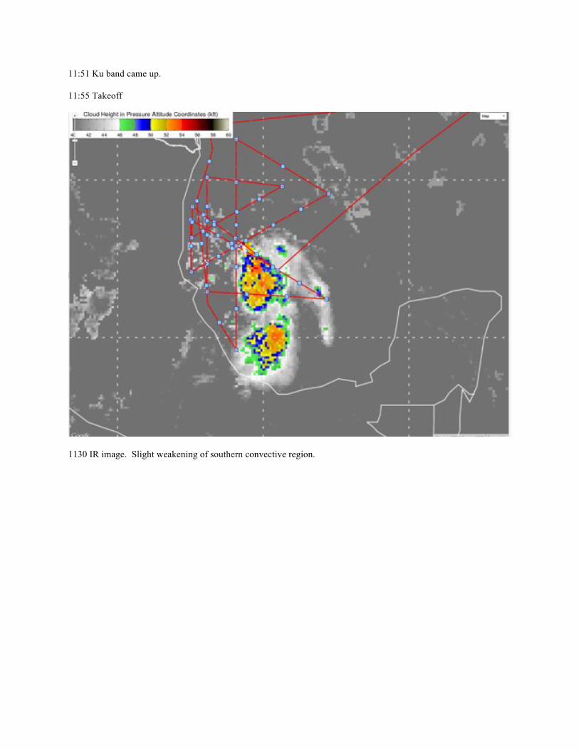
11:51 Ku band came up.
11:55 Takeoff
1130 IR image. Slight weakening of southern convective region.
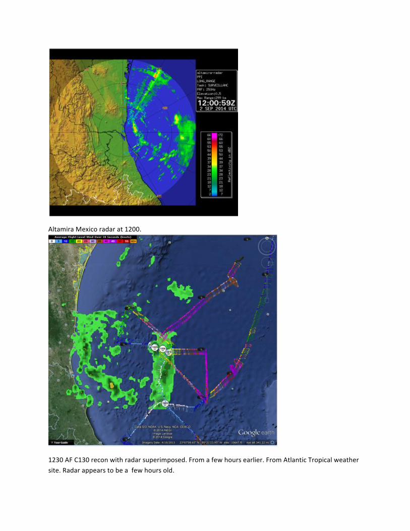
Altamira(Mexico(radar(at(1200.((
(
1230(AF(C130(recon(with(radar(superimposed.(From(a(few(hours(earlier.(From(Atlantic(Tropical(weather(site.(Radar(appears(to(be(a((few(hours(old.(

(
1230Z(IR.((Some(overshooting(tops.(Strongest(convection(on(north(side.(
1230Z(–(AVG6((deviated(around(overshooting(top(with(lightning(on(route.(
(
(
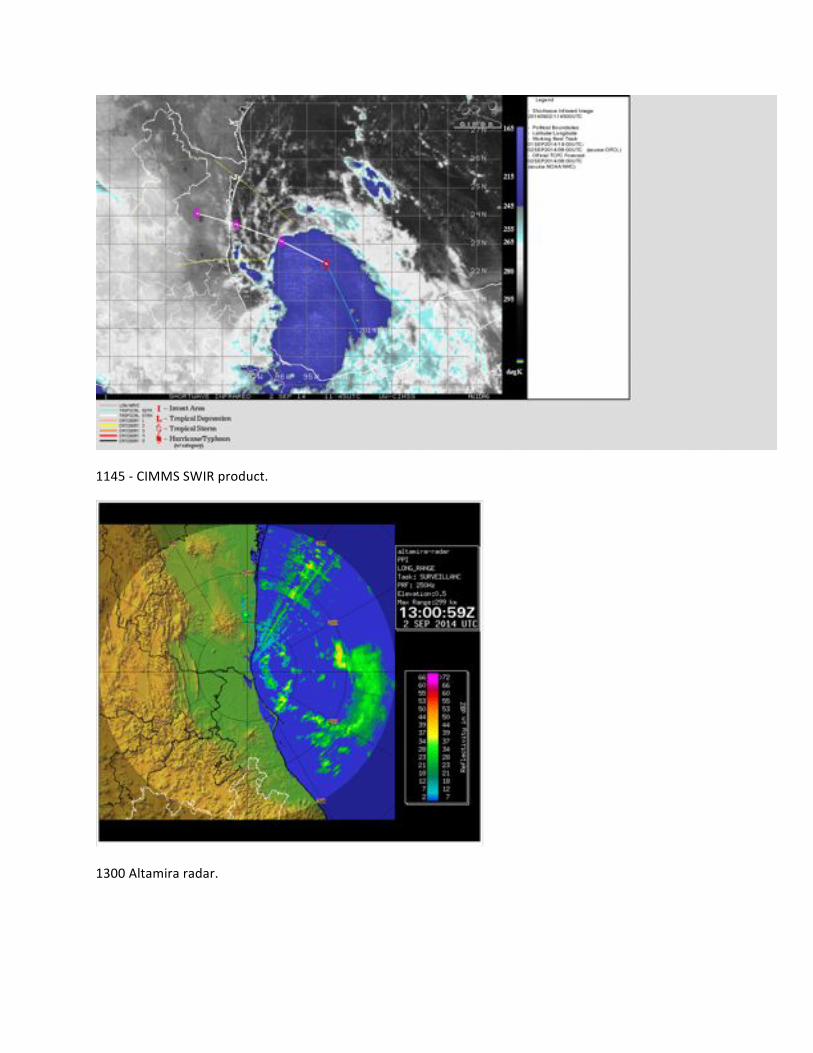
1145(G(CIMMS(SWIR(product.(
(
1300(Altamira(radar.(((

(
1245Z(Strong(overshooting(tops(on(north(side.(
( (

(
Zoom(of(overshooting(top(showing(lowGlevel(center(at(the(north(edge(of(anvil(boundaryG(north(of(turret.(

(
1320(CIMMS(AV6(product.((Based(on(visible(loop,(lowGlevel(center(of(circulation(appears(to(be(noth(of((strong(lightning(region.((Based(on(Altimara(radar(animation,(midGlevel(center(appears(to(be(centered(within(overshooting(top(region(and(just(east(of(lightning(cluster.(
(
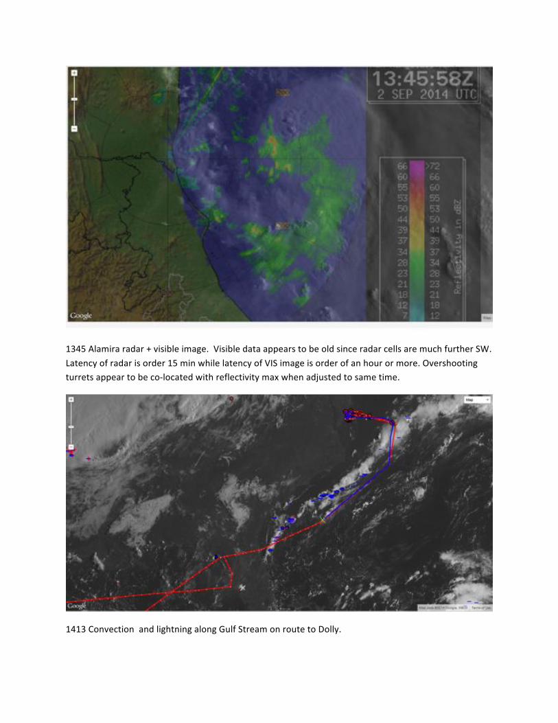
1345(Alamira(radar(+(visible(image.((Visible(data(appears(to(be(old(since(radar(cells(are(much(further(SW.(Latency(of(radar(is(order(15(min(while(latency(of(VIS(image(is(order(of(an(hour(or(more.(Overshooting(turrets(appear(to(be(coGlocated(with(reflectivity(max(when(adjusted(to(same(time.(
(
1413(Convection((and(lightning(along(Gulf(Stream(on(route(to(Dolly.(

(
1420(CIMMS(product.(Convection(picking(up(with(south(cluster.(
(
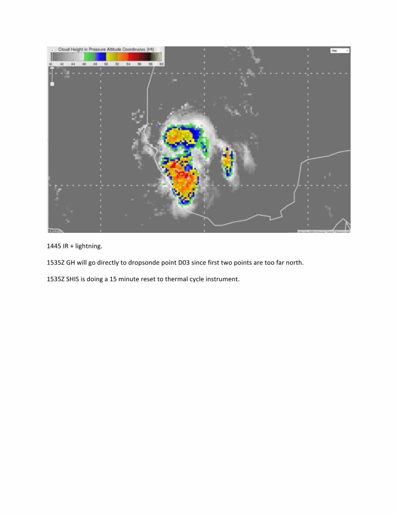
1445(IR(+(lightning.((
1535Z(GH(will(go(directly(to(dropsonde(point(D03(since(first(two(points(are(too(far(north.(
1535Z(SHIS(is(doing(a(15(minute(reset(to(thermal(cycle(instrument.(
(

(
1530Z(radar.(Reflectivity(max,(associated(overshooting(turrets(and(lowGlevel(circulation(have(all(rotated(around(edge(of(anvil(from(north(of(suppercell(anvil(center(to(SW(of(supercel(anvilG(suggesting(some(larger(scale(midGlevel(circulation(center(further(to(the(east.(This(appears(to(be(substantiated(by(appearance(a(short(time(later((see(below)(of(a(distinct(small(scale(circulations(center(in(the(form(of(a(transient(partial(eye(feature.(
(
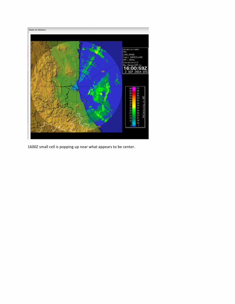
1600Z(small(cell(is(popping(up(near(what(appears(to(be(center.(
(
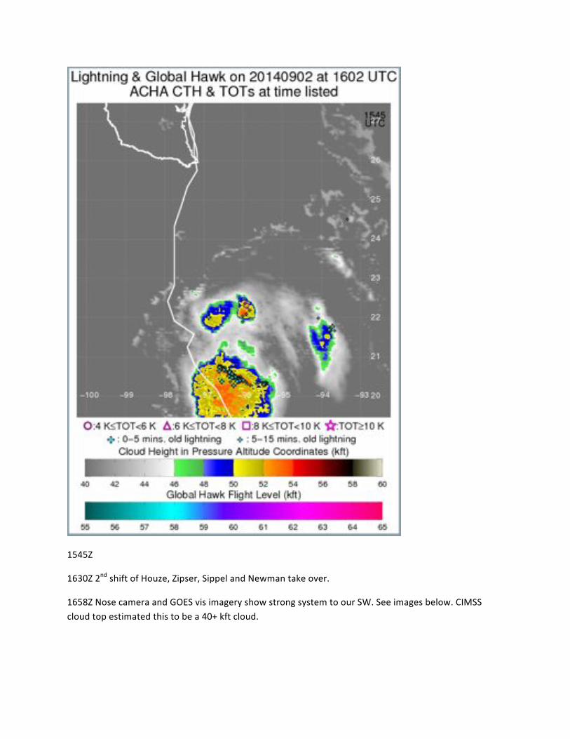
1545Z(
1630Z(2nd(shift(of(Houze,(Zipser,(Sippel(and(Newman(take(over.(
1658Z(Nose(camera(and(GOES(vis(imagery(show(strong(system(to(our(SW.(See(images(below.(CIMSS(cloud(top(estimated(this(to(be(a(40+(kft(cloud.(

(
1734Z(Modifying(drop(locations(and(track.(

(
1910(After(some(intense(maneuvering(around(the(cirrus(anvil(–(pilots(are(nervous(about(overflying(high(cirrus.((CPL(shows(some(very(high(cirrus.(
(
1915Z((CIMMS(cloud(top(heights(are(extremely(high,(but(this(is(mainly(cirrus(blow(off.(
(
(

(
(
(
2324Z(Storm(is(moving(onshore(between(0200(and(0300Z(based(on(Teal(73(fixes.(

(
0307(started(NGS(racetrack(to(sample(equatorward(outflow(jet(for(CPL.((Eastern(and(northern(bounds(of(the(race(track(were(bounded(by(limits(of(the(NOTAMS(that(were(filed.((Last(2(dropsondes(launched((at(N(end(of(the(1st(NGS(leg(and(S(corner(of(2nd(SGN(leg.(
(
(
(
(
(
(
(
(
(
(
(

(
0200(WellGdeveloped(equatorward(outflow(jet(in(Dolly’s(eastern(semiGcircle.((Race(track(set(up(to(sampe(and(then(over(toward(the(coast(before(heading(home.(
(
(
(
(
(
(
(
(
(

(
0000(wind(shear(analysis(shows(~15G20(kt(of(NW(shear(over(Dolly(
(
(
GPS(dropsonde((231156z;(24.22N,(97.29W,(see(the(symbol(in(the(above(image).((200G850(hPa(shear:(30(kt(267(deg;(200G700(hPa:(21(kt(244(deg;(350(hPa(RH:(9%.(

(
(
(
GPS(dropsonde((013929z;(20.54N,(96.65W)(dropped(along(a(NWGSE(coastal(leg(south(of(the(center.((Double(tropopause(structure((lower(inverison(likely(marks(the(top(of(the(cirrus(canopy(and(related(to(post(sunset(cooling.((Lower(temperature(is(2.5oC(and(291(m(deep.((Low(levels(appear(to(be(fairly(dry(as(well:(surface(RH:(76%;(925(hPa((RH:(62%.(
(

(
0300(Top(image(above(shows(the(flight(track(up(to(0300Z(where(a(dropsonde(was(released(to(sample(the(outflow(layer.(The(skewGT(diagram(shows(data(from(that(sonde(which(indicates(easterly(to(southeasterly(flow(at(low(levels(switching(to(northerly(flow(aloft.((
(
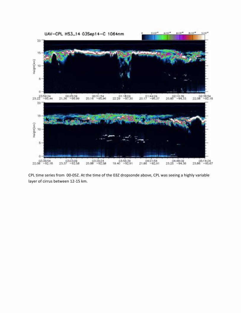
CPL(time(series(from((00G05Z.(At(the(time(of(the(03Z(dropsonde(above,(CPL(was(seeing(a(highly(variable(layer(of(cirrus(between(12G15(km.(

(
0354(Dropsonde(at(the(southern(end(of(lawnmower(pattern((this(was(the(last(drop(of(the(flight).(Results(are(similar(to(the(northern(region,(but(somewhat(weaker(flow(at(lower(levels(and(stronger(flow(aloft.(The(profile(above(600(mb(is(very(moist(with(the(exception(of(a(dry(layer(just(beneath(the(anvil(region.(CPL(shows(a(stronger(cloud(signal(in(this(region(with(cloud(tops(ner(16(km.(

(
SGHIS(brightness(temperature(from(the(entire(flight.(
(

(
The(above(figures(show(the(sonde(distribtion(in(a(stormGrelative(reference(frame.(Wind(barbs(show(stormGrelative(winds.(Color(filled(circles(show(total(groundGrelative(wind(speed(at(850(and(150(hPa.(LowGlevel(winds(depict(the(closed(circulation.(The(strongest(winds(are(generally(located(at(fairly(large(radius,(consistent(with(the(system(being(a(somewhat(disorganized(tropical(storm.((At(upper(levels,(the(outflow(is(primarily(to(the(SE(at(up(to(35(kt.(
(
Instrument)Reports)
AVAPS(Station(9((AVAPS(Science):((Gary(Wick,(Ryan(Spackman*,(Natalie(Gaggini(Station(8((AGS):((Terry(Hock,(Dean(Lauritsen,(Laura(Tudor((*(Corresponding(author((
The(third(science(flight(targeted(the(forecasted(rapid(development(of(TS(Dolly(before(landfall(on(the(SE(coast(of(Mexico.((This(was(a(100%(successful(flight(for(AVAPS(with(50(of(50(sondes(deployed.((Data(quality(was(excellent(with(no(fast(falls(and(essentially(no(telemetry(data(gaps(despite(numerous(aircraft(turns(after(sonde(launch.((Also,(AVAPS(performed(smoothly(during(a(couple(3GtoG4(min(drop(interval(sequences.((All(data(were(processed(in(real(time,(transmitted(through(the(GTS,(and(preliminary(data(

made(available(to(science(team(members.((The(instrument(is(fully(operational(and(prepared(for(the(next(flight(opportunity.(
Another(major(realGtime(processing(achievement(was(realized(during(this(flight.((All(the(raw(DGfiles(are(now(available(to(the(outside(world(and(we(are(able(to(access(them(from(the(AVAPS(science(station((Station(9).((During(the(next(flight,(we(will(be(working(to(automate(our(scripts(to(grab(them(directly(without(the(external(drive(transfer(that(currently(occurs(between(data(networks(in(the(GHOC.(
Sondes Allocated 750 Remaining 555 74.0% Released 195 26.0% Flight Take off Date Sonde Usage Sondes Left RF01 8/26/2014 75 675 RF02 8/28/2014 70 605 RF03 9/3/2014 50 555 (
(
S.HIS)Flight)Summary
Dan(DeSlover,(Joe(Taylor,(Bill(Smith,(Sr.,(Lori(Borg;(SSEC,(University(of(WisconsinGMadison
Summary:
SGHIS(MTS(products(were(severely(impacted(due(to(fragmentation(of(the(SGHIS(data(on(the(aircraft(network.(This(was(a(factor(during(the(entire(flight,(but(not(due(to(any(issues(with(the(SGHIS(instrument(or(software.(Complete(SGHIS(data(will(be(available(in(postGprocessed(products.
An(atGaltitude(power(cycle(of(the(SGHIS(at(45(minutes(prior(to(the(first(science(waypoint(was(requested(to(mitigate(SGHIS(cooler(temperature(drifting(occurred(at(1524(UTC.(The(power(off(cycle(was(15(minutes(duration.
SGHIS(crew(spent(much(of(the(flight(working(with(IT(to(determine(potential(issues(with(a(significant(decrease(in(datagram(packets(being(transferred(via(Ku.(This(impacted(the(realGtime(display(of(observed(brightness(temperature,(though(sounding(and(other(products(were(still(available.(Figure(1(shows(a(very(periodic(dropout(in(the(realGtime(observations(and(then(noted(improvement(once(IT(decreased(the(bandwidth(used(for(VOIP(communications.(Note(that(this(improved(SGHIS(datagram(transmission,(but(the(resultant(SGHIS(data(downlink(was(still(much(less(than(that(of(prior(flights(and(insufficient(to(generate(adequate(realGtime(products.(Figure(2(shows(the(reduced(realGtime(crossGtrack(brightness(temperature(product(display(as(a(result(of(the(poor(data(transfer(efficiency(over(Ku.
The(science(objectives(were(focused(on(Tropical(Storm(Dolly(as(the(system(was(beginning(to(make(landfall(on(the(coast(of(Mexico.(A(number(of(“figureG4”(flight(patterns(were(negotiated(by(mission(science(in(an(effort(to(observe(the(quickly(moving(system.(The(original(flight(track(was(abandoned(in(favor(of(dynamic(and(nearGreal(time(modifications(to(the(flight(track(to(optimize(the(number(of(

overpasses(over(Dolly(before(landfall.(The(storm(produced(very(high(cirrus(clouds,(Figure(3.
Timeline)(All)times)are)UTC)and)are)only)approximate):
• 20140902T1043(GH(engine(start((issues(on(a/c,(reGcycle(power)((• 20140902T1111(GH(engine(restart((• 20140902T1150(Ku(ON(and(transmitting((• 20140902T1155(Takeoff((• 20140902T1156(SHIS(Power(on((after(takeoff(due(to(delays)((• 20140902T1220(SGHIS(detector(temperature(and(cooler(nominal((• 20140902T1225(Significant(SHIS(datagram(loss(noted—begin(troubleshooting((• 20140902T1336(VOIP(shutdown,(strong(improvement(in(SHIS(datagram(efficiency((• 20140902T1353(Change(SHIS(PMTU(settings—no(improvement((several(reboots(w/(different(
(settings).(Believe(datagram(loss(due(to(VOIP(traffic(clobbering(SHIS(Ku(bandwidth(or(other(IT(setting((changes.((
• 20140902T1524(SHIS(power(down(for(15(minutes((• 20140903T0952(SGHIS(descent(heaters(on((• 20140903T1011(Instrument(power(OFF(before(descent((IL42,(IL41,(DC42,(DC41)((• 20140903T1029(Instrument(power(ON((DC41,(DC42,(IL41,(IL42)((• 20140903T1117(Instrument(power(OFF((DC41,(DC42,(IL41,(IL42)((• 20140903T1134(Landing(((
• Figure)1:)S.HIS)real)time)image)showing)significant)datagram)dropout)(with)periodic)gaps))
before)IT)started)modifying)VOIP)bandwidth.)(

Figure)2:)S.HIS)895.900)cm
.1)Brightness)Temperature)image)in)MTS)illustrates)significant)
reduction)in)display)product)due)to)Ku)data)transfer)dropouts.
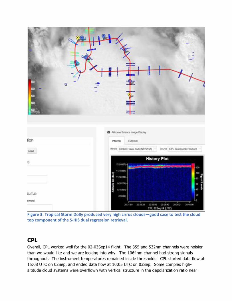
Figure)3:)Tropical)Storm)Dolly)produced)very)high)cirrus)clouds—good)case)to)test)the)cloud)
top)component)of)the)S.HIS)dual)regression)retrieval.
(
CPL Overall, CPL worked well for the 02-03Sep14 flight. The 355 and 532nm channels were noisier than we would like and we are looking into why. The 1064nm channel had strong signals throughout. The instrument temperatures remained inside thresholds. CPL started data flow at 15:08 UTC on 02Sep. and ended data flow at 10:05 UTC on 03Sep. Some complex high-altitude cloud systems were overflown with vertical structure in the depolarization ratio near

18:16 utc, as shown in seg B-2 below. A nice thunderstorm complex was observed in seg A-9 (below). We might have to lower the main instrument box during post-flight on Saturday to trouble shoot the signal issue.
(

(
(