hunting and fishing imperiled - theodore roosevelt ... · hunting and fishing imperiled ... the...
TRANSCRIPT

Hunting and Fishing Imperiled
Energy development threatens 10 of the most important fish and wildlife habitats on America’s
public lands.
During the past decade, an unprecedented energy boom has transformed huge tracts of the West’s cherished public lands. Much of this development has happened in irreplaceable wildlife habitat – special places where families have hunted and fished for generations. Unfortunately, because some development is poorly planned, America’s outdoor legacy is at risk. Between 2000 and 2008, the number of permits to develop oil and gas tripled, and an estimated 126,000 new wells are planned for the next 20 years. Another 26 million acres – an area larger than Ohio – are already leased for development. Sportsmen appreciate how important energy is to our country. But oil and gas drilling that pays little regard to fish, wildlife and water resources is unacceptable. Fortunately, many of the worst impacts of energy development can be avoided with careful planning. That’s why hunters and anglers created the Sportsmen for Responsible Energy Development coalition – and why we’re highlighting 10 irreplaceable fish and wildlife habitats at risk from irresponsible drilling. This overview explains what makes these habitats special and how they are at risk. The full report recommends ways to develop energy without losing recreational opportunities or the $7 billion that hunting and fishing contribute to the Western economy annually. The report also features testimonials from outfitters, guides and small-business owners who depend on these public lands and who want future generations to enjoy them too.

Colorado The Roan Plateau
John Gale Summary Located in western Colorado, just northwest of the town of Rifle, the Roan Plateau is comprised of approximately 67,000 acres of public lands, with about 34,000 acres located on top of the plateau and the remainder below the rim. These lands vary widely from sagebrush scrubland below the rim to deep lush canyons on top, making the Roan Plateau one of the most ecologically diverse landscapes in Colorado. The Roan offers some of the state’s best elk and deer hunting and supports healthy populations of native cutthroat trout. The Roan Plateau amounts to 1.5 percent of the larger Piceance Basin, where extensive energy development is well under way. With more than 90 percent of the public lands in the Piceance available for leasing and drilling, the Roan Plateau is literally an oasis of wildlife and trout habitat in a desert of industrial development. Despite protests from 14,000 citizens and more than a dozen conservations groups plus objections from Colorado’s elected leaders, the Bureau of Land Management (BLM) has moved forward with its plan to drill this sportsmen’s paradise. In August 2008, the federal agency sold leases for all of the public lands on the Roan Plateau. The lease sales were especially galling to sportsmen, who four months earlier witnessed the impacts of 1.2 million gallons of industrial drilling mud spilled into the Parachute Creek watershed from an adjacent drilling operation on private land. Whatever the resolution of the Roan Plateau controversy, at least some amount of drilling appears imminent. In August 2009, the lease holder, Bill Barrett Corp., told its investors the company had identified “up to 3,200 additional potential drilling locations” on the Roan. The question now is whether that development will be balanced with the needs of fish and wildlife.

What’s at Risk? The lands on top of the plateau are bisected by four streams: Trapper Creek, the East Fork of Parachute Creek, Northwater Creek and the East Middle Fork. All of these streams contain important populations of rare, native Colorado River cutthroat trout, a species that occupies less than 10 percent of its historical range. The plateau is a refuge for herds of elk and mule deer that attract hunters from across the country. It is truly a safe haven in the industrial development surge that is occurring in the lands surrounding the plateau. Local communities at the base of the Roan have long depended on these public lands for their outdoor recreational opportunities, including hunting and high-quality backcountry fishing. The BLM itself states that “the [Roan Plateau] is extremely species rich. There are only three areas of similar size in Colorado that contain such a richness of rare species. . . . Although the [plateau] is clearly of comparable biological significance; it is the only area of the four that does not enjoy protective status.”
The Sportsmen’s Solution Hunters and anglers who have spent years working to protect the Roan Plateau have been involved in talks with the BLM and lease holders to settle a lawsuit about the proposed leases on the Roan. Any settlement will need to require that habitat necessary for wildlife and trout is adequately protected from the industrial activity that would accompany drilling. If a settlement cannot be reached then a judge is expected to rule on the lawsuit this year and the leases could be canceled, allowing the BLM to revisit the issue with a fresh start.

Short of a settlement or favorable outcome in the lawsuit, sportsmen will be involved with the BLM and state of Colorado drilling approval process to ensure that the most sensitive areas – such as big-game winter range and cutthroat watersheds – of the Roan Plateau are protected to the greatest extent possible. Sportsman in the Spotlight John Trammell John Trammell has spent many hours on the Roan working to restore native trout populations. John is an active member of the Grand Valley Anglers chapter of Trout Unlimited. He and other chapter members have worked during the last 17 years to restore riparian habitat and build fencing to protect portions of the streams on the Roan Plateau. They also have been instrumental in increasing public understanding of the unique values atop the plateau, with emphasis on the Roan’s rare Colorado River cutthroats. John is one of many sportsmen outraged at the potential loss of this unique place and its native fish. The prospect of widespread drilling atop the Roan is a sobering thought for John.
Melissa Trammell
“It would be a serious mistake to jeopardize the irreplaceable values of native fish on the Roan by drilling in their watersheds.” – John Trammell

Colorado North Park Valley
Steve Torbit Summary The North Park valley lies more than 8,000 feet above sea level, surrounded by the Medicine Bow Mountains and the Rawah, Park and Zirkel ranges. Numerous creeks and rivers flow from these mountains into North Park to create the headwaters of the North Platte River, a 680-mile waterway that flows through Colorado, Wyoming and Nebraska. The Bureau of Land Management (BLM) has leased 125,000 acres of North Park for oil and gas drilling, and pressure is increasing throughout the region to exploit the energy resources that lie under the area. Test wells already have been drilled by one company and two other companies are seeking approval from the BLM to gain drilling access to leases in the valley. The North Park parcels that have been leased for energy development include provisions for scant quarter-mile buffers around known sage grouse breeding grounds, or “leks.” Science has shown such measures are inadequate to protect the grouse, which the U.S. Fish and Wildlife Service is considering for listing under the Endangered Species Act. The Colorado Division of Wildlife has expressed concern about leasing in these critical sage grouse nesting and breeding areas. If development moves forward using the BLM’s typical criteria for buffers, sage grouse populations are likely to decline. And that decline will inevitably lead to reduced or eliminated hunting seasons. What’s at Risk? The North Platte River is recognized as a Gold Medal trout fishery by the Colorado Division of Wildlife and as a Blue Ribbon trout stream by the Wyoming Game and Fish Department, designations reserved for the states’ highest-quality coldwater fish habitats.

North Park is home to one of the strongholds for greater sage grouse in Colorado and the North Park mule deer herd is renowned for its long seasonal migrations. The valley also provides excellent hunting for elk, pronghorn antelope, bighorn sheep, sage grouse, waterfowl and moose. Today the few roads and a limited amount of energy development infrastructure have not affected North Park’s wildlife habitat. Large-scale development, however, would require the construction of roads, drill pads, pipelines and other infrastructure that has been shown to increase sediment loads in waterways and fragment crucial wildlife habitat. If development is not pursued responsibly in North Park, hunting and fishing could be ruined for decades.
The Sportsmen’s Solution The BLM has a great opportunity to write a comprehensive conservation plan for North Park and provide baseline data prior to further development. Thorough planning that considers the entire landscape will enable thoughtful energy development to proceed in North Park while minimizing the adverse effects on hunting and fishing resources. The Kremmling BLM office, which manages the federal mineral estate in this region, is revising its 24-year-old resource management plan. Development should not proceed until this revised plan is completed and incorporates the latest science available for managing sage grouse populations and other wildlife and fisheries resources. In addition, development occurring in areas adjacent to Gold Medal and Blue Ribbon streams must be done with extreme care. If development occurs, stream buffers must be established to safeguard water quality. These streams offer some of the best fishing the states of Colorado and Wyoming have to offer. The loss of the unique fisheries in these remarkable waters would constitute a national tragedy.
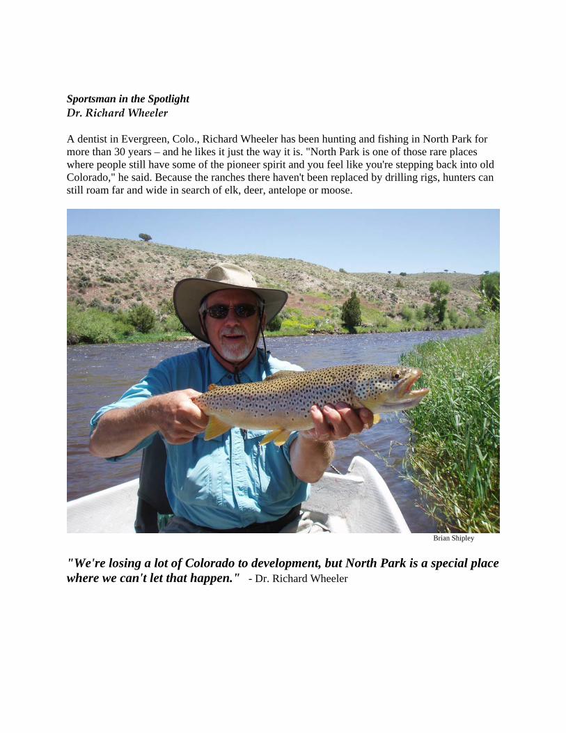
Sportsman in the Spotlight Dr. Richard Wheeler A dentist in Evergreen, Colo., Richard Wheeler has been hunting and fishing in North Park for more than 30 years – and he likes it just the way it is. "North Park is one of those rare places where people still have some of the pioneer spirit and you feel like you're stepping back into old Colorado," he said. Because the ranches there haven't been replaced by drilling rigs, hunters can still roam far and wide in search of elk, deer, antelope or moose.
Brian Shipley "We're losing a lot of Colorado to development, but North Park is a special place where we can't let that happen." - Dr. Richard Wheeler

Montana The Middle Yellowstone River Valley
BigSkyFishing.com
Summary Few places better evoke a sense of the great outdoors and abundant wildlife populations than the Middle Yellowstone River Valley. Located between the Montana towns of Bozeman and Billings, and framed by the Beartooth Mountains to the south and the Gallatin Range to the west, this storied region has been a dream hunting and fishing destination for generations of Americans. Unfortunately, the heritage of exceptional fishing and hunting is being threatened by poorly planned oil and gas development. Stillwater County, home to the Stillwater River, Rosebud Creek and the Yellowstone River, could host up to 700 coalbed methane wells and up to 100 conventional natural gas wells in the coming years, according to the Bureau of Land Management (BLM). In addition, the Montana Department of Natural Resources and Conservation has proposed leasing nearly every single tract of land the agency manages for oil and gas extraction, including parcels along the bed of the Yellowstone River and along Blue Ribbon stretches of the Boulder and Yellowstone rivers.
Perhaps the greatest challenge facing this region is the mixed land ownership, which includes the U.S. Forest Service, the BLM, and state and private landowners and whose lands sit on top of federally owned minerals. Wildlife conservation agreements vary widely between these jurisdictions. For instance, the Butte field office of the BLM recommends that lands near cutthroat streams and Blue Ribbon Fisheries be protected by a half-mile buffer where no surface disturbances are allowed. Yet the Billings field office, which manages most of the Middle Yellowstone country, does not require any buffer whatsoever. What’s at Risk?

Streams in this part of Montana offer exceptional recreational fishing and are a stronghold for Yellowstone cutthroat trout. Numerous streams contain conservation populations that are critically important for the continued survival and conservation of this species. The Middle Yellowstone area also is renowned for big-game and bird hunting. Hunting opportunities abound in the Gallatin and Custer national forests, and deer, elk, upland bird and waterfowl hunters can choose among a multitude of excellent locations at lower elevations.
The Sportsmen’s Solution Without a coordinated conservation plan that reflects comments from all relevant stakeholders, securing long-term conservation of game and fish populations in the region will be impossible. Landowners and agencies charged with managing these areas must develop conservation plans that ensure consistent resource protections regardless of which agency presides over a specific well pad, road, or waste water pit. Furthermore, this plan must take into consideration the entire landscape of the valley and, at a minimum, be consistent with or stronger than the plans and objectives of state wildlife agencies. Specifically, these plans should establish a minimum half-mile, no-development buffer for all cutthroat trout and Blue Ribbon fisheries, as well as much larger buffers for wildlife winter range and crucial sage-grouse habitats. Sportsman in the Spotlight Mike Willett Mike Willett is one of many sportsmen who know firsthand the importance of this region’s natural heritage. In the summer of 2003, Willett spent 32 consecutive days fishing the Stillwater River. Willett’s family lives nearby in the small town of Fishtail, Mont., and every day that summer he took his fly rod and waded the Stillwater. Spending that much time on a stream not only makes you a pretty good angler, it makes the stream become a part of you.
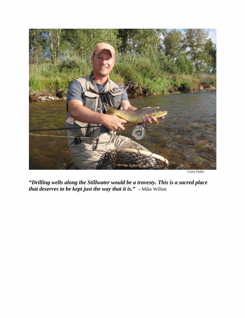
Corey Fisher “Drilling wells along the Stillwater would be a travesty. This is a sacred place that deserves to be kept just the way that it is.” – Mike Willett

Montana The Powder River Basin
Ted Wood Summary An area steeped in the culture of the Crow and Northern Cheyenne nations, the Powder River Basin in Montana is known for some of the most outstanding hunting for elk, mule deer, pronghorn and wild turkeys in Montana. Area ponds, the Tongue River Reservoir and the Yellowstone and Tongue rivers provide unique angling experiences for sauger, walleye and paddlefish. Sportsmen widely identify the Powder River Basin as one of the most important areas in the state for high-quality big-game and upland bird hunting. The Powder River Basin also is rich in resources. The Bureau of Land Management (BLM) has developed a supplemental environmental impact statement (SEIS) for coalbed methane drilling on nearly 3.2 million acres of public land in the Powder River and Billings resource management areas. Methane drilling impacts include saline discharges into the waterways, roads, pads, pipelines, power lines, transmission stations, and noisy compressors, all of which threaten habitat and disrupt migration routes. Many sportsmen as well as Montana Fish, Wildlife and Parks (FWP) have concluded that the BLM’s plan in the SEIS is wholly inadequate for the protection and maintenance of fish and wildlife habitat, and will have a substantial impact on the future of hunting and fishing in the Powder River Basin. If this plan moves forward as it stands, the basin’s outstanding fish and wildlife habitat could be rendered unsuitable for hunting and fishing. What’s at Risk? The Powder River Basin boasts a mule deer population of more than 36,000 and supports nearly 11,000 hunters annually. In Montana, the Powder River Basin ranks first for mule deer hunting among the state’s top four mule deer areas. Throughout the basin, coalbed methane drilling, similar to the development in the Powder River Basin in neighboring Wyoming, threatens the Montana part of the basin’s mule deer habitat, and would make maintaining a healthy mule deer population and reaching FWP’s regionwide annual harvest objectives virtually impossible.

The Sportsmen’s Solution A sharp decline in sage-grouse populations finally has forced the BLM’s office in Buffalo, Wyo.,
to significantly revise its land-use plan and impose interim restrictions on some methane drilling in order to conserve sage-grouse habitat. Unfortunately, with much of the land already leased and being drilled, the success of this after-the-fact conservation effort is uncertain. With careful planning that incorporates better science on managing sage-grouse populations as well other wildlife and fisheries resources and energy development, the Powder River country in Montana can avoid the wildlife losses experienced in Wyoming. Sportsman in the Spotlight Scott Hicswa A Miles City, Mont., resident and chair of the Tongue River Chapter of Pheasants Forever, Scott Hicswa is a dedicated mule deer and upland bird hunter in the Powder River Basin. Scott is a natural resources professional who understands the need for sound up-front planning of energy development to attain the right balance between natural gas production and fish and wildlife conservation.

Grant Winters
“This is an opportunity to ensure that things are done right, so our kids will have special places and abundant natural resources to enjoy.” - Scott Hicswa

New Mexico Otero Mesa
John Gale Summary In a remote area of southern New Mexico, south of the Sacramento Mountains and east of the Guadalupe Mountains, lies a majestic desert grassland known as Otero Mesa. This vast 2,400- square-mile area contains 1.2 million acres of public land overseen by the Bureau of Land Management (BLM). Roughly half of the area is covered by grassland, including the largest remaining tract of black grama grass in North America’s Chihuahuan Desert. In addition to breathtaking landscapes, Otero Mesa features New Mexico's only remaining native pronghorn antelope herds, a healthy mule deer population, a complex ecosystem full of native plants and more than 1,000 species of wildlife, including the rare Aplomado falcon. Hidden below Otero Mesa’s grassland is a large reserve of groundwater known as the Salt Basin. In an area already adversely affected by years of drought, protecting one of New Mexico's last uncontaminated aquifers is critical to the people of New Mexico. Despite its natural beauty and unique hunting opportunities, Otero Mesa is in danger of becoming an industrial oil and gas field. The BLM has acknowledged that the chances of finding economically recoverable amounts of oil and gas in this area are slim, yet agency officials recently gave a green light to energy development throughout the region. Meanwhile, the oil and gas industry has asked that 250,000 acres be opened to leasing in Otero and Sierra counties. During the last 40 years, oil and gas development in nearby Eddy County has significantly fragmented habitat and affected wildlife migration and activity patterns. In some areas of Eddy County, oil and gas wells are spaced fewer than 10 acres apart. The BLM’s plan fails to include adequate protections for wildlife, grassland restoration and water resource protection. Recent scientific studies clearly show that restoration or reclamation of the predominant black grama grasslands is unrealistic and not viable for the diverse flora and fauna of this fragile ecosystem. Surface disturbance, road building, and habitat fragmentation will imperil populations of trophy pronghorn and significantly disrupt the balance of other critical wildlife and plant species.

What’s at Risk? The BLM’s current plan allows drilling on 95 percent of Otero Mesa. If development is allowed, the impacts will be disastrous for the ecosystem and the water beneath this desert landscape. The Salt Basin’s shallow fresh water aquifers are highly vulnerable to contamination from oil and gas development. Drilling will have to go through one of New Mexico’s largest untapped fresh groundwater basins, which is critical to the region. Inevitable spills, produced water leaks and chemical-laden fracturing fluids threaten to penetrate the underlying aquifers and contaminate the water.
Although a 2009 federal court decision invalidated the BLM’s drilling proposal for Otero Mesa, requiring a more thorough environmental impact assessment, sportsmen are still faced with the threat of losing this invaluable landscape for just a few days worth of gas. The Sportsmen’s Solution Because the Salt Basin is an extremely important source of the region’s water and vulnerable to contamination, a broad coalition, including New Mexico’s governor, members of its congressional delegation, neighboring cities and counties as well as sportsmen, is supporting a moratorium on drilling until a comprehensive study of the Salt Basin aquifers is completed. To conserve the last stronghold of the Chihuahuan Desert grassland, a citizen’s proposal was submitted to the BLM to designate 583,837 acres of the mesa as an “area of critical environmental concern.” The best solution to protect Otero Mesa’s fragile ecosystem and its critical water resource is to help pass congressional legislation that eliminates mineral development, including oil and gas, from this magnificent area.

Sportsman in the Spotlight Rick Simpson Rick Simpson is a native New Mexican who grew up hunting and exploring Otero Mesa. As owner of S-S Outfitters in Glencoe and a former county commissioner from southern New Mexico, Rick has seen how irresponsible energy development in southeast New Mexico has transformed vast tracts of desert shrub and grassland into an industrial wasteland. During the past five years, Rick has been a champion for responsible energy development and the protection of Otero Mesa’s fragile habitat, wildlife and invaluable water resources.
Bob Willis
“For sportsmen in this area, Otero Mesa is worth much more as a place for future generations to hunt than it ever will be for energy development.” – Rick Simpson

New Mexico/Colorado The San Juan Mountain Ecosystem and HD Mountains
Steve Torbit
Summary In the arid parts of New Mexico and southern Colorado, streams sometimes simply disappear into the sand. A notable exception to this high-desert phenomenon can be found in the San Juan Mountains. Covering the eastern part of New Mexico’s Rio Arriba County and the western part of Taos County and extending into southern Colorado, the San Juans have abundant rainfall that sustains the lush mountainous terrain and wet meadows that form some of New Mexico’s premier fishing waters. Popular streams such as the Rio Brazos and native cutthroat fisheries such as El Rito de Tierra Amarilla, Rio San Antonio and the Rio de Los Piños all spring up from the marshy wetlands that cover much of the region. Some of the same sportsmen who enjoy this incredible region helped stop a proposal for 10 wells to be drilled in the western flank of the San Juan Mountains, within casting distance of El Rito de Tierra Amarilla. Rio Arriba County already has more than 11,000 wells, but so far, they are confined to the arid western portion of the county. Today, sportsmen are expressing concern about leases under consideration in the eastern part of the county that would threaten one of the state’s most important rivers. The HD Mountains, named for an historic cattle-ranch brand, represent one of the last undrilled roadless areas in San Juan Basin. Currently, 27 new wells and 11 miles of roads are slated for this 40,000-acre area in southwest Colorado. On the edges of the roadless area, 11 new wells have been approved, despite a pending lawsuit challenging the permits. What’s at Risk? The San Juans offer some of the best elk, deer and pronghorn antelope hunting in New Mexico, and provide anglers with endless opportunities along the banks of its prized trout streams. In western Taos County, populations of elk and deer that are among the strongest in the state winter in the rolling grasslands around San Antonio Mountain and Puncho Valley. But the area and its

ecosystem are being threatened by potential widespread oil and gas development from the west and the north. Across the state line, thousands of acres in or near Colorado’s San Luis Valley were proposed for leasing last year, and that trend could continue into northern New Mexico. In Colorado’s HD Mountains, big-game migration corridors and critical winter habitat are threatened as well as old-growth ponderosa pine, some of which are more than 300 years old. Plans to drill the area would allow new roads to be built in the most rugged terrain in the San Juan Mountains and adversely affect popular hunting and fishing grounds in the HD Mountains.
The Sportsmen’s Solution Concerns over water and wildlife have prompted New Mexico Gov. Bill Richardson to call for changes in state regulations to protect water and wildlife and call a “time out” until a development plan is in place. Sportsmen have pushed for developing stronger guidelines, including setbacks to buffer cold water fisheries, strict monitoring of drilling pollutants and mandatory well spacing for development close to surface and groundwater. Hunters and anglers also have supported a proposed national conservation area encompassing more than 235,000 acres of the Puncho Valley that would withdraw mineral development rights and conserve this critical winter range abutting the San Antonio Mountain area. Sportsman in the Spotlight Greg Scott Greg Scott runs Red River Anglers and lives with his wife and two sons in Red River, N. M. Greg is well aware of the impacts energy development is having on wildlife and water resources in his county and throughout the Rocky Mountain states. As vice president of the Enchanted Circle chapter of Trout Unlimited, Greg is actively involved in ensuring that energy development

is done in an environmentally responsible manner in order to conserve the fish and wildlife resources on which New Mexico depends.
Bobby Fellows
“We’ve worked long and hard to restore Rio Grande cutthroat trout to some of these drainages, and we expect the government and industry to take that into consideration before leasing and drilling in habitat that just can’t be replaced once it’s gone.” – Greg Scott

Utah Uinta National Forest
John Gale Summary The Uinta National Forest is home to some of the best wild and native cutthroat trout fishing in national forests throughout Utah, with angling opportunities ranging from flat-water glides to mountain stream riffles. Five Blue Ribbon waters are located either within the Uinta National Forest or fed directly by the cold, clear water that flows from these public lands. As America’s appetite for energy increases, the Uinta National Forest is one of the places where energy companies want to look for oil and natural gas. Until recently, little interest was paid to this part of Utah by the energy industry. As exploration companies seek new opportunities, however, the Uinta National Forest has become a target. Starting in 2004, approximately 165,000 acres of the forest have been leased, mostly in the Diamond Fork and Strawberry Valley regions. These lands feature prized coldwater fisheries, crucial and high-value elk and deer winter range, popular big-game hunting grounds and a multitude of recreational opportunities. All of the leases issued were based on an outdated planning document from 1997. In 2003, the Uinta National Forest revised its plan and specified stronger fish and wildlife protection measures for energy development. Without explanation, these stipulations were not included on the leases that were sold, leaving sensitive fish and wildlife habitat, including roadless backcountry areas, in jeopardy. What’s at Risk? Known for its vast fishing opportunities, the Uinta’s Strawberry Reservoir is Utah’s most popular trout fishery, accounting for 14 percent of the fishing use for the entire state. Anglers annually spend approximately 1.5 million hours on its waters, and fishing on the reservoir generates $20 million annually to the state’s economy. The main attraction on Strawberry is

colossal Bonneville cutthroat trout, which are often weighed in pounds, with the state record tipping the scales at 26 pounds, 12 ounces. Trout Unlimited has invested countless hours and substantial financial resources in restoring this fishery over the past decade, including an effort that removed non-native trout from 23 miles of the upper Diamond Fork.
The Uinta National Forest also is a mecca for big-game hunting. Once the fall hunting season begins, camouflage and blaze orange adorn most of the forest visitors as hunters scour the ridges for elk and mule deer. Despite high hunting pressure, roadless backcountry lands in the forest allow hunters room to roam and give deer and elk the habitat security necessary to grow into mature bucks and bulls. Unfortunately, many of the energy development leases sold in recent years are in these roadless backcountry areas as well as winter range on which big game depend on for survival. Due to the variety of habitats found in the Strawberry Valley and Diamond Fork regions, these portions of the forest provide everything that deer and elk need to survive year round, from winter range necessary to endure harsh winters to lush summer ranges where calves and fawns grow strong. The Sportsmen’s Solution Sportsmen have been working to implement the Uinta Sportsmen’s Oil and Gas Conservation Plan, which maps high-quality habitats and guides development in places that already are leased for energy development. On lands yet to be leased, the Forest Service must take a leadership role in developing its forestwide oil and gas leasing environmental impact statement and recognizing how important this area is to sportsmen. The Forest Service plan should establish base line data for fish and game, specify best management practices and enforce specific protections for fish and game. Additionally, the Forest Service needs to ensure that protections for trout and wildlife habitat, as well as roadless lands, are part of this plan and are implemented during the application-to-drill process for previously issued leases.

Sportsman in the Spotlight David Serdar David Serdar has fished Strawberry Reservoir and streams in the Uinta National Forest since his childhood. His family has a cabin near Strawberry, and those early fishing experiences instilled an appreciation for trout fisheries he exhibits today as vice president of conservation for the Stonefly Society of the Wasatch, Utah’s oldest and largest Trout Unlimited chapter. Serdar’s close connection to the land and water in this region has made him one of its biggest advocates. His chapter regularly volunteers to help with restoration projects, thereby helping to guarantee that the next generation enjoys the outdoor opportunities that abound on the Uinta National Forest, just as he did.
Corey Fisher
“Highlighting the Uinta puts industry and the government on notice that sportsmen care deeply about these places – and we want to see them protected, now and for generations to come.” – David Serdar

Utah Book Cliffs
Joel Webster Summary Stretching more than 200 miles from Price, Utah, to Palisade, Colo., the Book Cliffs encompass the longest continuous escarpment in the world and are considered one of the greatest big-game hunting areas on earth. Primarily public land administered by the Bureau of Land Management (BLM), the Book Cliffs are a popular backcountry hunting destination with a limited number of licenses are available to hunt the area’s trophy-class elk and mule deer. The BLM has described Gray Canyon in the Book Cliffs area as “a place where a visitor can experience true solitude – where the forces of Nature continue to shape the colorful, rugged landscape.” Part of the Uinta Basin, the Book Cliffs area is thought to contain large quantities of natural gas and includes the nation’s strategic oil shale reserve. Much of the region already has been leased for energy development in a disjointed fashion without the rigorous planning needed to ensure development is done right. During the next 15 years, the BLM estimates 7,800 new natural gas wells will be drilled in the Vernal and Price areas alone. Much of this development will occur in crucial mule deer, elk, bison, and bighorn sheep summer and winter range and migration routes and will result in an untidy maze of roads, pipelines and wells. If and when the strategic oil shale reserve is opened for development, a whole new level of threats will arise. The BLM is proposing a 45-mile highway through the heart of the Book Cliffs and crucial deer winter range to accommodate accelerated natural gas development. This proposed road would cut off an important big-game migration route and, according to state projections, could result in a 20-percent reduction in the Book Cliffs mule deer herd.

If crucial big-game summer and winter range are fragmented by roads and drill-rig traffic, sportsmen could lose one of the last, great backcountry hunting destinations in the West. In just a decade, the legendary trophy bucks and bulls of the Book Cliffs could become a memory, and the backcountry hunting that has been enjoyed for generations could be reduced to a maze of roads. Not only will the millions of dollars invested in fish and wildlife recovery in the Book Cliffs be lost, so will the opportunities to enjoy this great Western hunting destination.
What’s at Risk? This important sportsmen’s recreation area is home to mule deer, elk, bighorn sheep, bison, pronghorn antelope and native trout. Utahans know that the Book Cliffs offer some of the best hunting and fishing in the state, if not the nation. The Utah Division of Wildlife Resources has spent millions of sportsmen-generated dollars to restore populations of Rocky Mountain bighorn sheep, Colorado River cutthroat trout and American bison on the Book Cliffs. The state agency’s long-term plan is to facilitate increased sportsmen opportunity to pursue these important big-game animals, yet projected and proposed developments threaten current opportunities for sportsmen to pursue game. The Sportsmen’s Solution Ultimately, unless the BLM begins incorporating a more comprehensive approach to development, the great mule deer and elk herds of the Book Cliffs could fade away and recovery efforts for bison and bighorn sheep could be stymied. If energy development is planned to address the needs of fish and wildlife, however, we can maintain many of the important values of this treasured hunting destination. Phased development will help maintain the important summer range, migration corridors, and winter range of the Book Cliffs. Impacts to wildlife need to be monitored and adaptive management needs to take place to prevent wildlife populations from falling below predetermined thresholds.

Sportsman in the Spotlight Clay Hamann A Utah native, Clay Hamann has hunted and fished all over the West, but prefers to hunt the Book Cliffs of eastern Utah. Clay has been fortunate to hunt for trophy elk and trophy mule deer in this pristine area, and he recognizes the Book Cliffs as one of the last best places to find large deer and elk. He has served on the northeastern regional committee for the Utah Department of Wildlife Services for 10 years as well as the Uintah Basin Chapter of the Rocky Mountain Elk Foundation banquet committee. Clay has been instrumental in raising funds for wildlife in the Book Cliffs and he wants to see the area remain a place where wildlife thrive and future generations can hunt.
Clay Hamann “Long after the energy resources have been depleted, the Book Cliffs must remain a viable area for wildlife. Proper planning is the key.” – Clay Hamann

Wyoming Greater Little Mountain Area
Cathy Purves Summary Little Mountain has emerged as a battleground in the oil and gas energy boom in southwestern Wyoming. Located about 40 miles south of Rock Springs, the greater Little Mountain area supports thriving populations of elk and mule deer and is considered by many to be one of the best hunting destinations in the state. In addition to healthy sage grouse populations, the sub-alpine fir and juniper woodland-laced landscape also includes streams with superior trout fisheries for the sensitive Colorado River cutthroat trout. Limited energy development already is occurring on Wyoming state lands in the area. More than 169,000 acres in the greater Little Mountain area have been placed on the Bureau of Land Management’s (BLM) lease sale auction block for oil and gas development, but not all acres were sold. Gov. Dave Freudenthal has publicly voiced his concern about the impacts of such development on recreation, critical wildlife habitat, sensitive species, and air and water quality. “Any energy development, whether limited or broad, in the Little Mountain area is going to stir up a perfect storm of wildlife, environmental, recreational and social issues,” the governor said recently. According to the Wyoming State Geological Survey, the proposed energy field in the greater Little Mountain area likely will be characterized by closely spaced wells that will turn this world-class hunting area into a pock-marked industrial zone. Oil and gas leasing and development can adversely affect wildlife habitat if it’s not done carefully. The well pads and construction of associated pipelines and roads, as well as the noise

and water and air degradation, may independently and cumulatively impair a wide range of species. Increased human activity – from truck traffic to the presence of machinery and workers – also can result in conflicts ranging from changed wildlife movement patterns to wildlife poaching.
What’s at Risk? Since 1990, the greater Little Mountain area has benefited from more than $2 million in habitat restoration projects funded by a wide range of groups including Trout Unlimited, Bowhunters of Wyoming, the National Fish & Wildlife Foundation, the Rocky Mountain Elk Foundation, the Western Wyoming Mule Deer Foundation, the Wyoming Game & Fish Department and the BLM. Local hunters, anglers, teachers, Boy Scouts and wildlife enthusiasts have donated their time and participated in on-the-ground habitat projects and monitoring efforts. These restoration activities have supported the thriving elk herd in the Little Mountain area, which offers one of the most sought-after elk tags in the state. In fact, a resident hunter has only about a 6-percent chance of drawing an elk license for the area. Energy development here would bring new roads, which would reduce cover security for elk, increase elk vulnerability and decrease the size of the animals. Colorado River cutthroat trout, which have benefited from habitat restoration efforts in these fragile watersheds, would be compromised by development activity, and that could force the U.S. Fish and Wildlife Service to list the species as threatened under the Endangered Species Act. The Sportsmen’s Solution Sportsmen who use this area want to make sure that development on these lands occurs responsibly and preserves the unique qualities of these important wildlife resources. Where development does take place, the impacts should be minimized through conservation and mitigation measures including proper monitoring and the mandated use of best management

practices. Habitats that have not been developed or leased at this point should remain free from development activities and be withdrawn from future leasing. Sportsman in the Spotlight Joshua Coursey Joshua Coursey is an avid sportsman and the local chapter chairman of the Mule Deer Foundation. As a successful businessman, he appreciates the benefits that energy development has brought to his community in southwestern Wyoming. Yet, what is sometimes overlooked, he says, is “the level of accountability, how exploration occurs on public lands, and the impacts it holds for future generations.” Having hunted for trophy mule deer in the Little Mountain area for more than 20 years, Joshua wants to help ensure that his children can enjoy the same opportunity.
Joey Faigl “This issue is one of great emotion and passion, as it should be, for it revolves around an area that many of us hold to be serene and very dear to our hearts.” – Joshua Coursey

Wyoming Horse Creek-Ryegrass Rim
Cathy Purves Summary The headwaters of the Green River include a small valley that exemplifies Wyoming’s excellent hunting and fishing heritage. The Horse Creek drainage and other tributaries are home to native Colorado River cutthroat trout and provide excellent habitat for moose, elk, mule deer, sage grouse and pronghorn antelope. This region is one of the most popular areas in the state for hunting mule deer, a tradition that dates to the 1800s. Yet it is here that oil and gas companies are focusing their development dreams on some 44,000 acres of pristine wildlife habitat. In 2005, the U.S. Forest Service announced its intent to lease this valued hunting and fishing country for energy production, despite strong objections from Wyoming Gov. Dave Freudenthal residents from all corners of the state. Nearby, the Ryegrass Rim sits above Horse Creek, providing crucial winter range for migrating mule deer. The rim also is home to heavy oil and gas leasing, with a few prospect wells drilled in recent years. But for the most part, this wide open piece of Wyoming’s high sagebrush sea is untouched and open for hunters to enjoy. What’s at Risk? For years, the Horse Creek and Ryegrass Rim country has been a prized destination for mule deer hunters in search of a trophy buck. From the Horse Creek high country to slopes of bitterbrush foothills and benches of sage, the area is a mule deer heaven, where big bucks grow and thrive. Today the backcountry enjoys a world-renowned and well-deserved reputation and has been featured in many outdoors and trophy-hunting magazines. Each fall, sportsmen from

around the world descend on this region in search of their buck of a lifetime – and many are not disappointed. The lush willow and aspen complexes in this country also provide critical forage for moose and elk. And the streams offer excellent fishing for native Colorado River cutthroat trout.
The Sportsmen’s Solution The sale of the 44,000 acres offered for lease in 2005 in the Horse Creek drainage was neither valid nor responsible. Although 2009 federal legislation protected much of the Wyoming Range, oil and gas companies set their sights on the improperly leased 44,000-acre parcel that was left unprotected. Following protests from sportsmen, the BLM announced in August 2009 that it would not proceed with the leases on 24,000 of those acres. With the remaining 20,000 acres still vulnerable, sportsmen are working to conserve undeveloped portions of this northeastern gateway to the Wyoming Range. This area needs to be removed from leasing, and money refunded to bidders. Responsible energy development here means no development at all. Private buyout and retirement of adjacent leases in the region should be considered both on the Ryegrass Rim and in the upper Horse Creek drainage. If development is to occur it must take place with an upfront conservation plan that limits the road and well density to a minimum. Sublette County, home of Horse Creek and the Ryegrass Rim, is slated for more than 10,000 wells in the next 15 years. Placing Horse Creek off limits to development and limiting development on the Ryegrass will still allow trillions of cubic feet of natural gas to be extracted while helping to keep intact one of Wyoming’s largest mule deer herds and best places to hunt and fish. Sportsman in the Spotlight Gary Amerine

Gary Amerine, owner of the Daniel-based Greys River Trophies, has guided hunters in the Wyoming Range west of Merna for decades. He began organizing other outfitters and Daniel-area residents after the U.S. Forest Service announced in 2005 plans to lease for energy development 44,000 acres of the Wyoming Range. “I have hunters come to my hunting camp from all over the country and even other parts of the world,” Amerine said. “They spend money in my hometown and they pay for my services. Some are starting to go other places rather than return for a hunt with me because fewer licenses are available to nonresident hunters than in years past.”
Courtney Amerine “Non-resident mule deer licenses have dropped from 1,400 to 800 in the past five years and that reflects our declining deer herd, which has fallen nearly 50 percent in recent years due in part to the ongoing impacts of energy development.” – Gary Amerine