human interface technologies team
TRANSCRIPT

All Images Copyright HIT Team, EESE, University of Birmingham © 2015
ABOUT THE HIT TEAM
The University of Birmingham’s Human Interface Technologies (HIT) Team, based within the School of Electronic, Electrical & Systems Engineering (EESE) has been pioneering the development and uptake of serious games, interactive media and telerobotic technologies in the UK since 2003, building on over 28 years of experience in the domain of Virtual Reality (VR), Augmented Reality (AR), Mixed Reality, Simulation and Telerobotics/Telepresence. The Team’s participation within the UK’s Human Factors Integration Defence Technology Centre (HFI DTC) between 2003 and 2012, with Dstl, and, more recently similar collaborative initiatives in maritime defence and unmanned systems, provided excellent opportunities to work closely with stakeholders and end users in the development of methodologies supporting human-centred design for “serious games”-based part-task trainers and novel human interface concepts for telerobotic systems. The HIT Team’s award-winning research is helping to avoid the technology push failures evident in the Advanced Robotics and VR “eras” of the 1980s, ‘90s and early 2000s by developing and evaluating demonstrators that emphasise the importance of exploiting human factors knowledge when specifying issues such as task and context fidelity, learning content, evaluation metrics and appropriate interactive technologies.
THE PROJECTS ...
Unmanned Vehicle Simulation
Early HIT Team games-based training projects were originally conceived to demonstrate how low-cost gaming environments could be developed quickly and cheaply, thereby supporting the rapid development of technology demonstrations (military systems, scenarios, etc.) and, ultimately, investigations into the use of different forms of interactive display and control devices. Originally developed as a University Undergraduate Final Year project called TOMSAV (Teleoperation Of Multiple Semi-Autonomous Vehicles), this early effort migrated onto the Crytek (FarCry and Crysis) CryEngines and went on to demonstrate the deployment of Unmanned Air Vehicles, Personal Air Vehicle concepts and robotic ground vehicles in support of special urban operations.
Improvised Explosive Device (IED) Search & Disposal - EODSim
Developed with specialists at the UK’s Defence, Explosives, Munitions and Search School and the Defence Science & Technology Laboratory (Dstl), this project is investigating the potential for adopting gaming technologies in search, planning and IED/EOD (Explosive Ordnance Disposal) system deployment activities (including remotely controlled vehicles - RCVs). The initial demonstrator was based on a rural UK context. The field-based human factors analysis undertaken for this project indicated the need for very high fidelity representations of the virtual training scenarios. A more recent scenario, designed to support classroom-based threat assessment training, is based on a town centre environment with railway station, gas station, laboratory, car park, sports stadium and even part of an airfield. Trainees can develop their “Render Safe Procedures” and control 3D representations of RCVs (vehicles and manipulators), including Wheelbarrow, Cutlass and PackBot, using real-time virtual camera “feeds” to colour and monochrome displays in the back of a virtual logistics support vehicle.
Cutlass RCV Driving & Manipulation Skills Trainer
The challenge here was to develop an affordable skills trainer for the Cutlass RCV and its 9-axis manipulator, for multi-site deployment, with accurate physics-based representations of remote functions. Many Armed Forces EOD instructors feel that current classroom training does not equip RCV trainees with adequate skills and system awareness to help them appreciate the capabilities and limitations of the vehicles they are about to operate. Nor does it help trainees to adapt to the notion of controlling vehicles and manipulators remotely, especially in the case of multi-axis manipulator systems (such as that fitted to Cutlass), where each one of six joysticks controls a different function and movement of the manipulator, depending on which control mode has been selected. Consequently, early hands-on opportunities can sometimes be characterised by trainees pushing the remote systems to their limits and failing to appreciate those limits when approaching obstacles, such as steep ramps or stairways, narrow corridors, or platforms that may look mountable from a remote camera viewpoint, but in reality are not. As well as a highly realistic virtual urban street scene and house interior, a replica (physical) Cutlass console has also been constructed. Whilst this console does not possess all of the controls evident with the real system, it contains accurate representations and locations of the key components, including the manipulator mode selection areas on a touch screen. In a unique achievement for a University Research Team, 42 Cutlass simulators were delivered to the UK’s Armed Forces (including EOD Squadrons in Cyprus and Gibraltar).
Human Interface Technologies Team School of Electronic, Electrical & Systems Engineering
Human Factors, Virtual Reality, Simulation and Telerobotics Projects: Past & Present

All Images Copyright HIT Team, EESE, University of Birmingham © 2015
The “Afghan Village” Demonstrator
The Afghan Village demonstrator was originally requested to provide an interactive resource for a new Counter-IED course to be hosted at the IED Disposal Wing of DEMSS. The project also demonstrated how quickly such a resource could be developed by the HIT Team – in less than four weeks from the time of the original request. The demonstrator was designed to be used as a pre-deployment awareness-training tool, including many features – ground signs, building anomalies, threat indicators, unusual objects and the like – that might be experienced or observed whilst on a routine patrol in Afghanistan. One of the key driving features behind the level of fidelity specified for this demonstrator was the need for realistic and variable daylighting. When correctly implemented, realistic lighting and shadowing effects can help render crucial IED cues – command wires, disturbed earth, small markers – almost invisible, It is often these near-invisible markers that can make the difference between a safe patrol and one at risk of incurring casualties from IED detonation.
Minigun “Desktop” Trainer
Popularised in science fiction films such as Terminator 2 and Predator, the Dillon Minigun is an electrically-powered weapon capable of delivering 3000+ belt-fed 7.62mm rounds per minute. Following experiences in Operation TELIC, the Royal Navy fitted variants of the Minigun to its vessels, for close-range ship protection purposes. The original experimental game-based trainer was developed by a Birmingham MEng student, and addressed a number of key issues, including the torque-induced “kick-down” effect when fired. Delivering such a trainer in desktop form could offer greater benefits for familiarisation or refresher training, especially onboard RN Vessels on operational assignments. The serious games simulator was developed following human factors analyses of Minigun aiming and firing activities onboard the coastal survey vessel HMS Roebuck and the Type 42 Destroyer HMS Edinburgh. More recently, this project has been resurrected to include a higher fidelity input system based on a replica Minigun and to take advantage of improvements in real-time graphical software tools from the gaming industry.
Defence & Civilian Medical / Healthcare Applications
Again building on pioneering medical and surgical simulation research by HIT Team personnel in the mid-1990s, including the development of the world’s first laparoscopic (“keyhole”) surgical trainer, the Birmingham Team has been involved in a range of medical applications of VR technologies, from collaborative projects with medical specialists at the Queen Elizabeth Hospital Birmingham (QEHB) and the Hollier Simulation Centre to the development of trauma care simulators and games to help prevent hospital infection incidents. The Team has also provided Human Factors consultancy to the US Office of Naval Research-funded Pulse!! Virtual Healthcare project, led by Texas A&M University Corpus Christi. Members of the HIT Team are involved with the Health Education England’s Learning to Be Safer Expert & Advisory Group.
Restorative Environments – VRET
One highly unique – and very rewarding – line of research, both for the HIT Team and its postgraduate students, is addressing how to exploit virtual recreations of areas of natural beauty to help patients recover from traumatic incidents (including operations) and improve the well-being of others, from settings as diverse as Intensive Care Units to elderly care homes. Research conducted since the late 1970s suggests that exposing individuals to natural environments, such as rural and coastal settings and smaller-scale urban areas with natural features (gardens, parks, etc.) can promote stress reduction, enhance mental recovery following tasks requiring high levels of attention, even reduce post-operative recovery times and the need for pharmaceutical pain relief. These “restorative environments” are now recognised as powerful tools in the treatment of a range of psychological conditions and a number of initiatives are being launched to encourage engagement with the natural environment to promote both physical and psychological well-being. In collaboration with the Royal Centre for Defence Medicine (RCDM) and QEHB, the Virtual Restorative Environment Therapy (VRET) project aims to exploit simulated restorative environments to deliver similar benefits to those individuals who are unable to access and experience real natural environments. Current work is based on two VR recreations of West Country beauty spots – Wembury Bay and Burrator Reservoir (South Dartmoor) – and experiments are being conducted to evaluate individuals’ responses to the simulated sights, sounds and even smells of those recreations.
VRET – Rehabilitation and Preparing for Prostheses
More recently, the VRET research programme has been extended to assess how the same restorative virtual environments mentioned above can be developed to deliver more dynamic interactive activities, such as canoeing, snorkelling, hang-gliding, etc. Such developments, it is believed, will provide further support to the physiotherapy régimes offered to patients, and to amputees in particular, thereby helping to avoid muscular atrophy prior to the fitment of bespoke prosthetic devices. As part of this research, optimal techniques for allowing amputees to interact freely with the environments are being investigated, including an assessment of non-contact data input systems, such as Microsoft’s Kinect and the Asus Xtion PRO (which may offer less intrusive solutions for bedside and wheel-chair mounted applications), as well as data display (plasma screens, new, lightweight head-mounted displays, projection screens, etc.). Early trials with these technologies at the QEHB have yielded encouraging results, particularly with regard to the spatial (resolution) and temporal performance of the recording system during the capture of translational and rotation stump movements in lower-limb amputees. Work is under way to link the residual movement capabilities of amputees with early proof-of-concept scenarios in the virtual environments.
BIRMINGHAM DEFENCE & CIVILIAN
MEDICAL SIMULATION TEAM

All Images Copyright HIT Team, EESE, University of Birmingham © 2015
SubSafe
SubSafe was a ground-breaking experimental interactive 3D spatial awareness training project, designed to investigate the use of VR in the replacement of legacy training media in use by Royal Navy submarine qualification (SMQ) instructors. Navigating the decks and compartments in a “first-person” mouse-and-keyboard game style, SMQ trainees had access to all decks of a virtual Trafalgar Class submarine forward of the control room, comprising over 30 compartments and 500 different objects – including fire extinguishers, hose units, high-pressure air valves, and emergency breathing system masks. A statistical analysis of knowledge transfer data, collated following a year of experimental trials with the RN’s Submarine School, revealed that use of SubSafe during classroom training significantly improved the final “walkthrough” examination scores of trainees onboard an actual submarine. Interest in the SubSafe project and its experimental results have stimulated similar developments for the international submarine community, including virtual walkthroughs for the UK’s Astute Class, the Canadian Victoria Class and the Australian Collins Class.
Digital SubSafe assets were also re-used to develop a 3D animation of the HMS Tireless Self-Contained Oxygen Generator explosion incident in March 2007. The animation was presented at the subsequent Coroner’s Court of Inquiry. The Human Factors principles and design processes adopted for SubSafe are now being exploited as part of the RN’s Successor and Maritime Underwater Future Capability programmes.
Submarine Rescue
This concept demonstrator study was conducted at the request of the MoD’s Submarine Escape, Rescue and Abandonment Systems Project Team. The simulation was based on the LR5 manned submersible, which, at the time of the project, was part of the UK Submarine Rescue Service and was designed to rendezvous with a disabled submarine, create a watertight seal between the hatch to the submarine’s escape tower, and then transfer survivors to the safety of a support ship on the surface. In contrast to the Virtual Scylla Project (described under Heritage projects), the LR5 simulation demanded greater attention to visual fidelity of the underwater environment as a result of the environment being viewed (in the main) by the virtual submersible pilot, as opposed to via a basic camera mounted onboard a remotely operated vehicle. As well as a simulated view of a disabled Kilo Class Submarine through the submersible’s forward dome, the pilot’s virtual cockpit contained an additional two simulated CCTV displays, relaying real-time virtual views of the cameras mounted externally. For the purposes of this early demonstrator, flying the virtual submersible and looking around the cockpit area were made possible by the use of controls provided on an XBox gamepad.
Royal Navy Vessel Command Space Prototyping Tool
The Command Space Design Tool (CSDT) is an interactive games-based simulation system, enabling future Royal Navy (RN) multi-role vessel designers to explore a variety of command space layout concepts prior to finalising a specific solution. The CSDT project was sponsored by the Defence Science & Technology Laboratory (Dstl), via the BAE Systems-led Maritime Collaborative Enterprise (MarCE) and was designed with the aim of optimising team-working amongst RN command teams. The initial CSDT prototype provides a start-up 3D representation of a generic (and initially empty) deck, together with bulkhead and side panel representations. By moving the bulkheads and selecting a range of objects from a 3D library, the end user is able to construct and save a range of different options for subsequent presentation, discussion and evaluation. The object libraries include a variety of single and dual-screen consoles, wall-mounted displays, command tables, seats, ladders, and so on. The user is also able to select a number of 5th, 50th and 95th percentile avatars (male and female – based on data from recent military anthropometric data sources) and can position these around the deck area, in either seated or standing postures. Seated avatars can be configured to represent basic console poses and, for early ergonomics assessments, all avatars can be endowed with basic vision cones and reach envelopes. End users are able to visualise the results of their designs from both a third-person and first-person perspective, and the CSDT also supports the use of a range of human-system input and display devices, including head-tracked head-mounted displays, such as the Oculus Rift, game controllers, such as the Xbox gamepad and spatial hand trackers, such as the Razer Hydras.

All Images Copyright HIT Team, EESE, University of Birmingham © 2015
SubSafe “Spin-Out” Projects
Since the completion of the SubSafe project, other future vessel and naval system developers have commissioned small concept demonstrations, including submarine abandonment and rescue, swimmer delivery vehicle launch procedures, compartment safety equipment visualisations and early deck layout concepts for future surface combatants, such as the RN’s Type 26 and Successor. In particular, these projects have demonstrated how real-time, interactive data handling and content design procedures can be applied to a wide range of stakeholders’ assets, from commercial products such as CADDS, Tribon and Foran to more generic popular tools, such as 3ds Max and even SketchUp.
Subsea Situational Awareness Display
This project evaluated the capabilities of current gaming technologies to deliver a real-time, multi-source/multi-screen 3D visualisation capability for subsea situational awareness. The interest from Flag Officer Sea Training (FOST) related to the development of an intuitive visualisation tool that could be used by future Mine Countermeasures Vessel personnel to help foster a strong spatial awareness of the “arrangement” of the seabed and various artefacts – targets, debris, wrecks, mines and the like – and to plan the deployment of appropriate countermeasures assets. A process to support the conversion of bathymetric survey datasets into a format suitable for real-time exploration using a modified games engine was developed and the converted data were used to demonstrate a multi-window interface format, depicting seabed topography and simulated views from port-, front-, starboard- and downward-pointing virtual cameras as if onboard an ROV, which was itself controlled using an Xbox hand controller. The demonstrator was further developed to show how UK Hydrographic Office Assets (Maritime Foundation Data) could be digitised and overlaid onto the converted bathymetric scan data. It was also possible to vary the transparency of this digital chart, thus allowing the end user to visualise the seabed and any virtual artefacts that have been modelled.
“Rules-of-the-Road” Training
The principal role of the Royal Navy’s Junior or “Initial” Warfare Officers (J/IWOs) is to apply navigational knowledge and observational skills relating to the application of naval “rules of the road” (ROTR), thereby ensuring the safe passage of their own vessel and the safety of others. Unpublished historical performance data generated by the Maritime Warfare School (MWS) at HMS Collingwood indicated that the simulator-based training methods in place at that time were not consistently producing the required levels of competencies required of J/IWOs. Further anecdotal evidence suggested that certain trainees appeared to be unable to correlate navigational data presented in essentially two-dimensional form (e.g. from charts and bridge radar screens) with their simulated out-of-the-window counterparts. To develop a basic ROTR training tool, observational sessions took place within the MWS simulator suite and onboard a number of naval vessels. Then, working closely with MWS personnel, a games-based training tool was developed which has since been accredited for installation on the computers within the MWS Technology-Based Training Unit. The simulation starts by displaying a menu offering “scenario selection”. For example, the trainee can select a head-on collision scenario. The software will randomly select a collision scenario where the trainee’s own vessel faces a virtual vessel (endowed with Artificial Intelligence behaviours) either head on, or to port or starboard, as if from the bridge of the Type 23 frigate. A head-up display shows the trainee's actual and target heading, speed and signals, together with that of the AI vessel. If the trainee executes inappropriate movements of his/her own ship, this results in a rule violation and the simulation suspends. A window appears with a training report consisting of a 2D overview map, details of rules broken and interactive fields where the trainees can justify their decisions. The report is stored as part of the trainee’s records for later review by the instructor.
Helicopter Brownout
The dust clouds caused by helicopter rotor downdraft present a major challenge to aircrew when attempting to land safely in operational theatres such as Afghanistan. This project, conducted in collaboration with the University’s School of Mathematics, tested the capabilities of three current game engines and toolkits (VBS2, CryEngine2 and Quest3D) in simulating helicopter brownout, as well as developing bespoke, physics-based algorithms for future game engine-independent applications.
Future Infantry Weapon
As well as simulation-based defence projects, the HIT Team also provides Human Factors and Ergonomics consultancy support to other military domains as well. The Future Infantry Weapon Project was one such example, where team members supported the MoD-sponsored Consortium in the early definition of key human-centred design issues, including weight, balance, barrel length, stock design, main and subsidiary weapons actuation controls, sighting, protective assembly issues, and so on. A prototype weapon concept was developed by the Consortium using a combination of real and 3D-printed weapon components.

All Images Copyright HIT Team, EESE, University of Birmingham © 2015
Future Mission Systems 2035
When developed using strong human-centred design principles, Mixed Reality (Virtual, Augmented and Real-World) interfaces can be used to present a wide range of information sources to individual and small groups of end users, using appropriate methods of presentation, from (gesture-) selectable windows featuring readable or audio-presented text (e.g. manuals), static images and videos of instructional or previous incident records, to complete 3D reconstructions with a range of interactive elements. Furthermore, the use of “intelligent avatars” can help to guide the attention of the end user to critical elements of the Mixed Reality scene, or direct his/her attention to features that may have been missed.
One such Mixed Reality interface has been developed by the HIT Team to evaluate advanced human interaction techniques in a command and control context for BAE Systems. The end user’s motions and gestural input commands are tracked using a motion capture system and the outputs from the captured data are used to display – in real time – a range of different tactical information types. These include a cityscape that appears to exist in 3D on an otherwise empty “command table”, the locations of multiple unmanned air vehicles (UAVs), “floating” menu screens, enabling the user to tailor the amount and quality of the data being presented and simulated aerial 3D “keyhole”/laser sensor scans of suspect terrorist assets. An avatar provides additional spoken information and interface configuration support. Other applications for the Mixed Reality “command table” include an aerial 3D representation of a fictional mansion house being used for a “G8 Summit” and images from ground-based cameras (police-worn, social media-sourced, robotic patrol systems, etc., etc.) monitoring a protest in real-time, as it develops into something more sinister. Another scenario is based on a small city, this time with information relating to the predicted early spread of the contents of a “dirty bomb” detonated outside a metro station and being monitored by small UAVs.
With all of these scenarios, the user is free to translate, rotate and zoom into/out of the command table image in real time by using gestures tracked by the motion capture cameras. They can also point to any of a range of land/air and sea assets and, using “drag”-like gestures (similar to those used with mobile phones, tablets and so on), direct assets towards the focal point(s) of the developing incidents.
Reconfigurable Cockpit Test Bed
The aim of the reconfigurable cockpit research is to evaluate the use of mixed reality technologies to explore the pros and cons associated with implementing advanced interaction and visualisation techniques in high-tempo environments. Another aim is to assess the Human Factors implications of replacing physical display and control facilities by virtual, augmented and mixed reality alternatives and to evaluate the impact of their integration on human perceptual, motor and cognitive capabilities. Current-generation combat and training aircraft features will be integrated into the simulation to provide a baseline against which the mixed reality experimental concepts can be compared. This research builds on the results of previously reported studies that found that, using virtual displays as opposed to physical dials and controls, can increase performance and situational awareness, and reduce pilot workload. The reconfigurable concept is based around a standard gaming cockpit set-up, with representative flight controls, panels and a wrap-around set of 3, 4K displays, but is also designed to support a very wide range of other interactive subsystems, from infrared tracking systems (e.g. standard MOCAP, TrackIR) to Virtual and Augmented Reality Head-Mounted Displays (Oculus Rift, Meta, CastAR, Vuzix, etc.). As new devices become available through crowd-funding sources, these will receive their first integration and Human Factors evaluations using this cockpit test bed.
Domestic Dwelling Thermal Visualisation
Funded by the Engineering & Science Research Council (EPSRC), the eViz multi-centre research project is investigating methods of making “the invisible visible”, empowering energy users to take more control of energy management through the exploitation of the latest developments in Smartphones and tablets, simulation, ”serious games” and social media. Part of the eViz Project has focused on the development and experimental evaluation of an interactive virtual apartment, exploiting a range of user interface styles, 3D models, physics and particle-based effects from the gaming community.
The virtual apartment, developed using the Unity game development toolkit, interfaces with external datasets (appliance, lighting and heating usage). Ultimately the user must find the optimised energy usage for a particular scenario (e.g. day, night, winter, summer). The user has the ability to interact with doors, windows, appliances, lights and the boiler thermostat. They also have the ability to “buy” further upgrades to the home that will increase energy saving, such as double glazing, or wall, floor and roof insulation. Whilst understanding the amount of current energy use is important, the virtual apartment also helps explain to the user why there is energy loss by incorporating a virtual thermal camera and visualisations of heat and airflow based on computational fluid dynamics. The user can switch to a virtual thermal imaging mode designed specifically to give a thermal colour gradient representation of the apartment.

All Images Copyright HIT Team, EESE, University of Birmingham © 2015
Telerobotics & Telepresence
Given the synergies of human interaction with both virtual and remote (real-world) environments, and with the HIT Team’s Team UxV members experienced in the human factors of telerobotics and telepresence for underwater, nuclear and space applications, there are many opportunities supporting the successful exploitation of human-centred design and evaluation processes in both domains.
Experimental Evaluation of the Shadow Robotic Hand
Commissioned by Dstl, this project involved a brief evaluation of the Shadow Robot Company C6M “Smart Motor” Hand, controlled via a human interface based on a 22-sensor, right-handed CyberGlove. The study took the form of a usability evaluation, in particular measures of effectiveness (task performance accuracy, failures and error rates), efficiency (e.g. minimisation of mental and physical workload, effort and time) and “satisfaction”, based on subjective ratings of operability, such as approval, frustration, comfort and discomfort. The experimental task involved controlling the Shadow Hand to pass a range of objects a range of objects – handle, ball, coin and peg – from the participant’s real left hand to the robot hand. The results suggest that the CyberGlove–Shadow Hand combination produced considerable variability in participants’ performance data. Fatigue and discomfort were also key factors in defining overall performance. From a human-centred perspective, the study results questioned (a) whether there was an actual need for multi-digit end effectors, specifically those designed to mimic the human hand and (b) whether there was a need for anthropomorphic forms of data input devices to control said multi-digit effectors. Dissimilar control devices, if designed with the remote tasks in mind (with appropriate other sensory subsystems, such as haptics), can provide the human operator with as good a biomechanic coupling with the remote worksite.
Initial Evaluation of Haptic Feedback Hand Controller
The principle objective of this study, also commissioned by Dstl, was to produce a preliminary evaluation of the usability of a multi-axis haptic (force/touch) feedback manipulator system. The manipulator system (mounted on a static PackBot RCV) and task boxes (specially designed by the HIT Team researchers) were controlled remotely by participants using a haptic control unit, whilst viewing the task boxes remotely through two monitors, relaying views from a camera mounted on the side of the haptic manipulator system adjacent to the gripper, and from a camera located behind the haptic manipulator system. Analysis of the results showed that there was no significant difference in performance due to the presence of haptic feedback. However, there were a number of issues that may have mitigated the effectiveness of the haptic feedback in these experiments. These were (1) the level of haptic feedback set for the experiments, (2) the tasks not necessarily accommodating haptic feedback well, (3) the technique employed by novice users, and (4) users’ experience interpreting haptic feedback sensations optimally.
Team ROV
Since 2010, final year project students, together with academic and EECE technical staff, have come together to design and build a remotely operated vehicle (ROV) from scratch, with the challenge of diving the submersible onto the decks of the scuttled HMS Scylla (see previous entry relating to the Virtual Scylla project). Students develop their own underwater subsystems and integrate their solutions with those of fellow team members prior to the actual dive. Individual projects have ranged from developing the human-ROV interface to small manipulators, and from building subsea pressure and temperature sensors to onboard communications modules.
School Researchers and Technicians have been instrumental in setting up Team ROV to provide students with a basic ROV chassis, with cameras and thrusters, onto which they can integrate and test their project components. The first ROV was launched in February 2011 from the Plymouth-based diving support boat Venturer whilst moored alongside the historic Breakwater Fort in Plymouth Sound, as the weather was judged unsuitable for the longer transit out to the Scylla Reef. Despite some technical hitches, video records of the seabed and various artefacts were obtained. In 2014, a fully controlled launch and recovery of a new ROV, built by the School Technicians and instrumented by Final Year BEng students was achieved in a flooded quarry at Dosthill near Tamworth. The challenge of diving a student-built ROV onto the Scylla has yet to be achieved!

All Images Copyright HIT Team, EESE, University of Birmingham © 2015
Unmanned Vehicle Systems (UxVs)
As well as the projects described above, the HIT Team is constantly experimenting with new technologies to support field surveys of complex heritage sites, especially where they are difficult to access due to plant growth, hazardous terrain or protective measures. The use of telerobotic technologies, such as small unmanned air systems (sUAVs) or “drones” and other remotely operated devices is delivering an invaluable capability in not only the collection of data relevant to the future construction of Virtual Heritage sites, but in their subsequent visualisation, using remote AR techniques.
The HIT Team’s UxV “Fleet”
The DJI Inspire 1 is a very agile and impressive sUAV, boasting a 4K video capture and wireless streaming capability from an onboard proprietary camera with a 94o field of view. As well as reliable geo-location capability using as many GPS satellites as are available at the time of flight, the platform hosts a downward-oriented optical flow camera that feeds data to the quadcopter’s rotor control system to keep the aircraft level, regardless of the terrain topography below. The same system controls the raising and lowering of the quadcopter’s landing struts, (a) to prevent them appearing within the field of view of the camera whilst in flight and (b) to effect safe, controlled landings. The easy-to-interchange battery modules support up to 20 minutes of flight and the platform is remarkably stable, even in winds of up to 30mph.
The DJI Phantom 2 Vision is an older quadcopter than the Inspire 1, but a capable platform nonetheless. The sUAV’s GPS system provides stability in flight and a “return home” capability if battery power becomes low, or if the vehicle loses contact with the control unit. Although the Phantom 2 is equipped with its own WiFi high-definition camera (with remotely controlled tilt function), it can be retro-fitted with a gimbal-stabilised GoPro Hero system, which delivers much better in-flight video, with less “fish-eye” lens problems. Live video feeds can be viewed via the DJI iOS or Android app, which also displays other in-flight detail, such as latitude, location and remaining battery power. The Phantom 2’s lithium-polymer battery supports up to 25 minutes of flight.
The HIT Team’s Hexacopter platform is a “home-built” experimental platform, designed to evaluate new control, sensor and display subsystems, including head-mounted displays, panoramic still and video imaging systems, thermal cameras, radiation sensors, and so on. The hexacopter configuration includes six variable thrust, fixed-pitch propellers rotating in alternating clockwise and counter-clockwise directions. This sUAV is capable of fully autonomous flight, GPS waypoint navigation and auto-landing, with stabilisation being governed by a 3-axis gyro, accelerometer, magnetometer and barometer. Auto-heading and altitude hold functions are controlled by an integrated GPS and sonar subsystem. The hexacopter has a 2.5kg payload capacity.
The Neptune SB-1 remotely controlled minisub. This is a commercial radio-controlled (40MHz) system capable of diving to depths of between 5 and 10 metres (mechanical limit) at submerged speeds of just over 1 knot (2km/h). The sub has been designed with an inner waterproof module housing all of the vessels electronics and dives and surfaces by means of a ballast tank with roll-pump and motor. This arrangement means that the sub can undertake a static dive (i.e. dive and surface vertically without the need for forward momentum with the hydroplanes up or down). The ballast tank is also evacuated if the system detects low battery power, a low or lost transmission signal, or water ingress. The 12V motor provides full hydroplane and rudder control and the brass propeller can be interchanged between a 3-blade and 6-blade type. The sub has recently been modified to include a stronger waterproof camera module, capable of housing a GoPro camera for FPV diving. In addition to the HIT Team’s aerial and underwater vehicles, a range of small unmanned wheeled and tracked land vehicles are available for deploying sensors into inaccessible areas and for undergraduate/postgraduate student projects.
All Images Copyright HIT Team, EESE, University of Birmingham © 2015
“The Missions”
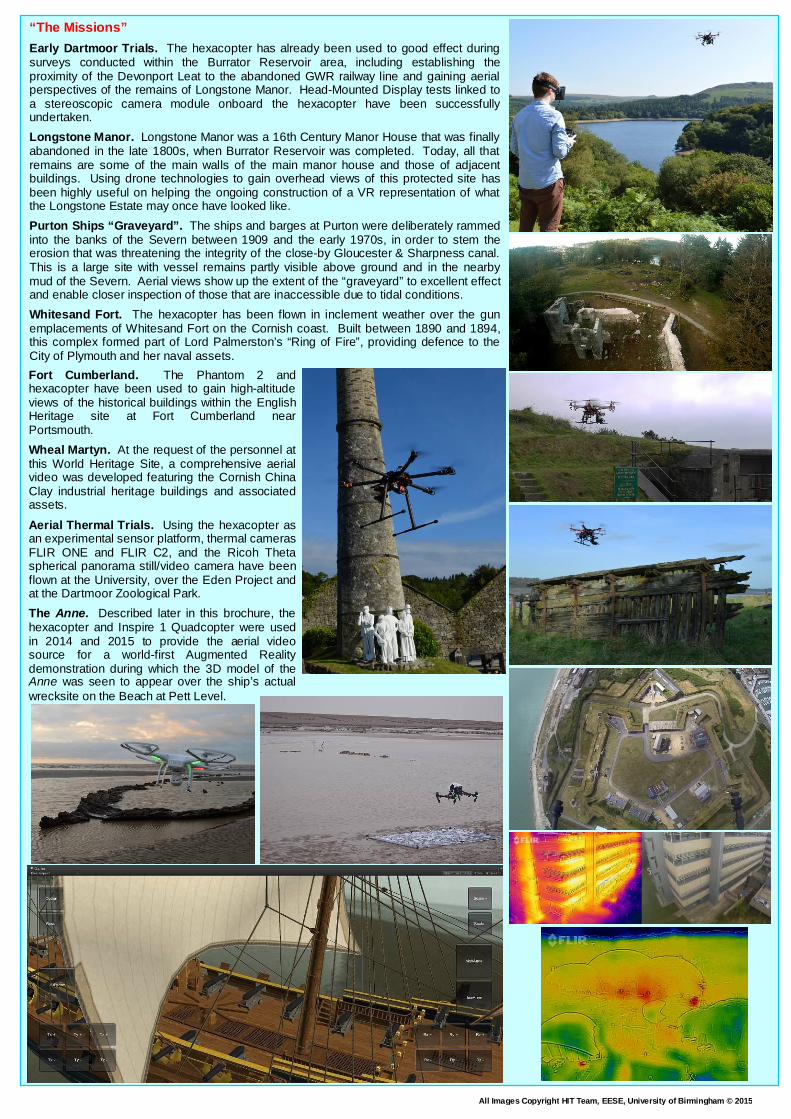
Early Dartmoor Trials. The hexacopter has already been used to good effect during surveys conducted within the Burrator Reservoir area, including establishing the proximity of the Devonport Leat to the abandoned GWR railway line and gaining aerial perspectives of the remains of Longstone Manor. Head-Mounted Display tests linked to a stereoscopic camera module onboard the hexacopter have been successfully undertaken.
Longstone Manor. Longstone Manor was a 16th Century Manor House that was finally abandoned in the late 1800s, when Burrator Reservoir was completed. Today, all that remains are some of the main walls of the main manor house and those of adjacent buildings. Using drone technologies to gain overhead views of this protected site has been highly useful on helping the ongoing construction of a VR representation of what the Longstone Estate may once have looked like.
Purton Ships “Graveyard”. The ships and barges at Purton were deliberately rammed into the banks of the Severn between 1909 and the early 1970s, in order to stem the erosion that was threatening the integrity of the close-by Gloucester & Sharpness canal. This is a large site with vessel remains partly visible above ground and in the nearby mud of the Severn. Aerial views show up the extent of the “graveyard” to excellent effect and enable closer inspection of those that are inaccessible due to tidal conditions.
Whitesand Fort. The hexacopter has been flown in inclement weather over the gun emplacements of Whitesand Fort on the Cornish coast. Built between 1890 and 1894, this complex formed part of Lord Palmerston’s “Ring of Fire”, providing defence to the City of Plymouth and her naval assets.
Fort Cumberland. The Phantom 2 and hexacopter have been used to gain high-altitude views of the historical buildings within the English Heritage site at Fort Cumberland near Portsmouth.
Wheal Martyn. At the request of the personnel at this World Heritage Site, a comprehensive aerial video was developed featuring the Cornish China Clay industrial heritage buildings and associated assets.
Aerial Thermal Trials. Using the hexacopter as an experimental sensor platform, thermal cameras FLIR ONE and FLIR C2, and the Ricoh Theta spherical panorama still/video camera have been flown at the University, over the Eden Project and at the Dartmoor Zoological Park.
The Anne. Described later in this brochure, the hexacopter and Inspire 1 Quadcopter were used in 2014 and 2015 to provide the aerial video source for a world-first Augmented Reality demonstration during which the 3D model of the Anne was seen to appear over the ship’s actual wrecksite on the Beach at Pett Level.

All Images Copyright HIT Team, EESE, University of Birmingham © 2015
Virtual Heritage
One of the major research and development areas for the HIT Team involves the application of VR and AR technologies to Virtual Heritage. Virtual Heritage (VH) can be defined as “the use of computer-based interactive technologies to record, preserve, or recreate artefacts, sites and actors of historic, artistic and cultural significance, and to deliver the results openly to a global audience in such a way as to provide formative educational experiences through electronic manipulations of time and space”1. Members of the HIT Team have, courtesy of previous employments, a long-standing history of involvement in the VH arena with such projects as the first ever Virtual Stonehenge, demonstrated live at the inaugural VH conference, held in Bath in 1995, and at the London Planetarium on 20 June 1996, presented by the famous astronomer, the late, great Sir Patrick Moore.
Another acclaimed project was Virtual Lowry – a unique VR experience in which the user was able to “enter” an L.S. Lowry painting and “re-emerge” into a three-dimensional world, constructed using images from the artist’s paintings and featuring animated matchstalk men and matchstalk cats and dogs (to use the title of a popular 1978 song by the singing duo Brian & Michael). More recently, the HIT Team has concentrated on recreating sites and artefacts relating to industrial and maritime archaeology, as these fields are in keeping with the engineering focus of the School in which the Team resides, offer the opportunity to interact with real-world rural and sometimes remote communities (fostering digital inclusion – defined below), and will help develop techniques, effects and new technologies that can be re-used in other applications, including teaching and student projects.
1: Stone, R.J. (1999). Virtual Heritage: “The willing suspe nsion of disbelief for the moment”. UNESCO World Heritage Review; pp.18-27.
“Digital Inclusion”
The term “Digital Inclusion” is often used to describe the ability of individuals and groups to access and make effective use of information and communication technologies (ICT), with occasional reference to the availability of appropriate hardware and software, the provision of relevant content and services, and the delivery of effective digital skills training. However, one issue that is not often acknowledged is the importance of removing the very early barriers that exist to inclusion and digital empowerment of individuals and groups – barriers such as geographical remoteness, attitudes (cost, complexity, etc.) and stereotypes (e.g. elderly citizens’ “fear” of, or lack of confidence with ICT).
Whilst conducting surveys and technology trials at real-world locations such as those described above, the HIT Team’s engagement with local residents and visitors suggests that members of diverse communities may be inspired and motivated to venture out more often to explore the (real) natural world if that world could be endowed with rich, discoverable, virtual cultural and historical artefacts, made accessible using appropriately-fielded VR and AR technologies. In addition, it is a strong conviction on the part of the research team that digital heritage environments, when presented to individuals and groups using appropriate interactive formats at appropriate venues (real-world or online presentations, even articles in local newsletters and magazines), can also encourage cross-generation and cross-community engagement – in effect, early Digital Inclusion – and, thus, help to uncover information, assets and narratives that would have otherwise been lost to future beneficiaries.
Virtual Mesolithic North Sea
One of the earliest successful PhD study outcomes for the HIT Team, and one that was a major influence on the Team’s subsequent virtual heritage research programme, involved the development of a VR representation of a world that existed in Mesolithic time, over 10,000 years ago, before the Ice Age glaciers melted and flooded what is, today, the Southern Basin of the North Sea. In the mid-to-late 1990s, seismic datasets from this region revealed topological evidence of part of a large river valley, some 600 metres wide with an observed length of 27.5km. According to geographical and archaeological specialists, the plain offered habitable conditions for hunter-gatherers moving between what is now the British Isles and Continental Europe. A group of geological, geographical and archaeological researchers at the University of Birmingham was established to exploit these datasets as part of a unique research project. The aim was to develop a dynamic virtual reconstruction of the Mesolithic plain and riverbed to investigate how these patterns may have been influenced by the existence of natural food and dwelling construction resources. To do this, a new artificial life (alife) visualisation system was developed called the SeederEngine. The basic premises behind the functioning of this engine were quite simple. Each entity in the alife system had the ability to sense and react to environmental changes and each entity had a preferred condition with upper and lower tolerances for sunlight, moisture, temperature, elevation, soil type, nutrients, carbon dioxide and space. As the condition exceeded the preferred level, the health of the alife entity decreased until it expired.
www.virtual-burrator.net

All Images Copyright HIT Team, EESE, University of Birmingham © 2015
Virtual Burrator
Virtual Burrator, like its Virtual Wembury counterpart, has its roots in a hospital rehabilitation research project which focuses on the development of virtual restorative environments and their potential effect on our sense of well-being (see also www.virtual-wembury.net and www.virtual-burrator.net). During the early investigations of the Wembury and Burrator areas, a number of interesting historical facts and sites came to the attention of the HIT Team researchers, not to mention recollections and narrative from local community members. It was therefore decided to extend research and development activities to capture these valuable historical artefacts using the medium of Virtual Reality. The 1909 Wembury Docks that “never were” is one example of such a project. There follows some brief descriptions of ongoing projects exploiting VR and AR techniques based on interesting heritage sites around the Burrator and nearby Yelverton areas. Between the 16th and 19th Centuries, supplying fresh water to the city of Plymouth and the naval base at Devonport was a continual challenge. Despite the construction of two granite-lined water channels called leats – the Plymouth (or Drake’s) Leat in 1591 and Devonport Leat in 1801 – the heavy demand for water and problems caused by pollution and dense snowfalls on Dartmoor meant that a more reliable and permanent solution had to be devised. In 1893, Plymouth Corporation authorised the construction of a reservoir at Burrator Gorge. Costing £178,000 and comprising two dams (Burrator, the largest, and Sheepstor, just to the east), the building works for Burrator Reservoir were completed in 5 years and the site was officially opened on 21st September, 1898. Burrator, as a southern region of Dartmoor’s National Park is one of stark contrasts, combining open moorland and high granite outcrops (called "tors") with woods of mixed trees and foliage. Steven Spielberg, when filming scenes from War Horse in the area said “I have never before, in my long ... career, been gifted with such an abundance of natural beauty ...”.
Burrator & Sheepstor Halt
As part of the research project to recreate the industrial heritage evident around the Burrator and Sheepstor area, one area of particular interest is the Yelverton-to-Princetown Railway at Burrator & Sheepstor Halt, an isolated station opened in 1924, which was used to disembark construction teams for the Burrator Reservoir project and also witnessed the transfer of French and American prisoners to Princetown Prison and the transport of Dartmoor granite for use in the building of such national icons as London Bridge and Nelson’s Column. The line closed in March 1956. Today the remnants of the Halt can be explored, courtesy of the Tyrwhitt Trail cycle path. All that remains today are the two “kissing” gates and associated steps giving access to the Reservoir and local moorland, isolated fence posts and the concrete/brick shelter foundation. This small historical area has been recreated using Unity3D, complete with a mixed passenger-freight train and a petrol-driven Wickham Trolley, and has been developed further to investigate the use of AR to visualise the Halt in situ.
Burrator Reservoir Suspension Bridge
Between 1923 and 1928, Government finance was used from an unemployment relief programme to enlarge the capacity of the Reservoir to over 1 million gallons by raising both the Burrator and Sheepstor Dams by 10 feet. Like the construction of Burrator & Sheepstor Halt, a suspension bridge was put in place to help ease transportation problems for the work teams. Built by Messrs. Orr, Watt & Co of Motherwell, Scotland, the bridge was of steel cable and wood construction, with a 10-ton weight limit (which was exceeded on one occasion, causing the steel cables to stretch). After completion of the Reservoir works in 1928 the suspension bridge was dismantled. All that remains today are the main cable anchors, one pair either side of the Reservoir, and the concrete foundation on the southernmost landside, with a single length of chain. Some of these remaining features were used to help locate a 3D model of the suspension bridge as part of a simple AR demonstration in 2013.
RAF Harrowbeer
Close to Burrator is the abandoned RAF airfield at Harrowbeer, part of the village of Yelverton (the western terminus for the old GWR Princetown Railway), about 2.5 miles west of Burrator Reservoir. The airfield (called Harrowbeer to avoid potential confusion between ‘Yelverton’ and the Royal Navy Air Station at ‘Yeovilton’ in Somerset) officially opened on 15th August 1941 and remained operational throughout World War II, under the control of 10 Group Fighter Command. It was also Headquarters to the first Air Sea Rescue Squadron. Constructed using rubble from the devastating air raids on Plymouth of March and April 1941, RAF Harrowbeer was used solely as a fighter base, although it did witness a large variety of aircraft during its existence, including Lysanders, Typhoons, Whirlwinds and Spitfires (Spitfires were used to provide enhanced protection for Channel convoys). In September 1944, the base was also visited by Glenn Miller and his orchestra, en route to concerts in Plymouth. In 1945, US President Harry Truman’s flight – a Douglas VC-54C named the Sacred Cow (the forerunner of Air Force One) – was diverted into RAF Harrowbeer from St Mawgan due to fog. The aircraft was returning the President back to the US after attending the Potsdam Conference (where the victorious Allies attempted to tackle issues arising from the future split of democracy and communism in Europe) They were then transported by road to lunch with King George VI on board HMS Renown in Plymouth Sound. All that now remains of RAF Harrowbeer are the foundation stones relating to accommodation, aircraft hangar and support buildings, some remains of the three (‘A’ layout) runways and the original Watch Office – now Knightstone Tea Rooms. However, the distinct dispersal pens can still be seen around the periphery of what was the airfield. One of these pens provided the backdrop for a 2013 Augmented Reality Spitfire, Dakota DC3 and Lancaster demonstration, with an additional AR sequence depicting the virtual Lancaster flying over Burrator Reservoir and Dam. More recently, individual buildings on the old airfield have been modelled using SketchUp, including the WWII Watch Tower.

All Images Copyright HIT Team, EESE, University of Birmingham © 2015
VIRTUAL WEMBURY & VIRTUAL BURRATOR … A UNIQUE HEALTHCARE AND HERITAGE INITIATIVE

All Images Copyright HIT Team, EESE, University of Birmingham © 2015
Maritime Heritage Projects
The UK’s coasts and waters are very rich in maritime heritage, from countless wrecks, including those deliberately scuttled to form artificial reefs and the casualties of war, and from fortifications to unique but long abandoned protective structures, in many cases exposed to the incessant destructive power of the sea. Virtual Maritime Heritage projects can help to preserve these fragile assets for the educational benefit of future generations.
Virtual Plymouth Sound
The Virtual Plymouth Sound Project is an ongoing initiative, involving researchers and students, the aim of which, over time, is to develop a comprehensive surface and subsea model of the Sound and to locate virtual maritime assets (including those described below) that can be interrogated by the use of appropriate interactive techniques and technologies. The project also enables members of the HIT Team to engage with a range of important West Country heritage organisations, including ProMare SHIPS (Shipwrecks & History In Plymouth Sound – a public charity established in 2001 to promote marine research and exploration), the Royal Navy National Museum, the National Marine Aquarium and the South West Maritime History Society.
Virtual Plymouth Sound builds upon a previous VR demonstrator project, developed for the Royal Navy and described earlier in this brochure (see: Subsea Situational Awareness Display), which delivered a real-time, multi-window 3D visualisation capability for future Mine Countermeasures Vessel personnel. More recently, the subsea topographical dataset used in this demonstrator was extended to represent basic above-water landforms using digital terrain mapping (DTM) data from Digimap – a comprehensive online collection of UK maps and geospatial data made available to Higher and Further Education establishments. This combined above- and below-water scenario is now providing a template for a number of student projects, particularly those focused on specific examples of maritime heritage, such as the Maria and GLAUCUS, described in more detail below. A future aspiration is to develop the model so that it can be used as the basis for an Augmented Reality coastal path “awareness tool”, highlighting heritage sites and events for tourists and local inhabitants alike.
The Maria
In 1774, a 31-foot, 50-ton converted wooden sloop called Maria, purchased for £340, entered the history books as being host to the first of 65,000 recorded submariner fatalities. The Maria was equipped with a wooden-beamed chamber measuring some 12ft by 9ft by 8ft, containing around “75 hogsheads” of air (24.5m3, providing 25 tons of buoyancy and allegedly sufficient for 24 hours life support).
A topside entry hatch allowed the vessel’s only occupant, a shipwright by the name of John Day, access to the vessel. A system of counterbalance and chains enabled him to close the hatch and render the chamber watertight. The Maria’s buoyancy was counteracted by filling the interior with (initially) 10 tons of limestone (although another 20 tons of rocks from local quarries had to be added on the day of the dive) and flooding the fore and aft spaces via sluice pipes. To allow the Maria to surface after the experiment, netted groups of 21-ton rocks were to be released by undoing (and quickly plugging!) bolts within the chamber.
The Maria was towed from Plymouth’s Sutton Harbour to Firestone Bay on June 20th 1774. Day boarded the Maria carrying a hammock, a watch, a candle, a bottle of water and some biscuits. The Maria “submerged” stern first and her disappearance was followed 15 minutes later by bubbles on the surface, indicative of the escape of a considerable amount of air from an underwater source. After 3 days of effort by 200 dockyard workers, the salvage operation was abandoned. Further extensive salvage attempts were made – one might even say rescue attempts – courtesy of a well-published MD by the name of Falck. Believing Day to be in a state of suspended animation due to the low temperatures of the depths of Firestone Bay, Falck sponsored a month of additional effort to raise the Maria. His mission came to nothing. Working with colleagues at ProMare, a 3D model of the Maria has been produced, with the future aim of reproducing the vessel’s final dive from external and internal perspectives.
The GLAUCUS
In September 1965, two divers from the British Sub-Aqua Club (Bournemouth Branch), Colin Irwin and John Heath, spent a week living within a 2-ton, 3.7m long and 2.1m diameter cylinder called GLAUCUS at a depth of 10.7m (35ft), just off the Plymouth Breakwater. One of the aims of this project was to demonstrate that living in underwater habitats could be achieved on a much smaller budget than that being expended at the time by, for example, Jacques Cousteau’s Conshelf Project team. The GLAUCUS cylinder was supported by a set of legs, themselves attached to a substantial ballast tray. Access to the habitat was via a small open hatch which enabled other divers to deliver food and supplies. Air was provided by a series of onboard air tanks (a semi-closed circuit – GLAUCUS was the first subsea habitat to demonstrate this), with CO2 scrubbing trays mounted within the structure.
The project was committed to a short film by British Pathé which is still available today (http://www.britishpathe.com/video/week-under-water/). Today, despite being recovered and temporarily relocated to Fort Bovisand, the deteriorating remains of the GLAUCUS lie 12 metres down on the seabed of Plymouth Sound, just a few metres from the Breakwater Fort – a sad end for an important piece of underwater history. The VR project is recreating a “GLAUCUS experience” by allowing users to “dive” down to a 3D recreation of the habitat and to explore its cramped interior. Relevant information and historical details are being provided by ProMare colleagues and Colin Irwin, who, as well as spending a week within the habitat in 1965, was the original designer of the GLAUCUS. An interview was conducted with Colin in September 2013, which generated a considerable amount of detail and narrative content for future educational projects planned for the Virtual GLAUCUS demonstrator.

All Images Copyright HIT Team, EESE, University of Birmingham © 2015
Maritime Heritage Projects (Continued)
The Virtual Scylla Reef
HMS Scylla was a Royal Navy Batch 3 Leander Class Frigate that was scuttled in March 2004 off Whitsand Bay near Plymouth by the National Marine Aquarium (NMA) to become Europe's first artificial reef. Using games-base simulation techniques, the 3D model of the Scylla can be explored in real time by piloting a virtual ROV using a Microsoft Xbox gamepad or other interactive controller. To add context to the experience, a geographically accurate model of the Whitsand Bay coastline, from Rame Head to Portwrinkle has been constructed using digital terrain map data and aerial photography. To endow the subsea wreck model with an educationally-related experience, members of the HIT Team also developed software techniques in artificial life (or alife) – the scientific study and simulation of the behaviour of biological organisms and systems – to investigate and predict how natural environments survive, reproduce, colonise and evolve and may be affected by environmental changes brought about by climate change, extreme weather events or pollution. Throughout the project, the Team has collaborated with the NMA and the Marine Biological Association, and has visited the site of the actual Scylla Reef on numerous occasions using a VideoRay remotely operated submersible. In 2009, the Virtual Scylla alife and wreck “fly-through” demonstrators were presented to schoolchildren and specialist adult audiences at the NMA.
HMS Amethyst Returns to Her Final Resting Place
Launched in 1943, HMS Amethyst was a “modified” Black Swan-class “sloop”, (or Frigate after WWII), pennant number F116. In the late 1940s, the ship and her crew made their mark on history. Whilst transiting the River Yangtse in April 1949, Chinese Communists mistook the ship as one belonging to the enemy Nationalists and opened fire, inflicting significant damage and 19 fatalities (including the ship’s Commanding Officer, Lt Cdr Skinner). The ship ran aground on a sandbank, at an angle that rendered the firing capabilities of the two forward turrets useless. With rapidly dwindling food and fuel supplies, Commander John Kerans, the British Naval Attaché in China (played by Richard Todd in the film Yangtse Incident), arrived from Nanking and took command of the ship. On 30 July 1949, Kerans decided to make a night-time bid for escape. Once again the ship took heavy fire, but on 31 July, at 05:00, the Amethyst rendezvoused safely with the destroyer HMS Concord. On 19 January 1957, she was towed into Plymouth’s Sutton Harbour, coming to a final stop on Marrowbone Slip, where she was broken up. This Augmented Reality project was designed to visualise the Amethyst’s final days, transiting the River Tamar towards Devonport and returning her to where she was finally scrapped, next to the China House Pub and Restaurant (itself an historic building, dating back to the 1600s), and to draw attention to what must have been a spectacular sight – a 1350-ton, 283-foot long Frigate laying silent in a small harbour which was, at the time, more used to welcoming fishing trawlers and sailing ships. The 3D model of the Amethyst also features alongside one of the quays in the Wembury Dock scenario, described below.
“The Wembury Docks That Never Were”
In 1909, a proposal was put forward to the House of Lords, the aim of which was to construct a huge passenger and commercial port within Wembury Bay in South Devon, to rival the established and growing docks at Liverpool and Southampton. The port was to comprise breakwaters extending far out into the Bay, four jetties, dry docks and even a railway terminus. In the end, the House of Lords rejected the scheme which is fortunate as, today, Wembury Bay is part of the National Trust and is classified as one of South Devon’s Areas of Outstanding Natural Beauty. However, Virtual and Augmented Reality techniques have been used to bring the original proposal “to life”, and to help end users understand the impact the dock would have had on the area, had the proposal been accepted. The 3D model of the Dock area was constructed as part of two postgraduate student projects using the HIT Team’s Virtual Wembury system (originally developed for healthcare and rehabilitation research) as a geographical “template”. Given the paucity of information relating to the Dock, historical research had to be conducted using references to other UK docks, including Liverpool/Birkenhead, Southampton and the Port of London, together with Hull, Cardiff, Falmouth and Bristol, where the current Heritage Dock exhibits proved to be particularly useful. This research enabled the team to build up a concept design featuring the main elements of the Wembury Dock and to select appropriate pre-built 3D models from established Internet sources. Given the enormity of the project, it was only possible to include a small number of features at this stage and it was important to focus the students’ time on the technical challenges posed by the AR software, not on modelling 3D objects from scratch. However, a large number of 3D models were purchased, with the aim of reflecting a range of historical buildings and vessels, and many of these had to be modified to reduce their geometric complexity, ready for the real-time AR visualisation trials using an iPad.
James Egan Layne
The SS James Eagan Layne was a US Liberty ship, one of many hundreds of mass-produced cargo vessels built during World War II to provide the Allies with vital supplies. After being torpedoed by U-399 off the Eddystone Reef in March 1945, the Eagan Layne was taken under tow by two local tugs and finally sank without loss of life in Whitsand Bay near Plymouth (today located 540m east of the wreck of the ex-HMS Scylla (see earlier)). This VR project aims to simulate the Eagan Layne’s final moments and to simulate her deterioration, ready for demonstration at the 70th anniversary (2015) of her sinking (part of the Liberty 70 Project). This is being undertaken by converting multibeam sonar data of the wreck into height maps and polygonised data suitable for real-time fly-throughs using Unity 3D. By superimposing a basic model of the ship onto the data, it becomes much easier to interpret the output from these underwater survey systems.

All Images Copyright HIT Team, EESE, University of Birmingham © 2015
HMS A7
The HIT Team was involved in a unique maritime heritage project, part of which involves the virtual recreation of one of Britain’s earliest submarines – a vessel and its crew that, sadly, met an untimely end 100 years ago off the Cornish coast. On 16 January 1914, just a few months before the beginning of World War I, HMS A7, one of the first submarines designed in Britain for the Royal Navy, was taking part in simulated torpedo attacks against her Depot Ship HMS Onyx and the maintenance/supply tender HMS Pygmy in Whitsand Bay to the west of Plymouth. Built by Vickers Sons and Maxim Ltd at Barrow-in Furness and launched in 1905, the A7 was a coastal patrol submarine powered by a single shaft/single screw, 16-cylinder, 600 horsepower Wolseley petrol engine whilst on the surface and a 150 horsepower electric motor whilst submerged.
Just after 11:00 on 16 January, 1914, and commanded by Lt. Gilbert Welman, the A7 began her simulated attack on the Pigmy. However, after diving, nothing more was seen of the boat. Over an hour after the exercise started, crewmembers of the Pigmy saw bubbles on the surface, suggesting that the submarine was attempting to blow water from her ballast tanks in an attempt to rise (the lack of adequate reserve buoyancy was noted as one of the A class’s major design shortcomings). The location was marked with a buoy before the Pigmy returned to Devonport to report the incident. Unfortunately, there was only enough air in the submarine for six hours and, tragically, all 11 crewmembers perished. Despite numerous salvage attempts over the following month, the A7 refused to move and so it was decided the leave her where she lay, in about 135ft of water. In 2001, she was declared as a "Controlled Sites" under the British Government’s Protection of Military Remains Act 1986 (Designation of Vessels and Controlled Sites), which means that diving on her is prohibited without special permission from the MoD. The reason for the A7’s demise has eluded maritime and naval historians for a century. It is still not understood what problems the vessel experienced during her final dive and attack run. Even more baffling is the fact that, when finally reached by divers six days after her loss, she was discovered on the seabed at an unusual bow-up angle of around 30° with her stern embedded in over 20ft of soft clay. Today, her stern is still embedded, but she is no longer at such an extreme angle. Instead, her bow is raised slightly upwards and her hull is listing to port by approximately 10°. The aft 13ft or so of the A7’s hull, the propeller, hydroplanes and rudder are still buried.
Again working with Promare, The HIT Team’s task was to recreate the A7 and her wreck site as a Virtual Reality scenario with educational content. The history of the vessel and its loss has received scant attention over the years, both in historical and educational records, locally and nationally. Promare specialists also included the Birmingham Team in a successful proposal to the MoD to undertake a thorough but unintrusive archaeological survey of the A7, with the aim of developing comprehensive records of the wreck and its deterioration, together with the layout of the local seabed environment and any associated debris. The MoD granted a rare dive licence to the A7 team in May 2014 and, following a number of dives in the summer of that year, a final report on the project was produced.
The Anne1
The Anne was a 70-gun third rate ship of the line, built by Phineas Pett at Chatham Dockyard as part of a late 17th century restoration of King Charles II’s Royal Navy, overseen by Samuel Pepys. Launched in 1678, the Anne was beached twelve years later during the Battle of Beachy Head. Under the command of John Tyrrell, the vessel was deliberately torched at Pett Level near Hastings to prevent her from being captured by the French. Over the years, the Anne has occasionally become visible as the sands covering the remains of the wreck shift. As a direct result of the extreme storms experienced on the south coast of the UK during December 2013 and the early part of 2014, the remains (which were designated under the British Protection of Wrecks Act in June 1974) became visible at low tide for the first time since January 1997. The wreck is owned by the Nautical Museums Trust (the Shipwreck Museum Hastings) and it is with this Museum that the HIT Team has been collaborating in an attempt to “resurrect” the Anne using VR and AR and small unmanned air vehicle technologies (as described earlier). Using material from a book by naval historian and artist Richard Endsor, The Restoration Warship (Conway Maritime Press, 2009), the 3D model of the ship was developed at two key levels of detail by two visiting French Interns, one level to support on-site AR visualisation trials (and subsequent online interaction) and a higher fidelity version to feature at special presentations and events.
1. Note that, even though this was a vessel of the Royal Navy, the prefix HMS (His or Her Majesty’s Ship) has only been in use since 1789.

All Images Copyright HIT Team, EESE, University of Birmingham © 2015
Student Projects – Real & Virtual
Students at all levels and from all academic corners, from undergraduate to postgraduate, and from international visitors to those studying in other schools, play an important role in the work and research of the HIT Team. The Team takes pride in ensuring that its taught-course content is research-led, and any student project undertaken must be of relevance to a real-world application. Field research is highly encouraged, as are the delivery of presentations, demonstrations and concisely-written reports to external subject matter experts and stakeholders who may be able to help develop the results of the research further. Just a small selection of the student projects over the past few years are presented here, but it is clear that the taught design principles (including Human Factors issues) underpinning VR, simulation and telepresence are well received.
Students gain significant benefit from including 3D modelling and games engine integration skills on their CV – skills that one would not normally associate with the teaching and research of a predominantly electronics school! Students have also benefited from these experiences when seeking employment after completing their academic courses. For example, the student behind the Minigun simulator development mentioned above went on to work for the games company Rebellion, programming many of the AI functions for the 2010 action game Aliens vs. Predator. Another student secured a position with Jaguar Land Rover’s Simulation Centre.
Year 3 Students studying Interactive 3D Design for Virtual Environments and Serious Games (School Ref.: EE3K1) are able to demonstrate their 3D modelling and games engine integration skills as part of a group project set by academic staff in October of each year. Over the years, the project application areas chosen have been both diverse and challenging, with groups presenting their achievements to a small academic assessment panel in January of the following year. Every year, the rapid acquisition of 3D skills and the achievements of the students continue to impress academic staff and external stakeholders/assessors. Projects have included:
Virtual Planetary Rovers: the group challenge here was to design and build a dynamic robot vehicle and manipulator system, capable of traversing a virtual planetary surface between a spacecraft and base, and to complete an object handling task en route. The two best projects were awarded unique prizes celebrating 50 years of manned spaceflight from visiting Russian space simulation specialists.
Virtual Hospital Ward Scenarios: basic bedside healthcare training was the focus of this group assignment, with student simulation offerings ranging from hygiene procedures and blood group checking, to the insertion of central venous lines and ventilator control. One student also developed an impressive vital life signs monitor, such that the displayed heart rate, blood pressure and oxygen saturation read-outs could be manipulated electronically from a separate computer screen.
Disability Awareness: students were set a unique problem of trying to represent different forms of sensory and physical disability using gaming software to demonstrate issues of building access or site navigation around 3D models of parts of the University campus. Issues such as wheelchair access, colour blindness and migraine symptoms were amongst the many simulations presented.
Air-Sea Search & Rescue Simulators: here the student groups were tasked with designing and demonstrating a prototype virtual trainer for helicopter search-and-rescue applications. Students within each group tackled specific design and build elements, from the helicopter exterior and flight characteristics to the cockpit control layout, and from the winchman and casualty avatars to the boat or coastal rescue scenario.
Virtual Heritage: with the most diverse range of projects presented to date, student groups were challenged to select an historical topic of local, national or international interest and to design an interactive virtual educational package based on that topic. Amongst the topics selected were the Village of Portmeirion, Warwick Castle, the Giza Necropolis, the Roman Colosseum, the inventions of da Vinci, even Concorde!
Year 4 (MEng) and MSc Students can choose to develop their own individual final year project and, over the years, there have been some very impressive outcomes, such as the Minigun simulator described earlier. Another MEng student developed a simulator to teach basic physics (laws of motion) using a scenario which required the end user to dock the (now defunct) Russian Kliper spaceplane concept with the International Space Station. Difficulty levels were based on introducing additional axes of spacecraft control. Based on the Ogre Engine, this demonstrator was demonstrated by the student to the Russians in Novocherkassk in July 2008. Other projects have focused on such topics as wearable computers for mini-telerobotic control, wreck-diving safety and spatial awareness, underwater explosive ordnance search and disposal (complete with a twin-screen instructor-student interface and a unique three-dimensional “after-action review” system), submarine periscope training and artificial life in a coastal rockpool context. The Wembury Dock Augmented Reality project described earlier was also the result of an MSc student’s research, demanding interaction with local village historians and the conduct of numerous on-site surveys.
PhD (Research) Students. The HIT Team is always keen to receive proposals from potential PhD research students on a wide variety of topics related to the applications domains described in this brochure. The Team also engages with other Colleges and Universities in the joint supervision of postgraduate students Past PhD students have focused on the development of Artificial Intelligence and Artificial Life for simulations visualising historical sites and marine ecosystems, human interface and navigation strategies for simulated remotely controlled systems, and, more recently, contactless motion-sensed interaction for amputees, restorative virtual environments and telepresence technologies for military robotics and the nuclear industry. In keeping with the HIT Team’s philosophy of exploiting research to make future technologies fit for human use, proposals should demonstrate a sound appreciation of human factors issues (including experimentation and ethics) relating to interactive technologies and media, simulation, gaming, robotics, and so on.

All Images Copyright HIT Team, EESE, University of Birmingham © 2015
Human Factors & Interactive Technologies
The 1980s, 1990s and early 2000s were marked by a series of important events in the evolution of interactive digital technologies. In particular, rapid developments in computer graphics hardware and software prompted the launch of a number of “movements” throughout the globe, including computer-generated imagery (CGI) and animation (e.g. for the film and TV industries), scientific visualisation, Virtual Reality (VR) and wearable computing. Whilst these groups did much to bring a range of previously expensive, unique and (superficially) impressive technologies to the attention of a much wider global audience than ever before, they were also responsible for creating a culture of myth, hype and false promise. This was particularly the case for VR. From the perspective of potential adopters in domains such as engineering, defence, medicine and so on, VR provided a roller coaster ride of achievement and failure throughout the 1990s. In many respects, some of these problems persist, even today.
One of the most important, if not the most important lesson to be learned from the early VR “era” is that, to help guarantee user acceptance, task relevance and credibility (especially in training), high levels of usability and, ultimately, the positive transfer of skills and know-how from the virtual to the real, Human Factors knowledge and techniques must be in evidence throughout the entire design process for interactive 3D (i3D) systems. For example, task analysis, concept demonstrations/presentations, the definition of learning outcomes and metrics, pedagogy (the science, theory and practice of teaching), Virtual Environment content and usability design, interactive technology assessment and evaluation – all demand a solid understanding of human-centred design issues.
The speed with which i3D hardware and software technologies have evolved over the past two to three decades, with the latest stage of evolution bring represented by products emerging from crowd-funding sources, has, unfortunately, not been matched by the timely delivery of appropriate and up-to-date Human Factors knowledge from the academic sector. What might have been usable and relevant data from research studies at the time they were conducted – and the technology on which they were based – are often no longer of generic applicability when those studies are finally published.
The HIT Team prides itself in being at the forefront of Human Factors expertise in the field of interactive technologies, particularly for VR, simulation and telepresence/ telerobotics. The Team regularly invests in new crowd-funding initiatives to ensure that its knowledge is current and relevant, and can be used to provide independent advice to students and contract sponsors alike. Undergraduate and postgraduate students on selected courses within the College of Engineering are regularly exposed to these new technologies as part of Human Factors teaching modules and in the delivery of their academic projects. Researchers within the HIT Team are members of the Chartered Institute of Ergonomics & Human Factors and apply their knowledge regularly to a range of human-centred design projects, not just in the VR and simulation domains.
Human Factors is the study of the relationship between the human and his or her working environment. It makes no difference if the working
environment is real or virtual.
For further information, contact:
Prof. Bob Stone (Director, Human Interface Technologies Team)
Tel. (Office): (+44) (0)121 414 7395 Tel. (Mobile): (+44) (0)7740 858901
e-mail: [email protected] or [email protected] www.birmingham.ac.uk/stone
www.birmingham.ac.uk/hit-teame