hull, ma - mass.gov€¦ · acknowledgements. commonwealth of massachusetts. deval patrick,...
TRANSCRIPT

Hull, MA
Nantasket Beach Reservation Master Plan
September 22, 2014
ACKNOWLEDGEMENTSCommonwealth of Massachusetts
Deval Patrick, Governor
Richard K. Sullivan, Jr., Secretary Executive Office of Energy & Environmental Affairs
Department of Conservation and Recreation
Jack Murray, Commissioner
Kevin Whalen, Deputy Commissioner
Karl Pastore
Joe Orfant, Chief, Bureau of Planning & Resource Protection
Priscilla Geigis, Director, State Parks & Recreation
Samantha Overton, Deputy Director, State Parks & Recreation
Mike Misslin, Acting Chief Engineer
Mike Galvin, Project Manager
Rick Corsi, Title
Susan Kane, Island District Manager
Matt Tobin,
Kevin Conway,
Paul DiPietro, (retired)
The Consultant Team
Crosby Schlessinger Smallridge, LLC: Landscape Architecture, Planning & Urban Design
The Louis Berger Group, Inc.: Civil & Transportation Engineering
Special Thank You to the Citizens Advisory Committee
Phil Bellone
Richard Billings, Chief of Police
Dennis Blackall
R. Marc Fournier, Director of Public Works
Justin Gould
Greg Hargadon
Rhoda Kanet
Nancy Kramer
Rick Lawrence
Frank Lyons, Fire Chief
Christopher J. Oliveri
David Twombly
Judith Van Hamm

ii
Executive Summary
1. Introduction 1
2. Existing Conditions 3
The Beach and Promenade 4
Beachfront Buildings & Adjacent Amenities 5
Landside Operations/Maintenance Buildings 8
Other Reservation Structures 12
Pedestrian & Vehicular Access 13
User Survey 15
3. Goals 17
The Beach 17
Operations 17
Access & Circulation 17
The Built Environment 18
The Natural Landscape 18
4. Related Studies 19
Traffic Analysis Report 19
Facilities Utilization Report 21
5. The Plan 27
Landscaping & Green Space 27
The Boardwalk/Promenade 30
Open Space & Recreational Amenities 30
Operations & Maintenance Area 38
Vehicular & Pedestrian Access & Circulation 38
Year Round Operations 41
Interpretive Opportunities 42
Wayfinding & Signage 42
Phasing 43
Appendices (Under Separate Cover)
Nantasket Beach Reservation Traffic Analysis Report, The Louis Berger Group, Inc., 2014
Nantasket Beach Reservation Facilities Utilization Report, The Louis Berger Group, Inc., 2014
TABLE OF CONTENTS

iii

iv
EXECUTIVE SUMMARY
In 2005, in conjunction with a project for seawall and
beach accessway repairs at Nantasket Beach, the
Massachusetts Department of Conservation and
Recreation (DCR) initiated this Nantasket Beach Res-
ervation Master Plan for the landside facilities of the
Reservation.
The overarching goal for the Nantasket Beach Master
Plan is to provide an enhanced natural and recreation-
al experience at Nantasket Beach, with:
• attractive amenities to support a wide range of
activities,
• safe and convenient access for pedestrians, cy-
clists, transit and ferry passengers and automo-
bile users, and
• connections to adjacent bicycle paths and park-
ing areas, as well as commercial and entertain-
ment opportunities.
The Plan is designed to provide visitors with a “great
day” at the Reservation from arrival to departure,
while aiding the DCR in operating and maintaining
the Reservation. The recommendations described
throughout this Master Plan were developed to
achieve that vision, and respond to DCR’s needs and
concerns, as well as the concerns that were expressed
by the community and the Citizens Advisory Commit-
tee throughout the Master Plan process.
The Plan recommendations are divided into the fol-
lowing categories:
• Landscaping and Green Space
• The Promenade/Boardwalk
• Open Space & Recreational Amenities
• Operations & Maintenance Area
• Vehicle & Pedestrian Access & Circulation
• Interpretive Opportunities
• Wayfinding&Signage
• Phasing
Key recommendations include:
• Nantasket Green - a major new park at the
foot of Wharf Avenue, providing a welcoming
Illustrative plan of the Master Plan recommendations.
v
entrance to visitors and an important gathering
spot.
• A continuous boardwalk with shade shelters and
spaces for vendors, extending the length of the
Reservation.
• A bicycle lane (adjacent to the boardwalk in
most locations) extending the length of the
Reservation and connecting to existing and
proposed (by the Town of Hull) bicycle routes;
along with new bicycle racks and opportunities
for bicycle rental.
• Relocation of both the David A. Cook and Tivoli
Bath Houses to more protected locations.
• Expanded playgrounds at both the David A.
Cook and Mary Jeanette Murray Bath Houses.
• Improved plazas adjacent to the Bernie King
Pavilion and Tivoli Bath House.
• New landscaping throughout the Reservation.
• AreconfiguredNantasketAvenue/HullShore
Driveintersectiontoimprovetrafficflowand
allow for an expanded and reorganized DCR
operations and maintenance facility.
• Repairs to existing buildings.
• Potential reuse options for the Dormitory Build-
ing, Clocktower Building and Police Station.
1
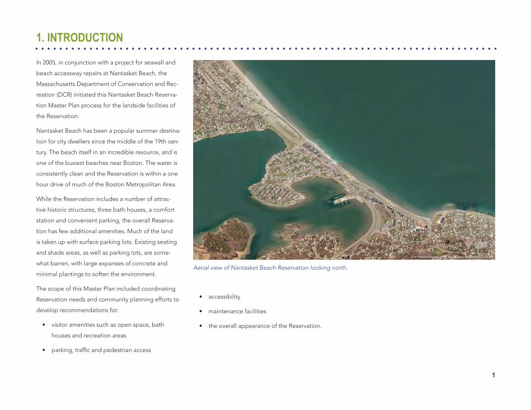
1. INTRODUCTION
In 2005, in conjunction with a project for seawall and
beach accessway repairs at Nantasket Beach, the
Massachusetts Department of Conservation and Rec-
reation (DCR) initiated this Nantasket Beach Reserva-
tion Master Plan process for the landside facilities of
the Reservation.
Nantasket Beach has been a popular summer destina-
tion for city dwellers since the middle of the 19th cen-
tury. The beach itself in an incredible resource, and is
one of the busiest beaches near Boston. The water is
consistently clean and the Reservation is within a one
hour drive of much of the Boston Metropolitan Area.
While the Reservation includes a number of attrac-
tive historic structures, three bath houses, a comfort
station and convenient parking, the overall Reserva-
tion has few additional amenities. Much of the land
is taken up with surface parking lots. Existing seating
and shade areas, as well as parking lots, are some-
what barren, with large expanses of concrete and
minimal plantings to soften the environment.
The scope of this Master Plan included coordinating
Reservation needs and community planning efforts to
develop recommendations for:
• visitor amenities such as open space, bath
houses and recreation areas
• parking,trafficandpedestrianaccess
Aerial view of Nantasket Beach Reservation looking north.
• accessibility
• maintenance facilities
• the overall appearance of the Reservation.

2
Public ProcessThis Master Plan was guided by a public process that
included both a Citizens Advisory Committee (CAC)
and a series of public meetings. The CAC provided
significantinputintothedevelopmentofthePlan,
reviewing and commenting on analysis and recom-
mendations at six meetings over the course of the
project. Several of these meetings were open to the
public to elicit feedback on the Master Plan as it was
developed.
Visitors enjoying a beautiful day at Nantasket Beach.
3
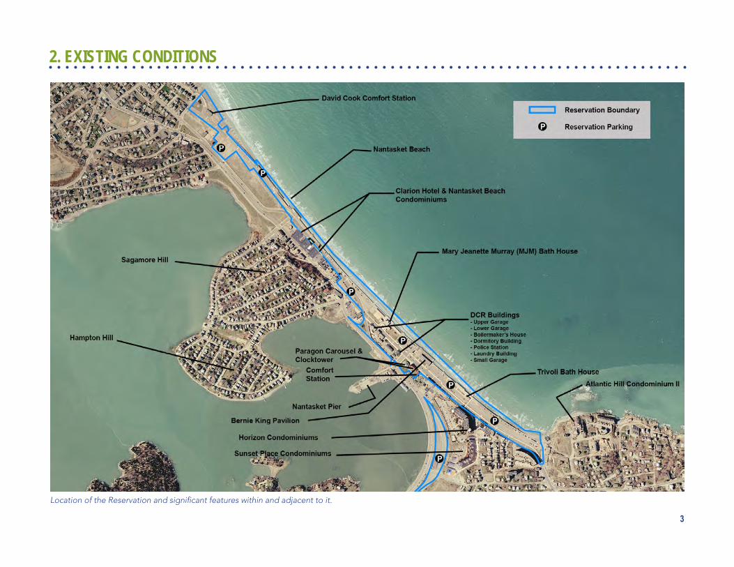
Location of the Reservation and significant features within and adjacent to it.
2. EXISTING CONDITIONS

4
At left, from top: A busy beach at high tide; the beach at low tide; new ramps have improved beach accessibility.
The Nantasket Beach Reservation, located on the
Atlantic Ocean on the northern shore of southeastern
Hull, MA, is owned and operated by the DCR. The
26-acre Reservation encompasses approximately 1.3
miles of beachfront (6,800 linear feet), and includes
the beach and adjacent visitor amenities, associated
parking areas, and an operations and maintenance
facility. It is bounded approximately by:
• Phipps Street to the north
• Hull Shore Drive and Nantasket Avenue (Route
228) to the west
• The driveway from Nantasket Avenue to the
southern end of the DCR parking lot to the
south
• The Atlantic Ocean to the east.
When the Master Plan was initiated, the Town of Hull
had recently prepared the 2004 Nantasket Focus Area
Study, and the Hull Redevelopment Authority (HRA)
was moving forward with a plan for residential devel-
opment on their parcels across Hull Shore Drive from
the northern end of the Reservation. More recently,
the Town has begun construction of streetscape im-
provements along Nantasket Avenue, between Water
and Bay Streets, and is preparing a new plan for the
HRA property and the adjacent commercial area.
The Beach & PromenadeThe beach runs along a beautiful long and narrow
strip of land (only 450 – 500 feet wide in some loca-
tions) that separates Nantasket Bay and the Atlantic
Ocean. At low tide, the beach is a wide, expansive
area that accommodates hundreds of beachgoers. At
high tide much of the beach is underwater.
A beachfront promenade, located between the park-
ing areas adjacent to the beach and the seawall (or
revetment), runs along the entire length of the Reser-
vation ocean frontage and provides visitors physical
and visual access to the beach, as well as passive and
active recreation opportunities. Along most of its
length, the seawall provides beach users with seating
along the promenade.
The beach is accessible from the promenade via con-
crete stairs and ramps in the seawall. New entry stairs,
accessible ramps and railings were constructed to
improve access as part of the seawall improvements
during Spring 2007.

5
Beachfront Buildings & Adjacent Amenities
Below are descriptions of buildings and adjacent
amenities found within the Nantasket Beach Reserva-
tion. Recommendations for maintenance activities
on individual buildings is included in the Nantasket
Beach Reservation Facilities Utilization Report, pre-
pared in 2014 by the The Louis Berger Group, Inc., as
part of this Master Plan Project, and available under
separate cover as Appendix A.
The buildings which are open to the public include
three bath houses, one restroom facility and an open
air pavilion. All three bath houses underwent renova-
tion during Spring and Summer 2007.
Mary Jeanette Murray Bath House
The Mary Jeanette Murray Bath House (MJM) is the
centerpiece of the Reservation. Built in 1930 in the Art
Deco style, the MJM is one of the more architectur-
allysignificantbuildingswithintheReservation.The
building has an area of approximately 3,640 square
feet and currently is used as a bath house facility and
community venue. It is in good condition overall, and
was recently renovated.
The MJM Bath House is currently underutilized by the
public as the main doors are locked when there are
no scheduled events. The wings of the building, which
contain restrooms and changing rooms, are open to
visitors regardless of event scheduling. Space within
the bath house also is underutilized. There is a large,
empty open space reserved for gatherings and a
utility room in both wings that is either largely empty
orusedforminimalstorage.Themanager’soffice
on the beach side of the building is partially used for
cleaningsuppliesandfirstaidsupplies(includingan
automatedexternaldefibrillator[AED]).
Historic RelevanceThe Massachusetts Historic Commission (MHC) has
determined that the building appears to be eligible
for listing as a contributing structure within a potential
Nantasket Beach Reservation Historic District. The
building was constructed in year 1935 and recon-
structed in the late 1990s.
Adjacent AmenitiesShade structures (pergolas) with benches are located
on the north and south sides of the bath house. These
are the primary shade structures for the Reserva-
tion and are heavily used by casual visitors and as
gathering areas for large groups. A volleyball court is
located directly north of the bath house and a small
playground with play structure is located directly to
the south. The playground was expanded in 2008.
From top: View of Mary Jeanette Murray Bath House from Nantasket Avenue; pergolas adjacent to the MJM Bath House provide a popular semi-shaded gathering area; the playground to the south of the bath house.

6
Bernie King Pavilion
Also on the oceanfront, south of the MJM Bath
House, is the renovated Bernie King Pavilion. Origi-
nally built in the late nineteenth century, this 10,800
square foot open air facility is primarily used for
seasonal concerts and dance events, and contains
a privately-operated concession stand. The pavilion
is a popular spot to picnic during summer months,
as it provides concession, seating and shade areas,
and allows views to the beach and ocean. On Sunday
afternoons visitors come to dance to live music.
In1999,elevatedlevelsofleadwereidentifiedonthe
pavilion’s exterior and interior. The facility subse-
quently underwent a $940,000 complete reconstruc-
tion, which was completed in 2004.
Adjacent AmenitiesAn open water side plaza adjacent to the Bernie King
Pavilion has picnic tables and benches. The lack of
shade structures and plantings make this a somewhat
inhospitable picnic area.
At left, from top: View of the Bernie King Pavilion from Nantasket Avenue; Sunday afternoon dancing at the Pavilion.
Tivoli Bath House
The Tivoli Bath House, located near the southern end
of the Reservation, is a single story concrete structure
built in 1981; it has an area of approximately 1,475
square feet and contains restroom and shower facili-
ties. The building suffers from repeated storm and
wave damage due to its unprotected locations so
close to the ocean.
Adjacent AmenitiesJust north of the Tivoli Bath House is a raised and
widened portion of the promenade with a row of
picnic tables and a row of benches with telescopes.
The tables and benches are far apart and have no
shade protection.
Comfort Station (205 Nantasket Avenue)
The Comfort Station, located on Nantasket Avenue
adjacent to the Clock Tower Building, is across Nan-
tasket Avenue from the beach and the Bernie King
Pavilion. The structure has an area of approximately
1,500 square feet and is used as a public restroom
facility. It is in seemingly good condition.

7
David A. Cook Comfort Station
The David A. Cook Comfort Station is located at the
northern end of the Reservation on Hull Shore Drive.
The single story red brick structure was built in 1953
and has an area of approximately 2,800 square feet. It
contains public restroom and shower facilities and is
in adequate condition. Additional space in the build-
ing is currently underutilized.
From top: The beach front plaza adjacent to the Ber-nie King Pavilion; view of the Tivoli Bath House from the south; view of the beach front plaza north of the Tivoli Bath House.
From top: View of the Comfort Station from Nantasket Avenue; view of the David A. Cook Comfort Station from Hull Shore Drive.

8
Landside Operations / Maintenance Buildings
Other DCR-owned buildings are found on the 3.5-acre
block bounded by Wharf Avenue, Nantasket Avenue
and George Washington Boulevard. The block is
across Nantasket Avenue from the MJM Bath House.
Some of these buildings date back to 1898. These
buildings are used primarily by DCR operations and
maintenance staff.
Dormitory Building
The two-story Dormitory Building has an area of ap-
proximately 9,000 square feet and is in overall poor
condition. It was originally built in 1898 and used as
astatepolicebarracks.Themainflooriscurrently
usedastheDCR’soperationsofficebuildingwith
some space available for dry and hazardous materials
storage.Theupperfloorislargelyvacant.Duringthe
summer of 2013 parking passes were sold from a fold-
Location of the buildings within the Operations and Maintenance Facility, and the nearby Clocktower Building.
View of the Dormitory Building from Nantasket Avenue.
ing table in front of the building and paperwork was
filedinanofficeinsidethebuilding.
Historic RelevanceAlthough the MHC has not undertaken any formal
survey or analysis of historical relevance for the Dor-
mitory Building, it is likely that it would be considered
eligible for listing as a contributing structure within
a potential Nantasket Beach Reservation Historic
District.

9
Police Station Building
The two-story former Police Station has an area of
approximately 4,000 square feet and is in very poor
condition. It was built in 1901 and used as a police
station by the former Metropolitan District Commis-
sion (MDC). It is currently vacant and entry is prohib-
ited due to high levels of asbestos. There is no full
basement under the building, just a crawl space.
Major rehabilitation work would be necessary for this
building to be re-used.
Historic RelevanceThe MHC has determined that the building appears
to be eligible for listing as a contributing structure
within a potential Nantasket Beach Reservation His-
toric District.
Small Garage (Fire Safety Building)
The small wooden garage building, also known as
the Fire Safety Building, has an area of approximately
1,000 square feet and is in overall poor condition. It
is currently used for cold storage of parking supplies
such as signs and posts.
Historic RelevanceThe MHC has not undertaken a formal survey or
analysis of historical relevance for the Small Garage.
Laundry Building
The Laundry Building is a World War II-era, single
story structure of approximately 900 square feet. It is
in overall adequate condition. It is currently used for
dry storage of lumber and is sometimes referred to as
the “wood storage room”.
Historic RelevanceThe MHC has not undertaken a formal survey or
analysis of historical relevance for the Laundry Build-
ing. It was likely moved to the location and therefore
would not be an original contributing element within
a potential Nantasket Beach Reservation Historic
District.
At right, from top: View of the Police Station Building from Nantasket Avenue; view of the Small Garage/Fire Safety Building from Wharf Avenue; view of the Laundry Building from Wharf Avenue.
10
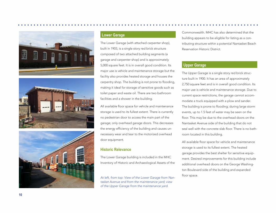
Lower Garage
The Lower Garage (with attached carpenter shop),
built in 1903, is a single story red brick structure
composed of two attached building segments (a
garage and carpenter shop) and is approximately
5,000 square feet. It is in overall good condition. Its
major use is vehicle and maintenance storage but the
facility also provides heated storage and houses the
carpentryshop.Thebuildingisnotpronetoflooding,
making it ideal for storage of sensitive goods such as
toilet paper and waste oil. There are two bathroom
facilities and a shower in the building.
Allavailablefloorspaceforvehicleandmaintenance
storage is used to its fullest extent. There is currently
no pedestrian door to access the main part of the
garage; only overhead garage doors. This decreases
theenergyefficiencyofthebuildingandcausesun-
necessary wear and tear to the motorized overhead
door equipment.
Historic RelevanceThe Lower Garage building is included in the MHC
Inventory of Historic and Archaeological Assets of the
Commonwealth. MHC has also determined that the
building appears to be eligible for listing as a con-
tributing structure within a potential Nantasket Beach
Reservation Historic District.
Upper Garage
The Upper Garage is a single story red brick struc-
ture built in 1900. It has an area of approximately
2,750 square feet and is in overall good condition. Its
major use is vehicle and maintenance storage. Due to
current space restrictions, the garage cannot accom-
modate a truck equipped with a plow and sander.
Thebuildingispronetoflooding;duringlargestorm
events, up to 1.5 feet of water may be seen on the
floor.Thismaybeduetotheoverheaddoorsonthe
Nantasket Avenue side of the building that do not
sealwellwiththeconcreteslabfloor.Thereisnobath-
room located in this building.
Allavailablefloorspaceforvehicleandmaintenance
storage is used to its fullest extent. The heated
garage provides the best shelter for sensitive equip-
ment. Desired improvements for this building include
additional overhead doors on the George Washing-
ton Boulevard side of the building and expanded
floorspace.At left, from top: View of the Lower Garage from Nan-tasket Avenue and from the maintenance yard; view of the Upper Garage from the maintenance yard.

11
Around 2007, the building’s interior was temporarily
divided to provide leased space, and the section of
the building fronting Nantasket Avenue was leased
to an art studio (“Studio at the Beach”). DCR recently
discontinued that lease and the entire building is
once again used for vehicles and maintenance storage.
Historic RelevanceAlthough the MHC has not undertaken any formal
survey or analysis of historical relevance for the Upper
Garage Building, it is likely that it would be consid-
ered eligible for listing as a contributing structure
within a potential Nantasket Beach Reservation
Historic District. In addition, it is possible that the
inventory form for the Lower Garage also includes this
building. It was constructed around year 1900.
Boilermaker’s House
The Boilermaker’s House has an area of approximately
780 square feet and is in overall poor condition. It is
currently used as a break room for lifeguards and as
officespaceforthelifeguardsupervisor.Thereisa
functioning bathroom in the building.
Historic RelevanceThe MHC has not undertaken a formal survey or
analysis of historical relevance for the Boilermaker’s
House. It was likely moved to the current location and
would not be an original contributing element within
a potential Nantasket Beach Reservation Historic
District.
From top: View of Upper Garage from Nantasket Avenue, with art studios opened to the sidewalk; view of the Boilermaker’s House.

12
Other Reservation StructuresThe Clocktower Building and Paragon Park Carousel
are located within the Reservation on the south side
of Wharf Avenue.
Paragon Carousel
The Paragon Carousel was part of Paragon Park, an
amusement park that opened in 1905. It is a local
landmark and tourist attraction, moved to its current
location following the 1984 closing of Paragon Park.
The carousel is privately owned, although it is located
on DCR land.
Clocktower Building
The Clocktower Building and the adjacent land for the
carousel have been leased to the “Friends of Para-
gon Park”. The long-term lease expires in 2016. The
basement currently houses the mechanical equipment
for the carousel and a workshop where the carousel
horsesaremaintained.Thefirstfloorhousesamu-
seum from Paragon Park and an ice cream parlor. The
upstairs is used for storage but has no electricity, heat
or plumbing.
The expiration of the lease in 2016 creates an oppor-
tunityforDCRtofindalternativeusesforthebuilding.
Regardlessoftheusesonthefirstandsecondfloor,
DCR would like to allow the mechanical equipment
for the carousel to remain in the basement and the
carousel itself to remain on the adjacent land.
Historic RelevanceThe building is included in the MHC’s Inventory of
Historic and Archaeological Assets of the Common-
wealth. MHC has also determined that the building
appears to be eligible for listing as a contributing
structure within a potential Nantasket Beach Reserva-
tion Historic District. It was constructed in 1903 as a
restaurant and waiting area for the ferry.
From top: View of the Paragon Carousel and Clock-tower Buildings; closeup of the Clocktower Building; fun on the carousel.

13
Pedestrian & Vehicular AccessContributing to the beach’s appeal is its high level of
pedestrian and vehicular accessibility from adjacent,
largely residential areas, and its proximity to the Bos-
ton metropolitan area. Based on a 2006 Visitor Survey
(see page 15), 91 percent of the visitors come by car.
That number may have come down some since the
introduction of the Greenbush Line Commuter Rail
Service from Boston, but the reduction is likely small
because of the lack of weekend service.
There are 26 crosswalks linking pedestrians to the
Reservation beachfront (see page 19). The crosswalks
are fairly evenly distributed along Nantasket Avenue
and Hull Shore Drive at intersection and mid-block lo-
cations and connect to bath houses and other public
facilities. Many of the crosswalks, however, are not at
stop signs, limiting the degree to which pedestrians
are protected.
Sidewalks along both sides of Nantasket Avenue in
the Reservation are generally in good condition. Side-
walks on the western side of Hull Shore Drive (abut-
ting vacant Hull Redevelopment Authority property)
are deteriorating and in need of improvement. The
sidewalk on the eastern side of Hull Shore Drive in this
location was recently reconstructed.
Transit
Transit access to the Reservation is somewhat limited.
Bus Route 714 runs from Pemberton Point to Hing-
ham Center, with stops on Nantasket Avenue. It
connects to the Greenbush Commuter Rail Line at
Nantasket Junction; however, there is no commuter
rail service on weekends. The bus provides access to
the ferry terminal at Pemberton Point, which has ferry
service from Long Wharf in Boston.
The 220 bus route connects the Quincy Center Mas-
sachusetts Bay Tranportation Authority (MBTA) station
to Nantasket Junction. A passenger could take the
MBTA Red Line or Old Colony Commuter Rail to
Quincy Center, then take the 220 bus to Nantasket
Junction and transfer to the 714 bus to Nantasket
Beach, but this three-seat journey would be lengthy,
anddifficulttocoordinate.
Bicycles
Bicycle racks are located in several locations through-
out the Reservation. The Town of Hull’s Bicycle Plan
was adopted in 2007 and proposes an extensive
network of bike routes throughout the Town (see il-
lustration on page 14); most of the plan has not been
implemented to date. An existing bike path along
the southwest side of George Washington Boulevard
connects to Hingham and there are plans to provide
signage to the path during 2014. The Town also
intends to stripe bike lanes on Wharf Avenue to con-
nect cyclists from George Washington Avenue to the
beach in 2014.
Parking
There are approximately 1,405 existing public parking
spaces within the Reservation, including both on and
off-street parking (see aerial photo on P. 3).
Most of the surface parking areas are adjacent to the
beachfront, with the highest concentration of public
parking found at the southern end of the Reserva-
tion.TwolargeoverflowlotsarelocatedonGeorge
Washington Boulevard near the southern end of the
Reservation.
These lots are separated from Nantasket Avenue
by a large condominium development (Horizons
Condominiums). Pursuant to a Massachusetts Public
Waterfront Act Chapter 91 License, a path adjacent
to the north edge of the Horizons Condominiums
parking lot was constructed to provide a more direct
link from the DCR parking lots on George Washington
Boulevard to Nantasket Avenue and the beach; this
path would increase the attractiveness of these unde-
rutilized lots. The path runs from Nantasket Avenue,

14
From top: Existing promenade and parking lots have minimal amenities; view of skating rink in the overflow lot on George Washington Boulevard.
Proposed route map from the Town of Hull’s 2007 Bicycle Plan.

15
across from the elevated picnic area south of the Ber-
nie King Pavilion, to within approximately 50-75 feet
ofGeorgeWashingtonBoulevard.Thefinalsegment
of the path would need to cross private property. The
DCR continues to negotiate with the property owner
regarding the lease or acquisition of the necessary
right of way.
Most of the parking lots are to the south of the MJM
Bath House and most of the on-street parking spaces
are to the north.
User SurveyAn informal visitor survey was conducted to gain a
better understanding of visitors’ use and impressions
of the Reservation. The responses provided valu-
able background information for development of the
Master Plan.
A total of 101 surveys were conducted on Monday
July 24, Sunday July 30, and Wednesday August 16,
2006. Although a few of the comments regarding
facilities are out of date, the majority of the responses
are still relevant. The responses are summarized
below.
Visitors
Almost 90 percent of the visitors surveyed were from
outside of Hull. It is assumed that many Hull residents
use the Town portion of the beach, rather than the
DCR portion of the beach. Respondents came from
areas west and south of Hull, from up to 40 miles
away.
91 percent of respondents came to the beach by car.
Thisisconsistentwiththefindingthatmostofthe
people on the DCR beach are not from Hull (transit
connections to the beach were very limited – the
Greenbush Line did not reopen until October 2007).
Seven percent of respondents walked (Hull residents)
and two percent drove a motorcycle.
Young crowds (13-25 years of age) tended to congre-
gate at the southern end of the beach near the Tivoli
Bath House, whereas families (adults with children
under 18 years of age) tended to congregate at the
northern end of the beach near the Cook Bath House.
Approximately 25 percent of the respondents came
with children under 18 years old.
Beach Facilities, Maintenance & Security
Overall, beach users had relatively positive responses
regarding DCR’s operation of the beach and the con-
ditions at the Reservation. Concerns about the cleanli-
ness of the bath houses were mentioned by some.
Beach Experience
72 percent of the respondents reported swimming.
28 percent said they had not been in the water, but
many of these respondents said they would be going
in shortly.
Beach Access
76 percent of the respondents thought there were
enough beach access points. Many commented that
existing access through the seawall would be ad-
equate if ramps and stairs were improved, repaired,
and cleared of large revetment boulders. Subsequent
to the survey, the ramps and stairs were improved,
and new ramps were added, as part of the seawall
improvements. The ramps now meet ADA accessibil-
ity standards.
80 percent of respondents thought there was an
adequate number of crosswalks on Nantasket Avenue
and Hull Shore Drive.

16
Parking
Parking was often described as being convenient. 66
percent gave ease of parking either the highest or
second highest rating. Respondents on the north-
ern half of the beach reported more parking dif-
ficultlythanthosetothesouth.Themostoftencited
problems with parking were “high prices” and lack of
parking in lots near the Mary Jeanette Murray Bath
House. 64 percent of respondents said they would
not consider using a remote parking lot with shuttle
service, even if it meant more green space within the
Reservation.
Attraction to Local Restaurants & Shops
67 percent of the respondents said they had been
or planned to go to a restaurant, shop, museum or
other business in town while at the beach. A third of
the respondents who gave improvement ideas for the
Reservation wanted more food related facilities (more
beach vendors, more convenient food).
Beach Replenishment
66 percent of the respondents said they would sup-
port beach replenishment with sand of another color.
74 percent of the respondents said they would like a
wider beach at high tide.
Suggestions for Additional Amenities
Respondentsidentifiedtheneedforthefollowing
additional amenities:
• Bath houses
• Shower related facilities
• Water fountains
• Park areas/picnic areas with benches
• Umbrella/chair rentals
• Recreational facilities
• Convenient food related facilities
• Trash cans
• Shops.
The arcades across Nantasket Avenue from the Tivoli Bath House and Bernie King Pavilion.

17
The overarching goal for the Nantasket Beach Master
Plan is to provide an enhanced natural and recreation-
al experience at Nantasket Beach, with:
• attractive amenities to support a wide range of
activities
• safe and convenient access for pedestrians, cy-
clists, transit and ferry passengers and automo-
bile users
• connections to adjacent bicycle paths and park-
ing areas, as well as commercial and entertain-
ment opportunities.
In order to focus the Master Planning process, the
following master plan goals, organized around four
focus areas, were developed.
The Beach• Provide and improve amenities on the beach
(such as bath houses, shade structures, a wid-
ened promenade, space for vendors, bike paths,
and other amenities as determined appropriate).
• Improve public access to beach for people of
all ages, abilities, and backgrounds, including:
bicycle access, accommodation of public trans-
portation, and improved parking and roadway
design.
• Create a gateway to Nantasket Beach.
• Foster local commerce by making connections
between the beach and local businesses and
encouragingavarietyofusesthatbenefitfrom
the beach setting.
• Interpret the historical context and natural
resource systems of the beach and the region.
• Preservetheessentialcharacter-definingfea-
tures of the landscape while adapting the beach
for contemporary uses.
• Consider year-round uses along the beach.
• Link Nantasket Pier to the Reservation.
Operations• Establish an annual beach users meeting as a
means of coordinating activities, sharing ideas
and voicing concerns.
• Promote and accommodate regional events and
programs on the beach.
• Ensure beach maintenance operations are ad-
equately staffed and equipped.
• Maintain beach stability and sustainability.
• Ensure public safety by providing lifeguards and
maintaining a clean beach.
Access & Circulation• Provide safe and continuous bicycle, skating,
and pedestrian access along the entire length of
the beach promenade.
• Separate footpaths and bike paths in order to
ensure safety and ease of movement for all users.
• Provide a comfortable, safe, and secure experi-
ence for visitors by reducing congestion and
minimizingconflictsonthepromenade,streets,
and bike paths.
• Establish easier and safer pedestrian movement
from the beach to local businesses and remote
parking, and in general promote pedestrian
friendliness.
• Improvetrafficflowandaccesstoparking,
including use of signage to direct both pedestri-
ans and vehicles.
• Increase public transportation to Nantasket
Beach and create connections to existing and
planned transit (i.e., a bicycle connection to
the MBTA rail station and potential future ferry
operations).
3. GOALS
18
• Increase the use of the rear lot along George
Washington Boulevard and open the pedestrian
right-of-way along the Horizons Condominiums.
• Improved public transportation including a ferry.
The Built Environment• Ensure that all building uses on DCR property
are public in nature .
• MakeefficientuseofDCR’sexistingbuildings
and operations area.
• Rehabilitate buildings consistent with program-
ming for Nantasket Beach and maintenance
operations .
• Provide multi-use public facilities and spaces
thatareflexible,well-designed,andeasilymain-
tained.
The Natural Landscape• Diversify plant communities in the Nantasket
beach area, to the degree that climate permits,
for a healthier and more attractive landscape.
• Establish a sustainable and maintainable land-
scape.

19
The results of two studies conducted simultaneously
withthefinalphaseofthisMasterPlanaresum-
marized below and incorporated into this Master
Plan.Thecompletefinalreportsareavailableunder
separate cover:
• Nantasket Beach Reservation Traffic Analysis
Report, The Louis Berger Group, Inc. 2014.
• Nantasket Beach Reservation Facilities Utiliza-
tion Report, The Louis Berger Group, Inc. 2014.
Traffic Analysis ReportThistrafficstudyassessedtrafficflowandpedestrian/
bicycle interaction at and around the Nantasket Beach
Reservation during the summer months and recom-
mendedmodificationstoimprovecirculation,as
appropriate.Traffic,pedestrian,andbicycleflowwere
counted in 2006 and analyzed for year 2013 (existing
conditions) and forecasted year 2033.
Pedestrian Crossings
The pedestrian counts at crosswalks within the study
area were high, with a total of 996 pedestrians using
crosswalks during the 12 pm to 1 pm hour on a Sat-
urday. The most heavily used crosswalk was number
17 with 151 pedestrians; the crosswalk is located on
Hull Shore Drive near a number of restaurants (i.e.,
Hull’s Kitchen, Dry Dock, Daddy’s Dogs). The report
included the following recommendations:
• Crosswalk 4 was utilized by only 11 pedestrians
during the Saturday peak hour. This crosswalk
does not have a clear destination from the
4. RELATED STUDIES
beach and could be removed to reduce the
number of locations where vehicles yield to
pedestrians.
• Crosswalks 8 and 9, which both lead to the
arcade buildings, could be combined. A total of
175 pedestrians would be expected to use this
Crosswalk locations (does not include crosswalks 22-26 to the north).

20
proposed crossing during the Saturday peak
hour.Apush-buttonactivatedflashingbeacon
and warning sign would be appropriate at this
combined location.
• Crosswalks 17 to 18 may also be viable candi-
dates for a pedestrian signal. These crosswalks
service 151 and 118 pedestrians during the
peak hour, respectively. Creating a push-button
activatedflashingbeaconandwarningsignat
one or both of these locations would encourage
safe crossing over the two-lane Hull Shore Drive
Traffic Alternatives For Improvements to the Maintenance Yard
Aside from the existing conditions, two alternatives
wereexaminedtore-configuretrafficinthevicinityof
theyardandtherebyincreaseyardspace.Specifically,
thetrafficalternativesbeingconsideredattheinter-
sections of Hull Shore Drive, Nantasket Avenue and
George Washington Boulevard are as follows:
• Alternative A: The existing condition remains.
(Estimated Cost: $0)
and allow larger groups of people to gather and
cross at the same time.
• All crosswalks at intersections should remain.
Drivers generally proceed more cautiously at
intersections creating a safer environment for
pedestrians when compared to mid-block cross-
walks.
From left: Roadway realignment alternatives A, B and C.

21
• Alternative B: Realignment of the cut-through
portion of roadway from George Washing-
ton Boulevard westbound. (Estimated Cost:
$320,000)
• Alternative C: Relocation of the cut-through
portion of roadway from George Washington
Boulevard westbound to the current intersec-
tion of George Washington Boulevard and
Nantasket Avenue. The southeastern terminus
of Hull Shore Drive is also shifted to align with
this proposed intersection. (Estimated Cost:
$1,000,000).
Fromatrafficcapacityperspectiveallthreeofthe
intersection alternatives will operate at level of service
(LOS) “B” during the current year and at LOS “C”
intheyear2033.LOS“B”isclassifiedasreasonably
freeflow.LOS“C”isclassifiedasstableflowandalso
considered a passing level of service.
Alternative C will provide the largest amount of yard
space for maintenance operations. The decision to
move forward with any of the alternatives will need to
consider factors such as property ownership, con-
cerns of local residents, and long-term plans for the
community.
The Town of Hull is currently in the process of evaluat-
ing changes to the existing roadway system. Potential
changes include making both Nantasket Avenue and
Hull Shore Drive two-way, and increasing the number
of through streets between them to improve connec-
tions and create smaller, more developable blocks
on the Hull Redevelopment Authority owned parcels
between Water and Phipps Streets. Alternative B is
most compatible with these changes and is therefore
included in the Master Plan drawings.
Other Findings
In addition to revising the roadway alignment, the
report includes the following recommendations:
• The intersection of Nantasket Avenue, Phipps
Street and Mountford Road is currently operat-
ing at a failing level of service (LOS) during the
Saturday peak hour. Recommended mitigation
for this location is to improve the signing system
for parking at DCR lots. In recent years DCR
has utilized four variable message signs (VMS)
at select parking lots to alert drivers when lots
are full. Adding VMS boards at other parking
lot entrances and updating the signs regularly
would allow drivers to be aware of full lots and
empty spaces allowing them to spend less time
circulating.
• All other stop-controlled locations are currently
operating at LOS “B” or better.
• All signalized intersections analyzed are cur-
rently operating at a LOS “C” or better during
the Saturday peak hour. If signalized intersec-
tions are found to be a bottleneck in future
years,updatingthefixedsignaltimingmay
decrease delays. Actuated signal timing systems
are another option if an acceptable LOS is not
achievedinthefield.Actuatedsignaltiming
allows sensors to notify the controller of waiting
vehicles to decrease unnecessary stop delay.
Facilities Utilization ReportThis report assessed the maintenance operations and
associated facilities at the Nantasket Beach Reserva-
tion. Several options were developed to improve
operations on the site and at the same time allow for
vacating some of the buildings for other potential
uses. Options were developed jointly with DCR staff.
Maintenance Operations
Maintenance operations at the Reservation are
ongoing year-round to keep the facility functioning
as expected for public use. The busiest time of year
is during the summer months from Memorial Day to
Labor Day but the area is open year-round from dawn
22
to dusk. During the winter months the staff is respon-
sible for snow removal. Storm management is neces-
sary year-round. The maintenance crews are currently
using all garage and yard space available and are in
need of additional covered/heated storage for critical
equipment.
BuildingsThere are a number of buildings on site that are not
used to capacity. The Dormitory Building is currently
utilizedbyDCRasofficespace.TheClocktowerBuild-
ing is leased out and the Police Station is closed due
to asbestos and major water damage. Maintenance
of the buildings on site is a major factor in any future
planning. Many buildings are 100+ years old and
need substantial repairs and upgrades as summarized
by DCR maintenance staff and documented in the
report.
Aside from long-term layout changes, several repairs
andmodificationstothefacilitiesareneeded,assum-
marized below:
1. Dormitory Building• Inspection and possible repairs to the roof
• Assessment of structural integrity of the building
• Re-pointing of all brick work
• Inspection and repair of the brick foundation
and support columns due to salt damage
• Extensive gutter and fascia replacement on
both porches
• Relocation of the generator from the basement
of the Dormitory Building to an area protected
fromflooding.
2. Laundry Building (if not planned to be demolished)
• Asbestos abatement (if not completed previ-
ously)
• Inspection and repair of rotten sills
• Replacement of windows.
3. Small Garage/Fire Safety Building (if not planned to be demolished)
• Inspection and repair of rotten sills
• Replacement of doors and windows.
4. Lower Garage • Inspection and possible repairs to the roof
• Repair of overhanging eves
• Re-pointing of all brick work
• Repair or replacement of all windows
• Insulation of the structure
• Installation of a pedestrian-sized door to access
the building.
5. Upper Garage • Inspection and possible repairs to the roof
• Repair of eve supports and gutters
• Re-pointing of all brick work.
6. Clocktower Building• Testingofthesecondfloorforleadandasbes-
tos
• Completeremodelingofbothfloors
• Possible upgrade of the heating, cooling, and
electrical systems
• Roof repairs.
7. Police Station • Major rehabilitation work.
8. Boilermaker’s House (if not planned to be demolished)
• Inspection and repair of rotten sills
• Inspection and repair of the foundation.
23
Facilities Layout Options
Four layout options were considered to better utilize
the yard area and consolidate DCR operations to
meet the anticipated needs of DCR staff. Facilities
LayoutOptions1and2includemodifyingtraffic
alongGeorgeWashingtonBoulevard(i.e.,Traffic
Alternatives B or C) to create additional yard space for
maintenance activities. Facilities Layout Options 3 and
4arebasedontheNo-buildTrafficAlternativeA.
Key features of each option are summarized in Table
1.Eachoptionmaybemodifiedusingelementsfrom
other options. Under each option at least two build-
ings would be available for lease to an outside party
whose purpose and goals match that of the DCR
mission at the Reservation. In all four options the Boil-
ermaker’s House, Small Garage and Laundry Building
are recommended for demolition or relocation to
increase yard area.
Facilities Layout Option 2 – Partial Build-out of Upper GarageLayout Option 2 - because it provides an improved
operations area, keeps all maintenance facilities on
site,isconsistentwithTrafficAlternativeB,anddoes
notrequireaddingasecondfloortotheUpperGa-
rage - was selected as the option to be incorporated
into the Master Plan illustrations in Chapter 5.
Office Buildings and Uses
Option2utilizesthePoliceStationforofficespace.
While the Police Station needs extensive repairs to
serve this purpose, DCR staff agrees that the central
location and ease of access make it an appropri-
ate ‘face’ of DCR’s operations on the Reservation.
The building is also slightly removed from the brick
garages and would aid in separating the public from
the maintenance operations and equipment. The
Dormitory Building would be available for lease to
a user and use that aligns with DCR’s mission. The
Clocktower Building would be available for a similar
lease as well. The Small Garage, Boilermaker’s House,
and Laundry Building are recommended for removal
or relocation to increase available yard space.
Maintenance Buildings
Due to the overall good condition of the brick Upper
and Lower Garages, Option 2 suggests reuse of both
with some improvements. Option 2 expands the back
wall of the Upper Garage by 10 feet to the south (to-
wards George Washington Boulevard) for additional
storage. Garage doors should be included on the
addition to create a convenient ‘pull-through’ area for
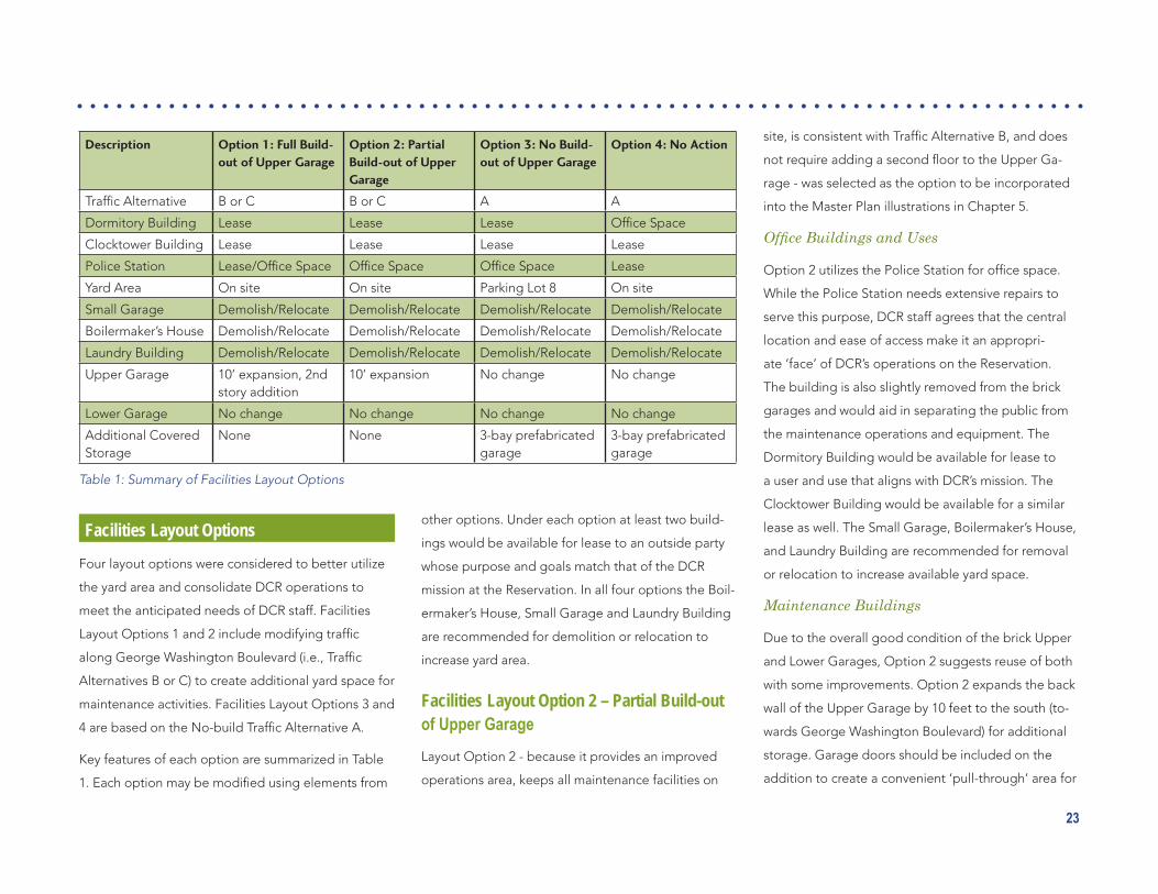
Description Option 1: Full Build-out of Upper Garage
Option 2: Partial Build-out of Upper Garage
Option 3: No Build-out of Upper Garage
Option 4: No Action
TrafficAlternative B or C B or C A A
Dormitory Building Lease Lease Lease OfficeSpace
Clocktower Building Lease Lease Lease Lease
Police Station Lease/OfficeSpace OfficeSpace OfficeSpace Lease
Yard Area On site On site Parking Lot 8 On site
Small Garage Demolish/Relocate Demolish/Relocate Demolish/Relocate Demolish/Relocate
Boilermaker’s House Demolish/Relocate Demolish/Relocate Demolish/Relocate Demolish/Relocate
Laundry Building Demolish/Relocate Demolish/Relocate Demolish/Relocate Demolish/Relocate
Upper Garage 10’ expansion, 2nd story addition
10’ expansion No change No change
Lower Garage No change No change No change No change
Additional Covered Storage
None None 3-bay prefabricated garage
3-bay prefabricated garage
Table 1: Summary of Facilities Layout Options

24
Facilities Layout Option 2

25
the operators. This would eliminate the need for driv-
erstostoptrafficonNantasketAvenuetoeitherback
into or out of the garage. The Lower Garage should
be improved as suggested earlier in this chapter. A
brick arch between the two maintenance garages
with the DCR logo is recommended to maintain the
architectural intent of the original design.
Yard Area
Due to the current restrictions of yard space it is rec-
ommended that the dumpster and ramp be relocated
to provide easier access during pickup and to avoid
the gas pumps. Additional yard space under Alterna-
tives B and C can accommodate a truck entrance to
the yard from Washington Boulevard. Trucks would
exit to Nantasket Avenue.
To improve the available area in the maintenance
yard, the Boilermaker’s House, Small Garage, and
Laundry Building have been removed or relocated. 43
parking spaces are located near the Dormitory Building.
For outside storage of materials and equipment,
various locations around the site have been strategi-
callychosentoleavesufficientopenspaceforvehicle
movement. One covered salt bin (capacity of 75 cubic
yards) and six open bins (capacity of 40 cubic yards
each) are located on the site for storage of materials
throughout the year.
Six employee parking spaces are located at the north
end of the site. Partial staff parking would be moved
to Parking Lot 7 during the summer months.
ForTrafficAlternativeB,theentrancefromWharf
Avenueshouldbereconfiguredtoincreasethearea
for turning movements of large trucks. A new fence
would surround the site to provide a visual screen.
Traffic Alternatives
LayoutOption2underTrafficAlternativeBincreases
the yard area substantially and “squares off” the yard.
UnderTrafficAlternativeC,evenmoreyardarea
would be available. In addition to a truck entrance
from Washington Boulevard and additional parking
spaces near the Dormitory Building, the storage bins
underTrafficAlternativeCaremovedtothenorthern
sideoftheyard.ForTrafficAlternativeC,thenumber
of employee parking spaces within the yard area is
increased to 10 (compared to 6 spaces under Traf-
ficAlternativeB).TrafficAlternativeCalsoallowsfor
some future expansion of the maintenance area, if
needed.
Considerations for All Future Operations Area Options
A number of building and yard maintenance im-
provements discussed in the preceding sections
are recommended for near-term consideration. The
buildings on site are in need of fairly major repairs just
to maintain the deteriorated conditions expected of
buildingsover100yearsold.Specifically,recommend-
ed improvements include the following:
• Build a temporary cover for the salt storage bin
to meet environmental run-off regulations until
a permanent structure can be constructed.
• Demolish or relocate the Laundry Building,
Small Garage/Fire Safety Building, and/or
Boilermaker’s House to allow for additional yard
space and to improve circulation.
• Re-route the current garage waste disposal
drains to connect to the town sewer line under
Nantasket Avenue.
• Relocate the generator from the basement of
the Dormitory Building to an area protected
fromflooding.
• Investigate options for a covered dumpster to
reduce odors.
• Work with local public transportation services
to coordinate the timing of routes to allow for
more convenient access to the Reservation.

26
Uses of Available BuildingsUnder all facilities layout options, at least two build-
ings are available to be leased to interested parties
that would help to maintain the buildings and act
within the intent of DCR’s mission statement. If no sat-
isfactory lease candidates are selected for a building,
DCR could use the buildings for internal programs.
Possible options for either of these scenarios were
discussed for each building by the DCR team and
consultants. The resulting options are described in the
following sections and are expected to be expanded
upon in years to come.
Maintained and Operated by DCR
Maintaining the historic value and essence of all
buildings on site is a priority of DCR. If maintenance
and upkeep of selected buildings is not agreed to in a
lease agreement, the repair and remodeling responsi-
bility would fall to DCR. In this circumstance, appropri-
ate uses for each building would need to be found.
The Dormitory Building could be used by DCR as a
headquarters for the youth program Student Conser-
vationAssociation(SCA).Thefirstfloorwouldbeused
asofficespaceandthesecondfloorwouldserveas
rooming for students visiting the site to participate in
the SCA program.
The Police Station could be used by DCR as a Visitor’s
Center. It is centrally located and has extensive histori-
cal documentation that would be of interest to the
public.
The Clocktower Building could be used by DCR for a
variety of activities. The current ice cream stand within
the building would make a convenient permit sales
location.Theadjacentfirstfloorareacouldserveasa
visitor’scenter,officespace,storagespace,and/ora
museum.Thesecondfloorwouldbebettersuitedfor
officespaceorstoragespace.
Leased by DCR
Theprojectteamagreedthatthefirststepinleasing
any of the spaces abandoned is to create a public fo-
rum to collect ideas on how visitors would like to see
the spaces used in the future. All proposals submitted
would be required to account for historic preservation
andmaintenancetaskswhilefittingwithintheDCR
mission statement. Possible uses that the team felt
were appropriate for the area and follow the mission
statement have been documented for each building.
The intent was only to brainstorm and inspire ideas,
not to limit the proposals that are received.
The team felt that the Dormitory Building may be a
suitable hostel for international youths visiting the
area. The Clocktower Building is historically relevant
so use as a museum was suggested to complement
the existing carousel. The Police Station building is
also historically relevant and could be used as a mu-
seum or perhaps as a studio for artists.
A few relevant details pertaining to the possible leas-
ing of these sites for interested parties are:
• Consideration should be given to the adjacent
maintenance facility with respect to visitors and
lessors.
• Flood insurance would be required for leased
occupants.Theareaisclassifiedasa“highve-
locity”zonebyFEMAandfloodingiscommon.
• Retail uses have historically struggled in the
region.

27
As described in Chapter 2, creating a more attractive,
greener environment, with better access to the beach
and Reservation, and more amenities for visitors, were
key goals of this Master Plan. The Plan is designed
to provide visitors with a great day at the Reservation
from arrival to departure, while aiding the DCR in
operating and maintaining the Reservation. The rec-
ommendations described below were developed to
achieve that vision, and respond to DCR’s needs and
concerns, as well as the concerns that were expressed
by the community and the Citizens Advisory Commit-
tee throughout the Master Plan process.
As described in the introduction, this Master Plan was
developed in conjunction with the Nantasket Beach
Seawall Repair Project. Recommendations (both design
and phasing) have been coordinated with the remain-
ingunfinishedelementsofthatProject,including:
• Installation of a stone revetment to stabilize the
existing seawall segment from the Mary Jea-
nette Murray Bath House north to Water Street.
• Rehabilitation of the revetment at the northern
end of the Reservation, near the David Cook
Comfort Station.
Recommendations are divided into the following
categories:
• Landscaping and Green Space
• The Promenade/Boardwalk
• Open Space and Recreational Amenities
• Operations and Maintenance Area
• Access and Circulation
• Interpretive Opportunities
• WayfindingandSignage
All facilities should be designed to meet ADA ac-
cessibility standards, and layouts for new facilities
(including the boardwalk, bikepath and parking) were
developed to accommodate those requirements.
Specificmodificationstoexistingfacilitiesarenoted
in the text.
Landscaping & Green SpaceA key concern expressed during this project was the
overall lack of greenspace throughout the Reservation.
In addition to the landscape buffer and new open
spaces described later in this chapter, recommenda-
tions include:
• Planting a row of trees along George Washing-
ton Boulevard to help screen the Maintenance
Area.
• Adding landscaping to parking lots.
• Enhancing plantings at entry points, such as
along Wharf Avenue.
It has been DCR’s experience at Nantasket Beach that
theharshbeachfrontenvironmentmakesitdifficult
fortreestoflourish.Withtheexceptionofthetrees
noted above, it is recommended that landscaping
include primarily shorter, hardy plants that can with-
stand the strong winds and sea spray.
5. THE PLAN
Illustrative Master Plan (see enlargement on pages 28-29)

28
Illustrative drawing of Master Plan recommendations
(RAMP ACCESS MAINTAINED)

29
POTENTIAL RECREATION AREA

30
The Promenade/BoardwalkAll visitors to the Reservation walk along the beach-
front promenade, whether to access the beach or to
simply exercise and enjoy the view. The promenade
also provides a refuge for visitors during high tide,
when the beach is underwater.
As with the existing promenade, the redesigned
promenade will be continuous along the entire length
of the Reservation. To give it more of the feel of a
traditional oceanfront boardwalk, it is recommended
that it be surfaced with either a wood or recycled
material boardwalk.
For most of the length of the beach, the promenade
is 16 feet wide. It widens to almost 20 feet behind the
Mary Jeanette Murray Bath House. At the northern
end of the beach, along the Hull Shore Drive, it nar-
rows to 10 feet because of the limited land area avail-
able between Hull Shore Drive and the seawall. The
promenade could be widened to 12 feet in this area
if the promenade construction takes place during or
after the Town of Hull’s proposed roadway widening.
A six foot wide planting buffer along the landside of
the promenade separates the promenade from the
bicycle lane (described on page 39). The sides of the
plantersshouldbeangledinwardtoavoidconflicts
with cyclists. In a few locations, the buffer strip nar-
rows to 4 feet. The exact width and juxtaposition of
the boardwalk, planting buffer and sidewalks change
as the available space differs over the length of the
Reservation. The cross sections (pages 31 through 35)
illustrate the different conditions.
Shade structures with benches, as well as locations
for vendor carts, are interspersed in the planting strip
along the length of the promenade. Vendor areas will
provide opportunities for local businesses to sell food,
beveragesandbeachitemslikeinflatabletoysor
sunscreen. Larger vendor stalls or pavilions to accom-
modate umbrella, beach chair and/or bicycle rentals
are located near the northern and southern end of the
beach.
Lighting is incorporated into the design for the prom-
enade and is shown as double pendant lights, similar
to those used at other DCR Reservations. Where
possible, the lights are placed to illuminate both the
promenade and the bicycle lanes or adjacent seating
areas.Lightingshouldbeenergy-efficient;theuseof
solar-powered lights should be explored during the
next design phase.
Open Space & Recreational AmenitiesThe beach is, of course, the major recreational amenity
and the reason most visitors come to the Reservation.
Above: Rendering of boardwalk with food vendor cart and with shade structure.
However, many visitors come for the day and are
looking for other recreational opportunities to limit
sun exposure, to create a more varied experience and
to “wait out” the loss of the beach during high tide.

31
Cross sections indicating juxtaposition and width of promenade, bicycle lane and other amenities at vari-ous locations (cross section locations are shown on Page 32).

32
Parking Lot A: 168 spaces (6 HC)
Parking Lot C: 68 spaces (3 HC)
Parking Area 1: 49 spaces (3 HC)
Parking Area 7: 75 spaces (6 HC)
Parking Area 5: 36 spacesParking Area 4: 21 spaces
Parking Area 3: 14 spaces
Parking Area 2: 48 spaces
Above and facing page: Location of cross sections on pages 31, 34 and 35 and parking facilities discussed on page 39.

33
Parking Lot G: 246 spaces (7 HC) + 10 bus spaces
Parking Lot F: 314 spaces (8 HC)
Parking Lot E: 116 spaces (6 HC)
Parking Lot B: 57 spaces (3 HC)
Parking Lot H: 46 spaces (0 if recre-ation area)
Parking Area 6: 57 spaces (3 HC)

34
Above and facing page: Cross sections indicating juxtaposition and width of promenade, bicycle lane and other amenities at various locations (cross section locations are shown on Page 32).

35

36
The recommendations on the following pages are
designed to provide a range of amenities and activi-
ties for visitors.
Central Area
The area from the MJM Bath House to the Tivoli Bath
House encompasses many of the key visitor amenities
and gathering spots, including the MJM Bath House,
a playground, the Bernie King Pavilion and the Tivoli
Bath House. It is located close to much of the parking
and is very visible for visitors arriving via Wharf Av-
enue. It also is directly across Nantasket Avenue from
the Carousel and Clocktower Buildings, as well as the
DCR operations and maintenance center. A number
of improvements are recommended for this area.
As part of the ongoing Seawall Stabilization Program,
a stone revetment is planned be constructed between
the MJM Bath House and Water Street. Recommen-
dations described below for this area should not be
constructed until after the revetment is in place.
Nantasket GreenA key feature will be Nantasket Green, a new gateway
greenspace directly across from Wharf Avenue, that
will welcome visitors to the Reservation. The space in-
cludes a water feature that will both be visually attrac-
tive and provide a popular play/cooling off spot during
high tide. A large open lawn will provide space for
picnics, Frisbee throwing, etc. and can accommodate
a tent for larger gatherings and events. Long shade
structures are shown parallel to Nantasket Avenue
and lining both sides of the water feature area. Com-
munity members liked the idea of open lattice roofs
so that the benches are not in full shade. Picnic tables
are shown along the sides of the large lawn area.
Bernie King PavilionOn the ocean side plaza adjacent to the Bernie King
Pavilion, new plantings and picnic tables with permanent
Close-up of the Central Area.
Rendered view of Nantasket Green from Wharf Avenue.
POSSIBLE EVENT TENT LOCATION
NEW GATEWAY PARK WITH SPRAY POOL
NEW BIKE RACKSEXPANDED PLAYGROUND
NEW AWNINGS FOR ART SALES/VENDORSREFURBISHED MARY JEANETTE MURRAY BATH HOUSE
RELOCATED TIVOLI BATH HOUSE
RECONFIGURED PARKING AREA
NEW TRANSIT STOP AND SHELTERS
PICNIC TABLES WITH UMBRELLAS
NEW SHADE STRUCTURES
NEW VENDOR PAVILION
BIKE LANE

37
umbrellas will provide a more attractive and better
protected picnic area adjacent to the beach. The
design and installation of these umbrellas will need
to allow for potential removal during strong storm
conditions.
Accessiblity: The existing promenade is widened at
the southwest corner of the Bernie King Pavilion, by
the stairs to the beach, to eliminate the pinch point in
that location.
Mary Jeanette Murray Bath HouseAs discussed in Chapter 2, the Mary Jeanette Mur-
ray Bath House is underutilized, with the main space
being closed for much of the time. While no mainte-
nance repairs are needed at the MJM Bath House,
a number of changes were suggested for the near
future:
• Hang historical pieces and artwork in the open
meeting space to create a more inviting atmo-
sphere.
• Open the doors and invite the public in during
normal operating hours, rather than just during
special events.
• Create a station in the open meeting space to
sell DCR parking permits during the summer;
this would require a phone line for credit card
transactions.
• Add windows to the utility rooms in each wing
ofthebuildingtocreateofficespaceforthe
rangers and the lifeguard supervisor.
• Inthewomen’swing,reconfigurethecurrently
empty room with the large door to the outside
to be a break room for the lifeguards. The inside
door would need to be secured to prevent ac-
cess to the women’s room – lifeguards would
be allowed access through the large outer door.
The room has a large door that opens directly
to the beach and a number of lockers that could
be used for storage. This layout would allow
the rangers and lifeguards to stay closer to the
beachfront to serve visitors.
• TheManager’sofficecouldbeusedforstorage
of materials that are currently located in the util-
ity rooms proposed.
• Awnings are provided along the front of the
MJM Bath House for artists and vendors.
The existing playground on the south side of the Mary
Jeanette Murray Bath House is expanded to accom-
modate more children. Play structures should be
designed for a variety of ages.
Tivoli Bath HouseThe Tivoli Bath House is relocated further back from
the beach, to provide more protection from wave
damage.
At the existing plaza between the south side of the
Bernie King Pavilion and the Tivoli Bath House, new
shade structures are added. One of two larger vendor
pavilions is shown to the south of the plaza, to pro-
vide a location for chair and umbrella rentals.
Accessibility: The promenade in this location will re-
quire regrading to eliminate the steep slopes at either
end of the plaza.
North Area
North of Bay Street, the narrow width of the Reserva-
tion limits facilities to the Promenade, buffer strip and
bike lane, with the exception of the far north end.
Changes at the northern end of the Reservation at
Phipps Street are designed to make this area more
Rendering of improvements to plaza behind the Ber-nie King Pavilion.

38
attractive and user-friendly. Currently, amenities and
opportunities for purchasing food and drink are very
limited at this end of the Reservation.
It is recommended that Manomet Avenue, which
separates the beach from adjacent Reservation
property, be closed to create a larger area contiguous
to the boardwalk. The expanded area includes a new
playground as well as a vendor pavilion for selling
food, beverages and other beach items, or for bicycle
rental.
A portion of the revetment needs to be rehabilitated
in this area. It is recommended that the David Cook
Comfort Station be relocated to the land side of the
boardwalk to allow for dune reclamation, and that
this area serve as an early pilot project for the beach
nourishment program.
Operations & Maintenance AreaRecommendations for the operatIons and mainte-
nance area are described in detail in Chapter 4.
Vehicular & Pedestrian Access & Circulation
Pedestrian Access
Pedestrian access to and through the Reservation is
provided via the sidewalks and Promenade described
above. Buffer planting will provide a more attractive
pedestrian environment. 26 crosswalks provide access
to the beach. The Plan includes the introduction of
bumpouts at a number of those locations to shorten
the crossing, and it is recommended that temporary
raisedcrosswalksbeusedtoslowtrafficduringthe
summer. The temporary raised crosswalks can be
Close-up of the North Area.
It is recommended that the David Cook Comfort Sta-tion be relocated to the landside of the boardwalk.
(RAMP ACCESS MAINTAINED)

39
removed between the fall and spring to provide good
trafficflowandtoavoidconflictswithsnowplows.
Recommendationsforpush-buttonactivatedflashing
beacons and warning signs are discussed in Chapter 4.
A wide crosswalk on George Washington Boulevard
(outside of the Reservation) will provide a safe pedes-
trian crossing, should ferry service to the City Pier be
established.
Bicycles
As shown on the Plan on Pages 28 and 29, and the
sections on Pages 31 through 35, a two-way 12-foot
wide bicycle lane runs the entire length of the Reser-
vation. For most of that length, it is at the same height
as the boardwalk and sited to allow cyclists to ride
close to the beach, separated from the Boardwalk/
Promenade by the planted buffer strip. The bike lane
moves to the street in front of the MJM Bath House
and the Bernie King Pavilion, where beach side access
is limited by the buildings. The bicycle lane would
connect with the Town’s proposed bike lanes at either
end of the Reservation, and with the George Wash-
ington Boulevard bike lane at Wharf Avenue.
Bicycle racks are provided throughout the Reservation
and vendor pavilions near the north and south ends
could be designed to accommodate bicycle rentals.
Transit
The Plan is designed to accommodate transit access
to the Reservation, and it is recommended that DCR
work with the MBTA to coordinate ferry, train and bus
schedules to allow for easy transfers between modes.
It is also recommended that a consolidated schedule
be developed each summer so that potential visitors can
easily plan a transit route to and from the Reservation.
Recommended transit-related improvements include:
• On Nantasket Avenue, new pull-outs are
provided for buses and trolleys in front of the
Bernie King Pavilion (on the northbound side)
and the Dormitory Building (on the southbound
side), in addition to the existing pull-out in front
of the MJM Bath House. Covered waiting areas
have been included in front of the Bernie King
Pavilion.
• Parking at the George Washington Boulevard
lot(LotG)hasbeenreconfiguredtoaccommo-
date 10 buses (see plan on pages 32 and 33).
• A wide crosswalk has been added on George
Washington Boulevard (outside of the Reser-
vation) to provide a safe pedestrian crossing
should ferry service to the City Pier be estab-
lished, as stated above.
Parking
While much attention has been paid to bicycle, pe-
destrian and transit access, it is likely that the majority
of visitors will continue to arrive by car. As discussed in
Chapter 4, a key recommendation is the incorporation
of a variable message signage system that will direct
drivers to the lots with space available. This system
will help to eliminate much of the needless circling of
cars searching out available spots.
Particularly important will be the addition of a sign
just south of the entrance to the George Washington
Boulevard lots (Lots G and H). Drawing visitors into
thoselotswillreducetrafficonNantasketAvenueand
Hull Shore Drive. Similarly, a sign on Route 228/Nan-
tasket Avenue, south of Rockland Road, would direct
drivers to open lots and keep them off of Nantasket
Avenue when the lots there are full. A sign in this loca-
tionwouldbemoredifficulttoimplementbecauseit
would not be on DCR property.
Manyoftheparkinglotsarereconfiguredsomewhat
to accommodate the boardwalk, bicycle lane and
landscapebuffer,aswellastoprovidemoreefficient
layouts. Landscaping has been added to most of the
parking lots. Parking locations, as well as accessible
spaces, are indicated on the drawing on pages 32 and
33andinTable2.Location-specificchangesinclude
the following:

40
• George Washington Boulevard lot north of
Rockland Circle (Lot G): The skating rink has
beenremovedandthelotisreconfiguredtoac-
commodate bus parking. DCR should continue
to negotiate with the private property owner
to allow completion of the pedestrian path
adjacent to the north edge of the Horizons Con-
dominiums parking lot. This path would provide
a direct link from the DCR parking lots to the
beach, which would increase the attractiveness
of these underutilized lots.
• George Washington Boulevard lot south of
Rockland Circle (Lot H): It is suggested that
this lot, which is used only on the busiest days,
could be converted into a skate park.
• South of the Bernie King Pavilion (Lots E &
F):Theparkinglotshavebeenreconfiguredas
one continuous lot with entrances at both the
far southern end and at a midpoint across from
Park Avenue. Exits are located at the southern
entrance and at the northern end by the Bernie
King Pavilion. The midpoint entrance and the
northernexitaresufficientlywidetoallowcars
to enter and exit at both locations during non-
peak times when the lots are not staffed, or for
special events at the MJM Bath House, Nantas-
ket Green or Bernie King Pavilion.
Location Existing Spaces
Future Spaces (in-cluding Accessible Spaces)
Accessible Spaces
Parking Lots
Lot F: Nantasket Ave., south of Tivoli Bath House 332 314 8
Lot E: Nantasket Ave., Tivoli Bath House to Bernie King Pavilion 136 116 6
Lot D: Nantasket Ave., Bernie King Pavilion to MJM Bath House
81 0 (open space)
Lot C: Between Nantasket Ave. and Hull Shore Drive, south of Red Parrot Restaurant
57 68 3
Lot B: Nantasket Ave., North of MJM Bath House 90 57 3
Lot A: Between Hull Shore Drive and Nantasket Ave., south of Quincy St.
109 168 6
Subtotal Parking Lots 805 723
Remote Lots
Lot G: George Washington Boulevard, north of Rockland Circle 230 246 (+ 10 bus spaces)
7
Lot H: George Washington Boulevard, south of Rockland Circle 46 46 (0 if skate park)
Subtotal Remote Lots 276 292
Parking Areas
Area 1: Hull Shore Drive, south of Water Street 89 49 3
Area 2: North of Water Street (on grass) 48 48 (no changes)
Area 3: North of Bay Street, west of Nantasket Ave. (on grass) 14 14 (no changes)
Area 4: Nantasket Ave., north of Sagamore Terrace 21 21*
Area 5: Nantasket Ave., north of Bay Street 36 36*
Area 6: Nantasket Ave., from south to Bernie King Pavilion 66 57 3
Area 7: Hull Shore Drive, between Water and Phipps Streets 50 est. 75 6
Subtotal Parking Areas 324 300
TOTAL 1,405 1,315
Table 2: Existing and future parking availability (see plan on pages 32 and 33 for parking locations).
* Number of spaces may be changed due to ongoing streetscape improvements by Town of Hull.

41
• South of the MJM Bath House (Lot D): The lot
is eliminated to accommodate the Nantasket
Green open space.
• North of the MJM Bath House (Lot B). The
lotisreconfiguredtoaccommodateroadway
changes and additional landscaping.
On-streetparkingisalsomodified,asshownon
Table 2.
Traffic Circulation
Changesintrafficcirculationrelatedtotherealign-
ment of the George Washington Boulevard/Nantasket
Avenue intersection are described in Chapter 4.
Year-Round OperationThe busiest time of year at Nantasket Beach Reserva-
tion is between Memorial Day and Labor Day when
warm weather draws a lot of beachgoers. However,
the Reservation also is utilized during the other nine
months of the year by visitors walking along the beach
and enjoying the view. Improvements proposed in the
MasterPlanaredesignedtobenefitvisitorsduring
all seasons through use of hardy plants and sturdy
weather-proof materials. The improved promenade
and the new bicycle lanes can be used year-round.
Potential new uses discussed for the Dormitory,
Clocktower and Police Station Buildings, as well as
interpretive exhibits in the Mary Jeanette Murray Bath
House, are designed to encourage year-round activity.

42
Interpretive OpportunitiesInterpretive opportunities at Nantasket Reserva-
tion include both historic and natural resources. Key
elements could include the former Paragon Park,
former uses of the buildings within the operations and
maintenance facility, as well as an explanation of the
evolution of the beachfront from a natural seashore
to a constructed seawall. The former Police Station,
Clocktower Building and MJM Bath House all provide
opportunities for displaying historic photos and artifacts.
Potential outdoor interpretive signage locations
include the plaza behind the Bernie King Pavilion and
the new park at the northern end of the Reservation.
The northern end, in particular, would provide a prime
location for explaining sand dunes and natural wave
action.
Wayfinding & SignageAwayfindingandsignageprogramwouldhelpvisi-
tors to navigate the Reservation and the important
destinations scattered throughout. Maps in key loca-
tions, including arrival spots such as parking lots and
transit stops, would better enable visitors to plan their
At right: Examples of interpretive elements inserted in boardwalks, embedded in pavement, attached to railings and free standing.

43
visit. Signage should clearly identify bath houses, pic-
nic areas, vendor pavilions and the carousel. Signage
should also identify the location for pass sales.
PhasingIt is anticipated that full implementation of the Master
Plan recommendations, including beach nourishment,
could take up to 30 years. However, as shown on
Table 3, it is recommended that much of the design
work take place during the next two years, with con-
struction of many of the visitor amenities taking place
inyearstwotofive.
The schedule is laid out to ensure that the design and
construction of related and/or adjacent elements can
happen in a coordinated and cost effective manner,
and that design and construction packages have
realistic budgets based on potential DCR funding
availability.
Above: Examples of interpretive elements attached to low walls and free standing.
Above: Examples of interpretive elements attached to indoor building walls and within shade shelters; typical DCR wayfinding signage.

44
Table 3: Phasing Schedule
Year Location Activity
Master Plan (not including DCR operations and Maintenance Facilities)
0-2
Boardwalk, Bike Lane and Other Im-provements from Southern End to Phipps
Design Boardwalk (incl. accessibility improvements on existing promenade ramp)
Relocated bath houses (Cook and Tivoli)
Shade Structures
Expanded playground
Closed Manomet Avenue
Bike lane
Vendor pavilions
Planting buffer
Lighting
Nantasket Green Area Design Nantasket Green Park with Water Feature
Playground expansion
Seating area behind Bernie King Pavilion
Nantasket Avenue Improvement (Narrow-ing roadway)
Design Roadway, crosswalks and sidewalk
Bike lane in front of MJM and Nantasket Green
Parking lot north of MJM and south of Bernie King Pavilion (Incl. Kiosk)
Transit stops
Seawall Stabilization between MJM Bath House and Water Street
Design & Construct
Stone Revetment to provide passive support, so seawall will survive a 100-year storm
Parking Signage Program Design & Construct
Parkingsignage/notificationprogram
2-5
Central/Nantasket Green Area Construct Nantasket Green with water feature
Playground expansion
Boardwalk
Seating area behind Bernie King Pavilion
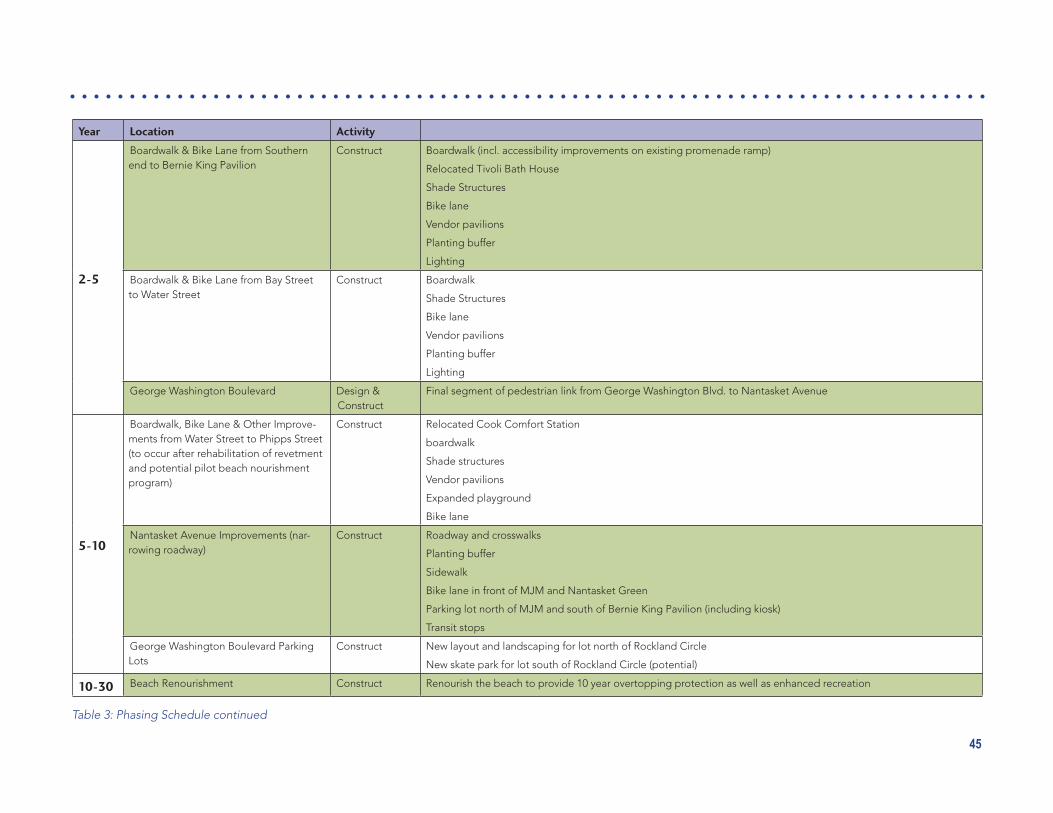
45
Year Location Activity
2-5
Boardwalk & Bike Lane from Southern end to Bernie King Pavilion
Construct Boardwalk (incl. accessibility improvements on existing promenade ramp)
Relocated Tivoli Bath House
Shade Structures
Bike lane
Vendor pavilions
Planting buffer
Lighting
Boardwalk & Bike Lane from Bay Street to Water Street
Construct Boardwalk
Shade Structures
Bike lane
Vendor pavilions
Planting buffer
Lighting
George Washington Boulevard Design & Construct
Final segment of pedestrian link from George Washington Blvd. to Nantasket Avenue
5-10
Boardwalk, Bike Lane & Other Improve-ments from Water Street to Phipps Street (to occur after rehabilitation of revetment and potential pilot beach nourishment program)
Construct Relocated Cook Comfort Station
boardwalk
Shade structures
Vendor pavilions
Expanded playground
Bike lane
Nantasket Avenue Improvements (nar-rowing roadway)
Construct Roadway and crosswalks
Planting buffer
Sidewalk
Bike lane in front of MJM and Nantasket Green
Parking lot north of MJM and south of Bernie King Pavilion (including kiosk)
Transit stops
George Washington Boulevard Parking Lots
Construct New layout and landscaping for lot north of Rockland Circle
New skate park for lot south of Rockland Circle (potential)
10-30 Beach Renourishment Construct Renourish the beach to provide 10 year overtopping protection as well as enhanced recreation
Table 3: Phasing Schedule continued

46
Year Location Activity
DCR Maintenance Facilities
0-2
Operations & Maintenance Yard Design & Construct
Install storage bins including a covered bin for salt
Re-route the garage waste disposal pipe to tie into the town sewer line under Nanatasket Avenue
Remove or relocate the boilermaker’s House
Investigate options for a covered dumpster
Mary Jeanette Murray Bath House Operate & Construct
Hang historical pieces and artwork in open meeting space
Keep doors open during normal operating hours
Move parking permit sales to MJM (requires phone line for credit card sales)
Secure large conference room door that connects to women’s bathroom to serve as lifeguard’s break area
Dormitory Building Construct Movethegeneratorfromthebasementtopreventdamageduetoflooding
Other Operations Work with public transportation services to better coordinate timing of routes
2-5
Operations & Maintenance Yard Design & Construct
CoordinatewithMassDOTanddesignforTrafficAlternativeB
Create an entrance on George Washington Boulevard for maintenance workers and large vehicles
Install new fencing throughout the maintenance yard area
Remove or relocate the Laundry Building and Small Garage Building/Fire Safety Building
Addanewentranceandexitpointbetweentheloweranduppergaragebuildings,finishwithabrickarchandDCRlogo
Mary Jeanette Murray Bath House Design & Construct
Remodel by installing windows in the utility rooms on each wing
MovetheRanger’sofficetooneoftherecentlyremodeledutilityrooms
MovetheLifeguard’sOfficetooneoftherecentlyremodeledutilityrooms
Clocktower Building Design & Construct
2016-bulding lease ends. The carousel and it’s operating equipment will remain
Utilizetherecentlyvacated1stfloorasstorageformaterialscurrentlyintheLaundryBuildingandSmallGarage/FireSafey Building
Renovate, including: testing and possible abatement for lead and asbestos, roof repairs, structural assessment and repairs,remodelingbothfloors,heatingsystemsupgrade,electricalsystemupgrade,plumbingsystemupgrade
Lease or repurpose the building
Table 3: Phasing Schedule continued

47
Year Location Activity
5-10
Operations & Maintenance Yard Construction ImplementTrafficAlternativeBandexpandmaintenanceyard
Police Station Design & Construct
RenovatetoserveasDCRofficespace.Renovationsinclude,butarenotlimitedto:asbestosabatement,sstructuralrepairs, heating system installation, electrical system installation, plumbing system installation
Move DCR on-site operations into the newly renovated builidng
Lower Garage Design & Construct
Renovate, including: roof and eave repairs, repointing all brick work, replacing windows, insulating the structure, installingapedestriandoor,inspectingfloordrains
10-20
Upper Garage Design & Construct
Expand garage space by a minimum of 10 feet as shwn in the conceptual design
Install overhead doors on the expansion side of the buidling to improve circulation
Renovate the existing portion, including: roof and eave repairs, repointing all brick work, replacing gutters and fascia
Lease or repurpose the building
Table 3: Phasing Schedule continued

48