http:// professor peter styles keele university united kingdom
TRANSCRIPT

http://www.sheerproject.euhttp://www.sheerproject.eu
Professor Peter StylesKeele UniversityUnited Kingdom

Potential hazards of shale gas Potential hazards of shale gas operations operations

Work Packages

DESCRIPTION DESCRIPTION
The ObjectiveObjective of SHEERSHEER is to develop best practices for assessing and mitigating the environmental footprint of shale gas exploration and exploitation.
SHEER will develop a probabilistic procedure for assessing short and long-term risks associated with:
– Groundwater contaminationGroundwater contaminationBy chemicals contained in the flow back, formation, produced and waste waters;
– Air pollutionAir pollution By migration of fugitive methane through induced and natural fractures and mobilization ofradioactive particles and gases from the underground
– Induced seismicityInduced seismicityFrom fracking and injection of waste water

o To develop procedures to assess time-dependent vulnerability of infrastructures, life-lines, and socio-economic assets to different possible hazards, to perform a multi-risk analysis.
o To implement the developed framework for one of the case-studies.
o To carry out a comparative analysis between the impacts of shale gas operations and impacts related to exploitation of alternative energy sources.
SHEER DISTINCTIVE FEATURES SHEER DISTINCTIVE FEATURES

which may develop as an unwanted by-product of the fracking processes and may become pathways for gas and fluid migration towards underground water reservoirs or the surface.
DESCRIPTION The severity of each hazard depends strongly on the
unexpected enhanced permeability patternunexpected enhanced permeability pattern
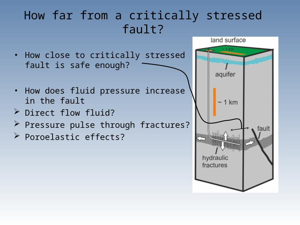
How far from a critically stressed fault?
• How close to critically stressed fault is safe enough?
• How does fluid pressure increase in the fault Direct flow fluid? Pressure pulse through fractures? Poroelastic effects?

Which faults are critically stressed?
Stress field known approximately Earthquake locations known But not positioned in 3D So we do not know which faults the energy
comes from…..and therefore which faults are responsible
Relative relocation

Simulated Hydrofrac
Calculated Coulomb Stress Change on
Optimal Strike Slip Faults

Impact on drinking water aquifers is a key issue in shale oil and gas
An assessment of potential impacts of shale gas/tight oil exploration and development on groundwater resources, in terms of possible pollution or resource impairment, requires an investigation of three possible scenarios, as shown in Figure 1, in which groundwater could be impacted:
• At surface : spills of pollutants &/or contaminants; disposal of flowback;
• Around the well-bore as a result of a failure in well integrity in which drilling fluids or flow back is allowed to escape into surrounding strata;
• Through groundwater flow arising from fracture stimulation
Risks associated with the transfer of contaminants through surface activity such as spills of contaminants are not included within the research proposal.

Research Objectives
WP5 will characterise baseline conditions and potential impacts on drinking water supplies in shale gas plays within Europe. Assessment of potential impacts of shale gas exploration and development on groundwater resources, in terms of possible pollution or resource impairment, requires investigation of three scenarios in which groundwater could be impacted:
• Well integrity
• Abandoned well legacies.
• Fracture simulation eg changes in ground water flow and the potential for enhanced gas or fluid migration through high permeability pathways.
Task 5.1 . Develop Generic Settings (Task Leader: Andrew Gunning – RSK; UGL
Task 5.2. Detailed Hydrogeological modelling (Task Leader: Andrew Gunning – RSK; UGL
Task 5.3. Recommendation for best practice (Task Leader: Paul Younger – UGL; RSK)
WP5 - Assessment Of Groundwater Chemistry [Months: 1-36]RSK W Ltd, IGF PAS, KeU, UNIVERSITY OF GLASGOW

DATA GATHERINGDATA GATHERING
Opportunity to monitor the site and collect whole- life-
cycle data from the site preparation phase to the
production phase
SHEER DISTINCTIVE FEATURES SHEER DISTINCTIVE FEATURES
Seismic NetworkGroundwater Borehole networkAtmospheric Methane
Polish shale gas sitePolish shale gas siteMunicipality: Gmina LiniewoMunicipality: Gmina Liniewo

Seismic network Locations being determined plus some borehole sensors collocated with these
monitoring boreholes
Pomerania Ordovician Shale Gas Play: Wysin

The Wysin groundwater
monitoring wells consist of at
least 4 wells >200mm diameter,
drilled to c 75 metres (mbgl).
The well locations are as follows:
•GW1 – Upstream of direction of
groundwater flow relative to the main
drilling pad
•GW2 – Midway (800m) above lateral of
Wysin 2H
•GW3 - Midway (800m) above lateral from
Wysin 3H
•GW4 - Downstream of direction of
groundwater flow relative to the main
drilling pad
•GW5 – if required.

MULTI-RISK ANALYSISMULTI-RISK ANALYSIS
Probabilistic methodology for assessing short and long-term risksProbabilistic methodology for assessing short and long-term risks
To implement an effective mechanism to identify and structure scenarios of risk
interactions and cascading effects, taking into account the phase of
development of the project:
o Drilling, Hydraulic stimulation, Production, AbandonmentDrilling, Hydraulic stimulation, Production, Abandonment
o To develop and implement physically-based, probabilistic tools for the
assessment of the likelihood of occurrence of interrelated risk scenarios with
regard to:o Induced seismicityInduced seismicity
o Ground water pollutionGround water pollution
o Air pollutionAir pollution
SHEER DISTINCTIVE FEATURES SHEER DISTINCTIVE FEATURES

ThanksAny questions