document
Upload: united-nations-office-for-the-coordination-of-humanitarian-affairs
Post on 22-Mar-2016
213 views
DESCRIPTION
http://www.ochaopt.org/documents/ocha_opt_bethlehem_shrinking_space_may_2009_english.pdfTRANSCRIPT

UNITED NATIONS Office for the Coordination of Humanitarian Affairsoccupied Palestinian territory
SpEcIAl fOcUS MAY 2009
P. O. Box 38712 East Jerusalem 91386 l tel. +972 (0)2 582 9962 l fax +972 (0)2 582 5841 l [email protected] l www.ochaopt.org
SHrinking SPACE: UrbAN cONTrAcTION AND rUrAl frAgmENTATION
IN ThE bEThlEhEm gOvErNOrATE
This report on the Bethlehem governorate documents how the centralurban core is constricted by a combination of Israeli infrastructure, including the Barrier, settlements and settlement outposts. In the eastern governorate, administrative restrictions (Area C, closed military areas and nature reserves) also limit the potential for urban expansion, graz ing, and for
plan ning and development at the governorate level. If Barrier construction goes ahead as planned in the western part of the governorate, the rural hinterland will be cut off, reducing access to land and water resources. Some 21,000 Palestinian residents will face additional restrictions on access to markets, health services, and higher education in the Bethlehem urban area.
Pho
to b
y St
eve
Sabe
lla

SPECiAL FOCUS May 2009 Un OCHA oPt
2
1947: UN Partition Plan envisages Bethlehem and Jerusalem as belonging to neither the proposed Arab nor Jewish state, but a corpus separatum under international trusteeship.
1948: Bethlehem communities lose land as a result of 1st ArabIsraeli War: three refugee camps set up in Bethlehem for Palestinian refugees.
1967: June War: Israel occupies West Bank. Bethlehem land annexed to the Jerusalem municipal boundary expanded by Israel. Settlement con struction begins.
1993: General closure imposed on West Bank. Permits required for West Bank ID holders, including residents of Bethlehem, to enter East Jerusalem & Israel.
1995: Bethlehem City handed over to the administration of the Palestinian Authority, with the exception of Rachel’s Tomb area. Of the 658 km2 in the Bethlehem governorate, only 13 percent is under full or partial Palestinian Authority control: Area A (7.5%, 49.1 km2) and Area B (5.5%, 36.4 km2). Some 66 percent (434.2 km2) is designated as Area C, where Israel retains security control and jurisdiction over planning and construction. An additional 19.4 percent (127.7 km2) is designated as nature reserves, ostensibly handed over to the Palestinian Authority in 1998 but remains under the effective control of the Israeli authorities.
2000: Bethlehem 2000: large investment programme to prepare the city for the new millennium. Pope John Paul II visits in March. Second intifada begins in September. Over the following years, conflict and the Israeliimposed closure regime (roadblocks, earthmounds, etc.) severely undermine the economy of Bethlehem.
2002: IDF Operation Defensive Shield: Bethlehem city reoccupied and placed under curfew for a total of 156 days.
2002: Barrier construction begins in north Bethlehem governorate.
2004: The advisory opinion of the International Court of Justice declared that the route of the Barrier though the West Bank and East Jerusalem violates international law. The Barrier will intrude approximately 10 kilometres into the Bethlehem governorate, isolating approximately 74 Km2 of land and water resources. There are now 19 settlements and 16 settlement outposts in the Bethlehem governorate.
TiMELinE
Corpus Separatum, 1947

3SPECiAL FOCUS May 2009Un OCHA oPt
G r e e n L i n e ( 1 9 4 9 A r m i s t i c e )
Gilo
Efrata
Teqoa
Har Homa
Bat AyinAllon Shevut
El'azar
Noqedim
Har Gilo
Newe Daniyyel
Rosh Zurim
Kefar Ezyon
Ma'ale Amos
Mizpe Shalem
Ein Fashkhah
Ovnat CollegeNahal Gevaot
Husan
Battir
Nahalin
Ad Doha
Nu'aman
Al Jab'a
Mar Saba
Al Khadr
Al Walaja
Wadi Fukin
Al Ma'sara
Ush GhurabBeit Sahur
Beit Fajjar
Duheisa Camp
Khallet Al Louza
'Arab ar Rashayida
Southern Villages
Rachel's Tomb
Beit Jala
Ayda Camp
Artas
Military Area
Nature Reserve
Area CArea A Area B
Gush Etzion
Al 'AzzaCamp
For the purpose of this report we have divided the Bethlehem governorate into three areas:central-urban, western and eastern.
Old City
The eastern governorate comprises an extensive area of desert and semi-desertand the Dead Sea. This area is effectivelyoff-limits to Palestinians, because of Israeli-administered Area C, nature reserves and military areas.
The fertile Western Bethlehem area is the governorate's traditional breadbasket. In recent decades, settlement constructionand expansion has reduced the agricul-tural space available for Bethlehem farmers. Planned Barrier construction threatens to sever this agricultural hinterland from the urban core to the east.
Western Area: Centre-Urban Area: Eastern Area:
Dead Sea
Planned Industrial Zone
The central-urban area comprises Bethle-hem city, Beit Sahur, Beit Jala, and adja-cent refugee camps, municipalities and villages, which form a continuous urbanfabric. It also includes the southern villages and Beit Fajar, which are separated from each other and from the urban area in the north by large tracts of Israeli-administeredArea C.
Beitar Illit
#
#
#
##
#
###
#
Central-Urban Area:
(Palestinian Designated)
Territorial and Administrative Division of the Bethlehem Governorate
7.5 % 5.5 % 66 %19.4 %
LegendArea A: The Palestinian Authority has security and civil control. Urban areas.
Closed Military Area (40 % of the governorate and 60 % of Area C)
Area C: Israel retains security control and jurisdiction over planning and construction.(Approximately 66% of Bethlehem governorate)
Area B: The Palestinian Authority has full civil control and joint security responsibility. Rural communities.
Constructed Barrier
Planned Barrier, (under construction) If completed as planned, the Barrier will isolate12 % of the total area of the governorate.
Under the Wye River Memorandum of 1998, land reserves, were handed over to the Palestinian Authority (PA) to be set aside as a Green area/Nature Reserves: however,the PA has not been allowed to utilize this area.
# Settlement Outposts (digitized from satellite imagery March 2005)
Israeli Declared Nature Reserves
Source: OCHA, JRC, PA- MOPIC
Dead Sea : Around 90 % of the Palestinian Dead Sea coast falls withinthe Bethlehem governorate
Settlement Municipal Area
Settlement built-up and outer limits
(
1.6 % within Jerusalemmunicipal boundary
Territorial and Administrative Division of Bethlehem governorate

SPECiAL FOCUS May 2009 Un OCHA oPt
4
ExECUTivE SUMMArYThis report is part of a series by OCHA examining the impact of Israeli measures, such as the Barrier, settlements and closures, on Palestinians in the West Bank.1 It will focus on the Bethlehem governorate, examining both the contraction of its central-urban core and the fragmentation of its eastern and western parts.
The Bethlehem governorate comprises approximately 660 km2. After four decades of Israeli occupation only approximately 13 percent of the Bethlehem governorate’s land is available for Palestinian use, much of it fragmented. Furthermore, access to East Jerusalem has been severely reduced. Israeli measures have led to this reduction in Palestinian access and space. These measures include the continued expansion of Israeli settlements and settlement outposts, construction of the Barrier, and the zoning of the majority of the Bethlehem governorate as Area C, where Israel retains security control and jurisdiction over planning and construction. The physical and administrative restrictions allocate most of Bethlehem’s remaining land reserves for Israeli military and settler use, effectively reducing the space available to the Palestinian inhabitants of Bethlehem.
As a result, Bethlehem’s potential for residential and industrial expansion and development has been reduced as well as its access to natural resources. The traditional mainstays of the Bethlehem governorate economy, such as work in Israel, tourism, agriculture, herding and the private sector have been undermined. Continuation of these Israeli measures compromises the future economic and social development of the Bethlehem governorate.
Major factors behind this reality include the following:
1. Annexation of approximately 10 km2 to Jerusalem: In 1967, the Israeli government annexed approxi-mately 10 km2 of the northern Bethlehem governorate
to Israel, including these lands within the newly expanded Jerusalem municipal boundary. This annexation is not recognized by the international community.
2. Construction of israeli settlements and related infrastructure: Israeli settlements were constructed in the section of Bethlehem annexed into Jerusalem (Har Homa, parts of Gilo) and more are planned.2 Additional settlements were constructed in the remaining parts of the governorate, including the Gush Etzion bloc in the west,3 Teqoa, Noqedim, Ma’ale Amos in the east, and Mizpe Shalem in the Dead Sea area. Today, there are approximately 86,000 Israelis living in 19 settlements in the Bethlehem governorate and in 16 settlement outposts.4 The Palestinian population constitutes approximately 175,000 persons.5
3. restrictions on entry into East Jerusalem: Beginning in the 1990’s, new Israeli measures further fragmented the Bethlehem governorate and constrained the movement of its Palestinian inhabitants. Since the 1993 imposition of a general closure on the West Bank, residents of Bethlehem require Israeli-issued permits to enter East Jerusalem and Israel. These permits are valid for limited periods and do not allow the passage of vehicles. The application process has become more restrictive since the beginning of the second intifada in 2000.
4. Construction of the Bethlehem bypass road: During the 1990’s, the Israeli government altered the existing JerusalemBethlehemHebron transport axis, Road 60, to facilitate Israeli settler movement. The new construction consists of a major bypass road, two tunnels and a bridge. Part of the constructed Barrier route runs along the new Road 60.The tunnels checkpoint, subsequently constructed on this road, controls entry into Jerusalem from the southwestern West Bank.

5SPECiAL FOCUS May 2009Un OCHA oPt
5. Designation of 66% of the Bethlehem governorate as Area C: Under the Oslo Accords, the West Bank was demarcated into three administrative zones A, B and C.6 Approximately 66 percent of the Bethlehem governorate was designated Area C, where Israel retains security control and jurisdiction over planning and construction. Until today, permits for Palestinian construction are rarely granted. Area C includes large tracts of land in the eastern Bethlehem governorate, which have been designated as military areas/fire zones and nature reserves where Palestinian entry and usage is restricted or forbidden. These administrative restrictions effectively limit Bethlehem’s residential and industrial expansion to the east and south-east. In addition, the majority of the obstacles to Palestinian movement, roadblocks, earth-mounds, etc., put in place by the IDF since September 2000, are also located in Area C.
6. Construction of the Barrier in 2002: In summer 2002, following a campaign of suicide bombings by Palestinian militants, the Government of Israel approved construction of a Barrier with the stated purpose of preventing such attacks. The Barrier has compounded the territorial restrictions in the northern and western parts of Bethlehem. The completed section of the Barrier in the north, not only seals the separation of Bethlehem from East Jerusalem, but prevents the urban growth of Bethlehem northwards. The western section of the Barrier, if completed, will further devastate the governorate. Approximately 64 km2, including some of the most fertile land in the governorate and nine
Palestinian communities with approximately 21,000 residents, will be isolated; the latter will face reduced access to Bethlehem City, the major services centre for health, education, markets and trade.
The Way Forward While Israel has the duty to ensure the safety and security of its citizens in response to attacks by Palestinians, the steps it takes must be in accordance with international law and not cause long-term detriment to the local Palestinian population. In practice, Israeli measures have radically reduced the space available to the inhabitants of Bethlehem, compromising the future economic and social development of the governorate.
Steps can be taken to prevent further deterioration. Many of the administrative measures taken by the Israeli authorities are reversible and the Barrier route is not yet finished. Actions including halting construction of the rest of the Barrier in the West Bank, opening up closed military areas and nature reserves for sustainable Palestinian development, along with the international call for a freeze on settlement activity and related actions like ‘state land’ declarations, would restore parts of the lost space to the governorate and improve the humanitarian and economic situation in Bethlehem. In the long term, these types of immediate steps would contribute to ensuring compliance with international law and UN resolutions and lay the groundwork for a durable political solution in the occupied Palestinian territory.

SPECiAL FOCUS May 2009 Un OCHA oPt
6
PArT 1: SUFFOCATing THE CEnTrAL-UrBAn COrE
The Barrier in the rachel’s Tomb areaIn the north of the Bethlehem governorate, the completed Barrier intrudes two kilometres into Bethlehem City, encircling Rachel’s Tomb, the traditional burial site of the Biblical matriarch. The Bilal Mosque, located in the same building as Rachel’s Tomb, is now inaccessible to Muslim worshippers.7 The Barrier severs the historic artery to Jerusalem and pilgrims and other visitors approaching Bethlehem now enter the city through a military checkpoint and a concrete wall. The once thriving commercial and tourist areas in the vicinity of Rachel’s Tomb have been severely affected with 74 out of 80 shops and commercial establishments closed or relocated.8 Bethlehem residents also cite the psychological and social impact of the concrete wall, especially on children and adolescents.9
reduced access to land: Beit Sahur and Beit JalaAlthough Beit Jala and Beit Sahur retain something of their former village character, their agricultural land is shrinking, as is their potential for residential and commercial expansion.
Beit Jala lost over 3,000 dunams of land, which was incorporated into the expanded Jerusalem municipal boundary in 1967.10 Completion of the Barrier will isolate an additional 3,200 dunams of land.11 This includes almost 3,000 dunams of olive groves, fruit trees and terraces of the only recreational forest in the area, the Cremisan Monastery and Winery, and the Al Makhrour lands, whose apricot, olive, fig and almond trees are an important source of livelihood for Beit Jala farmers.12
Combined with the land lost to the Jerusalem municipal boundary, the Barrier will expropriate or restrict access to almost 50 percent of Beit Jala’s land: only about 4,500 dunams will remain readily accessible. In addition to isolating scarce agricultural resources, open spaces and recreational areas, this
will further limit the area for the future urban expansion of Beit Jala. Much of the town’s available residential land is privately or church-owned, with only four to five parcels of publicly-owned space remaining for building. By necessity, residential planning now envisages vertical expansion (‘up rather than out’), an architecture which is at variance with the traditional character of the town.13
In the case of Beit Sahur, the completed Barrier isolates olive groves which are now only accessible through two gates, open to the Palestinian landowners for limited periods during the annual olive harvest. The competed Barrier also compounds the isolation of the small community of Num’an – whose inhabitants are ‘illegally’ residing in Jerusalem according to the Israeli authorities (see box p. 8).
restrictions on agricultural access: Al khader and ArtasAl Khader and Artas still have significant tracts of agricultural land, as do many of the villages in the southern part of the Bethlehem governorate. However, future access and usage of agricultural resources on the part of these villages will be restricted by construction of the Barrier in the western part of the Bethlehem governorate. In recent years, there has been a marked decline in agriculture as a source of income in the Bethlehem governorate. In 1998, the total rain fed area was 46 km2 while the irrigated area comprised 0.4 km2: by 2007, the total rain fed area had decreased to 4.3 km2 and the irrigated areas to 0.3 km2. 14
In the case of Al Khader (population approxi mately 10,000), planned Barrier con struction will result in up to 75 percent of its agricultural land isolated behind the Barrier. Al Khader is known for the variety and quantity of its grapes, with more than 20,000 dunams dedicated to grape production, a source of fruit and processed juice for the local market. In the preintifada years, production was

7SPECiAL FOCUS May 2009Un OCHA oPt
Gilo checkpoint is the main point of access for West Bank Palestinians to enter East Jerusalem and Israel from the south. It is one of four checkpoints where West Bank Palestinians with Israeliissued permits are allowed entry into Jerusalem on foot: West Bank ID card holders are forbidden from driving in Jerusalem or riding a bicycle. West Bankers enter East Jerusalem for work, tertiary health care, education, family reasons and for worship, all of which require a permit.16
Workers can obtain permits valid for six months: some 5,330 permits were issued to Bethlehem gover norate Palestinians to work inside Israel and settle ments in 2008.17 Security, age and marital status regulations ex clude a large proportion of the work force, especially the younger and ablebodied. The stipulation that, to obtain a permit, an Israeli employer must register that his company needs a specific worker also precludes the many workers in Bethlehem who do not have existing links with Israeli employers.
Despite the number of health centres in Bethlehem, specialised tertiary care such as cardio and neurosurgery is only available in Jerusalem, as are facilities for cancer, eye surgery and other conditions.18 Patients can apply for permits once they have hospital appointments: permits may be valid for as limited a period as the specific day of the consultation or operation.
There are frequent closures of Gilo and the other checkpoints for reasons of security or for Jewish holidays. In 2008, there were 61 closure days. However, high poverty and unemployment rates in the West Bank, and higher wage rates inside Israel, mean that on a typical morning up to 600 West Bank labourers are waiting to cross Gilo checkpoint at the official opening time of 0500 hours, with some arriving as early as 0200 hours to ensure they can cross the checkpoint and arrive on time to work.19
Those crossing have to pass an initial permit check, metal detectors and an ID card check/fingerprint scanner.20 A study conducted by UNRWA over three days in January and February 2009 showed the average crossing time was 1 hour 10 minutes with a range from 22 minutes to 3 hours and 9 minutes.21The gate frequently opens late, adding to the delay and stress. Once through the final check, workers generally have to wait for public transport or for their Israeli employers to collect them.
Women and the elderly tend to avoid crossing Gilo in the early hours because of the crowding. In February 2009, the Israeli authorities opened up a special lane for women, children, the elderly and those with medical conditions, but this only bypasses the first of the three checking procedures.
giLO CHECkPOinT15
Palestinians queueing before dawn at the Gilo checkpoint. Photo by JCTordai

SPECiAL FOCUS May 2009 Un OCHA oPt
8
marketed in Israel and to a lesser extent in East Jerusalem.24 The imposition of Israeli restrictions in the aftermath of the second intifada25 led to the over-saturation of the local market and a drop in price from NIS 3.5 to NIS 1 per kilogram.
In Artas (population 3,700), approximately 500 dunams of village land will be isolated to the west of the planned Barrier route. In February 2009, the Israeli authorities announced that approximately 1,700 dunams of land near Artas, to the east of the planned Barrier route, had been designated ‘state land’, following the rejection of appeals by eight local Palestinian landowners.26 This land falls within the municipal boundary of Efrat settlement, and is intended for its expansion onto its eighth hill, Givat Eitam, and the construction of 2,500 new housing units. The fact that the land is located on a hillside on the ‘Palestinian side’ of the planned Barrier raises
concerns of a rerouting further into the Bethlehem governorate to encompass the new expansion. In any event, a wedge of Israeli-controlled Area C, spreading eastwards from this area to the settlements of Teqoa and Noqedim, place a de facto obstacle to the expansion of the Bethlehem urban area southwards.
Area C: Separating the southern villages and Beit FajjarArea C separates the centralurban core from a number of small villages in the south. This area is hilly and contains stone-cutting factories, which are the main source of stone production in the West Bank. Up to 50 percent of these village lands are located to the west of the planned Barrier and the route will prevent direct access to Road 60, the main transportation artery to Hebron. Further south, separated by additional tracts of Area C, is
Nu’man (population 173) is a Bethlehem community that was unilaterally absorbed into the expanded municipal boundary of Jerusalem by the Israeli authorities in 1967. However, the inhabitants were recorded as residents of the West Bank and issued with West Bank identity cards.
In 1992, the Jerusalem municipality informed the residents that the presence of West Bank identity cardholders in a community inside Jerusalem was illegal. In 1993 and 2007, the residents petitioned the Israeli Supreme Court for the village to be recognized as part of the West Bank, or, alternatively, for residents to be issued with Jerusalem identity cards and to receive a master plan and services from the Jerusalem Municipality.22
Following completion of the Barrier, the village is now surrounded on three sides. A military checkpoint was established at the entrance to the village in May 2006, at which residents’ names are registered. Regular delays and humiliation are reported at the checkpoint. The community has no shops, school, mosque or health facilities. Public transportation has ceased and most service providers are prevented from entering or no longer come because of delay and harassment at the checkpoint.
Although officially located inside Jerusalem, the Jerusalem Municipality refuses to provide essential services to the ‘illegal’ residents. The combined restrictions have segregated the village from neighbouring communities and obstructed normal family life. Young couples are prevented from building in the community because of the impossibility of receiving construction permits.
In recent years, village land has been confiscated to construct a Border Police Base, the Mazmoriyya terminal and for part of a settler bypass road to connect Har Homa and the settlements of Teqoa and Noqedim in the southern Bethlehem governorate. The Jerusalem Municipality Master Plan 2000 envisages the planned expansion of Har Homa settlement (Har Homa D) on a portion of Nu’man’s land.23
nU’MAn: Living in LiMBO

9SPECiAL FOCUS May 2009Un OCHA oPt
Because West Bank Palestinians have been required to obtain Israeliissued permits to enter Jerusalem since 1993, access to Muslim and Christian places of worship is severely restricted throughout the year. Since the second intifada, the Israeli authorities have imposed age restrictions on Palestinians wishing to pray at the Al Aqsa Mosque in Jerusalem during Fridays in Ramadan. In 2008, only men over 50 and women over 45 years of age were allowed to enter Jerusalem without Israeli-issued permits. Palestinians who did not fit the criteria were not allowed access.
The Palestinian Christian population, many of whom reside in the Bethlehem urban area, also require special seasonal permits to celebrate religious holidays in Jerusalem. According to the Israeli Governorate Coordination Liaison Office in Bethlehem, 39,220 such permits were issued during 2008, a decline of almost 30 percent from the 54,866 permits issued in 2007. Christians require different permits depending on the religious holiday, as each permit is limited in time.27
In addition, the Barrier has interrupted participation in traditional religious festivals and customs, such as the Mar Elias feast in August when Christians and Muslims from Bethlehem would visit the Mar Elias monastery, four kilometres north of the city, and picnic under the olive trees. Also in August, Christians from the Bethlehem area would walk in a procession to the Church of the Assumption in Gethsamene in Jerusalem to celebrate the feast of the Virgin Mary. The deteriorating political and economic situation since the beginning of the second intifada has led to an increase in Christian emigration from Bethlehem, altering the ethnic diversity of the city.28
rESTriCTiOnS On ACCESS TO rELigiOUS SiTES in JErUSALEM
Taxis waiting where the barrier blocks the historic main route from Jerusalem into Bethlehem. Photo by Patrick Zoll

SPECiAL FOCUS May 2009 Un OCHA oPt
10
the important stone-producing centre, Beit Fajjar (see box below).
The Bethlehem industrial ZoneBecause of the physical and bureaucratic constraints described above, the only available space left for the residential and industrial expansion of Bethlehem lies to the south. Some 530 dunams is designated for the creation of a new zone for light industry in Khallet al Bad, of which 220 dunams is Waqf (Islamic endowment) land and 310 dunams private property. The municipality would have preferred to locate the industrial zone in Khallet al Louza, in Area C, but the request was refused by the Israeli authorities.
This project is a joint venture between the Bethlehem municipality and the government of France: 40
percent will be dedicated to the Palestinian private sector; 40 percent French private sector; 10 percent Palestinian public sector; 10 percent French public sector. There will be an exhibition area, a training centre and a design centre for production & packaging. Environmental regulations will be strict and the Government of France will intercede with the Israeli authorities to facilitate the movement of goods, with plans for special stickers on trucks to ensure priority access through checkpoints.
The industrial zone will also include a sports stadium for the governorate on 20 dunams of Waqf land.29 The Bethlehem slaughterhouse, now located in the middle of a highly populated area, will also be moved to the new industrial zone.30
Beit Fajjar, population approximately 1,800, is located in the south of the Bethlehem governorate. The community (and nearby communities) largely depends on the 72 stone factories currently located in Beit Fajjar. There were 150 such factories before the beginning of the second intifada: only 12 of the current facilities work on a fulltime basis, with the remaining 60 depending on orders. Some have experienced confiscation of equipment and detention of workers because of Area C restrictions. The last such incident took place in October 2008 when the IDF confiscated stone-cutting machinery and bulldozers on the grounds that the area in which the quarry was established is designated as Area C. 32
Over 70 percent of the finished product is exported to Israel, but it has become more difficult and expensive for the stone to reach this market. Only 47 trucks per day are allowed through the Tunnels checkpoint. In addition, Beit Fajjar trucks, along with the other 800 trucks per day which use Tarqumiya Terminal, face considerable trouble because of the limited operation hours and special loading and unloading procedures.33
Factory owners fear that if the Barrier is constructed as planned the local economy will collapse. The replacement of the current main crossing point from Road 60, next to Gush Etzion, to the alternative road through Wadi Sa’ir, which is unsuitable for commercial usage, will double the time it takes to reach the community and increase transportation and maintenance costs.
BEiT FAJJAr31
11SPECiAL FOCUS May 2009Un OCHA oPt
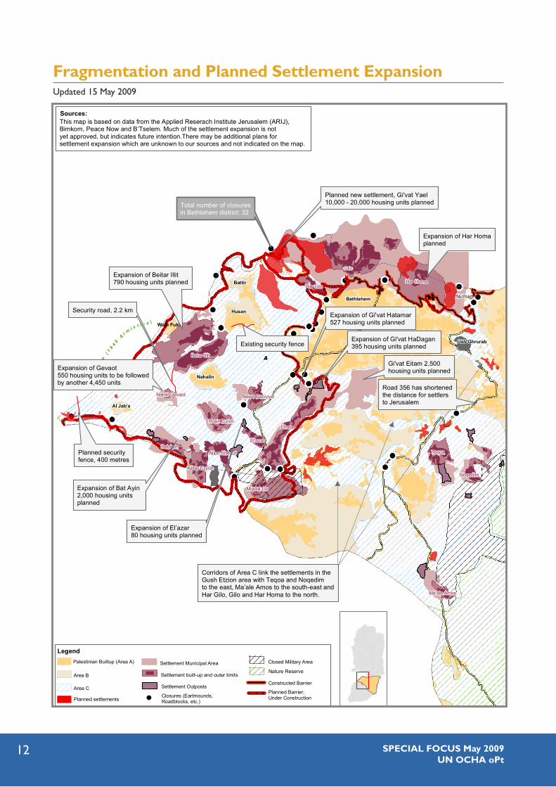
PArT 2: THE WEST: BETHLEHEM’S SHrinking HinTErLAnD
The completed Barrier in the northern Bethlehem governorate has already affected economic activity and access to agricultural resources. The planned Barrier route will follow (approximately) the Green Line for 12.7 kilometres in the western Bethlehem governorate. In addition, a more intrusive inner route reaches approximately ten kilometres inside the West Bank, to encircle the Gush Etzion settlement block. Access to Road 60, currently the main route for the residents of Bethlehem to travel south to Hebron, will be blocked, necessitating an
alternative transportation route for Palestinians further east.34
If implemented, this route will isolate Bethlehem’s rural hinterland, further squeezing the urban area. Nine Palestinian communities will be isolated on the western or ‘Israeli side’ of the Barrier, with the village of Al Walaja encircled within an additional inner Barrier.35 Proposed settlement and outpost expansion will further fragment the agricultural space available to these Palestinian communities.
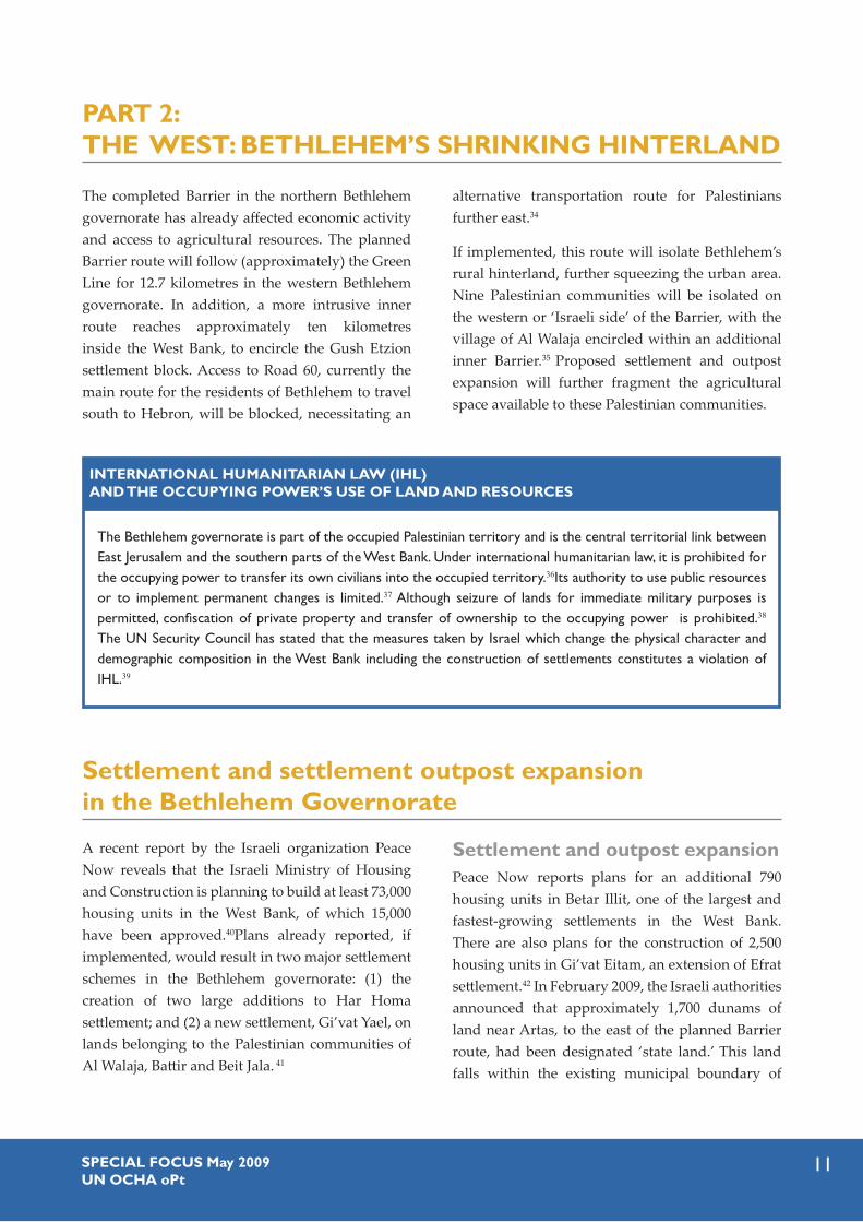
The Bethlehem governorate is part of the occupied Palestinian territory and is the central territorial link between East Jerusalem and the southern parts of the West Bank. Under international humanitarian law, it is prohibited for the occupying power to transfer its own civilians into the occupied territory.36Its authority to use public resources or to implement permanent changes is limited.37 Although seizure of lands for immediate military purposes is permitted, confiscation of private property and transfer of ownership to the occupying power is prohibited.38 The UN Security Council has stated that the measures taken by Israel which change the physical character and demographic composition in the West Bank including the construction of settlements constitutes a violation of IHL.39
inTErnATiOnAL HUMAniTAriAn LAW (iHL) AnD THE OCCUPYing POWEr’S USE OF LAnD AnD rESOUrCES
Settlement and settlement outpost expansion in the Bethlehem governorate
A recent report by the Israeli organization Peace Now reveals that the Israeli Ministry of Housing and Construction is planning to build at least 73,000 housing units in the West Bank, of which 15,000 have been approved.40Plans already reported, if implemented, would result in two major settlement schemes in the Bethlehem governorate: (1) the creation of two large additions to Har Homa settlement; and (2) a new settlement, Gi’vat Yael, on lands belonging to the Palestinian communities of Al Walaja, Battir and Beit Jala. 41
Settlement and outpost expansionPeace Now reports plans for an additional 790 housing units in Betar Illit, one of the largest and fastest-growing settlements in the West Bank. There are also plans for the construction of 2,500 housing units in Gi’vat Eitam, an extension of Efrat settlement.42 In February 2009, the Israeli authorities announced that approximately 1,700 dunams of land near Artas, to the east of the planned Barrier route, had been designated ‘state land.’ This land falls within the existing municipal boundary of
SPECiAL FOCUS May 2009 Un OCHA oPt
12
G r e e n L i n e ( 1 9 4 9 A r m i s t i c e )G
r e e n Li n
e (
19
49
Ar m
i s t i c e )
I S R A E L
Betar Illit
Efrata
East Talpiyyot
Teqoa
French Hill
Ramot Allon Ramat Shlomo
Ma'alot Dafna
Har Homa
Ramat Eshkol
Bat AyinAllon Shevut
El'azar
Noqedim
Newe Daniyyel
Har Gilo
Karmi Zur
Rosh Zurim
Kefar Ezyon
Migdal Oz
Ma'ale Amos
Jewish Quarter
Asfar (Mezad)
Hebrew University
Nahal Gevaot
Battir
Husan
Wadi Fukin
Nahalin
Al Jab'a
Expansion of Beitar Illit790 housing units planned
Expansion of Gi'vat HaDagan 395 housing units planned
Expansion of Gi'vat Hatamar527 housing units planned
Expansion of Bat Ayin 2,000 housing unitsplanned
Expansion of Har Homaplanned
Gi'vat Eitam 2,500housing units planned
This map is based on data from the Applied Reserach Institute Jerusalem (ARIJ),Bimkom, Peace Now and B’Tselem. Much of the settlement expansion is notyet approved, but indicates future intention.There may be additional plans forsettlement expansion which are unknown to our sources and not indicated on the map.
Corridors of Area C link the settlements in theGush Etzion area with Teqoa and Noqedimto the east, Ma’ale Amos to the south-east andHar Gilo, Gilo and Har Homa to the north.
Existing security fence
Security road, 2.2 km
Ush Ghrurab
Bethlehem
Fragmentation and Planned Settlement Expansion
Total number of closuresin Bethlehem district: 32
Sources:
Gilo
Nu'man
Road 356 has shortenedthe distance for settlersto Jerusalem
Battir
LegendPalestinian Builtup (Area A) Closed Military Area
Nature Reserve
Area C
Area BConstructed Barrier
Planned Barrier; Under Construction
Settlement Outposts
Settlement Municipal Area
Settlement built-up and outer limits
Closures (Eartmounds, Roadblocks, etc.)Planned settlements
Expansion of El’azar80 housing units planned
Planned new settlement, Gi'vat Yael 10,000 - 20,000 housing units planned
Planned securityfence, 400 metres
Expansion of Gevaot 550 housing units to be followedby another 4,450 units
Fragmentation and Planned Settlement ExpansionUpdated 15 May 2009

13SPECiAL FOCUS May 2009Un OCHA oPt
Efrat settlement, and is intended for its expansion onto its eighth hill, Gi’vat Eitam.
The Israeli human rights organization B’Tselem has revealed plans for Geva’ot, which currently hosts 12 families. Initial construction plans are for a new neighbourhood of 550 apartments, which will eventually lead to a total planned 5,000 apartments. In addition, 2,000 new apartments are intended for the settlement of Bat ‘Ayin, which currently has 120 families.43
There are also plans for the expansion of two outposts near Efrat: 395 housing units in Gi’vat Hadagan and 527 units in Gi’vat Hatamar;44 and for 80 housing units between El’azar settlement and the Derekh Ha’avot outpost.45
Other infrastructureOn 1 January 2009, a seizure order was issued for a new 2.2 kilometre-long security road between Betar Illit and Geva’ot settlements. The security road will be an obstacle for Palestinian residents of Nahalin trying to access their land and the principal village well, Ein al-Faras, west of this road.46
In January 2009, seizure orders for security fences were issued to Husan and Al Jab’a.47 Landowners in Al Jab’a also received military orders ordering them to remove agricultural growth from their lands on the grounds that they were ‘state land’. The IDF subsequently cleared approximately 300 olive tree saplings from the area.
The Western Bethlehem villages: Another closed military area?
In January 2009, the Israeli authorities issued military orders declaring the area between the Barrier and the Green Line in Hebron and parts of the Salfit, Ramallah, Jerusalem and northern Bethlehem governorates a closed military area (‘seam zone’). These are the first such orders to be issued since October 2003, when all of the land between the Barrier and the Green Line in the Jenin, Tulkarm and Qalqiliya governorates was designated ‘closed’.
‘Seam zone’ residents are physically separated from the rest of the West Bank and from health, education and commercial services which are generally located to the east of the Barrier. Children, patients and workers have to pass through gates to reach schools, medical facilities and workplaces and to maintain family and social relations.48 The comparative table opposite demonstrates how dependent the inhabitants of the western villages are on the Bethlehem urban area for essential services and economic activity.
If a similar closed area is declared once the Barrier is complete in the western Bethlehem area, this will constitute the largest ‘seam zone’ area in the West
Bank in terms of the number of Palestinians who will be isolated. Nine Palestinian communities of approximately 21,000 residents are located within this area and already face restrictions to agricultural and grazing land as a result of settlements and related restrictions.
If the regime in the northern West Bank is a guide, the closed area designation will also affect Bethlehem residents who reside on the ‘Palestinian side’ of the Barrier. Farmers from Al Khader, Artas and other communities will require IDF-issued 'visitor' permits to access their land behind the Barrier. In the northern West Bank, permit requirements have become more stringent over the years. Those applying for, or renewing, fixed-period permits are required to pass security checks and to prove a connection to their land by providing valid ownership or land taxation documents, which are not easily obtainable.49
For the minority granted permits, access is through one of the approximately 70 designated Barrier gates and checkpoints, which open on a daily, weekly and/or seasonal basis. Permit-holders must queue for

SPECiAL FOCUS May 2009 Un OCHA oPt
14
their documents to be inspected and their persons and belongings searched before being allowed to access their land, and there are also restrictions on the passage of vehicles, agricultural equipment and
materials. The restrictions resulting from the permit and gate regime severely curtail the opportunity available for cultivation with negative impact on agricultural practice and rural livelihoods.
In July 2004, the International Court of Justice issued an advisory opinion to the General Assembly on the route of the Barrier inside the occupied Palestinian territory (oPt) in which it concluded that while Israel has the obligation to protect its citizens from acts of violence, the measures it takes must conform to international law and its obligations as an occupying power. Accordingly, it concluded that given the extensive damage and harm of the Barrier route inside the oPt, the construction was illegal and must stop. The court also called on Israel to dismantle existing parts, cancel all administrative regulations, and provide reparations to those damaged. This opinion was overwhelmingly reaffirmed by the General Assembly.50
Excerpts from its conclusion:
‘The fact remains that Israel has to face numerous indiscriminate and deadly acts of violence against its civilian population. It has the right, and indeed the duty, to respond in order to protect the life of its citizens. The measures taken are bound nonetheless to remain in conformity with the applicable international law.’ (Para. 141)
‘…Cessation of these violations entails in practice the dismantling forthwith of those parts of that structure situated within the Occupied Palestinian Territory, including in and around East Jerusalem. All legislative and regulatory acts adopted with a view to its construction and to the establishment of its associated regime, must forthwith be repealed or rendered ineffective, except in so far as such acts, by providing for compensation or other forms of reparation for the Palestinian population, may continue to be relevant for compliance by Israel…’ (Para. 151)
inTErnATiOnAL COUrT OF JUSTiCE ADviSOrY OPiniOn
Landscaped terracing in Husan. Photo by JCTordai

15SPECiAL FOCUS May 2009Un OCHA oPt
Comparative Table of West Bethlehem villages Locality & Population
Demolition & Displacement Services Daily life Land affected
Al Walaja 2,041
Demolished:23 houses & 12 agricultural structures. 2 cisterns destroyed during building of bypass road. Pending demolition orders: 46 houses.
Clinics: No health facilities. Schools: High School in Beit Jala or Bethlehem Garbage: Dumped in Dar Salah on other side of planned Barrier route. Palestinian Authority Police: Coordination with Israeli authorities & IDF escort needed for armed Palestinian Police to enter village.
Economic: No market for products inside enclave.Basic needs: 4 small shops. Meat and dairy products from Bethlehem.Movement: Approx. 1,200 go to Bethlehem or Hebron daily.
Approx.4-5000 dumums of village land on other side of the planned Barrier route.
Battir 3,967
Demolished:None. Pending demolition orders: 7 houses.
Clinics: Clinic. Doctor present six times a week.Schools: High School Garbage: Dumped in Yatta on other side of projected Barrier route. Palestinian Authority Police: As above.
Economic: No market for products inside enclave.Basic needs: Approx. 20 small shops. Meat & dairy products from Bethlehem & Hebron. Movement: Approx. 2,000 go to Bethlehem or Hebron daily.
Approx. 3000 dunums of village land on other side of the planned Barrier route.
Husan 5,551
Demolished: 10 houses, 25 beehives, 20 animal shelters and 1 cistern. Pending demolition orders:2 houses.
Clinics: Clinic. Doctor is present 4 days a week. Only first aid equipment available.Schools: High SchoolGarbage: Dumped in Yatta on other side of the planned Barrier route. Palestinian Authority Police: As above.
Economy: No market for products inside the enclave.Basic needs: Around 160 small shops. Meat and dairy products from Bethlehem.Movement: Approx. 2,000 people go to Bethlehem or Hebron daily.
Approx 2,500 dunums of village land on the other side of planned Barrier route.Other: Limited possibilities for natural growth except for vertical expansion.
Wadi Fukin 1,168
Demolised:None.Pending demolition orders: 7 cisterns. 40 farmers ordered to erase rehabilitation work from their land.
Clinics: Doctor present twice a week. Mobile clinic with doctor 3 days a week. All residents are registered refugees & use Ad-Deheisha's health & school facilities in Bethlehem. Schools: High School Garbage: Dumped in Yatta outside the planned Barrier route.Palestinian Authority Police: As above.
Economy: No market for products inside enclave. Basic needs: People shop in Bethlehem. UNRWA are distributing to 200 families. Movement: Approxi. 350 go to Bethlehem or Hebron daily.
Approx. 2,000 dunums of village land on the other side of the projected Barrier. Other: Untreated sewage spills onto land from Beitar Illit settlement. Other: Limited possibilities for natural growth except for vertical expansion.
Nahalin 6,827
Demolished: 4 houses. Pending demolition orders: 10 houses. 6 farmers ordered to erase rehabilitation work from their land.
Clinics: Clinic. Doctor and analyst 4 days a week.Schools: High SchoolGarbage: Dumped in Yatta outside the projected Barrier route.Palestinian Authority Police: As above.
Economy: No market for products inside enclave. Basic needs: Approx. 70 shops. Movement: Approx. 1100 go to Bethlehem or Hebron daily.
Will not loose land to Barrier. Other: Untreated sewage spills onto land from Beitar Illit settlement. Spring & 15 dunums of land contaminated. Other: High Voltage lines connecting settlements to be constructed around the village.
Khallet Sakariyya Khallet al Balluta Khallet Afana approx. 600
Demolished: 7 houses and 2 cisterns.Pending demolition orders: 26 houses and 2 animal pens
Clinics: Clinic. Doctor and nurse once a week. Clinic very basic (project ends 12.2009).Schools: Primary school up to 6th grade. After that the children walk 10-12 km to Al Arub School. Garbage: No garbage collection. Burnt on outskirts of village. Palestinian Authority Police: As above.
Economy: No market for products inside the enclave.Basic needs: One small grocery shop.Movement: Approx. 600 people go to Bethlehem or Hebron daily.
Will not loose land to Barrier. Other: No posibility for expansion. Children move away to marry.
Al Jab'a 896
Demolished:None.Pending demolition orders:8 houses, 2 agriultural structures, 2 school class rooms, 3 cisterns and 1000m of land rehabilitation walls.
Clinics: Simple room serves as a clinic. Doctor once a week.Schools: High School in SurifGarbage: Burnt on the outskirts of the village.Palestinian Authority Police: As above.
Economy: No market for their products inside the enclave. Basic needs: 5 small shops.Movement: Approx. 200 go to Bethlehem or Hebron daily.
Approx. 900 dunums will be located to the west of the projected Barrier.
* Based on interviews with village councils

SPECiAL FOCUS May 2009 Un OCHA oPt
16
PArT 3: ADMiniSTrATivE COnSTrAinTS in THE EAST
Husan (population 5,500) is one of nine Bethlehem communities which will be isolated by the planned Barrier route in the western Bethlehem governorate. Husan has already lost much of its agricultural land due to settlement construction and expansion. Commercial agriculture has been undermined, with many households now only cultivating for domestic consumption. A study surveying 172 women in the community to determine the potential impact on their lives if the Barrier is completed as planned, found the following:
There is a close relationship between Husan and Bethlehem city, with most services provided in the urban area. • The majority (96.5%) of the women cannot obtain all needed domestic products inside the community. Most women fear that access will become more difficult following completion of the Barrier in their area.
The Barrier will likely cause an increase in male unemployment and poverty. Of the husbands who used to • work in Israel, the women interviewed reported a decrease of 67.5% since the Barrier was completed in the northern part of the Bethlehem governorate.
The vast majority of the women (96.9%) interviewed had given birth in facilities in Bethlehem City. The majority • (87.8%) responded that doctors are unavailable in case of a nighttime emergency.
Of the 42 women pursuing higher• education, 28 study outside the community. On completion of the Barrier these women will face difficulty reaching schools and universities because it is unacceptable for women living in rural areas to arrive home late, whatever the obstacle (lack of transportation, flying checkpoints, detours, etc).
87.5% of the women reported that their children go to Bethlehem city for supplementary educational courses, • especially to prepare for the high school matriculation exam (tawjihi), when good grades are essential for future education and careers.
Due to ongoing construction, villagers have had to alter their route to reach Bethlehem city, adding to travel • time and transportation costs. Only 55.8% of those surveyed visit relatives outside the community, due to difficulties experienced in travelling to and from the community.
As wives customarily move to their husband’s location upon marriage, the majority (98.3%) preferred that their • daughters married in Husan, instead of the neighbouring villages or Bethlehem city, to ensure that they remain in easy contact.
THE iMPACT OF THE BArriEr On WOMEn in HUSAn51
The Dead Sea, military areas and nature reservesLarge tracts of land in the eastern Bethlehem gover-norate have been designated by Israel as military areas/fire zones or nature reserves, where Palestinian entry and usage is forbidden or restricted.52 Although the Judean Desert presents a challenge to the expansion of Bethlehem to the east and south-east, these restrictions block the potential for important economic activities such as grazing (See box
Bethlehem bedouins). The niche but profitable eco-tourism market – highlighting the desert landscapes and habitats of Wadi Qadron and Wadi Khreitun and the monastery of Mar Saba – are underexploited. Lack of access by Palestinians to the 32 kilometres of the Dead Sea coastline, which forms the most easterly part of the Bethlehem governorate, also limits the possibility of industrial and tourism development of this unique attraction. 53

17SPECiAL FOCUS May 2009Un OCHA oPt
Small communities of herding Bedouin reside in the southeast of the Bethlehem governorate on the borders of the desert. The groups are largely settled, living in tents, shacks or basic cement houses, with few community members moving with the flocks for seasonal grazing.
The Bethlehem Bedouins are under pressure: some communities face demolition of their dwellings and animal shelters for lack of Area C building permits: their herding lands are encroached on the IDF or have been designated by Israel as nature reserves. A series of droughts and a worldwide increase in fodder prices have contributed to marginalizing herding as a way of life. Water has become expensive due to the drought and transportation costs over difficult roads. Communities that largely relied on rainwater in the past now need to purchase water throughout the year for people and livestock. Reduced access to grazing areas has caused greater dependence on fodder, but fodder prices have also increased, and herders are going deeper into debt. These pressures lead herders to sell their flocks, thus threatening their ability to continue living on these lands.
The community of Rashayida in the southern Bethlehem governorate has 50 families, of which 47 are registered as refugees with UNRWA. They were displaced from near Ein Gedi in 1948. Some 30 structures have been demolished by the IDF in the last two years because of lack of building permits. This community reports a decline in the number of small ruminants from 8,000 three years ago to fewer than 5,000 today. The cost of trucking water to the community is 25 NIS per cubic metre of water.
BETHLEHEM BEDOUinS 54
Photo by JCTordai

SPECiAL FOCUS May 2009 Un OCHA oPt
18
Settlements and Bypass road 356
The Eastern Gush Etzion settlements, Teqoa and Noqedim, and Ma’ale Amos further south, also constitute a check on the expansion of Bethlehem eastwards: in 2004, a new bypass road was con-structed for the benefit of these settlements to ensure easier access to Jerusalem.
In addition, continuing attempts by settlers to re-occupy the site of the former Shdema military base to the east of Beit Sahur, represent an obstacle to the municipality’s plans for developing recreational and health services. The area known as Ush Ghurab was vacated by the IDF in April 2006, but a group called ‘The Committee for a Jewish Shdema’ is attempting to
claim the site, with the intention of establishing a settlement there. The land was not returned to the Beit Sahur municipality and technically remains a closed area. However, lacking available public space, in 2007, the municipality constructed a public park on approximately 100 dunams of the site, which includes sports facilities, a climbing tower and a cafeteria. The project was partially funded by USAID, which inaugurated the site in February 2008.
The municipality has plans for a paediatric hospital at the site to be built and funded by Cure International, a US-based charity. The hospital, which plans to be in operation by Christmas 2009, would have 65 beds, and would cater for children with physical disabilities from all over the West Bank.55
The historic Mar Saba Monastery in the eastern Bethlehem governorate. Photo by Kathrine Fauske

19SPECiAL FOCUS May 2009Un OCHA oPt
Tourism and Heritage Preservation in Bethlehem
Bethlehem, the birthplace of Jesus, is twinned with 52 cities worldwide. Tourism and pilgrimages are the mainstay of the economy, providing employment in hotels, restaurants, travel agencies, and in souvenir and handicraft workshops. As part of the Bethlehem 2000 project, designed to prepare the city for the new millennium and the expected dividends of the Oslo peace process, some $300 million was invested in the area. Instead, tourism declined dramatically with the beginning of the second intifada in September 2000, the closure regime, the reoccupation of Bethlehem in 2002, construction of the Barrier and the lack of permits issued to local tourist guides. In 2004, the total number of people employed in hotels was 95 compared to 393 in 2000.
Tourist numbers increased markedly in 2008 with over 800,000 foreign tourists, mainly due to an appeal by churches and related organisations for pilgrims to visit Bethlehem. However, much of this increase is attributable to the overflow from hotels in Jerusalem, with tourists paying brief visits to Bethlehem and only about 45 percent staying overnight and contributing to the local economy.56 Moreover, Bethlehem benefits little from domestic
tourism with only 65,000 Palestinians visiting in 2008, or from Palestinian citizens of Israel, with approximately 15,000 visits the same year.
In addition, the benefits of tourism are confined to a small number of pilgrimage sites in the Bethlehem urban area, in particular, the Church of the Nativity and the Shepherds’ Fields. Few foreign tourists visit historic sites and monuments within the city of Bethlehem itself, or nearby historic attractions, such as Solomon’s Pools in Artas. The landscaped terraces in the western Bethlehem governorate, such as Al Makhrour and Wadi Fukin,57 are virtually unknown to foreign tourists, as is the desert and semi-desert in the east. The festivals which celebrate the products characteristic of local villages - the lettuce in Artas; apricots in Beit Jala; fakkus in Beit Sahour; grapes in Al Khader; aubergines in Battir; and an annual olive festival in Bethlehem city itself - are also largely unattended by foreign tourists. In any case, continuing administrative and physical restrictions, including ongoing Barrier construction, make it difficult to develop a holistic approach to tourism and heritage conservation at the Bethlehem governorate level.58
Young men performing dabka, the traditional Palestinian folk dance. Photo by Patrick Zoll

SPECiAL FOCUS May 2009 Un OCHA oPt
20
COnCLUSiOn
The space available to the Palestinian population in the Bethlehem governorate has been significantly constricted by Israeli measures such as the continued expansion of Israeli settlements and their outposts, construction of the Barrier, and the zoning of the majority of the Bethlehem governorate as Area C, (entailing strict Israeli building regulations). These measures have reduced Bethlehem’s development space, limited its access to resources, severed Bethlehem’s historic links to Jerusalem and restricted the urban area’s potential for residential and industrial expansion. The traditional mainstays of the Bethlehem governorate economy such as work in Israel, tourism, agriculture herding and the private sector have been undermined. Continuation of these Israeli measures, compromises the future economic and social development of the Bethlehem governorate.
While Israel has the duty to ensure the safety and security of its citizens in response to attacks by Palestinians, the steps it takes must be in accordance with international law and not cause long-term detriment to the local Palestinian population. In
practice, however, most of this Israeli infrastructure, in particular settlements and settlement outposts and the Barrier have been constructed for the benefit of the Israeli population and not the local Palestinian community.
Steps can be taken to prevent further deterioration. Many of the administrative measures taken by the Israeli authorities are reversible and the Barrier route is not yet finished. Actions such as halting construction of the rest of the Barrier in the West Bank, opening up closed military areas and nature reserves for sustainable Palestinian development, along with the international call for a freeze on settlement activity and related actions like ‘state land’ declarations, would restore parts of the lost space to the governorate and improve the humanitarian and economic situation in Bethlehem. In the long term, these types of immediate steps would contribute to ensuring compliance with international law and UN resolutions and lay the groundwork for a durable political solution in the occupied Palestinian territory.

21SPECiAL FOCUS May 2009Un OCHA oPt
1 An earlier OCHA report on Bethlehem highlighted the consequences of the closure regime on the Bethlehem urban area, OCHA-UNSCO: Costs of Conflict: The Changing Face of Bethlehem, December 2004.
2 Regarding settlements, Article 49 of the Fourth Geneva Convention prohibits the Occupying Power from transferring its civilian population into the territory it occupies. The illegal status of Israeli settlements has been confirmed by the United Nations Security Council in Resolution 465 (1980) and the International Court of Justice in 2004. For settler expansion plans see map: Fragmentation and planned settlement expansion. P. 12
3 The Gush Etzion bloc includes a small portion of land which was Jewish-owned before 1948.
4 Settler population statistics, The Applied Research Institute Jerusalem (ARIJ) Geopolitical Status of Bethlehem Governorate, July 2007, p. 10.
5 The Palestinian Central Bureau of Statistics (PCBS) 2007 census cites 176, 235 for the Palestinian population of Bethlehem.
6 Under the 1995 Israeli-Palestinian Interim Agreement on the West Bank and Gaza Strip (Oslo II), originally designated for a five year period, full security and civil control was transferred to the Palestinian Authority for Palestinian areas designated as Area A. Full civil and joint security control with Israel was set up in Area B. Together, Areas A and B comprised approximately 40 percent of West Bank territory. Israel retained security control and jurisdiction over planning and construction in Area C, approximately 60 percent of the West Bank.
7 The Oslo Agreement states that ‘…while the Tomb, as well as the main road leading from Jerusalem to the Tomb… will be under the security responsibility of Israel, the free movement of Palestinians on the main road will continue. (Oslo II Agreement, Annex 1, Article V, Section 7).
8 See OCHA: Bethlehem: Costs of Conflict, p. 11.
9 According to Mr. Zougbhi Zoughbi, the Director of the Palestinian Conflict Resolution Centre, ‘the Barrier cuts off families from lands and orchards which their forefathers have tended for generations. The lack of available land for residential building and
for public parks adds to the feeling of hopelessness for the future.’ (Interview, 3 December 2008). According to the Governor of Bethlehem, Mr. Salah Al-Tamari, the concrete wall ‘has a negative impact on young people. It’s an ugly structure which blocks hope – you can’t keep hope alive with a ten metre wall.’ (Interview, 4 December 2008).
10 1 dunam = 1000 m2
11 ARIJ: The Strangulation of Beit Jala City, April 2008.
12 World Vision International has launched a campaign to try to halt the loss of the Al Makhrour land to Beit Jala farmers. See http://meero.worldvision.org/video/againstthewall.mov
13 Interview with architect Ms. Samia Zeit Khailieh, Beit Jala municipality, 18 December 2008.
14 PCBS: Change of Area of Cultivated Lands (Km2) by Irrigated Area and Governorate 2004-2007. The Ministry of Agriculture concurs with the PCBS findings regarding a reduction in dependency on agriculture. (Interview, 23 March, 2009).
15 Information supplied by the UNRWA West Bank Operations office and the World Council of Churches, Ecumenical Accompaniment Programme in Palestine and Israel (EAPPI).
16 Although Bethlehem has a well established university, it does not provide degrees in subjects such as medicine, engineering or law.
17 Statistics from the Bethlehem Governorate Coordination and Liaison Office. This number includes renewals of existing permits.
18 On average, 3,000 patients are referred by the Palestinian Ministry of Health to East Jerusalem hospitals each year and many more non-referrals seek care there annually. OCHA: The Humanitarian Impact of the West Bank Barrier on Palestinian Communities: Update No. 7, East Jerusalem, June 2007, p. 25.
19 EAPPI: Special Report, Checkpoint 300, Key Findings Based on Statistical Data from 2008, January 2009. According to EAPPI, about 2,500 people, mainly workers, cross in the morning hours.
End notes

SPECiAL FOCUS May 2009 Un OCHA oPt
22
20 According to EAPPI, on an average day, only two of the three metal detectors and between three and five of the 12 ID booths function. Ibid.
21 UNRWA West Bank Operations Office. According to EAPPI, ‘on a normal day it takes about 1.5 hours to pass if one queues at 4:30.’
22 The latter case is still pending.
23 Al Haq: Al Nu’aman Village: a Case Study of Indirect Forcible Transfer, 2006.
24 The average cost of producing one kilogram of grapes was NIS 2.5, while its selling price inside Israel was as high as NIS 5 per kilogram.
25 Restrictions included the Barrier, lack of access to Israeli markets, increased difficulty in reaching land inside the boundary of settlements, and settler harassment.
26 Over the years, the Government of Israel has designated large tracts of the West Bank as ‘state land’ and allocated this land for the construction of settlements.
27 According to the Israeli authorities, a series of goodwill measures will permit the ‘unlimited entrance of Palestinian Christians from Judea and Samaria (the West Bank) into Israel for participation in religious ceremonies and family visits’ during the period 1 April and 15 May 2009. Almost 10,000 permits were issued for this purpose in Bethlehem. IDF Spokesperson, 6 April 2009.
28 For additional information see OCHA, Costs of Conflict, 2004.
29 There were plans in the 1990s to build the stadium on Bethlehem land near Tantur, unilaterally annexed to Israel by the expanded Jerusalem municipal boundary, but this was refused by the Israeli authorities.
30 Interview with Dr. Victor Batarseh, Mayor of Bethlehem, 3 December 2008, and Dr. Samir Hazbun, Head of Bethlehem Chamber of Commerce, 4 December 2008.
31 Interview with the Head of Beit Fajjar municipality, Mr. Ahmad Abdallah Jaber Thawabteh and staff, 5 April 2009.
32 The machinery is still in the custody of the IDF. In some cases, it has been impounded for up to eight years before a heavy fine is imposed on the owners.
33 Products must be placed on wooden bases. The highest of the stacked products should not exceed more than 160 cm. Beit Fajjar businesses have problems meeting this requirement as their stone and marble do not fit onto these wooden bases.
34 The diversion of Palestinian traffic eastward will presumably result in more costly and time consuming journeys for residents of Bethlehem to reach Hebron, including the students enrolled in the Polytechnic University and Al Arrub Agricultural School and the estimated 2,400 patients who visit Al Ahli Hospital and the Governmental Hospital in Hebron annually.
35 In previous official Barrier routes, the Palestinian communities of Battir, Husan and Nahalin were also enclosed within an inner barrier, although this had disappeared on the most recent official route, as published on the website of the Ministry of Defence in April 2006. See www.seamzone.mod.gov.il.
36 Paragraph 6 of Article 49 of the IV Geneva Convention Relative to the Protection of Civilian Persons in Time of War, 12 August 1949: ‘The Occupying Power shall not deport or transfer parts of its own civilian population into the territory it occupies.’
37 See for example Articles 46 and 55 of Convention (IV) respecting the Laws and Customs of War on Land and its annex: Regulations Concerning the Laws and Customs of War on Land, The Hague, 18 October 1907; see also, Article 47 of the IV Geneva Convention Relative to the Protection of Civilian Persons in Time of War, 12 August 1949, and Pictet, Commentary to the IV Geneva Convention: “Consequently, occupation as a result of war, while representing actual possession to all appearances cannot imply any right whatsoever to dispose of territory.” page 275.
38 Ibid.
39 S/Res/465 (1980) Adopted by the Security Council at its 2203rd meeting on 1 March 1980.
40 Peace Now: Ministry of Housing’s Plans for the West Bank, March 2009, p 1. Under the Road Map, the Government of Israel made commitments to halt all settlement expansion, including natural growth, and to dismantle the settlement outposts created since March 2001. This commitment was reconfirmed at the Annapolis summit in November 2007.
41 The number of housing units planned for G’ivat Yael,

23SPECiAL FOCUS May 2009Un OCHA oPt
varies from ‘ up to 10,000 housing units’ (Jerusalem Deputy Mayor and Chairman of the Jerusalem Planning and Construction Committee, Yehoshua Pollak, quoted in Meron Rappaport: Committee approves construction of three new Jewish neighbourhoods in East Jerusalem’, Ha’aretz, 10 May 2007; to 13,600 housing units (Ir Amin: Jerusalem in the shadow of the disengagement from Gaza, August 2005; to as much 20,000 housing units, ARIJ, Geopolitical Status of Bethlehem Governorate, p.16
42 Peace Now: Ministry of Housing’s Plans for the West Bank, March 2009, pp.7-9.
43 B’Tselem: Settlement expansion plans, 27 February 2009.
44 Peace Now: Ministry of Housing’s Plans for the West Bank, p.5.
45 Amos Harel: Defence Minsiter is likely to approve 80 housing units in settlement, Ha’aretz, 23 March 2008.
46 Peace Now: New Land Seizure Orders Issued During the Gaza Operation, February 2009, p.1.
47 Ibid. The community of Husan filed an objection to the seizure order and, according to the lawyer concerned, the order expired without being implemented.
48 OCHA Special Focus: Three years later: the Humanitarian Impact of the Barrier since the International Court of Justice Opinion. July 2007. http://www.ochaopt.org/documents/ICJ4_Special_Focus_July2007.pdf. In the northern West Bank, residents of the ‘Seam Zone’ require ‘permanent resident’ permits to continue to live in their own homes. The Israeli authorities have stated that this requirement will not be introduced in the Bethlehem governorate.
49 According to a UNOCHA-UNRWA survey of 67 localities in the northern West Bank, fewer than 20 percent of those who used to farm their lands in the closed area before completion of the Barrier are now granted permits. UNOCHA/UNRWA Special Focus: The Barrier Gate and Permit Regime Four Years On: Humanitarian Impact in the Northern West Bank, November 2007. (http://www.ochaopt.org/documents/OCHA_SpecialFocus_BarrierGates_2007_11.pdf). This figure was replicated in a follow-up survey of the same communities in May-June 2008.
50 A/RES/ES-10/15 Resolution adopted by the General Assembly, ‘Advisory opinion of the International Court of Justice on the Legal Consequences of the Construction of a Wall in the Occupied Palestinian Territory, including in and around East Jerusalem’ 2 August 2004.
51 From ‘The Impact of the Expansion and Annexation Wall on Women in Hussan village - Bethlehem Governorate’ by Nisreen Adnan Shqueir, MA Thesis for Masters Degree in International Cooperation and Development, Bethlehem University, 2008. Used with permission of the author.
52 See OCHA, The Humanitarian Impact on Palestinians of Israeli Settlements and Other Infrastructure in the West Bank, July 2007, pp. 42-45. Under the Wye River Memorandum of 1998, some 16,665 hectares of West Bank land reserves, principally in the eastern Bethlehem governorate, was handed over to the Palestinian Authority (PA) to be set aside as a green area/nature reserve: however, the PA has not been allowed to utilize this area. (Interview with Mr. Salah Al-Tamari, Governor of Bethlehem, 4 December 2008.)
53 ‘It is important to emphasize that the Dead Sea is a unique natural phenomenon. Israel exploits this resource intensively, particularly in the section to the south … both for its chemical industry (the Dead Sea Works) and for tourism. These two economic activities create numerous jobs and significant foreign currency earnings.’ B’Tselem, Land Grab, May 2002, p.96.
54 UNRWA West Bank Operations Office.
55 Interview with Mayor of Beit Sahur, Mr. Hani al Hayek, 18 December 2008.
56 Interview with Mr. Majed N. Ishaq, Ministry of Tour-ism and Antiquities, Bethlehem, 4 December 2008.
57 The ancient farming terraces have been described as a ‘unique cultural landscape deserving of world heritage status’ according to Gidon Bromberg, Israeli director of Friends of the Earth Middle East. Rory McCarthy: Israeli barrier and settlement to leave West Bank village with nowhere to go, Guardian, 30 October, 2006.
58 Interview with Mr. Issam Juha, Director, Centre for Cultural Heritage Preservation, 18 December 2008.

P. O. Box 38712 East Jerusalem 91386 www.ochaopt.org
Tel. +972 (0)2 582 9962 Fax +972 (0)2 582 5841 [email protected]
UNITED NATIONS Office for the Coordination of Humanitarian Affairsoccupied Palestinian territory
Expansion of Beitar illit settlement with the lands of Wadi Fukin below. Photo by JCTordai