-hss9lhz iru :lqgrzv · a 0, / , 1 6 9 2 5 7 * 1 67$5 ^ -(33(6(1 $// 5,*+76 5(6(59(' /*65 -75...
TRANSCRIPT

General Information
Location: SANTORINI GRCICAO/IATA: LGSR / JTRLat/Long: N36° 23.95', E025° 28.75'Elevation: 123 ft
Airport Use: PublicDaylight Savings: ObservedUTC Conversion: -2:00 = UTCMagnetic Variation: 5.0° E
Fuel Types: JetCustoms: YesAirport Type: IFRLanding Fee: YesControl Tower: YesJet Start Unit: NoLLWS Alert: NoBeacon: Yes
Sunrise: 0519 ZSunset: 1503 Z
Runway Information
Runway: 16LLength x Width: 6972 ft x 98 ftSurface Type: asphaltTDZ-Elev: 123 ftLighting: Edge, REIL
Runway: 16RLength x Width: 6962 ft x 98 ftSurface Type: asphaltTDZ-Elev: 126 ft
Runway: 34LLength x Width: 6962 ft x 98 ftSurface Type: asphaltTDZ-Elev: 57 ft
Runway: 34RLength x Width: 6972 ft x 98 ftSurface Type: asphaltTDZ-Elev: 53 ftLighting: Edge, ALS
Communication Information
ATIS: 126.450Santorini Tower: 25.780 MilitarySantorini Tower: 118.050Santorini Tower: 122.100Santorini Approach: 25.780 MilitarySantorini Approach: 118.050Santorini Approach: 122.100Santorini Radio: 298.900 AFIS Air-GroundSantorini Radio: 563.700 AFIS Air-Ground
Airport Information For LGSRPrinted on 11 Dec 2017Page 1(c) JEPPESEN SANDERSON, INC., 2017, ALL RIGHTS RESERVED
jep=JEPPESENJeppView for Windows

D
D
D32
.009
3^M
IL11
3.5
M I L35
00
INS
VO
R
UVRIT
IRBEG
PEXA
N
10-2 .STAR.
JEPPESEN
| JEPPESEN, 2017. ALL RIGHTS RESERVED.
LGSR/JTRSANTORINI
SANTORINI, GREECE
297^
117^
510
1520
2530
3540
450
5
R048
R349
R315
228^
169^
135^
.Eff.7.Dec.
3500
3500
3500
PEXA
N 1A
IRBEG 1A
UVRIT 1A
110.
4 SN
ISN
ID
SAN
TORI
NI
23
1 DEC 17
25.0
21.0
ATI
S
126.
450
Apt
Ele
v
123
Alt
Set
: hP
aTr
ans
leve
l: B
y A
TCST
ARs
are
con
nect
ed w
ith
appr
oach
VO
Ra R
WY 3
4R.
Reissue.
2346
37
36
36-30
25-00
25-30
CHANGES:
MHA
350
0
IRBE
G 1
A [IRBE
1A]
UVRIT
1A [UVRI1A
]PE
XAN 1
A [PE
XA1A
]
RWY 3
4R A
RRIVALS
CO
NTO
UR
INTE
RVA
LS
4000
2000
Printed from JeppView for Windows 5.3.0.0 on 11 Dec 2017; Terminal chart data cycle 24-2017; Notice: After 14 Dec 2017, 0000Z, this chart may no longer be valid

343^ D9.0
R048
R335
D32
.009
3^M
IL11
3.5
M IL
3500
IN
SV
OR
PEXA
N
IRBEG
UVRIT
KO
RA
X
.STAR.
JEPPESEN
| JEPPESEN, 2017. ALL RIGHTS RESERVED.
10-2ALGSR/JTRSANTORINI
SANTORINI, GREECE.Eff.7.Dec.
335^
155^
D39.5
MIL
3500
PEXA
N 1
C
3500 IRBEG 1C
191^(I
AF)
110.
4 SN
ISN
ID
SAN
TORI
NI
D14
.0 A
rc
3500
(SN
I R3
49/D
25.0
)
D16.0
SIN
3500
UVRIT 1C
228^
5.0
(D21
.0 S
NI)
510
1520
2530
3540
450
5
7.5
MHA
350
0
1 DEC 17
Alt
Set
: hP
aTr
ans
leve
l: B
y A
TCST
ARs
are
con
nect
ed w
ith
appr
oach
VO
Ry R
WY 1
6L.
ATI
S
126.
450
Apt
Ele
v
123
Reissue.
2346
37
36
40
36-30
25-00
25-30
26-00
CHANGES:
IRBE
G 1
C [IRBE
1C]
UVRIT
1C [UVRI1C
]PE
XAN 1
C [PE
XA1C
]
RWY 1
6L A
RRIV
ALS
CO
NTO
UR
INTE
RVA
LS
4000
2000
Printed from JeppView for Windows 5.3.0.0 on 11 Dec 2017; Terminal chart data cycle 24-2017; Notice: After 14 Dec 2017, 0000Z, this chart may no longer be valid
D
D
36-00
36-30
25-30 26-00
93
36
3500 V
OR
INS
BINKI
GIVIS
.STAR.
JEPPESEN
| JEPPESEN, 2017. ALL RIGHTS RESERVED.
Apt Elev Alt Set: hPa
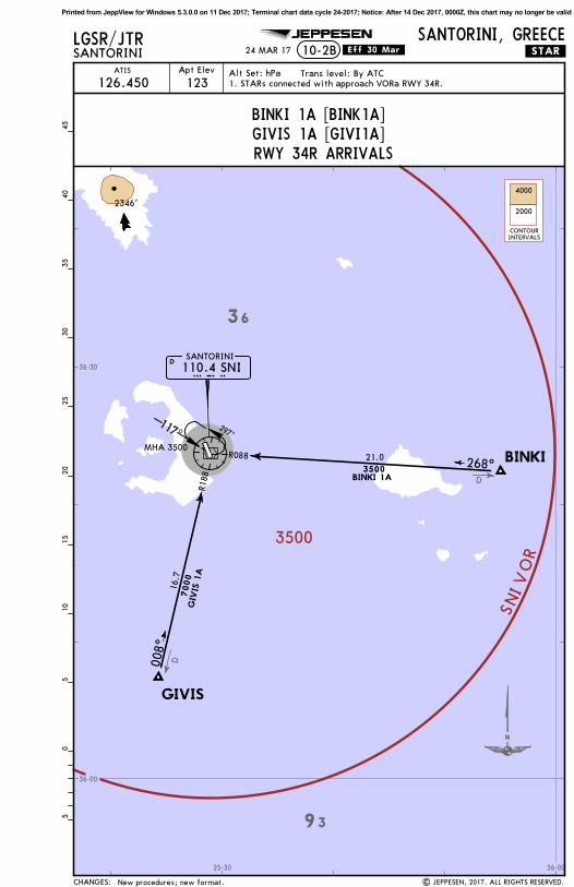
LGSR/JTRSANTORINI 10-2B
SANTORINI, GREECE
ATIS
126.450 123Trans level: By ATC
24 MAR 17 .Eff.30.Mar.
110.4 SNISNIDSANTORINI
R088
R188
268^
008^
3500BINKI 1A
7000
GIV
IS 1
A
MHA 3500
297^117^
510
1520
2530
3540
450
5
2346'
New procedures; new format.
1. STARs connected with approach VORa RWY 34R.
16.7
21.0
CHANGES:
BINKI 1A [BINK1A]GIVIS 1A [GIVI1A]RWY 34R ARRIVALS
CONTOURINTERVALS
4000
2000
Printed from JeppView for Windows 5.3.0.0 on 11 Dec 2017; Terminal chart data cycle 24-2017; Notice: After 14 Dec 2017, 0000Z, this chart may no longer be valid

D9.0
169^
343^
R088
R335
36-30
36-00
36-30
25-3093
36
3500
VORINS
GIVIS
BINKI
KORAX
.STAR.
JEPPESEN
| JEPPESEN, 2017. ALL RIGHTS RESERVED.
Apt Elev Alt Set: hPa
LGSR/JTRSANTORINI 10-2C
SANTORINI/GREECE
ATIS
126.450 123Trans level: By ATC
24 MAR 17 .Eff.30.Mar.
110.4 SNISNIDSANTORINI
(IAF)
D16.0
D16.0
3500BINKI 1C
(D21.0 SNI)268^
D14.0 Arc
3500
(SNI R188/D16.7)
7000
3500
GIV
IS
1C
MHA 3500335^
155^
510
1520
2530
3540
450
5
2346'
New procedures; new format.
1. STARs connected with approach VORy RWY 16L.
5.0
D14.0
Arc
CHANGES:
BINKI 1C [BINK1C]GIVIS 1C [GIVI1C]RWY 16L ARRIVALS
CONTOURINTERVALS
4000
2000
Printed from JeppView for Windows 5.3.0.0 on 11 Dec 2017; Terminal chart data cycle 24-2017; Notice: After 14 Dec 2017, 0000Z, this chart may no longer be valid
056^
358^
340^
048^
349^
D21.
0 3500
SNI
VO
R
IRBEG
UVRIT
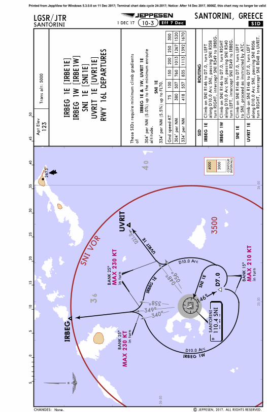
10-3 .SID.
JEPPESEN
| JEPPESEN, 2017. ALL RIGHTS RESERVED.
LGSR/JTRSANTORINI
SANTORINI, GREECE.Eff.7.Dec.
146^
D7.0
SNI 1E
BA
NK 1
5^
D10.0 Arc
D10.0 Arc
IRBEG 1W
UVRIT 1E
IRBEG
1E
BA
NK 2
5^
BA
NK 2
5^
1020
3040
500
515
2535
455
110.
4 SN
ISN
ID
SAN
TORI
NI
1 DEC 17
None.
Tran
s al
t: 5
000
Apt
Ele
v
123
334'
per
NM
418
557
835
1113
1392
1670
304'
per
NM
380
507
760
1013
1267
1520
Gnd
spe
ed-K
T75
100
150
200
250
300
in t
urn
in t
urn
in t
urn
2675
36
40
36-30
25-30
26-00
MA
X 2
10 K
T
MA
X 2
30 K
T
MA
X 2
30 K
T
CHANGES:
RO
UTIN
G
IRBEG
1E
SID
IRBEG
1W
SNI 1E
UVRIT
1E
Cli
mb
on S
NI
R146
to
D7.
0, t
urn
RIG
HT
alon
g D
10.0
Arc
SN
I, p
assi
ng S
NI
R340
turn
LEF
T, i
nter
cept
SN
I R3
49 t
o IR
BEG
.
Cli
mb
on S
NI
R146
to
D7.
0, t
urn
LEFT
to S
NI,
pro
ceed
as
inst
ruct
ed b
y A
TC.
Cli
mb
on S
NI
R146
to
D7.
0, t
urn
LEFT
alon
g D
10.0
Arc
SN
I, p
assi
ng S
NI
R056
turn
RIG
HT,
int
erce
pt S
NI
R048
to
UVRI
T.
Cli
mb
on S
NI
R146
to
D7.
0, t
urn
LEFT
alon
g D
10.0
Arc
SN
I, p
assi
ng S
NI
R358
turn
RIG
HT,
int
erce
pt S
NI
R349
to
IRBEG
.
Thes
e SI
Ds
requ
ire
min
imum
cli
mb
grad
ient
s of
IRBEG
1E &
1W
, UVRIT
1E
334'
per
NM
(5.
5%)
up t
o FL
70.
SNI 1E
alti
tude
.30
4' p
er N
M (
5.0%
) up
to
the
min
imum
enr
oute
IRBE
G 1
E [IRB
E1E]
IRBE
G 1
W [IRBE
1W]
UVRIT
1E [UVRI1E
]SN
I 1E
[SN
I1E]
RWY 1
6L D
EPART
URE
S
CO
NTO
UR
INTE
RVA
LS
4000
2000
Printed from JeppView for Windows 5.3.0.0 on 11 Dec 2017; Terminal chart data cycle 24-2017; Notice: After 14 Dec 2017, 0000Z, this chart may no longer be valid

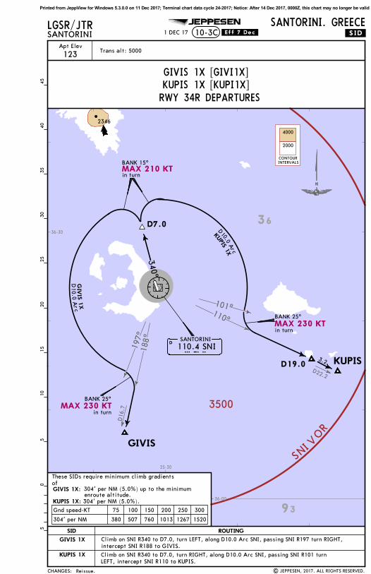
038^
048^
D
D21.0
3500
INS VOR
UVRIT
IRBEG
110.4 SNISNIDSANTORINI
BANK 25^
BANK 15^
D7.0
SNI 1X
D10.0 Arc UVRIT 1X
349^
IRBEG
1X
25.0340^
.SID.
JEPPESEN
| JEPPESEN, 2017. ALL RIGHTS RESERVED.
LGSR/JTRSANTORINI
SANTORINI, GREECE10-3A
Trans alt: 5000
.Eff.7.Dec.5
1015
2025
3035
4045
05
334' per NM 418 557 835 1113 1392 1670
304' per NM 380 507 760 1013 1267 1520
Gnd speed-KT 75 100 150 200 250 300
1 DEC 17
Apt Elev
123
2675
in turn
in turn
Reissue.
36
40
36-30
25-30
26-00
MAX 230 KT
MAX 210 KT
CHANGES:
ROUTINGSID
IRBEG 1X Intercept SNI R349 to IRBEG.SNI 1X Climb on SNI R340 to D7.0, turn RIGHT to SNI, proceed as instructed by ATC.
UVRIT 1X Climb on SNI R340 to D7.0, turn RIGHT along D10.0 Arc SNI, passing SNI R038 turn LEFT,intercept SNI R048 to UVRIT.
These SIDs require minimum climb gradients ofIRBEG 1X:
SNI 1X:UVRIT 1X:
304' per NM (5.0%) up to the minimumenroute altitude.334' per NM (5.5%) up to FL70.304' per NM (5.0%).
IRBEG 1X [IRBE1X]SNI 1X [SNI1X]
UVRIT 1X [UVRI1X]RWY 34R DEPARTURES
CONTOURINTERVALS
4000
2000
Printed from JeppView for Windows 5.3.0.0 on 11 Dec 2017; Terminal chart data cycle 24-2017; Notice: After 14 Dec 2017, 0000Z, this chart may no longer be valid

110^
188^
D16.7
D22
.2
3500
VO
RI
NS
KUPIS
GIV
IS
.SID.
JEPPESEN
| JEPPESEN, 2017. ALL RIGHTS RESERVED.
LGSR/JGRSANTORINI 10-3B
SANTORINI, GREECE
Tran
s al
t: 5
000
.Eff.7.Dec.
BA
NK 1
5^
110.
4 SN
ISN
ID
SAN
TORI
NI
D7.0
GIW
IS 1
W
KUPIS
1E
233^
065^
510
1520
2530
3540
450
5
146^
365'
per
NM
456
608
913
1217
1521
1825
304'
per
NM
380
507
760
1013
1267
1520
Gnd
spe
ed-K
T75
100
150
200
250
300
1 DEC 17
Apt
Ele
v
123
D19.0
3.2
Reissue.
in t
urn
2195
36
40
36-00
36-30
25-30
26-00
MA
X 2
10 K
T
CHANGES:
Thes
e SI
Ds
requ
ire
min
imum
cli
mb
grad
ient
s of G
IWIS
1W
:
KUPIS
1E:
RO
UTIN
GSID
GIV
IS 1
WCli
mb
on S
NI
R146
to
D7.
0, t
urn
RIG
HT,
233^
tra
ck,
inte
rcep
t SN
I R1
88 t
o G
IVIS
.
KUPIS
1E
Cli
mb
on S
NI
R146
to
D7.
0, t
urn
LEFT
,06
5^ t
rack
, in
terc
ept
SNI
R110
to
KUPI
S.
365'
per
NM
(6.
0%)
up t
o th
e m
inim
umen
rout
e al
titu
de.
304'
per
NM
(5.
0%)
up t
o th
e m
inim
umen
rout
e al
titu
de.
GIV
IS 1
W [GIVI1W]
KUPIS 1E
[KU
PI1E
]RW
Y 1
6L D
EPART
URE
S
Printed from JeppView for Windows 5.3.0.0 on 11 Dec 2017; Terminal chart data cycle 24-2017; Notice: After 14 Dec 2017, 0000Z, this chart may no longer be valid
197^
188^
110^
101^
D22.2
D16
.7
3500
V
OR
INSGIVIS
KUPIS
.SID.
JEPPESEN
| JEPPESEN, 2017. ALL RIGHTS RESERVED.
Trans alt: 5000
10-3CLGSR/JTRSANTORINI
SANTORINI. GREECE.Eff.7.Dec.
110.4 SNISNIDSANTORINI
D7.0340^
BANK 15^
GIV
I S 1
XD
10 .0 A
rc
KUPIS 1X
D10.0 A
rc
BANK 25^
BANK 25^
2346
304' per NM 380 507 760 1013 1267 1520
Gnd speed-KT 75 100 150 200 250 300
enroute altitude.
510
1520
2530
3540
450
5
1 DEC 17
Apt Elev
123
D19.03.2
in turn
in turn
in turn
Reissue.
93
36
36-00
36-30
25-30
MAX 210 KT
MAX 230 KT
MAX 230 KT
CHANGES:
ROUTINGSID
GIVIS 1X
KUPIS 1X Climb on SNI R340 to D7.0, turn RIGHT, along D10.0 Arc SNI, passing SNI R101 turnLEFT, intercept SNI R110 to KUPIS.
These SIDs require minimum climb gradients ofGIVIS 1X:
KUPIS 1X: 304' per NM (5.0%).
304' per NM (5.0%) up to the minimum
GIVIS 1X [GIVI1X]KUPIS 1X [KUPI1X]RWY 34R DEPARTURES
Climb on SNI R340 to D7.0, turn LEFT, along D10.0 Arc SNI, passing SNI R197 turn RIGHT,intercept SNI R188 to GIVIS.
CONTOURINTERVALS
4000
2000
Printed from JeppView for Windows 5.3.0.0 on 11 Dec 2017; Terminal chart data cycle 24-2017; Notice: After 14 Dec 2017, 0000Z, this chart may no longer be valid

349^
340^331^
312^
294^
302^
3500
I NSVOR
NETIS
MA
DEX
D10.0 Arc
MADEX 1W, NET
IS 1
W
110.
4 SN
ID
SAN
TORI
NI
146^
D7.0
SNI
BA
NK 1
5^
BA
NK 2
5^BA
NK 2
5^
BA
NK 2
5^
NET
IS 1
E, 1
W
MA
DEX
1E, N
ETIS 1E
D10.0
Arc
510
1520
2530
3540
450
5
| JEPPESEN, 2017. ALL RIGHTS RESERVED.
.SID.
JEPPESENLGSR/JTRSANTORINI
SANTORINI, GREECE10-3D .Eff.7.Dec.
Tran
s al
t: 5
000
MADEX
1E, 1W
304'
per
NM
380
507
760
1013
1267
1520
Gnd
spe
ed-K
T75
100
150
200
250
300
1 DEC 17
Apt
Ele
v
123
2D29.0
in t
urn
in t
urn
in t
urn
in t
urn
Reissue.
2346
37
36
36-30
25-00
25-30
MA
X 2
10 K
T
MA
X 2
30 K
TM
AX 2
30 K
T
MA
X 2
30 K
T
CHANGES:
Thes
e SI
Ds
requ
ire
a m
inim
um c
lim
b gr
adie
nt
of
RO
UTIN
GSID
MA
DEX 1
E
MA
DEX 1
W
NETIS
1E
NETIS
1W
Cli
mb
on S
NI
R146
to
D7.
0, t
urn
LEFT
, al
ong
D10
.0 A
rc S
NI,
pas
sing
SN
I R3
49tu
rn R
IGHT,
int
erce
pt S
NI
R340
to
MA
DEX
.
Cli
mb
on S
NI
R146
to
D7.
0, t
urn
RIG
HT,
alo
ng D
10.0
Arc
SN
I, p
assi
ng S
NI
R331
turn
LEF
T, i
nter
cept
SN
I R3
40 t
o M
AD
EX.
Cli
mb
on S
NI
R146
to
D7.
0, t
urn
LEFT
, al
ong
D10
.0 A
rc S
NI,
pas
sing
SN
I R3
12tu
rn R
IGHT,
int
erce
pt S
NI
R302
to
NET
IS.
Cli
mb
on S
NI
R146
to
D7.
0, t
urn
RIG
HT,
alo
ng D
10.0
Arc
SN
I, p
assi
ng S
NI
R294
turn
LEF
T, i
nter
cept
SN
I R3
02 t
o N
ETIS
.
304'
per
NM
(5.
0%)
up t
o th
e m
inim
um e
nrou
teal
titu
de.
MADEX
1E [M
ADE1
E]MADEX
1W [MADE1
W]
NET
IS 1
W [NET
I1W]
NET
IS 1
E [NET
I1E]
RWY 1
6L D
EPART
URE
S
CO
NTO
UR
INTE
RVA
LS
4000
2000
Printed from JeppView for Windows 5.3.0.0 on 11 Dec 2017; Terminal chart data cycle 24-2017; Notice: After 14 Dec 2017, 0000Z, this chart may no longer be valid

302^ 35
00
I NSVOR
NETIS
MA
DEX
NET
IS 1
X
110.
4 SN
ISN
ID
SAN
TORI
NI
340^
D7.0
BA
NK 1
5^
257^
MADEX 1X
Tran
s al
t: 5
000
.SID.
JEPPESENLGSR/JTRSANTORINI
SANTORINI, GREECE10-3E .Eff.7.Dec.
| JEPPESEN, 2017. ALL RIGHTS RESERVED.
510
1520
2530
3540
450
5
474'
per
NM
593
790
1185
1580
1975
2370
304'
per
NM
380
507
760
1013
1267
1520
Gnd
spe
ed-K
T75
100
150
200
250
300
1 DEC 17
D29.0
2
Apt
Ele
v
123
Reissue.
in t
urn
2346
37
36
36-30
25-00
25-30
MA
X 2
10 K
T
RO
UTIN
GSID
MA
DEX 1
X
NETIS
1X
Cli
mb
on S
NI
R340
to
D7.
0, t
urn
LEFT
, 25
7^ t
rack
, in
terc
ept
SNI
R302
to
NET
IS.
Cli
mb
on S
NI
R340
to
MA
DEX
.
NETIS
1X:
MA
DEX 1
X:
CHANGES:
474'
per
NM
(7.
8%)
up t
o th
e m
inim
um e
nrou
te a
ltit
ude.
304'
per
NM
(5.
0%)
up t
o th
e m
inim
um e
nrou
te a
ltit
ude.
Thes
e SI
Ds
requ
ire
min
imum
cli
mb
grad
ient
sof
MADEX
1X [MADE1
X]
NET
IS 1
X [NET
I1X]
RWY 3
4R D
EPART
URE
S
CO
NTO
UR
INTE
RVA
LS
4000
2000
Printed from JeppView for Windows 5.3.0.0 on 11 Dec 2017; Terminal chart data cycle 24-2017; Notice: After 14 Dec 2017, 0000Z, this chart may no longer be valid

Apt Elev 123' 10-9SANTORINI, GREECE
SANTORININ36 24.0 E025 28.8*SANTORINI Tower
RWY ThresholdLANDING BEYOND
USABLE LENGTHS
WIDTHTAKE-OFFGlide SlopeRVRRVR
ADDITIONAL RUNWAY INFORMATION
MIRL REIL PAPI-L(angle 3.02^)
Feet
Meters
0
0
1000
1000
2000 3000 4000 5000
1500500
LGSR/JTR
6972'2125m
36-23 36-23
36-24 36-24
36-25 36-25
25-28
25-28
25-29
25-29
25-30
25-30
CAUTION: Use low engine power onparking area.
The first 1312'/400mof rwy 34L (twy A) notvisible from Tower.
6962' 2122m
1
1 Marked and lighted as rwy, but primarily used as twy A.
JEPPESEN
24 MAR 17 .Eff.30.Mar.
*ATIS
| JEPPESEN, 2001, 2017. ALL RIGHTS RESERVED.
05^E
126.450 118.050 122.100
Bird concetrations in thevicinity of the airport.
TAKE-OFF
ABCD
(Day only)Adequate vis ref
(Day only)RCLM
.Standard.
400m 500m
Lights. ABN. Birds note added.CHANGES:
16L34R 30mMIRL HIALS PAPI-L(angle 2.95^)
ARP
AISControl Tower
G
C C
D D
F
Elev123'
Elev53'
NDB
VOR
16L154
^
B
98'
Taxiway A
Taxiway A
E
Elev57'
Elev126'
34L334
^
16R154
^
98'30m
16R34L
34R334
^
Printed from JeppView for Windows 5.3.0.0 on 11 Dec 2017; Terminal chart data cycle 24-2017; Notice: After 14 Dec 2017, 0000Z, this chart may no longer be valid

343^
1000
1000
1000
1000
1000
2000
BINKI(IAF)
UVRIT(IAF)
SANTORINI110.4 SNISNID
14 DME A
rc SNI
3500
MILOS113.5 MILMILD
DME required.
LGSR/JTRSANTORINI 13-1
SANTORINI, GREECEVOR Z Rwy 16L.Eff.7.Dec.
*ATIS
126.450*SANTORINI Approach *SANTORINI Tower
VORSNI
110.4
FinalApch Crs
155^ 3000'(2877') 1200'(1077')
Apt Elev 123'
Rwy 123'
(IAF)
KORAX
Alt Set: hPa Rwy Elev: 4 hPa Trans level: By ATC Trans alt: 5000' MSA SNI VOR
3500MISSED APCH:
BRIE
FIN
G S
TRIP
TM
| JEPPESEN, 2017. ALL RIGHTS RESERVED.
JEPPESEN
155^
268^
228^
A
B
C
D
CIRCLE-TO-LANDSTRAIGHT-IN LANDING RWY
MDA(H)Kts100
135
180
205
VIS
1500m
1600m
2400m
3600m
.Standard. 16L
1200'(1077')
(1077')1200'1200'1200'
1200'
RVR 1500m
RVR 2400m
Not authorized West of rwy
(1077')
(1077')
(1077')
Max
315^36
0^
008^
3500
5.1
5.1
3500
12.0
3500
14 DME Arc SNI
3500
KORAX
3.30^
TCH 50'
Gnd speed-KtsDescent Angle 3.30^
70 90 100 120 140 160409 526 584 701 817 934
MAP at D2.0
315^
D9.0 SNI
05
510
1520
36-20
36-30
36-40
25-20 25-40 25-50
1779'
686'
965'
1079'
2195'
2346'
118.050 122.100 118.050 122.100
[MA16L]
[MA16L]
PA
NS O
PS
DA/MDA(H)KORAX
Turn LEFT as soon as practicable to track 315^, intercept and followR-360 SNI. At R-360 SNI/14 DME fix turn LEFT intercept and follow R-335 SNI inbound
CDFA
DA/MDA(H)
335^
1 DEC 17
MDA
to KORAX. Enter the holding pattern. Climb to 3500'.
SMA. Waypoints compulsory.
Procedure Alt
REILPAPI-L
As soon aspracticable
LT
GIVIS(IAF)
IRBEG(IAF)
PEXAN(IAF)
008^
191^
093^3500
7.4 3500
700016
.7
NOT TO SCALE
D25.0/R-349 SNI
D32.0/R-093 MIL D39.5
D16.7/R-188 SNI
NOT TO SCALE
CHANGES:
D2.0
MHA3500
D14.0(IF)
D14.0
SNI DME
ALTITUDE 2650'8.0
2300'7.0
1950'6.0
1590'5.0
1240'4.0
3500'
3000'
D14.0
D2.0
1.17.05.0 Rwy 123'
155^
D12.0
D16.0
D21.0/R-088 SNI
D21.0/R-048 SNI
D16.0SNI
SNI
SNI
SNI
MIL
SNI
SNI
SNID9.0 SNI
SNI
SNI VOR
Printed from JeppView for Windows 5.3.0.0 on 11 Dec 2017; Terminal chart data cycle 24-2017; Notice: After 14 Dec 2017, 0000Z, this chart may no longer be valid

1000
1000
1000
MISSED APCH:
BRIE
FIN
G S
TRIP
TM
SANTORINI 13-2SANTORINI, GREECE
*SANTORINI Approach *SANTORINI Tower
VORSNI
110.4 155^ 3000'(2877')(1077')1200'
Trans level: By ATC Trans alt: 5000'
A
B
C
D
CIRCLE-TO-LANDSTRAIGHT-IN LANDING RWY
MDA(H)MaxKts100
135
180
205
VIS
1500m
1600m
2400m
3600m
.Standard. 16L
1200'(1077')
(1077')1200'1200'1200'
1200'
RVR 1500m
RVR 2400m
FinalApch Crs
05
510
LGSR/JTR
Not authorized West of rwy
(1077')
(1077')
(1077')
Rwy Elev: 4 hPaAlt Set: hPa
JEPPESEN
.Eff.7.Dec.
*ATIS
| JEPPESEN, 2001, 2017. ALL RIGHTS RESERVED.
126.450
Apt Elev 123'
Rwy 123'
VOR Y Rwy 16L
Turn LEFT (MAX 185 KT) as soon as practicable to track 315^, intercept
KORAX(IAF)
3 60^
315^
KORAX
3.30^
DME required.
3500
MSA SNI VOR
Gnd speed-KtsDescent Angle 3.30^
70 90 100 120 140 160409 526 584 701 817 934
MAP at D2.0
315^
TCH 50'
36-30
36-40
25-20 25-30 25-40
965'
1079'
D9.0
118.050 122.100 118.050 122.100
[MA16L]
[MA16L]
PA
NS O
PS
KORAXDA/MDA(H)
and follow R-360 SNI. At R-360 SNI/14 DME fix turn LEFT (MAX 230 KT, bank angle 15^)
CDFA
DA/MDA(H)
REILPAPI-L
As soon aspracticable
185 KTMAX
LT
1 DEC 17
MDA
SMA. Waypoints compulsory.
Procedure Alt
335^
intersept and follow R-335 SNI inbound to KORAX. Enter the holding pattern. Climb to 3500'.
CHANGES:
SNI DME
ALTITUDE 2650'8.0
2300'7.0
1950'6.0
1590'5.0
1240'4.0
VOR3500' 3500'
3000'
D14.0
D2.0
D9.0
335^
1.17.05.0 Rwy 123'
155^
D2.0
D14.0(IF)
155^
MHA3500
110.4 SNISANTORINI
S N ID
D14.0
Printed from JeppView for Windows 5.3.0.0 on 11 Dec 2017; Terminal chart data cycle 24-2017; Notice: After 14 Dec 2017, 0000Z, this chart may no longer be valid

131^
LG(C)-101
100010001000 BINKI
(IAF)
UVRIT(IAF)
SANTORINI110.4 SNISNID
LGSR/JTRSANTORINI
SANTORINI, GREECE13-3 VOR B
BRIE
FIN
G S
TRIP
TM
| JEPPESEN, 2017. ALL RIGHTS RESERVED.
JEPPESEN
3500
MSA SNI VOR
*ATIS
126.450
*SANTORINI Approach *SANTORINI Tower
VORSNI
110.4
FinalApch Crs
324^D3.0
1700'(1577')
MDA(H)
1700'(1577')Apt Elev 123'
MISSED APCH:
Alt Set: hPa Apt Elev: 4 hPa Trans level: By ATC Trans alt: 5000'
CIRCLE-TO-LAND
MDA(H) VIS
1500m
1600m
2400m
3600m
.Standard.
(1577')
(1577')
(1577')
(1577')
1700'1700'
1700'
1700'
MaxKts100
135
180
205
A
B
C
D
Not authorized West of rwy
MAP at VOR
2500'
R-324110.4
Lighting -
Refer toAirportChart
on
SNI
324^
05
510
1520
228^
268^
135^
117^
297^
3500
3500
3500
9.0
9.0
3500
10 DME A
rc SNI
3000
3000
30003
24^
(IF)
.Eff.7.Dec.
DME required.
3500
324^MILOS
113.5 MILMILD
36-20
36-30
25-20 25-30 25-40 25-50
1779'686'787'
965'
1079'
2195'
118.050 122.100 118.050 122.100
PA
NS O
PS
1 DEC 17
MDA
Climb on R-324 SNI to 2500', then turn RIGHTto SNI VOR climbing to 3500' and hold.
SMA. Waypoints compulsory.
Procedure Alt
PEXAN(IAF)
IRBEG(IAF)
D25.0/R-349 SNI
D32.0/R-093 MIL
169^3500
13.0
NOT TO SCALE
CHANGES:
D21.0/R-088 SNI
D12.0SNI
D12.0SNI
D12.0SNI
D12.0SNI
D21.0/R-048 SNI
3000'
D8.0
2.4Apt 123'
1700'D3.0
5.0
D3.0
D8.0SNI
SNI
SNI
SNI
SNI VOR
Printed from JeppView for Windows 5.3.0.0 on 11 Dec 2017; Terminal chart data cycle 24-2017; Notice: After 14 Dec 2017, 0000Z, this chart may no longer be valid

LG(C)-101
10001000
1000
BRIE
FIN
G S
TRIP
TM
MAP at VOR
CIRCLE-TO-LAND
MDA(H) VIS
1500m
1600m
2400m
3600m
.Standard.
(1577')
(1577')
(1577')
(1577')
1700'1700'
1700'
1700'
2500'
R-324110.4
SNI
on
Lighting -
Refer toAirportChart
SANTORINI 13-4SANTORINI, GREECE
VORSNI
110.4 324^D3.0
1700'(1577')
MDA(H)
(1577')1700'
MaxKts100
135
180
205
A
B
C
D
05
510
FinalApch Crs
MISSED APCH: Climb on R-324 to 2500', then turn RIGHT to VORclimbing to 3500' and hold.
Alt Set: hPa Trans level: By ATC Trans alt: 5000'
LGSR/JTR
Not authorized West of rwy
JEPPESEN
.Eff.7.Dec.
*ATIS *SANTORINI Approach *SANTORINI Tower
Apt Elev: 4 hPa
| JEPPESEN, 2001, 2017. ALL RIGHTS RESERVED.
(IAF)
126.450
DME required.
3500
MSA SNI VOR
324^
132^
117^
CAT A
& B
CAT C & D
117^
297^3500
324^
36-20
36-30
25-20 25-30 25-40
686'
787'
965'
1079'
2195'
Apt Elev 123'
VOR A
118.050 122.100 118.050 122.100
PA
NS O
PS
324^
1 DEC 17
Procedure Alt
MDA
SMA. Waypoints compulsory.CHANGES:
VOR
3000'3500'
D8.0
2.4
117^132^
CAT C & D
CAT A & B
D8.0
D8.0
D110.4 SNI
SANTORINI
S N I
D8.0
D3.0
(IF)
Apt 123'
D3.0
5.0
1700'
Printed from JeppView for Windows 5.3.0.0 on 11 Dec 2017; Terminal chart data cycle 24-2017; Notice: After 14 Dec 2017, 0000Z, this chart may no longer be valid