how transportation and community partnerships are shaping
TRANSCRIPT

How Transportation and Community Partnerships Are Shaping AmericaPart II: Streets and Roads
Project for Public Spaces, Inc.

In May of 1998, chief executive officers, senior highway engineers,designers, and planners from 29 state departments of transportation,and stakeholders from government, the private sector, and citizens’
organizations from 39 states met at the University of Maryland just outside the nation’s capital. Their mission was to chart a course for promoting and advancing a new vision for highway design that seeks toaddress core environmental, historic, cultural, aesthetic, sce-nic and other community values through a collaborative,open, and interdisciplinary approach.
The case studies in this booklet offer a small sample ofthe ways in which highway projects can be designed withimagination, creativity, and collaboration to preserve andenhance the character and quality of a community without sacrificing transportation mobility and safety. While these few examples illustrate the art of the possible,throughout the country we see a new commitment to collaboration leading to more imaginatively designed facilitiesthat enrich the communities in which they are located.
This new approach is nothing less than visionary and atransformation of the way state transportation agencies design their facilities and conduct their business, working with and for their customers. Throughout the country, no person serves as a better symbol forthis movement than Clyde Pyers, Director of the Maryland State HighwayAdministration’s Office of Highway Policy Assessment. His leadership bothin demonstrating and promoting context-sensitive design sets a standard of excellence for his profession. For these reasons I dedicate this report to Clyde on behalf of his transportation family, his colleagues, and the citizens whose lives he has enriched.
Sincerely yours,
Thomas R. WarneExecutive Director, Utah Department of TransportationPresident, AASHTO
Foreword
Clyde yers

2
How Transportation and CommunityPartnerships are Shaping America
Part II: Streets and Roads
Project for Public Spaces, Inc.
Contents
1 Foreword
3 Introduction
6 Small Town Main StreetsLake Worth, FloridaSpringdale, Utah
9 Urban Streets and NeighborhoodsMLK Boulevard, Portland, OregonDavis Square,Somerville, Massachusetts
13 Suburban Town CentersTowson, MarylandOld Town Calabasas, California
17 Scenic RoadsParis Pike, Lexington, KentuckyMerritt Parkway, Connecticut
21 State Transportation Initiatives:The Times are Definitely Changing
23 “Getting the Show On the Road”
Ocean Avenue, Belmar, New Jersey

Introduction
3
Transportation corridors,whether a main street or ascenic rural road, and transit
facilities, whether a simple bus stop ora major train station, are natural focalpoints for communities. To view themas catalysts for strengthening commu-nity life necessitates a shift away fromthe way transportation has traditional-ly been conceived. In this more holis-tic approach, highway engineers, tran-sit operators, traffic engineers, resi-dents, merchants, property owners,city agencies, planners, architects,and developers, as well as communityand faith-based organizations, candemonstrate that through partner-ships, they can bring together the tra-ditional safety and mobility goals oftransportation agencies and the liv-ability goals of communities.Concerns about livability are shared by every type of com-munity — whether a suburb, inner cityneighborhood, small town, or ruralarea. This booklet explores how peo-ple in these communities are workingin partnership with transportationagencies to create transportation sys-tems that enhance places — socially,economically, and physically. Thecase studies emphasize the directrelationship between community rein-vigoration and community-supportive streets androads. This booklet is a companion toa publication devoted specifically totransit projects.
A New Era forTransportation: PartnershipsAround PlaceAfter more than a half century oftransportation planning and policy-making geared largely to facilitatingthe safe and efficient movement ofautomobile traffic, a broader approachis taking hold and gaining momentum.This placemaking approach — some-times called
“context-sensitive design” — looks atthe role streets and roads can play inenhancing communities, rural areas,and scenic environments.
Rather than just designing roadsto accommodate motor vehicles,placemaking aims to balance all theusers of a street — pedestrians, transit riders, motorists, and bicyclists.The focus is not only upon the streetor road itself, but also on how thesestreets and roads connect to the sur-rounding districts and public spacesand make these areas more economi-cally stable, safe, and productive. Theinput of those who use and experi-ence a place on a regular basis isessential to the process. Moreover, toaddress these broader “quality of life”goals, transportation agencies andcommunities must work together withan open mind, pool resources, andshare responsibility for implementa-tion.
The context-sensitive designapproach is gaining federal supportand is being promoted by theAmerican Association of StateHighway and Transportation Officials(AASHTO) and by an increasing num-ber of state departments of trans-portation. Local and regional trans-portation agencies are also increas-ingly adopting a placemakingapproach to street and road design.
The case studies included in thisbooklet provide tangible examples ofhow transportation partnerships arebeginning to reshape America. Forthe state DOTs involved in these proj-
ects, this approach reflects an evolu-tion in the way these agencies operate. While safety is stillthe paramount concern, new flexibilityin street design standards is emergingthat allows the standard design to beadjusted to fit its context, while main-taining acceptable levels of service.No longer is a “one size fits all” approach the onlyoption available.
As more and more projects ofthis type are implemented, more isbeing learned about what works andwhat obstacles need to be overcome.The case studies in this report haveyielded a few important lessons:
Working HolisticallyPlace-sensitive design cannot beachieved by just adding a few piecesof street furniture to a sidewalk, but byaddressing all aspects of how a place
functions in an integrated way.
Working CollaborativelyThe approach to planning should be collaborative: traffic engineers,design professionals, and city agencies must work together, with as much awareness of where andhow their interests and goals inter-sect. While collaborative projects maytake longer to plan, approvals arestreamlined because the goals of the project are clearer, facilitatingpermitting and inspection processes,and communities see the benefit to their quality of life and can articu-late their support for the project.
continued on next page
Context-sensitive design is a collaborative, interdisciplinary
approach, involving all stakeholders to ensure that
transportation projects are in harmony with communities
and preserve environmental, scenic, aesthetic, and historic
resources while maintaining safety and mobility.

Working IncrementallySuccessful placemaking is rarely accom-plished through a single, large-scale con-struction project. Rather, many places areimproved in a relatively short period of timewith low cost design changes. While theprojects featured in this booklet all involvemajor investments, many of them began asexperiments, and sometimes small failuresthat allowed planners and community mem-bers to see how this approach might look,and fix problems before they were literallyset in stone. Once in place, many of theseprojects served as catalysts to other initia-tives and development that further improvedthe livability of the area.
Measuring SuccessPlacemaking also calls for new ways ofmeasuring the success of transportationfacilities. In the case of streets, success isbased upon how well pedestrians, bicycles,autos, and transit are accommodated andthe extent to which a street reflects, preserves, and enhances a community’sunique personality and is supportive of localbusinesses and residents.
The successes achieved by thecommunities profiled in this bookletare directly attributable to the effec-tiveness of the partnerships estab-lished to carry them out. These casestudies highlight specific projects thataddressed different transportation and liv-ability concerns in a variety of communities and among different constituencies, while sustaining thetraditional goals of safety and mobility.Reading about these real success storieswill inspire transportation officials and theirmany existing and potential partners to pur-sue, with fresh conviction, the true potentialthat our nation’s transportation systems andfacilities offer to the communities theyserve.
4
Place-making calls
for new ways of
measuring the success
of transportation
facilities.

Small Town Main Streets
A main street can be the pride — or the bane — of a small town’s exis-
tence. If it cuts a broad swathe through the community, with more
regard for moving traffic than for the people who live, work, and play
there, it not only hinders safety, but also can drive away people and
damage the activities and resources that make a place special and able
to prosper. On the other hand, if a main street
is shaped to fit the community’s small-town scale, its goals, its
features, and its temperament, it can become the community’s
lifeline, a place for vibrant public life, for robust commerce, and
for recreational enjoyment.
5
Street painting fair, Lake Worth, Florida

Lake Worth, Florida Concern Over Soaring Speed Helps Trigger A Downtown Comeback
Lake Worth, Florida entered the1990s with its downtown decliningas badly as its traffic problems were
growing. Commercial vacancies ran as highas 50%, and the few pedestrians who ven-tured there found a deteriorating no-place,bare of enhancements and amenities,where crossing the street safely was amajor challenge. Traffic zipped by with easeon Lake Avenue heading east and LucerneAvenue heading west, the downtown’s corestreets. Speeds had reached 55 mph whena local teenager crashed into and totaledanother car as it passed through an inter-section.
In 1992, just when the Treasure CoastRegional Planning Council wound up aLake Worth downtown community planning charrette, the Florida Depart-mentof Transportation (FDOT) initiated discus-sions with the city on the traffic safety issue.The charrette’s results showed public pref-erence for more pedestrian space, reduced
speeds, and more parking on both Lake andLucerne Avenues, results that were thenincorporated in the Downtown Redeve-lop-ment and Revitalization Plan. FDOT, work-ing with Lake Worth planner Gene Nowakand project manager Ray Smith, conductedan experiment. Using only paint, each streetwas significantly narrowed to two lanes withthe third lane striped for parking. Whenaccident rates fell by over 44% during the 1994/95 trial year, a heated dis-cussion ensued — how would they allot thenewly gained 12 feet of roadway? While thecity of Lake Worth and the Treasure CoastCouncil opted for wide sidewalks, 10-footlanes, and parking on both sides of thestreets, FDOT emphasized bike lanes andkeeping wider traffic lanes.
Working together for almost a year, thepartners shaped a “win-win” compromise.Both Lake and Lucerne Avenues got nar-rower lanes, parallel parking, decorativelight fixtures, planters, paver-block side-walks and crosswalks, benches, trash
Project PartnersCity of Lake Worth
City Commission
Florida Department ofTransportation
Treasure Coast RegionalPlanning Council
“Traffic moves slowly,
but hey, it’s a down-
town, not a highway.” Gene Nowak, City Planner,
Lake Worth, Florida
Wider sidewalks allow room for outdoor cafes, strolling, shopping, and “schmoozing.”
6

7
containers, and other amenities in“you’re in Lake Worth now” colors.Both streets also received 65-footcorner “bumpouts” that shorten streetcrossings for pedestrians and serveas convenient stops for the countybus and the “Lolly the Trolley”minibus. A westbound bike lane wasadded to Lucerne Avenue, and aneastbound lane was added on anadjacent street. Lake Avenue, LakeWorth’s bonafide “Main Street,”received widened sidewalks, includ-ing two blocks of 21-foot sidewalks ata point where a broader roadbedcould be whittled down for morepedestrian space.
During construction, the cityreached out to merchants to apprisethem of progress and help them gainaccess to economic development grantfunds. At the same time, to attract people tothe new downtown, an “Evenings on theAvenues” festival was held the first and thirdFridays every month downtown. Now a tra-dition, the events feature live music andsidewalk vendors, while many stores stayopen late.
Once construction was completed in1998, existing businesses began sprucingup, while new ones like restaurants, retail-ers, and art galleries moved in, and contin-ue to do so. Vacancies now are practicallynil, or as Gene Nowak puts it, “you’d behard pressed to find 1,200 square feet inone place.” Traffic rarely moves beyond 20mph, and accidents have been cut in half.This attractive, bustling community place isfilled with residents and visitors eating at thenew outdoor cafes, shopping, “schmoozing,”and strolling both day and night (since busi-nesses stay open late). As an indication of the success of thesechanges, in a city of some 30,000, attendance at the annual downtown street
Contacts Gene Nowak, City Planner Ray Smith, Projects ManagerCity of Lake Worth, Florida(561) 586-1687
Rick Chesser, Secretary, District 4Florida Department ofTransportation(954) 777-4110
Before: FDOT tested how two lanes would work by “striping out” the third one.Accident rates fell by over 44%.
“We don’t want our roadways to be scars in
their communities. We want them to blend in
with their surroundings and act as community
members.” —Rick Chesser, Secretary, District 4Florida Department of Transportation
painting festival has exceeded 100,000 inthe past two years. Downtown property val-ues were up $10 million in 1999, over 10%from the previous year.
The last phase of improvements, thereconstruction of State Road 5 and U.S.Highway 1, and construction of a round-about that will serve as a traffic-calminggateway to Lake Worth’s center, are nownearing completion. FDOT is already point-ing to the completed improvements as anexample of how transportation can helpbuild livable communities. Rick Chesser,Secretary of FDOT District 4 and a staunchsupporter of the Lake Worth project, talksabout a new climate evolving at FDOT inwhich roadways don’t always need to be“interstate designs.” He’s been giving pre-sentations showing the importance of factor-ing communities into the state highwaydesign process. “Finally there’s recognition,”he says “that FDOT standards have a rangethat can be adapted to community needs.”
Paver block sidewalks and crosswalks, trash dispensers,trees, and other amenities havehelped produce a place that wel-comes people.

Springdale, Utah What’s Good For a Park is Good for a Town, Too
8
Surrounded on three sides by ZionNational Park, the town ofSpringdale, Utah has long served
as the gateway community for the park’svisitors. State Route 9, which links directlyto the park, is Springdale’s Main Street, andover 75% of the town’s businesses provideservices for park patrons such as lodging,
restaurants, retail, and parking facilities.However, with almost three million visitors every year, by the early1990’s, traffic congestion and illegal parkingwere taking their toll on the park and itsgateway town.
In 1993, the National Park Service rec-ommended a mandatory shuttle system totransport visitors to Zion’s inner canyon.They held public meetings in the surround-ing communities. Springdale residents, led by Mayor Phillip Bimstein,suggested that the park extend the shuttlesystem into town. Park visitors could beencouraged to leave their cars in Springdaleand take a free shuttle service to the park;reducing traffic and, at the same time,allowing visitors to explore
the town. Zion National Park Superintendent Don
Falvey was receptive to the idea and gath-ered together a ten-member Springdale-Zion Liaison Committee. The group partnered with the Zion NaturalHistory Association and the UtahDepartment of Transportation, who toget-her applied for federal highway funds.
The heart of the project is the free shut-tle bus system that runs through town,picks-up and drops off passengers at park-ing facilities, hotels and major areas, andends at a new visitor center located withinZion National Park. Visitors are directed tothe clean, propane-powered shuttle servicethrough posted signs in and aroundSpringdale as well as through a specialradio station with park information that ispromoted to visitors along the roadways.Springdale supplies about 1,000 spaces intown for visitor parking.
Encouraged by UDOT’s flexible, context sensitive design program, Route 9was narrowed from 40’ to 32’ at four loca-tions, where pedestrian crossings and busshelters that match those in the park wereinstalled. The roadbed, curbs, and side-walks were colored red to minimize thevisual impact on the natural landscape, andto create a seamless experience for visitorstraveling through town into the park. “Weare doing whatever we can to marry thepark and town together,” said MayorBimstein.
In the shuttle’s first week of operation,residents of Springdale were seen using itfor daily errands, to go to church, and, ofcourse, to visit the park. The shuttle’s bikeracks are especially convenient for them, asthey can ride the bus to the end of the lineand bike home. Reports from the park arealso encouraging. “The first night the roadwas closed to car traffic, we spotted amountain lion,” said Tom Haraden, AssistantChief Naturalist, Zion National Park. “Wehaven’t see mountain lions in this part of thecanyon for years.” Contact
Glen Hill, Town ManagerSpringdale, Utah(435) 772-3434
Project PartnersTown of Springdale
National Park Service
Zion Natural HistoryAssociation
Utah DOT
Shuttle buses equipped with frontbicycle racks bring visitors to ZionNational Park from parking lots inneighboring Springdale, Utah, andfrom the park’s visitors center.
“The changes have improved the quality of life for the residents
in town, and the experience for visitors.”—Phillip Bimstein, Mayor of Springdale
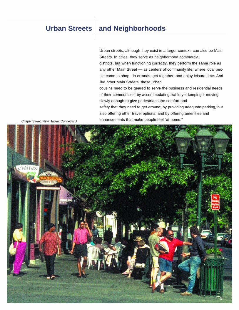
Urban Streets and Neighborhoods
Urban streets, although they exist in a larger context, can also be Main
Streets. In cities, they serve as neighborhood commercial
districts, but when functioning correctly, they perform the same role as
any other Main Street — as centers of community life, where local peo-
ple come to shop, do errands, get together, and enjoy leisure time. And
like other Main Streets, these urban
cousins need to be geared to serve the business and residential needs
of their communities: by accommodating traffic yet keeping it moving
slowly enough to give pedestrians the comfort and
safety that they need to get around; by providing adequate parking, but
also offering other travel options; and by offering amenities and
enhancements that make people feel “at home.”Chapel Street, New Haven, Connecticut
9

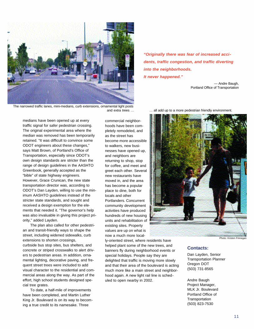
Portland, Oregon A Boulevard’s Broken Dreams are Mended
10
By the time Portland, Oregon’sUnion Avenue became MartinLuther King Jr. Boulevard in the
late 1980s, it was in bad shape. Once athriving hub of local business and communi-ty life, the street had been reconstructed inthe early 1970s with no parking, a new 10-foot-wide median and four travel lanes, cre-ating an expanse that encouraged high-speed traffic and scared away pedestrians.The median, with grand oak trees andabundant greenery, may have brightened upthe surroundings, but locals complained thatit blocked them from crossing the street andbroke up the community. Along the 3.5miles where the boulevard travels throughthe six adjacent neighborhoods of the innercity’s Albina community — a racially mixedarea, with a large African-American population, as well as Asians, Latinos, andRussians — a common perception was thatthe street had been rebuilt to rush whitecommuters through. What’s more, withoutconvenient parking or full pedestrianaccess, local business had begun to fadeaway.
When Oregon Governor John Kitzhaberappeared at a local event in 1996, commu-nity members captured his attention andasked for help in restoring the street’s
neighborly, business-friendly, kind-to-pedes-trians quality. The governor assigned hisCommunity Solutions Team (leaders of sev-eral state agencies) to organize a demon-stration project addressing both streetscapeimprovements and redevelopment. In turn,the team created a Martin Luther KingAction Committee to oversee the develop-ment and testing of pilot improvements.Oregon Department of Transportation(ODOT) set up a five-block experiment,completely removing the heavily-plantedmedian, adding parking on both sides of thestreet, and narrowing the travel lanes. Thisexperiment became a point of reference fora visioning process, led by the PortlandOffice of Transportation in partnership withODOT, the Portland DevelopmentCommission, and the Metro regional plan-ning agency, to transform the boulevard intoa street that truly supported the community.
Two committees were formed to helpdevelop the vision. The Project AdvisoryCommittee made up of neighborhood asso-ciations, businesses, and property owners;and a Technical Advisory Committee of rep-resentatives from the state and city DOTs,the transit agency, urban forestry, the plan-ning department and other Portlandbureaus. Public input was actively sought inthrough area tours, interviews, focusgroups, open houses, workshops and eveninteractive display boards. The procedurerevealed that in a study area of varyingneighborhoods — residential, commercial,light industrial, affluent, modest, and multi-ethnic — one solution for the street wouldnot fit all needs.
In response, the plan provided for sev-eral different options. The most extensivechange bolstered commercial nodes byrestoring on-street parking on both sides,narrowing traffic lanes down to ten feet, andbuilding a “mini-median” whose four feetwould provide refuge for pedestrians andspace for plantings. A second option retainsthe wider medians with their mature treesand greenery in residential areas wheremost people preferred this enhancement.Since these same residents also wanted tocross the street more easily, the lengthy
“Now it will be much eas-
ier to do these types of
projects — we can point
to this. I think it greatly
improved ODOT’s reputa-
tion in the community.”
—Dan Layden, Oregon DOT
Project PartnersPortland Office ofTransportation
ODOT
Portland DevelopmentCommission
Metro
Tri-Met
With on-street parking restored and the street accessible to walkers, new businesses, and neighbors, have been moving in.
11
medians have been opened up at everytraffic signal for safer pedestrian crossing.The original experimental area where themedian was removed has been temporarilyretained. “It was difficult to convince someODOT engineers about these changes,”says Matt Brown, of Portland’s Office ofTransportation, especially since ODOT’sown design standards are stricter than therange of design guidelines in the AASHTOGreenbook, generally accepted as the“bible” of state highway engineers.However, Grace Crunican, the new statetransportation director was, according toODOT’s Dan Layden, willing to use the min-imum AASHTO guidelines instead of thestricter state standards, and sought andreceived a design exemption for the ele-ments that needed it. “The governor’s helpwas also invaluable in giving this project pri-ority,” added Layden.
The plan also called for other pedestri-an and transit-friendly ways to shape thestreet, including widened sidewalks, curbextensions to shorten crossings, curbside bus stop sites, bus shelters, andconcrete or striped crosswalks to alert driv-ers to pedestrian areas. In addition, orna-mental lighting, decorative paving, and fre-quent street trees were included to addvisual character to the residential and com-mercial areas along the way. As part of theeffort, high school students designed spe-cial tree grates.
To date, a half-mile of improvementshave been completed, and Martin LutherKing Jr. Boulevard is on its way to becom-ing a true credit to its namesake. Three
commercial neighbor-hoods have been com-pletely remodeled, andas the street hasbecome more accessibleto walkers, new busi-nesses have opened up,and neighbors arereturning to shop, stopfor coffee, and meet andgreet each other. Severalnew restaurants havemoved in, and the areahas become a popularplace to dine, both forlocals and otherPortlanders. Concurrentcommunity developmentactivities have producedhundreds of new housingunits and rehabilitation ofexisting sites. Propertyvalues are up on what isnow a much more local-ly-oriented street, where residents havehelped plant some of the new trees, andbanners fly during neighborhood events orspecial holidays. People say they aredelighted that traffic is moving more slowlyand that their area of the boulevard is actingmuch more like a main street and neighbor-hood again. A new light rail line is sched-uled to open nearby in 2002.
Contacts:Dan Layden, SeniorTransportation PlannerOregon DOT(503) 731-8565
Andre BaughProject Manager, MLK Jr. BoulevardPortland Office ofTransportation(503) 823-7530
“Originally there was fear of increased acci-
dents, traffic congestion, and traffic diverting
into the neighborhoods.
It never happened.”
— Andre Baugh, Portland Office of Transportation
Photo: Kristen Finnegan
The narrowed traffic lanes, mini-medians, curb extensions, ornamental light posts and extra trees … … all add up to a more pedestrian friendly environment.

Somerville, It’s Hip To Be In Davis SquareMassachusetts
12
Once a gritty, down-at-the-heelsintersection, Davis Square is nowa vibrant nightspot and popular
shopping district. New restaurants andnightclubs attract a young crowd from allover the Boston area to what is billed as analternative to Harvard Square in Cambridge.There are also many new professionaloffices and neighborhood-oriented services,and property values are climbing steadily.
How did Davis Squareundergo this radicaltransformation? Byleveraging opportuni-ties through transporta-tion partnerships.
The heart of DavisSquare is a complexsix-point intersectionthrough which severalfreight trains once raneach day, forcing trafficto back up for long periods of time. In
1976, to help resolve the safety and mobilityissues at this intersection, the city convertedstreets to one-way, and simplified traffic sig-nals. This led to five years of fast movingtraffic, a dangerous environment for pedes-trians, and an economically stagnant neigh-borhood.
In 1982, a partnership between the city,state, regional, and community planninggroups used the construction of a new sub-
way stop in DavisSquare as leverageto fix the traffic prob-lems. The citychanged the wholelook of the squareby constructing aseries of pedestrian-oriented streetscapeand landscapeimprovements,including new pavingfor crosswalks andsidewalks, pedestri-an islands, and cen-tral islands, all ofwhich serve to chan-nel and calm the
movement of cars within intersections andenhance pedestrian capacity, circulation,and safety.
The city of Somerville redeveloped andlandscaped the railroad right-of-way throughDavis Square as a linear park andbicycle/pedestrian pathway that connects tothe 13-mile Minuteman Trail. In 1994, theMassachusetts Highways Department rede-veloped a portion of its right-of-way, as abike path as well; Mass Highways upgradedthis segment with new lighting to facilitatenighttime riding and friendlier fencing, withparcels along the bike path given to adja-cent residents who have set up a series ofcommunity gardens along the route.
Impacts• Property development has rebound-
ed, including a storefront and facadeimprovement grant program that isattracting new businesses, and therestoration of a historic theater;
• A portion of the square was designat-ed as an urban renewal district andhas since been developed as a100,000 square foot office and retailcomplex, including public open spaceand parking;
• The former freight right-of-way hasbecome a central square, used by residents, shoppers, exercisers, wait-ing bus passengers, and is the sitefor several annual community events.
ContactOffice of Housing andCommunity DevelopmentSomerville City Hall(617) 625-6600
Project PartnersMassachusetts BayTransportation Authority
City of Somerville
Davis Square Task Force
Massachusetts HighwaysDepartment
Pedestrians and businesses have benefited most from the strong phys-
ical and visual connections that linktransit facilities to the main shopping
street and central square.
The heart of Davis Square has been restored, thanks to a community and transportation partnership with a long-term vision.

Suburban Town Centers
Built largely around the automobile, suburbs represent a unique chal-
lenge for balancing traditional transportation goals with
community values. One starting point has been to revive older town cen-
ters that still have their basic infrastructure in place that allows for plan-
ners to create a sense of place and community —
when a better balance between pedestrians and vehicles is achieved.
13
Laguna Beach, California, at intersection of the Pacific Coast Highway
Towson, Maryland Planners Take a Roundabout Approach to Downtown Revitalization
14
It was standing room only by the win-dows of Souris’ Bar that chilly Februarymorning in 1998 when the Maryland
State Highway Administration (MSHA)unveiled its first urban roundabout inTowson, Maryland. As residents of Towsonlooked out of their store windows andhomes that morning, police guided com-muters around a neat line of cones, barrels,and “yield” signs that formed an oblong-shaped, temporary traffic circle where a bunch of signals andmind-numbing congestion had greeted themonly days before. By the time the experi-ment was over, and construction was com-pleted in October the same year, motoristsand pedestrians had learned their wayaround, and merchants and shoppers hadcome to love the new
traffic-calming feature. In 1994, after a series of other
design attempts had failed, the MSHAproposed installing a roundabout atthe complex meeting point of fiveroads that forms the center of the his-toric county seat. Baltimore Countyofficials liked the plan too, as theyrecognized the opportunity to continuetheir streetscape revitalization effortsin a town with a willing partner.However, the county stipulated that
the streetscape program would not goahead unless at least two-thirds of localproperty owners agreed either to upgradethe facades of their buildings or pay anassessment. In the end both the roundaboutand streetscape projects moved ahead andwere built as one. “It was logical that thingswould come together in one physical loca-tion at the same point in time,” commentedRay Heil, streetscape program manager forthe Baltimore County Department of PublicWorks. The project costs totaled $4.25 million.Baltimore County has agreed to maintainboth the streetscape enhancements andlandscaping in the roundabout.
In terms of economic viability for sur-rounding businesses, “the roundabout is alifesaver,” says Susan DiLonardo, executivedirector of the Towson BusinessAssociation. “The cars are not backed up in
Project PartnersMaryland State HighwayAdministration’s
Offices of HighwayDevelopment
Traffic Engineering Support Section
Systems Planning andEvaluation
Community Liaison Office
Baltimore CountyDepartment of Public Works
Towson BusinessAssociation
“When you have an unusual prob-
lem, you have to find an interesting
solution, and I think that’s what we
have here.”
—Ray Heil, Baltimore County Department of Public Works
Before the roundabout was built, the gateway to Towson was dominated by cars waiting in long lines at traffic lights. Photo: Maryland State Highway Administration
Since the inception of the MSHA’sroundabout program in the early 90s,
close to 30 roundabouts have beeninstalled throughout the state, though
none in such a congested area asTowson. During peak periods, thisurban roundabout handles nearly
4000 cars per hour.
Photo: Maryland State Highway Administration

15
front of the businesses. It’s cleaner and qui-eter.” DiLonardo, who saw it as her role toensure that business needs were continu-ously conveyed to MSHA during the build-ing of the roundabout and other improve-ments, was indispensable to the project. Asa result of her efforts, MSHA assigned astaff member to work on-site with merchantsto solve problems during the entire process.MSHA and the Towson BusinessAssociation also conducted the public edu-cation component of the project — visitingsenior centers, schools, and shoppingmalls, and running community meetingstogether.
Impacts• Traffic backups along York Road
have disappeared, which hasimproved the environment for pedes-trians and businesses. For example,businesses from other parts ofTowson are relocating to the “down-town” around the roundaboutbecause the foot traffic is better, evenat the expense of dedicated on-siteparking lots.
• At the same time the roundabout wasbeing planned, a developer finallypurchased the long vacant Hutzler’sdepartment store, which occupies anentire quadrant adjacent to theroundabout and the entrance to thetown center. “The streetscape androundabout projects were critical tomaking this redevelopment happen,”said developer David Rhodes, “andto attracting Barnes and Noble, whotook the corner site that anchored thewhole project for us.”
• There has been a considerablereduction in accident severity at the
site, since the roundabout lowersspeed and most accidents are lowdamage, according to Bob Douglass,Deputy Chief Engineer, MSHA.
• Although top speeds in the circlerarely exceed 22 mph (as reported bythe police department), the round-about is handling about 400 morecars per peak hour than it did before.In fact, traffic moves so smoothly thatbusinesses are asking for added onstreet parking, and other ways toslow vehicles on their approach, nowthat it is faster to go through townthan bypass it.
ContactsSusan K. DiLonardoTowson Business Association(410) 825-1144
Robert D. Douglass, P.E.Deputy Chief Engineer,Highway Development Maryland State HighwayAdministration(410) 545-8888
Baltimore County Public Works’ streetscape plan extended the amenities and landscaping treatments from the roundabout westward into the center of town, where they slow the approach of traffic into the circle, while stimulating renewed foot traffic for local business-es.
“There’s no question that this was a high risk, experimental project. We keep
tweaking the roundabout — moving signs, checking it out every week to see
how it’s doing. We could have narrowed the lanes even more, but we’re going
to keep inventing new things.”
—Robert DouglassDeputy Chief Engineer, Highway Development, Maryland State Highway Administration

Calabasas, California Traffic Relief Measures Give Old Town a New Look
16
The city of Calabasas, a suburbof Los Angeles in the SanFernando Valley, needed to
reduce the impact of traffic spillover from the often-con-gested Ventura Freeway upon theone-mile long Main Street of this his-toric “Old West” settlement town whileimproving pedestrian and bicyclesafety, and transit service through thearea. Through extensive communitycooperation, the city developed andimplemented the Old TownCalabasas Road ImprovementProject, which included flexibledesign standards for improvingcapacity along the section ofCalabasas Road that passes throughOld Town.
The project included extensive treeplanting to reach the maximum allowed inan urban thoroughfare, and preservation ofexisting oak trees; the incorporation ofboardwalks, bollards, and lighting into theroadway design, and cobblestoned pedestri-an crossings; bicycle lanes and busturnout bays; free trolley service betweenthe Old Town on off-site parking facilities toreduce shopping trips by car; and a
25 mph speed limitation. Road widthincreases to create two lanes for eastboundtraffic was facilitated by the donation by property owners to the city of the additional right-of-way required. A seven-phased construction schedule minimized impact upon existing businesses and property owners.
ImpactsCompleted in 1998, and funded by the LosAngeles Metropolitan Transit Authority, thestate department of transportation (CAL-TRANS), and the US EconomicDevelopment Administration, the project hasincreased transit ridership due to improvedschedule reliability, reduced traffic acci-dents, and enhanced pedestrian safety. Thenew street environment encourages shop-ping and tourism, while the trees provideshade, prevent soil erosion, and mitigateagainst noise and dust. Congestion causedby through traffic has been replaced byincreased visits to local destinations, suchas the farmers market, restaurants, and aquarterly Art Show, all of which have led toincreased economic benefit and the attrac-tion of new businesses to the area.
PartnersCalifornia Department ofTransportation
City of CalabasasTransportation Dept.
Los Angeles MTA
US Economic DevelopmentAdministration
ContactsRobert YaldaTransportation DirectorCity of CalabasasTransportation Department(818) 878-4225
Old Town Calabasas is a “picturepostcard” example of what can beachieved by state highway offi-cials, local traffic departments, andmunicipalities working in partner-ship to realize common goals.
The landscaped medians are a refuge for pedestri-ans while the cobblestoned pedestrian crossingsare just one element of the roadway design thatphysically reinforces the design speed ofCalabasas Road — 25 mph.
Courtesy of City of Calabasas, CA

17
Scenic Roads
Sense of place is not confined to small towns and neighborhoods in
urban areas. However rural areas, especially those with special scenic
and historic qualities, face design issues that are very dif-
ferent from those of commercial and residential districts. A road that
respects the contours and characteristics of the land, rather than an
inflexible solution that bulldozes out uniqueness, supports both the nat-
ural and built-up areas that flank a road. In this way, a state road can
enhance the experiences of driving and living along it, while preserving
a sense of place. With careful attention to design, safety goals can be
achieved without sacrificing a road’s compatibility with the natural envi-
ronment.
Paris Pike, Lexington, Kentucky Photo: Kentucky Transportation Cabinet

Lexington, Kentucky A Highway Fit for the National Register
18
No ordinary two-lane highway, ParisPike is the tree-lined “main street”of Kentucky’s bluegrass horse
country. Flanked by pristine thoroughbredrace horse farms with hand crafted stonewalls and fences, and rolling fields, the pike,also known as the Lexington Road, is actu-ally eligible for the National Register ofHistoric Places. So in 1979, when planswere developed to widen a 12-mile stretchof the state road connecting Lexington andParis, property owners and preservationadvocates filed an injunction against its con-struction.
What began as a battle between thestate DOT, property owners, and historicadvocates has resulted — 20 years later —in a new Paris Pike that enhances theregion while significantly improving safetyand capacity. This was not an easy process,
and it is remarkable tomany of the key stake-holders that it has evenhappened. The legacy of the road can be seen in its innovativedesign but, more impor-tantly, in a new communi-ty-oriented process thatthe Kentucky DOT —which is officially namedthe KentuckyTransportation Cabinet —is now utilizing on roadprojects elsewhere in thestate.
Once a sleepy coun-try road, Paris Pike hadseen its traffic volumessteadily increase to about12,000 cars per day. Itstwo lanes were pictur-esque but dangerous, andthere were frequent acci-
dents and fatalities on the road. “Safety wasthe number one concern,” one residentactive in the project reported. “It was theone thing everyone could agree on.” Whatstakeholders couldn’t agree on was what todo about it.
Lack of trust was an important hurdle toovercome. For example, opponents of theroad widening did not believe the state’straffic counts. “They just didn’t want the traf-fic to be there,” said Henry Alexander a res-ident who is sometimes called the “lordmayor of Paris Pike” and played a key rolein the injunction and the ultimate settlement.It was Alexander who came up with an ideato break the stalemate: get the communityto take the counts. For eight hours a day forsix days, opponents and proponents satside-by-side counting, and ultimately affirm-ing the state’s numbers.
After a year long process, partnersworked out a unique “Memorandum ofUnderstanding” between all the parties thatsupported the road’s widening, but set forthground rules for its basic design features,the public design process, and the role ofthe task force selected to guide the process.A landscape architect would develop thedesign with the assistance of an engineerexperienced in scenic roads. The publicwas to be involved “to the maximum practi-cal extent.” The settlement lifted the injunc-tion, and its time-liness was reinforced the next day whenthere was another fatality on Paris Pike.
The design process, which began in1994, involved an extensive analysis of thelandscape and cultural resources along theroad with an equally extensive public participation process, complete with meet-ings, newsletters, bus tours and even hay rides around farms so propertyowners and interested people could see forthemselves the details of what needed to be
Project PartnersCommonwealth of Kentucky, Transportation Cabinet
Bluegrass Tomorrow
Lexington-Fayette CountyUrban County Government
City of Paris
Bourbon County
Federal HighwayAdministration
“The more time you spend in planning and people
relationships, the less time it takes on the other end.”
— Jean Scott, former director of Bluegrass Tomorrow
Fears that a road widening would forever alter the beauty ofParis Pike stalled the project foralmost 20 years.
Photo: Christine Amos

19
preserved. “We literally walked the entireroad,” said landscape consultant ChristineAmos. “If the road moves, it is moving inresponse to a cultural resource, a naturalenvironmental or topographic feature orlandscape. We wanted to take the taskforce and other parties out so that theycould see what we saw,” she described.Another innovation: electronic polling wasused during property owner workshops totest design options. With each owner votingwith a keypad, results were immediately dis-played on a screen at the meeting. This set-tled a lot of discussion quickly, while identi-fying problems that truly needed moreexploration.
The final design is a relatively simpleone that meets the guidelines contained inthe AASHTO Greenbook, and respects thelocal context. The existing road became halfof the new road, but rather than just adding
ContactsClifford C. LinkesChief District EngineerKentucky Department ofHighways(606) 246-2355
Henry Alexander
Paris Pike Advisory TaskForce(606) 299-4449
“When we get through we
will have a better road, a
prettier road, one that
flows with the land-
scape.”
— Bob Wiseman, Office of the Mayor,
City of Lexington
The two-lane Paris Pike before its widening.
A completed section of the road shows the newly built two lanes in the foreground. By constructing a variable width median, three trees (center of photo) and an adjacent historic house (shown in the right of the photo) were preserved. Wooden guardrails and grass shoulders integrate the road into its setting.
two more lanes, a variable width medianwas used — sometimes becoming so wideand following an entirely different contourthat the new lanes are not even visible fromthe old road. In this way, the road detoursaround significant trees and landscape fea-tures, and follows the contours of the land— rather than the traditional extensive grading to make the land fit the road.Stonemasons were brought in fromScotland to train local artisans how to relo-cate and replace the dry-laid stone walls.Guardrails are made of wood, and newbridges are of stone, like the walls. Grassshoulders were selected over macadam,and median crossovers (wide enough toaccommodate U-turns by horse vans) limitthe need for intersections.
As phases are completed, Paris Pike isunfolding as a unique rural road — and willcontinue to reveal itself as the landscapematures. As Henry Alexander puts it, “Thereal impact of the road will be felt 15 years from now. Every aspect of theroad is going to say that it was all worth it.”
Group tours with community members during theParis Pike planning process helped determine thehistoric and landscape features that needed to be preserved during the road widening.

Merritt Parkway, Historic Roadway Gets a Community-Backed FaceliftConnecticut
20
Built in the late 1930s, the MerrittParkway is a 38-mile parkwayincorporating a series of historic Art
Deco bridges and whitewashed service sta-tions along its heavily wooded route.Though it was considered a national modelfor its time, by the late 1980s the parkway’sbridges, signs, and other features were inneed of restoration, usage was up to 60,000cars a day, and traffic statistics reported anaverage of one accident every eight hours.To deal with the volume and safety issues,the Connecticut Department ofTransportation proposed the addition ofacceleration and deceleration lanes.
Spurred by public concern over the pro-posed changes, and by the parkway’s sub-
sequent listing on the NationalRegister of HistoricPlaces in 1991, then-Connecticut DOTCommis-sioner EmilFrankel convened aworking group con-sisting of architects,preservationists, andhis top managementstaff to develop road-way and landscapedesign guidelines tobalance traffic safety,road maintenance
and restoration while preserving the road’shistoric character. The group commissioneda historic documentation study of the park-way, formulated guidelines for improve-ments, and commissioned a landscapingmaster plan and a bridge restoration study.The working group also designed a woodguardrail to replace the steel guardrail usedon the parkway.
These efforts have guided parkwayimprovement. A maintenance, restoration,and preservation program divided the road-way into segments and phases for restora-tion. Work has been completed on the gate-
way projects in Greenwich and Stratford,towns located at the parkway’s oppositeends. An advisory committee of ConnecticutDOT personnel and public and private inter-est groups reviews any parkway-relatedactivities, including landscape character,bridges, medians, and the roadside.Community groups and individual propertyowners are engaged as the phased road-way segments come on line.
For safety considerations, accelerationand deceleration lanes were added, but thedesign attempted to use the minimumlength suggested by the AASHTOGreenbook, making the interchanges moreconsistent with overall design of the road,according to ConnDOT Commissioner JimSullivan. The changes also reduced trafficcongestion at parkway exits by 25%. A rockremoval and landscape maintenance pro-gram was instituted to make room for largereight-foot grass pull-off shoulders along theparkway. Traffic accidentshave been “significantly reduced,” accordingto Jeff Scala, a senior engineer atConnecticut DOT. An effort is now underwayto establish a Merritt Parkway Conservancy,a public-private partnership that would facili-tate parkway projects and raise money forthe long-term maintenance of improve-ments.
“The Merritt Parkway project taught us how to balance safety improve-
ments with the community’s expectations for preservation.
It has changed our whole philosophy.”
—Jim Sullivan, Commissioner, Connecticut Department of Transportation
Project PartnersConnecticut Department of Transportation
Connecticut Trust for Historic Preservation
Federal HighwayAdministration
Greater Bridgeport RPA
South Western RPA
Connecticut Society ofArchitects
Connecticut HistoricalCommission
ContactCarl BardConnecticut Department of Transportation(860) 594-3274
Before improvements, steel guardrails predomi-
An advisory committee helpeddesign a guardrail that was moreappropriate to the parkway’s historic context.
21
State Transportation Initiatives: The Times Are Definitely Changing
As these case studies indicate, a new ethos is beginning to emerge that
recognizes roads as a staging ground for improved community livability.
Increasingly, state highway departments are looking at the multiple pur-
poses a roadway can serve beyond just transporting someone or some-
thing safely from here to there. They are also
seeing that road projects offer an opportunity to enhance a
community’s attractiveness, build its local economy, preserve its charac-
ter, and provide for the comfort and safety of its inhabitants.
Consequently, the importance of roads that are tailored to the environ-
ments they pass through is being emphasized. State DOTs are re-
examining their design standards and learning that they have the flexi-
bility that allows for this more community-responsive tucking and fitting.
And as this new ethos begins to spread, new state DOT policies and
programs are starting to spring up that encourage innovations like the
ones in this book and allow for more
ambitious new projects. continued on next page
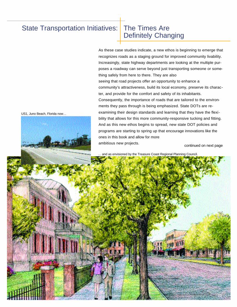
US1, Juno Beach, Florida now…
… and as envisioned by the Treasure Coast Regional Planning Council.

22
FloridaIt’s hard to believe that not too long ago theFlorida Department of Transportation wasreluctant to try angled parking onTallahassee’s Monroe Street, its mainstreet. That same FDOT is now an excellent example of a state DOT that iscommitted to paving the way for people-friendly places with its new TransportationDesign and Livable Communities policy. Tocarry out these principles, a new chapter is being prepared for FDOT’s PlansPreparation Manual, with details on appropriate techniques and guidelinesfor their application, and on how existingguidelines can be adapted to accommodatecommunity livability needs in different envi-ronments.
The department has also developed aPublic Involvement Training Program andtool kit to help facilitate community input. Acollaborative approach to planning and eval-uation is encouraged, with diverse local andstate agencies working together with citi-zens. A livable communities coordinatorhelps ensure that the word is getting out onthese new transportation opportunities. Thisnew sensitivity to community context hasled to FDOT’s partnering with entities likeFlorida’s Departments of Community Affairs,State and Environmental Protection, theFlorida League of Cities, and the FloridaMain Street Program.
The Treasure Coast Regional Planning
Council is working to revitalize the US 1corridor in Palm Beach County. Once themajor east coast access from north to southFlorida, US 1 is an aging, deteriorated strip,still sized to “rush hour” capacity. Along a15-mile expanse, seven cities and towns,most of whom never really had a mainstreet, have joined in creating a comprehen-sive plan to transform each of their parts ofUS 1 into central places, and downsize theroad accordingly. For more information, con-sult the council’s web site at www.tcrpc.org. (See page 21)
OregonThe State of Oregon is often viewed as anincubator for new planning practices, and itstransportation department has increasinglyfollowed suit. In fact, as a result of the col-laborative efforts of Oregon DOT and thestate’s Department of Land Conservationand Development, Oregon’s Transportationand Growth Management Program wasestablished in 1993. The purpose of theprogram is to promote the integration oftransportation and land use planning to fos-ter the development of compact communi-ties that support walking, bicycling, and
“State DOTs… paving the
way
for people-
friendly places.”
Monroe Street, Talahassee,Florida

23
transit use. Through this program,ODOT helps local governments devel-op community-friendly transportationsolutions by providing grants, “quickresponse” technical assistance teams,publications, and an outreach pro-gram that includes workshops, part-nership development and training forpractitioners. For more information,see the program website atwww.lcd.state.or.us/issues/tgmweb.
A new handbook, Main Street...When A Highway Runs Through It isthe Transportation and GrowthManagement Program’s latest tool forcommunities, produced through thecollaboration of ODOT with its LandConservation and Develop-mentDepartment partner and the OregonDowntown Development Association.Main Streets that are also state high-ways are prevalent in Oregon. Thehandbook’s purpose shows how trafficcan be accommodated on such cen-tral streets while preserving an attrac-tive, safe, and economically healthyenvironment that welcomes pedestri-ans and encourages many activitiesthat enhance the life of the communi-ty.
MarylandSpurred by the success of its 1998national conference, “ThinkingBeyond the Pavement,” the Mary-landState Highway Administration ischanging the way it does business.Since 1998, MSHA has embarkedupon and completed about a dozencontext-sensitive design projects,focusing on places where state high-ways serve as main streets, arterials,and scenic byways; 22 more projectsare currently underway, as are stafftraining efforts, agency-wide.Maryland is one of five states that areimplementing model context sensitivedesign programs.
Governor Parris Glendening seescontext sensitive road design as inte-gral to the state’s far-reaching “smartgrowth” policy because it focuses
renewed attention on strengtheningexisting centers of development. Thenew policy has tripled funds for com-munity enhancement projects-from $8million to $24 million, through theNeighborhood Enhancement Programand the Maryland State HighwayAdministration. While greater aware-ness of community-sensitive designstrategies are currently incorporatedinto all projects as much as possible,it is anticipated that by the fall of2001, context-sensitive design strate-gies will be a formal part of allaspects of the agency’s work. Formore information, and for materialsrelated to the “Thinking Beyond thePavement” conference, see thedepartment’s web site atwww.sha.state.md.us.
New JerseyAs the most densely settled state inthe nation, New Jersey is leading theway back from highway-driven sprawland congestion with state-wide trans-portation initiatives in both traffic engi-neering and transit. The New JerseyDepartment of Transportation has ini-tiated context-sensitive design train-ing, not only for its own staff, but alsofor engineering consultants, countyengineers, community activists, and mayors throughout the state. Theyhave also commissioned the creationof a flexible design standards manual
NJ Transit’s Woodbridge Train Station is one of many new stations now serving as a focalpoint for community life in New Jersey.
for highway design. From a transit perspective, much
has recently been accomplished. Inthe last 15 years, over $7.5 billion hasbeen spent to repair, rehabilitate,expand, and connect all of the state’spassenger rail lines — built in the late1800’s by competing rail companies— into one seamless transit system.Together, these connections,upgrades and two new light rail lineswill result in an interconnected railnetwork with over 170 stations servingthe majority of state residents. Thishuge investment, which has begun toovercome years of neglect of transit infavor of the highway network, has ledthe way for a new program — “TransitFriendly Communities” — to partnerwith local communities to improvepedestrian and bicycle access to trainstations, and make them focal pointsfor new development and communityrevitalization. A model stations andshelters program is in the process ofupgrading 50 train stations and pro-viding innovative bus sheltersstatewide.

24
and what doesn’t work aboutthe place. Listen to their sug-gestions. Through this process, you will develop a better understanding about how aplace operates and how it canbe improved.
2. Seek out partners. Transporta-tion agencies, communityorganizations, business owners,local officials, and other publicagencies should work togetherto develop elicit their ideas collectively, and provide mutualsupport. Invite members of each of these constituencies fora tour or site visit of an existingor proposed project. Discussways of working together toplan, design, and implement aproject. Reach out to othermembers of the community and your political representa-tives to get them on board anddraw upon their skills and finan-cial resources.
3. Develop a shared vision forthe project. Address the futureneeds of the community and ofthe transportation agency byworking together from the start.Specify short- and longer-termgoals, immediate actions steps,and additional partners. Seekways to solve problems, over-come obstacles, and identify arange of funding sources thatmay be available to the commu-nity, to the transportationagency, or to other public part-ners. Set up a structure forreviewing and giving feedbackon the project as it progresses.
4. Get the word out. Before eventhe smallest activity takesplace, let the community knowwhat’s about to happen. Tell thepress, send out newsletters,hold meetings, and even set upa web site. Establish a commu-nity liaison to reach out to busi-ness owners and others to keepthem abreast of what’s happen-ing, help them
1. Get out “on the street.” Take awalk around the community.Observe what kinds of activitiesare occurring along the streetand roadway - in downtown, in residential areas, aroundparks, and other public spaces,in historic and natural scenicareas. Are people comfortablecrossing the street? How fast istraffic moving? Are there manypeople around? What valuedhistoric, cultural, or environmen-tal resources exist? Talk to peo-ple, and ask them what works
Getting the Show on the Road
Thinking Beyond the Pavement
Here are some ways to set in motion a placemaking program that will
also help create transportation and community partnerships:
A project that achieves excellence in transportationdesign:• satisfies the purpose and need.
• is a safe facility.
• is in harmony with the communityand preserves environmental, scenic, aesthetic, historic, and natural resource values of the area.
• involves efficient and effective use of resources.
“Thinking Beyond the Pavement,” a national conference held in Maryland in 1998 (see page 23), reached
consensus about how to best integrate transportation facilities with communities.
• is built with minimal disruption to the community.
• is seen as having added lasting value to the community.
• exceeds the expectations of designers and stakeholders.
Excellence comes from a planning and design processthat: • establishes a multi-disciplinary team.
• seeks to understand the landscape, community, and valued resources.
• involves stakeholders in developing the scope of work.
• tailors the process to the circumstances.
• secures commitment from top agency officials and local leaders.
• makes communication open, honest, early, and continuous.
• tailors the public involvement process to the specific project.
• uses a full range of tools to communicate alternatives.

For More Information
About Project for Public Spaces, Inc.Project for Public Spaces, Inc.(PPS) is a nonprofit corporationspecializing in the planning,design, and management ofpublic spaces. Founded in 1975,PPS has completed projects inover 850 communities through-out the United States andabroad and has become widelyknown for its innovativeapproach to public space plan-ning and community revitaliza-tion that focuses on the behavior, expressedneeds, and collaborative envi-sioning of community members.
Project for Public Spaces,Inc.
153 Waverly PlaceNew York, NY 10014Tel: (212) 620-5660
Fax: (212) 620-3821E-Mail: [email protected]
About AASHTOFounded in 1914, the AmericanAssociation of State Highwayand Transportation Officials(AASHTO) is a nonprofit organi-zation that represents state-level publicagencies concerned with high-way and transportation in the fifty States, the District of Columbia, andPuerto Rico. Its mission is a transportation system for thenation that balances mobility, economicprosperity, safety, and the environment.
AASHTO 444 North Capitol StreetN.W. Suite 249Washington, D.C. 20001Tel: (202) 624-5800Fax: (202) 624-5806
The Route 66 Festival in San Bernardino, California takes advantage of new angledparking downtown.
adjust their activities accord-ingly, and better understandthe ultimate benefits of the proj -ect. Make sure this is doneon a continuous basis andencourage involvement.
5. Be flexible. Be open to newideas and never forget that each environment has itsown specific conditions thatneed to be addressed.Remember the AASHTOGreenbook allows for differ-ent approaches to a projectand its standards are flexibleenough to meet many differ-ent circumstances. You canalways make revisions laterif you begin the effort with asmall demonstration project.
6. Get started. Implement someshort-term projects by exper-imenting with low-costimprovements, like angled parking, striping, bollards,planters or other simplephysical improvements tostreets and the areas adja-cent to them. Collaborativelyplan special events,cleanups, and beautificationprojects. Invite the public tohelp.
7. Evaluate, refine, and phase-inconstruction. Test out the short-term improvementsand observe how they areworking. Ask drivers, pedes-trians, and local merchantswhether the improvementswork for them and for sug-gestions on how to improvethem. Based on the inputand observed conditions,make modifications andphase in construction toensure continuing communityaccess and convenience.
8. Keep the big picture in mind.Make more major changes using short-term projects asstepping-stones. Use the partnership as a mechanism