how to use web soil survey 3.0
TRANSCRIPT

How To Use Web Soil Survey 3.0

Contents
I. About Web Soil Survey II. Soil Data for an Area of Interest
a. Define an Area of Interest (AOI)b. View Soil Mapc. Explore Additional Soil Informationd. Shopping Cart for Selected Information
III. Download Soil Data for GIS
Part I: About WSS
Part I: About the Web Soil Survey (WSS)
Purpose Products New Features Pathways Starting WSS Opening Screen The Interactive Map
Part I: About WSS
Purpose
The WSS is a Web application that provides customers (producers, agencies, technical service providers, and others) electronic access to relevant soil and related information needed to make wise land use and management decisions.
WSS replaces the traditional hardcopy publication.
WSS provides quicker delivery of new or updated information.

Part I: About WSS
Purpose—cont.
WSS provides interactive access to the most current official data.
WSS allows you to select the information you want: Map units for your geographic area of interest
(AOI), Information relevant to your land use
concerns; e.g., rangeland or cropland. Downloadable soil survey data for use in a
local geographic information system (GIS).

Part I: About WSS
Products
WSS can produce a soil map for your AOI using color imagery or a topographic map as a backdrop.
WSS can produce tables of soil property data and interpretations by AOI.
Part I: About WSS
Products—cont.
WSS allows you to download SSURGO data clipped to your AOI.
WSS allows you to download SSURGO data sets for entire soil survey areas.
WSS allows you to download STATSGO2 data sets for entire states or for the entire United States.
Part I: About WSS
Products—cont. WSS allows you to generate a custom soil
resource report (in PDF) by adding selections to the free shopping cart. The report is customized for your AOI. The soil map, map unit legend, and map unit
descriptions are included by default. The other content is specifically chosen by you:
Thematic maps (including summary tables and text), Ecological site description map and information, Tabular data tables, and Introductory material.

Part I: About WSS
New Features
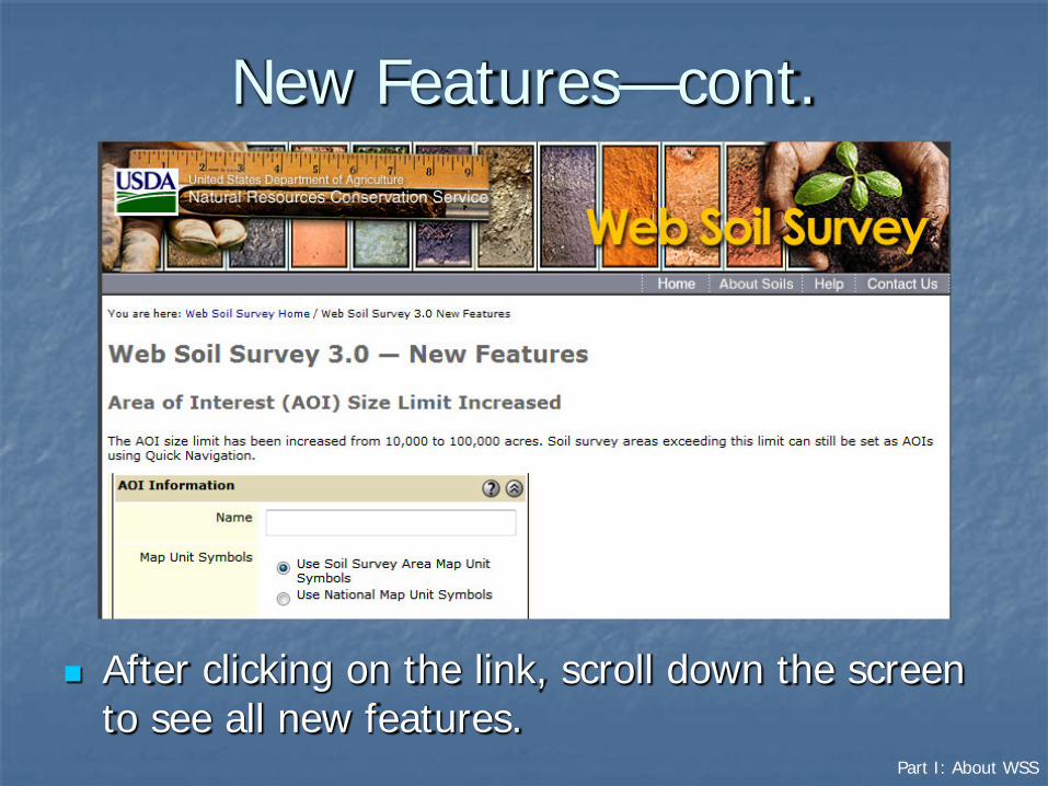
A link to a list of new features is available from the homepage of WSS.
Part I: About WSS
New Features—cont.
After clicking on the link, scroll down the screen to see all new features.
Part I: About WSS
New Features—cont.
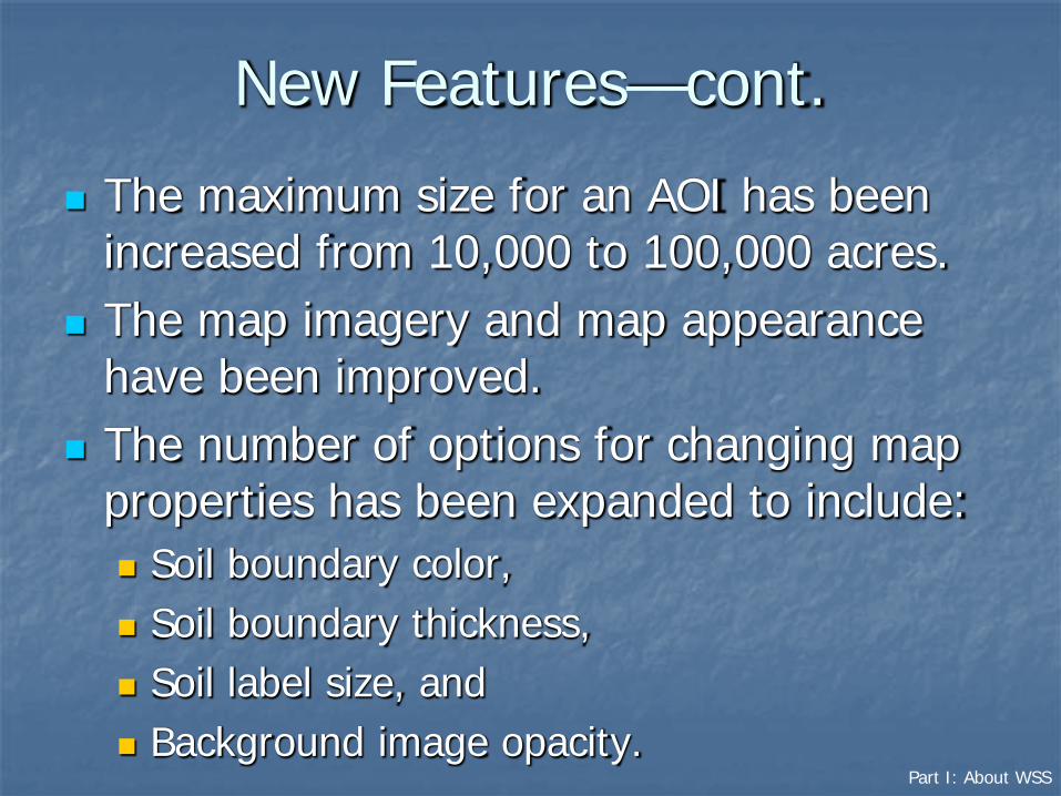
The maximum size for an AOI has been increased from 10,000 to 100,000 acres.
The map imagery and map appearance have been improved.
The number of options for changing map properties has been expanded to include: Soil boundary color, Soil boundary thickness, Soil label size, and Background image opacity.

Part I: About WSS
New Features—cont.
The identify tool can now display information about multiple data layers at the same time.
SSURGO and STATSGO2 data can now be downloaded directly from WSS. You no longer need to go to the Soil Data Mart.
Support has been added for data regarding the Pacific Island Area.
Support has been added for map unit line and point data.

Part I: About WSS
New Features—cont.
The options for tiling printable maps have been improved.
RSS notifications are now available regarding soil data updates.
WSS is now online 24/7.
Part I: About WSS
Pathways through WSS
Two major pathways are available for using WSS:1. Define an area of interest, view the soil
map, explore additional soil data, and check out with a report or data download that includes the selected information.
2. Download SSURGO data for a whole soil survey area, or STATSGO2 data for a state or the entire U.S. directly from the “Download Soils Data” tab.
Part I: About WSS
Pathway 1
Define an area of interest (AOI). You must specifically set the AOI before you can view maps or reports in WSS. In addition to maps and reports, a SSURGO
GIS dataset may be downloaded that is clipped to the AOI boundary.
View the soil map. The WSS generates a soil map for your AOI if the spatial data is available.
Part I: About WSS
Pathway 1
Explore additional soil data and related information. Generate thematic maps. Access tabular data and interpretive tables. Print or download the selected maps and
reports.
Check out with the selected information by building a custom soil resource report in the shopping cart or by downloading SSURGO data clipped to the AOI.
Part I: About WSS
Pathway 2
WSS 3.0 allows you to download raw soil data for use in a local GIS.
Select the “Download Soils Data” tab. You can download: SSURGO data clipped to the AOI boundary, SSURGO data for entire soil survey areas, STATSGO2 data by state or for the entire U.S.

Part I: About WSS
Starting Web Soil Survey
On the homepage (http://websoilsurvey.nrcs.usda.gov/),click on the big green button to start the Web Soil Survey.

Part I: About WSS, Opening Screen
The Opening Screen
• This is the opening screen after starting WSS.• The top navigation bar includes selections for Contact Us, Subscribe,
Archived Soil Surveys, Soil Survey Status, Glossary, Preferences, Link, Logout, and Help.
Part I: About WSS, Opening Screen
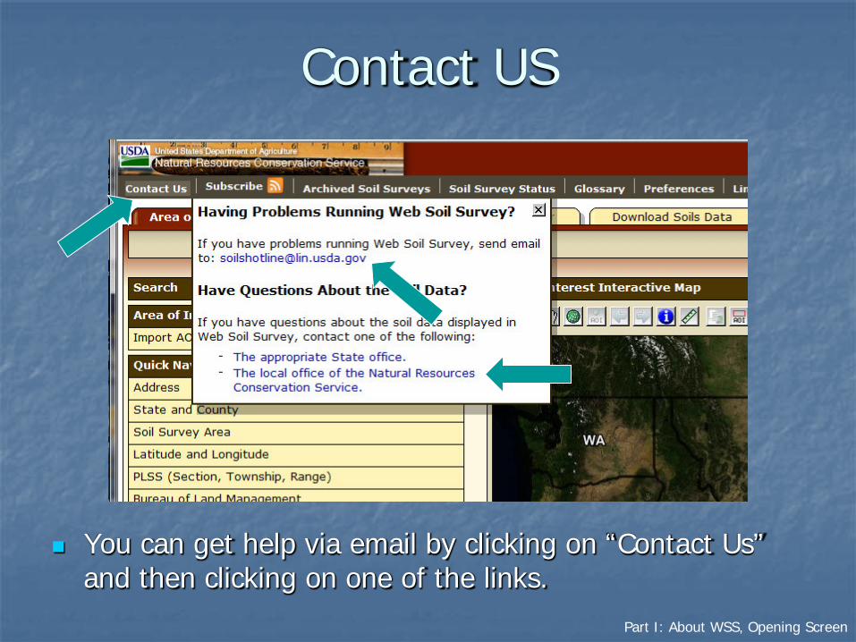
Contact US
You can get help via email by clicking on “Contact Us” and then clicking on one of the links.

Part I: About WSS, Opening Screen
RSS Subscriptions
You can click “Subscribe” to begin the RSS subscription process.
Part I: About WSS, Opening Screen
RSS Subscriptions—cont.
WSS 3.0 allows you to subscribe to RSS notifications regarding the updating of data for soil survey areas.
Updates to official soil survey data are generally only made on October 1 of each year. Exceptions are made for newly completed datasets. Exceptions are also made to resolve critical issues on a case-by-case basis.
Part I: About WSS, Opening Screen
RSS Subscriptions—cont.
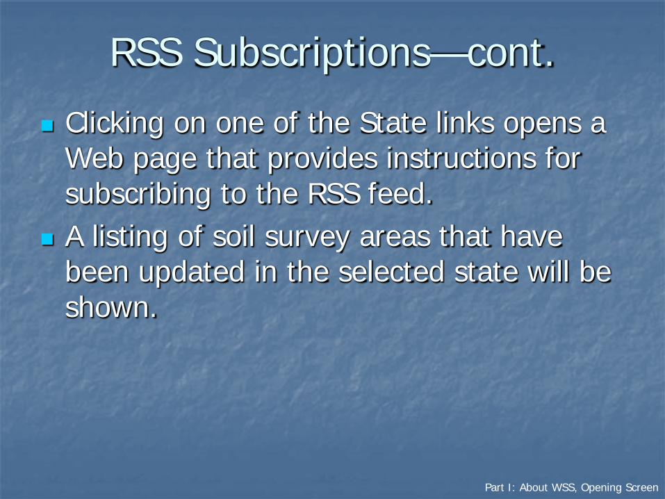
Clicking on one of the State links opens a Web page that provides instructions for subscribing to the RSS feed.
A listing of soil survey areas that have been updated in the selected state will be shown.

Part I: About WSS, Opening Screen
RSS Subscriptions—cont.
• Click on the “Subscribe to this feed” link to initiate your subscription.
• A second link is provided to “Learn more about feeds.”
Part I: About WSS, Opening Screen
RSS Subscriptions—cont.
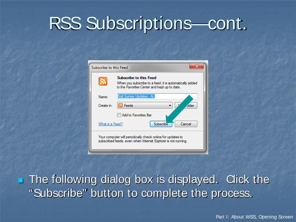
The following dialog box is displayed. Click the “Subscribe” button to complete the process.

Part I: About WSS, Opening Screen
Archived Soil Survey Publications
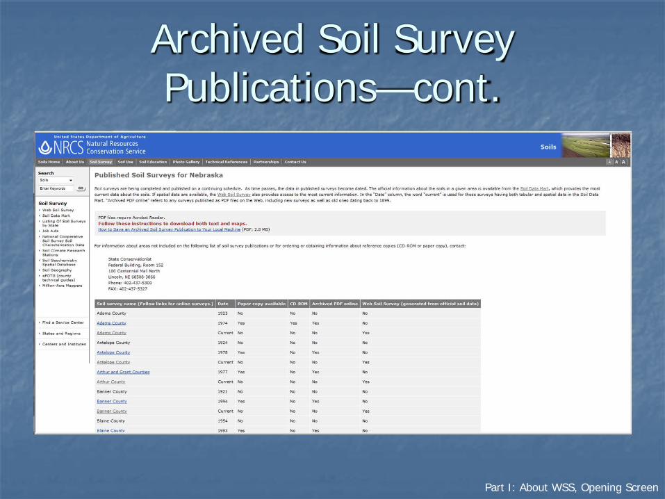
Listings of published soil surveys are stored on an external Web site. For a listing of the state(s) included in the AOI, click the link.
Part I: About WSS, Opening Screen
Archived Soil Survey Publications—cont.

Part I: About WSS, Opening Screen
Soil Survey Status
This menu item includes a link to a map showing what types of data (tabular, spatial, or both) are available for each soil survey area.
Part I: About WSS, Opening Screen
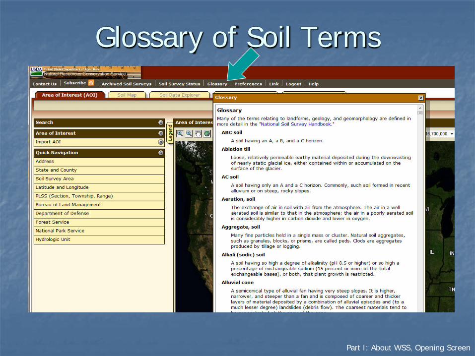
Glossary of Soil Terms

Part I: About WSS, Opening Screen
Preferences
• You can set certain user preferences. For example:• You can choose to view PDF files and links in the same browser window
as WSS or in different window, • You can choose not to view maps by default, and• You can choose between three color schemes.

Part I: About WSS, Opening Screen
Help
You can get general help from the top navigation bar or context-specific help from the “?” symbols.
Part I: About WSS, Opening Screen
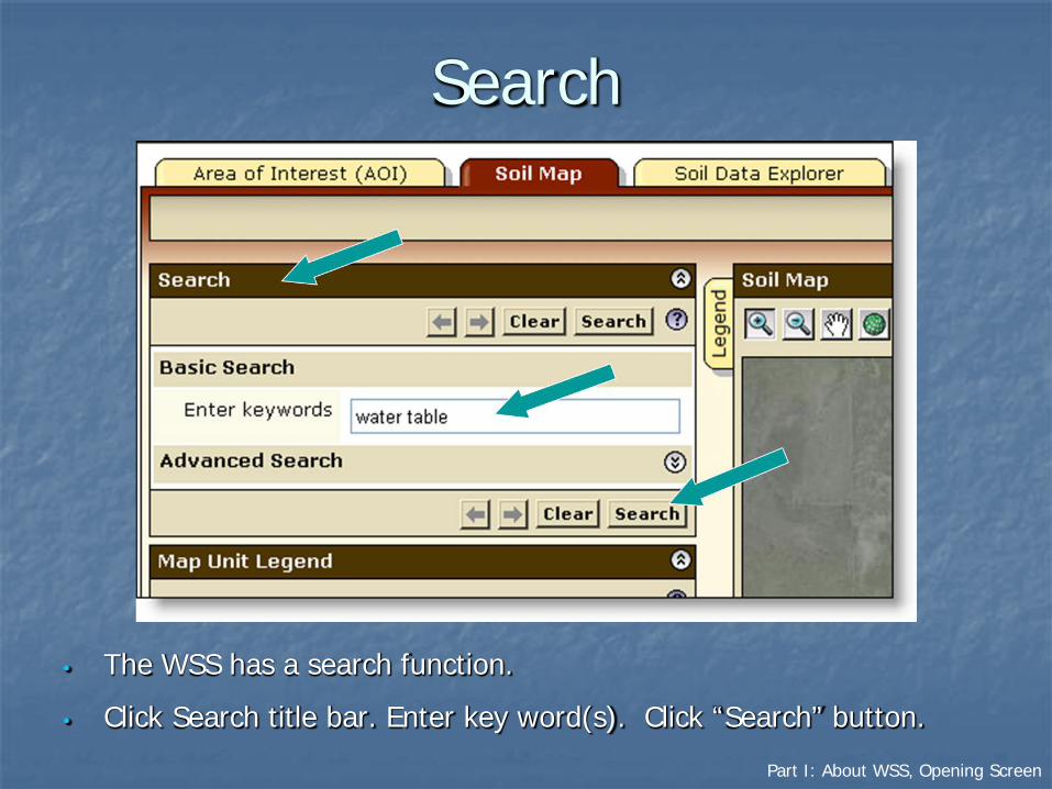
Search
• The WSS has a search function.
• Click Search title bar. Enter key word(s). Click “Search” button.

Part I: About WSS, Opening Screen
Search–cont.
• Search results are displayed with links to parts of Web Soil Survey where the key word(s) can be found.
• Click on a link to go to the relevant section.

Part I: About WSS, Opening Screen
The Interactive AOI Map
• Several tools are available to zoom to your area of interest on the interactive map.
Part I: About WSS, Opening Screen
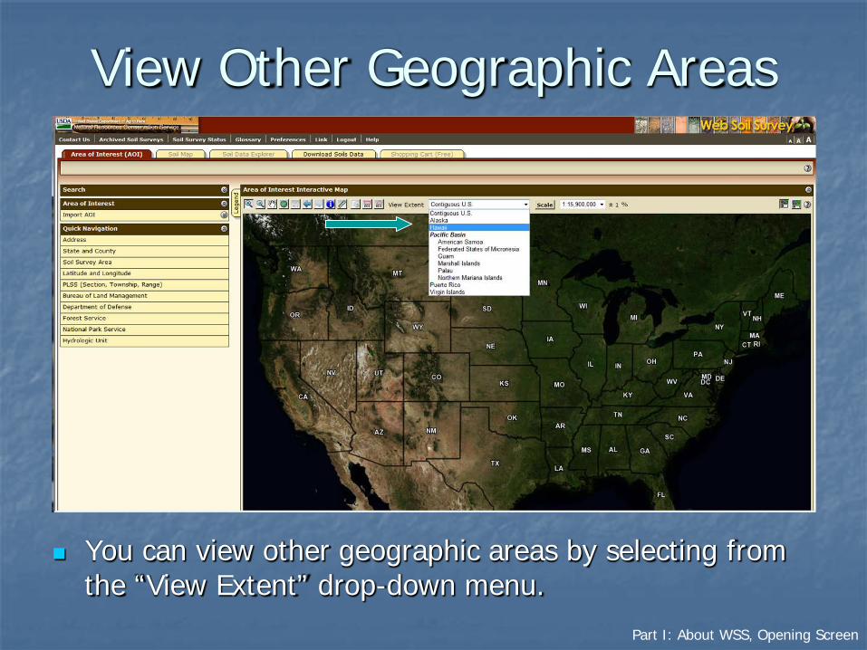
View Other Geographic Areas
You can view other geographic areas by selecting from the “View Extent” drop-down menu.

Part I: About WSS, Opening Screen, Interactive Map
View Map at Full Screen Width
Part I: About WSS, Opening Screen, Interactive Map
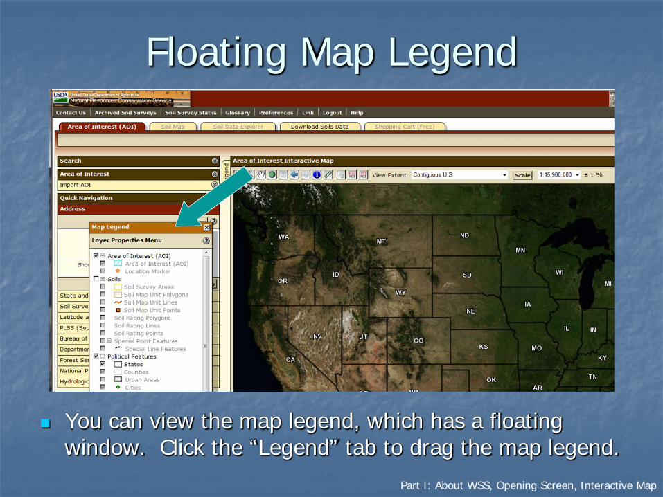
Floating Map Legend
You can view the map legend, which has a floating window. Click the “Legend” tab to drag the map legend.

Part I: About WSS, Opening Screen, Interactive Map
Zoom Tools
The map has zoom-in and zoom-out tools. Click on the symbol of the magnifying glass with a plus sign, then click and drag on the map to zoom in to a selected rectangle.
Part I: About WSS, Opening Screen, Interactive Map
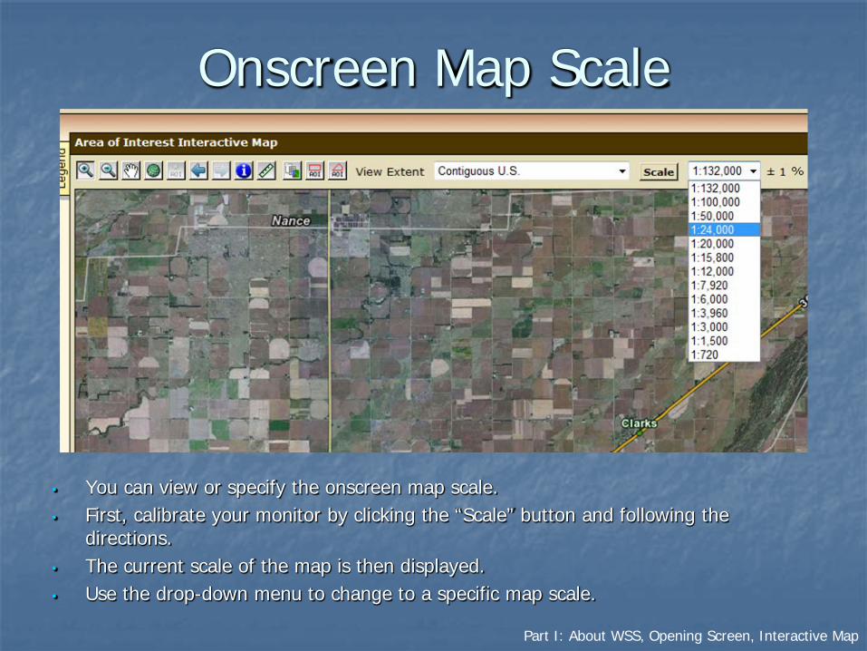
Onscreen Map Scale
• You can view or specify the onscreen map scale.• First, calibrate your monitor by clicking the “Scale” button and following the
directions.• The current scale of the map is then displayed.• Use the drop-down menu to change to a specific map scale.
Part I: About WSS, Opening Screen, Interactive Map
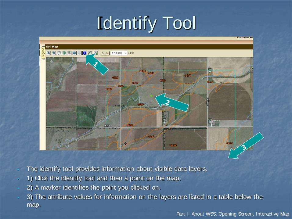
Identify Tool
• The identify tool provides information about visible data layers. • 1) Click the identify tool and then a point on the map. • 2) A marker identifies the point you clicked on. • 3) The attribute values for information on the layers are listed in a table below the
map.

Part I: About WSS, Opening Screen, Interactive Map
Identify Tool—cont.
The “Identify” table provides information about the selected data layers at the point identified. The table appears below the interactive map after a point is selected with the identify tool.

Part I: About WSS, Opening Screen, Interactive Map
Linear Measuring Tool
• Click the ruler button.
• Click on the map to begin and end linear segments.
• Segment length and cumulative length are displayed in metric and English units in the table.

Part I: About WSS, Opening Screen, Interactive Map
Help
Additional help with the interactive map is available by clicking on the “?” icon.

Part II: Soil Data
Part II. Soil Data for anArea of Interest
a. Define an Area of Interest (AOI)1. AOI Features2. Navigate to the area3. Define a specific area
b. View Soil Mapc. Explore Additional Soil Informationd. Shopping Cart for Selected
Information

Part II(a): Soil Data, Define an Area of Interest
IIa. Define an Area of InterestThe Web Soil Survey is backed by a database that contains soil information for the entire country. You can use the interactive map to select the area for which you want information.
a. Define an Area of Interest (AOI)1. AOI Features2. Navigate to the area3. Define a specific area

Part II(a1): Soil Data, Define AOI, AOI Features
II(a1). Area of Interest Features
You can navigate to the area where you wish to specify an area of interest using basic map navigation data layers: Transportation, Aerial photography, Hydrography, and Political features.
Part II(a1): Soil Data, Define AOI, AOI Features
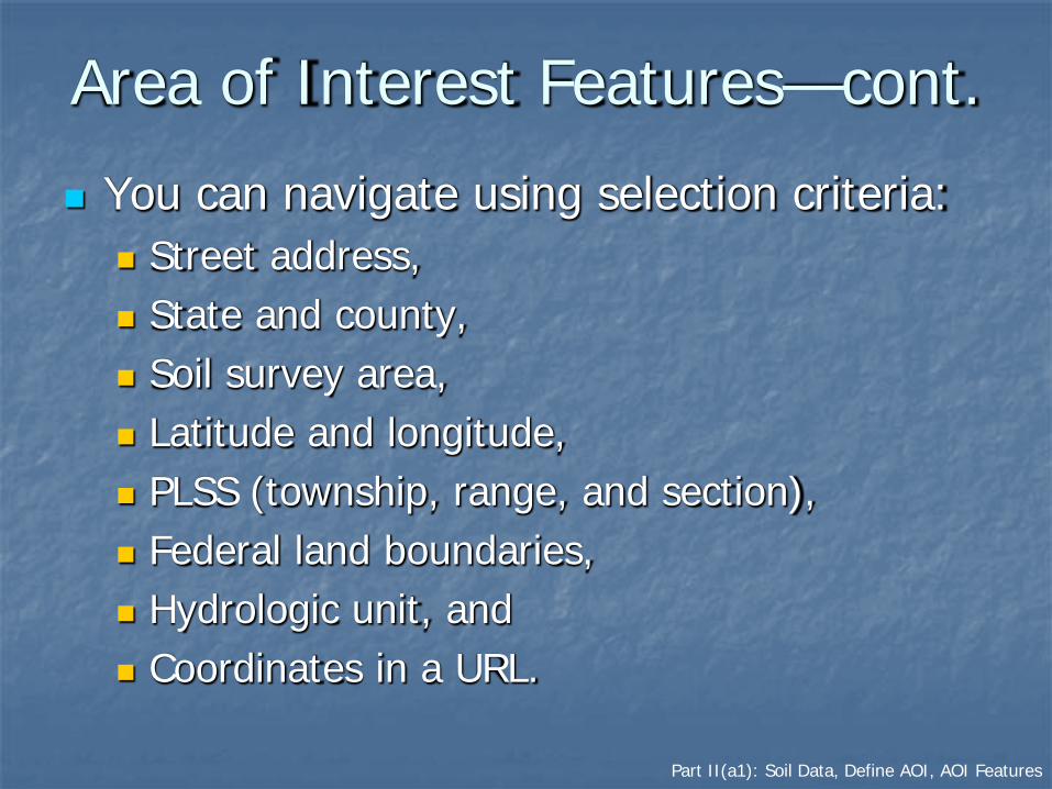
Area of Interest Features—cont.
You can navigate using selection criteria: Street address, State and county, Soil survey area, Latitude and longitude, PLSS (township, range, and section), Federal land boundaries, Hydrologic unit, and Coordinates in a URL.

Part II(a1): Soil Data, Define AOI, AOI Features
Area of Interest Features—cont.
You can use the zoom in/out tools. You can define an AOI by:
Drawing a polygon on a map Using the rectangle tool, or Using the multi-sided polygon tool;
Selecting a soil survey area; Importing an AOI boundary file; or Embedding bounding coordinates in a URL.
You can clear a previously selected AOI.
Part II(a1): Soil Data, Define AOI, AOI Features
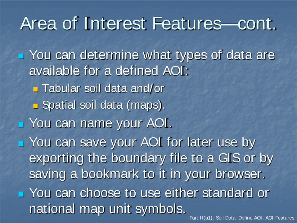
Area of Interest Features—cont.
You can determine what types of data are available for a defined AOI: Tabular soil data and/or Spatial soil data (maps).
You can name your AOI. You can save your AOI for later use by
exporting the boundary file to a GIS or by saving a bookmark to it in your browser.
You can choose to use either standard or national map unit symbols.
Part II(a2): Soil Data, Define AOI, Navigate
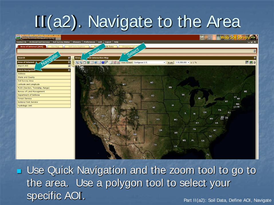
II(a2). Navigate to the Area
Use Quick Navigation and the zoom tool to go to the area. Use a polygon tool to select your specific AOI.

Part II(a2): Soil Data, Define AOI, Navigate
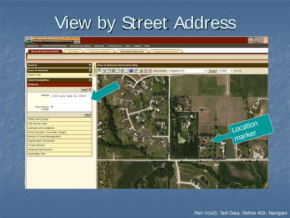
Navigate by Street Address
Part II(a2): Soil Data, Define AOI, Navigate
View by Street Address

Part II(a2): Soil Data, Define AOI, Navigate
Manage Display of Data Layers
• Click on the “Legend” tab.• Turn layers on or off by checking or unchecking boxes on
the legend.
Part II(a2): Soil Data, Define AOI, Navigate
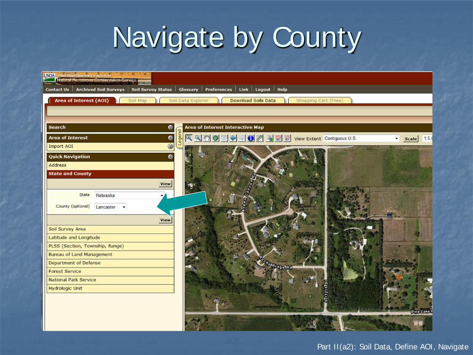
Navigate by County
Part II(a2): Soil Data, Define AOI, Navigate
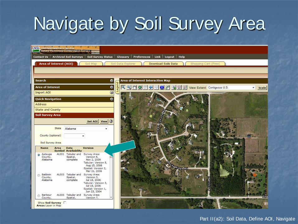
Navigate by Soil Survey Area
Part II(a2): Soil Data, Define AOI, Navigate
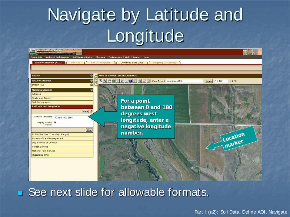
Navigate by Latitude and Longitude
See next slide for allowable formats.

Part II(a2): Soil Data, Define AOI, Navigate
Allowable Coordinates for Latitude and Longitude
All coordinates are assumed to be specified with reference to the WGS 84 spatial reference. Latitude is specified first, except in the Well-Known Text (WKT) format.
Decimal Degrees 46.8075,-100.78306 46.80750 N 100.78306 W 46.8075~-100.78306 46.8075° -100.78306°
Degrees/Minutes/Decimal Seconds 46° 48' 27" N, 100° 46' 59.016" W 46d 48' 27" N 100d 46' 59.016" W 46°48'27"N,100°46'59.016"W 46:48:27N 100:46:59.016W
Degrees/Decimal Minutes 46° 48.45', -100° 46.9836'
GPS N 46 48.45 W 100 46.9836
GNIS 464827N 1004659W
WKT (-100.78305 46.80749) (-100.78305%2046.80749)

Part II(a2): Soil Data, Define AOI, Navigate
Navigate by Public Land Survey System (Section, Township, and Range)

Part II(a2): Soil Data, Define AOI, Navigate
Navigate by Federal Land Management Agencies

Part II(a2): Soil Data, Define AOI, Navigate
Example: Bureau of Land Management
• Select a State office.• Select a field office.• Click the "View" button.• The outline of the
selected area is then displayed on the map.
• A similar process is available for the other Federal agencies listed.

Part II(a3): Soil Data, Define AOI, Define Specific AOI
II(a3). Define the Specific AOI Remember, you must specifically set the AOI
before you can view soil maps or data. You can define an AOI by:
Drawing a polygon on a map Using the rectangle tool, or Using the multi-sided polygon tool;
Selecting a soil survey area; Importing an AOI boundary file; Embedding bounding coordinates in a URL; or Using a previously bookmarked link.
Part II(a3): Soil Data, Define AOI, Define Specific AOI
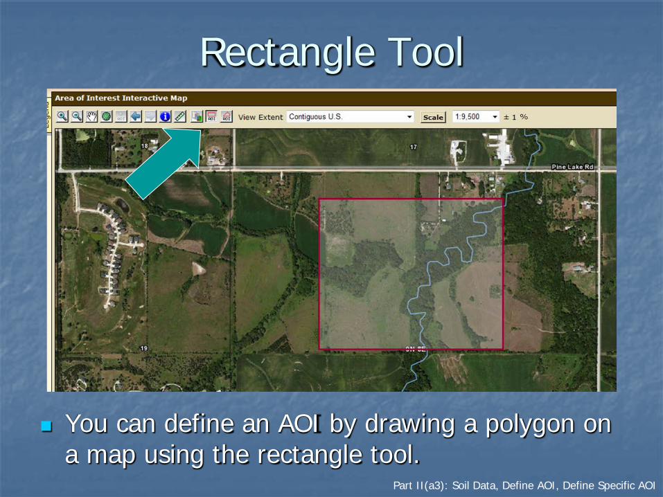
Rectangle Tool
You can define an AOI by drawing a polygon on a map using the rectangle tool.

Part II(a3): Soil Data, Define AOI, Define Specific AOI
View Selected AOI
Part II(a3): Soil Data, Define AOI, Define Specific AOI
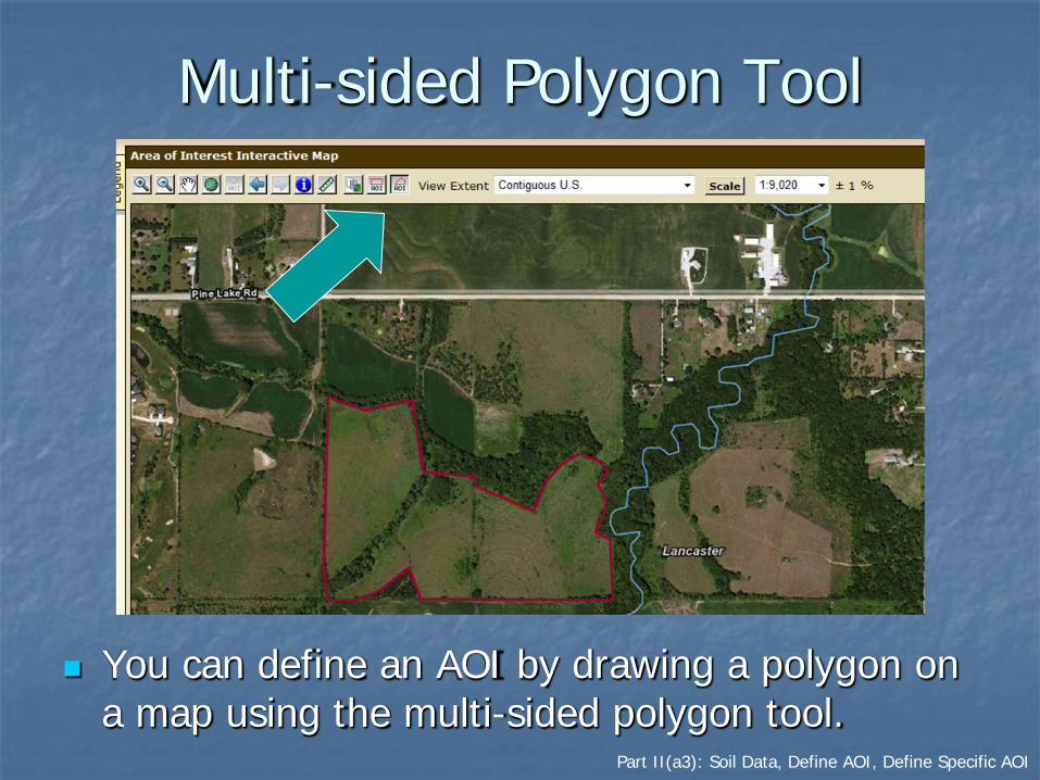
Multi-sided Polygon Tool
You can define an AOI by drawing a polygon on a map using the multi-sided polygon tool.

Part II(a3): Soil Data, Define AOI, Define Specific AOI
View Selected AOI
Part II(a3): Soil Data, Define AOI, Define Specific AOI
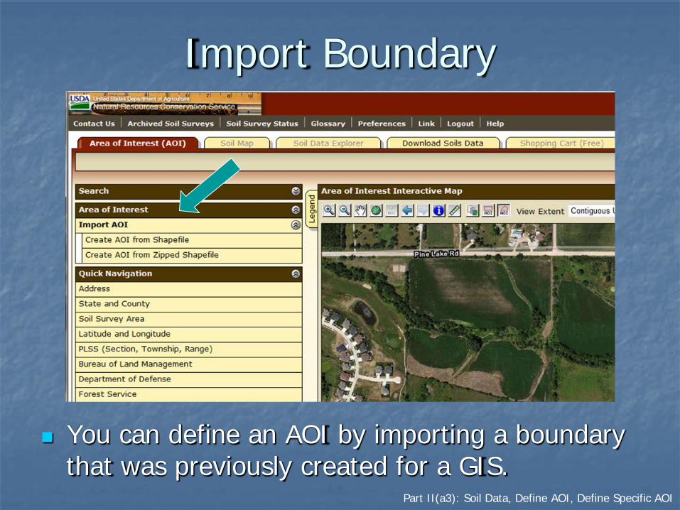
Import Boundary
You can define an AOI by importing a boundary that was previously created for a GIS.

Part II(a3): Soil Data, Define AOI, Define Specific AOI
Import Boundary—cont.
Import the required .shp, .shx, and .prj files from your local computer. The files can be imported as zipped or unzipped files. Use the “Browse” buttons to find the files. After files have been identified, click “Set AOI” button.

Part II(a3): Soil Data, Define AOI, Define Specific AOI
Saving the AOI as a Link
• After you have defined an AOI, you can save the URL as a browser link.
• Click the “Link” tab on the top navigation bar. A dialog box opens showing the URL of your WSS session with coordinates of the AOI boundary.
• Right click on the URL displayed and select “Add to Favorites.” Rename as appropriate.
Part II(a3): Soil Data, Define AOI, Define Specific AOI
Use Bookmarked Link
Find and select a bookmark that you saved from an earlier WSS session. See the previous slide.
Web Soil Survey will open in your browser, and the previously defined AOI will be displayed.

Part II(a3): Soil Data, Define AOI, Define Specific AOI
Set AOI by URL The AOI can also be defined by embedding a set
of coordinate points in a URL. See the following example. http://wss30/app/WebSoilSurvey.aspx?aoicoords=((-
96.97725%2041.28462,-96.97725%2041.29099,-96.96512%2041.29099,-96.96512%2041.28462,-96.97725%2041.28462))
Each coordinate pair represents a vertex point along the AOI boundary.
Part II(a3): Soil Data, Define AOI, Define Specific AOI
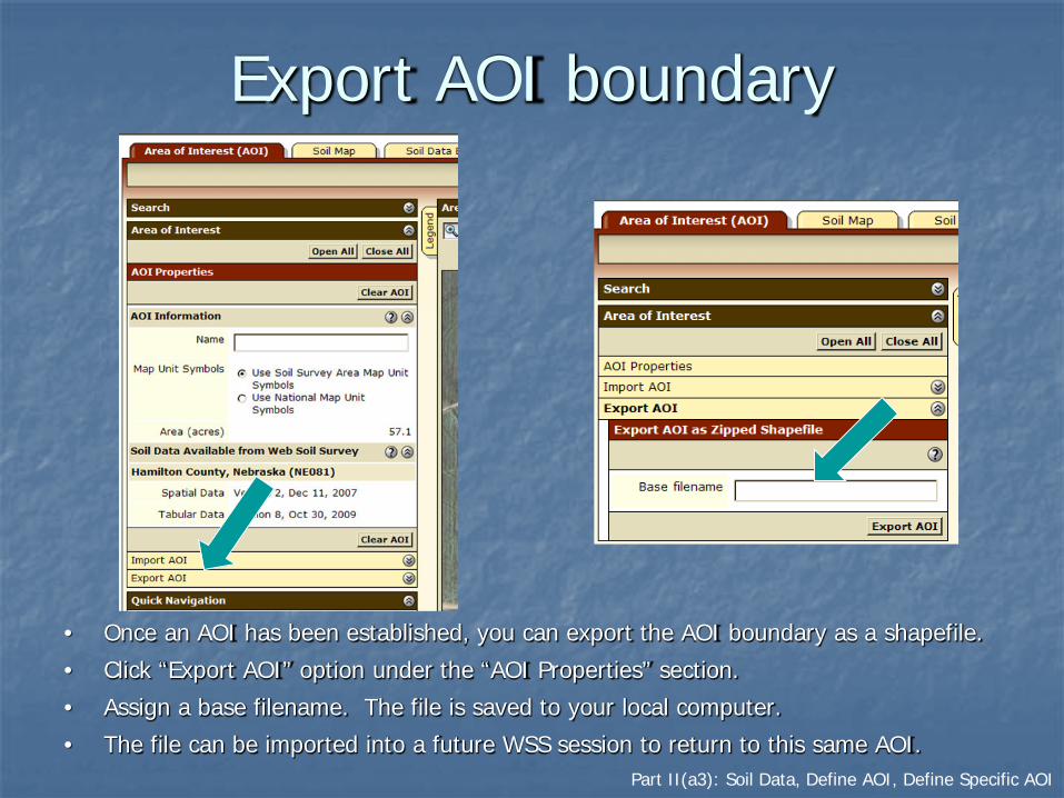
Export AOI boundary
• Once an AOI has been established, you can export the AOI boundary as a shapefile.
• Click “Export AOI” option under the “AOI Properties” section.
• Assign a base filename. The file is saved to your local computer.
• The file can be imported into a future WSS session to return to this same AOI.

Part II(a3): Soil Data, Define AOI, Define Specific AOI
Explicitly Clear the AOI
You can clear the current AOI.

Part II(b): Soil Data, View Soil Map
IIb. View Soil Map
After selecting an AOI, click the “Soil Map” tab.

Part II(b): Soil Data, View Soil Map
Map Units Displayed
A soil map for the AOI and a list of soil map units are displayed.

Part II(b): Soil Data, View Soil Map
View Printable Map Unit Description
• Click on a map unit name at left to view a map unit description.• Clicking on the “Printable Version” button produces a PDF file.

Part II(b): Soil Data, View Soil Map
Print Soil Map
Clicking on the “Printable Version” button produces a PDF file of the soil map and legend.

Part II(b): Soil Data, View Soil Map
Print Options
Part II(c): Soil Data, Explore Soil Information
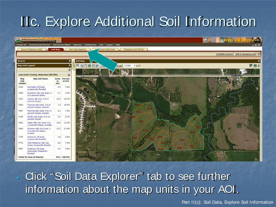
IIc. Explore Additional Soil Information
• Click “Soil Data Explorer” tab to see further information about the map units in your AOI.
Part II(c): Soil Data, Explore Soil Information
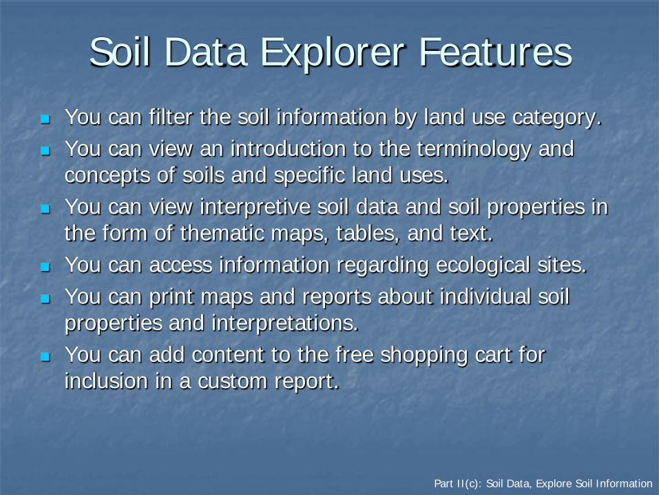
Soil Data Explorer Features You can filter the soil information by land use category. You can view an introduction to the terminology and
concepts of soils and specific land uses. You can view interpretive soil data and soil properties in
the form of thematic maps, tables, and text. You can access information regarding ecological sites. You can print maps and reports about individual soil
properties and interpretations. You can add content to the free shopping cart for
inclusion in a custom report.

Part II(c): Soil Data, Explore Soil Information
Help

Part II(c): Soil Data, Explore Soil Information
Introduction to Soils
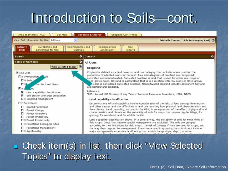
Part II(c): Soil Data, Explore Soil Information
Introduction to Soils—cont.
Check item(s) in list, then click “View Selected Topics” to display text.
Part II(c): Soil Data, Explore Soil Information
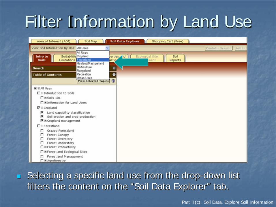
Filter Information by Land Use
Selecting a specific land use from the drop-down list filters the content on the “Soil Data Explorer” tab.

Part II(c): Soil Data, Explore Soil Information
Example: Forestland Information
List of topics narrowed to those related to Forestland.

Part II(c): Soil Data, Explore Soil Information
Adding to Shopping Cart
Material displayed in right-hand panel (text, maps, tables, etc.) can be added to the shopping cart. The content is bundled in the shopping cart as a single PDF file for download or printing.

Part II(c): Soil Data, Explore Soil Information
Suitabilities and Limitations
• You can display a variety of interpretations as thematic maps.• Open a category folder, then select an interpretation. Click “View Rating” button to display
interpretive map.• For further information regarding the options for an interpretation, click the “View Description”
button.

Part II(c): Soil Data, Explore Soil Information
Filter Choices by Land Use
The list of suitabilities and limitations changes based on the land use selected.
List changes according to land use.

Part II(c): Soil Data, Explore Soil Information
Display an Interpretive Map
After selecting an interpretation, click the “Legend” tab to display the map legend. A table is displayed below the map. The table shows ratings and limiting features of each soil in a summary report.

Part II(c): Soil Data, Explore Soil Information
Sample Summary Report

Part II(c): Soil Data, Explore Soil Information
Interpretation Descriptionand Selected Rating Options
Further information regarding the selected interpretation is listed below the “Summary Report” table.

Part II(c): Soil Data, Explore Soil Information
Soil Properties and Qualities

Part II(c): Soil Data, Explore Soil Information
Select a Soil Property or Quality
Note: Additional help is available for view options and advanced options. Click the respective “?” symbol.

Part II(c): Soil Data, Explore Soil Information
Display Results
Individual thematic maps and summary reports can be printed and/or added to the shopping cart. Information added to the cart will be available for creating a custom report.
Part II(c): Soil Data, Explore Soil Information
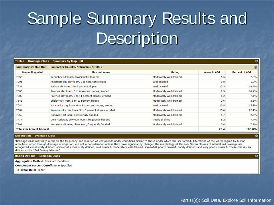
Sample Summary Results and Description

Part II(c): Soil Data, Explore Soil Information
Ecological Site Assessment
View information about ecological sites linked to soil map unit components.

Part II(c): Soil Data, Explore Soil Information
Soil Reports
A broad selection of soil information relevant to specific topics is available in predetermined formats. Select a topic and click on the “View Soil Report” button to generate a report for your AOI.

Part II(c): Soil Data, Explore Soil Information
Sample Soil Report: Chemical Soil Properties
The report is displayed below the soil map.
Part II(d): Soil Data, Shopping Cart
IId. Shopping Cart for Selected Information
WSS allows you to generate a custom soil resource report (in PDF) by adding selections to the free shopping cart. The report is customized for your AOI. The soil map, map unit legend, and map unit
descriptions are included by default. The other content is specifically chosen by you:
Thematic maps (including summary tables and text), Ecological site description map and information, Tabular data tables, and Introductory material.

Part II(d): Soil Data, Shopping Cart
The Shopping Cart
The shopping cart provides you with options for building a report based on your selections from the other tabs.
Part II(d): Soil Data, Shopping Cart
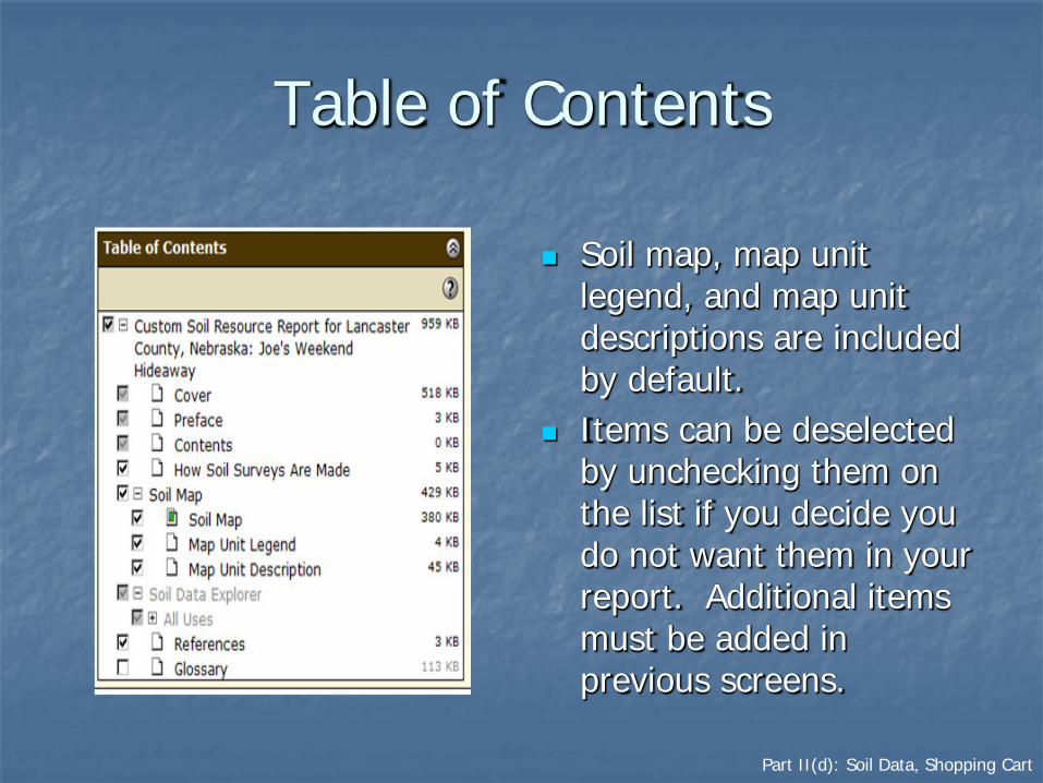
Table of Contents
Soil map, map unit legend, and map unit descriptions are included by default.
Items can be deselected by unchecking them on the list if you decide you do not want them in your report. Additional items must be added in previous screens.

Part II(d): Soil Data, Shopping Cart
Preview an Item

Part II(d): Soil Data, Shopping Cart
Check Out
• During check out, you can elect to get the file now or later. The “Download later” option can be beneficial if the file is large.
• Click the “OK” button to initiate checkout.

Part II(d): Soil Data, Shopping Cart
Generation of Custom Soil Resource Report
The time required to generate the report depends on the size and complexity of the items included and on the current traffic on the system.

Part II(d): Soil Data, Shopping Cart
Custom Soil Resource Report
The report is generated as a PDF file that can be opened directly or saved to your local computer.

Part III: Download Data for GIS
Overview Download
SSURGO Data for an Area of Interest (AOI) SSURGO Data for a Survey Area STATSGO2 data

Part III: Download Data
Overview
WSS 3.0 allows you to download raw soil data for use in a local GIS.
This feature replaces the data download functionality formerly in the Soil Data Mart. You can download: SSURGO data clipped to the AOI boundary, SSURGO data for entire soil survey areas, STATSGO2 data by state or for the entire U.S.
Links to SSURGO metadata reports are available.

Part III: Download Data
Download Soils Data

Part III: Download Data
SSURGO Data for Your AOI
If you have already designated a specific area of interest (see Part II above), you can download the GIS data for the area.

Part III: Download Data
SSURGO Data for a Survey Area
You can download the GIS data for an entire soil survey area. Such areas are commonly entire counties. Scroll through the list of available soil survey areas by state, then click the Download Link.
Set desired options

Part III: Download Data
STATSGO2 Data
You can download STATSGO2 data for the entire U.S. or for individual states.
Click desired link to begin download process.

Questions?
You can get general help from the top navigation bar or context-specific help from the “?” symbols.

More Ways to Get Help
You can get help via email by clicking on “Contact Us” and then clicking on one of the links.