how much can a rock get? a reflection from the ... · a reflection from the okinotorishimarocks 1-3...
TRANSCRIPT

Panel III: Islands and Rocks:
How Much Can a Rock Get? A Reflection from the Okinotorishima Rocks
1-3 December 2010Marriot Metro Center, Washington, DC
Guifang (Julia) XueInstitute for the Law of the SeaOcean University of China (Qingdao)
KMI, COLP, and NILOS Conference on
Globalization and the Law of the Sea

2. Oknotorishima Rocks and Japan’s Islandisation Efforts2. Oknotorishima Rocks and Japan’s Islandisation Efforts
3. Concluding Remarks3. Concluding Remarks
Agenda
1. Regime of Islands and its Implications1. Regime of Islands and its Implications

Islands are important!
� Pearls of the ocean:
-- to generate large areas of waters under sovereignty, sovereign rights and jurisdiction
� Unsinkable aircraft carrier:
-- to support national security
� Natural resources reservoir: living & non-living: fish, oil & gas:
-- to sustain national economic development

1. An island is a naturally formed area of land, surrounded by water, which is above water at high tide.
2. Except as provided for in paragraph 3, the territorial sea, the contiguous zone, the exclusive economic zone and the continental shelf of an island are determined in accordance with the provisions of this Convention applicable to other land territory.
3. Rocks which cannot sustain human habitation or
economic life of their own shall have no exclusive
economic zone or continental shelf.
Regime of Islands--Article 121, Part VIII, UNCLOS

• Primary Criteria: an island must be• a natural feature
• an area of land
• surrounded by water
• above water at high tide
• Relatively uncontroversial• Artificial islands disqualified
• Distinction between islands and low-
tide elevations
• Implications of sea level rise
Implications of Island Regime
• Islands are important, but not all islands are created equal!
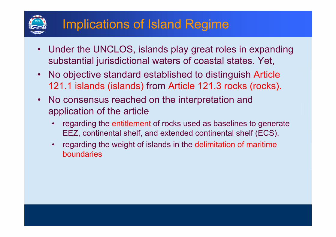
• Under the UNCLOS, islands play great roles in expanding substantial jurisdictional waters of coastal states. Yet,
• No objective standard established to distinguish Article 121.1 islands (islands) from Article 121.3 rocks (rocks).
• No consensus reached on the interpretation and application of the article
• regarding the entitlement of rocks used as baselines to generate EEZ, continental shelf, and extended continental shelf (ECS).
• regarding the weight of islands in the delimitation of maritime boundaries
Implications of Island Regime
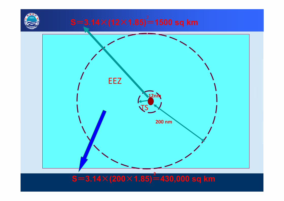
TS
12nm
200 nm
EEZ
S====3.14××××(12××××1.85)====1500 sq km 2
S====3.14××××(200××××1.85)====430,000 sq km 2

Japanese Effort on Okinotorishima Islandisation
“Shima” means “island” in Japanese
1. 5 atoll reefs originally called “Parece Vela” by a Spanish sailor in 1565.2. Later called “Douglas Reef” after a British navigator William Douglas in 1789.3. No official mention about the Okinotorishima prior to 1888 by Japan.4. In 1922 and 1925, Japan investigated the area and confirmed in 1931 that no
other countries had claims and thus declared the reefs its territory.
Kyushu-Palau Ridge

Higashikojima (“Eastern Islet”)
Kitakojima (“Northern Islet”)
Minamikojima (“Southern
Islet”)
Location of latitude: 20 degree 25’ northOkinotorishima: longitude: 136 degree 04’ east
Japanese Effort on Okinotorishima Islandisation
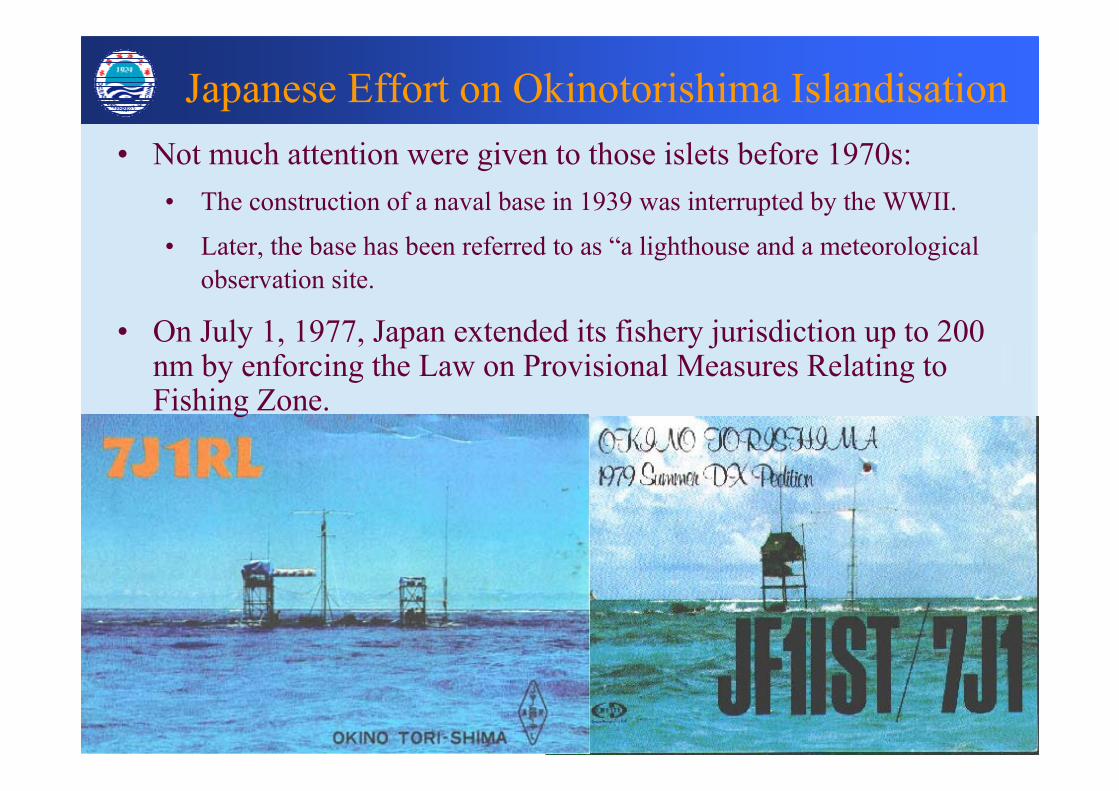
• Not much attention were given to those islets before 1970s:
• The construction of a naval base in 1939 was interrupted by the WWII.
• Later, the base has been referred to as “a lighthouse and a meteorological
observation site.
• On July 1, 1977, Japan extended its fishery jurisdiction up to 200 nm by enforcing the Law on Provisional Measures Relating to Fishing Zone.

• In 1980s, the sea level rise theory was employed and evidenced, and a proposal was raised to build constructions to keep the rocks above water.
• In 1987, the Japanese government launched an embankment building project.
Okinotorishima Islandisation
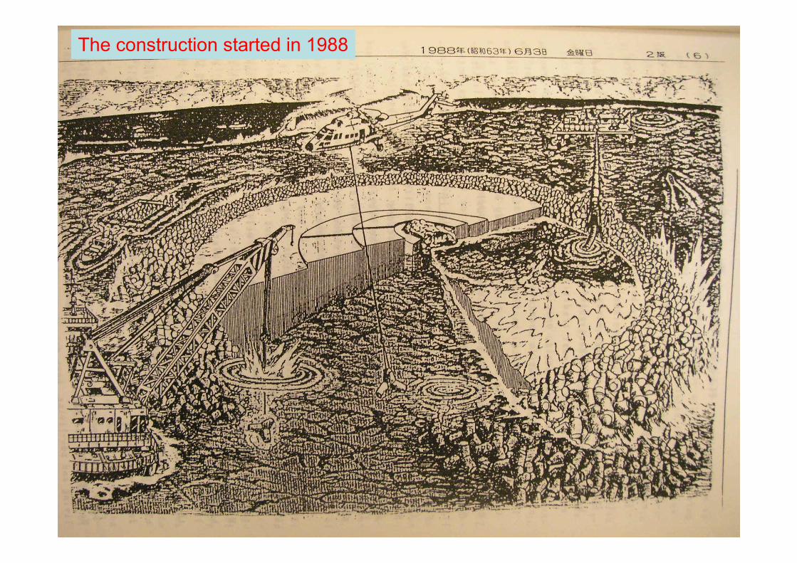
The construction started in 1988

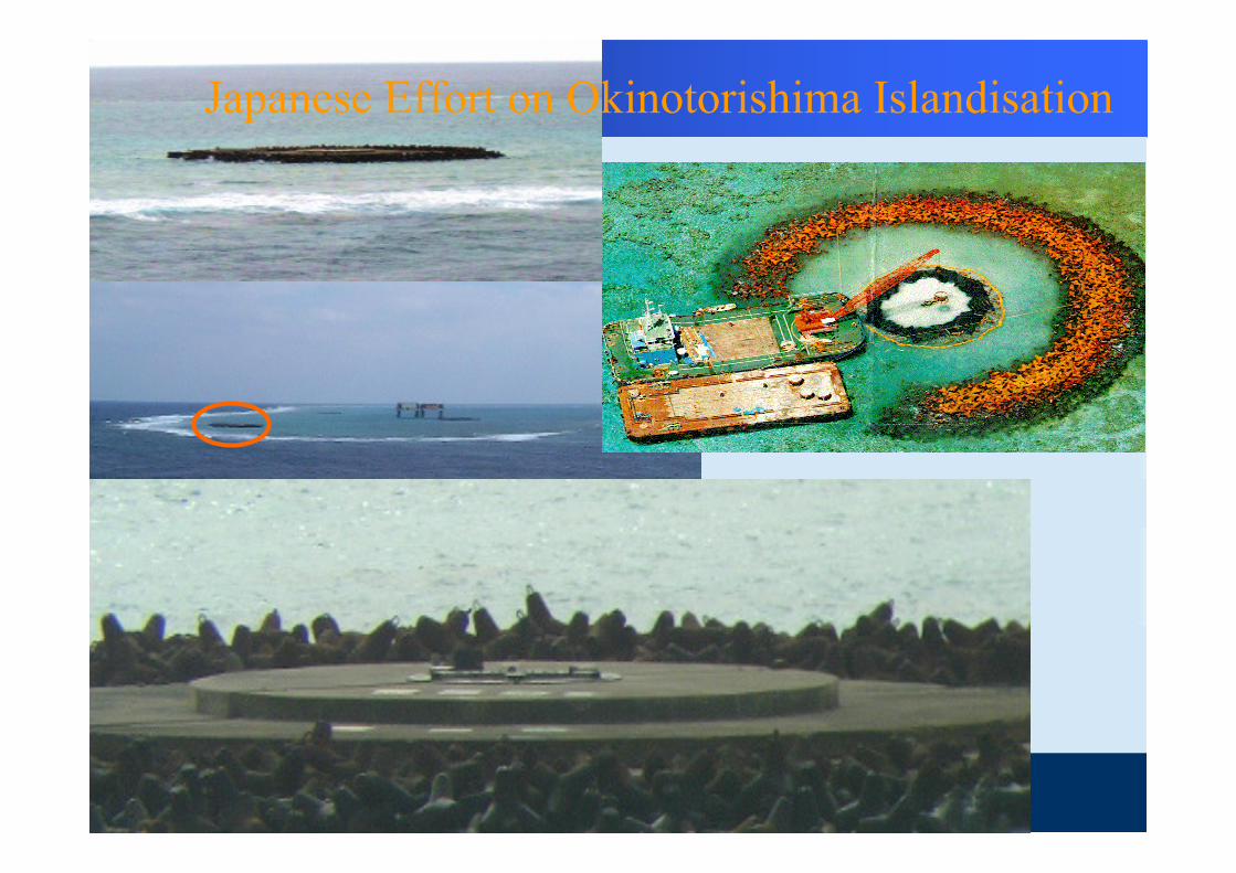
Japanese Effort on Okinotorishima Islandisation
•• During1987During1987--19931993, , artificial artificial
structuresstructures ((steel breakwaters steel breakwaters
and concrete wallsand concrete walls) of ) of 50 50
meters in diametermeters in diameter were built, were built,
and and the original islets the original islets ((natural natural
rocksrocks) have been ) have been completely completely
covered up covered up to stop the erosionto stop the erosion..


Station: 8 m
Supporting structure: 13 m
Japanese Effort on Okinotorishima Islandisation

• In 1999, the central government took over the administration and protection tasks according to its amended Coast Act.
• In 2004, the Nippon Foundation dispatched a mission to investigate how to make Okinotorishima and the surrounding EEZ utilized: to breed coral reef, build lighthouse, social infrastructure (port and houses) for human habitation, marine studies, and development, to promote sightseeing, and to build an ocean-thermal energy conservation power plant.
• In 2005, the Nippon Foundation dispatched another mission to focus on feasibility studies in the most promising fields of marine engineering, power generation etc.
Hmm..I think there might be something naturally formed around there. Ah, here it is:Okinotorishima…island?
http://www.japanprobe.com/2007/04/10/okinotorishimaisland/
Japanese Effort on Okinotorishima Islandisation

Japanese Effort on Okinotorishima Islandisation
Japanese Effort on Okinotorishima Islandisation

The 8-billion-Yen cover
Tokyo GovernorShintaro Ishihara
1×1.5 meter

• 2004, the OPRF organized the first conference in protecting the rocks, and later on set up regular forums to examine related issues.
• In 2005, the central government installed a Radar system (¥ 330 million), repaired a heliport, and placed an official address plaque.
• In 2007, the Japan Coast Guard installed a light beacon for surveillance.
Japanese Effort on Okinotorishima Islandisation
Japan has spent over $600 million fortifying the rocks to prevent them from being washed away and to meet the minimum criteria for being regarded as a legal island!
Without the Without the
OknotorishiOknotorishi
mama rocks, the rocks, the
TS of Japan TS of Japan
will retreat to will retreat to
its south its south
most tip of most tip of
MinamiMinami--Io Io
ToTo--shimashima, ,
and suffer a and suffer a
loss of 1550 loss of 1550
sq km TS sq km TS
and 430,000 and 430,000
sq km EEZ.sq km EEZ.
EEZ and CS based on Oknotorishima Rocks

Proposed Map of ECS Submission in 2005
ECS extension up to 350 nms

Japan’ ECS submission on 12 Nov. 2008
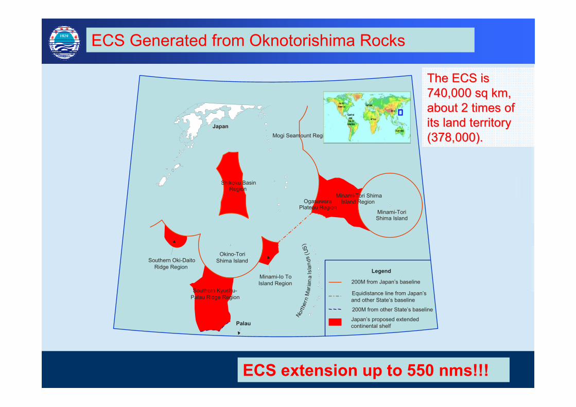
ECS Generated from Oknotorishima Rocks
1. Southern Kyushu-Palau Ridge Region,,,,
KPR
2. Minami-Io To Island Region,,,,MIT
3. Minami-Tori Shima,,,,MTS
4. Mogi Seamount Region,,,,MGS
5. Ogasawara Plateau Region,,,,OGP
6. Southern Oki-Daito Ridge Region,,,,ODR
7. Shikoku Basin Region,,,,SKB
Japan
Legend
200M from Japan’s baseline
200M from other State’s baseline
Equidistance line from Japan’s and other State’s baseline
continental shelfJapan’s proposed extended
NorthernMar ianaIslands(US)
Minami-ToriShima Island
Mogi Seamount Region
Okino-ToriShima Island
Palau
Shikoku Basin Region
Ogasawara Plateau Region
Minami-Tori ShimaIsland Region
Southern Kyushu-Palau Ridge Region
Minami-Io To Island Region
Southern Oki-Daito Ridge Region
The ECS is The ECS is
740,000 sq km, 740,000 sq km,
about 2 times of about 2 times of
its land territory its land territory
(378,000).(378,000).
ECS Generated from Oknotorishima Rocks
ECS extension up to 550 nms!!!

•Para. 2 of Section 6.1 of the Executive Summary of the Japanese Submission: it is suggested that the ridge forms part of the natural prolongation of Japan's land mass represented by Okinotorishima Island (so called!).
• Maritime features could be accorded to maritime zones, but not all features are entitled to EEZ and beyond.
• The vagueness of UNCLOS island regime has resulted in:-- Enduring complexities of maritime claims
-- Excessive baseline claims
-- Sovereignty disputes over Islands-- Disputes over weight accorded to insular features
• Increasing assertiveness on maritime disputes
• Aggressive extended continental shelf submissions
Concluding Remarks

27
• Should interpretation and implementation of
international laws be guided by general obligation of a
State with good faith?
• As States move forward with excessive claims and
islandsation initiatives, is there a potential danger of
undermining international laws and encroachment of
the common heritage of mankind?
• Who should defend the interests of international
community, and how?
Concluding Remarks
Guifang (Julia) XueLaw of the Sea Institute Ocean
University of China238 Songling Road, Qingdao
266103, PR China Tel::::0532-66782330Fax::::0532-66781851
Email: [email protected]
THANK YOU FOR YOUR ATTENTION!