how many tower-houses were there in the scottish borders ... · the castle studies group journal no...
TRANSCRIPT
THE CASTLE STUDIES GROUP JOURNAL NO 25: 2011-12224
How Many Tower-houses were there in the Scottish Borders?A few observations.
Alastair Maxwell-Irving, FSA, FSAScot.

THE CASTLE STUDIES GROUP JOURNAL NO 25: 2011-12 225
How Many Tower-houses were there inthe Scottish Borders? A few observationsAlastair Maxwell-Irving, FSA, FSAScot.
Abstract
The question of how many tower-houses therewere in the Scottish Borders crops up from timeto time, but nobody has yet been able to give adefinitive answer. This paper deals with a num-ber of aspects of the subject, and attempts toshow why there can be no simple answer. Itcompares the work of early surveyors and mapmakers in the 16th and 17th centuries, togetherwith the written records of the period, and triesto explain some of the differences between whatwas recorded then and what has been learnedfrom more recent research. At the same time, italso tries to clarify the distinction between thedifferent types of fortified houses in the Bordersduring the later Middle Ages, and why this isrelevant to such analyses.
At a recent conference on castles, the old ques-tion of how many tower-houses there were in theScottish Borders cropped up once again duringa general discussion. As far as I know it is asubject that has never been seriously researchedin its entirety, and despite having spent wellover half a century studying and researching thetowers myself, it was a question I could notanswer. Indeed, I do not think anyone can givea definitive answer, for a number of reasons.
For a start: What does one mean by a ‘Bor-der Tower’, and what point in history should onetake as one’s datum? These defensive strong-holds came in all shapes and sizes over a periodof nearly 300 years. From the great tower-housecastles of the late 14th and 15th centuries to thelesser towers of the 16th century and later, moreand more of these strongholds were being built,and rebuilt, while others were disappearing fromthe scene, for one reason or another - Englishinvasions, clan feuds, the official razing of thehomes of those declared outlaws, or those justabandoned. And then there were the strong-holds of lesser families, pele-houses, bastle-houses and simple peles. Should they also beincluded? There is no simple answer.
The most obvious starting point for any suchsurvey is the maps of Timothy Pont, surveyedduring the closing years of the 16th century andfirst published by Joan Blaeu in 1654 (Koeman,70-76). There are a total of ten maps covering
the three Marches of the Borders: The Merse,Lauderdale, Tweeddale, Teviotdale, Liddesdale,Eskdale & Ewesdale, Annandale, Nithsdale,Eastern Galloway and Mid Galloway. Unfortu-nately, only one sheet of Pont’s original manu-scripts for the Borders has survived forcomparison; this covers all of Nithsdale and,separately in one corner, a small portion ofTeviotdale (Stone, 187-197). Pont’s maps areof inestimable value for what they have record-ed, but at the same time they are very frustrat-ing, as he does not appear to have always beenconsistent in the symbols he used to denote thevarious townships, castles, tower-houses, etc.,and Blaeu’s interpretation of his manuscriptshas further muddied the water by the wholesale‘editing’ of Pont’s symbols to provide a morestandardized appearance of the maps.1 Pont’ssketches, where available, remain a much morevaluable resource.
A simple count shows that the total numberof individual ‘habitations’ (towers, bastles, pe-les, fermtouns, homesteads, settlements, etc.)that Pont/Blaeu recorded was about:
4592 East March 7693 Middle March
12604 West March
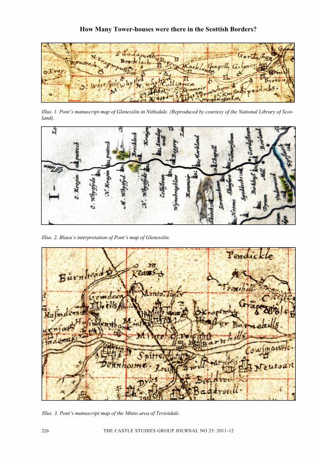
This gives an overall total of about 2488 ‘habi-tations’, excluding towns and large villages.But this can only be taken as a rough guide. Onehas also to bear in mind that Pont never mappedUpper Annandale, from Lockerbie northwards.5A major handicap in comparing Pont’s mapswith Blaeu’s copies is the absence of so many ofPont’s originals, and when the sole survivingone for the Borders is compared with Blaeu’s‘copies’, there are major differences. For exam-ple, in Glenesslin, a tributary of the Cairn Waterin Dumfriesshire, Pont marks 7 sites with a‘tower’ symbol and 11 with a plain circle, ‘o’,whereas Blaeu just shows 18 ‘towers’ (Illus.1and 2). This seems to have been for cartograph-ic convenience, to produce a ‘pretty’ map, but itcompletely distorts the statistics, and we are leftwondering how many towers there really were,not only here but elsewhere too. It is only fairto point out, however, that Pont’s manuscriptsare often written in a very small script that is inmany places scratchy, or overwritten, and diffi-cult to read. If we knew for certain that the ‘o’symbol used by Pont represented a fermtoun orhomestead without a tower, it would help, but,whilst Pont correctly shows the humble ‘pele’ of
How Many Tower-houses were there in the Scottish Borders?
THE CASTLE STUDIES GROUP JOURNAL NO 25: 2011-12226
How Many Tower-houses were there in the Scottish Borders?
Illus. 2. Blaeu’s interpretation of Pont’s map of Glenesslin.
Illus. 1. Pont’s manuscript map of Glenesslin in Nithsdale. (Reproduced by courtesy of the National Library of Scot-land).
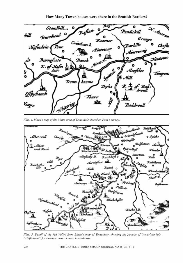
Illus. 3. Pont’s manuscript map of the Minto area of Teviotdale.

THE CASTLE STUDIES GROUP JOURNAL NO 25: 2011-12 227
Brockloch, in Glenesslin, with the tower sym-bol (its ruins survive) (RCAHMS – Glenesslin1994, Figs. 11, 14) on his Nithsdale map (Illus.1), this is clearly not the case elsewhere. Fer-mtouns, moreover, often had a tower as well formutual defence, classic examples being foundin Peeblesshire at Glentress, Langhaugh andLour (RCAHMS 1967, Nos.505, 515, 517).
Other subtle, but important, differences be-tween Pont’s and Blaeu’s versions of Nithsdaleinclude: (1) Glencairn Castle, where Pont hasdrawn a tall tower with corbelled-out parapet,turrets and two side towers with pitched orconical roofs, whereas Blaeu has omitted theparapet and turrets and only shown small sidewings without roofs; (2) Terregles, wherePont’s large tower with side towers has beenreduced by Blaeu to a standard, single tower; (3)Caerlaverock Castle, where Pont’s attempt toindicate the substantial size of the 13th centurycastle has again been changed by Blaeu to asimple tower like any other; (4) Enoch Castle,where Pont’s portrayal of a large tower withseveral secondary buildings has been reduced toa simple tower with wings or a barmkin; and (5)Over and Nether Gribton, which Blaeu shows astwo towers, whereas Pont clearly differentiatesbetween the two, by indicating the former withan ‘o’ and the latter with a tower. These are justa few examples; there are many more.
In dealing with the small fragment of Pont’ssurvey of Teviotdale that has survived - the areaaround Hawick and Ancrum - Blaeu has resort-ed to much simpler symbols, perhaps to get sucha large area on one map. The area aroundMinto, for example, where Pont has clearlyshown Minto Tower (Fatlips) on a hill andvarious sized towers at Minto, Barnhills, MintoCraig, Newton, Denholm and Hassendean (Il-lus. 3), has been reduced by Blaeu to no morethan a series of ‘o’ symbols (Illus. 4); and thispractice was repeated throughout most of Tevi-otdale (Illus. 5). Many of the spellings of placenames have also been changed, and Barnhillsand Minto Craig have ended up on the wrongsides of Craigend Burn! In Teviotdale as awhole, Blaeu gives 483 habitations, only 107 ofwhich are shown as towers (including just 11major castles), leaving the vast majority as plain‘o’s (Blaeu Atlas 2006, Map 3, ‘Teviotdale’).But this is a complete distortion, for many of thelatter are known to have been towers, many ofwhich still exist, while others are recorded in
documents. Apart from the towers aroundMinto just described, another example is thetower of Dolphinston, which is now just a site 4miles SE of Jedburgh. It is shown as an ‘o’(Illus. 5), yet it has a well documented historyas a “tower and fortalice” (“cum turre et fortali-cio”), first in the possession of the Ainslies ofDolphinston, and then, after being acquired bymarriage, in the possession of the Kers of Lit-tledean (RMS III, No. 342; IV, No. 489; V, No.1456; Scots Peerage VII, 330-1). “Dolphis-toun” is also specifically mentioned in an Act ofParliament of 1481, as one of the places where20 ‘men of war’ were to be posted (APS II,140). It is even more confusing, when one findsMervinslaw pele-house (Illus. 15), near Jed-burgh, shown as a tower (Illus. 5), while thesimilar, and neighbouring, pele-houses atSlacks (Illus. 16) and Northbank only merit an‘o’, and a fourth pele-house, at Kilnsike, ap-pears to have been omitted altogether (despitethe ruins surviving to this day) (RCAHMS1956, Nos. 931, 933, 934). Another pele-house,at Leitholm, is also omitted from the map of‘The Merce’ (RCAHMS 1915, No. 140).
It is misleading where groups of towers areonly shown as a single entity. There are twoknown examples in Teviotdale. One is at Lan-ton, near Ancrum, where a restored tower stillsurvives. Whilst the settlement is only shownby a single ‘o’, there are known to have beentwo other towers in the village (RCAHMS1956, Nos. 433, 434). Darnick also had threetowers, two of which survive, one in its entirety(Illus. 22) and the other as a much altered ruin(RCAHMS 1956, Nos. 580, 581).
Towns and other large communities are morecomplex, for, like the hill-towns and cities ofmediaeval Italy and some other parts of South-ern Europe, where defensive towers proliferat-ed, either for individual or mutual protection,some of those in the Scottish Borders had anumber of towers and bastle-houses. Jedburgh,for example, is known to have had at least sixtowers, Hawick had several (RCAHMS 1956,p.44), including Drumlanrig’s Tower (Illus. 20)and Lockerbie had two, with several others,now lost, close by. Bastle-houses were evenmore numerous, being a cheaper form of de-fence for communities throughout the Middleand East Marches, though only three are knownin the West March. In the earlier years of the16th century, these were by no means always
How Many Tower-houses were there in the Scottish Borders?
THE CASTLE STUDIES GROUP JOURNAL NO 25: 2011-12228
How Many Tower-houses were there in the Scottish Borders?
Illus. 4. Blaeu’s map of the Minto area of Teviotdale, based on Pont’s survey.
Illus. 5. Detail of the Jed Valley from Blaeu’s map of Teviotdale, showing the paucity of ‘tower’symbols.“Dolfintoun”, for example, was a known tower-house.

THE CASTLE STUDIES GROUP JOURNAL NO 25: 2011-12 229
How Many Tower-houses were there in the Scottish Borders?
built entirely of stone, and the roofs were ofthatch, so they fell an easy prey to Englishraiding parties, especially in the 1540s (L & P,Henry VIII, XIX, Nos. 333, 625; XXI, No.1279). In November 1544, no less than “16strong bastell houses” were burnt in Lessudenalone in one raid by Sir Ralph Eure (Armstrong,lxx). Towers of stone often merited specialmention, such as during a raid in November1543, when “a stone howse in Overhowden[was] spoyled”, while other towers were “burnt”(Armstrong, lviii), and a year later “a towre ofthe lord of Bucklughe’s called Mosse-House[was] smoked very sore” (Armstrong, lxvi).6 Inthe same month, Sir Bryan Layton burnt Little-ton Hall and stables and all the other housesthereabouts, “saving the stone house” (Arm-strong, lxvi). Incidentally, the callous disregardfor life and property in these raids was stagger-ing. One English report for 1543-4 records 222towns and 133 houses burnt, 4 towns ‘spoiled’,8 other properties damaged, 89 Scots killed and695 taken prisoner, as well as more than 11,000horses, cattle and sheep taken or ‘burnt’ (in thegeneral conflagrations of barns, etc) (Arm-strong, lv-lxiii).
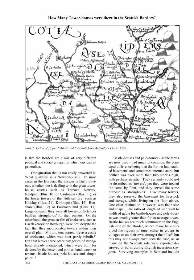
Blaeu’s map of Liddesdale is quite differentfrom Teviotdale; it shows 157 habitations, onlythree of which are mere ‘o’s. The rest are allshown as towers, including the major strongholdof Hermitage Castle. Were they really all tow-ers? Certainly life in Liddesdale was hazardousto say the least. By comparison, a less formalsurvey of the area was carried out only a fewyears earlier for Lord Burghley by Edward Agli-onby. Popularly known as “Aglionby’s Platte”,it is dated ‘December 1590’ (Illus. 8) (Archaeo-logia XXII (1829), 161-171). It does not claimto be a comprehensive map of the area, butnames 108 significant Scottish towers from Lid-desdale to Annandale (excluding the castles ofCaerlaverock and Lochmaben). Interestingly,twenty five of these are towers in Upper Annan-dale that were omitted from Pont’s ‘Annandale’(Blaeu Atlas 2006, Map 10, ‘Annandale’); buteven that list omits some of the surviving tow-ers, such as Lochhouse Tower (Illus. 18), Gle-nae, Boreland, Breconside, Frenchland,Blacklaw, Mellingshaw, Raecleugh, Kinnelheadand Whamfray,7 as well as omitting others, suchas Dinwiddie, whose site is now lost.8 In Lid-desdale itself, 21 ‘significant’ towers are shownon the Scottish side of the Border - as well as 23
on the English side. But it was by no means thewhole story. In the parish of Castleton alone,the RCAHMS, in their Inventory for Rox-burghshire, list 17 known ‘sites’, apart fromruins, and in the county as a whole 52 ‘sites’.9
The recorded sites are largely those whereruined walls could still be seen, or local traditionidentified heaps of rubble, when the earliestOrdnance Survey maps were made. The case ofDolphinston has already been mentioned, wherethe O. S. map shows the “site” within a smallclump of trees. Other sites, such as Cockburn’sCastle and Eldinhope in the Yarrow valley, re-corded the “remains of” towers, where all thatcan be seen today is a heap of overgrown stonesbarely even showing the outline of the formerwalls. These were commonly the successors ofearlier towers of timber, so many of which fellvictim to the English raids of the 1540s. In1544, Lord Wharton “burnt Bonshaw, Robgylland all the houses, peills, steds, and corn in theirway” in Kirtleside, Dumfriesshire (Armstrong,lxvi); but when the Earl of Sussex came on therampage in 1570, he felt he had to employ muchmore drastic measures, demolishing and de-stroying with gunpowder “The Castell of Car-lavrok, . . . Closburne, Tynnell, Bonshaw, anddyvers uther houssis” (Irving, 43). Bonshaw isknown to have been rebuilt around that time,and in 1585 it was described by Lord Scrope, theEnglish Warden of the West March as “one ofthe strongest howses of that border” (Illus. 12)(Border Papers I, No. 321). Nearby was anotherIrving tower, Woodhouse, whose name waspresumably self-explanatory; it too was rebuiltin stone, the ruins of which may still be seen.10
Whilst timber towers were going up in smokeright across the Borders in the 1540s, a wholenew generation of stone towers started to comeon the scene after the Reformation of 1560. Thiswas a direct result of the Reformation itself.Lands that had formerly been possessed by thechurch were now acquired by the local noblesand their families, leading to much greater secu-rity in their possession. This in turn led to agreat increase in the building of stone towers,especially after the English incursions of 1570,and again in the 1580s. The dates on many ofthese towers record their construction.11
Just as the Romans had established signalstations throughout their empire to give rapidwarning of trouble over long distances, so theBorderers had as early as the 13th century estab-

THE CASTLE STUDIES GROUP JOURNAL NO 25: 2011-12230
How Many Tower-houses were there in the Scottish Borders?
Illus. 6. Detail from Blaeu’s map of the Manor Valley in Tweeddale, showing an abundance of ‘tower’ symbols.Peebles is on the right.
Illus. 7. Detail from Blaeu’s map of The Merse around Home Castle.

THE CASTLE STUDIES GROUP JOURNAL NO 25: 2011-12 231
lished beacons on the hilltops to warn of Englishinvasions; and in 1448 it was decreed that thesebe further augmented by additional beacons ondesignated hilltops up the principal valleys(APS I, 352). At a more local level, families andgroups of families had likewise sited theirstrongholds in such positions that they too hadchains of communication, especially up thevalleys. This became much more evident in thesecond half of the 16th century, when the newtowers were built. The lines of sight can still befollowed. Thus one can follow the link alongthe major valleys of Tweeddale, Teviotdale,Liddesdale, Eskdale, Annandale and Nithsdale,as well as along such lesser valleys as Manor(Illus. 6), Ewesdale, Kirtleside, Glenesslin andthe Cluden, and these can clearly be followed onthe Blaeu maps. It is only in the Merse in theeast and Galloway in the far west that the linksare less obvious. The Merse, being less hilly,relied largely on a few key sites, such as Smail-holm and Home, both of which had a vast fieldof view (Illus. 7). There was also a beacon atEvelaw in the Lammermuirs,12 and no doubtothers whose location is not now known.13
Despite the ravages wrought by English incur-sions - as well as those wrought by the Scots inreturn - beacons did serve a purpose. An Eng-lish raid on Old Roxburgh in June 1545 had tobe abandoned “in consequence of the beaconsburning all round” (L & P, Henry VIII, XIX,No.1279).14 The rallying call had gone out.
The distribution of towers in the Stewartryof Kirkcudbright, the eastern half of Galloway,is more problematic, as the history of the districtbecomes further removed from the frontier poli-tics of the Borders the further west one goes.Whilst Blaeu shows about 725 individual habi-tations or settlements in the area, only 92 areshown with the symbol used for ‘towers’, andonly 38 of these lie west of the Ken-Dee valley.This compares with only 31 towers that can beseen today, either as complete towers or recog-nizable ruins. In addition to these, there are 10other known sites. On the other hand, only 20of Blaeu’s sites are clearly defined as importantcastles or towers, and only 13 of these are stillstanding at least in part, though what little is leftof the once important castle of Cally barelyqualifies.15 If only we had Pont’s original man-uscripts for comparison. An English survey ofthe West March c.1565 only mentions 13 of theprincipal strongholds, namely Cardoness
(Illus.11), Garlies, Threave, Kenmure, San-quhar, Drumlanrig, Castlemilk, Lochmaben,Torthorwald, Maxwell’s Castle in Dumfries,Caerlaverock, Cockpool (Comlongon) and An-nan (Armstrong, Appendix No. LXX). Thiscompares with the more local ‘Platte of Milk-castle’, made in 1547, which only shows Cas-tlemilk, Lochwood, Langholm, Hollows,Mangerton, Cockpool (Comlongon) and Caer-laverock (Merriman, M. ‘The Platte of Cas-tlemilk, 1547’, TDGAS, 3rd Series, XLIV,175-181).
The most complete list of towers in Eskdaleand Annandale was published by the RCAHMSin their volume on ‘Eastern Dumfriesshire’.Based largely on the researches of John andRobert Hyslop of Langholm some ninety yearsearlier (Hyslop 1912), they list a total of 116known towers and places of strength, togetherwith a map showing their locations (RCAHMS1997, 211, 312-5).16 The sites of four of themare ‘uncertain’. There are a number of knownomissions in Annandale and Kirtleside, and afew others whose existence and location is nowlargely lost. It does, nevertheless, provide abenchmark against which the other sources canbe judged for that particular area. Aglionby’stotal of 108 towers, for example, is comparable;but both are very far short of the Blaeu totals of190 habitations for Annandale and 114 for Es-kdale and Ewesdale, a total of 304 habitationsfor roughly the same area.
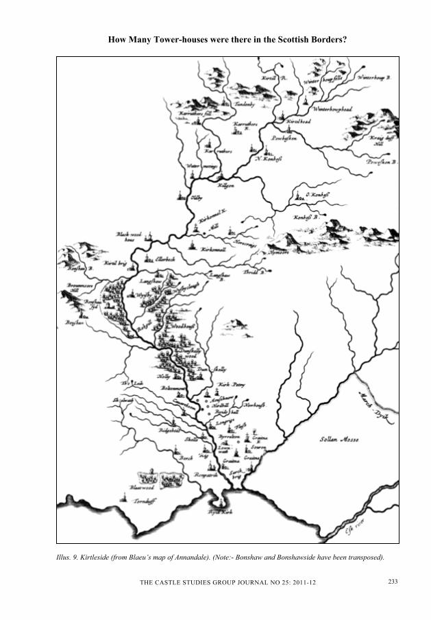
If one narrows the comparison in those sur-veys to just one valley, Kirtleside, theRCAHMS lists just 16 sites, compared with 14on Aglionby’s Platte and no less than 42 onBlaeu’s map (Illus. 9). As the majority of thesites shown by Blaeu were once known towers,including two sites not marked as towers thatwere in fact towers (Mossknowe and Redhall),why the discrepancy? Some of the more re-mote sites, such as Dumbretton, Tundenby,Kirtlehead, Winterhopehead and Carruthers,are associated with ‘homesteads’ and ‘settle-ments’ as recorded on the earliest OrdnanceSurvey maps, and a few, such as Kirtlebridgeand Gretna, are known villages. If one adds tothis perhaps a generous half dozen other ‘settle-ments only’, that still leaves about 31 actualtowers, twice as many as previously listed; andif one were to extrapolate that across the wholeof Annandale and Eskdale, it would give a totalfor that area of about 230 towers. The difficulty
How Many Tower-houses were there in the Scottish Borders?
THE CASTLE STUDIES GROUP JOURNAL NO 25: 2011-12232
How Many Tower-houses were there in the Scottish Borders?
Illus. 8. Detail of Upper Eskdale and Ewesdale from Aglionby’s Platte, 1590.
is that the Borders are a mix of very differentpolitical and social groups, for which one cannotgeneralize.
One question that is not easily answered is:What qualifies as a ‘tower-house’? In mostcases in the Borders, the answer is fairly obvi-ous, whether one is dealing with the great tower-house castles such as Threave, Newark,Neidpath (Illus. 10) or Cardoness (Illus. 11), orthe lesser towers of the 16th century, such asHillslap (Illus. 21), Kirkhope (Illus. 19), Bon-shaw (Illus. 12) or Fourmerkland (Illus. 13).Large or small, they were all towers or fortalicesbuilt as ’strongholds’ for their owners. On theother hand, the great castles of enclosure, such asCaerlaverock or Roxburgh were not, despite thefact that they incorporated towers within theiroverall plan. Morton, too, started life as a castleof enclosure, which was later partly rebuilt.17
But that leaves three other categories of strong-hold, already mentioned, which were built fordefence by the lesser, and poorer, landowners ortenants: bastle-houses, pele-houses and simplepeles.18
Bastle-houses and pele-houses - as the termsare now used - had much in common, the prin-cipal difference being that the former had vault-ed basements and sometimes internal stairs, butneither was ever more than two stories high,with perhaps an attic. They certainly could notbe described as ‘towers’, yet they were treatedthe same by Pont, and they served the samepurpose as ‘strongholds’. Like many towers,they also reserved the basement for livestockand storage, whilst living on the floor above.One clear distinction, however, was their sizeand shape. The ratio of length of side wall towidth of gable for bastle-houses and pele-hous-es was much greater than for an average tower.Bastle-houses are much commoner on the Eng-lish side of the Border, where many have sur-vived the rigours of time, either in groups invillages or on their own amongst the hills;19 butthis may not always have been the case, as somany on the Scottish side were reported de-stroyed or burnt during English incursions (su-pra). Surviving examples in Scotland include
THE CASTLE STUDIES GROUP JOURNAL NO 25: 2011-12 233
How Many Tower-houses were there in the Scottish Borders?
Illus. 9. Kirtleside (from Blaeu’s map of Annandale). (Note:- Bonshaw and Bonshawside have been transposed).

THE CASTLE STUDIES GROUP JOURNAL NO 25: 2011-12234
How Many Tower-houses were there in the Scottish Borders?
several ruins and sites in Berwickshire;20 theoldest part of Old Gala House in Galashiels(Illus. 14) (RCAHMS 1957, 41-3); several in-corporated into later buildings in Peebles (Bu-chan I, 251); the ruins of Kinnelhead andRaecleugh in Upper Annandale (Maxwell-Ir-ving, 172, 215); a recently identified bastle inNew Abbey (Ward, 30); possibly Queen Mary’sHouse in Jedburgh;21 and a number further northin Lanarkshire (Ward, 26-30).
Pele-houses, on the other hand, appear tohave been confined largely to the wild moorlandof Southdean parish in Roxburghshire, wherealmost complete, but roofless, examples arefound at Mervinslaw and Slacks (supra)(RCAHMS 1956, Nos. 932, 934). Two moreruins are found at Kilnsike and Northbank(RCAHMS 1956, Nos. 931, 933), while a sec-ond site has been identified at Slacks, and othersites nearby at Hilly Linn, Hindshaughhead,Longslack Sike, Watties Spindles and WhiteHill (RCAHMS 1994 - Southdean, 11-17). Theruins of Glenae Tower, in Annandale, also sug-gest a pele-house (Maxwell-Irving, 147).
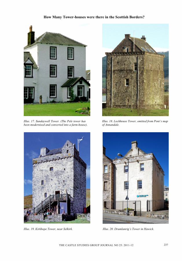
Peles (as opposed to pele-houses) were insome respects the simplest of all towers, thoughthe sole surviving complete example, at Sun-daywell in Glenesslin (Illus. 17) (Maxwell-Ir-ving, 241), although now modernised, showsthat they were not restricted to two floors, butwere indeed ‘towers’. They represented a sim-ple form of tower that appears to have beenlargely confined to the valleys north and west ofDunscore, in Nithsdale. Built of clay mortar ―like most bastles and pelehouses ―, they weresmall and almost square with walls about 3ft(0.91m) thick. Their basements were not vault-ed, and unlike the more typical towers, there isno evidence that any of them had stone stairs.Another at nearby Bogrie was only finally de-molished in the 20th century. The rest are nowso ruinous that only the lowest courses of thewalls and heaps of rubble survive, and most ofthat has been robbed to build dykes. Brock-loch, further up the same valley, is a typicalexample (Maxwell-Irving, 266; RCAHMS 994- Glenesslin, 13-14). It was shown by Pont as a‘tower’ (Illus.1), while other probable sites inthe valley only merited an ‘o’. Other knownsites in the neighbouring Cairn valley, such asStewarton and Auchenfedrick, are not allmarked or named; but none are shown as towers.Pont shows some 18 towers further up the val-
ley, but in addition uses another, simpler symbolfor a further 43, which might have been peles.Blaeu does not discriminate between them,showing them all as towers.
None of this, of course, gives a definitiveanswer to the question of how many towersthere were in the Borders; but it does create apicture of a fairly dense distribution of towers inthe valleys of the Tweed, Teviot, Manor, Liddel,Esk, Ewes, Kirtle, Annan and the Nith and itstributaries, as portrayed by Pont and Blaeu; aless dense distribution in some other valleys;bastle-houses, pele-houses and peles in thepoorer headwaters of valleys such as Glenesslinand in the windswept moorland of Southdean;and a more settled life as one travels furtherwest in Galloway, with a relatively small num-ber of great tower-house castles22 and - if thesurviving sites are to be taken as representative- few of the lesser towers of the 16th century.The evidence would appear to show that the vastnumber of ‘habitations’ shown by Blaeu in theStewartry of Kirkcudbright are very misleading,as, unlike elsewhere in the Borders,23 the vastmajority were nothing more than homesteads,fermtouns (farmsteads) and settlements withoutany tower at all, or indeed the perceived need forone.
Acknowledgements
The author wishes to thank Geoffrey Stell forkindly reading the draft of this paper, and formaking a number of useful suggestions, espe-cially in respect of the RCAHMS’s work on thesubject in their book on Eastern Dumfriesshire.He is also grateful to the Trustees of the Nation-al Library of Scotland for permission to repro-duce extracts from Timothy Pont’s manuscriptsurvey of Nithsdale and Teviotdale.

THE CASTLE STUDIES GROUP JOURNAL NO 25: 2011-12 235
How Many Tower-houses were there in the Scottish Borders?
Illus. 10. Neidpath Castle. Illus. 11. Cardoness Castle.
Illus. 12. Bonshaw Tower. Illus. 13. Fourmerkland Tower.

THE CASTLE STUDIES GROUP JOURNAL NO 25: 2011-12236
How Many Tower-houses were there in the Scottish Borders?
Illus. 14. Old Gala House. (Original Bastle-house incorporated into NW wing of later house).
Illus. 15. Mervinslaw Pele-House. Illus. 16. Slacks Pele-House.
THE CASTLE STUDIES GROUP JOURNAL NO 25: 2011-12 237
How Many Tower-houses were there in the Scottish Borders?
Illus. 17. Sundaywell Tower. (The Pele tower hasbeen modernised and converted into a farm-house).
Illus. 18. Lochhouse Tower, omitted from Pont’s mapof Annandale.
Illus. 19. Kirkhope Tower, near Selkirk. Illus. 20. Drumlanrig’s Tower in Hawick.

THE CASTLE STUDIES GROUP JOURNAL NO 25: 2011-12238
How Many Tower-houses were there in the Scottish Borders?
Illus. 21. Above: Hillslap Tower. Illus. 22. Below: Darnick Tower in 1991.

THE CASTLE STUDIES GROUP JOURNAL NO 25: 2011-12 239
How Many Tower-houses were there in the Scottish Borders?
Notes
1 Blaeu’s desire for standardization is clear-ly seen in his maps for other parts of theBritish Isles (Blaeu’s Atlas reprinted byThames & Hudson) as well as some of hismaps for Mainland Europe, such asFrance, Belgium, Cologne, Northern Italyand Russia (Atlas Maior of 1665). Thereis, however, often a lack of standardisationwhere a given place appears on two, oreven three, overlapping maps, appearingwith one symbol on one and another on theother(s). It is not known whether thisoriginated with Pont or Blaeu.
2 406 in the Merse and 53 in Lauderdale.
3 129 in Tweeddale, 483 in Teviotdale and157 in Liddesdale.
4 114 in Ewesdale and Eskdale, 190 in An-nandale, 231 in Nithsdale, 431 in EasternGalloway and 294 in Mid Galloway.
5 The reason for this omission is not known,especially when he included Corehead onhis map of Tweeddale. More than 30known towers were completely omitted, aswell as the old castle at Auchencass andseveral lost sites.
6 A month later, Sir Ralph Eure “won byassault the Mosse Towre” after a siege of5 hours (L & P, Henry VIII, XIX, Pt. 2,No. 191; Hamilton Papers, II, No. 318),which was elsewhere described as a‘strong’ tower.
7 See Maxwell-Irving 2000, pp.78, 87, 89,143, 147, 172, 208 and 215.
8 Lost sites are now being found by archae-ologists using geophysical techniques,such as ground radar. This has been suc-cessfully employed in recent years to mapout ‘lost’ Norman castles, abbeys and me-diaeval towns and villages in England, aswell as much older sites.
9 In their Inventories for the Borders as awhole, the RCAHMS list 144 ‘sites’, basedlargely on the early Ordnance Surveymaps, but this is far from being a completelist.
10 The ruins were consolidated, with a newstair to the parapet walk, in 1877.
11 e.g. Carsluith (1568), Corbet (1572),Greenknowe (1581), Maclellan’s (1581),Hillslap (1585), Isle (1587), Fourmerk-land (1590).
12 The stone-vaulted top floor of Evelaw’swing could only be justified as the base fora beacon.
13 No doubt the vaulted top floor of Bar-holm’s wing, in Galloway, served a simi-lar purpose to that at Evelaw, thoughposssibly with another object in mind, asBarholm was far from the Border, but veryclose to smuggling activities in the Sol-way.
14 A further Act of the Scottish Council in1587 ordained that “the lieges . . . keepwatch night and day, and burn bales ac-cording to the accustomed order observedat such times upon the borders” (Lockhart,W. E. ‘Historical Notes relating to Branx-holme’, THAS, 1906).
15 Balmangan, Barholm, Cally, Cardoness,Carsluith, Cumstoun, Kenmure, Kirkcon-nell, Machermore, MacLellan’s, Plunton,Rusco and Threave. Little is left of Bal-mangan and Cumstoun (see Maxwell-Ir-ving, pp.68, 115), and even less of Cally.
16 The map actually shows 2 more towersthan are given in the list.
17 The story of Morton’s architectural histo-ry is too complex to discuss here.
18 Although these three types of building arein general architecturally distinct, somearchitectural historians are not happy withsuch stereotyping.
19 See RCHM, 1970 Shielings and Bastles,61-95.
20 Bite-About, Carfrae, Edington, Foulden,Kelloe, Leitholm and Witches Cleuch.
21 See Cruft, et al., 425.
22 e.g. Garlies, Cardoness, Rusco, MacLel-lan’s, Threave and Kenmure.
23 Parliament defined the Borders as all theterritory between the North Sea and theriver Cree in Galloway.
THE CASTLE STUDIES GROUP JOURNAL NO 25: 2011-12240
How Many Tower-houses were there in the Scottish Borders?
Bibliography
APS Acts of the Parliament of Scotland, 1124-1707. Thomson, C and Innes, C (eds.).Edinburgh, 1844-75.
Archaeologia: or Miscellaneous Tracts relatingto Antiquity. Society of Antiquaries ofLondon.
Armstrong, R B 1883 The History of Liddes-dale, Eskdale, Ewesdale, Wauchopedaleand the Debateable Land. Edinburgh.
Atlas Maior of 1665. Reprint of selected maps,Cologne, 2005.
Blaeu’s Atlas of England, Scotland, Wales andIreland. Thames & Hudson, London (un-dated).
Blaeu Atlas of Scotland, The. Reprint, Edin-burgh, 2006.
Border Papers Calendar of Letters and Papersrelating to the Affairs of the Borders ofEngland and Scotland, 1560-1603. Bain,J (ed). Edinburgh, 1894.
Cruft, K, Dunbar, J & Fawcett, R The Buildingsof Scotland: Borders. London, 2006
Hamilton Papers The Hamilton Papers: Lettersand Papers illustrating the Political Rela-tions of England and Scotland in theXVIth Century. Bain, J (ed). Edinburgh,1890-92.
Hyslop J & Hyslop R Langholm As It Was: AHistory of Langholm and Eskdale fromthe earliest times. Langholm, 1912.
Irving, J B The Book of the Irvings, etc. Ab-erdeen, 1907.
Koeman, C Joan Blaeu and his Grand Atlas.Amsterdam, 1970.
L&P, Henry VIII Letters and Papers, Foreignand Domestic, of the Reign of Henry VIII.London, 1862-1910.
Maxwell-Irving, A M T The Border Towers ofScotland: The West March. Blairlogie,2000.
RCAHMS Sixth Report and Inventory of Mon-uments and Constructions in the Countyof Berwick. Edinburgh, 1915.
RCAHMS An Inventory of the Ancient & His-torical Monuments of Roxburghshire. Ed-inburgh, 1956.
RCAHMS An Inventory of the Ancient & His-torical Monuments of Selkirkshire. Edin-burgh, 1957.
RCAHMS Peeblesshire: An Inventory of theAncient Monuments. Edinburgh, 1967.
RCAHMS GLENESSLIN, NITHSDALE: AnArchaeological Survey. Edinburgh, 1994.
RCAHMS SOUTHDEAN, BORDERS: An Ar-chaeological Survey. Edinburgh, 1994.
RCAHMS EASTERN DUMFRIESSHIRE:anarchaeological landscape. Edinburgh,1997.
RCHM Shielings and Bastles. Ramm, H.G. etal. Royal Commission on Historical Mon-uments (England). London, 1970.
RMS Registrum Magni Sigilli Regum Scotto-rum; The Register of the Great Seal ofScotland, 1306-1668. Edinburgh, 1984.
Scots Peerage. The Scots Peerage. Balfour-Paul, Sir J (ed). Edinburgh, 1904-14.
Stone, J C The Pont Manuscript Maps of Scot-land. Tring, 1989.
TDGAS Transactions of the Dumfriesshire &Galloway Natural History & AntiquarianSociety. Dumfries, 1862-
THAS Transactions of the Hawick Archaeolog-ical Society. Hawick, 1856-
Ward, T Glenochar Bastle House and Fer-mtoun. Biggar, 1998.