house trajectories in el cabo, dominican republic: the
TRANSCRIPT
House trajectories in El Cabo, Dominican Republic: The buildingblocks of Late Ceramic Age cultureSamson, A.V.M.; Rebovich S. A.
CitationSamson, A. V. M. (2011). House trajectories in El Cabo, Dominican Republic: The buildingblocks of Late Ceramic Age culture. Proceedings Of The Xxiii Congress Of TheInternational Association For Caribbean Archaeology, 104-126. Retrieved fromhttps://hdl.handle.net/1887/17778 Version: Not Applicable (or Unknown)License: Leiden University Non-exclusive licenseDownloaded from: https://hdl.handle.net/1887/17778 Note: To cite this publication please use the final published version (if applicable).

1
Submission for the proceedings of the XXIII Congress of IACA, Antigua and Barbuda,
June 29 – July 3 2009. Alice V. M. Samson, Leiden University.
House trajectories in El Cabo, Dominican Republic: The building blocks of Late
Ceramic Age culture. The archaeological site of El Cabo, on the east coast of the Dominican Republic, was
inhabited from AD 600 to the first decade of European contact (ca. AD 1504). This paper
focuses on the Chicoid habitation and presents results of excavation from the largest unit.
A rich artefact assemblage and dense posthole configurations allowed reconstruction of
domestic life, including at least fifty indigenous structures, most of which are interpreted
as houses. The reconstruction methodology is described and a typology of built structures
presented. It is argued that the diachronic renewal of the house over the course of
centuries, forming “house trajectories”, was an important factor in the constitution of Late
Ceramic Age culture and sociality.
Le trajectoire de maisons dans le site de El Cabo, La République Dominicaine: Le
fondement de la culture Céramique Tardive. Le site de El Cabo, situé sur la côte est de la République Dominicaine, était occupé de
600 ap JC à la première décennie après la invasion Européenne (1504 ap JC). Cet article
se concentre sur l’occupation Chicoide et présente les résultats des fouilles de la tranchée
plus grande. Un mobilier abondant et des nombreux trous de poteaux ont permis la
reconstruction de la vie quotidienne, y compris au moins de cinquante structures
domestiques, parmi lesquels des plans de maisons. La méthodologie de reconstruction et
une typologie de structures sont élaborées. On raisonne que le renouvellement
diachronique de la maison à travers des siècles, produisait des “trajectoires de maisons”.
Ces trajectoires étaient un élément important dans la culture et socialité de la Céramique
Tardive.
Trayectorias de viviendas en El Cabo, República Dominicana: Los cimientos
culturales de la Cerámica Tardía. El yacimiento arqueológico de El Cabo, ubicado en la costa oriental de la República
Dominicana, estuvo habitado desde el 600 DC hasta la década después de la llegada de
los europeos (aproximadamente 1504 DC). Este artículo abarcará la fase habitacional
Chicoide y los resultados de la excavación de la trinchera mayor. Un gran conjunto de
artefactos y una densa configuración de huecos de poste contribuyeron a la
reconstrucción de la vida domestica. Así como las reconstrucciones de por los menos
cincuenta planos de estructuras indígenas, la mayor parte interpretados como viviendas.
Se describe la metodología de reconstrucción y la tipología de estructuras construidas. Se
argumenta que la renovación diacrónica de las viviendas a lo largo de los siglos dió
forma a las “trayectorias de viviendas”. Estas trayectorias fueron un factor significativo en
la constitución de la cultura y la socialización en la Cerámica Tardía.
Introduction The pre-Columbian archaeological site of El Cabo is situated on the east coast of the
Dominican Republic, overlooking the Mona Passage. The site was first investigated by
researchers from the Museo del Hombre Dominicano in the late 1970s, and in an impact

2
assessment in 2000 the site was deemed vulnerable due to mineral extraction in the area
(Olsen 2000, 2001, Ortega 1978). Since 2005, archaeological and geophysical
investigations have been carried out under the direction of Dr Menno Hoogland and
Professor Corinne Hofman, with a field team from Leiden University, in collaboration
with the Museo (Hofman et al. 2006, 2008, Samson and Hoogland 2007). The
excavations form part of a project funded by the Netherlands Foundation for Scientific
Research (NWO) also involving Dr José Oliver, Dr Lee Newsom and Dr Branko Mušič.
Research in El Cabo reveals a picture of community life spanning a millennium. This
contribution focuses on some of the results from the 10th
to early 16th
century habitation,
specifically relating to house structures. Given the large number of structures, a
description of their individual characteristics is not possible in a short paper.1 This
contribution presents an interpretation of structures and a site typology and describes how
structures articulate into sequences within a community history. Some fifty structures
were reconstructed, the majority interpreted as houses, but also various non-residential
buildings, fences and domestic tools. The habitation area and built structures reveal
details of architecture, house lifecycle, inhabitant composition and related domestic,
ritual and mortuary activities. Four inhumations were recovered as well as a range of
bodily adornments, tools, domestic goods, food remains and socially valuable items. The
community of El Cabo was abandoned in the first decade of the 16th
century, probably
after the second wars of Higüey (1504), or even as late as 1514 (Moya Pons 1992).
Background The location of El Cabo situates it within a cultural-geographical area which is seen as
both the origin of the development of the Chicoid ceramic series; one of the latest
ceramic styles in the Greater Antilles, and within the Mona Passage archaeological area;
identified on the basis of similarities in material culture between the eastern Dominican
Republic and western Puerto Rico (Ortega et al. 2003, Rouse 1951, 1992, Veloz
Maggiolo 1993, Veloz Maggiolo et al. 1973, Veloz Maggiolo and Ortega 1996). On the
basis of ceremonial artefacts, pottery styles and historic texts, this area has been seen as a
locus of innovation and cross-fertilization which has provided a template for complex
society in the region. Recently, this has gained more momentum and the social
mechanisms behind Mona Passage relations have been characterised in terms of
centuries-old genealogical ties between elites, specifically between caciques in an
Higüey-Guaynía network (Oliver 2008, 2009). Research at El Cabo to document the
internal dynamics of Late Ceramic Age settlement brings a domestic and lived
perspective to bear on such models. The research was especially valuable given the rapid
destruction of cultural heritage in the eastern Dominican Republic for large-scale coastal
development.
1 A full interpretation of site structures and community development is the subject of a forthcoming
dissertation by the author.
3
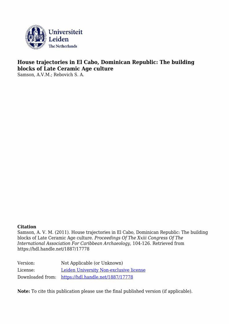
Figure 1 Map of Altagracia province, eastern Dominican Republic, showing sites referred to in the
text.
The eastern part of the Dominican Republic was densely occupied during the Late
Ceramic Age. El Cabo is situated within 40 km of the contemporaneous sites of El Barrio
and Sitio de Pepe (Punta Cana), Macao, Atajadizo and La Aleta, amongst others (Atiles
and Ortega 2001, Conrad et al. 2001, 2008, Ortega 1978, Ortega and Atiles 2003, Veloz
Maggiolo 1976, Veloz Maggiolo et al. 1991, Veloz Maggiolo and Ortega 1972, 1996).
The site of El Cabo itself occupies a low coastal promontory of uplifted carbonate lagoon
deposits, softer than the hard coral coastline on either side. The Mona Passage linking
Altagracia and the west coast of Puerto Rico was a busy shipping lane in early contact
times (Lovén 1935). The site commands an excellent view of the coast and out to sea,
although there are no easy harbours, nor ready access to the beach. To the west, at a short
distance inland, the site is ringed by cliffs. These cliffs, karst formations riddled with
caves, reveal a considerable precolonial presence, including mortuary remains and
petroglyphs in some of the local caves. There are a myriad of smaller sites within a short
walk of the site, testified by the presence of surface pottery scatters on the coast, probably
fishing spots and lookouts, and others at the base of the cliffs or associated with bathing
4
water sources and possible ceremonial areas (Johnson this volume, Johnson 2009, Olsen
2000, 2001).
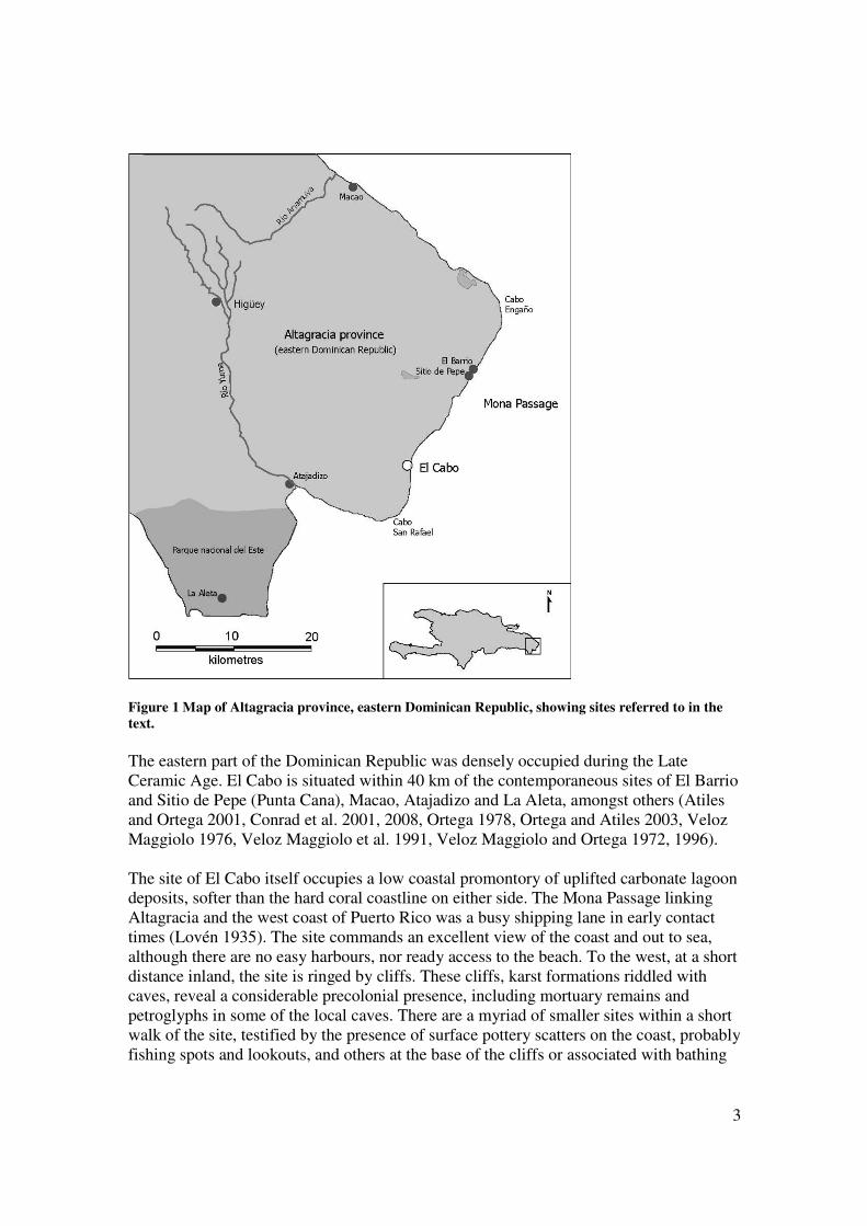
Figure 2 View of El Cabo from the south. Arrow indicates the promontory on which the archaeological site is located.
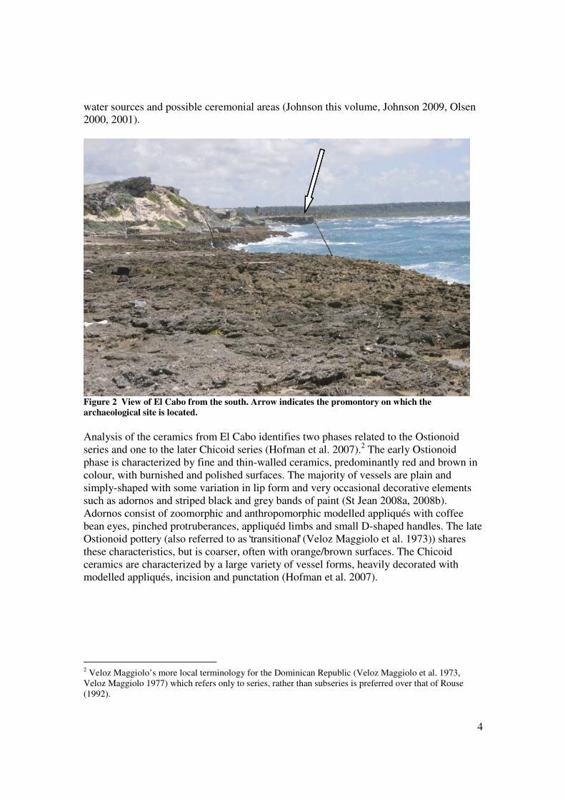
Analysis of the ceramics from El Cabo identifies two phases related to the Ostionoid
series and one to the later Chicoid series (Hofman et al. 2007).2 The early Ostionoid
phase is characterized by fine and thin-walled ceramics, predominantly red and brown in
colour, with burnished and polished surfaces. The majority of vessels are plain and
simply-shaped with some variation in lip form and very occasional decorative elements
such as adornos and striped black and grey bands of paint (St Jean 2008a, 2008b).
Adornos consist of zoomorphic and anthropomorphic modelled appliqués with coffee
bean eyes, pinched protruberances, appliquéd limbs and small D-shaped handles. The late
Ostionoid pottery (also referred to as ‘transitional’ (Veloz Maggiolo et al. 1973)) shares
these characteristics, but is coarser, often with orange/brown surfaces. The Chicoid
ceramics are characterized by a large variety of vessel forms, heavily decorated with
modelled appliqués, incision and punctation (Hofman et al. 2007).
2 Veloz Maggiolo’s more local terminology for the Dominican Republic (Veloz Maggiolo et al. 1973,
Veloz Maggiolo 1977) which refers only to series, rather than subseries is preferred over that of Rouse
(1992).

5
Figure 3 Ceramic adornos from El Cabo. Left: early Ostionoid. Right: Chicoid. Scale 1:1.
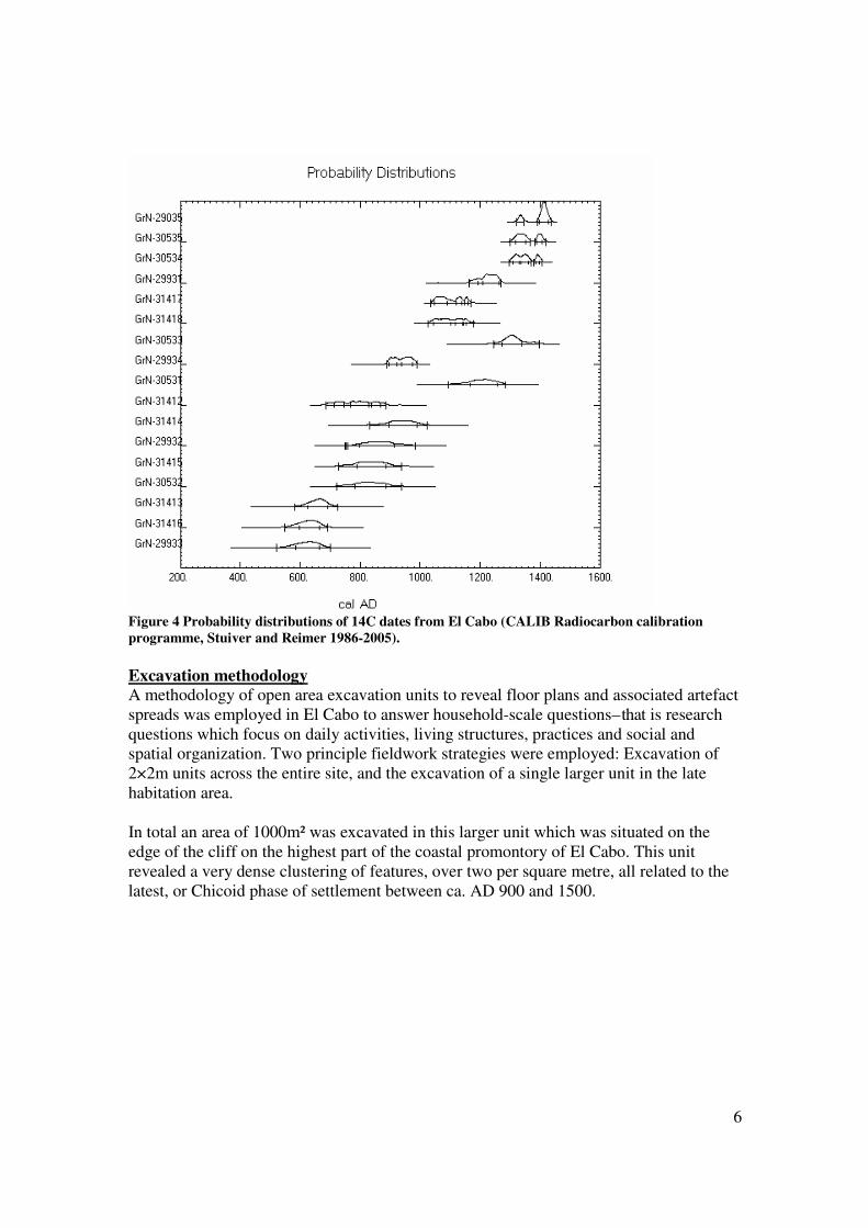
Radiocarbon dates from El Cabo show the earliest dated Ostionoid sequence in the
eastern Dominican Republic, beginning in the late 6th
to mid 7th
century.3 El Cabo also
bears the latest dates for a Chicoid context in the region, in the late 14th
century. This is
noteworthy because the presence of early European material culture and written texts
indicate sites in the area, including El Cabo, Atajadizo, Macao and those in the Parque
del Este, witnessed a colonial presence in the late 15th
century, and yet there are no 15th
or
16th
century radiocarbon dates.
3 Early dates from El Barrio are excluded from this discussion due to issues of calibration and context.
6
Figure 4 Probability distributions of 14C dates from El Cabo (CALIB Radiocarbon calibration
programme, Stuiver and Reimer 1986-2005).
Excavation methodology A methodology of open area excavation units to reveal floor plans and associated artefact
spreads was employed in El Cabo to answer household-scale questions – that is research
questions which focus on daily activities, living structures, practices and social and
spatial organization. Two principle fieldwork strategies were employed: Excavation of
2×2m units across the entire site, and the excavation of a single larger unit in the late
habitation area.
In total an area of 1000m² was excavated in this larger unit which was situated on the
edge of the cliff on the highest part of the coastal promontory of El Cabo. This unit
revealed a very dense clustering of features, over two per square metre, all related to the
latest, or Chicoid phase of settlement between ca. AD 900 and 1500.

7
Figure 5 The El Cabo coastal promontory showing the village buildings (grey) and excavated units
(black).
The stratigraphy of the large unit consisted of a thin layer (5 to 30cm) of present ground
surface and a sandy soil on top of karst bedrock into which the features were cut. There
was no stratigraphic distinction in this layer. Material from the artefact layer was
recovered in 1m squares, allowing the interpretation of activities and practices associated
with the structures.
8
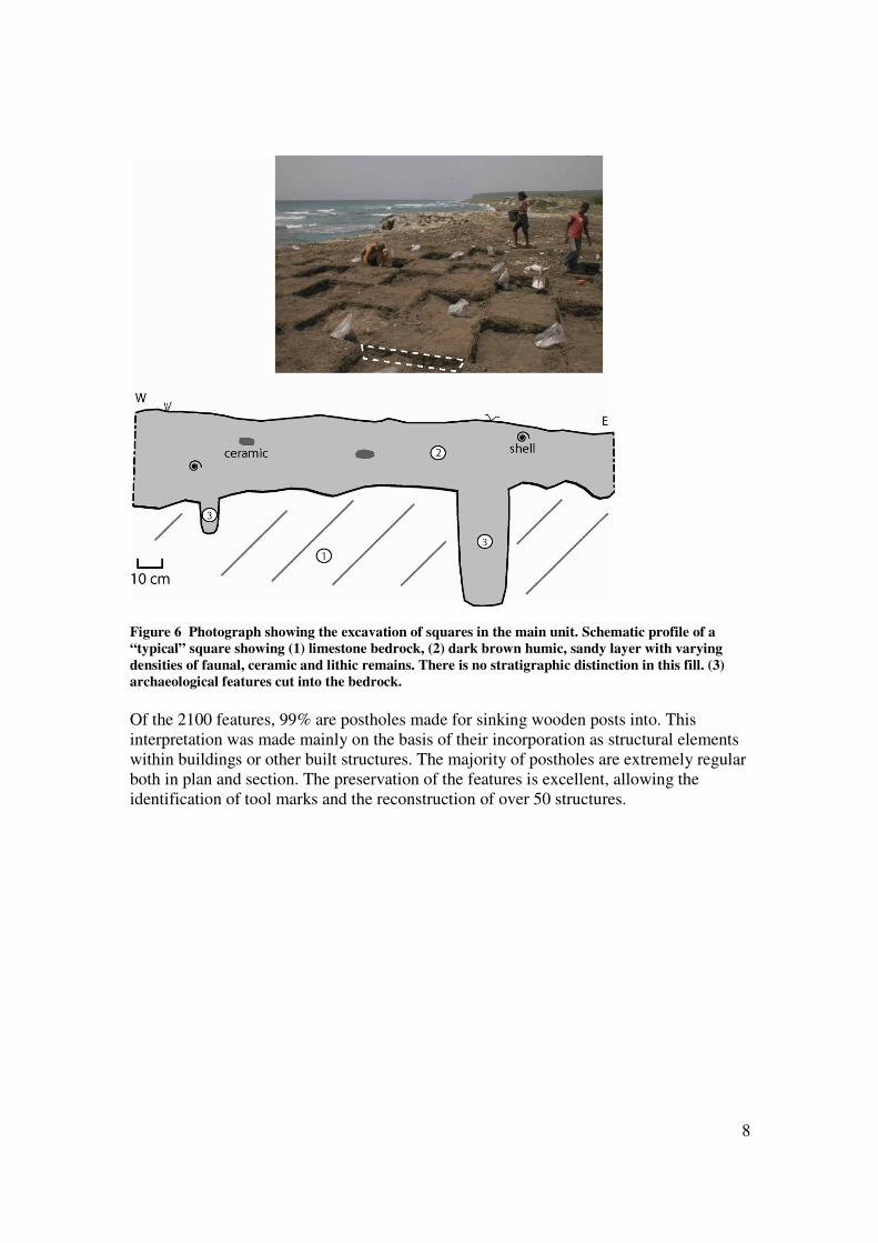
Figure 6 Photograph showing the excavation of squares in the main unit. Schematic profile of a
“typical” square showing (1) limestone bedrock, (2) dark brown humic, sandy layer with varying
densities of faunal, ceramic and lithic remains. There is no stratigraphic distinction in this fill. (3)
archaeological features cut into the bedrock.
Of the 2100 features, 99% are postholes made for sinking wooden posts into. This
interpretation was made mainly on the basis of their incorporation as structural elements
within buildings or other built structures. The majority of postholes are extremely regular
both in plan and section. The preservation of the features is excellent, allowing the
identification of tool marks and the reconstruction of over 50 structures.

9
Figure 7 View of the main unit as excavated in 2006 with details of individual postholes on the right.
Note the vertical tool marks evident in the lower posthole.
Posthole fills are dependent on abandonment (Schinkel 1992:167-169). The most
common practice was removal of posts and back-filling of the posthole. Exceptionally
structures were burnt down. Five burnt post stumps were recovered in situ belonging to
two house structures; the first dated to the 14th
century (GrN 29035, GrN 30535 and GrN
30534, see figure 4), and a second dated to the early 12th
century (GrN 31417 and GrN
31418, see figure 4).
Analysis of charcoal wood samples from the features by Dr Lee Newsom, Pennsylvania
State University, shows that the posts were from Sapotaceae (sapodilla family), matching
with two different species of the Sideroxylon genus: S. salicifolium (L.) Lam. and S.
foetidissimum Jacq. These are tropical hardwoods which thrive in dry coastal conditions
and whose wood is ideal for construction.
Reconstruction methodology

10
Figure 8 Plan drawing of the main unit. All features shown. The solid line in the east is the edge of
the cliff.
Structures were primarily identified on the basis of the spatial relationships between
features in the horizontal plane. This is immediately apparent when looking at the plan
drawing of the main unit; circular configurations are instantly eye-catching. After spatial
relationships, diameter and depth, recorded for all features, were the next most important
factors for identifying structures. Other factors such as fill properties became relevant in
later stages of analysis, concerning for example the lifecycle or chronology of particular
structures.
Reconstructions of site structures were divided into 4 confidence classes (very reliable,
reliable, plausible and possible), with well over half the reconstructions being classified
as reliable and very reliable, and a strict threshold for rejecting any structures which didn’t

11
come up to scratch. It was possible to incorporate over 70% of the features into
reconstructions. Those which remain unassigned generally cluster on excavation
boundaries, where the full structure was not visible and therefore credibility was not
strong enough.
The structures and structure typology The structures in El Cabo fall into eight main types: four house types, two types of
special activity structure, a type which includes all post alignments, regardless of function
and a unique type of small structure clearly not belonging to any other type. The house
structures are the focus of this paper, but the full typology will be presented for the sake
of completeness.
First a word on the term “house”, as this is the dominant interpretation of the structures
identified. The architecture of “house” structures, as opposed to ancillary buildings, is
consistently more elaborate and regular. Moreover, these structures are larger than other
structures, have roofs and continuous, probably closed walls, a regular orientation and are
the locations of commemorative acts and closing rituals. They are assumed to be dwelling
structures and the material focus of domestic life and identity.
The recurrent architectural forms of the house structures are consistently related to a wide
range of material culture remains. These include ceramic griddles, ceramic vessels,
marine shell, fish and small mammal remains, whole or fragmented ground stone tools
(mainly petaloid axes and adzes for woodworking and forest clearance), coral and stone
crushing or grinding implements, modified stone and shell material, equipment associated
with fishing and hunting activities, many items of personal adornment, cemí icons and
parts of cemí icons and occasionally human remains. The distribution and density of the
remains represent sweeping accumulations of domestic debris related to systematic
maintenance of the living area in the last phase of habitation, or acts of deliberate
deposition associated with structures (Samson forthcoming, Samson and Hoogland
2007).
Summarizing, the identification of “house” is based on the morphology and character of the
architectural plan and the range of functions associated with the structure. Looking at the
structures in more detail, it is possible suggest a typology. The different types (notably
between Types 1, 2 and 4) also correspond to indigenous types.
El Cabo structure typology4
4 All schematic drawings of the structures are to the same scale with north at the top of the page.
12
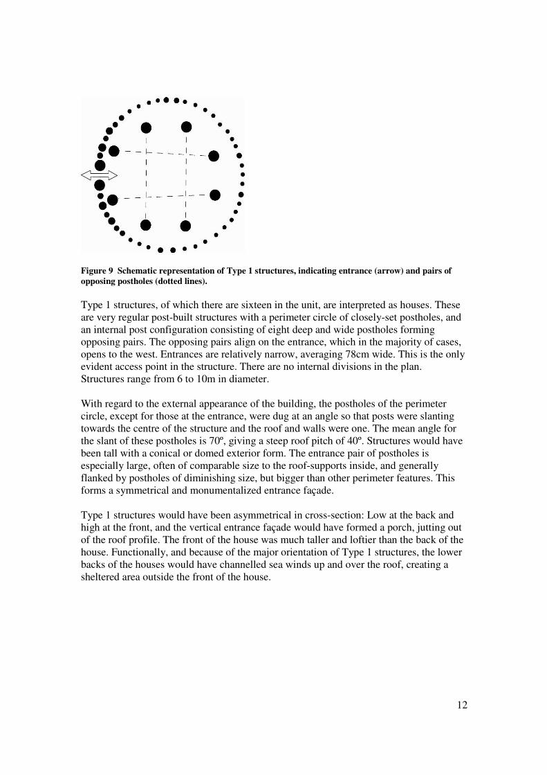
Figure 9 Schematic representation of Type 1 structures, indicating entrance (arrow) and pairs of
opposing postholes (dotted lines).
Type 1 structures, of which there are sixteen in the unit, are interpreted as houses. These
are very regular post-built structures with a perimeter circle of closely-set postholes, and
an internal post configuration consisting of eight deep and wide postholes forming
opposing pairs. The opposing pairs align on the entrance, which in the majority of cases,
opens to the west. Entrances are relatively narrow, averaging 78cm wide. This is the only
evident access point in the structure. There are no internal divisions in the plan.
Structures range from 6 to 10m in diameter.
With regard to the external appearance of the building, the postholes of the perimeter
circle, except for those at the entrance, were dug at an angle so that posts were slanting
towards the centre of the structure and the roof and walls were one. The mean angle for
the slant of these postholes is 70º, giving a steep roof pitch of 40º. Structures would have
been tall with a conical or domed exterior form. The entrance pair of postholes is
especially large, often of comparable size to the roof-supports inside, and generally
flanked by postholes of diminishing size, but bigger than other perimeter features. This
forms a symmetrical and monumentalized entrance façade.
Type 1 structures would have been asymmetrical in cross-section: Low at the back and
high at the front, and the vertical entrance façade would have formed a porch, jutting out
of the roof profile. The front of the house was much taller and loftier than the back of the
house. Functionally, and because of the major orientation of Type 1 structures, the lower
backs of the houses would have channelled sea winds up and over the roof, creating a
sheltered area outside the front of the house.

13
Figure 10 Schematic representation of Type 2 structures, indicating entrance (arrow) and pairs of
opposing postholes (dotted lines).
Type 2 structures, of which there are seven in the unit, are also houses. These are very
similar to Type 1, with a few notable differences. The houses of Type 2 are oriented
slightly differently (west northwest, instead of west). Moreover, the postholes of the
perimeter circle are vertically dug into the bedrock, implying a cone and cylinder
construction. Of course, the wall uprights may still have been joined together at the top as
for structures in which the roof stretches down to the ground, but this is not as explicit in
the underground architecture as for Type 1. Again Type 2 structures would have had a
monumentalized entrance façade. Gaps in the back are not interpreted as additional
access points. Structures range from 7 to 11m in diameter.

14
Figure 11 Schematic representation of Type 3 structures, indicating entrance (arrow) and pairs of
opposing postholes (dotted lines).
Type 3 structures, of which there is only one in the unit, are houses with maximised floor
space by incorporating the roof supports into the perimeter wall. Despite this innovation
the structural tenets are the same as Types 1 and 2. This structure is 10m in diameter.
Figure 12 Schematic representation of Type 4 structures, indicating entrance (arrow) and pairs of
opposing postholes (dotted lines).
Type 4 structures, of which there are two, are houses similar in diameter to Type 3.
Unlike Type 3, they have separate internal roof-supports and are oriented northwest.
15
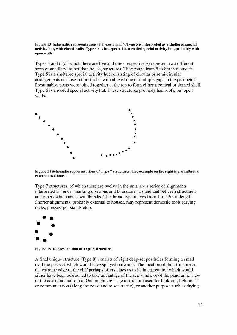
Figure 13 Schematic representations of Types 5 and 6. Type 5 is interpreted as a sheltered special
activity hut, with closed walls. Type six is interpreted as a roofed special activity hut, probably with
open walls.
Types 5 and 6 (of which there are five and three respectively) represent two different
sorts of ancillary, rather than house, structures. They range from 5 to 8m in diameter.
Type 5 is a sheltered special activity hut consisting of circular or semi-circular
arrangements of close-set postholes with at least one or multiple gaps in the perimeter.
Presumably, posts were joined together at the top to form either a conical or domed shell.
Type 6 is a roofed special activity hut. These structures probably had roofs, but open
walls.
Figure 14 Schematic representations of Type 7 structures. The example on the right is a windbreak
external to a house.
Type 7 structures, of which there are twelve in the unit, are a series of alignments
interpreted as fences marking divisions and boundaries around and between structures,
and others which act as windbreaks. This broad type ranges from 1 to 53m in length.
Shorter alignments, probably external to houses, may represent domestic tools (drying
racks, presses, pot stands etc.).
Figure 15 Representation of Type 8 structure.
A final unique structure (Type 8) consists of eight deep-set postholes forming a small
oval the posts of which would have splayed outwards. The location of this structure on
the extreme edge of the cliff perhaps offers clues as to its interpretation which would
either have been positioned to take advantage of the sea winds, or of the panoramic view
of the coast and out to sea. One might envisage a structure used for look-out, lighthouse
or communication (along the coast and to sea traffic), or another purpose such as drying.
16
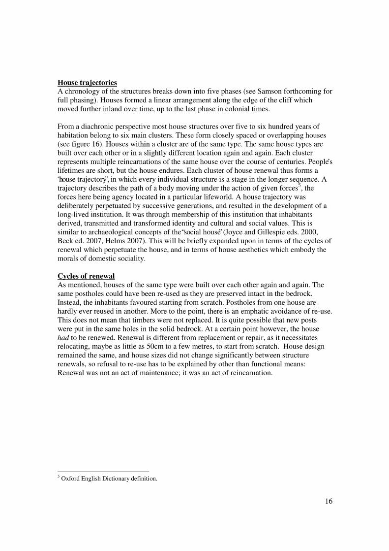
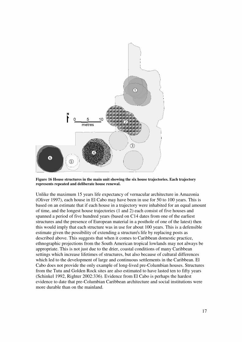
House trajectories A chronology of the structures breaks down into five phases (see Samson forthcoming for
full phasing). Houses formed a linear arrangement along the edge of the cliff which
moved further inland over time, up to the last phase in colonial times.
From a diachronic perspective most house structures over five to six hundred years of
habitation belong to six main clusters. These form closely spaced or overlapping houses
(see figure 16). Houses within a cluster are of the same type. The same house types are
built over each other or in a slightly different location again and again. Each cluster
represents multiple reincarnations of the same house over the course of centuries. People’s
lifetimes are short, but the house endures. Each cluster of house renewal thus forms a
“house trajectory”, in which every individual structure is a stage in the longer sequence. A
trajectory describes the path of a body moving under the action of given forces5, the
forces here being agency located in a particular lifeworld. A house trajectory was
deliberately perpetuated by successive generations, and resulted in the development of a
long-lived institution. It was through membership of this institution that inhabitants
derived, transmitted and transformed identity and cultural and social values. This is
similar to archaeological concepts of the “social house” (Joyce and Gillespie eds. 2000,
Beck ed. 2007, Helms 2007). This will be briefly expanded upon in terms of the cycles of
renewal which perpetuate the house, and in terms of house aesthetics which embody the
morals of domestic sociality.
Cycles of renewal As mentioned, houses of the same type were built over each other again and again. The
same postholes could have been re-used as they are preserved intact in the bedrock.
Instead, the inhabitants favoured starting from scratch. Postholes from one house are
hardly ever reused in another. More to the point, there is an emphatic avoidance of re-use.
This does not mean that timbers were not replaced. It is quite possible that new posts
were put in the same holes in the solid bedrock. At a certain point however, the house
had to be renewed. Renewal is different from replacement or repair, as it necessitates
relocating, maybe as little as 50cm to a few metres, to start from scratch. House design
remained the same, and house sizes did not change significantly between structure
renewals, so refusal to re-use has to be explained by other than functional means:
Renewal was not an act of maintenance; it was an act of reincarnation.
5 Oxford English Dictionary definition.
17
Figure 16 House structures in the main unit showing the six house trajectories. Each trajectory
represents repeated and deliberate house renewal.
Unlike the maximum 15 years life expectancy of vernacular architecture in Amazonia
(Oliver 1997), each house in El Cabo may have been in use for 50 to 100 years. This is
based on an estimate that if each house in a trajectory were inhabited for an equal amount
of time, and the longest house trajectories (1 and 2) each consist of five houses and
spanned a period of five hundred years (based on C14 dates from one of the earliest
structures and the presence of European material in a posthole of one of the latest) then
this would imply that each structure was in use for about 100 years. This is a defensible
estimate given the possibility of extending a structure’s life by replacing posts as
described above. This suggests that when it comes to Caribbean domestic practice,
ethnographic projections from the South American tropical lowlands may not always be
appropriate. This is not just due to the drier, coastal conditions of many Caribbean
settings which increase lifetimes of structures, but also because of cultural differences
which led to the development of large and continuous settlements in the Caribbean. El
Cabo does not provide the only example of long-lived pre-Columbian houses. Structures
from the Tutu and Golden Rock sites are also estimated to have lasted ten to fifty years
(Schinkel 1992, Righter 2002:336). Evidence from El Cabo is perhaps the hardest
evidence to date that pre-Columbian Caribbean architecture and social institutions were
more durable than on the mainland.
18
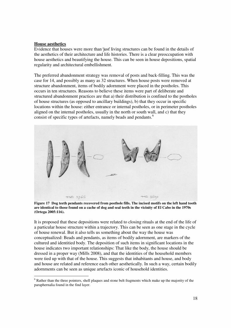
House aesthetics Evidence that houses were more than ‘just’ living structures can be found in the details of
the aesthetics of their architecture and life histories. There is a clear preoccupation with
house aesthetics and beautifying the house. This can be seen in house depositions, spatial
regularity and architectural embellishment.
The preferred abandonment strategy was removal of posts and back-filling. This was the
case for 14, and possibly as many as 32 structures. When house posts were removed at
structure abandonment, items of bodily adornment were placed in the postholes. This
occurs in ten structures. Reasons to believe these items were part of deliberate and
structured abandonment practices are that a) their distribution is confined to the postholes
of house structures (as opposed to ancillary buildings), b) that they occur in specific
locations within the house: either entrance or internal postholes, or in perimeter postholes
aligned on the internal postholes, usually in the north or south wall, and c) that they
consist of specific types of artefacts, namely beads and pendants.6
Figure 17 Dog teeth pendants recovered from posthole fills. The incised motifs on the left hand tooth
are identical to those found on a cache of dog and seal teeth in the vicinity of El Cabo in the 1970s
(Ortega 2005:116).
It is proposed that these depositions were related to closing rituals at the end of the life of
a particular house structure within a trajectory. This can be seen as one stage in the cycle
of house renewal. But it also tells us something about the way the house was
conceptualized: Beads and pendants, as items of bodily adornment, are markers of the
cultured and identitied body. The deposition of such items in significant locations in the
house indicates two important relationships: That like the body, the house should be
dressed in a proper way (Mills 2008), and that the identities of the household members
were tied up with that of the house. This suggests that inhabitants and house, and body
and house are related and reference each other aesthetically. In such a way, certain bodily
adornments can be seen as unique artefacts iconic of household identities.
6 Rather than the three pointers, shell plaques and stone belt fragments which make up the majority of the
paraphernalia found in the find layer.

19
In terms of the architecture of the house, the fronts of all house types are
monumentalized, probably producing an imposing façade. This is always the case for the
two posts flanking the entrances and often for up to a third of the perimeter on either side
of the entrance. This results in a front/back dichotomy emphasizing the face of the house
and turning it into an area of display. Moreover, there is a consistent orientation in the
circular structures: The entrance points away from the sea. However, within this broad
functional rule there are three major orientations. Houses in the same phase share exactly
the same orientation. So all houses in phase 1 are oriented west northwest, whereas those
in phases 2, 3 and 4 are oriented due west. Another example of the concern for
orderliness in architecture can be seen in the symmetry of the house plans. Regularity has
not been exaggerated in the schematic drawings (figures 9 to 12), and the vast majority of
the thirty or so houses incorporate multiple levels of symmetry in their foundations which
would have been reflected in their architecture.
Scholarship on the characteristics of sociality of Native peoples of Amazonia has shown
a profound link between morality and aesthetics, especially in the settlement realm
(Overing and Passes ed. 2000). In El Cabo, the deposition of items marking stages in
house renewal, the relationship between house and body, the emphasis of the house
façade and the consistent and regular orientation and architecture of houses indicate that
there was a proper way to embellish, dress and order the house i.e. make it beautiful like
the bodies and social lives of its inhabitants. Domestic aesthetics in El Cabo may
similarly have contributed to the creation of a tranquil and harmonious environment
where work could be carried out and children raised.
Conclusion Discussions of the development of Late Ceramic Age social complexity have not
satisfactorily taken the domestic realm into account. Analysis of the development of
house trajectories in El Cabo provides insight into how the house, as a material and social
institution, in its everyday and long-term dynamics, is fundamental to this process.
The site of El Cabo offers an archaeological perspective on pre-Columbian indigenous
domestic life. It was possible to reconstruct over fifty domestic buildings and identify a
series of house types and multiple phases in community history. Houses were deliberately
renewed, forming diachronic house trajectories, which led to the development of durable
indigenous institutions. These institutions were responsible for the transmission of moral
and social values and thus important constituents of Late Ceramic Age culture and
sociality. The above discussion has been limited to just one house group from the main
unit. However, evidence not discussed here, shows that multiple, contemporaneous house
groups existed across the whole late settlement (Samson forthcoming). This resulted in a
stable community of 250 to 300 inhabitants for at least five, and possibly more than six
hundred years.
Acknowledgements I thank my supervisers Dr Menno Hoogland and Professor Corinne Hofman, as well as
Adriana Churampi Ramírez and my colleagues in the Caribbean Research Group, Leiden
University and all participants in the Caribbean Fieldschools and especially to the

20
community of El Cabo, and to the mayor Lionel Avila. Thanks also to the Fundación
Ecológica de Punta Cana for logistical support, and the teacher and students of El Cabo
school for the same. Finally, many thanks to the Museo del Hombre Dominicano,
especially for the partnership of the current and former directors Juan Rodríguez Acosta,
Marcio Veloz Maggiolo and Carlos Hernández Soto, and especially for the collaboration
and support of Harold Olsen Bogaert, Jorge Ulloa Hung and Glenis Tavarez María.
Thanks to Erik van Driel, Leiden University, for the artefact illustrations and Jimmy
Mans, Alistair Bright and Angus Mol for comments on this paper. Participation in this
conference was sponsored by Leiden University Fund (LUF)/ Byvanck. References - Atiles, G. and E. Ortega (2001). "Un sitio llamado Manantial de la Aleta." Boletín del Museo
del Hombre Dominicano 30: 33-54.
- Beck, R. A., Ed. (2007). The durable house: House society models in archaeology. Carbondale
Archaeological Investigations. Occasional Paper no. 35, Southern Illinois University.
- Conrad, G. W., C. D. Beeker, C. Descantes, J. W. Foster and M. D. Glascock. (2008).
"Compositional analysis of ceramics from La Aleta, Dominican Republic: Implications for site
function and organisation." Journal of Caribbean Archaeology special publication no.2: 57-68.
- Conrad, G. W., J. W. Foster and C. D. Beeker. (2001). "Organic artifacts from the Manantial de
la Aleta, Dominican Republic: Preliminary observations and interpretations." Journal of
Caribbean Archaeology: 1-20.
- Helms, M. W. (2007). House Life. The durable house: House society models in archaeology. R.
A. Beck. Carbondale, Center for Archaeological Investigations, Occasional Paper no. 35,
Southern Illinois University: 487-504.
- Hofman, C. L., M. L. P. Hoogland, J. R. Oliver and A. V. M. Samson. (2006). "Investigaciones
arqueológicas en El Cabo, oriente de la República Dominicana: Resultados preliminares de la
campaña de 2005." El Caribe Arqueológico 9: 95-106.
- Hofman, C. L., M. L. P. Hoogland, A. V. M. Samson and J. R. Oliver (2008). "Investigaciones
arqueológicas en El Cabo, oriente de la República Dominicana: Resultados preliminares de las
campañas 2005 y 2006 " Boletín del Museo del Hombre Dominicano 42.
- Hofman, C. L., J. Ulloa Hung, and L. Jacobs. (2007). "Juntando las Piezas del Rompecabezas.
Dándole sentido a la Cronologia Cerámica del Este de la Republica Dominicana." El Caribe
Arqueológico 10.
- Johnson, E. (2009). Life between the cracks: Uses and meanings of a past Hispaniolan
landscape at El Cabo. MA thesis. Faculty of Archaeology. Leiden, Leiden University.
- Joyce, R. A. and S. D. Gillespie, Eds. (2000). Beyond kinship: Social and material reproduction
in house societies. Philadelphia, University of Pennsylvania Press.
- Lovén, S. (1935). Origins of the Tainan culture, West Indies. Göteburg, Elander.
- Mills, B. J. (2008). Remembering while forgetting: Depositional practices and social memory at
Chaco. Memory work: Archaeologies of material practices. B. J. Mills and W. H. Walker. Santa
Fe, School for Advanced Research Press: 81-108.
- Moya Pons, F. (1992). The politics of forced Indian labour in La Española 1493-1520. Antiquity
66:130-139.
- Oliver, J. R. (2008). El universo material y spiritual de los Taínos. El Caribe precolombino:
Fray Ramón Pané y el universo Taíno, Museu Barbier-Mueller and Fundación Caixa Galicia:
136-202.
- Oliver, J. R. (2009). Caciques and cemí idols: The web spun by Taíno rulers between Hispaniola
and Puerto Rico. Tuscaloosa, The University of Alabama Press.
- Oliver, P. (1997). Encyclopedia of vernacular architecture of the world: Cultures and habits.
Cambridge, Cambridge University Press.
21
- Olsen Bogaert, H. (2000). Prospección Arqueológica: Estudio de Impacto Ambiental Proyecto
Concesión de Explotación Minera Carmelo, Higuey, Provincia La Altagracia. Santo Domingo,
Secretaria de Estado de Medio Ambiente y Recursos Naturales: 1-121. Unpublished report Museo
del Hombre Dominicano.
- Olsen Bogaert, H. (2001). Adendum Prospección Arqueológica: Concesión de Explotación
Minera Carmelo. Unpublished report Museo del Hombre Dominicano.
- Ortega, E. J. (1978). "Informe sobre investigaciones arqueológicas realizadas en la region este
del país, zona costera desde Macao a Punta Espada." Boletín del Museo del Hombre Dominicano
11: 77-105.
- Ortega, E. J. (2005). Compendio General Arqueológico de Santo Domingo. Vol. 1. Santo
Domingo.
- Ortega, E. J., and G. Atiles. (2003). Manantial de la Aleta y la arqueología en el Parque
Nacional del Este. Santo Domingo: Academia de Ciencias de la República Dominicana.
- Ortega, E. J., G. Atiles and J. Ulloa Hung. (2003). Arqueología en la Iglesia de Macao. Santo
Domingo, Academia de Ciencias de la República Dominicana/Fundación Ortega Alvarez, Inc.
- Overing, J. and A. Passes (2000). Introduction: Conviviality and the opening up of Amazonian
anthropology. The anthropology of love and anger: The aesthetics of conviviality in native
Amazonia. J. Overing and A. Passes. London and New York, Routledge: 1-30.
- Righter, E., Ed. (2002). The Tutu archaeological village site: A multidisciplinary case study in
human adaptation. London and New York, Routledge.
- Rouse, I. B. (1951). "Areas and periods of culture in the Greater Antilles." Southwestern Journal
of Anthropology 7(3): 248-265.
- Rouse, I. B. (1992). The Tainos: Rise and decline of the people who greeted Columbus. New
Haven and London, Yale University Press.
- Samson, A. V. M. and M. L. P. Hoogland (2007). "Residencia Taína: Huellas de asentamiento
en El Cabo, República Dominicana." El Caribe Arqueológico 10: 93-103.
- Schinkel, K. The archaeology of St. Eustatius: The Golden Rock site.
- St. Jean, C. J. (2008). "Early Ostionan Ostionoid ceramic component of the El Cabo site,
Dominican Republic: A morphological, technological and stylistic ceramic examination based on
attribute analysis " Leiden Journal of Pottery Studies 24: 19-54.
- St. Jean, C. J. (2008). An investigation of the early Ostionan Ostionoid ceramic component of
the El Cabo site, Dominican Republic. MA thesis. Faculty of Archaeology. Leiden, Leiden
University.
- Veloz Maggiolo, M. (1976). Arqueología de Yuma, República Dominicana. Santo Domingo,
Taller.
- Veloz Maggiolo, M. (1977). Medioambiente y adaptación humana en la prehistoria de Santo
Domingo: La formación agricultora, 2nd edition. Vol. 1. Santo Domingo: Ediciones de Taller.
- Veloz Maggiolo, M. (1993). La Isla de Santo Domingo antes de Colón. Santo Domingo: Banco
Central de la República Dominicana.
- Veloz Maggiolo, M. and E. Ortega (1972). "Excavaciones en Macao, República Dominicana."
Boletín del Museo del Hombre Dominicano 2: 157-175.
- Veloz Maggiolo, M., E. Ortega and F. Luna Calderón. (1991). Los occupantes tempranos de
Punta Cana, República Dominicana. Proceedings of the 14th Congress of the International
Association for Caribbean Archaeology, Barbados: 262-277.
- Veloz Maggiolo, M. and E. J. Ortega (1996). Punta Cana y el origen de la agricultura en la isla
de Santo Domingo. Ponencias del Primer Seminario de Arqueología del Caribe. M. Veloz
Maggiolo and A. Caba Fuentes. La Romana, Museo Arqueológico Regional de Altos de Chavón:
5-11.
- Veloz Maggiolo, M., E. J. Ortega and P. Pina. (1973). "Fechas de radiocarbón para el periodo
ceramista en la República Dominicana." Boletín del Museo del Hombre Dominicano 3: 138-198.


ERROR: undefined
OFFENDING COMMAND: ��
STACK: