horse riding protecting access rights in the · hasl em r bordon ringmer bu g s hill henfield...
TRANSCRIPT
CONTACTSouth Downs National Park Authority:
01730 814810
@southdownswaynt @SDNPA
/SDNPA
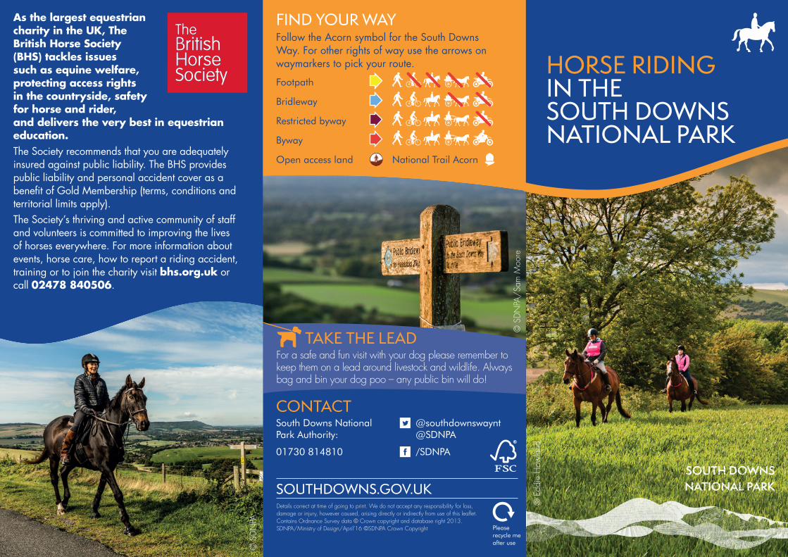
FIND YOUR WAYFollow the Acorn symbol for the South Downs Way. For other rights of way use the arrows on waymarkers to pick your route.
Footpath
Bridleway
Restricted byway
Byway
Open access land National Trail Acorn
Please recycle me after use
HORSE RIDING IN THE SOUTH DOWNS NATIONAL PARK
As the largest equestrian charity in the UK, The British Horse Society (BHS) tackles issues such as equine welfare, protecting access rights in the countryside, safety for horse and rider, and delivers the very best in equestrian education.The Society recommends that you are adequately insured against public liability. The BHS provides public liability and personal accident cover as a benefit of Gold Membership (terms, conditions and territorial limits apply). The Society’s thriving and active community of staff and volunteers is committed to improving the lives of horses everywhere. For more information about events, horse care, how to report a riding accident, training or to join the charity visit bhs.org.uk or call 02478 840506.
TAKE THE LEADFor a safe and fun visit with your dog please remember to keep them on a lead around livestock and wildlife. Always bag and bin your dog poo – any public bin will do!
Details correct at time of going to print. We do not accept any responsibility for loss, damage or injury, however caused, arising directly or indirectly from use of this leaflet. Contains Ordnance Survey data © Crown copyright and database right 2013. SDNPA/Ministry of Design/April’16 ©SDNPA Crown Copyright
© S
DNPA
/Sam
Moo
re
© E
ddie
How
land
© S
DNPA

When riding in the South Downs you will often find yourself sharing the path with walkers, cyclists and road users. Here are some tips to make sure you have a fun and safe visit…
ÎWear reflective clothing at all times so you are clearly visible. Î Ride in single file when you need to let others pass you safely. Î Use hand signals so people know your intentions. Î Carry a mobile phone for emergencies.
ÎWatch out for farm animals grazing on what might appear to be open land. Î Avoid damaging timber or hedgerows by jumping. Î Always follow the countryside code: Remember to leave gates and property as you find them, protect plants and animals, take all your litter home and keep dogs under close control.
Visit bhs.org.uk for more details on riding responsibly.
BE A RESPONSIBLE RIDER
THE SOUTH DOWNS WAYThe South Downs Way provides 160km of bridleway for horse riders to explore. If you are looking to ride along some or all of this beautiful National Trail visit nationaltrail.co.uk/south-downs-way/plan for tips on horsebox friendly car parking, accommodation with stables and much more. There are a series of water taps and troughs along the route so horse and rider need never go thirsty – see tap icons on the centre map.
With over 1200km of bridleways within the South Downs National Park there is something for all riders to enjoy – from a gentle trot along a country lane to a long hack up on to the Downs.
© E
ddie
How
land
© S
DNPA

M3
ENGLISH CHANNE L0 10 km
N
0 10 km
N
A285
A285 A29
A284
A29
A27
A283
A281
A272A272
A283
A275
A26
A259
A27
A259
A24
A23
A27
A31
A32
5
A31
A272
A32
A31
M3
A3(M
)
M27 A3
A272
A23
A264
A29A272
M3
M23
M23A22
A26
A22
A272
A26
A265
A267
A27
A22
A22
A22
River Rother
River Meon
River Itchen
River Arun
River Adur River Ouse
Cuckmere River
View to Old Winchester Hill, Hampshire East Meon, Hampshire Little Butser , Hampshire Arundel Castle, West Sussex Cissbury Ring, West Sussex View from Ditchling Beacon, East Sussex Seven Sisters, East Sussex
BASINGSTOKE
ALDERSHOT DORKING
Cuckfield
LingfieldCharlwood SmallfieldGodalming
Milford
Hindhead
Wrecclesham
Hailsham
HeathfieldHurstpierpoint
EASTBOURNE
Alfriston
LEWES
Fulking
East Dean
DitchlingSteyning
Findon
Singleton
Seaford
Lavant
Newhaven
Rottingdean
HaywardsHeath
EASTGRINSTEAD
Horsham
CRAWLEY
WisboroughGreen
Crowborough
Uckfield
Cranleigh
Billingshurst
Selborne
Upham
Twyford
ShirrellHeath
Wickham
Bishop’sWaltham
Eastleigh Bishopstoke
Havant
WINCHESTER
CHICHESTER Barnham
BOGNOR REGIS
LITTLEHAMPTONWORTHING
BRIGHTON & HOVE
Storrington
PulboroughPetworthMIDHURSTSouth Harting
Shipwrights W
ay
Cocking
Liss
HaslemereBordon
Ringmer
BurgessHill
Henfield
Northchapel
Fernhurst
Milland
SOUTHAMPTON
FAREHAM
GOSPORT
PORTSMOUTH
PETERSFIELD
ALTON
FourMarks
Monkwood
NewAlresford
ItchenAbbas
West MeonEast Meon
Buriton
Rowlands Castle
Hambledon
Droxford
Arundel
Liphook
Chawton
Binsted
Southease
GlyndeBerwick
Hassocks
AmberleyFalmer
ShipwrightsWay
HangersWay
The CuckooTrail
Barnhamto Bignor
DownsLink
EgretsWay
Meo
nVa
lley
Trai
l
DownsLink
Heyshott Down
GoodwoodCountry Park
Queen ElizabethCountry Park
Beachy Head
Seven SistersCountry Park
Firle BeaconLong Manof Wilmington
Mill Hill
DitchlingBeacon
Devil’s DykeChanctonburyRing
Cissbury Ring
Bignor Hill
Harting Down
Butser HillBeacon Hill
St. Catherine’s Hill
WoolbedingCommon
Black Down
Iping Common
Kingley Vale
Selborne
Alice Holt
OldWinchester
Hill
Common
HORSEBOX PARKINGThis map shows a selection of parking locations for horseboxes across the South Downs National Park – some locations are suitable for any size of horsebox, some only for smaller boxes and some sites require a permit. For more details about these and many other parking sites visit nationaltrail.co.uk/south-downs-way. (Please be aware that some sections of the long distance routes highlighted on this map are not accessible by horse. Please check your route using an OS map before you begin.)
RIDING SCHOOLS IN THE SOUTH DOWNSIf you don’t own a horse there are lots of riding schools and stables throughout the National Park that offer lessons and riding tours for all ages and abilities. Many will collect you from local railway stations and drop you back at the end of the day, so you can leave the car at home and enjoy the view on the journey too. To find a British Horse Society approved riding school near you visit bhs.org.uk.Visit nationalrail.co.uk to plan your journey now.
Wilmington HillJevingtonAlfriston
Firle BeaconHousedean Farm A27
Ditchling Beacon
Devil’s DykePyecombe A23Chanctonbury Ring
Washington A24Bignor HillLittleton Farm A285
Cocking Hill A286Harting DownQECPButser Hill
Beacon HillCheesefoot HeadWINCHESTER EASTBOURNE
The River CuckmereThe River Ouse
The River AdurThe River Arun
ft600400200
010 20 30 40 50 60 70 80 90 100 milesThe River Meon
ft6004002000
SOUTH DOWNS WAY PROFILE
HORSE RIDING IN THE SOUTH DOWNS NATIONAL PARK
Win
ches
ter
The
Milb
urys
Exto
n
QEC
P
Har
ting
Dow
n
Coc
king
Hill
Bign
or H
ill
Am
berle
y
Was
hing
ton
Rive
r Adu
r
Trul
eigh
Hill
Dev
il’s
Dyk
e
Ditc
hlin
g Be
acon
Hou
sede
an F
arm
Sout
heas
e
Alfr
iston
Jevi
ngto
n
Eastb
ourn
e
WinchesterThe Milburys Inn (Beauworth) 9
Exton Village (The River Meon) 13 4Queen Elizabeth Country Park 23 14 10
Harting Down 29 20 16 6Cocking Hill Car Park (A286) 36 27 23 13 7
Bignor Hill 43 34 30 20 14 7Amberley Village (River Arun) 48 39 35 25 19 12 5
Washington Village (A24) 54 45 41 31 25 18 11 6River Adur 61 52 48 38 32 25 18 13 7
Truleigh Hill 63 54 50 40 34 27 20 15 9 2Devil’s Dyke 68 57 53 43 37 30 23 18 12 5 3
Ditchling Beacon 70 61 57 47 41 34 27 22 16 9 7 4Housedean Farm (A27) 75 66 62 52 46 39 32 27 21 14 12 9 5
Southease Village (River Ouse) 82 73 69 59 53 46 39 34 28 21 19 16 12 7Alfriston Village (River Cuckmere) 90 81 77 67 61 54 47 42 36 29 27 24 20 15 8
Jevington Village 94 85 81 71 65 58 51 46 40 33 31 28 24 19 12 4Eastbourne 98 89 85 75 69 62 55 50 44 37 35 32 28 23 16 8 4
MILEAGE CHARTDistances between main access points along the
bridleway route
South Downs National Park Boundary
South Downs Way
South Downs Way Footpath Only
Long distance routes
Planned route
Railway
Railway stations
Countryside sites
Settlement
Visitor Information
Drinking water taps
Horsebox permitparking
Horsebox parking for some(restricted space or steep, narrow approach)
Horsebox parkingfor all