homeland infrastructure foundation level data (hifld...
TRANSCRIPT

Homeland Infrastructure Foundation
Level Data (HIFLD) Overview and
Map Tools Available for State and
Local Governments
NCTCOG Regional GIS Meeting
May-11 2011, Allen, Texas

Michael Ouimet
HIFLD to the Regions (HTTR)
HTTR Gulf Coast Region (AL, LA, MS, TX)
(512) 921-9671

3
Agenda
I. HIFLD Program Overview
II. HSIP Freedom and HSIP Gold Datasets
III. HSIN Portal Access

4
HIFLD to the Regions (HIFLD)
1. Everyone Wants Situational
Awareness
2. Everyone Wants a Common
Operational Picture
3. Both Require Common
Foundation Data from
Authoritative Sources -
Everything has location
Support Domestic Infrastructure Data Gathering,
Sharing and Protection, Visualization, and Spatial
Knowledge Management for Homeland Defense,
Homeland Security and Emergency Preparedness,
Response and Recovery Communities

5
HTTR Phased Implementation

6
Four HIFLD Official Members
Over 3,500 Contributing Partners

7
HIFLD Organizing Structure
HIFLD
HIFLD to the Regions
Process &
Standards
Interagency
Coordination
Teams (ICT)
Data
RqtsTechnical
HIFLD provides an organization structure to: Enhance situational awareness & support to
HLS/HD infrastructure protection activities
Support the Information Sharing Environment
Share best practices
Build, enhance, sustain partnerships
Provide resources for approved activities
ICTs work together across the partnership to: Provide technical support to HIFLD activities
Process and standards implementation for missions/
operations
Update governing/planning documents
Develop, validate and prioritize requirements
Current HIFLD Programs promote: Common foundation infrastructure data
Enhanced partnership/participation at the State level
Increased Awareness of Federal support, data, tools
and training
Understand / help resolve regional data and
technical requirements

8
HIFLD to the Regions (HTTR)
Requested by:
National States Geographic Information Council
Mission:
Work with HIFLD members and contributing
partners in the Protective Security Advisor (PSA)
Areas involved with Homeland Defense, Homeland
Security and Emergency Preparedness, Response
and Recovery to promote domestic infrastructure
information gathering, sharing and protection,
visualization and spatial analysis
Purpose:
To advance the success of the national level
HIFLD Working Group into the eight PSA Areas
focusing HIFLD support on state and local
priorities and issues to bring those communities
together to increase and enhance regional
activities and to strengthen Federal, State and
private sector partnerships

9
HIFLD to the Regions (HTTR)

10
1) MUST be a Fed/State/Local Gov’t member
Government contractors provide contact info for your
government sponsor
2) Access can be requested via non-passworded
website (http://www.hifldwg.org)
“How to Join” link at top of page
Web-based access request template
Visit the HIFLD Website

11
3) HIFLD Website Content:
Information and on-line registration for
upcoming HIFLD meetings
Agendas, attendee lists, briefings, and
minutes from previous meetings
Searchable library of HIFLD and
homeland infrastructure-related
documents
Roster and contact info for HIFLD WG
Federal geospatial data guidance
On-line HSIP Gold data request form
On-line HSIP Gold feedback mechanism
Visit the HIFLD Website

1212
Homeland Security
Infrastructure Program
HSIP Gold 2010 UpdateJune 2010
NGA PMHP
Domestic
Preparedness
Branch
Steve AlnessChief, Domestic Preparedness Branch
HSIP Manager/Partnerships & OutreachNorth America & Homeland Security Division NGA
Approved for Public Release - NGA Case 10-273

1313
Role in Homeland Security and Disasters
Operating Assumption– Apply NGA’s GEOINT expertise -- critical for
our traditional foreign intelligence mission--to the Domestic Homeland mission
Mission – To provide GEOINT needed to prepare for,
deter, prevent, and respond to domestic terrorist threats and natural disasters
Key Homeland Business Areas– Disaster Readiness, Response, & Recovery
– Support to Domestic Counterterrorism Analysis & Ops.
– Support to Foreign Counterintelligence Analysis & Ops.
– National Security Special Events (NSSE)
– Special Security Events (SSE)
– Domestic Geospatial Data Acquisition & Integration
Approved for Public Release - NGA Case 10-273

1414
Homeland Security Infrastructure Program (HSIP)
Mission Statement
To aggressively capture, integrate and provide the
Homeland Security, Homeland Defense and
Emergency Preparedness, Response and Recovery
community with common operational geospatially
enabled baseline data - create a user defined
operational picture to analyze threat, support critical
infrastructure protection and expedite readiness,
response and recovery in the event of a man-made or
natural disaster.
Approved for Public Release - NGA Case 10-157
1515
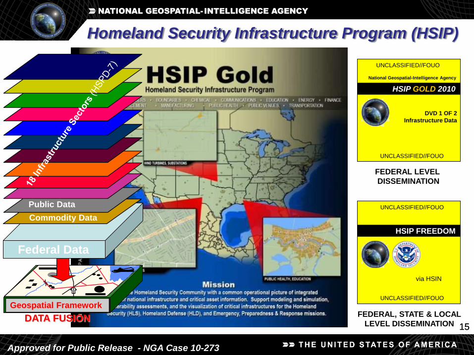
Geospatial Framework
DATA FUSION
Federal Data
Commodity Data
Public Data
Homeland Security Infrastructure Program (HSIP)
HSIP GOLD 2010
UNCLASSIFIED//FOUO
UNCLASSIFIED//FOUO
DVD 1 OF 2
Infrastructure Data
HSIP FREEDOM
FEDERAL LEVEL
DISSEMINATION
FEDERAL, STATE & LOCAL
LEVEL DISSEMINATION
UNCLASSIFIED//FOUO
via HSIN
National Geospatial-Intelligence Agency
UNCLASSIFIED//FOUO
Approved for Public Release - NGA Case 10-273

HSIP Sample Datasets
16
Energy and Chemical Communication and IT Emergency Services Government Facilities
Alternative Fueling Stations AM Antennas Fire Stations ARNG Field Maintenance Shop
Propane Locations FM Antennas EMS ARNG Unit Training Equip Sites
Mines TV B Contours 911 Service Boundaries ARNG Aviation Facilities
Coal Fields US TV Digital Station Transmitters National Shelter System OFO Facilities
Nuclear Fuel Antenna Structure Registrate FEMA REGIONS ANG Installation Areas
Uranium MiningBroadband Radio Service (BRS)
TransmittersOBP Sector Headquarters ANG Sites
Plume Exposure Pathway EPZ Call-sign Service Boundaries OBP Sectors Detailed Army Recruiting Centers
EPA Regions Cellular Towers OBP StationsARNG Readiness and Response
Center
EPA FRS Facilities Land Mobile Commercial Local Emergency Operations Centers ARNG Training Centers
Hazmat Routes Land Mobile private Red Cross Divisions; HQ; Regions Schools; Colleges; Universities
Microwave Towers State EOCs Federal Lands
Internet Exchange Points Hurricane Evacuation Routes Flight Schools
Internet Service ProviderDOI US Park Police; BIA; BLM; FWS;
NPSFusion Centers
IT Locations Portals FBI Field and Resident Agency Office Governors Mansions
Joint Forces Headquarters
Diplomatic Missions Offices
USACE Districts; Divisions
USARMY Reserves Locations
USCG Sectors; Units
WMD Civil Support Teams
Defense Sites
Indian Lands
1717
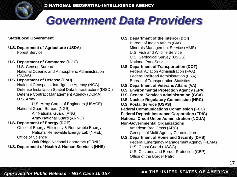
State/Local Government
U.S. Department of Agriculture (USDA)
Forest Service
U.S. Department of Commerce (DOC)
U.S. Census Bureau
National Oceanic and Atmospheric Administration (NOAA)
U.S. Department of Defense (DoD)
National Geospatial-Intelligence Agency (NGA)
Defense Installation Spatial Data Infrastructure (DISDI)
Defense Contract Management Agency (DCMA)
U.S. Army
U.S. Army Corps of Engineers (USACE)
National Guard Bureau (NGB)
Air National Guard (ANG)
Army National Guard (ARNG)
U.S. Department of Energy (DOE)
Office of Energy Efficiency & Renewable Energy
National Renewable Energy Lab (NREL)
Office of Science
Oak Ridge National Laboratory (ORNL)
U.S. Department of Health & Human Services (HHS)
U.S. Department of the Interior (DOI)
Bureau of Indian Affairs (BIA)
Minerals Management Service (MMS)
U.S. Fish and Wildlife Service
U.S. Geological Survey (USGS)
National Park Service
U.S. Department of Transportation (DOT)
Federal Aviation Administration (FAA)
Federal Railroad Administration (FRA)
Bureau of Transportation Statistics
U.S. Department of Veterans Affairs (VA)
U.S. Environmental Protection Agency (EPA)
U.S. General Services Administration (GSA)
U.S. Nuclear Regulatory Commission (NRC)
U.S. Postal Service (USPS)
Federal Communications Commission (FCC)
Federal Deposit Insurance Corporation (FDIC)
National Credit Union Administration (NCUA)
Non-Governmental Organizations
American Red Cross (ARC)
Geospatial Multi-Agency Coordination
U.S. Department of Homeland Security (DHS)
Federal Emergency Management Agency (FEMA)
U.S. Coast Guard (USCG)
U.S. Customs and Border Protection (CBP)
Office of the Border Patrol
Government Data Providers
Approved for Public Release - NGA Case 10-157

1818
HSIP Gold 2010 Commodity Data
NAVTEQ Corporation- Transportation
- Core Points of Interest (hotels, restaurants, gas stations
etc)
- Extended Points of Interest (business points of interests)
- 3D City info, 3D Landmarks, Speed Limits etc
Ventyx- Electrical Energy
PLATTS-Oil and Natural Gas
Techni Graphic Systems (TGS)
- Industrial PinPointer
Approved for Public Release - NGA Case 10-273

1919
HSIP Gold 2010 Update
Total Number of 2008 Data Layers: 333
Total Number of 2010 Data Layers: 336
Change in Total Number of Data Layers +3
• Unchanged Layers: 140 (40%)
• New Layers: 59 (18%)
• Updated Layers*: 103 (30%)
• Replaced Layers**: 39 (12%)
• 2010 includes full NAVTEQ product line, not all data is included in the individual layer count
• 2008 Layers Completely Deleted (i.e. ‘gap’) 35
* Updated Data Layers were provided by the same source for 2008 and 2010
** Replaced Data Layers were provided by a different source in 2010 (vs. 2008)
Approved for Public Release - NGA Case 10-273

Updates for HSIP Freedom
• Total Number of 2008 Data Layers: 190
• Total Number of 2010 Data Layers: 232
• Change in Total Number of Data Layers: +42– Unchanged Layers: 104 (45%)
– New Layers: 72 (31%)
– Updated Layers*: 53 (23%)
– Replaced Layers**: 4 (1%)
• Addition of 9 Partnership Layers After Full Concurrence
is Achieved (Fire Stations, Correctional Facilities (Prisons and Jails), EMS Stations, Law
Enforcement, Hospitals, Urgent Care, Places of Worship, Nursing Homes, Public
Health Departments)
*Updated Data Layers were provided by the same source for 2008 and 2010
**Replaced Data Layers were provided by a different source in 2010 (vs. 2008)
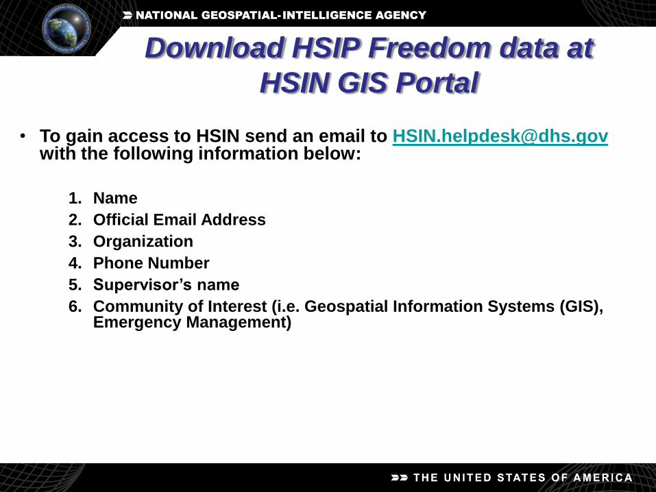
Download HSIP Freedom data at
HSIN GIS Portal
• To gain access to HSIN send an email to [email protected] the following information below:
1. Name
2. Official Email Address
3. Organization
4. Phone Number
5. Supervisor’s name
6. Community of Interest (i.e. Geospatial Information Systems (GIS), Emergency Management)

Download HSIP Freedom data at
HSIN GIS Portal
• If you are not a Federal, State, or Local government employee you will need a sponsor. Your sponsor must be a Federal, State, or Local government employee. Requests will not be processed without this information.
Please add information below to request:1. Government Sponsor’s Name
2. Government Sponsor’s Official Email
3. Government Sponsor’s Organization
4. Government Sponsor’s Phone Number
• If you already have an HSIN account, but are requesting access to another Community of Interest (COI), please send the same information to the [email protected] and specify the GIS and EM COIs

HSIN GIS Portal
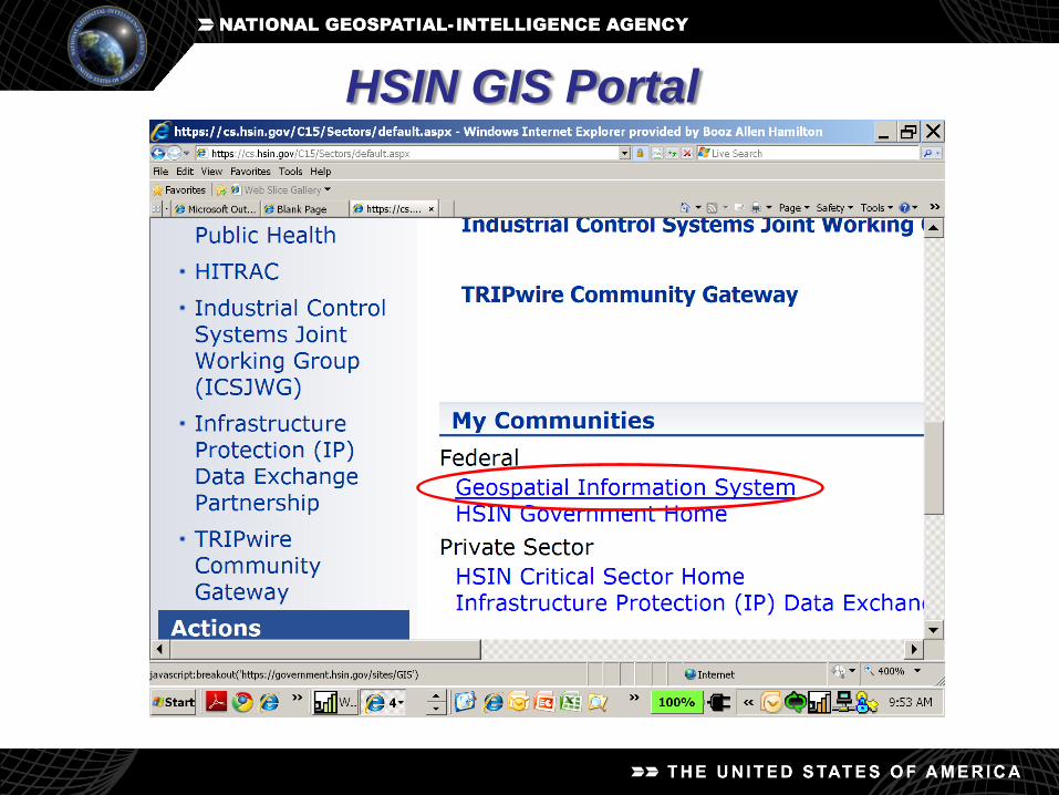
HSIN GIS Portal

HSIN GIS Portal

Michael Ouimet
HIFLD to the Regions (HTTR)
HTTR Gulf Coast Region (AL, LA, MS, TX)
(512) 921-9671