history - terreform one · and then the trolley dodgers, have a new place to play. 1929 to 1964 - a...
TRANSCRIPT
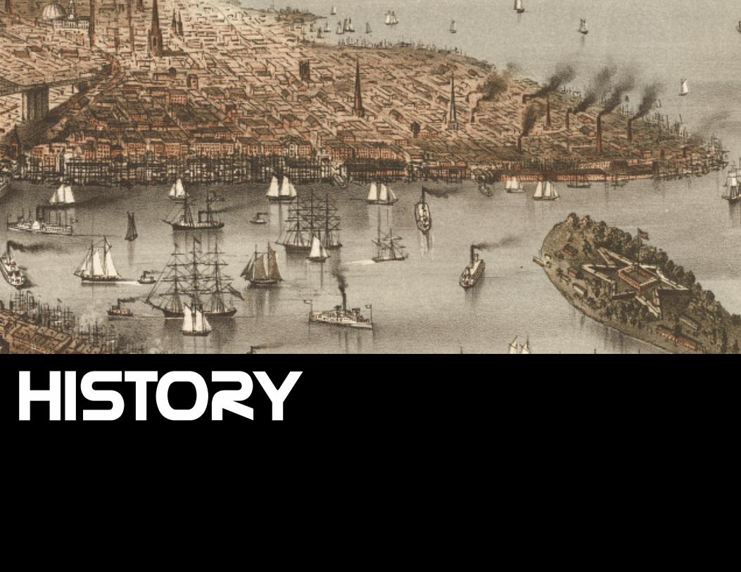
HISTORY
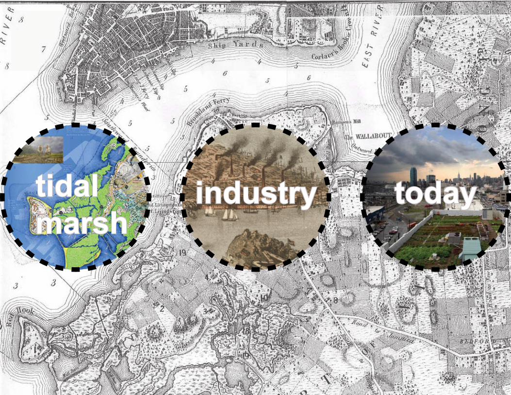
tidal marsh
industry today
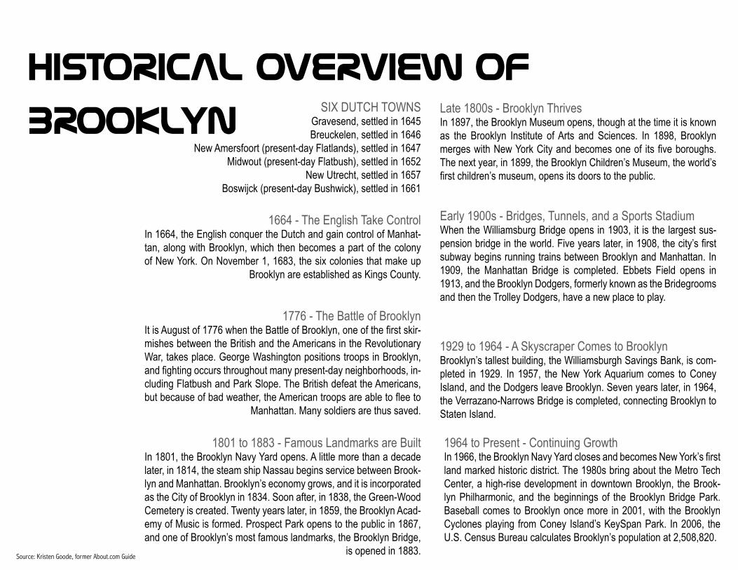
HISTORICAL OVERVIEW OF
BROOKLYNSIX DUTCH TOWNS
Gravesend, settled in 1645Breuckelen, settled in 1646
New Amersfoort (present-day Flatlands), settled in 1647Midwout (present-day Flatbush), settled in 1652
New Utrecht, settled in 1657Boswijck (present-day Bushwick), settled in 1661
Source: Kristen Goode, former About.com Guide
1801 to 1883 - Famous Landmarks are BuiltIn 1801, the Brooklyn Navy Yard opens. A little more than a decade later, in 1814, the steam ship Nassau begins service between Brook-lyn and Manhattan. Brooklyn’s economy grows, and it is incorporated as the City of Brooklyn in 1834. Soon after, in 1838, the Green-Wood Cemetery is created. Twenty years later, in 1859, the Brooklyn Acad-emy of Music is formed. Prospect Park opens to the public in 1867, and one of Brooklyn’s most famous landmarks, the Brooklyn Bridge,
is opened in 1883.
Late 1800s - Brooklyn ThrivesIn 1897, the Brooklyn Museum opens, though at the time it is known as the Brooklyn Institute of Arts and Sciences. In 1898, Brooklyn merges with New York City and becomes one of its fi ve boroughs. The next year, in 1899, the Brooklyn Children’s Museum, the world’s fi rst children’s museum, opens its doors to the public.
Early 1900s - Bridges, Tunnels, and a Sports StadiumWhen the Williamsburg Bridge opens in 1903, it is the largest sus-pension bridge in the world. Five years later, in 1908, the city’s fi rst subway begins running trains between Brooklyn and Manhattan. In 1909, the Manhattan Bridge is completed. Ebbets Field opens in 1913, and the Brooklyn Dodgers, formerly known as the Bridegrooms and then the Trolley Dodgers, have a new place to play.
1929 to 1964 - A Skyscraper Comes to BrooklynBrooklyn’s tallest building, the Williamsburgh Savings Bank, is com-pleted in 1929. In 1957, the New York Aquarium comes to Coney Island, and the Dodgers leave Brooklyn. Seven years later, in 1964, the Verrazano-Narrows Bridge is completed, connecting Brooklyn to Staten Island.
1964 to Present - Continuing GrowthIn 1966, the Brooklyn Navy Yard closes and becomes New York’s fi rst land marked historic district. The 1980s bring about the Metro Tech Center, a high-rise development in downtown Brooklyn, the Brook-lyn Philharmonic, and the beginnings of the Brooklyn Bridge Park. Baseball comes to Brooklyn once more in 2001, with the Brooklyn Cyclones playing from Coney Island’s KeySpan Park. In 2006, the U.S. Census Bureau calculates Brooklyn’s population at 2,508,820.
1664 - The English Take ControlIn 1664, the English conquer the Dutch and gain control of Manhat-tan, along with Brooklyn, which then becomes a part of the colony of New York. On November 1, 1683, the six colonies that make up
Brooklyn are established as Kings County.
1776 - The Battle of BrooklynIt is August of 1776 when the Battle of Brooklyn, one of the fi rst skir-mishes between the British and the Americans in the Revolutionary War, takes place. George Washington positions troops in Brooklyn, and fi ghting occurs throughout many present-day neighborhoods, in-cluding Flatbush and Park Slope. The British defeat the Americans, but because of bad weather, the American troops are able to fl ee to
Manhattan. Many soldiers are thus saved.
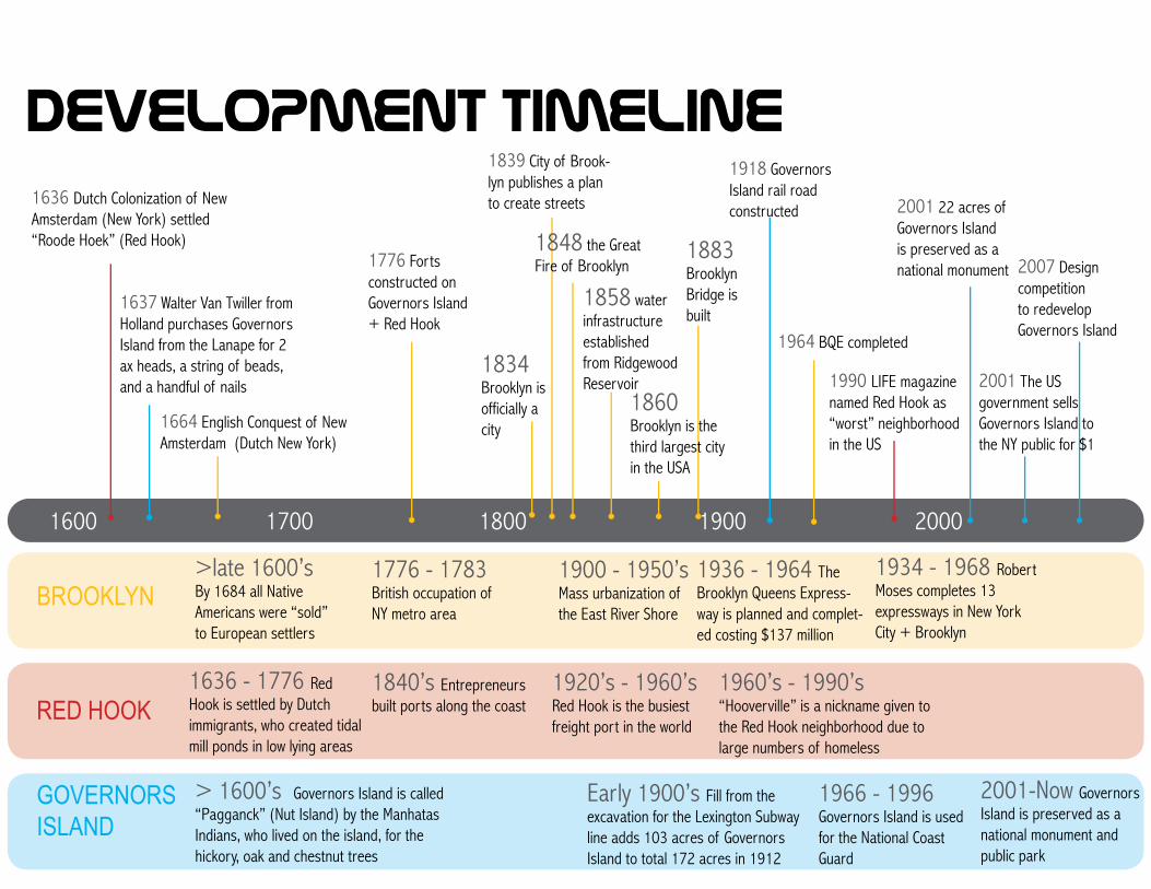
>late 1600’sBy 1684 all Native Americans were “sold” to European settlers
1900 - 1950’sMass urbanization of the East River Shore
1776 - 1783 British occupation of NY metro area
1834 Brooklyn is officially a city
1883 Brooklyn Bridge is built
1858 water infrastructure established from Ridgewood Reservoir
1934 - 1968 Robert Moses completes 13 expressways in New York City + Brooklyn
1936 - 1964 The Brooklyn Queens Express-way is planned and complet-ed costing $137 million
Early 1900’s Fill from the excavation for the Lexington Subway line adds 103 acres of Governors Island to total 172 acres in 1912
> 1600’s Governors Island is called “Pagganck” (Nut Island) by the Manhatas Indians, who lived on the island, for the hickory, oak and chestnut trees
1966 - 1996 Governors Island is used for the National Coast Guard
2001-Now Governors Island is preserved as a national monument and public park
1920’s - 1960’s Red Hook is the busiest freight port in the world
1960’s - 1990’s “Hooverville” is a nickname given to the Red Hook neighborhood due to large numbers of homeless
1636 - 1776 Red Hook is settled by Dutch immigrants, who created tidal mill ponds in low lying areas
1840’s Entrepreneurs built ports along the coast
1600 1700 1800 1900 2000
BROOKLYN
RED HOOK
GOVERNORS ISLAND
1636 Dutch Colonization of New Amsterdam (New York) settled “Roode Hoek” (Red Hook)
1664 English Conquest of New Amsterdam (Dutch New York)
1637 Walter Van Twiller from Holland purchases Governors Island from the Lanape for 2 ax heads, a string of beads, and a handful of nails
1776 Forts constructed on Governors Island + Red Hook
1839 City of Brook-lyn publishes a plan to create streets
1964 BQE completed
1918 Governors Island rail road constructed 2001 22 acres of
Governors Island is preserved as a national monument
2001 The US government sells Governors Island to the NY public for $1
2007 Design competition to redevelop Governors Island
1990 LIFE magazine named Red Hook as “worst” neighborhood in the US
1860 Brooklyn is the third largest city in the USA
1848 the Great Fire of Brooklyn
DEVELOPMENT TIMELINE
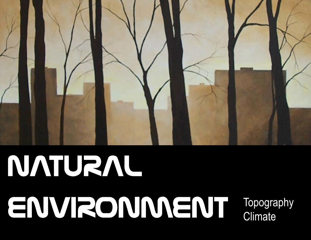
TopographyClimate
NATURAL
ENVIRONMENT
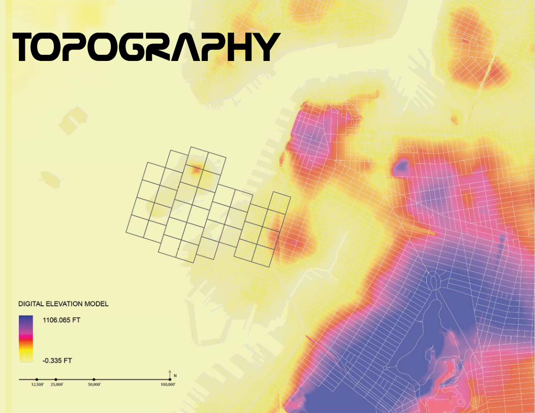
TOPOGRAPHY
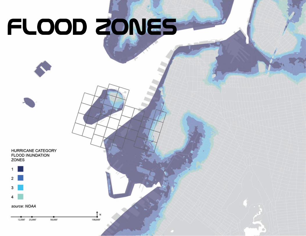
Flood zones
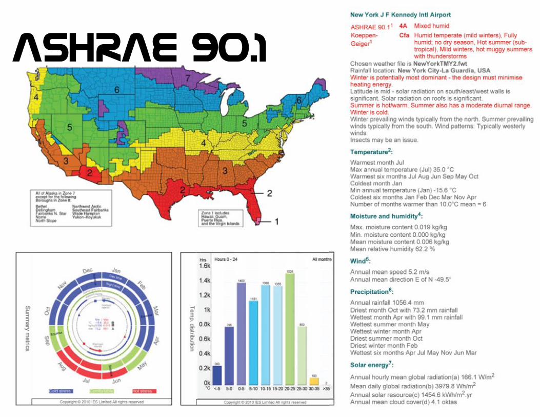
ashrae 90.1

temperature
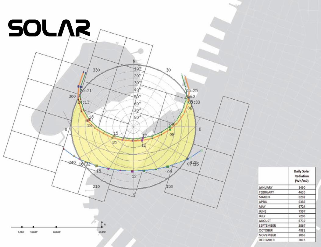
solar
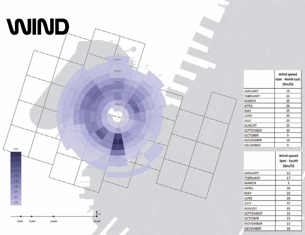
wInd
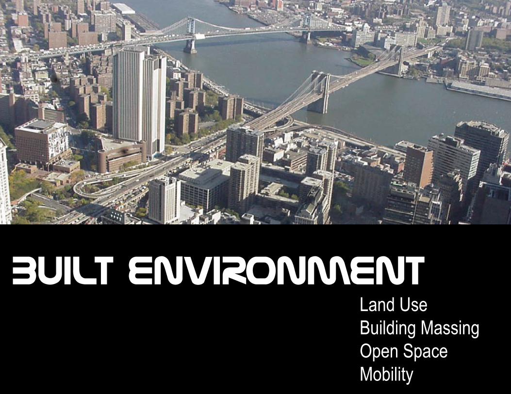
Land UseBuilding MassingOpen SpaceMobility
BUILT ENVIRONMENT
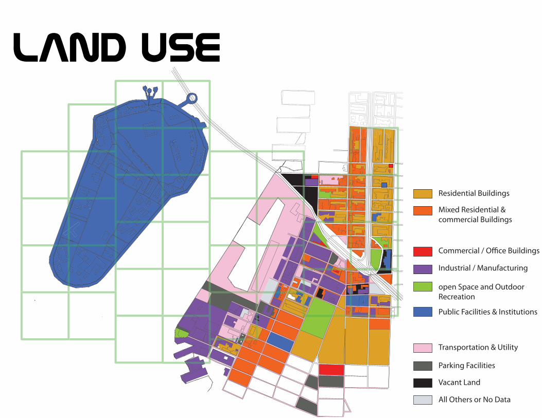
Commercial / Office Buildings
Transportation & Utility
Parking Facilities
Vacant Land
All Others or No Data
Industrial / Manufacturing
open Space and Outdoor Recreation
Public Facilities & Institutions
Residential Buildings
Mixed Residential & commercial Buildings
land use
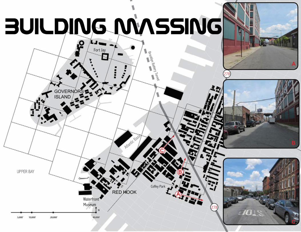
Coffey Park
Waterfront Museum
Fort Jay
UPPER BAY
Atlantic
Basin
RED HOOK
GOVERNORS ISLAND
RED HOOK
278
278
Brooklyn Battery Tunnel
buIldIng massIng
A
A
B
B
C
C
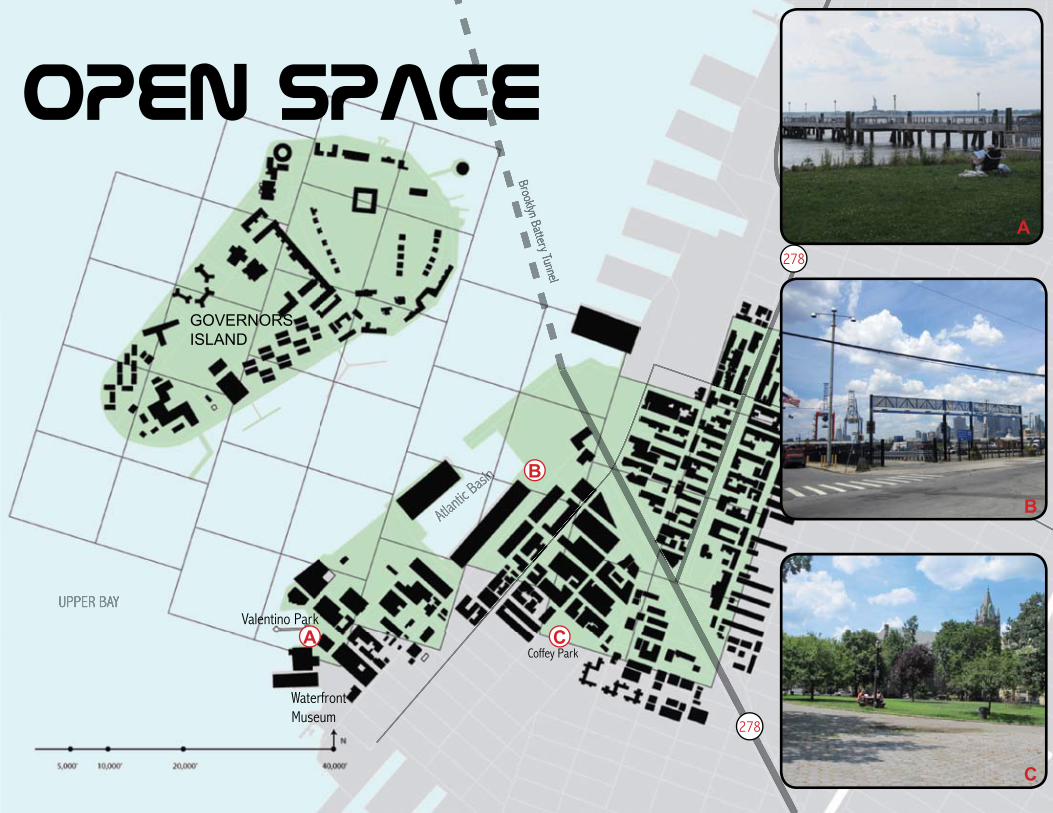
Coffey Park
Valentino Park
Waterfront Museum
Gowa
nus C
anal
UPPER BAY
Atlantic
Basin
CARROL GARDENS
COBBLE HILL
GOVERNORS ISLAND
278
278
Brooklyn Battery Tunnel
C
C
A
A
B
B
open space
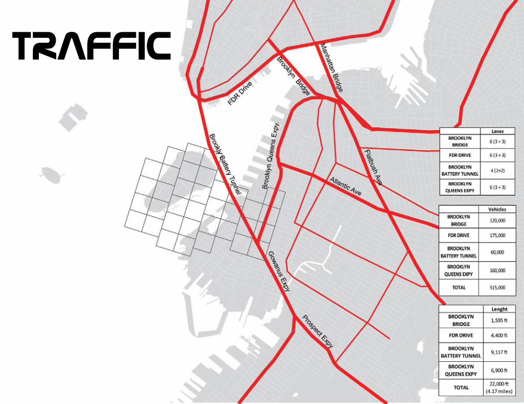
traffIc
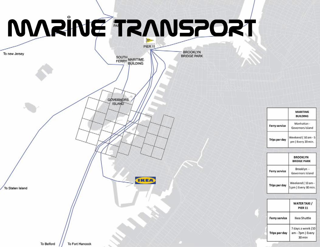
marine transport
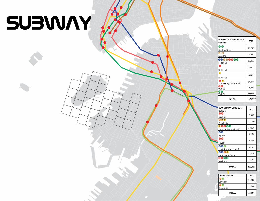
subwayDOWNTOWN MANHATTAN Stations
2011
South Ferry / Whitehall 29,583
TOTAL 191,077
Bowling Green27,015
Fulton St63,203
Broad St5,746
Rector St8,902
Rector St8,083
Wall St 22,986
Wall St 25,559
DOWNTOWN BROOKLYN Stations
2011
Court St /Borough Hall38,026
TOTAL 133,427
Clark St5,596
DeKalb Av17,180
6,586
Hoyt St
High St
6,535
Hoyt-Schermerhorn Sts9,760
Nevins St11,708
Jay St-MetroTech38,036
URBANEER SITE 2011
TOTAL 22,954
Bergen St11,048
Carroll St11,906
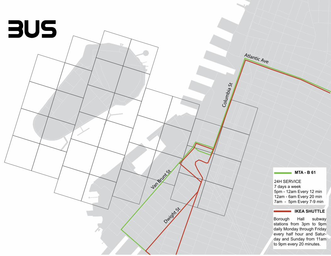
Van Brunt S
t
Dwight St
Colu
mbi
a St
Atlantic Ave
MTA - B 61
IKEA SHUTTLE
24H SERVICE7 days a week5pm - 12am Every 12 min12am - 6am Every 20 min7am - 5pm Every 7-9 min
Borough Hall subway stations from 3pm to 9pm daily Monday through Friday every half hour and Satur-day and Sunday from 11am to 9pm every 20 minutes.
bus
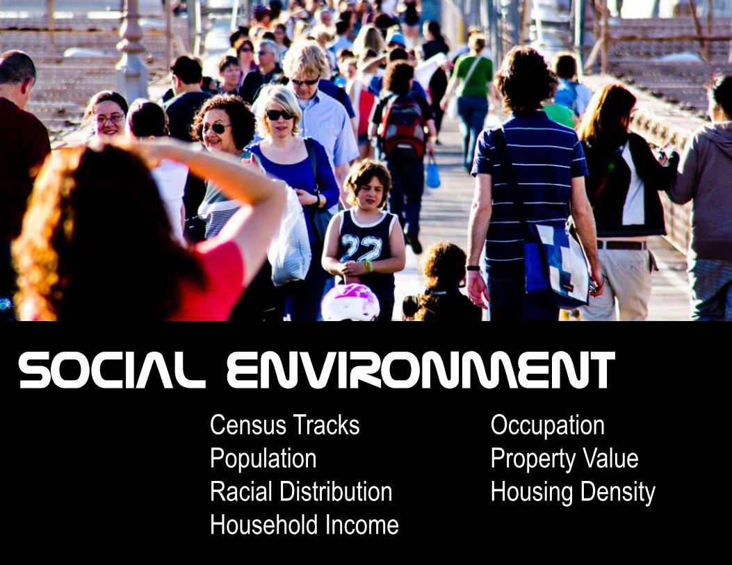
Census TracksPopulationRacial DistributionHousehold Income
OccupationProperty ValueHousing Density
SOCIAL ENVIRONMENT
Van B
runt S
treet
UPPER BAY
Atlantic
Basin
RED HOOK
GOVERNORS ISLAND
RED HOOK
278
278
Brooklyn Battery Tunnel
Gowa
nus C
anal
COLUMBIA STREET WATERFRONT DISTRICT
CARROL GARDENS
COBBLE HILL
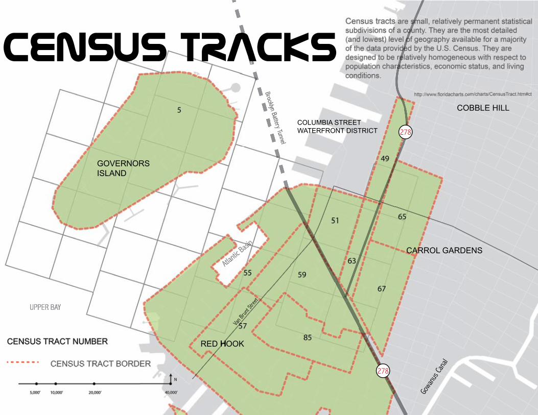
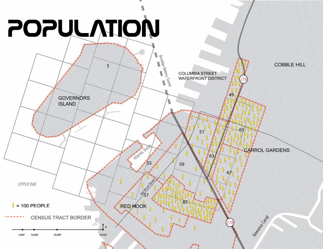
Census tracks
Van B
runt S
treet
UPPER BAY
Atlantic
Basin
RED HOOK
GOVERNORS ISLAND
RED HOOK
278
278
Brooklyn Battery Tunnel
Gowa
nus C
anal
COLUMBIA STREET WATERFRONT DISTRICT
CARROL GARDENS
COBBLE HILL
POPULATION
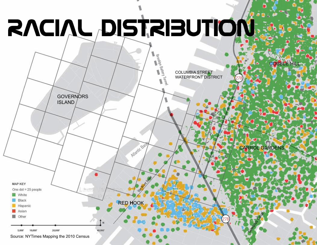
RACIAL DISTRIBUTION
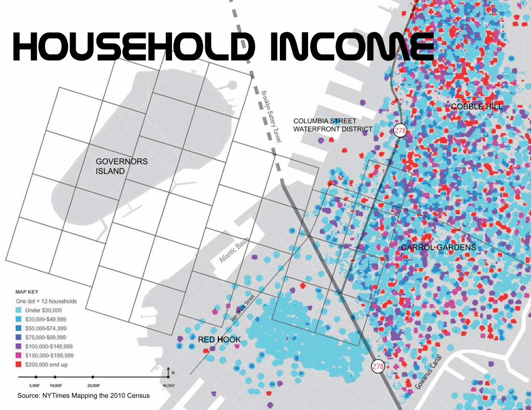
Source: NYTimes Mapping the 2010 Census
RACIAL DISTRIBUTIONRACIAL DISTRIBUTION
Van B
runt S
treet
Atlantic
Basin
RED HOOK
GOVERNORS ISLAND
RED HOOK
278
278
Brooklyn Battery Tunnel
Gowa
nus C
anal
COLUMBIA STREET WATERFRONT DISTRICT
CARROL GARDENS
COBBLE HILL
Van B
runt S
treet
Atlantic
Basin
RED HOOK
GOVERNORS ISLAND
RED HOOK
278
278
Brooklyn Battery Tunnel
Gowa
nus C
anal
COLUMBIA STREET WATERFRONT DISTRICT
CARROL GARDENS
COBBLE HILL
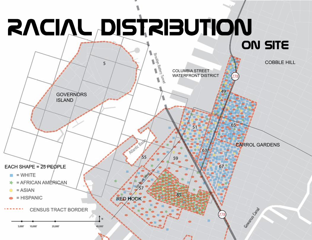
on sIteracIal dIstrIbutIon
Source: NYTimes Mapping the 2010 Census
Van B
runt S
treet
Atlantic
Basin
RED HOOK
GOVERNORS ISLAND
RED HOOK
278
278
Brooklyn Battery Tunnel
Gowa
nus C
anal
COLUMBIA STREET WATERFRONT DISTRICT
CARROL GARDENS
COBBLE HILL
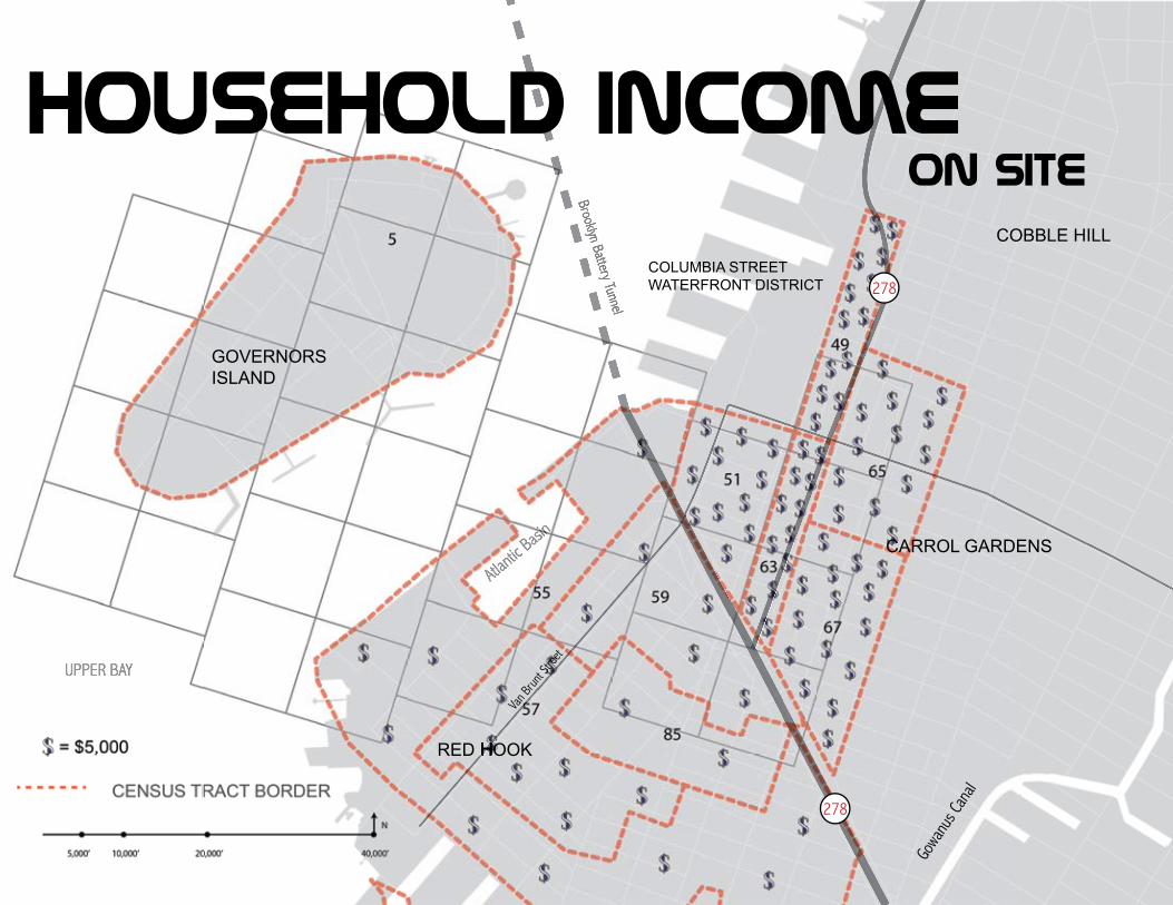
household Income
Van B
runt S
treet
UPPER BAY
Atlantic
Basin
RED HOOK
GOVERNORS ISLAND
RED HOOK
278
278
Brooklyn Battery Tunnel
Gowa
nus C
anal
COLUMBIA STREET WATERFRONT DISTRICT
CARROL GARDENS
COBBLE HILL
on sItehousehold Income
Van B
runt S
treet
Atlantic
Basin
RED HOOK
GOVERNORS ISLAND
RED HOOK
278
278
Brooklyn Battery Tunnel
Gowa
nus C
anal
COLUMBIA STREET WATERFRONT DISTRICT
CARROL GARDENS
COBBLE HILL
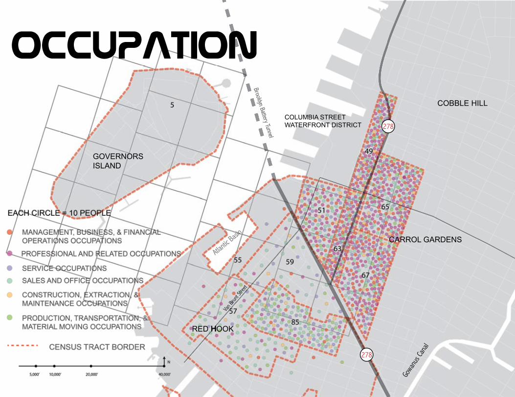
OccupatIon
Source: NYTimes Mapping the 2010 Census
Van B
runt S
treet
Atlantic
Basin
RED HOOK
GOVERNORS ISLAND
RED HOOK
278
278
Brooklyn Battery Tunnel
Gowa
nus C
anal
COLUMBIA STREET WATERFRONT DISTRICT
CARROL GARDENS
COBBLE HILL
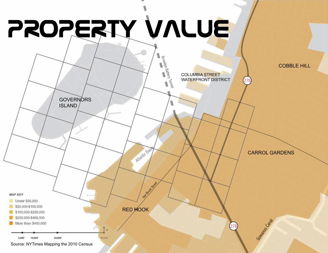
Property value
Source: NYTimes Mapping the 2010 Census
Van B
runt S
treet
Atlantic
Basin
RED HOOK
GOVERNORS ISLAND
RED HOOK
278
278
Brooklyn Battery Tunnel
Gowa
nus C
anal
COLUMBIA STREET WATERFRONT DISTRICT
CARROL GARDENS
COBBLE HILL
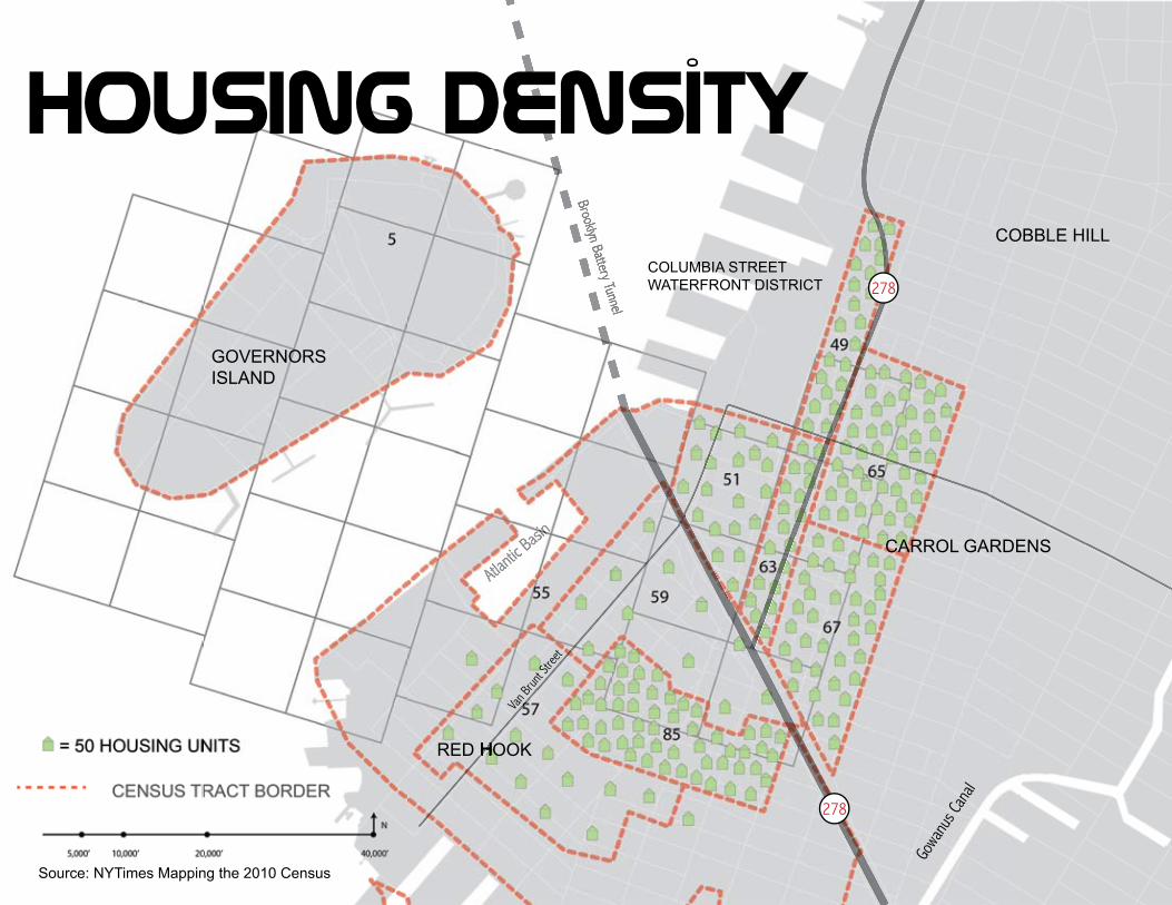
housIng density