history of mapping taught at g&m - library of congress of mapping taught at g&m ... tronomer...
TRANSCRIPT
History of Mapping Taught at G&M
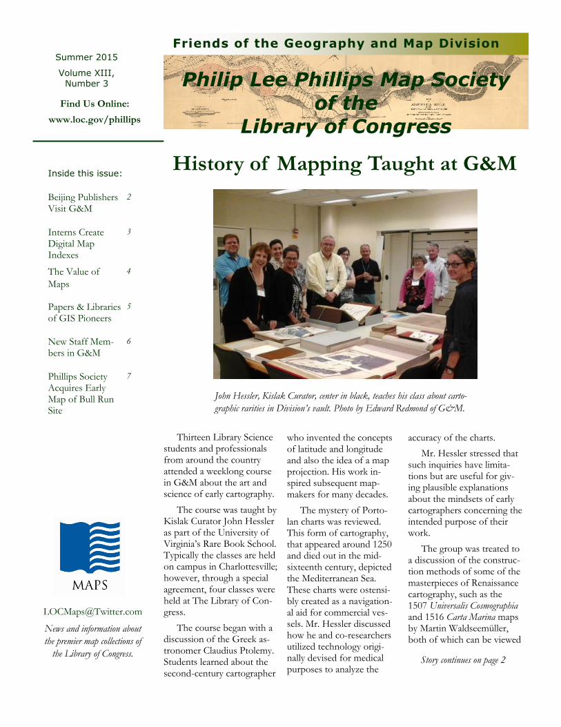
Thirteen Library Science students and professionals from around the country attended a weeklong course in G&M about the art and science of early cartography.
The course was taught by Kislak Curator John Hessler as part of the University of Virginia’s Rare Book School. Typically the classes are held on campus in Charlottesville; however, through a special agreement, four classes were held at The Library of Con-gress.
The course began with a discussion of the Greek as-tronomer Claudius Ptolemy. Students learned about the second-century cartographer
Inside this issue:
News and information about
the premier map collections of
the Library of Congress.
Philip Lee Phillips Map Society
of the Library of Congress
Friends of the Geography and Map Division Summer 2015
Volume XIII,
Number 3
who invented the concepts of latitude and longitude and also the idea of a map projection. His work in-spired subsequent map-makers for many decades.
The mystery of Porto-lan charts was reviewed. This form of cartography, that appeared around 1250 and died out in the mid-sixteenth century, depicted the Mediterranean Sea. These charts were ostensi-bly created as a navigation-al aid for commercial ves-sels. Mr. Hessler discussed how he and co-researchers utilized technology origi-nally devised for medical purposes to analyze the
accuracy of the charts.
Mr. Hessler stressed that such inquiries have limita-tions but are useful for giv-ing plausible explanations about the mindsets of early cartographers concerning the intended purpose of their work.
The group was treated to a discussion of the construc-tion methods of some of the masterpieces of Renaissance cartography, such as the 1507 Universalis Cosmographia and 1516 Carta Marina maps by Martin Waldseemüller, both of which can be viewed
Find Us Online:
www.loc.gov/phillips
Beijing Publishers Visit G&M
2
Interns Create Digital Map Indexes
3
The Value of
Maps
4
Papers & Libraries of GIS Pioneers
5
New Staff Mem-bers in G&M
6
Phillips Society Acquires Early Map of Bull Run Site
7
John Hessler, Kislak Curator, center in black, teaches his class about carto-
graphic rarities in Division’s vault. Photo by Edward Redmond of G&M.
Story continues on page 2

Page 2 Phi l ip Lee Phi l l ips Map Soc iety Volume XIII , Number 3
The Philip Lee Phillips Map So-
ciety of the Library of Congress is
named in honor of Philip Lee Phillips
(1857-1924), the first Superintendent
of Maps at the Library of Congress
when the Hall of Maps and Charts
was established in 1897.
The group is a non-profit, volun-
tary association whose objective is to
develop, enhance, and promote the
work of the Geography and Map
Division by advancing its publication,
education, exhibition, preservation,
and acquisition programs.
For membership information
please contact our staff below.
PLP Newsletter Staff
Ryan Moore
Editor
202-707-7779
Ralph E. Ehrenberg
Managing Editor
202-707-1992
David Ducey
Copy Editor
G&M Chief Ralph E. Ehrenberg and Cataloging Supervisor Min Zhang met with a group of publishers from Beijing University Press.
Beijing University Press is the leading publisher in China for early Chinese works.
Following the meeting, Reference Specialist Habte Teclemari-am and Cataloging Specialist Tammy Wong provided a tour of the Division for the Beijing-based publishers.
Beijing Publishers Visit G&M
at The Library of Congress.
The course closed with sur-vey of contemporary tools that are being used to help date and understand the complex notions of error and knowledge trans-mission in cartography. In other words, understanding how mis-takes are unwittingly accepted as fact and then become repeated, thereby reinforcing a falsehood.
Mr. Hessler is the Curator of the Jay I. Kislak Collection of
Rare Book School at G&M Story continued from page 2
the Archaeology and History of the Early Americas and a Spe-cialist in Modern Cartography and Geographic Information Science at the Library of Con-gress. A Fellow of the Royal Geographical Society, he is also a lecturer in the history of car-tography and early modern sci-ence in the Graduate School of Advanced Studies at Johns Hopkins University.
By Ryan Moore

Page 3 Friends of the Geography and Map Division
Indexes for many of G&M’s map sets will soon be online thanks to a unique project spear-headed by Kislak Curator John Hessler and four interns.
The project started in June 2015. Geographic Information Science (GIS) technicians from local universities were assigned to create digital indexes for hot-spot maps in the Middle East. Although the Division created digital indexes for African set maps, a project sponsored by the Council of Li-braries and Information Resources in 2011, this complex and dynamic indexing program was a substantial progression from that earlier effort.
The benefits of the project to members of the public are clear. Researchers, working from a computer with Internet access, will be able to check whether a particular map sheet is available to view in the Reading Room. There are plans to post complete map sets that are in the public do-main online.
The work of library staff members will be made easier. Digital indexes will help both acquisitions and reference staff members know immediately about the Division’s coverage of individual map sheets in a geo-graphic setting. Indexes also simplify the retrieval of maps should a patron request one.
Using GIS as a platform, team members processed some 7000 maps. The procedure included constructing geo-referenced and cropped images, which were stitched together into almost seamless coverage for each map set. In short, this process required the copy-ing of metadata from each individual map sheet, high-resolution scanning, geo-referencing, and uploading the final mosaic to an online server.
The team members who are recent graduates, in-cluded: Amanda Brioche from the University of Miami, Evan Neuwirth from Towson University, Erin Kelly from Towson. Current graduate student Michael Schoelen from Towson State University worked on the team as well.
Stitching the World Together
Geo-Digitizing Map Collections with GIS
Above: 1:100,000 index of Syria. Below: A portion of a
Russian map set that shows the capital city Damascus.

Page 4
Throughout the ages, maps and atlases have been powerful ways of communi-cating information.
Today, G&M has the largest and most comprehen-sive cartographic collection in the world with more than 5.5 million items. While most current cartographic works published in the United States are acquired by the Library through the U.S. Copyright Office or pur-chased with appropriated funds, private support helps the Library acquire rare and unique maps and other col-lections that might otherwise be out of reach.
In 1995, G&M established two support groups: the Philip Lee Phillips Map Society, an association of friends of maps named after the Division’s first chief; and the Center for Geo-graphic Information (CGI), a partner-ship of private sector firms. The CGI encourages deposits of geospatial data sets by American and foreign govern-ment, industry and academic produc-ers. Institutions such as Harvard have responded by donating their profes-sional papers concerning the develop-ment of computer-assisted mapping.
Gifts from Phillips Map Society members have supported the Library’s acquisition of rare cartographic items such as the James Merrill Safford Col-lection of 55 geological maps of Ten-nessee. William Wooldridge of the Phillips Map Society, along with the Norfolk Southern Foundation, made it possible for the Library to acquire Herman Boye’s 1827 map of Virginia. Several members of the Phillips Map Society, including its chair, George
Tobolowsky, along with Roger Baskes, William Ginsburg and Richard Brown, are also members of the James Madi-son Council, the Library’s private-sector advisory group. Both groups, with support from Phillips Map Socie-ty Steering Committee member Thomas J. Touchton, collaborated to purchase for the Library a 1752 map of Philadelphia by Nicholas Scull.
The Madison Council has made many Library acquisitions possible, including several exceedingly rare maps. One such map is the only known copy of the 1507 world map by Martin Waldseemüller— the first map to use the name “America.” It spent nearly 400 years in obscurity in the library of a castle in southern Ger-many until its rediscovery in 1901.
The Library purchased it in 2003 for $10 million— with half the funds coming from a congressional appro-priation and the other half from pri-vate donors, including Discovery Channel, former Madison Council
The Value of Maps
Phi l ip Lee Phi l l ips Map Soc iety Volume XIII , Number 3
chairman H.F. (Gerry) Lenfest, and others.
The following year, the Library acquired a major collection of rare books, manuscripts, historic docu-ments, maps and art of the early Americas, which were donated by the Jay I. Kislak Foundation. The Kislak Collection includes the Carta Marina (1516), the first printed navigational chart of the entire world, prepared by Waldseemüller.
In 2010, philanthropist David M. Rubenstein, the current chair of the Madison Council, purchased a rare copy of a 1784 map of the new United States by Abel Buell. Rubenstein gen-erously placed the map at the Library so it can be publicly displayed.
This story first appeared in the July/August 2015 edition of The Library of Con-gress Magazine.
Ryan Moore and John Hessler contribut-ed to this article.
Donors Help Build G&M’s Collection

Page 5
Papers and Libraries of GIS Pioneers
The papers and personal libraries of two noteworthy Geographic Infor-mation Systems (GIS) pioneers are avail-able for research in G&M. Waldo To-bler was a cutting-edge theorist who pushed the envelope to find an effective way to display geographic data using computer programs. Joel L. Morrison had the vision to collect and preserve the literature written by cartographic professionals concerning the develop-ment of GIS software from the early 1960s to 2001.
Finding aids are available online for both collections.
GIS Visionary
Waldo Tobler, born in 1930, is an American-Swiss geographer and cartog-rapher. Tobler is famous for the "first law of geography," an idea that posits "everything is related to everything else, but near things are more related to each other." He is a leading figure in the de-velopment of digital cartography and invented many map projections.
Tobler received his doctorate in ge-ography from the University of Wash-ington at Seattle in 1961. He taught at the University of Michigan from 1961 to 1977. Until his retirement in 1994, he held the positions of Professor of Geog-raphy and Professor of Statistics at the University of California, Santa Barbara. The University of Zurich, Switzerland, awarded him an honorary doctorate in 1988.
Tobler worked on the editorial board of many journals, which included Journal of Regional Science, The American Cartogra-pher, and International Journal of Geograph-ical Information and Geographical Analysis. He served as a member of Royal Geo-graphical Society in Great Britain, Re-gional Science Association and United States National Academy of Sciences. He was the United States delegate to
International Geographical Union Commission on Sensing and Data Pro-cessing.
Aggregator and Editor
Joel L. Morrison served as a leader in the creation of uniform geographic data. He worked to bring together di-verse efforts within the United States to create the Spatial Data Transfer Stand-ard.
During the course of his career, he compiled a large body of papers on the topic of GIS by professionals from around the world. He amassed a collec-tion of gray literature and white papers written between 1963 and 2001.
Professor Morrison’s time at The Ohio State University is represented by correspondence from that period. The collection contains professional records from his work on Elements of Cartography and for Goode's World Atlas. Also present is correspondence and materials relating to his work as editor for Annals of the Association of American Geographers and as chairman for the American Congress of Surveying and Mapping.
Collections Available for Research in G&M
Professor Morrison received his doctorate from the University of Wis-consin in Madison in 1968 and was hired as faculty. He was department chairman for sixteen years. He entered government service in 1984 and joined the U.S. Geological Survey in Reston, Virginia as the Senior Advisor for Ge-ography in the National Mapping Divi-sion. In 1987, he accepted the position of Assistant Division Chief in NMD for Research. In 1995, he became the Chief of the Geography Division of the U.S. Bureau of the Census. In 1998, he directed the Center for Mapping at The Ohio State University in Columbus until his retirement as Professor Emeri-tus in 2003.
Professor Morrison served as Presi-dent of the American Congress on Sur-veying and Mapping and as President of the International Cartographic Associa-tion. He was one of the organizers of the Cartography Specialty Group of the Association of American Geographers.
By Ryan Moore
Friends of the Geography and Map Division
Waldo Tobler at the University of
Michigan, 1961-1977 Joel L. Morrison photographed in
1999 at The Ohio State University.

Page 6 Phi l ip Lee Phi l l ips Map Soc iety Volume XIII , Number 3
Katje Lattik served as a Junior Fellow in G&M this sum-mer. Ms. Lattik researched Mesoamerican jade objects in the Jay Kislak Collection. The objects are thought to have been used for funerals and ritual commemorations of the dead. She examined each objects’ origins, iconography, cultural identity and stone composition. Archaeological reports and digital photography were utilized in her research.
Ms. Lattik is an undergraduate at Towson University. Her primary areas of study are anthropology, art history, and museum studies. She has particular interest in archeology and cultural studies of the Early Americas.
John Hessler, G&M Kislak Curator, oversaw her project.
Her findings were presented to Dr. James Billington and Library staff members, alongside other Junior Fellows, in July.
*
Min Zhang, Head of G&M Cataloging, served as a men-tor in the Library’s FutureBridge program and supervised the work of a library employee, who was involved in scan-ning Chinese maps.
The scans were shared with Macau University of Science and Technology. Hundreds of early seventeenth-century Chinese maps in The Library’s collections were made availa-ble digitally for the first time.
Ms. Zhang has been a mentor since 2012. G&M Digital Team Leader, Colleen Cahill, also assisted the mentee.
The program’s purpose is to help self-motivated employ-ees enhance and enrich their professional development, bet-ter understand their value and purpose in the Library and Library Services, and expand their opportunities.
G&M Fellows, Mentors & New Staff
This summer, Timothy St. Onge joined the Digital Cartography Team. He is a recent graduate of Clark University where he earned his Master of Science degree in Ge-ographic Information Science . The focus of his graduate research was urban geography and how GIS con-tributes to the understanding of human-environment interactions to address persistent urban problems, such as crime, poverty, residential segregation, and transportation in-efficiencies
*
The Cataloging Team has hired two language spe-cialists with extensive cataloging experience.
Marzieh Rafi and Setsuko Means join the Divi-sion, after working in Library’s Acquisitions and Bibliographic Access Division.
Ms. Rafi specializes in Persian and will be handling maps of Iran, as well as Arabic-language materials. Before joining The Library of Congress, she worked for NASA.
Ms. Means is a Japanese lan-guage specialist and will be cataloging Japanese maps, in particular working on project to describe Japanese military maps from the period of WWII.
She has a Master of Library and Information Science from the University of Maryland. In Japan, she worked as a reference librari-an at various public libraries.
Mr. St. Onge
Ms. Rafi
Ms. Means

Page 7
Phillips Map Society Map Purchase
Phillips Map Society funds were used to purchase a colonial-era map known as Plat for a large parcel in Fairfax County, Vir-ginia belonging to Captain Willoughby Newton. The acquisition totaled $6,775.00.
The plat displays and describes a 6,420-acre parcel in the vicinity of the present-day Centreville, Virginia, which was later the site of the first battle of the Civil war. Land owner Captain Willoughby Newton assembled the plot in the 1740s by com-bining a large grant of 3,600 acres with the purchase of adjacent land.
Little is known about the surveyor Elias Davis of Westmoreland County. In 1748, he drew the map with ink on four sheets, which are sized approximately 21 x 23 inches.
More than a hundred years after the map was produced, the July 21, 1861 Battle of Bull Run, also known as First Manas-sas in the South, ended in defeat for the Union army.
The battle was preceded by a series of skirmishes in Fairfax County. The area mapped by Davis was the site of Union General Irvin McDowell’s failed attempt to cross Bull Run Creek and flank the Confederate army.
By Ryan Moore
Map Shows Land Where Bull Run Skirmishes Fought
Friends of the Geography and Map Division

Steering Committee
Page 8 Friends of the Geography and Map Division
Ex Officio
Ralph E. Ehrenberg, Chief, G&M
John R. Hébert, Chief, G&M , 1999-2011
John A. Wolter, Chief, G&M, 1978-1991
Academic Advisors
George Tobolowsky, Texas (Chair)
Dianne G. Powell, Texas (Vice Chair)
Wesley A. Brown, Colo.
Robert David, Fla.
William B. Ginsberg, N.Y.
Arthur Holzheimer, Ill.
Jay Lester, N.C.
Glen McLaughlin, Calif.
Kenneth Nebenzahl, Ill.
Richard Pflederer, Va.
Seymour I. Schwartz, N.Y.
J. Thomas Touchton, Fla.
James Walker, Ore.
Ronald Grim, Boston Public Library
Alice Hudson, New York Public Library, Ret.
Mark Monmonier, Syracuse University
Mary Pedley, Univ. of Michigan
Dennis Reinhartz, Univ. of Texas at Arlington, Ret.
Susan Schulten, Univ. of Denver
Norman J. W. Thrower, Univ. of California at LA, Ret.
Cordell D. K. Yee, St. John’s College, Annapolis