history and general distribution of the monroe
TRANSCRIPT

Publication 2, Geological Series 1 – Page 1 of 93
STATE OF MICHIGAN MICHIGAN GEOLOGICAL AND BIOLOGICAL SURVEY
Publication 2. Geological Series 1. THE MONROE FORMATION OF SOUTHERN
MICHIGAN AND ADJOINING REGIONS
by A. W. Grabau and W. H. Sherzer
PUBLISHED AS PART OF THE ANNUAL REPORT OF THE BOARD OF GEOLOGICAL AND BIOLOGICAL SURVEY FOR
1909.
LANSING, MICHIGAN WYNKOOP HALLENBECK CRAWFORD CO., STATE
PRINTERS 1910
Contents Letter of Transmittal. ......................................................... 1 Chapter I. History and General Distribution of the Monroe Formation, by W. H. Sherzer. .............................. 1 Chapter II. Stratigraphy, Structure and Local Distribution of the Monroe Formation, by W. H. Sherzer and A. W. Grabau. ............................................................................. 9 Chapter III. The Sylvania Sandstone; Its Distribution, Nature and Origin, by W. H. Sherzer and A. W. Grabau. 24 Chapter IV. Description of Monroe Fossils, by A. W. Grabau. ........................................................................... 34 Chapter V. Stratigraphic and Palaeontologic Summary, by A. W. Grabau.............................................................. 84 Chapter VI. Correlation of the Monroe Formation of Michigan, Ohio and Canada, with the Upper Siluric of Eastern North America and Elsewhere, by A. W. Grabau. ........................................................................... 88 Chapter VII. Palaeogeography of Monroe Time, by A. W. Grabau and W. H. Sherzer. ....................................... 91
List of Illustrations
Plates Plate I. A. Dolomitic oolite, Monroe, Michigan. ........................9
Plate I. B. Oolitic sand, Garfield Landing, Great Salt Lake. .....9
Plate I. C. Disintigrated oolite, Monroe, Michigan....................9
Plate II. A. General view of Sylvania quarry (Toll’s pit), Monroe County, Michigan..............................................................9
Plate II. B. Stratification of Sylvania sandstone, Monroe County, Michigan..............................................................9
Plate III. A. Oblique partings in Sylvania Sandstone, Monroe County, Michigan............................................................27
Plate III. B. Upper projecting sedimentary layers, showing fossils, and cross bedded layers. ...................................27
Plate IV. A. Horizontal and oblique lamination, Sylvania Sandstone ......................................................................27
Plate IV. B. Stratification and lamination, in sand dune, Dune Park, Ind.........................................................................28
Plate V. Sand grains, enlarged 14½ times ............................31
Plate VI. Desert sand grains, enlarged 14½ times ................31
Plate VII. Sylvania and St. Peter sand grains, enlarged 14½ times. .............................................................................32
Figures Figure 1. Map showing distribution of Sylvania Sandstone. 25
Figure 2. Cross bedding in Sylvania sandstone ....................27
Figure 3. Cross bedding on east wall of Toll’s Pit quarry ......28
Figure 4. Cross bedding shown on south wall of Toll’s Pit quarry .............................................................................28
Figure 5. Cross bedding on south wall of Toll’s Pit quarry in Sylvania sandstone. .......................................................28
Figure 6. Cross bedding shown on south wall of Toll’s Pit quarry in Sylvania sandstone. ........................................28
Figure 7. Cross bedding shown in south wall of Toll’s Pit quarry in Sylvania sandstone .........................................28
Figure 8. Cross bedding on south wall of Toll’s Pit quarry ....28
Figure 9. Mid Siluric Whitfieldellas. .......................................61
LETTER OF TRANSMITTAL. To the Honorable the Board of Geological and Biological Survey of the State of Michigan:
Gov. Fred M. Warner, President. Hon. D. M. Ferry, Jr., Vice-President. Hon. L. L. Wright, Secretary.
Gentlemen -- I beg to present herewith, for printing as a part of the report of the Board of Geological and Biological Survey for 1909, Publication 2, Geological Series 1, being a monograph by Professors A. W. Grabau and W. H. Sherzer on the Monroe Formation of Southern Michigan and adjoining regions.
Very respectfully, R. C. ALLEN, Director.
CHAPTER I. -- HISTORY AND GENERAL DISTRIBUTION OF THE MONROE FORMATION. BY W. H. SHERZER
PIONEER STUDIES UPON THE MONROE FORMATION. The scientific study of the limestones about the western end of Lake Erie was begun almost simultaneously in

Publication 2, Geological Series 1 – Page 2 of 93
1837 by the Ohio and Michigan Geological Surveys, under the direction of Lieutenant W. W. Mather and Dr. Douglass Houghton. Previous to this time many outcrops of these beds had been located by the early settlers and shallow quarries opened from which were obtained building stone and material for lime. The outcrop of the Sylvania sand-rock, north of the Raisin river in Monroe county, Michigan, was known and samples of it had been successfully tested for a high grade glass. The presence of brine in these limestones and in the overlying drift had been discovered by the Indians and early settlers and salt was crudely manufactured at a few localities.
In his first geological report, dated January 22, 1838, Houghton describes these limestones under the heading "grey limestone," which he traced in outcrop from the rapids of the Maumee to that of the Raisin, and referred them "without doubt" to the "mountain limestone" (Carboniferous) of European geologists.1 He did not separate the dolomitic limestones of the eastern part of this belt from the much purer and geologically younger limestones of the western part. The presence of the Sylvania sandrock was noted and its origin suggested from the adjacent silicious limestones seen along the Raisin river. More detailed study of the strata in Monroe and Wayne counties, Michigan, was assigned to the assistant geologist, Bela Hubbard, and reported upon a year later.2 The outcrops and quarries were visited and briefly described. An eastern and a western belt were recognized, separated by the silicious strata and differing both lithologically and Palæontologically, but no attempt was made thus early to ascertain the approximate age of either belt by means of the fossils. The strata were found to dip towards the northwest, or northwest by north, and the dip was stated to equal about 5°. The amount of this dip was afterwards reduced to 15 feet to the mile, with a variation of 10 to 20 feet.3 The mineral contents of the beds and their occasional oolitic and veined character were noted. Further studies by Hubbard led him to conclude that these limestones lie beneath the "black strata," now known as the Antrim, or upper division of the Devonian, and above the Cincinnati blue limestones and shales, the Cincinnatian division of the Ordovician, and that they are the geological equivalent of the so-called "Cliff limestone;" the Clinton, Niagara and Onondaga of Indiana and Ohio.4
A geological reconnaissance of the rock strata of northwestern Ohio had been made by Dr. J. L. Kiddell, who was one of the special committee commissioned by the Ohio legislature to report upon a method of obtaining a complete geological survey of that state. His report bears date of January 12, 1837, and alludes to the calcareous sandstones and the limestones of the Maumee valley. The more detailed study of the region was assigned to assistant geologist Prof. C. Briggs, Jr., the work being done during the season of 1838 and reported upon briefly in the Second Annual Report of the Geological Survey of Ohio, 1838, p. 109. The limestones in the bed of the Maumee river, for several
miles above Perrysburg, were examined, and their silicious nature and passage into a calciferous sandrock were noted. The location of a number of outcrops and quarries in Wood county is given (p. 113), based upon his own observations and those of the county surveyor. A mention is made of marble, this probably being the streaked and mottled dolomite known in Monroe county, Michigan, to the north. The limestones encountered in Crawford county, to the southeast, he placed higher in the geological series than those studied in Wood county. The chief interest at this time, however, centered in the economic importance of the limestones, rather than their geological age, and the uses suggested were for buildings, chimneys, manufacture of lime, as a soil fertilizer and in road construction.
While this work was being prosecuted in Michigan and Ohio, similar reconnaissance work was being done in Indiana by Dr. D. D. Owen, his first report being published in 1838 and the second in 1839. The latter volume contains a summary of the geology of the state (p. 39) in which are given the approximate limits of the "bituminous coal formation," and the remaining rocks of the state are referred to the sub-carboniferous, which was said to correspond, in some respects to the "mountain limestones” of European geologists. The financial depression of the late 30's brought the geological work to a standstill in Michigan, Ohio and Indiana, and for the two decades there was practically no systematic work attempted in this region. 1Report of the State Geologist, 1838. Senate document No. 16; p. 7; House document No. 24, p. 281. 2Second Annual Report of the State Geologist, 1839. Senate document No. 12, p. 354; House document No. 23, p. 470. 3Fourth Annual Report of the State Geologist, 3841. Joint document No. 11, p. 571. 4Third Annual Report of the State Geologist, 1840. Senate document No. 7, p. 83. House document No. 7, p. 124. According to the later work of Orton this "Cliff limestone" consisted .mainly of the Clinton and Niagara formations, but in Highland county, at least, included also the "Lower Helderberg." Geol. Surv. of Ohio. Report of Progress in 1870; 1871, p. 307.
SUBSEQUENT WORK OF THE STATE SURVEYS. Geological work was first resumed in Michigan with the organization of the Second Geological Survey in 1859, under the directorship of Prof. Alexander Winchell, but was quickly interrupted by the outbreak of the Civil War. In the meantime the New York series; with which the Monroe strata are to be correlated, was being carefully Studied by W. W. Mather, Ebenezer Emmons, Lardner Vanuxem, and James Hall, and the contained fossils described and figured.5 In a western trip, taken in 1841 for the purpose of identifying the rock strata of the middle states with those of New York, Hall referred certain limestones in the vicinity of Mackinac to the Onondaga Salt Group and Water-lime.6 In his geological map published in 1853, Jules Marcou designated all the formations about the western end of Lake Erie as
Publication 2, Geological Series 1 – Page 3 of 93
Devonian. In the light of the important work of the New York geologists, Winchell re-studied the strata of this region but without discovering their true geological equivalency with the eastern series. The dolomitic limestones, with the intercalated sandrock, were referred to the "Upper Helderberg" (Devonian), with isolated patches of the Onondaga Salt Group at Ida, Ottawa Lake and Monroe, in Monroe county. The identification of the latter formation was based upon the occurrence of the “characteristic, acicular crystals” and a brownish argillaceous limestone suggestive of “water-limestone.” The thickness as assigned to this formation in Monroe county was 24 feet; consisting of 10 feet of chocolate colored limestone, and 14 feet of a fine, ash colored, argillaceous limestone carrying the acicular crystals (p. 140 of Biennial Rep. of Progress, 1861.)
A geological map of Canada and the adjacent portion of the United States was published in 1865 by Sir William E. Logan, Director of the Geological Survey of Canada.7 The formations in the southwestern portion of Ontario and about the western end of Lake Erie were designated as Devonian (Corniferous and Oriskany), while the broad belt of dolomitic limestone reaching from the southwestern portion of the lake, southward and southwestward across Ohio and into Indiana, forming the crest of the Cincinnati anticlinal arch, was referred to the Niagara. This was bordered on the east and west by a narrow strip of “Onondaga,” but there was no recognition of the Lower Helderberg. One year before the publication of Logan’s Map, Prof. E. J. Chapman published a crude sketch showing the geology of the Lake Erie region.8 A narrow strip of Hamilton borders the lake upon the south and extends southwestward across northwestern Ohio. Between this and the Corniferous limestone indicated at the extreme western end of Lake Erie and southwestern Ontario, there extend to the southwestward narrow strips of Corniferous (Onondaga), Onondaga Salt Group (Salina), Guelph, and apparently Portage formations. Just north of Long Point island, upon the Canadian side, there is indicated an undefined area of “Eurypterus formation or Lower Helderberg Group,” in Bertie and Cayuga townships, Ontario. The formation here consists of thin-bedded, greyish dolomites, not exceeding 50 feet in thickness, interstratified toward the base with brownish shales and having a brecciated bed of dolomitic fragments. Concerning this formation the author remarks: “With us in Western Canada, it might be called the ‘Bertie or Cayuga dolomite,’ as its only known exposures are in those townships or a still better term would be the Eurypterus formation, so named from its principal and characteristic fossil" (p. 190). These beds rest upon 200 to 300 feet of thin-bedded dolomites, usually of a yellowish color, with greenish shale and occasional lenticular masses of gypsum (p. 188), referred to the "Onondaga or Gypsiferous Group." These observations of Chapman are of much interest and importance in the discussion of the Monroe formation, since we have here the first recognition in the Lake Erie region of one of the important members of the series. Although the author
refers these dolomitic beds to the Lower Helderberg, the presence of the Eurypterus fauna shows unmistakably that they are the equivalents of the New York Waterlime.
The Ohio survey was not revived until 1869, under the directorship of Prof. J. S. Newberry, and in that year he recognized in the limestones of Put-in-Bay, North and Middle Bass islands, of Lake Erie, the characteristic Waterlime fossils: Eurypterus remipes (eriensis), Leperditia alia, Spirifer plicatus (ohioensis), and Avicula, (Pterinea) rugrosa (lanii).9 In the earlier reports of the survey these beds were included in the undifferentiated "Cliff limestone." Further studies established the presence of this formation over a considerable area in the interior of the state. The presence of gypsum in the vicinity of Sandusky led to the correlation of subjacent beds with the Onondaga Salt Group (Salina). The map forming the frontispiece of the volume, bearing the date 1870, presents for the first time the formations about the western end of Lake Erie in their approximate relations and based upon correct interpretations. The Waterlime and Salina are united and form a broad belt, two to three counties wide, extending south-westward across northwestern Ohio into Indiana and sending a gradually thinning and narrowing strip southward almost to the Ohio river. The area is bordered by a narrow strip of sandrock, believed then to represent the Oriskany, but since termed the Sylvania and known to be intercalated in the dolomites referred to the Waterlime. In the Report of Progress in 1870, published in 1871, the assistant geologists, Orton and Gilbert, recorded their detailed studies upon these beds in Highland and Lucas counties. In Highland county the maximum thickness of the formation is given by Orton as 100 feet (the Greenfield dolomite of the present report), there being no recognition of the Onondaga. The rock is mainly dolomitic, drab in color and arranged in courses from 4 to 8 inches in thickness, rarely exceeding 14 inches. Concretions from one to three inches in diameter are noted, arranged in a layer, and numerous stylolites occur throughout the series. Nodules of zinc blend, shot-like grains of asphatum and fossiliferous bands of chert are common. In one 15-foot section the rock is friable and crumbly, and known locally as marl. An analysis of this showed 1.39% of calcium phosphate, rendering it valuable as a soil fertilizer. The dolomite is generally quite barren of fossils but occasional layers yield numerous specimens in the form of casts and molds. Similarly to that seen in the lake region the rock strata are often much disturbed and shattered, rendering them useless for flagging and building purposes. Near Rockville there were seen some 20 feet of thin but even-bedded rock, ringing under the blow of a hammer and almost destitute of fossils but showing sun-cracks and ripple-marks. Orton concluded that "it can therefore be confidently asserted that much of the Helderberg limestone grew in water so shallow that portions of its surface were from time to time left bare by the retreating tide" (p. 292, Rep. of Progress in 1870). In Lucas county, Gilbert found strata of the same geological age in the bed of the Maumee from Waterville to Maumee

Publication 2, Geological Series 1 – Page 4 of 93
City and in Swan and Ten-Mile creeks. West of the village of Sylvania some 76 feet of the formation were exposed along the highway, consisting of thin-bedded, gray and drab limestones (dolomites?), massive buff limestone, partially brecciated and with chert nodules, and a gray, shaly limestone. The rock was said to show no decided dip but numerous local flexures.
The Waterlime age of the dolomites in Michigan, lying at the western end of Lake Erie, was announced in 1871 by Winchell.10 In company with Newberry he had visited exposures upon Put-in-Bay island when the characteristic fossils were found and 60 feet of strata in Michigan were believed to be of the same geological age. It was then, and has long since remained a matter of surprise that no traces of Eurypteri, or related forms, were found in any of the Michigan strata. The present studies have shown that this is because they lie above the Eurypterus horizon and it is confidently expected that traces of these forms will be found in the lower beds of the Detroit salt shaft.11 Winchell’s notes were never published by the state in the form contemplated by him and some of the material appeared in Walling's Atlas of Michigan (published by B. M. & S. T. Tackabury, Detroit, 1873), and in a small volume entitled "Michigan, its Topography, Climate and Geography, 1873." The geological map accompanying the atlas and volume shows a narrow strip of Lower Helderberg, three to four miles wide, following the shore of Lake Erie, with a broad belt of "Corniferous" (Onondaga) to the west and embracing nearly the whole of Monroe county. Small patches of Salina, with marginal strips of "Lower Helderberg" (Monroe) are shown at Ida, Ottawa Lake, Monroe and Brest. The Sylvania sandrock was given a thickness of but 4 feet and included in the Corniferous (p. 40 of atlas). The Lower Helderberg is represented also as forming the extreme tip of the Lower Peninsula of Michigan, Mackinac island, and a narrow strip of coast opposite, in the Upper Peninsula, the latter being bordered upon the west with a narrow strip of Salina. The probable thickness of the Salina, or Onondaga Salt Group, is placed at 50 to 60 feet, exclusive of the bed of rock salt penetrated at Caseville and Alpena. The Lower Helderberg as found to the north was assigned a thickness of about 50 feet and described as a series of chocolate-colored, magnesian limestones, more or less argillaceous, in regular layers 4 to 8 inches in thickness and passing by irregular gradations into an overlying brecciated mass. In the Lake Erie region the strata are characterized as evenly-bedded, rather dark ashen in color, more or less argillaceous and sometimes showing dark seams.
In Ohio detailed studies in a number of counties were made by Orton, Gilbert and N. H. Winchell and reported upon in Volume I, part 1, Ohio Geological Survey, published in 1873. The course of the Waterlime across Sandusky, Seneca, Wyandot and Marion counties was followed by Winchell, mapped and numerous sections given. In Sandusky county the important discovery was made that the so-called Oriskany sandstone was overlain by several feet of drab limestone having all the
lithologic characters of the Waterlime, but the full significance of this was not appreciated until some years later. Upon Tymochtee creek, in Wyandot county, the beds dip toward the southwest and expose a section about 85 feet thick, which includes a series of shaly strata, making a recognizable horizon to be more fully described in the next chapter. In describing the geology of West Sister island, Lake Erie, Gilbert gives the details of a 90-foot section there exposed, showing the variable characters of the formation (p. 589). This island is located about half-way between Put-in-Bay and the Michigan shore and upon the crest of the Cincinnati anticline. In summarizing the geological structure of the state, Newberry (p. 63) assigns a thickness of 30 to 40 feet to the Salina in the neighborhood of Sandusky, from which locality the formation was believed to rapidly thin out. The term, Lower Helderberg, was contracted to Helderberg and was thought to be represented by the Waterlime with a thickness of 100 feet (p. 135). The magnesian character of the limestones he attributed to the content of magnesia in the hard parts of the organisms from which the dolomitic slime was assumed to have been derived (p. 65). The more cavernous character of the formation he ascribed to the greater solubility of the rock in atmospheric waters (p. 137).
With the resignation of Winchell, in 1871, from the Michigan Geological Survey, the work was continued by the Geological Board and the study of the palaeozoic rocks assigned to Dr. Carl Rominger. The work in the Upper Peninsula was reported upon in Geological Survey of Michigan, Volume I, part 3, 1873, and in the Lower Peninsula in Volume III, 1876. The limestones and dolomites in Monroe and Wayne counties, as well as those in the vicinity of Mackinac, are described as the Helderberg Group and mapped as a single formation. Chapter V of Volume III, is devoted to a detailed description of the strata, in which there is recognized an upper and a lower division, distinguished lithologically and Palæontologically and separated by the Sylvania sandrock, which was. accepted as the probable equivalent of Oriskany (p. 29). This was given a thickness of but 8 to 10 feet, and incorrectly correlated with the oolites of Monroe county. The lower division of this Helderberg Group was regarded as the geological equivalent of the Waterlime of the New York series (p. 25), while the upper division, of purer limestone and rich in fossils, was regarded as of Corniferous (Onondaga) age, ((Volume 1, part 3, p. 25). No definite thickness was assigned to the Waterlime in southeastern Michigan, but it was recognized as exceeding 300 feet, while in the Upper Peninsula the formation was assigned a thickness of 150 feet, and characterized as follows:
“It is composed of a great variety of calcareous, dolomitic, cherty and calcareo-argillaceous rock fragments, mixed and thrown about through the re-cemented rock mass. A great portion of the brecciated material is distinctly recognizable as the fractured beds of the immediately underlying formation, and frequently larger rock masses, composed of a series of successive ledges, which have retained their original position to
Publication 2, Geological Series 1 – Page 5 of 93
each other, are scattered through the breccia." (p. 23.) * * * * * * * "Very characteristic for this dolomitic formation, in its whole extension, are tabular leaflets of calc-spar crystals, pervading certain ledges in every direction; seen edgewise the crystals appear in acicular form. In many instances the spar-crystals subsequently have been re-dissolved, and the empty spaces present themselves as narrow slits in the rock." (p. 27). 5Natural History of New York. Pt. Ill, Geology of the Third Geological District, 1842. Pt. IV, Geology of the Fourth Geological District, 1843. Pt. VI, Palæontology, Vol. 3, 1859. 6Geology of New York. Pt. IV, 1843, p. 512. See also Geology of the Lake Superior Land District, Foster & Whitney, Pt. II, 1851, p. 162. 7Geological Survey of Canada. Report of Progress from its Commencement to 1863, Montreal, 1863. 8A Popular and Practical Exposition of the Minerals and Geology of Canada, Toronto, 1864, p. 202. 9Ohio Geological Survey for 1869: 1871, p. 16. For the synonym and correct identification of these see Chapter III. 10Report on the Progress of the Geological Survey of Michigan, 1871, p. 28. 11That this expectation was not realized, is probably due to the scattered character of the fossils, and the comparatively small size of the shaft.
THE MONROE FORMATION AS DEFINED AND RESTRICTED. So tenaciously does old Mother Earth hold her secrets that 50 years of careful study, based upon the revelations of hammer and drill, were required to solve the problem of the relative position of the beds making up the Monroe formation. It was recognized by Orton, then State Geologist of Ohio, that the gypsiferous beds of Ottawa county and Put-in-Bay do not rest upon the Niagara but are underlain by several hundred feet of Waterlime, thus correcting the reference of these beds to the Salina, or Onondaga Salt Group.12 The white sandrock, previously referred to as the Oriskany, was recognized as an intercalated member in the series of dolomites, as suggested by N. H. Winchell, and was named the Sylvania sandstone (p. 19). Between it and the base of the Onondaga there intervene some 200 feet of dolomitic limestone, indistinguishable from that which underlies the formation in northwestern Ohio. The name Lower Helderberg was now made to include all the beds from the top of the Niagara to the base of the Onondaga, was stated to attain a thickness in northern Ohio of 600 feet (p. 16), to thin to the southward and wedge out in southern Ohio and Kentucky. A large scale geological map accompanies the volume, showing the extensive distribution of the formation in northwestern and west central Ohio. Practically the same discussion again appeared in Volume VII of the Survey, 1893, pp. 13-18, with a reduced size map.
The extension of these beds into southeastern Michigan, the certainty that the Salina was heavily represented and the difficulty of separating these two formations in well records, made it desirable that a term other than Lower Helderberg be employed to cover the strata intervening
between the top of the Niagara and the base of the Devonian. The term "Monroe beds" was used for this series in the early part of 1893, by Dr. A. C. Lane, then assistant geologist under Dr. M. E. Wadsworth,13 but was not defined until 1895,14 "as extending from the limestones of the overlying Dundee down to the lowest gypsiferous beds, and to consist mainly of buff dolomites and of calcareous and argillaceous marls, associated with anhydrite and rock salt." The thickness as judged by borings was given as more than 1,200 feet. The beds were stated by Lane to have been deposited in an excessively salt interior sea, extending from New York to eastern Wisconsin, exposed to a hot sun and receiving little accession of fresh water from rivers. Shallow water conditions prevailed in places, particularly in Ohio, where there was a great bar, reef or flat, permitting the formation of ripple-marks and mud-cracks. Over this flat great tidal waves rushed bringing in accessions of sea water to the enclosed sea and forming breccia and conglomerate. In southeastern Michigan three periods of dessication were recognized, the first and greatest of which gave rise to the heavy beds of rock salt, aggregating in thickness some 900 feet; the second preceded the formation of the Sylvania member of the series, marked by gypseous or salty dolomites and above the Sylvania, at the top of the series, a third period of dessication, during which there were deposited dolomites or gypseous, marls (p. 28). Under the term, "Monroe Group" the name was approved in May, 1903, by the Committee on Geological Names of the U. S. Geological Survey.
In 1898, Grabau proposed the name "Greenfield limestone," from the locality in Highland county, Ohio, for the so-called "bull head" division seen in the neighborhood of Buffalo, New York; it being supposed that the limestones at the two localities were identical.15 The bed was more fully described two years later and correlated with the Manlius (Cobleskill) of eastern New York, having a thickness of but 7 to 8 feet,16 and resting upon some 50 feet of Waterlime (Bertie). It is now proposed to use the name "Greenfield dolomite" for the lowermost division of the Monroe, the beds being exposed at Greenfield, Highland county, and at Ballville, Sandusky county, Ohio.
Studies upon the Monroe formation in southeastern Michigan were begun in 1896 by Sherzer, and published in Geological Survey of Michigan, Volume VII, Part 1, 1900, pp. 43-100. The strata were found to have a general northwesterly dip, ranging from 26 to 56 feet to the mile and to attain a thickness of 1,300 to 1,400 feet. The Sylvania sandrock was found to occupy the position in Michigan assigned to it by Orton in Ohio, being well embedded in the series, and its course across Monroe county was mapped. Well records procured showed that the stratum thickens very considerably to the north of the Ohio-Michigan line and that it has a much heavier development than had been supposed by any of the previous surveys. In the Detroit salt shaft the thickness proved to be 117 feet, where it is overlain by 274 feet of Silurian dolomite. At Milan, Royal Oak and Ypsilanti the

Publication 2, Geological Series 1 – Page 6 of 93
thickness approaches 300 feet. The most plausible explanation found at that time was that the stratum represented a littoral deposit along the margin of an encroaching, interior sea. The lithological and Palæontological characters of the Monroe beds, based upon these and subsequent observations, will be detailed in the following chapter. The union of the New York Waterlime (Rondout) with the Salina by Barton in 1892,17 with the approval of Hall and Orton, seemed to establish the equivalency of the Monroe formation. This simple disposition of the problem of correlation was annuled by the revision of the New York series by Clarke and Schuchert and the assignment of the Rondout Waterlime to the Manlius formation.18 The correlation of the various members of the Monroe with the New York beds is discussed by Grabau in the final chapter of this paper.
In the year 1903 Prof. C. S. Prosser, then of the Ohio Survey, proposed the name "Lucas limestone" for "all the rocks between the top of the Sylvania sandstone and the base of the Columbus limestone, or the base of the formation which Dr. Lane in Michigan has named the Dundee limestone."19 The introduction of three new members into this series in Michigan makes it desirable to limit the term to the dolomites in Lucas county, Ohio, which intervene between the top of the Sylvania and the base of the Columbus, or Dundee (Onondaga), while the prevailing magnesian character of the beds makes dolomite more appropriate than limestone. In the Detroit salt shaft the Lucas, as thus restricted, has a thickness of some 180 feet, and is separated from the Sylvania by the other beds mentioned, having an aggregate thickness of 85 to 100 feet. For the Monroe beds below the Sylvania Prosser suggested the provisional use of the term "Tymochtee," a name used by N. H. Winchell in 1873 for a series of thin-bedded, shaly dolomites seen along the banks of a creek of this name in Wyandot county, Ohio. Although the fauna of this series of beds is so far unknown, it is believed that it can be recognized in well records and in the salt shaft by its lithological characters alone and that it is best to employ this term in as nearly its original usage as possible for one of the subdivisions of the Lower Monroe. Our knowledge of the rock strata in Ontario, in the vicinity of the Detroit river, has been still further extended through the investigations of Rev. Thomas Nattress, of Amherstburg. This gentleman has collected an interesting suite of fossils from the dolomites blasted and dredged from the bed of the Detroit river and has carefully studied the rocks exposed in the Anderdon quarry, just east of the "Lime Kiln Crossing."20 These collections have proven of much value in deciphering the succession of strata in the Detroit river region.
In a paper before the New York Academy of Sciences, presented January 6, 1908,21 Grabau proposed a convenient subdivision of the Monroe into an upper, a middle, and a lower division, the Sylvania constituting the middle member, and proposed that the Salina beds be removed from the Monroe. The entire Siluric system was similarly divided into an upper member, this
Monroan; a middle member the Oilman and a lower member, the Niagaran. In papers presented about the same time before the Albuquerque meeting of the Geological Society of America and the Chicago meeting of Section E, of the American Association for the Advancement of Science, by Grabau, Lane, Prosser, and Sherzer, this restriction and subdivision of the Monroe formation was recognized,22 and the upper and lower members each divided into four subdivisions as given on page 10 of Chapter II. The Upper Monroe, or the Detroit River Series, shows a thickness in southeastern Michigan of about 100 feet at Wyandotte, to 350 feet at Windsor, including the series of dolomites and limestones between the base of the Dundee (Onondaga) and the top of the Sylvania. The Middle Monroe, or Sylvania member, consists, in the main, of a pure, incoherent sandrock, not recognizable in some well sections, but averaging in the Detroit river region about 100 feet in thickness. It is not infrequently divided by a bed of siliceous dolomite, sometimes by two such beds, for which the name Sylvania dolomite is proposed. The Lower Monroe, or Bass Islands Series, extends from the base of the Sylvania to the top of the Salina, which may be regarded in well records as the first bed of salt, or first heavy bed of gypsum. A comparison of the logs of adjacent wells, as for instance those of Wyandotte and Trenton, shows that some of the upper beds of salt are replaced to the southward by deposits of gypsum. It was hoped that in the salt shaft we would be able to determine about how much of the series, if any, above the first salt layer should be referred to the Salina. Although the beds above the salt proved unfossiliferous, still it seems probable that most of them are referable to the Monroe. When measured from the base of the Sylvania to the first salt or gypsum deposit the Lower Monroe shows a thickness of from 225 feet to 460 feet. The average thickness in the 17 wells of the Solvay Process Company, Delray, is 360 feet. As restricted, the Monroe formation in southeastern Michigan and western Ontario may be given a thickness of from 500 to 900 feet. 12Geological Survey of Ohio, Vol. VI, 1888, p. 15. 13Report State Board Geological Survey of Mich. for 1891 and 1892, p. 66, 1893. 14Geol. Surv. of Mich., Vol. V, 1895, Pt. 2, pp. 26, 27, 28. 15Science, Vol. VIII, New Series, 1898, p. 800. 16Siluro-Devonic Contact in Erie county, New York. Bull. Geol. Soc. of Am., Vol. XI, 1900, p. 350. 17Thirteenth Ann. Rep. State Geol. of N. Y., Vol. I, Geology, p. 216. 18American Geologist, Vol. XXXI, No. 3, 1903, p. 160. 19Journal of Geology, Vol. XI, No. 6, 1903, p. 540-541. 20Report of the Bureau of Mines, Ontario, 1902, p. 123. Report for 1904, Part 2, p. 41. Ninth Annual Report Michigan Academy of Science, 1907, p. 177. 21Reported in Science, N. S., Vol. XXVII, p. 622. 22Bull. Geol. Soc. of Amer., Vol. XIX, 1907, p. 553.

Publication 2, Geological Series 1 – Page 7 of 93
DISTRIBUTION OF THE MONROE FORMATION. The beds thus far described have been confined, in the main, to the Lake Erie region and located in Michigan, Ohio, New York and Ontario. The recognition of beds of similar nature and age in other states becomes a matter of interest and importance in the present discussion for the light that is thereby shed upon the extent of the area over which Monroan conditions prevailed. Errors and uncertainties in correlating beds with the New York series and in separating them from adjacent strata make the problem difficult of solution. From Ohio all the main divisions of the Monroe may be traced into Indiana but only limited exposures of the strata occur. Upon the geological map published in 1890 by Phinney23 the Waterlime is combined with the Lower Helderberg and together they form a rather narrow belt extending westward through Adams, Wells, Huntington, Wabash, Miami and Cass counties. Other small patches are shown in Pulaski, Tipton, Fayette and Hamilton counties, and a still larger area in the northwestern corner of the state. The Waterlime is well exposed at Kokomo, Howard county, consisting of evenly bedded strata, thinnest at the top and growing gradually thicker toward the bottom of the quarries. In general, it is of a gray or light brown color, often dark from bituminous matter, which is, at times, in thin films, giving the rock a banded appearance. Several species of Eurypterus demonstrate the Bertie, or the Put-in-Bay equivalency, of the Kokomo formation, which attains a thickness of about 100 feet. The strata overlying, referred to the Lower Helderberg, represent higher members of the Monroe. T heir small fauna was recently described by Foerste.24 An exposure of glass sandrock at Pendleton, Madison county, although it contains fossils of later age, is probably the representative of the Sylvania. It has here a thickness of 14 feet and immediately underlies the Corniferous (Onondaga). What is believed to be the same bed is penetrated in borings in Johnson, Hendricks, Parke, Jackson and Albion counties, the maximum thickness shown being 36 feet. Northward of the Wabash river the entire series is stated to become thicker (p. 634). In the geological map of the state compiled 1901-1903, the Waterlime and the Niagara are represented by a single color25 and the "Kokomo limestone" is referred by Foerste to the Bertie or Lower Waterlime (p. 33).
Further westward than the State of Indiana we have no conclusive evidence of the occurrence of strata of Monroan age. In his report in 1866 Worthen referred a set of siliceous limestones, in southern Illinois, resting directly upon strata of the Cincinnati Group (Ordovician), to the Lower Helderberg and Oriskany.26 From fossils collected he concluded that the beds ranged in age from the Niagara to the base of the Oriskany. In the map of the state, however, published by him in 1875, these beds are not recognized, and in the map of 1907 nothing is shown lying between the Niagara and the base of the Devonian. In the bulletin describing this map27 Weller
states that the deposits in Jackson, Union and Alexander counties, referred to in the older reports as of Lower Helderberg age, may be so in small part, but that definite Helderbergian faunas have not been observed in the state. Such fossils, however, he recognizes in bluffs of the Mississippi river, Missouri side, opposite Grand Tower and northward in Perry county. In 1873 these beds were described as "Delthyris shale” and referred to the Lower Helderberg. They rest upon the Niagara, have an estimated thickness of 350 feet and consist of alternations of buff and bluish-gray, compact calcareo-siliceous limestone and ferruginous chert.28 In 1900 they were described by Gallaher as the "Delthyris Shaly Limestone" and were considered as the last member of the Silurian division.29 The fossils enumerated would not indicate equivalency with the Monroe beds.30 Farther northward in Iowa at LeClaire, upon the Mississippi, Hall described in 1858 a series of thin-bedded, drab, argillaceous dolomites under the name "LeClaire limestone." These strata show shaly partings and are more or less laminated, and resting upon rocks of Niagara age left no doubt in Hall's mind as to their identity with the Waterlime, then considered as the upper member of the Onondaga Salt Group.31 This disposition of the beds was not accepted by Worthen,32 nor by White, who referred the LeClaire limestone to the Niagara upon stratigraphic and Palæontologic grounds.33 This reference is confirmed by Calvin in his report for 1906, Vol. XIVII, p. 235. In the eastern part of Wisconsin, a few miles northwest of Milwaukee, there occurs an exposure of thin-bedded, often thinly laminated, gray or ashen-colored dolomite, described by Lapham as "shaly limestone"34 and referred by Hall to the Onondaga Salt Group.35 In 1883 the beds were referred somewhat doubtfully by Chamberlin to Lower Helderberg.36 They are exposed in Milwaukee and Ozaukee counties and were described as hard, brittle, light gray magnesian limestone, porous from minute angular cavities, thin-bedded and laminated. The strata rest upon Niagara and are overlain by Hamilton. Leperditia (referable to alta) is abundant and there occurs Meristella nucleolata, and two species of Orthis, resembling oblata and subcarinata. This series is referable to the Monroe.
To the eastward of the Michigan and northward of the Lake Erie exposures of the Monroe already described, the formation, especially the upper series, may be recognized in heavy development. At Goodrich, Ontario, in the borings of a salt well, Hunt found beneath the Corniferous some 278 feet of chiefly dolomitic strata.37 This series was underlain by 276 feet of a gray, non-magnesian, coralline limestone with much chert. From fragments of coral submitted to Hall he was led to believe that this limestone represented a bed of Corniferous, intercalated between the Silurian dolomites. The explanation given was that the Salina and Waterlime strata were formed in-interior basins while the Corniferous conditions prevailed in the outer ocean (p. 242). A temporary influx of the sea into the region brought with it the Devonian life and conditions favorable

Publication 2, Geological Series 1 – Page 8 of 93
for the formation of a limestone. This is the first recognition of the Anderdon limestone, exposed near Amherstburg and penetrated at Sibley, Detroit, and Windsor. It is of importance to note that the bed thickens thus rapidly to the northeastward as this suggests the direction of the open, interior sea of this time. In the Goodrich well the Middle Monroe, or Sylvania member, is not recognized but is represented a few miles north, at Kincardine, by a 29-foot stratum. In his summary of the palaeozoics of southern Ontario, in 1893, Brumell assigns the Lower Helderberg and Onondaga Salt Group a thickness of 300 to 1,000 feet, with an average of 650 feet.38 In the well records of this and the following reports the strata are very generally referred to the Onondaga. A dolomitic conglomerate exposed on the Island of St. Helens, near Montreal, was referred to the Lower Helderberg by Logan. The fossils from this locality were described by Meeks in the Canadian Record of Science (Vol. IV, No. 2, 1890, pp. 104-109) and by Ami in the Annual Report of the Geological Survey of Canada (Vol. VII, New Series, 1896, p. 155 J, for 1894. A very heavy development of limestone in the Cape Gaspé region was referred by him also to the same geological age. This same formation extends through New Brunswick, Nova Scotia, Maine, and northern New Hampshire, but, so far as known, is to be correlated with the Helderbergian and Oriskian, rather than the Monroe.39
From the eastern extremity of Lake Erie there extends eastward through central New York a narrow strip of limestone, in the main magnesian, which Grabau correlates with certain members of the Monroe of the Lake Erie region. The New York series attains its greatest development in Herkimer county, east central part of the state, with a total thickness of 170 to 200 feet. The outcrop narrows eastward to the Hudson river and curves southwestward, cutting across New Jersey, entering eastern Pennsylvania and extending, with interruption, to the central part of the state. Lithologically the strata much resemble their western representatives, suggesting identity, or similarity of origin. They are, in the main, drab to gray, of bluish, argillaceous, magnesian limestone; generally thin and even-bedded, but sometimes passing into compact, massive beds. Carbonaceous, shaly seams are common, often giving the rock a finely laminated, or "ribbon structure." Some of the horizons show sun-cracks, extensive brecciation and the "gashed structure” which are common characteristics of the formation in the Lake Erie region. Both east and west the dolomite weathers to a creamy or buff, mealy product. In New Jersey, Pennsylvania, Maryland and West Virginia the Bertie cannot be separated lithologically, or Palæontologically, from the lower beds, erroneously referred to the Salina, with which it is intimately connected, the Eurypterus fauna being practically absent. The remainder of the Monroe, Cobleskill, Rondout and Manlius, ranges in thickness in these states, according to Schuchert, from 100 to 145 feet.40 In Maryland the fossiliferous "Salina" probably represents Lower Monroe, while the overlying "Manlius,"
since described as the Corrigan formation, is Upper Monroe.
Passing southward from the Ohio localities described, there has-been no recognition of the Monroe formation in Kentucky, the Onondaga limestone (Upper Helderberg) appearing to rest directly upon the Clinton. In Tennessee, however, there occurs, in the western valley of the Tennessee river, a series of light-blue limestones, often shaly and highly fossiliferous, with frequent cherty layers, referred by Safford to the Lower Helderberg. These strata are estimated to attain a maximum thickness of 100 feet, are best seen near White Sulphur Springs, Hardin county, and disappear to the eastward. They rest upon Niagara and are overlain by a black shale, regarded as the probable representative of the Genesee shale of New York.41
These Lower Helderberg strata (Linden formation) correlate with the New Scotland of New York, but equivalents of the Monroe have not yet been found. From the Hudson river to the most western known exposure of the formation is about 725 miles and from St. Ignace to the Greenfield locality, in southern Ohio, is approximately 460 miles. These measurements mark the minimum limits of the interior sea in which were deposited the sediments of the Upper and Lower Monroe, covering an area of perhaps 150,000 to 200,000 square miles. 23Eleventh An. Rep. Dir. U. S. Geol. Sur., Pt. 1, p. 620. 24Journ. Cincinnati Soc. Nat. Hist., Vol. XXI, No. 1, Sept., 1909. 25Dept. of Geol. and Nat. Resources of Indiana, Twenty-eighth An. Rept., 1903. 26Geol. Sur. of Ill., Vol. I, 1866, p. 127. See also Vol. Ill, Geology and Palæontology, 1868, pp. 368-392. 27Bulletin No. 6, Ill. State Geol. Sur., 1907. 28Reports on the Geological Survey of the State of Missouri, 1855-1871. Broadhead, Meek and Shumard, 1873, pp. 260 and 281. 29Preliminary Report on the Structural and Economic Geology of Missouri, 1900, p. 144. See also Geol. Surv. of Ill., Vol. Ill, 1868, pp. 393-406. 30Profs. Stewart Weller and T. B. Savage of Illinois were appealed to for information concerning the possible equivalency of any of the Helderbergian strata of the central Mississippi region with the Bertie, Cobleskill, Rondout or Manlius of the New York series. Under date of Jan. 27, 1909, Prof. Weller writes that he knows of no occurrence of these strata, either in southern Illinois or Iowa. Prof. Savage, Feb. 1, 1909, writes that there is no recognized representative of any of the strata in Illinois, Iowa, or southeastern Missouri. His recent studies upon the Helderbergian strata of southwestern Illinois gave a development of about 225 feet, all referable to the New Scotland horizon of the New York series, (Am. Jour. Science, Vol. XXV, 1908, p. 435). In Illinois no Silurian strata younger than the Niagara have been recognized. 31Geol. Surv. of Iowa, Vol. I, Pt. 1, 1858, p. 77. 32Am. Jour, of Sci., Vol. XXXIII, 1862, p. 46. Geol. Surv. of Ill., Vol. I, 1866, p. 127. 33Rept. of the Geol. Surv. of Iowa, Vol. I, 1870, p. 182. 34Report on the Geology of Lake Superior Land District, Pt. 2, 1851, p. 170. 35Geol. Surv. of Wisconsin, Vol. I, 1862, p. 70.

36Geol. Surv. of Wisconsin, Vol. I, Survey of 1873-1879, 1883, p. 197.
Publication 2, Geological Series 1 – Page 9 of 93
37Geol. Surv. of Canada, Rept, of Progress for 1876-7, 1878, p. 242. 38Geol. Surv. of Canada, New Series, Vol. V, Pt. II, 1893, p. 5Q. 39Geol. Surv. of Canada, Rept, of Progress to 1863 ; 1865, pp. 390-404. Bull. U. S. Geol. Surv., No. 165, 1900. Palaeozoic Fossils, Vol. II, Pt. I, E. Billings, 1874, pp. 1-64. Clarke, J. M., Early Devonic History of New York and Eastern North America. Mem. N. Y. State Mus. 9. 40Am. Geologist, Vol. XXXI, No. 3, 1903, p. 178. See also Proceedings U. S. Nat. Mus., Vol. XXVI, 1903, p. 413. 41Geology of Tennessee, 1869, p. 322.
Plate I. A. Dolomitic oölite, Monroe, Michigan.
The individual granules are more or less obscured by a coating of fine rhombohedrons of dolomite x6¾ times.
Plate I. B. Oolitic sand, Garfield Landing, Great Salt Lake.
Three types of granules are shown—the sub-spherical, the rod-like and sparingly the “tubercular.” All are believed to have been formed through the agency of algæ. x6¾ times.
Plate I. C. Oolitic disintegrated in the operation of blasting, Monroe, Michigan.
Owing to the general similarity in size, structure and types of granules this Monroe oölite is believed to have had a similar origin to that of Great Salt Lake. x6¾ times.
Plate II. A. General view of Sylvania quarry (Toll’s pit), Monroe County, Michigan. July 24, 1907. National Silica Company.
Plate II. B. Stratification of Sylvania sandstone, pit of National Silica Company, Monroe County, Michigan.
The irregular stratification indicated is believed to point to aeolian, rather than aqueous deposition.
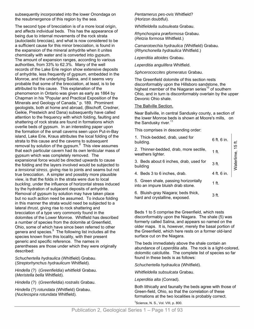
CHAPTER II. -- STRATIGRAPHY, STRUCTURE AND LOCAL DISTRIBUTION OF THE MONROE FORMATION. BY W. H. SHERZER AND A. W. GRABAU.
The following subdivisions of the Monroe formation are now recognized:
The following pages are devoted to a discussion of the Monroe formation of southeastern Michigan, and hence are primarily concerned with those members of the Monroe exposed in this area. There are, however, other beds of this formation not exposed in southern Michigan, but penetrated by the deep wells and by the salt shaft. These beds are known to crop out in Ohio, and there have furnished opportunity for study. In order that our discussion of the formation -- which is typically developed in Michigan -- may be complete, a brief review of these lower beds is included.
Publication 2, Geological Series 1 – Page 10 of 93
A. THE LOWER MONROE OR BASS ISLANDS SERIES. In the Detroit region well borings show 3601 feet of dolomites below the Sylvania and overlying the salt of the Salina. Most of this is undoubtedly to be referred to the Monroe formation (using this term for the marine upper Silurics, above the Salina), though some of the beds immediately above the salt may belong to the Salina series.
In the Royal Oak well No. 2, about 550 feet2 of limestone and dolomite lie between the Sylvania and the uppermost salt bed which is nearly 100 feet thick. In one of the Wyandotte wells 440 feet of shales, dolomites and gypsum occupy the same interval. In each case a certain amount of the beds just above the salt undoubtedly belong to the Salina, but the greater part no doubt is Lower Monroe. There is no reason for believing that the first salt bed struck in these wells is other than the same bed, since it is unlikely that a bed of such thickness should be other than continuous over the area mentioned, unless, indeed, erosion occurred prior to the deposition of the Lower Monroe. If this reasoning is valid, then the difference in the thickness of the Lower Monroe in the different well sections may be attributed to unequal erosion before the deposition of the Sylvania sandstone, or it may be, that in the slow retreat of the
sea which produced the dry land conditions, believed to have existed in Sylvania time, the Detroit area was uncovered before the other two areas, which therefore received higher deposits of this series than are found in the Detroit region. It is, however, most probable that in the thinner sections some of the lower beds are wanting, the higher resting by overlap on the Salina.
In the deep well at Monroe 660 feet of dolomites and shales are found overlying the "Niagara." The identification of all this as Monroe is not as yet verified, -- some of it may be Salina -- and some may belong even to the Upper "Niagara." Only about 200 feet of Lower Monroe are exposed in southeastern Michigan. These are shown in the quarries at Monroe, Newport, etc., and along the lower Raisin river. They constitute the Raisin river dolomite, which is the highest division of the Lower Monroe found in this region. The lower members do not crop out in southern Michigan but are seen in Ohio and in Canada. They will, however, be found in the well and shaft sections and for that reason they should be briefly described. 1The average of the seventeen wells of the Solvay Process Co., at the mouth of the Rouge river. 2One hundred feet of this is recorded by the driller as white sandstone and if so should be added to the base of the Sylvania, but Lane thinks it may be gypsum rather than sand. See Mich. Geol. Surv., Vol. V., well records
1. THE GREENFIELD DOLOMITE. The name Greenfield limestone was proposed by Grabau in 18983 for the deposits of late Siluric dolomites overlying the Niagaran beds in southern Ohio, from the excellent exposures found at Green-field in Highland county, Ohio. The name Greenfield stone, used commercially, was used by Orton for this formation as a local name.4 Since it is a pure dolomite in nearly all of its exposures the name is best changed to Greenfield dolomite. A characteristic sample from Greenfield, Ohio, gave 49.70% of CaCO3 and 44.87% MgCO3. Another gave 53.67% CaCO3 and 42.42% MgCO3
5. It is mostly thin-bedded and drab colored on fresh exposures, but soon oxidizes to a yellowish shade. The greatest thickness in the Greenfield section is 100 feet, but higher divisions of the Monroe may be present. Some brecciated beds occur but these are chiefly of intraformational character, formed probably by the collapse of roofs of caverns or by other causes.
This brecciation of the dolomites of the Monroe is a very general characteristic, being found in widely separated localities. Two types of brecciation must be distinguished, the general and the local. The first shows a complete shattering of the beds, a rearrangement of the blocks, so that the stratification dips in all directions, followed by a recementation. This has been interpreted by Lane as perhaps due to the inrush of great tides over shallow flats,6 but Grabau has argued that it represents the talus breccia produced on an extensive land surface of post-Monroe time and that this talus was
Publication 2, Geological Series 1 – Page 11 of 93
subsequently incorporated into the lower Onondaga on the resubmergence of this region by the sea.
The second type of brecciation is of a more local origin, and affects individual beds. This has the appearance of being due to internal movements of the rock strata (autoclastic breccias), and what is now considered to be a sufficient cause for this minor brecciation, is found in the expansion of the mineral anhydrite when it unites chemically with water and is converted into gypsum. The amount of expansion ranges, according to various authorities, from 33% to 62.3%. Many of the well records of the Lake Erie region show extensive deposits of anhydrite, less frequently of gypsum, embedded in the Monroe, and the underlying Salina, and it seems very probable that some of the brecciation, at least, is to be attributed to this cause. This explanation of the phenomenon in Ontario was given as early as 1864 by Chapman in his "Popular and Practical Exposition of the Minerals and Geology of Canada,” p. 189. Prominent geologists, both at home and abroad, (Bischoff, Credner, Geikie, Prestwich and Dana) subsequently have called attention to the frequency with which folding, faulting and shattering of rock strata are found in formations which overlie beds of gypsum. In an interesting paper upon the formation of the small caverns seen upon Put-in-Bay island, Lake Erie, Kraus attributes the local folding of the strata to this cause and the caverns to subsequent removal by solution of the gypsum.8 This view assumes that each particular cavern had its own lenticular mass of gypsum which was completely removed. The expansional force would be directed upwards to cause the folding and the layers involved would be subjected to a tensional stress, giving rise to joints and seams but not true brecciation. A simpler and possibly more plausible view, is that the folds in the strata were due to local buckling, under the influence of horizontal stress induced by the hydration of subjacent deposits of anhydrite. Removal of gypsum by solution may have taken place but no such action need be assumed. To induce folding in this manner the strata would need be subjected to a lateral thrust, giving rise to rock shattering and brecciation of a type very commonly found in the dolomites of the Lower Monroe. Whitfield has described a number of species from the dolomite at Greenfield, Ohio, some of which have since been referred to other genera and species.9 The following list includes all the species known from this locality, with their present generic and specific reference. The names in parentheses are those under which they were originally described:
Schuchertella hydraulica (Whitfield) Grabau. (Streptorhynchus hydraulicum Whitfield).
Hindella (?) (Greenfieldia) whitfieldi Grabau. (Meristella bella Whitfield).
Hindella (?) (Greenfieldia) rostralis Grabau.
Hindella (?) rotundata (Whitfield) Grabau. (Nucleospira rotundata Whitfield).
Pentamerus pes-ovis Whitfield? (Horizon doubtful).
Whitfieldella subsuleata Grabau.
Rhynchospira præformosa Grabau. (Retzia formosa Whitfield.)
Camarotoechia hydraulica (Whitfield) Grabau. (Rhynchonella hydraulica Whitfield.)
Leperditia altoides Grabau.
Leperditia angulifera Whitfield.
Sphcerococcites glomeratus Grabau.
The Greenfield dolomite of this section rests disconformably upon the Hillsboro sandstone, the highest member of the Niagaran series10 of southern Ohio, and in turn is disconformably overlain by the upper Devonic Ohio shale.
The Ballville Section.
Near Ballville, in central Sandusky county, a section of the lower Monroe beds is shown at Moore's mills, on the Sandusky river.11
This comprises in descending order:
1. Thick-bedded, drab, used for building. 6 ft. 6 in.
2. Thinner-bedded, drab, more sectile, weathers lighter. 1 ft.
3. Beds about 6 inches, drab, used for building 3 ft.
4. Beds 3 to 6 inches, drab. 4 ft. 6 in.
Wat
erlim
e, 1
5 ft.
5. Green shale, passing horizontally into an impure bluish drab stone. 1 ft.
6. Bluish-gray Niagara; beds thick, hard and crystalline, exposed. 3 ft.
Beds 1 to 5 comprise the Greenfield, which rests disconformably upon the Niagara. The shale (5) was formerly called Salina, and appears so named on the older maps. It is, however, merely the basal portion of the Greenfield, which here rests on a former old-land surface cut on the Niagara.
The beds immediately above the shale contain an abundance of Leperditia alta. The rock is a light-colored, dolomitic calcilutite. The complete list of species so far found in these beds is as follows:
Schuchertella hydraulica (Whitfield).
Whitfieldella subsulcata Grabau.
Leperditia alta (Conrad).
Both lithically and faunally the beds agree with those of Green-field, Ohio, so that the correlation of these formations at the two localities is probably correct. 3Science, N. S., Vol. VIII, p. 800.

Publication 2, Geological Series 1 – Page 12 of 93
4Geol. Surv. Ohio, Report for 1870, pp. 287, et. seq. 5Loc. cit. 6Geol. Surv. of Michigan, Vol. V, 1895, Pt. II, p. 27. 8American Geologist, Vol. XXXV, 1905, p. 170. 9Ann. N. Y. Acad. Sci., Vol. II, 1882, p. 193 and Vol. V, p. 505, and Geol. of Ohio, Vol. VII, 1893. Meristella laevis WhitfieId = Whitfieldella prosseri Grabau, described from this locality by Whitfield appears to be erroneously cited, the specimens determined by Whitfield coming most probably from the Raisin river dolomites of Lucas county, as shown more fully under the discussion of that species. 10The possible Salina, or even early Monroe equivalence of the sandstone must not be overlooked. It probably represents a reworked continental deposit. 11Geology of Ohio, Vol. I, 1873. Geology of Sandusky county by N. H. Winchell, p. 598 and 599, and text figure.
2. THE TYMOCHTEE BEDS. This name was given by N. H. Winchell in 187312 to the exposures on the Tymochtee creek, in Wyandotte county, Ohio. Here in sections 27 and 34 of Crawford township a total of 84 feet 10 inches of rock is shown. The section given by Winchell is as follows, in descending order:13
1. Thin, (1-inch) dark drab, brittle bed. 1 ft.
2. Beds 2 to 3 inches; lenticular; light drab; weathering ashen; with Leperditia alta 2 ft. 6 in.
3. Light drab beds; weathering ashen; 2 to 6 inches. 2 ft.
4. Drab, slaty beds, with frequent bituminous films; deep fracture sometimes blue drab; beds half-inch thick; blue color rarely seen; the equivalent of the stone of Carey's quarry 24 ft.
5. Beds 2 to 4 inches; drab; compact and fine-grained; showing no blue; like the stone in June's quarry, Fremont 15 ft
6. Beds thin (1 to- 4 inches); drab; regular; fine-grained; compact; showing no blue or chocolate; on a deep fracture bluish drab or blue 12 ft.
7. Drab, slaty beds; separated by brown bituminous films; above the beds are thicker but more lenticular 10 ft.
8. Drab, fine-grained; slaty with bituminous films that weather blue. Some beds are 4 inches, but without long horizontal continuance 4 ft.
9. Earthy; slaty beds, weathering blue and chocolate on the sides which are coated with bituminous films. The broken edges of the bedding dark drab, sometimes with irregular spots of light blue. 10 ft.
10. Vesicular and carious; coarse, ungainly; of a dark drab color; with traces of fossils; mostly hid from observation, but apparently without horizontal continuance 1 ft. 6 in.
11. One bed; fine-grained; drab. 4 in.
12. Beds 14-inch; slaty; drab; with blue films. 1 ft.
13. Drab, lenticular beds of 2 inches; sometimes bulging and then harder, or in regular courses of 2 to 4 inches 1 ft. 6 in.
Total exposed 84 ft. 10 in.
Beds 7, 8, and 9, 24 feet thick, were designated by Winchell Tymochtee slate. They are described as homogeneous, tough and thin-bedded, sometimes having so much bituminous matter as to appear like the Ohio black slate.
From the strata of this section few fossils have apparently been obtained. Those recorded are Leperditia alta and a fossil which appears like a species of Modiolopsis.
The stratigraphic position of the Tymochtee slate must at present remain unsettled, since no data are at hand by which to determine its exact position. That it rests above the Greenfield dolomite seems certain from its geographic position, but whether it lies below or above the Put-in-Bay dolomite has not been determined. There is; some reason for believing that it lies below that formation, filling the gap between the Greenfield and Put-in-Bay, since dark, shaly beds referred to the "Salina," underlie the latter formation in various places. It is, of course, not impossible that the beds of Tymochtee creek represent one or the other of the dolomites mentioned, or perhaps parts of each, constituting a somewhat more argillaceous phase. Traces of this horizon are found in Monroe and Newport wells between 400 and 500 feet below the Sylvania sandstone. 12Geol. Ohio, Vol. I, p. 633. 13Loc. cit., p. 633.
3. THE PUT-IN-BAY DOLOMITE. This name is proposed for the next higher series of strata of the Lower Monroe which is well exposed on Put-in-Bay island in Lake Erie, and characterized by a fauna not found in the lower or upper beds. The following section was given by Newberry14 for the southern point of this island, in descending order:
1. Gray, brecciated limestone, massive and without fossils 30 ft.
2. Cream-colored, thin-bedded limestone. 3 to 7 ft.

Publication 2, Geological Series 1 – Page 13 of 93
3. Gray, brecciated limestone, similar to No. 1, containing immense numbers of Leperditia alta 8 ft.
4. Thin-bedded, dove-colored or gray, laminated, earthy limestone, with fossils, used for waterlime. 12 ft.
5. Blue, earthy, massive limestone, weathering chocolate, without fossils, at lake level 10 ft.
Total 63-67 ft.
Higher beds are exposed on the northern end of the island; these being similar in character to those of South Point, i. e., "massive and brecciated layers, intersected by thin sheets of laminated limestone." At Peach Point the laminated layers have furnished large numbers of fossils, among which Goniophora dubia and Spirifer (ohioensis) predominate.
Leperditia alta is also common, and occasionally Eurypterus eriensis is found. Pterinea aviculoidia = Pt. lanii Grabau, described from this horizon by Whitfield, may be derived from the higher beds of Lucas county, as more fully discussed under the description of that species, though it is not impossible that it was derived from the higher beds which apparently crop out on Put-in-Bay.
These limestones are rich in celestite as well as flour spar. Large and fine specimens of the first of these have been obtained from Strontian island and other localities. In lower beds than those shown on South Point, gypsum occurs, this being often dragged up from the bottom of the channel off South Point. This gypsum is worked on the peninsula 8 miles distant. The massive beds of the series on Put-in-Bay range in carbonate of lime from 42.03% to 63.37%, the corresponding percentage of magnesium carbonate being 41.64% and 32.57%, though some of the beds range as high as 44.98% magnesium carbonate. The hydraulic layers of South Point range in carbonate of lime from 42.95% to 51.43%, a corresponding percentage of magnesium carbonate being 39,79% and 40.24%, the latter being the highest recorded. In these hydraulic beds the amount of silica may be as high as 13.3%.
Among the fossils of this division none are so abundant as Goniophora dubia (Hall) which sometimes covers the surface of the slabs. It appears to be nearly restricted to this horizon and may be taken as a type fossil of this palæontologic zone. Spirifer ohoensis Grabau, is also common in some of the beds, though not as abundant as the preceding species.
This formation is not found in contact with the underlying Greenfield, nor the Tymochtee, the waters of Lake Erie and the drift on the main land covering the line of junction. So far as definite observations go, it is not found in contact with the formation next to be described, though from the occurrence of Whitfieldella prosseri, and
possibly Pterinea lanii in rocks obtained from Put-in-Bay it seems that the next higher formation is found there. This further seems probable from the course of the Sylvania sandstone outcrop, as shown below. The same division with Goniophora dubia is again reported from the bed of the Scioto river at Middletown in southern Marion county, Ohio. It appears not far from the outcrop of the Dundee which seems to overlie this division disconformably, thus cutting out the higher members seen farther westward. 14Geol. Ohio, Vol. II, p. 202.
4. THE RAISIN RIVER DOLOMITE. This name is applied to the dolomitic calcilutites and oölites which constitute the upper part of the Lower Monroe. It has a thickness of about 200 feet, and lies directly below the Sylvania sandstone in all its exposures in Monroe county, Michigan, and Lucas county, Ohio. The dolomites have the characteristic drab to gray color, are generally thin-bedded and more or less shattered and broken. Fossils are not abundant except at certain levels and are represented chiefly as molds. Local brecciation along joint planes and in cavities is not infrequent, while at times it is more general and involves the main body of certain beds. Thin slabs occasionally show mud cracks and ripple marks, testifying to the shallow water conditions under which their material was accumulated. Upon the floors of some of the quarries about Monroe immense hemispherical masses protrude from the lower beds, having a finely laminated, concentric structure and apparently concretionary in their nature.
The best exposures of the Raisin river series are in the quarries of the Monroe Stone Co., south of Monroe; that of the Shore Line Stone Co., just north of Monroe, and at Newport. Owing to the dip of the beds the lowest strata are seen in the quarry south of Monroe, at present writing about 60 feet below the surface, while the highest stratum exposed constitutes the top ledge at the Newport quarry, giving a range through nearly the entire series. A unique feature of the Raisin river series is the occurrence of a number of separate oölitic strata, each underlain by a peculiar bed of blotched, mottled, and streaked lutaceous dolomite; compact, unfossiliferous, brittle, and with a pronounced conchoidal fracture. The dolomite itself is light gray in color and the discoloration of a distinct bluish cast, except where exposed in outcrop when it has assumed a rusty brown, indicative of the presence of iron. Rominger compared one of these beds with castile soap, which it somewhat resembles. It is difficult to understand what is the connection between the oölites and this type of dolomite, but in every case they were found to be associated and the presence of the dolomite in a number of cases led to the recognition of the oölite, where the structure was obscure and might have been readily overlooked. These dolomitic beds are generally seen to consist of three separate beds, the upper 8 to 12 inches having a gnarled pattern, the middle 4 or 5 inches mottled and the lower 3 to 4 feet
Publication 2, Geological Series 1 – Page 14 of 93
streaked. At the quarry north of Monroe in one of the lower beds there occurs a series of very perfect concentric spheres outlined by the bluish discoloration. Between these three separate beds of the dolomite there occur seams of dark clay, or shale, varying in thickness from zero to 12 inches, which in places show the same blotching as the dolomite itself. At the quarry of the Monroe Stone Co. an upper, middle and lower oölite may be recognized, having a thickness respectively of 20 inches, 34 inches and 24 to 48 inches. About 30 feet of dolomite separate the upper and middle oölites, and about 13 feet intervene between the middle and lower. At the Shore Line Stone quarry, where about 50 feet of strata are exposed, an oölite, ranging in thickness from 15 to 25 inches, is found at a depth of 20 feet, and some 7 to 8 feet lower an obscurely defined bed. At the Newport, quarry a streaked bed occurs at the crest of the wall, strongly suggesting the presence of an oölitic stratum lost by erosion. Twenty-four feet below the top of this bed an oölite occurs, with an average thickness of 12 to 13 inches, underlain by some 30 inches of streaked dolomite. Still lower, and separated by from 14 to 18 feet of dolomite, is found a third oölite with an average thickness of 32 to 33 inches and resting upon 31 inches of streaked and mottled dolomite. Judging from the dipping of the strata to the northward and westward it does not seem that these Newport oölites can be correlated with those at Monroe, and the inference is justified that the Raisin river series is made up essentially of alternating layers of drab dolomite, gray blotched dolomite and oölite, all in more or less intimate contact. The conditions necessary for the formation of each of these beds were successively repeated in the same order.
The granules of which the oölite is composed have been made the subject of microscopic study by Sherzer,15 and found to consist of minute rhombohedrons of dolomite having a poorly defined concentric structure, without a nucleus of other mineral, and showing about the inner portion more or less organic matter. They are roughly spherical to ellipsoidal in shape, and most of them range from .2 mm. to .6 mm. in diameter and are held more or less firmly together (see plate I, fig. A) by a dolomitic cement which in places obscures the oölitic structure. Mingled with the sub-spherical granules are others of the same general structure, having the diameter of the smaller granules but relatively elongated and either straight or curved. Tongue-like to frondescent masses also occur, ranging in size from a few millimeters to 7 to 10 cm. in breadth and length and with a thickness ranging from 2 to 3 cm. Their edges and corners are rounded, their surfaces somewhat undulating, frequently showing rounded tubercles and irregular ridges. Dissolved in acid they are shown to contain also considerable bituminous material. Upon comparing these three types of structures with those found in the oölitic sands of Great Salt Lake, Utah, there is little room for doubt that they have been formed under similar conditions, although the alteration from calcium carbonate to dolomite has partially disguised the
similarity. (See plate I, fig. B.) According to the investigations of Dr. A. Rothpletz, of Munich, the Salt Lake oölite has resulted from the secretion of calcium carbonate by colonies of algae, known as Glœcapsa and Glœotheca, giving rise to the rounded granules, the elongated rods and the tubercular masses.16 If the oölitic components of the Monroe rocks are identical, or very similar, to those of the Salt Lake sands it might be necessary to assume that they originated under similar conditions, in bodies of water temporarily separated from the open sea. Similar oölites are known to form, however, in partially enclosed seas, such as the Arabian Gulf, and this probably represents more nearly the conditions existing in Monroan time.
The thin-bedded, drab dolomites, lying between the upper and middle beds of oölite, at the quarry of the Monroe Stone Co., in five analyses gave:
Calcium carbonate 50.92% to 53.50%Magnesium carbonate 41.39% to 44.77%Silica, iron oxide and alumina 3.08% to 6.08%
In the abandoned quarry to the north of Monroe, formerly operated by the same company, the following three analyses show the nature of the rock:
2 ft. down.
7 ft. down.
10 ft. down.
Calcium carbonate 54.54 54.47 54.94Magnesium carbonate 42.75 43.59 42.84Silica 2.00 .74 1.33Iron oxide and alumina .70 .90 .58
Difference .01 .22 .31100.00 100.00 100.00
Locally the beds contain patches of iron pyrite, and in the cavities and seams deposits of well crystallized calcite and celestite occur. Less frequently small masses of strontianite occur either separately or in association with the last two minerals.
The fauna of the Raisin river beds is chiefly derived from the strata quarried at Newport and at Monroe, and less abundantly from Stony Point and outcrops on the Raisin river. In the salt-shaft section, this fauna was found well developed between 87 and 138 feet below the Sylvania standstone. The following species have so far been obtained, those starred (*) having been obtained in this fauna only in the salt shaft:
Brachiopoda. Pholidops cf. ovata Hall. *Schuchertella hydraulica Whitfield. *S. interstriata (Hall). Whitfieldella prosseri Grabau. Camarotoechia sp.
Pelecypoda. Pterinea lanii Grabau.

Publication 2, Geological Series 1 – Page 15 of 93
Goniophora dubia Hall. Tellinomya sp. Modiomorpha sp.
Gastropoda. Solenospira minuta (Hall). Holopea 3 species. Loxonema sp.
Cephalopoda. Cyrtoceras (Cyclostomiceras) orodes Billings.
Ostracoda. Kloedenia monroense Grabau.
Plantae. Sphaerococcites glomeratus Grabau. Stipes of plants.
The details of the distribution of the fossils in the lower beds of the salt shalt are as follows:
At a depth of 624 to 634 feet, or from 87 to 97 feet below the Sylvania, the following species were found:
Schuchertella hydraulica with the striæ approaching in character to S. interstriata, rare.
S. interstriata, a specimen with the characters of this species.
Whitfieldella prosseri, common.
Goniophora dubia.
Cyrtoceras orodes, rare.
At a depth of 630 to 635 feet, or from 93 to 98 feet below the Sylvania, the following species were found:
Schuchertella hydraulica, varying from the typical form, in that the difference between the striæ is less marked. Between the coarse striæ are one secondary and two tertiary striæ, and sometimes quaternary striæ. The secondary striæ often become so strong, as to resemble the primary ones, when the species takes on the character of S. interstriata. Some specimens are more nearly like S. interstriata of the Akron dolomite, though there is more difference in the thickness of the striæ than is the case in the western New York species. They are, however, clearly transitional forms from one to the other.
Whitfieldella prosseri, abundant,
Goniophora dubia, not uncommon.
Cyrtoceras orodes, fairly abundant.
Indeterminable bryozoan.
At 655 to 657 feet, or from 118 to 120 feet below the Sylvania, the following species have been found:
Whitfieldella prosseri, abundant.
Spirorbis laxus, abundant.
Stems or stipes of plants.
The association of these three fossils strongly suggests the horizon of the Newport quarries. There, however,
Pterinea lanii is common, while not a trace of this species has been found in the shaft section.
At a depth of 672 feet, or 138 feet below the Sylvania sandstone, the following species have been found:
Schuchertella hydraulica, typical, common, some specimens approaching S. interstriata in character.
Whitfieldella prosseri, common.
Goniophora dubia, common, occurs on slab with Whitfieldella prosseri and Schuchertella hydraulica.
Impressions of bryozoans. Oölite layers occur at this horizon.
The highest exposed beds of this division, just below the Sylvania are very siliceous, being intermingled with round quartz grains which constitute a large percentage of the material of these upper layers. In these were found: Meristina profunda Grabau, and S. profunda mut. sinosus Grabau, both of which are of typical Siluric affinities. 15Geol. Survey of Mich., Vol. VII, Pt. 1, p. 62. 16Botanisches Centralblatt, Nr. 35, 1892. Translation in American Geologist, Vol. X, No. 5, 1892, p. 279.
B. THE SYLVANIA SANDSTONE. This formation, varying in thickness from 30 to 300 feet in southern Michigan, everywhere separates the Lower and Upper Monroe beds. On account of its remarkable character, peculiar distribution, and palæogeographic as well as economic importance it is treated in a separate chapter.
While in most cases the contact with the overlying and underlying beds is not an abrupt one, there is nevertheless a disconformity17 both above and below the Sylvania. So far as the records admit of interpretation it appears, that the Sylvania rests on different members of the Lower Monroe series, and is succeeded by various members of the Upper Monroe series, or by the Dundee.
Fossils have been found so far only in the intercalated dolomite in the upper part of the Sylvania, and these belong to the Upper Monroe division. Where the formation is in contact with the Dundee, as at the Toll pits, (National Silica Co., 7 miles northwest of Monroe, Michigan), internal molds apparently of Paracyclas are not uncommon. 17The term disconformity was proposed by Grabau for a hiatus without structural discordance of the beds involved. The term unconformity is restricted to cases where such discordance exists.
C. THE UPPER MONROE OR DETROIT RIVER SERIES. The four recognized divisions of this series are in ascending order: Flat Rock dolomite; Anderdon limestone; Amherstburg dolomite, and Lucas dolomite. They are not always present in the various localities, one
Publication 2, Geological Series 1 – Page 16 of 93
or more of the lower members being wanting through overlap of the higher ones.
1. THE FLAT ROCK DOLOMITE. The name is given to the lowest bed in the Oakwood (Detroit) salt shaft. It is a very compact, dark gray, harsh and rather porous magnesian calcarenite (rarely a calcilutite) alternating with more uniform and softer magnesian brownish calcarenites.
Fossils are comparatively uncommon, though the porous rock contains many impressions, mainly of unrecognizable fragments. Gastropods, so characteristic of the upper dolomite (Lucas) seem to be wanting altogether, but corals are more commonly seen. The following species have been obtained from this bed in the salt shaft:
Syringopora cooperi Grabau.
Syringopora cf. hisingeri Billings.
Favosites mammas ? Troost.
Syringopora cooperi obtained 30 feet above the Sylvania, seems to be restricted to this bed, though a species closely related, if not identical, occurs in the brecciated magnesian calcilutite of Mackinac Island, referred to the Dundee by Hall and Rominger, but more probably referable to the horizon of the Flat Rock. S. hisingeri ? also occurs in the Amherstburg dolomite, where it is one of the characteristic fossils.
So far, this formation is definitely known only from the salt shaft, at Oakwood, where it is 47 feet thick, and from Flat Rock, Wayne county, where it forms the surface rock. Southward from Oakwood it appears to thin away, until at the Wayne-Monroe county boundary line it is absent, having been overlapped against the Sylvania as a basal bed, by higher members of the series. There seems to be an exception to the general and progressive thinning away southward as shown by a recent well drilled at Wyandotte, Monroe county, Michigan, and studied by Lane and Sherzer. Here about 130 feet of brown dolomite, apparently the Flat Rock, overlies the Sylvania sandstone without any trace of the higher beds.
The Dundee, too, seems to be absent. In an earlier well section at Wyandotte, given by Lane in Volume V, of the Michigan Survey reports, the record to the Sylvania is as follows:
1. Clay and gravel 75 ft.2. Dark limestone 15 ft.3. Light brown limestone 10 ft.4. Gray limestone 25 ft.5. Brown sand with slate 30 ft.6. Brown sand and lime 5 ft.7. Brown and white limestone. 70 ft.8. Freestone (Sylvania) 60 ft.
Total beds 2 to 7 inclusive, 155 feet. Though in the driller's record these beds are called limestone they are undoubtedly for the most part brown dolomites. Beds 2 to 4 were correlated by Lane with the Dundee. If this correlation is correct the sandy beds 5 and 6 may represent the Oriskany horizon, and the Upper Monroe is represented by 70 feet of brown dolomites, which must be referred to the Flat Rock. It is more probable, however, that the entire series of beds overlying the Sylvania is referable to the Flat Rock horizon.
This formation is typically developed on the Huron river in the vicinity of Flat Rock, Wayne county, Michigan. Here a brown dolomite forms the banks and bed. of the creek for a short distance, and has been quarried in the meadows. It is thin-bedded, hard and practically barren of organic remains, except that at rare intervals Syringopora cf. hisingeri occurs, which is also characteristic of the lower dolomites of the salt shaft.
2. THE ANDERDON FORMATION. This is named from the Anderdon quarry about a mile northeast of Amherstburg, Ontario, where the formation is typically exposed. The section shown in the quarry is as follows, in descending order:
C. Soil and drift.
B. Dundee limestone (Devonic).
B. 4. Compact dolomitic calcilutite, weathering light brown, and resembling strikingly some layers of the Monroe formation. No fossils except the spine of a fish have been found in thin bed. Thickness exposed 1-4 feet.
B. 3. Calcarenites, highly crystalline in the upper portion, with crinoidal disks and of a light gray or purplish color. Some layers are covered with specimens of Rhypidomella livia (Billings). Other layers of this rock are full of a small variety of Atrypa reticularis, together with various Stropheodontas, and other characteristic Dundee fossils. Analysis shows this bed to average 81.24% CaCO3 and 16.75% MgCO3. Total thickness of B. 3, 15 feet.
B. 2. Fine and uniformly grained calcarenite,. -- approaching closely to a calcilutite, in beds from a fraction of a foot to one foot or more in thickness, and practically barren of fossils but with numerous vertical, curved, or horizontal tubes which are formed by the decomposition of pyritous stems, and visible on the surface of the slabs as rounded pits. The rock does not show stratification well. It is bluish when fresh, but readily weathers to a buff. When unweathered it has more nearly the appearance of a calcilutite. Analysis shows a composition of 62.02% CaCO3 and 34.08% MgCO3 together with 2% of insoluble residue. Thickness to upper floor of quarry, 6 feet.
Publication 2, Geological Series 1 – Page 17 of 93
B. 1. Brown, compact and fine-grained dolomite, apparently unfossiliferous. Thickness to second floor of quarry about 6 feet.
Great disconformity, representing the entire Lower Devonic and a part of the uppermost Siluric.
2a. ANDERDON LIMESTONE.
A. Siluric. This is shown in the deepest, eastern part of the quarry. In the extreme eastern part it is represented by a Stromatopora reef from 6 to 8 feet thick and composed almost entirely of large heads of Stromatopora galtense and S. (Clathrodictyon) ostiolatum, together with an abundance of the small branching Stromatoporoids, Idiostroma nattressi. Favosites and other corals are also abundant, but molluscs and brachiopods are rare. (See list of species.) Downward and laterally this reef passes into finely and evenly bedded calcilutites with characteristic conchoidal fracture. The lowest beds exposed are mottled, but the others are laminated. Intercalated in the calcilutites are some thin beds of calcarenites, one of which, about 4 feet above the base of the quarry, appears oölitic, and shows an occasional crinoid disk. Otherwise the rock is wholly barren of fossils except at the reef portion.
The fossils obtained from the reef are:
Stromatoporoidea. Clathrodictyon ostiolatum Nicholson cc* C. variolare V. Rosen c Coenostroma pustulosum Grabau rc Stromatopora galtense (Dawson) c Stylodictyon sherzeri Grabau rc Idiostroma nattressi Grabau cc
Anthozoa. Helenterophyllum caliculoides Grabau rc Cyathophyllum thoroldene Lambe rr Diplophyllum integumentum Barrett rc Cystiphyllum americanum mut. Anderdonense Grabau c Ceratopora tenella (Rominger) c Cladopora bifurcata Grabau Favosites basaltica mut. nana Grabau rc F. concave Grabau c F. rectangulus Grabau c
Brachiopoda. Spirifer (Prosserella) lucasi Grabau rr
Gastropoda. Pleurotomaria cf. velaris Whiteaves rr
Analysis shows this rock to be nearly pure lime, the percentage of CaCO3 being as high as 99+%.
Exposed to the lowest floor of the quarry, 24 feet.
The surface of the Anderdon bed forms the middle quarry floor, and was originally overlain throughout most of its extent by the lowest brown dolomite of the Dundee (B. 1), much of this has since been removed by quarrying operations. The surface of the Anderdon bed thus uncovered shows evidence of extensive erosion
before the brown dolomite of the Dundee was deposited upon it. Shallow channels of a foot or more in width traverse the calcilutite in all directions and are commonly filled by the material of the overlying bed. The channels' are very similar to those worn along joints of the surface rock of certain parts of the Sahara desert, by the drifting sands,18 and suggest eolian erosion during early Devonic time, when this surface was exposed to the atmosphere. Sections of a large species of gastropod, probably Trochonema ovoides Grabau, characterize the surface in many places. These large shells rested on the mud on their flat under surface and thus were sectioned parallel to the base during the erosion of the limestone surface. Along the contact with the overlying brown dolomite a quartz sandstone, or calcareous silicarenite with rounded quartz grains embedded in a more or less calcareous matrix, was found by the Rev. Thomas Nattress. This rock corresponds to a similar layer in the drill cores of the Sibley quarries as described beyond, and represents the Oriskany.
A comparison of the fauna of the reef shows a very close correspondence with that of the reef of the salt shaft. Much of the material is better preserved and a few new forms are added to the salt shaft list, while several of that list are unrepresented at the Anderdon quarry. Nevertheless there can be no doubt as to the identity of the two beds. The total absence of the Lucas beds in this section shows the extent of erosion here prior to the deposition of the Dundee. There can be no question that the whole of the Lucas beds, some 180 feet thick at Detroit, and originally probably thicker, was also present at one time in the Anderdon region, and that it was wholly worn away in lower Devonic time, so that with the advent of the mid-Devonic sea, the new deposits here were laid down upon the erosion surface of the Anderdon bed. *c=common, cc=very common, r=rare, rr=very rare, rc=moderately abundant. 18For an illustration of these see Martonne, Ed. de, Traité de Géographic Physique, 1909, plate XXXIII, B.
2b. THE ANDERDON LIMESTONE OR CORAL BED OF THE SALT SHAFT.
This is a light-brown, fine-grained, calcarenite of a somewhat crumbly character. It is 37 feet thick. Fossils are abundant, consisting mainly of corals and Stromatoporoids. So far as can be ascertained the material here, as at the Anderdon quarry, represents a reef in situ, the contemporaneous erosion of which has supplied the lime-sand for the calcarenite of the bed.
The fauna is entirely distinct from that of the overlying Lucas dolomite and is essentially a coral fauna in which Devonic elements abound. The fossils obtained from it are:
Stromatoporoidea. Clathrodictyon ostiolatum Nicholson cc Stromatopora galtense (Dawson) c Stylodictyon sherzeri Grabau rc Idiostroma nattressi Grabau c

Publication 2, Geological Series 1 – Page 18 of 93
Anthozoa. Cyathophyllum cf. thoroldense Lambe r Synaptophyllum multicaule (Hall) rc Diplophyllum integumentum (Barrett) c Favosites basaltica var nana Grabau c Cladopora dichotoma Grabau c Syringopora retiformis Billings rc
Brachiopoda. Spirifer (Prosserella) modestoides Grabau rc
Pelecypoda. Conocardium monroicum Grabau rc
Gastropoda. Eotomaria galtensis (Billings) r
The fossils are mostly calcareous but a few of the Stromatoporoids are silicified. This formation is apparently a direct succession of the Flat Rock dolomite, the one grading into the other. The formation likewise appears to grade upward into the overlying division (Lucas), though the Amherstburg dolomite has not been differentiated in the material from the shaft.
2c. THE ANDERDON OF THE SIBLEY WELLS.
The Anderdon bed is again observed in the cores of the test holes drilled in the Sibley quarry near Trenton. The section here comprises 76 feet of pure crystalline Dundee limestone, below which occur from 14 to 19 feet of a high grade limestone with the typical Anderdon species of corals. This grades downward into un-fossiliferous brownish dolomites, probably representing the Flat Bock horizon. At the point of contact between the Dundee and Anderdon the cores show several inches to a foot of quartz sand, sometimes pure, but generally intimately mixed with the limestone. The grains are all perfectly rounded, small and of uniform size indicating wind transported material, or reworked Sylvania. From its position between Monroe (upper) and Dundee, the sand corresponds in a general way to the Oriskany of New York. It probably accumulated during the period of dry land and erosion, which in this region characterized the Lower Devonic, the material being derived most probably from the near at hand Sylvania.
The details of the well sections in the Sibley quarry, as determined from the cores, are as follows:
Core No. 1. Mouth about 20 feet above river, or some 594 ft. A. T. Depth 67 feet.
Dundee limestone 32 ft.Disconformity Anderdon limestone with reef fossils 14 ft.Dolomitic limestones, probably Flat Bock, to bottom of hole. 21 ft.
At 46 feet the MgCO3 is 16.80% “ 50 “ ” “ “ 37.04% “ 55 “ ” “ “ 33.18% “ 60 “ ” “ “ 43.26% “ 62 “ ” “ “ 43.26%
“ 67 “ ” “ “ 36.96%Core No. 2. Mouth above river level about 9 feet or about
583 A. T. Beginning on Bed I of the Dundee:
DUNDEE:1. Dundee above mouth of well 35 ft.2. Dundee in well 41 ft.
Total Dundee 76 ft.MONROE:
3. Calcarenite with numerous rounded grains of pure quartz 1
4. Calcilutites 25. Calcarenites with some Anderdon fossils. 2.56. Typical Anderdon reef rock. 4.57. Calcarenite with occasional reef fossils. 68. Calcilutite 39. Calcilutite with 32 to 43% MgCO3 1410. Fine grained calcarenite with alternating
streaks of calcilutite 8
Total Monroe 41
Of this 41 feet of Monroe the upper 19 feet (beds 3-8) are typical Anderdon, while beds 9 and 10 probably represent the Flat Rock, which is a pure dolomite. If this correlation is correct, then only the lower portion of the Anderdon (19 ft.) is present in the core sections. None of the wells were put down to the Sylvania, so we do not know the thickness of the Flat Rock in this section.
2d. THE TOLL PIT BEDS.
At the Toll pit quarry, near Scofield, the upper part of the Sylvania is interstratified with some dolomitic layers carrying an Anderdon fauna. From this Favosites basaltica var. nana and Cladopora dichotoma have been identified. The mixture of limestone and rounded quartz grains is intimate, the latter prevailing. This indicates that the Anderdon was the first bed to be deposited in this section, on the invasion of the Sylvania sand-area by the sea, the upper beds of the sand being incorporated in the basal deposit. That only a part of the Anderdon was deposited here, is shown by the relationship existing at the Woolmith quarry further west, where the Amherstburg fauna occurs 20 to 30 feet above the sandstone. At the Toll pits, the pre-Dundee erosion has carried away all the Monroe beds except this thin layer of Anderdon in the upper Sylvania. On top of this eroded surface the Dundee was subsequently deposited and of this traces still remain.
3. THE AMHERSTBURG OR TRANSITION BED. This has not been recognized in the salt shaft, nor has it been preserved in the Anderdon quarries where pre-Onondaga erosion has removed it together with the overlying Lucas beds and perhaps a part of the Anderdon, as has been the case at the Sibley locality. It,

Publication 2, Geological Series 1 – Page 19 of 93
however, forms the bed of the Detroit river opposite Amherstburg, where dredging in the Canadian channel of the river has brought the rock to the surface. A good exposure of the strata has also been obtained in the dry excavation of Livingston channel, along side Stony island. It consists of a brown dolomite, very porous and highly fossiliferous, containing a remarkable assemblage of species, many of them of types heretofore only known from the middle-Devonic in this country. The following list comprises the species obtained by the Rev. Thomas Nattress, of Amherstburg, from the dredgings of this channel. As will be seen by comparison with the species of the Anderdon bed, many species are found in common between these two formations, though a number of species not yet recorded from the Anderdon bed are found here. Several of the most characteristic species pass upwards into the overlying Lucas dolomite.
Species of the Amherstburg bed (dolomite) of the Detroit river:
Stromatoporoidea. Clathrodictyon ostiolatum Nicholson rc Idiostroma nattressi Grabau rc
Anthozoa. Heliophrentis alternation Grabau c mut compressum Grabau r mut magnum Grabau r Heliophrentis carinatum Grabau c Cystiphyllum americanum var anderdonense Grabau r Acervularia sp. r Synaptophyllum multicaule (Hall) c Diplophyllum integumentum (Barrett) rc Romingeria umbellifera (Billings) c Ceratopora regularis Grabau rc Favosites tuberoides Grabau c Cladopora dichotoma Grabau c Cladopora dichotoma, Grabau c Syringopora hisingeri Billings c
Bryozoa. Fenestella sp. c
Brachiopoda. Schuchertella interstriata (Hall) rc Schuchertella amherstburgense Grabau rc Stropheodonta vasculosa Grabau rc Stropheodonta præplicata rc Stropheodonta sp. rc Spirifer sulcata mut sulmersa Grabau rc Spirifer (Prosserella) modestoides Grabau rc mut depressus Grabau c Whitfieldella sp rc Meristina cf. profunda Grabau ? Atrypa reticularis rr Cyrtina sp. rr
Pelecypoda. Panenka canadensis Whiteaves rc Cypricardinia canadensis Grabau rc Conacardium monroioum Grabau c
Gastropoda. Hormotoma subcarinata c Holopea antiqua pervetusta (Conrad) rc Acanthonema holopiformis Grabau c Strophostylus cyclostomus Hall rc Eotomaria areyi Clarke and Ruedemann rc Eotomaria sp. rc Lophospira bispiralis (Hall) rc Trochonema ovoides Grabau mr
Cephalopoda. Dawsonoceras annulatum americanum Foord rc Cyrtoceras orodes Billings rc Poterioceras cf. sauvidens Clarke and Ruedemann r Tachoceras anderdonensis Grabau r
Trilobitæ Proetus crassimarginatus rc
Annelida. Cornulites armatus Conrad rr
The bed is again found in the lower part of the Gibraltar quarry in Brownstown township, Wayne county, 18 miles south of Detroit. Only about 5 feet of the rock are exposed, passing upward into the true Lucas dolomite. The dolomite is brown and porous and indistinguishable in lithic character and organic contents from the rock dredged in the Detroit river. There is a bed rich in Stromatoporoids exposed in the base of the quarry, but for the most part the fossils found in the lower beds are scattered. They comprise the following species:
Hydrocorallines. Stromatopora ostiolatum Nicholson c
Anthozoa. Heliophrentis carinatum Grabau rc Cladopora bifurcata Grabau c
Pelecypods. Conocardium monroicum Grabau rc
The depth at which the Sylvania lies in this section is not ascertained, though the fact that across the river, at the Anderdon quarry, the Anderdon bed is shown, suggests that this bed lies below the floor of the Gibraltar quarry. The upper beds of the Gibraltar quarry are the typical gastropod bearing Lucas dolomites.
The Amherstburg bed is probably found in the lower part of, or just below, the Patrick quarry on Grosse Isle, but since this quarry is now filled with water the evidence for, or against this supposition is inaccessible. From the fossils formerly collected here, this seems to be the case. The bed in question seems to appear again in the lower part of the Woolmith quarry near the town of Scofield, Exeter township, Monroe county. Here a dolomite -- bed F of Sherzer's report on this quarry --19 lying a little below the middle of the quarry, carries a meager fauna, which though poorly preserved, clearly represents the Amherstburg horizon, though it may be a

Publication 2, Geological Series 1 – Page 20 of 93
recurrent fauna at a somewhat higher level than the top of the Amherstburg.
The following species have been obtained:
Anthozoa. Heliophrentis carinatum Grabau rc Diplophyllum integumentum Barrett rc Cladopora bifurcata Grabau r Cladopora cf. cervicornis Hall rc
Bryozoa Fenestella sp. r
Brachiopoda. Meristospira michiganensis Grabau cc
Pelecypoda. Conocardium monroicum Grabau cc Panenka canadensis Whiteaves r
The higher beds carry a true Lucas fauna, while below this bed are about 35 feet of siliceous dolomites resting on the Sylvania, and themselves containing streaks and grains of pure quartz. These lower dolomites clearly represent transitional phases from the Sylvania which recurs periodically in the form of these streaks or scattered grains (Sherzer). These lower beds may be exposed in some of the quarries southwestward from this point to the state line, but they have not been definitely recognized, since where they rest on the Sylvania they are not always fossiliferous.
In Lucas county, Ohio, the Lucas dolomite rests on the Sylvania in all the quarries, thus showing that the lower beds, including the Anderdon and Amherstburg, have been cut out by overlap of the dolomite on the Sylvania, which here has been converted into the basal bed of a transgressive, marine series.
The thickness of the Amherstburg bed is probably not over 20 feet, and very likely it is much thinner. Five feet of it are shown in the Gibraltar quarry, and below this is a Stromatoporoid bed which may represent the top of the Anderdon. From 10 to 20 feet are probably a fair estimate of this bed, which so far has not been found exposed completely in any section. 19Geol. report of Monroe county, by W. H. Sherzer. Geol. Surv. Mich., Vol. VII, Pt. 1, p. 81.
4. THE LUCAS DOLOMITE. This is the highest Monroe bed of the salt shaft where 189 feet exist between the Anderdon and the Dundee, the basal portion probably including the Amherstburg dolomite. Southwestward from this point, at the Sibley quarries, the drill cores show that this bed is wholly wanting, the Dundee resting on the Anderdon with a bed of quartz grains marking the contact. Southeast of the Sibley quarries, at Anderdon and in the Canadian channel of the Detroit river, this bed is also wanting, the Dundee in the former resting directly upon the Anderdon, while in the Detroit river only the Amherstburg bed has thus far been found. A little to the south of this, however, and between the Anderdon and Sibley
quarries, some 20 feet of the Lucas beds are exposed in the Patrick quarry on Grosse Isle, while at Gibraltar about 3½ miles further west, from 20 to 30 feet of the lower Lucas are shown resting upon the Amherstburg. The following species have been obtained from the beds of the Patrick quarry, on Grosse Isle. Those starred probably belong to the Amherstburg bed on the floor of the quarry:
Anthozoa. Cylindrohelium profundum Grabau rc *Romingeria umbellifera (Billings) rc *Cladopora bifurcata Grabau rc
Brachiopods. *Prosserella modestoides Grabau rc Prosserella lucasi Grabau rc Prosserella subtransversa Grabau rc Prosserella unilamellosa Grabau rc Meristospira michiganense Grabau r Cyrtina sp.
Pelecypoda. Conocardium monroicum Grabau c
Gastropoda. Acanthonema holopiformis Grabau c A. holopiformis var obsoleta Grabau rc A. laxa Grabau rc A. newberryi (Meek) rc
Cephalopoda. Orthoceras cf. trusitum Clarke and Rued. r
In the Gibraltar quarry about 20 feet belong to the Lucas dolomite, and these with the 5 foot of Amherstburg in the floor of the quarry, make up the exposed rock mass. The following species have been obtained from this horizon:
Anthozoa. Cylindrohelium profundum Grabau c
Brachiopoda. Prosserella subtransversa Grabau rc
Pelecypoda. Panenka canadensis Whiteaves r Conocardium monroicum Grabau rc Modiella ? sp. r
Gastropoda. Hormotoma subcarinata Grabau c Hormotoma tricarinata Grabau r Acanthonema holopiformis Grabau c A. holopiformis var obsoleta Grabau rc A. laxa Grabau rc Eotomaria areyi Clarke and Rued. rc Eotomaria galtense (Billings) rc
In the Woolmith quarry a total of 75 feet of the strata are exposed, of which the upper 40 to 50 feet are referable to the Lucas. The following species have been obtained here:
Anthozoa. Cylindrohelium profundum Grabau c
Publication 2, Geological Series 1 – Page 21 of 93
Brachiopoda. Spirifer (Prosserella) lucasi Grabau r
Gastropoda. Hormotoma subcarinata Grabau rc
The following analyses show the variable character of these strata:
4 ft. down.
18 ft. down.
24 ft. down.
Silica 6.19 3.05 97.76Iron oxide and alumina .45 .31 .55Calcium carbonate 50.12 52.72 1.14Magnesium carbonate 43.53 44.59 1.43
Difference --.29 --.67 --.88 100.00 100.00 100.00
The last of the three samples represents a recurrent streak of Sylvania.
About 4 miles southeast of the Woolmith quarries, at the Toll pits in the Sylvania sand, these beds are wholly cut out by the pre-Dundee erosion, the lower Dundee with characteristic fossils resting directly upon the Sylvania sandstone, as noted by Rominger in 1876,20 and grading down into the Sylvania. The upper Sylvania carries an abundance of molds of Paracyclas, showing that during the advent of the Dundee waters the upper beds of the sand were reworked and the Dundee fossils embedded in it. In some of the beds, as already noted, Anderdon species are enclosed, showing that the Anderdon and higher beds were present originally, but were eroded before the deposition of the Dundee.
In northern Ohio the lower Lucas beds are shown in the Webster and Silica quarries west of Sylvania, Ohio. In the former the upper beds have furnished:
Cylindrohelium profundum Grabau r Cladopora bifurcata Grabau c Schuchertella interstriata (Hall) rc Prosserella lucasi Grabau cc Atrypa reticularis Linne ? Acanthonema holopiformis Grabau r
While the higher beds of the Silica quarry carry -- Heliophrentis carinata Grabau r Cylindrohelium profundum Grabau c Prosserella lucasi Grabau r Prosserella subtransversa Grabau rr
A quarter of a mile east of the sand pits at Silica, the lower Dundee crops out at the roadside. It carries the usual Dundee species of this region, with Hexacrinus stem-joints in abundance. The estimated dip of the strata would make the interval between this outcrop and the top of the Sylvania about 200 feet, but this is perhaps too great. In the S. K. Cooper quarry, 2 miles west of Sylvania and ½ mile south of the Webster quarry, Lower Dundee with Hexacrinus sp. nov. is again found resting directly upon the Lucas beds, similar, to
those of the Webster quarry. A well across the road from this quarry, however, passed, according to report, through 75 feet of dolomite without reaching the Sylvania. It is not impossible that a local fold has brought the Sylvania above the erosion plane, the well beginning below it, or that a synclinal fold has carried the Sylvania to a considerable depth. The beds of the Webster quarry are, however, close to the Sylvania, since, the sandrock is found outcropping near by.
Half a mile further south, or a mile south of the Webster quarry, the Lower Dundee beds were quarried extensively. Here Hexacrinus sp. is not uncommon, besides the brachiopods and other fossils of this horizon. 20Geol. Surv. Mich. Vol. Ill, Pt. I, p. 27.
The Monroe-Dundee Disconformity.
It is evident from the foregoing that a pronounced stratigraphic break exists between the Monroe and the Dundee, and that the former was subjected to considerable erosion before the deposition of the latter upon it. This is shown by the fact that the Dundee rests on various members of the Upper Monroe (Detroit River Series). Thus, in the Detroit region it rests on some 180 feet of Lucas dolomite, while at Sibley and Anderdon it rests on the Anderdon limestone. At the S. K. Cooper quarries it rests on the Lucas dolomite, of which at least 75 feet are present, if the reported well record is reliable. At the Toll pit quarry south of Scofield, Michigan (7 miles northwest of Monroe), it rests directly on the Sylvania, with which it is even to some extent interbedded.
Since the Monroe and Dundee strata are so nearly horizontal that the difference in the dip between the two series is not ascertainable, the stratigraphic break is not easily recognized, and has in fact been commonly overlooked. When it is seen, however, that the Dundee in different localities in Michigan and northern Ohio rests on different members of the Monroe, even down to the Sylvania, while in central Ohio it rests on Lower Monroe, it is apparent that a break does exist and that marked erosion has occurred with only sight previous folding of the strata and sometimes with none at all. This erosion is further shown by the worn shells and the solution, or erosion grooves of the Anderdon bed at the contact with the Dundee at the Anderdon quarries as described above. The stratigraphic break described falls under the term disconformity, proposed by Grabau for such breaks, which are readily distinguished from unconformities, where folding and erosion of the lower series has preceded the deposition of the upper series. The stratigraphic interval, or hiatus, thus left unrepresented, constitutes elsewhere the Lower Devonic.
STRUCTURAL RELATIONSHIPS OF THE BEDS. A critical consideration of the relationship of the Lower Monroe beds to underlying formations brings out the fact that they represent a marine invasion of what was formerly, to a large degree at least, dry land. Thus, the lowest bed shown at Greenfield, in southern Ohio, and

Publication 2, Geological Series 1 – Page 22 of 93
Ballville, in northern Ohio, the Greenfield dolomite, rests disconformably upon the Niagara, or perhaps Salina beds, (Hillsboro sandstone). It is succeeded by Devonic black shale, the Sylvania sandstone and higher members being wholly cut out. In Monroe county, Michigan, (Monroe wells), the Lower Monroe is reported over 600 feet thick, and rests on Niagara, without intervention of Salina, while a short distance north of Detroit (Royal Oak well), a thousand feet of Salina underlie nearly 500 feet of Lower Monroe. It is, of course, impossible at present to determine whether or not a disconformity exists between the Salina and the Monroe in the region around Detroit. If the Salina is interpreted as a continental (i. e. desert) deposit such a disconformity undoubtedly exists. If, on the other hand, the Salina is regarded as a border-sea deposit a disconformity need not necessarily be implied. Whatever the relationship (which will be more fully discussed in a later section), it is clear that the Salina deposit was more limited in area than the Monroe, which overlapped it southward and westward (and probably in other directions as well) and came to rest upon the eroded surfaces of earlier Siluric formations. In general it may be said that south of a line drawn so as to leave Muskegon and Wyandotte on its northeast, and Monroe and Kalamazoo on the southwest (Lane) the Monroe overlaps the Salina and rests disconformably on pre-Salina formations. The apparent absence of the Lower Monroe beds in the salt shaft section also suggests irregularity of the old Salina surface across which the sea transgressed in Lower Monroe time, and this irregularity may in part account for the varying thickness of the Lower Monroe in the different wells.
The Mid-Monroe Disconformity.
As will be more fully shown in the descriptions of the Sylvania, a disconformity of some extent probably exists at the base of that formation, thus accounting in part for the unequal thickness of the tower Monroe in different well sections. No direct proof of this has yet been obtained, though in some Indiana wells sandstone, identified as Sylvania, rests upon Niagara, and is succeeded by Dundee (Onondaga). The disconformity at the top of the Sylvania is well established, as shown by the progressive overlap of the successive members of the Upper Monroe on the Slyvania. The more important sections showing the relationship of the higher beds with the Sylvania are the following: In the Detroit well 47 feet of dolomite (Flat Rock) lie between the Anderdon and the Sylvania. South of Detroit, at Wyandotte, 130 feet of this lower formation overlie the Sylvania. At the Windsor well, 5.6 miles east northeast from the Detroit well, about 60 feet of the lower beds overlie the Sylvania. This indicates an unequal advance of the sea over the Sylvania surface so that the Wyandotte region was submerged first, later the Windsor region, and still later the Detroit region.
No outcrops, or well sections, are known to show the relationship of the Sylvania to the overlying formations along the Detroit river. That the greater part of the Flat
Rock is overlapped by the higher beds seems certain, but whether this overlap is completed or not is not definitely settled. The outcrops of brown dolomite on Celeron island are most certainly of the Flat Rock, but whether that outcrop continues eastward between the Anderdon and the Sylvania is not known, the country being low, swampy, and more or less drift covered.
The Flat Rock dolomite is most certainly overlapped by the Anderdon near Scofield. At the Sylvania sand pits (Toll pits) the upper beds of the Sylvania contain the Anderdon fauna in siliceous limestones, as already noted. Subsequent erosion has removed all these beds down to the Sylvania, and a part of the sand was incorporated in the Dundee, most of which has since been worn away. In northwestern Ohio (Webster, Cooper, Silica quarries) the Lucas has overlapped the Anderdon, resting directly upon the Sylvania.
Lower Devonic Deformation.
During Lower Devonic (post-Monroe) time, this region suffered slight deformation, the extent however, being insufficient to affect the apparent relationship of the strata so far as conformability is concerned. Thus, in all the outcrops, where the later formations rest upon the earlier ones, which were truncated after deformation, the difference in dip between the two formations is so slight as to be unrecognizable. As a result it is extremely difficult to locate the disconformity which exists, and a hiatus covering several hundred feet of strata is recognizable only by palæontologic means. The local deformation which this region suffered in Lower Devonic (pre-Dundee) time comprises, at least, one anticline with two synclines. The general trend of the axis of these gentle folds is in a direction about north 60° east. The axis of the anticline passes through Wyandotte, and about 5 miles north of the Woolmith quarry. The axis of another, but incomplete anticline, passes south of the Anderdon quarry and through, or to the south of the Sylvania sand pits near Scofield. The axis of one of the synclines passes through Grosse Isle and the Gibraltar and Woolmith quarries, and the second through Windsor and the salt shaft. In the center of the more southern syncline, the top of the Sylvania is 280 feet below the mouth of the Church & Company's well, which begins 6 feet above the level of the Detroit river (580 A. T.), and there is probably not over 30 feet of dolomite between the Sylvania and the Anderdon. In the Wyandotte well at least 135 feet of these lower dolomites overlie the Sylvania, the surface of which was thus originally approximately 100 feet lower at Wyandotte than at the Church & Company well. Correcting for this, and assuming that, before erosion in this region, the Dundee rested directly upon this 135 feet of dolomites at Wyandotte, and likewise upon the 280 feet of dolomites and limestones of the Church & Company well, we get a measure of the amount of deformation between the anticline and syncline by noting what would be the depth of the surface of the Sylvania, assumed to be level before deformation, and the base of the Dundee as deposited on the eroded surface. This difference in the
Publication 2, Geological Series 1 – Page 23 of 93
section under discussion is about 250 feet, the distance between the two points being about 5 miles, making the rate of deformation 50 feet to the mile. In the same way the deformation between the Wyandotte and salt shaft regions is about 360 feet with a distance between points of about 6 miles, or a rate of deformation of 60 feet to the mile.
The Dundee invasion, following upon prolonged erosion of this slightly deformed region resulted in the deposition of the Dundee upon various Siluric beds. Thus in the salt shaft region about 275 feet of the upper Monroe remained. In the Wyandotte region only 135 feet. In the Sibley region the Dundee came to rest on the lower 19 feet of the Anderdon, -- a similar relationship existing near Amherstburg (Anderdon quarry), while between these points various thicknesses of Lucas rested beneath the Dundee. At the Toll pits the Dundee came to rest directly on the Sylvania, while southeastward in Ohio and Canada the Dundee came to rest on various members of the Lower Monroe.
The Post-Devonic Deformation.
A second deformation of this region occurred in post-Devonic time, affecting the higher as well as the lower strata. The directions of the axes of the new set of low folds was in part parallel and in part nearly at right angles to those of the earlier folds. One of these later folds apparently underlies the Detroit river with a northeastward trend, as shown by the fact that the Dundee has been removed over this region while a fragment of the Sibley outlier remains in the Sibley region. This fold also caused the southward dip of the Dundee at the Anderdon quarry21 and also that now shown in the operations in the bed of the Detroit river, at Stony island. Another broader fold underlies the Huron river and Swan creek, and this has resulted in separating the originally continuous anticlines into two sets pitching in opposite directions. The first of these deformations, that of Lower Devonic time, was incidental to the larger deformation which produced the Michigan basin and the Cincinnati anticline. The second one, of post-Devonic origin, was probably contemporaneous with the Appalachian deformation, and was closely connected with a second basining of the Michigan and doming of the Cincinnati regions. 21Nattress, T., Mich. Acad. Sci., 9th Ann. Report, p. 177.
THE WESTERN NEW YORK SECTION. In western New York the highest Siluric formation is a magnesian calcilutite of marine origin. It is locally known as the "Bull Head limestone" and is best exposed in the cement quarries in North Buffalo, at Williamsville, and at Akron, in Erie county. From the latter exposure it has recently been named by Grabau the Akron dolomite. In the first of these localities it is 7. feet thick, in the others its thickness is 8 feet. In all. its exposures it is intimately associated with the Bertie waterlime which, immediately underlies it and with which it forms a continuous depositional series. The rock is for the. most part thin-
bedded, and is often mottled with purplish blotches. It resembles very closely the rock from Greenfield, Ohio. Analysis shows 47.23% of CaCO3 and 9.25% MgCO3, the percentage of CaCO3 being some 12% higher than that of the underlying Bertie waterlime.
The fauna of the Akron dolomite is comparatively meager. It was described by Grabau in 1900,22 12 species being recognized. One, a species of Favosites, has since been added. The species described are:
Plantae. Nematophyton crassum Penhallow.
Anthozoa. *Cyathophyllum hydraulicum Simpson, abundant. Favosites sp.
Brachiopoda. **Orthothetes hydraulica (non Whitefield) = Schuchertclla interstriata (Hall) c **Spirifer eriensis Grabau *Whitfieldella sulcata (Vanuxem). Whitfieldella (?) cf. rotundata (Whitfield) r W. cf. laevis (Whitfield) = Whitfieldella subsulcata Grabau. Rhynchonella ? sp. r
Gastropoda. Loxonema ? sp. r Pleurotomaria ? sp. r
Cephalopoda. **Trochoceras gebhardi Hall r
Crustacea. **Leperditia scalaris Jones c
A few of these species, such as Leperditia scalaris and some undescribed Lingula and other fossils occur in the upper beds of the Bertie waterlime, showing the oncoming of the marine fauna at the close of the Bertie time, shortly after the disappearance of the Eurypterids.
As pointed out by Grabau in 1900, this fauna is, in its leading species, that of the Coralline, or Cobleskill limestone, of eastern New York. The species in common between the Cobleskill of eastern New York and the Akron are marked with a double star (**), while those in common between the Akron and the Cobleskill of central New York are marked by a single star (*). It is thus seen that all the fully identified species are found elsewhere in the Cobleskill, and this would seem to be a reliable indication of their equivalency. This equivalency, assumed by Schuchert and Hartnagel, has been generally accepted. If this correlation is correct it will serve as a means of further correlation between the eastern and western upper Siluric formation. (See further chapter.) 22Bull. Geol. Soc. of Am., Vol. II, pp. 347-376, Pls. 21-22.

Publication 2, Geological Series 1 – Page 24 of 93
CHAPTER III. THE SYLVANIA SANDSTONE; ITS DISTRIBUTION, NATURE AND ORIGIN. BY W. H. SHERZER AND A. W. GRABAU.1
The occurrence in southeastern Michigan of a remarkably pure sandrock has been generally known since the publication of the early work of the Michigan Geological Survey, soon after the organization of the state. The silicious nature of the dolomite that one encounters as he ascends the River Raisin, in Monroe county, was noted in 1837 by Douglass Houghton, Michigan's first State Geologist, and attention called to the associated bed of pure quartz sand,2 which occurs in outcrops some 7 miles northwest of the city of Monroe. The detailed study of this region was assigned by Houghton to his assistant Bela Hubbard and during the working season of 1838 data were secured for a brief report upon Monroe county and the adjoining county of Wayne.
The location of the sandrock in the bed of the Raisin was recognized, where it was stated to form a ledge, a foot in thickness,3 and its chief lithological characters noted. The sand was then being used locally for scouring purposes, and a sample had already been tested for glass manufacture for Thomas Colwell, upon whose farm was located the main outcrop. The silicious nature of the dolomites, occurring at the same geological horizon in northwestern Ohio, had been recognized at a slightly earlier date by John L. Riddell, M. D., who was one of a special committee commissioned by the Ohio legislature to report upon a method of obtaining a complete geological survey of the state. This report bears the date of January 12, 1837, and alludes to the calcareous sandstone then being procured for building purposes from the bed of the Maumee, thirteen miles above Perrysburg, and its occurrence as a ridge some three miles west of Miltonville, in Lucas county. T he examination of this region for the Ohio Geological Survey was assigned to the assistant geologist, Prof. C. Briggs, Jr., and the work done during the season of 1838, at the same time that Hubbard was at work upon the Michigan series, just to the north. Apparently the main Sylvania bed was not seen, for the report states that some of the rock obtained from, the Maumee bed is so sandy as to be mistaken by the inexperienced for sandstone.4
The crippling of both the Ohio and Michigan Surveys by the withdrawal of funds and their early suspension terminated all systematic geological work in these two states. With the temporary resumption of work in Michigan in 1859, under direction of Alexander Winchell, attention was again directed to this rock, but the full importance of the Sylvania as a separate stratum was not yet recognized, and it was included with the limestones then incorrectly referred to the Upper Helderberg.5 The same disposition of the bed was made in the small volume entitled "Michigan," published by Dr. Winchell in 1873 and in Tackabury's Atlas of Michigan,
1873, p. 40. In the text and upon the geological map accompanying the Atlas, page 39, the site of the Sylvania outcrop is colored "Corniferous." In the reorganization of the Ohio Survey in 1869, G. K. Gilbert was assigned the work in the northwestern part of the state, under the directorship of J. S. Newberry, and by him the Sylvania bed received further study and was for the first time located upon a geological map.6 In the preliminary geological map of Ohio, issued in connection with Newberry's Keport of Progress for 1869, the outcrop beneath the drift is shown as narrow strips upon either side of the Cincinnati anticline and referred to the Oriskany (p. 17). The stratum was later assigned a thickness of fifteen to twenty feet and in the text of Volume I, was referred to the Corniferous (p. 582), but upon the map of Lucas county was still marked "Oriskany." What was regarded as the same bed was further traced by N. H. Winchell across the counties of Sandusky, Seneca, Wyandot and Marion, ranging in thickness from two to twenty feet and becoming in places a gravelly sand. In Sandusky county, only, was the bed seen in section, and here it was overlain by some six to eight feet of dolomitic limestone, apparently of Waterlime age. By Newberry the bed was believed to mark the horizon of the Oriskany sandstone of New York (p. 141), although no fossils were found in the Ohio deposits to sustain such belief. This disposition of the bed was regarded as the most satisfactory by Rominger in his studies of the Michigan strata7 and was the one commonly made by the Ontario geologists who were called upon to interpret the records of the wells in the western part of the province, the Oriskany having been recognized in eastern Ontario as early as 1863 by Sir William Logan.8 In the year 1888 Edward Orton, then State Geologist of Ohio, assigned the name Sylvania to the bed, from the locality near which it is now being quarried9 and confirmed the observation of N. H. Winchell, above referred to, that it lies well embedded in rocks referred by the Ohio Survey to the Lower Helderberg, or Waterlime. Studies in Monroe county, Michigan, by W. H. Sherzer, conducted for the State Survey, led to the mapping of the bed from Sylvania to the mouth of the Detroit river. Further conclusive evidence was obtained that it lies, in certain places, far below the base of the Corniferous10 and embedded in the series of late Silurian strata to which the name Monroe has been given by former State Geologist, A. C. Lane.11 The main body of the bed must be regarded as of Monroe age, and this view has been accepted by the Michigan and Ohio surveys.
The suitability of this sandrock for the manufacture of high grade glass, because of its purity, texture and incoherent nature, combined with the discoveries in the neighboring region of cheap fuel in the form of oil and gas, have greatly enhanced the value of this extensive deposit and given it economic importance. Owing to the certainty with which it could be distinguished from limestone and shale in well drillings, it has proven of much stratigraphic importance in the region about the Detroit river and the western end of Lake Erie. Studies

by the authors during the past year indicate that, because of its method of formation, it may possess additional scientific interest. The vigorous search for oil, gas and salt in this region, during the past two decades, has given us much information concerning the distribution, position and thickness of the Sylvania. In outcrop, beneath the drift, the bed is known to extend as a narrow belt across the western portions of Wood and Lucas counties in Ohio, northeastward across Monroe county, Michigan, curving eastward and crossing the Detroit river near its mouth, as shown upon the map. Well records in Essex and Kent counties, Ontario, show that the bed must curve around to the southeastward, apparently about the northern extremity of the Cincinnati anticlinal fold.12 The occurrence of a white sand-rock at the proper geological horizon in the well upon Pelee island, regarded by Rev. Thomas Nattress as the Sylvania, indicates that the bed crosses Lake Erie southward, and that it may be expected to appear again in Ohio some miles to the eastward of its outcrop in Wood and Lucas counties. In Newberry's Ohio report of 1873, already cited, page 141, the bed is stated as crossing the peninsula north of Sandusky bay (Ottawa county) to the west of Marblehead, indicating that its outcrop lies in the bed of Lake Erie between Pelee island and Kelleys island, upon the east and the three Bass islands (North, Middle and South) upon the west. The general southwesterly course of the bed, evidently the basal portion, was traced by Winchell, as previously noted, across the counties of Sandusky, Seneca, Wyandot and Marion. In the next county to the south, Delaware, there occurs at the base of the Columbus a calcareous conglomerate, consisting of rounded pebbles of the underlying limestone regarded by Newberry as marking the same horizon as the sandrock, but by him referred to the Oriskany. Similar pebbles were noted sparingly by Winchell in Sandusky county.13 Beneath an outlier of the Columbus, to the west in Logan county, an exposure of Sylvania occurs at West Liberty, as noted by Newberry. The strike of the Columbus and Monroe strata in the western portion of Ohio would lead us to look for evidence of this sandrock in Allen or Adams counties, Indiana, and the tiers of counties to the west. No sections, or outcrops, have, however, been here noted by the Indiana geologists, and the published well records for the localities to the north are not given in sufficient detail to enable one to recognize the presence of the sand stratum at the proper geological horizon. In his report upon the natural gas field of Indiana,14 however, A. J. Phinney maps a narrow strip of pure bluish-white sandstone, at the base of the Corniferous, as extending across the counties of Hamilton and Madison in a northwest-southeast direction. The stratum is referred to the Schoharie, of the New York series, upon the authority of James Hall, but the correctness of this reference is questioned in the text (p. 634), and the fossils found in the bed are assigned to the Corniferous.15 The presence of Corniferous (Dundee) fossils, especially in the upper portion of the bed, agrees with the authors' observations in Monroe county, Michigan, and may be readily reconciled with their theory
of its deposition. In the counties to the west, southwest and south of the outcrop the sand stratum, presumably the same, is penetrated by the drill, giving a thickness of 5 to 36 feet. The elimination of the Upper and Lower Monroe in places allows the sand bed to rest upon the Niagara and to carry directly above it the Corniferous. It seems probable that this bed is to be correlated with the Sylvania, from a careful consideration of the available data, although it should be noted that a very thin stratum of sand, or a silicious limestone, occurs above the Sylvania at, or near the junction of the Monroe and the Dundee and near the true horizon of the Oriskany. When the calcareous cement is removed by acid the sand grains remaining cannot be distinguished from those of the Sylvania and, it is probable, were derived from "the earlier bed. It seems very probable that this Indiana bed is, or at some time was, continue as with the Ohio portion described, around the northern margin of the Cincinnati anticlinal arch, (see map).
Figure 1. Map showing distribution of Sylvania Sandstone. (Base map by permission of Prof. M. S. W. Jefferson.)
Outcrop (beneath drift) in black streak. Well records in black dots with cross (x): relative development roughly indicated by size of dots. Dots with light centers (○), bed not fully penetrated. Black dots, silicious, dolomite or shale (●). Four wells in Kent county, Ontario, are not yet located upon map because no map is available giving data needed. 1. Ravey well, Orford township, Lot 10, Concession 11, 160 feet of Sylvania. 2. Grant well, Orford township, lot 23, Concession 14, 90‡ feet of Sylvania. 3. (a) Camden well, Camden township, Lot 3, Concession 2, 46 feet of Sylvania. 4. (b) Camden well, Camden township, Lot 2, range 5, 10 feet of Sylvania.
In Table I, accompanying this paper, has been compiled the data of especial interest in connection with the distribution, position and thickness of this formation under hard rock cover, as revealed by deep borings. No one who has attempted to collect such information needs to be told that the figures given are only approximate and that the correlation of the stratum may be, at times, at fault. Those wells in which a silicious
Publication 2, Geological Series 1 – Page 25 of 93

dolomite only was encountered near the middle of the Monroe series are not included in the table. Along the line of outcrop of the bed the stratum enters Michigan from Lucas county, Ohio, with a thickness of about 35 feet and attains soon its greatest elevation in the Lake Erie region of about 673 feet above sea level. Towards the south the bed thins to some 8 to 10 feet, but thickens northeastward to about 65 feet at the pits of the National Silica Co., located some 7 miles northwest of Monroe, upon the site of the outcrop, known locally as the Toll’s pits, from the recent owner. Eastward along the strike the bed maintains a fairly uniform thickness to the Detroit river, the pit of the American Silica Co. having been recently opened just east of Rockwood, in Wayne county. In crossing Lake Erie and reentering Ohio the bed is reduced in thickness to 2 to 20 feet, and seems to wedge out entirely in Delaware county. Between the northernmost portion of the outcrop and the foot of Lake Huron the bed is penetrated by practically all the wells that reach sufficient depth, but is absent at New Baltimore and replaced by a silicious lime-rock in the St. Clair region and at Mt. Clemens. Northward along the Detroit river the beds dip at an average rate of 27 to 32 feet to the mile, and the 17 wells of the Solvay Process Co., near Detroit, give an average thickness of 93½ feet, with a range from 70 to 165 feet. The bed dips somewhat more rapidly towards the northwest, between the outcrop and Ann Arbor, averaging 38½ feet to the mile, and, it is important to note, thickens very materially, being 288 feet at Milan, 284 feet at Royal Oak, and 300 feet+ at Ypsilanti. Upon the oppposite side of the Lower Peninsula of Michigan some 40 feet of sandrock were penetrated in one of the Ludington wells at the right geological horizon for the Sylvania and at an elevation of 1,510 feet below sea level. At Cheboygan an incomplete record shows only the presence of some sand, in one or two layers, at about the right horizon. From Detroit to the northeast, east and southeast the bed may be recognized in the deep borings, gradually dropping to lower levels and diminishing in thickness to some 15 to 30 feet. The average dip from Detroit northeastward to Port Huron, Michigan, is 12.6 feet to the mile, eastward to Port Rowan, Ont., but .7 foot, and southwestward to McConnelsville, Ohio, some 13.5 feet to the mile. How far the bed extends still farther to the southeastward can only be conjectured as the bed is dipping too rapidly to be reached in the wells of southeastern Ohio. At three localities along the St. Clair river,—St. Clair, Marysville and in one of the wells at Marine City, only a silicious dolomite is encountered at the horizon of the Sylvania. This is true also for the wells in southwestern Michigan and northwestern Indiana. In the State House well at Columbus two feet of sharp sandrock were found between the Corniferous and the Lower Helderberg, the horizon of the Oriskany, and then followed 486 feet of limestones referable to the Monroe, the upper portion of which was found to be sandy. These sand grains are believed by the writers to have been introduced into this limerock at the same time that the Sylvania sand was accumulating to the northward and hence to be of the same age. In some
instances the well samples indicate that the Sylvania comes in suddenly as a pure sandrock, but not infrequently it is preceded and followed by a silicious dolomite of varying thickness. When these sand grains are separated from the limerock by the use of acid they cannot be distinguished from the Sylvania grains themselves. In many records, as shown in the table, the Sylvania sandrock is separated into two or more separate beds by one or more layers of silicious dolomite. In the Rockwood and Toll's pits this dolomite carries marine fossils sparingly, there being intercalated layers of upper Monroe dolomite. The species identified from these layers are: Favosites basaltica mut. nana, and Cladopora bifurcata. (See Chapter II.) In the Port Lambton, Ontario, well the Sylvania is represented by two beds of sandrock separated by some 420 feet of silicious dolomite and gypsum, suggesting that a considerable time must be allowed for the Sylvania epoch.
Typically, the sandrock is a remarkably pure/sparkling, snow-white aggregation of incoherent quartz grains. By drillers it is often compared with snow, flour, salt and granulated sugar. Lumps of it may be crumbled in the hands and when placed in water simply fall to pieces like some varieties of clay. At the Rockwood pit the rock is being disintegrated by means of a small stream of water from a hose and with the grains in suspension pumped to the washing vats of an adjacent building. The small amount of binding material present consists of a dolomitic cement, apparently introduced into the bed by percolating water, subsequent to the deposition of the sand. Immediately beneath the drift the rock is often discolored by iron oxide to a depth varying from a few inches to several feet. Before marketing the sand for glass manufacture the dolomitic cement is removed by washing, when the per cent of silica is over 99%. Grains of minerals other than quartz are relatively very infrequent. The following analysis of the sand-rock, before being subjected to the washing process, is
Publication 2, Geological Series 1 – Page 26 of 93

furnished by the National Silica Co., Toll's pits, Monroe county, Michigan.
Silica 96.50%Calcium carbonate 1.50%Magnesium carbonate 1.04%Iron oxide 0.00%Sulphuric acid loss and undetermined .76%Loss on ignition .20%
Total 100.00%
Publication 2, Geological Series 1 – Page 27 of 93
Wherever exposed in the open pits, in both Ohio and Michigan, the sandrock shows a poorly defined and irregular stratification, the strata ranging from a few inches to several feet, within the limits of the pit, and being approximately horizontal or gently inclined. A pronounced lamination is everywhere to be seen, varying from horizontality to angles of 28° to 30°, indicated by slight differences in the color and texture of the sand. At times the lamination becomes wavy and cross-bedded as shown in text figures 2, 3, 4, 5, 6, 7 and 8, and in Plates III and IV. Oblique partings are met with in the Rockwood and Toll's pits making about the same angle with the horizontal as the more steeply inclined laminæ, but not observed to be conformable with them (Plate III, Fig. A).
Figure 2. Cross bedding in Sylvania sandstone, Sylvania sand
pit, northwest of Monroe, Michigan. Length, 5 feet.
Plate III. A. Oblique partings in Sylvania Sandstone (upper half of view, stratification in lower half), National Silica Company pits, Monroe County, Michigan.
These oblique partings, or seams, are interpreted as representing the succession of temporary dune surfaces, since they conform with neither the stratification nor the lamination.
Plate III. B. Sylvania Sandstone, pit of National Silica Company.
The projecting layers (snow-covered) at the top of the quarry wall are regularly stratified, rich in carbonaceous matter and contain casts of fossil brachiopods, indicated on the under side of the layers by the white specks. These layers are believed to represent the sands worked over and rearranged by the waves of the sea, encroaching upon the wind-blown land deposits.
Plate IV. A. Horizontal and oblique lamination, Sylvania Sandstone. Pit of the National Silica Company, Monroe County, Michigan.
This type of lamination, in which the inclined layers curve around and become tangent, to the horizontal ones, is believed to be characteristic of aeolian deposits. The steeper layers shown in the cut are inclined 20° to 23° with the horizontal.

Plate IV. B. Stratification and lamination, in sand dune, Dune Park, Ind.
Photograph by E. S. Bastin, U. S. Geological Survey.
Figure 3. Cross bedding on east wall of Toll’s Pit quarry.
Length, 20 feet.
Figure 4. Cross bedding shown on south wall of Toll’s Pit
quarry. Length, 15 feet; height, 10 feet. Slopes from 18° to 27.5°.
Figure 5. Cross bedding on south wall of Toll’s Pit quarry in
Sylvania sandstone. Length, 5 feet.
Figure 6. Cross bedding shown on south wall of Toll’s Pit
quarry in Sylvania sandstone. Length, 8 feet.
Figure 7. Cross bedding shown in south wall of Toll’s Pit quarry in Sylvania sandstone. Length and height, 8 feet.
Figure 8. Cross bedding on south wall of Toll’s Pit quarry.
Length, 5 feet.
The body of the rock itself in Michigan and Ohio has yielded no fossils, so far as known, but in the Toll pit, where the rock is succeeded by the Dundee, the less pure, upper beds one to two feet thick, contain Paracyclas-like casts in abundance, along with traces of plant life. These layers are horizontally bedded and contain more binding material, enabling them to overhang somewhat when the sandrock is removed from beneath. This is shown in Plate III, figure B, in which the Paracyclas-like casts of white sand contrast strongly with the dark under surface of the stratum. In blocks of sandrock removed from the River Raisin, near Grape, one of the authors in 1896, found a nest of fossils consisting of casts of trilobites, corals, brachiopods, pelecypods and gastropods, well preserved for the Sylvania, but still unsatisfactory for specific determination. These fossils seem to have disappeared but it is interesting to note, in the light of our present
Publication 2, Geological Series 1 – Page 28 of 93

knowledge, that in looking them over at the time of the Detroit meeting of the Geological Society of America, Edward Orton commented upon the Corniferous (Dundee) aspect of some of the material. The carbonaceous films penetrate the rock in various directions, probably due to secondary deposition. Small pellets, two to three mm. in diameter, occur abundantly in portions of the bed, which have to be removed by screening before the sand can be marketed for glass manufacture. These consist of collections of rather coarser grains, bound together by a dolomitic, but in slight part silicious cement. They are probably of a concretionary nature.
To the eye the sand generally glistens like fine snow crystals, and it proves most destructive upon drills and the valves of pumps. At the Detroit salt shaft the jackets to the pumps, engaged in lifting the water from the bed, have had to be replaced every second day. The cause of this appearance and the marked abrasive character of the sand are understood if the grains are examined under the miscroscope. Numbers of them are thus seen to consist of doubly-terminated quartz crystals, with brilliant faces and sharp edges, as first recognized by Hubbard.16 The original rounded grains have been secondarily enlarged, as described by one of the authors in 1900,17 the silica crystallizing about the granule so as to make the entire crystal optically homogenous throughout. In the case of the granules embedded in the associated dolomites they are sometimes seen to have enlarged against the dolomitic matrix and exhibit over their surfaces microscopic molds of the rhombohedrons. Something of this effect was described by Sorby as occurring in the New Red Sandstone of Penrith.18 It shows conclusively that the granules of the dolomite were enlarged after the deposition of the bed, and leads to the safe inference that the granules in the underlying Sylvania beds received their secondary enlargement also subsequently to its deposition, probably from percolating water carrying silica in solution. Confirmatory evidence of this view is furnished by the entire absence of any evidence of abrasion upon the faces and edges of the enlarged crystals. Very exceptionally sufficient silica has been deposited about the grains to convert the sandstone into a quartzite. In the original rounded granules Prof. C. H. Smyth has identified fluid inclusions and crystalline inclusions of hornblende, tourmaline, apatite, rutile and zircon.
For a bed of such extent and thickness the individual grains are remarkably fine and uniform throughout their vertical and horizontal range. Some 14 samples of sand, selected from three different localities, have been analyzed by J. A. Kosen, of the Michigan Agricultural College, and only in one case did any of the grains remain upon a sieve having a mesh of .8 mm. The bulk of the grains passed a sieve of .42 mm. mesh, and were caught upon sieves of .35 mm. and .18 mm. mesh respectively. Only small percentages, ranging from .10 to 4.85%, passed the finest sieve used with a mesh of .08 mm. and the bulk of this material must have consisted of the dolomitic cement secondarily
introduced. Using an aspirating machine, by which the percentage of pore space was determined, the average size of the granules in these 14 samples was found to range from .18 mm. to .39½ mm. For purposes of comparison some dune and desert sands were similarly treated and the results given in the accompanying table. Aside from the uniformity and fineness of the grains a noteworthy point is the practical absence of any original material of the nature of clay or dust. Another striking characteristic of the granules, important because of the light that it may shed upon the origin of the bed, is the. very general rounding which the grains show when moderately magnified. Even in the case of grains secondarily enlarged the rounded character of the original nucleus is generally apparent. This rounding is seen strikingly in grains of various sizes and continues down to those but .1 mm. in diameter. (Plate VII, Figs. A-D.) It impresses one most strongly after he has been examining a series of beach, dune and even desert sands to turn to a mount of the typical in which not only the corners and edges are rounded but the body of the granule approaches the sphere or ellipsoid. The surfaces of the Sylvania granules, except those secondarily enlarged, do not show the vitreous luster of quartz fragments but, under the microscope, are seen to be roughened and pitted, and to present the appearance of frosted glass.
This unusual assemblage of characteristics would suggest that the Sylvania has had a history different from that of the ordinary sedimentary sandstone and but few attempts have been made thus far to give any explanation of its origin. The original suggestion of Houghton was that the bed of sand had been derived from the disintegration of the silicious dolomite, with which it is often associated. This view was concurred in
Publication 2, Geological Series 1 – Page 29 of 93

Publication 2, Geological Series 1 – Page 30 of 93
by Hubbard and Winchell of the Michigan Survey and by Briggs, of the Ohio Survey, but before they had any idea of the thickness and extent of the bed. The difficulty of finding a suitable explanation is thus pushed backward but a step for there still remains the question of how sand of such character could find its way into the sedimentary slimes from which the dolomites themselves were formed, and how, after disintegration, the bed could have acquired its marked stratigraphic characters. In his Monroe county report, previously cited (p. 58), Sherzer endeavored to explain the bed as a littoral deposit made by a sea encroaching upon the land. The sand grains were supposed to have been derived from some silicious, crystalline rock, concentrated, rounded, assorted and deposited by wave action over the broad littoral belt. The destruction of the softer minerals and their reduction to clay called for a correlative bed of shale, seaward from the sand deposit, but which was not known, and the suggestion was made that the sand for the Sylvania may have been derived from some previously formed sandstone, such as the Potsdam, carrying only a small percentage of finer particles. The gradual subsidence, supposed to be in progress, would permit the accumulation of sand to a considerable thickness, but it was recognized that the granules of the layers should become successively finer, terminating in silicious shale. Much fuller knowledge concerning the distribution, thickness and structure of the bed and a better acquaintance with the component granules indicate that the theory of an encroaching sea could be applied to the upper fossiliferous layers only, and that the body of the sand was not accumulated originally under water. Opposed to any theory of water accumulation stand the irregular stratification, highly inclined lamination, absence of original binding material, absence of fossils, uniformity in size of grain, the rounding of the finer granules and the pitted character of their surfaces. In connection with the silicious dolomites it is somewhat difficult to understand how currents from the shore capable of carrying sand grains would fail to take into suspension the ooze of which these dolomites were evidently formed.
The writers have been led to adopt the eolian theory by which to account for the accumulation of the main body of the bed, as furnishing the most satisfactory explanation of all the stratigraphic and lithologic characters of the formation. The increase in thickness from the Detroit river region towards the northwest and the decrease in thickness in every other direction, combined with the passage into silicious dolomite, suggest strongly that the source of the material lay to the northwest. Unfortunately none of the wells in the central portion of the Lower Peninsula reach the horizon and we have no means of knowing whether or not the bed is continuous from Ann Arbor and Port Huron to Ludington and Cheboygan, as would naturally be inferred. The retreat of the sea toward the northeast and southwest at the opening of the epoch would lay bare a peninsula, or isthmus, of largely dolomitic strata of mid-Monroe to earlier age, extending in a northeast-southwest direction
from Wisconsin, across Michigan and Ontario and into Ohio. The destruction of some previously formed pure sandstone, such as the St. Peter, or Potsdam, by wave action and the carriage of the granules by prevailing northwesterly winds across this area would give rise to the Sylvania. Whether the sand was moved entirely over land, or worked along shore by wave action, as suggested by Lane, there is now no means of judging, the essential thing being the rehandling of the sand by the wind. During the slow retreat of the shore line the heavier winds would carry the finer grains to sea where they mingled with the accumulating dolomitic slime, giving rise to the silicious dolomites underlying the Sylvania. One or more readvances of the sea established, in southeastern Michigan and Western Ontario, off-shore to littoral conditions, and permitted the formation of a purer dolomite carrying marine fossils. This was followed by another pronounced retreat and the deposition under atmospheric conditions of the upper Sylvania bed, or beds. Upon the final return of the sea, and the closing of the Sylvania episode, the upper layers were reworked by the waves, horizontally stratified, and some finer sediment and fossils introduced. This reworking of the sands by seas of later geological age may have happened locally and permitted the introduction of fossils of later age, as for instance those of the Dundee found in Monroe county, Michigan. Since this bed formed here an outcrop in the bed of glacial Lake Warren it is readily conceivable that it might have carried even Pleistocene fossils. The final stage of the transgressing Monroe sea again allowed the mingling of dolomitic slime and wind transported sand grains and the formation here and there of silicious dolomite overlying the Sylvania. Around the outskirts of the Sylvania desert, kept so by shifting sands, barren soil and probably arid climatic conditions, only silicious dolomite and shale, or sedimentary sandrock could be formed. At the base of the lowest bed we might reasonably expect coarse sand and gravel, formed as a beach deposit, and just beyond the limits of sand distribution, this type of deposit only, as in Deleware county, Ohio. With mainly the sand itself to work upon such a deposit would not be expected at the top of the series and, so far as known, does not occur. In the main body of the Sylvania no granules have thus far been found which do not come well within the limits for wind transportation.
With the geographic conditions thus presented it remains to inquire to what extent this eolian theory is more satisfactory than any sedimentary one that might be proposed. The stratification of a sand dune, such as that described by Walther in his classic work Die Denudation in der Wuste, 1891, and shown in Figure 92, is strikingly like that seen in the pits, irregular, more or less poorly defined in places and varying in thickness. The steepest inclination observed—28° to 30°—agrees with that found upon the lee side of modern sand dunes (29° to 32°).19
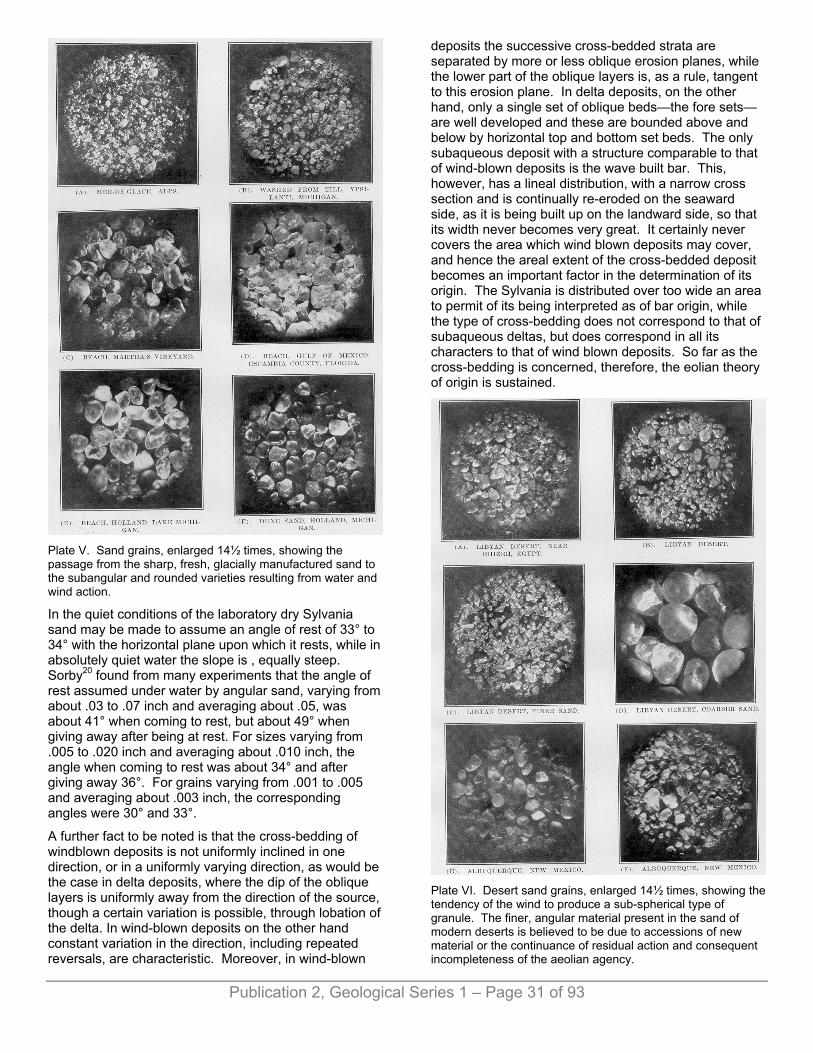
Plate V. Sand grains, enlarged 14½ times, showing the passage from the sharp, fresh, glacially manufactured sand to the subangular and rounded varieties resulting from water and wind action.
In the quiet conditions of the laboratory dry Sylvania sand may be made to assume an angle of rest of 33° to 34° with the horizontal plane upon which it rests, while in absolutely quiet water the slope is , equally steep. Sorby20 found from many experiments that the angle of rest assumed under water by angular sand, varying from about .03 to .07 inch and averaging about .05, was about 41° when coming to rest, but about 49° when giving away after being at rest. For sizes varying from .005 to .020 inch and averaging about .010 inch, the angle when coming to rest was about 34° and after giving away 36°. For grains varying from .001 to .005 and averaging about .003 inch, the corresponding angles were 30° and 33°.
A further fact to be noted is that the cross-bedding of windblown deposits is not uniformly inclined in one direction, or in a uniformly varying direction, as would be the case in delta deposits, where the dip of the oblique layers is uniformly away from the direction of the source, though a certain variation is possible, through lobation of the delta. In wind-blown deposits on the other hand constant variation in the direction, including repeated reversals, are characteristic. Moreover, in wind-blown
deposits the successive cross-bedded strata are separated by more or less oblique erosion planes, while the lower part of the oblique layers is, as a rule, tangent to this erosion plane. In delta deposits, on the other hand, only a single set of oblique beds—the fore sets—are well developed and these are bounded above and below by horizontal top and bottom set beds. The only subaqueous deposit with a structure comparable to that of wind-blown deposits is the wave built bar. This, however, has a lineal distribution, with a narrow cross section and is continually re-eroded on the seaward side, as it is being built up on the landward side, so that its width never becomes very great. It certainly never covers the area which wind blown deposits may cover, and hence the areal extent of the cross-bedded deposit becomes an important factor in the determination of its origin. The Sylvania is distributed over too wide an area to permit of its being interpreted as of bar origin, while the type of cross-bedding does not correspond to that of subaqueous deltas, but does correspond in all its characters to that of wind blown deposits. So far as the cross-bedding is concerned, therefore, the eolian theory of origin is sustained.
Plate VI. Desert sand grains, enlarged 14½ times, showing the tendency of the wind to produce a sub-spherical type of granule. The finer, angular material present in the sand of modern deserts is believed to be due to accessions of new material or the continuance of residual action and consequent incompleteness of the aeolian agency.
Publication 2, Geological Series 1 – Page 31 of 93

Plate VII. Sylvania and St. Peter sand grains, enlarged 14½ times, the latter the supposed source of the former. In these sands the assorting, the concentration of quartz and the general rounding of the granules are far more pronounced than in the sand of any known modern desert. Many of the granules in cut A have been secondarily enlarged and give angular outlines, (see text).
Great irregularities in the thickness of the beds, as reported from the Sylvania in neighboring wells, are to be expected upon the eolian hypothesis, but are difficult to explain if we assume that the deposit took place under water. The total disappearance of the bed, as at New Baltimore, Michigan, surrounded by localities in which the bed is known to occur, is readily accounted for on the the entire vertical and horizontal extent is demanded by the eolian hypothesis but difficult to reconcile with any theory of water deposition, where flocculation would cause large and small particles to sink together. The absence of anything of the nature of original clay or dust, the very complete rounding of the smaller granules, and the pitted character of the surfaces of the coarser granules, when not extinguished by secondary enlargement, all point to a long continued wind action.
For purposes of comparison with the Sylvania grains a study has been made of the different types of sand and photographs taken to illustrate the characteristic differences.21 (Plates V to VII.) At one end of the series stand the glacial sands with the granules typically sharp
and angular, the quartz fragments fresh and vitreous looking, showing conchoidal fracture, with a variety of material and little evidence of assorting. The few rounded grains seen probably possessed this form in the original rock from which they were derived. Sand washed from glacial till (Plate V, Fig. B.) shows much the same appearance, but with a larger proportion of partially, or completely rounded granules. In the case of typical beach sand the grains are relatively coarse, the finer material having been removed by the continued washing process; there is more or less variety in the minerals represented; the quartz fragments are vitreous, with more or less conchoidal fracture; and the general form of the granules is angular, but with rounded corners and edges. Occasionally very perfectly rounded grains are to be seen, especially amongst the coarser fragments. Transportation for long distances along shore would be expected to emphasize this character, if there were no opportunity for a fresh supply of sand, and there would be gradually eliminated the softer minerals leading to a concentration of the quartz. A remarkably pure beach sand, from which practically all other minerals than quartz have been eliminated, is found on the coast of the Gulf of Mexico, Escambia county, Florida. A mechanical analysis of this sand by the U. S. Department of Agriculture shows that practically all the material below .1 mm. has been removed and that the granules range from 1.0 mm. to .1 mm., 56% constituting their "medium sand" with granules .5 mm. to .25 mm. An inspection of figure D, plate V, shows that the process by which the quartz was concentrated did not result in the general rounding of the grains. The surfaces are smoothed, the edges and corners ground off but the bodies of the granules still remain angular in striking contrast with the Sylvania. A very similar gray sand occurs upon the Atlantic coast at West Palm Beach, Florida, showing the same degree of purity and the same characteristics of grain. The two sands have evidently been derived from crystalline rocks to the north and have traveled along shore for a considerable distance. Evidently the purity of the sand is attained long before the complete rounding of the grains. In the case of shore dunes, for which the material is derived more or less directly from the beach, the differences in the granules are not strikingly shown. The extent and thickness of the deposits are greater, however, and the assorting of the granules rather more perfect. The dune sands show a larger percentage of rounded grains, as a rule, and there are more that appear dulled and frosted, with pitted surfaces. Owing to the opportunity for shifting their position from dune to water and water back to dune, there occurs a mixture of granules and a difficulty arises in attempting to distinguish between the two classes of deposits. It seems probable, however, that typical beach sand, not yet acted upon by the wind, can be distinguished from typical dune sand. Desert sands, so far as examined, show a higher degree of rounding, extending down to granules less than one-tenth of a mm. in diameter. As pointed out by Zittel, Walther and Sokolow, typical desert sand contains also considerable angular and subangular material, but not as much as
Publication 2, Geological Series 1 – Page 32 of 93

Publication 2, Geological Series 1 – Page 33 of 93
that ordinarily found in beach and littoral deposits. The bulk of the sand consists, of quartz, showing in the coarser grains especially, a characteristic pitted and frosted appearance, but fragments of other minerals are much in evidence. This variety of material and its angular character are probably due to fresh accessions from the original sources and the more or less continuous action of residual agencies. In describing sand of the Libyan desert Zittel says that it "consists of irregularly formed, rounded, perfectly pure—washed and polished quartz grains from .5 mm. to 2.0 mm. in diameter. Generally the grains of a given sample have a nearly uniform size, sand masses of fine, medium and coarse grain being as a rule separated. Under the microscope the separate grains are seen to consist of clear, colorless or wine yellow quartz or again of clouded, milky or brown ferruginous quartz. * * * Clay, marl or iron impurities are not found in the desert sand, the aggregation is free from dust and of most agreeable purity."22 Owing to the cleavable character of the common rock forming minerals except quartz, their softer character and greater tendency toward disintegration, they are in time reduced to powder, which is carried away by the winds to form deposits of clay about the margin of the desert. In speaking of this action Walther says, "It is no accident that the bed of vegetation-less desert is covered with quartz sand, the bed of grass grown steppe with clay dust. It is also no accident that the North African deserts are surrounded by clay dust steppes. Desert and steppe belong together, not only from the view point of climatology, but also sedimentary formation. The steppe is often the child of the desert." (p. 152.)
In comparing the Sylvania sand with the types studied it is found to lie upon the opposite side of the desert sand from the glacial, littoral and dune sands; to actually out-Sahara the Sahara sand itself so far as purity, rounding and assorting are concerned. It is a more typical desert sand than is known from any modern desert and has already attained the condition which present desert sands are approaching but never reach. This perfected character of the Sylvania sand is readily understood when its probable history is made known—a lengthy and repeated buffeting with wind and wave, with no opportunity for the accession of new material. There has thus been a concentration of the resistant quartz after the manner emphasized in the recent presidential address of the late Prof. I. C. Eussell.23 In looking to the northwestward for a possible source of the material from which the deposit could have been derived there is encountered at once, upon the western side of Lake Michigan, a sandstone of early Ordovicic age—the St. Peter. This bed has a northeast-southwest strike, approximately parallel to the lake shore, extends for more than 120 miles in Wisconsin, varying in thickness from zero to 212 feet and presumably enters the northern peninsula of Michigan, although not known there in outcrop. This formation is the counterpart, stratigraphically and lithologically of the Sylvania, having recently been made the subject of special study by Prof.
C. P. Berkey and by him believed to have been deposited in part by wind and in part by water.24 This sandstone is typically white or yellowish, consisting of uniform quartz grains which range in size from .01 to 2 mm., but the bulk of the rock consists of grains from .05 to .4 mm. in diameter. The grains are generally rounded down to a diameter of .1 mm. to .2 mm., the coarser ones being more perfectly rounded and showing pitted surfaces. In comparing samples of St. Peter granules from Missouri, Illinois, Wisconsin and Minnesota, with those of the Sylvania from southeastern Michigan, the granules are not so completely rounded nor so perfectly assorted. (Compare figures C and D with E and F on plate VII.) The original clay or dust has been removed and the percentage of silica is sometimes above 99%. The basal deposits of sandstone of the Upper Mississippi, region, of late Cambrian age, are believed to have furnished the material for the St. Peter and this, in turn, was derived from the original crystallines to the north and east as the result of wave action. This repeated working of the granules by waves and currents and later by wind has eliminated the softer and decomposable minerals originally present, the finer material has been washed out and blown away, and the remaining quartz grains assorted, rounded and pitted. The absence of deposits of shale about the margin of the Sylvania desert is to be explained by the purity of the St. Peter itself and furnishes confirmatory evidence that the Sylvania must have been derived from some bed of highly silicious rock. At Niles, Michigan, some 20 feet of a silicious shale was met, at what appears to be the Sylvania horizon,25 but this is the only record known of such a bed; the Tymochtee shale of the Monroe series being of earlier age.
If the Sylvania formation has had the history ascribed to it by the authors, the basal layers sedimentary, the body eolian, the upper eolian deposits reworked by a transgressing sea, and the materials in the main derived from the St. Peter,—it will be recognized that it will be difficult to assign the beds to any definite geological horizon. Basally it will be found to rest upon successively younger strata as we pass southeastward from the St. Peter in Wisconsin and northern Michigan and to be younger than the youngest bed upon which it rests. As the result of the work of the encroaching sea it will be successively overlapped by strata younger than itself and will be geological older than the oldest of these beds. The key to the geological age of the formation is found in the Detroit river region where the Sylvania is found to rest upon dolomites of the Lower Monroe series and to be capped by 250 to 350 feet of strata of the Upper Monroe series. The Sylvania episode is to be referred to about mid-Monroe time and probably lasted long enough for the accumulation in the littoral region of some 200 to 300 feet of dolomitic slime. 1The writers desire to acknowledge their indebtedness and to express their most appreciative thanks to the following persons for samples of sand: Libian desert, Mrs. Julia Sherman, Dr. Jane Sherzer and Dr. Johannes Walther, samples from the latter being obtained through the courtesy of Mr. Frank Leverett and Dr. Karl Kielhack; Prof. B. O. D'Ooge for samples of western Sahara and other sands; to Dr. Alfred

Publication 2, Geological Series 1 – Page 34 of 93
C. Lane for samples from the neighborhood of Albuquerque, New Mexico; to Prof. Mark Jefferson for various samples of beach and dune sands; to Chief Milton Whitney, of the Department of Agriculture, for beach and dune sands; to Supt. O. H. Tittman, of the Coast and Geodetic Survey, for sea bottom sands off the Atlantic coast, and to Prof. Chas. P. Berkey and Geologist Samuel Weidman, for samples of the St. Peter sandstone. 2First Annual Report of the State Geologist, 1838. House document No. 24, p. 306. 3Second Annual Report of the State Geologist, 1839. Senate document No. 12, p. 377. House document No. 23, p. 493. 4Second Annual Report of the Geological Survey of Ohio, 1838, p. 112. 5First Biennial Report of the Progress of the Geological Survey of Michigan, 1861, p. 63. 6Geological Survey of Ohio, Report of Progress for 1869, 1871. Geological Survey of Ohio, Volume I, 1873, p. 573. 7Geological Survey of Michigan, Vol. Ill, 1876, p. 29. 8Geological Survey of Canada, Report of Progress from its commencement to 1863, p. 359. 9Geological Survey of Ohio, Vol. VI, 1888, p. 18. See also Vol. VII, 1893, p. 17. 10Geological Survey of Michigan, Vol. VII, 1900, Part 1, p. 60. 11Geological Survey of Michigan, Vol. V, 1895, Part 2, p. 26. 12Geological Survey of Canada, 1893, New Series, Vol. V, Part 2, Brumell's report on gas and petroleum, p. 760. Annual Report of the Michigan Academy of Science, Vol. IX. 1907, p, 177. The Geological Continuity of Essex and Kent counties, Ontario, and Monroe and Wayne counties, Michigan, Rev. Thomas Nattress. 13Geological Survey of Ohio, Vol. I, 1873, p. 603. 14Eleventh Annual Report, Director U. S. Geological Survey, 1891, Plate LXIII. 15Cyathophyllum rugosum, Conocardium trigonale, C. nasutum, Tentaculites scalariformis, with several species of favositoids. 16Second Annual Report of the State Geologist (Michigan), 1839, Senate document No. 12, p. 377. 17W. H. Sherzer, Geol. Sur. Mich., Vol. VII, Pt. 1, p. 57. 18Quarterly Journal of Geol. Society of London, 1880, Vol. 36, p. 63. A fuller discussion of the secondary enlargement of quartz grains in sandstones will be found in Bulletin No. 8, of the U. S. Geol. Survey, 1884, by Irving and VanHise. See also VanHise's Treatise on Metamorphism, Monograph XLVII, U. S. Geol. Survey, 1904, pp. 75, 121, 619 and 864. 19Die Dunen, Sokolow, 1884. Translated from Russian into German by Arzruni, 1894, p. 82. 20Quart. Journ. Geol. Soc., Vol. 64, p.174, 1908. 21Since the preparation of this manuscript Sherzer has extended his studies upon sand grains and has worked out a genetic classification of the same, which will appear in a forthcoming bulletin of the Geological Society of America, (Vol. 21). Seven distinct types of granules are recognized; glacial, volcanic, residual, aqueous, eolian, concentration and organic. Numerous sub-types are described and illustrated, resulting from the secondary action of the various geological agencies upon these main types; as, for instance, water upon a sand of residual origin, or the wind acting upon an aqueous or volcanic sand. 22Geologie der Lybischen, Wuste, Etc., 1883, p. 138. 23Concentration as a Geological Principle. Bull. Geol. Soc. of Am., Vol. 18, 1907, p. 6. 24Paleogeography of Saint Peter Time. Bull. Geol. Soc. of Am., Vol. 17, 1906, p. 229. This paper contains references to St. Peter
literature. See also Grabau, A. W., Types of Sedimentary Overlap. Ibid., pp. 616-620. 25Surv. of Mich., Vol. V, pl. 44.
CHAPTER IV. DESCRIPTION OF MONROE FOSSILS, BY A. W. GRABAU. 1. Stromatoporoidea. .......................................................34 2. Anthozoa......................................................................37 3. Bryozoa........................................................................47 4. Brachiopoda.................................................................47 5. Pelecypoda. .................................................................64 6. Gastropoda. .................................................................69 7. Cephalopoda................................................................78 8. Annelida. ......................................................................80 9. Ostracoda. ...................................................................80 10. Trilobitae. ...................................................................82 11. Merostomata. .............................................................82 12. Plantae.......................................................................83
STROMATOPOROIDEA.
Genus CLATHRODICTYON Nicholson and Murie.
1. CLATHRODICTYON OSTIOLATUM (Nicholson). (Plate VIII, Fig. 6; XIII, Fig. 1; XVI, Fig. 18.)
1873. Stromatopora ostiolata Nicholson, Ann. and Mag. of Nat. History, 4th ser., Vol. XII, p. 90, pl. IV, figs. 1, 1a.
1874. Stromatopora ostiolata Nicholson, Pal. Province of Ontario, pl. I, fig. 1, 1a, p. 63. 1875.
1886. Clathrodictyon (Stromatopora) ostiolatum Nicholson, Mem. British Stromatoporidaea pt. 1, p. 14.
1887. Clathrodictyon ostiolatum Nicholson, Ann. and Mag. Of Nat. History, 5th ser., Vol. 19, p. 11, pl. 3, figs. 1-3.
1895. Clathrodictyon ostiolatum Whiteaves, Palaeozoic fossils, Vol. 3, pt. 2, p. 52.
1903. Clathrodictyon ostiolatum Clarke and Ruedemann, Mem. N. Y. State Mus. No. 5, p. 37, pl. 1, figs. 10-12.
1906. Clathrodictyon ostiolatum Grabau and Shimer, North American Index fossils, p. 41.
Specimens showing the essential characters of the species are abundantly represented in the collection. In form they are massive, no specimen showing the under side. They frequently constitute masses a foot or more in diameter. The surface is commonly drawn out into numerous nipple-like projections which are sometimes sharp and in other cases more rounded. Rarely is there an apical depression simulating a pore. In some large

Publication 2, Geological Series 1 – Page 35 of 93
fragments the projections are more botryoidal than nipple-like, while in others still they approach in regularity and form the mamelons of other genera. Generally the protuberances are coarse and conical, but in some specimens they approach a finger-like character, though, as a rule, the "fingers" are contiguous and united for most of their length.
In section the specimens show the typical structure of Clathrodictyon in its discontinuous vertical pillars. These join the two lamellæ, rarely projecting downwards in the form of spines as in C. striatellum. The double character of the spines of that species has not been observed in any specimens sectioned. On the average five lamellæ and four interspaces occur to the millimeter, the inter-laminar space being for the most part twice the thickness of the laminæ. At irregular intervals, however, the width of the interlaminar spaces may increase to twice that amount or more, up to half (or even .6 of) a millimeter. Around the nipple-like projections the growth is concentric, but otherwise it has the form of undulating laminæ. Frequently, however, the coenosteum envelopes foreign bodies, such as the corals Diplophyllum and Syringopora and other tubular structures which may belong to tubiculous annelids. (Plate XVI, fig. 18.) This gives rise to the Caunopora structure, often exceedingly well developed in this species. The growth in all cases is concentric around these tubes, unless, as is sometimes the case, they lie parallel to the laminæ.
The surfaces of the laminæ in most broken specimens show an irregular series of granules, frequently anastomosing. No astrorhizae have been observed, nor do any of the surfaces show the raised "oscula" described in the original Canadian specimen. These, however, do not appear in other specimens from the same horizon in New York judging from the figures given by Clarke and Ruedemann in their Monograph of the Guelph faunas, (Plate I, Pgs. 10-12). "Conic oscula" are mentioned in the description, but the authors add that "in the specimens under observation they are, however, not arranged distinctly as described by Nicholson."1
Tangential sections of the laminæ show a delicately reticulated net work. The original specimens from the Guelph of Guelph, Ontario, was a dolomitic specimen, and is the only one sharing the elevations described as oscula. In all other respects our specimens agree with this, and they further agree with specimens identified as this species from the Guelph of New York. According to Clarke and Ruedemann the species also occurs in the Cobleskill of the Schoharie region.
Certain portions of the specimens in the collection from the salt shaft are silicified, while intermediate layers still remain in a calcareous condition, the interspaces being mostly infiltrated with calcium carbonate. In other specimens the structure is still open, what infiltration has occurred being limited to a crystallization of calcite on the surfaces of the laminæ. When worn the surface commonly shows the concentric structure of the laminæ.
Horizon and localities.—This species is the most abundantly represented stromatoporoid in the collection from the Anderdon limestone of the salt shaft, and likewise occurs in large masses in the reef at the Anderdon quarry where it is abundant. A few silicified specimens have been obtained from the Amherstburg bed of the Detroit river. It also occurs in the Guelph and Cobleskill of New York and Canada.
2. CLATHRODICTYON VARIOLARE von Rosen. (Plate IX, Figs. 1-2.)
1867. Stromatopora variolaris von Rosen, Ueber die Natur der Stromatoporen, p. 61, pl. II, figs. 2-5.
1887. Clathrodictyon variolare Nicholson, Ann. and Mag. of Nat. History XIX, 5th series, p. 4, pl. I, figs. 4-6.
1888. Clathrodictyon variolare Nicholson, Mon. British Stromatoporoids, p. 150, pl. XVIII, figs. 1-5, pl. XVII, fig. 14.
Coenosteum massive, the material obtained representing fragments of heads of considerable size. A somewhat obscure arrangement into latilaminæ is indicated on polished sections. Surface marked by mamelons which are closely crowded and obtusely rounded in one specimen, and rather distant and more sharply pointed in another. Astrorhizae rather faint, and generally coinciding with the mamelons, but not wholly confined to them. In sections the latilaminæ show a wavy character and the laminæ appear to be finely crumpled. The alternation of several rows of coarser vesicles with rows or zones of minute ones, characteristic of this species, is well shown in our specimens. A zone of five coarser vesicles has a width of 1.4 mm., while an adjoining zone, one of the same width, contains twice as many vesicles. The stratified appearance of the fossil in section is largely due to this alternation of coarser and finer vesicles.
Horizon and localities.—In the reef portion of the Anderdon limestone, Anderdon quarry near Amherstburg, Ontario. Not very common. Originally described from the Niagaran.
Genus STROMATOPORA Goldfuss.
3. STROMATOPORA GALTENSE (Dawson). (Plate VIII, Fig. 1.)
1879. Coenostroma galtense Dawson, Quart. Journ. Geol. Soc., Vol. XXXV, p. 52.
1903. Stromatopora galtense Clarke and Ruedemann, Guelph Fauna of New York, Memoir 5, N. Y. State Museum, p. 36, pl, I, fig. 13.
Compare:
1852. Stromatopora constelleta Hall, Pal. N. Y., Vol. II, p. 324, pl. 72, fig. 2.
1891. Stromatopora typica v. Rosen, Nicholson, Mon. British Stromatoporoids, p, 169, pl. I, V, XXI, XXII.

Publication 2, Geological Series 1 – Page 36 of 93
The specimens identified with the above species are massive, or occur in the form of thin layers of a number of laminæ. Their occurrence in this manner seems to prove that the coenosteum is divided into latilaminæ along the dividing planes of which separation takes place. No epithecal surface has been observed.
The latilaminæ are undulating but no regular mamelons appear. The surfaces of the laminæ show the characteristic roughness due to the irregular granules and ridges which represent the vertical elements of the coenosteum, but no pustulose character appears. This character is similar to that illustrated for S. typica by Nicholson (British Stromatoporoids, pl. XXI, fig. 7). The astrorhizae are rather large and irregularly distributed, their centers slightly raised, and separated 10 to 12 mm. (sometimes more, sometimes less) from one another. In some specimens the distance varies from 8 to 19 mm. The radiating canals branch once or twice, extending from 4 to 6 or 7 millimeters from the center. Often the center appears as if formed into a tube, and "Caunopora" tubes are sometimes found.
In the massive specimens the latilaminar character, or stratification, is shown by the separation of the coenosteum into strata a few millimeters thick. The surfaces are undulating and the astrorhizae. generally occur on the summits of the undulations which can scarcely be called mamelons. But the astrorhizae are variable, sometimes occurring in depressions. They are best seen on the under side of the latilaminæ. Distance between their centers varies in different specimens from 5 to 13 mm., and there is also some variation in the frequency of branching of the canals. Under certain conditions of preservation the horizontal laminæ are readily distinguished, though the vertical elements are less clearly differentiated. The laminæ are three to four times as thick as the interspaces. Transverse sections of the massive specimens show the latilaminæ, but the laminate and radial pillars are not readily distinguishable. Occasionally vertical tubules, such as described for S. typica are found. Tangential sections likewise show an exceedingly dense tissue.
Horizon and localities.—This species is common in the coral bed of the salt shaft, and is easily recognized by its astrorhizae and its dense tissue, as well as the absence of mamelons and pustules. It is not uncommon in the Anderdon reef of the Anderdon quarry Amherstburg, Ontario. It has also been described from the Guelph of Ontario and New York, and from the Cobleskill horizon of eastern New York.
4. STROMATOPORA (COENOSTROMA) PUSTULOSUM.
(Plate IX, Figs. 3-4.)
Coenosteum massive, generally occurring as large hemispheric heads, up to a foot or more in diameter. A latilaminate structure is more or less perfectly developed, the coenosteum readily splitting into layers sometimes less than a millimeter thick. Surface of the latilaminæ undulating, but without mamelons; minutely
and strongly pustulose, the pustules .5 mm. in diameter, and separated by from .6 to .8 mm. The pustules are rounded and without apical openings, while the interpustular surface is finely granulose. Astrorhizae well developed, though generally visible only on the under side of the lamellæ; their centers are from 6 to 8 mm. apart, and their branches divide repeatedly.
In vertical section, the structure is seen to comprise strong vertical pillars, which average about .3 mm. in thickness, and are separated by from .3 to .5 mm. intervals. Horizontal laminæ crowded, from 5 to 6 to a millimeter. At subequal intervals of from .8 to 1 mm. the interlaminar space is of about twice the normal width. Very fine vertical pillars are occasionally discoverable between the larger radial pillars.
In tangential sections the horizontal laminæ are seen to consist of an exceedingly dense tissue, the open spaces, except in the astrorhizae being very fine and distant. No indication of the radial pillars is seen in tangential section.
This species comes nearest to O. ristigouchense Spencer, of the Siluric of Canada (Bull. University State Missouri, p. 49, pl. VI, figs. 12, 12a, 1884), from which it differs chiefly in its denser tissue and the strongly pustulose surface, no such structure having been reported for that species. The radial pillars of that species are also somewhat broader, and the horizontal laminæ are wider apart.
This species is most readily distinguished from S. galtense with which it is associated, by the strong pustulose character of the surface.
Horizon and localities.—This species occurs in large masses and in fragments in the coral reef of the Anderdon horizon, below the Dundee, in the Anderdon quarry near Amherstburg, Ontario.
Genus STYLODICTYON Nicholson.
5. STYLODICTYON SHERZERI sp. nov. (Plate VI, Figs. 4-5.)
Coenosteum typically in the form of a Vienna loaf separating into latilaminæ, each of which, like the external surface, is marked by a closely crowded series of circular pustules. The center of the top of the pustule has the appearance of being the opening of a tube. The pustules are unequally spaced and about their own diameter apart, closer or sometimes wider apart. Their diameter varies from 1 to 1.5 mm. in different parts of the coenosteum, the larger ones being mostly on the outer strata. Between the pustules the surface is finely granulose.
In vertical section the tissue is dense, and traversed by a series of very dense vertical pillars or rods. These end upwards in the pustules, which are their superficial continuation. The laminæ are arched downward between the rods, their edges appearing to bend sharply upon the rods in the manner of a rope suspended
Publication 2, Geological Series 1 – Page 37 of 93
loosely from a series of equally spaced poles. According to the direction of the section, the rods appear from 1 to 2 mm. apart. In tangential section the ends of the pillars form centers around which the cut edges of the laminæ make concentric exposures.
The only other known species of this genus are S. columnare Nicholson, from the Devonic limestones (Columbus) of Kelly's island, Lake Erie, and S. wortheni Rominger, from the Traverse group of Michigan. These two species are probably identical, as generally held. There may, however, be an additional species in the Lower Traverse. All the species so far recognized are Devonic, and all are large, massive or hemispheric or subglobular forms. The peculiar elongate form of the present species is its most striking characteristic, as are also the closely crowded pustules with their median depressions. In the type species of the genus (Stylodictyon columnare, Nich.), the pustules are more rounded, less closely crowded and more irregularly spaced, and altogether less pronounced than in the present species. The course of the vertical pillar is also readily seen on the broken surfaces, but this may be due to the method of fossilization.
In vertical section the pillars are seen to be thicker and more widely separated in S. columnare than in S. sherzeri, being on the average from 2 to over 3 mm. from center to center. The arched laminæ and the connecting vertical elements are also more distinct in the Devonic species.
On the whole it must be said that the Siluric species differ only in minor characters from the Devonic species. Yet the difference between Siluric and Devonic species of other Stromatoporoids is often not very great. In the present case, however, the external characters seem to make the distinction comparatively easy.
Horizon and Locality.—Anderdon limestone. Represented by a number of fragments in the collection from the coral bed of the salt shaft. It has so far not been found in the other sections.
I take pleasure in naming this species after Prof. W. H. Sherzer of Ypsilanti, Michigan, whose study of the Monroe formation of Michigan has helped to elucidate the puzzling problems of Siluric stratigraphy, and through whose kindness the material of the coral bed was brought to my attention.
Genus IDIOSTROMA Winchell.
6. IDIOSTROMA NATTRESSI sp. nov. (Plate IX, Figs. 5, 6 and 7.)
Small, sub-cylindrical, more or less irregularly curving branches, varying in diameter from 2 to 3 mm. in the smaller specimens, 4 to 5 mm. in the larger. Branching frequent and irregular. Surface of stems generally without markings of any kind, except those due to the. porosity of the tissue. In some cases a faint grooving of the surface is seen, this being most distinct around the knob-like elevations, or incipient branches found on
some specimens. In section the vertical pillars are seen to occupy a radial position. The tissue is dense on the whole, though large, open lacunæ appear at intervals in the section.
This is the only known Siluric species of this branching genus of Stromatoporoid. A number of species from Devonic rocks of America (Hamilton) and Europe are known. The species is not unlike I. cylindrica Grabau mss., from the upper Traverse rocks of the Alpena region, but that species is a more frequently branching one, and varies in size from 3 mm. upward. Owing to the poor preservation of the specimens, details of structure are not determinable.
Horizon and Localities.—Common in the coral reef portion of the Anderdon bed in the Anderdon quarry. It generally covers weathered surfaces of other Stromatoporoids, or occurs independently. It is likewise common in the same formation in the salt shaft, occurring in the more shaly beds, often more or less compressed. Silicified specimens largely composed of the species (apparently) occur in the Amherstburg bed in the Detroit river cut.
The dense character of the tissue causes this species to resemble Amphipora ramosa of the Devonic of Europe, but the growth and branching of our species are too irregular. In good sections the radial pillars are seen to be distinct. 1Clarke, J. M, and Ruedemann, R. Guelph Fauna in the state of New York. Memoir N. Y. State Museum. 5 p. 38.
ANTHOZOA.
HELENTEROPHYLLUM. gen. nov.
General form and proportions those of Enterolasma of which it derivative. Calyx deep, septa of uniform thickness, carinated strong transverse carinæ as in Heliophyllum. Genotype H. caliculoides.
The species for which this genus is made would ordinarily be ed as a Heliophyllum, since it has the most characteristic structural feature of that genus, the carinæ. That there is no tic relation whatever between this and the mid-Devonic Heliophylum halli, is beyond doubt. The present genus is a successor of the Niagaran Enterolasma, the two constituting a lateral branch the main line of evolution of the Streptelasmoid corals. There is objection to uniting the type species generically with Enterolasma except that in such case the diagnosis of that genus must be altered.
7. HELENTEROPHYLLUM CALICULOIDES. sp. nov. (Plate XI, Figs. 2-3.)
Externally in all respects like Enterolasma calicula of the Niagara, from which it differs, apparently, only in the carination of the septa. General form, a slightly compressed, gently curving cone, the cross section approaching very closely to a circle. Calyx deep, with sides sloping from the sharp margin to the base of the
Publication 2, Geological Series 1 – Page 38 of 93
calyx. Septa about 50, radially arranged, but showing the primitive pinnate character with reference to the cardinal and alar septa, by the costal grooves of the exterior. Carinæ prominent, about 5 to 2 mm. Epitheca thin, concentrically wrinkled, and showing faint growth lines.
Measurements: Diameter of calyx at a length of 10 mm. = 10 mm. by 9.5 mm.
This species resembles in all respects, except the carination of the septa, the Niagaran Enterolasma calcicula, from which it is y a direct derivative. Externally the two cannot be told apart,—the number of septa is the same in each, the prominence innate arrangement of the costal grooves and the general form and curvature correspond. This species probably represents a terminal member of a lateral branch of the Streptelasmoid genealogical tree. The relationship to other species may be express as follows:
Upper (Monroan) Helenterophyllum caliculoides.Middle (Salinan). Siluric.
Lower (Niagaran) Enterolasma calicula.Upper (Cincinnatian) Streptelasma rusticum.Upper (Trenton) Streptelasma corniculum.Ordovic.
Lower and Middle Streptelasma profundum.
Horizon and Locality.—In the Anderdon coral reef at the Anderdon quarry near Amherstburg, Ont. Several specimens. Also in the Manlius limestone of Manlius, N. Y. (Coll. Columbia University.)
8. CYATHOPHYLLUM THOROLDENSE Lambe. (Plate XII, Fig. 16.)
1901. Cyathophyllum thoroldense Lambe, Contrib. Can. Pal. IV, Pt. II, p. 147, plate XI, fig. 5 a-b.
Conico-cylindrical, or slightly curved, gradually enlarging toward the calicular end. Surface covered with a strongly wrinkled epitheca, showing numerous slight constrictions and swellings. Costal grooves marked. Calyx deep. Septa numerous, alternating long and short, 28 or more reaching the center, where they are somewhat intertwisted. Shorter septa reaching one-third the way to the center occur between these. Still shorter ones only reach part way down the calyx. Dissepiments numerous in the outer zone, less crowded towards the center. They often unite in a cystose manner, and are strongly oblique at the margins where they bend downward.
The specimens here described agree in all essentials with the Siluric species from Thorold, Ont., except that the carination of the septa, described by Lambe, is not recognizable in the cross sections of the specimens. In a fragment of a deep calyx, apparently belonging with these specimens, faint carination is visible on margins of the septa. If these are more than calicinal, the species
should rather be referred to the genus Heliophyllum, or to some other genus.
A specimen externally similar to the present one, but with the septa not preserved, is figured by Weller from the Decker Ferry formation of New York. (Pal. N. Y. Ill, pl. 17, fig. 10.)
Horizon and localities.—In the coral layer (Anderdon limestone) of the Upper Monroe of the salt shaft, Detroit, Michigan. Rather rare. A specimen, apparently of this species, was obtained from the Anderdon limestone of the Anderdon quarry, Amherstburg, Ont. It was originally described from the Niagaran of Ontario.
9. CYATHOPHYLLUM HYDRAULICUM Simpson. (Plate XXI, Fig. 1a-d.)
1900. Cyathophyllum hydraulicum. Simpson Mss.
(Mss.) Memoir of the New York State Museum. "The Genera of Palæozoic Corals."
1900. Cyathophyllum hydraulicum. Grabau, Bull. Geol. Soc. Am., Vol. II, p. 364, pl. 21, fig. 1a-d.
"Corallum simple, conico-cylindrical, usually long and slender. Growth irregular, with numerous abrupt changes in direction. Surface of the mature portion longitudinally ribbed by numerous rounded costal ridges, which are strongly marked and separated from each other by a sharply depressed line. Epitheca well developed, the numerous lines of growth strongly marked on the surface of the costæ. The epitheca is thrown into frequent coarse crinkles which give the coral a very rugose appearance.
"The young corallum is usually destitute of costæ, and is sub-cylindrical in form, barely increasing in diameter, through a length of over half an inch. It is strongly marked by wrinkles and lines of growth of the epitheca, which are sometimes quite sharp. At the end of this youthful stage the corallum rapidly expands, often abruptly so, and the costæ quickly become prominent.
"A calyx of moderate depth, the total depth being usually somewhat less than the greatest diameter of the calyx. Septa numerous, strong but thin, and separated by interspaces from 2 to 3 times their width. They retain a uniform width from periphery to center. Bottom of calyx often flattened in the center where the septa meet and become slightly twisted. They not infrequently unite before they reach the center. Dissepimental structures appear to be well developed. No fossula occurs.
"The corallum is not infrequently curved, the primary septum then appearing on the convex side. The remarkable cylindrical non-costate young with strongly wrinkled epitheca, and usually abrupt appearance of the costæ, and the concomitant rapid expansion of the corallum are the most striking features of this coral. No internal structure has been observed, as the fossils are nearly all represented by hollow molds. From these, gutta percha casts can readily be made which will show all the external characters of the corallum in great clearness. No well preserved coral has been found so
Publication 2, Geological Series 1 – Page 39 of 93
far, the only cases where the coral was preserved at all being rendered worthless by the crystallization of the whole in interior, thus destroying all structural features." (Grabau.)
Horizon and localities.—These corals are abundant in the upper three or four feet of the Akron (Bullhead) dolomite in nearly al] its exposures in Erie county. Most of the individuals lie parallel to the bedding plane, having fallen before they were buried.
Genus HELIOPHRENTIS gen. nov.
Corals combining the form and septal arrangement of Zaphrentis with the carinæ of Heliophyllum, with steeply sloping or nearly vertical sides. Calyx deep, septa numerous, alternating, the longer reaching the center. Carinæ more or less prominently developed though in some of the more primitive species they are restricted to the marginal portion of the calyx, or in immature specimens may be wanting altogether. Fossula present in specialized species. Growth conical to conico-cylindrical and often irregularly restricted.
Genotype HELIOPHRENTIS ALTERNATUM. sp. nov.
The genera of Palæozoic corals are in a most unsatisfactory state of analysis, and a lumping of a heterogeneous mass of material in which superficial resemblances occur, has given us genera which are merely collections of homeomorphic equivalents from numerous diverse genetic series. This is especially the case with such species as are referred to Zaphrentis, Cyathophyllum, Heliophyllum, etc. and so long as this practice is persisted in no permanent advance in the systematic arrangement of these organisms is accomplished. As has been shown by Shimer and Grabau, Heliophyllum branches off from Cyathophyllum in mid-Devonic time (Hamilton) and all species which cannot be shown to be derivations from Heliophyllum halli, cannot properly be referred to that genus, if it is to repose upon a genetic basis. This throws out a large number of forms which have been commonly referred to this genus, arid they must be accommodated elsewhere. The generic name here proposed applies only to the forms congeneric with the species here described. If it can be shown that such forms as "Heliophyllum" corniculum are derivatives of these types, or developed from the same Zaphrentoid ancestor, this generic name must be extended to cover them.
10. HELIOPHRENTIS ALTERNATUM. sp. nov. (Plate XIII, Figs 2-3.)
Calyx deep, with sides at first sloping inward and then descending more abruptly, in some cases almost vertically, to the bottom of the calyx, which is nearly flat or slightly depressed in the center. In other cases the calyx after a slight constriction widens out again, this being repeated several times, the lower portion then sloping rapidly toward the center .of the calyx. Septa in the form of low, sharp ridges on the side of the calyx, alternating in size, the larger ones separated by
interspaces of about 1.3 mm., the thickness of the septum itself at that point being .5 mm. The smaller septum occupying the interspace is about one-half that thickness. They extend to within a short distance of the bottom of the calyx. The larger septa unite in bundles of two, three or more on the bottom of the calyx before reaching the center. At the center the septa are very fine and slightly twisted. Fossula rather irregular and coarse, confined to the bottom of the calyx.
The septa are free from carinæ throughout the greater portion of the calyx. Only in the upper fourth or less are carinæ shown, about five occurring in 3 mm. of septal length. In some cases they are absent altogether or are faintly developed only in the very uppermost portion.
Diameter of calyx of a typical specimen (PI. XIII, fig. 2) at rim 29 mm., in lower part 23 mm.; depth 21 mm.; number of septa 96; carinated portion 6 mm.
Another specimen has its greatest diameter of 25 mm. a little above the middle, below which it slopes rather rapidly to the center, the depth being 29 mm., and the number of septa 88, of two sizes. In the character of the septa and calyx this species is closely similar to Zaphrentis foliata Hall, from the Onondaga of the Falls of the Ohio. The septa are, however, more numerous and more strongly alternating. The occurrence of carinæ in the Detroit specimens is a further distinctive feature. The species has also some resemblance to "Heliophyllum" (Heliophrentis?) corniculum which, however, is coarsely carinated with fewer, less strongly alternating septa.
Horizon and localities.—In the brown Amherstburg dolomite from the Detroit river, bottom, near Amherstburg, Ont., in the form of molds. Rev. Thomas Nattress collection. The species are most nearly allied to Devonic forms.
The noncarinated individuals of this species also resemble Zaphrentis racinencis Whitfield, from the Racine of Wisconsin. In this species the septa alternate, and the larger ones unite into bundles on the flat bottom of the calyx. The fossula is likewise well developed. The number of septa, however, is smaller, a large sized individual showing only 72, with a calicinal diameter of 30 mm., whereas a specimen of H. alternata of the same diameter shows 96 septa, which, therefore, are closer together. Moreover, while the cardinal and the alar septa are readily recognizable in Zaphrentis racinensis, the new septa coming in next to these principal septa in a pinnate manner, the arrangement in Heliophrentis is entirely radial. This would indicate that Z. racinensis is the more primitive type, and that Heliophrentis may be a derivative of this Niagaran species.
What appears to be a young individual of H. carinata, with deep calyx and sloping walls, and with the septa showing pinnate arrangement, a deep fossula and slight twisting of the inner septal ends, occurs in the lower Lucas dolomite of the Silica quarry, near Sylvania, Ohio. (PL VII, fig. 2.)

Publication 2, Geological Series 1 – Page 40 of 93
In the Schoharie grit of the Helderbergs occurs a species apparently indistinguishable from this one.
11. Mutation COMPRESSA. mut. Nov. (Plate XIII, Figs. 4-5.)
Large, robust, calyx 4 mm. in depth, compressed dorso-ventrally to a diameter of 25 mm. at the rim, the corresponding transverse diameter being 40 mm. Cardinal portion flatly convex both longitudinally and transversely, as seen in the mold of the calyx; counter side concave. Sides sloping regularly to the bottom. Septa distinctly alternating, both in length and thickness; cardinal fossula extending the entire length of the calyx. Larger septa .9 mm. thick, interspaces 1.6 mm.; smaller septa less than half the thickness of the larger. Number of septa 92. The barest indication of carinæ occurs in the upper part of the calyx on one side.
Horizon and locality.—Associated with the preceding in the Amherstburg dolomite of the Detroit river bed opposite Amherstburg, Ont. Rev. Thomas Nattress coll.
12. Mutation MAGNA. mut. nov. (Plate XIII, Fig. 6.)
This differs from the typical form of the species only in the large size of the calyx, which is transversely elongate, and slightly constricted at the center of the long faces as if preparatory to division. The lateral septa are not quite parallel but in two groups, those near he center slightly diverging inwards so as to approach radiality nth reference to two new centers. Septa strong, but alternating is in the typical form, the larger ones reaching the center, on the bottom of the calyx, but so far as observable not uniting, or at least less frequently uniting, than in the typical form. The septa of both kinds broaden out towards the rim of the calyx. No carinæ have been observed.
Measurements.—Greatest diameter, 70 mm.; transverse diameter, 46 mm.; depth of calyx, 48 mm. Number of septa, 150.
Horizon and locality.—In the Amherstburg dolomite of the Detroit river bed, opposite Amherstburg, Ont.
13. HELIOPHRENTIS CARINATUM sp. nov. (Plate XII, Fig. 2; Plate XIII, Fig. 7.)
Corallum irregularly conical, with many constrictions and frequent changes in the direction of growth. Epitheca thin but strongly wrinkled and with well-marked lines of growth. Costal grooves pronounced and broad, the interseptal ridges being narrower and sharp.
Calyx deep, generally conical with a regular slope to the bottom, septa alternating in size as in the preceding species but carinated or the greater part of their extent. The carinæ in some of the less specialized individuals occur only in the upper half of the calyx, while in the more specialized types, they occur throughout. There re about 8 carinæ to 5 mm.
Fossula well developed, extending part way up the side of the calyx. Measurements of a small individual give
greatest diameter of calyx, 19 mm.; depth, 17 mm.; number of septa, 64; carinated for 13 mm. The distinction between this species and H. alternatum is to some degree arbitrary, since individuals in which the carination is developed to a greater or less degree occur. In general those with the septa carinated throughout the greater part of their length, must be referred to H. carinatum, while those without carination, or with carinæ only near the margin are to be referred to H. alternatum.
Horizon and localities.—Associated with the preceding species in the brown Amherstburg dolomite from the bed of the Detroit river at the old Lime Kiln Crossing near Amherstburg, Ont. Also in the same formation in the lower part of the Gibraltar quarry near Gibraltar, Michigan, and the Woolmith quarry (Lucas?).
Genus CYLINDROHELIUM, gen, nov.
Corallum long, slender, frequently curved, or geniculate and of the same diameter throughout most of its extent. Surface marked by regular, sharp, longitudinal, costal grooves and by lines of growth. Calyx deep, sides nearly perpendicular, flat bottomed, septa in the form of low ridges on the side of the calyx. Generally alternate in size and carinated for a part of their entire length. Genotype C. profundum. Central area of corallum tabulate, peripheral zone with septa and dissepiments. No inner wall.
14. CYLINDROHELIUM PROFUNDUM sp. nov. (Plate XI, Figs. 4, 5 and 6.)
Corallum long, slender, and in the form of a more or less irregularly curved cylinder, strongly marked by the costal grooves and not infrequently by constrictions and irregular concentric ridges. Diameter of coral from 7 to 9 mm. or larger. Calyx profound, more than 15 mm. deep in a specimen in which the diameter is 10.5 mm. Sides nearly vertical, very slightly flaring at the top. Septa alternating in size, in the form of ridges, the smaller only extending part way to the bottom; carinated in the upper part, the carinæ in the form of thick spines on the outer edge of the septum, about 8 carinæ to 5 mm. Sometimes the septa seem to be entirely replaced by rows of thick spines, and in some cases the carinæ are absent from the lower part of the calyx, or, at least, very faintly developed.
Horizon and localities.—In the Lucas dolomite of the salt shaft, the Silica quarry near Sylvania, Ohio, and the Gibraltar quarry in Michigan.
A small collection of fossils made by the late Miss Mary W. Adams, a student in Columbia University, from the Palaeozoic limestones of the headwaters of the North Fork of the Saskatchewan river, Canada, shows that this species is abundantly represented in that locality. The stems are irregularly cylindrical, from 6. to 7. mm. in diameter, and somewhat flexuous; separated in the specimens seen by from 2 to 4 mm. The epitheca is strongly wrinkled and the costal grooves are well

Publication 2, Geological Series 1 – Page 41 of 93
marked. In an average specimen there are 40 septa, the alternating ones being somewhat shorter and thinner than the others. All are marked by minute, but sharp, carinæ. Diameter of calyx, 4.3 mm.; depth, considerable, but not measured. Central area tabulate, about 7 tabulæ in 5 mm., the individual tabulæ varying from .5 mm. to 1. mm. apart. In the narrow outer zone occurs an abundance of dissepiments between the septa, giving the zone a vesicular appearance.
15. CYLINDROHELIUM HELIOPHYLLOIDES sp. nov. (Plate X, Fig. 7.)
Compare 1883. Heliophyllum pravum Hall, 12th annual report, Ind. Geol. Surv., p. 274, pl. 15, fig. 12, pl. 25, fig. 4.
Calyx deep, flaring at the top, sides nearly perpendicular, bottom flat. Septa numerous, thin, in several cycles, 46 nearly uniform septa occurring in a calyx, the maximum diameter of which is 12 mm., and the depth 9 mm. They form short, sharp ridges on the side of the calyx but do not extend inward except at the bottom, which is broad. Carinæ numerous on all the septa, extending for more than the width of the septum on either side. Corallum on the whole coarser and less regular than in the preceding species.
In general form and character this species resembles Cyathophyllum hydraulicum Simpson, of the Cobleskill of Buffalo. That species, however, is without carinæ, while these are well developed in the present species. The corallum is also longer than in the Bullhead species.
Clarke and Ruedemann figure the calyx of a species of "Heliophyllum" from the Guelph of western New York (Guelph Fauna, pl. I, fig. 45, p. 28) which seems to be identical with the present species, so far as the mold of the calyx, the only part preserved, is concerned.
This .species differs from the preceding in its uniform septa, strong carinæ, and shallower calyx which is only about half the depth of that species, as well as the less cylindrical corallum.
This species comes nearer H. pravum Hall than to any other species described. It agrees with that species in its deep, flat bottomed calyx and character of the septa. The absolute identity of our specimens with that species is, however, not established.
Horizon and localities.—In the Lucas dolomite of the salt shaft, also in the Guelph of New York.
Genus CYSTIPHYLLUM. Lonsdale.
16. CYSTIPHYLLUM AMERICANUM, mut. ANDERDONENSE. mut. nov.
(Plate XII, Figs. 3-5.)
Corallum the size of C. americanum and in general similar to it. Calyx deep, slope at first at an angle of 45° or over, for some distance from the rim, and after that abruptly descending to the center which is depressed. Septa represented by rows of narrow, elongate vesicles,
which in some cases are so thin and near together as to form a continuous ridge, while in others they are coarser and farther apart. Towards the bottom of the calyx the vesicles become larger, the central area being occupied by half a dozen large and prominent ones. Depth of calyx, 27 mm.; greatest diameter at the rim (the specimen is somewhat compressed), 41 mm. In a typical specimen of C. americanum from the Hamilton group of Ontario, the coarse ridges are near the top and the septa become more pronounced downwards.
Several sections of a large Cystiphyllum in the Anderdon coral reef rock probably represent this mutation. They show a certain amount of irregularity of outline and curvature, with repeated constrictions, such as are found in most species of this genus. The vesicular tissue is arranged -in a rather broadly funnel-shaped manner, the coarsest cysts being generally at the center. Diameter of a section, 38 mm.; depth of center of vesicular lamellæ, 15 mm.; length of fragment, 60 mm.
Horizon and locality.—The calyx described was found as a mold in the Amherstburg dolomite of the Detroit river. The sections are from the coral reef portion of the Anderdon limestone, at the Anderdon quarry. Cystiphylli of this type are common in. the upper Siluric of Bohemia (Etage E.). (See C. Bohemicum Barr.)
Genus ACERVULARIA.
17. ACERVULARIA. sp. (Plate XV, Fig. 6.)
In the Amherstburg dolomite occurs an impression of the upper side of a species of Acervularia (Prismatophyllum?) which resembles very closely the characteristic Traverse group species commonly referred to A. davidsoni. The main difference seems to be the smaller diameter of the central pit of the corallites, the flat surface of the outer part of the calyx, and the thicker, rather abruptly raised intercalicinal rims. The average diameter of the adult corallites is from 8 to 10, rarely 12 mm.
Horizon and locality.—In the Amherstburg dolomite of the Detroit river, opposite Amherstburg, Ont.
Genus SYNAPTOPHYLLUM Simpson.
18. SYNAPTOPHYLLUM MULTICAULE (Hall). (Plate XII, Fig. 6.)
1852. Syringopora ? multi-caulis, Hall, Pal. N. Y., Vol. II, p. 119, pl. 33, figs. 3 a-g.
1876. Diphyphyllum multi-caule (Hall) Rominger, Geol. Surv. Mich., Vol. Ill, Foss. corals, p. 121, pl. 45, figs. 3 and 4.
1901. Diphyphyllum multi-caule (Hall) Lambe, Cont. to Can. Pal. Vol. IV, Pt. II, p. 159, pl. XIII, figs. 4, 4 a, b, c.
Specimens in the form of hollow molds penetrating the dolomite. Casts of these give the external characters of

Publication 2, Geological Series 1 – Page 42 of 93
this species. They are cylindrical, somewhat irregular or flexuous stems with a somewhat wrinkled epitheca marked by crowded lines of growth and by longitudinal costal furrows. Diameter of corallites varies from 3.5 to 5 mm., the distance between the corallites varying from 2.5 to 7 mm. At intervals where the corallites approach one another hey are united by short transverse proliferations, which are from one-third to one-half the thickness of the corallites or less. These proliferations are placed at irregular and rather infrequent intervals.
Depth of calyx exceeding diameter, walls nearly vertical and larked by septal ridges of uniform size. Central tabulated area shows in some cases with a diameter about one-half that of the entire corallum. Number of septa in an average corallite about 24. The interspaces between the septa are twice the thickness of the septa or more. In other corallites the principal septa extend to the center.
The specimens of this species here described from the Upper Monroe, are somewhat larger, on the average, than those of the Niagaran limestones; the connecting extensions are also somewhat larger. So far as can be judged from the imperfectly preserved molds of the calyx, the septa are somewhat less in number. The specimens are not as large or coarse as S. simcoense of the Onondaga, being in a measure intermediate between the Niagaran and Onondagan species. Better preserved material will probably show characters of sufficient distinctiveness, to make it desirable to separate this species under a new name.
Horizon and localities.—As molds in the brown Amherstburg dolomite from the Detroit river, opposite Amherstburg, Ont. Rev. Thomas Nattress coll. Also as crushed specimens in the basal Anderdon limestone (Amherstburg?) of the salt shaft. It was originally described from the Niagaran of New York.
Genus DIPLOPHYLLUM Hall.
19. DIPLOPHYLLUM INTEGUMENTUM. Barrett. (Plate X, Fig. 1; Plate XV, Figs, 9-10; Plate XVI, Figs. 15
and 17.)
This species is abundantly represented throughout the Monroe. In most cases single stems alone occur and in general these are poorly preserved, often only as external molds. Frequently the interior is separated from the exterior portion and has the aspect of a series of invaginated cups, recalling strikingly the slender species of Blothrophyllum. A number of well preserved specimens show all the characteristic features of the cylindrical stems from the Decker Ferry beds of New Jersey.
The coral consists of more or less irregularly curving, single and simple cylindrical stems, averaging from 6 to 8 mm. in diameter, though sometimes exceeding this. The exterior is frequently contracted and the corallum as a whole is often geniculate. The surface is marked in addition by the crowded concentric growth lines of the
epitheca, and by the longitudinal costal grooves between which the wall of the intercostal space bulges out into a rounded rather broad ridge. In some of the larger specimens these intercostal ridges become strongly marked, the costal grooves being sharply depressed.
Calyx deep, the depth commonly twice as great as the diameter or greater. Sides nearly vertical so that the diameter at the base of the calyx is but little less than at the top and often of the same width. Sides of calyx marked by low, sharp, septal ridges which are distinctly alternating in size, the smallest occurring as mere lines and only extending part way to the bottom of the calyx. They begin a short distance below the rim of the calyx. The bottom of the calyx is generally rather depressed in the center, sometimes almost funnel-shaped. The earlier cycles of septa reach the center, being somewhat irregular in most cases, while the later cycles extend only part way in. In a large specimen there are about 45 to 46 septa which extend into the inner area, but less than one-third of these reach the center. Ordinarily there are only about one-half that number of the long septa. In the largest specimen seen, in which the diameter of the calyx rim was 12.3 mm., the number of large septa was 52, while an equal number of finer septa, which occurred merely as lines on the wall of the calyx, occupied the spaces between the larger ones. The outer zone (1.5 mm, in a specimen 9 mm. in diameter, and 1 mm. in a specimen 6 mm. in diameter) is solid but transversed by the septa.
Dissepiments are numerous, and in several cycles, generally arranged so as to form a resemblance to a series of concentric rings or inner walls, but no true inner wall is present. They are more or less cup-shaped, bending downwards to the center of the coral where they are continuous and of the character of tabulæ. This is the cause of the cup in cup appearance of the central portion when separated from the solid exterior under certain conditions of preservation. Not infrequently hemitabulæ, uniting with the preceding or succeeding one, and not continuous across the entire tube, occur.
No undoubted case of budding has been observed in the material at hand, though frequently individuals are in close enough juxtaposition to have had a common origin. Nevertheless, the simple stem generally more or less curved, seems to be the prevailing type.
This species is readily distinguished from D. panicum, the common form of the Traverse beds of Michigan, by its more slender and more regularly cylindical form, the more pronounced character of the "solid" peripheral portion and the more widely separated, fewer and less continuous dissepimental tabulæ. These latter in D. panicum are crowded and predominate over the septa, so that they are the most conspicuous feature in a cross-section, whereas in D. integumentum the septa are the more prominent feature. In D. panicum, furthermore, the septa scarcely reach the center, dying out successively on the tabulæ. The corallites of D. panicum are also crowded, rarely occurring by themselves.

Publication 2, Geological Series 1 – Page 43 of 93
The largest specimen observed has a diameter of 12.3 mm. at the calyx rim; the average is 8 mm. There are about 18 tabulæ in 20 mm. of length.
Not infrequently the smaller individuals are enclosed by a growth of Stromatoporoid (Clathrodictyon, etc.) giving the "Caunopora" type structure.
Horizon and localities.—This species is most abundant in the Anderdon limestone of the salt shaft. It is less common in the reef portion of the same bed at the Anderdon quarry. In the Amherstburg bed of the Detroit river the species is fairly common, and it also occurs in the same bed in the bottom of the Gibraltar quarry. It occurs in the Cobleskill of New Jersey.
Genus ROMINGERIA Nicholson.
20. ROMINGERIA UMBELLIFERA (Bill). (Plate XIV, Fig. 7.)
1859. Aulopora umbellifera Billings, Can. Journ., Vol. IV. p. 119.
1876. Quenstedtia umbellifera, Rominger, Geol. Surv. Mich., Vol. Ill, Pt. II, p. 71.
1879. Romingeria umbellifera Nicholson, Tabulate corals of the Palaeozoic period.
1903. Romingeria umbellifera (Billings) Beecher, Am. Journ. Sci., 4th series, Vol. XVI, p. 2-6, pl. I-V.
1906. Romingeria umbellifera (Billings) Grabau and Shimer, North American Index fossils, p. 79.
Corallum compound, consisting of a loosely arranged agglomeration of slightly flexuous or nearly straight and slender tubes which give rise to verticils of closely crowded tubes, of which from 10 to 12 generally arise from each parent tube. Many of the daughter tubes again give rise to verticils of tubes of a later generation. The parent tubes first described are often seen to unite into the umbel of an earlier parent tube, thus demonstrating a succession of umbelliferous budding. The length of the parent stems is about 7 mm. and the diameter from 1.5 to 2 mm., there being a gentle enlargement forward. At the point of budding the diameter is from 2.5 to 3 mm. In the most perfect specimen observed, the number of buds is 11. T he buds remain closely adjoining for over half their length, after which they diverge. Surface marked by the epithecal lines of growth, which are rarely irregular. Internal structure not shown in our specimens.
The specimens here described are in all respects so like the specimens from the Onondaga limestone, that a specific separation seems impossible. They are almost altogether represented by external molds but the form is characteristic and unmistakable.
Horizon and locality.—In the Amherstburg, dolomite of the Detroit river bed, opposite Amherstburg, Ont., associated with Cladopora dichotoma, Conocardium monroicum, and other characteristic species of this fauna. Rev. Thomas Nattress Coll. The species has
heretofore been reported only from the Onondaga limestone.
Genus CERATOPORA Grabau.
21. CERATOPORA REGULARlS sp. nov. (Plate XI, Fig. 8.)
Corallum compound, of gently tapering, slightly flexuous, slender branches, of a circular cross section. Branching loose, infrequent, near the mature end of the corallites. Surface formed by a comparatively smooth epitheca, showing only faint concentric growth lines and faint longitudinal costal grooves. Corallum walls comparatively thin, leaving a large empty interior space, commonly represented by cylindrical rock molds. As shown by these molds (pl. V, fig. 8) the successive branches remain in perfect contact. The interior of the tubes is marked by close set vertical rows of fine spines which are so near together as to give the appearance of fine spinose septal ridges, separated by intervals of about twice the width of the ridges.
This species comes nearest to Ceratopora nobilis of the Onondaga and Lower Hamilton (Marcellus limestone) of New York, but is not quite as large and robust as that species. The character of the cystose wall in our specimen is unknown.
Horizon and locality.—In the brown Amherstburg dolomite from the bottom of the Detroit river opposite Amherstburg, Ont. Nattress collection.
22. CERATOPORA TENELLA. (Rominger.) (Plate XIV, Fig. 6.)
1876. Syringopora tenella Rominger, Geol. Surv. Mich., Vol. Ill, Pt. I, p. 81, pl. 30, fig. 4.
Corallum of small tubes varying from 1.3 to 1.8 mm., and in rare cases to 2 mm. or more, in diameter and branching at intervals of 4 or 5 mm. Generally only a single bud is given off, diverging at an angle of 40 to 45 degrees, or more. Surface marked only by faint lines of growth.
Calyx gently contracting downward and continued as an attenuated tube through the corallum, cystose structure occupying more than two-thirds of the diameter of the corallum in the older portion.
Horizon and locality.—Common in the coral reef portion of the Anderdon limestone at the Anderdon quarry, Ont. It is commonly associated with Idiostroma nattressi, occupying the interstices between the branches of that hydrocoralline. The species was originally described from the Niagara of Point Detour and Drummonds island, Michigan, and from Indiana and Kentucky.

Publication 2, Geological Series 1 – Page 44 of 93
Genus FAVOSITES Lamarck.
23. FAVOSITES BASALTICA Goldfuss var. NANA. var. nov.
(Plate IV, Figs. 5, 6.)
Corallum forming hemispheric masses with the corallites approximately of uniform size, each face bearing usually a single row of mural pores, though this may become double by a displacement of alternate pores for a short distance. Sometimes two pores occur side by side, but no case of a continuous double row of pores has been observed. Outside of the pores,—between the rows when two exist,—or sometimes in line with the pores, frequently a faint ridge is observable, suggesting the ridges of F. epidermatus. Sometimes the pores occur on the angles of the prismatic corallite. The size of the pores varies somewhat in different corallites but averages in diameter perhaps one-fourth the width of the prism face (which is -about 1 mm. wide) though sometimes occupying one-third or more. Each pore has a distinct rim which is slightly elevated. Distance between pores in the same line, from two to three times their diameter, rarely more, the actual distance being about .8 mm. and less (rarely more). On the interior of the corallites the squamulæ are well developed, in a double or single row, in the latter case alternating in position. Tabulæ numerous, often complicated with the squamulæ.
Compared with typical specimens of F. basaltica from the Demonic limestones of Kelley's island, Lake Erie, the corallites are seen to be smaller. In the Kelley's island specimens the width of the prism faces ranges from 1.4 mm. to 1.8 mm., whereas in the specimens from the Monroe of Michigan the width of the faces averages 1 mm. The mural pores are also larger in the Kelley's island specimens, but the average proportion between the diameter of pore and width of the face is the same. The tabulæ of the Kelley's island specimens are, however, much farther apart, than is the case in the specimens from the Michigan Siluric, and the squamulæ are much less pronounced.
On the average there are five tabulæ or squamulæ and four interspaces in 2 mm. in the var. nana., while in typical basaltica from Lake Erie the tabulæ and squamulæ are from .5 mm. to .2 mm. apart.
One fragment, however, from the salt shaft shows characters closely akin to the typical F. basaltica from Kelley's island. The width of the faces averages 1.5 mm.; the diameter of the mural pores is about one-fourth this, or something less, and they are separated by a distance of from 1 to 1.5 mm., the same interval occurring between the tabulæ. The squamulæ are not preserved.
Horizon and locality.—In the Anderdon limestone of the salt shaft and the quarry.
F. basaltica has heretofore not been reported from the Siluric. It is a characteristic fossil of the Middle Devonic
limestones of northern Ohio, and occurs in the same horizon elsewhere.
24. FAVOSITES RECTANGULARIS. sp. nov. (Plate XIV, Figs. 3 and 4.)
Corallum cylindrical, sometimes forking, with the corallites slightly diverging from the axis for about one-half their length, after which they bend abruptly outward almost at right angles. The corallites are not uniform in size, smaller ones occurring between the larger. The latter average 1 to 1.1 mm. in diameter. The tabulæ and squamulæ are as in F. basaltica, var. nana, from which the specimens are mainly distinguished by their cylindrical mode of growth, with the accompanying abrupt outward bending of the corallites, which describe nearly, or quite a right angle. The squamulæ are especially well developed in this species, occurring in one or two alternating rows. Tabulæ also occur. The mural pores are seldom shown in our series of specimens, but where found they occur in a single row as in the preceding species, except in one or two cases where a double row of small pores was observed. This species represents merely an extreme development of form in the direction of cylindrical growth.
A typical specimen measures 26 mm. in diameter, the fragment being over 70 mm. long. The average size of the adult corallites is 1 mm.
This species differs from those with which it is associated in its cylindrical form, the abrupt outward bending of the corallites, their small size, and the crowded character of the squamulæ and tabulæ. It approaches nearest to F. basaltica nana from which it is apparently derived, as is also the next species. In the older portions of the corallites the squamulæ and tabulæ are less crowded, while the tubes diverge upward without bending outward at right angles as in the adult. This portion therefore resembles to a certain degree Cladopora bifurcata with which it is associated. The abruptly outward bending adult portion of the corallites and the numerous squamulæ and tabulæ sufficiently distinguish this species. This species is readily distinguished from Cladopora bifurcata, with similar growth, by the thickness of its branches, which are seldom less than 25 mm. or more in diameter; also by the abundant tabulæ and squamulæ, as well as by the abrupt outward curvature of the tubes which are at right angles to the surface.
Horizon and localities.—In the Anderdon limestone, especially the reef portion, in the salt shaft and at the Anderdon quarry. Common.
25. FAVOSITES TUBEROIDES. sp. nov. (Plate XIV, Fig. 2.)
Compare Favosites tuberosus Rominger, Geol. Sur. Mich., Vol. Ill, Pt. 2, p. 31, pl. IX, fig. 1-2.
Corallum massive, apparently in the form of moderate sized heads, with the corallites diverging gently, so as to give the appearance of parallelism of all corallites in a fragment. Corallites smaller than those of the typical F.

Publication 2, Geological Series 1 – Page 45 of 93
tuberosus Rominger, ranging in diameter from 1.2 mm. to 2 mm., the majority lying between 1.5 and 1.8 mm., while those of the typical species of F. tuberosus range from 2 to 3 mm. with larger tubes up to 5 mm., intermingled (Rominger). Sides of tubes with a double (rarely a triple) row of pores, averaging about .5 mm. apart in each row. On the interior the squamulæ are well developed, mostly in a double row, the corresponding members of which are alternately arranged. In general each squamula lies beneath its pore. The squamulæ project as tongue-shaped brackets from the wall to the center, about 13 in 5 mm.
Horizon and locality.—In the Amherstburg dolomite of the Detroit river, opposite Amherstburg, Ont. Often silicified.
Lambe (Cont. to Canadian Palæontology, Pt. 1) has united the F. tuberosus of Rominger with F. forbesi, Nicholson, F. epidermatus (Rominger), and F. basaltica, Goldfuss, and included them all under the last name. This practice is to be condemned most emphatically for it leaves us without any designation of types in which a definite association of characters appears,—and further makes the limits of our species so vague and ill-defined, as to make them practically worthless for all but the most superficial work. It is true that within the same head, corallites of different kinds may occur, but this is due to intracolonial acceleration or retardation as pointed out by the writer some years ago. That we may actually have more than one species within the colony is a demonstrated fact, for by acceleration certain individuals may develop the characters of a more specialized type, while others may by retardation retain the characters of more primitive ancestral types. The condition of the majority of the members of a colony determines the norm for that colony, and to that norm the specific name is applied. Thus, if the difference between F. basaltica and F. tuberosus lies in the single row of pores of the one and the double row of the other, and if it is shown, as I believe it can be, that the single row is the more primitive condition, then we may expect certain accelerated individuals in the F. basaltica colony to be advanced beyond the norm, acquiring a double row, and therefore passing into the F. tuberosus stage. On the other hand, a colony in which the F. tuberosus stage, is the norm may have retarded individuals in the F. basaltica stage (single row of pores and squamulæ), and others in which a more complex stage, that of three rows, normally characteristic of a still more specialized type, may develop as the result of acceleration. Thus, considering these features alone, we may have three species within the same colony, the norm being the F. tuberosus, which name is applied to the colony.
Another fact must be borne in mind, namely, that the characters we have selected as showing specific diversity are not all the characters of importance. Many of them we may not be able to recognize in our specimens at all. Furthermore, those shown may be homoeomorphic characters, cropping out singly, or in association in diverse genetic series. Thus we may
have in distinct lines of evolution types of Favosites with a single row of pores and a corresponding single row of squamulæ (basaltica type) and types with a double row of pores and squamulæ (tuberosus type) and yet the two would not be related at all. It is very probable that just this thing obtains in the Anderdon and Amherstburg types. Whether we consider these formations as uppermost Siluric or Lower Devonic, the fact remains that a considerable time interval existed between these formations and the Onondaga. We know that few, if any of these corals are long lived, and we also know that similar characters crop out in different genetic series. I am inclined to regard these small Favosites in the basaltica and tuberosus stages as members of a distinct genetic series, which ran through its series of modifications in Upper Monroe time, and was later, in Onondaga time, paralled by a distinct series of species which passed independently through the same modifications. If this interpretation is correct, the form here named and described is a wholly distinct species from the typical Onondaga, F. tuberosus.
26. FAVOSITES CONCAVA. sp. nov. (Plate XV, Figs. 2-3.)
Corallum forming heads of medium size, corallites diverging regularly but at a slight, and somewhat regularly increasing, angle. Corallites varying from 1.8 to 2.5 mm. in diameter. Tabulæ crowded in certain concentric zones within the colony, farther apart in others. In the crowded portion 9 tabulæ occur within a space of 4 mm., in the other part 4 tabulæ or sometimes only 3, occupy the same interval.
A characteristic feature of the majority of tabulæ is their concavity or downward bending. This is sufficiently marked to be noticeable at the ends of the tubes as well as on broken specimens. Squamulæ small, scarce.
As is to be expected, small young tubes occur plentifully among the larger adults; mural pores in two rows.
This species resembles F. epidermatus but is somewhat smaller; the concave tabulæ and their arrangement into zones of crowded and distant tabulæ, form a ready means of distinction.
Horizon and locality.—In the Anderdon limestones of the coral beds of the Anderdon quarry, near Amherstburg, Ont. Common.
27. FAVOSITES cf. MAXIMUS Troost. (Plate XV, Figs. 4-5.)
1890. cf. Calamopora maximus Troost 5th Ann. Rep. Geol. Tenn., p. 73.
A large-celled species from the Flatrock dolomite is represented by a fragment in the collections. The adult corallites are from 3.5 to 4.5 mm. in diameter. The tabulæ are flat or concave and rather distantly spaced. They are frequently drawn down on one side in a sort of funnel-like prolongation. Walls of the tube doubly sinuate, consisting of alternate depressions on one and elevations on the other half, separated by a vertical

Publication 2, Geological Series 1 – Page 46 of 93
ridge. The mural pores are situated on the elevated positions and hence are in double rows. They average about a millimeter apart.
This species agrees closely in form and size and in character of the tabulæ with a specimen identified as F. maximus Troost from the Columbus limestone of Sandusky, Ohio. No surface features of that specimen haye been seen.
Horizon and locality.—In the Flatrock dolomite of the salt shaft at Oakwood, near Detroit, Michigan.
Genus CLADOPORA Hall.
28. CLADOPORA BIFURCATA sp. nov. (Plate X, Figs. 2-4; Plate XII, Figs. 7-8; Plate XV, Fig. 1.)
Corallum consisting of bifurcating, cylindrical, somewhat flexu-ous branches. Diameter varying from 5 to 10 mm., though an unusually large specimen measures 13.5 mm. in diameter. The longest straight and unbranched fragment observed is 50 mm. with a diameter of 5 mm. The apertures of the corallites are oblique to the axis of the branch and approximately at right angles to the final portion of the corallite. The outer lip of the aperture is crescentic, and this side of the corallite projects a short distance beyond the next lower aperture, the outer face of the corallite thus exposed being cylindric. Where the surface is slightly worn the apertures are more oblique and the outer lips less projecting. In well preserved specimens faint longitudinal striations appear on the inside of the calyx. Corallites prismatic, in the smaller specimens (5 mm.) diverging steadily at an angle of 23° from the axis. In larger specimens the outer part of the corallite diverges more so as to make the outer angle about 30° or more. Sometimes, however, stems only 5 mm. in diameter show a change in divergence from 23° in the inner to 45° in the outer portion. The tubes slowly enlarge outwards. Mural pores scattered and comparatively few, small, not forming rows, and situated either on the side or the angle of the tube. Tabulæ few, distant, and rarely complete, often more of the nature of squamulæ. In a branch 7.5 mm. in diameter the tubes at the aperture are .9 mm.
This species is of the type of Cladopora fibrosa Hall, of the Niagara limestones, but the tubes are proportionately larger and less numerous, and the apertures less oblique.
Horizon and localities.—In the Anderdon limestone of the salt shaft and the reef portion of the Anderdon quarry, near Amherstburg, Ont. Common. Also in the Amherstburg (and Lucas ?) dolomite of the Detroit river and the lower part of the Gibraltar quarry. A closely related, if not identical, species occurs in the Palaeozoic limestones of the headwaters of the Saskatchewan river in Alberta, Canada.
29. CLADOPORA cf. CERVICORNIS Hall. (Plate XIV, Fig. 5.)
1852. cf. Cladopora cervicornis Hall, Pal. N. Y., Vol. II, p. 139, pl. 38, fig. 3 a-b.
Branches of medium size, frequently dividing, cylindrical, bluntly terminating, and only slightly flexuous. Apertures rather distant, very oblique, and transverse, with a slightly projecting, crescentic outer lip. Transverse diameter of the aperture 1.2 mm., longitudinal diameter .7 mm., distances between apertures from 1 to 2 diameters. Diameter of an average branch 4.5 mm.
The method of branching is less precise in this species than in the preceding one. Generally the branches thicken irregularly before division results. This species is preserved only in the form of external molds, in which the long slender fillings of the calices project downward at a uniform angle.
Horizon and locality.—In the brown Amherstburg dolomite from the Detroit river at Amherstburg, Ont. Nattress coll.
30. CLADOPORA sp.
A fragment of a rather large subcylindrical branch with irregularly scattered apertures, curved on one side, occurs in the Lucas dolomite of the salt shaft as an external mold.
Genus SYRINGOPORA Goldfuss.
31. SYRINGOPORA MICROFUNDULUS sp. nov. (Plate IX, Figs. 7-8.)
Corallum of small, irregularly bent corallites, from 1 to 1.2 mm. in diameter, and distant from each other by a greater or less amount, sometimes in contact. Tabulæ flat around the margin, funnel-shaped in the center, each funnel extending down into the next one, giving the central portion a distinctly solid appearance, not unlike a columella. When the funnel portion is removed, the remaining rim of the tabulæ produces the impression that horizontal tabulæ existed.
This species is of the type of Syringopora (Cystostylus) infundibulus Whitfield, of the Niagaran of Wisconsin and -the Guelph of Ontario. That species, however, is from two to four times as large as the present one, the diameter varying from one to nearly two lines (2 to 4 mm.), whereas our species rarely exceeds 1.2 mm. The two species have, however, the same type of structure. In general form, this species resembles S. retiforme, but the tubes are mostly closer together. In size of tubes and general growth this species also resembles S. hisingeri, but the transverse bars are much fewer and more widely scattered than in that species.
Horizon and localities.—A single fragment shoeing structure was obtained from the base of the Anderdon coral bed of the salt shaft at Detroit. Numerous hollow rock molds in the dolomite of the Detroit river (Amherstburg) and that of the Plat Rock region are
Publication 2, Geological Series 1 – Page 47 of 93
apparently of this or the succeeding two species. A fragment from the Flat Rock dolomite of the salt shaft may also belong here.
32. SYRINGOPORA COOPERI sp. nov. (Plate XIV, Fig. 1.)
Corallum in the form of large, more or less hemispherical masses, or fragments of such, and consisting of fine, subcylindrical tabes from .7 to 1.1 mm. in diameter, and varying in position from closely crowded to 1.7 mm. or more apart. In the most typical condition, the separation is less than the diameter of the tube. Tubes slightly flexuous, the surface of the epitheca characterized by well-marked growth lines, which occasionally become wrinkles. The tubes are connected by short cross stems which arise at frequent intervals and often in verticils. They are circular in section, and their diameter is about one-third that of the tube. There is considerable irregularity in the disposition of the connecting tubes, the distance varying from half a millimeter to a millimeter or more, while in some cases they are so closely crowded that the spaces between them are from a half to .2 mm. wide.
This species is not unlike Syringopora hisingeri of the Onondaga, from which it differs chiefly in the more crowded and larger transverse connecting tubes and the more closely crowded condition of the main tubes. From S. retiformis of the Niagara group it differs in the smaller size and greater regularity of the tubes as well as the great numbers of the transverse bars.
Horizon and localities.—This species has been obtained from the Flat Rock dolomite at a depth of 390 feet in the salt shaft. A very closely related, if not identical, species occurs in a similar gray magnesian calcilutite on Mackinac island. Named after Mr. W. F. Cooper of the Michigan Survey, through whose energy much of the material described was obtained.
33. SYRINGOPORA cf. HISINGERI Billings.
A number of hollow molds in the brown dolomites (Amherstburg) from the Detroit river and elsewhere show the form and mode of growth of this species, and may possibly represent it, or a closely allied one. The stems are flexuous and have a somewhat strongly wrinkled epitheca. At frequent intervals the tube becomes slightly geniculate, and from the angle thus produced springs a connecting tube which is less than half the thickness of the main tube which measures 1 mm. or slightly more across. The tubes are distant from each other from 1.3 to 2.2 mm. or over. The connecting tubes are not regularly spaced, ranging as high as 2 mm. apart. A fragment from the Amherstburg bed of the Detroit river, preserving the tubes, shows all the essential characters of this species. The tubes are about 1 mm. in diameter, are distant by their own diameter or more, and the connecting tubes are frequent and irregular.
So far as it is possible to determine, the hollow molds are almost identical with specimens of S. hisingeri from the Onondaga of Canada wrest. There appear to be no
features of a sufficiently strong character by which a separation can be effected. It is not unlikely, however, that the hollow molds all belong to S. microfundulus.
Horizon and locality.—In the brown Amherstburg bed of the Detroit river. The specimen from Flat Rock dolomite of the salt shaft, referred to S. microfundulus, may also belong here. The hollow molds in the brown dolomite which forms the surface rock in the vicinity of Flat Rock, in Monroe county, may possibly be of this species rather than the preceding.
BRYOZOA.
Genus FENESTELLA Lonsdale.
34 and 35. FENESTELLA sp. 1 and 2.
Among the material collected by the Rev. Mr. Nattress from the Amherstburg bed of the Detroit river is a number of specimens representing at least two species of Fenestella. No detailed characters except form and size of branches are preserved.
Horizon and locality.—In the Amherstburg bed from the Detroit river.
BRACHIOPODA.
Genus PHOLIDOPS.
36. PHOLIDOPS cf. OVATA Hall. (Plate XVII, Fig. 13.)
1859. Compare Pholidops ovatus Hall, Pal. N. Y., Vol. Ill, p. 490, pl. 103 B, figs. 7 a-b.
1903. Compare Pholidops ovata Hall, Weller, Pal. N. J., Vol. Ill, p. 226, pl. XX, figs. 27-29.
Shell small, nearly elliptical. Beak excentric, situated about one-fourth the length from the posterior end. In the ventral (?) valve the muscular ridges are very strong (represented in the mold by depressions); they converge gently forward, and between them they contain, at the point of greatest approach, a faint median ridge. They are connected by a faint transverse ridge. Posterior-wards they thicken considerably. Posterior adductor impressions small and circular, situated at the posterior ends of the diverging ridges.
Horizon and locality.—In the Raisin river dolomite, Claim 674, T. 6 S., R. 9 E., on the N. Sandy creek, associated with Whitfieldella prosseri, etc. It is probably not conspecific with Hall’s species, but the one described by Weller from the Decker Ferry formation of New Jersey, may be the same.

Publication 2, Geological Series 1 – Page 48 of 93
Genus SCHUCHERTELLA Girty.
37. SCHUCHERTELLA HYDRAULICA (Whitfleld). (Plate XVII, Fig. 7; Plate XXX, Figs. 1-3.)
1893. Streptorhynchus hydraulicum (Whitfield), Ann. N. Y. Acad. Sci., Vol. II, p. 193, 1882; ibid, Vol. V, 1891, p. 508, pl. 5, figs.1-3. Ibid. Geol. Sur. Ohio, Vol. VII, 1893, p, 410, pl. I, figs. 1-3.
Whitfield's original description: "Shell small to minute, the largest individuals yet observed not exceeding five-eighths of an inch in greatest diameter, while the most of those observed are not rngre than two-thirds as great. Valves depressed convex, or more commonly, appearing very flat as seen on the surface of the stone. Hinge line straight, nearly as long as the width of the shell below, and the latter usually more than the length, frequently nearly once and a half as great. Ventral valve characterized by a very narrow and nearly vertical cardinal area, and a usually more or less twisted or otherwise distorted beak. Dorsal valve slightly more convex than the ventral, with a perceptible mesial depression extending from beak to base, becoming broad and undefined below the middle of the length. Surface of the shell marked by coarse and somewhat rigid radiating striæ, which are distinctly alternating in size; the principal ones proportionally very strong."
"The small size of the shell, with the strong radiating and alternate striæ, are distinguishing, features of the species. There is no species resembling it to any degree among fossils of New York rocks of a corresponding age. It presents much more the features of forms of the genus from the Coal Measures than any heretofore described from Silurian rocks of America, and will not be readily confounded with any known species."
All the specimens which have come under my observation show the alternation of coarser and finer striæ. Generally about three of the finer striæ lie between the large ones. Only about half the number, or in large shells even fewer, of coarse striæ extend to the beak, the others beginning as intercalations at an early stage in the development. Generally the primary intercalated striæ become coarse toward the front, so that they appear of the same character as the principal ones. In some of the larger shells, however, the second set of intercalated striæ also becomes large, and only the third and fourth set remain smaller.
Concentric lines distinctly crenulate the striæ, both coarse and fine.
Measurements.—The following table gives measurements of average examples:
Locality. Greatest
width. Hinge line. Height.
Ballville, Ohio 1.11 mm. 7.3 mm. 7.0 mm.Ballville, Ohio 7.6 mm. 6.9 mm. 6.4 mm.Ballville, Ohio 10.1 mm. 9.2 mm. 7.5 mm.
Horizon and localities.—In the Greenfield dolomite at Ballville, Ohio, and Greenfield, Ohio. This species also occurs in the Raisin river beds of the salt shaft between 87-137 feet below the Sylvania.
38. SCHUCHERTELLA INTERSTRIATA (Hall). (Plate XVII, Figs. 4-5; Plate XXXII, Fig. 1a-1c.)
1852. Orthis interstriatus Hall, Pal. N. Y., Vol. II, p. 326, pl. LXXIV, figs, 1a, b, 2a, b.
1900. Orthothetes hydraulicus Grabau (non. Whitfield) Bull. Geol. Soc. Am., Vol. II, p. 365, pl. 22, figs. 1 a-c; ibid. 1901. Geol. and Pal. Niagara Falls, p. 184, fig. 92.
1906. Orthothetes interstriatus (Hall) Grabau, Geol. and Pal. of the Schoharie Valley (Bull. 92, N. Y. State Mus. Nat. Hist.), p. 108, fig. 8.
1907. Schuchertella interstriata (Hall) Grabau and Shimer. North American Index Fossils, p. 228, fig. 277.
Grabau's original description.—"The pedicle valve has a slightly elevated beak, with a low triangular cardinal area, which is flat and transversely striate; delthyrium moderate, covered in great part by a strong convex deltidiuni. The cardinal teeth are prominent and supported by two short and narrow dental plates, which have the same angle of divergence as the sides of the delthyrium. The cardinal extremities are obtuse, the hinge line being shorter than the greatest width of the shell, while the front is uniformly rounded.
The brachial valve has a very narrow hinge area which is erect, making a moderately obtuse angle with the hinge area of the pedicle valve. A strong band-like chilidium covers the median fissure. Between it and the delitidum there is a narrow open space through which can be seen the cardinal process, which appears bilobed; surface of both valves marked with strong, rounded, but sharply defined radiating striæ, which curve slightly upward on the lateral margins near the cardinal area. The strongest of these reach close upon the beak. Passing forward, new striæ appear between them, as soon as they have separated by more than their own width. Additional sets of striæ appear as the shell increases in size, these having been observed up to the fifth generation. (Pl. XI, fig. 2.) The striæ are cancellated by uniform, close, fine and regular concentric lines which are most prominent on the striæ.
"A mold of the interior shows the striæ quite strongly, and even the cancellations are visible. It is not improbable, however, that after the solution of the shell, the two molds becoming closely appressed, the stronger external features were impressed upon the weaker internal, thus accounting for the markings, which would otherwise indicate a shell of great tenuity. The muscular impressions have not been retained in the molds."
"This species is so closely related to Orthis (Orthothetes) interstriatus, Hall, of the Coralline limestone at Schoharie, that it is practically impossible to distinguish

Publication 2, Geological Series 1 – Page 49 of 93
the two. In size, outline, and convexity of valves, form and method of intercalation of striæ and character of cancellating lines, the specimens from the Manlius [Bullhead] limestone of Erie county and those of the Coralline [Cobleskill] limestone of Schoharie appear to be identical. The only difference observed is in the shallow, but broad, mesial depressions in the pedicle valve, which occurs in a number of specimens from Williamsburg and Akron, but has not been observed in the Coralline limestone species; neither does it always or very commonly occur in the Manlius [Bullhead] limestone species in Erie county, N. Y."
This species differs from S. hydraulica of the Ohio beds merely in the fact that the striæ are all of uniform strength. The shells also grew to larger size. One of the larger specimens from Buffalo measured about 21 mm. in width by 16.3 mm. in height, with a hinge area 16.5 mm. long. In general, however, the specimens are smaller.
Whether this species is to be considered distinct from S. hydraulica depends upon the value placed upon the relative strength of the striæ. In a form with similar surface characters, Stropheodonta varistriata, specimens with the two types of striæ are generally placed together. In my own opinion the two forms should be distinguished by distinct names.
Horizon and localities.—In the Bullhead (Akron) dolomite of Buffalo, Williamsville, Akron and elsewhere in western New York. The typical form occurs in the Cobleskill of the Scholiarie Valley. Typical specimens are not infrequent in the Lower Lucas dolomite of the Webster quarry, north Ohio. They are mostly small.
A single specimen, apparently of this species, has been obtained from the Amherstburg bed of the Detroit river. (Pl. XI, fig. 3.) This specimen is small and corresponds in general to the specimens from the Bullhead of Buffalo except that there is a distinct gradation in the thickness, as well as the length of the striæ of the various orders. Thus the striæ which reach to the beak are the coarsest, those of the second order next between are somewhat finer as well as shorter, those of the third order still finer and shorter and so on. While the specimen at first suggests S. hydraulica in the arrangement of the striæ, it is readily seen to differ, since in that species the primary and secondary, and sometimes even tertiary striæ, are all of one thickness, while the remainder are thin, but uniform among themselves.
In the upper. Raisin river beds of the salt shaft, occur several individuals closely approaching the forms from the Akron dolomite.
39. SCHUCHERTELLA AMHERSTBURGENSE. sp. nov.
(Plate XVII, Figs. 1-3.)
Shell minute (young?), wider than high, with the hinge line forming nearly the greatest width of the shell. Cardinal angles slightly obtuse; sides and front regularly rounded. Beak of pedicle valve elevated, thick and
slightly irregular; hinge area flat, about one-fifth as high as wide. Deltidium strong, convex, and sharply defined. Surface of shell moderately concave below beak, otherwise practically flat in antero-posterior direction, gently arched transversely. Surface marked by about 24 or more rounded, narrow and sharply pronounced striæ which increase forward by bifurcation and intercalation, and are separated by wider interspaces. They are crossed by numerous fine, but sharp concentric lines. Width of small specimen 4.3 mm., height 2.7 mm., height of hinge area .9 mm. Brachial valve unknown. A fragment of a large shell shows narrow, high striæ, rounded at top, and about twice as wide as high, or more. They are separated by spaces equal near the front to nearly the width of two striæ. They become more pronounced towards the front, but towards the beak they become faint, and many of them finally obsolete. They seem to be arranged, in many cases, in bundles of three. Fine, close crowded, concentric striæ occur.
This species, in its general aspect, is very similar to S. becraftensis, Clarke, of the Oriskany of Becraft mountain. It is, however, a more flattened shell and the striæ are more prominent and separated by wider interspaces. It also, in some respects, resembles S. flabellum (Whitfield) from the Dundee (?) of the Columbus region of Ohio.
Horizon and locality.—In the brown Amherstburg dolomite of the Upper Monroe, from the bed of the Detroit river. Rev. Thomas Nattress collection. Apparently rare.
Genus STROPHEODONTA Hall.
40. STROPHEODONTA VASCULOSA sp. nov. (Plate XVII, Figs. 8-11.)
Shell robust and with extremely convex pedicle and almost as strongly concave brachial valve. Pedicle valve higher than wide, the umbo well elevated above the hinge line and strongly incurved. Surface of valve regularly curved for two-thirds to three-fourths the distance from the beak to the front, when a moderate, though recognizable, change in the curvature occurs, the effect being to diminish the convexity towards the front. A similar change occurs in the transverse section, the shell thus having the appearance of flaring out towards the edge of the valve. This anterior portion is strongly marked by regular, parallel, bifurcating, vascular grooves. Hinge line forming the greatest width of the shell. Cardinal angles rectangular and slightly reflexed. Hinge area of moderate height, apparently without delthyrium or deltidium, and crenulated from near the center to the hinge extremities by oblique teeth which are coarser and thicker near the extremities and finer and longer towards the center. Interior of pedicle valve with two low, strongly diverging, dental ridges bounding the large, flabellate, muscular scars. A compound median groove (appearing in the internal mold as a grooved median ridge) divides the adductor scars, which

Publication 2, Geological Series 1 – Page 50 of 93
are more deeply impressed than the large radially striate, diductor scars. Just within the rostral cavity, and on either side of the posterior end of the adductor scars, are two small, oval and rather deeply impressed cavities, which in the mold of the interior appear as pronounced calosities on either side of the beak. Interior surface of the valve strongly pustulose between the muscular area and the strongly striate, vascular margin. Surface characters of pedicle valve not observed. Brachial valve strongly concave. In young individuals it follows very closely the convexity of the pedicle valve. (See section, figure 10.) Hinge area less than that of pedicle valve.
Surface of brachial valve marked by fine radiating striæ at distant intervals. These are increased by interpolation of others of the same strength, towards the center and again towards the front.
This shell is of the type of S. patersoni from the Schoharie and Onondaga formations. It is, however, more ventricose and of less width. The striæ are of more nearly uniform thickness and the vascular markings are further characteristic. The corrugation of the surface, characteristic of S. patersoni, appears also to be wanting.
The shell corresponds much more nearly to the mutation bonamica Olarke, from the Lower Devonic of Delhousie, N. B. (Clarke, J. M., N. Y. State Mus. Bulletin 107, p. 271, with figure). It agrees closely with that type in the ventriocosity and the character of the surface markings, but differs in being more regularly convex, and in the more strongly elevated and overarched umbonal portion. Our species also shows no inclination of the corrugations characterizing the younger portion of mut. bonamica. The hinge is furthermore denticulate throughout, whereas in bonamica it is denticulate only near the delthyrium. In the character of the vascular markings and muscular impressions it approaches closely to S. inequiradiata of the Schoharie.
Horizon and locality.—In the Amherstburg dolomite of Upper Monroe age (Upper Siluric) from Detroit river bed opposite Amherstburg, Ont. Coll. of Rev. Mr. Nattress.
41. STROPHEODONTA DEMISSA mut. HOMOLOSTRIATA mut nov.
(Plate XVII, Fig. 6.)
A number of impressions of brachial valves from the Amherstburg bed of the Upper Monroe show such close similarity to S. demissa that only by very careful examination can they be separated. In comparison with the typical form from the Hamilton Group, the Upper Monroe specimens are less convex and of proportionally greater height, though never attaining the actual size of the Hamilton forms. The cardinal extremities are rectangular, the beak of the pedicle valve elevated and increased to a slightly greater extent than in the Hamilton form. The hinge areas of both valves are somewhat narrower proportionally. But the most distinctive character is the regularity and uniformity of the striæ. They are moderately strong, rounded, and separated by interspaces equal to them in width or
slightly wider. They increase both by bifurcation and by intercalation forwards. At irregular intervals strong concentric growth lamellæ occur. This mutation is even more closely similar to the representatives of S. demissa in the Onondaga and Schoharie formations. In fact, so far as can be judged with the material at hand they are identical.
Horizon and locality.—In the brown Amherstburg dolomite of the Upper Monroe. Specimens obtained from the bed of the Detroit river, opposite Amherstburg, Ont. Rev. Mr. Nattress coll.
42. STROPHEODONTA PRÆPLICATA sp. nov. (Plate XVII, Fig. 12.)
Shell small, coarsely plicated, wider than high. Hinge area forming greatest width of the shell; cardinal angles nearly rectangular, sides and front regularly rounded. Surface gently convex, except at the beak wliicli is more strongly arched and incurved, being slightly raised in the hinge area. Transverse contour a gentle arch to the cardinal angles which are flattened out or slightly reflexed. About 8 or 10 coarse, rounded, rather strongly divergent plications occupy the center of the pedicle valve. Outside of this are two finer, while a third is suggested on the otherwise smooth cardino-lateral portions. Concentric lines fine, regular, but not strongly impressed, cancellate the plications.
Width 9.6 mm., height 6.5 mm. This species is surprisingly like the small, coarsely plicate Stropheodontas of the Traverse Group of Michigan, though differing in detail. There is no Siluric species known which resemble this.
Horizon and locality.—Amherstburg dolomite of Detroit river bed, opposite Amherstburg, Ont.
43. STROPHEODONTA sp.
Shell of medium size. Pedicle valve strongly convex with an elevated umbonal area, and with the beak closely curved in, so as to project but slightly above the hinge area. Hinge line shorter than the greatest width of the shell which is about one-third the distance from the beak to the front. Cardinal angles rounded. Sides and anterior portion subquadrangularly rounded. Surface marked by from 40 to 50 strong, rounded ribs, the longer of which extend to the beak, the others arising by successive intercalations of shorter ones. Towards the front the ribs are separated by a space somewhat wider than the thickness of the rib. Fine concentric striæ cancellate the ribs.
Width, 13 mm.; length of hinge line, 8.5 mm.; height, 10.5 mm.
Horizon and locality.—In the Amherstburg dolomite from the Detroit river bed. Rare.
Publication 2, Geological Series 1 – Page 51 of 93
Genus PENTAMERUS Sowerby.
44. PENTAMERUS PES-OVIS Whitfield. (Plate XXX, Figs. 18-22.)
1882, March. Pentamerus pes-ovis Whitf., Ann. N. Y. Acad. Sci., Vol. II, p. 195; ibid. Vol. V, 1891, p. 513, pl. V, figs. 11-22; ibid. Geol., Ohio, Vol. VII, 1893, p. 414, pl. I, figs. 18-22.
Whitfield's description.-“Shell quite small, and of a somewhat broadly triangular form, with depressed convex valves, the ventral side being nearly twice as deep as the dorsal, and more elongated at the beak, giving it the triangular character; cardinal slopes straightened and rapidly diverging; front broadly rounded.
"The species is known only in the condition of internal casts, and as thus seen, the ventral valve is deeply cleft along the medianline by the removal of the central septum, the slit often extendingmore than three-fourths of the length of the valve. The filling ofthe spoon-shaped cavity is proportionally large, being long andnarrow, and not strongly arched. Cast of the dorsal valve characterized by a proportionally large and broad cardinal plate, fromwhich project two long and strongly divergent and distant cruralprocesses, reaching far along the surface of the cast in some cases, while in others they are quite short. The surface of the valveshas been destitute of plications, but is usually marked in the largerindividuals by several strong varices of growth near the frontmargin, which give to the shell a prematurely old appearance forso small a species; the individuals seldom exceed five-eighths of an inch in length on the ventral side.
"The species is unlike any known form of a similar size, in the .shallowness of the valves, in the erect character of the ventral beak, and in the deeply divided feature of the cast of this valve. The dorsal valve is much less marked, and is often destitute of any distinguishing feature."
Horizon and locality.—In the Lower Monroe formation of Adams county, Ohio. The individuals occur "in numbers densely packed together, but having the shelly substance entirely removed" (Whitfield). No specimens of this species have been seen, and the exact horizon is not determined. It is probably above the Greenfield dolomite, and perhaps above the Put-in-Bay beds.
Genus CAMAROTOECHIA.
45. CAMAROTOECHIA HYDRAULICA (Whitfield). (Plate XXX, Fig. 17.)
1882. Rhynchonella hydraulica Whitfield, Ann. N. Y. Acad. of Sci., Vol. II, p. 194; ibid. Vol. V, 1891, p. 513, pl. V, fig. 17; ibid. Geol. Ohio, Vol. VII, 1893, .p. 414, pl. I, fig. 17.
Whitfield's original description.—"Shell rather smaller than medium size, transversely oval in outline and ventricose in profile, the dorsal valve being highly
convex, and the ventral somewhat depressed convex. Beaks small, not prominent or conspicuous; that of the ventral valve moderately incurved. Surface of the shell marked by 16 to 18 simple plications, 4 of which are strongly elevated on the front half of the dorsal valve to form the mesial elevation, which does not extend beyond the middle of the valve, and 6 or 7 may be counted on each side of the valve. The plications are but slightly elevated, are round on the summit, and do not extend beyond the middle of the shell, the upper part of which is smooth, and marked only by concentric lines of growth. The interior of the dorsal valve is marked by a moderately strong mesial septum extending from the apex of the valve to about one-third of its length. The shell appears to have been also marked by fine concentric lines of growth, some of which form distinct varices."
"This species belongs to the semi-plicated group of the genus, of which there are many species having close resemblance to it, but none in rocks of corresponding age or position having very close affinities."
At the front of the shell, the median portion of the pedicle valve is prolonged into a strong linguiform extension, while correspondingly the brachial valve is incised.
Horizon and locality.—In the Greenfield dolomite at the base of the Monroe at Greenfield in northern Ohio.
46. CAMAROTOECHIA SEMIPLICATA (Conrad). (Plate XVI, Figs. 13-14; Plate XX, Fig. 12.)
1859. Rhynchonella semiplicata (Conrad) Hall, Pal. N. Y., Ill, p. 224, pl. XXIX, fig. 1 a-o.
This species is represented by a number of individuals which are larger than the characteristic specimens of the Coeymans limestone of the Helderberg mountains, with which they otherwise agree.
In outline the pedicle valve is broadly ovoid, with the beak sloping at an angle slightly less than a right angle and scarcely incurved. Anterior half regularly rounded. Convexity of valve pronounced. A broad, flat-bottomed sinus occupies the median third of the anterior end, causing a rather pronounced deflection of the frontal margin. On either side the sinus is flanked by a low, rounded plication, which becomes distinct about two-thirds the distance from the beak. A second, shorter and scarcely defined third plication is found outside of the first one. A few lines of growth are visible, but otherwise the upper end of the shell is entirely smooth. Dental plates marked by pronounced impressions.
Brachial valve less convex and more rotund in outline, with a less elevated beak, a pronounced median septum and a well marked spondylium. Muscular area marked by faint, radiating ridges.
A characteristic specimen measured 8 mm. in length by 6.75 mm. in greatest width. Another measures 9 mm. in length by about 7.8 mm. in width. The width of sinus from top to top of bounding plication at the anterior end is 4 mm., the bottom width being a little more than half

Publication 2, Geological Series 1 – Page 52 of 93
that. Measurements of a characteristic specimen from the Coeymans limestone give: length, 6 mm.; greatest width, 6 mm.
The Monroe specimens further differ from the Coeymans type in having the plications more rounded and less pronounced.
In the Upper Manlius transition layers at Schoharie, N. Y., occurs a small variety (var. angulata Grabau, Bull. 92, N. Y. State Mus., p. 118) in which the plications are more angular, the sinus being further supplied with a median fold. A similar form is described from the Coeymans of Flatbrookville, N. J., by Weller. (Pal. N. J., Ill, pl. XXIX, figs. 12-19, p. 281.) Our own specimens are merely internal molds, and occasionally two very faint plications are suggested, in the sinus. The species compares not unfavorably with the young of C. acinus from the Clinton and Niagara.
Nettleroth figures (Kentucky Fossil Shells, p. 76, pl. 33, figs. 18-20) some specimens from the Niagara (Louisville) limestone of Louisville, Ky., which closely resemble our species. He identifies them as C. (Rhynchonella) indianense, but states that they differ distinctly from the Waldron forms of the species in the slight development of the plications which are rounded and occur only on the frontal margin. The pronounced median depression at the frontal margin of our specimens seems to be wanting in the Louisville limestone specimens and in that respect they resemble the younger stages of our form.
Rhynchonella gainesi Nettleroth from the "rotten hornstone of the Devonian * * * in Jefferson county, Ky." = Hamilton (Nettleroth, Kentucky Fossil Shells, p. 76, pl. 31, figs. 6-9) appears to be a very closely related type. It is somewhat more triangular and the frontal expression of fold and sinus is somewhat more abrupt. The plication of fold and sinus is faintly suggested in our specimens. Nettleroth's figures of C. acinus from the Louisville limestone likewise do not differ much from the specimens here described. (Nettleroth, pl. 26, figs. 6, 13 and 14, pl. 32, figs. 13-16.)
Horizon and locality.—In the Lucas or Upper Dolomite of the salt shaft at Detroit. Not uncommon. It is abundant in the Helderbergian (Coeymans).
47. CAMAROTOECHIA sp.
A broad species of the hemi-plicate type with well marked median septum occurs in the rock from the Monroe quarries. There are three well defined, rounded plications on each side of the median fold in the brachial valve. They reach about one-third the distance to the beak, the remainder of the shell being smooth. They are separated by spaces equal to them in width. About 4 similar plications constitute the median fold. The septum extends a little less than half the distance to the front of the valve. Width 7 mm., height 5.3 mm.
Horizon and locality.—In the Raisin river beds of the Monroe stone quarry. Bare.
Genus RHYNCHOSPIRA Hall.
48. RHYNCHOSPIRA PRÆ-FORMOSA sp. nov. (Plate XX, Figs. 2, 3; Plate XXX, Figs, 15 and 16.)
1891. Retzia formosa, Whitfield, Ann. N. Y. Acad. Sci., Vol. V, p. 512, pl. V, figs, 15 and 16, ibid. Geol. Ohio, Vol. VII, 1893, p. 413, pl. I, figs. 15 and 16.
Whitfield's description.—"Shell small, the specimens observed not exceeding five-eighths of an inch in length, by about one-fourth of an inch or less in width; elongate-ovate in form, widest below the middle and narrowing at the beak; on the ventral side, the apex being slightly incurved. Valves highly convex, with a slight depression along the middle. Surface of the shell marked by about 22 simple, rounded, radiating plications, two of which in the middle of the valves are more slender than the others and depressed below their level, forming a slight mesial sinus on each valve."
"The shell, or rather the impression of the shell, of this species left in the rock, appears to represent an adult specimen, but is very much smaller than those of the Lower Helderberg group of New York, or those of R. evax in the Niagara group at Waldron, Indiana, but possesses all the essential specific characters of the species except in this one particular. The species as recognized in the Silurian rocks of Perry county, Tenn., resembles exactly this from Ohio, both in size and general characters. It has proven hitherto quite rare, but might possibly be found in greater abundance were it sought for, the specimens noticed occurring on blocks of stone selected for other fossils."
This species differs from R. formosa of the Helderbergian, with which Whitfield identified it, in several respects. It is smaller, as already noted by Whitfield; the brachial valve is more rotund, and the front is scarcely emarginate. In the center of the brachial valve a single thinner plication extends to the beak, and this is flanked on either side near the front by two shorter plications, which only extend half way or a little nearer to the beak. Outside of these on each side is a stronger one, and then the plications increase in strength to the middle one of each lateral group (7 in the specimens figured) beyond which they decrease again, the last plication on each side being thin, faint and short. In the pedicle valve a single median plication bifurcates almost one-third the distance from the beak. On either side of this are 7 plications, gradually decreasing towards the lateral margins. The beak of the pedicle valve is more closely incurved over that of the brachial valve than in the Helderberg species. On the whole the shell appears more robust than is the case with R. formosa.
Horizon and locality.—In the Greenfield limestone of Greenfield, Ohio. Rare. It may be looked for in the Lower Monroe beds of Michigan at a depth of 300 to 400 feet or more below the Sylvania.

Publication 2, Geological Series 1 – Page 53 of 93
Genus SPIRIFER.
49. SPIRIFER ERIENSIS Grabau. (Plate XXXI, Figs. 2a-2b.)
1900, May. Spirifer eriensis Grabau, Bull. Geol. Soc. Am., Vol. II, p. 366, pl. 21, figs. 2 a-b.
1901. Spirifer eriensis Grabau, Geol. & Pal. of Niagara Falls, (Bull. 45 N. Y. State Museum, p. 199, fig. 119).
Grabau's original description.—"Shell small, pedicle valve strongly convex, almost ventricose, subrhomboidal in outline, with the beak much elevated and gently incurved. Mesial sinus pronounced; angular in the center with the sides nearly flat, gradually and uniformly increasing in width from beak forward. Sometimes it is slightly rounded in the bottom. It is prolonged at the front of the shell as a prominent rounded lip. On either side of the sinus is a moderately strong, broad, rounded, but not very prominent plication, in addition to which there are about three or four on either side, which are fainter and progressively become narrower, away from the sinus. Interspaces narrow, having the form of a depressed line, the broadest next to the plications adjoining the sinus. Brachial valve almost semicircular, moderately convex, with a straight hinge line, which is shorter than the greatest width of the valve. Beak elevated above the hinge line and incurved. Fold distinctly defined by a sharp, depressed line on either side, but not elevated much above the general surface of the valve. It gradually and uniformly widens forward, is broadly rounded on top, and is occasionally marked by a slight central depression. Bibs almost obsolete, a faint depression outlining the first on either side of the fold in some specimens. Surfaces of both valves marked by fine, uniform, and subequally spaced concentric lines which curve forward in the sinus of the pedicle valve. Occasionally strong lines mark a temporary resting stage during growth. The whole surface appears to be covered with fine radiating striæ, which are interrupted by the concentric striæ, thus giving the surface a fimbriate appearance.
"On the interior of the pedicle valve are two short dental plates diverging slightly more than the sides of the sinus.
"The cardinal area of this species is high, occupying, in some specimens, as much as a third of the total height of the valve. The strength of the ribs on the brachial valve varies somewhat in different specimens, but they are always much less marked than those of the pedicle valve, and they are usually quite obsolete.
"The species to which this most nearly approaches is the variety of S. crispus Hisinger, found in the Coralline limestone at Schoharie. In this variety the ribs are much fainter than in the normal S. crispus of the Niagara shales and limestones of western New York. In many specimens from Schoharie the ribs are almost obsolete, comparing well with their character in S. eriensis. In general the ribs of the. later species (S. eriensis) are slightly broader and rather more flattened on top than is the case in the Coralline limestone species, and the
interspaces are somewhat narrower. Taking all the variations into consideration, a very close relation must be accepted as existing between the two species.
"Width of the pedicle valve illustrated, 10 mm. length, 8.5 mm. Width of the brachial valve illustrated, 7.5 mm.; length, 6 mm."
Horizon and localities.—In the Akron dolomite, locally known as "Bullhead rock" of Williamsville, and more rarely at North Buffalo. The species has been recorded from the Cobleskill of Schoharie, but it appears that a very careful comparison of these types is necessary before the identity of Cobleskill and Bullhead species can be fully accepted. Species of a much higher horizon than the Akron have the extreme characters of this species.
50. SPIRIPER OHIOENSIS sp. nov. (Plate XVIII, Figs. 1, 2 and 3; Plate XXIX, Figs. 4-5.)
1891. Spirifer vanuxemi Whitfield (non Hall), Ann. N. Y. Acad. Sci., Vol. V, p. 509, pl. V, figs. 4 and 5, and Geol. Ohio, Vol. VII, 1893. p, 411, pl. I, figs. 4 and 5.
Whitfield's description in part.—"The form is transversely oval in outline and convex in profile, on each side; the ventral being the most rotund, cardinal angles rounded and cardinal line short, ventral beak strongly incurved. The shell is marked on each side of the mesial fold or sinus by about four strong, rounded plications which are separated by concave spaces, which on the ventral valve appear of about equal width with the plications, but on the dorsal are narrower and somewhat sharper in the bottom. The mesial fold is fully twice as wide as the strongest plication, is somewhat regularly rounded or depressed convex, white the mesial sinus of the ventral valve appears narrower and deeply concave. The surface of the shell is marked by fine transverse or concentric striæ which are strongly undulated in crossing the plications and fold, and under a magnifier are seen to present considerable regularity in size and arrangement."
The species is large for the crispus group to which it belongs; the length of the pedicle valve is proportionately less than in S. vanuxemi of the Manlius to which it bears a close resemblance. The plications are pronounced and well defined, largest on either side of the sinus and becoming smaller and shorter towards the cardinal margin. The interspaces are widest and deepest next to the largest plication which they nearly equal in width. They become less pronounced and almost obsolete away from the center. The fourth plication of the pedicle valve is generally very faint and short, and beyond that the valve is free from plications. The sinus is deep, broad and round bottomed. In one specimen only the first pair of plications, those next to the sinus, are developed. In a specimen with four strong and a fifth weak plication, a low median plication occurs, in the bottom of the sinus, and the inter-plical space next to the sinus is nearly as wide as the sinus. The brachial valve has the beak but slightly elevated and incurved, the cardinal angles are rounded, and the greatest width of

Publication 2, Geological Series 1 – Page 54 of 93
the shell is less than a third the length of the valve from the beak. Median fold pronounced and rapidly broadening forward, commonly with a groove down the center. Plications rarely more than 5 on either side of the fold. A very wide one occurs next to the fold, and beyond this the plications decrease in thickness and length rapidly. Interspaces narrow and sharp. Surface marked by fine regular concentric striæ.
This species differs from S. vanuxemi, its closest relative, in the large size, which is about twice that of normal S. vanuxemi. The character of the plications is also distinctive. They are generally fewer and wider apart, but the chief difference is the rapid diminition in size of the plications from the center outward. The broad interspace next to the first plication in the pedicle valve is very pronounced, and the first pair of plications corresponding to it in the brachial valve is unusually large. The proportional greater width over height in the dimensions of our species is another distinctive feature.
Measurements.—A characteristic pedicle valve measured, width 17 mm., height 12 mm., length on curvature 14 mm. Another measured, greatest width 16 mm., height 12.3 mm. A large brachial valve measures 20 mm. in greatest width by 14 mm. in height.
This species is, in a measure, intermediate between S. eriensis and S. vanuxemi and may possibly form a connecting link between the two, though the geological position is not such as to warrant that assumption.
Horizon and locality.—Rather abundantly represented in the Put-in-Bay dolomites of Peach Point, Put-in-Bay island, Ohio. (Lake Erie.) Types in the Newberry collection of Columbia University (Cat. 3140, 3537, 12140 and 12139) associated with Eurypterus eriensis. The species should be looked for in the dolomites approximately 300 or 400 feet below the Sylvania in the Michigan well sections.
51. SPIRIPER SULCATA Hisinger mut. SUBMERSA mut. nov.
(Plate XVII, Figs. 4-6.)
Shell small, transverse, coarsely plicate. A small pedicle valve (fig. 4) is subsemicircular; twice as wide as high; strongly convex, with the hinge line forming the greatest width; the sides and front regularly rounded. Cardinal extremities acute. Beak moderately elevated and incurved. Surface marked by a deep median sinus which broadens rapidly and regularly forward, and the bottom of which is regularly rounded. It is flanked on either side by a strong, pronounced plication. A second weaker plication and a third faint or nearly obsolete one occur on either side, the intercostal spaces being wider than the ribs. Strong concentric lines at intervals, but the main sculpture of the concentric type not preserved. Dental lamellæ pronounced, outside of and parallel to the first pair of plications. They extend more than half way to the front. A well marked me'dian septum occurs in this valve and extends more than half way to the front. One side of the shell is somewhat more extended than the other. Width 7.8 mm., height 4 mm. Brachial valve
of another and much larger individual, somewhat wider proportionally than the pedicle valve, with a straight hinge line forming the greatest width of the shell, and ending in acute but not mucronate angles. Beak but slightly elevated above the hinge line. Median fold sharply defined, strongly elevated and flattened at the top but without median depression. On either side are four rounded plications, the strongest next to the median fold but separated from it by a wider depression; the fourth plication is short and faint. The interspaces are round bottomed, deep, and wider near the front than the plications and like these diminish in size and depth towards the cardinal extremities. Concentric lines mostly not preserved, but the indications are that they were strong. A second brachial valve is still larger and has an additional plication.
Measurements of two brachial valves (figs. 5 and 6).—Width 13.5 mm. and 20 mm., respectively; height, 6 mm. and 10.2 mm.
This mutation is much more like those from the Wenlock limestone of Dudley (Davidson, Sil. Brach., pl. X, fig. 5) than those from the American mid-Siluric. The British forms referred to have fewer plications, mostly only 1 or 2 on each side of the fold and sinus, and the intercostal spaces are narrower. The American Niagaran species have generally much more numerous plications and are proportionally less wide. The European form is also, as a rule, much larger than the American and in this respect comes nearer to our mutation.
Horizon and locality.—In the brown Amherstburg dolomite of the Upper Monroe (Detroit river series) from the bottom of. the Detroit river opposite Amherstburg, Ont. Rev. Thomas Nattress collection. Two pedicle and two brachial valves.
52. SPIRIFER MODESTUS. Hall. (Plate XVI, Figs. 11, 12, 24 and 25.)
1859. Spirifer modestus Hall, Pal. N. Y., Ill, p. 203, pl. XXVIII, figs. 1 a-e.
This little shell is represented by a number of external and internal molds in the Lucas dolomite of the salt shaft. The pedicle valve is smooth except for faint growth lines. The beak elevated and slightly incurved; the area is high, triangular and with a narrow base, forming scarcely more than a flat boundary of the large delthyrium. Dental lamellæ strong, converging slightly towards the bottom of the valve, and extended as thin sharp ridges for more than half way to the front of the valve, and much more widely separated than in the succeeding species.
Horizon and locality.—Not uncommon in the Lucas dolomite of the salt shaft, associated with Prosserella lucasi, etc. It was originally described from the Manlius formation of Cumberland, Md. A comparison of our species with typical ones from Cumberland, Md., show their close correspondence, though it is not impossible that our specimens represent young of one of the larger

Publication 2, Geological Series 1 – Page 55 of 93
species of Prosserella in which the separation of the dental lamellæ is more than a millimeter.
Width of average pedicle valve (figs. 29 and 25) is 9 mm.; height, 5 mm.+ (the entire shell is not preserved). Another smaller specimen measures, width 6 mm., distance between dental lamellæ on bottom of valve 1.2 mm.
Subgenus PROSSERELLA. s. g, nov.
This group is of the glabrati type of the firmbriate Spirifers. Smooth or with faint plications, with or without median sinus and fold and with a very narrow hinge area on the pedicle valve. The most characteristic feature is the disposition of the dental lamellæ which are mostly well developed and rest close together on the bottom of the pedicle valve, the separation being often not more than the thickness of the individual lamella. In rare cases, a complete union of the lamellæ is effected before the bottom of the valve is reached, when they form a spondylium supported by a singje septum as in Cyrtina and Pentamerus. On the bottom of the valve or on the outside of the internal mold, the septa are parallel or even slightly convergent, whereas in other Spirifers they mostly diverge forwards. Outwards the lamellæ diverge gradually, thus producing a sharply defined, deep and narrow median cavity, occupying the rostral portion and extending forward about one-third the length of the shell. The brachial valve is always more transverse than the pedicle valve. It has a narrow, but sharply defined, area with a broad median chilidium, and a well developed, thickened, concave hinge plate which rests on the bottom of the valve and carries a well defined cardinal process more or less divided on its summit, but rarely projecting above the hinge area. Crural plates laterally define the hinge plate, and a faint median septum commonly divides the muscular area.
The fold, when developed at all, is mainly confined to the anterior portion of the shell.
This subgenus differs from Martinia McCoy in the presence of the well developed and closely parallel dental lamellæ. The type of Martinia (M. glaber Mart.) according to Waagen, is without dental lamellæ, but Dr. Hans Scupin (Die Spiriferen Deutschlands, Palæontographische Abhandlungen von Dames & Koken, N. F. Bd. IV, Heft 3, p. 7, 1900) has found, in what he considerstypical examples of that species, short and low dental lamellæ which are parallel on the bottom of the valve. The illustrations given show these plates to be very short, and though parallel, much farther apart than in our species. It should be noted in thisconnection that the dental lamellæ of S. modestus from the Manlius sometimes are approximately parallel, but they are never as close together as in Prosserella. The subgenus Martiniopsis was erected by Waagen (Pal. Indica Sec., XIII, Vol. 1, p. 524), for punctate Spiriferoids of the type of the more rounded of our species, but with the dental plates diverging forward, and with similar crural plates in the brachial valve. This genus probablyhas no close
relation to any species, the similarities being homoeo-morphic. The only American examples of this type so far recorded are from the Upper Monroe (Detroit river series) of Michigan and Ohio, to which division the genus seems to be restricted. It has many factors in common with S. modestus, its nearest relative, but the close set, parallel dental lamellæ form a markedly distinct feature. The specimens of this group have heretofore been referred to species of Meristella and to Gypidula galeata, to both of which individuals not infrequently bear a close resemblance. A speciesprobably identical with our typical species is found in the Cobleskill of New York. In Europe Spirifer inflatus Schnur (S. unquiculus A. Rominger) seems to be the last representative of this type of structure. This species is characteristic of the mid-Devonic, and it is succeeded by the Carbonic Martinias to which it appears to form a transition. Judging from the specimens of this species from Grund, Hartz, the dental lamellæ of the Eifelian species arestill strong enough to cause it to be placed in the subgenus Prosserella.
53. PROSSERELLA MODESTOIDES sp. nov. (Plate XVI, Figs. 20, 22 and 23; Plate XVI, Figs. 28-30.)
Smooth or faintly plicate, general outline of pedicle valve quadrangular, with a strongly projecting and overarching beak, and with the sides sloping at an angle of from 50° to 60°. A very faint median depression, sometimes only a line, marks the center, and the anterior portion is moderately extended; cardinal margins subangular to rounded; area moderate in size, divided by a narrow triangular deltidium.
Brachial valve transverse with the beak slightly elevated, but not incurved; area narrow. Anterior margin regularly rounded, as are also the cardinal angles. No median fold or depression.
Surface of valves in exfoliated specimens showing only concentric growth lines; but when the shell is preserved, and sometimes in the exfoliated specimens also, radiating lines are seen. These are sharply rounded, and distant several times their diameter, except near the front, where their number is increased by intercalation of new ones.
A characteristic internal mold from the Amherstburg brown dolomite of the Detroit (pl. XXI, figs. 28-30) shows scarcely any depression down the center but has a marked anterior prolongation. Indications of three to five faint rounded ribs are seen on either side of the median portion, becoming fainter away from the center. In all cases plications are absent on the young stages of the individuals. Concentric wrinkles are not infrequently seen on the molds.
The dental septa are from .5 to .8 mm. apart on the bottom of the valve in typical specimens. From this they diverge until at the aperture they are from 4.5 to 6 mm. apart. Where the dental lamellæ are more widely separated, a faint depression is often shown on the interseptal portion of the internal mold, corresponding to

Publication 2, Geological Series 1 – Page 56 of 93
a faint median septum. This is sometimes more strongly developed in young individuals.
The best preserved pedicle valve measured in width 21 mm. by 18 mm. in length, without considering curvature. Actual length from tip of beak to base, measured along curvature, 24 mm. Length of hinge line, 15 mm. Greatest convexity, 7 mm.
A brachial valve measured 16 mm. in width, 12 mm. in height. Greatest convexity, about 3.75 mm.
A typical pedicle valve (pl. XXI), from the dolomites of the Detroit river, measures 22.5 mm, in width, and height, not considering curvature. In actual length the shell measures 30 mm. The width of the hinge area on the hinge line is 12 mm. and that of the delthyrium 5 mm. The length of the dental plates is 9 mm. on the bottom of the valve, and their distance apart is 0.5 mm. This species is probably identical with the one figured and described by Hall as Spirifer sp. from the Coralline (Cobleskill) limestone of Schoharie (Pal. N. Y., II, p. 327, pl. 74, fig. 8). The specimen figured (Hall's fig. 8) agrees closely in form and size with the present species. Clarke (Guelph Fauna, pl. 4) figures a number of Spirifers of this type from the Shelby (Guelph) dolomite of Rochester, referring them provisionally to S. bicostatus and S. crispus. They show concentric striæ and a median depression in the pedicle valve. The brachial valve shows a faintly outlined fold. The dental plates in most of the specimens figured by Clarke diverge forward on the bottom of the valves, whereas those of the specimens from the Detroit river remain parallel. In the elongate specimen figured by Clarke as Sp. cf. bicostatus (pl. IV, fig. 21-22) and which appears to be identical with our elongate form (mut. depressus), the dental lamellæ remain parallel but they are much farther apart.
Sp. indifferens Barrande from Div. F, 2, is very similar to our species, differing chiefly in the more pronounced sinus. (Barrande Syst. Sil., Vol. V, pl. 3, figs. 5 a, c.)
Horizon and localities.—This species is represented by only a few individuals in the coral layer (Anderdon) of the Monroe, in the Detroit salt shaft. It is associated with Diplophyllum and other fossils characteristic of this bed. It is also found common in the Amherstburg brown dolomite from the Detroit river bed, opposite Amherstburg, Ont., associated with the mutation depresses and is also, though more sparingly, represented in the Amherstburg bed of the Patrick quarry on Grosse Isle.
54. Mutation DEPRESSUS nov. (Plate XXI, Figs. 24-26, 31-33.)
This mutation differs from the typical form in having a more pronounced quadrangular outline, higher cardinal portion, more angular cardinal margins, smaller hinge area, a more pronounced median sinus, stronger plication and somewhat more widely separated dental plates. The sinus is generally shallow, flat-bottomed and widens gradually to the anterior end. In some cases,
where the specimens become broader, the sinus is more rounded and the anterior end becomes more strongly depressed, in some cases forming a pronounced frontal emargination. The brachial valve in this case bears a strong, but ill defined, fold near the front only. The plications are generally of moderate strength, broadly rounded and with narrow separations. There are from 5 to 6, rarely more, on either side of the center. The sinus sometimes also shows two very low, broad plicae, one on each side of the center. In rare cases the plications are obsolete in this mutation. The dental lamellæ of this mutation are from 1 to 1.5 mm. apart on the bottom of the valve. Not infrequently they converge slightly forward. They are often continued forward for about half the length of the shell. A low median septum sometimes occurs between the dental lamellæ. The young of this mutation agrees quite closely with the typical form of the species in the absence of the median sinus, and the slight development of the plications. This is quite in accord with the stratigraphic relations of the forms, the mutation depressus being most characteristic of the Amherstburg bed while the species proper is characteristic of the Anderdon.
In the molds of the interior the sides of the ventral portion are flattened, while the hinge area is very narrow, sometimes hardly recognizable. In the species proper the cardinal sides are rounded and the hinge area well marked. The crural lamellæ of the brachial valve are moderately prominent, extending forward at the bottom of the valve for about a fourth of the distance. They diverge slightly, and between them a faint median septum occurs.
Horizon and locality.—This is the common form of the Amherstburg dolomite, being especially abundant in the Detroit river bottom opposite Amherstburg, Ont.
This mutation is not dissimilar to the specimen called Spirifer cf. bicostatus (Vanuxem) and figured by Clarke and Ruedemann from the Upper Shelby dolomite (Guelph) of western New York (Guelph Fauna, pl. 4, figs. 21 and 22). Our specimens are larger, the median sinus and plications are more strongly developed, and the dental lamellæ are closer together than in the Guelph species.
55. PROSSERELLA LUCASI sp. nov. (Plate XVI, Fig. 21; Plate XIX, Figs. 2, 3; Plate XXI, Fig.
23.)
Subquadrate, smooth with pronounced median sinus and fold.
Pedicle valve strongly convex, with elevated, scarcely incurved beak, from which the sides of the shell diverge in nearly straight lines at an angle somewhat over 90°, for a little less than half the height of the shell, after which the margins become gently rounded to the slightly produced anterior end. A well marked median sinus begins at the beak and gradually widens forward without much deepening. Rarely is the sinus represented by a mere flattening of the shell. In some of the broader mutations which lead to the next species, the sinus is

Publication 2, Geological Series 1 – Page 57 of 93
broad and deep and faintly margined by elevated plications. Fine lines of growth and occasional coarser concentric wrinkles characterize the surface.
The dental lamellæ are close together and extend forward for about one-third the height of the shell. They converge perceptibly towards the front. Hinge area high but narrow.
Brachial valve shorter and more transversely extended, with a pronounced median fold which is strongest towards the front of the shell where it extends forward in a nasute manner. Strong, short and closely set crural lamellæ characterize this valve, while a faint median septum extends nearly to the center of the valve. Growth lines as in pedicle valve.
A characteristic pedicle valve of this species from Lucas county, Ohio, measures, length 21 mm., height 16 mm., greatest width 17 mm.; a brachial valve measures, height 14.4 mm., greatest width 16.3 mm. A pedicle valve from the Upper Lucas dolomite of the salt shaft measures, height 14 mm., greatest width 15 mm.
Horizon and localities.—This species is quite common in the Lucas dolomite (upper dolomite) of the salt shaft. It is abundantly represented in the Lucas dolomite of the Webster quarry near Sylvania, in Lucas county, Ohio, and not uncommon in the same formation on Grosse Isle. It is rarely found in the Woolmith quarry. A single brachial valve has been found in the Anderdon of the Anderdon quarry. This species appears to have its European analogue in Spirifer superstes Barrande of Etage G. 1.2 in the Bohemian Basin, the form figured by Barrande from Dworetz (Syst. Sil., Vol. V, pl. 123, fig. 3 a-c) comes nearest to our species though the median portion in the pedicle valve is characterized only by a narrow depression. In the variety from Chotecx (Barr. fig. 2) the pedicle sinus is, however, well developed.
56. PROSSERELLA SUBTRANSVERSA sp. nov. (Plate XXI, Fig. 27; Plate XVIII, Figs. 7, 9; Plate XIX,
Figs. 1, 4, 5-6, 7-8, 12, 13.)
Of medium size, transversely extended for the genus, with rounded cardinal extremities, surface faintly plicate. Sinus and low fold present. Pedicle valve subrhomboidal, with moderately elevated beak; the cardinal slopes rounded and diverging at an obtuse angle. Greatest width behind the middle; frontal margins regularly rounded to the slightly produced base. Sinus a shallow median depression gradually widening from beak to-base, the center often somewhat sharply depressed and the sides smoothly sloping to it. On the internal mold the impressions of two slightly diverging muscular areas produce two faint ridges in the sinus. On either side of the median depression are from 5 to 7 low rounded plications separated by interspaces of similar width or slightly narrower. The plications rarely extend beyond the middle of the shell and generally are found only near the front. Young individuals are nearly or quite smooth (fig. 7). Hinge area narrow, cardinal margins rounded. Dental lamellæ 'close together, extending for about a third the length forward, and
slightly converging. Brachial valve strongly transverse, with hinge line somewhat less than half the width of the valve. Beak slightly projecting above the hinge line. Area narrow, obtusely triangular. Median fold generally only developed near the front, and never definitely outlined. Generally represented only by a faint median accentuation of the curvature of the shell. Crural lamellæ strong and short; rising from bottom of valve close together and diverging outward to chilidial margins. They continue forward for a short distance, then converge and are continued forward in a faint median septum. The hinge plate enclosed by the lamellæ, has the character of a shallow spondylium resting on the bottom of the valve. Adductor scars strongly excavated.
This species is a near relative of S. eriensis Grabau. It is larger and more robust and also more transverse, yet the resemblance is close. S. eriensis, however, has diverging dental lamellæ and belongs to another subgenus.
Measurements.—Pedicle valve measures, height 13 mm., length 15.5 mm., width 17 mm. Another pedicle valve measures, height 12 mm., length 15 mm., width 14.5 mm., width of area 7.3 mm., height of brachial valve 11 mm. A large specimen measures, height 17.5 mm., length 22 mm., width 20 mm., height of brachial valve 15 mm.
Horizon and localities.—Common in the Amherstburg bed of the Woolmith quarry; also in same bed in Detroit river (PI. XII, fig. 9) Brachial valves of this type occur in the Lucas of the salt shaft, and the species is not uncommon in the Lucas of the Patrick quarry on Grosse Isle, and in the Gibraltar quarry. It has also been found in the same formation at Silica (Sylvania), Ohio.
A characteristic internal mold of a brachial valve from the Lucas beds of the Gibraltar quarry (Pl. XXI, fig. 27, pl. XIX, fig. 12) shows a narrow, sharply defined hinge area, a little wider than half the greatest width of the valve; a pronounced thickened hinge plate resting on the bottom of the valve and bounded by a short, sharp crural ridges; deep, oblique dental sockets; a slightly elevated, five-lobed cardinal process, and excavated muscular areas divided by a faint median septum, the continuation of the median portion of the hinge plate. The median fold is scarcely defined, and on either side of it, towards the front .of the shell, appear five rounded plications. The greatest width of the shell is at the center, the measurements being, width 18 mm., length 15.5 mm., width of hinge area 11 mm.
This species is very closely related to the more transverse forms of Spirifer inflatus Schnur (Spirifer unguiculus A. Roemer non Sowerby) from the middle and upper Devonic of Germany, etc. Characteristic specimens from Grund, in the Hartz, are with difficulty distinguished from some of our specimens. The tendency to form plications and the rather more prominent median sinus characteristic of our forms are almost the only marked differences. The brachial valves of our species are a little more strongly arched near the
Publication 2, Geological Series 1 – Page 58 of 93
front, but in structure they seem to agree closely with the European form. The subgeneric characters also agree. Short dental lamellæ are found in the pedicle valve, these being parallel on the bottom of the valve, and close together. They are, however, much shorter and weaker and somewhat farther apart than in our species.
57. Mut. ALTA. mut. nov. (Plate XVIII, Fig. 10.)
This mutation is subrhomboidal in outline with strongly elevated and incurved beak. Median sinus rather sharply depressed, and marked alternately by a projecting lip. Hinge area narrow and high, dental lamellæ parallel on bottom of valve and about 3 to 4 times their thickness apart.
This mutation is almost identical in form with S. eriensis Grabau of the Greenfield limestone, being, however, twice as large as that species. It is quite distinct in the character of dental lamellæ.
Horizon and locality.—Occurs rarely with the preceding.
The specimen represented by fig. 4 and figs. 5 and 6 of plate XIII, may also be designated distinct mutations. The first is characterized by narrow, sharp, though not very high plications, extending more than two-thirds the distance to the beak, and separated by wide interspaces. It has a pronounced, though shallow sinus, and short, somewhat distant, but parallel, dental plates. This may be designated mutation X. The other (figs. 5-6) is smooth, without sinus or plications and with a high hinge area, in both valves. The outline is also more rounded. This may be designated mutation B.
58. PROSSERELLA UNILAMELLOSUS sp. nov. (Plate XIX, Figs. 9-11.)
Pedicle valve subrhomboidal in outline, with a strongly elevated, slightly incurved beak. Cardinal slopes concave; cardinal area high and narrow. Greatest width one-third the distance from hinge line to front. Cardinal angles rounded. Antero-lateral margins gently curving to the front which is prolonged- in a round anterior lip. A well marked median sinus extends from beak to base, gradually widening, and with faint indications of plicae in the sinus. A few rounded or subangular plications occur on each side of the sinus. These become fainter towards the cardinal angles. Upper half of valve without plications. Dental lamellæ uniting into a spondylium, the union being close to the shell but far enough away to allow the formation of a very low, single median septum.
In the formation of the spondylium a distinctly Cyrtiniform stage is reached, the other characters, however, being those of Spirifer (Prosserella).
In form and proportion this species coincides with S. eriensis, except that it is twice as large. As before noted, the disposition of the dental plates forms one of the readiest means of distinguishing the two. The uniting of the dental lamellæ in this species is a unique feature not known in any other Spirifer and leading directly to Cyrtina.
Horizon and locality.—In the Lucas dolomite of the Patrick quarry, Grosse Isle.
59. PROSSERELLA PLANISINOSUS. sp. nov. (Plate XVI, Figs. 19 and 26; Plate XVIII, Fig. 8.)
Shell large for the subgenus. Pedicle valve transverse, sub-rhomboidal; regularly arched from beak to base. Beak strongly projecting, slightly incurved over the moderately high, arched area. Cardinal angles rounded. Area occupying about three-fourths of the greatest width of the shell, with rounded margins. Anterior end regularly rounded; surface smooth, except for a faint median depression, which is very gently convex in the center, but has rather pronounced marginal depressions, which, however, extend but little below the general level of the valve. The general aspect is that of a faintly depressed, flat-bottomed, very slightly diverging sinus. External mold marked by faint concentric lines of growth which are more prominent towards the front.
Greatest width, 26 mm., height 20 mm., or the length 25 mm., taking into account the convexity. At a somewhat earlier stage the width is 24 mm., the height 16.5 mm., or the length 20 mm., considering the convexity. Width of sinus at anterior end, 8 mm. at the top, 6 at the bottom. Convexity about 8 mm. Height of beak above hinge line, 3.5 mm.
A number of brachial valves found associated with the pedicle valve described probably belong to this species, although they are all smaller than the pedicle valve of the individual above described. (PI. XVI, fig. 29.) Only a fragment of a pedicle valve corresponding to these in size has been found.
The brachial valves are gently convex, subhemispheric in outline, with the beak slightly projecting above the hinge line, which forms somewhat less than the greatest width of the valve. Cardinal extremities rounded. Frontal margin nearly uniformly rounded. Surface smooth, except for the low, convex, and rather flattened, but sharply defined median fold, which gradually widens and increases in strength towards the front. A single impression has been found which indicates faint plications on the lateral margins, as in S. eriensis, and rather strong concentric lines of growth.
A characteristic specimen is 13 mm. in width by 9 mm, in height. Another specimen measures 14 mm. in width, by 10 in height. The width of the fold near the anterior end is 4.75 mm.
The valve is of the type of Sp. eriensis Grabau from the Bullhead of western New York. It is, however, larger and somewhat wider proportionally than the specimens from that region, and the cardinal extremities are more rounded. In the Cobleskill of eastern New York occur brachial valves so similar to those described here, that it will be difficult to make a distinction between them. (PI. XVIII, fig. 8.) They are transverse with a well defined, though low, fold gradually, and toward the front more abruptly, widening forward. There are no plications, but concentric growth lines are marked. Whether these

Publication 2, Geological Series 1 – Page 59 of 93
brachial valves belong to the Prosserella type of Spirifer, or are those of a large S. eriensis, as commonly held, is undetermined. Greatest width of the brachial valve from the Gobleskill of Schoharie here figured, 17 mm., height 12 mm., length of hinge area 12.5 mm., width of fold at front 6 mm.
Horizon and localities.—In the upper (Lucas) dolomite of the salt shaft associated with P. lucasi from which it is readily distinguished by its transverse form, deep, flat-bottomed sinus, and sharply defined fold of the brachial yalve.
Genus HINDELLA Davidson.
To this genus are provisionally referred two species from the Greenfield beds heretofore described under Meristella and Whitfieldella. They differ from both in the absence of a median septum in the brachial valve, agreeing in this respect with Hyattella, with which genus the muscular markings and the character of the hinge plate and dental lamellæ also agree. The form, however, is Whitfieldella-like, Hindella apparently agrees with this diagnosis, though Hall and Clarke state that the hinge plate, which is constructed on the same plan as that of Meristina and Whitfieldella, * * * "Is supported by a median septum extending for about one-half the length of the valve." Their cross sections, however, show no such median septum. If the septum is a characteristic feature of Hindella, our species will have to be referred to a new genus. In that case Greenfieldia would not'be inappropriate with Hindella? whitfieldi as the genotype.
60. HINDELLA? (GREENFIELDIA) WHITFIELDI = sp. nov.
(Plate XIX, Fig. 4; Plate XXI, Figs. 11, 17-19; Plate XXX, Figs. 8-10.)
1891. Meristella bella Whitfield. Ann. N. Y. Acad. ScL, Vol. V, p. 510, pl. V, figs. 8-10; and Pal. Ohio, Vol. VII, 1893, p. 412, pl. I, figs. 8-10.
1900. Meristella bella, Sherzer. Geol. Surv. Mich., Vol. VII, p. 223, pl. XVII, figs. 8-10.
Not. 1857. Meristella bella Hall, 10th Rep. State Cat. Nat. Hist., p, 93, figs. 1-7; and Pal. N. Y., Vol. Ill, 1859, p. 248, pl. 40, figs. 1 a-p.
Shell subquadrangular to subpentagonal in outline with the valves strongly convex, the pedicle valve more so than the brachial.
Pedicle valve with the beak slightly incurved and truncated by a circular foramen visible in some cases. Surface regularly convex from beak to frontal margin; greatest convexity about one-third the distance from the beak. Center of valve marked by shallow mesial depression which begins in the region of greatest convexity and becomes more pronounced forward, at the same time becoming broader.
Brachial valve subrhomboidal in outline with the beak scarcely elevated above the hinge line; greatest convexity in the middle third; a very faint mesial fold
corresponding to the sinus is occasionally indicated; more generally the surface is regularly convex, or even a faint mesial depression may occur. Frontal margin slightly sinuate from the fold and sinus. Surface marked only by concentric growth lines.
On the interior the muscular scars of the pedicle valve are slightly excavated, and bounded by somewhat prominent dental lamellæ. The hinge plate of the brachial valve is medially divided, and there is no median septum. Character of the brachidium unknown. This species is similar to Hindella prinstana (Billings) from Div. 1, Anticosti group. Whether the internal characters of the two agree, remains to be ascertained.
A characteristic specimen measures, total height 16 mm., height of brachial valve 13 mm. Greatest width 15 mm.; greatest depth of another pedicle valve 7 mm. Another characteristic brachial valve measures, height 13 mm.; greatest width 15 mm.
Horizon and locality.—This species is common in the Greenfield dolomite of Greenfield, Ohio, where it is associated with Camarotoechia hydraulica, Retzia prœformosa, Schuchertella hydraulica and Leperditia alta, as well as the next species.
61. HINDELLA? (GREENFIELDIA) ROSTRALIS. sp. nov.
(Plate XXI, Figs. 1-2, 7.)
Shell robust, higher than wide, with valves strongly convex, the convexity of the pedicle valve slightly exceeding that of the brachial.
Pedicle valve with the greatest convexity a little behind the center, strongly arching toward the lateral margins, which are regularly curved to a slightly extended frontal portion. Center of valve with a pronounced mesial sinus which produces a marked sinuosity in the frontal margin. Brachial valve subcircular, greatest convexity in the posterior third, center slightly elevated near the front into a rounded median fold. Surface of both valves smooth with the exception of lines of growth.
Interior of pedicle valve with a deep rostral cavity and pronounced dental plates which are nearly parallel, and possess faint lateral supporting plates like those of Whitfieldella. Center of rostral cavity depressed into a deep, narrow, elongate groove, divided by a faint, sharp median septum into the two diductor scars. Forward the sides of the groove diverge, and the median septum thickens bearing the anterior adductor scars. In some cases the septum scarcely begins until the sides of the muscular pit diverge. The internal mold agrees in all its muscular characters with Hyatella congesta. The form, however, is Whitfieldella-like. Hinge plate of brachial valve divided medially by a deep cleft. A characteristic internal mold measures, length, 20 mm.; height, 15 mm.; height of brachial valve, 13 mm.; greatest width, 14 mm.
Horizon and locality.—In the Greenfleld division of the Monroe formation at Greenfield, Ohio, associated with the preceding. Type in coll. Columbia University, Cat. No. 3540.

Publication 2, Geological Series 1 – Page 60 of 93
62. HINDELLA? (GREENFIELDIA?) ROTUNDATA (Whitfield.)
(Plate XXX, Figs. 11-14.)
1882. Nucleospira rotundata, Whitfield. Ann. N. Y. Acad Sci., II, p. 194, pl. V, figs. 11-14, and Geol. Sur. Ohio, VII, 1893, p, 413, pl. I, figs. 11-14.
1900. Nucleospira rotundata, Whitfield Sherzer, Geol, Sur. Mich., Vol. VII, p, 223, pl. XVII, figs. 11-14.
Whitfield's description.—"Shell attaining a rather large size for the genus (Nucleospira), being often more than half an inch in transverse diameter, and when of medium or large size, strongly ventricose or rotund. The younger individuals, however, are depressed, convex or lenticular in profile. Length of shell as great or greater than the transverse diameter. Beaks small and incurved, not at all conspicuous. Valves marked by a slight depression along the median line, strongest on the ventral side."
Horizon and localities.—The species described by Whitfield occurs in the Greenfield dolomite of Greenfield, Ohio, where it has been obtained as external and internal molds, often indistinguishable from the internal molds of Hindella (?) whitfieldi, the originals from which Whitfield's descriptions were made have not been seen, and none of the specimens from Greenfield, Ohio, in the collection of Columbia University show the characters of this species.
Genus WHITFIELDELLA Hall and Clarke.
63. WHITFIELDELLA cf. NUCLEOLATA Hall. (Plate XXXII, Fig. 3a-b.)
1852. Compare Atrypa nucleolata Hall. Pal. N. Y., Vol. 2, p. 328, pl. 74, fig. 10 a-m. 1900. Whitfieldella cf rotundata (Whitfield) Grabau, Bull. Geol. Soc. Am., Vol. XI, p. 68, pl. 22, figs. 3 a-b.
Grabau's description.—"Shell small, subcircular in outline, with valves moderately convex, pedicle valve more strongly convex than brachial, slightly longer than wide, with a pointed, gently incurved, and slightly overhanging beak. The greatest convexity of the valve is a little posterior of the center from which point the contour descends toward the beak, at first with a gentle, and then with a more abrupt curvature. The final portion of the curve of the beak is approximately at right angles to the plane of contact between the valves. Anteriorly the slope is a uniform curve. A faint medial flattening or depression occasionally occurs; rostral cavity deep; teeth supported by short, strongly diverging dental lamellæ; which appear to lie just beneath the cardinal slopes; surface marked, by numerous lines of growth and by frequent (in some specimens) stronger concentric wrinkles; brachial valve less convex than the pedicle with the beak closely incurved beneath that of the pedicle valve. In some specimens the cardinal slopes areless rounded, giving the posterior portion of the shell a subtriangular aspect."
"The subcircular expression of the shell, its moderate and uniform convexity, and the gently incurved beak distinguish the species. It was originally compared with Whitfield's Nucleospira rotundata from Greenfield, Ohio, but that species is usually represented by larger and more robust shells.
A comparison with Whitfieldella nucleolata Hall of the (Cobleskill) limestone of Schoharie shows considerable similarity between the two species, so much so, that it is difficult to consider them other than conspecific.
A brachial valve measures a millimeter in length and 8 mm. in width. The convexity of the valve is 2.5 mm.
Horizon and locality.—In the soft, friable, bituminous "Bullhead" or Akron dolomite. The only locality from which it has so far been obtained is Akron, in Erie county, N. Y. It occurs chiefly in the young molds, both external and internal, the shell being wholly dissolved. Characters of the exterior are often impressed on the internal mold from pressure contact. Occasionally the mold is filled with crystalline calcite, which forms a perfect cast of the shell. The types from western New York are in the state collection at Albany.
64. WHITFIELDELLA PROSSERI sp. nov. (Plate XXI, Figs. 3, 8, 9, 12-13; Plate XXX, Figs. 6-7.)
1891. Meristella laevis Whitfield. Ann. N. Y. Acad. Sci., Vol. V, p. 510, pl. V, figs. 6 and 7, and Ohio Pal., Vol. VII, 1893, p. 411, pl. I, figs. 6 and 7.
1900. Meristella laevis Whitfield. Sherzer, Geol. Sur. Mich., Vol. VII, p. 223, pl. XVII, figs. 6 and 7.
Not 1842. Atrypa laevis Vanuxem, Geol. Rep. 3rd Dist. N. Y., p. 120, fig. 2.
Not 1859. Meristella laevis (Vanuxem) Hall, Pal. N. Y., Ill, p. 247, pl. 39, figs. 3, 4.
Shell of medium size, elongate, with strongly convex, smooth valves. Pedicle valve arcuate from beak to base; greatest convexity in the umbonal region. Beak curved to a 90° angle with the edge of the valve apparently truncated by a circular foramen. The center of the valve is marked by a median depression which begins a short distance below the beak and, extending forward, gradually broadens without much deepening. Near the anterior end this sinus is gently rounded, sometimes almost flat-bottomed. On the anterior end the sinus is expressed in the form of a slight rounded projection. Surface marked by concentric striæ, which at intervals, in some specimens, become strong wrinkles near the front.
On the interior the deltidial margins are supported by delicate dental septse. These arise from the bottom of the valve on either side of the center and at first are inclined outwards for about one-half their height, and then turn rather abruptly upwards, making a marked angle. Near the upper end they bend outward again to the margins of the delthyrium. At the lower angle a thin, short plate springs outward and upward connecting the septum with the shell. This plate is marked in the
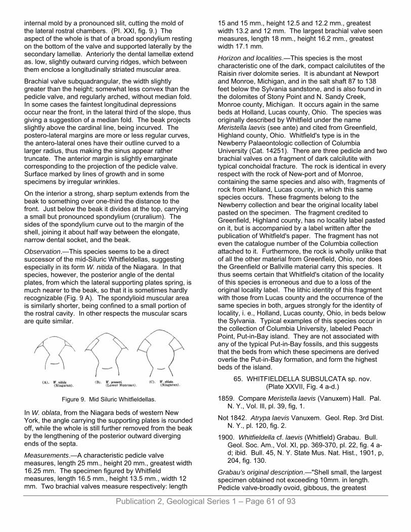
internal mold by a pronounced slit, cutting the mold of the lateral rostral chambers. (PI. XXI, fig. 9.) The aspect of the whole is that of a broad spondylium resting on the bottom of the valve and supported laterally by the secondary lamellæ. Anteriorly the dental lamellæ extend as. low, slightly outward curving ridges, which between them enclose a longitudinally striated muscular area.
Brachial valve subquadrangular, the width slightly greater than the height; somewhat less convex than the pedicle valve, and regularly arched, without median fold. In some cases the faintest longitudinal depressions occur near the front, in the lateral third of the slope, thus giving a suggestion of a median fold. The beak projects slightly above the cardinal line, being incurved. The postero-lateral margins are more or less regular curves, the antero-lateral ones have their outline curved to a larger radius, thus making the sinus appear rather truncate. The anterior margin is slightly emarginate corresponding to the projection of the pedicle valve. Surface marked by lines of growth and in some specimens by irregular wrinkles.
On the interior a strong, sharp septum extends from the beak to something over one-third the distance to the front. Just below the beak it divides at the top, carrying a small but pronounced spondylium (cruralium). The sides of the spondylium curve out to the margin of the shell, joining it about half way between the elongate, narrow dental socket, and the beak.
Observation.—This species seems to be a direct successor of the mid-Siluric Whitfieldellas, suggesting especially in its form W. nitida of the Niagara. In that species, however, the posterior angle of the dental plates, from which the lateral supporting plates spring, is much nearer to the beak, so that it is sometimes hardly recognizable (Fig. 9 A). The spondylioid muscular area is similarly shorter, being confined to a small portion of the rostral cavity. In other respects the muscular scars are quite similar.
Figure 9. Mid Siluric Whitfieldellas.
In W. oblata, from the Niagara beds of western New York, the angle carrying the supporting plates is rounded off, while the whole is still further removed from the beak by the lengthening of the posterior outward diverging ends of the septa.
Measurements.—A characteristic pedicle valve measures, length 25 mm., height 20 mm., greatest width 16.25 mm. The specimen figured by Whitfield measures, length 16.5 mm., height 13.5 mm., width 12 mm. Two brachial valves measure respectively: length
15 and 15 mm., height 12.5 and 12.2 mm., greatest width 13.2 and 12 mm. The largest brachial valve seen measures, length 18 mm., height 16.2 mm., greatest width 17.1 mm.
Horizon and localities.—This species is the most characteristic one of the dark, compact calcilutites of the Raisin river dolomite series. It is abundant at Newport and Monroe, Michigan, and in the salt shaft 87 to 138 feet below the Sylvania sandstone, and is also found in the dolomites of Stony Point and N. Sandy Creek, Monroe county, Michigan. It occurs again in the same beds at Holland, Lucas county, Ohio. The species was originally described by Whitfield under the name Meristella laevis (see ante) and cited from Greenfield, Highland county, Ohio. Whitfield's type is in the Newberry Palaeontologic collection of Columbia University (Cat. 14251). There are three pedicle and two brachial valves on a fragment of dark calcilutite with typical conchoidal fracture. The rock is identical in every respect with the rock of New-port and of Monroe, containing the same species and also with, fragments of rock from Holland, Lucas county, in which this same species occurs. These fragments belong to the Newberry collection and bear the original locality label pasted on the specimen. The fragment credited to Greenfield, Highland county, has no locality label pasted on it, but is accompanied by a label written after the publication of Whitfield's paper. The fragment has not even the catalogue number of the Columbia collection attached to it. Furthermore, the rock is wholly unlike that of all the other material from Greenfield, Ohio, nor does the Greenfield or Ballville material carry this species. It thus seems certain that Whitfield's citation of the locality of this species is erroneous and due to a loss of the original locality label. The lithic identity of this fragment with those from Lucas county and the occurrence of the same species in both, argues strongly for the identity of locality, i. e., Holland, Lucas county, Ohio, in beds below the Sylvania. Typical examples of this species occur in the collection of Columbia University, labeled Peach Point, Put-in-Bay island. They are not associated with any of the typical Put-in-Bay fossils, and this suggests that the beds from which these specimens are derived overlie the Put-in-Bay formation, and form the highest beds of the island.
65. WHITFIELDELLA SUBSULCATA sp. nov. (Plate XXVII, Fig. 4 a-d.)
1859. Compare Meristella laevis (Vanuxem) Hall. Pal. N. Y., Vol. Ill, pl. 39, fig, 1.
Not 1842. Atrypa laevis Vanuxem. Geol. Rep. 3rd Dist. N. Y., pl. 120, fig. 2.
1900. Whitfieldella cf. laevis (Whitfield) Grabau. Bull. Geol. Soc. Am., Vol. XI, pp. 369-370, pl. 22, fig. 4 a-d; ibid. Bull. 45, N. Y. State Mus. Nat. Hist., 1901, p, 204, fig. 130.
Grabau’s original description.—"Shell small, the largest specimen obtained not exceeding 10mm. in length. Pedicle valve-broadly ovoid, gibbous, the greatest
Publication 2, Geological Series 1 – Page 61 of 93

Publication 2, Geological Series 1 – Page 62 of 93
gibbosity in the umbonal third. Longitudinal contour, a symmetrical curve, descending more abruptly in the umbonal region. Transverse contour a symmetrical arch flattened at the top, and with steep sides, which approach vertically in the umbonal region. A faint depressed line runs down the center near the beak to the anterior margin. Surface marked by fine concentric growth lines and by coarser wrinkles appearing at intervals.
“Rostral cavity of moderate depth; teeth strong and rounded, supported by two thin but prominent dental lamellæ which diverge but slightly and arise from the bottom of the valve. Beak apparently truncated by a circular foramen of moderate size. A strong, rather broad, and not distinctly defined median elevation divides the muscular area, which appears to be longitudinally striate. The ridge broadens foreward and at the same time becomes more and more obsolete. The rostral portion of the pedicle valve of this species is strongly compressed laterally, the sides converging uniformly. This gives the shell an elongate appearance, while the actual length is but slightly greater than the width. There is some variation in this, in some cases the length being scarcely more than the width.
“Brachial valves somewhat less convex than the pedicle, with the beak incurved beneath that of the pedicle valve. The ovoid form, very slightly diverging dental lamallæ, and the median range dividing the muscular impression, distinguish this species from the preceding one.”
To the above need only to be added that the mesial sinus of the pedicle valve sometimes becomes quite pronounced near the anterior end, where it is the cause of a sinuosity in the frontal margin; that a low, faint fold corresponds to it on the anterior part of the brachial valve; that the upper third of the brachial valve has the greatest convexity, this convexity exceeding that of the pedicle valve, and that the median septum of the brachial valve is pronounced and broadens towards the beak.
Measurements of a characteristic specimen show; length of pedicle valve 12.5 mm., height 11 mm., length of brachial valve 11.5 mm., height 10 mm., greatest width 10.2 mm.
Horizon and localities.—In the Akron dolomite (Bullhead) of Buffalo, Akron and Williamsville in western New York, and apparently also in the Greenfield dolomite of Greenfield and Ballville, Ohio.
66. WHITFIELDELLA SULCATA, (Vanuxem). (Plate XXXII, Figs. 2 a-d.)
1842. Atrypa sulcata Vanuxem, Geol. Report of 3rd Dist. N. Y., p. 112, fig. 5.
1843. Atrypa sulcata Hall, Geol. Report of 4th Dist. N. Y., p. 142, fig. 5.
1859. Merista bisulcata Hall. Pal. Of N. Y., Vol. III, p. 253.
1900. Whitfieldella sulcata (Vanuxem) Grabau, Bull. Geol. Soc. Am., Vol. II, pp. 367-368, pl. 22, fig. 2 a-d.
Grabau’s original description.—“This characteristic Manliuslimestone species is quite common in the Bullhead (or Akron dolomite) limestone of North Buffalo and Akron. The individuals are of the size of the specimens figured by Vanuxem and Hall and agree closely with them in form and proportions. The shell is ventricose, elongately ovoid to subpentagonal in outline, most bulging in the posterior third. The beak of the brachial valve is considerably more elevated. The mesial sinus of the pedicle valve is well developed, narrow and prominent near the front; that of the brachial valve is less prominent, being more of the nature of a flattening near the anterior margin. The concentric lines of growth are very fine and occasionally interrupted by strong wrinkles. Near the front of the pedicle valve, in mature or senile individuals, an abrupt change of growth occurs, the relative size of the valve becoming progressively reduced with further growth. On this portion of the shell the lines of growth are more prominent.
“This shell is readily recognized by its elongate character, strong ventricosity, and well marked, sharp mesial sinus in the pedicle valve. It is not uncommon in the more compact portions of the rock, but in the porous portions it appears usually as hollow molds.
“The measurements of an average pedicle valve are: length 9.5 mm., width 7.5 mm., convexity 3.5 mm.”
Horizon and locality.—In the Bullhead or Akron dolomite of North Buffalo and Akron in western New York. Common. Originally described from the Manlius of eastern New York.
67. WHITFIELDELLA sp. (Plate XXI, Fig. 10.)
Shell large for the genus, broadly ovate with rather contracted and pointed, somewhat incurved beak in the pedicl valve. Dental lamellæ approach closely on the bottom of the valve, rostral cavity deep and narrow. Muscular scars slightly raised, narrow and elongate, terminating rather abruptly above the middle of the shell; longitudinally grooved.
Surface characterized by concentric lines, stronger ones occuring at intervals. Only one fragmentary specimen is known. The muscular area is different from that of any species of the genus known, but the general character is that of Whitfieldella. It comes perhaps nearest to W. nitida but is distinct in its broad outline and large size. The muscular impressions are quite distinct from those of W. oblata to which the form corresponds.
Horizon and locality.—In the brown Amherstburg dolomite, associated with Stropheodonta demissa mut. homolostriata, and other species. One fragmentary specimen.

Publication 2, Geological Series 1 – Page 63 of 93
The form and muscular impression suggest, to some extent, Meristella haskinsi of the Hamilton from which it is, nevertheless, distinct.
Genus MERISTOSPIRA. gen. nov.
Shell small, meristoid, subcircular or transversely elongate, with elevated, slightly incurved pedicle beak and a median sinus in one or both valves. Surface smooth except for growth lines. On the interior the pedicle valve is characterized by strong dental lamellæ restricted to the rostral region; a median septum is absent or faintly developed. I n the brachial valve the hinge plate is strong and free from the bottom of the valve, being supported by the strong socket plates. It curves upwards and into the cavity of the pedicle valve as in Nucleospira, but not so strongly or abruptly. Just beneath the beak of the brachial valve the hinge plate is pierced by a visceral foramen as in Athyris. A median septum is present, but is independent of the hinge plate.
The essential difference between this genus and Meristella lies in the freedom of the hinge plate from the median septum, the agreement in this respect being with Nucleospira, and in the presence of the visceral foramen instead of the median division of the hinge plate, the agreement in this respect being with Athyris. The pedicle valve differs from these genera, however, in having strong dental lamellæ. The beak of the pedicle valve is also more strongly elevated in this genus than in Nucleospira, agreeing in that respect with Meristella. Except for the visceral foramen the genus might be briefly characterized as combining a Neucleospiroid brachial with a Meristelloid pedicle valve. Character of the brachidium unknown.
Genotype MERISTOSPIRA MICHIGANENSE sp. nov.
68. MERISTOSPIRA MICHIGANENSE sp. nov. (Plate XXV, Figs. 5-6, 7-11; Plate XVI, Figs. 4-6.)
Shell small, subcircular or transversely extended. Pedicle valve evenly curved, the greatest convexity being behind the middle. Beak slightly curved but projecting above the beak of the brachial valve and apparently truncated by a small circular foramen. Umbonal slopes, rounded and making an obtuse angle with each other; sides more strongly rounded; anterior end slightly pronounced in the center, otherwise regularly rounded. A more or less pronounced median sinus extends from beak to front, becoming broad and round-bottomed in some cases, or remaining narrow and becoming deeper in others.
Brachial valve wider than high, somewhat less convex than the pedicle valve, the greatest convexity being above the middle. A low, indistinct median fold comes into existence near the front of the shell corresponding to the sinus of the pedicle valve. Several very shallow sinuses, or low depressions, run forward from the beak, the median one sometimes being strong enough to destroy the median fold.
Surface smooth except for lines of growth. On the interior the cardinal teeth of the pedicle valve are pronounced and parallel or slightly curving towards each other, extending less than one-fifth the distance to the front. A strong rostral cavity is enclosed between them, and this is continued forward from the dental lamellæ in the striated area or in several diverging grooves. Generally a faint median septum divides the muscular area, extending from the beak half way to the front. The brachial valve has a strong hinge plate which rises abruptly from the valve, supported only by the strong socket plates. The median septum is low and does not support the hinge plate. The muscular area is delimited by faint diverging striæ or ridges. Strong vascular sinuses are seen in many specimens, being radially arranged in both valves.
This species differs from Whitfieldella in its form, being proportionally wider than any species of that genus. It further differs in the character of its hinge plate. In this latter respect the species also shows marked differences from Meristella. In typical species of this latter genus the hinge plate is supported by and continuous with a strong septum, whereas in M. michiganense the septum is free from the hinge plate, corresponding in this respect to Nucleospira, with which genus the brachial valve agrees rather closely, the only important difference being the presence of the visceral foramen in the hinge plate of our species. The pedicle valve of Neucleospira has moreover no dental lamellæ, but has instead a median septum which is slightly developed in our species. This species, therefore, combines the internal characters in part of a brachial valve of Nucleospira and in part of Athyris, with the internal characters of a pedicle valve of Meristella or Whitfieldella. The form of the shell, moreover, is that of a transverse Meristella or a Nucleospira but the beak of the pedicle valve is too elevated for that genus.
Measurements.—A characteristic specimen measures: length pedicle valve, 13 mm.; height of pedicle valve, 10 mm.; height of brachial valve, 9.2 mm.; greatest width, 12 mm. Another measures: length of pedicle valve, 14 mm.; height of pedicle valve, 11 mm.; height of brachial valve, 10 mm.; greatest width, 12 mm.; thickness, 7.5 mm.
Horizon and localities.—Abundant in the Amherstburg dolomite of the Woolmith quarry, Monroe county, Mich., also doubtfully in the Lower Lucas.
All the specimens obtained so far are internal molds. In these the visceral foramen of the hinge plate is shown by the presence of a connection between the beak of the brachial valve and the rostral filling of the pedicle valve.
Genus MERISTINA. Hall.
69. MERISTINA PROFUNDA sp. nov. Plate XXI, Figs. 20-22.)
General form and size as in M. maria of the Niagaran with a strong, broad, anterior depression in the pedicle
Publication 2, Geological Series 1 – Page 64 of 93
valve. Teeth and dental plates well developed, the latter curving outwards and surrounding the profoundly impressed muscular area. They are continued forward to near the front of the shell, converging again as the mesial depression becomes pronounced. The adductor scars of the pedicle valve form the central narrow depression in the muscular area, while the adductor scars on either side leave a longitudinally striate surface. The pedicle muscle is attached to an abruptly raised surface, which is grooved centrally and has the grooved portion extending forward on the adductor area. In the internal mold of the pedicle valves, the rock filling of the muscular area stands out prominently and broadly as in some of the Spirifers of the Oriskany. This is. a feature markedly different from that seen in Meristina maria, though in structure the two muscle areas correspond. It amounts to a more profound development of both adductor and diductor, and the extension of the area of attachment both forward and backward, the latter resulting in a displacement of the pedicle scar farther into the rostral cavity.
Barrande figures a partially broken shell of Meristina tumida (Dalm.) from etage E2 Colines entre Lodenitz et Bulonitz (Syst. Sil., Vol. V, pl. 112, XVI) in which the muscular impression closely approaches that of our species. The ordinary expression of this common European species is, however, more nearly like that of our American M. maria with a less profound muscular impression than in the species here described. (See Barrande, Vol. V, pl. 11, and Davidson, Sil. Brach., pl. XI.) Brachial valve unknown.
Horizon and localities.—Raisin river beds. Represented by molds in a rock composed of well rounded quartz grains in a matrix of dolomite, the quartz predominating. The rock lies just below the Sylvania sandstone. Collected by the Michigan Survey from the bed of the Raisin river in Claim 467, T. 6 S., R. 8 E., (No. 18103). Original in Mich. Survey coll. Molds in coll. Columbia University. A fragmentary mold apparently of the same species occurs in the brown Amherstburg dolomite from the Detroit river.
70. MUTATION SINOSUS mut. nov. (Plate XXI, Figs. 14-16.)
This differs from the preceding in having a pronounced angular sinus which extends nearly to the beak. This greatly alters the aspect of the muscular area arid of its impression in the internal mold. The adductor scar thus comes to rest on the strongly elevated central area, while the diductors rest on the striated lateral slopes of this central elevation. The dental plates become more nearly parallel towards the front, and finally converge rather abruptly at the anterior end of the muscular area. This area, as a whole, lacks the width and profoundity of that of the species proper. The pedicle area is less strongly defined, and longer in proportion, in this respect approaching more closely in character the muscular area of the pedicle valve of the Niagaran species. (M. maria.)
This strong median depression is a character which appears occasionally in the other species of this genus, though primarily it is not a characteristic feature of the genus, the sinus mostly appearing at the front and then, though deep, being also broad and rounded. It is desirable that this departure from the main form be signalized as a distinct mutation in each case, even though intermediate forms are common. A method of expressing this feature would be to use Meristma profunda sinosus for the extreme of the mutation and to express the intermediate types by M. profunda if they are nearer to the true species form, and M. sinosus if they approach the sinosus type more closely.
Horizon and locality.—This mutation has been found in a siliceous dolomite with rounded quartz grains obtained from the barn well at the county house in Claim 432, T. 6 S., R. 8 E., by Prof. Sherzer (Michigan Survey No. 18114). Casts in coll. Columbia University. The horizon is nearly the same as for the preceding, lying just below the Sylvania, i. e., upper Raisin river bed.
Genus ATRYPA. Dalman.
71. ATRYPA RETICULARIS Linn. (Plate XX, Fig. 1.)
An impression of a small pedicle (?) valve apparently represents this species. The shell is somewhat distorted and has a faint median sulcus. The striæ are rounded and distinct, repeatedly bifurcate or increase in number by intercalation of new ones. Concentric lines of growth are visible at intervals but no regularly spaced reticulating concentric lines are preserved. The identification with the above species is questionable.
Horizon and locality.—In the brown Amherstburg dolomite in the bed of the Detroit river. One specimen. Rev. Thomas Nattress coll. 2Now regarded as Devonic.
PELECYPODA.
Genus PANENKA Barrande.
72. PANENKA CANADENSIS Whiteaves. (Plate XXII, Figs. 1-2.)
1902. Panenka canadensis, Whiteaves, Ottawa Naturalist, Vol. XV, No. 12,"p. 265, pl. XV, figs. 1 and 2.
Original description.—"Shell, or rather cast of the interior of the shell, of about the average size, valves regularly and rather strongly convex, varying in outline in different specimens from subcircular to longitudinally subovate, but always at least a little longer than high. Posterior side rather broader and much longer than the anterior, umbones broad, tumid prominent, very oblique and placed considerably in advance of the mid-length, beaks curved inward and forward, hinge line straight, horizontal, considerably prolonged behind in some specimens but apparently not so much so in others.

Publication 2, Geological Series 1 – Page 65 of 93
"Test unknown, surface of the cast (internal mold) marked by numerous (about sixty) narrow but prominent ribs, with concave grooves between them. In the original of figure 1 on plate XV, the ribs are slightly unequal in size. Most of them are simple but they bifurcate, and here and there a few shorter ribs are intercalated between the longer ones, that radiate from the umbones. In the original of figure 2 on the same plate, the ribs are more regularly disposed, and they are all a little larger posteriorly than anteriorly.
"Muscular impressions and hinge dentition unknown.
"Dimensions of a comparatively high and short specimen (fig. 1); maximum length, 74 mm.; greatest height (inclusive of umbo), 67 mm.; do. of a more elongate specimen (fig. 2) that is narrower in the direction of its height, length, 77 mm.; greatest height, which happens to be behind the umbo, 60 mm.
"Corniferous formation, Anderdon township, Essex county, Ontario; a few specimens collected by Mr. Harry Hodgman, U. S. Inspector, in October and December, 1901. According to Mr. Nattress they are from a brown dolomite which underlies the true Corniferous limestone in that neighborhood”
The bed from which these fossils were obtained is the Amherstburg bed of late Siluric (Upper Monroe) age. It is not surprising that Whiteaves should refer this species to the Corniferous (Onondaga or Dundee) since it is a type otherwise known only from the Middle and Upper Devonic of this country. The brown dolomite (Amherstburg bed) lies just below the Dundee (true Corniferous) of the Amherstburg region, though a little further inland, even that bed is removed by pre-Dundee erosion, and the "Corniferous" rests directly upon the Anderdon limestone which underlies the Amherstburg bed.
Little can be added to the very full description given by Whiteaves. That author compares the original of his figure 1 with P. multiradiata Hall from the Onondaga of western New York, but he, states that P. canadensis "has broader and more oblique umbones, and a much longer hinge line posteriorly." Figure 2 of Whiteaves "comes nearer to P. robusta and P. dichotoma Hall, but * * * is more regularly and longitudinally subovate than either. In P. robusta, also, the ribs are much fewer and coarser, and in P. dichotomy the anterior end is represented as produced and subangular above." In P. dichotoma from the Schoharie, the ribs are close together, there is more frequent intercalation, and the posterior expansion is much less prominently marked than is the case in P. canadensis. The young of P. dichotoma shows characters more nearly like those of adult P. canadensis.
Horizon and locality.—In the Amherstburg dolomite of the Detroit river bed opposite Amherstburg, Ont. Also rarely in the Lower Lucas of the Gibraltar quarry.
Genus PTERINEA Goldfuss.
73. PTERINEA LANII* sp. nov. (Plate XX, Fig. 13; Plate XXXV, Fig. 22.)
1882. Pterinea aviculoidea Whitfield, Geol. Rep. Wis., Vol. IV, p. 322, pl. 25, figs. 6-7.
1891. Pterinea aviculoidea Whitfield, Ann N. Y. Acad. Sci., Vol. V, p. 514, pl. V, fig. 23; and Geol. Ohio, Vol. VII, 1893, p. 415, pl. I, fig. 23.
Whitfield's original description.—"Shell of proportionally small size, obliquely rhomboidal in outline, with a moderately long, straight hinge line, but little shorter than the length of the body of the shell below. Left valve depressed convex, with a small, slightly incurved beak, scarcely extending above the cardinal line. Anterior end short, and the anterior projection scarcely defined; posterior wing concave and the posterior margin nearly at right angles to the hinge line for a short distance below, then gently curving backward to the rounded postero-basal extremity; basal line rounded and on the anterior side of the umbonal ridge curving rapidly upward to the anterior extremity. Body of the valve convex and oblique to the hinge, the umbonal ridge broadly rounded. Surface of the shell marked only by lines of growth, some of which are stronger and form slight varices."
More perfect material since obtained from Michigan permits a more detailed and more accurate description. The hinge line is actually longer than the shell below. In Megambonia aviculoidea Hall, with which this species has heretofore been identified, the hinge line is shorter, except in the young. The terminal point of the wing is acute in our species, projecting to the same extent as, or slightly beyond, the shell below, whereas in M. aviculoidea it falls considerably short of this point. The posterior margin is gently concave. The umbonal angle is approximately 45°, while in a typical specimen of M. aviculoidea from the Manlius it is 60°. The anterior ear is quite well marked in our specimens. It is oblique though the separation from the shell is not pronounced. The umbo is moderately elevated, and the beak is curved and pointing forward. The shell is strongly convex at the umbo, but flattens out on the wing. Concentric lines alternate with subequally spaced stronger symmetrical ridges, which give a'definite surface pattern to the shell.
Right valve similar to left but without the strong stride, the surface appearing smooth. Length of a medium sized left valve (Pl. XX, fig. 13) 18 mm., height 13.8 mm. A larger specimen measures, length 23 mm., height 17.5 mm.
The corresponding measurements of a typical specimen of M. aviculoidea from the Manlius are, length 22.7 mm. and 20 mm., height 24.5 mm. and 18 mm.
Horizon and localities.—In the Raisin river dolomites (calcilutites) of the Newport and Monroe quarries and elsewhere in this formation in southeastern Michigan. It is a common form. The species was originally described by Whitfield from the Monroe beds of Wisconsin under the name Pterinea aviculoidea and identified with Hall's
Publication 2, Geological Series 1 – Page 66 of 93
Manlius limestone species. It was again described by Whitfield from Put-in-Bay island, Ohio. The original of Whitfield's type from Ohio is in the Newberry collection at Columbia University, and the matrix agrees with the Raisin river beds of Lucas county and Monroe county, rather than with the typical rocks of Put-in-Bay. Moreover it is the only specimen of this species, and is unaccompanied by detailed locality label. With it are associated other Raisin river types found at Newport but not in the Put-in-Bay beds. The inference is that, as in the case of the Whitfieldella prosseri, this specimen has had assigned to it the wrong locality. It is possible, however, that the specimen came from the highest beds on Put-in-Bay island, which are apparently the extension of the Raisin river beds. A single imperfect specimen, apparently of this species, is associated with Pterinea bradti in the Lucas dolomite of the salt shaft. The species is quite common in the tipper Siluric calcilutites (Lewiston limestone) of southern Pennsylvania. *Named in honor of Dr. A. C. Lane, State Geologist of Michigan.
74. PTERINEA BRADTI sp.nov. (Plate XVI, Figs. 9, 10.)
Left valve strongly convex, elongate, and oblique. Umbo elevated and subanterior, projecting for a short distance beyond the hinge line, and moderately incurved. A faint depression begins in the beak, and runs to the ventral margin with which it makes a small angle. Anterior portion rounded, rather abruptly to the hinge line, continuing downward and backward in a gentle curve to the posterior margin, which is more abruptly rounded. Posterior wing well defined, with a pronounced concave margin and rather acute terminal angle, which projects slightly beyond the margin of the shell below.
Greatest convexity of the valve in anterior third, sloping regularly towards the ventral and posterior margins, in the neanic portion of the shell; more abruptly deflected in the last or adult portion of its growth, so that in some cases the angle of change approaches 135°. This change in direction of growth is evidence of old age conditions in the group (phylogerontism).
Surface marked by strong, subregular concentric undulations in the younger portion, and by very irregular lines of growth in the adult portion. In the external mold, crowded, strongly impressed lines of growth are shown. Cartilage groove long and narrow.
In some specimens, the sulcus extending from beak to base is quite well marked, becoming broader towards the center. In others, it is scarcely recognizable. There is also a difference in the definition of the posterior wing, which in some young specimens is quite sharply defined.
Eight valve as convex as the left valve with the beak sharp, and elevated but scarcely incurved. The sulcus is broader .and deeper than in the brachial valve and its posterior margin is a sharp angulation extending from the beak to the medio-ventral margin. Posterior wing less pronounced than in the left valve.
This species is represented by a number of individuals (mostly left valves) in the gastropod layers (Lucas dolomite). It differs from Pterinea lanii Grabau (Pterinea aviculoidea Whitfield, non Hall) described above in its more elongate character, lesser height and smaller angle of torsion, which is about 35°, while that of P.lanii is nearly 50°.
Clarke has figured under the name Pterinea subplana Hall a shell which in all essentials appears to be identical with the present species (Guelph Fauna, pl. V, fig. 4). This species, however, is distinct from the Avicula subplana, Hall, of the Rochester shale (Pal. N. Y., II, p. 283, pl. 59, fig. 3 a-o) which is a much larger and flatter shell, with less strongly individualized wing, and with the beak not projecting above the cardinal line, as is the case in the Guelph and Monroe species, where also the umbonal portion is more strongly elevated. As to the identity of the Guelph and the Monroe types, there can scarcely be a doubt.
Measurements of characteristic specimens:
Left valves from the
Monroe beds.
Guelph specimens,
figure by Clarke.
1 2
Greatest length of shell on hinge line 16 mm. 17 mm. 18.5 mm.
Length of oblique axis (beak to posterior margin) 15 mm. 15 mm. 17.7 mm.
Beak to base at right angles to hinge line 7 mm. 7.7 mm. 9 mm.
Greatest height of shell at right angles to hinge 9 mm. 9 mm. 11.5 mm.
Angle of obliquity 35°.
Named in honor of Mr. E. F. Bradt, Superintendent of the Detroit salt shaft, through whose courtesy we were enabled to obtain the material from that salt shaft.
Horizon and locality.—In the Lucas dolomite of the salt shaft, not uncommon.
Genus GONIOPHORA Phillips.
75. GONIOPHORA DUBIA (Hall) Whitfield. (Plate XX, Figs 24-26.)
1859. Cf. Modiolopsis ? dubius Hall, Pal. N. Y., Vol. III, p. 264, pl. 49, fig. 2.
1891. Goniophora dubia Whitfield, Ann. N. Y. Acad. Sci., Vol. V, p. 514, pl. 5, figs 24-26, and Geol. Ohio, Vol. VII 1893, p. 415, pl. I, figs. 24-26.
Whitfield’s original description.—“Shell small, transversely elongate, nearly twice and a half as long as high. Valves ventricose, most highly convex on the

Publication 2, Geological Series 1 – Page 67 of 93
anterior half, becoming slightly more depressed toward the posterior; beaks small, very slightly incurved but not elevated above the cardinal border and rather inconspicuous, situated about half or rather less than half the height of the shell from the anterior extremity, proportionally more distant on the larger specimens than on those of small size. Hinge line long and straight, extending four-fifths of the length of the shell behind the beaks and characterized by a narrow but distant escutcheon. Anterior end short and full, very obtusely pointed at the longest part, which is at about the middle of the height, above which point there is a very distinct but narrow lunule extending to the extremity of the hinge line. Basal margin of the valve very broadly curved, slightly emarginated just anterior to the middle and the whole subparallel to the cardinal line. Posterior extremity sharply rounded below and the upper margin very obliquely truncated; body of the valve marked by a broad distinct mesial sulcus extending from behind the beak to the broad sinus of the basal margin. The umbonal ridge is rather sharply marked and angular in the upper portion, but becomes less distinctly marked posteriorly; posterior-cardinal slope of moderate width, very slightly concave in the younger stages of growth but less strongly marked as the growth advances. Surface of the valves marked by strong sublamellose, concentric lines of growth parallel to the outer margin of the valves.
“The shell undergoes considerable change in form and in the strength of the surface characters between the younger and more advanced stages of growth; the sharpness of the features being much reduced on the older portions, by the rounding of the umbonal ridge and of the angularity of both the anterior and posterior extremities of the shell. The shell differs in several of its external features from the genus Modiolopsis, possessing a distinct lunule and escutcheon as well as the angular umbonal ridge, in all of which features it corresponds with Goniophora.”
Whether this species is identical with the form described by Hall as Modiolopsis ? dubia from the Manlius limestone of Herkimer county, cannot be definitely ascertained, since no good specimens of the Manlius form are at hand for comparison.
Horizon and localities.—This species is extremely abundant in the Put-in-Bay dolomites of Peach Point, Put-in-Bay island, Lake Erie. The shells cover the surfaces of the thin slabs in vast numbers, of various sizes. Also, in the same rock at Middletown, Ohio. A single specimenwas obtained from the Raisin river dolomites of the Monroe stone quarries associated with Whitfieldella prosseri. It is not uncommon in the Raisin river beds of the salt shaft, from 87 to 138 feet below the Sylvania sandstone, associated with Whitfieldella prosseri.
76. GONIOPHORA? sp.
Several specimens from the Lucas dolomite of the salt shaft seem to be related to the preceding species and are provisionally referred to the same genus. They are
small, transversely elongate shells, strongly ventricose and with the beak near the anterior end. The greatest convexity is near the anterior end. A shallow sulcus runs from the beak to the base, and slightly posterior-ward. Umbonal angle generally less defined than in the specimens of G. dubia from Put-in-Bay island.
The specimes from the Lucas dolomite differ considerably from G. dubia of the lower horizon. They are more convex, the beak more anterior, the sulcus less oblique, the umbonal angle less angular, and the whole shell less angulate.
A characteristic specimen measures 8 mm. in length by 5 mm. in height, while a characteristic specimen of G. dubia from Put-in-Bay island measures 18 mm. in length by 8 mm. in height.
A fragmentary specimen referred to this species has a sharper umbonal ridge and somewhat less anterior beak, beneath which, at the anterior end, a lunule appears.
The specimens are not perfect enough for a specific description.
Horizon and locality.—In the Lucas dolomite of the salt shaft. Rare.
Genus CYPRICARDINIA Hall.
77. CYPRICARDINIA CANADENSIS sp. nov. (Plate XVIII, Figs. 14-15.)
Shell equivalve, rather elongate, length about twice as great as height. Valves angularly convex, beak subanterior, low and not prominent. Anterior basal portion slightly produced. A pronounced subangular umbonal ridge curves backward and downward to the posterior basal margin. Below the ridge, the shell is flat or very slightly concave, especially in the posterior part. Above the ridge the shell is rounded to the cardinal margin which is depressed and marked by a pronounced escutcheon. Posterior extremity forming a rectangle with the basal margin, but becoming rounded towards the dorsum. Surface marked only by lines of growth. Anterior adductor muscle large, just below and in front of the beak, and strongly outlined by an elevated rim which appears as a circular depression in the internal mold.
Horizon and locality.—In the Amherstburg bed of the Upper Monroe, in the bed of the Detroit river, opposite Amherstburg, Ont.
Genus TELLINOMYA Hall.
78. TELLINOMYA sp.
A small, elongate shell, with the small beak slightly excentric, and with narrowly rounded ends with a flat or slightly concave surface and well marked concentric growth lines occurs in the Raisin river dolomites of the Newport quarry. It is too poorly preserved for specific identification.
Publication 2, Geological Series 1 – Page 68 of 93
Genus MODIOMORPHA Hall.
79. MODIOMORPHA sp.
Shell small, elongate, about twice as long as high. Anterior end nasute, beak small, situated about one-fourth the length of the shell from the anterior end. Dorsal and ventral .borders nearly parallel. Posterior end rounded .below, abruptly truncated above. Surface marked by lines of growth of moderate strength. Length 13.5 mm., height 7 mm.
Horizon and locality.—In the Raisin river dolomites of the Newport quarry.
Genus CONOGARDIUM Brown.
80. CONOCARDIUM MONROICUM sp. nov. (Plate XVI, Figs. 1-3; Plate XX, Figs. 14-15; Plate XXII,
Fig. 3.)
Shell of medium size. Valves rather strongly convex, with the posterior end abruptly truncated, the margins of the valve meeting almost in a plane in some specimens, though produced in others, in the ventral portion. Sides of valves somewhat flattened, curving more abruptly towards the dorsal and ventral margins. Umbonal slope making an agle of about 120° with the cardinal line.
Anterior end attenuate and produced slightly into a subcylindrical prolongation. Lateral surface of the shell ornamented by coste which are rounded or even slightly angular at the posterior end but become broader to flat-topped towards the anterior end, where they are separated by a space equal to the width of the costæ or wider. Fine, sharp, concentric striæ occur throughout both on the ribs and in the interspaces. In a slightly exfoliated specimen the ornamentation consists of broad, flat-topped coste marginated on each side by a faint, blunt ridge, which gives the top of the costæ a slightly sunken aspect. The costæ are separated by linear, rectangular depressions of about the width of the bordering ridge on the costæ.
When the surface is more strongly worn, the coste lose their flat upper portion, and only the double down-folded portion of the shell forming the intercostal depression, remains. This gives the shell the appearance of being composed of a series of narrow ribs, separated by a space several times their diameter, which shows the rock surface of the internal mold. In somewhat less worn specimens the narrow ridges are connected by transverse bars, while in still less worn specimens the ridges and interspaces seem to be covered with strong concentric striæ which zigzag across the radiating ridges.
On the interior of the shell, if unworn, the ribs or coste appear as faint depressions, flat-bottomed and marked by faint transverse striæ. The intercostal depressions appear as slightly elevated costæ, marginated by a faint ridge on each side, and wider than the depressions representing the coste. The ribs become wider toward the posterior margin, as is well shown on the internal
molds. At the umbonal angle a flattened space occurs, wider than the broadest rib, and showing dorsally curving lines of growth, indicating that the shell here was marked by a faint emargination. This flat rib is flanked on either side by a similar, though narrower, flat rib, separated from it only by a faint depression. Sometimes only one of these flanking ribs, generally the posterior one, seems to be developed. These broad ribs mark the point of departure of the free posterior shell hood characteristic of these shells, which, however, is rarely preserved. Towards the anterior end the ribs become narrower, more sharply defined, and separated by deeper interspaces. The extreme anterior end consists of a coarse, rounded fold, rapidly widening anterior-wards. In some specimens two or even three broad costæ occur just in front of the one at the umbonal angle; after which the costæ begin as narrow and shallow ridges, separated by narrower depressed lines, and gradually increase in width and strength forward, while at the same time the intercostal spaces become progressively wider and deeper.
The truncated posterior end is marked by narrow, sharp radiating ribs, curving in conformity with the curvature of the umbonal ridge, and separated by spaces from one to several times their width. Fine, sharp, transverse strise cross both interspaces and ribs. These striæ extend onto the posterior prolongation which forms the hood, but not entirely across this (See fig. 3, pl. XXII). At the point of departure of the posterior hood, the shell is thick and coarsely cellular, as seen in fractured specimens.
This species is closely related to C. cuneus var. nasutum Hall, of the Schoharie grit. In fact it is at first difficult to distinguish the two, but the character of the surface ornamentation is more pronounced in our species, as outlined. It agrees perhaps better with the ornamentation of the young of C. nasutum. The curved ribs on the truncated posterior end are narrower, more widely separated, and more sharply defined, than is the case in Devonic species generally. Nevertheless, the relationship is exceedingly close, and the species must be considered as a Devonic rather than a Siluric type.
Horizon and localities.—This species is fairly common in the Anderdon limestone (coral bed) of the salt shaft at Detroit, the specimens mostly preserving the shell. They are associated with Diplohyllum, Cladopora and Favosites. It is also common in the brown transition dolomite (Amherstburg bed) from the bed of the Detroit river, opposite Amherstburg, Ont, where it is associated in the same specimens with Acanthonema holopiformis; also in the same brown dolomite, in the bottom of the Gibraltar quarry, and in the higher Lucas beds of that quarry, and the Patrick quarry, where it is associated with the characteristic Gastropods of that bed. It is further common in the Amherstburg beds of the Woolmith quarry, and is in fact widely distributed at this horizon.

Publication 2, Geological Series 1 – Page 69 of 93
GASTROPODA.
Genus HORMOTOMA Salter.
81. HORMOTOMA SUBCARINATA sp. nov. (Plate XXIV, Figs. 1-5.)
Shell turreted, consisting of numerous regular whorls separated by deep sutures and with the apical angle about 25°. Ambital portion of the whorls marked by two prominent, revolving carinæ, between which is a depressed band. The shoulder above these carinæ is flat or slightly concave, or if a faint convexity obtains, the effect of the concavity is produced by a slight thickening on the whorl at the suture, thus producing a faint rounded subsutural band. Body of shell below the carinæ rounded, with frequently a faint suggestion of another angulation about midway between the carinæ and the suture, and a faint concavity just below the revolving band. The whorls embrace slightly so as to leave a larger space below the carinæ than above them. In some cases the relation of width between shoulder and exposed portion of the whorl is as 2 is to 3. The carinæ are from .5 to .8 mm. apart, according to the size of the whorl. The lines of growth curve obliquely backwards from the suture to the ambitus, near which they are more strongly deflected. They arch over the carinæ and pass across the depressed band in a rather oblique manner then curve abruptly forward again, thus indicating a pronounced emargination of the lip, with the center marked by the depressed band margined by the carinæ. The body whorl is prolonged downward and strongly deflected at the base. Aperture apparently sub-circular, elongate, oval. This species is somewhat similar to Hormotoma whiteavesi Clarke* of the Guelph of Canada and New York, with which it agrees in the relative position of the slit band, but differs in the more prominent carinæ bounding this band, and especially in the flatness or concavity of the shoulder as well as the indication of a third carina. The angulation of the whorl and flattening of the shoulder is less marked in the young whorls of our species, these being scarcely or not at all angulated. It thus appears that the angulation of the whorl by the slit band, the flattening of the shoulder, and further, the strength of the carinæ bounding the band, are progressively intensified in the ontogeny of the earlier species, and it therefore is to be expected that all the characters are still more strongly emphasized in a later species of related series. This is the case in H. subcarinata of the Upper Monroe which is not improbably a descendant of the Guelph species. In the Siluric of Gotland are several "Murchisoniæ" of this type and without doubt genetically related to our species. They are Hormotoma camim (Murchisonia cava Lindström) found in all three strata of Gotland; Hormotoma moniliformis (M. moniliformis Lindström) of the lower stratum and Hormotoma obtusangulata (M. obstus angulata Lindström) and Hormotoma subplicata (M. subplicata Lindström) both restricted to the upper stratum, besides others. From all of these, however, our species differs in the high position of the slit band, which
leaves a larger body than shoulder portion, and in the faint secondary angulation and depression characteristic of most individuals.
The largest specimen found has a length of 20 mm. and a diameter of the last whorl of 7+ mm. Fragments with a diameter of the last whorl of over 8 mm. have also been obtained. Nearly all the specimens so far obtained are external molds (a few internal molds have also been found but no shells).
Horizon and localities.—It is a common form in the Lucas dolomite of the Patrick quarry, on Grosse Isle, and the upper beds of the same age in the Gibraltar quarry. It occurs more sparingly in the same beds in the Woolmith quarry. It is represented by small specimens in the upper dolomites of the salt shaft. In these localities it is always associated with Acanthonema. It occurs in the same association in the brown Amherstburg dolomite from the bed of the Detroit river where internal molds, showing only faint carination, also occur. *Clarke and Ruedemann, Guelph Fauna, Mem. 5, N. Y. State Mus., p. 65, Plate 7-10.
82. HORMOTOMA TRICARINATA sp. nov. (Plate XXV, Figs. 3-4.)
Shell elongate, turreted, writh a spire of 6 or more volutions, separated by deep sutures. Slit band about a third of the width of the whorl from the upper suture, bounded by strong spiral ridges. Shoulder strongly concave, the concavity being emphasized by the strong upper carina of the slit band.
This species is derived from H. subcarinatum by the accentuation of the shoulder concavity and of the carinæ, and consequently the convexity of this part of the shell.
Horizon and locality.—In the Lucas dolomite, Gibraltar quarry. Rare.
Genus SOLENOSPIRA Ulrich.
83. SOLENOSPIRA MINUTA Hall. (Plate XVI, Fig. 8.)
1859. Murchisonia minuta Hall, Pal. N. Y., Ill, p. 298, pl. 54, fig. 17.
Shell minute with sharply angulated whorls, of which there are 9 in the space of 7 mm. Spire very slender, apical angle about 17 degrees. The shoulder and body of the whorl are flat or slightly concave, and the slit band margined by two elevated carinæ whichgive a pronounced angularity to the whorl, the angulations being separated by marked concavities. This shell appears to be identical with the small form described by Hall from the Manlius limestone of Onondaga county. It is not uncommon in the Lucas dolomite of the salt shaft, where it occurs in the form of external molds. It is readily distinguished from the preceding by its slender form and the angulated whorls.

Publication 2, Geological Series 1 – Page 70 of 93
The preceding description is made from specimens found in the Lucas dolomite of the salt shaft. A minute form apparently identical with the above occurs, in the Baisin river dolomites of southern Michigan in the form of external molds. They are sharply carinated at the center of the exposed part of the whorl, the carination being margined by two revolving spirals. Above and below, the surface of the whorls is concave or flat. In a specimen 2.3 mm. long six whorls are seen, the apical angle being 19°. One specimen, possibly referable to this species, was 10 mm. long and showed six whorls but the apex is wanting. It is not unlikely that if more perfect material were available the specimens from the Raisin river beds would prove distinct from those of the Lucas.
Horizon and locality.—The species was originally described from the Manlius limestone of eastern New York. The Michigan specimens identified with it occur in the Raisin river beds of Monroe county, and in the Lucas dolomite of the salt shaft.
84. SOLENOSPIRA? EXTENUATUM (Hall). (Plate XVI, Fig. 7.)
1859. Murchisonia extenuata Hall. Pal. K Y., Ill, p. 298, pl. 54, fig. 15.
This species is proportionally shorter than the preceding one, with the whorls more embracing, as a result of which the exposed portion of the body of the whorl has only about two-thirds the width of the shoulder, whereas in the preceding species the width of body and shoulder is about equal. The shoulder angle appears to be simple, though a sharp cast shows faint indication of a double carination as in the preceding species.
This specimen is also of larger size than the preceding. In the larger specimens a spiral is sometimes indicated just above the suture. A specimen showing the last five volutions measures 6.5 mm. in length, with a diameter of body whorl of 3.75 mm.
Horizon and locality.—Not uncommon in the Lucas dolomite, in association with the preceding, in the salt shaft. It was originally described from the Manlius.
Genus LOXONEMA Phillips.
85. LOXONEMA PARVA sp. nov. (Plate XVI, Fig. 6.)
Shell minute, from six to eight volutions shown. Volutions gently convex, compactly turreted with suture only slightly impressed. Angle of spire about 10°, very regular and with slopes uniform. Faint revolving striæ indicated on one of the whorls.
Horizon and locality.—This species is known only from an impression in the Lucas dolomite of the salt shaft. Its small size is its chief distinguishing feature.
86. LOXONEMA sp.
An impression of a part of a shell referable to Loxonema occurs in the Raisin dolomites of the Newport quarry.
The specimen is 10 mm. long and has very oblique whorls. Other somewhat more perfect specimens occur in a rock of apparently the same division from Buena Vista, Fayette county, Ohio. The whorls enclose one-third of the preceding whorl, this not reaching quite to the ambitus, and thus a slight suture remains. The whorls are subcircular in section, ten occurring in a specimen 8.5 mm. long and 3.5 mm. wide at the ambitus of the body whorl. A pical angle about 25°. (Columbia University No. 3538.).
87. LOXONEMA sp. 2. (Plate XXXII, Fig. 5.)
1900. Loxonema sp. Grabau Bull. Geol. Soc. Am., Vol. XI, p. 370.
"An internal mold showing nothing but the general outline of the volutions and the form of the spire, was obtained from the Manlius (Bullhead or Akron) of Buffalo. Only four volutions remain, separated by rather deep sutures. Whorls uniformly rounded. Angle of divergence (apical angle) between 11° and 12°. From the imperfect state of preservation, even the generic determination must be doubtful."
Horizon and locality.—In the Akron (Bullhead) dolomite of Buffalo. One specimen.
Genus HOLOPEA Hall.
88. HOLOPEA SUBCONICA Hall.
1859. Holopea subconica Hall. Pal. N. Y., Ill, p. 294, pl. 54, figs. 1 a-b.
This species appears to be represented by a number of small subconical shells, consisting of three or four whorls, close coiled and with the sides of the whorls (shoulders) nearly flat, giving the whole shell a turboroid aspect. Sutures slightly impressed; whorls rapidly enlarging, the body whorl nearly equal in height to the rest of the spire. Faint lines of growth are visible in some cases, but no revolving spirals have undoubtedly been observed.
Length of a characteristic specimen 4 mm.; diameter of body whorl 2.75 mm.; apical angle about 45°.
Horizon and locality.—This appears to be a common species, generally occurring in the form of external molds in the Lucas dolomite of the salt shaft. It is only about one-half as large as the specimens from the Manlius limestone of New York and it may be that our species should be regarded as distinct from that of the Manlius beds of New York. That some of the molds of this character represent Acanthonema holopiformis, in which the impression of the nodose spirals has not been preserved, is undoubted. (See plate X, fig. 4.)
89. HOLOPEA ANTIQUA var. PERVETUSTA (Conrad). (Plate XXVIII, Figs. 4-5.)
1859. Holopea antiqua var. pervetusta (Conrad) Hall, Pal. N. Y., Ill, p. 295, pl. 54, figs. 4 and 5.
Publication 2, Geological Series 1 – Page 71 of 93
Two molds of this species occur among the Anderdon material. The spire is higher than that of typical H. antiqua, and the last volution is less strongly rounded. The last whorl is very slightly separated at the suture from the preceding one, leaving a very narrow and shallow groove. In general the sutures are deeply impressed and the whorls regularly rounded. The surface is marked by regular, rather strong lines of growth, which curve gently backward from the suture.
The best preserved mold shows six whorls and has an apical angle of about 52°. The length is probably 15 mm. (the basal portion not being preserved); the basal diameter is 13 mm.
Horizon and locality.—This species has been cited from the Manlius limestone of New York. It is closely related to H. antiqua, which is abundant in certain layers of the Manlius limestone of eastern New York, and with which it may prove to be identical. It is sparingly represented in the Amherstburg bed of the Detroit river. A number of small internal molds from this horizon are perhaps directly referable to H. antiqua.
90. HOLOPEA sp. (1).
Shell turreted; whorls with subdued angulation above the middle, the shoulder above being nearly flat, the whorl below rounded. Whorls loose coiling, the embracing being such as to leave the exposed part below the angulation, about two-thirds the width of the shoulder. Body whorl rounded below to the umbilicus, which appears to be open. Surface smooth. Though angulated, there is apparently no notch or slit band. The original number of whorls was probably four or five. Original length of specimen described perhaps 3 mm.; diameter of body whorl 2.5 mm.; apical angle about 35°.
Horizon and locality.—In the Raisin river dolomites of the Newport quarry and probably elsewhere in southern Michigan.
91. HOLOPEA sp. (2).
Shell minute, spire low, apical angle about 52°, whorls rounded, very rapidly increasing in size, the later embracing the preceding about one-half or less. Body whorl very ventricose, uniformly rounded; peristome apparently slightly produced below. Surface smooth. Height 3.2 mm.; diameter of body whorl 2.2 mm.; greatest thickness of body whorl 1.2 mm.
This species is of the form of H. antiqua, but is much smaller and the body whorl is proportionally more ventricose.
Horizon and locality.—In the Raisin river dolomites of the Newport quarry and probably elsewhere in southern Michigan.
92. HOLOPEA sp. (3).
A small species with rather high spire and somewhat compressed whorls, occurs in the Raisin river dolomites of the Newport quarry in the form of internal molds. It is provisionally referred to this genus.
Genus PLEUROTRQCHUS gen. nov.
Shell turreted, generally of from five to ten whorls, which are ornamented by revolving spinose ridges. The early whorls are generally characterized by lamellose rib-like vertical varices which extend from suture to suture and are regularly spaced. These are cancellated by revolving spirals, one of which generally nearer the lower suture, is stronger than the others. On the later whorls the lamellose varices become more or less discontinuous, remaining prominent on the spirals, where they assume the form of elevated emarginations or blunt spines. These are generally more pronounced on the larger spirals, where they become less frequent than on the smaller ones, owing to the merging of several of the emarginations by continuation of the spine until it covers the interspace between two or more spines on the higher spirals. There is thus a gradual enlargement of the spine for several varical periods until, when it has reached full size, it comes to a sudden end, and a new one begins. The spine is thus of the type of that of modern Fulgur carica, or of that of the simpler Murices. It is distinct in this respect from the slit band of the Pleurotomarioid types, which represents a continuous and uniform, instead of a periodically augmented, emargination. Although probably derived from species with a continuous slit band, these forms have started on a distinct line of development.
Aperture subcircular, with columellar lip reflexed, nearly or quite covering the umbilicus.
Genotype PLEUROTROCHUS TRICARINATUS Grabau.
Distribution Siluric. Europe and America. Other examples are Pleurotrochus tortuosus (Lindström) and Pleurotrochus imbricatus (Lindström).
93. PLEUROTROCHUS TRICARINATUS sp. nov. (Plate XXVII, Figs. 1-2.)
Shell conical, of five or more volutions and an apical angle of nearly 50°. Earliest whorls marked by sharp, regularly spaced and closely set rib-like varices which extend from suture to suture of the otherwise flat exposed portion of the whorl. These varices are slightly modulated in three points, this being apparently due to the cancellation of the varices by three revolving spirals. They are about equally spaced; the lowest one, which is also the largest, is situated a short distance above the suture, the upper one next in size, a similar distance below the upper suture, while the middle one is scarcely visible in the young whorls; the varices break up into three rows of imbricating spines, the number of such spines no longer remaining uniform in the three rows. Thus the lower row, which consists of large, somewhat obliquely set, broad, rounded imbricating spines has the smallest number; the upper row comes next, while the median row, which has the smallest spines, also has the greatest number. In the later whorls the median row approaches in size closely to the upper one. A single non-spinose or tuberculate carina occurs below the

Publication 2, Geological Series 1 – Page 72 of 93
lower row of spines, at a distance equal to about the space between the lowel and middle rows of spines. The whorls embrace up to this carina which is hence not visible in the earlier whorls. As the spines become prominent the outline of the whorl becomes more angularly convex, and the sutures more deeply depressed.
This species is of the type of the broader form of Murchisonia imbricata Lindström from the upper beds of the island of Gotland3 with which it agrees in most characters including size, form, apical angle and type of sculpture. It differs, however, in the stronger development of the median row of spines, which in the Gotland species is scarcely developed, being shown as a mere series of faint notches on the body whorl. In this respect the Gotland species represents a younger stage of the Michigan species, which passes through this condition in the earlier whorls. The Michigan species is therefore a somewhat more advanced mutation of the same stock. T he slender Gotlandic mutation (Lindström, fig. 7) apparently represents another line of development, in which the larger row of spines becomes emphasized. Owing to a somewhat looser coiling, the spire is more slender, and the large row of spines is nearer the center of the exposed part of the whorls. In P. imbricata (Lindström) the lowest carina is imbricated but in the Michigan species it seems to be smooth.
Horizon and locality.—In the Lucas dolomite from the salt shaft. Rare.
Genus ACANTHONEMA gen. nov.
Shell elongate, turreted, composed of regularly enlarging whorls, with varying amounts of embracing in different species. Whorls rounded or angulated, marked by three revolving spirals, of which the lower is often covered by the next whorl. In rare cases the median spiral is obsolete. Lines of growth vertical from suture to suture or nearly so. The spirals are cancellated at regular intervals by low, nodose spines due to faint emarginations of the shell. The lowest spiral is commonly free from spines.
The younger stages of these shells often show lamellose lines of growth which correlate with the spinosities on the spirals. In this respect they correspond to Pleurotrochus, from which indeed the present genus may be derived. In the adult it, however, looses all these features, the spirals only with their regular and uniform nodes, remaining.
Two species and one variety have been obtained from the Upper Siluric of Michigan and adjoining regions. A third species was previously described as from the limestone of Wood county, Ohio, just above the Glass Sand. This is from the Lucas dolomite and has been described as Orthonema newberryi by Meek,4 who referred it to that genus tentatively. The generic term Orthonema was proposed by Meek and Worthen5 for turreted shells with flattened whorls and smooth revolving spirals, which are generally found in the
neighborhood of the sutures. The species of this genus are Carbonic, and seem to form a compact and natural group.
Genotype ACANTHONEMA HOLOPIFORMIS Grabau. Known range, Upper Siluric.
94. ACANTHONEMA HOLOPIFORMIS sp. nov. (Plate XXVI, Figs. 1, 2, 3 ; Plate XXIII, Figs. 6, 8, also
Plate XVI, Fig. 4.)
Shell minute, with subtrochiform spire of four or more volutions. Apical angle about 45°. (It appears much too large in figure 2, owing to the fact that the shell is partly buried in the rock). Volutions subangulated above, rounded below.
Three distinct spirals or revolving ridges mark the volutions, one a short distance below the upper suture, and one at or just above the lower suture, and best visible on the body whorl; the third between the others and nearer the lower one. The upper two spirals are marked by regular, sharp, evenly spaced nodes or spines separated by.more than twice their width. The lower spiral is free from these except in rare cases where faint spinelets appear on it. This last carina is generally covered by the edge of the next volution and appears prominently only on the body whorl.
When the three spirals are well developed the spaces between them are flat (PI. XXVI, figs. 2 and. 3) thus giving the whorls a pronounced angularity. Where the middle spiral is fainter the whorls are more rounded, and the shell approaches Holopea in form. This condition is shown in the transitional forms to var. obsoleta.
Basal portion of whorl regularly rounded to the umbilicus, which is merely in the form of a slight depression. Aperture apparently circular.
Measurements of a characteristic individual. Length 8 mm.; diameter of body whorl 5 mm.; height of aperture 3 mm. Internal molds (Pl. XXIII, figs. 6 and 7) with the carime well marked, though seldom sharing their nodose spinous character.
Horizon and locality.—Common in the Lucas dolomite of the Gibraltar, Patrick and Woolmith quarries. Also in the same formation at Otsego, Wood county, Ohio. More rarely in the Lucas of the salt shaft, generally not showing the spirals (Pl. X, fig. 4). It occurs both as external and internal molds in the (transition) Amherstburg dolomite of the Detroit river.
95. Var. OBSOLETA var. nov. (Plate XXVI, Fig. 1, right half.)
This variety is characterized by the absence of the median carina, the faint development of the nodes on the upper one and the rather strongly impressed suture. The whorl is more rounded than in the species proper. Neither in the young nor the adult of the specimens so far seen is there any indication of the median spiral. The lower spiral appears a short distance above the suture,
Publication 2, Geological Series 1 – Page 73 of 93
the embracing of the whorls being slightly less than in the typical form.
Horizon and locality.—Associated with the preceding in the Lucas dolomite at Gibraltar.
96. ACANTHONEMA LAXA sp. nov. (Plate XXVI, Fig. 4; Plate XXVII, Figs. 3-4.)
Elongate turreted, six or more volutions. Whorls angular and sharply carinated by three revolving spirals, which appear on all except the youngest whorls, the upper two being marked by numerous sharp, more or less regularly disposed nodes or spines, while the lower is smooth. In the youngest whorls the third carina appears just above the suture, but in all the later ones (in the last one only, in the more retarded forms) the carina is prominent, and the suture deep. This is due to looser coiling, each succeeding whorl embracing less. The apical angle of a characteristic specimen is 40°. A number of individuals of this species show phylogerontism, in that their last whorl is looser coiled than the preceding, the spirals diverge more or even become obsolete. When the spirals remain the third or lower one also becomes noded. In extreme cases the spirals become entirely obsolete and the whorl assumes a rounded outline (PL XXVI, fig. 4).
Horizon and localities.—This species is not uncommon in the Lucas dolomite of the Gibraltar and Patrick quarries. It occurs also in the Amherstburg bed.
97. ACANTHONEMA NEWBERRYI (Meek). (Plate XXVII, Fig. 5.)
1871. Orthonema newberryi Meek, Proc. Acad. Nat. Sci. Philad., p. 81.
1873. Orthonema newberryi Meek, Geol. Surv. Ohio, Pal., Vol. I, p. 217, pl. 20, figs. 3a, b.
Original description.—"Shell turreted, elongate-conical; volutions eight or nine in adult examples, compressed-convex, with a more outward slope than the general slant of the spire, the most convex part being near the lower side of each, a little above the suture; first one or two very small and depressed, and the next one or two more rapidly increasing in size than those below, thus giving a proportionally shorter and more conical appearance to young than adult specimens; suture well defined in consequence of the prominence of the lower part of each turn just above. Surface ornamented by three very slender, raised, revolving lines, one of which is placed a little below the suture, and the other two below the middle of the turns of the spire, and on the middle of the last volution; of these revolving lines, the upper two are broken up into minute, regularly arranged, projecting points, while the other is usually continuous; lines of growth minute, sharply defined, and very regularly and closely arranged, passing vertically and very nearly or quite straight across the volutions. Aperture unknown."
The type specimen is in the collection of Columbia University, and is clearly in the Lucas dolomite. The
species is much more slender and more closely coiled than A. laxa and the whorls are more nearly flat between the carinæ. This gives the shell a low apical angle, 20% being normal. The length of the type specimen is .63 inches (18 mm.); the width of the basal whorl is .22 inches or 5.5 mm. The closer approximation of the lower two spirals is another characteristic feature.
Horizon and locality.—This species was originally described and figured as from the Corniferous group just above the glass sand in Otsego, Wood county, Ohio. The glass sand is the Sylvania, the rock immediately above it being the Lucas, from which these specimens were obtained.
Genus STROPHOSTYLUS Hall.
98. STROPHOSTYLUS CYCLOSTOMUS Hall. (Plate XVIII, Figs. 9, 10-11.)
1863. Strophostylus cyclostomus Hall, Trans. Albany Inst., Vol. IV, p. 218, ibid., 28th Ann. Rep. N. Y. State Mus., p. 176, pl. 30, figs. 1-13.
Several internal molds, the matrix of one of which preserved a small portion of the impression of the exterior, occur in the Nattress collection from the Detroit river. They consist of several gradually enlarging whorls, of slightly less thickness vertically than transversely. The final whorl does not enlarge as rapidly as in the typical members of the species, but has rather the form of the var. disjunctus Hall, but without the loosening of the final portion. Aperture of shell subcircular, umbilicus curved. Surface ornamentation of strong, subequal striæ, parallel to the lip, with occasionally finer, and more rarely, coarser striæ. The concentric striæ are very faintly indicated.
Horizon and localities.—In the Amherstburg dolomite of the Detroit river. Rev. T. Nattress, collector. It occurs in the Guelph and in the Niagara elsewhere.
Genus PLEURONOTUS Hall.
99. PLEURONOTUS SUBANGULATA sp. nov.
Several internal molds, with pronounced characteristics, of the genus cannot be referred to any described species. Since they constitute a characteristic element of the fauna, less mischief is done by describing them under a new name, imperfect as they are, than would be done if they were tentatively referred to a species with which they have only remote affinities, if any.
They consist of about three volutions, increasing rather rapidly in size and forming a flat or slightly elevated spiral. The whorls are subtriangular in section with the apex of the triangle on the unibilical side. Upper (apical) surface flat or gently convex, separated by a more or less blunt angulation from the lateral slope, with which it commonly forms nearly a right angle. The angulation occasionally marked by a faint ridge. Sometimes the upper surface is depressed towards the inner suture, and the spire thus takes on a slightly sunken aspect.

Publication 2, Geological Series 1 – Page 74 of 93
The lateral portion of the whorl slopes somewhat more abruptly on the under side, a sharp basal angulation being formed outside the center of the whorl; sometimes this angulation approaches closely to the laterial margin. Umbilical slope gently sigmoid from the angulation inwards, the innermost portion turning somewhat abruptly upwards.
Lines of growth curving forward from the suture, and backward again to the upper marginal angulation, forming a regular arc. After crossing the angulation they bend forward again, forming a second arc on the lateral slope. After crossing the umbilical angulation they curve gently backwards, converging on the umbilicus. A pronounced, though blunt, sinus or emargination thus characterizes the outer superior angulation.
This species is unlike any Siluric type described, though perhaps approaching nearest to Euomphalus galtense Whiteaves. It differs, however, from that in many characters, chief among which are the flat or slightly raised rather than sunken spire, and the umbilical rather than the lateral angulation. E. gotlandicus Lindström has the chief characters of our species reversed, the median angulation being on the apical side forming the slit band.
This species comes nearest to E. (Pleuronotus) deceni of the Onondaga, though its spire is not as sunken nor its slit band angulation as pronounced as in that species. Occasionally, however, young individuals of the Onondaga form have the characters of our species, and it is not unlikely that the Devonic species is a derivative of this late Siluric species, which in turn may prove to be a descendant of the Guelph species.
Horizon and locality.—Not uncommon in the Lucas dolomite of the salt shaft, Detroit.
100. EUOMPHALUS cf. FAIRCHILDI Clarke. (Plate XVI, Fig. 28.)
1903. Euomphalus fairchildi Clarke, Guelph Fauna, p. 75, pl. 8, figs. 3, 4.
This species seems to be represented by several large individuals from the Lucas dolomite of the salt shaft. The spire is slightly turreted or nearly flat, the number of whorls being about four or more, gradually increasing in size. Upper surface of the whorls nearly flat, or slightly descending towards the suture, the outer surface rectangular with it. The angle between the outer and upper faces more or less sharply defined. Outer and under face of the whorls at right angles to each other, with the junction abruptly rounded. The cross section of the whorl thus becomes nearly quadrangular. Umbilicus large and deep. Lines of growth at first arching forward, and then abruptly backward over the upper outer angle of the whorl, making a pronounced re-entrant. On the outer margin of the whorl they arch gently forward, and continue with a gentle backward flexure on the under side, to the umbilical margin, where they bend gently forward again,
Represented only by internal molds and one external mold.
The specimens described by Clarke from the Guelph of Rochester have the spire depressed below the summit of the body whorl, and the upper portion seems somewhat more angular than in our specimens. The whorls also are less quadrangular, and the retral curve of the growth lines is somewhat closer to the sutures. It may be necessary to separate our specimens, therefore, under a distinct specific name, though their affinity with the Rochester Guelph species is very close.
Horizon and locality.—Occasionally in the Lucas dolomites of the Detroit salt shaft, associated with Pterinea bradti, Grabau, Pleuronotus subcarinatus Grabau, and Trochonema ovoides Grabau. It was originally described from the Guelph of New York.
It differs from the preceding species in the rectangular character of the lateral and umbilical portions and the absence of the sharp median basal angulation.
Genus EOTOMARIA Ulrich.
101. EOTOMARIA AREYI Clarke and Ruedemann. (Plate XVII, Fig. 5.)
1903. Eotomaria areyi Clarke and Ruedemann, N. Y. State Mus., Mem. 5, p. 68, pl. 8, fig. 2 and text figures.
Original description.—"This is a large and robust shell bearing somewhat the expression of P. galtensis Billings, but its proportions are larger, stouter and distinct in certain other details.
"Shell depressed conic, broader than high, the thick spire being but slightly elevated; apical angle between 85° and 90°; whorls five, increasing slowly in size; suture not deeply impressed, as the upper surface of the whorls slopes gradually to the preceding ones; but on the casts there is a deep furrow along the suture line. The upper slope of the early whorls is moderately convex, but assumes a gently sigmoidal contour on the body whorl, the upper part being gently convex, the lower concave, markedly so directly above the slit band. This band forms a rather narrow groove with projecting sides a little above the middle of the whorl; on the casts it appears as a quite prominent ridge, and passes on the spire a little above the suture line. Periphery of whorls slightly convex, nearly vertical, imbilical surface strongly convex; umbilicus small, only about one-sixth of the diameter of the base of the shell; surface marked by fine, crowded growth lines, which curve strongly backward at the slit band but on the under side converge directly toward the umbilicus; aperture not observed.
"There is no satisfactory evidence of revolving ridges on the surface."
"Dimensions: The best preserved example has a height of 38 mm., basal width of 47 mm. Another, an incrusted specimen, has a height of 43 mm., a basal width of 47 mm,"
Our specimens agree closely with those figured and described by Clarke and Ruedemann. The upper part of

Publication 2, Geological Series 1 – Page 75 of 93
the whorls is rather strongly convex, becoming concave towards the slit band, which is prominent, though narrow. Faint marginal carinæ outline the band. The suture in most cases is rather strongly impressed, owing to the fact that the later whorls do not quite reach the slit band of the preceding. In the last whorl the embracing is generally less than in the earlier ones, showing a larger space of the body of the penultimate whorl, and making a deep suture, owing to the slight retreat of the body of the whorl. The lines of growth on the shoulder are gently convex, bending backward at an angle of about 50°, arching over the band and then bending forward again. The under side of the body whorl is regularly rounded, and the lines of growth converge at the umbilicus.
In well preserved external molds the lines of growth are seen to be emphasized at more or less regular and frequent intervals, producing a faint ornamentation of raised, sharp lines several times their diameter apart, and parallel to the outer lip of the shell. This ornamentation is confined to the younger whorls and is most pronounced in the space just below the suture, the ridges becoming fainter towards the suture band. In internal molds the angulation of the periphery of the whorls is less marked and the shoulder seems to be somewhat more convex.
The largest mold in the collection has a basal diameter of about 40 mm. The height of another shell was in the neighborhood of 40 mm., with a basal diameter of 30 mm. or over.
The young are more ornate and with flatter shoulders and more closely coiled whorls.
Horizon and localities.—This shell is not uncommon in the Lucas dolomite of the Gibraltar quarry and Grosse Isle. Also in the Amherstburg of the Detroit river. The original specimens are from the Guelph of Rochester, N. Y.
102. EOTOMARIA GALTENSIS (Billings). (Plate XXV, Figs. 1-2.)
1862. Pleurotomaria galtensis Billings, Palaeozoic Fossils, I, 154, fig. 136.
1895. Pleurotomaria galtensis Whiteaves, Palaeozoic Fossils, Vol.. 3, pl. 2, p. 75., pl. II, fig. 7.
1903. Eotomaria galtensis Clarke and Ruedemann, Mem. 5, N. Y. State Mus., p. 70, pl. X, figs. 10-12.
Shell trochoid; depressesd conical with apical angle of 85° to 90°. Whorls five or more, sharply angulated in the middle, the angulation occupied by a moderately prominent slit band which is delimited by two moderate spiral ridges or carinæ. Whorls embracing to the base of the slit band which is visible above the suture. Shoulder flat or faintly concave just above the slit band, but very gently convex in the upper half. This and the pronounced embracing of the whorls give an almost continuous slope to the spine. Suture marked by a sharp depression and in some cases a faint revolving subsutural ridge, and by the nearly vertical slit band of
the whorl above it. Body of whorls rather abruptly rounded off to the umbilicus; the height of the body is less than that of the shoulder, bringing the slit band below the middle of the whorl.
Surface marked by rather sharp, subimbricating lines of growth which are subequally spaced and often have finer ones interspersed between the larger ones. They start at the revolving sutural ridge, and turn sharply backwards, and these maintain their position at an angle of about 45° to the slit band over which they arch, and then with a gentle forward arch extend to the umbilicus.
This species is readily distinguished from L. areyi by its more perfect trochoid form, the shoulder surface being flatter and the body curving in more abruptly than on that species.
Horizon and localities.—This species is known from the Guelph of both Canada and New York. In the Lucas dolomite of the Gibraltar quarry associated with C. areyi, Hormotoma subcarinata, etc., and in the Amherstburg bed of the Detroit river. A crushed and imperfect specimen, probably of this species, was obtained from the Anderdon limestone of the salt shaft.
103. EOTOMARIA sp.
Several internal molds of robust species of Eotomaria occur in the material from the Detroit River. They differ from E. areyi mainly in the looser coiling and more depressed shoulder, which in places is almost flat, thus exposing a considerable portion of the shell below the suture. This portion descends abruptly without, however, retreating. The slit band is prominent as an angulation, depressed in the center and margined by a raised ridge on either side. The lines of growth extend sharply backward with a very gentle outward curvature to the slit band, across which they arch.
Horizon and locality.—In the Amherstburg brown dolomite; from the bottom of the Detroit river. Collected by the Rev. Mr. Nattress.
Genus LOPHOSPIRA Whitfield.
104. LOPHOSPIRA BISPIRALIS (Hall). (Plate XXIII, Fig., 16.)
1852. Pleurotomaria bispiralis Hall, Pal. N. Y., Vol. II, p. 348, pl. 84, fig. 2 a-b.
1895. Pleurotomaria bispiralis Whiteaves, Pal. Fossils, Vol. Ill, Pt. 2, p. 94.
1903. Pleurotomaria bispiralis Clarke and Ruedemann, Mem. N. Y. State Mus., V, p. 71, pl. 10, figs. 6-9.
Several internal and one external molds are referred to this species, which is known in the Guelph of Canada and New York. They are larger than any specimens heretofore described. The whorls are obtusely angular with a prominent slit band which is distinctly marked by a ridge in the internal mold. On the body whorl this slit band occupies about the center of the whorl, while on the other whorls the exposed portion of the body whorl is

Publication 2, Geological Series 1 – Page 76 of 93
about half that of the shoulder. The sides of the slit band are marked by two rounded, prominent, parallel ridges and the lines of growth form an acute re-entrant on the slit band. The center of the shoulder is marked by an angulation, the surfaces on either side being nearly flat and forming an angle of about 160°. In the younger whorls the angle seems to be nearer the slit band. It is faintly visible in the internal molds. Suture sharp and especially deep in the internal mold.
Ventrally the whorls in the internal mold are regularly rounded to the umbilicus, which in some of the molds is sufficiently large to suggest its being open in the shell. In one specimen the last portion of the body whorl seems to be loose coiled. A cast of the external mold shows a prominent angulation on the lower side of the whorl. The last whorl embraces the preceding one up to this angulation. The height, of the largest specimen is 38 mm., the apical angle being 68°. Diameter of body whorl 16 mm. vertical by 20 mm. horizontal.
Horizon and localities.—The internal molds were found by the Rev. Mr. Nattress in the brown dolomite of the Amherstburg bed in the Detroit river. The external mold is from the Lucas dolomite of the Gibraltar quarry. It was originally described from the Guelph.
EUOMPHALOPTERUS Roemer.
105. EUOMPHALOPTERUS VALERIA (Billings). (Plate XXVIII, Figs. 1-2 and Fig. 3.)
1865. Pleurotomaria valeria Billings, Geol. Sur. Canada, Pal. Foss., Vol. I, p. 169.
1884. Pleurotomaria valeria Whiteaves, ibid., Vol. Ill, Pt. 1, p. 23, pl. 4, fig. 1, 1a.
1895. Pleurotomaria valeria Whiteaves, ibid., Pt. 2, p. 71, pl. XI, figs. 2 and 3.
Cf. Euomphalopterus alatus var. obsoletus Ulrich. Pal. Minn., Pt. 2, 1897, p. 934, figs. 5 g, h, i.
A fragment of the internal mold of the last volution of a specimen showing the characteristics of this species was found in the Grosse Isle dolomite of the salt shaft. It shows a nearly circular cross section of the whorl, the baso-peripheral portion of which is prolonged into an alar expansion or rim which is curved downwards near its outer extremity. The alar expansion of this specimen is shown by the internal mold, a feature not prominent in either the Canadian specimens of this species, or the closely related E. alata of Gotland. In these specimens the section of the internal mold is circular, though a narrow revolving rim is shown in the mold of the type specimen. The presence of the peripheral alation in this mold shows that this alation is hollow, and does not consist of the closely appressed shell lamellæ as in E. alata. This species differs further from E. alata in the absence of the ridge around the umbilicus, shown in the typical specimens figured by Lindström (Sil. Gast. and Peterop. of Gotland, pl. 10, figs. 20 and 23). That this is absent from the shell as well a& from the mold is shown
by an external mold of the base of the shell from the Siluric (Guelph) dolomites of Geneva, Ohio, as well as by the Canadian specimens. In other respects our species seem to be identical with the E. alata of Gotland. Lindström has called attention to the non-existence of the tubular perforation through the lamellar edge of Pleurotomaria alata Wahlenberg, which Roemer made the chief characteristic of his genus Euomphalopterus of which that species was the type. Nevertheless, the name may be conveniently retained for the Siluric Pleurotomarias with pronounced alation, wide umbilicus and trochoid form.
Ulrich has figured a small (?) form from Waldron, Ind., under the name Euomphalopterus alata var. obsoletus Ulrich. He speaks of it as the only representative of the genus in this country, having evidently overlooked Billings' species. The absence of the revolving ridge around the umbilicus is made the main feature of distinction, but this character is typical of the specimens from Ohio as well as the Canadian Guelph. In the absence of more detailed diagnosis, Ulrich's Waldron variety must be identified with Billings' species.
Horizon and locality.—In the Lucas dolomite of the salt shaft of Detroit,—a fragment. In the Guelph dolomite of Geneva, Ohio, and in the same horizon at various localities in Canada. It has not been recorded from the New York fauna.
106. PLEUROTOMARIA cf. VELARIS Whiteaves. (Plate XXIII, Figs. 1-2.)
1895. Cf. Pleurotomaria velaris Whiteaves, Pal. Foss., Vol. Ill, Pt. 2, p. 72, pl. XI, figs. 4, 4a.
Cf. Pleurotomaria lunata Lindström, Sil. Gast. Pter. of Gotland, p. 144, pl. X, figs. 2-5.
An internal mold together with a portion of the shell, wholly decomposed into a brownish, soft powder, shows some of the characteristics of the above cited species from the Guelph of Elora, Canada and the Upper Siluric beds of Gotland. The whorls, of which less than two are preserved, are compressed elliptical in section. The angulation forms the baso-lateral margin of the whorl, the body of which recedes abruptly, almost at right angles to the axis of the shell. The angle between body and shoulder is about 50°. The latter is gently convex, and in the mold a portion of the preceding whorl is shown above the suture. The shell, however, embraced up to the angulation, thus making a continuous slope. There are further indications in the decomposed shell matter, that the angulation of the shell margin was reinforced by an alate expansion or flange. No indication of the surface ornamentation remains, except faint growth lines converging on the umbilicus. Umbilicus wide, but shallow and scarcely showing the inner whorls.
The specimen described is from the Anderdon limestone near the reef, Anderdon quarry. It is too poorly preserved to allow even close generic determination. The indications of the alate expansion and the size and

Publication 2, Geological Series 1 – Page 77 of 93
form of the shell suggest its possible affinities with the Guelph species. The umbilicus, however, is much shallower than in the Guelph species of this type, exposing less of the inner whorls. In this respect the specimens described resemble P. lunata from Gotland with which species it also agrees in the more compressed character of the whorls of the internal mold.
Horizon and locality.—Anderdon limestone of Anderdon quarry, Ontario. The species was described from the Guelph.
Genus TROCHONEMA Salter.
107. TROCHONEMA OVOIDES sp. nov. (Plate XXIII, Figs. 3-4, also Figs. 12-13 (young).
Shell a low, broad cone, consisting of four or five slightly overlapping volutions, with a broad, open umbilicus, showing all the inner volutions. Volutions vertically flattened, ovoid in section, the more acute end at the umbilicus. Transverse diameter of whorls about twice the vertical diameter. Upper surface of whorls most flattened, with indications of a slight angulation on the outer, upper margin. On the umbilical side the upper surface of the whorl is marked by a narrow concavity, which occupies perhaps one-fifth of the transverse diameter of the whorl. This is the portion overlapped by the preceding whorl. Outer margin of whorls abruptly and somewhat sharply rounded, the curvature being slightly asymmetric, bringing the periphery a little nearer the umbilical side. Umbilical surface of whorls regularly, though gently, rounded.
Surface marked by subangular lines of growth which curve backwards on the umbilical side.
This species has some resemblance to Pleurotomaria aequilatera Wahlenberg from Gotland, but differs in the flatter whorls and the looser coiling which shows more of the younger whorls in the umbilicus.
A young specimen (figs. 12 and 13) showing some of the earlier but not the earliest whorls was obtained by Mr. Nattress. In this the upper slopes are somewhat steeper than in the adult whorl and the shoulder angle is somewhat less angular. A second fainter angulation appears near the suture. Lines of growth curve backwards and over the shoulder angle.
This species is not unlike Trochonema lescarboti Clarke (Bull. 107, N. Y. State Museum) described from the Lower Devonic of Percé Rock, P. Q. In that the shoulder is very gently concave and the shoulder angle pronounced. The last whorl seems to increase somewhat more rapidly, this and the form of the cross section of the whorl apparently being the only difference of moment. The two species seem to be closely related.
Diameter of the largest complete shell 55 mm.; height about 18 mm. Transverse diameter of aperture 18 mm., vertical diameter 10 mm. A larger fragment measures 22x12 mm. in greatest diameter. Diameter of small
individual 15 mm.; height of last whorl 4 mm.; height of spine 10 mm.
Horizon and localities.—In the Amherstburg dolomite of the Detroit river opposite Amherstburg, Ont., several specimens. Also in the Lucas dolomite of the salt shaft associated with Euomphalus fairchildi and Pterinca lanii. Also in beds of the same age in the Woolmith quarry.
Genus POLEUMITA Clarke.
108. POLEUMITA cf CRENULATA (Whiteaves). (Plate XVI, Fig. 27.)
1884. Cf. Straparollus crenulatus Whiteaves, Palaeozoic Fossils, Vol. 3, pt. 2, p. 21, pl. 3, fig. 8a-b.
Poleumita crenulata (Whiteaves) Clarke and Ruedemann Guelph Faunas, p. 64, pl. 9, figs. 9, 11, 16-24.
A deeply umbilicated, low spired, and round whorled form occurs in the Lucas dolomite. The apical angle is about 120°. Suture very deeply impressed, the whorls hardly embracing each other. Upper surface of whorls nearly flat and making a right angle with the axis of the shell. It is rounded off into the lateral margin, which is also somewhat flattened, and for a short space is parallel with the axis of the shell. Inner margin of whorl obliquely rounded. The umbilicus is deep and wide, occupying more than one-third the width of the shell at the base. Surface features unknown, but apparently smooth or with fine spirals. The shell is not unlike in form to Poleumita crenulata Whiteaves of the Guelph of Canada and western New York, but it is impossible to make a detailed comparison.
Horizon and locality.—In the Lucas dolomite of the salt shaft. Originally described from the Guelph.
Genus HERCYNELLA Barrande.
109. HERCYNELLA CANADENSIS sp. nov. (Plate XXV, Figs. 5-6.)
Shell cap-shaped, non-spiral; outline subcircular, with the posterior end truncated. Beak elevated and slightly incurved over the flattened truncated area; continued forward in a sharp, curved angulation for a little over a third of the diameter of the shell, beyond which it quickly dies away in the general broad convexity of the shell. The truncated posterior end is defined by marked angulations which extend from the beak, where they are sharpest, towards the posterio-lateral margins, gradually becoming less marked. Cross section of shell just in front of the beak subtri-angular, near the middle of the shell, a nearly perfect arch. Greatest height of the shell a short distance behind the beak, near the end of the dorsal angulation. Surface marked by faint radiating striæ on the body of the shell.
Measurements.—Length, 43+ mm.; greatest transverse diameter, 44 mm.; greatest convexity 16+ mm.; height from beak to base, 12 mm. (?).

Publication 2, Geological Series 1 – Page 78 of 93
This species is a very near relative of H. fastigiata Barrande, of the Bohemian Lower Devonic (Etage G.). That species has a more strongly arching slope above the beak which is nearer the base of the shell. In other respects, so far as our specimen permits of comparison, the two are identical. (See Barrande; Gastropodes, by Perner, pl. 123.)
Horizon and locality.—In the Amherstburg dolomite of the Detroit river region. One specimen. 3See G. Lindström, on the Silurian Gastropoda and Pteropoda of Gotland, p. 133, Plate XIII, Fig. 8. 4Pal. Ohio. Vol. I, p. 217, Plate XX, Fig. 3 a b. 5Pal. Ill., Vol. II, p. 380.
CEPHALOPODA.
Genus ORTHOCERAS.
110. ORTHOCERAS cf. TRUSITUM Clarke and Ruedemann.
Shell small, nearly cylindrical; diameter 7.5 mm. Surface smooth. Sutures separated from 1.8 to 2.2 mm.; septa strongly concave, concavity about 1.5 mm. Siphuncle central, diameter about 1.8 mm. These specimens are provisionally referred to the above species with the young of which they seem to agree pretty closely. The species is common in the Guelph of western New York.
Horizon and localities.—In the Lucas dolomite of the Patrick quarry on Grosse Isle. Two fragments, (20024, 20028). The species occurs in the Guelph and in the Cobleskill.
Genus DAWSONOCERAS Hyatt.
111. DAWSONOCERAS ANNULATUM (Sowerby) var. AMERTCANUM Foord.
(Plate XXVIII, Fig. 8; Plate XXIX, Fig. 1.)
This characteristic Siluric species is represented by several fragments in the brown Amherstburg dolomite of the Upper Monroe. It corresponds well in general characters to a specimen figured by Clarke and Ruedemann from the Lower Shelby dolomite (Guelph). (Guelph Fauna, pl. II, fig. 1). The greatest diameter of the specimen, which is somewhat compressed, is 22 mm. The distance between the tops of the annuli varies from 16 to 17 mm. On one of the molds of the exterior there are indications of septal sutures which are 1.4 to 2.6 mm. apart. The length of the largest fragment is 90 mm. The surface markings are not preserved.
Horizon and locality.—In the Amherstburg dolomite of the Detroit river, opposite Amerstburg, Ont. Rev. Thomas Nattress coll. The form also occurs in the Guelph.
Genus CYRTOCERAS.
CYCLOSTOMICERAS.
112. CYRTOCERAS (CYCLOSTOMICERAS) ORODES Billings.
(Plate XXVIII, Figs. 6-7; Plate XXIX, Figs. 2-3.)
1865. Cyrtoceras orodes Billings. Pal. Fossils, Vol. I, p. 162.
1895. Cyrtoceras orodes Whiteaves. Pal. Fossils, Vol. Ill, Pt. 2, p. 103, pl. 14, figs. 7-9.
1903. Cyrtoceras orodes Clarke and Ruedemann. Guelph Fauna in the State of N. Y. Mem. N. Y. State Mus. 5, p. 88, pl. 15, fig. 3-11.
Original description.—"Section nearly circular, the dorso-veiitral diameter slightly greater than the lateral. Aperture 15 lines in diameter; shell at 9 lines from the aperture, 11 lines in diameter; depth of chamber of habitation 9 lines. The septate portion of the specimen is 21 lines in length measured on the ventral side, and in that distance there are 12 septa. The specimen is so gently curved that in a length of 30 lines the arch formed by the ventral outline is only 5 lines in height in the middle.
"This shell differs from C. orestes in being more gently curved, and in having the aperture expanded."
The original specimen came from the Guelph of New Hope, Ont. Whiteaves describes other specimens from the Guelph of Durham. He adds to the description the fact that the siphuncle "is evidently exogastric and situated close to the margin of the venter." Clarke and Ruedemann found a number of specimens of this species in the Lower Shelby dolomite (Guelph) of Rochester, N. Y. Our specimens agree closely with those from the New York Guelph and with the type specimen. The section of the young shell is nearly circular, that of the adult becoming slightly compressed. The curvature is a very gentle one, while the divergence of the sides is such that the transverse diameter is doubled in a length of about 35 mm. Septa 1.5 mm. apart in the younger, and 2.5 to 3 mm. apart in the older portion of the shell; moderately concave, the concavity being about 3 mm.; diameter of siphuncle 3.3 mm. where the diameter of the shell is 15 mm.
In the adult (or old age?) the septa become more closely crowded. Thus in a characteristic specimen the interval between the seventh and sixth septum from the living chamber is 2.8 mm.; between the sixth and fifth it is 2.4 mm., while the interval from the fifth to the first inclusive is only 3 mm., or on the average .75 mm. between the last five septa. In the best preserved specimen about 20 mm. of the living chamber are shown, the diameter increasing somewhat less than in the earlier portions.
Horizon and locality.—In the Amherstburg or transition layer from the Detroit river. It also occurs not uncommonly in the Raisin river beds of the salt shaft between 87 and 98 feet below the Sylvania. It occurs in
Publication 2, Geological Series 1 – Page 79 of 93
the Guelph of New York and Ontario. Rev. Thomas Nattress coll.
Genus POTERIOCERAS McCoy.
113. POTERIOCERAS cf. SAURIDENS Clarke & Ruedemann.
(Plate XXIX, Fig. 4.)
1903. Cf. Poteriocerus sauridense Clarke and Ruedeman, Guelph Fauna, Mem. 5, N. Y. State Mus, p. 93, pl. 14.
Among the material from the Upper Anderdon of the Detroit river (Nattress collection) is a single specimen of a fragment of the internal mold of the living chamber and one of the camera or air chambers of a breviconic cyrtoceracone, which seems to agree in all respects with those figured by Clarke and Ruedemann from the Lower Shelby bed (Guelph) of western New York. The mold is subcircular in section, the ventral border being flattened to a somewhat larger radius. The living chamber widens slightly to about one-third the length and then becomes contracted on the ventral and lateral sides until the aperture is less than at the base of the living chamber, after which slight expansion again occurs. The dorsal surface is regularly curved. As a consequence the aperture is dorsoventrally compressed. Last camera exceedingly shallow, almost wedge-shaped at the ventral border, the lateral margins faintly crenulate, the crenulations continuing on the mold of the living chamber as short longitudinal grooves. Siphuncle not preserved.
Although only a fragment has been found, the characteristics of this species are so marked that there is little question of the identity of our fragment with this Guelph species. Here, as in New York, it is associated with the preceding.
Horizon and localities.—Amherstburg dolomite, Detroit river, opposite Amherstburg, Ont. Rev. T. Nattress coll. Also Guelph of New York.
Genus TROCHOCERAS Hall.
114. TROCHOCERAS GEBHARDI Hall. (Plate XXXI, Fig. 3 a-b.)
1852. Trochoceras gebhardi, Hall, Pal. of N. Y., Vol. II, p. 335, pl. 77, fig. 2; pl. 77a, figs. 1 a-d.
1900. Trochoceras gebhardi, Hall, Grabau. Bull. Geol. Soc. Am., Vol. XI, p. 371, pl. 21, fig. 3 a-b.
Gradbau's description.—"This species originally described from the Coralline limestone of Schoharie county is represented by several specimens from the Manlius limestone (Akron dolomite) of Erie county. A very perfect specimen (pi. 21, [25], fig. 3 a-b) obtained by Messrs. Vogt and Piper from the cement quarries (Buffalo), preserves about four and one-half volutions, several being broken away at the apex. The shell has the aspect of a large gastropod with rounded, strongly embracing whorls. The umbilicus is wide and deep, the
margin angular, cross section of body whorl irregularly subhemispherical. The apical angle of the spire is 60°, the sutures being moderately depressed below the outline. No septa are shown. In a specimen from Williamsville, referred to this species, the surface of the shell is marked with fine crowded lines of growth. No other surface ornamentation is shown.
"Greatest diameter of the spire of the illustrated specimen, 75 mm. This is about a volution younger than the type specimens, with which it agrees in all the points which admit of comparison. Where the body whorl has a height of 45 mm., the umbilicus has a diameter of 30 mm.
"In addition to the fine specimen obtained from Buffalo, a number of compressed portions of whorls have been obtained from this rock at Williamsville. These are in the state collection at Albany and appear to represent older and larger individuals. The fact that septa are not visible does not render the identification doubtful, as the form of the shell is very characteristic. The greater portions of the type specimens from Schoharie show no septa."
Horizon and localities.—In the Akron (Bullhead) dolomite of Buffalo and Williamsville and the Cobleskill (Coralline) limestone of Schoharie.
115. TROCHOCERAS ANDERDONENSE sp. nov. (Plate XXVIII, Fig. 9; Plate XXIX, Figs. 5 6.)
Shell a low spire of about 5 whorls loosely embracing and leaving a very wide umbilicus open to the apex; whorls rounded, smooth, with nearly circular cross section and apparently not indented by the preceding whorl; slowly increasing in diameter. Septa strongly concave 1.8 mm. apart where the transverse diameter of the whorl is 10.5 mm. and the vertical diameter 9.5; apical angle 134°; height about 35 or 40 mm.; basal diameter about 70 mm.; diameter of umbilicus about 35 mm.; diameter of final whorl 21 mm. Siphuncle excentric—nearer the ventro-lateral (outer) margin, with a diameter on the septum of 1.7 mm., where the whorl has a maximum diameter of 10.5. Structure of siphuncle in cameræ not observed.
This species is of the form of T. priscum Barrande of Etage E, the Upper Siluric of Bohemia, though the spire is somewhat higher. Whether or not our species possess the moniliform siphuncle of the Bohemian form is not ascertainable on the only specimen known. If this should prove to be the case the two species must be regarded as representative in the faunas. It differs from T. gebhardi of the Cobleskill in its much broader apical angle, and in the circular cross-section of the whorls; the umbilical angulation of T. gebhardi being absent. Hall (Pal. N. Y., Ill, p. 337) mentions the occurrence of a more depressed species in the Coralline (Cobleskill) of Schoharie, but this has never been described.
On the external mold of the shell lines of growth are observable which gently arch forward on the outer lateral margins of the whorls.
Publication 2, Geological Series 1 – Page 80 of 93
Horizon and locality.—Associated with Conocardium monroicum and Spirifer modestoides in the brown dolomite or Amherstburg bed of the Monroe in the Detroit river opposite Amherstburg. Rev. Thos. Nattress, B. A., collector.
ANNELIDA.
Genus SPIRORBIS Daudin.
116. SPIRORBIS LAXUS Hall. (Plate XV, Fig. 12.)
1859. Spirortis laxus Hall, Pal. N. Y., Vol. Ill, p. 349, pl. 54, fig. 18 a-e.
1900. Spirortis laxus Sherzer, Geol. Sur. Mich., Vol. VII, Pt. 1, p. 225.
Shell small, normally forming a regular coil which is broadly umbilicated, but often also coiling loosely or irregularly to almost complete non-volution. Tubes circular in cross section, .6 mm. in diameter or less. Generally from two to three coils occur, the tube enlarging but slightly. Transverse ridges are generally developed though these are weaker than in the specimens from the Manlius limestone of New York.
Horizon and localities.—In the Raisin river dolomite of the Newport, and Monroe quarries, also at Little Lake and Little Sink. At the last locality the tubes are said to be coarser. It is often extremely abundant but occurs mainly as external molds. It occurs in the salt shaft between 118 and 120 feet below the Sylvania. It was originally described from the Manlius of New York.
Genus CORNULITES Schlotheim.
117. CORNULITES ARCUATUS Conrad. (Plate XXII, Figs. 4-6.)
1842. Cornulites arcuatus Conrad, Acad. Nat. Sci. Journ., Vol. VIII, p. 276, pl. 17, fig. 8.
1903. Cornulites arcuatus Conrad, Clarke & Reudemann, Mem. N. Y. State Mus. 5, Guelph Fauna, p. 105, pl. IV, figs. 1-5.
Tube small, rapidly tapering basal portion in the only specimen seen, curved almost at right angles. Annulations about 10. In the internal mold the surface slopes gently outward and then suddenly contracts, so that the two surfaces are nearly at right angles. Sections becoming smaller toward the curved end; slightly irregular at the point of curvature. The only specimen in the collection, an internal mold, shows somewhat more of a tapering on the tube as a whole than is shown in most of the specimens figured by Clarke and Ruedemann from the Guelph of western New York. In this respect our specimen agrees more closely with fig. 1 of Clarke and Ruedemann, but that specimen is not curved at the base. Length about 7 mm.; diameter of tube at aperture 2.8 mm.
Horizon and localities.—In the brown Amherstburg dolomite of the Detroit river bed, opposite Amherstburg, Ont. One internal mold. The species is described by Clarke and Ruedemann from the Guelph of western New York.
OSTRACODA.
Genus LEPERDITIA Rouault.
118. LEPERDITIA SCALARIS (Jones) Grabau. (Plate XXXII, Fig. 6 a-d.)
1858. Leperditia gibbera var. scalaris Jones. Annals and Magazine of Nat. Hist., 3rd series, Vol. IV, p. 250, pl. 10, fig. 7 a-b, 10 a-b, 11.
1900. Leperidita scalaris (Jones), Grabau, Bull. Geol. Soc. Am., Vol. II, p. 371-372, pl. 22, fig. 6 a-d.
1910. Leperditia scalaris Grabau & Shimer, North American Index Fossils, Vol. II. p. 340, fig. 1655.
Grabau's description.—"The general outline of the carapace is bean-shaped, as in Leperiditia generally. The greatest height is posterior to the middle. Hinge line straight, about two-thirds the length of the carapace, terminating anteriorly in an obtuse, slightly salient angle. Posterior extremity of hinge line likewise salient, with the posterior border below it uniformly rounded on a short radius. Anterior dorsal margin sloping off abruptly, making an angle of about 130° with the hinge line. Anterior end nasute, obtusely rounded. Basal margin a uniformly asymmetric curve, more convex in the posterior portion of the shell.
"A distinct marginal border or fold occurs on both anterior and posterior ends, the former being the stronger and the best defined. It is well flattened, with the margin sometimes slightly elevated. Occular tubercle about a third the length of the carapace from the anterior end and about a fourth of the height below the dorsal margin. The longitudinal contour is a flattened curve, rather more convex in the anterior third and becoming abrupt near the ends. Dorso-ventral contour an asymmetric curve, flatter near the hinge line and abruptly incurved at the ventral border. The ventral border of the right valve overlaps that of the left valve, which is abruptly flattened.
"In the left valve occurs a strong, elongated fold or nodule situated just below the hinge line in the posterior half of the carapace. It begins about midway of the length of the hinge line and extends backward to half way between the center and the posterior end thus equaling in length about a fourth of the hinge line. This fold is accentuated by an abrupt depression of the valve below it, the fold thus becoming strongly pronounced below, but grading into the upper slope of the valves. This fold or "dorsal hump" is wanting in the right valve. Surface smooth. A perfect right valve measures; Length 11.5 mm.; height 7.5 mm.; hinge 9 mm.; greatest convexity 2.5 mm. Another measures 12x7 mm., with

Publication 2, Geological Series 1 – Page 81 of 93
hinge line 8 mm. long. Another measures 11.5x6.5 mm. Three left valves from Williamsville measure respectively 10.5x5.5 mm., 9.2x5 mm., and 8.5x4.5 mm."
Horizon and localities.—Jones' original specimens were obtained by Charles Lyell from the "Waterline rock" of Williamsville. This is unquestionably the Bullhead or Akron dolomite, in which this species occurs abundantly, not only in Williamsville but elsewhere in Erie county, New York. The species is reported by Jones from black limestone of the "Scalent group" of Pennsylvania and it has been found in the dark calcilutites or waterlimes of other parts of New York. It also occurs in the Cobleskill limestone of High Falls, Ulster county, New York. The species has not been recorded so far in, any of the other outcrops of the Upper Monroe, in Michigan, Ohio or Canada but will probably be found in the Amherstburg or Anderdon.
119. LEPERDITIA ANGULIFERA Whitfield. (Plate XX, Figs. 28-30.)
1882, March. Leperditia angulifera Whitfield, Ann. N. Y. Acad. Sci., p. 196; ibid, Vol. V, 1891, p. 518, pl. 5, figs. 28-30, and Geol.-of Ohio, Vol. VII, 1893, p. 418-419, pl. 1, fig. 28-30.
1910. Leperditia angulifera Grabau & Shimer, North Am. Index Fossils, Vol. II, p. 340, fig. 1654.
Whitfield's original description.—"Carpace of medium size, having a length, in adult individuals, of about three-eighths of an inch, by a height of one-fourth of an inch in the broadest part. General form of the outline broadly subovate and widest posteriorly; hinge-line straight, equal in length to two-thirds that of the entire valve; anterior end a little the shortest, narrowly rounding into the broadly-curved basal line; posterior end broadly rounded. Surface of the carpace highly elevated and prominent, forming a strong, somewhat angular, longitudinal node just within the basal margin, and near the middle of the length. From this point the surface slopes somewhat gradually upward to the hinge-line, with a barely perceptible convexity, except on the anterior end, where it is more strongly convex, and characterized by a rather prominent and well marked occular tubercle. From the angular node near the lower margin, there is, on well-preserved individuals, a perceptible angulation, extending along the surface to the point of greatest length on the anterior end, and a similar one, but less strongly marked, on the posterior side. There is no perceptible difference in form between the right and the left valves, each showing the features about equally developed. No appearance of striations radiating from the ocular tubercles can be detected, neither on the internal casts nor in the matrices; still the nature of the rock in which they are imbedded is such that very obscure markings would scarcely be preserved.
This species differs from Leperditia alta Conrad, of the same formation, in its larger size, and in the larger and more distinct eye tubercle, as well as in its slightly different position; but most distinctly in its subangular
ridge-like node, and greater convexity of the lower border of the valves. This projecting node being situated near the lower margin, and also being the most prominent point of the valve, causes the rock to adhere to the more abrupt sides when fractured, and gives to the valves as they appear upon the fractured surfaces a very decidedly triangular aspect, entirely unknown in L. alta."
Horizon and locality.—Greenfield dolomite, Greenfield, Ohio, (Whitfield).
120. LEPERDITIA ALTOIDES nom. nov. (Plate XXX, Fig. 27.)
1891. Leperditia alta (Conrad) Whitfield. Ann. N. Y. Acad. Sci., Vol. V, p. 517, pl. 5, fig. 27, and Geol. Ohio, Vol. VII, 1893, p. 417418, pl. 1, fig. 27.'
Whitfield's original description.—"Valves of the carpace transversely subovate, widest posterior to the middle and narrowed in front, the proportional height and length being somewhat variable, but are usually about as two to three. Hinge-line straight, nearly two-thirds as long as the entire valve, extremities salient. Anterior end of the valves narrowly rounded and the posterior extremity broadly curved; basal line curved but with a scarcely perceptible angularity just posterior to the middle of the length. Surface prominently convex and a little the fullest anterior to the middle; ocular tubercle small, situated a little below and just behind the anterior extremity of the hinge-line. Lower margin of the valve slightly inflected, and in some cases the posterior margin appears to have been bordered by a slightly thickened rim.
"The individuals examined are either internal casts or impressions of the exterior, owing to which fact the finer surface features of the crust cannot be definitely ascertained; enough is seen, however, to show its identity with those from the Tentaculite limestone of New York. The species as described by Mr. F. B. Meek, includes this and the following one, which are very distinct species, the differences being very strongly marked in the great prominence of the lower part of the valves of that one, and its strongly sub-angular form as well as in its greater size. The principle variation noticed among the individuals of this species, is; in the greater proportional length of some of them, producing a cylindrical form. This feature is, however, seen occasionally among those from Schoharie, N. Y., but does not appear to be worthy of specific consideration."
This species is larger than typical L. alta (Conrad) of the Manlius limestone, its hinge line is proportionately shorter than in that species and the difference in height between the anterior and posterior ends is more marked.
Horizon and localities.—Lower Monroe formation of Bellevue, Sandusky county, Ohio. Also in Greenfield dolomite of Greenfield and Ballville, Ohio.
Publication 2, Geological Series 1 – Page 82 of 93
121. LEPERDITIA ALTA (Conrad).
1859. Leperditia alta (Conrad) Hall. Pal. N. Y., Vol. Ill, p. 373.
1910. Leperditia alta (Conrad) Grabau & Shimer, North American Index Fossils, Vol. II, p. 341.
This common Upper Siluric species seems to be well represented in the lower Monroe beds. It is characterized by its small size, strong convexity and similarity of valves, with the eye tubercle one-fourth the shell-length from the anterior and the dorsal margin.
Horizon and localities.—In the Put-in-Bay dolomite of Lake Erie, and the Manlius limestone of New York, etc.
Genus KLOEDENIA Jones and Holl.
122. KLOEDENIA MONROENSIS sp. nov. (Plate XV, Fig. 11.)
1903. Compare Beyrichia sussexensis Weller, Pal. N. J., Vol. Ill, p. 253, pl. 23, figs. 34.
A single carapace from the Raisin River beds agrees in its general features with Welter's Beyrichia sussexensis, but shows some important differences which require its removal to a new species. The hinge-line is proportionately somewhat shorter, being about eight-tenths the entire length of the shell. The anterior end is somewhat lower than the posterior and the anterior border forms a rectangle with. the hinge line, whereas the posterior border is curved to the hinge line. The dorsal grooves or sulci are about equally spaced, dividing that portion of the shell into three nearly equal lobes, whereas in Welter's species the posterior lobe is at the center of the shell. No connecting sulcus has been observed.
Measurements of a characteristic specimen give:—length 3 mm. greatest height 1.9 mm.
Horizon and locality. In the Raisin river calcilutites of the Newport quarry. Rare. The original of Welter's species was described from the Rondout of New Jersey.
TRILOBITÆ.
Genus PROETUS.
123. PROETUS CRASSIMARGINATUS Hall. (Plate XX, Figs. 16-18.
1888. Proetus crassimarginatus Hall and Clarke, Pal. N. Y., Vol. VII, p. 99, pis. 20, 22 and 25.
This characteristic Dundee (Schoharie and Onondaga) species is represented by a number of individuals from the Amherstburg dolomite. The cephalon is represented by a fragment which shows the characteristic marginal rim, and large convex glabella, delimited by pronounced furrows.
A number of pygidia show the characteristic features. A very large one (over 33.5 mm. long), though crushed,
shows 14 rings to the axis, and the grooves on the limb are well developed in the anterior part but become obsolete posterior-wards. The pleural grooves become obsolete on the border which is 6.4 mm. wide, and of which the outer part (3.7 mm.) forms a prominent marginal rim which descends abruptly on the inside.
Another large pygidium 20.5 mm. long, 24 mm. wide at anterior end, shows a very narrow marginal rim, which is about 2 mm. wide in the anterior portion, but becomes narrower posteriorly until it is little more than 1 mm. wide. The pleural grooves come within about 1 mm. of the marginal rim, but there is no broad pronounced depression as in the previously described specimen. The number of recognizable rings on the axis is 14, but the final portion (about 4 mm.) is without recognizable rings. The characteristic angulation of the rings is shown. From the groove on either side of the axis the ring passes forward for about one-fourth the diameter of the axis. Then it suddenly bends back, and describes a low, backward curve across the center of the axis.
Horizon and locality.—In the brown Amherstburg dolomite of the Upper Monroe, from the bed of the Detroit river, opposite Amherstburg, Ont. Rev. Thomas Nattress coll. It occurs in the Schoharie and Onondaga elsewhere.
MEROSTOMATA.
Genus EURYPTERUS DeKay.
124. EURYPTERUS ERIENSIS Whitfield. (Plate XXX, Figs. 31-32.)
1882, March. Eurypterus eriensis Whitfield. Ann. N. Y. Acad. Sci., p. 196; ibid, Vol. V, p. 515, pl. 5, figs. 31-32, and Geol. of Ohio, Vol. VII, 1893, p. 416417, pl. 1, figs. 31-32.
1910. Eurypterus eriensis (Whitfield) Grabau and Shimer, North American Index Fossils, Vol. II, p. 407, fig. 1707.
Whitfield's original description.—"Among the fossils from the hydraulic limestones of Peach Point, Put-in-Bay Island, Lake Erie, there are several detached cephalic shields and one body, of a species of Eurypterus, which is so distinctly different from any of those described, that it seems necessary to class it as a separate species. The differences, so far as seen on the parts preserved, consist in the form of the cephalic plate, in the size and position of the eye tubercles, and in the proportions of the body as compared with the known forms. There are undoubtedly other and more important differences in the appendages, but as these are not preserved on any of the individuals examined, comparison is impossible.
"The cephalic shield is proportianally broader than that of E. remipes or E. lacustris, and is more regularly rounded or arched on the anterior border, lacking that subquadrate form characteristic of those species. The eyes are proportionally smaller, and situated near each

Publication 2, Geological Series 1 – Page 83 of 93
other, and also farther forward, as well as being somewhat more oblique to the longitudinal axis of the body. The minute ocular points are somewhat larger than in E. remipes, are situated close together and are nearly opposite the posterior end of the real eye tubercles; they consist of a pair of distinctly elevated rings surrounding rather deep, although minute, central depressions; the inner margins of the rings being almost in contact. The head does not show evidence of having been margined by an elevated or thickened rim, as in those species, but as the specimens are rather impressions of the inner surface of the external crust than actual external surfaces (being more properly internal casts, the substance of the carapace having been entirely removed), this feature may not be properly shown . The head-plate more closely resembles that of E. microphthalmus Hall (Pal. N. Y., vol. Ill, p. 407, pl. 80a, fig. 7), from the Tentaculite limestone near Cazenovia, N. Y., than of any other described species; it differs, however, in being proportionately much shorter, which gives it a, more semicircular form. The eye tubercles are also more nearly of the size of those of that species and similarly situated.
"The thorax closely resembles that of E. remipes in its general form, but the lower three or four segments are proportionately shorter, giving the posterior extremity a much more compact character. The principal distinction between the two species, as shown by the thorax, exist in a difference of the ornamentation of the surface, as seen on the specimens used. This consists in the minute spine-like pustules or pointed granules, marking the surface of the crust, being arranged in irregular transverse lines across the body, and parallel to the anterior and posterior margins of the segments, instead of being irregularly disposed, as in all other species described. No indication of the longitudinal rows of larger pustules, marking the median line of the thoracic segments, can be traced. Caudal spine not observed."
Horizon and locality.—In the dolomite calcilutites of the Putin-Bay horizon, at Put-in-Bay Island. Several specimens. Types in the collection of Columbia University.
PLANTÆ. Plant remains of various kinds and of unidentifiable character have been found in various formations within the Monroe. In the Greenfield dolomites they occur arranged in radial bunches of sub-cylindrical stems. In the Raisin river beds of Roche de Boeuf, Lucas county, Ohio, they occur as similar stems not branching and not radially arranged. From the Akron dolomite of Buffalo, nt Y., Nematophyton crassum and Bythotrephis lesquereuxi have been described. Slender fucoids are also found at Put-in-Bay. In the Raisin river dolomites long, reed-like plant remains occur. The following new species are sufficiently well preserved for description:
Genus BYTHOTREPHIS Hall.
125. BYTHOTREPHIS CLAVELLOIDES sp. nov. (Plate XII, Fig. 1.)
Plant consisting of repeatedly dichotomizing cylindrical stems, which frequently become slightly thickened towards the obtusely rounded apex. Branching often incomplete, the branches adhering for the greater part of their length. Diameter of main stem 4.6 mm. of smallest branch 2 mm.
This species is of the type of B. ramosus Hall of the Clinton group, but branches more rapidly and is less rigid.
Horizon and locality.—In the Akron (Bull Head) dolomite of North Buffalo, N. Y. It may be looked for in the Upper Monroe beds of Michigan.
Genus SPHAEROCOCCITES Sternberg.
126. SPHAEROCOCCITES (?) GLOMERATUS sp. nov. (Plate XI, Fig. 1.)
Plant consisting of numerous fine nearly cylindrical branches which seem to be caught together in a common center, each plant forming a bunch an inch or less in diameter, thickest in the centre and with the somewhat flexuous branches irregularly radiating. The appearance of jointing in the branches is very common, many of them appearing as strings of short cylindrical segments. Rarely is the appearance of bifurcating produced; in no case is it absolutely determinate.
Average thickness of the branches 1 mm.; length of segment in jointed stem 1.3 mm.; diameter of branch from 18 to 30 mm.
Sometimes the branches ate somewhat larger and more scattered, and occasionally the surface of the slab is covered by dissociated segments.
The generic reference is provisional. The species should probably be placed in a new genus.
Horizon and localities.—In the Greenfield dolomite, Greenfield, Ohio. Also the Raisin river dolomite of Koche de Boeuf, Lucas county, Ohio, and in the same formation in Monroe county, Michigan.

CHAPTER V. STRATIGRAPHIC AND PALÆONTOLOGIC.
SUMMARY OF THE MONROE FORMATION. BY A. W. GRABAU. The distribution of the faunas of the various formations is shown in the preceding tables. It will be seen at once that there are almost no species in common between the Lower and Upper Monroe; of the few recorded the majority are imperfectly preserved and doubtfully identified. This goes far to prove the importance of the hiatus represented by the Sylvania sandstone. The Lower Monroe fauna lacks altogether the coral element which is so large a feature of the Upper Monroe, where 27 species of corals and 6 species of stromatoporoids are known. The gastropod element is likewise almost wanting in the Lower Monroe, only three or four species occurring, while 24 species occur in the Upper Monroe. Six species of cephalopods representing that number of genera occur in the Upper Monroe, but only one of these
has been found in the Lower Monroe. Of the 33 species of brachiopods, 18, or a little over one-half the number, occur in the Upper Monroe. This includes all the species of the subgenus Prosserella, the Stropheodontas, and a few others while the Whitfieldellas, Spirifers of the S. crispus type, and the Meristinas characterize the Lower Monroe.
Such a complete and striking difference in the two faunas is indicative of a pronounced geological break or hiatus, and this is represented by the desert sands of the Sylvania. It is not saying too much, that the interval corresponds to several hundred feet of sedimentation, the unrepresented middle Monroe series being no doubt of equal magnitude with that of either of the other two divisions.
THE FAUNAS IN DETAIL.
A. LOWER MONROE. a. The Greenfield fauna. This fauna at Greenfield, Ohio, ranges probably through 100 feet of strata, and is found again at Ballville in northern Ohio. It was formerly identified by the author with the Bullhead or Akron fauna
Publication 2, Geological Series 1 – Page 84 of 93

of western New York, but a critical comparison of the actual specimens, preserved in the collection of Columbia University, shows agreement in few points only. To begin with, both the cephalopods and the coral element, absent from the Lower Monroe, are found in the Akron. At the same time the Whitfieldella type of brachiopod, the crispus type of Spirifer, and the ostracods are characteristic of the Akron and seem to link it with the Ohio Greenfield. The most characteristic brachiopod of the Greenfield fauna Schuchertella hydraulica finds its nearest relative in S. interstriata of the Akron. The species referred to Hindella with a query have their nearest representation in the Clinton of Ohio, and in the Anticosti group.
From the most abundant and characteristic type, this fauna may be called the Schuchertella hydraulica fauna.
b. The Put-in-Bay fauna. This is a typical upper Siluric fauna. Spirifer ohioensis and Goniophora dubia are the predominant types, the latter being the most characteristic, so that the fauna may well be named the Goniophora dubia fauna. Both the characteristic specie s have their nearest analogues in the Manlius limestone. Spirifer ohioensis is a modification of S. vanuxemi, both being probably derived from S. crispus of the Niagaran. S. ohioensis appears to be intermediate between S. vamixemi and S. crispus. Goniophora dubia of the Put-in-Bay beds has not been differentiated from the species of the Manlius limestone of Schoharie to which the name was originally applied. The species is represented by a single impression in the collections from the Raisin river beds of the Monroe quarries, but by a number of individuals in the salt shaft. This together with the fact that Whitfieldella prosseri occurs in some of the higher beds of Put-in-Bay island, indicates the close relationship between the Put-in-Bay and Raisin river beds. The common Leperditia of these beds seems to be identical with L. alta of the Manlius. The presence, of
Eurypterus in these strata side by side with the marine fossils, should be noted. The genus is most characteristic of the Bertie Waterlime, but the species most nearly related to if not identical with E. eriensis of the Monroe, is found in the Manlius of New York.
c. The Raisin river fauna. The fauna of the Raisin river beds is another typical upper Siluric fauna. The most characteristic species is Whitfieldella prosseri, which appears to be a derivative of the Niagaran W. nitida. The characteristic Siluric genus Meristina is likewise represented in the higher beds of this series and the little Pholidops identified by Weller as P. ovata, and occurring in the Upper Siluric (Rondout?) of New Jersey, also has been found. The identification with Hall’s Helderbergian species is probably incorrect. The pelecypods are well represented by Pterinea lanii, which is abundant and well preserved. It is a somewhat distant relative of Megambonia aviculoidea of the Manlius, with which it has often been identified. Apparently identical individuals occur in the corresponding strata in Wisconsin and in southern Pennsylvania. Other pelecypods are a species of Tellinomya, and a small .species of Modiella ??
The gastropods are represented by several specimens, chiefly Loxonema and Solenospira, S. minutum and S. extenuatum being among those provisionally identified. Holopea also is represented by one or more species, but the material is too imperfect for absolute identification. These species are represented in the Manlius limestone of eastern New York but the identity of our specimens is not fully established.
The little Kloedenia sussexensis described by Weller from the Decker Ferry formation of New Jersey, is represented in this division by K. monroensis. The worm tube Spirorbis laxis is another Manlius type abounding in these strata.
On the whole the Lower Monroe faunas are intimately related to the Upper Siluric (Manlius and Rondout) of eastern New York. This is especially true of the Put-in-Bay and Raisin river beds, only here the fauna is distributed through at least 300 feet of strata, while in New York the beds aggregate less than 100 feet.
THE UPPER MONROE FAUNAS. d. The faunas of the Flatrock, Anderdon and Amherstburg beds. The faunas of these three beds must be considered together since they constitute a unit. Its most characteristic feature is its Devonic element. If the fauna were considered by itself, it would probably be pronounced a Schoharie or an Onondaga fauna without a moment's hesitation, though there is a considerable Siluric element. The position of this fauna beneath 200 to 250 feet of the Lucas dolomite with a Siluric fauna, forces us to consider this as Siluric. A detailed consideration of the fauna will bring out its relationships. The Stromatoporoids which are wholly con-fined to this fauna are among its most characteristic elements. Of these three species Clathrodictyon osleolatum, C.
Publication 2, Geological Series 1 – Page 85 of 93

Publication 2, Geological Series 1 – Page 86 of 93
variolare and Stromatopora galtense are characteristic Siluric fossils, the first and third occurring in the Guelph of Canada and New York, and in the Cobleskill of eastern New York, while the second is a characteristic Siluric species in Europe. Two of the remaining species, however, though new, are of genera heretofore known only from mid-Devonic formations. Thus Stylodictyon sherzeri is of the type of S. columnare, characteristic of the Dundee (Columbus) limestone of Ohio and elsewhere. Idiostroma nattressi is closely related to another small Idiostroma abundant in the Upper Traverse of Michigan and is also similar to a form of the European middle Devonic. The only described American species of that genus I. cœspitosa is a characteristic Upper Traverse species. The third new species Cœnostroma pustulosa, is most nearly related to Siluric types.
Among the corals Helenterophyllum calyculoides appears to be an immediate derivative of Enterolasma caliculus, a characteristic Niagaran type. It has also been found in the Manlius limestone of New York. Cyathophyllum cf. thoroldense is compared with a Niagaran type, and Heliophrentis represented by four mutations is only a slight modification of a Niagaran type. Thus Heliophrentis alternatum is a modified Zaphrentis racinensis of the Niagaran of Wisconsin, while the other species are modifications of this type, chiefly through carination of the septa. This species is represented by a closely related if not identical form in the Schoharie of the Helderbergs. Cystiphyllum americanum mutation anderdonense is a type whose nearest relative is a characteristic Hamilton species. Acervularia sp. is likewise a Devonic type, though a somewhat similar species occurs in the Niagaran below the Dundee. Synaptophyllum multicaule on the other hand is a Siluric type, being well represented in the Niagaran. Diplophyllum integumentum is otherwise known only from the Cobleskill and Decker ferry, while a closely related species, D. cœspitosum is a characteristic Niagaran type. Romingeria umbellifera is again a Devonic type, being most characteristic of the Onondaga of Canada and elsewhere. Cladopora regularis is very closely related to Cladopora subtenuis of the Helderbergian of New York but it is much larger. Ceratopera tenella is a Niagaran species. The Favosites are without exception Devonic types, their nearest relatives being Dundee species. Thus F. basaltica var. nana is only a smaller form of F. basaltica of the Columbus limestone. F. rectangulus is a cylindrical type of the same character, while F. tuberoides is a reduced representative of F. tuberosus of the Dundee. It is not unlikely that these species represented in a distinct genetic series, the stages in development represented by the corresponding Mid-Devonic species in their genetic succession. F. concava and F. maximus also are Devonic types, the former representing the structure of F. epidermatus. The genus Cladopora is represented by several species, one of which, C. dichotoma most characteristic of the Anderdon bed, also found in the limestones of the Upper Saskatchewan, has its nearest
relative among the known Siluric species, while another is identified with a typical Devonic form. Syringopora is represented by one Siluric species, S. retiformis, but the other two, S. cooperi and S. hisingeri, are Devonic types.
The brachiopods are represented by a number of species in this fauna. Schuchertella interstriata is a Siluric type occurring in the Cobleskill of eastern New York. A modified type of the same structure though resembling somewhat an Oriskany type is S. amherstburgense. The genus Stropheodonta is represented by species of Devonic affinities. Thus S. vasculosa comes nearest to Schoharie types though a Helderbergian form (S. patersoni-bonamica Clarke) also closely resembles our species. A variety of S. demissa, resembling the forms from the Schoharie and Onondaga is not uncommon in the Amherstburg beds, while S. prœplicata, a close relative of S. plicata of the Hamilton, further emphasizes the Devonic aspect of this fauna. The Spirifers are chiefly represented by the subgenus Prosserella with P. modestoides and its mutation depressus predominating. These species, characterized by closely parallel dental lamellæ, are of types not definitely known from the Siluric elsewhere, though a species found in the Cobleskill of eastern New York has the form and general characters of the Anderdon species, the internal structure being, however, unknown. Species with the type of internal structure and external form characteristic of Prosserella occur in the Mid-Devonic limestone of the Eifel district. There is, however, a species of Siluric affinities in the Amherstburg fauna. This is Spirifer sulcatus mut. submersus, which is most nearly identical with Sp. sulcatus as developed in the European Siluric, though not of the form of that species in the American Niagaran. On the whole brachiopods are not common in the formations in question. Besides those mentioned there are a number of others more or less perfectly preserved, among which Atrypa reticularis has been doubtfully identified.
Of pelecypods, the two most common and characteristic species are Devonic types. These are, Panenka canadensis and Conocardium monroicum. The former was described by Whiteaves as a "Corniferous" or Dundee type, and its nearest relative is found in Panenka dichotoma of the Schoharie grit. Conocardium monroicum finds its nearest relative in C. trigonale of the Schoharie and Onondaga fauna. The two, while distinct, may very readily be mistaken the one for the other. This species is widely distributed through the Anderdon and Amherstburg beds, being abundant in nearly every exposure. It also passes up into the base of the overlying Lucas dolomites. Cypricardinia, the only other characteristic pelecypod is rather indeterminate; its affinities seem to be with lower Devonic species.
The gastropods of this fauna are all Siluric species, or when new, have their nearest relatives among Siluric species. Many of them are types characteristic of the overlying Lucas, making their first, appearance in the Amherstburg bed. Others are so far unknown from the

Publication 2, Geological Series 1 – Page 87 of 93
overlying beds, but clearly belong to the gastropod fauna of those beds. It is clearly an immigrant fauna of a new type which has entered this region at the end of the period of dominance of the coral fauna of the Anderdon.
The fauna is best considered as a whole under the discussion of the Lucas fauna.
The cephalopods of this fauna are with one exception so far known only from the Amherstburg beds. They are Siluric types, several of the species being characteristic Siluric forms. These are Cyrtoceras orodes and Poterioceras sauridens characteristic of the Guelph of Canada and New York. Only the first of these has been found in the Lower Monroe. The annulated cephalopods are represented by a variety of Dawsonoceras annulatum characterized by close-set septa, while the turreted cephalopods are represented by a smooth species of Trochoceras (T. anderdonense) which has its nearest relative in T. priscum Barrande of Etage E, the upper Siluric of Bohemia. In fact it is questionable if our species is not merely a local representative of the Bohemian species.
The tubicular annelids are represented in this fauna only by Cornulites armatus Conrad, a species occurring in the Guelph of New York as well as in the Cobleskill.
Finally the Trilobites are represented by a species indistinguishable from Proëtus crassimarginatus of the Schoharie and Onondaga faunas.
To sum up, the stromatoporoids of this fauna are partly Siluric and partly of Devonic types. The corals are represented by 9 Siluric species and 13 species identical with or most nearly like Mid-Devonic species. The brachiopods are, with two exceptions, of types otherwise known only from the Mid-Devonic. The pelecypods are similarly Mid-Devonic types and so are the trilobites. The gastropods and cephalopoda on the other hand are without exception upper Siluric types.
THE LUCAS FAUNA. This is the highest fauna of the Monroe group, and it is throughout a Siluric fauna. The only corals found in it are Cylindrohelium profundum, derivative of the Siluric Diplophyllum integumentum of the underlying beds and also characteristic of the limestone on the upper Saskatchewan; Cladopora dichotoma, also a Siluric type, persisting from the Anderdon, and a calyx of Heliophyllum? not unlike that of H. pravum, and also occurring in the Guelph of western New York. The brachiopods are mainly persistent types, passing upwards from the lower formations of the Upper Monroe. They include Schuchertella interstriata, and four species of the Spiriferoid genus Prosserella. P. lucasi, which is most characteristic, P. subtransversa and P. unilamellosus mainly in the lower beds, and P. planisinosus. Apparently species of this latter type are found in the Cobleskill limestone of eastern New York. The closely related upper Siluric Spirifer modestus, and the Upper Siluric and lower Devonic Camarotoechia
semiplicata also occur in this horizon. The pelecypods are few, consisting for the most part of species continued into the lower Lucas from the Anderdon and Amherstburg horizons, as Pananka canadensis and Concardium monroicum. In the higher beds of the salt shaft the only pelecypod is Pterinea bradti, apparently derivative of the Lower Monroe P. lanii. Goniophora appears also to be represented by a species related to the characteristic form of the Lower Monroe.
A gastropod fauna, as already noted, is a Siluric fauna, and moreover one mostly exotic in character. It makes its first appearance in the Amherstburg bed side by side with the members of the indigenous Anderdon-Amherstburg fauna.
The genus Hormotoma with species in the Ordovicic and Devonic, as well as the Siluric, is represented by two species which are very abundant in individuals. Their nearest relatives occur in the Upper Siluric beds of Gotland (H. cavum, H. moniliformis, H. obtusangulus and H. subplicata Lindström) where the genus is well represented. Solenospira appears to be represented by two minute species also found in the Manlius limestone, and perhaps also in the upper beds of the Lower Monroe. The genus Holopea is represented in the fauna by the species characteristic of the Manlius limestone of the eastern region, i. e., H. antiqua pervetusta and H. subconicus. The genus Pleurotrochus with one species is well represented among the “Murchisonias” of Gotland, there being several species in the Upper Siluric of that region, at least one of which appears to be a very close relative of our species. Acanthonema appears to be derivative of Pleurotrochus. It is so far unknown from other formations. One of our species A. newberryi was originally referred to the “Corniferous,” in the Palæontology of Ohio. It is, however, a Lucus type and unknown outside of the Upper Monroe.
Strophostylus cyclostomus is a characteristic Niagaran species while the species of Eotomaria and Lophospira are such as have been previously obtained from the Guelph of America, and have their close relatives in the Siluric of Gotland. Euomphalopterus is a typical Siluric genus with several species in the foreign Siluric and one in the American Siluric. Our species though very fragmentary seems nearest to E. valeria (Billings) of the Guelph, while the closely related Pleurotomaria velaris Whiteaves is also represented. Only two species are similar to the Devonic forms. These are Pleuronotis subangularis which is apparently closely related to P. deccwi of the Dundee; and Trochonema ovoides which has a close relative in T. lescarboti Clarke of the Helderbergian of the Gaspé region. The remarkable genus of Hercynella has heretofore been known only from the lower Devonic, being abundantly represented in Div. G. of the Bohemian series.
It thus appears that the Anderdon fauna was a local invasion probably from the north of a highly specialized indigenous fauna, which was later replaced by an immigrant fauna of European origin and probably entering the region through eastern United States. This

Publication 2, Geological Series 1 – Page 88 of 93
immigrant Siluric fauna consisted mainly of gastropods and cephalopods, while the brachiopod-pelecypod-trilobite element together with the corals and stromatoporoids are of indigenous development. This indigenous fauna later on returned as the Schoharie fauna and by modification and immigration developed into the Onondaga and later into the Traverse faunas.
CHAPTER VI. CORRELATION OF THE MONROE FORMATION OF MICHIGAN, OHIO AND CANADA, WITH THE UPPER SILURIC OF EASTERN NORTH AMERICA AND ELSEWHERE. BY A. W. GRABAU. The correlation of the Monroe formation with the known Siluric formations of New York—the type section for eastern North America—is a matter of considerable difficulty. So long as the true thickness and character of this division remained unknown the general correlation with the late Siluric beds of New York seemed possible. The relation of Waterlime (Bertie) and Salina in the western New York region seemed to be reproduced in the Ohio region, where the calcilutites of Greenfield, Ohio, Put-in-Bay and Lucas county, and their extension into southern Michigan were denominated the Waterlime group, while the dark or gray shales found beneath them in some localities were correlated with the Salina. From the fact that the Waterlime (and Tentaculite or Manlius) were in the older classifications classed with the Helderbergian formations as Lower Helderberg, this term was pretty generally applied to the formations between the Salina and Oriskany or Onondaga. Thus in Ohio these beds were generally known by the name Waterlime, while in Michigan the term Lower Helderberg has been widely applied to this formation. At first it was thought that this so-called "Lower Helderberg" series bridged the gap between the Salina and the Oriskany, the great hiatus between these two formations being unrecognized, and when further the hiatus between the Waterlimes and the Onondaga became apparent, it was at first thought that this series might be in part representative of the Salina of New York as well as the Waterlime and Manlius.
Lane in 1893, proposed the term Monroe for the entire series of the formations lying between the Niagara and the Dundee. This is synonymous with the term Cayugan of Clarke and Schuchert. Moreover it was assumed that the line of division between the Salina and the overlying waterlime series was an indefinite one and not always at the same level. It is becoming more and more apparent, however, that the line of contact between the Salina and the overlying calcilutites is a very distinct one, the former representing physical conditions widely distinct from the marine conditions indicated by the latter. Grabau has repeatedly pointed out the close agreement of the Salina
formation with the requirements of the theory of desert origin of these deposits and their total disagreement with the requirements of the bar theory of Ochsenius, which was used by Hubbard to explain the salt deposits of Michigan, and has been more or less generally accepted.1
One of the chief points to be considered is the total absence of organic remains in the strata enclosing the salt,—whereas, according to the theory defended by Hubbard, remains of marine organisms should be abundant in these deposits, as shown by the most typical modern examples of salt deposits found under the conditions required by the bar theory—the Kara Bugas gulf on the eastern border of the Caspian and the Bitter seas of Suez. Another point2 is the absence outside of the salt area of marine deposits corresponding to the salt beds, for if the present area of these salt beds marks the limit of their accumulations as is indicated by the fact that they are overlapped by higher strata of late Siluric age, there should be just outside of the salt area extensive deposits with marine fossils representing the time period during which the salt accumulated in the cut-off portion of the sea. This marine series should be wide spread, for only from an extensive body of sea water, capable of furnishing the salt supply of the water in the cut-off by washiug across the shallow bar can extensive beds of salt accumulate. There is nowhere, in North America a suitable marine formation which would fill these requirements, but without the evidence of the former existence of such a formation, the bar theory breaks down utterly. Nor can the advocates of the bar theory appeal to erosion as having removed this purely marine "Salina" formation, for the higher marine beds the typical Monroe which overlie the Salina beds also overlap and rest upon the eroded surface of Niagaran or earlier formations. If a marine series corrasponding to the Salina, did exist, it should be preserved beneath the cover of the later marine Silurics. But in all directions, these marine upper Silurics, where they do not rest upon the Salina itself, rest upon the eroded surfaces of pre-Salina formations. This indicates land all around the basin in which the Salina was deposited, and extensive erosion. This condition is compatible only with the theory of the desert origin of the salt deposits.
Whether or not we consider the non-marine origin of the salt deposits as proven, there can be no doubt of the marine origin of most of the overlying beds, for they contain typical marine fossils. Furthermore, since the fossiliferous beds overlie the salt beds, there can be no other interpretation than that pure marine conditions suceeded the peculiar conditions existing during Salina time in Michigan, Canada and western New York, and that these marine conditions were more widely spread than the preceding Salina conditions. For this reason, as repeatedly urged by the author, it is desirable to restrict the name Monroe to the marine deposits following the Salina, especially since the deposits at Monroe, Michigan, from which the name is derived, are all of this marine type, the Salina here being in great part if not wholly overlapped.

Publication 2, Geological Series 1 – Page 89 of 93
The author has elsewhere proposed3 to rearrange the North American Siluric formations according to the following plan:
3. Upper Siluric or Monroan. 2. Middle Siluric Salinan. 1. Lower Siluric or Niagaran.
This represents a more satisfactory division than that heretofore in use, and expresses the present state of our knowledge, it is in accordance with this subdivision that the term Monroe is used in this paper.
The Lower Monroe beds have not been well exposed in Michigan but they are penetrated by the salt shaft, but even in this, owing to the difficulty of examination, we are unable to get a very satisfactory evidence of their relationship with the underlying Salina. All that can be said is that the salt appears to be succeeded conformably by some member of the Lower Monroan which higher up is fossiliferous. That the Greenfleld dolomite of Ohio represents the lowest exposed Monroe beds is most probable, though this can not be absolutely proven until the series in Ohio has been thoroughly investigated over wider areas. Wherever exposed in southern as well as northern Ohio the Greenfleld rests upon the Niagaran surface. The Greenfield was formerly correlated by Grabau with the Akron or Bullhead dolomite of Buffalo, which in turn has been correlated with the Cobleskill of eastern New York. Both correlations can not be correct since this would give us a total of nearly 900 feet of Siluric strata in Michigan and Ohio, above the horizon of the Cobleskill.
From a comparison of the Cobleskill and Akron faunas it becomes evident that the two faunas are very closely related. In fact all the most important species of the Akron fauna are typical also of the Cobleskill. Moreover the relation of the Akron and the underlying Bertie Waterlime is a very intimate one, the latter grading up into the former, while some of the fossils of the Akron already made their appearance in the upper Bertie. Moreover this relationship of the two formations is traceable through most of western New York, while in central New York near Union Springs on Cayuga Lake, where the Cobleskill is typically developed, the Bertie with its characteristic Eurypterus is found to underlie it,4 while the Rondout and Manlius overlie it, followed after a dis-conformity and hiatus by the Oriskany.
In looking over the divisions of the Monroe which might be taken as the western representative of the Cobleskill, or better, of which the Cobleskill is the eastern extension, the Anderdon and Amherstburg beds appear to be the most available ones. Certainly none of the Lower Monroe beds have the faunal character which we should expect to characterize such a formation, but such a character is found in the faunas of the two formations mentioned. Of the two the Amherstburg bed is probably to be considered the more direct equivalent of the Cobleskill. Faunally the Cobleskill shows its relationship to the Upper Monroe in the presence of Clathrodictyon ostiolare and Stromatopora galtense; Diplophyllum
integumentum and probably some of the Favosites are likewise common to both, and so is Schuchertella interstriata. It is quite likely also that some of the pauciplicate and smooth species of brachiopods described as Spirifers or perhaps under other generic names, may belong to the genus Prosserella and possibly other brachipods may be found in common between the two. Other species in common between the two faunas are Orthoceras trusitum and Cornulites arcuatus and possibly some pelecypods.
If we correlate the Cobleskill with the Amherstburg and accept the correlation of the Cobleskill and Bullhead of Buffalo, we are forced to the conclusion that a great hiatus exists between the Bertie and the Salina of the western New York section. This we have to assume, because the Salina of Michigan—a thousand feet thick is followed by nearly a thousand feet of marine strata of which the Amherstburg, the assumed correlative of the Cobleskill, forms one of the upper members, while in western New York, the Salina less than 400 feet thick, and probably representing only the Vernon and Pittsford shales or a part of them, of the more eastern localities, is succeeded by about 60 feet or less of Waterlimes, the upper beds of which carry the Eurypterus fauna, and pass upward into the overlying Akron with a Cobleskill fauna. Of course the whole of the Salina, as represented by the central New York and the Michigan deposits may never have been deposited in western New York, since continental deposits are notably of an irregular character. If the Bertie waterlime represents marine conditions, as is generally held, and as seems to be indicated by the molluscan and brachiopod elements of its fauna, though not necessarily by the Eurypterid elements—then it must be regarded as the first invasion of the sea over the Salina area of New York. But this invasion was preceded by a long period of marine conditions in Michigan and Ohio, during which the Lower Monroe beds were deposited. This series of formations represents an invasion possibly from the Atlantic through a passage connecting the lower Monroe sea either with the region of the present Gulf on the south or with the Atlantic in the Maryland region. The marine fauna of the lower Monroe is essentially an Atlantic upper Siluric fauna, if we may judge from its similarity to the Manlius fauna which is believed to be an Atlantic fauna though on the correlation here considered a younger fauna than the lower Monroe. It is certain that the invasion was not from the northeast, since here continental conditions continued longer, as shown by the overlaps of the marine beds in that direction.
Thus while the whole, or the greater part of the Monroe seems to be present in Maryland, only the Upper Monroe appears to be represented by the Lewistown of central Pennsylvania. In New York the Decker Ferry formation together with the underlying Bossardville and Poxino island beds includes nearly 60 feet of Upper Monroe, the summit being formed by the Cobleskill. Above this are the Rondout 39 feet, and the Manlius 39 feet, making a total of nearly 139 feet of Upper Siluric strata. In the Rosendale region of Ulster county, New

Publication 2, Geological Series 1 – Page 90 of 93
York, the High Falls (Upper Salina) shales are succeeded by a limestone generally less than a foot in thickness (Wilbur limestone), and this by the Rosendale cement bed 22 feet thick, the Cobleskill limestone 14 feet, and the Rondout 20 feet, and Manlius5 42 feet. In the Kingston region the Cobleskill rests directly upon the Hudson River shales,6 while in the northern Helderberg,7 and at Becraft mountain,8 the Manlius with perhaps a suggestion of the Rondout rest upon the Ordovicic Hudson River beds. A progressive northward and northeastward overlap is thus shown throughout Monroe time.
In Maryland the beds immediately succeeding the Niagaran have been referred to the Salina, These beds are well exposed on the Baltimore and Ohio R. R. near Potomac, (Pinto) Maryland. This section was first described in 1900 by C. C. O'Harra in the report on Alleghany county, Md. (Md. Geol. Survey). It was more fully discussed by Schuchert,9 in 1903, whose interpretation differs somewhat from that of O'Harra; among other changes he places the dividing line between the Niagara and "Salina" nearly 25 feet higher up in the series. A somewhat careful study of this section with O'Harra's paper as a basis and without reference to Schuchert's work led me to place the dividing line at the exact place determined on by Schuchert.10 This interpretation was wholly on physical grounds, for the evidence of a profound hiatus and disconformity was obtained. At the top of the Niagaran series, which is here a ripple-marked sandstone, is a mass of disintegrated rock containing rounded boulders of limestone, the aspect of these boulders being such as to indicate water wear and not disintegration, since the boulders are wholly unaffected by the disintegration of the surrounding rock. These boulders probably mark the first readvance of the sea over an old land surface of Niagaran rock. No fossils have been seen in the boulders and their age is indeterminate. They may be anywhere from Niagaran to early Monroan, though from the fact that they rest upon the Niagaran beds, they, probably belong to the lower horizon. The confirmatory Palæontologic evidence furnished by the restudy of Schuchert's paper makes the interpretation practically unassailable. He finds that Leperditia makes its first appearance in this section at this point, and that "no part of its (the Niagara) fauna is found higher up, unless it be a few of the Ostracoda which remain undetermined."11 Schuchert, however, considers that "the Niagaran deposits are seen to pass without apparent break into the Salina."12 The break, however, may be determined by a study of the disintegrated zone.
The beds of the Lower Monroe of this section, the so-called Maryland Salina, are nearly all calcilutites, mostly thin-bedded, well stratified, and of the general type of the Monroe formation elsewhere. Fossils, while not very abundant as compared with the Michigan strata, nevertheless occur, being mostly ostracods of the genera Leperditia, Bollia, Octonaria, etc. These range through the lower 600 feet or more. The beds above this were referred by O'Harra to the "Helderberg," but
Schuchert includes nearly the entire series in the Salina (525 feet) and regards the top of the section as the lowest Manlius. The succeeding "Manlius" exposed at Keyser, W. Va., (110 feet) has recently been made the subject of a careful and detailed faunal study by Dr. T. Poole Maynard of Johns Hopkins University. The series have been named the Corrigan formation, and in the outline presented before the Geological Society of America at the Cambridge meeting, 1909-10, it was shown that the fauna was a unit and of the Upper Siluric (Cobleskill-Manlius) type. A comparison of the fossils with those of the Upper Monroe formation of Michigan has convinced both Mr. Maynard and the author of the relationship of the faunas, some of the characteristic Michigan species, such as Meristospira michiganense Grabau, Panenka, etc., being present in the Corrigan. While thus the Corrigan of Maryland (Manlius of Schuchert, Helderbergian of O'Harra's Potomac section) must be regarded as representative of the Upper Monroe, together with a part of Schuchert's Salina, i. e., that part referred by O'Harra to the Helderbergian, the Lower Salina of Schuchert (Salina of O'Harra's Potomac section), is with equal confidence referred to the Lower Monroe of Michigan. There is absolutely no stratigraphic break between the two series, in fact as shown by Schuchert, deposition here was continuous from the time it commenced in post-Niagaran time through the Coeymans of the lower Devonic. But according to my interpretation of the facts and section this marine deposition commenced in post-Salina time, this latter—the mid-Siluric—being wholly unrepresented in the Maryland region.
In central Pennsylvania, the Lewistown succeeds generally the Longwood shale, which is a red continental deposit of Salina age, and which in turn rests upon the Shawangunk conglomerate. This latter rock has been recognized for some time by the author as a characteristic fan of continental origin13 (continental river deposits) formed in early Saline time.14
Lately Mr. Paul Billingsley, a graduate, student in the author's laboratory at Columbia University, has undertaken a detailed investigation of this problem, the results of which were announced before Section E., A. A. A. S., Cambridge meeting, 1909-10, and the New York Academy of Sciences. The full detail will be published shortly, but it may be stated that Mr. Billingsley's investigations fully demonstrate the torrential origin of the Shawangunk, and the continental conditions of the Appalachian region at the time of its formation. The contained Eurypterid fauna is also shown to be in harmony with this interpretation, these Merostomes being either fresh water forms or capable of entering the streams which discharged into the contracted sea of late Niagaran and early Salinan time.
The Lewistown limestone for the most part represents upper Monroe, as shown by the abundance of stromatoporoids and corals of the types found in the Anderdon limestone. A study of the Lewistown fauna now in progress at Columbia will, it is believed, help to

fully establish this relationship on faunal grounds. The limestone in some places seems to grade downwards into the Salina shales, the Ostracods making their appearance in the upper part of these shales. This, however, is to be expected when on the transgression of the sea across a region of previous continental sedimentation, the upper beds of this continental series are reworked, and so incorporated with the basal marine series, while at the same time the existing hiatus is obscured or rendered invisible.
Publication 2, Geological Series 1 – Page 91 of 93
1See Geol. Michigan, Vol. V, Pt. II, 1895, introduction, p. xiii. 2Grabau, A. W., Jour, of Geology, XVII, p. 245. An extensive discussion of this problem is in preparation, of which the passages here given are a condensation. 3Science N. S., Vol. XXVII, 1908, p. 622. See also Physical and Faunal Evolution of North America during Ordovieic, Siluric and early Devonic time. Journ. of Geology, Vol. XVII, pp. 209-252. (Correlation table.) 4Hartnagel, Rep. N. Y. State Pal., 1902, p. 1134. 5Hartnagel, C., N. Y. State Palaeon. An. Rept. 1903. Vanlngen, G. and Clark, P. E., N. Y. State Geol. 17th An. Rept., and N. Y. State Museum 51st An. Rept., Vol. II, 1899. 6Grabau, A. W., Bull. 92, N. Y. State Mus., p. 312. 7Prosser, C. S., N. Y. State Geol. 18th An. Rept. See also N. Y. State Mus., Bull. 92, p. 286. 8Grabau, A. W., Stratigraphy of Becraft Mountain, N. -Y. State Palaeontol. Rept., 1903, pp. 1030-79. 9Schuchert, Chas., Proc. U. S. Nat. Mus., Vol. XXVI, pp. 413-424. 10Schuchert's paper was not consulted until after return from the field, and the difference in interpretation between the two authors was not noted until that time. 11Loc. cit. pp. 415-416. 12Loc. cit. p. 415. 13Journ. of Geology, XVII, 1909, pp. 245-246. 14Geol. Soc. American Bull., Vol. XVI, p, 582, 1906.
ALTERNATIVE CORRELATION. If correlation were to be based on faunal evidence alone, a different interpretation of the stratigraphy of Michigan would probably be adopted. In that case the lower Monroe would be correlated with the upper Cuyugan, i. e., the beds from the Cobleskill upwards. Faunally there is a striking correspondence between the Raisin River and Put-in-Bay beds and the Manlius of New York. This extends even to the Eurypterids as determined by Ruedemann. Spirorbis laxus, Goniophora dubia, and Leperditia alta are represented in both, and Spirifer ohioensis and Pterinea lanii have their representatives in Spirifer vanuxemi and Pterinea aviculoidea of the Manlius of New York.
Faunally the upper Monroe might be considered as the indigenous lower Devonic, with a sparse mingling of foreign types of this age, such as Hercynella. On this hypothesis, the Sylvania would represent the continental condition appearing at the end of the Siluric during the temporary retreat of the Siluric sea and before the expansion of the Helderbergian sea. Thus considered,
the upper Monroe would represent a provincial phase of the lower Devonic distinct from the Helderbergian.
Since the Monroe beds and underlying formations are all involved in slight folding which took place in post-Monroe and pre-Dundee times, this folding and the subsequent erosion would have to be referred to the Oriskany. Though much longer than usually assumed, from the partial representation of this formation in eastern United States, it may be questioned of Oriskany time was long enough to permit all this deformation and erosion which in places removed the entire upper Monroe so that the Dundee rests upon the Sylvania or lower beds.
THE CORRELATION AS ADOPTED. All facts considered, we may conclude that the correlation first discussed is approximately correct, the correspondence being as follows:
CHAPTER VII. PALÆOGEOGRAPHY OF MONROE TIME. BY A. W. GRABAU AND W. H. SHERZER. The Palæogeography of Monroe time is that of the North American Upper Siluric. The Middle Siluric period, or that of the Salina deposits, was characterized at the beginning, by the withdrawal of the wide-spread Niagaran sea, and the gradual dessica-tion of the continental block. The sea may have lingered in arctic North America, but at present we have no knowledge of
Publication 2, Geological Series 1 – Page 92 of 93
the details of sedimentation there. So far as the United States were concerned, there appears to have been no marine area in Salina time. During the progress of contraction of the sea, while still a remnant remained in the New York-Michigan area, elevation took place in the Northern Appalachians, which caused the torrential deposits now constituting the Shawangunk conglomerate. The Eurypterids living in the streams which formed these deposits, and the remains of which are found in fragmentary condition in the intercalated black shales, were also carried out into the remnant of the Niagaran sea, where they were probably able to exist in waters not too salt, and where their remains became embedded in the early strata of the Salina series, which are the direct depositional successors of the Guelph formation. With the complete disappearance of the sea from the North American continent, the climate became more arid, and the deposition of the extensive rod. shale series (Longwood) of eastern New York and Pennsylvania commenced. Over the Michigan-Ontario-Western New York area, which constituted one or more basin-shaped depressions, the deposition of the Salina muds began. These were derived from the erosion of the earlier marine strata, especially the Niagaran series, which according to all indications had a wide distribution in prc-Salina time. Since the Niagaran is so largely calcareous, the resultant detrital material made more or less argillaceous calcihrtites or lime-mud rocks. These were carried by the intermittent desert streams to the center of the Salina desert, which was in the Michigan region, and there deposited in shallow playa lakes. This accounts for the fine stratification and other depositional features of these formations. The deposits carried by rivers from the northern Appalachians, were mostly argillaceous and at first predominantly red. These are now found in the lower Salina shales of New York, etc. The salt and gypsum found in these deposits was the old sea-salt imprisoned in the Niagaran and earlier marine stata at the time of their formation under the sea. On exposure of these salt impregnated limestones (the salt in which constituted about one per cent of the mass), to the dry and hot desert climate of Salina time, the salt and gypsum formed as an efflorescence upon the surface of the exposed rocks, and this in rainy periods was washed towards the center of the basin; i. e., the Michigan and New York regions. Here it was deposited on the evaporation of the shallow playa lakes, after the manner of deposition of salt in desert basins of today. To produce a salt bed 100 ft. thick, and covering an area of 25,000 square miles, which is probably in excess of the area covered by the thick salt beds, it would require the erosion of 100 ft. of marine limestone covering an area of 2,500,000 square miles, or 400 ft. of limestone covering an area of 625,000 square miles, and the concentration of the derived salt in the basin 25,000 square miles in area. Thus for the production of a pure mass of rock salt covering 25,000 square miles, and 100 ft. thick, the erosion of 400 ft. of limestone from Wisconsin, Minnesota, the upper Great Lake region, and the Ontario region west of Toronto would suffice. But
since we know, that the thickness of the Niagaran limestone over this region was at least twice 400 ft., not to mention the thickness of the lower marine strata which have also been removed by erosion, it will be seen that the removal of the Niagaran limestones from this area would give a salt mass 200 ft. thick and covering an area of 25,000 square miles, or approximately 1,000 cubic miles of rock salt. This is probably much more than the total quantity of rock salt in the Salina of Michigan, while that of Canada, with a total thickness of 126 ft. at Goderich, comprises probably not much over 100 cubic miles of salt, and that of New York perhaps less than half that amount. It is therefore probable, that the Niagara formation alone was able to furnish all the salt found in the succeeding Salina formation, of New York, Ontario, and Michigan.
Succeeding the desert conditions of the Salina, came the marine invasion of the lower Monroe. This was from the Atlantic, as shown by the Atlantic type of the fauna. The path of invasion was across Maryland and Northern Virginia, and spread westward to Ohio and Indiana, where the Kokomo dolomite probably represents lower Monroe. The lowest beds were apparently deposited in Ohio, and the series spread northward and westward into Michigan and the Lake Erie region, where the earliest beds seem to be the Put-in-Bay dolomites. At Monroe, a greater thickness, (600 ft +) was deposited, than in the Detroit region (360 ft.) owing probably to overlap of the higher beds at Detroit. In the Monroe region, the Monroe formation rests directly on the Niagaran series, but a short distance to the north, the Salina comes in between the two, and at the Royal Oak well north of Detroit, where the lower Monroe is 550 ft. thick, the Salina is over a thousand feet thick, with about 600 ft. of rock salt.
The Lower Monroe invasion extended across Michigan and into Wisconsin, where today near Milwaukee, some small areas are underlain by this formation. The maximum advance was followed by a partial retreat of the sea, and an exposure of quartz sandstone, such as the St. Peter of Wisconsin and the Superior sandstone of the Upper Peninsula, from which the sands of the Sylvania could be derived. The sea did not wholly retreat from North America, as shown by the continuity of the Monroe deposition in the Maryland region, but central North America was probably laid bare. While the drifting Sylvania sands probably represented an extensive sand-dune area covering most of Michigan, a part of Ohio, and Ontario, it probably did not represent a return of the extreme desert conditions which existed here during Salina time. The sands seem to have been the only type of subaerial deposit formed during this interval, and they probably do not represent typical desert conditions, but conditions comparable to some of the semi-deserts along our modern coasts.
Following these semi-desert conditions of Sylvania time, we have a renewed invasion of Michigan by the sea, this time most probably from the north, as indicated by the section of the overlap of the beds of this series. This

invasion brought with it the marine fauna developed from the early Siluric fauna, with perhaps some elements added by imigration from the northwest. The Anderdon reefs flourished over Michigan and Canada, and the waters slowly extended eastward. At first only low mud flats, in which the mud derived largely from a calcareous shore, was a lime mud, existed over much of western New York. These mud flats constituted the waterlimes of which the Bertie is a most typical example. Eastward they are represented by the quartz sandstones and greenish pyritiferous shales (Brayman) of Schoharie valley, these overlapping the Salina and resting on eroded Ordovicic strata. The Atlantic sea also transgressed northward and westward from the Maryland region, the beds progressively overlapping towards the north as the sea encroached. The formation of marine limestones in New Jersey and southeastern New York, with an Atlantic Siluric fauna indicates this late Siluric transgression of the Atlantic sea. Meanwhile the purer water condition which permitted the formation of coral reefs extended eastward, and with it the fauna of the lower members of the Upper Monroe beds. The Atlantic fauna likewise encroached so that in the Cobleskill limestones we have the results of the meeting of the two faunas, the Atlantic and the interior, the eastern extension of this limestone containing the Atlantic Siluric fauna with Halysites in abundance, while the more western portion contained a larger element of the Upper Monroe fauna. The entrance of the Atlantic fauna from the east, effected in Cobleskill time, was succeeded by the entrance of the upper Siluric gastropod and cephalopod fauna also from the east. This fauna, exposed in Michigan, Canada and Ohio, constituted the Lucas fauna. This fauna became dominant and superseded the Anderdon-Amherstburg fauna, although certain elements of the earlier fauna seem to have held on throughout Lucas time.
The Anderdon fauna apparently had its center of evolution in northwestern North America. A small collection of fossils made by Miss Adams from the headwaters of the Saskatchewan and Athabasca rivers in Alberta, Canada, shows as one of the most abundant and characteristic species Cylindrohelium profundum Grabau, a species characteristic of the lower Lucas of Michigan and Ohio, but so far unknown elsewhere. This species is a derivative of Diplophyllum integumentum which is characteristic of the Anderdon formation. Cladopora bifurcata is another upper Monroe species associated with Cylindrohelium in the Palaeozoic rocks of Alberta.
There seems thus little doubt, that we may expect to find in the unexplored Palaeozoics of the Canadian Rockies, the record of the evolution of the late Siluric faunas from the early Siluric or Niagaran faunas, as well as the origin of the indigenous element of the Schoharie and Onondaga faunas.
The origin of the typical Lucas fauna is probably to be sought in western Europe. Certainly the majority of the species have a great similarity to west European upper
Siluric types, especially those of Gotland. Many of these species had found their way into the American interior sea in lower Siluric or Niagaran time, but were destroyed during the Salina interval of land conditions. They continued, however, with only slight modifications to the end of Siluric time in the more open sea of that period, and on the opening of the Atlantic channel again made their way into the newly reestablished interior sea.
BOARD OF GEOLOGICAL AND BIOLOGICAL SURVEY,
1909.
EX OFFICIO:
THE GOVERNOR OF THE STATE, HON. F. M. WARNER, President.
THE SUPERINTENDENT OF PUBLIC INSTRUCTION, HON. L. L. WRIGHT, Secretary.
THE PRESIDENT OF THE STATE BOARD OF EDUCATION, HON. D. M. FERRY, JUNIOR.
SCIENTIFIC ADVISORS.
Geologists. -- Dr. L. L. Hubbard, Houghton; Prof. W. H. Hobbs, Ann Arbor; Prof. W. H. Sherzer, Ypsilanti.
Botanists. -- Prof. W. J. Beal, East Lansing; Prof. F. C. Newcomb, Ann Arbor.
Zoologists. -- Prof, W. B. Barrows, East Lansing; Prof. J. Reighard, Ann Arbor.
Publication 2, Geological Series 1 – Page 93 of 93