historic resources survey report chatsworth-porter ranch...
TRANSCRIPT
Historic Resources Survey Report Chatsworth-Porter Ranch Community Plan Area
Prepared for: City of Los Angeles Department of City Planning Office of Historic Resources Prepared by:
Architectural Resources Group, Inc. Pasadena, CA July 9, 2015
Table of Contents Project Overview 1
SurveyLA Methodology Summary 1 Project Team 3 Survey Area 3 Designated Resources 16 Community Plan Area Survey Methodology 18
Summary of Findings 20
Summary of Property Types 20 Summary of Contexts and Themes 22
Selected Bibliography 37 Appendices
Appendix A: Individual Resources Appendix B: Non-Parcel Resources Appendix C: Historic Districts and Planning Districts
SurveyLA Chatsworth-Porter Ranch Community Plan Area 1
Project Overview This Historic Resources Survey Report (Survey Report) has been completed on behalf of the City of Los Angeles Department of City Planning’s Office of Historic Resources (OHR) for the SurveyLA historic resources survey of the Chatsworth-Porter Ranch Community Plan Area (CPA). This project was undertaken from June 2014 to June 2015 by Architectural Resources Group (ARG). This Survey Report provides a summary of the work completed, including a description of the Survey Area; an overview of the field methodology; a summary of relevant contexts, themes, and property types; and complete lists of all recorded resources. This Survey Report is intended to be used in conjunction with the SurveyLA Field Results Master Report (Master Report), which provides a detailed discussion of SurveyLA methodology and explains the terms used in this report and associated appendices. The Master Report, Survey Report, and appendices are available online at www.surveyla.org. SurveyLA Methodology Summary Below is a brief summary of SurveyLA methodology. Refer to the Master Report discussed above for more information. Field Survey Methods
• Properties surveyed for SurveyLA are evaluated for eligibility for listing in the National
Register of Historic Places, California Register of Historical Resources and for local designation as Los Angeles Historic-Cultural Monuments (HCM) or Historic Preservation Overlay Zones (HPOZ), commonly known as historic districts.
• Field surveyors cover the entire area within the boundaries of a CPA. However, only resources that have been identified as significant within the contexts developed for SurveyLA are recorded.
• Consultants making resource evaluations meet the Secretary of the Interior’s Professional Qualifications Standards in Architectural History, History, or a related field.
• Surveys focus on identifying significant resources dating from about 1850 to 1980.
• All surveys are completed from the public right-of-way (from vehicles or on foot as needed).
• Digital photographs are taken of all evaluated resources.
• Field surveys do not include:

SurveyLA Chatsworth-Porter Ranch Community Plan Area 2
Individual resources and historic districts (including HPOZs) that are already designated (listed in the National, California or local registers).
Community Redevelopment Agency of Los Angeles (CRA/LA) surveys conducted within the last five years.
Potential HPOZ areas which have been surveyed within the last five years and are in the process of being designated.
SurveyLA Resource Types SurveyLA identifies individual resources, non-parcel resources, historic districts and district contributors and non-contributors. Each of these is described below. Appendices A, B, and C of this Survey Report are organized by resource type.
• Individual Resources are generally resources located within a single assessor parcel, such as a residence or duplex. However, a parcel may include more than one individual resource, if each appears to be significant.
• Non-Parcel Resources are not associated with Assessor Parcel Numbers (APNs) and generally do not have addresses. Examples may include street trees, street lights, landscaped medians, bridges, and signs.
• Historic Districts are areas that are related geographically and by theme. Historic districts may include single or multiple parcels depending on the resource. Examples of resources that may be recorded as historic districts include residential neighborhoods, garden apartments, commercial areas, large estates, school and hospital campuses, and industrial complexes.
• District Contributors and Non-Contributors are buildings, structures, objects, sites and other features located within historic districts (such as residences, schools, and parks). Generally, non-contributing resources are those that are extensively altered, are built outside the period of significance, or do not relate to historic contexts and themes defined for the district.
• Planning Districts are areas that are related geographically and by theme, but do not meet eligibility standards for designation. This is generally because the majority of the contributing features have been altered, resulting in a cumulative impact on the overall integrity of the area and making it ineligible as a Historic District. The Planning District determination, therefore, is used as a tool to inform new Community Plans being developed by the Department of City Planning. These areas have consistent planning concepts, such as height, massing, setbacks, and street trees, which may be considered in the local planning process.
SurveyLA Chatsworth-Porter Ranch Community Plan Area 3
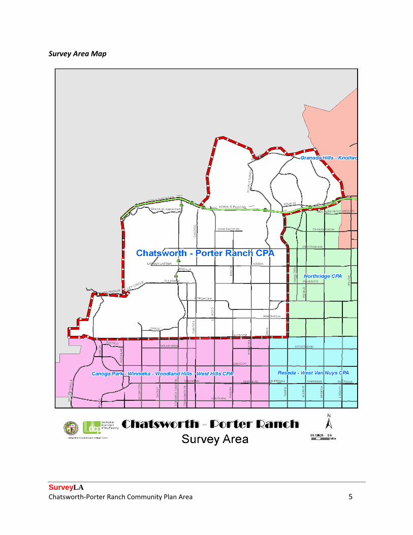
Project Team The Chatsworth-Porter Ranch CPA survey team included the following personnel from ARG: Katie E. Horak, Principal, Architectural Historian and Preservation Planner; and Andrew Goodrich, Architectural Historian and Preservation Planner. Additional assistance was provided by intern Christina Park. Katie Horak served as project manager. The project team also included Kevin Roderick, journalist, editor, and author of The San Fernando Valley: America’s Suburb. Kevin provided valuable expertise and input regarding the San Fernando Valley and its significant resources throughout all phases of the project. Survey Area Description of the Survey Area The boundaries of the Survey Area correspond with those of the Chatsworth-Porter Ranch CPA, which is located approximately 30 miles northwest of Downtown Los Angeles in the northwestern corner of the San Fernando Valley. The area is large in size compared to other CPAs and irregular in shape. Its boundaries are defined by portions of the Ronald Reagan Freeway/State Route 118 (118 Freeway) and the Santa Susana Mountains on the north, Roscoe Boulevard on the south, portions of Tampa Avenue and the Aliso Canyon Wash on the east, and the Santa Susana Mountains and Simi Hills on the west. The Survey Area abuts the CPAs of Northridge and Granada Hills-Knollwood on the east, and Canoga Park-Winnetka-Woodland Hills-West Hills and Reseda-West Van Nuys on the south. Its north and west boundaries are coterminous with the Los Angeles city limits and abut unincorporated areas within Los Angeles and Ventura Counties. Located within the Survey Area are two distinct communities of Los Angeles:
• Chatsworth, which accounts for a majority of the land area within the CPA boundaries, comprises the south and west sections of the Survey Area. First settled by homesteaders in the mid-nineteenth century and formally founded in 1888, Chatsworth is among the oldest communities in the San Fernando Valley. Chatsworth is irregular in shape and is generally bounded by the 118 Freeway on the north, Roscoe Boulevard on the south, Tampa Avenue on the east, and the Los Angeles city limits on the west.
• Porter Ranch comprises the north and east sections of the Survey Area. In contrast to Chatsworth, Porter Ranch remained entirely undeveloped until the 1960s and is one of Los Angeles’ most recently-developed communities, consisting largely of contemporary residential tracts. Porter Ranch is also irregular in shape and is generally bounded by the

SurveyLA Chatsworth-Porter Ranch Community Plan Area 4
118 Freeway on the south, the Aliso Canyon Wash on the east, and the Los Angeles city limits on the north and west.
• The area between Tampa and Corbin Avenues is commonly referred to as Northridge
and falls within the jurisdiction of the Northridge West Neighborhood Council. Residents and property owners in this area generally identify as being located within Northridge. The larger Northridge area is generally located within the Northridge CPA, which is directly to the east of the Chatsworth-Porter Ranch CPA.
SurveyLA Chatsworth-Porter Ranch Community Plan Area 5
Survey Area Map
SurveyLA Chatsworth-Porter Ranch Community Plan Area 6
Within the Survey Area are 24,141 parcels, 19,562 of which were evaluated by the SurveyLA team. In accordance with SurveyLA methodology, properties constructed after 1980 and resources designated under local, state, and/or federal programs were not surveyed. The Chatsworth-Porter Ranch CPA is a relatively large area in the far northwest corner of the San Fernando Valley. Located at the base of the Santa Susana Mountains and Simi Hills and the mouth of the Santa Susana Pass, the area is notable for its irregular and rugged topography. The southeast quadrant of the CPA sits on the floor of the San Fernando Valley and thus is generally flat; however, the north and west sections of the CPA feature a combination of gentle and moderate hills as the area begins its ascent from the valley floor into the adjacent mountains. The westernmost section of the CPA, which is largely undeveloped, is located within the mountains and is characterized by its rugged and mountainous terrain. Given its location at the periphery of urbanized Los Angeles and its proximity to a mountain range, the CPA contains an abundance of natural features. The Santa Susana Mountains and Simi Hills delineate the north and west boundaries of the CPA and stand out as among the area’s most prominent geographic features. Dotting the landscape near the base of the mountains are massive boulders and sandstone outcroppings including Stoney Point (HCM # 132), a municipal park and popular rock climbing destination. Creeks and washes descend from the mountains and traverse the CPA, although the sections of these waterways that pass through developed areas have been encased in concrete. At the southwest corner of the CPA is the two-square-mile Chatsworth Nature Preserve, which was originally a reservoir operated by the Los Angeles Department of Water and Power but was later converted into an open space preserve. Valley oak trees, native to the northwest San Fernando Valley, pepper the landscape and have also been incorporated into the yards of many nearby houses. Several notable human-made features are also located within the CPA. The area is bisected by the Southern Pacific Railroad right-of-way, a primary route for freight and passenger trains traveling between Los Angeles and Ventura Counties. Three tunnels, which were constructed at the turn of the twentieth century, carry trains through the mountains near the Santa Susana Pass. A dedicated bus right-of-way (Metro Orange Line) runs north-south along Canoga Avenue to its terminus between Devonshire and Lassen Streets, following the course of what used to be a branch line of the Southern Pacific Railroad between Burbank and Chatsworth. The 118 Freeway, which runs east-west through the CPA, includes both at-grade and below-grade sections as well as associated ramps, overpasses, and underpasses. The CPA is relatively diverse in terms of land use and associated property types. Much of the area is zoned for residential use and is developed with single-family and multi-family housing. Many of the residential parcels in the western section of the CPA are comparatively large and are zoned for equestrian use. A mix of light and heavy industrial uses are concentrated in the center of the CPA, near the Southern Pacific right-of-way. Commercial development largely consists of low-scale shopping plazas and strip malls located along major vehicular corridors; in

SurveyLA Chatsworth-Porter Ranch Community Plan Area 7
addition, the Survey Area contains two regional commercial centers including the Northridge Fashion Plaza, which flanks the CPA’s eastern border, and the Porter Ranch Town Center, which is located near the center of the Porter Ranch community. Public and private institutional uses, as well as public facilities and open spaces, are interspersed throughout the CPA. Streets within the CPA generally correspond to the topographical conditions of the surrounding area. The streets bisecting the “flats” in south and east Chatsworth tend to be oriented around the orthogonal grid on which most of the San Fernando Valley was developed, with boulevards and arterial streets that divide the area into a series of uniformly-sized blocks. However, streets in Porter Ranch and the west section of Chatsworth deviate from the grid and instead follow an irregular pattern that conforms to the natural contours of the land. The few streets that extend into the westernmost reaches of the CPA enter into the adjacent mountains and are thus characterized by winding routes, steep grades, and switchbacks. The major east-west arteries within the Survey Area are (from north to south): Sesnon Boulevard, Rinaldi Street, Santa Susana Pass Road, Chatsworth Street, Devonshire Street, Lassen Street, Plummer Street, Nordhoff Street, Parthenia Street, and Roscoe Boulevard. The major north-south arteries within the Survey Area are (from east to west): Tampa Avenue, Corbin Avenue, Winnetka Avenue, Mason Avenue, De Soto Avenue, Canoga Avenue, Topanga Canyon Boulevard, Fallbrook Avenue, and Valley Circle Boulevard.
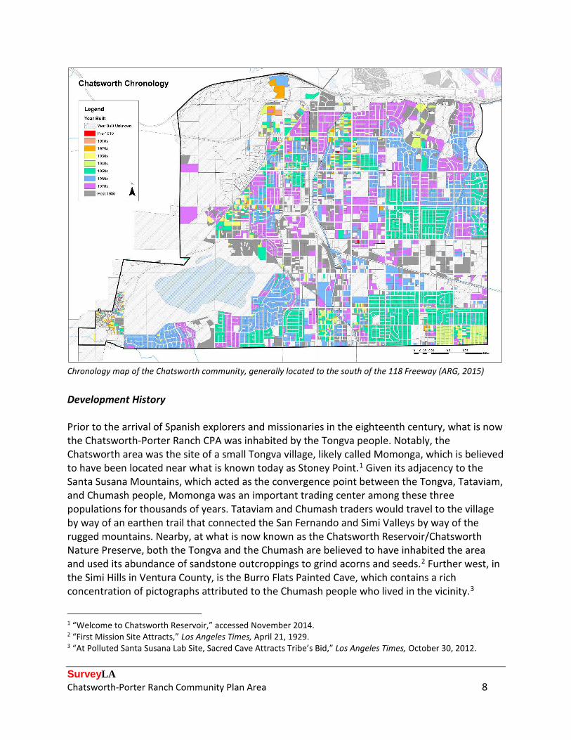
Chronology map of the Porter Ranch community, generally located to the north of the 118 Freeway (ARG, 2015)
SurveyLA Chatsworth-Porter Ranch Community Plan Area 8
Chronology map of the Chatsworth community, generally located to the south of the 118 Freeway (ARG, 2015) Development History Prior to the arrival of Spanish explorers and missionaries in the eighteenth century, what is now the Chatsworth-Porter Ranch CPA was inhabited by the Tongva people. Notably, the Chatsworth area was the site of a small Tongva village, likely called Momonga, which is believed to have been located near what is known today as Stoney Point.1 Given its adjacency to the Santa Susana Mountains, which acted as the convergence point between the Tongva, Tataviam, and Chumash people, Momonga was an important trading center among these three populations for thousands of years. Tataviam and Chumash traders would travel to the village by way of an earthen trail that connected the San Fernando and Simi Valleys by way of the rugged mountains. Nearby, at what is now known as the Chatsworth Reservoir/Chatsworth Nature Preserve, both the Tongva and the Chumash are believed to have inhabited the area and used its abundance of sandstone outcroppings to grind acorns and seeds.2 Further west, in the Simi Hills in Ventura County, is the Burro Flats Painted Cave, which contains a rich concentration of pictographs attributed to the Chumash people who lived in the vicinity.3
1 “Welcome to Chatsworth Reservoir,” accessed November 2014. 2 “First Mission Site Attracts,” Los Angeles Times, April 21, 1929. 3 “At Polluted Santa Susana Lab Site, Sacred Cave Attracts Tribe’s Bid,” Los Angeles Times, October 30, 2012.
SurveyLA Chatsworth-Porter Ranch Community Plan Area 9
Indigenous settlement patterns were disrupted upon the arrival of Franciscan missionaries to the San Fernando Valley and the subsequent founding of the Mission San Fernando in 1797. Momonga was abandoned as the local Tongva population either relocated to the mission or succumbed to communicable diseases introduced by the Spanish, for which no immunity had been developed.4 Given its relative distance from the mission, the Chatsworth area remained of little use to the mission’s operations and thus remained largely undeveloped during the Spanish era of California history (1769-1821). The only instance of activity in the area involved the excavation of several caleras, or limestone kilns, in the basin of the future Chatsworth Reservoir; lime deposits that were extracted from the caleras are believed to have been used to vitrify building blocks that, in turn, were used to build the San Fernando Mission.5 Several caleras were once in operation at the site, but of these only one remains (HCM #141).6 When California was ceded to Mexico, the Survey Area was incorporated into the Rancho Ex Mission San Fernando, a land grant that included almost all of the San Fernando Valley and was sold to Eulogio de Celis in 1846.7 De Celis’s heirs sold the northern half of the Rancho Ex Mission San Fernando to a triad of San Francisco-based investors that included State Senator Charles Maclay, shoe manufacturer George K. Porter, and Porter’s cousin, Benjamin, in 1874.8 The men divided their purchase into three parts of roughly equal size: Maclay took the eastern third with his eye set on developing towns; George Porter took the middle third to plant crops and raise livestock; and Benjamin Porter, who was the least interested in developing the land, assumed control of the remote and least-desirable western third.9 What would become Chatsworth and Porter Ranch fell entirely within the area controlled by Benjamin Porter. The Survey Area remained undeveloped well into the nineteenth century; however, given its adjacency to a mountain pass, the area was often traversed by parties traveling between the San Fernando and Simi Valleys. The trail that Tataviam and Chumash traders had used to travel to Momonga remained in continuous use in the eighteenth and nineteenth centuries, first by Spanish colonists traveling between the San Fernando and San Buenaventura Missions and later by American settlers traveling between Northern and Southern California via wagon.10 Seeking ways to improve intrastate transit, elected officials of the newly-established State of California financed significant improvements to the mountain trail in 1859. The trail re-opened as the Santa Susana Stage Road in 1861 and served “as the main commercial overland [stagecoach] route between Los Angeles and San Francisco” until the mid-1870s, transporting
4 California State Parks, “Santa Susana Pass State Historic Park,” 2010. 5 California State Office of Historic Preservation, “Chatsworth Calera Site,” accessed November 2014; Mildred Brooke Hoover, et al., Historic Spots in California (Stanford: Stanford University Press, 1932), 152. 6 “Welcome to Chatsworth Reservoir,” accessed November 2014. 7 Kevin Roderick, The San Fernando Valley: America’s Suburb (Los Angeles: Los Angeles Times Books, 2002), 26. 8 Catherine Mulholland, William Mulholland and the Rise of Los Angeles (Berkeley: University of California Press, 2000), 98. 9 Roderick (2002), 42. 10 Alexander D. Bevil, “Santa Susana Pass State Historic Park Cultural Resources Inventory Historic Overview,” 2007.
SurveyLA Chatsworth-Porter Ranch Community Plan Area 10
mail and passengers between the two cities in as little as 72 hours.11 Passing through the Survey Area and ascending into the mountains at what is now Chatsworth Park South, the stage road traversed some of the region’s most rugged terrain and was known for its treacherous course through the mountains; at one particularly perilous point known as Devil’s Slide, drivers often had to blindfold easily-spooked horses and employ other unorthodox tactics “to keep from losing control of the stagecoach.”12 The stage road remained a primary transportation artery between north and south until the mid-1870s, when it was relegated to local traffic only; the road ceased to be used after 1895, when the new Chatsworth Grade Road opened and provided a more navigable route through the mountains along what is now Santa Susana Pass Road.13 A portion of the original stage road, including Devil’s Slide, is listed on the National Register of Historic Places and is also a local landmark (HCM #92). The first instance of development in the Survey Area dates to the mid-1860s, making it one of the earliest examples of non-indigenous settlement in the San Fernando Valley. Development was made possible by the Homestead Act, federal legislation that permitted private citizens to settle, or “homestead,” up to 160 acres of public land provided that certain conditions were met; specifically, each homesteader was required to “live on the land, build a home, make improvements, and farm for five years.”14 Almost all of the Survey Area was not eligible for homesteading, as it fell within the former mission lands that were privately owned by de Celis, and later Porter; however, the area to the west of present-day Andora Avenue was federally owned and thus available to those wanting to settle the land.15 As early as the mid-1860s, families began to set down roots in the hills west of Chatsworth under the auspices of the Homestead Act; Neils and Ann Johnson, homesteaders who arrived in the 1870s, are credited as being the first Anglo Americans to settle in the San Fernando Valley.16 In 1880, a small wooden schoolhouse (not extant) was constructed to serve the handful of children residing nearby, with Ann Johnson “driving around in her buggy picking up children to maintain the minimum number of students needed to keep the school open.”17 The handful of homesteads that dotted the foothills never coalesced into a formal community. Rather, the first concerted effort to develop a town in the vicinity is associated with the completion of a transcontinental rail line to Los Angeles in the 1880s, which touched off a real estate boom where “no piece of Southern California seemed impossible to develop.”18 One of the many new towns to be recorded at the height of the boom was located in the far northwest corner of the San Fernando Valley, some thirty miles from central Los Angeles. Subdivided in 1888 by investor George Crow, the town was named Chatsworth Park after the Duke of 11 “Stage Road Has Dust of History,” Los Angeles Times, June 18, 1990. 12 California State Parks, “Santa Susana Pass State Historic Park,” 2010. 13 Ann Vincent, “The Stagecoach Trail,” Chatsworth Past and Present (March 2010). 14 National Park Service, “About the Homestead Act,” accessed November 2014. 15 Chatsworth Historical Society, “Chatsworth Hills Homesteaders – Part 1,” accessed February 2015. 16 Ibid. 17 Chatsworth Park Elementary School, “Our History,” accessed February 2015. 18 Mulholland (2000), 40.
SurveyLA Chatsworth-Porter Ranch Community Plan Area 11
Devonshire’s country estate in England.19 Crow envisioned the town as a picturesque agricultural community composed of family farms; his subdivision map consisted of ten-acre agricultural parcels, which were well-suited to small-time farmers, and three east-west streets named Ben Porter (now Chatsworth), Devonshire, and Fernando (now Lassen).20 Chatsworth Park remained very sparsely developed in its formative years because of its isolated location and lack of viable transit connections to and from Los Angeles. The Los Angeles Times aptly noted that “a number of lots [in Chatsworth Park were] sold and some improved, but lack of railroad communication kept the section back” upon its initial subdivision, with development limited to a few modest orchards.21 However, the town benefited tremendously when the Southern Pacific Railroad built a spur line to the northwest San Fernando Valley in 1893, which branched off of its main line at Burbank and terminated in Chatsworth Park. “Two trains ran daily from Chatsworth to Los Angeles” on the newly-completed Burbank Branch, providing the peripheral town with a direct and reliable connection to central Los Angeles for the first time.22 Completion of the railroad line regenerated interest in the fledgling town, ushering in a very modest wave of new development in the late nineteenth century that put the community on the map. In 1893, the San Fernando Valley Improvement Company re-subdivided Chatsworth Park, orienting the settlement around the Burbank Branch. At the end of the railroad line, located near what is now Topanga Canyon Boulevard and Lassen Street, a small town center emerged which consisted of a railroad depot, inn, general store, and post office, none of which are extant. A handful of modest houses and small orchards were also developed nearby, and in 1903 a cornerstone was laid for a new church (Chatsworth Community Church, HCM #14). By the turn of the twentieth century, Chatsworth Park had evolved from what was essentially a paper town to a bustling young community with a population of 23.23 The railroad’s completion also bolstered the town’s economy by creating a market for local products. Notably, the rock-strewn hills located just west of the town were well-suited to sandstone quarrying, a linchpin of the local economy between the 1890s and 1910s. The most prolific sandstone quarry was located near the former stage road and was operated by William Bannon, a seasoned quarryman who had homesteaded the site in 1892.24 Sandstone that was extracted from the Bannon Quarry, which possessed a distinctive aesthetic quality and came to be known as Chatsworth Park Stone, was widely distributed throughout Southern California and was used in a variety of architectural and structural contexts. Notably, Chatsworth Park Stone was used to clad several turn-of-the-century commercial buildings in Downtown Los Angeles
19 Chatsworth Historical Society, “England Collection,” accessed February 2015. 20 “Plat of the Lands of B.F. Porter Estate,” accessed February 2015. 21 “House and Lot: Business Dull in Real Estate Circles,” Los Angeles Times, July 8, 1893. 22 “Woman Recalls Better Days of Chatsworth Inn,” Los Angeles Times, September 23, 1956. 23 “Chatsworth Celebrates 125 Years as an Anchor of the North San Fernando Valley,” in Chatsworth/Porter Ranch Chamber of Commerce Business Directory 2013-2014, 19. 24 Chatsworth Historical Society, “Chatsworth Hills Homesteaders – Part 2,” accessed February 2015.
SurveyLA Chatsworth-Porter Ranch Community Plan Area 12
and also formed the main breakwater at San Pedro Harbor.25 To facilitate the mass export of quarried stone, Southern Pacific added an additional mile of track to the Burbank Branch in 1898, which extended from its terminus at Lassen Street into the Bannon Quarry site.26 Other quarries were located nearby, though most appear to have been smaller-scale operations. The railroad continued to influence the vitality of the town in subsequent years. Between 1898 and 1904, Southern Pacific embarked upon the construction of a new Coast Line that connected Los Angeles and San Francisco via a route that bisected the San Fernando Valley and crossed the Santa Susana Pass by way of Chatsworth.27 So that trains could travel through the mountain pass, three tunnels were blasted through the mountains northwest of Chatsworth, a costly and labor-intensive venture that claimed many lives and was lauded as an engineering feat upon the tunnels’ completion.28 Construction of the tunnels brought scores of laborers and their families to the Chatsworth Park area, augmenting its meager population. The project also positioned the town along what was among the most important intrastate transit corridors at the time, securing Chatsworth’s position as the anchor of the northwest San Fernando Valley. Further along into the twentieth century, agriculture supplanted quarrying and railroad construction as the backbone of the local economy. This economic transition was brought on by two significant events. First, like almost all of the San Fernando Valley, the Survey Area was annexed by Los Angeles in 1915.29 Annexation provided the local population with access to water supplied by the Los Angeles Aqueduct, which had opened in 1913. Second, in 1917, the Department of Water and Power broke ground on a new municipal reservoir southwest of the town “to store and handle the flow of the gigantic Los Angeles Aqueduct;” when it was placed into service in 1919, the Chatsworth Reservoir functioned as the principal water storage facility in the West San Fernando Valley.30 Together, annexation and the reservoir facilitated large-scale agricultural development by providing this semi-arid section of the Valley with a reliable and abundant water supply. The area’s vast expanses of undeveloped land were subsequently used to cultivate a variety of crops including sizable yields of oranges, lemons, walnuts, melons, and Kadota figs. By the 1920s, the word “Park” had been dropped from the name of the town, which came to be known as simply “Chatsworth.”31 The rise of agriculture was accompanied by the rise of film and television production, which also emerged as an important tenet of the Chatsworth economy in the first half of the twentieth century. Beginning in 1912, Hollywood producers used the area’s picturesque landscape and dramatic rock formations as the backdrop for myriad productions set in the
25 Bevil (2007). 26 Ann Vincent and Ray Vincent, “Chatsworth Park Quarry,” Chatsworth Past and Present (May 2014). 27 Ann Vincent, “Chatsworth Railroad History,” Chatsworth Past and Present (February 2012). 28 “Traffic Starts Through Chatsworth Tunnel,” Los Angeles Times, March 19, 1904. 29 Roderick (2002), 62-63. 30 “Work Is Stated on Gigantic New Reservoir for Aqueduct,” Los Angeles Times, November 4, 1917. 31 “Los Angeles County, First in America,” Los Angeles Times, January 1, 1925.
SurveyLA Chatsworth-Porter Ranch Community Plan Area 13
American West and various exotic locations.32 Over the next several decades, the Survey Area was an immensely-popular filming location, with its rugged chaparral and rock-studded hills featured in numerous motion pictures and, later, in television programs. Much of the production activity took place at either the Chatsworth Reservoir or at several “movie ranches” that were located in the Santa Susana Pass and served as dedicated shooting locations. Prolific movie ranches in the Chatsworth area included the Iverson Ranch, located near the mouth of the Santa Susana Pass; Spahn Ranch, which was once owned by silent film star William S. Hart (and was later squatted upon by infamous criminal Charles Manson and his accomplices); and the Corriganville and Bell Moving Picture Ranches, both of which were located farther west.33 The Iverson Ranch, an early movie ranch that remained in operation into the postwar era, was especially prolific and is “the most shot-up movie location ranch in motion picture history.”34 Chatsworth’s peripheral location and proximity to nature also appealed to Angelenos seeking respite from the fast pace of urban life, paving the way for the development of several weekend retreat communities in the 1920s. In 1927, George W. Haight subdivided a portion of his homestead near the mouth of Browns Canyon into a resort community sited around two man-made lakes. Known as Twin Lakes Park, the community consisted of small resort houses and offered ample amenities for outdoor recreation including boating, fishing, hunting, swimming, and archery.35 Notably, Haight hired noted architect Robert Stacy-Judd to design the main clubhouse building, entrance portal, and several houses in the architect’s signature Mayan Revival style, providing the community with an exotic flavor.36 Small communities of weekend cabins also arose in the hills above the Chatsworth Reservoir, and were marketed under names that stressed their bucolic setting including Chatsworth Lake Manor and Chatsworth Highland Springs.37 The heyday of these communities was relatively short-lived, however, as the market for weekend retreats was significantly impacted by the onset of the Great Depression. Several entertainment stars acquired land and established ranches in and around Chatsworth beginning in the 1930s. Among the celebrities who settled in the area were motion picture stars Mae Marsh and Lionel Barrymore, who each served for a period as the town’s honorary mayor, and singer and radio personality Ginny Simms.38 In the early 1940s, renowned entertainment stars Lucille Ball and Desi Arnaz purchased a ranch house near Devonshire Street and Corbin
32 “Chatsworth Celebrates 125 Years as an Anchor of the North San Fernando Valley,” in Chatsworth/Porter Ranch Chamber of Commerce Business Directory 2013-2014, 19. 33 Jerry England, Reel Cowboys of the Santa Susanas (Chatsworth: ECHO Press, 2008). England, a San Fernando Valley historian, author, and longtime resident of Chatsworth, has written two books about the history of film and television production in the San Fernando Valley. 34 Jerry England, “Iverson Movie Location Ranch,” accessed February 2015. 35 “Twin Lakes Park: Home of the Mayan Village,” promotional pamphlet, n.d. 36 “Historic-Cultural Monument Application for the Haight-Dandridge Residence,” prepared by Laura Meyers for the City of Los Angeles, April 26, 2013. 37 Chatsworth Historical Society, “Chatsworth Lake Manor,” accessed February 2015. Chatsworth Lake Manor is located outside of the City of Los Angeles and was not evaluated as part of SurveyLA. 38 Virginia Watson, “Movie Personalities Lived in Chatsworth,” Chatsworth Past and Present (n.d.).

SurveyLA Chatsworth-Porter Ranch Community Plan Area 14
Avenue, which served as their primary residence until the 1950s.39 Cowboy duo Roy Rogers and Dale Evans resided on a ranch adjacent to Oakwood Memorial Park in the 1950s and 1960s, where they raised their children and were active members of the Chatsworth community.40 For a period, Rogers also served as the community’s honorary mayor. A small enclave of celebrity ranches arose near Winnetka Avenue and Devonshire Street, in what is now a gated community known as Monteria Estates, and included ranches that were owned by actor and dancer Dan Dailey, actress Veronica Lake, and film director (and Lake’s husband) André de Toth.41 Prior to World War II, the Survey Area largely “remained a quiet agricultural community, with large citrus orchards and other crops,” thoroughbred horse ranches, and a population that was meager even by Valley standards.42 However, like almost all of the San Fernando Valley, Chatsworth experienced a remarkable wave of growth and development after World War II, which transformed the area from a rural outpost into a sprawling and populous suburb.43 The area’s vast expanses of farm and ranch lands were well-suited to neighborhoods of mass-produced single-family houses, which were developed in earnest to accommodate an influx of households seeking a suburban lifestyle. Piece by piece, many of the Survey Area's agricultural parcels were sold to developers and subdivided into residential tracts. These new neighborhoods catered to a variety of income levels, ranging from developments of economical tract houses to communities of custom-designed residences sited on large, half-acre lots. Many were designed in various iterations of the Ranch style, which was immensely popular at the time. By the 1960s, Chatsworth’s population had increased to an unprecedented 33,000, though, as noted by the Los Angeles Times, the area remained less-densely developed than other Valley communities and still had “some stretching to do before it is wide awake.”44 Rapid residential development was accompanied by the rise of various commercial and institutional uses, which arose to serve the day-to-day needs of the area’s steadily increasing population. Commercial development coalesced along the community’s major boulevards and consisted largely of low-scale strip malls, shopping plazas, and edifices such as the Munch Box walk-up food stand (HCM #750) that catered to passing motorists. New public school campuses were constructed in and around the new residential tracts that were being developed to keep pace with the area’s influx of families, as were a number of parks, churches, and various other institutions. New streets were platted, and existing roads were widened and improved. Chatsworth also witnessed a considerable amount of industrial development in the postwar era and became of the Valley’s foremost manufacturing and employment centers. Beginning in the mid-1950s and continuing over the next several decades, large tracts of land near the Southern
39 Ibid; Roderick (2002), 92-93. 40 “Rogers’ House a Chatsworth Landmark,” Los Angeles Times, July 7, 1998. 41 “Stars’ Homes Periled by Chatsworth Blaze,” Los Angeles Times, November 11, 1950. 42 “Lifestyle Options in Wide Open Space,” Los Angeles Times, May 19, 1991. 43 “Valley Growth Sets Pace for State’s Increase During 1962,” Los Angeles Times, December 30, 1962. 44 “Chatsworth Clings to Rural Air,” Los Angeles Times, September 14, 1969.
SurveyLA Chatsworth-Porter Ranch Community Plan Area 15
Pacific Railroad tracks were re-zoned to accommodate industrial uses, which promoted a balanced pattern of growth and aimed to “keep the West San Fernando Valley from becoming bedroom communities.”45 A variety of industries thereafter located in the area – including research and development laboratories, manufacturing plants, service centers and corporate offices, and high-tech enterprises – providing its burgeoning population with a steady employment base. Aerospace and defense contractors, including Thompson-Ramo-Woolridge and Atomics International, operated facilities in the Survey Area and were among its foremost employers; the Santa Susana Field Laboratory associated with Rockwell International/ Rocketdyne, which was involved in the production of rocket engines and nuclear technology, was located in the hills west of Chatsworth.46 A Nike Missile Base, one of sixteen such sites operated by the company around Southern California, opened in 1956 at Oat Mountain, located in the mountains north of Chatsworth; notably, it “was the first [site] in Los Angeles to house a Nike Hercules, a missile equipped with a nuclear warhead.”47 One of the most significant changes to the area’s physical environment was set into motion in 1962, when the heirs of Benjamin Porter sold off the last remaining section of his ranch – which included 4,150 acres of pristine, undeveloped land north of Chatsworth and Northridge – to the Macco Corporation.48 Under Macco’s supervision, what was among the last large undeveloped areas in the San Fernando Valley was transformed into Porter Ranch, a master-planned community that has been continuously developing since the 1960s. As one of the most recently-developed areas of Los Angeles, Porter Ranch is emblematic of contemporary trends in suburban development as evidenced by its curvilinear streets, careful delineation of land uses, clusters of large-scale residential subdivisions, wide roads that facilitate the unimpeded flow of traffic, and big box retail centers. The core of Porter Ranch is built out, but some areas on the periphery of the community are actively being developed with new residential subdivisions. Chatsworth has struggled to retain elements of its rural past in the wake of rapid postwar suburbanization. Some of the community’s earliest resources were unceremoniously razed to make way for new development including the Chatsworth Inn (built 1890) and the Southern Pacific Railroad Depot (built 1910), which were demolished in 1958 and 1962, respectively.49 When the 118 Freeway was constructed through the Santa Susana Pass after World War II, it bisected the Iverson and Corriganville movie ranches and generated ambient noise that contributed to the ranches’ demise.50 Many of the area’s ranches and equestrian estates were subdivided into residential tracts that encroached upon the area’s open spaces, a trend that continues into the present-day as the demand for new housing in Los Angeles persists. 45 “West San Fernando Valley Explodes,” Los Angeles Times, March 13, 1960. 46 Ibid. 47 “Nike Missile Base-Turned SWAT Training Center in Chatsworth Hills Draws Taggers, Vandals,” Los Angeles Daily News, February 3, 2013. 48 “Wind-Swept But Comfy on L.A’s Fringe,” Los Angeles Times, January 6, 2008. 49 Chatsworth Historical Society, “Chatsworth Timeline,” November 17, 2014; Water and Power Associates, “Early Views of the San Fernando Valley,” accessed February 2015. 50 “Why Corriganville and the Iverson Movie Ranch Will Never Be the Same,” accessed February 2015.

SurveyLA Chatsworth-Porter Ranch Community Plan Area 16
However, there have also been successes in the preservation of Chatsworth’s cultural and natural resources. The Chatsworth Community Church (1903) was also slated for demolition in the early 1960s to make way for a new shopping center, but was ultimately saved and relocated to its present site within Oakwood Memorial Park in 1965.51 The effort to save the church was spearheaded by the Chatsworth Historical Society, which had been formed in response to this issue and remains an active part of the community. Notable examples of open spaces and natural features including Stoney Point (HCM #132), the Santa Susana Pass State Historic Park, and an iconic concentration of sandstone outcroppings known as Garden of the Gods were preserved as parkland. In the early 1990s, when the out-of-service Chatsworth Reservoir was eyed by developers as a potential site for new subdivisions, local residents and stakeholders successfully lobbied the City to set aside the site as open space and limit its use “to a nature preserve and accessory uses only.”52 Chatsworth remains one of relatively few areas within the City with equestrian zoned parcels, and many of its streets are accompanied by bridle paths. While development pressures continue to re-shape the area’s land use patterns, Chatsworth has retained a small-town feeling that has all but disappeared in postwar Los Angeles. Designated Resources
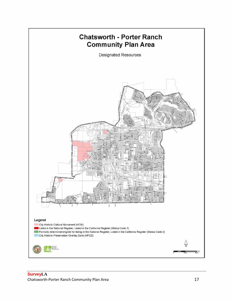
The following map depicts the location of designated resources within the Chatsworth-Porter Ranch CPA at the time of the survey. These include properties listed in the National Register of Historic Places (NR) and/or the California Register of Historical Resources (CR), as well as locally designated Los Angeles Historic-Cultural Monuments (HCM). Currently, there are no locally-designated Historic Preservation Overlay Zones (HPOZ) located within the CPA. For the most up-to-date information on designated resources refer to ZIMAS.lacity.org and HistoricPlacesLA.org, or contact the Los Angeles Department of City Planning’s Office of Historic Resources. An HCM nomination for the Chatsworth Nature Preserve (originally known as the Chatsworth Reservoir) was being processed at the time this survey was completed.
51 “Church Marks Its 90th Birthday,” Los Angeles Times, October 23, 1993. 52 City of Los Angeles, “Ordinance No. 169723,” February 24, 1994.
SurveyLA Chatsworth-Porter Ranch Community Plan Area 17
SurveyLA Chatsworth-Porter Ranch Community Plan Area 18
Community Plan Area Survey Methodology The survey of the Chatsworth-Porter Ranch CPA was conducted using the methodology established by the OHR for SurveyLA which includes the Citywide Historic Context Statement and customized mobile Field Guide Survey System (FiGSS).53 Concurrent with the survey of the Chatsworth-Porter Ranch CPA, seven additional community plan areas were also being surveyed, all of which are located in the San Fernando Valley. The fieldwork was conducted in two phases: reconnaissance and documentation. The reconnaissance phase was conducted by the project managers and key staff of all four CPA surveys, all of whom meet the Secretary of the Interior’s Professional Qualifications Standards. This phase involved a detailed and methodical review of each neighborhood, street, and individual property within the Survey Area. It was during this phase that decisions were made about which properties and districts should be documented, and how those properties should be evaluated. During this initial reconnaissance phase, surveyors reviewed pre-loaded data submitted by community members to MyHistoricLA, identified concentrations of resources that might later be recorded as eligible historic districts and planning districts, and developed lists of pre-field research tasks that would help inform the field survey. By making these decisions up front and as a team, this methodology ensures a more thoughtful approach to resource identification and evaluation, creates greater consensus among the field survey teams, and produces more consistent survey results across CPAs. This approach also substantially streamlines the next phase of field survey, enabling the field teams to document large numbers of properties quickly and efficiently. During the reconnaissance phase, ARG created Geographic Information Systems (GIS) maps of each neighborhood; these maps were printed for use in the field. A blank map showing only street names, address numbers, and parcel lines was used by surveyors in the field for notes and comments about resources identified during the reconnaissance phase. Another map featured parcels shaded by decade of building construction, which helped to illustrate chronological development patterns and concentrations of resources. Once the reconnaissance phase was completed, the documentation phase began. During this phase, fieldwork was conducted by teams of two. Properties that were identified during the previous phase, along with those that had significant associative qualities identified in pre-loaded data in FiGSS, were recorded and evaluated for potential historic, cultural, or architectural significance. Documentation included a digital photograph, recordation of historic features and subsequent alterations, and the reason for a property’s potential historic significance. It was also during this phase that contexts and themes were applied and evaluation status codes were assigned.
53 For more information about the SurveyLA methodology, see the SurveyLA Field Results Master Report.
SurveyLA Chatsworth-Porter Ranch Community Plan Area 19
Surveyed properties included residential, commercial, institutional, and industrial buildings and important landscape and infrastructure features such as bridges and designed landscapes. All fieldwork was conducted from the public right-of-way. Following the completion of fieldwork, all survey data was reviewed in detail by a qualified survey professional to ensure accuracy and consistency throughout the data set. Survey teams conducted research on individual properties and neighborhoods throughout the field survey process. When specific information was needed in order to complete an evaluation, additional research was conducted. Sources included building permits, historical newspapers and periodicals, Sanborn maps, tract maps, and city directories. The survey team also utilized research materials available online from the Chatsworth Historical Society. Other sources that were consulted include the collections of the Los Angeles Public Library; Online Archive of California; University of Southern California (USC); University of California, Los Angeles (UCLA); and the Library of Congress archives. This research helped with the identification of historic tract names and boundaries, names of tract subdividers, dates of subdivision, and original building uses and footprints.
SurveyLA Chatsworth-Porter Ranch Community Plan Area 20
Summary of Findings The following discussion of Property Types, Contexts, and Themes relates to the resources identified and recorded as eligible for designation. Summary of Property Types In terms of land use, the Chatsworth-Porter Ranch CPA is relatively diverse. While a majority of the CPA is zoned for residential use and is developed with post-World War II housing tracts, the area also includes many commercial and institutional properties, concentrations of industrial development, and a number of open spaces and public parks. Following is a summary of the property types within the CPA that were documented and evaluated as significant. Residential Properties Residential development in the Survey Area consists largely of mass-produced residential tracts, which were developed beginning in the 1950s and are emblematic of the San Fernando Valley’s transformation from an agricultural stronghold into a sprawling and populous suburb after World War II. Residential properties account for a majority of resources identified in the Survey Area; eligible residential property types include both individual resources and concentrations of resources (historic districts and planning districts). Eighteen residential properties were identified as individually eligible resources. Eight of these properties are single-family houses that were built prior to 1930 and reflect early settlement patterns in the area. These houses are rare examples of extant resources associated with the early history of Chatsworth, and all are stylistically modest. Three additional single-family houses from the 1920s were evaluated as rare remaining examples of resources associated with the Weeks Poultry Colony, a utopian agricultural enterprise that was in operation in the vicinity between the 1920s and 1930s.54 The survey also identified several single-family houses that are excellent examples of either Spanish Colonial Revival, Tudor Revival, or Mid-Century Modern architecture, and a handful of single-family houses that are associated with notable figures in Los Angeles’ entertainment industry. Many residential properties that were identified by the survey are located within a historic district or planning district. In total, two residential historic districts and one residential
54 The Weeks Poultry Colony was predominantly located in the neighboring community of Winnetka, and a number of resources associated with the colony were identified as part of the SurveyLA survey of the Canoga Park-Winnetka-Woodland Hills-West Hills CPA. For a more detailed discussion of the history of the Weeks Poultry Colony, please refer to the SurveyLA Historic Resources Survey Report for the Canoga Park-Winnetka-Woodland Hills-West Hills CPA.
SurveyLA Chatsworth-Porter Ranch Community Plan Area 21
planning district were identified in the Survey Area. Both of the historic districts were evaluated as significant examples of postwar suburbanization and also as excellent, intact concentrations of Ranch style architecture. Similarly, the planning district was evaluated as a notable example of postwar suburbanization and for possessing a concentration of Mid-Century Modern residential architecture. However, since most buildings within the planning district have been altered, it does not appear to retain sufficient integrity for historic district eligibility, although it may merit special consideration in the local planning process. In addition, the survey identified three multi-family residential complexes that were evaluated as excellent examples of Tiki/Polynesian architecture. Commercial Properties Most commercial development in the Survey Area is concentrated along the major east-west and north-south boulevards that traverse the area. Compared to residential properties, relatively few commercial properties were identified as individually eligible resources. The survey did identify three examples of long-term businesses that contribute to the community’s commercial identity, one example of a 1960s supermarket that exemplifies the property type, and one roadside eatery that was evaluated as an excellent example of Googie architecture. Industrial Properties Most industrial development in the Survey Area is located in areas proximate to the Southern Pacific railroad corridor. One industrial campus was identified in the survey: a manufacturing plant that was originally the headquarters of a major defense contractor (Atomics International) and was one of the foremost employers in the area after World War II. Three railroad tunnels that date to the turn of the twentieth century and helped usher in an early wave of industrial development were evaluated as non-parcel resources. Institutional Properties The survey identified a number of institutional properties, which are not concentrated in a specific section of the Survey Area but are rather interspersed throughout its boundaries. Public and private institutional properties represent the second most common resource type identified in the Survey Area, surpassed only by residences. Eligible institutional property types were recorded both as individual resources and as districts, depending on the number of significant resources present at a given site. Institutional resources consist primarily of government services that were constructed to accommodate the area’s rapid population growth in the postwar era. Specifically, the survey identified four Department of Water and Power (DWP) facilities, including distributing stations and a former municipal reservoir; one fire station; one municipal park; and three LAUSD schools
SurveyLA Chatsworth-Porter Ranch Community Plan Area 22
that exemplify campus planning and design principles applied in the postwar period of school construction. Also identified was one LAUSD campus that dates to the 1930s and exemplifies the post-1933 earthquake period of school construction. Private institutions that were identified include a private boarding school that has continuously catered to underserved youth since the 1930s, two churches that were evaluated as excellent examples of Mid-Century Modern architecture, and a rare example of a 1920s cemetery. Two institutional resources were recorded as non-parcel resources. Both are air raid sirens that are associated with civil defense efforts during World War II and the Cold War. Other Properties Finally, the survey identified two significant examples of natural features. These features include a grouping of mature trees that substantially pre-dates surrounding development, and a concentration of sandstone outcroppings (Garden of the Gods) that is both an iconic natural feature and was used as a backdrop in numerous motion picture and television productions. Summary of Contexts and Themes Many of the Contexts and Themes developed as part of the SurveyLA Citywide Historic Context Statement are represented in the Chatsworth-Porter Ranch CPA. Following is a representative sampling of some of the more common Context/Theme combinations that were used in the Survey Area, as well as several combinations that are either particularly representative or unique components of the area’s developmental history. Each Context/Theme combination listed is illustrated with specific examples from the Survey Area. Appendix A includes a complete list of all individual resources identified as meeting eligibility standards and criteria for the National Register, California Register, and/or HCM/HPOZ. Appendix B includes a complete list of all non-parcel resources identified as meeting eligibility standards and criteria for the National Register, California Register, and/or HCM/HPOZ. Appendix C includes a complete list of historic districts identified as meeting eligibility standards and criteria for the National Register, California Register, and/or HCM/HPOZ. This appendix also includes Planning Districts, which do not meet eligibility standards and criteria for listing but may warrant special consideration for local planning purposes.
SurveyLA Chatsworth-Porter Ranch Community Plan Area 23
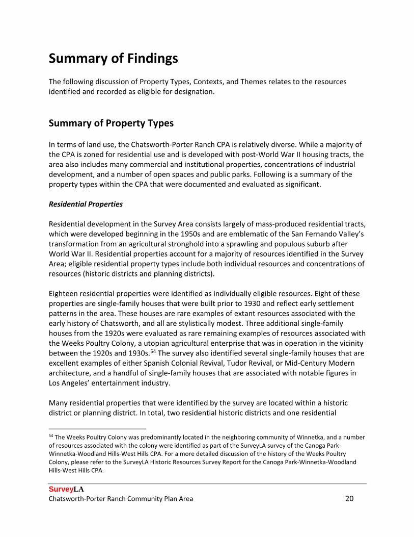
Context: Residential Development and Suburbanization, 1850-1980 Theme: Early Residential Development, 1880-1930 Sub-Theme: Early Single-Family Residential Development, 1880-1930 While the Survey Area is generally associated with postwar suburbanization, Chatsworth is one of the oldest communities in the San Fernando Valley, with deep roots that date back to the late nineteenth and early twentieth centuries. Interspersed throughout the community are a small number of properties that date to the community’s formative period and represent its earliest settlement patterns. Eight single-family residences were evaluated under this Context/Theme combination, all of which were built prior to 1930 and are very rare examples of development associated with the community’s early history. Reflecting the modest means of early settlers, all of the residences identified are simple and lack stylistic articulation.
Address: 10921 N. Old Santa Susana Pass Rd. Address: 10239 N. Jordan Ave. Date: 1917 Date: 1928
Address: 9939 N. Farralone Ave. Address: 10224 N. Vassar Ave. Date: 1927 Date: 1928

SurveyLA Chatsworth-Porter Ranch Community Plan Area 24
Context: Residential Development and Suburbanization, 1850-1980 Theme: Post-War Suburbanization, 1938-1975 Sub-Theme: Suburban Planning and Development, 1938-1975 As the San Fernando Valley rapidly suburbanized after World War II, scores of residential tracts were developed in the Chatsworth area to accommodate the steady influx of households seeking new, quality housing in a suburban setting. Postwar housing tracts account for much of the residential development in the Survey Area. This Context/Theme combination was used to evaluate two historic districts and one planning district that are excellent examples of postwar suburbanization, possessing design and planning features that strongly evoke this period of residential development. Each district was also evaluated under the Architecture context for possessing notable concentrations of either Mid-Century Modern or Ranch style architecture.
District: Devonshire Highlands Historic District District: Devonshire Country Estates Historic District Period of Significance: 1955-1964 Period of Significance: 1956-1964
District: Northridge West Planning District Developer: Cal-Frank Homes, with Palmer and Krisel Period of Significance: 1955-1956

SurveyLA Chatsworth-Porter Ranch Community Plan Area 25
Context: Commercial Development, 1850-1980 Theme: Commercial Identity, 1850-1980 The Chatsworth area is home to several long-term businesses that, over time, have evolved into local commercial institutions that help to define the area’s commercial identity. This Context/ Theme combination was used to evaluate three examples of local businesses that have remained in continuous operation for several decades and are venerated tenets of the area’s commercial landscape. Included are two well-known local eateries, including a Mexican restaurant (top left), a delicatessen (top right), and a western-themed saloon (bottom) that evokes the area’s rural culture and bills itself as “the last real honky tonk” in the community.
Name: Los Toros Mexican Restaurant Name: Brent’s Delicatessen Address: 21743 W. Devonshire St. Address: 19565 W. Parthenia St. Date: 1967 Date: 1967
Name: Cowboy Palace Saloon Address: 21633 W. Devonshire St. Date: 1971

SurveyLA Chatsworth-Porter Ranch Community Plan Area 26
Context: Public and Private Institutional Development, 1850-1980 Sub-Context: Education, 1876-1980 Theme: Public Schools and the LAUSD, 1876-1980 Sub-Theme: Post World War II Schools, 1946-1966
Many new public school campuses were built in the Chatsworth area to keep pace with rapid residential development that occurred after World War II. Financed by municipal bonds that were approved by Los Angeles voters, these campuses embodied contemporary ideas in school design known as “building for learning,” which emphasized fresh air, natural light, and the use of color, and also encouraged outdoor learning and mobility. This Context/Theme combination was used to evaluate three LAUSD campuses within the Survey Area, all of which feature highly intact site plans. One of the identified schools (top left) features a distinctive, radial site plan; another (bottom) was designed by noted Modern architect Gregory Ain and was also evaluated under as an excellent example of Mid-Century Modern institutional architecture.
Name: Chatsworth Senior High School Name: Germain Street Elementary School Address: 10027 N. Lurline Ave. Address: 20730 W. Germain St. Date: 1963 Date: 1963
Name: Nevada Avenue Elementary School Address: 22120 W. Chase St. Architect: Gregory Ain Date: 1960
SurveyLA Chatsworth-Porter Ranch Community Plan Area 27
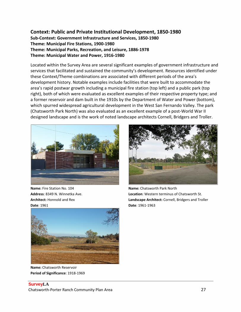
Context: Public and Private Institutional Development, 1850-1980 Sub-Context: Government Infrastructure and Services, 1850-1980 Theme: Municipal Fire Stations, 1900-1980 Theme: Municipal Parks, Recreation, and Leisure, 1886-1978 Theme: Municipal Water and Power, 1916-1980
Located within the Survey Area are several significant examples of government infrastructure and services that facilitated and sustained the community’s development. Resources identified under these Context/Theme combinations are associated with different periods of the area’s development history. Notable examples include facilities that were built to accommodate the area’s rapid postwar growth including a municipal fire station (top left) and a public park (top right), both of which were evaluated as excellent examples of their respective property type; and a former reservoir and dam built in the 1910s by the Department of Water and Power (bottom), which spurred widespread agricultural development in the West San Fernando Valley. The park (Chatsworth Park North) was also evaluated as an excellent example of a post-World War II designed landscape and is the work of noted landscape architects Cornell, Bridgers and Troller.
Name: Fire Station No. 104 Name: Chatsworth Park North Address: 8349 N. Winnetka Ave. Location: Western terminus of Chatsworth St. Architect: Honnold and Rex Landscape Architect: Cornell, Bridgers and Troller Date: 1961 Date: 1961-1963
Name: Chatsworth Reservoir Period of Significance: 1918-1969
SurveyLA Chatsworth-Porter Ranch Community Plan Area 28
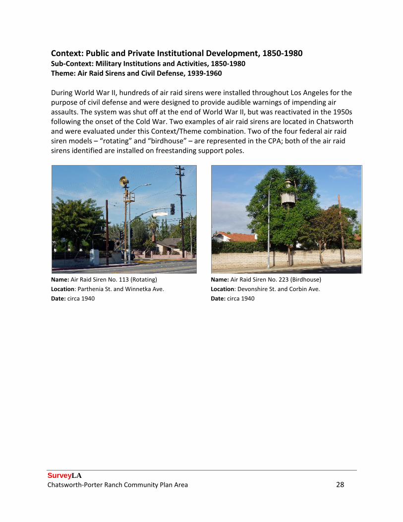
Context: Public and Private Institutional Development, 1850-1980 Sub-Context: Military Institutions and Activities, 1850-1980 Theme: Air Raid Sirens and Civil Defense, 1939-1960 During World War II, hundreds of air raid sirens were installed throughout Los Angeles for the purpose of civil defense and were designed to provide audible warnings of impending air assaults. The system was shut off at the end of World War II, but was reactivated in the 1950s following the onset of the Cold War. Two examples of air raid sirens are located in Chatsworth and were evaluated under this Context/Theme combination. Two of the four federal air raid siren models – “rotating” and “birdhouse” – are represented in the CPA; both of the air raid sirens identified are installed on freestanding support poles.
Name: Air Raid Siren No. 113 (Rotating) Name: Air Raid Siren No. 223 (Birdhouse) Location: Parthenia St. and Winnetka Ave. Location: Devonshire St. and Corbin Ave. Date: circa 1940 Date: circa 1940

SurveyLA Chatsworth-Porter Ranch Community Plan Area 29
Context: Architecture and Engineering, 1850-1980 Theme: Mediterranean and Indigenous Revival Architecture, 1887-1952 Sub-Theme: Spanish Colonial Revival, 1915-1942 Since the Period Revival architectural movement in Los Angeles reached its peak before most of Chatsworth was developed, buildings of these styles are not as common in the CPA as in other neighborhoods. Nonetheless, two single-family houses were identified as excellent examples of the Spanish Colonial Revival style and were evaluated under this Context/Theme combination. Introduced at the Panama-California Exposition of 1915, the style both celebrated and reinterpreted California’s Spanish Colonial origins and was applied to myriad residential, commercial, and institutional buildings between the 1910s and 1940s. Common features include asymmetrical facades, clay tile roofs, stuccoed exteriors, arched doors and windows, patios and courtyards, wrought iron grillwork, and decorative terra cotta and/or polychromatic tile.
Address: 10723 N. Lurline Ave. Address: 10859 N. Independence Ave. Date: 1937 Date: 1936
SurveyLA Chatsworth-Porter Ranch Community Plan Area 30
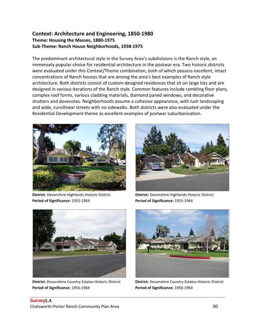
Context: Architecture and Engineering, 1850-1980 Theme: Housing the Masses, 1880-1975 Sub-Theme: Ranch House Neighborhoods, 1938-1975 The predominant architectural style in the Survey Area’s subdivisions is the Ranch style, an immensely popular choice for residential architecture in the postwar era. Two historic districts were evaluated under this Context/Theme combination, both of which possess excellent, intact concentrations of Ranch houses that are among the area’s best examples of Ranch style architecture. Both districts consist of custom-designed residences that sit on large lots and are designed in various iterations of the Ranch style. Common features include rambling floor plans, complex roof forms, various cladding materials, diamond paned windows, and decorative shutters and dovecotes. Neighborhoods assume a cohesive appearance, with lush landscaping and wide, curvilinear streets with no sidewalks. Both districts were also evaluated under the Residential Development theme as excellent examples of postwar suburbanization.
District: Devonshire Highlands Historic District District: Devonshire Highlands Historic District Period of Significance: 1955-1964 Period of Significance: 1955-1964
District: Devonshire Country Estates Historic District District: Devonshire Country Estates Historic District Period of Significance: 1956-1964 Period of Significance: 1956-1964
SurveyLA Chatsworth-Porter Ranch Community Plan Area 31
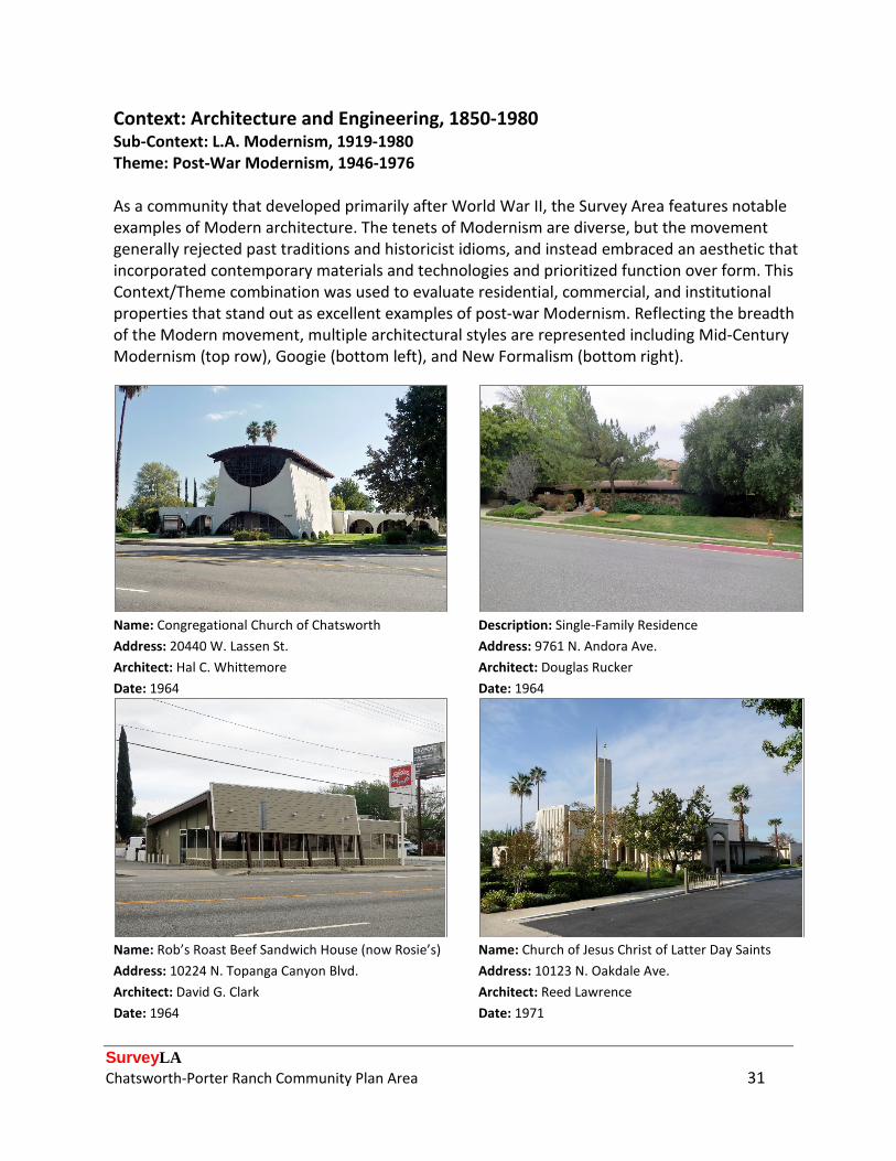
Context: Architecture and Engineering, 1850-1980 Sub-Context: L.A. Modernism, 1919-1980 Theme: Post-War Modernism, 1946-1976 As a community that developed primarily after World War II, the Survey Area features notable examples of Modern architecture. The tenets of Modernism are diverse, but the movement generally rejected past traditions and historicist idioms, and instead embraced an aesthetic that incorporated contemporary materials and technologies and prioritized function over form. This Context/Theme combination was used to evaluate residential, commercial, and institutional properties that stand out as excellent examples of post-war Modernism. Reflecting the breadth of the Modern movement, multiple architectural styles are represented including Mid-Century Modernism (top row), Googie (bottom left), and New Formalism (bottom right).
Name: Congregational Church of Chatsworth Description: Single-Family Residence Address: 20440 W. Lassen St. Address: 9761 N. Andora Ave. Architect: Hal C. Whittemore Architect: Douglas Rucker Date: 1964 Date: 1964
Name: Rob’s Roast Beef Sandwich House (now Rosie’s) Name: Church of Jesus Christ of Latter Day Saints Address: 10224 N. Topanga Canyon Blvd. Address: 10123 N. Oakdale Ave. Architect: David G. Clark Architect: Reed Lawrence Date: 1964 Date: 1971

SurveyLA Chatsworth-Porter Ranch Community Plan Area 32
Context: Architecture and Engineering, 1850-1980 Theme: Exotic Revivals, 1900-1980 Sub-Theme: Tiki/Polynesian, 1948-1969 Tiki/Polynesian architecture was introduced in the years after World War II, when soldiers who fought in the Pacific Theater returned home from battle. Its popularity was perpetuated by the release of motion pictures such as South Pacific and Hawaii’s admittance to the Union as the nation’s fiftieth state. Composed of an eclectic variety of stylistic elements that loosely drew upon Polynesian culture, the style was well-known for its kitsch value. This Context/Theme combination was used to evaluate three multi-family residential properties that exemplify Tiki/ Polynesian architecture and are rare, intact examples of the style. Common features include steeply-pitched roofs with slanted gables, exposed beams and ornamental rafter tails, wood cladding and screens, stylistic motifs including torches and tiki totems, and tropical landscaping.
Name: Kona Kai Village (recreation building) Name: Kona Kai Village (site planning features) Address: 8800 N. Eton Ave. Address: 8800 N. Eton Ave. Date: 1968 Date: 1968
Name: Stoney Point Apartments Name: Canoga Island Village Address: 10445 N. Canoga Ave. Address: 8838 N. Independence Ave. Date: 1964 Date: 1963
SurveyLA Chatsworth-Porter Ranch Community Plan Area 33
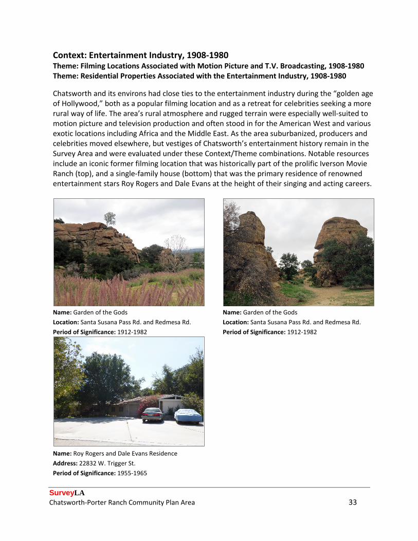
Context: Entertainment Industry, 1908-1980 Theme: Filming Locations Associated with Motion Picture and T.V. Broadcasting, 1908-1980 Theme: Residential Properties Associated with the Entertainment Industry, 1908-1980 Chatsworth and its environs had close ties to the entertainment industry during the “golden age of Hollywood,” both as a popular filming location and as a retreat for celebrities seeking a more rural way of life. The area’s rural atmosphere and rugged terrain were especially well-suited to motion picture and television production and often stood in for the American West and various exotic locations including Africa and the Middle East. As the area suburbanized, producers and celebrities moved elsewhere, but vestiges of Chatsworth’s entertainment history remain in the Survey Area and were evaluated under these Context/Theme combinations. Notable resources include an iconic former filming location that was historically part of the prolific Iverson Movie Ranch (top), and a single-family house (bottom) that was the primary residence of renowned entertainment stars Roy Rogers and Dale Evans at the height of their singing and acting careers.
Name: Garden of the Gods Name: Garden of the Gods Location: Santa Susana Pass Rd. and Redmesa Rd. Location: Santa Susana Pass Rd. and Redmesa Rd. Period of Significance: 1912-1982 Period of Significance: 1912-1982
Name: Roy Rogers and Dale Evans Residence Address: 22832 W. Trigger St. Period of Significance: 1955-1965

SurveyLA Chatsworth-Porter Ranch Community Plan Area 34
Context: Industrial Development, 1850-1980 Theme: Agricultural Roots, 1850-1965 Sub-Theme: Truck Farming and Local Markets, 1850-1945 A small section of the Survey Area falls within what was historically known as the Weeks Poultry Colony. Active between 1923 and 1934, the colony was a utopian agricultural community that was founded by visionary poultry farmer Charles Weeks and championed a new method of farming that was rooted in socialist ideals. The colony was composed of one-acre “ranchettes,” on which each property owner would erect a small house and raise chickens for egg production; the eggs were then sent to communal processing plants (no longer extant), where they were consolidated and prepared for sale and distribution. Three very rare, remaining examples of properties associated with the experimental colony were evaluated under this Context/Theme combination. While most of the ancillary structures that were used in egg production have been removed, each property retains its original house and its associated vernacular landscape.
Address: 19954 W. Chase St. Address: 20012 W. Chase St. Date: 1927 Date: 1926
Address: 20024 W. Chase St. Date: 1927

SurveyLA Chatsworth-Porter Ranch Community Plan Area 35
Context: Industrial Development, 1850-1980 Sub-Context: Manufacturing for the Masses, 1883-1989 Theme: Aviation and Aerospace, 1911-1989 Sub-Theme: Aerospace, 1946-1989 The Survey Area experienced a considerable amount of industrial development in the postwar era and became one of the San Fernando Valley’s main industrial and employment centers. A wide variety of industries located in the Chatsworth area, but those related to aerospace and civil defense played a particularly important role in the local economy and was among the area’s foremost employers. This Context/Theme combination was used to evaluate an industrial plant that originally served as the headquarters of Atomics International, a division of North American Aviation that played an instrumental role in the development of nuclear energy and technology.
Name: Atomics International Name: Atomics International Address: 8900 N. DeSoto Ave. Address: 8900 N. DeSoto Ave. Architect: Kenneth Neptune/A.C. Martin Associates Architect: Kenneth Neptune/A.C. Martin Associates Period of Significance: 1958-1983 Period of Significance: 1958-1983
SurveyLA Chatsworth-Porter Ranch Community Plan Area 36
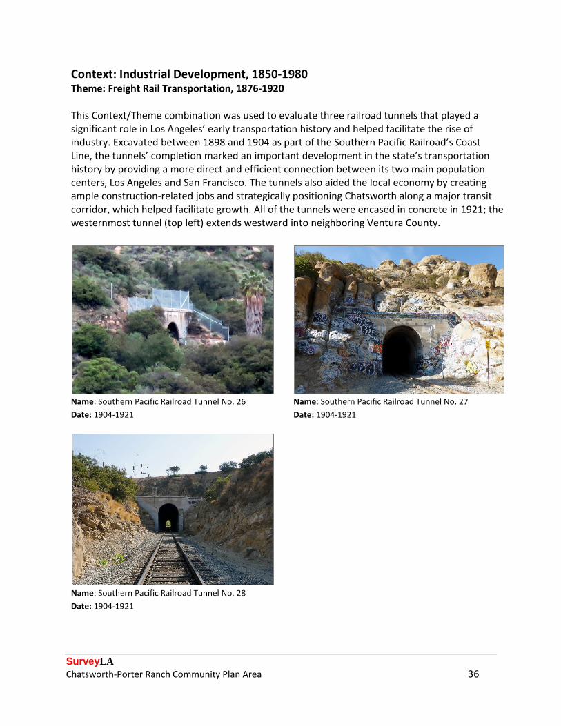
Context: Industrial Development, 1850-1980 Theme: Freight Rail Transportation, 1876-1920 This Context/Theme combination was used to evaluate three railroad tunnels that played a significant role in Los Angeles’ early transportation history and helped facilitate the rise of industry. Excavated between 1898 and 1904 as part of the Southern Pacific Railroad’s Coast Line, the tunnels’ completion marked an important development in the state’s transportation history by providing a more direct and efficient connection between its two main population centers, Los Angeles and San Francisco. The tunnels also aided the local economy by creating ample construction-related jobs and strategically positioning Chatsworth along a major transit corridor, which helped facilitate growth. All of the tunnels were encased in concrete in 1921; the westernmost tunnel (top left) extends westward into neighboring Ventura County.
Name: Southern Pacific Railroad Tunnel No. 26 Name: Southern Pacific Railroad Tunnel No. 27 Date: 1904-1921 Date: 1904-1921
Name: Southern Pacific Railroad Tunnel No. 28 Date: 1904-1921

SurveyLA Chatsworth-Porter Ranch Community Plan Area 37
Selected Bibliography Books and other published material: Bevil, Alexander D. “Santa Susana Pass State Historic Park Cultural Resources Inventory Historic
Overview.” Prepared for the California State Parks Southern Service Center. 2007.
“Chatsworth Celebrates 125 Years as an Anchor of the North San Fernando Valley.” Chatsworth/Porter Ranch Chamber of Commerce Business Directory 2013-2014.
Creason, Glen. Los Angeles in Maps. New York: Rizzoli International Publications, Inc., 2010.
England, Jerry. Reel Cowboys of the Santa Susanas. Chatsworth: ECHO Press, 2008.
Hise, Greg. Magnetic Los Angeles: Planning the Twentieth-Century Metropolis. Baltimore: The Johns Hopkins University Press, 1997.
Hoover, Mildred Brooke, et al. Historic Spots in California. Stanford: Stanford University Press, 1932.
Mulholland, Catherine. William Mulholland and the Rise of Los Angeles. Berkeley: University of California Press, 2000.
Roderick, Kevin. The San Fernando Valley: America’s Suburb. Los Angeles: Los Angeles Times Books, 2002.
San Fernando Valley: Then and Now. Salt Lake City: Gibbs Smith, 2003. “Twin Lakes Park: Home of the Mayan Village,” promotional pamphlet, n.d.
Vincent, Ann. “Chatsworth Railroad History.” Chatsworth Past and Present, February 2012.
Vincent, Ann. “The Stagecoach Trail.” Chatsworth Past and Present, March 2010.
Vincent, Ann, and Ray Vincent. “Chatsworth Park Quarry.” Chatsworth Past and Present, May 2014.
Wallach, Ruth, Dace Taube, Claude Zachary, Linda McCann, and Curtis C. Roseman. Los Angeles in World War II. Charleston, SC: Arcadia Publishing, 2011.
Wanamaker, Marc. San Fernando Valley. Charleston, SC: Arcadia Publishing, 2011.
Watson, Virginia. “Movie Personalities Lived in Chatsworth.” Chatsworth Past and Present, n.d.

SurveyLA Chatsworth-Porter Ranch Community Plan Area 38
Other repositories of maps, photographs, periodicals, and other materials:
California State Office of Historic Preservation. “Chatsworth Calera Site,” accessed November 2014. http://ohp.parks.ca.gov/ListedResources/Detail/911.
California State Parks. “Santa Susana Pass State Historic Park,” accessed February 2015. http://www.parks.ca.gov/pages/611/files/Santa%20Susana.pdf.
Chatsworth Historical Society. “Presentations,” accessed August 2014-February 2015. http://www.chatsworthhistory.com/Presentations.html.
Chatsworth Historical Society. “Timeline,” accessed August 2014-February 2015. http://www.chatsworthhistory.com/index.html.
Chatsworth Park Elementary School. “Our History,” accessed February 2015. https://chatsworth-lausd-ca.schoolloop.com/history.
Digital Sanborn Maps 1867-1970, Sanborn Fire Insurance Maps, accessed January 2015. http://sanborn.umi.com.ezproxy.lapl.org/.
England, Jerry. “A Drifting Cowboy.” Online blog, accessed August 2014-February 2015. http://a-drifting-cowboy.blogspot.com/.
“Jerry England and Echo Press, Chatsworth, CA,” accessed August 2014 - February 2015. http://www.cowboyup.com/.
Los Angeles County Department of Public Works. Tract Maps, accessed January 2015. http://dpw.lacounty.gov/sur/surveyrecord/tractMain.cfm.
Los Angeles Public Library, California Index, accessed January 2015. http://www.lapl.org/collections-resources/visual-collections/california-index.
Los Angeles Public Library Photographic Collection, Historic Photographs, accessed January 2015. http://photos.lapl.org/carlweb/jsp/photosearch_pageADV.jsp.
Los Angeles Times. “Mapping L.A,” accessed January 2015. http://projects.latimes.com/mapping-la/neighborhoods.
Museum of the San Fernando Valley, accessed August 2014 – February 2015. http://www.themuseumsfv.org/.
National Park Service. “About the Homestead Act,” accessed November 2014. http://www.nps.gov/home/historyculture/abouthomesteadactlaw.htm.
SurveyLA Chatsworth-Porter Ranch Community Plan Area 39
Oviatt Library Digital Collections, accessed August 2014 – February 2015. http://digital-library.csun.edu/.
“Plat of the Lands of B.F. Porter Estate,” accessed February 2015. http://www.raremaps.com/gallery/detail/29883/Plat_of_the_Lands_of_BF_Porter_Estate_NW_Portion_of_Ro_Ex_Mission_San/Southern%20Pacific%20Railroad%20Company.html.
ProQuest Newsstand, Historical Los Angeles Times, accessed August 2014 – February 2015. http://search.proquest.com.ezproxy.lapl.org/.
UCLA Digital Collections, Los Angeles Times Photograph Collection, accessed 2014. http://digital2.library.ucla.edu/.
USC Digital Library, California Historical Society, accessed 2014. http://digitallibrary.usc.edu/search/controller/index.htm.
USC Digital Library, Whittington Photographs, accessed 2014. http://digitallibrary.usc.edu/search/controller/index.htm.
Water and Power Associates. “Early Views of the San Fernando Valley,” accessed August 2014 – February 2015. http://waterandpower.org/museum/Early_Views_of_the_San_Fernando_Valley.html.
“Why Corriganville and the Iverson Movie Ranch Will Never Be the Same,” accessed February 2015. http://iversonmovieranch.blogspot.com/2013/04/why-corriganville-and-iverson-will.html.