historic property potentials - city of ames
TRANSCRIPT
4-1
4
HISTORIC PROPERTY POTENTIALS INTRODUCTION The City of Ames possesses a wealth of historic properties with preservation potential. This chapter explains which of them have been identified in Ames to date. The National Register of Historic Places, a program established within the National Park Service of the U.S. Department of the Interior in 1966, provides the most widely employed method for identification and registration of historically significant property. This chapter is divided into the following sections:
Survey Official Historic Properties Potential Historic Districts
Historic resources are preserved through a three-fold process of survey (or identification), official recognition, and preservation. The first subsection outlines the survey this process. The second subsection discusses properties already officially recognized in Ames. Preservation, the third in this triad, occurs in many ways. Some of them are outlined in Chapter 5. Much of the information in this chapter is taken directly from previous survey work in Ames. References at the end of the various subsections refer the reader to those documents if further information about the properties is desired. The discussion of these potential historic districts and other properties in this chapter suggest opportunities available for the Ames community. Others await discovery. SURVEY The identification of historical, architectural, and archaeological resources in Ames results from historical and architectural surveys evaluating their significance. The City of Ames coordinates these surveys with the State Historical Society of Iowa. Other survey reports, prepared by private property owners or other interested parties, augment this database. The identification of historical, architectural, and archaeological resources in Ames results from historical and architectural surveys evaluating their significance. The City of Ames coordinates these surveys with the State Historical Society of Iowa. Other survey reports, prepared by private property owners or other interested parties, augment this database.

4-2
A variety of survey formats are available to target specific survey needs according to the criteria outlined in Chapter 3. These formats range from the windshield survey, reconnaissance survey, and intensive survey. Each yields a different level of information about the property type in question. A variety of survey formats are available to target specific survey needs. These formats range from the windshield survey, reconnaissance survey, and intensive survey. Each yields a different level of information about the property type in question. The windshield survey is the quickest and most cursory type of these surveys. Sometimes called a pedestrian survey, this brief examination includes a visual examination of an area and recommendations for future survey work. For example: “Many late-19th century buildings remain intact with good integrity, warranting additional survey.” Or: “The area has been virtually redeveloped with few historic buildings remaining.” A reconnaissance survey examines, in preliminary fashion, the potential of a subject area. The “recon” survey identifies and sketches in a preliminary fashion the appropriate historic contexts that might lead to the understanding the area’s history. An Iowa Site Inventory Form is completed for a selected number of properties in the area, chosen to convey a sense of the area’s resources. Finally, the reconnaissance survey recommends a future course of action to treat the area’s potential. Such a recommendation might advise an intensive survey of the area in question or might determine that no further survey action is necessary. It is helpful if the geographic range of a reconnaissance survey is broad. Its recommendations can include a more precisely defined area for an intensive survey, if such potential exists. An intensive survey examines the history and architectural heritage of a defined geographic area, creates an extensive discussion of its historic context, completes Iowa Site Inventory Forms for each property within it, and evaluates the area’s potential for nomination to the National Register of Historic Places using that program’s criteria for significance. Typically, the completion of an intensive survey predates the preparation of a National Register application for the area. OFFICIALLY DESIGNATED HISTORIC PROPERTY Ames currently possesses a variety of federally registered and locally designated historic properties. “Registered” refers to properties listed on the National Register of Historic Places by the U.S. Department of the Interior, National Park Service, upon nomination by the State Historical Society of Iowa. Federally registered properties can be listed as historic districts or as individual resources. “Locally designated” refers to a status conferred upon eligible properties by the City of Ames with review and comment by the State Historical Society of Iowa. This status can be conferred upon historic districts or landmarks. Local historic districts and local landmarks substantially differ in regulation from National Register-listed properties. (See Chapter 2.) Federal and local designations are not mutually exclusive. A property can, and often is, eligible for both designations at the same time. Only one criterion of significance is all that is required for either of these two types of designation. National Register Historic Districts At the present time the following two historic districts in Ames are listed on the National Register of Historic Places:

4-3
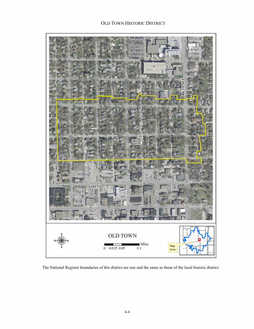
Old Town Historic District
Location From 7th to 9th between Duff & Clark
Date of Designation 1989 (Local Historic District)
Date of Listing January 2, 2004 (National Register of Historic Places)
Significance Criterion A: Community Planning & Development Transportation Education
Criterion C: Architecture Landscape Architecture
Reference Local District Application 1988 (Wirth) Intensive Survey 2003 (Page) NRHP Nomination 2003 (Page)
4-4
OLD TOWN HISTORIC DISTRICT
The National Register boundaries of this district are one and the same as those of the local historic district.

4-5
Bandshell Park Historic District
Location Between Duff, E. 5th, Carroll, & E. 6th
Date of Listing October 7, 1999
Significance Criterion A: Entertainment/Recreation
Criterion C: Architecture
Reference NRHP Nomination 1999 (Page)

4-6
BANDSHELL PARK HISTORIC DISTRICT

4-7
National Register Individual Property Appendix 5 of this report contains a complete list of individual properties presently National Register-listed in Ames. Local Historic District The City of Ames, enabled through legislation by the General Assembly of Iowa, has the power to designate local historic districts. The State Historical Society of Iowa has a review and comment authority during the designation process. A historic preservation commission is established to administer the local historic district with projects reviewed using design guidelines as evaluation criteria. Local historic districts include a zoning overlay with a design review process. Major physical alterations to properties within the local historic district must first obtain a Certificate of Appropriateness, granted in Ames by the Ames Historic District Commission, before a building permit for the project can be issued. This design review process protects the local historic district from inappropriate alterations to its historic integrity. The design guidelines for this process are contained in Chapter 31 of the Ames Municipal Code. (See Appendix 2.) The City of Ames designated the Old Town Historic District as a local historic district in 1988. Currently, this is the only locally designated historic district in the city. Local historic districts and National Register historic districts are not mutually exclusive. The Old Town Historic District is both a federally listed and locally designated property. Usually, properties become National Register districts and subsequently apply for local designation. With Old Town, this process was reversed. When the National Register nomination was prepared in 1999, the district’s boundaries were carefully drawn to coincide with those of the local district to promote consistency and avoid confusion. Local Landmarks The City of Ames, enabled through legislation by the General Assembly of Iowa, has the power to designate local landmarks as well as local historic districts. The State Historical Society of Iowa has the same review and comment authority with local landmarks as with local historic districts. The local landmark designation brings with it a zoning overlay similar to that covering a local historic district. A design review process is required to obtain a Certificate of Appropriateness for major physical alterations before a building permit can be issued for the project. The design guidelines for this process are contained in Chapter 31 of the Ames Municipal Code. (See Appendix 2.) To date, the City of Ames has designated the following two local landmarks. One of them is also National Register-listed.
4-8
Ames Municipal Building
Location 420 Kellogg Ave.
Date of Local NEED Landmark Designation
Date of N.R. Listing June 2, 1997
Significance Criterion A: Government Criterion C: Architecture
Reference NRHP Nomination 1997 (Page) Local Landmark Application 20NEED (NEED)
Following the relocation of the Ames city hall from this building, discussion ensued as to its future use. Youth and Shelter Services, Inc. (YSS), a Central Iowa social services agency, expressed interest in its purchase. The City of Ames agreed to this sale if YSS would agree to the building’s designation as a local landmark, thus ensuring that the building’s conversion to this new use would not negatively impact its integrity. Archie and Nancy Martin House
Location 218 Lincoln Way
Date of Local December 12, 2007 Landmark Designation
Significance Criterion A: NEED Criterion C: Architecture
Reference Local Landmark Application 20007
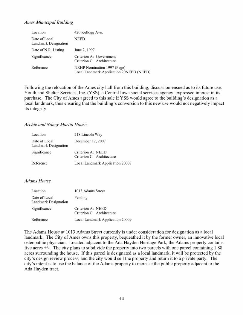
Adams House
Location 1013 Adams Street
Date of Local Pending Landmark Designation
Significance Criterion A: NEED Criterion C: Architecture
Reference Local Landmark Application 20009
The Adams House at 1013 Adams Street currently is under consideration for designation as a local landmark. The City of Ames owns this property, bequeathed it by the former owner, an innovative local osteopathic physician. Located adjacent to the Ada Hayden Heritage Park, the Adams property contains five acres +/-. The city plans to subdivide the property into two parcels with one parcel containing 1.88 acres surrounding the house. If this parcel is designated as a local landmark, it will be protected by the city’s design review process, and the city would sell the property and return it to a private party. The city’s intent is to use the balance of the Adams property to increase the public property adjacent to the Ada Hayden tract.

4-9
ADAMS HOUSE
Current city planning has the entire Adams property designated as a local landmark with the area shown in the dashed lines to be sold off and the balance of the property used in conjunction with the parkland to the north. This designation will provide
protection to both parcels of the property.
4-10
POTENTIAL HISTORIC DISTRICTS Over the last quarter century, a series of cultural resources surveys have identified numerous potential historic districts in Ames. These districts include commercial, governmental, educational, residential, and mixed-use properties. The following paragraphs summarize the results of these surveys and recommend planning activities to promote their preservation. Iowa State University Survey 1980 H. Summerfield Day, the former University Architect and Planning Coordinator, published in 1980 a report entitled “The Iowa State University Campus and Its Buildings, 1859-1979.” Although not specifically stated as such, the Summerfield survey demonstrated that the main campus of Iowa State University possessed potential for nomination to the National Register as an historic district. Already interest existed on the campus for historic preservation, as evidenced by the 1966 nomination of the Knapp-Wilson House to the National Register. The interest generated at the university from this and other historic research such as Day’s resulted in the nomination of the Marston Water Tower Hall to the National Register in 1982. Other property nominations followed, including Engineering Hall (1983), Agriculture Hall (1985), Christian Petersen Courtyard Sculptures and Dairy Industry Building (1987), Morrill Hall (1996), and Alumni Hall (2002). The university administration tends to view the preservation of historic resources on the campus in mixed fashion. When initially recalcitrant, the force of public opinion can change this point of view, often resulting in preservation projects of superior quality, such as the rehabilitations of Morrill Hall and Agricultural Hall (Botany Hall, Carrie Chapman Catt Hall). Because the City of Ames and the Ames Historic Preservation Commission have no jurisdiction over Iowa State University, preservation activities must originate from within that institution. In addition to the university’s main campus, its College of Veterinarian Medicine, whose campus is situated to the southeast, is also likely National Register eligible, the 1987 listing of the Christian Petersen Courtyard Sculptures and Dairy Industry Building in 1987 being indicative.

4-11
IOWA STATE UNIVERSITY CAMPUS
4-12
Surveys 1992 In 1992, the City of Ames completed an intensive survey of the Ames Central Business District and a reconnaissance survey of the 1943 incorporated limits of the City of Ames. William C. Page, Public Historian, conducted those surveys. The following paragraphs summarize their results and recommend treatment to preserve those properties. Central Business District
Location Both sides of Main & 5th between Duff & several properties west of Clark
Date of Plat 1865
Significance Criterion A: Commerce Criterion C: Architecture
Reference Intensive Survey 1992 (Page)
Recommendation NRHP Nomination
The development of commerce in downtown Ames is historically significant because it calls attention to the growing interconnections between Iowa State as an institution and the people of Ames as a city. The downtown is architecturally significant because of its radical remodeling in the 1920s through the 1950s. Under the influence of the Commercial Style of architecture, many owners stripped the Victorian facades off their Main Street commercial properties and replaced them with simplified, efficient, and no-nonsense designs. This transformation was nearly universal and resulted in a distinctive downtown. (Page 1992: I/4-5)
4-13
CENTRAL BUSINESS DISTRICT
4-14
College Park Addition
Location Between Lincoln Way & Fourth St. west of Grand to 3 Lots beyond Hazel St.
Date of Plat 1893
Significance Criterion A: Community Planning & Development
Status Reconnaissance Survey 1992 (Page)
Recommendation Continued Research
The College Park Addition plat was laid out by H. W. Bean, surveyor of Greene County, Iowa, and filed in the public record in 1893. The purpose behind the plat appears to have been the desire to realize a profit on land owned by the proprietors in proximity to a new streetcar line, inaugurated by the Ames and College Railroad between the I.S.C. campus and downtown Ames. Development of the area, however, proceeded slowly. Many of the houses appear to date from the 1920s. The character of College Park Addition is residential. Single-family dwellings predominate. College Park Addition has the feeling of a working class neighborhood. Homes are mostly small in scale and utilitarian in design. There are many houses showing the influence of bungalow and craftsman design. The use of stucco is pronounced. The fact that the neighborhood required so many years to develop suggests that the plat’s original intent lacked resonance in the community, diminishing the plat’s significance as an early streetcar suburb. Today, the southeast portion of the plat is zoned as Highway-Oriented Commercial and has been redeveloped to that land use.

4-15
COLLEGE PARK ADDITION

4-16
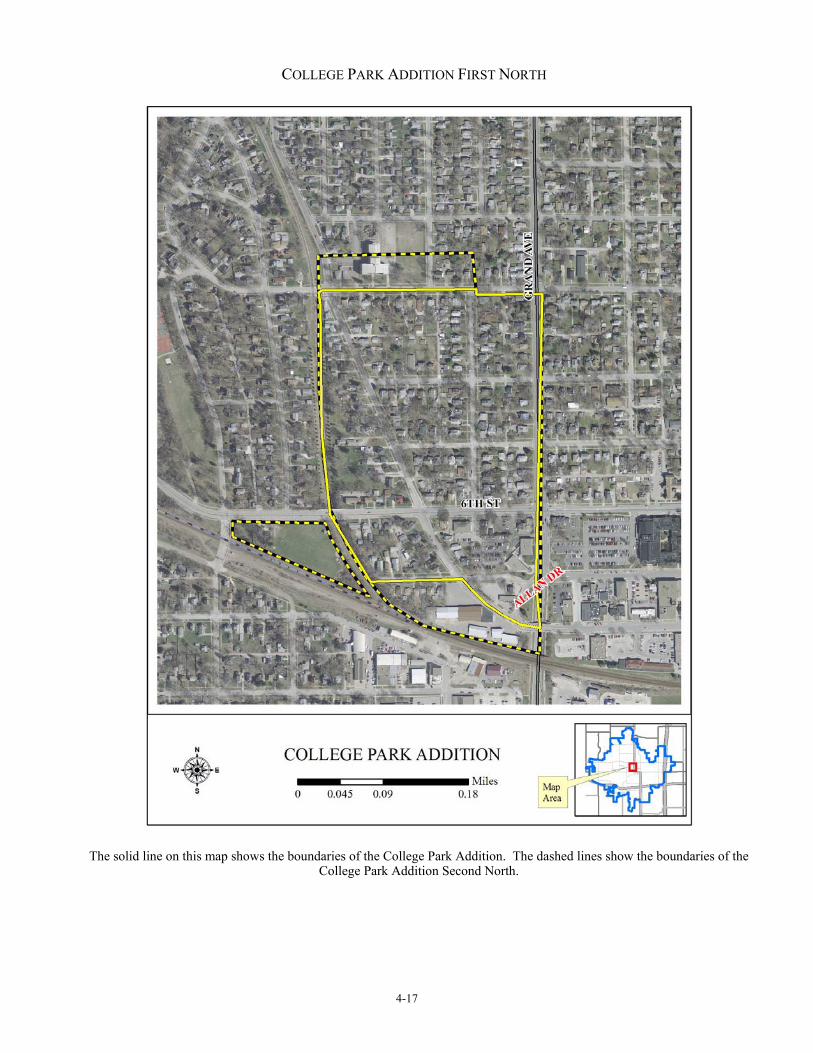
College Park Addition First North
Location Railroad tracks on west; 5th St. on south; Grand Ave. on east; 9th St. on north
Date of Plat 1900
Significance Criterion A: Community Planning & Development Criterion C: Architecture
Status Reconnaissance Survey 1992 (Page)
Recommendation Intensive Survey of College Park Addition First North in conjunction with College Park Addition Second North (see below)
Platted in 1900 as a streetcar suburb, College Park Addition First North was laid out by H. Y. Ludwig. Development of the addition was led by J. L. Stevens and G. D. Rowe, both of Boone, Iowa, and William D. Hodge of Wright County, Iowa, along with other Story County investors. This development was restricted to land surveying and platting. The upbuilding of College Park Addition First North required a number of years. A concentration of new construction occurred following World War I and in the 1920s. Hodge Avenue became known popularly as “Professors’ Lane” because of the many college faculty and their families attracted to the area. The character of College Park Addition First North is residential. Although both single-family and multiple-family dwellings were built in the area, the single-family homes dominate. A row house (or triplex) standing on Northwestern Avenue is an outstanding and rare example of this architectural form in Ames. A number of duplexes are also located in the neighborhood. Difficult to identify because they blend, by design, into the neighborhood, these resources are interesting in themselves as a property type. Homes in the neighborhood are either 1- or 2-story. They are mostly frame. Houses exhibit a variety of stylistic influences, including many with bungalow and craftsman characteristics. College Park Addition First North is historically significant because it calls attention to the expansion of Iowa State College and the City of Ames following World War I. An intensive survey of the neighborhood should be undertaken to determine its potential for nomination to the National Register as an historic district. Residents along Hodge Avenue and adjacent streets have formed a neighborhood organization, and this organization could act as an advocate for such action. At some future time, these residents might wish to consider the designation of the neighborhood as a local historic district and receive the protection this overlay confers on real estate.
4-17
COLLEGE PARK ADDITION FIRST NORTH
The solid line on this map shows the boundaries of the College Park Addition. The dashed lines show the boundaries of the
College Park Addition Second North.

4-18
College Park Addition Second North
Location Railroad tracks on west; 5th St. on south; Grand Ave. on east; a little above 9th St. on north Railroad tracks on south & west; 5th St. on north; Grand Ave. on east Date of Plat 1907
Significance Criterion A: Community Planning & Development Criterion C: Architecture
Status No survey to date
Recommendation Intensive Survey of College Park Addition Second North in conjunction with College Park Addition First North (see above)
Platted in 1907 as a streetcar suburb, College Park Addition Second North was laid out by NEED. This plat expanded the plat of College Park Addition First North with the addition of two parcels of land. One parcel lies to the south of the first addition, and one parcel lies to the north of it.

4-19
COLLEGE PARK ADDITION SECOND NORTH
The solid line on this map shows the boundaries of the College Park Addition. The dashed lines show the boundaries of the
College Park Addition Second North.

4-20
Chautauqua Park Addition
Location East of Squaw Creek between 6th and 9th & Railroad Tracks
Date of Plat 1910
Significance Criterion A: Community Planning & Development Criterion C: Architecture
Status Reconnaissance Survey 1992 (Page)
Recommendation Intensive Survey
Chautauqua Park Addition is a good example of an early 20th century automobile suburb in Ames. Building lots in the plat sold quickly to many of Ames professional people who actually built homes there rather than purchasing them as investments. The decision by Mrs. William N. Beardshear, the widow of Iowa State College’s beloved president, to build a home at 714 Brookridge Avenue added luster to the area. Craftsman and Tudor Revival influences prevail. The layout of the plat exploited the natural terrain of the area. The plat included a footbridge across Squaw Creek to link the neighborhood and the college campus.

4-21
CHAUTAUQUA PARK ADDITION
4-22
Ridgewood [First] Addition
Location East of Squaw Creek between 9th and 13th & Railroad Tracks
Date of Plat 1916
Significance Criterion A: Community Planning & Development Criterion C: Architecture Criterion C: Landscape Architecture
Status Reconnaissance Survey 1992 (Page)
Recommendation Intensive Survey H. R. Green, a civil engineer based in Cedar Rapids, Iowa, laid out the Ridgewood [First] Addition in 1916. It included Lot 1 in the Oak Park Addition, a tract laid out by John L. Stevens in 1909 but undeveloped and subsequently replatted within the Ridgewood [First] Addition. Green’s design for the addition includes curvilinear streets reflecting the area’s topography, deep backyards adjacent to Squaw Creek, a public walk from Ridgewood Avenue to the creek, and a footbridge over it. Out Lot A of this plat became a public park in 1932.
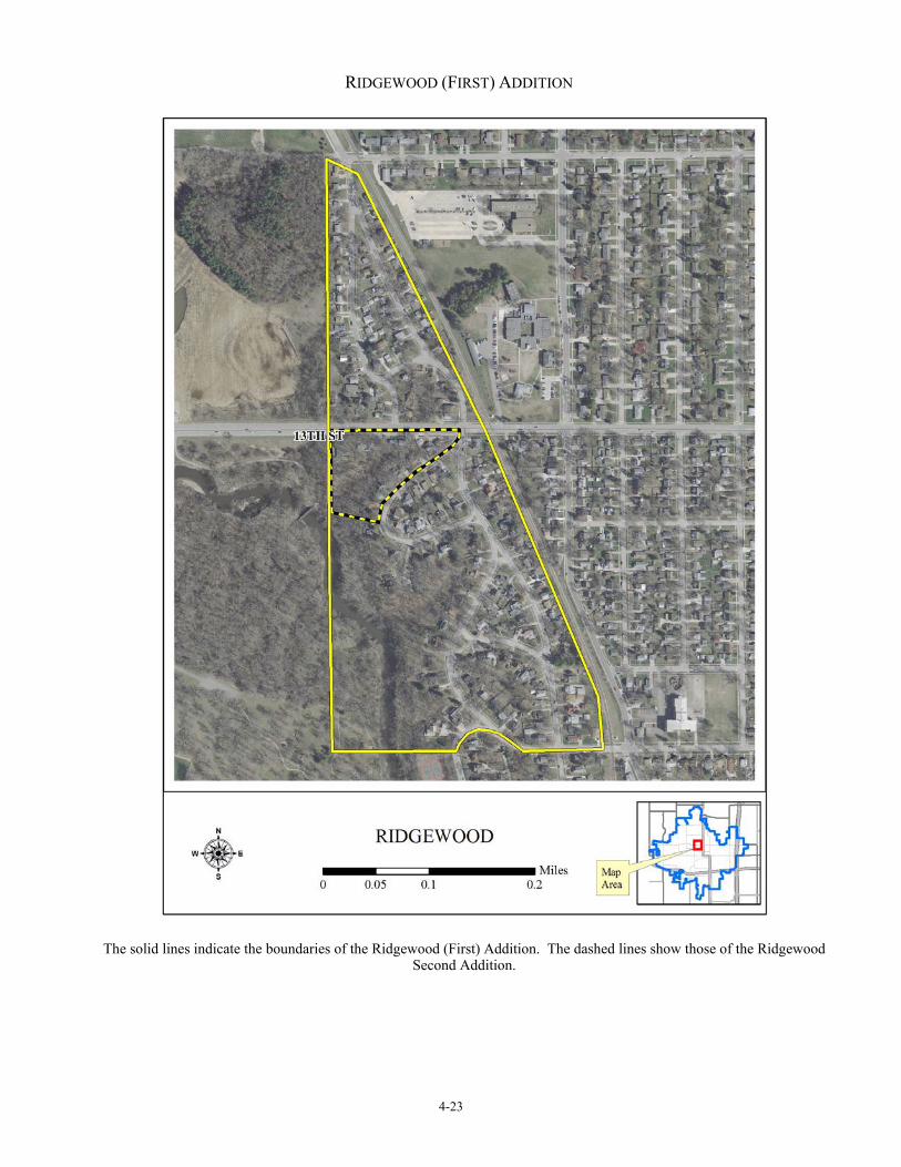
4-23
RIDGEWOOD (FIRST) ADDITION
The solid lines indicate the boundaries of the Ridgewood (First) Addition. The dashed lines show those of the Ridgewood
Second Addition.
4-24
Ridgewood Second Addition
Location Between 13th, Railroad Tracks & a Quarter Section Line
Date of Plat 1923
Significance Criterion A: Community Planning & Development Criterion C: Architecture Criterion C: Landscape Architecture
Status Reconnaissance Survey 1992 (Page)
Recommendation Possible Intensive Survey
The McGregor Subdivision Company platted this land in 1923 as the Ridgewood Second Addition. The plat included and reconfigured Out Lot B in the Ridgewood [First] Addition. H. R. Green, the civil engineer of Cedar Rapids, Iowa, who had laid out the Ridgewood Addition, might have platted this second addition as well, although the second addition’s plat, on file in the Story Country Recorder’s Office, does not mention his name and its graphic design lacks the earlier one’s elegance. Regardless of its source, the plat for the Ridgewood Second Addition echoes the curvilinear street layouts of its sister plat to the south. In other respects, Ridgewood Second is less pretentious in intent. The building lots in the second addition lack the large sizes found in the first. The character of Ridgewood Second Addition is residential. Homes in the neighborhood are either 1- or 2-story and are almost universally single-family dwellings. Houses in the neighborhood exhibit a variety of stylistic influences with many modest examples of simplified ranch style. Most buildings in the area appear to have been constructed after World War II. The neighborhood was conceived in conjunction with other plats situated along the eastern ridge above Squaw Creek and designed to benefit from the topographical beauty of the area. Although the Ridgewood Second Addition was platted prior to World War I as an early automobile suburb, the area was slow to develop. As a result, it projects the image of later vintage. In this respect, the plat calls attention to the growth of Ames during the mid-20th century. The plat might possess architectural significance in calling attention to the variety of stylistic influences over the design of its houses.
4-25
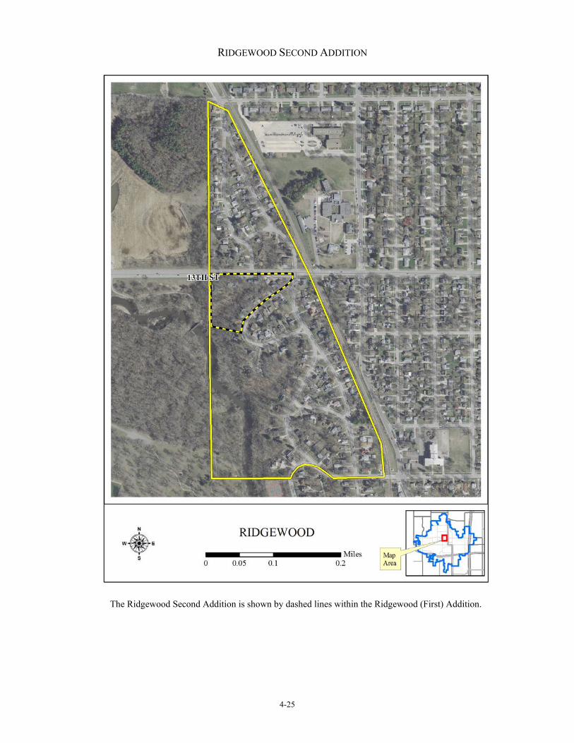
RIDGEWOOD SECOND ADDITION
The Ridgewood Second Addition is shown by dashed lines within the Ridgewood (First) Addition.

4-26
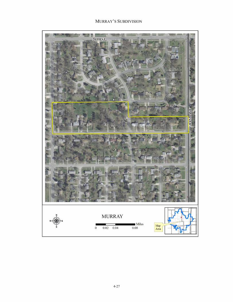
Murray’s Subdivision
Location North side of Murray Dr. between Grand & Northwestern
Date of Plat 1927, 1938 (replat)
Significance Criterion A: Community Planning & Development Criterion B: Charles B. Murray Criterion C: Architecture
Status Reconnaissance Survey 1992 (Page)
Recommendation Intensive Survey
This plat consists of 17 lots and typifies the small suburban subdivisions platted in Ames during the 1920s. Deep backyards characterize this plat offering generous space for homeowners to garden. Charles B. Murray, in conjunction with C. O. Egemo and Marie Egemo, platted this area in 1927. The plat was laid out by J. Q. Wickham, City Engineer of Ames. The southern boundary of Murray’s Subdivision abutted the north corporation line of the City of Ames so that, when platted, the subdivision was unincorporated. In 1938, Murray, the Egemos, and two other families replatted the area. Known as the Replat of Murray’s Subdivision, this plan was a somewhat scaled down version of the 1927 layout. Restrictive covenants had been attached to this land before Murray and the Egemos acquired it. In the warranty deed, which transferred its title from Mr. and Mrs. W. H. Van Duzer (and others) to them in 1917, the new owners covenanted “not to build or construct nor will we permit or allow any other person, persons, firm, company or corporation to build or construct. . . any barn or out buildings within 150 feet nor any dwelling within 75 feet of the west line of the street or public highway known as Grand avenue which passes along the east side of the above described premises, nor will be build [sic] or permit any dwelling to be built on said premises which costs less than $2,000.00” (Story County Recorder’s Office, Town Lot Deed Record Book: 73) This restrictive covenant promoted uniform development of the neighborhood. Homes in the neighborhood are either 1- or 2-story, mostly of frame construction, and of simple design. Charles B. Murray was the treasurer of Iowa State College. It is unclear if he and his family ever lived in the subdivision, and it appears that the plat was a real estate investment for Murray. Murray’s Subdivision (and the subsequent replat) is significant under National Register A because it calls attention to the rise of the automobile suburb in Ames and the growing use of restrictive covenants as a tool to protect property owners and their investments. Although restrictive covenants were widely used in metropolitan areas, restrictive covenants were more infrequently employed in smaller communities. Murray’s Subdivision is yet more unusual, in this respect, because the property was rural and unincorporated at the time. The neighborhood is additionally significant, under Criterion A, because it calls attention to Charles B. Murray, his association with Iowa State, and how that institution’s administration participated in the upbuilding of residential subdivisions in Ames, and, possibly under Criterion C, because of its architectural design.
4-27
MURRAY’S SUBDIVISION

4-28
Ames Civic Center
Location 5th St. between Clark & Carroll
Date of Plat 1865
Significance Criterion A: Community Planning & Development Criterion C: Architecture Criterion C: Landscape Architecture
Status Reconnaissance Survey 1992 (Page)
Recommendation Intensive Survey
A civic center emerged in Ames during the Victorian period as an organic expression of town building activity. The center is situated along the 5th Street corridor between the town’s central business district and one of its residential districts to the north. Properties along this corridor evolved in mixed land use. They included public and semi-public property with government, education, religious, and social functions. The following table indicates this mixed land use: Note that properties already listed on the National Register anchor this potential historic district—the Ames High School on the west and Bandshell Park Historic District on the east. The Ames Public Library is currently under consideration for individual National Register nomination. A few historic resources in this civic center are nonextant. During the early 20th century, some metropolitan areas in Iowa, such as Des Moines and Davenport, planned and implemented civic centers as conscious expressions of local pride. The Ames Civic Center calls attention to an earlier impulse in town building. As communities expanded in Iowa during the Victorian period, local leaders often chose transitional areas between commercial and residential sections of the community as the sites for the erection of churches, schools, and other types of public and semi-public facilities. These transitional areas usually formed a corridor along one or more streets stretching for several or more blocks in either direction. The public and semi-public property types in these civic centers rarely stood check-to-jowl exclusively along the corridor. Their sites were usually punctuated by other land use. In spite of this blending, an overall sense of an intended civic purpose prevailed in many of them. The Ames Civic Center is an excellent and representative example of such organic evolution. Ascension Lutheran Church at 621 Kellogg Avenue is located beyond the likely district boundaries of the Ames Civic Center, but the church might be individually eligible for nomination to the National Register because of its architectural design. This building’s site locates it within the general transitional corridor along 5th Street.

4-29
AMES CIVIC CENTER
The “bubble” shows the approximate boundaries of the Ames Civic Center. The dashed lines on the west shown of location
of the Ames High School and the dashed lines of the east show that of the Bandshell Park Historic District. Both of these properties are already National Register listed.
4-30
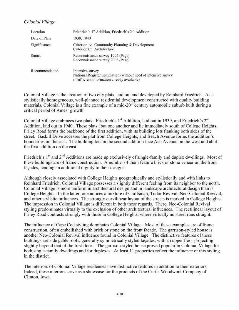
Colonial Village
Location Friedrich’s 1st Addition, Friedrich’s 2nd Addition
Date of Plats 1939, 1940
Significance Criterion A: Community Planning & Development Criterion C: Architecture
Status Reconnaissance survey 1992 (Page) Reconnaissance survey 2003 (Page)
Recommendation Intensive survey National Register nomination (without need of intensive survey if sufficient information already available)
Colonial Village is the creation of two city plats, laid out and developed by Reinhard Friedrich. As a stylistically homogeneous, well-planned residential development constructed with quality building materials, Colonial Village is a fine example of a mid-20th century automobile suburb built during a critical period of Ames’ growth. Colonial Village embraces two plats: Friedrich’s 1st Addition, laid out in 1939, and Friedrich’s 2nd Addition, laid out in 1940. These plats abut one another and lie immediately south of College Heights. Friley Road forms the backbone of the first addition, with its building lots flanking both sides of the street. Gaskill Drive accesses the plat from College Heights, and Beach Avenue forms the addition’s boundaries on the east. The building lots in the second addition face Ash Avenue on the west and abut the first addition on the east. Friedrich’s 1st and 2nd Additions are made up exclusively of single-family and duplex dwellings. Most of these buildings are of frame construction. A number of them feature brick or stone veneer on the front façades, lending an additional dignity to their designs. Although closely associated with College Heights geographically and stylistically and with links to Reinhard Friedrich, Colonial Village possesses a slightly different feeling from its neighbor to the north. Colonial Village is more uniform in architectural design and in landscape architectural design than is College Heights. In the latter, one notices a mixture of Craftsman, Tudor Revival, Neo-Colonial Revival, and other stylistic influences. The strongly curvilinear layout of the streets is marked in College Heights. The impression in Colonial Village is different in both these regards. There, Neo-Colonial Revival styling predominates virtually to the exclusion of other architectural influences. The rectilinear layout of Friley Road contrasts strongly with those in College Heights, where virtually no street runs straight. The influence of Cape Cod styling dominates Colonial Village. Most of these examples are of frame construction, often embellished with brick or stone on the front façade. The garrison-styled house is another Neo-Colonial Revival influence found in Colonial Village. The distinctive features of these buildings are side gable roofs, generally symmetrically styled façades, with an upper floor projecting slightly beyond that of the first floor. The garrison-styled house proved popular in Colonial Village for both single-family dwellings and for duplexes. At least 11 properties reflect the influence of this styling in the district. The interiors of Colonial Village residences have distinctive features in addition to their exteriors. Indeed, these interiors serve as a showcase for the products of the Curtis Woodwork Company of Clinton, Iowa.

4-31
Colonial Village is a strong candidate for nomination to the National Register of Historic Places as an historic district, under Criterion C. The district features a fine collection of Neo-Colonial Revival designs. Many of them are likely from published sources. Developed during the late 1930s through the 1950s, the district’s integrity is high with few intrusions. Properties have been well maintained. The small geographic size of Colonial Village would make this a relatively easy project. It is said that residents have already completed extensive research into the neighborhood’s construction and development.

4-32
COLONIAL VILLAGE
Map forthcoming.

4-33
Ames Municipal Cemetery
Location East of Crawford Ave. above 7th St. Date of Plats 1878, 1917, 1929, etc.
Significance Criterion C: Landscape Architecture
Status Reconnaissance Survey 1992 (Page)
Recommendation Intensive survey
Planned by landscape architect A. N. Carpenter of Galesburg, Illinois, the Ames City Cemetery is significant as a designed historic landscape. The cemetery calls attention to the Victorian concept of cemeteries as parks and how that concept was implemented locally in Ames. Originally, the cemetery was owned and managed by the Ames Cemetery Association. The City of Ames later acquired this property and has expanded it over the years. National Register Criteria Considerations D applies to this property because of its function as a cemetery. This consideration likely is satisfied because of the property’s landscape design.

4-34
AMES MUNICIPAL CEMETERY
Map forthcoming.

4-35
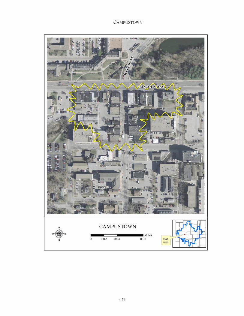
Survey 2007 A reconnaissance survey, completed in 2007 and entitled Fourth Ward: Ames, Iowa, identified the following resources as potential historic districts. Campustown
Location South side of Lincoln Way between Beach & Sheldon & property adjacent to Hayward, Welch, Stanton, & Lynn north of Chamberlain
Date of Plats Various, late19th & early 20th century
Significance Criterion A: Community Planning & Development Criterion A: Commerce Criterion C: Architecture
Status Pedestrian survey 2007 (Page)
Recommendation Intensive survey
Campustown began its evolution as the most fully developed commercial node in West Ames during the early 20th century. By the 1920, Campustown had far surpassed the West Gate commercial node importance and even challenged downtown Ames with some of its retail and service offerings. Following World War II, the rise of the automobile, and the development of strip malls, business in Campustown declined. Today the area awaits its rediscovery as a vital element in the Ames community.
4-36
CAMPUSTOWN
4-37
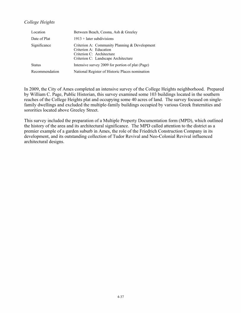
College Heights
Location Between Beach, Cessna, Ash & Greeley
Date of Plat 1913 + later subdivisions
Significance Criterion A: Community Planning & Development Criterion A: Education Criterion C: Architecture Criterion C: Landscape Architecture
Status Intensive survey 2009 for portion of plat (Page)
Recommendation National Register of Historic Places nomination
In 2009, the City of Ames completed an intensive survey of the College Heights neighborhood. Prepared by William C. Page, Public Historian, this survey examined some 103 buildings located in the southern reaches of the College Heights plat and occupying some 40 acres of land. The survey focused on single-family dwellings and excluded the multiple-family buildings occupied by various Greek fraternities and sororities located above Greeley Street. This survey included the preparation of a Multiple Property Documentation form (MPD), which outlined the history of the area and its architectural significance. The MPD called attention to the district as a premier example of a garden suburb in Ames, the role of the Friedrich Construction Company in its development, and its outstanding collection of Tudor Revival and Neo-Colonial Revival influenced architectural designs.

4-38
COLLEGE HEIGHTS

4-39
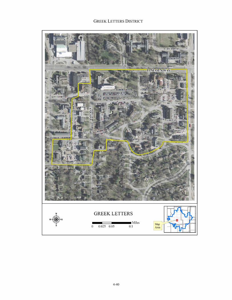
Greek Letters District
Location Between Lincoln Way, Beach, Greeley, & Ash
Date of Plats Late 19th & early 20th centuries, College Heights Addition 1913
Significance Criterion A: Community Planning & Development Criterion A: Social Criterion C: Architecture
Status Pedestrian survey 2007 (Page)
Recommendation Intensive survey
The Greek Letters Historic District includes portions of the College Heights Plat need and other properties along Ash and Lynn Avenues between Lincoln Way and Beech Avenue. These properties developed beginning in the 1920s and continued through the mid-20th century. Applicable National Register Criteria for significance include A (community planning and development; education), C (architectural design), and C (landscape architecture). The 2007 survey, Fourth Ward, Ames, Iowa: 1859-1918, developed historic context for this district and provides the basis for an intensive survey of the area. The report identifies one historic district and a number of individual Greek chapter houses deemed eligible for National Register nomination. The Greek Letters Historic District includes portions of the College Heights Plat and other property, including portions of the Ash Avenue and Lynn Avenue corridors. In addition to this historic district, a number of properties located outside of it are also potentially National Register eligible. For more information see: Fourth Ward, Ames, Iowa: 1859-circa 1956.
4-40
GREEK LETTERS DISTRICT

4-41
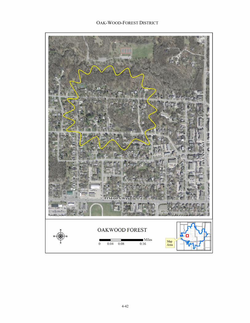
Oak-Wood-Forest District
Location Oakland & Woodland from Forest Glen to Franklin
Date of Plats Various, early 20th century
Significance Criterion A: Community Planning & Development Criterion C: Landscape Architecture
Status Inventory n.d. (Knipe) Reconnaissance survey 2007 (Page)
Recommendation Intensive survey
Located along both sides of Oakland Street, Woodland Street, and Forest Glen Avenue, properties in the Oak-Wood-Forest Historic District date from the turn of the 20th century to the present day. Although this chronological range is wide, most buildings date to the middle of that century. A 2007 reconnaissance survey of the area provided a brief historic context for its significance. (Page 2007: E196-E197) Lynn Knipe, a sometime district resident in the 1980s, prepared a building-by-building description of the neighborhood and a sketch of its past. Eden Schmidt, a member of the Steering Committee for the Ames Comprehensive Historic Preservation Plan, conducted a windshield survey of Ellis Street and its resources in 2008. (Schmidt) The district features an eclectic collection of Craftsman, Prairie School, Tudor Revival, and Neo-Colonial Revival designs. The integrity of these buildings and of that of the overall district is outstanding. Many of these buildings are architect-designed by local Ames architects. Identified architects include Richard McConnel, Alexander Linn, Barnie Slater, Charles Bowers, Kraetsch and Kraetsch (Des Moines), and Don Ayers. This historic district of single-family dwellings evolved from a number of suburban acreages, which once made up much of its area. The district developed as a choice residential neighborhood for faculty members at Iowa State University and for other professionals in Ames. The Oak-Wood-Forest Historic District preserves the feeling of a wooded and rural landscape set upon an uneven topography with streets following its undulations. The Oak-Wood-Forest Historic District is one of the largest historic neighborhoods in Ames surveyed to date. The 2007 survey evaluated this district as a strong candidate for nomination to the National Register of Historic Places, under Criterion C, because of its architectural designs. It also found the district National Register eligible, under Criterion C, because of its landscape architecture and, under Criterion A, because of its historical significance. The name of this district is recent and a clever contraction of street names coined by residents to form an appropriate one for this historic neighborhood.
4-42
OAK-WOOD-FOREST DISTRICT

4-43
Ross Road District
Location West along Ross Road from Hyland Ave.
Date of Plats Various, mid-20th century
Significance Criterion A: Community Planning & Development Criterion C: Architecture Criterion C: Landscape Architecture
Status Reconnaissance survey 2007 (Page)
Recommendation Intensive survey
Ross Road was originally laid out in the 1930s as a short street to access a newly created plat. The road was located along the north ridge above Clear Creek. As Ames’ population burgeoned following World War II, more plats were laid out in piecemeal fashion to the west of this plat. Ross Road served as the link connecting these new plats with one another and with the Hyland Avenue artery. The course of Ross Road follows, in broad strokes, that of Clear Creek and its valley. The road begins at Hyland Avenue and runs west to Garfield Avenue, where it terminates. Between Hyland and Iowa Avenues, Ross Road features a curvilinear layout. This stretch of about one-half mile is lined on both sides by single-family residences dating The period of this district’s historic significance stands at the threshold of National Register’s 50-year rule. Other potential historic districts in West Ames of earlier development should be given higher priority for National Register listing.

4-44
ROSS ROAD
The Ross Road District includes the Emma McCarthy Lee Memorial Park to the south, whose natural features influenced the
layout of the district and added much to the appeal of this residential section.

4-45
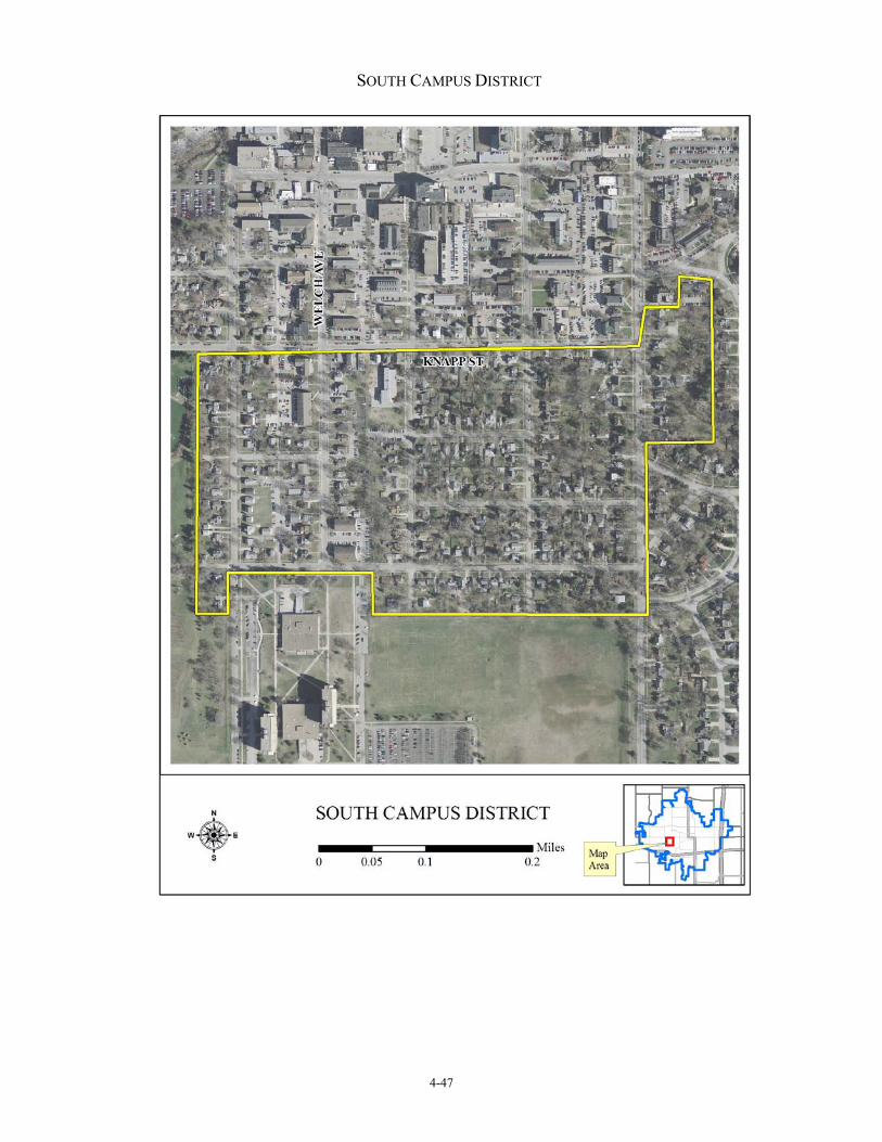
South Campus District
Location Between Hayward, Storm, Lynn/Ash & Knapp
Date of Plats Various, late 19th & early 20th centuries
Significance Criterion A: Community Planning & Development Criterion C: Architecture
Status Inventory 2006-2007 (SCAN) Reconnaissance survey 2007 (Page)
Recommendation Intensive survey
The South Campus district includes multiple land use areas including single-family dwellings, multiple-family dwellings, and commercial property. The latter two land uses cluster mainly along Welch Avenue and make up a fraction of the overall number of properties in the district. The upbuilding of the South Campus area occurred quickly during the early 20th century. In 1915, one student newspaper reported that:
MUCH BUILDING ON SOUTH SIDE Ten New Houses Are Under
Construction Within One Block On Knapp And Ridge
Things are decidedly on the boom on the south side. It was noted yesterday that here were ten new houses under construction within one block at one place on the south side. The place referred to is at the corner of Knapp and Ridge [now Stanton, ed.], where much building seems to be centralized. Here three new double apartments are being erected by Clyde Williams and W. R. Boyd, three houses by W. K. Grier, one each by Dr. O. H. Cessna, W. O. Parks, Prof. George Morback and the Phi Delta fraternity. (Iowa State Student, August 4, 1915)
Accounts such as this attest to the rapid upbuilding of the south campus area during the 1910s. Within the space of one generation—say 1910 to 1939—most of the lots in the South Campus Historic District had filled with improvements. Although it is true that these buildings exhibit a variety of architectural styles, most of them share a contemporary feeling with one another. This sense is compounded by the fact that certain streets likely developed even more quickly than the neighborhood as a whole. An intensive survey of properties along Donald Street, Baker Street, and parts of Storm Street undoubtedly will reveal that many of the houses in these blocks went up within one or two years of each other. The South Campus area is a large neighborhood. Properties date from the turn of the 20th century to the present day. Although this chronological range is wide, most buildings within the district date before World War II. The district features an eclectic collection of Craftsman, Prairie School, Tudor Revival, and Neo-Colonial Revival designs. The integrity of these buildings is outstanding. Many are likely architect-designed either by custom or from published sources. While it is true that a number of intrusions stand along Welch Avenue—mostly multiple-family dwellings redeveloped during the late 20th century on the sites of single-family dwellings—these intrusions retain the neighborhood’s setback from the street and do not over-power the historic buildings in height. The number of these intrusions is very low within the overall integrity of the historic district. Most properties have been well maintained.

4-46
An active neighborhood organization is working to encourage the preservation of these buildings and their owner-occupancy. The South Campus area is also National Register eligible, under Criterion A, because of its significance for education and its association with Iowa State College. The area contains many different plats and layouts, a legacy of its laissez faire development. Because of this patchwork development, an intensive survey of the neighborhood should not focus on any one or two plats but rather embrace the entire area as a significant expression of laissez faire town building.
4-47
SOUTH CAMPUS DISTRICT

4-48
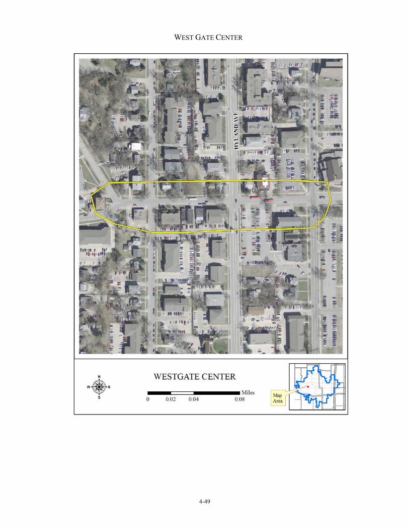
West Gate Center
Location From Sheldon Ave. west several blocks along West St.
Date of Plats Various, late 19th & early 20th centuries
Significance Criterion A: Community Planning & Development Criterion C: Landscape Architecture
Status Reconnaissance survey 2007 (Page)
Recommendation Intensive survey
“West Gate Center” is a nonhistoric name for properties located along both sides of West Street from the western edge of the Iowa State University campus to where West Street forks at Woodland Street. This corridor emerged during the first decade of the 20th century as the hub of activity for residents, mostly associated with Iowa State College, who lived west of the college campus. Mixed land use prevailed from the beginning of the area’s settlement. Single-family dwellings stood check-to-jowl with fraternity and rooming houses for students. Commercial and institutional buildings soon arose among them. By the 1930s, the corridor had taken on its historic character. In 2007, the City of Ames completed a reconnaissance survey of the West Gate Center area. The survey inventoried about two-dozen resources within the area. (Page 2007: E192-E195) The survey found that, since the 1970s, this area has undergone change. Although infill, alteration, and redevelopment have occurred within it, the center’s essential qualities of historic mixed land remain extant. Fraternal, commercial, and institutional properties remain extant from the early 20th century surrounded by recent apartment buildings much larger in scale. The center continues to serve its historic function as the heart of the surrounding neighborhoods—a place to buy some staple goods, to eat a meal, and to meet friends. The district features mixed land use of commercial, residential, and institutional property types and buildings influenced by Colonial Revival, Prairie School, Commercial Style, and Tudor Revival styling. Substantial redevelopment has occurred along this corridor because of its proximity to the Iowa State campus, and yet its historic character as the center of the West Gate neighborhood is still discernable. Many changes also have taken place to the storefronts of these buildings, but this is not unusual for commercial structures. The over-arching significance of this district should be subsumed under Criterion A, however; and, although architectural significance should be claimed, the district’s historical significance is paramount. Most properties to the north and the south of West Street and between Oakland and Lincoln Way have been redeveloped with large 2- and 3-story apartment buildings, since the 1970s. Although a few of the early rooming and fraternity houses remain extant in these redeveloped areas, they stand as isolated representatives of a property type once frequent in the area. Because of extensive redevelopment, the integrity of this historic district lacks the strength of other potential districts in the Fourth Ward. Its listing would require a carefully crafted justification. National Register Criterion A would provide the primary source for this justification, although Criterion C should also be explored. An intensive survey of the West Gate Center would provide a definitive evaluation of the district’s National Register potential.
4-49
WEST GATE CENTER

4-50
Surveys 2008-2009 The Steering Committee, which provided the direction for this comprehensive plan, identified the following potential historic districts as the result of windshield surveys conducted in 2008-2009: Edgewood Park (Edgewood Park First Addition, Edgewood Park Second Addition)
Location Between Duff, O’Neil, Meeker School Grounds, & 20th St.
Date of Plat 1962, 1964
Significance Criterion A: Community Planning & Development Criterion C: Landscape Architecture
Status Windshield survey 2009 (Ongard)
Recommendation Intensive survey
Edgewood Park is the creation of R. Friedrich and Sons, Inc., the developers, who constructed this complex of apartment buildings in the early 1960s. The park consists of two plats, Edgewood Park First Addition (1962) and Edgewood Park Second Addition (1964). John Conis, a professional engineer, platted both of these properties. The first addition includes 13 building lots. Each lot is improved with a 2-story, brick apartment building with a 1-story wing. Each building possesses four units and features a stud frame clad with brick veneer. These buildings edge Duff Avenue, 20th Street, Douglas Avenue, and the second addition. The latter addition includes five building lots. Each of these lots is improved with a brick apartment building similar in design to those in the first plat. The second addition also includes a brick garage and a frame garage. Edgewood Park is historically significant, under National Register Criterion A, because it calls attention to the post-World War II growth of Ames as a community and the leading role R. Friedrich and Sons, Inc., played in that development. Edgewood Park is significant, under National Register Criterion C, as a designed historic landscape. The property stands as a fine example of a mid-20th century garden suburb. Originally laid out on the northern edge of Ames, the grounds of the two plats are landscaped with mature specimen trees and shrubs and entrance features, including retaining walls and brick name plaques with “Edgewood Park” cut in stone. The interior space of the first addition includes a large open space—landscaped with playgrounds, plantings, pedestrian walks, and other amenities—which visually link all of the apartment buildings together. These qualities promote a neighborly feeling among the complex’s residents. The property possesses high integrity and is well maintained to the present day. The complex blends well into the surrounding single-family residential neighborhood because of its compatible open space, building massing and materials, and density.

4-51
EDGEWOOD PARK

4-52
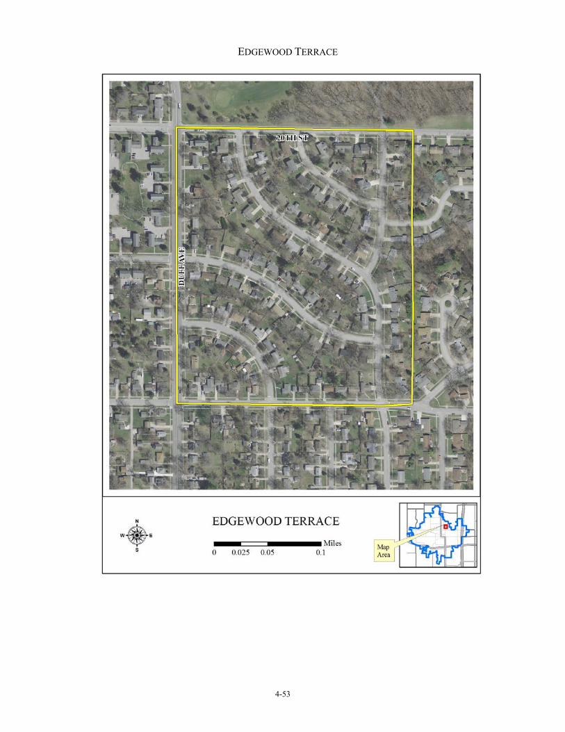
Edgewood Terrace
Location Between Duff; E. 20th; Maxwell & both sides of Allen & Maxwell Ave.; & E. 16th
Date of Plats Various, mid-20th century
Significance Criterion A: Community Planning & Development Criterion C: Architecture Criterion C: Landscape Architecture
Status Windshield survey 2009 (Page)
Recommendation Intensive survey
Edgewood Terrace is a large residential area in the northeast quadrant of Ames laid out in a series of plats in the early 1960s for the development of single-family dwellings. The area includes 36 acres (a quarter section of a quarter section) and is divided into the following plats: EDGEWOOD TERRACE PLATS
Name of Plat Date of Plat Edgewood Terrace 1st Addition 1956 Edgewood Terrace 2nd Addition 1957 Edgewood Terrace 3rd Addition 1962 Edgewood Terrace 4th Addition 1964 Edgewood Terrace 5th Addition 1966
R. Friedrich and Sons, Inc., the local real estate developer responsible for so much residential housing in Ames, laid out these plats. The streets in both of the sections feature curvilinear layouts, which gives shape to the area and distinguishes it from its surrounding residential counterparts. The use of the words “edgewood” and “terrace” in the names of these plats highlight the intent among the developer to attract new homeowners by the physical beauty of the area. Located on the upland above the Skunk River floodplain, these plats enjoy a gently rolling terrain and mature timber. Homewood Golf Course is located immediately north of Edgewood Terrace. Parkland along the Skunk River valley is located a little to its east. This parkland offers recreational amenities to the plats and further contributes to their physical beauty. Houses influenced by Ranch styling tend to predominant. Most are custom-built, feature quality building materials, and are sited on spacious lots. A feeling of solid comfort permeates the area. This area of Ames developed in the mid-20th century as a residential section of preference in the city. An intensive survey of this area might result in the determination that an historic district exists in it.
4-53
EDGEWOOD TERRACE
4-54
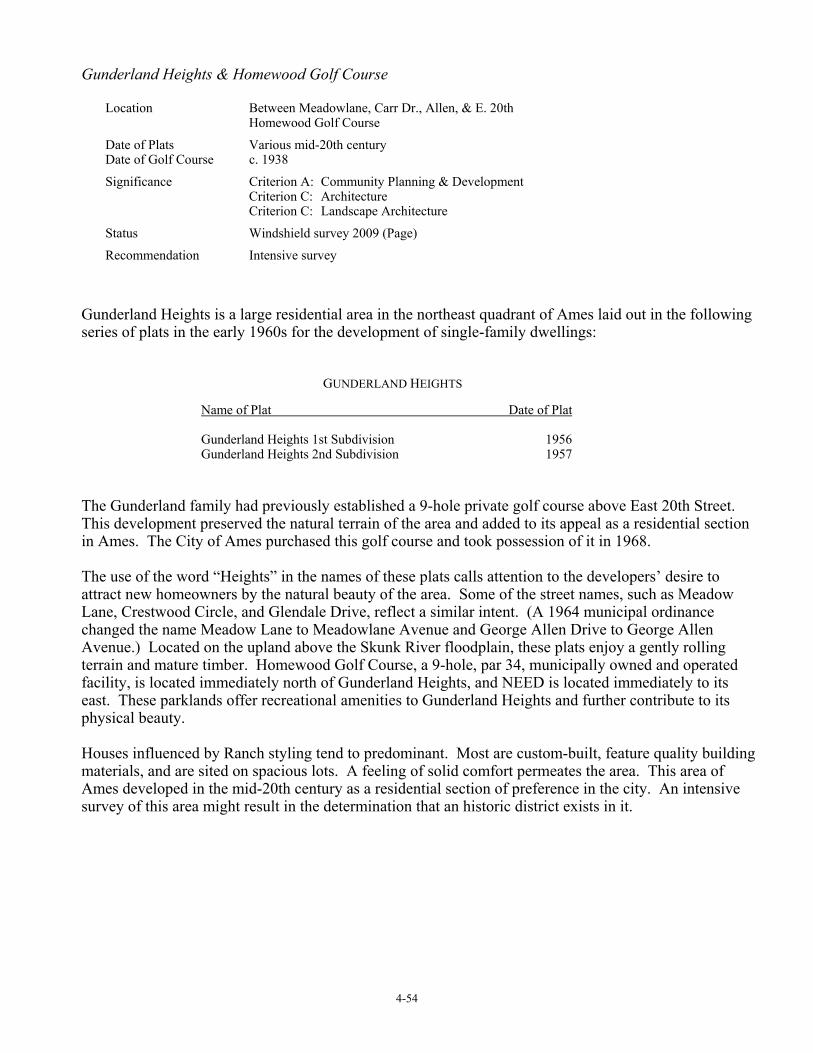
Gunderland Heights & Homewood Golf Course
Location Between Meadowlane, Carr Dr., Allen, & E. 20th Homewood Golf Course
Date of Plats Various mid-20th century Date of Golf Course c. 1938
Significance Criterion A: Community Planning & Development Criterion C: Architecture Criterion C: Landscape Architecture
Status Windshield survey 2009 (Page)
Recommendation Intensive survey
Gunderland Heights is a large residential area in the northeast quadrant of Ames laid out in the following series of plats in the early 1960s for the development of single-family dwellings: GUNDERLAND HEIGHTS
Name of Plat Date of Plat Gunderland Heights 1st Subdivision 1956 Gunderland Heights 2nd Subdivision 1957
The Gunderland family had previously established a 9-hole private golf course above East 20th Street. This development preserved the natural terrain of the area and added to its appeal as a residential section in Ames. The City of Ames purchased this golf course and took possession of it in 1968. The use of the word “Heights” in the names of these plats calls attention to the developers’ desire to attract new homeowners by the natural beauty of the area. Some of the street names, such as Meadow Lane, Crestwood Circle, and Glendale Drive, reflect a similar intent. (A 1964 municipal ordinance changed the name Meadow Lane to Meadowlane Avenue and George Allen Drive to George Allen Avenue.) Located on the upland above the Skunk River floodplain, these plats enjoy a gently rolling terrain and mature timber. Homewood Golf Course, a 9-hole, par 34, municipally owned and operated facility, is located immediately north of Gunderland Heights, and NEED is located immediately to its east. These parklands offer recreational amenities to Gunderland Heights and further contribute to its physical beauty. Houses influenced by Ranch styling tend to predominant. Most are custom-built, feature quality building materials, and are sited on spacious lots. A feeling of solid comfort permeates the area. This area of Ames developed in the mid-20th century as a residential section of preference in the city. An intensive survey of this area might result in the determination that an historic district exists in it.

4-55
GUNDERLAND HEIGHTS & HOMEWOOD GOLF COURSE

4-56
Duplexes above East 13th Street
Location Generally between Duff, E. 13th, NEED, and NEED
Date of Plats Various, mid-20th century
Significance Criterion A: Community Planning & Development Criterion C: Architecture
Status Reconnaissance survey 1992 (Page)
Recommendation Intensive survey
A large number of modest duplexes is situated throughout the area north of East 13th Street and east of Duff Avenue. Friedrich’s Sixth Addition contains many, but by no means all, of them. Located along the west side of Carroll Avenue between 13th and 16th Streets and in certain adjacent areas, this plat was developed by R. Friedrich and Sons, Inc., in the late 1940s and early 1950s. Each of these duplexes is 1-story and features frame construction with brick or stone veneer, side-gable roof, and a footprint measuring 90 feet by 26 feet. Each duplex typically is set back 30 feet from the public right-of-way. The front facade is of symmetrical design embellished by brick or stone veneer. Fenestration tends to feature 6/6 double-hung sash. Front doors are wood paneled with multiple panes in the upper panels. These architectural features show the diluted influence of Colonial Revival styling on the buildings. A 2-bay, frame garage is typically situated behind each duplex. Although each of these duplexes features the same floorplan, the treatment of their front facades varies. Some facades feature rough-cut rubble limestone randomly laid, some feature square-cut ashlar limestone laid in irregular courses, some feature red brick, and some feature tan-colored brick. Many of these materials are polychrome in consistency. This variety of building materials, textures, and colors relieves the streetscape from any sense of regimentation and readily distinguishes the buildings from one another. The duplexes above East 13th Street are historically significant because they call attention to the growth of Ames following World War II and the important role R. Friedrich and Sons, Inc., played in that development. The design of these duplexes demonstrates the Friedrich firm’s desire to offer low- and moderate-income rental housing of quality construction. Although the firm no longer holds the titles to these properties, the duplexes and their garages remain well maintained and possess a high degree of historical integrity. Other developers likely engaged in the construction of these duplexes. An intensive survey of the area would need to cast a wide net to include as many of these duplexes as possible and analyze their National Register potential as an historic district.

4-57
DUPLEXES ABOVE EAST 13TH STREET

4-58
North Old Town
Location Above Old Town north to 13th St. between Duff and Grand
Date of Plats Various, late 19th & early 20th century
Significance Criterion A: Community Planning & Development Criterion C: Architecture
Status Windshield survey 2009 (Page)
Recommendation Reconnaissance survey
“North Old Town” is a nonhistoric name coined by residents to define a large residential area situated north of 10th Street, south of 13th Street, and between Duff and Grand Avenues. This area developed in the late 19th and early 20th century. (Thirteenth Street remained the northern corporate limits of the City of Ames until after World War II.) A neighborhood association is loosely organized in this area currently above 10th Street. (The boundaries of the Old Town Neighborhood Association extend to 10th Street, somewhat beyond the boundaries of the federally listed and locally designated Old Town Historic District.) Most of the buildings in North Old Town are single-family dwellings. Some of these houses might be architect-designed and custom-built, but most reflect popular styles, whose plans were available through mass publications or the experience of their contractor-builders. Further, these houses are of moderate size, nicely detailed, well maintained, and exemplary of middle class housing. North Old Town calls attention to the residential development of Ames during the late 19th to the mid-20th centuries. This development proceeded in a patchwork quilt sequence of construction, with houses of various stylistic influences standing check-to-jowl with others of later and earlier vintage. These influences include Craftsman, Tudor Revival, Neo-Colonial Revival, and Ranch styling. North Old Town stands somewhat in the shadow of the Old Town Historic District, particularly when its generally modest designs are compared with that of its historic district neighbor to the south. With its somewhat earlier period of significance, the Old Town Historic District developed when Victorian conspicuous consumption was at its zenith. By contrast, the North Old Town area possesses a later and broader period of significance, a period which reacted to such extravagance, prizing practicality and a simplified lifestyle instead. A reconnaissance survey of North Old Town along these or other lines might reveal historical and/or architectural significance sufficient to justify its nomination to the National Register as an historic district.

4-59
NORTH OLD TOWN
Map forthcoming.