historic preservation master plan - independence · commitment to historic preservation through the...
TRANSCRIPT

HISTORIC PRESERVATION MASTER PLAN

This project is partially funded by a grant from the Missouri Department
of Natural Resources, State Historic Preservation Office and the National
Park Service, U.S. Department of the Interior. Grant awards do not imply an
endorsement of contents by the grantor. Federal laws prohibit discrimination
on the basis of race, religion, sex, age, handicap or ethnicity. For more
information, write to the Office of Equal Opportunity, U.S. Department of the
Interior, Washington, D.C. 20240
Summer 2019
Prepared by:

3
Table of ContentsHISTORIC PRESERVATION IN INDEPENDENCE
Chapter 1
HISTORIC PRESERVATION OVERVIEW
Chapter 2
4-6 Introduction
6-7 Preservation in Independence Today
7-9 The Historic Preservation Master Plan (HPMP)
PRESERVATION APPROACHES
Chapter 3
17 Preservation Approaches for Historical Resources and Cultural Landscapes 19 Historic Areas and Districts 22-44 Traditional Neighborhoods
22-24 Truman Heritage District/McCoy Neighborhoods
24-27 Mount Washington/Fairmount Neighborhoods
28-30 North Main Neighborhood
30-32 South Main Neighborhood
32-34 Benton Neighborhood/Woodlawn Cemetery
34-36 West White Oak Neighborhood
36-38 Procter Neighborhood
38- 40 Winner Road Neighborhood
GOALS & OBJECTIVESChapter
562 Community-Wide Preservation Challenges
63 Community-Wide Preservation Opportunities
63 Preservation Master Plan Goals & Objectives
64 2019 - 2024 Priorities 65 2024 - 2029 Priorities
10 Historic Preservation Division
10-13 Independence Heritage Commission
13-14 Heritage Tourism
14 Community Input
14 Public Outreach and Education
14 Federal and State Regulation Compliance
15 Building Permit and Dangerous Building Reviews
15 Grant Management
COMMUNITY ENGAGEMENTChapter
460- 61 Topic Suggestions
60 Planning & Zoning
61 Historic Designation, Education & Outreach, Economic Incentives, and Property Maintenance
APPENDIX: SURVEYChapter
666 - 71 Historic Preservation Master Plan Survey Results
40-42 Golden Acres Neighborhood
42- 44 Manor Oaks Neighborhood
44- 53 Traditional Commercial Districts
44-46 Independence Square
46-48 Englewood Commercial District
49- 50 Contemporary Resources
50-52 Religious Sites and Structures
53 Historic School Buildings
54-59 Cultural Landscapes
55 The American Civil War in Independence
56 Independence Cemeteries
56-57 The Three Trails and the Historic Retracement Trail
58 Archaeology

4
and diverse historical and cultural resources, federal designation brought no protection from alterations or even demolition. It was not until February 1972, that local citizens, residents in and around the NHL, formed the Harry S. Truman Historic District Committee with the intent of pressuring the city to create a local historic district (Taylor, 122). In June 1973, a local petition drive succeeded with the establishment of the seven-member Heritage Commission by the Independence City Council. The Commission was charged
CONTRIBUTING VS. NON-CONTRIBUTING
Contributing (aka “historic”) is a term that describes resources located in historically designated districts that contain high levels of architectural or historical integrity due to age (date of construction), retention of original features, or affiliation with important people or events.
Non-contributing resources do not contribute to the significance or character of the area due to lack of age, lack of retention of original integrity, or the insensitive alteration of the building over time.
Historic Preservation in Independence
IntroductionThe contemporary history of preservation in Independence began in 1972 with the death of President Harry S Truman. While individual buildings such as the 1859 Jail and Marshall’s Home and the Square’s Jackson County Courthouse spoke to earlier individual efforts, awareness in the overall protection of the built environment did not wholly begin until the 1970s. Development pressure around the Truman Home, that began as early 1971, set preservation activism in motion. In response to concerns by local citizens, the National Park Service created the National Historic Landmark (NHL) District on November 11, 1971, that included much of the neighborhood in which Truman walked daily.
The district remains unique in that it is only one of a few NHLs located in an active neighborhood. Further, the NHL district spans Truman’s lifetime (1884-1972), making everything from 19th century Queen Anne homes up to 1960s ranch homes “contributing” to the district’s integrity (Taylor, 122). Though the establishment of the NHL district was a solid first step in bringing awareness to the community’s outstanding
CH. 1
Bird’s eye view of the city of Independence, Missouri 1868, drawn by A. Ruger
1. Taylor, J. E. (2008). A President, a Church, and Trails West: Competing Histories in Independence,
Missouri. Columbia: University of Missouri Press.

5Chapter 1: Historic Preservation in Independence
with overseeing matters related to the newly created, locally designated, Truman Heritage District (Taylor, 123). The Heritage Commission would eventually play a leading role in both preservation advocacy and public education, a function previously served by the Jackson County Historical Society (Taylor, 125). Preservation in Independence would once again be in the spotlight with the acquisition and restoration of the Bingham-Waggoner Estate and the Vaile Victorian Mansion in the late 1970s and early 1980s but would undergo numerous challenges in the 1980s
and 1990s with threats to individual houses and even neighborhoods near the Truman Home. These pressures eventually led to the reduction of the overall boundary of the local district. In 1987, the City was recognized by the Missouri State Historic Preservation Office (SHPO) as a Certified Local Government (CLG). CLG status recognized the creation of the Heritage Commission, and the ordinance that established the group, as part of the City’s attempts to incorporate preservation into a larger city-wide planning process to identify and protect historic resources. One
CERTIFIED LOCAL GOVERNMENT (CLG)
A Certified Local Government, or CLG, is a community that has made a commitment to historic preservation through the adoption of a local preservation ordinance and the creation of a reviewing body. The program is administered jointly between the National Park Service and State Historic Preservation Offices (SHPOs) throughout the country. In addition to technical assistance, CLG communities have access to at least 10% of Historic Preservation Fund monies, available in the form of grants. Independence has utilized these grants to conduct architectural surveys, update the City’s preservation design guidelines, and to assist in the creation of this master plan.
Independence became a CLG
in 1987.
The Truman Jackson County Courthouse

6 Independence Historic Preservation Master Plan
of the most advantageous benefits of CLG status is the availability of 10% of federal Historic Preservation Funds (HPF) dedicated for planning, design, and construction projects in CLG communities via grants. Despite some progress during this time, the Heritage Commission struggled in defining their role as advocates of Truman-related resources and of protecting historical resources city-wide. After the on-going threat and loss of numerous buildings and structures, the Heritage Commission was granted review of city-wide demolition requests in 1997. The authority to review demolition requests from the western border with Kansas City, Missouri to Independence’s eastern edge adjacent to Blue Springs, Missouri, and Jackson County allows for both a public process and the ability to potentially protect everything from log cabins and barns to bungalows and post-war housing. This authority is unique in Missouri and allows the Heritage Commission the ability to provide protection to resources, whether
or not they are documented and/or locally designated (Taylor, 203). In-depth preservation planning began in the late 1990s with the creation of design guidelines and later the adoption of Chapter 11 as part of the City’s Comprehensive Plan in 2000 (Taylor, 222). In 2004 and 2005, the Heritage Commission’s by-laws and historic preservation ordinance were revised. An update to the design guidelines was completed in 2010 using HPF grant monies. Additional planning efforts have included a variety of architectural surveys, though much of the city’s historic built environment remains undocumented. Preservation in Independence Today
There is currently just one locally designated historic district, the Truman Heritage District and 26 individual Landmark properties (individually-listed, locally designated properties). The Harry S. Truman National Historic Landmark District was expanded in
7Chapter 1: Historic Preservation in Independence
2011, almost tripling the number of buildings federally-recognized, including those on the Independence Square. There are also 24 individually-designated National Register listed properties in Independence. However, as was previously stated, the lack of overall design review and demolition review protection for National Register properties makes it the less desirable of the two types of designation from a local preservation perspective. Today, the Independence Heritage Commission consists of nine members that include both professionals and laypersons as well as two ex-officio members representing the Truman Presidential Library and the National Park Service’s Harry S Truman National Historic Site. Though the ex-officios are non-voting members, their perspective on the needs of the community and its preservation efforts is invaluable.
The Historic Preservation Master Plan (HPMP)One component of the requirements to maintain Certified Local Government status is the regular update of a community’s preservation comprehensive plan. Though overdue, the creation of this Historic Preservation Master Plan (HPMP) is critical to the continuation of the City’s previous preservation planning efforts and the overall success of the preservation program. The HPMP will serve as a guide for both city staff as well as Independence citizens and property owners to identify concentrations of areas with high levels of historic integrity, make suggestions about possible resources to protect through local designation, highlight properties that may be eligible for National Register designation, and outline goals through long-range planning efforts, five and ten years out.
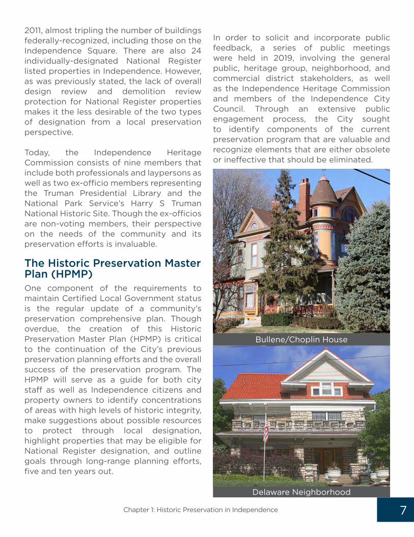
In order to solicit and incorporate public feedback, a series of public meetings were held in 2019, involving the general public, heritage group, neighborhood, and commercial district stakeholders, as well as the Independence Heritage Commission and members of the Independence City Council. Through an extensive public engagement process, the City sought to identify components of the current preservation program that are valuable and recognize elements that are either obsolete or ineffective that should be eliminated.
Bullene/Choplin House
Delaware Neighborhood

8 Independence Historic Preservation Master Plan
With a focus on PRESERVATION PLANNING, the GOALS OF THIS DOCUMENT are intended to:
1. IDENTIFY AND DOCUMENT previously unsurveyed city-wide historic resources;
2. RECOMMEND PRESERVATION INCENTIVES and economic development tools to encourage investment in traditional neighborhoods and commercial areas;
3. PROMOTE AND INCENTIVIZE the local designation program;
4. REVIEW ZONING POLICIES to ensure compatibility with community-wide preservation goals;
5. ENERGIZE CURRENT PROPERTY OWNERS in existing historic districts and other traditional neighborhoods to participate in city-initiated preservation programs;
6. ADDRESS PRESERVATION CHALLENGES such as the reduction of blight and deferred maintenance;
7. Continue to Promote PUBLIC OUTREACH AND EDUCATE THE PUBLIC about the need for historic preservation in Independence; and,
8. Adopt realistic GOALS for the NEXT FIVE (5) AND TEN (10) YEARS that can be accomplished with current staff and budget constraints.
Mormon Visitors Center

9Chapter 1: Historic Preservation in Independence
To better organize and reflect these recommendations, the new plan will be divided into FOUR MAIN CHAPTERS:
1. The first chapter will provide an overview of the current preservation program and outline the duties of the City’s Historic Preservation Division.
2. The next chapter will identify city-wide resources through the creation of traditional character areas as distinguished by both their physical boundaries and development history. These areas will recognize resources with high levels of architectural/historical integrity with dates of construction up to 1973, denoting both residential and commercial resources up through 45 years of age. This chapter will also identify significant cultural resources and outline a strategy for protection.
3. Next, the plan will outline and highlight feedback gathered during the public engagement process, noting both challenges and opportunities.
4. Finally, that feedback will be prioritized by identifying five planning goals for the preservation program to achieve in the next five years (by the year 2024) and 10 preservation-related goals to achieve in 10 years (by 2029).
Woodlawn Cemetery

10
Historic Preservation DivisionThe City of Independence Historic Preservation program is overseen by the Historic Preservation Manager, under the Historic Preservation Division. This division splits its duties between two departments: Community Development and Parks, Recreation, and Tourism (PRT). Under Community Development, the Preservation Division oversees various aspects of planning, community outreach and education, grant management, and federal and state historic preservation review compliance. The Preservation Division is also responsible for conducting city-wide building permit reviews and dangerous building reviews. When working with the Tourism Division, Preservation assists maintenance staff and oversees restoration projects for all city-owned historic sites, manages preservation grants, and ensures compliance with federal and state preservation guidelines.
Independence Heritage CommissionOne of the primary responsibilities of the Historic Preservation Manager under Community Development is serving as liaison to the Independence Heritage Commission. The Heritage Commission is comprised of nine members; two of which are ex-officio positions held by representatives of the Truman Presidential Library and the National Park Service. The remaining seven positions are appointed by the City Council. The Heritage Commission was established through the adoption of an ordinance, codified in Article 9 of the Unified Development Code (UDC). After its formation, the Commission
adopted by-laws and design guidelines. The guidelines provide direction for both Commissioners and historic property owners on proper treatments of historic materials and guidance on appropriate improvements and alterations. Creation of the Heritage Commission and adoption of guidelines, by-laws, and a preservation ordinance led the City of Independence to be recognized by the Missouri State Historic Preservation Office as a Certified Local Government on August 11, 1987.
Article 9 of the UDC identifies the duties of the Heritage Commission as follows:
� Reviews Certificate of Appropriateness and Certificate of Economic Hardship applications for all locally designated properties;
� Initiates, reviews, and recommends properties for designation as a local Landmark, Historic District, or Conservation District;
� Establishes specific design guidelines for the alteration, construction, relocation, or demolition of Landmarks or buildings within designated historic districts;
� Reviews city-wide applications for demolition requests;
� Reviews all special-use permits affecting any designated property;
� Initiates, reviews, and makes recommendations concerning National Register nominations to City Council and the State Historic Preservation Office;
� Initiates, develops, and maintains cultural resource surveys and inventory; and, works with various governmental agencies on matters involving historic properties in the City.
Independence Historic Preservation Master Plan
CH. 2 Historic Preservation Program Overview

11
Historic Preservation Program
Chapter 2: Historic Preservation Program Overview
HISTORIC PRESERVATION DIVISION
COMMUNITY DEVELOPMENT
PARKS, RECREATION, & TOURISM
Independence Heritage Commission
Building permit reviews
Dangerous building reviews
Conducts federal & state historic preservation reviews
for city-wide projects
Coordinates with regional heritage groups
Conducts public outreach & education including social
media
Assists the public with historic preservation questions/concerns
Manages historic preservation grant projects
Oversees restoration projects at city-owned historic sites
Assists Tourism maintenance staff at city-owned historic
sites
Oversees federal, state, & local compliance with historic
preservation guidelines
Manages historic preservation grants

12 Independence Historic Preservation Master Plan
LOCAL VERSUS NATIONAL DESIGNATION
Local Historic DesignationLocal Historic Designation is recognition by local government that a property possesses a high level of architectural integrity and/or is associated with local, regional, state, or national history. Locally designated properties in Independence consist of both individual properties and those located in a district. These properties must undergo design review by Preservation staff or the Independence Heritage Commission prior to most exterior alterations. This review ensures the retention of the historic integrity and character of the property.
National Historic DesignationNational Historic Designation is recognition by the federal government that a property reflects a unique style of architecture or craftsmanship, is associated with a significant person or event that contributed to the American past, or may yield information important to prehistory or history. Unlike local designation, listing in the National Register of Historic Places is strictly honorary. National designation does not require design review and provides no protection from alterations or demolition.
National Designation IDENTIFIES and RECOGNIZES; Local Designation PROTECTS THROUGH DESIGN REVIEW
Bullene/Choplin home
Locally Designated Property
Trinity Episcopal Church
Nationally Designated Property

13
Preservation Division staff assists with the organization of monthly Commission meetings (held on the first Tuesday of each month), writes staff reports and distributes packets for the monthly meetings, and aids the public with questions concerning the design review process. Preservation staff also assists property owners with historic property research, the Heritage Commission review process, local designation nominations, and the National Register nomination process.
Heritage Tourism The National Trust for Historic Preservation defines cultural heritage tourism as “…traveling to experience the places, artifacts, and activities that authentically represent the stories and people of the past and present. It includes cultural, historic, and natural resources.” Having played a critical role as the departure for the trails west, the crossroads in the battle over slavery and state’s rights in the American Civil War, a pivotal role in defining the Mormon experience, and of course, as the hometown of President Harry S Truman, heritage tourism is an essential component of historic preservation in Independence. Increasing the understanding of the City’s role in the overall development of the region, the State, and ultimately, the Nation, and making a connection between that history and the physical representation of it through its historic built environment, is critical to the success of the City’s heritage tourism industry. In conjunction with the Tourism Division, the Preservation Division assists with the restoration and repair of city-owned sites, grant management, and federal, state, and local preservation regulation compliance. Because many of the city-owned properties are also locally or nationally designated as historic, the Preservation Division often submits improvements and alterations at the sites for review to the Independence
CERTIFICATE OF APPROPRIATENESS (COA) MATRIX
While many design review requests by owners of locally-designated properties require review by the Independence Heritage Commission, many allow for administrative review. This process allows staff to review and approve a COA request significantly expediting the review process and the time it takes to receive approval. As a guide to property owners, the COA Matrix was developed in 2005. This reference chart divides projects into general categories, separates contributing from non-contributing properties (see page 4), and notes whether the improvement/alteration requires Heritage Commission review, administrative review, or no review.
A link can be found at:
http://www.ci.independence.mo.us/userdocs/ComDev/COA_Matrix.pdf
Chapter 2: Historic Preservation Program Overview

awards, architectural tours, lectures, and other activities inspired by the built environment. Programs vary from year-to-year and are promoted in the City Scene newsletter, the City’s website and calendar, as well as social media.
Federal and State Regulation ComplianceThe City of Independence is mandated to follow both federal and state guidelines for historic preservation. The most prevalent of these regulations is Section 106 of the National Historic Preservation Act of 1966. Section 106 requires a review of all projects using federal funding or undertakings by a federal agency to determine if any cultural resources could be harmed or adversely affected. This analysis is then forwarded to the Missouri State Historic Preservation Office (SHPO) and/or the Tribal Historic Preservation Office (THPO) for review and comment. The Preservation Division assists all city departments in this review process as well as comments on area projects going through a 106 review processed by outside agencies and contractors.
14
Heritage Commission (see sidebar for city-owned, designated sites). While the Preservation Division works closely with Tourism, a division of PRT, the Tourism Division oversees specific aspects related to heritage tourism that includes the promotion and marketing of city-wide tourism sites and programs, management of volunteer programs at the city-owned sites, as well as overseeing daily operations and site coordination. The Tourism Division is also responsible for historic site interpretation, special programming, and tours. Though heritage tourism is a vital component of the City’s overall preservation goals, it is not addressed at length in this plan, since this document is intended to outline and prioritize preservation planning goals rather than suggest management and future use proposals for city-owned historic sites, suggest interpretive programming or modify the management of the city’s historic sites and tours.
Community InputThe Preservation Division assists a variety of boards and commissions throughout the Kansas City Metro. The division also supports efforts by regional heritage groups and provides comments on preservation matters throughout the region. This includes projects related to buildings and sites, cemeteries, statues, historic markers, historic walking and driving trails, cultural landscapes, and transportation corridors, just to name a few.
Public Outreach and EducationIn partnership with the Heritage Commission and community heritage groups, the Preservation Division hosts a variety of public programs and community outreach events throughout the calendar year. The culmination of these events is the annual celebration of National Historic Preservation Month in May. Events include preservation
Independence Historic Preservation Master Plan
Community Workshop

15
Building Permit and Dangerous Building ReviewsThe Preservation Division reviews city-wide building permits and those tagged as “dangerous” by the City, including all requests for demolition. Research is conducted by City staff to determine the building’s age and to evaluate if the loss of the building could harm the overall architectural integrity of the neighborhood or commercial district it is located in. Demolition requests for buildings deemed “historic,” due to age and overall integrity, are required to be reviewed and approved by the Heritage Commission prior to issuance of a permit.
Grant ManagementThe Preservation Division works with both Community Development and the Tourism Division to write and manage grant projects that assist the City with preservation planning efforts, promotes community outreach and education projects, and in the restoration of city-owned historic sites. Planning projects can include conducting surveys, updating design guidelines, and the creation of planning documents like this master plan. Outreach and education grants can provide funding to create preservation workshops on such topics as window repairs or re-pointing historic masonry, bring in guest speakers, and create educational materials for historic property owners. Grants are also sought after to assess repair work and outline maintenance plans at city-owned historic sites and to conduct restoration work. While the City seeks out a variety of both public and private funding sources, Certified Local Government grants, utilizing Historic Preservation Funds, are most often requested and utilized by the Preservation Division.
Chapter 2: Historic Preservation Program Overview
This process provides an extra level of review
and input to PROTECT historic properties.
SECTION 106 & NATIONAL HISTORIC PRESERVATION ACT (NHPA)
The National Historic Preservation Act was enacted in 1966. Section 106 of this act requires federal agencies undertaking a project or when using federal funds to take into account the overall impact of that undertaking on historic properties. If it is determined that the project will cause a negative impact, the agency must seek comments from the Advisory Council on Historic Preservation (ACHP) in order to mitigate that impact. Properties already listed in the National Register of Historic Properties are automatically evaluated during the 106 review process adding another incentive for federal historic designation.

16 Independence Historic Preservation Master Plan
CITY-OWNED HISTORIC SITES-AND ADDRESSES
� The Bingham-Waggoner Estate
� Chicago & Alton Train Depot
� Historic Fire Station #1
� Pioneer Spring Cabin
� The National Frontier Trails
Museum Complex
� The Truman Historic Train Depot
� The Vaile Victorian Mansion
� Woodlawn Cemetery
� 1827 Log Courthouse

17
Preservation Approaches for Historical Resources and Cultural LandscapesThe previous version of the comprehensive plan began with the evaluation of both the original 1850s boundary and the larger, successive annexations that took place after 1948, that dramatically expanded the overall land area. Today, Independence occupies 78 square miles bounded by Blue Springs, Missouri and unincorporated Jackson County to the east, Kansas City, Missouri to the west, Sugar Creek, Missouri to the north, and Lee’s Summit, Missouri to the south. Identification of the City’s historic resources and cultural landscapes is a key component of this 21st century preservation planning process and is critical to the retention and preservation of physical representations of Independence’s heritage. Chapter three of this Master Plan will assist the Preservation Division and the Independence Heritage Commission in the creation of a comprehensive architectural survey program, recommendations for historic designation and economic incentives, assisting in long-range planning decisions such as re-zoning recommendations, and in reviewing demolition requests through the demolition permit review process and dangerous building review process. In order to identify sections with the greatest concentration of historic resources, the previous Comprehensive Plan divided the City into seven character-defining areas and an overview of the remaining areas. In addition to age, the areas were noted for their historical significance, historical development patterns, affiliations with
people, groups, and organizations, and development pressures. To re-evaluate these areas, four factors helped to determine what will be part of the Master Plan:
1. Was there a loss of overall architectural integrity in that area?
2. Was the area previously overlooked or omitted?
3. Have new areas now come of age for consideration (45 years or older)?
4. Are development pressures or economic factors causing the erosion of the overall integrity of an area?
Using these criteria, the following areas were determined as having a high concentration of historical/architectural integrity, are currently of age for designation consideration, and should be part of a comprehensive preservation strategy. These areas include:
1. Truman Heritage District/McCoy Neighborhood
2. Mount Washington/Fairmount Neighborhoods
3. North Main Neighborhood
4. South Main Neighborhood
5. Benton Neighborhood/Woodlawn Cemetery
6. West White Oak Neighborhood
7. Procter Neighborhood
8. Winner Neighborhood
9. Golden Acres Neighborhood
10. Manor Oaks Neighborhood
Chapter 3: Title of the Chapter Here
CH. 3 Preservation Approaches

18
Also evaluated and included as part of the Master Plan process are the City’s traditional commercial corridors that include the Independence Square and the Englewood Station Arts District. In addition to historic resources that make up the built environment, cultural landscapes were evaluated, and preservation efforts prioritized, as part of this review process. These landscapes include rural open spaces, prehistoric sites associated with Native American peoples, agricultural land and their associated outbuildings, and sites
and routes associated with early pioneers. These cultural landscapes are also made up of land associated with the Little Blue Battlefield in eastern Independence/Jackson County and historical cemeteries like Woodlawn, Lobb, and Mount Washington. While these resources may not be included as part of a larger survey process, they should nonetheless be considered part of the overall planning process and have a consistent preservation approach adopted that recognizes both significance and their unique attributes and contributions as historical and cultural resources.
Independence Historic Preservation Master Plan
Independence Annexation Map

19
Historic Areas
1. Truman/McCoy
2. Mount Washington/ Fairmount
3. North Main
4. South Main
5. Benton/Woodlawn Cemetery
6. West White Oak
7. Procter
8. Winner Road
9. Golden Acres
10. Manor Oaks
Historic Neighborhoods
2
3
45
6
7
8
9
10
1
Englewood Arts District
Local Historic District
National Landmark District
Historic Independence Square
Map Courtesy of Rohn Grotenhuis
Chapter 3: Preservation Approaches

20
Truman Heritage (Local) District
Independence Historic Preservation Master Plan

21
Harry S. Truman National Historic Landmark District
Chapter 3: Preservation Approaches

22
Traditional Neighborhoods The historic development patterns of the City remained constrained until annexation began in the 1940s that expanded the boundaries of Independence significantly up through the 1980s. As a result, much of what is recognized as a historic part of the City is concentrated around the Independence Square. Today, as Independence’s building stock has come of age, much of the City’s newer mid-century neighborhoods are being considered for possible historic designation as well. This section of Chapter Three will re-evaluate the traditional historic neighborhoods that were included in Chapter 11 of the previous Comprehensive Plan while researching those neighborhoods previously excluded with a high level of architectural/historical integrity that are at least 45 years of age. An overview of each area will be provided with associated maps and preservation recommendations that address the unique character and contribution of each area. Truman Heritage District/McCoy Neighborhood
Boundary: The Truman Heritage District/McCoy Neighborhoods reflect the westernmost and southernmost boundaries of the National Historic Landmark District and abuts the North Main District to the east. U.S. 24 Highway was chosen as the northern boundary to highlight the area’s unique architecture and to separate the residential properties from the commercial found along the highway. This neighborhood also possesses a higher level of architectural integrity and is more consistent than those properties north of 24 Highway. Famous for its association with the country’s thirty-third President, the Truman District/
McCoy Neighborhood is known for its tree-lined streets, diverse architecture, and walkability. The area is incorporated into the National Historic Landmark District (NHLD), an honorary federal distinction that distinguishes it as having the highest level of national significance. The district, that now includes roughly 600 properties, was established in 1971 just before President Truman’s death. It is unique in that it is one of the only areas in the country that retains individual homeownership directly adjacent to a National Park Service site. This area also contains the only locally designated historic district in Independence, though considerably smaller than the NHLD. The local Truman Heritage District is made up of just under 200 properties that runs north along Delaware Avenue from Maple Avenue and includes portions of Lexington Avenue and Union Street. Though the buildings within the Truman District/McCoy Neighborhood often date before the birth of President Truman in 1884, the period of significance for the Truman Heritage District spans the life of the president (1884-1972). The Truman District/McCoy Neighborhood is made up of a variety of architectural styles dating from the mid-late 19th through the mid-twentieth century that includes Colonial Revival, Queen Anne, Folk Victorian, Kansas City Shirtwaists, and bungalows, to name a few. Some newer infill includes ranches and split levels. Most properties consist of small, often elevated, urban lots, many of which are reinforced by limestone retaining walls.
Independence Historic Preservation Master Plan
Truman Home

23
Truman / McCoy Neighborhood
Chapter 3: Preservation Approaches

24
Today, the area is known for its central location in Independence (within walking distance of the Independence Square), well-maintained properties, high level of architectural integrity, and historical significance. Preservation Approach
The Truman Heritage District and adjacent McCoy Neighborhood are currently stable and retain a fairly high level of architectural integrity. Much of the area is incorporated into both the local historic district as well as the Harry S Truman National Historic Landmark District. Interest in the area’s history and its central location continue to be contributing factors to its appeal for new homeowners. Though well-documented, the Preservation Division should continue to promote the area and offer a variety of programs and incentives for historic property owners to maintain their homes. The Preservation Division should also seek to expand the local district boundaries to match those of the National Historic Landmark District. In addition to expanding local protection, all locally-designated, contributing properties within the district could be eligible for State Historic Preservation Tax Credit for rehabilitation, and if income-producing, could combine that with Federal Historic Preservation Tax Credits.
Threats to mature trees are also a concern due to disease and placement. In order to retain the mature tree canopy in the neighborhood, a partnership should be formed with the Independence Tree Board to conduct a mature tree survey and make recommendations to homeowners on appropriate care and, if needed, removal.
ACTION PLAN
� Partner with the Independence Tree Board to conduct a mature tree survey
� Offer a variety of outreach programming to property owners including workshops, lectures, and tours
� Reach out to area property owners to determine interest in expansion of the local district
� Continue to seek out incentives for historic property owners to maintain owner-occupied homes using the Historic Preservation Guidelines
Mount Washington/Fairmount NeighborhoodsBoundary: The Mount Washington/
Fairmount Neighborhood boundaries are
intended to combine sections of both of
these traditional neighborhoods having
the greatest concentration of architectural
integrity within these contiguous areas. This
area stretches to the westernmost border of
the City of Independence, abutting Kansas
City, Missouri. Mount Washington Cemetery
(southwest corner) and Sugar Creek and
Independence municipal properties (to the
north) help to define the district’s southern
and northern edges. Hardy Avenue to the
east is the last full block located in the
Fairmount subdivision making it a practical
boundary for the districts.
Independence Historic Preservation Master Plan
Owens-McCoy House

25
Mount Washington / Fairmount Neighborhood
Chapter 3: Preservation Approaches

26
Once the home to two different amusement parks, Mount Washington and Fairmount were originally utilized by wealthy residents of Kansas City who traveled by “dummy line” to the country to enjoy fresh air and take in the sites. What is today Mount Washington Cemetery was, in the 1880s, a 382 acre park site with a 20 acre lake featuring swans and boat rentals where families and couples could picnic to live music. This park closed around 1900 and was converted for use as Mount Washington Cemetery. The stone bus stop on U.S. 24 Highway marked the original north entrance to this park. By 1892, the electric trolley line brought Kansas City residents to a new park developed north of U.S. 24 Highway that included what is today both Independence and Sugar Creek to the north of the Fairmount Business
District. Originally called Cusenbary Springs, it was later renamed Fairmount Park. This park boasted a pavilion and band stand where the public could enjoy dancing to live bands, a shooting gallery, and leisurely boat rides. Concert and vaudeville-type acts kept the park filled until the Great Depression when the park closed. Both Mount Washington and Fairmount’s housing stock began as summer homes for well-to-do Kansas City families. Remnants of these Victorian and Foursquare-style homes can still be found scattered along roads like Brookside and Winner. By the 1920s and 1930s, working-class bungalows appeared in Mount Washington and Fairmount, many of which dominate these neighborhoods today. Concentrations of these bungalows remain along Ash and Hardy, both north and south of U.S. 24 Highway.
Independence Historic Preservation Master Plan

27
This area of Independence was not incorporated into the city limits until the 1950s. This autonomy from the adjacent cities provided an opportunity for the area to develop its own unique character and appeal. Today, the area is known for its central location to I-435, I-70, and downtown Kansas City, longevity of homeownership, and its varied, often modest, housing stock. Recent redevelopment projects within the Fairmount Business District, reinvestment from the City of Independence, the Northwest Community Development Corporation, and other community groups, as well as the adaptive reuse of the historic Mount Washington School has fostered revitalization and renewed interest in these areas.
Mount Washington School, located at 570 South Evanston Avenue, is the only National Register designated property within these neighborhoods. It was converted to senior housing in 2013.
Preservation Approach
The Mount Washington/Fairmount Neighborhoods suffer from more extensive deferred maintenance/blight
than other traditional neighborhoods identified in this plan. Demolition requests due to dangerous building status and lack of regular property maintenance is causing loss of housing stock at a consistently high rate. To combat this, the City should seek a grant to conduct an intensive-level architectural survey to document area properties for the purposes of demolition review and to be proactive in addressing deferred maintenance of historically significant resources. Additionally, expanding property maintenance programs such as the Rental Ready inspection program and introducing proactive code enforcement could slow blight and encourage single-family, owner-occupied properties.
ACTION PLAN
� Conduct an intensive-level architectural survey
� Partner with the Independence Tree Board to conduct a mature tree survey
� Tackle deferred maintenance/neglect by introducing new programs or expanding/improving existing programs that address property maintenance, codes violations, and enforcement
� Adopt programs and incentives that
encourage owner-occupied properties
Mount Washington Senior Apartments
Chapter 3: Preservation Approaches

28
North Main NeighborhoodBoundary: The North Main District is defined by the age of the housing stock as well as the creation of U.S. 24 Highway to the north. The proposed district boundary reflects the area found in the North Main Street survey conducted in 2013.
The North Main Street Neighborhood was annexed by the City of Independence in 1851 and predominantly developed between the 1870s and early 1900s, reflecting the prosperity of the city during that period. Prominent Independence families such as the Wallaces, the Flourneys, the Otts, and the Bundschus settled in this neighborhood creating what would be today, a middle-to- upper class area filled with shopkeepers, lawyers, bankers, and prosperous landowners. Most of these houses were constructed north of Farmer Street along both sides of Main and Liberty Streets. As many of the lots in the area were subdivided from the 1910s through the 1930s, smaller, one and one-and-a-half story bungalows were constructed filling in voids found between more stately homes. This was particularly true along North Liberty and North Main Streets, north of College Street. As was typical of many of the larger homes throughout Independence, significant alterations were often introduced during both World Wars I and II, converting single family homes to multi-family rentals. Many of these rentals remained through Urban Renewal in the 1960s. It was not until the late 20th and early 21st century that many of these homes were converted back to single-family. The North Main Street Neighborhood has a diverse, often eclectic, mix of architectural styles, influences, and plans. The majority of property types are vernacular in nature that includes gable and wing plans, bungalows,
and Foursquares that date from the late-19th century through the 1930s. Several dwellings, ranging from the 1850s through about 1930, feature the influences of Gothic and Classical Revival, Victorian, Tudor, Craftsman, and Italianate style architecture. High styles of architecture in this area include Kansas City Shirtwaists, Gothic Revival, and Queen Annes that date mainly from the mid-19th century to the turn of the 20th century.
Preservation Approach
The North Main Neighborhood was part of a reconnaissance-level architectural survey conducted by the City of Independence in 2013. While the conclusions of the survey do not recognize a high level of overall architectural integrity in the neighborhood due to inappropriate alterations and infill, the area should nonetheless be considered eligible for local designation. Further, numerous individual properties are considered eligible for both local and National Register designation. The neighborhood overall suffers from deferred maintenance and lack of property investment due to limited owner-occupied housing. Increasing property maintenance programs such as the Rental Ready inspection program and introducing proactive code enforcement could slow blight and encourage single-family, owner-occupied properties and increase investment.
North Main Neighborhood
Independence Historic Preservation Master Plan

29
NETTLETON AVE
US 24 HWY
COLLEGE ST
SPR
ING
ST
NO
LAN
D R
DOSA
GE
ST
LIB
ERTY
ST
WHITE OAK AVE
LYN
N S
T
MA
IN S
T
PARKER CT
FARMER ST
WALDO AVE
HIG
H ST
ST CHARLES AVE
MILL ST
DO
DG
ION
AVE
1 inch = 279 feet± North Main Street NeighborhoodNorth Main Street NeighborhoodChapter 3: Preservation Approaches

30
ACTION PLAN
� Pursue local/National designation as a district or individual properties based on the data collected in the architectural survey conducted in 2013.
� Research/implement economic incentives to encourage reinvestment and historic designation
� Partner with the Independence Tree Board to conduct a mature tree survey
� Tackle deferred maintenance/neglect by introducing new programs or expanding/improving existing programs that address property maintenance and codes violations
� Adopt/improve upon programs and incentives that encourage owner-occupied properties
South Main NeighborhoodBoundary: The South Main District is defined by the age of its housing stock and its period of development. The northernmost boundary, on the south side of Walnut, divides commercial properties on the Independence Square from the residential area to its south. The district’s southernmost boundary culminates at Southside Boulevard and the Union Pacific railroad tracks. Several subdivisions also end at Southside Boulevard making the street a sensible southern border to the district.
The South Main Neighborhood was originally made up of stately homes and large lots owned by Independence professionals and business owners, many of whom worked on the Independence Square. Several of these grand dwellings are individually-listed in the National Register of Historic Places including the Bryant House (519 South Main Street), the Hughes House (801 South Main Street), and the Bingham Waggoner Estate (313 West Pacific Avenue). Smaller, more modest infill, that includes
bungalows and Foursquares, were introduced at the start of the 20th century. Today, the neighborhood consists of tree-lined streets and a wide variety of architecture dating from the 19th century to contemporary infill. Properties at the northernmost and southernmost ends of the South Main Neighborhood have suffered the most from demolition, questionable alterations, and inappropriate infill. The bisection of the southern portion of the neighborhood by the commercially-developed 23rd Street also challenges the overall cohesion of the residential area.
Preservation Approach
The South Main Neighborhood consists of a wide variety of architecture and dates of construction. In order to determine the overall integrity of the area, an intensive-level architectural survey should be conducted using Historic Preservation Funds. Designation should then be pursued based upon the results of the survey, either as individual properties or an overall district. While previous attempts to designate South Main as a local historic district failed, local/National designation should be considered a priority to recognize and preserve the unique character and history of the area. The Preservation Division should also reach out to the Independence Tree Board to partner in a mature tree survey to protect the area’s tree canopy from disease, inappropriate removal/trimming, and to encourage new plantings, where appropriate.
Bryant House
Independence Historic Preservation Master Plan

31
South Main Street Neighborhood
Chapter 3: Preservation Approaches

32
ACTION PLAN
� Conduct an intensive-level architectural survey
� Partner with the Independence Tree Board to conduct a mature tree survey
� Adopt/improve upon programs and incentives that encourage owner-occupied properties
� Research/implement economic incentives to encourage reinvestment and historic designation
Benton Neighborhood/Woodlawn CemeteryBoundary: The Benton Neighborhood is bounded by commercial properties on the east side of Noland Road to the west and Woodlawn Cemetery to the south. The boundary ends at Lexington Avenue to the north creating a natural boundary between the residential area and commercial properties along Truman Road. Strode Street jogging west on Walnut Street to Hocker Avenue make up the easternmost boundary due to the location of the railroad tracks and the introduction of contemporary infill further east. The Benton Neighborhood/Woodlawn Cemetery area lies directly east and south of the Independence Square. A portion of the area includes the original plat of Independence along with some of its earliest additions. The earliest homes constructed here date to the mid-nineteenth century, some of which survive today. Most of these homes can be found north of Woodlawn Cemetery and just east of Noland Road. The eastern side of the neighborhood remained agricultural until after World War II as housing was developed for returning soldiers. More robust development of Benton brought with it infill housing that included worker’s cottages and bungalows starting at the turn of the twentieth century
and ranch and traditional tract style homes beginning in the 1940s and 1950s. In addition to mature trees and several parks, Benton boasts some of the oldest houses in Independence to survive the Civil War’s Order Number 11, which dictated that Jackson County residents pledge allegiance to the Union or have their properties burned to the ground. Woodlawn Cemetery, located to the south of Benton, was founded in 1837 as an early family cemetery. In 1845, Joseph and Sally Hansbrough sold one and 6/25 acres of land for use as a grave yard for persons of Jackson County. The land was to be used for the purpose of public burials. This established the cemetery known for many years as the City Cemetery. The land south of the original cemetery was sold to Father Donnelly in 1853 adding six acres on the southern edge dedicated to Catholic patrons and calling it Saint Mary’s Cemetery. These three cemeteries were combined in 1922 to become Woodlawn Cemetery. Owned and maintained by the City of Independence Parks, Recreation, and Tourism Department, the property is designated as a local historic landmark. Today, Woodland Cemetery contains 56 acres, with over 30,000 souls interred. Some of its more famous “residents” include U.S. Congressman Samuel Hughes Woodson (1815-1881), Hiram Young, famous wagon maker and African-American business owner (1815-1882), John Taylor Hughes, Civil War Confederate Brigadier General (1817-1862), and Harvey Merrick Vaile, wealthy and successful entrepreneur who had the 30-room Vaile Mansion (1500 North Liberty Street) constructed in 1881 in Independence as a residence for himself and his wife (1831-1894).
Preservation Approach
Independence Historic Preservation Master Plan

33
Benton Neigborhood / Woodlawn Cemetery
Chapter 3: Preservation Approaches

34
The Benton Neighborhood/Woodlawn Cemetery area consists of a wide variety of architecture, with some dating back to the early development of the City. An informal history and survey of the area was produced by local residents but no additional data has since been collected. In order to determine the overall integrity of the area and create a detailed historical context of its development, an intensive-level architectural survey should be conducted using Historic Preservation Funds. Designation should then be pursued based upon the results of the survey, as either individual properties or an overall district. The Preservation Division should also reach out to the Independence Tree Board to partner in a mature tree survey to protect the area from disease, inappropriate removal/trimming, and to encourage new plantings as part of a larger streetscape improvement program. This area also suffers from deferred maintenance and lack of property investment due to limited owner-occupied housing. Stabilization and maintenance is needed to encourage new investment in the area. Increasing property maintenance programs such as the Rental Ready inspection program and adopting proactive code enforcement may slow blight and encourage more single-family, owner-occupied properties.
ACTION PLAN
� Conduct an intensive-level architectural survey
� Research/implement economic incentives to encourage reinvestment and historic designation
� Partner with the Independence Tree Board to conduct a mature tree survey
� Tackle deferred maintenance/neglect by introducing new programs or expanding/improving existing programs that address property maintenance and codes violations
� Adopt/improve upon programs and incentives that encourage owner-occupied properties
West White Oak NeighborhoodBoundary: The West White Oak Neighborhood is bounded by Forest Avenue to the west and the Harry S Truman National Historic Landmark District boundary to the east on River Boulevard. The area begins along St. Charles Avenue, excluding commercial properties along U.S. 24 Highway to the north and expands south to Short Avenue, excluding industrial sites on Elm Street. The West White Oak Neighborhoods represent a later phase of the City’s residential expansion. The area is made of more modest dwellings constructed beginning in the early twentieth century. Predominant architectural styles include Folk Victorian, bungalows, Minimal Traditional, and ranches.
Increasingly the housing stock has suffered from insensitive alterations and often inappropriate infill. Lack of overall investment in the area and a high percentage of rentals have caused a loss of overall integrity over the last two decades. Threats from demolition also plague the area due to neglect and development pressures along Truman Road.
Benton Neighborhood
Independence Historic Preservation Master Plan

35
West White Oak Neighborhood
Chapter 3: Preservation Approaches

36
Preservation Approach
The West White Oak Neighborhood is predominantly made up of modest housing with a high percentage of rental properties. Demolition often occurs in this area due to development pressures along Truman Road, land expansion by local institutions, lack of investment, and deferred maintenance. As a result, the City should pursue an intensive-level architectural survey to determine what remains of the integrity of the area and whether local/National designation could be pursued to assist with stabilization of the neighborhood. This area also suffers from a lack of new investment due to limited owner-occupied housing. Programs that encourage property maintenance such as the Rental Ready inspection program should be expanded upon in the area. Additional incentives should also be implemented to slow blight and encourage more single-family, owner-occupied properties.
ACTION PLAN
� Conduct an intensive-level architectural survey
� Research/implement economic incentives to encourage new investment
� Partner with the Independence Tree Board to conduct a mature tree survey
� Work to educate local developers and area institutions on the importance of maintaining the cohesion and character of the neighborhood
� Tackle deferred maintenance/neglect by introducing new programs or expanding/improving existing programs that address property maintenance and codes violations
� Adopt/improve upon programs and incentives that encourage owner-occupied properties
Procter NeighborhoodBoundary: The Procter Neighborhood centers on the residential properties that developed along the original interurban rail line that ran in the median of Lexington Avenue/Winner Road. The properties that surround the median make up the northernmost boundary along the Union Pacific railroad tracks. The remaining borders were chosen due to their locations along major thoroughfares in the area and the boundaries of various subdivisions along Crysler to the east, Sterling to the west, and U.S. 78 Highway/23 Street to the south. The Procter Neighborhood consists mainly of single-family homes dating from the late 19th to mid-twentieth century. The area between Crysler and Forest Avenues developed as early suburbs of the City of Independence, while the area west of Forest initially developed as part of an unincorporated area of Jackson County. At the old city limits at Forest Avenue, Linden Avenue becomes 19th Street and Lexington becomes Winner Road. The grassy median that divides Winner Road denotes the change. This median also marks the historic
Homes in the West White Oak Neighborhood
Independence Historic Preservation Master Plan

37
Procter Neighborhood
Chapter 3: Preservation Approaches

38
right-of-way for Willard Winner’s interurban rail line. The Englewood Commercial District lies immediately to the west along Winner Road. The neighborhood’s architecture consists of a variety of often high styles. Some of the more common types are Gable Front, Gable and Wing, Folk Victorian, Colonial Revival, Tudor Revival and Foursquare. Most notably are the Mediterranean Revival, Craftsman, and Prairie-style homes. Most of the area’s newer housing stock dates from the 1910s through the 1930s, though some more contemporary twentieth-century infill can also be found.The Woodson-Sawyer House (1604 East Lexington Avenue) is currently the only locally-designated property in the Procter Neighborhood.
Preservation Approach
An intensive level architectural survey was conducted in 2001 that included both the Procter Neighborhood as well as the Englewood Commercial District. While the conclusions of the survey do not recognize a high level of overall architectural integrity in the neighborhood due to inappropriate alterations and infill, the areas should nonetheless be considered eligible for local designation. Further, numerous individual properties are considered eligible for both local and National Register designation.
ACTION PLAN
� Refer to the 2001 survey to guide the pursuit of local historic designation
� Partner with the Independence Tree Board to conduct a mature tree survey
� Offer a variety of outreach programming to property owners including workshops, lectures, and tours
� Continue to seek out incentives for historic property owners to maintain their homes using the Secretary of the Interior’s Standards
Winner Road NeighborhoodBoundary: The L-shaped, Winner Road Neighborhood follows the historic interurban rail line that was constructed in the median along Winner Road at the turn of the 20th century. The properties that now lie to the north and south of this corridor make up the northern and southern edges of this district. The neighborhood begins just beyond the Englewood Commercial District at Northern Boulevard and terminates at the northern end of Winner Road at U.S. 24 Highway.
The Winner Neighborhood is defined by the remnants of an interurban rail line created by Willard Winner (1849-1929), an investor and real estate developer who once boasted ownership of over 20,000 acres of land in Jackson, Platte, and Clay Counties. Winner later lost his fortune during an 1890s real estate collapse of the Kansas City market. Once a part of unincorporated Jackson County, the Winner Neighborhood and its associated transportation corridor formed a link between Kansas City and what is today the City of Independence. Spanning roughly from 24 Highway south to Truman Road and curving east towards Sterling Avenue, the Winner Road corridor was originally part of an early, more affluent suburb of Kansas City located just south and east of the property associated with
Home in Procter Neighborhood
Independence Historic Preservation Master Plan

39
Winner Road Neighborhood
Chapter 3: Preservation Approaches

40
Mount Washington Cemetery. Winner Road was previously known as Washington Park Avenue, so named for its destination from Kansas City terminating at Washington Park, a 400 acre amusement park spanning much of what is today northwestern Independence. The park included a 20 acre lake famed for its majestic swans. The park, created by Willard Winner, was credited with attracting people and business opportunities to the area. After the park failed around 1900, it was purchased and a portion of the land was converted into Mount Washington Cemetery. A 100’ wide right-of-way along Winner Road was dedicated for the creation of the trolley line that reflects the boulevard-like feel of much of Winner Road today. Prominent homes were constructed predominantly from the early 20th century in this neighborhood. Some mid-century infill is also present. Architectural styles include Kansas City Shirtwaists, traditional Foursquares, and distinctive bungalows. Two locally designated properties are located in this neighborhood. They include the eclectic Kirby-Kille House (9867 East Winner Road) and the Raasch House (9725 East Winner Road).
Preservation Approach
Continue to seek out incentives for historic property owners to maintain their homes
using the Secretary of the Interior’s Standards. A small portion of Winner Road was included in an architectural survey conducted in 2001. While the conclusions of the survey do not recognize a high level of overall architectural integrity in the neighborhood due to inappropriate alterations and infill, the areas should nonetheless be considered eligible for local designation. Further, numerous individual properties are considered eligible for both local and National Register designation. The Preservation Division should seek to expand the 2001 survey to include properties west of Northern Boulevard, heading west on Winner Road, north to U.S. 24 Highway.
ACTION PLAN
� Seek out a survey to expand the 2001 survey to include the remainder of the Winner Road corridor and consider re-evaluation of the overall Procter/Winner Neighborhoods and Englewood Commercial Corridor
� Partner with the Independence Tree Board to conduct a mature tree survey
� Offer a variety of outreach programming to property owners including workshops, lectures, and tours that promote and enhance the traditional character of the corridor
Golden Acres NeighborhoodBoundary: The district follows the boundaries of the Golden Acres subdivision.
Developed in 1931 by the Kroh Brothers of Kansas City, Missouri, Golden Acres was the first planned subdivision in Independence. The community was created on what was originally a golf course. In fact, the south end of the neighborhood lies adjacent to the Drumm Farm Golf Club. The Kroh Brothers designed the neighborhood with meandering streets, limestone retaining
Kirby-Kille House
Independence Historic Preservation Master Plan

41
GUDGELL AVE
EMER
Y ST
KIE
R A
VE
LESLIE DR
DR
UM
M A
VE
CR
AN
E ST
MANOR RD
RANKIN RD
BELLEVISTA DR
DRUMM CIR
RED RD
LESLIE AVE
LAKE DRIVE CT
PARTRIDGE AVE
LINWOOD TERR
POLL
ARD
AVE
PEARL ST
LAK
E TE
RR
LAKE DR
DEVON ST
LINWOOD AVE
1 inch = 366 feet± Golden Acres NeighborhoodGolden Acres NeighborhoodChapter 3: Preservation Approaches

42
walls, and incorporated many of the existing, mature trees. The architecture is cohesive while still giving each house its own individual style. Gateway features include brick pillars and signage denoting the neighborhood’s boundaries. It is said that Golden Acres got its name from the prevalence of forsythia, which blooms in golden shades of yellow each spring. Golden Acres is made up of various architectural styles from its period of construction that includes Tudor Revival, Colonial Revival, Dutch Colonial Revival, and Minimal Traditional houses that incorporate a combination of brick, wood, stucco, and stone. An adjacent, newer subdivision of Golden Acres includes ranches and split levels. Today, Golden Acres is known for its central location in Independence, longevity of home ownership, tree-lined streets, and its high level of architectural integrity. Many of the houses have had alterations that have increased their square footage, yet overall, they have retained the feeling and style first introduced by the Kroh Brothers.
Preservation Approach
Offer workshops and lectures to educate property owners about appropriate alterations in order to retain overall integrity Golden Acres is a well-maintained neighborhood that retains long-term property owners while encouraging new
investment. It is well-known for its diversity of mainly pre-World War II architecture and its historic streetscapes that include an extensive mature tree canopy and stone retaining walls. The area is also known for its curvilinear street patterns, unique to early Independence’s planned developments. The neighborhood has the potential for district designation. An intensive-level survey should be conducted to determine eligibility and make recommendations for local and/or national designation. Threats to mature trees are a concern due to disease and placement. In order to retain the mature tree canopy in the neighborhood, a partnership should be formed with the Independence Tree Board to conduct a mature tree survey and make recommendations to homeowners on appropriate care and, if needed, removal. Conduct an intensive-level architectural survey
ACTION PLAN
� Partner with the Independence Tree Board to conduct a mature tree survey
� Research/implement economic incentives to encourage reinvestment and historic designation
Manor Oaks NeighborhoodBoundary: The neighborhood follows the boundaries of the Manor Oaks subdivision. Manor Oaks is a mid-century neighborhood established in the early 1960s. Known for its wide lots and ranch-style homes, the area boasts curvilinear streets, manicured lawns, and a canopy of mature trees. Gateway features and signage at the entrance of each street welcomes residents and visitors and delineates Manor Oaks as its own distinctive location. Ranch-style homes in suburban areas were a rejection of previously popular narrow,
Example of a Tudor Revival home in Golden Acres
Independence Historic Preservation Master Plan

43
36TH ST
33RD TERR
EDW
AR
DS
CIR
32ND ST
OAK RIDGE RD
FOR
EST
AVE
35TH ST
CRY
SLER
AVE
DUMAINE CIR
BEVERLY RD
SHADY BEND DR
33RD ST
35TH TERR
NO
RTO
N A
VE
WO
OD
LAN
D C
T
PAR
K A
VE
SUN
RIS
E SL
OPE
SCO
TT A
VE
NEWBURY LN
MARKHAM RD
MAR BEC TRAIL
1 inch = 300 feet± Manor Oaks NeighborhoodManor Oaks NeighborhoodChapter 3: Preservation Approaches

44
urban lots and the multi-story houses and detached garages of the early twentieth-century. Mid-century homes took advantage of linear, often one-story floor plans that stretched over the entire width of the lot. While most homes in Manor Oaks were constructed in this popular ranch style, designs and materials vary widely with brick, wood, and stone exteriors, large picture windows, low-pitched roofs, prominent driveways, and often front-facing garage entries. These unique features give each home its own character and identity, while maintaining an overall cohesive, mid-century feel to the neighborhood.
Preservation Approach
Manor Oaks is a well-maintained neighborhood known for its mid-century architecture and established tree canopy. The area is unique for its curvilinear street patterns and oversized lots. The neighborhood has the potential for district designation. An intensive-level survey should be conducted to determine eligibility and make recommendations for local and/or National designation. Threats to mature trees are a concern due to disease and placement. In order to retain the mature tree canopy in the neighborhood, a partnership should be formed with the Independence Tree Board to conduct a mature tree survey and make recommendations to homeowners on appropriate care and, if needed, removal.
ACTION PLAN
� Conduct an intensive-level architectural survey
� Partner with the Independence Tree Board to conduct a mature tree survey
� Research/implement economic incentives to encourage reinvestment and historic designation
Traditional Commercial DistrictsIndependence Square
Boundary: The boundary for the Independence Square abuts the McCoy Neighborhood/North Main Neighborhood boundary to the north and the South Main Neighborhood border to the south. Municipal buildings and parking lots to the east of Main Street were excluded from the area. The western boundary was drawn at Spring Street due to the presence of vacant and parking lots that lie beyond. The historic Independence Square is laid out in a rectangular pattern oriented on the cardinal directions. Its focal point is the Truman Jackson County Courthouse that is centered on the Square proper. The building has undergone a variety of alterations and updates culminating in the most recent façade, a personal project of then Judge Harry S Truman in 1933. Since its founding
Ranch-style home in Manor Oaks Entry feature in Manor Oaks
Independence Historic Preservation Master Plan

45
Truman/Jackson County Courthouse
Farmers Market
WALNUT ST
KANSAS AVE
SPR
ING
ST
WHITE OAK AVE
LEXINGTON AVE
TRUMAN RD
OSA
GE
ST
MAPLE AVE
LIB
ERTY
ST
MA
IN S
T
LYN
N S
T
1 inch = 200 feet± Independence Square AreaIndependence Square
Chapter 3: Preservation Approaches

46
in 1827, the Square has remained one of the City’s most prominent commercial centers, though its popularity waned with the opening of the Independence Center Mall and area chain retailers in southeast Independence in the 1970s through the early 2000s.
Today, the Square is experiencing a revitalization with the continuation of private investment, bringing with it new shops and restaurants. New businesses continue to open on the Square despite the economic challenges facing independently-owned shops and physical stores posed by ecommerce. In 2018, the Independence Square Association (ISA), an active group of area property owners, business owners, and stakeholders, joined the Missouri Main Street program as an Affiliate Grant Community to better promote the Square and encourage new investment. Events, sponsored by the ISA, continue to bring residents and visitors to the area. ISA also seeks to promote the Square’s history and the preservation of its historic buildings as part of a larger revitalization effort.
Preservation Approach
The Independence Square is designated as part of the Harry S Truman National Historic Landmark District. The City should support the ISA in their outreach to citizens and local property owners including promotion of their year-round events. The Preservation Division should also continue to support the Square with various outreach programs that highlight the history and historic development of the district. The Square has suffered with the loss of mature trees for the last few decades due to inappropriate selections for their urban location and owner removal. The Preservation Division should partner with the Independence Tree Board and the City’s horticulturalist to recommend an urban tree
planting program around the Square and seek funding sources to implement it. Further, the City should continue to provide incentives for investment including the use of State and Federal Historic Tax Credits and possibly other government-supported incentives such as the use of Community Development Block Grant (CDBG) funds to encourage adaptive re-use of the buildings. These programs should promote the retention of historic facades and traditional building materials as new investment is introduced in order to retain a high level of integrity within the district.
ACTION PLAN
� Partner with the Independence Tree Board to encourage the adoption of an urban tree planting program
� Support the ISA in their community outreach efforts and Square events
� Partner with the ISA to offer a variety of outreach programming to Square property owners including workshops, lectures, and tours
� Assist the ISA with the promotion of events and programs
� Support the designation of the Square as a Missouri Main Street Community
� Continue to seek out incentives for historic property owners to maintain their businesses using the Secretary of the Interior’s Standards
Englewood Commercial DistrictBoundary: The Englewood Commercial District lies at the center of the traditional commercial corridor that developed along the interurban railway on Winner Road. The area also abuts the Winner Road Neighborhood boundary to the west and the Procter Neighborhood boundary to the east.
Independence Historic Preservation Master Plan

47
Englewood Commercial District
Chapter 3: Preservation Approaches

48
The Englewood Commercial District is made up of several blocks of predominantly 20th century commercial buildings flanked by the more affluent residential neighborhoods of Procter and Winner Road to the east and west, respectively. Traditional businesses once served the adjacent neighborhoods with a variety of goods and services but have since relocated or closed due to pressure from competing development and e-commerce. Recent attempts have been made to convert the area to an arts destination, the Englewood Station Arts District, with varying degrees of success. The overall district is linear in design having followed the traditional path of the original streetcar line that ran along Winner Road. Angled parking currently divides the north and south sides of the corridor. The sidewalks have recently been widened and street trees planted as part of a phased streetscape improvement project. While the corridor has a distinct character, most the buildings have varying degrees of architectural integrity, making it unlikely eligible for a National Register or local historic district, though some individual properties should be considered for individual historic designation, such as the Englewood Theater (11024 East Winner Road).
Preservation Approach
The Englewood Commercial District was included as part of an intensive-level survey conducted in 2001. The survey concluded that this district would be eligible as a locally-designated conservation district. The survey also notes that while some of the properties could be considered eligible for national listing, many of the properties have suffered from inappropriate alterations and the introduction of incompatible materials, making the entire district unlikely eligible as a National Register District. As such, the City should pursue designation of the area as a local conservation district and develop associated design guidelines in order to add review protection and retain the current level of architectural integrity and character. Individual properties should also be considered for historic designation.
ACTION PLAN
� Support the Englewood Business Association (EBA) in their community outreach efforts and with district events
� Support the designation of individually listed properties
� Assist the EBA with the creation of a conservation district and adoption of associated design guidelines
Englewood Theater Englewood Commercial District
Independence Historic Preservation Master Plan

49
HISTORIC DISTRICT VS CONSERVATION DISTRICT
A conservation district is similar to a historic district in that it creates design review standards and an overlay on the City’s zoning map. However, conservation districts typically possess less architectural integrity than properties located within a historic district and has standards for exterior alterations that are less stringent than those in a historic district. Conservation districts must possess one of the following to be eligible for designation:
þ Constructed at least 50 years ago and retains distinctive architectural and historical characteristics that are worthy of conservation, but which has less historical, architectural or cultural significance than a historic district;
þ Is recognized for its identity and character such as distinctive exterior features or by environmental characteristics;
þ The area has a relationship to an identifiable commercial or residential center where preservation is critical to the protection of that area; and/or,
þ Owing to its unique location or singular physical characteristics, represents an established and familiar visual feature or development pattern of the neighborhood, community, or city.
Contemporary ResourcesWhile most people consider properties developed in the last 40 to 50 years as being too new to be considered “historic,” buildings constructed just 45 years ago can be considered eligible for potential listing. Documentation and protection of these resources help to mitigate potential inappropriate alterations and possibly even demolition. As part of the creation of this master plan, a windshield survey was conducted by Polis: Cultural Planning, LLC (Kansas City, Missouri) to determine the eligibility of neighborhoods with a high concentration of contemporary resources (1950 and later). Through this analysis, several mid-century subdivisions were evaluated for significance and overall integrity. They include: Susquehanna, Sycamore Hills, Lee Manor, Stewart Heights, Green Crest, Tomasha Village, and Glenmore Acres. Two individual contemporary properties were also evaluated for possible historic designation. They are the Mormon Visitor’s Center (937 West Walnut Street), built c.1969 and the previous City of Independence Water Department Building (11610 E. Truman Road), constructed in 1964. Both structures were determined to be nationally and locally eligible for historic designation.
City of Independence Water Department Building built in 1964
Chapter 3: Preservation Approaches
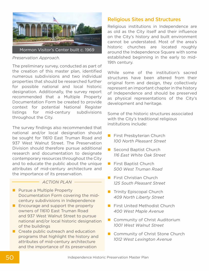
50
Preservation Approach.
The preliminary survey, conducted as part of the creation of this master plan, identified numerous subdivisions and two individual properties that should be researched further for possible national and local historic designation. Additionally, the survey report recommended that a Multiple Property Documentation Form be created to provide context for potential National Register listings for mid-century subdivisions throughout the City. The survey findings also recommended that national and/or local designation should be sought for 11610 East Truman Road and 937 West Walnut Street. The Preservation Division should therefore pursue additional research and documentation to designate contemporary resources throughout the City and to educate the public about the unique attributes of mid-century architecture and the importance of its preservation.
ACTION PLAN
� Pursue a Multiple Property Documentation Form covering the mid-century subdivisions in Independence
� Encourage and support the property owners of 11610 East Truman Road and 937 West Walnut Street to pursue national and/or local historic designation of the buildings
� Create public outreach and education programs that highlight the history and attributes of mid-century architecture and the importance of its preservation
Religious Sites and StructuresReligious institutions in Independence are as old as the City itself and their influence on the City’s history and built environment cannot be understated. Most of the area’s historic churches are located roughly around the Independence Square with some established beginning in the early to mid-19th century. While some of the institution’s sacred structures have been altered from their original form and design, they collectively represent an important chapter in the history of Independence and should be preserved as physical representations of the City’s development and heritage. Some of the historic structures associated with the City’s traditional religious institutions include:
� First Presbyterian Church 100 North Pleasant Street
� Second Baptist Church 116 East White Oak Street
� First Baptist Church 500 West Truman Road
� First Christian Church 125 South Pleasant Street
� Trinity Episcopal Church 409 North Liberty Street
� First United Methodist Church 400 West Maple Avenue
� Community of Christ Auditorium 1001 West Walnut Street
� Community of Christ Stone Church 1012 West Lexington Avenue
Mormon Visitor’s Center built c. 1969
Independence Historic Preservation Master Plan

51
Historic Houses of Worship
Chapter 3: Preservation Approaches

52
Preservation Approach
Currently, many of these traditional
congregations struggle with aging members
and decreasing numbers. To support these
groups, the City should partner in the creation
of public outreach and education events that
highlight the role of these organizations in
the development of Independence. Further,
the Preservation Division should provide
technical support and assist in seeking
funding sources that help local historic
churches meet the challenges of preserving
historic houses of worship.
ACTION PLAN
� Support historic churches in the overall preservation of the structures
� Encourage community outreach with the celebration of the various histories and styles of architecture
� Develop partnerships for the creation of local tours and lectures
� Provide technical preservation support and assist local historic churches with grant applications for restoration efforts
First Presbyterian Church
First Baptist Church
Second Baptist Church
Independence Historic Preservation Master Plan

53
Historic School BuildingsLocated primarily on the west side of Independence, historic school buildings are often a preservation challenge. These oversized, though well-constructed buildings, often sit idle when no longer used by their institution. Many of the City’s historic school buildings have seen adaptive reuse as housing, centers for educational programs, and office space. These include the historic Young School (501 North Dodgion Street), the Nova Center School (2425 North Harvard Avenue), and Mount Washington Senior Housing (570 South Evanston Avenue). While many of these buildings must undergo some alteration for their new use, including requirements for accessibility, the original design and look of the buildings can often be retained.
Preservation Approach
Many of the City’s historic school buildings have undergone adaptive reuse or have plans in place to reuse the property. The
Preservation Division should continue to encourage the reuse of these buildings in order to preserve them and to minimize risk of demolition. The City should support not-for-profits looking to utilize institutional buildings for office space, housing, and as centers for community services. Further, the Preservation Division should provide technical support and assist in seeking funding sources that help local organizations reuse these buildings.
ACTION PLAN
� Support the preservation of historic school buildings and encourage appropriate adaptive reuse projects
� Encourage the use of state and federal tax credits and other financial incentives to restore/rehabilitate historic school buildings
� Provide technical preservation support and assist local organizations wishing to reuse historic school buildings while retaining the building’s overall integrity
Hiram Young School was built for African-American students in 1935
Today, the Hiram Young School is owned by the Truman Heritage Habitat for Humanity
Chapter 3: Preservation Approaches

54
Cultural Landscapes While the historic built environment in Independence is extensive, so too are the City’s cultural landscapes. From pre-historic sites to cemeteries to Civil War battlefields, Independence’s diverse cultural landscapes should be documented and preserved. Located on both public and private land, the area’s cultural landscapes are scattered throughout Independence. Therefore, the preservation approach for each is unique. In order to document each area, the City’s mapping database should be updated to include all known cemetery locations, sites related to pioneer trails, and Civil War battlefields to better coordinate with future city-wide projects. The Preservation Division
should also expand its archaeological survey database by seeking grants to better document known Native American and pre-historic sites, including those on undeveloped parcels and located near geological features such as rivers and springs. Though the building boom experienced by Independence in the early 2000s has slowed, concerns remain that undeveloped agricultural land and associated agricultural outbuildings to the east will soon be lost to development. Proactive steps to document these areas should be a preservation priority. In addition to surveying, this can include additional markers and signage, interpretive programs, and pursuit of National Register designations.
Boundary map of the Battle of the Little Blue Civil War Battlefield
Independence Historic Preservation Master Plan

55
The American Civil War in IndependenceIndependence participated in several small battles and skirmishes associated with the American Civil War.
The most famous of these are:
� First Battle of Independence:
August 11, 1862
� Battle of the Little Blue:
October 21, 1864
� Second Battle of Independence:
October 21-22, 1864
Presently, none of the battlefields are listed in the National Register of Historic Places though all are recognized within the America Battlefield Protection Program survey. A regional heritage group, the Civil War Round Table of Western Missouri (CWRTWM), is currently consulting with the Missouri State Historic Preservation Office to pursue National Register designation for a portion of the Battle of the Little Blue battlefield. In addition to regular meetings, the CWRTWM actively offers regular community programming (tours, lectures, etc.) and encourages participation in the statewide heritage program as well as area driving tours. The advocacy group also assists with the identification and maintenance of associated Civil War markers and has “adopted” the Lewis-Gregg Cemetery in eastern Jackson County.
Civil War Markers
Chapter 3: Preservation Approaches

56
Independence Cemeteries Independence is home to numerous active and inactive cemeteries located throughout the City. While most are privately owned and maintained, the City owns and maintains both Woodlawn Cemetery and the Hill Park Cemetery. The following is a list of known cemeteries and burial sites throughout Independence:
� Woodlawn Cemetery
� Mount Washington Cemetery
� Lobb Cemetery
� Tucker-Hartwell Cemetery
� Pitcher Cemetery
� Hill Park Cemetery
� Webb Cemetery
� Campground Cemetery
� Luttrell Cemetery
� Mound Grove Cemetery
� Poteet-Compton Cemetery
The Three Trails and the Historic Retracement TrailIn Independence, the story of the pioneer trails is integral to the development of the area tying the influence of the Missouri River with the settlement of the west. Over the last several years, the National Park Service’s National Trails Intermountain Region worked with the Mid-America Regional Council (MARC), local governments, and local trails organizations to develop a strategy concept plan for retracing the three historic trails —
Woodlawn Cemetery Mausoleum at Woodlawn Cemetery
Independence Historic Preservation Master Plan

57Chapter 3: Preservation Approaches

58
the Santa Fe, Oregon, and California trails — through the Kansas City region. Ultimately, the retracement trail will lead visitors from Wayne City Landing in Sugar Creek, Missouri to Garden City, Kansas. The alignment of the retracement trail will follow the historic trails as closely as possible given constraints associated with private property and traffic patterns and congestion in order to make the trail as safe to follow as possible while still giving the visitor the most authentic experience possible. In addition to the retracement trail and the National Frontier Trails Museum, Independence has several active community groups associated with the historic trails that includes the Friends of the National Frontier Trails Museum and the Oregon-California Trails Association (OCTA). These organizations work to preserve and document the trails and to share the stories of those who traversed them.
Archaeology An archaeological survey was conducted in 1991 with a focus on current and future development proposed around major transportation corridors in Independence. While some sites with pre-historic evidence were documented, the survey was by no means a comprehensive analysis of the city’s overall resources.
Preservation Approaches for Cultural Landscapes
Documentation is the most important planning tool to better protect and preserve cultural landscapes in Independence. The Preservation Division should seek out grants to expand on the surveys already conducted and encourage interpretation, signage, and designation of those sites that are already recognized and that would not risk vandalism or destruction of the resource. Further, existing driving and walking tours and historic sites markers should be actively promoted by the City and incorporated into outreach and education programs. In 2019, Independence was included in the Missouri Civil War Passport Program, a Missouri Division of Tourism-initiative intended to encourage visitors to acquire passport book stamps and to visit Civil War sites scattered across Missouri. In addition to existing tours, it is hoped that this new program will better highlight the contribution made by Independence in the Civil War and encourage protection as well as visitation. The City’s cemeteries range from large, planned sites to small family plots. While the Preservation Division wishes to discourage possible looters and vandalism, it is important to document these sites on city-wide maps for consideration in future planning and infrastructure improvement projects. The Preservation Division should also work to expand on the public “adoption” of cemeteries that have been neglected or abandoned. With respect to the Retracement Trail and Independence’s pioneer history, the City should adopt the recommendations outlined in the strategy concept plan and incorporate them into future projects and policies while supporting the Retracement Trail’s promotion and use. Further, the City should
Independence Historic Preservation Master Plan

59
continue to support the organizations associated with the three trails history and their mission to educate, promote, and preserve trails-related heritage. Finally, Independence has an abundance of pre-historic and historic sites associated with Native American and early Independence settlement. While it is imperative that these resources are protected, they must be carefully documented in order to shield their location from looters and vandals. The City should expand on the previous archaeological survey conducted in 1991 to include locations in eastern Independence in order to better coordinate city-wide projects and to ensure that future development does not interfere with areas with concentrations of significant artifacts.
ACTION PLAN
� Incorporate Civil War battlefield
locations on City-developed maps and
share with other City departments
for more comprehensive long-range
planning
� Support the Missouri Civil War Passport
Program through community and
regional programs
� Document all known cemeteries on City
maps
� Support efforts by the National Park
Service and MARC to promote, enhance,
and preserve the Retracement Trail
� Support trails groups in their efforts
to educate the public on the role of
Independence in the development of
the Santa Fe, California, and Oregon
Trails
� Encourage the creation of an overlook
with interpretive signage south of 24
Highway and north of Powell Road to
educate residents and visitors about the
Battle of the Little Blue
� Support area heritage groups seeking
National Register designation of Civil
War sites
� Seek planning grants to better
document cultural landscapes that
include pre-historic/ archaeological
sites (particularly those in eastern
Independence) that builds on the 1991
survey results
� Support regional heritage groups in
interpretive signage programs and tours
� Encourage property owners to preserve
cultural landscape features located on
private land
� Create outreach and education
programs celebrating the larger role of
cultural landscapes
Chapter 3: Preservation Approaches

6060
A series of events were held in order to encourage citizen participation and to gather feedback for the creation of the goals outlined in this plan. Public engagement occurred through a variety of citizen meetings including the December 4, 2018 and June 5, 2019 Heritage Commission meetings, a meeting of community stakeholders on March 26, 2019, and two public input meetings held on April 11, 2019 and June 18, 2019. A survey asking for feedback on the plan was also offered to the public via social media and on the city’s preservation web page from April through the end of June 2019. Paper versions were printed for those without online access.
Five general topics emerged during the public engagement discussions and in responses to the survey:
1. Planning & Zoning
2. Historic Designation
3. Education & Outreach
4. Economic Incentives
5. Property Maintenance
The following is a summary of the suggestions put forth during the discourse:
PLANNING & ZONING
� Use historic preservation as a revitalization tool
� Identify areas to conduct architectural surveys and encourage historic designation based on the results
� Focus on underrepresented areas
� Adopt better signage for historic resources/areas
� Document and protect historic cemeteries
� Protect open space/archaeological sites
� Document and highlight the role of historic churches and trails
� Share locations of preservation resources with all city departments
� Correct zoning irregularities and conflicts in historic districts/areas
HPMP Public Workshop Groups discussed HPMP objectives
Independence Historic Preservation Master Plan
CH. 4 Community Engagement

61
HISTORIC DESIGNATION
� Align the current local district with the National Historic Landmark District boundaries
� Facilitate/incentivize historic designation
� Better educate property owners about how historic designation affects them
� Educate property owners about the importance of following preservation guidelines and retaining the property’s integrity
EDUCATION & OUTREACH
� More outreach is needed to educate citizens on the benefits of preservation
� Add a dedicated article in City publications for local history/preservation topics
� Promote Independence history using the built environment to tell the story
� Reach out to area schools
� Utilize social media, apps, and video to educate the public about historic preservation and better engage the community
� Create more resources for new homeowners and realtors
� Create a speaker’s bureau for history/preservation topics
� Better promote the City’s historic preservation web page
� Educate HOAs
� Host more community and technical workshops for historic property owners
ECONOMIC INCENTIVES � More economic incentives should be
offered to current property owners and to entice new investment in traditional neighborhoods and commercial districts
� Research incentives in other communities
� Adopt low interest or revolving loan programs
� Cost may be a barrier for current owners of historic buildings. Seek incentives and programs to assist.
� Partner with local businesses to create
incentives for historic properties
PROPERTY MAINTENANCE
� Host biannual neighborhood clean-ups or trash pick-up by the City to curb blight
� Assist property owners to maintain historic buildings and enforce code compliance and blight removal
� Improve accountability of absentee landlords
� Encourage city-wide property maintenance and expand current maintenance programs
� Historic properties are being lost to demolition. Encourage maintenance and create incentives for investment.
In order to prioritize the most critical issues facing preservation in Independence, the final chapter of this plan will:
� Highlight the top ten themes discussed during the public engagement process (as outlined above)
� Establish goals and objectives to achieve them.
Chapter 4: Community Prioritization & Feedback

62
CH. 5 Goals & ObjectivesCommunity-wide Preservation ChallengesThroughout the public engagement process, both obstacles and opportunities arose in discussions about historic preservation efforts in Independence. There are presently a number of threats to the successful preservation of the city’s historic resources.
Some of those challenges identified in the creation of this document include:
� Deferred maintenance/blight
� Disinvestment in traditional neighborhoods and commercial areas
� Absentee landlords
� Lack of economic incentives
� Apathy
� Need for more education and outreach (workshops, lectures, tours, etc.)
� Limited owner-occupied housing/local ownership
� Lack of documentation of historic resources
� Loss of integrity of historic resources
� Absence of a preservation advocacy group
Two of the biggest challenges facing the City’s historic built environment are deferred maintenance and disinvestment. Whether rental or owner-occupied, the City’s traditional neighborhoods and commercial areas suffer from a lack of consistent maintenance, repairs, and investment. While programs like the Rental Ready inspection program (requiring biennial inspections
of rental properties) and tax abatement programs encouraging local investment have attempted to incentivize upkeep, absentee landlords, over-extended property management companies, and the need for tougher property maintenance standards, make it easier for buildings to fall into disrepair and ultimately be demolished, rather than repaired or rehabilitated. Tools such as reviewing zoning that may be harming the re-use of a building, block, or neighborhood, partnering with local lending institutions to establish low-interest loan programs, and more robust rental maintenance requirements and proactive code compliance inspections may be excellent initial steps in tackling these threats.
Community-wide Preservation Opportunities With each challenge comes opportunity. While there are numerous hurdles to overcome, there are a variety of programs and incentives that can be offered to better educate the public about preservation, address deferred maintenance, and promote community-wide investment.
They include:
� Research regulations in other communities that better protect cultural resources and historic landscapes
� Conduct systematic city-wide architectural surveys funded through Certified Local Government (CLG) grants as recommended in this master plan
Independence Historic Preservation Master Plan

63
� Adopt a proactive codes compliance program
� Research economic incentives to expand local historic designation and encourage new and more robust investment in traditional neighborhoods and commercial districts
� Encourage the development of a city-wide, not-for-profit, preservation advocacy group
� Expand the current public education and outreach efforts by the Preservation Division and Heritage Commission Outreach Committee
� Adopt programs that highlight successful preservation projects
� Review current zoning to ensure compatibility with city-wide preservation efforts
� Update GIS mapping to limit conflicts between preservation and other department’s city-wide projects
Preservation Master Plan Goals & Objectives
Based on research conducted in the development of this master plan and feedback collected during the public engagement process, a pattern of needs emerged. To address these concerns in a productive and thoughtful way, ten preservation priorities were highlighted as the most important to address over the next ten years. To strategically meet these goals and objectives based upon current staffing and budget constraints, the goals were divided into two sets of five to be undertaken over the next decade. The goals, along with strategies developed by stakeholders and community members, are as follows:
Community Meeting #1
Results from Community Meeting
Public Engagement Presentation
Chapter 5: Goals & Objectives

64
GOAL 1Conduct architectural surveys
� OBJECTIVE: Seek grant funding to systematically conduct architectural surveys that document historic resources city-wide pursuant to this plan and use the results of these surveys to encourage historic designation.
GOAL 2Create economic incentives
� OBJECTIVE: Work with local lending institutions to establish low-interest loans and other economic incentives to encourage historic property ownership and property maintenance.
GOAL 3Develop more opportunities and resources to assist historic property owners
� OBJECTIVE: Sponsor workshops and lectures that offer both technical advice and introductory topics in preservation for historic property owners as well as the general public.
GOAL 4Support the expansion of current property maintenance programs to discourage demolition-by-neglect and demolition requests
� OBJECTIVE: Work with existing property maintenance programs such as those within the City’s Code Compliance and Dangerous Building Divisions, as well as the Rental Ready program, to encourage stabilization and reinvestment and to avoid unnecessary demolition.
� OBJECTIVE: Research mothballing as a policy to discourage neglect and to allow time for alternatives to demolition.
GOAL 5Reach out to the general public using social media, traditional City publications, and other technologies using the historic built environment to physically connect our citizens to the City’s heritage
� OBJECTIVE: Distribute relatable information about historic preservation, using both traditional and digital forms of communication, to promote the City’s historic built environment and highlight the importance of historic resources to the general public.
2019-2024 Priorities
Independence Historic Preservation Master Plan

65
GOAL 6Create more opportunities for blight removal
� OBJECTIVE: Partner with community groups, neighborhood groups, and other city departments in events that promote neighborhood clean-ups, support code compliance, and assist local property owners in need.
GOAL 7Adopt a historic signage program that highlights the boundaries of the historic districts
� OBJECTIVE: Work with area heritage groups and partners in the creation of targeted historic signage that delineates both locally and nationally designated districts.
GOAL 8Correct zoning conflicts by reviewing maps of all traditional neighborhoods
� OBJECTIVE: Review the current zoning maps and make recommendations to Planning & Zoning staff where conflicts may discourage investment in historic buildings or where adverse zoning may inadvertently encourage demolition.
GOAL 9Align the current local historic district with the boundaries of the National Historic Landmark District (NHLS)
� OBJECTIVE: Expand programs that educate and engage local property owners about the positive impacts of historic designation and seek to expand the boundaries of the local historic district to match that of the NHLD.
GOAL 10Support the creation of a grassroots, not-for-profit, preservation advocacy group
� OBJECTIVE: Provide technical assistance and support to members of the community in the development of an independent, not-for-profit preservation advocacy group.
2024-2029 Priorities
Chapter 5: Goals & Objectives

6666 Independence Historic Preservation Master Plan
APPENDIX Survey Results
Do you own a historically DESIGNATED property?
The nine (9) question survey was made available to the public April 2019 through June 2019 and is supplemental to the community input from public meetings. The survey aimed to help prioritize goals and guide the development of the plan through a series of ranking questions. The survey was promoted at public meetings, on the City’s website and via social media and e-blasts, yielding a total of 96 responses.
Question 1
4%1%1% 8% 86%Yes, my property is locally
designated.
Yes, my property is nationally
designated.
Yes, my property is both locally & nationally designated.
No, I do not own a locally or nationally designated property.
No, I do not own a designated
property, but I do think my property
is historically significant. Provide
address here:
What type of historically designated property do you own?Question 2
Residential I do not own a historically designated property
Commercial
7% 91%2%

6767APPENDIX: Survey Results
55%53% 51%
41%
32%
27% 26%
17%
The Independence Historic Preservation Master Plan will identify and rank the community’s most pressing historic preservation issues, and develop strategies to address them. From the list below, select the top THREE (3) issues you think should be addressed:
Question 3
Absentee landowners in historic neighborhoods don’t maintain properties.
The cost to maintain historic properties is a barrier to preservation.
Historic properties are being torn down due to lack of maintenance.
Property owners are worried there may be too many restrictions if they designate their properties.
Because of improper zoning, properties in historic neighborhoods are not protected from conversion to other uses.
Limited funding and staff support for historic preservation planning and property review.
Historic properties are being remodeled and losing their integrity.
Difficulty finding knowledgeable /skilled contractors.

6868 Independence Historic Preservation Master Plan
What is the highest priority for historic preservation in Independence? From the list below, select the top FIVE (5) things you’d like the City’s historic preservation program to accomplish:
Question 4
Improve accountability of absentee landowners.
Explore economic incentives and funding sources for property owners of individual
properties and historic neighborhoods.
Protect historic properties and surrounding neighborhoods from negative impacts of
improper zoning.
Pro actively identify and preserve resources before they lose their integrity.
Use historic preservation as a tool for neighborhood revitalization.
More actively enforce property maintenance codes in historic neighborhoods and for
historic properties.
Promote historic properties to both new and existing residents.
Educate property owners via technical workshops and lectures who are trying to
preserve historic resources.
Educate key stakeholders and the public about the community benefits of historic
preservation.
Re-evaluate the process for local designation and assess whether changes are needed to
make it more easily understood.
Increase funding for additional historic preservation staff and programming.
Increase the number of historically designated properties. 19%
23%
26%
32%
35%
35%
45%
50%
51%
58%
61%
65%

6969Chapter #: Title of the Chapter HereAPPENDIX: Survey Results
How important is the preservation of individual properties as a benefit for the community?
Question 5
60%20%
18%
1% 1%
Important
Somewhat Important
Not ImportantDon’t Know/
Have no Opinion
Very Important
80% of respondents think preservation is IMPORTANT or VERY IMPORTANT

7070 Independence Historic Preservation Master Plan
What zipcode do you live in?
What is your age?
Question 6
Question 7
PREFER NOT TO ANSWER
5%35 - 44 years
5%25 - 34 years
7%18 - 24 years
1%
65+ years
33%55 - 64 years
26%45 - 54 years
22%
6405020% 64056
6%
6405536%
6405713%
6405212%
640531% 64054
1%
Prefer Not To Answer
12%Independence CIty Hall

7171APPENDIX: Survey Results
Do you have any other suggestions or comments pertaining to the Independence Historic Preservation Master Plan? *Quotes were taken directly from survey results, but some were pared down to consolidate space.
Additional Comments
“Devise an online assessment tool for suggesting potentially
historic properties.”
“I am pleased to see the Civil War Round Table of
Western Missouri and City Cemeteries mentioned.”
“Property maintenance in ALL neighborhoods are extremely important.”
“...include properties surrounding the
designated properties.”
“Excited to see how Hiram Young School
can contribute to local history efforts.”
“Educate and help owners of historic properties on how to apply
for help from private funds...put all unnecessary projects on hold until Independence is only spending what they bring in.”
“The infrastructure and other surroundings that are near historic properties and
neighborhoods can really add to or take away from the integrity of those historic and interesting
properties.”
“Our city is rich in history and it’s
important to maintain it and preserve it.”
“Revitalization does not need to conflict with preservation.”
“it is costly to renovate and maintain
the historic homes.”
“...save our beautiful city while maintaining the public opinions...”
“Keep all land, trails, and
properties of historic nature a
top priority.”
“The historic aspect of
independence is its trademark.”

2019