historic environment assessment for the south ... · historic environment assessment of the south...
TRANSCRIPT
Adam Mindykowski
Malcolm Atkin, Emma Hancox and Tom Rogers With contributions from James Dinn
20th May 2010 Revised final report
© Historic Environment and Archaeology Service,
Worcestershire County Council
Historic Environment and Archaeology Service, Worcestershire County Council, Woodbury, University of Worcester, Henwick Grove, Worcester WR2 6AJ
Historic Environment Assessment For
The South Worcestershire Joint Core Strategy Area
Report 1672 WSM 39127

Contents Part 1 Project summary Part 2 Detailed report 1. Background......................................................................................................................... 2 1.1 Reasons for the project ..................................................................................................... 2
1.1.1 Project policy and wider framework links .................................................................. 2 1.2 Project parameters ........................................................................................................... 2 1.3 Previous historic environment assessments in Worcestershire ....................................... 2
1.3.1 Outline assessment of RSS areas, 2006 .................................................................. 2 1.3.2 Worcester Growth Point scoping report, 2007 .......................................................... 3
2. 2009 South Worcestershire Joint Core Strategy study .................................................. 4 2.1 Aims .................................................................................................................................. 4 3. Methods ............................................................................................................................... 5 3.1 Methodological background .............................................................................................. 5 3.2 Preparation of Historic Environment Record data ............................................................ 6
3.2.1 Introduction to the HER ............................................................................................. 6 3.2.2 Preparation and selection of records ......................................................................... 6
3.3 Preparation of Landscape Description Units (LDUs) ........................................................ 8 3.4 Definition of Historic Environment Character Zones (HECZ) ........................................... 8 3.5 Production of character statements and HECZ assessment criteria ................................ 9
3.5.1 Summary of assessment themes and scoring criteria .............................................. 9 3.5.2 Issues affecting scoring ........................................................................................... 11
4. Summary and consideration of the assessment results ............................................. 12 4.1 Key outcomes of the assessment ................................................................................... 12
4.1.1 Grouping of assessment themes ............................................................................. 14 4.2 Issues of survival, potential and sensitivity to change .................................................... 15
4.2.1 Historic environment: survival ................................................................................. 15 4.2.2 Historic environment: potential ................................................................................ 17 4.2.3 Historic environment: sensitivity to change ............................................................. 19
4.3 Assessment of coherence and diversity ......................................................................... 21 4.3.1 Historic environment: group value ........................................................................... 21 4.3.2 Historic environment: diversity ................................................................................ 23
4.4 Opportunities for historic environment conservation and promotion within masterplanning and Green Infrastructure design ...................................................................... 25
4.4.1 Historic Environment: amenity ................................................................................. 25 5. Publication summary ....................................................................................................... 27 6. Summary of sources for masterplanning ...................................................................... 27 7. The archive........................................................................................................................ 28 8. Acknowledgements .......................................................................................................... 28 9. Personnel .......................................................................................................................... 28 10. Bibliography .................................................................................................................. 28 11. Abbreviations and glossary......................................................................................... 29 12. General periods for the historic environment ........................................................... 30 Appendix 1: .............................................................................................................................. 31 Historic Environment Character Statements for the South Worcestershire Joint Core Strategy area ............................................................................................................................ 31


Historic Environment Assessment of The South Worcestershire Joint Core Strategy Area
Page 1
Historic Environment Assessment for The South Worcestershire Joint Core Strategy Area
Part 1 Project summary
This project has produced an integrated historic environment assessment of the South Worcestershire Joint Core Strategy area (see Fig 1). The assessment has been carried out with the overall aim of providing a strategic level historic environment evidence base for the JCS site allocations and policy DPD and Green Infrastructure strategy.
It was recognised during work-up of the Preferred Options Paper (SWJCS 2008) that production of an integrated historic environment assessment was required in order to provide an evidence base that would highlight key historic environment character and sensitivities. This would aim to define the context for development site-based assessment and flag areas requiring detailed investigation.
To achieve this aim the project was commissioned with the support of English Heritage and South Worcestershire, would be based on integrated historic environment assessments carried out in Shropshire and projects in the south-east of England. The method involved drawing together Historic Environment Record data with current and historic landscape characterisation. The assessment would also include, but not be biased towards, designated historic assets, namely, Scheduled Monuments, Listed Buildings, Registered Parks and Gardens and Registered Battlefields. The aim was not to devalue designated assets, but to recognise that over 20,000 non-designated assets are recorded on the HER. Taken together in context with the historic landscape, these assets define the historic environment and underpin local distinctiveness.
The assessment has defined 128 Historic Environment Character Zones (HECZ). The results of the assessment are presented in the following detailed report.

Historic Environment Assessment of The South Worcestershire Joint Core Strategy Area
Page 2
Part 2 Detailed report
1. Background
1.1 Reasons for the project
The project was commissioned by the South Worcestershire Joint Core Strategy planning partnership (SWJCS) comprising Worcester City Council, Malvern Hills and Wychavon District Councils. The project was only possible as a result of funding support provided by both the Districts partnership and English Heritage. The brief was to carry out a Historic Environment Assessment (HEA) in order to form part of the evidence base for both the Joint Core Strategy, set out in the Preferred Options Paper (2008) and Green Infrastructure study.
1.1.1 Project policy and wider framework links
The draft Preferred Options Paper, published in September 2008, contained headline references to the historic environment in Proposed Policy CS1 (pages 15-16). Another important document that is contributing towards delivery of historic environment policy guidance is the emerging Green Infrastructure strategy (SWJCS forthcoming). An historic environment officers group comprised of JCS officers, representatives of Worcestershire Historic Environment and Archaeology Service, Worcester City Museum Archaeology Service, English Heritage and Natural England was formed to both steer and develop policy content for both policy and Green Infrastructure documents. Early results from this project have informed historic environment content in the preliminary Green Infrastructure study; formed the basis for production of headline statements for Preferred Option sites and have helped to identify key objectives as part of the historic environment officers' group consultation process.
In November 2008, Worcestershire County Council produced a draft technical working paper for Planning and Green Infrastructure aimed at providing the first iteration of an integrated environmental framework (WCC November 2008). The document is part of a multi-stage process that aims to provide an over-arching Green Infrastructure framework that will link district strategies and provide a strategic guide for all types of environmental and developmental planning. The results of the SWJCS HEA will be integrated with similar studies being produced for Bromsgrove District and Redditch Borough Councils during 2010. The combined results will then inform version 2 of the technical working paper, which is being drafted for publication in spring 2010.
1.2 Project parameters
The project conforms to the Standard and guidance for archaeological desk-based assessment (IfA 2008) and to a project proposal of 30th September 2008, prepared by Worcestershire Historic Environment and Archaeology Service.
1.3 Previous historic environment assessments in Worcestershire
1.3.1 Outline assessment of RSS areas, 2006
A brief outline of Historic Environment Character for the RSS assessment areas around Evesham, Pershore, Droitwich Spa and Malvern was produced

Historic Environment Assessment of The South Worcestershire Joint Core Strategy Area
Page 3
in 2006 (WHEAS, November 2006). The study centred on quantifying the diverse range of historic assets recorded on the County Council HER at that time. By including County designated assets the study deliberately avoided the shortcomings of landscape scale assessments that only consider nationally designated assets (Scheduled Monuments, Listed Buildings, Registered Parks and Gardens and Registered Battlefields), although these assets were included within the overall assessment. A series of maps illustrating the locations of different classifications of assets were produced for 1 kilometre buffer zones around each town. The aims were to highlight diversity and show gaps in the record due to a lack of investigations. In addition, a short descriptive statement was produced for each buffer zone to capture the essential HLC attributes within each zone. The Worcestershire HLC project had not commenced at the time of the study. HLC statements were therefore drawn from a rapid map-based assessment of each buffer zone using broad type HLC character descriptions.
1.3.2 Worcester Growth Point scoping report, 2007
In May 2007 the historic environment and archaeological services of Worcestershire County Council and Worcester City Council prepared a scoping report as a first stage study to inform the Green Infrastructure Strategy process for the Worcester new growth point project.
Through this work, and following discussion with Worcestershire County Council Planning Officers, it became clear that, in order to ensure consistency and to avoid duplication of effort in serving the needs of the emerging pattern of strategic planning documents, it would be an advantage to have a consistent, countywide historic environment assessment that could be easily fed into wider strategic documents. This is particularly important within the context of the Worcestershire two-tier system and the multiplicity of sub-county core strategies. It was concluded that a countywide Historic Environment Assessment would generate a more informed understanding of the capacity of the county to accommodate potential new development. It would also contribute an evidence base to support development of county and district Green Infrastructure strategies.

Historic Environment Assessment of The South Worcestershire Joint Core Strategy Area
Page 4
2. 2009 South Worcestershire Joint Core Strategy study
2.1 Aims
In August 2008, it was agreed between Worcestershire Historic Environment and Archaeology Service, English Heritage and the Officers of the SWJCS that the historic environment assessment for the JCS area would follow an adapted methodology based on the Shropshire County Council ‘Shrewsbury New Growth Point Historic Environment Assessment’ project design.
This would effectively complete the first stage of the desired countywide coverage. In order to address external short-term deadlines, this study would proceed in a number of stages. This reflects that, whilst there is an urgent need for a base level of information to inform the current strategic planning process, a full analysis will only be possible with the completion of Historic Landscape Characterisation (HLC) in 2012.
A project proposal was submitted to the SWJCS Officers and English Heritage in 2008. The proposal was accepted and commenced immediately with funding support from both organisations.
The key project objectives were to:
Define Historic Environment Character Zones covering the entire SWJCS area
Identify and define historic environment coherence and diversity
Assess the level of survival, potential and sensitivity to change
Provide a local historic environment context for individual features recorded in the County Historic Environment Record
Identify opportunities that could inform Green Infrastructure design
Present the results in a clear GIS format with a set of supporting character statements for each zone

Historic Environment Assessment of The South Worcestershire Joint Core Strategy Area
Page 5
Figure 1: Assessment area
3. Methods
3.1 Methodological background
A methodology designed to combine and assess different historic environment datasets has emerged from work carried out in the south and south-eastern counties of England in response to proposed large scale housing developments. These projects set out to merge Historic Landscape Characterisation (HLC) data with the more site specific data held within Historic Environment Records (HERs). The initial assessment methodology was developed in partnership between English Heritage, Essex and Kent County Councils for the Thames Gateway Project (2004) and was further developed by Essex County Council at District scale. In 2007, Shropshire County Council carried out a historic environment assessment for the Shrewsbury New Growth Point area. The Shrewsbury project adopted the assessment criteria developed by Essex County Council with one principle distinction. The methodology merged HLC data with Landscape Description Units (LDU), defined in the Shropshire Landscape Characterisation Assessment, to create a redefined set of character polygons which were then merged with HER data to complete the assessment (Wigley, forthcoming).

Historic Environment Assessment of The South Worcestershire Joint Core Strategy Area
Page 6
3.2 Preparation of Historic Environment Record data
3.2.1 Introduction to the HER
The Historic Environment Record maintained by Worcestershire Historic Environment and Archaeology Service is the principal record of historic environment assets in Worcestershire. A similar record is maintained for Worcester by Worcester City Museum and Archaeology Service. The HER embraces all known assets drawn from a diverse range of sources. In addition to holding records of above and below ground historic environment features, the HER also holds data relating to nationally designated assets (SM, RB, RPG and LB). The evolution from a Sites and Monuments Record (SMR) to a Historic Environment Record (HER), in 2004, marked a shift towards development of a more holistic record that now includes data on ancient trees, palaeoenvironmental data, selected geological records historic town deposit modelling and the definition of historic landscape components. There are also links to related sources such as reports on research and investigation projects and historic documentation. The HER records spatially the location of archaeological investigations both fieldwork and desk-based. The record is underpinned by a suite of historic and modern map sources, aerial photographs and character maps, all managed within a GIS package.
3.2.2 Preparation and selection of records
In line with similar characterisation studies, selected HER data was abstracted from the record to show the distribution of assets and key landscape features and areas.
Selected HER layers were converted to point data to enable assessment based on the distribution of assets, the type of evidence and broad period. These datasets are:
Monuments
Historic Buildings
Listed Buildings
Historic Farmsteads
Scheduled Monuments
Ancient Trees
Selected landscape component layers were not converted to point data given their value as a context for individual and grouped historic assets. They also contributed to the definition of character zones based on their influence on landscape character. These datasets are:
Parks and Gardens
Ancient semi-natural and ancient replanted woodland
Conservation areas
Registered Common Land

Historic Environment Assessment of The South Worcestershire Joint Core Strategy Area
Page 7
The Documentation assessment theme (see section 3.4) was largely informed by information and sources drawn from the Activities layer in the HER.
The full range of HER sources considered is listed in table 1.
Table 1: HER sources
Source name Description
Historic Environment Record layers
Activities Activity is defined as the collection of information or judgements by an individual or organisation which is related to a defined geographic area and is undertaken at a fixed moment in time
Buildings Building is defined as a visible up standing structure which is not an earthwork. This source is comprised of both listed and non-listed historic buildings
Monuments A Monument is the documentation of any feature of the landscape or seascape that, by its nature (either extant or former), imparts knowledge about the historic environment (source: MIDAS Heritage)
Parks and Gardens
A layer that is embedded within Monuments recording ornamental and designed landscapes, and areas of landscape with designed characteristics such as historic woodland, parkland type plantation, or designed water features
GIS layers from English Heritage
Listed Buildings A point layer based on all Listings that pre-date 1999. Not all locations are accurate, however, at a strategic assessment scale the accuracy is sufficient to allow assessment of LB density
Scheduled Monuments
Nationally designated historic assets that are mapped as a layer in the Historic Environment Record based on the Schedule Descriptions provided by English Heritage. The mapped areas are a guide. Only English Heritage hold the definitive maps for Scheduled Monuments
Historic environment project layers
Historic Farmsteads Characterisation
This project aims to develop an integrated understanding of farmstead character, survival and current use within their landscape and settlement context; using early 20th century ordnance survey mapping as a baseline for recording
Other layers available via
Ancient semi-natural woodland
Woodland that has persisted in the landscape since approximately 1600AD

Historic Environment Assessment of The South Worcestershire Joint Core Strategy Area
Page 8
the County Council GIS
Ancient replanted woodland
Woodland where the original native tree cover has been felled and replaced by plantation often during the 20th century
Conservation areas
"An area of special architectural interest, the character or appearance of which it is desirable to preserve or enhance" (source Section 69 of the Planning (Listed Buildings and Conservation Areas) Act 1990)
Worcestershire Ancient Trees
Records showing the locations of ancient and veteran trees drawn from a Worcestershire Biological Records Centre project
Common land Land in Worcestershire which was registered under The Commons Registration Act 1965
Digital map/image sources
OS Master Map 1:2,500
Digital vector map of the modern landscape
OS 1:10,560 series publication date 1843-1893.
Historic raster map
OS 1:2,500 series publication date 1884-1889.
Historic raster map
Getmapping Air Photo coverage 2005
The most recent aerial photographic coverage available on the County GIS
Google Earth Aerial photographic coverage of various dates used for comparison with County GIS coverage
3.3 Preparation of Landscape Description Units (LDUs)
The Landscape Description Units layer is one of two polygon map layers produced by Worcestershire County Council's Landscape Team for the Landscape Character Assessment. The LDUs provide both a landscape context for HER records in addition to their value as indicators of landscape character. A copy of the LDU layer with most of the existing attribute data removed was loaded into GIS
3.4 Definition of Historic Environment Character Zones (HECZ)
The data and layers described above were loaded into GIS software, which offers a practical and flexible method of comparing data. The process examined the data for patterns in the distribution of historic environment assets within each layer. It also identified areas of group value related across one or more layers and similarly areas of diversity across the range of layers. Using this method it was possible to identify areas with similar archaeological character. For example, areas defined by surviving extensive below ground archaeology or where features are broadly of a similar period.
The historic buildings, Listed Buildings and historic farmsteads layers were compared to assess the distribution and relationship between historic buildings and their setting in the landscape.

Historic Environment Assessment of The South Worcestershire Joint Core Strategy Area
Page 9
This assessment was carried out in relation to the existing LDU mapping, selected historic Ordnance Survey mapping and aerial photographic coverage. It was therefore possible to make an assessment of the historic landscape character in any given area.
By combining the above, it was possible to define areas of distinctive or related historic environment character to create an integrated evidence base; the Historic Environment Character Zone. A total of 128 HECZ were defined covering the entire Joint Core Strategy area. The next stage involved preparation of a character statement and thematic assessment of each character zone. It is important to stress that this study is the first iteration of a strategic assessment. Once the county Historic Landscape Character project is complete, this data should be used to deepen the assessment of landscape character and sensitivity.
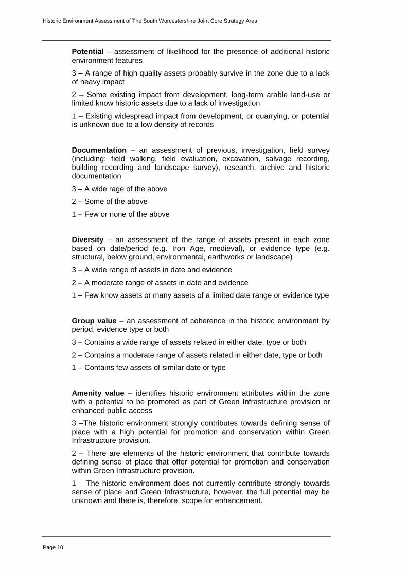
3.5 Production of character statements and HECZ assessment criteria
Each HECZ is supported by three short statements, an introductory summary to set the context followed by summaries of historic landscape and archaeological character attributes for the zone.
This is followed by an assessment of the zone based on seven themes:
Survival
Potential
Documentation
Diversity
Group value
Amenity
Sensitivity to change
Each theme has been scored between 1 and 3, with 3 being the highest value. The definition of assessment themes and scoring methodology is based on the method employed by Shropshire Council for the Shrewsbury New Growth Point Assessment (Wigley forthcoming). This method is rooted in the approach developed for the Rochford District Historic Environment Characterisation Project (Brown, Clarke and Havis, 2006). It must be understood that at this strategic assessment level the numerical assessment is indicative. The scores must therefore be taken in relation to the overall character description statements.
3.5.1 Summary of assessment themes and scoring criteria
Survival – based on current Historic Environment Record assets, land-use and the impact of previous development
3 – High preservation of many known assets
2 – Moderate preservation of many assets or few recorded assets, but little disturbance within the zone
1 – Low or unknown preservation due to heavy impact or low density of Historic Environment Records
Historic Environment Assessment of The South Worcestershire Joint Core Strategy Area
Page 10
Potential – assessment of likelihood for the presence of additional historic environment features
3 – A range of high quality assets probably survive in the zone due to a lack of heavy impact
2 – Some existing impact from development, long-term arable land-use or limited know historic assets due to a lack of investigation
1 – Existing widespread impact from development, or quarrying, or potential is unknown due to a low density of records
Documentation – an assessment of previous, investigation, field survey (including: field walking, field evaluation, excavation, salvage recording, building recording and landscape survey), research, archive and historic documentation
3 – A wide rage of the above
2 – Some of the above
1 – Few or none of the above
Diversity – an assessment of the range of assets present in each zone based on date/period (e.g. Iron Age, medieval), or evidence type (e.g. structural, below ground, environmental, earthworks or landscape)
3 – A wide range of assets in date and evidence
2 – A moderate range of assets in date and evidence
1 – Few know assets or many assets of a limited date range or evidence type
Group value – an assessment of coherence in the historic environment by period, evidence type or both
3 – Contains a wide range of assets related in either date, type or both
2 – Contains a moderate range of assets related in either date, type or both
1 – Contains few assets of similar date or type
Amenity value – identifies historic environment attributes within the zone with a potential to be promoted as part of Green Infrastructure provision or enhanced public access
3 –The historic environment strongly contributes towards defining sense of place with a high potential for promotion and conservation within Green Infrastructure provision.
2 – There are elements of the historic environment that contribute towards defining sense of place that offer potential for promotion and conservation within Green Infrastructure provision.
1 – The historic environment does not currently contribute strongly towards sense of place and Green Infrastructure, however, the full potential may be unknown and there is, therefore, scope for enhancement.

Historic Environment Assessment of The South Worcestershire Joint Core Strategy Area
Page 11
Sensitivity to change – identifies sensitivity based on the impact of medium to large-scale development
3 – Medium to large-scale development will have a significant impact on the historic environment.
2 – Medium to large-scale development will have a considerable impact on the historic environment.
1 – The historic environment could accommodate medium to large-scale development although specific assets may suffer adverse effects.
The integrated assessment is then expressed as an overall score, which is the sum total of scores from the seven criteria.
3.5.2 Issues affecting scoring
Where a score of 1 has been applied this does not, in every case, indicate a low historic environment value. The assessment of historic environment data has been reliant on existing information and sources held in the Worcestershire HER. In common with all other local authorities, the HER is largely populated with records drawn from the following activities:
Archaeological investigations carried out as part of development control conditions of assessment and mitigation
Archaeological assessments and investigations carried out in conjunction with aggregates extraction
Archaeological investigations carried out in conjunction with large infrastructure installation and upgrade projects, such as utilities and road building
Previous landscape-scale or urban historic environment assessments
Private and academic survey and research
There is, therefore, a tendency for HER information to be concentrated within, or on the fringes of larger villages and towns where domestic and industrial redevelopment or expansion has taken place, adjacent to major road and utility networks, in areas of significant aggregate extraction and in areas of arable farming where surface artefacts and below ground archaeological features have been widely researched (see Figure 2). By contrast, rural areas with a lower settlement density and higher ratio of woodland and/or pasture are considered to be under-represented in the HER as they have not been the subject of detailed archaeological investigation.
Current research being undertaken as part of the Heritage Lottery Fund led Grow with Wyre project offers a prime example of where a heavily wooded, sparsely populated landscape has been revealed as a complex, multi-period historic environment. This issue underpins the need for site masterplanning to ensure detailed investigations are undertaken in order to establish fully the intricate variables that will be present on any site, to measure loss, survival and identify potential and therefore opportunities for conservation and enhancement. Across all zones, diverse types of historic environment features and landscape attributes are subject to the same level of impact from development. By contrast, the opportunities for mitigation and conservation are more intricate requiring detailed assessment and understanding during site masterplanning.

Historic Environment Assessment of The South Worcestershire Joint Core Strategy Area
Page 12
Figure 2: Assessment of historic environment research and investigation
4. Summary and consideration of the assessment results
4.1 Key outcomes of the assessment
The project has identified and characterised 128 HECZ covering the SWJCS area. These are strategic level indicative character assessments. In the majority of cases, the base Landscape Description Units were either altered or merged to reflect clear patterns in the association between the historic environment and landscape. Decision processes developed for the county Historic Landscape Character Project were used, particularly, to assess historic field patterns in their chronological framework. In retrospect, had HLC mapping been available for this assessment the final results may have varied to some degree. Nonetheless, by applying HLC assessment techniques as part of the HEA assessment process, the essential HLC attributes and trends have been successfully captured. It has been possible to validate this by respective comparison, of selected HECZ, in those areas where the HLC has been completed. The individual scores for each of the seven assessment themes, discussed in section 3.5, were combined to provide an overall score for each HECZ. The score range spans from 8 to 21 with the majority of HECZ scoring 12 or above. This is summarised in the table below.

Historic Environment Assessment of The South Worcestershire Joint Core Strategy Area
Page 13
Table 2: Distribution of overall scores out of the total of 128 HECZ
Overall HECZ score range Count
21 6
20 9
19 17
18 11
17 12
16 12
15 17
14 18
13 7
12 11
11 3
10 1
9 2
8 3
0
2
4
6
8
10
12
14
16
18
20
21 20 19 18 17 16 15 14 13 12 11 10 9 8
Nu
mb
er
of
HEC
Z p
er
sco
re
Overall score range
SWJCS HEA overall score summary
Count

Historic Environment Assessment of The South Worcestershire Joint Core Strategy Area
Page 14
Figure 3: Overall scores for the assessment area
4.1.1 Grouping of assessment themes
In the following section the seven assessment themes have been grouped together to reflect their conceptual relationships, for example, there is a direct link between the survival of historic environment features and the potential for additional features and sites being present in the same zone. It must me stressed that all seven themes interact and therefore contribute towards assessments of sensitivity, opportunity (amenity) and the overall score in each zone.

Historic Environment Assessment of The South Worcestershire Joint Core Strategy Area
Page 15
4.2 Issues of survival, potential and sensitivity to change
4.2.1 Historic environment: survival
Survival – based on current Historic Environment Record assets, land-use and the impact of previous development
3 – High preservation of many known assets
2 – Moderate preservation of many assets or few recorded assets, but little disturbance within the zone
1 – Low or unknown preservation due to heavy impact or low density of Historic Environment Records
The assessment of survival is based on existing records held in the HER, which has been measured against the broad impacts from development, aggregate extraction and, to some extent, rural land-use. It is not possible to assess site intrinsic factors such as the depth of ploughing in arable land or the affects of soil erosion from weathering and run-off. Such detail can only be achieved by carrying out fieldwork investigations. However, by including aerial photographic coverage as a source in the assessment, it is possible to identify broad trends in rural land-use and consider their impact. For example, in areas of extensive arable farming it is likely there will be some negative impact on below ground archaeology. This will vary depending on factors such as local topography and type of crop regime, nonetheless, at the level of HECZ assessment the effect of broad trends can be estimated with moderate confidence.
Overall, the results show a largely medium to high assessment of survival with a few zones that have a lower or unknown rating due, in part, to a paucity of recorded information. There is a bias of high scores in urban areas due to the cluster of HER records typical in urban areas and the density of historic buildings and features that survive in the deeply stratified deposits that characterise urban archaeology. In some of the less arable areas east of Worcester and Droitwich a higher incidence in the survival of earthworks and above ground features is more evident.

Historic Environment Assessment of The South Worcestershire Joint Core Strategy Area
Page 16
Figure 4: Assessment of historic environment survival

Historic Environment Assessment of The South Worcestershire Joint Core Strategy Area
Page 17
4.2.2 Historic environment: potential
Potential – assessment of likelihood for the presence of additional historic environment features
3 – A range of high quality assets probably survive in the zone due to a lack of heavy impact
2 – Some existing impact from development, long-term arable land-use or limited known historic assets due to a lack of investigation
1 – Existing widespread impact from development, or quarrying, or potential is unknown due to a low density of records
The assessment of potential is logically linked with survival; where there is good survival then the presence of additional features can be forecasted with reasonable confidence. However, high potential can also be estimated in zones where the impact on landscape from development and intensification of farming is less evident.
Historic environment potential has to be understood in the abstract. Zones that have an intact historic field pattern can not produce more boundaries and hedgerows. However, by contrast, the deep alluvial deposits associated with river corridors and palaeolchannels preserve ancient environmental materials, organic artefacts and structures, and multi-period features sealed beneath the upper alluvial layers. These are not visible on the surface, but are highly susceptible to impact from the deep excavations imposed by development
Potential is high in all urban areas where deeply stratified structures, features and deposits of multi-period origin are likely to survive.

Historic Environment Assessment of The South Worcestershire Joint Core Strategy Area
Page 18
Figure 5: Assessment of historic environment potential

Historic Environment Assessment of The South Worcestershire Joint Core Strategy Area
Page 19
4.2.3 Historic environment: sensitivity to change
This map has been generated from an assessment of the impact of medium to large-scale development on the historic environment within each character zone. The types of sensitivity present vary within each zone. Each zone is scored between 1 and 3, with 3 being the highest value.
3 (High) – Medium to large-scale development will have a significant impact on the historic environment.
2 (Medium) – Medium to large-scale development will have a considerable impact on the historic environment.
1 (Low/Unknown) – The historic environment could accommodate medium to large-scale development although specific assets may suffer adverse effects.
At a strategic scale, there are some notable patterns in the distribution and range of sensitivity. Some of the zones that have rated high are, perhaps, obvious. For example, Worcester and all of the towns have scored high. This is largely due to a high density of historic environment features; including multi-period historic buildings and diverse, deeply stratified below ground archaeology. Similarly, it is easy to appreciate how zones covering the Malvern Hills, in the west, and Bredon Hill, in the south have a high sensitivity to change. This is largely due to the presence of well preserved prehistoric settlement remains set within highly distinctive historic landscapes. Other zones with high sensitivity perhaps require more explanation, given that the reasons their high score may not be immediately apparent.
High sensitivity in the Severn corridor is largely the result of extensive prehistoric and Romano-British settlement remains located on the lower gravel terraces. These sites are all preserved as below ground remains with very little surface evidence, in the form of artefact scatters and seasonal cropmarks. However, decades of mapping, survey and targeted excavation have built up an evidence base indicating that these now largely arable landscapes were densely populated by farming settlements for well over a millennium.
In the south-east of Worcestershire, there is a distinctive area of high sensitivity in the area occupied by 'The Lenches'. Set on a plateau of rolling topography is a landscape defined by a pattern of dispersed settlement with medieval origins. These settlements are set within a landscape of diverse field patterns dating from the high medieval period to the 19th century. The boundaries and hedgerows of these fields were set out over earlier medieval open-fields with their distinctive ridge and furrow form. In many parts of this area, ridge and furrow has survived due to the high ratio of land under permanent pasture. In some places the extent of survival has resulted in the preservation of whole parts of the medieval field systems. These alone are highly sensitive to change.

Historic Environment Assessment of The South Worcestershire Joint Core Strategy Area
Page 20
Figure 6: Assessment of impact and sensitivity to change

Historic Environment Assessment of The South Worcestershire Joint Core Strategy Area
Page 21
4.3 Assessment of coherence and diversity
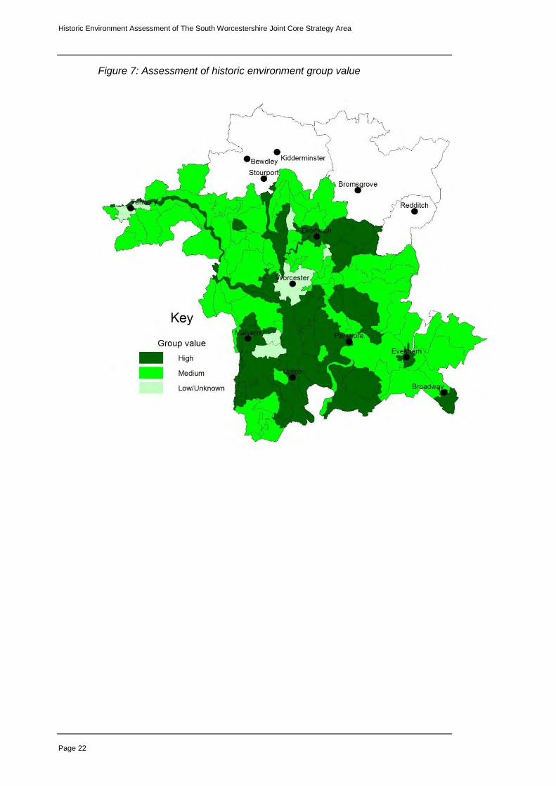
4.3.1 Historic environment: group value
Group value – an assessment of coherence in the historic environment by period, evidence type or both
3 – Contains a wide range of assets related in either date, type or both
2 – Contains a moderate range of assets related in either date, type or both
1 – Contains few assets of similar date or type
The assessment of group value has particular relevance towards aiding an understanding of setting and sense of place. This may be a visual experience, for example: dispersed settlement along sinuous lanes, areas of well-preserved medieval earthworks, historic hedgerows, relic parkland or commons.
By contrast, group value might be defined by features that are not visible, yet they contribute strongly towards the historic environment of a zone, for example: later prehistoric and Romano-British settlement remains that occupy the gravel terraces in the lower Severn corridor and the lowlands around Bredon Hill or areas with alluvial soils that preserve assemblages of palaeoenvironmental materials.
Group value assessment also provides a specific indicator of sensitivity. Any loss or weakening of coherence identified in character zones with a high group value will weaken the overall historic environment character of the zone and potentially impact on the setting of related historic assets.
This theme also provides an indicator of opportunities that should inform Green Infrastructure design. For example, zones that may have a relatively intact historic field pattern, ancient woodland, medieval moated sites or areas of relic parkland offer particular opportunities for integration into Green Infrastructure networks and open space. Equally, the protection of high value below ground archaeology might be achieved through the allocation of open space that limits ground disturbance within a development area. The group value theme does not identify those specific areas of sensitivity at a site level, but is does aim to define areas where these constraints and opportunities are likely to be encountered.
Group value is high in all urban areas where related deeply stratified structures, features and deposits of multi-period origin are likely to survive. There is also coherence in the survival of historic buildings, both listed and non-listed, within the historic core of all urban areas in South Worcestershire.
Historic Environment Assessment of The South Worcestershire Joint Core Strategy Area
Page 22
Figure 7: Assessment of historic environment group value

Historic Environment Assessment of The South Worcestershire Joint Core Strategy Area
Page 23
4.3.2 Historic environment: diversity
Diversity – an assessment of the range of assets present in each zone based on date/period (e.g. Iron Age, medieval), or evidence type (e.g. structural, below ground, environmental, earthworks or landscape)
3 – A wide range of assets in date and evidence
2 – A moderate range of assets in date and evidence
1 – Few know assets or many assets of a limited date range or evidence type
At a strategic scale of assessment, diversity is a key attribute of the historic environment. Nonetheless, it is possible to identify and classify distinctive areas where multi-period historic assets are present. Equally, some zones contain a wide range of assets of different types. It might seem predictable that zones with a lower group value will have a higher diversity score and vice-versa. This is, however, not necessarily the case as comparison between figures 7 and 8 demonstrates.
For example, HECZ 041 (Chateau Impney to Hanbury Park) has both a high group value, due to the well-preserved parkland landscapes, and a high diversity value, due to the presence of Romano-British and medieval archaeology plus the Conservation Areas at Hadzor and along the Droitwich Link and Birmingham to Worcester Canals.
Historic environment diversity, perhaps, presents extra challenges, but also opportunities for planning and Green Infrastructure design. The range of constraints and opportunities for protection and enhancement will be greater given that buildings, earthworks, paleoenvironmental remains, below ground archaeology and relic landscapes each demand very different responses within an integrated strategy to deliver effective solutions.
The area east of Droitwich, up to the borders of Redditch, has a high group value due to its coherent well preserved medieval and post-medieval landscape character. This requires an approach to planning design that respects the grain and scale of the historic field and settlement patterns. However, there are areas of diversity within this landscape where below ground archaeology is concentrated, and therefore, particularly sensitive to change. Undoubtedly, where these factors combine, complex constraints arise that may affect development opportunities. In such cases, there is a need for further investigation to fully explore constraints and opportunities.
Diversity is high in all urban areas where deeply stratified structures, features and deposits of multi-period origin are likely to survive.

Historic Environment Assessment of The South Worcestershire Joint Core Strategy Area
Page 24
Figure 8: Assessment of historic environment diversity

Historic Environment Assessment of The South Worcestershire Joint Core Strategy Area
Page 25
4.4 Opportunities for historic environment conservation and promotion within masterplanning and Green Infrastructure design
4.4.1 Historic Environment: amenity
This map has been generated from an assessment of the actual and/or potential value of the historic environment to contribute towards Green Infrastructure design in each zone. The assessment has considered uniqueness, key historic environment landmarks, good public access and the potential for promoting the historic environment for the benefit of public interest, educational value and place making. Again, each zone is scored between 1 and 3, with 3 being the highest value.
3 (High) – The historic environment provides a major contribution towards defining sense of place. There are constraints and significant opportunities for conservation and promotion that should be addressed in masterplanning and Green Infrastructure design.
2 (Medium) – The historic environment contributes towards local distinctiveness and sense of place. This may be specific elements of the historic landscape and historic environment features or a combination of both. Constraints and opportunities for conservation and promotion should be addressed during masterplanning and Green Infrastructure design.
1 (Low/Unknown) – The historic environment does not appear to contribute strongly towards defining sense of place. However, the full potential may be unknown and there is, therefore, scope for further investigations. These should be carried out as part of masterplanning and Green Infrastructure design to identify constraints and opportunities.
The map clearly demonstrates that some potential for promotion and conservation exists across the entire assessment area. Individual zones and zone groups that have a high amenity value are reasonably dispersed throughout the assessment area. In some cases, such as the Malvern Hills, Bredon Hill and Broadway, this is a result of the co-existence between high value, high density historic assets and equally high value landscapes. However, in other zones, such as parts of the former Feckenham Forest area in the east of Worcestershire, the high score reflects a perhaps less obvious value, which is the result of greater diversity in the range of historic environment assets and landscape types.
It is important to note that zones with a low score are not necessarily devoid of historic environment interest, nor are they degraded landscapes without other environmental potential, although areas of degraded landscape will, of course, influence scoring. In some cases these are zones where the historic environment is not well recorded. In others they reflect heavy arable land-use, for example, in the south-east of Worcestershire.
The development of opportunities to conserve historic environment features and landscapes and promote their contribution towards defining identity and a sense of place should be a key objective in Green Infrastructure design. Historic environment features can contribute towards achieving multi-functional objectives in connection with landscape, biodiversity, recreation, access and climate change mitigation. Version 1 (and later iterations) of the Technical Research Paper for Green Infrastructure (WCC 2008) is aiming to develop these Specific groups of historic environment features, and their relationship with Green Infrastructure themes, can be defined as follows:

Historic Environment Assessment of The South Worcestershire Joint Core Strategy Area
Page 26
Green Infrastructure historic environment networks: hedgerows, green lanes, canals, disused railway lines
Green Infrastructure historic environment open space/green space: orchards, designed landscape (e.g. parkland), permanent pasture with earthworks (e.g. ridge and furrow), land with extensive below ground archaeology, ancient semi-natural and ancient replanted woodlands.
Green Infrastructure historic environment interfaces with Blue Infrastructure: ponds, water filled quarries and clay pits, canals, bogs, palaeochannels and alluvial soils.
Figure 9: Assessment of historic environment amenity potential in the context of Green Infrastructure design

Historic Environment Assessment of The South Worcestershire Joint Core Strategy Area
Page 27
5. Publication summary
The Service has a professional obligation to publish the results of archaeological projects within a reasonable period of time. To this end, the Service intends to use this summary as the basis for publication through local or regional journals. The client is requested to consider the content of this section as being acceptable for such publication.
A Historic Environment Assessment of the South Worcestershire Joint Core Strategy area was carried out on behalf of the Joint Core Strategy partners: Malvern Hills District Council, Worcester City Council and Wychavon District Council. The project was designed to provide an integrated historic environment evidence base to support policy and Green Infrastructure documents aimed at shaping future development strategy. The project combined county landscape character mapping with Historic Environment Record data and an outline Historic Landscape Character assessment. The results have produced 128 distinctive Historic Environment Character Zones, which are supported by character statements assessing historic environment survival, potential, documentation, diversity, group value, sensitivity and amenity potential for each zone. The project has provided an immediate assessment of the historic environment, however the methodology also provides the capacity for re-evaluation at key future stages.
6. Summary of sources for masterplanning
Specialist advice:
Worcestershire County Council Historic Environment and Archaeology Service
Worcester City Council Archaeological Service
District Conservation Officers (Malvern Hills, Wychavon and Worcester City)
District landscape officers (Malvern Hills, Wychavon and Worcester City)
English Heritage Documents:
Historic Environment Assessment For The South Worcestershire Joint Core Strategy Area
Planning for Landscape, Biodiversity and the Historic Environment in the development of Green Infrastructure Strategies in Worcestershire, Technical Research Paper: Version 2, Worcestershire County Council
Revised historic environment content for the Worcester Green Infrastructure Study
SWJCS Policy CS22 and Green Infrastructure content
Planning Policy Statement 5: Planning for the Historic Environment
District Conservation Area Appraisals (Malvern Hills, Wychavon and Worcester City)
Sources:
Sites or monuments registered on the County Historic Environment Record
Sites or monuments on the Worcester City Historic Environment Record
District Listed Buildings records

Historic Environment Assessment of The South Worcestershire Joint Core Strategy Area
Page 28
English Heritage record of Scheduled Monuments, Registered Battlefields and Registered Parks and Gardens
Worcestershire (and West Midlands) Historic Farmsteads Characterisation Project (English Heritage and Regional Local Authorities)
Historic Landscape Characterisation Project for Worcestershire (Worcestershire Historic Environment and Archaeology Service)
7. The archive
The archive consists of:
GIS based map coverage for the SWJCS area and supporting digital documentation.
The project archive is intended to be placed at:
Worcestershire Historic Environment and Archaeology Service Woodbury University of Worcester Henwick Grove Worcester WR2 6AJ
Tel: 01905 855455 Fax: 01905 855035
8. Acknowledgements
The Service would like to thank Vanessa Clarke (BBC) and Andy Wigley (SC) for their kind assistance in guiding the development of the project methodology. The SWJCS Heritage Officers team in all of its guises has provided valuable feedback and a welcome forum for discussion throughout this project. We are very grateful to Amanda Smith of English Heritage for providing support and helping to enable delivery of the project. Finally, we would like to extend our gratitude to our partners in the SWJCS for their technical and financial support, without which this project could not have progressed.
9. Personnel
The methodology and background section of the report were produced by Adam Mindykowski and Malcolm Atkin. The assessment was undertaken by Emma Hancox, Adam Mindykowski and Tom Rogers with contributions by James Dinn. The project manager responsible for production of the final report and the quality of the project was Adam Mindykowski.
10. Bibliography
IFA, 1999 Standard and guidance for archaeological desk-based assessment, Institute of Field Archaeologists.
SWJCS , 2008, The South Worcestershire Joint Core Strategy Preferred Options Paper, public consultation document http://swjcs.org/PO_CONSULTATION/swjcs_PO.pdf
WCC, 2008, Planning for Landscape, Biodiversity and the Historic Environment in the development of Green Infrastructure Strategies in

Historic Environment Assessment of The South Worcestershire Joint Core Strategy Area
Page 29
Worcestershire, Technical Research Paper: version 1, WCC unpublished document
Worcestershire Landscape Character Assessment http://gis.worcestershire.gov.uk/website/lca/viewer.htm
11. Abbreviations and glossary
BBC: Bedford Borough Council
Cropmarks: The visible effect on the development of arable crops caused by the presence of below ground historic environment features
DPD: Development Plan Document
GI: Green Infrastructure
HEA: Historic Environment Assessment
HER: Historic Environment Record.
HECZ: Historic Environment Character Zones
HLF: Heritage Lottery Fund
LB: Listed Buildings
LDU: Landscape Description Unit
Planning Policy Guidance 15 (PPG15): provides a full statement of Government policies for the identification and protection of historic buildings, conservation areas and other elements of the historic environment (source: www.communities.gov.uk)
Planning Policy Guidance 16 (PPG16): sets out the Secretary of State's policy on archaeological remains on land, and how they should be preserved or recorded both in an urban setting and in the countryside (source: www.communities.gov.uk)
Planning Policy Statement 5 (PPS5): sets out the Government's planning policies on the conservation of the historic environment and has replaced both PPG15 and PPG16 as of March 2010 (source: www.communities.gov.uk)
Palaeochannels: ancient silted up river channels, or other watercourses that are often associated with well-preserved organic remains and historic environment features
Palaeoenvironmental: all biological and non-biological material relating to past environments
RB: Registered Battlefield
Ridge and furrow: large-scale earthworks associated with former medieval and post-medieval open-field communal farming that appear as a distinctive corrugated surface
RPG: Registered Park and Garden
SC: Shropshire Council
SM: Scheduled Monument
WHEAS: Worcestershire Historic Environment and Archaeology Service
WCC: Worcestershire County Council

Historic Environment Assessment of The South Worcestershire Joint Core Strategy Area
Page 30
12. General periods for the historic environment
Palaeolithic -500000 BC to -10001 BC
Mesolithic -10000 BC to -4001 BC
Neolithic -4000 BC to -2351 BC
Bronze Age -2350 BC to -701 BC
Iron Age -800 BC to 42 AD
Romano-British 43 AD to 409 AD
Post-roman (Early medieval) 410 AD to 1065 AD
Medieval 1066 AD to 1539 AD
Post- medieval 1540 AD to 1900 AD
Modern 1901 AD to 2050 AD

Historic Environment Assessment of The South Worcestershire Joint Core Strategy Area
Page 31
Appendix 1:
Historic Environment Character Statements for the South Worcestershire Joint Core Strategy area
Figure 10: HECZ locations

Historic Environment Assessment of The South Worcestershire Joint Core Strategy Area
Page 32
HECZ 001: Spetchley Park
Summary: This zone is located on predominantly clay soils to the east of an area of Worcester dominated by modern housing and communications. The zone itself is dominated by ornamental parkland associated with Spetchley Hall.
Historic Landscape: the parkland comprises areas of open pasture with veteran trees contrasted with parcels of regular enclosure. The park hinterland is characterised by a mixture of regular and irregular enclosed fields that are predominantly under pasture.
Archaeological Character: The zone is characterised by features associated with historic parkland, which have largely survived as a coherent assemblage. The parkland has also fossilised earlier landscape features under pasture; therefore, there is a good survival of ridge and furrow.
Table 1: Spetchley Park
HECZ Criteria Description Score
Survival Woodland plantation, avenues, veteran trees, ornamental ponds and buildings, plus earlier ridge and furrow survive well. The overall pattern of fields has survived well.
3
Potential There is a moderate potential for pre-parkland archaeology to survive including possible settlement remains.
2
Documentation The park is well recorded and has been the subject of a parkland management plan. Veteran trees have all been recorded.
3
Diversity of historic environment assets
Mainly coherent parkland features with some evidence of earlier land-use.
2
Group value association
Characterised by well-managed historic parkland and satellite field system,
3
Amenity value Access is already good, both via public rights of way and permissive access courtesy of the landowners.
3
Sensitivity to change
Coherence of satellite field pattern would suffer if significant change occurred.
3
Overall score 19

Historic Environment Assessment of The South Worcestershire Joint Core Strategy Area
Page 33
HECZ 002: Whittington
Summary: This zone is focused around the linear settlement of Whittington. It includes Crookbarrow Hill and the Worcester City rural part of Battenhall. The zone has a low rolling topography with clay soils, with Crookbarrow Hill providing a highly distinctive feature in the landscape.
Historic Landscape: The historic settlement pattern is predominantly nucleated. The scale and overall form of Whittington village has altered little since the 19
th century
and therefore remains a nucleated row pattern with some outlying, scattered development. Battenhall was once a much larger medieval manorial settlement. The zone was once associated with communal farming, but this has since been superseded by a post-medieval piecemeal enclosure field pattern.
Archaeological Character: The zone is characterised by a distinctive assemblage of both above and below ground medieval archaeology, The zone contains two nationally designated assets (SM): medieval moated settlements at Middle Battenhall and Crookbarrow.
Table 2: Whittington
HECZ Criteria Description Score
Survival Medieval settlement pattern, some communications and ridge and furrow. A largely intact post-medieval piecemeal field pattern survives throughout the zone, although there has been heavy localised impact from construction of the ring road.
2
Potential Likelihood of extensive medieval below ground archaeology.
3
Documentation Extensive Historic Environment Record data, desk-based assessment, artefact studies and archaeological excavation.
3
Diversity of historic environment assets
Wide range of features associated with multi-status medieval and post-medieval settlement and land-use .
3
Group value association
High value associated with medieval settlement and landscape features, tempered only by modern road communications.
3
Amenity value Existing access good via public rights of way network. The zone engenders a strong sense of place, but this weakened as a result of compartmentalisation of the zone by the ring road. Nonetheless the zone could provide a strong amenity contribution within the provision of green infrastructure space.
2
Sensitivity to change
The considerable visible historic landscape throughout the zone and potential below ground archaeological deposits are sensitive to change.
3
Overall score 19

Historic Environment Assessment of The South Worcestershire Joint Core Strategy Area
Page 34
HECZ 003: Norton and Littleworth
Summary: A zone of mixed mudstones and sandstones, with a rolling lowland topography and free draining soils. The zone is an area of pastoral land use with a dispersed settlement pattern and a small to medium scale of field pattern.
Historic Landscape: The dispersed settlement pattern is comprised of small hamlets, farmsteads and wayside dwellings. The scale of settlement has increased where localised development has taken place. The zone has a distinctive network of sinuous narrow lanes linking settlement. An equally distinctive small to medium-scale historic field pattern distinguishes the zone, which is principally piecemeal in origin and remains largely intact.
Archaeological Character: There is a core area of medieval archaeology grouped around Norton, Littleworth and Hatfield, although areas of medieval ridge and furrow have been ploughed out. The zone contains scattered prehistoric and Roman settlements. The record is likely to be under-representative due to the predominant pastoral land-use.
Table 3: Norton and Littleworth
HECZ Criteria Description Score
Survival A principally intact medieval settlement pattern, lane network, and post-medieval field pattern. Some loss of medieval earthworks by ploughing and some weakening of Historic Landscape Character due to limited settlement expansion and development on the site of the former Norton Barracks.
2
Potential Likelihood of extensive prehistoric and Roman settlement under pasture and further medieval archaeology within and clustered around principle settlements.
3
Documentation Historic Environment Record data and excavated data principally from two pipelines, which cross the zone. North of the railway to the borders of Spetchley is less well documented.
2
Diversity of historic environment assets
Wide ranging medieval to post-medieval settlement, communications and field pattern. Prehistoric and Roman farming settlements.
3
Group value association
High value Historic Landscape Character principally defined by historic settlement, communications and field pattern.
3
Amenity value There are no key nodes offering amenity opportunities, however, the zone has a good Public Rights of Way network.
2
Sensitivity to change
Historic Landscape Character would particularly vulnerable to change.
2
Overall score 17

Historic Environment Assessment of The South Worcestershire Joint Core Strategy Area
Page 35
HECZ 004: Wadborough and Besford
Summary: An area of lias clay and rolling topography. Land-use is mixed farming with usually large blocks of ancient woodland. There is a diverse range of historic environment features including remnant parkland with medieval remains more dominant in the south of the zone.
Historic Landscape: The settlement pattern is comprised of dispersed settlement and a moderate density of scattered farmsteads, with a notable concentration associated with blocks of woodlands that forms a band across the central part of the zone. The historic pattern of sub-regular fields survives well throughout much of the zone except for in the northern area around Stoulton where considerable field amalgamation is evident.
Archaeological Character: There is some cropmark evidence of prehistoric settlement and boundaries scattered throughout the zone. There are extensive medieval below ground and earthwork features throughout the zone although the greater density of earthworks survive south of woodlands around Wadborough.
Table 4: Wadborough and Besford
HECZ Criteria Description Score
Survival Ploughing has been the primary source of erosion and former parkland areas have been weakened as a result of land-use change, however earthworks survive well under pasture and below ground features will survive under ploughsoil.
2
Potential Below ground archaeology is likely to survive extensively under ploughsoil buffer throughout the zone.
2
Documentation Extensive HER data, isolated excavation and evaluation reports.
2
Diversity of historic environment assets
Multi-period sites present throughout the zone. Diverse range of historic buildings in core settlements, large country houses and farmstead assemblage. Zone well represented by ancient woodland.
3
Group value association
Largely coherent survival in historic field pattern. Historic country housed set in ornamental gardens. Extensive areas of ancient woodland in central and southern area. Coherent historic character in historic settlement cores with the exception of Drakes Broughton.
3
Amenity value Good potential to develop promotion of ancient woodlands.
2
Sensitivity to change
Below ground historic environment features and historic field pattern sensitive to development.
2
Overall score 16

Historic Environment Assessment of The South Worcestershire Joint Core Strategy Area
Page 36
HECZ 005: River Severn Corridor South of Worcester
Summary: This zone is comprised of alluvial river flood plain bordered by low undulating sand and gravel river terraces. The settlement pattern is one of low-level dispersal with some later expansion associated with mixed farming – riverside pasture contrasted with cereal and vegetable growing on the terraces.
Historic Landscape: The zone has a diverse pattern of small to medium, irregular enclosed riverside grazing pasture contrasted with areas of larger sub-regular enclosures characterising the arable terraces. The historic dispersed low-density settlement pattern is still extensive throughout the zone (e.g. Severn Stoke, Kerswell Green and Kinnersley) whereas Kempsey has expanded considerably during 20
th c.
Extensive areas of traditional orchards have been lost as a result of Kempsey’s expansion.
Archaeological Character: Extensive below ground prehistoric and Romano-British settlements on the terraces and ritual features of national and regional importance located along the alluvial plain. The latter often associated with palaeolchannels, which preserve nationally important environmental deposits. The medieval settlement pattern remains intact with some survival of ridge and furrow earthworks, common pasture, water meadows irrigation features and a range of listed buildings.
Table 5: River Severn Corridor South of Worcester
HECZ Criteria Description Score
Survival In un-quarried areas below ground historic features survive well. The historic settlement and field pattern also survives well.
2
Potential High potential for survival of below ground features in un-quarried areas.
3
Documentation Extensive HER data, extensive evaluation and excavation records. River Severn Archaeological Assessment.
3
Diversity of historic environment assets
Multi-period below ground features and extensive prehistoric landscape features. Multi-period field pattern and dispersed settlements.
3
Group value association
Extensive prehistoric settlement and ritual features surviving within the remains of their prehistoric landscape context.
3
Amenity value Limited in heavily farmed areas and quarry zones, but opportunities to develop promotion of commons and riverside access.
2
Sensitivity to change
Below ground deposits and historic landscape pattern sensitive in un-quarried areas.
3
Overall score 19

Historic Environment Assessment of The South Worcestershire Joint Core Strategy Area
Page 37
HECZ 006: Kempsey and Stonehall Commons
Summary: This zone is an area of mixed mudstone and sandstone, with free draining brown soils and a rolling lowland topography. This is an unsettled, unwooded landscape with a land use of rough grazing.
Historic Landscape: A distinctive area of unenclosed common grazing land with an irregular plan form that is typical of the many small areas of common in Worcestershire that have been shaped by encroachment of dispersed settlement, small holdings and enclosure.
Archaeological Character: This zone is notable for the presence of three prehistoric barrows surviving as earthworks in a cluster close to the centre of the common. The barrows provide a good example of how historic common pasture can fossilise earlier landscapes with earthworks that might otherwise be ploughed out. There is a short section of Roman Road surviving adjacent to the M5.
Table 6: Kempsey and Stonehall Commons
HECZ Criteria Description Score
Survival Extant prehistoric earthworks and a high potential for well-preserved archaeological features surviving below the topsoil
3
Potential Good potential for prehistoric below ground features throughout the zone where there has been no modern ground disturbance.
2
Documentation HER data, M5 widening DBA 1
Diversity of historic environment assets
Prehistoric ritual features, artefacts and Romano-British futures
2
Group value association
Coherent historic common character. Cluster of prehistoric ritual features.
3
Amenity value High potential for promotion of historic environment of this zone.
3
Sensitivity to change
Landscape, earthworks and below ground archaeology sensitive to change of any scale.
3
Overall score 17

Historic Environment Assessment of The South Worcestershire Joint Core Strategy Area
Page 38
HECZ 007: Madresfield Park
Summary: Grade I listed house and Grade II* Registered Park and Garden. Formal Gardens and pleasure grounds of the late 19th century and very early 20th century associated with a country house and a 19th century landscape park.
Historic Landscape: There has been a park at Madresfield since the 17th century. The modern park was probably created about 1870, as a part of the same campaign of improvements, which saw the removal of the old church. There is a coherent Historic Landscape Character, which defines the modern landscape character of this zone.
Archaeological Character: In addition to the distinctive parkland character, this zone is notable for the presence of former medieval moated settlement sites and a suspected former medieval village to the north-east of Madresfield Court. Madresfield Court (listed grade I) stands within a moat, which is crossed by a bridge over its south arm. A range of listed buildings is present in the western part of the zone.
Table 7: Madresfield Park
HECZ Criteria Description Score
Survival Stately home with ornamental gardens and designed landscape. Coherent pattern of historic development preserved.
3
Potential Likely good potential for medieval archaeology preserved by parkland landscape.
3
Documentation HER, Statutory Listing documents, landscape survey, historic records.
3
Diversity of historic environment assets
Wide range of historic assets associated with Madresfield estate and designed landscape.
3
Group value association
Significant assemblage of high-status designed landscape features, historic buildings and preserves earthworks.
3
Amenity value No Public Rights of Way access. Potential opportunity for permissive access.
2
Sensitivity to change
Historic environment and designed landscape character highly sensitive to change.
3
Overall score 20

Historic Environment Assessment of The South Worcestershire Joint Core Strategy Area
Page 39
HECZ 008: Land south of the lower Teme Valley
Summary: An area of soft rock, comprising mixed mudstones and sandstones producing a rolling, lowland topography and free-draining brown soils. Larger settlements were historically dispersed, however, modern infill and expansion has altered this to an aggregated character.
Historic Landscape: Settlement remains dispersed in between larger hamlets and villages. The field pattern is largely comprised of irregular and sub-regular large enclosures with pockets of smaller-scale irregular fields in patches throughout the zone. The largest of which surround Brayswick. The zone has characteristic small blocks of ancient semi-natural woodland linked by the historic hedgerow network.
Archaeological Character: The zone is characterised by multi-period archaeology and a moderate density of listed buildings, both wayside and scattered throughout the larger settlements. Medieval ridge and furrow, moated settlements and communications form the principal, recorded assemblage of historic assets in this zone.
Table 8: Land south of the lower Teme Valley
HECZ Criteria Description Score
Survival Dispersed settlement pattern and historic piecemeal field pattern survives well. Moderate survival of medieval earthworks. Designated motte and bailey at castle Green (SAM).
2
Potential Likelihood of prehistoric settlement along river terraces in the north of the zone. Potential for below ground medieval archaeology around settlements.
2
Documentation HER. Limited field walking surveys, archaeological evaluation, excavation and salvage recording.
2
Diversity of historic environment assets
Historic settlement pattern and fieldscapes. Prehistoric farming settlement potential on terraces. Medieval settlement and field system features. Diverse historic buildings stock including Leigh Tithe Barn (SAM) and a moderate assemblage of listed buildings.
3
Group value association
Characterised by dispersed historic farmstead pattern and post-medieval field pattern.
2
Amenity value Good Public Rights of Way access across much of the zone. Potential to develop access to semi-ancient natural woodlands. Overall potential remains unclear.
2
Sensitivity to change
Coherence of dispersed settlement pattern and the structure of the historic fieldscape together with potential prehistoric and medieval buried archaeology would suffer if significant change occurred.
2
Overall score 15

Historic Environment Assessment of The South Worcestershire Joint Core Strategy Area
Page 40
HECZ 009: Land adjacent to Lower Howsell Road
Summary: An area of lowland mixed farming on mixed clay soils. The settlement pattern is dispersed with a predominant field pattern of irregular enclosures. Significant Roman ceramic production sites dominate the below ground archaeology of this zone.
Historic Landscape: The field pattern is predominantly irregular and piecemeal in character with some modern amalgamation of smaller fields contrasted by subdivision in other parcels. The settlement pattern along Lower Howsell Lane is a dispersed row character with outlying five farmsteads.
Archaeological Character: This zone is strongly characterised by extensive below ground archaeology associated with Roman pottery production on a proto-industrial scale.
Table 9: Land adjacent to Lower Howsell Road
HECZ Criteria Description Score
Survival Extensive Roman pottery production kiln sites, dumps and infrastructure. Some impact from ploughing and construction of the railway.
2
Potential High potential for Roman archaeology throughout the zone.
3
Documentation HER, evaluation and excavation reports, fieldwalking surveys.
3
Diversity of historic environment assets
Dominated by Roman below ground archaeology with medieval ridge and furrow in places and a moderately intact medieval to post-medieval settlement and field boundary pattern.
2
Group value association
Extensive Roman archaeology throughout the zone. 3
Amenity value Limited by largely below ground nature of archaeology. 1
Sensitivity to change
Below ground Roman archaeology highly sensitive to change.
3
Overall score 17

Historic Environment Assessment of The South Worcestershire Joint Core Strategy Area
Page 41
HECZ 010: Old Hills and Pixham
Summary: A zone of soft rock, comprising mixed mudstones and sandstones distinguished by its undulating topography and low hills, which marks it out as distinctive from the surrounding lowland and floodplain. The zone is a contrasting landscape of small fields and open common pasture.
Historic Landscape: An area of elevated historic common grazing land located close to riverside meadows and areas of former medieval communal cultivation. Piecemeal post-medieval enclosure of the previously open-fields has encroached onto the common creating an irregular field pattern. Small compartments of semi-ancient natural woodland are present with young woodland now regenerating throughout much of the zone, particularly on the Old Hills.
Archaeological Character: The zone contains earthworks associated with medieval open-field cultivation and evidence of below ground Romano-British settlement on land overlooking the river.
Table 10: Old Hills and Pixham
HECZ Criteria Description Score
Survival Surviving ridge and furrow earthworks are preserved under pasture and regenerated woodland. Romano-British artefacts have been found in concentrations in two locations. One location has been lost to deep ploughing. Historic field pattern survives well despite some boundary loss.
2
Potential Likelihood of additional Romano-British below ground archaeology
2
Documentation HER, field observation notes, aerial photographs. 1
Diversity of historic environment assets
Romano-British below ground archaeology, medieval cultivation earthworks and post-medieval field pattern.
2
Group value association
Relationship between field boundaries, open common and medieval landscape features.
2
Amenity value Promotion could be developed in relation to understanding the historic development and land-use of this largely public accessible zone.
2
Sensitivity to change
Locally distinctive landscape and below ground archaeology highly sensitive to change.
3
Overall score 14
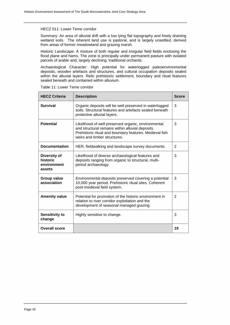
Historic Environment Assessment of The South Worcestershire Joint Core Strategy Area
Page 42
HECZ 011: Lower Teme corridor
Summary: An area of alluvial drift with a low lying flat topography and freely draining wetland soils. The inherent land use is pastoral, and is largely unsettled, derived from areas of former meadowland and grazing marsh.
Historic Landscape: A mixture of both regular and irregular field fields enclosing the flood plane and hams. The zone is principally under permanent pasture with isolated parcels of arable and, largely declining, traditional orchards.
Archaeological Character: High potential for waterlogged paleoenvironmental deposits, wooden artefacts and structures, and cultural occupation deposits sealed within the alluvial layers. Relic prehistoric settlement, boundary and ritual features sealed beneath and contained within alluvium.
Table 11: Lower Teme corridor
HECZ Criteria Description Score
Survival Organic deposits will be well preserved in waterlogged soils. Structural features and artefacts sealed beneath protective alluvial layers.
3
Potential Likelihood of well preserved organic, environmental and structural remains within alluvial deposits. Prehistoric ritual and boundary features. Medieval fish weirs and timber structures.
3
Documentation HER, fieldwalking and landscape survey documents. 2
Diversity of historic environment assets
Likelihood of diverse archaeological features and deposits ranging from organic to structural, multi-period archaeology.
3
Group value association
Environmental deposits preserved covering a potential 10,000 year period. Prehistoric ritual sites. Coherent post-medieval field system.
3
Amenity value Potential for promotion of the historic environment in relation to river corridor exploitation and the development of seasonal managed grazing.
2
Sensitivity to change
Highly sensitive to change. 3
Overall score 19

Historic Environment Assessment of The South Worcestershire Joint Core Strategy Area
Page 43
HECZ 012: Land between Rushwick and Lower Broadheath
Summary: An area of soft rock, comprising mixed mudstones and sandstones producing a rolling, lowland topography and free draining loamy brown soils, mixed farming with areas of relic parkland and a principally dispersed settlement pattern.
Historic Landscape: A zone defined by a broadly consistent pattern of medium to large-scale irregular fields, with scattered areas of relic parkland, relic orchard and medium sized compartments of ancient semi-natural woodland and historic plantation. Settlement is dispersed small-scale with the exception of an area of modern expansion at Rushwick. Former medieval open-fields were enclosed in a piecemeal process creating characteristic ‘reverse S’ field boundaries. The boundaries were straightened in the 19
th century to create the rectilinear field pattern
now characteristic in this zone.
Archaeological Character: Earthwork and below ground archaeological evidence of former medieval settlement and communal farming throughout the zone. Late prehistoric below ground archaeology located on the river terrace in the south of the zone. Limited opportunities for archaeological research have resulted in this zone being under-represented on the Historic Environment Record.
Table 12: Land between Rushwick and Lower Broadheath
HECZ Criteria Description Score
Survival Limited disturbance suggests a good potential for survival of below ground. Dispersed settlement pattern of medieval origin and relic medieval settlement deposits and features.
3
Potential There is a high potential for surviving historic environment assets, which includes prehistoric and medieval settlement features.
3
Documentation HER 1
Diversity of historic environment assets
Medieval landscape and settlement features, relic parkland, traditional orchards, historic farm buildings and potential for extensive below ground prehistoric and medieval archaeology.
2
Group value association
Historic landscape features, settlement pattern, relic medieval settlement and cultivation earthworks.
3
Amenity value Potential for promoting Historic Landscape Character. 2
Sensitivity to change
Historic landscape, dispersed settlement pattern and below ground archaeology highly sensitive to change.
3
Overall score 17

Historic Environment Assessment of The South Worcestershire Joint Core Strategy Area
Page 44
HECZ 013: Holt and Grimley river terraces
Summary: A zone of low lying river terraces adjacent to the west bank of the River Severn comprised of clay soils overlying soft rock and sand and gravels. This is a landscape rich in prehistoric and Romano-British archaeology. The zone contains five Scheduled Monuments located in a cluster around Grimley.
Historic Landscape: The visual character of the zone is defined by a dominant field pattern of medium to large regular enclosures. There has been a moderate to high impact in some parts of the zone as a result of modern field amalgamation and reorganisation in areas that have been quarried.
Archaeological Character: The zone is rich in below ground archaeology including ritual activity, settlement and boundary features that range from the Neolithic through to the Romano-British period. A long phase of quarrying activity throughout the zone has removed many archaeological sites, nonetheless, there is a high potential for similar sites and artefacts in un-quarried parts of the zone.
Table 13: Holt and Grimley river terraces
HECZ Criteria Description Score
Survival Potential for survival in un-quarried areas. 2
Potential Un-quarried areas have a high potential for single, or multi-period below ground archaeology.
3
Documentation HER, Extensive evaluation and excavation, fieldwalking and desk-based assessment.
3
Diversity of historic environment assets
Extensive historic environment assets of multi-period date ranging from the Neolithic onwards.
3
Group value association
Historic environment assets associated with millennia of settlement, landscape organisation and ritual land-use.
3
Amenity value The long history of river terrace occupation and exploitation provides scope for interpretation.
2
Sensitivity to change
Un-quarried areas are highly sensitive to change. 3
Overall score 19

Historic Environment Assessment of The South Worcestershire Joint Core Strategy Area
Page 45
HECZ 014: Hallow and Sinton Green
Summary: An area of mixed sandstones and mudstones, with loamy brown soils and a rolling lowland topography. It is an area of mixed farming with a settlement pattern of farmsteads and strings of wayside dwellings, associated with a medium to high level of dispersal, and a small to medium scale field pattern.
Historic Landscape: The zone is associated with a pattern of principally piecemeal, irregular fields. Moderate to high loss of historic boundaries has lead to widespread field amalgamation throughout the zone, although the overall historic grain in land division is still evident. Two principal areas of parkland at Thorngrove and Hallow still retain their historic character, however, there is some boundary evidence that indicates other areas of relic parkland. The settlement pattern is largely represented by liner row settlements (e.g. Grimley/Moseley), or agglomerated around former common greens (e.g. Hallow/ Sinton). As a result of modern expansion along the A443, Hallow, has evolved into both types. Dispersed farmsteads and strings of wayside dwellings are characteristic throughout the zone.
Archaeological Character: The archaeological character of this zone is currently not comprehensively understood. However, there is a concentration of prehistoric and medieval below ground archaeology around Moseley with good potential for additional prehistoric sites throughout the zone. Excavations near the Church in Hallow have revealed 11
th – 13
th century settlement. Hallow is a conservation area
with seven listed buildings clustered within the area, and two additional clusters within the northern and southern extents of Hallow. Listed buildings are present in small numbers within all principle settlements within the zone.
Table 14: Hallow and Sinton Green
HECZ Criteria Description Score
Survival Preserved parklands, village greens and historic buildings stock. Good potential for prehistoric to medieval below ground archaeology.
3
Potential Likelihood of extensive prehistoric below ground archaeology, particularly in sand and gravel areas.
3
Documentation HER, archaeological evaluation and excavations. 2
Diversity of historic environment assets
Multi-period below ground archaeology, locally distinctive dispersed settlement pattern and parkland.
3
Group value association
Distinctive green settlements, prehistoric below ground features.
2
Amenity value There is potential for promoting the ‘green village’ character of this zone and also the prehistoric exploitation of the river vale when linked to HECZ 013.
2
Sensitivity to change
Coherence of dispersed settlement pattern and potential below ground archaeology would suffer if significant change occurred.
2
Overall score 17
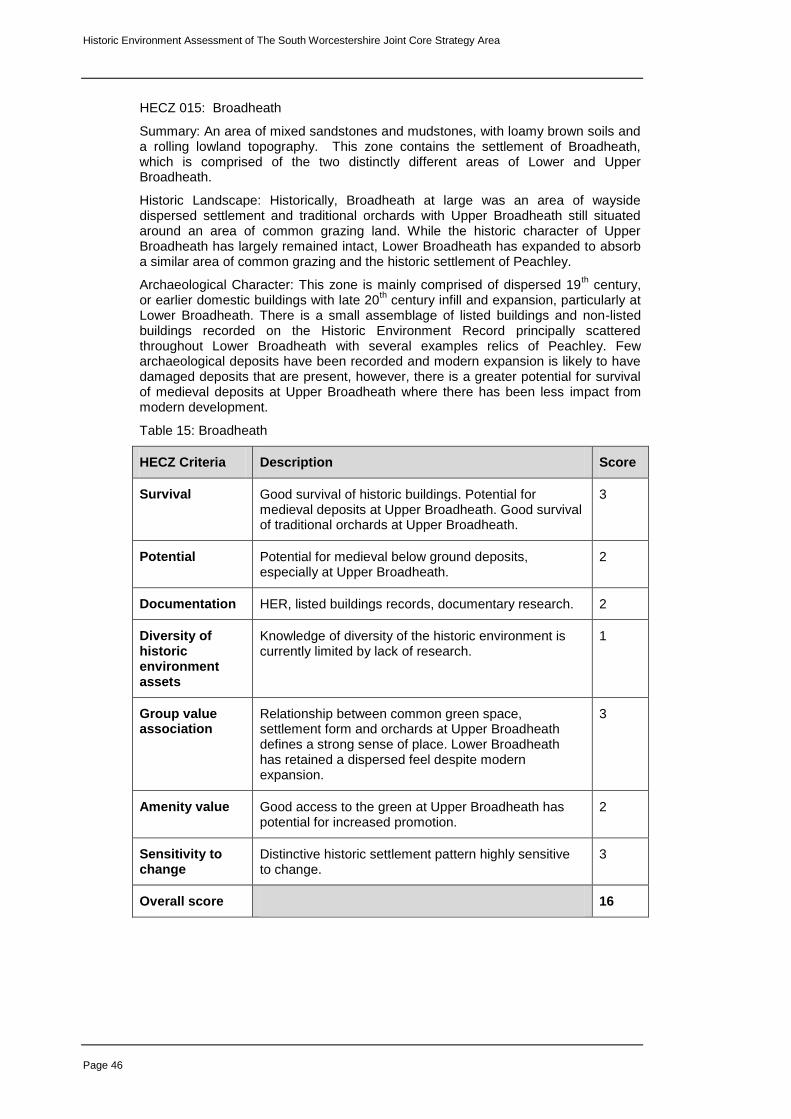
Historic Environment Assessment of The South Worcestershire Joint Core Strategy Area
Page 46
HECZ 015: Broadheath
Summary: An area of mixed sandstones and mudstones, with loamy brown soils and a rolling lowland topography. This zone contains the settlement of Broadheath, which is comprised of the two distinctly different areas of Lower and Upper Broadheath.
Historic Landscape: Historically, Broadheath at large was an area of wayside dispersed settlement and traditional orchards with Upper Broadheath still situated around an area of common grazing land. While the historic character of Upper Broadheath has largely remained intact, Lower Broadheath has expanded to absorb a similar area of common grazing and the historic settlement of Peachley.
Archaeological Character: This zone is mainly comprised of dispersed 19th century,
or earlier domestic buildings with late 20th century infill and expansion, particularly at
Lower Broadheath. There is a small assemblage of listed buildings and non-listed buildings recorded on the Historic Environment Record principally scattered throughout Lower Broadheath with several examples relics of Peachley. Few archaeological deposits have been recorded and modern expansion is likely to have damaged deposits that are present, however, there is a greater potential for survival of medieval deposits at Upper Broadheath where there has been less impact from modern development.
Table 15: Broadheath
HECZ Criteria Description Score
Survival Good survival of historic buildings. Potential for medieval deposits at Upper Broadheath. Good survival of traditional orchards at Upper Broadheath.
3
Potential Potential for medieval below ground deposits, especially at Upper Broadheath.
2
Documentation HER, listed buildings records, documentary research. 2
Diversity of historic environment assets
Knowledge of diversity of the historic environment is currently limited by lack of research.
1
Group value association
Relationship between common green space, settlement form and orchards at Upper Broadheath defines a strong sense of place. Lower Broadheath has retained a dispersed feel despite modern expansion.
3
Amenity value Good access to the green at Upper Broadheath has potential for increased promotion.
2
Sensitivity to change
Distinctive historic settlement pattern highly sensitive to change.
3
Overall score 16

Historic Environment Assessment of The South Worcestershire Joint Core Strategy Area
Page 47
HECZ 016: Lower Severn and Salwarpe valleys
Summary: A zone of low lying alluvial drift characterised by enclosed riverside grazing meadows with isolated parcels woodland. Historic irrigation and drainage features are prevalent along with extensive paleoenviromental deposits.
Historic Landscape: Enclosed riverside grazing meadows with mature hedgerows. These are small to medium regular enclosures in the north of the zone becoming larger and more irregular south of Grimley. The sinuous lower Salwarpe valley is characterised by small irregular riverside meadows.
Archaeological Character: The zone contains a very high potential for prehistoric environmental deposits preserved within the alluvial layers and features sealed beneath alluvial layers. There is an equal potential for organic structures and wooden artefacts, such as fish traps, riverbank revetments and relic structures associated with historic river trade preserved within waterlogged soils. There is evidence at Grimley of an extensive medieval, or post-medieval water meadow. There is a likelihood of similar relic water management features throughout the zone. Earthwork remains of drainage and irrigation and relic field systems are prevalent in the zone around Holt.
Table 16: Lower Severn and Salwarpe valleys
HECZ Criteria Description Score
Survival Earthworks preserved under permanent riverside pasture, historic field pattern and extensive paleoenvironmental and organic below ground archaeological features.
3
Potential High potential for extensive below ground archaeology. 3
Documentation HER, desk-based assessment, archaeological evaluation and environmental survey.
2
Diversity of historic environment assets
Environmental and cultural deposits, wooden structures and artefacts. Field pattern and water management features.
2
Group value association
Extensive assemblage of multi-period environmental deposits.
3
Amenity value Potential to promote historic management of riverside meadows and pastoral farming and historic exploitation and trade along the Severn.
2
Sensitivity to change
Environmental deposits, preserved structures and infield water meadow features highly sensitive to change.
3
Overall score 18

Historic Environment Assessment of The South Worcestershire Joint Core Strategy Area
Page 48
HECZ 017: Land between Fernhill Heath and Droitwich
Summary: A zone of mixed mudstones and sandstones, a rolling lowland topography and free draining brown soils, a medium to large irregular field pattern interwoven with sinuous roads and lanes, relic parkland and scattered small compartments of woodland. Settlement is dispersed with a scattered pattern of listed and historic buildings throughout the zone.
Historic Landscape: The predominant pattern of irregular fields has resulted from widespread field amalgamation and boundary loss in the later 20
th century. Prior to
this, the field pattern was more rectilinear with smaller fields. The settlement pattern is dominated by dispersed row, or clustered settlements with wayside cottages and scattered farmsteads arranged along a network of sinuous lanes. The landscape has wooded feel, despite the low density of woodlands, perhaps due to the frequency of mature hedgerow trees. There is a large area of relic historic parkland at Hindlip.
Archaeological Character: This zone is unrepresented in the HER due largely to a lack of large-scale development. Nonetheless, there is emerging evidence of significant Romano-British below ground archaeology at Hindlip close to the line of the Roman Road associated with the current A38. It is likely that settlements in the zone are associated with medieval and post-medieval below ground archaeology based on the historic buildings stock. Medieval earthworks are also present in places with a higher density of ridge and furrow in the north of the zone. This is likely to be a bias in the record due to research carried out on the hinterland of Droitwich and is not necessarily representative of survival throughout the zone.
Table 17: Land between Fernhill Heath and Droitwich
HECZ Criteria Description Score
Survival Potential survival of multi-period archaeology associated with settlements and below the ploughsoil in arable fields.
2
Potential Good potential for multi-period archaeology throughout the zone.
3
Documentation HER, limited archaeological evaluation and building surveys
1
Diversity of historic environment assets
Historic settlement pattern, communications and overall grain in the landscape. Emerging evidence for Romano-British occupation. Limited investigations have resulted in a low level of recorded historic environment features, which probably does not reflect the true situation.
2
Group value association
Characterised by well-preserved dispersed settlement pattern.
2
Amenity value Potential for promotion of locally distinctive landscape. 2
Sensitivity to change
Coherence of dispersed settlements together with below ground archaeology would suffer id significant change occurred.
2
Overall score 14

Historic Environment Assessment of The South Worcestershire Joint Core Strategy Area
Page 49
HECZ 018: Perdiswell (by James Dinn)
Summary: A low lying, flat area of river terrace sands and gravels with free draining sandy soils on the northern fringes of Worcester City. Note: this zone lies wholly within the City administrative boundary. The zone is now dominated by two golf courses, a leisure complex and ‘park and ride’ facilities with a few fragments of surviving historic landscape.
Historic Landscape: Historic Landscape Character was formerly dominated by Perdiswell Park in the south of this zone and a rectilinear field pattern in the north. The zone became the focus of a civilian airfield in the 1920s converting to an RAF airfield during WWII. Post-war, the zone has been largely redeveloped for sports and leisure and a recent ‘park and ride’ facility.
Archaeological Character: In 2000 a Bronze Age ringwork was excavated on the site of the park and ride linking early prehistoric activity to the area. An undated but probably prehistoric enclosure has also been recorded. A triple-ditched Romano-British farmstead has been identified from cropmarks and may be associated with field systems. Moathouse Farm is associated with a medieval moated settlement, and Perdiswell Hall was preceded by a medieval manorial site. A small area of ridge and furrow earthworks survives between the golf courses. Landscaping may have caused substantial (though often localised) disturbance to below ground archaeology.
Table 18: Perdiswell
HECZ Criteria Description Score
Survival Landscape-scale impact of sports and leisure developments, but below ground remains appear to survive relatively well in many areas.
2
Potential A moderate to high potential for multi-period below ground archaeology in areas where disturbance has been limited.
2
Documentation Worcester City HER, archaeological evaluation, excavation and research.
3
Diversity of historic environment assets
Early (and later?) prehistoric, Roman and medieval below ground deposits, limited post-medieval earthworks, park features, WWII structures.
3
Group value association
Limited post-medieval earthworks, some park features (gate piers, walled garden and coach house), and infrastructure surviving from the airfield period (roads and isolated buildings). Little evidence of coherent patterns from earlier periods.
2
Amenity value Significant opportunities for promotion of (largely below-ground) historic environment to a wide public (see for instance the layout of the park and ride car park which was guided by the Bronze Age feature).
3
Sensitivity to change
Surviving below ground archaeology in less disturbed, or undisturbed areas sensitive to change.
2
Overall score 17

Historic Environment Assessment of The South Worcestershire Joint Core Strategy Area
Page 50
HECZ 019: Claines
Summary: A low lying, flat area of river terrace sands and gravels with free draining sandy soils, medium to large-scale fields and scattered relic orchards. The settlement pattern is predominantly modern linear wayside development. There is evidence of below ground prehistoric archaeology in the west of the zone and medieval settlement at Claines.
Historic Landscape: Medium to large-scale regular amalgamated fields are dominant across this zone demarcated by an extensively degraded hedgerow network. Claines village retains much of its historic character clustered about the church and crossroads with modern expansion extending south-east along Claines Lane. The broad settlement pattern was largely dispersed prior to a phase of 20
th century infill.
Archaeological Character: There is high potential for survival of below ground prehistoric and Romano-British features throughout the zone, particularly given the extensive area of free-draining sand and gravels. Field surveys have recovered a range of prehistoric and Romano-British artefacts associated with likely settlement. There is a high potential for the presence of medieval to post-medieval features, both within and around the village of Claines.
Table 19: Claines
HECZ Criteria Description Score
Survival Prehistoric settlement on sand and gravel terrace. Largely intact historic character around Claines village.
2
Potential Likelihood for extensive prehistoric and Romano-British features and below ground archaeology.
3
Documentation Worcester City and Worcestershire County Council HERs, fieldwalking survey and limited excavation.
2
Diversity of historic environment assets
Prehistoric and Romano-British below ground archaeology. Overall structure of the historic landscape in the vicinity of (and including) Claines village.
2
Group value association
Characterised by high potential for Prehistoric and Romano-British settlement.
2
Amenity value Limited at present, however, potential for promotion of Claines and its hinterland as a locally distinctive historic settlement.
2
Sensitivity to change
Extensive Prehistoric and Romano-British features and historic character of Claines village sensitive to change.
2
Overall score 15

Historic Environment Assessment of The South Worcestershire Joint Core Strategy Area
Page 51
HECZ 020: Bevere
Summary: A low lying, flat area of river terrace sands and gravels with free draining sandy soils. A distinctive zone characterised by the dispersed settlement of Bevere with a strong historic parkland character and assemblage of listed buildings.
Historic Landscape: A locally distinctive well-preserved mature parkland landscape, which largely thanks to avenues of mature trees creates a highly wooded feel interspersed with irregular shaped, small-scale pasture fields. The settlement pattern is a dispersed cluster of mainly historic high-status domestic buildings.
Archaeological Character: There is a high potential for surviving prehistoric and Roman period below ground archaeology in undisturbed areas. Preservation is likely to be good given the predominantly pastoral land-use. There is a similarly high potential for medieval archaeology associated with the current settlement.
Table 20: Bevere
HECZ Criteria Description Score
Survival Historic settlement pattern intact, mature parkland, historic buildings. Artefactual evidence of prehistoric and Romano-British occupation.
3
Potential Likelihood of multi-period below ground archaeology preserved under permanent pasture.
2
Documentation HER, documentary research 2
Diversity of historic environment assets
Historic settlement pattern, Multi-period below ground archaeology.
2
Group value association
Dispersed historic settlement, high-status housing, mature parkland and hedgerows.
3
Amenity value Historic landscape has a high amenity potential. 3
Sensitivity to change
Dispersed settlement and its setting would suffer if change occurred.
3
Overall score 18

Historic Environment Assessment of The South Worcestershire Joint Core Strategy Area
Page 52
HECZ 021: Fernhill Heath
Summary: A soft rock area of mixed mudstone and sandstone with free draining brown soils and a rolling lowland topography. The zone is dominated by the expanded settlement of Fernhill Heath.
Historic Landscape: The historic core of Fernhill Heath is situated in the north-eastern section of this zone. Originally a dispersed row settlement, Fernhill Heath began to expand south-west along the A38 from the late 19
th century becoming
greatly extended. During the latter half of the 20th century, expansion outwards
rapidly altered the ribbon character of the settlement with a shift towards a planned suburban form. The 19
th century field enclosure pattern associated with the historic
settlement has largely lost, or reorganised with settlement expansion.
Archaeological Character: There has been a lack of archaeological investigation across much of this zone due largely to the nature and chronology of development, therefore, there is a lack of available information upon which to base an informed assessment. Nonetheless, there is potential for medieval and post-medieval below ground archaeological features and occupation deposits within and around the historic core of Fernhill Heath. There is a low density of listed buildings and an under-representative record of historic buildings, which does not necessarily reflect the true situation in the historic core of Fernhill Heath and along the A38. There is also a moderate potential for Romano-British occupation along the A38 corridor although archaeological investigations carried out to the south of this zone have to date produced negative results.
Table 21: Fernhill Heath
HECZ Criteria Description Score
Survival Limited in built up areas, but not completely eradicated.
1
Potential Open areas, or lightly developed areas may preserve archaeological deposits. Moderate potential for Romano-British to post-medieval archaeology.
1
Documentation HER, targeted archaeological evaluation and salvage recording and desk-based assessment.
2
Diversity of historic environment assets
Limited known diversity in a largely modern built up zone. Some coherence in historic buildings and moderate potential for multi-period below ground archaeology
1
Group value association
Some coherence with historic buildings along the A38. 2
Amenity value Limited although it might be possible to develop and understanding of 20
th century housing development in
association with links to Worcester.
1
Sensitivity to change
Area largely built up and therefore impact to character would be limited to the risk of scale and amalgamation with outer suburban areas of Worcester.
1
Overall score 9

Historic Environment Assessment of The South Worcestershire Joint Core Strategy Area
Page 53
HECZ 022: Chatley and Hawford
Summary: An area of soft rock, comprising mixed mudstones and sandstones producing a rolling, lowland topography and free draining brown soils. The zone is characterises by an irregular, amalgamated field pattern, dispersed settlement pattern and a diverse assemblage of multi-period historic assets.
Historic Landscape: The settlement pattern is dispersed with row settlements with wayside farmsteads and cottages set along sinuous narrow lanes. There is moderate assemblage of recorded historic buildings scattered throughout the zone, principally focused on farmsteads, augmented by a small number of listed buildings. There is clear evidence which to indicate that open-field communal farming was practiced during the medieval period. The lands was later enclosed with a largely rectilinear field system, which has since been modified through boundary loss to the extent that the zone now has a pattern of medium sized irregular shaped fields.
Archaeological Character: The zone is characterised by a diverse range of assets ranging from and Iron Age field system and Romano-British settlement sites on the lower-lying terrace at Hawford to medieval agricultural and settlement features, which are recorded throughout the zone. Two scheduled monuments are located at Hawford: below ground remains of a Roman military camp and Hawford Dovecote. Medieval ridge and furrow earthworks have survived in fields of permanent pasture.
Table 22: Chatley and Hawford
HECZ Criteria Description Score
Survival Historic environment survives well despite some losses to ploughing and field boundary removal.
3
Potential High potential for multi-period below ground archaeology.
3
Documentation HER, field survey and salvage recording. 2
Diversity of historic environment assets
Features relating to multi-period settlement and land-use extensive throughout the zone.
3
Group value association
Coherence of settlement, communications, medieval cultivation earthworks.
2
Amenity value There is potential to promote the historic importance of settlement and river valley exploitation.
2
Sensitivity to change
Settlement pattern and extensive below ground archaeology would be adversely affected if change occurred.
3
Overall score 18

Historic Environment Assessment of The South Worcestershire Joint Core Strategy Area
Page 54
HECZ 023: Westwood Park and High Park
Summary: An area of soft rock, comprising mixed mudstones and sandstones producing a rolling, lowland topography and free draining brown soils dominated two areas of historic parkland
Historic Landscape: Westwood Park is a Grade II Registered Park and Garden. There are elements of a 17th century garden and park associated with a hunting lodge, later a house. Modifications and additions to the park were undertaken between the 18th century and early 20th centuries. High Park is an area of post-medieval parkland adjacent to the south of Westwood. Despite being much smaller than Westwood in area, High Park, nonetheless combined with Westwood creates a large coherent area of historic designed landscape.
Archaeological Character: During the medieval period Westwood was the site of a nunnery, which survived up until The Dissolution. The current house is situated with in the area understood to be the focus of the nunnery. Aerial photographic sources show evidence of the pre-parkland landscape and land-use with evidence of trackways, communal farming and the possible line of a Roman road heading west from Droitwich.
Table 23: Westwood Park and High Park
HECZ Criteria Description Score
Survival Coherent survival of historic parkland landscape with associated historic listed buildings and evidence of below ground preservation of pre-parkland landscape. Some loss of parkland plantations.
2
Potential There is a high potential for below ground archaeology relating to the medieval nunnery and its landscape and Romano-British occupation based on comparison with other zones. Although there has been some impact from recent remodelling of the kitchen garden area.
3
Documentation HER, Historic research, fieldwalking survey, salvage recording, Register of parks and Gardens entry.
3
Diversity of historic environment assets
Overall structure of historic parkland design survives well. Medieval ecclesiastical landscape surviving as below ground archaeology.
2
Group value association
Coherent historic parkland landscape. 3
Amenity value High potential for promotion of historic parkland and evolution in the cultural landscape.
3
Sensitivity to change
Coherent historic designed landscape and preserved below ground archaeology highly sensitive to change.
3
Overall score 19

Historic Environment Assessment of The South Worcestershire Joint Core Strategy Area
Page 55
HECZ 024: Ombersley
Summary: An area of soft rock sandstone with sandy brown soils and a rolling, lowland topography. The land-use is mixed parkland, pasture and arable. The locally distinctive estate, parkland, village and associated farms define the character of this zone. Ombersley village contains a high density of listed and non-listed historic buildings.
Historic Landscape: The landscape around Ombersley has undergone moderate field boundary loss and significant loss of traditional orchards since the 19
th century.
Nonetheless the overall historic character of the landscape has survived well. The discrete plantations, coverts and groups of trees are, in many cases associated with the historic parkland. The field has retained its broad rectilinear character, and the historic plan form of Ombersley village is still largely intact despite modern expansion, particularly to the north.
Archaeological Character: There is a high potential for surviving medieval and post-medieval below ground features focused within and around Ombersley village, and throughout the zone. There is also a high potential for prehistoric and Romano-British occupation surviving as below ground archaeology throughout much of the zone, given its location close to the River Severn. In areas of permanent pasture, particularly within the historic parkland, there is a high potential for historic features surviving as eathworks. These may relate to relic parkland features, or may be preserved features relation to the pre-parkland historic environment.
Table 24: Ombersley
HECZ Criteria Description Score
Survival Coherent historic parkland character and historic settlement pattern. Settlement has a significant assemblage of historic listed buildings.
2
Potential Likelihood of extensive medieval and post-medieval below ground archaeology throughout the zone with a stronger focus at Ombersley village. Potential for prehistoric and Romano-British below ground archaeology throughout the zone.
3
Documentation HER, Rapid evaluation and salvage recording, building survey, historical research.
3
Diversity of historic environment assets
Historic parkland landscape, historic buildings, multi-period below ground archaeology.
2
Group value association
Coherence of historic parkland and settlement. 3
Amenity value The existing nature and character of this zone offers considerable opportunity for promotion.
3
Sensitivity to change
Historic Landscape Character sensitive to change including impact to below ground archaeology.
3
Overall score 19

Historic Environment Assessment of The South Worcestershire Joint Core Strategy Area
Page 56
HECZ 025: Hadley
Summary: An area of soft rock, comprising mixed mudstones and sandstones producing a rolling, lowland topography and free draining brown soils. This zone is focused around the row settlement of Hadley and a group of distinctive small fields, relic orchards and small compartments of woodland.
Historic Landscape: The hinterland of Hadley has suffered less from field amalgamation compared with the surrounding zones. This is, perhaps, partly due to the significant number of traditional orchards that were closely associated with Hadley until the later half of the 20
th century when they began to decline. While the
orchards themselves have now largely disappeared, the pattern of small, regular, hedged fields has survived. The creation of a fishery in the north of this zone has had a less significant impact on the landscape than it might because the ponds have all been located within existing field enclosures, therefore limiting impact on the landscape. The historic dispersed settlement pattern of Hadley is still largely intact and there is a relatively high percentage of both listed and non-listed buildings, mostly represented by farmhouses and their associated outbuildings.
Archaeological Character: A developed understanding of the archaeological character of this zone is limited by a lack of research. The Historic Environment Record for the zone is comprised of mainly medieval and post-medieval features associated with settlement, quarrying and agriculture.
Table 25: Hadley
HECZ Criteria Description Score
Survival Historic dispersed row settlement pattern, overall structure of fields and network of lanes survives well.
2
Potential Likelihood of medieval and post-medieval below ground archaeology within the settlement area.
2
Documentation HER 1
Diversity of historic environment assets
Historic settlement pattern and overall character of farmsteads. Relic orchard field system survives well. Limited investigations have resulted in a limited record of historic assess, which probably does not reflect the true situation.
2
Group value association
Characterised by dispersed settlement pattern with associated historic farms and field pattern.
3
Amenity value Limited investigation hampers a full understanding and potential for promotion at present although a good public rights of way network exists offering potential for Historic Landscape Character interpretation.
2
Sensitivity to change
Coherence of dispersed settlement and historic landscape would suffer if significant change occurred.
2
Overall score 14

Historic Environment Assessment of The South Worcestershire Joint Core Strategy Area
Page 57
HECZ 026: Hadley Heath
Summary: An area of soft rock, comprising mixed mudstones and sandstones producing a rolling, lowland topography and free draining brown soils. This is associated with Romano-British settlement, then medieval open-field cultivation and open common grazing before being enclosed during the 18
th and 19
th centuries.
Historic Landscape: This is a sparsely settled zone of enclosed former open common. The pattern of large, mainly arable, fields have developed from a 19
th
century landscape of smaller regular enclosed fields that have been amalgamated during the 20
th century. The two large compartments of ancient semi-natural
woodland (Knight’s Grove and Gardeners Grove) are possibly contemporary with the former common and may be surviving examples of former medieval managed woodland. Settlement is sparse and dispersed mainly at the boundaries of the zone.
Archaeological Character: The zone contains multi-period below ground archaeology with a concentration of Romano-British settlement adjacent to, and within, Knight’s Grove. A substantial series of five substantial fishponds at Mayhouse Farm along with scattered records of ridge and furrow characterise the medieval and post-medieval archaeology of the zone, although limited investigations in this zone suggest this may not be truly representative of archaeological potential in the zone.
Table 26: Hadley Heath
HECZ Criteria Description Score
Survival Overall settlement pattern, road network and historic woodlands survive well. Evidence of Romano-British settlement. Historic field pattern has been weekend by boundary loss and amalgamation.
2
Potential Likelihood of extensive Romano-British below ground archaeology.
3
Documentation HER, salvage recording, historic and cartographic research.
2
Diversity of historic environment assets
Historic settlement pattern and road network surviving from the previous open common landscape. Romano-British below ground archaeology, ancient semi-natural woodlands.
2
Group value association
Historic settlement pattern and road network. 2
Amenity value Potential for promoting access to ancient semi-natural woodlands.
2
Sensitivity to change
Historic dispersed settlement pattern and below ground archaeology would suffer if significant change occurred.
2
Overall score 15

Historic Environment Assessment of The South Worcestershire Joint Core Strategy Area
Page 58
HECZ 027: Land north and south of Dean Brook
Summary: An area of lias clay, with poorly draining soils and an intermediate, rolling topography. The settlement pattern is dispersed with a field pattern that has evolved from post-medieval piecemeal enclosure of former grazing meadow and medieval communal open-fields. The zone has an extensive range of medieval historic environment features associated with settlement and farming.
Historic Landscape: The zone is characterised by a distinctive post-medieval field pattern, which has resulted from a process of piecemeal enclosure marking the shift away from communal farming during the 17
th – 19
th centuries. The radial field pattern
surrounding Phepson largely represents enclosures based on the furlongs that once characterised the open-field. The land either side of the Dean Brook is dominated by enclosed meadows that were formerly more extensive and open in character. The settlement pattern is comprised of small, dispersed hamlets and wayside farms. The large block of semi-ancient natural woodland, which combines Goosehill, Little Goosehill and Puckhill woods, dominates the central part of this zone.
Archaeological Character: The zone is associated with extensive medieval historic environment features. Phepson was a larger settlement during the medieval period. The settlement declined during the later 18
th century, however, extensive earthworks
are present around the existing farms and there is a high potential for surviving below ground archaeology. Areas of medival ridge and furrow survive throughout the zone indicative of the former communal farming system. Land either side of the brook was the subject of managed irrigation during the post-medieval period. Some watercourses and drains have survived to become modern field boundaries. A range of listed and non-listed historic buildings characterise the small hamlets that populate the margins of this zone.
Table 27: Land north and south of Dean Brook
HECZ Criteria Description Score
Survival Overall settlement pattern, road network and historic woodlands survive well.
2
Potential Likelihood of medieval and post-medieval below ground archaeology within the zone.
3
Documentation HER, historic and cartographic research. 2
Diversity of historic environment assets
A range of medieval and post-medieval buildings and landscape features survive.
2
Group value association
Coherence of settlement, communications, medieval cultivation earthworks.
3
Amenity value Historic landscape has a high amenity potential. 3
Sensitivity to change
Coherent historic landscape and preserved below ground archaeology highly sensitive to change.
3
Overall score 18

Historic Environment Assessment of The South Worcestershire Joint Core Strategy Area
Page 59
HECZ 028: Newland Common
Summary: An area of lias clay, with poorly draining soils and an intermediate, rolling topography. It is an agricultural landscape with a dominant pastoral land use and small/medium scale, defined by its hedged fields. The zone is enclosed common land in a landscape with a notable network of winding lanes, scattered farms and clusters of wayside settlements.
Historic Landscape: The zone is characterised by a distinctive 19th century field
pattern, which has resulted from a process of late enclosure of Newland Common. The field pattern is very distinctive with large regular field parcels. The settlement pattern is comprised of small, dispersed wayside farms, typical of common edge settlement. Newland Common Road forms the western boundary of the zone. This is typical of the very straight roads that run across commons and is probably medieval or earlier in date. The M5 motorway cuts through the centre of the zone.
Archaeological Character: The zone is associated with very few historic environment features and little research has been conducted here. Cropmarks of the pre-motorway field pattern survive. A single listed building and several historic non-listed buildings survive within the farmsteads. There are no Scheduled Monuments.
Table 28: Newland Common
HECZ Criteria Description Score
Survival The above ground survival appears poor and the below ground archaeology is unknown.
1
Potential Areas under pasture may preserve archaeological deposits although the zone is likely to have been open common for a significant period of time.
1
Documentation Limited historic and cartographic research. 1
Diversity of historic environment assets
Cropmarks of 19th century field boundaries, a possible
battery of unknown date and a possible filled in moat at Park Farm are the only known archaeological features.
1
Group value association
19th century enclosed common. 1
Amenity value Limited investigation hampers a full understanding and potential for promotion at present, although a good public rights of way network exists, offering potential for Historic Landscape Character interpretation.
2
Sensitivity to change
Surviving below ground archaeology, if any, in less disturbed, or undisturbed areas sensitive to change.
1
Overall score 8

Historic Environment Assessment of The South Worcestershire Joint Core Strategy Area
Page 60
HECZ 029: Sale Green Plateau
Summary: This zone lies in a largely wooded agricultural landscape of isolated brick farmsteads, clusters of wayside dwellings and occasional small nucleated villages. A key visual element in the landscape is Trench Wood, a replanted ancient woodland. Other pockets of ancient semi-natural woodland also survive.
Historic Landscape: The zone is characterised by piecemeal enclosure and there has been little boundary loss since c.1800. The large compartments of replanted and ancient semi-natural woodland (Trench Wood, Stanley Wood, Fillet Wood and Sale Green Wood) may be surviving examples of former medieval managed woodland. The settlement consists of isolated farmsteads and the village of Sale Green. The village is a small nucleated settlement of at least 16
th century date.
Archaeological Character: Trench Lane is a former Saltway and important trading route and may date as far back as the Iron Age. A number of listed and unlisted historic buildings survive within the zone. There is little in the way of surviving earthwork features such as ridge and furrow, but potential for below ground archaeology, particularly in the form of former settlement around Sale Green.
Table 29: Sale Green Plateau
HECZ Criteria Description Score
Survival Overall settlement pattern, road network and historic woodlands survive well.
2
Potential Likelihood of medieval and post-medieval below ground archaeology within the zone. Possibility of earlier deposits associated with Trench Lane.
3
Documentation HER, building recording, watching brief, historic and cartographic research.
2
Diversity of historic environment assets
A range of medieval and post-medieval buildings and landscape features survive.
2
Group value association
Coherence of settlement, communications and ancient semi-natural woodland.
3
Amenity value Potential for promoting access to ancient semi-natural woodlands.
2
Sensitivity to change
Coherent historic landscape and preserved below ground archaeology highly sensitive to change.
3
Overall score 17

Historic Environment Assessment of The South Worcestershire Joint Core Strategy Area
Page 61
HECZ 030: Crowle and Crowle Green
Summary: Situated within a largely agricultural, gently rolling landscape the villages of Crowle and Crowle Green represent quite large nucleated settlements in an area of predominantly dispersed farmsteads and clusters of wayside settlement.
Historic Landscape: The area around the villages is dominated by Parlimentary enclosure. This is unusual in a landscape of predominantly earlier piecemeal enclosure. The hinterland of Crowle has suffered less from field amalgamation compared with the surrounding zones. This is, perhaps, partly due to the significant number of traditional orchards that were closely associated with Crowle until the later half of the 20
th century when they began to decline. While the orchards themselves
have now largely disappeared, the pattern of small, regular, hedged fields has survived.
Archaeological Character: Archaeological works have indicated that Church Road is Roman in date and that an earlier cobbled surface survives below the modern surface. Settlement dating to this period may survive below ground. There is also the possibility of prehistoric archaeology associated with the hillfort that lies to the east of this zone. Crowle is a Conservation Area and contains a medieval Scheduled Monument and a large number of listed and unlisted historic buildings. There is some reasonably well preserved ridge and furrow in the north of the zone and the Scheduled earthworks around Crowle Court are well preserved.
Table 30: Crowle and Crowle Green
HECZ Criteria Description Score
Survival Coherent surviving landscape, large number of historic buildings and some reasonable earthwork survival
3
Potential Likelihood of extensive below ground Roman, medieval and post-medieval remains. Possibility of prehistoric remains relating to the hillfort.
3
Documentation HER, field walking, excavation, documentary and cartographic sources
3
Diversity of historic environment assets
A range of medieval and post-medieval buildings and landscape features survive.
3
Group value association
Coherent medieval and post-medieval landscape. 2
Amenity value A good public rights of way network exists, offering potential for Historic Landscape Character interpretation.
2
Sensitivity to change
Coherent historic landscape and preserved below ground archaeology highly sensitive to change.
3
Overall score 19

Historic Environment Assessment of The South Worcestershire Joint Core Strategy Area
Page 62
HECZ 031: Netherwood to Moor End
Summary: A flat, low-lying landscape, poorly draining basins fringed by low hills or scarps. This is a predominately arable landscape characterised by a regular pattern of piecemeal enclosure.
Historic Landscape: The dominant field pattern is that of piecemeal enclosure, although in some places there has been significant field amalgamation. The settlement is dispersed wayside settlement and small farmsteads. Crowle Road runs across the zone from East to West. This road appears to pre-date the field systems here and may represent a much earlier landscape. The railway line cuts through the centre of the zone from North to South.
Archaeological Character: There are no Conservation Areas or Scheduled Monuments. A number of listed and non-listed buildings survive associated with the farmsteads scattered along the road network. There has been very little archaeological work carried out in this zone and its potential is unknown. There is cropmark and place name evidence in the west of the zone that indicates the possibility of Roman occupation, but no archaeological work has been carried out to test this.
Table 31: Netherwood to Moor End
HECZ Criteria Description Score
Survival There has been some field amalgamation and earthworks, such as ridge and furrow, have been ploughed out, but the historic and listed buildings have a reasonable level of survival.
2
Potential The below ground potential and that of the historic built environment of this zone is unknown following little research here.
2
Documentation Limited documentary and cartographic sources. 1
Diversity of historic environment assets
A mainly post-medieval landscape with 20th century
field amalgamation. Some evidence of an earlier landscape survives in the road network and historic buildings.
2
Group value association
Some coherence in the historic buildings along Crowle Road and Netherwood Lane.
2
Amenity value Limited although it might be possible to develop and understanding of post-medieval farmstead development
1
Sensitivity to change
The historic and listed buildings would be sensitive to change.
2
Overall score 12

Historic Environment Assessment of The South Worcestershire Joint Core Strategy Area
Page 63
HECZ 032: Oddingley to Tibberton
Summary: A rolling, lowland, settled agricultural landscape with a mixed pastoral and arable land use. The landscape is characterised by a network of winding lanes, scattered farms and clusters of wayside settlements.
Historic Landscape: The field pattern is predominately piecemeal enclosure, with a small area of parliamentary enclosure near Oddingley. Some field amalgamation has occurred, but generally the field pattern survives well, partly due to the significant number of traditional orchards that were closely associated with the villages until the 20
th century when they began to decline. While the orchards themselves have now
largely disappeared, the pattern of small, regular, hedged fields has survived. Tibberton is now a nucleated row settlement, but throughout the 19
th century and
earlier it was an interrupted row settlement with dispersed farmsteads along the road network. The pattern of the village, with small blocks of land encircled by a road, is shared with White Ladies Aston and Peopleton and unique to this part of the County. The village has medieval or earlier origins and elements of this survive in the landscape. Oddlingley is typical of medieval common edge settlements.
Archaeological Character: There are no Scheduled Monuments, but the Worcester and Birmingham Canal Conservation Area snakes across the zone from east to west. There are a significant number of listed and unlisted historic buildings within the zone, mostly associated with farmsteads. A number of the farmsteads show evidence that they were once moated. Cropmark evidence indicates a prehistoric landscape of dispersed farmsteads similar to the medieval landscape still apparent.
Table 32: Oddingley to Tibberton
HECZ Criteria Description Score
Survival Relatively coherent landscape, but erosion of dispersed settlement character. Good historic building survival.
2
Potential Cropmark evidence suggests that below ground archaeology could be well preserved.
3
Documentation HER, documentary and cartographic evidence 2
Diversity of historic environment assets
A range of medieval and post-medieval buildings and landscape features survive.
3
Group value association
Relatively coherent medieval and post-medieval landscape.
2
Amenity value Limited although it might be possible to develop and understanding of post-medieval farmstead development. The canal has high amenity value, but little of it is in this zone.
1
Sensitivity to change
The dispersed nature of the medieval landscape has already been eroded. Below ground archaeology could be highly sensitive to change.
2
Overall score 15

Historic Environment Assessment of The South Worcestershire Joint Core Strategy Area
Page 64
HECZ 033: Warndon to Swinesherd
Summary: A rolling, lowland, settled agricultural landscape with a mixed pastoral and arable land use. Effectively a green corridor between the M5 and A4440 that widens to include Worcester Woods Country Park and greenspace around County Hall and the Hospital. It is a moderately well preserved historic landscape particularly in the north and south of the zone despite the impact of modern roads and civic building complexes.
Historic Landscape: The historic field pattern has been eroded by field amalgamation and the impact of the M5 and A4440, however, field boundaries of medieval and post-medieval origin survive well in the north of the zone and immediately east of Worcester Woods Country Park. Nunnery Wood has late medieval origins as enclosed woodland and Warndon Wood is possibly of a similar or post-medieval origin.
Archaeological Character: There is a well preserved medieval landscape surviving within and partly about Worcester Woods Country Park. This is characterised by woodland boundaries and ridge and furrow earthworks. There is cropmark evidence of a small late prehistoric or Romano-British settlement on sloping ground that overlooks the A4440. There is potential for below ground multi-period archaeology throughout the zone with likely concentrations in the vicinity of the country park and tin the north of the zone.
Table 33: Warndon to Swinesherd
HECZ Criteria Description Score
Survival Well preserved medieval woodland with underling earlier medieval landscape features. Largely intact medieval / post-medieval field pattern in the north of the zone. This has been eroded elsewhere by boundary loss and ploughing of medieval earthworks.
2
Potential Potential for below ground multi-period archaeology mainly in the south-west and north of the zone.
2
Documentation Country park landscape survey, HER, desk-based assessment.
2
Diversity of historic environment assets
Romano-British settlement east of the country park, medieval earthworks and below ground archaeology with moderately intact medieval and post-medieval field pattern.
2
Group value association
Well-preserved medieval and post-medieval landscape features and archaeology around Old Parsonage Farm and at Worcester Woods Country Park.
2
Amenity value High potential existing country park with a well preserved historic landscape and ASN Warndon Wood in the north of the zone linked by a green corridor.
3
Sensitivity to change
The setting of Old Parsonage Farm, Warndon Wood and the country park are highly sensitive to change.
2
Overall score 15

Historic Environment Assessment of The South Worcestershire Joint Core Strategy Area
Page 65
HECZ 034: Land west of Crowle and Churchill
Summary: A large scale, wooded, agricultural landscape of dispersed settlement and small villages. Key visual elements in this landscape are the many large, irregularly shaped ancient woodlands.
Historic Landscape: The landscape is characterised in this zone by predominantly Parliamentary and private planned enclosure. There has been no boundary loss since the 1
st Edition Ordnance Survey. Four areas of ancient semi-natural woodland,
Thrift Wood, Churchill Wood, Stonepit Coppice and The Marshes, form a key element of this zone. The settlement is predominantly dispersed farmsteads along a network of narrow winding lanes. Several former lanes also survive as public footpaths, one of which is also a hollow way.
Archaeological Character: There are a number of listed and unlisted historic buildings, mainly related to the dispersed farmsteads. Field walking has been carried out over parts of the zone and large quantities of Roman pottery have been found, indicating potential for below-ground remains of that date. In the far north of the zone, earthworks relating to Crowle Court survive.
Table 34: Land west of Crowle and Churchill
HECZ Criteria Description Score
Survival Good survival of the landscape with no boundary loss and a coherent road network and settlement pattern
3
Potential Potential for below ground archaeological remains of Roman and medieval date. Deposits may have been truncated in some areas due to intensive ploughing.
2
Documentation Fieldwalking, HER, HLC, documentary and cartographic sources.
2
Diversity of historic environment assets
A range of medieval and post-medieval buildings and landscape features survive.
2
Group value association
A coherent medieval and post-medieval landscape. 2
Amenity value Potential for promoting access to ancient semi-natural woodlands and a good public rights of way network exists, offering potential for Historic Landscape Character interpretation.
2
Sensitivity to change
Below ground archaeology and above ground landscape features sensitive to change.
3
Overall score 16

Historic Environment Assessment of The South Worcestershire Joint Core Strategy Area
Page 66
HECZ 035: Churchill and White Ladies Aston
Summary: A landscape of irregularly shaped woodlands, winding lanes and frequent wayside dwellings and farmsteads. A key element of the broader landscape is the strong presence of tree cover in the guise of woodlands, hedgerow trees, and linear tree cover associated with streams and watercourses. Within the zone only a few very small areas of woodland survive, but veteran trees abound along the hedgerows.
Historic Landscape: The field pattern is a mix of Parliamentary and piecemeal enclosure. Some field amalgamation has occurred, particularly close to the village of White Ladies Aston. White Ladies Aston is an interrupted row settlement with dispersed farmsteads along the road network. The pattern of the village, with small blocks of land encircled by a road, is shared with Tibberton and Peopleton and unique to this part of the County. The village has medieval or earlier origins and elements of this survive in the landscape. The road network survives well and is probably medieval or earlier in date. The A44, which forms the western boundary of the zone is referred to as Salt Street in the Anglo Saxon Charter for Upper Wolverton and is potentially Roman or prehistoric.
Archaeological Character: The Scheduled Monument of Churchill Court lies in the north of the zone. There are a significant number of listed and unlisted historic buildings, mostly 17
th century in date. A number of the farmsteads show evidence
that they were once moated and there are at least two moats that still contain water. There is good survival of ridge and furrow earthworks in the northern part of the zone, showing evidence of a pre-enclosure landscape.
Table 35: Churchill and White Ladies Aston
HECZ Criteria Description Score
Survival Some field amalgamation, but generally a coherent medieval and post-medieval landscape
2
Potential There is significant potential for medieval and post-medieval below-ground archaeology
3
Documentation Archaeological works, HER, HLC, documentary and cartographic sources.
3
Diversity of historic environment assets
A range of medieval and post-medieval buildings and landscape features survive.
3
Group value association
A coherent medieval and post-medieval landscape. 3
Amenity value Limited but a good public rights of way network exists, offering potential for Historic Landscape Character interpretation.
2
Sensitivity to change
Below ground archaeology and above ground landscape features sensitive to change.
3
Overall score 19

Historic Environment Assessment of The South Worcestershire Joint Core Strategy Area
Page 67
HECZ 036: Sherrard's Green
Summary: This is a landscape of irregularly shaped woodlands, winding lanes and frequent wayside dwellings and farmsteads.
Historic Landscape: The zone is characterised by agricultural land cleared directly from woodland, on a piecemeal basis, together with land enclosed from former localised areas of open fields, resulting in an irregular field pattern with dispersed farmsteads and wayside settlement. One of the key characteristics is the woodland. There are frequent small patches of wood in between the fields and trees dotted along the hedgerows. An area of common survives in the north of the zone.
Archaeological Character: A number of listed and unlisted historic buildings survive dating to the medieval and post-medieval period. Earthwork evidence of medieval moated sites survives at Grove House Farm and Moat Court. Moat Court, in Sherrard's Green, is a Scheduled Monument. The 19
th century Beauchamp
Almshouses, the Grange and the site of St Leonard's Church form a Conservation Area in the north of the zone. There is a second Conservation Area around Hayswood Farm. Little archaeological work has been carried out in the zone and the below ground archaeological potential is unknown. Excavation immediately to the west of the zone found evidence of Romano-British settlement and this could extend into the zone.
Table 36: Sherrard's Green
HECZ Criteria Description Score
Survival Below ground survival is unknown. Above ground a coherent medieval and post medieval landscape exists with earthwork and historic buildings.
3
Potential Possibility of Romano-British below ground archaeology, likelihood of medieval and post-medieval remains.
2
Documentation Limited documentary and cartographic sources. Little archaeological work.
1
Diversity of historic environment assets
Coherent landscape with earthworks and historic buildings.
2
Group value association
Coherent settlement and landscape pattern of the medieval and post-medieval period.
3
Amenity value Limited 1
Sensitivity to change
This landscape is highly sensitive to change. 3
Overall score 15

Historic Environment Assessment of The South Worcestershire Joint Core Strategy Area
Page 68
HECZ 037: Guarlford
Summary: A flat landscape of small fields, irregularly shaped woodlands, winding lanes and frequent wayside dwellings and farmsteads.
Historic Landscape: The zone is characterised by piecemeal enclosure of former localised areas of open fields, resulting in the dispersed pattern of farmsteads and wayside cottages and lack of nucleated settlement. Since the 19
th century, a
significant amount of boundary loss has changed the small scale of the field pattern to a more medium sized landscape. From the 14
th century Blackmore Park existed in
the southern part of this zone. The park has been enclosed, but the field pattern here is more regular in nature.
Archaeological Character: A few 17th to 19
th century listed and unlisted buildings
survive within the zone. There are no Conservation Areas or Scheduled Monuments. Rhydd Road has been identified as a possible drove road and it runs to an ancient fording point on the River Severn (outside the zone), suggesting that the road may be of some antiquity. There are few surviving earthworks. It is difficult to assess the below ground potential here, although where excavations have taken place, no deposits of significance have been found.
Table 37: Guarlford
HECZ Criteria Description Score
Survival Little below ground archaeology has been uncovered and the landscape character has been eroded.
1
Potential A lack of archaeological work means that below ground potential is unknown, but deposits may survive, especially along Rhydd Road.
2
Documentation Cartographic and documentary sources, but little work has been carried out here.
1
Diversity of historic environment assets
The landscape is predominantly post-medieval in date. 1
Group value association
The boundary loss and enclosure of the parkland to arable farmland has eroded the landscape character.
1
Amenity value Limited. 1
Sensitivity to change
The landscape is less sensitive to change than other areas.
1
Overall score 8

Historic Environment Assessment of The South Worcestershire Joint Core Strategy Area
Page 69
HECZ 038: Dripshill Wood
Summary: The landscape here is characterised by agricultural land cleared directly from woodland, on a piecemeal basis. Several patches of irregularly shaped woodland survive within a network of lanes with dispersed farmsteads.
Historic Landscape: Across the zone there has been significant boundary loss and the area is intensively farmed. A number of patches of woodland survive and include ancient semi-natural woodland and more recent plantations.
Archaeological Character: There are a number of medieval and post-medieval cropmark and earthwork features in the area. Those within the woodland probably survive well, although no survey has been carried out. The other features recorded in the HER may have been subject to plough damage, but there is potential for significant below ground remains to survive. Evidence of the medieval settlement around Clevelode may exist, there may also be prehistoric or Roman settlement in the south of the zone around Dripshill Wood. A few dispersed historic listed and non-listed buildings survive. There are no Conservation Areas or Scheduled Monuments.
Table 38: Dripshill Wood
HECZ Criteria Description Score
Survival The landscape character has been eroded by boundary loss. Survival of the other features recorded in the HER is unknown.
1
Potential There has been a lack of investigation in this area so it is difficult to define the potential, but there is the likelihood of good survival within the woodland. Plough damage may have occurred elsewhere.
2
Documentation Limited documentary and cartographic evidence 1
Diversity of historic environment assets
The lack of investigation makes it difficult to determine the level of diversity. A diverse range of earthwork and cropmark features are recorded in the HER along with some historic buildings, but their condition and survival is unknown.
2
Group value association
Unknown 1
Amenity value Potential for promoting access to ancient semi-natural woodlands.
2
Sensitivity to change
The lack of archaeological evidence makes it difficult to determine this, but any below ground archaeology and the woodland are highly sensitive to change.
2
Overall score 11

Historic Environment Assessment of The South Worcestershire Joint Core Strategy Area
Page 70
HECZ 039: Malvern Urban Area
Summary: The area is dominated by the Malvern Hills. The zone lies on the lower eastern slopes of the hills and the flatter plain beneath.
Historic Landscape: The 19th century expansion of Malvern and Malvern Link was
very rapid and grew out the Victorian Spa town industry. The landscape is characterised by large detached houses and luxurious hotels spreading out from the medieval towns and villages within the zone. Patches of smaller Victorian terraces lie in between the network of larger properties. Areas of post war and modern infill link up the smaller towns and villages, including Great Malvern, Malvern Link and Barnard's Green, creating a single urban area with various densities of housing.
Archaeological Character: The area around Upper and Lower Howsell to the north of Malvern is the centre of a large scale Romano-British pottery industry. Numerous finds of kilns, pottery wasters and other information suggest that this was an area of substantial industry throughout the Roman period. Below ground remains survive well in places.
There are a number Listed and unlisted historic buildings, three Conservation Area and two Scheduled monuments. They represent a coherent story of the development of the town from a small settlement around Malvern Priory to a large Victorian spa town.
Table 39: Malvern Urban Area
HECZ Criteria Description Score
Survival Excellent survival of above ground remains post medieval. Reasonable preservation of below ground remains
3
Potential Potential for excellent below ground archaeology from the Roman period through to the post-medieval
3
Documentation There is a significant amount of documentation, cartographic and photographic sources. Also HER, survey and archaeological works.
3
Diversity of historic environment assets
A diverse range of below and above ground features relating to the Roman pottery manufacturing industry and the development of the post-medieval spa town.
3
Group value association
A coherent story of the town's development and expansion following the Victorian fixation with spa towns.
3
Amenity value Excellent potential for marketing the historic development of the town
3
Sensitivity to change
This area is highly sensitive to change 3
Overall score 21

Historic Environment Assessment of The South Worcestershire Joint Core Strategy Area
Page 71
HECZ 040: Droitwich Urban Area
Summary: Droitwich lies in a gentle rolling landscape of dispersed settlement and mixed agriculture. The town has grown out of the salt production industry that arose from the numerous natural brine springs that exist in and around the town.
Historic Landscape: The zone covers the urban area. Until the beginning of the 20th
century Droitwich was a small but relatively affluent town. During the first 70 years of the 20
th century it doubled in size. Over the last 40 years the town has spread
dramatically and now has a population of 25,000 inhabitants. The landscape is dominated by post 1960s semi detached housing. The centre of old Droitwich still retains the character of the medieval settlement.
Archaeological Character: Extensive and deep below ground deposits survive from the Iron Age onwards. The town was quite large and affluent in Roman times and evidence of this survives throughout including the Scheduled areas of Vines Park and Dodderhill Roman Villa. Two further Scheduled areas lie just outside the zone and include a Roman fort and camp, a Saxon Church and a medieval hospital. A number of Listed and non-listed historic buildings lie in the centre of the town, mostly within the Droitwich Canal, Canal Link and Droitwich Town Conservation Areas.
Table 40: Droitwich Urban Area
HECZ Criteria Description Score
Survival Survival of above ground remains from the medieval time to present. Excellent preservation of below ground remains including environmental deposits
3
Potential Potential for excellent below ground archaeology from the Iron Age through to the post-medieval including environmental deposits
3
Documentation There is a significant amount of documentation, cartographic and photographic sources. Also HER, survey and archaeological works.
3
Diversity of historic environment assets
A diverse range of below and above ground features. 3
Group value association
A coherent story of the town's development from an Iron Age salt production centre through to a Victorian spa town.
3
Amenity value Excellent potential for marketing the historic development of the town
3
Sensitivity to change
This area is highly sensitive to change 3
Overall score 21

Historic Environment Assessment of The South Worcestershire Joint Core Strategy Area
Page 72
HECZ 041: Chateau Impney to Hanbury Park
Summary: A landscape of predominately parkland set within piecemeal enclosure with irregularly shaped woodlands, winding lanes and frequent wayside dwellings and farmsteads.
Historic Landscape: The key historic character here is parkland. Several historic properties lie within the zone, Wychbold Hall, Chateau Impney, Hadzor Hall and Hanbury Hall, all of which have extensive parkland. A network of medieval roads and the Roman Hanbury Road and Rashwood Road (A38) snake across the landscape. The Birmingham to Worcester Canal, the M5 and the railway line cut across the zone from north to south.
Archaeological Character: Extensive Roman remains have been uncovered just outside the zone near the Roman road and there is potential for further archaeology to survive. There are also a wide range of medieval and post-medieval landscape features and historic listed and non-listed buildings. Conservation Areas exist in Hadzor and along the Droitwich Link Canal and the Birmingham to Worcester Canal. Hadzor Church, Hanbury Hall ice house and ponds and a moated site at Huntingdrop Farm are all Scheduled.
Table 41: Chateau Impney to Hanbury Park
HECZ Criteria Description Score
Survival A coherent landscape with a variety of archaeological features and buildings surviving.
3
Potential There is significant potential for further below ground Roman to post-medieval features.
3
Documentation Documentary and cartographic evidence, archaeological surveys and HER data.
2
Diversity of historic environment assets
Diverse below ground remains and earthworks, historic parkland and historic buildings.
3
Group value association
A coherent historic landscape. 3
Amenity value The parkland and Canal CA and Hanbury Hall are all of high amenity value.
3
Sensitivity to change
This landscape and the archaeology within it is highly sensitive to change
3
Overall score 20

Historic Environment Assessment of The South Worcestershire Joint Core Strategy Area
Page 73
HECZ 042: Sneachill to Drakes Broughton
Summary: An area of lias clay and rolling topography. Land-use is predominately arable farming with scattered irregularly shaped blocks of ancient and replanted woodland. There is a reasonably diverse range of historic environment features relating to the medieval and early post-medieval periods.
Historic Landscape: The settlement pattern is comprised of dispersed settlement and a moderate density of scattered farmsteads, with a notable concentration associated with the A44 that runs through the zone from north to south. This road is probably post-Roman in date, although could be earlier. The historic pattern of sub-regular fields does not survive well throughout much of the zone as considerable field amalgamation is evident.
Archaeological Character: There are no Scheduled Monuments but there are a number of earthwork and cropmark features of medieval settlement. Very little research or archaeological work has been carried out in the zone, therefore, the potential for below ground and earthwork features is unknown. It is likely that further medieval and post-medieval features survive. There is no solid evidence for pre-medieval settlement here, with the exception of the A44 itself, and the potential for such remains are unknown. A few listed and non-listed historic buildings survive, mainly associated with the scattered farmsteads.
Table 42: Sneachill to Drakes Broughton
HECZ Criteria Description Score
Survival Some erosion of the landscape character by field amalgamation, but a number of earthwork and cropmark remains of medieval and post-medieval date survive
2
Potential A lack of research makes potential difficult to determine. The historic buildings within the farmsteads have potential.
2
Documentation Cartographic and documentary sources. Little survey or excavation.
1
Diversity of historic environment assets
A reasonable diversity of cropmark and earthwork features and historic buildings of the medieval and post-medieval period.
2
Group value association
A reasonably coherent medieval and post-medieval landscape, although some erosion of the landscape character.
2
Amenity value Limited 1
Sensitivity to change
The historic buildings are sensitive to change as is any below ground archaeology.
2
Overall score 12

Historic Environment Assessment of The South Worcestershire Joint Core Strategy Area
Page 74
HECZ 043: Pirton Park and Croome Park
Summary: An ordered agricultural landscape characterised by a sub-regular pattern of medium to large sized fields interspersed with small geometric woodland plantations. The zone is dominated two areas of historic parkland.
Historic Landscape: Croome Park, a Grade I Registered Park and Garden, is a mid 18th century landscape park by Lancelot Brown., his first independent commission associated with a country house. Pirton Park is a Grade II Registered Park 2km to the north-west of Croome. This was also landscaped by Lancelot Brown for the Earl of Coventry in the 1760s. Although registered as a separate site for reasons of clarity, Croome and Pirton were indivisible and essentially elements of the same scheme of landscaping. The two parks create a large coherent area of historic designed landscape that has been restored in recent years.
Archaeological Character: Little is known about the landscape here before the park was built, but there is potential for medieval or earlier settlement. The current house is situated with in the area understood to be the focus of a medieval manor house, church, mill and village, but these have not been located. A significant number of listed and unlisted historic buildings exist associated with the parkland and the surrounding villages and wayside farmsteads.
Table 43: Pirton Park and Croome Park
HECZ Criteria Description Score
Survival Coherent survival of historic parkland landscape with associated historic listed buildings. Some loss of parkland plantations.
3
Potential There is a high potential for below ground archaeology relating to the medieval landscape. There is the possibility of earlier below-ground archaeology.
3
Documentation HER, Historic research, fieldwalking survey, excavation, Register of parks and Gardens entry.
3
Diversity of historic environment assets
Overall structure of historic parkland design survives well.
2
Group value association
Coherent historic parkland landscape. 3
Amenity value High potential for promotion of historic parkland and evolution in the cultural landscape.
3
Sensitivity to change
Coherent historic designed landscape and preserved below ground archaeology highly sensitive to change.
3
Overall score 20

Historic Environment Assessment of The South Worcestershire Joint Core Strategy Area
Page 75
HECZ 044: Brockamin to Alfrick
Summary: An area of soft rock, comprising Mercia mudstones, producing a rolling, lowland topography, sloping gently to the edge of the Teme, with free-draining brown soils. Larger settlements were historically dispersed, however, modern infill and expansion has altered this to a more aggregated character.
Historic Landscape: Settlement is dispersed in between larger hamlets and villages. The field pattern is largely comprised of small scale irregular fields throughout the zone, with a significant amount of boundary loss around Brockamin leading to large irregular fields around the village. The zone has characteristic small blocks of ancient semi-natural woodland linked by the historic hedgerow network.
Archaeological Character: The zone is characterised by a moderate density of listed buildings, both wayside and scattered throughout the larger settlements. Archaeology is recorded from the medieval and post medieval periods and there is high potential for earlier remains along the river terraces, particularly Roman as numerous finds of Roman artefacts have recorded on the surface.
Table 44: Brockamin to Alfrick
HECZ Criteria Description Score
Survival Dispersed settlement pattern and historic piecemeal field pattern survives well. Moderate survival of medieval earthworks.
2
Potential Likelihood of prehistoric settlement along river terraces in the north of the zone. Potential for below ground medieval archaeology around settlements.
2
Documentation HER. Limited field walking surveys, archaeological evaluation, building recording.
2
Diversity of historic environment assets
Historic settlement pattern and fieldscapes. Prehistoric farming settlement potential on terraces. Medieval settlement and field system features. Diverse historic buildings stock.
3
Group value association
Characterised by dispersed historic farmstead pattern and post-medieval field pattern.
2
Amenity value Good Public Rights of Way access across much of the zone. Might be appropriate to develop access to the area of semi-ancient natural woodland. Overall potential remains unclear.
1
Sensitivity to change
Coherence of dispersed settlement pattern and the structure of the historic fieldscape together with potential prehistoric and medieval buried archaeology would suffer if significant change occurred.
2
Overall score 14

Historic Environment Assessment of The South Worcestershire Joint Core Strategy Area
Page 76
HECZ 045: Pinvin
Summary: An open, rolling fertile landscape characterised by a nucleated pattern of expanded rural villages, surrounded by large arable fields, often sub-divided into a series of smaller plots. Historic Landscape: This is an intensively farmed landscape associated with fertile, free draining soils which give rise to high quality farmland used for growing a wide variety of crops. There is little woodland or hedgerow trees. The field pattern is characterised by Parliamentary enclosure, but there has been boundary loss over the last century. The settlement is characterised by expanded nucleated settlement. The A44, which runs through the zone, is a Saxon road or earlier and represents the remains of an earlier landscape.
Archaeological Character: There are no SAMs or Conservation Areas and few Listed or historic buildings. Field walking has produced significant amounts of Roman pottery and excavations have found Bronze Age and Iron Age settlement. There is high potential for further below ground archaeology.
Table 45: Pinvin
HECZ Criteria Description Score
Survival Good below ground survival. Some earthworks and landscape features of medieval and post medieval date
2
Potential High potential for below ground archaeology of prehistoric, Roman and medieval date
3
Documentation HER, field walking, excavation, documentary and cartographic sources
2
Diversity of historic environment assets
Below ground prehistoric and Roman features. The above ground remains are less diverse.
2
Group value association
Coherent prehistoric and Roman landscape 2
Amenity value Limited as most of the archaeological remains are below ground.
1
Sensitivity to change
Below ground remains sensitive to change. 3
Overall score 15

Historic Environment Assessment of The South Worcestershire Joint Core Strategy Area
Page 77
HECZ 046: Pershore Urban Area
Summary: Pershore lies in a meander of the River Avon and the underlying topography consists of a terrace sloping down to the river floodplain in the east. The local soils are fertile clays and brown earths. The underlying geology consists of Jurassic Lower Lias clay overlain by alluvium and river terrace deposits.
Historic Landscape: Archaeological remains indicate that there was a Roman settlement in Pershore. By medieval times the documentary evidence shows the town to have been moderately prosperous. The town appears to have gone into a decline after the dissolution of the monasteries and remained a small market town since. The urban landscape is characterised by a medieval and post-medieval core surrounded by 19
th and 20
th expansion in the form of terraced rows and semi-
detached houses.
Archaeological Character: The historic core of Pershore contains buried archaeological deposits, and these are judged to have high potential. The Listed and historic buildings are concentrated within the Conservation Area and are judged to have moderate potential for detailed study and recording. The site of the Abbey is a Scheduled Monument.
Table 46: Pershore Urban Area
HECZ Criteria Description Score
Survival Good survival of above ground remains from the medieval time to present. Excellent preservation of below ground remains
3
Potential Potential for excellent below ground archaeology from the Roman period through to the post-medieval
3
Documentation There is a significant amount of documentation, cartographic and photographic sources. Also HER, survey and archaeological works.
3
Diversity of historic environment assets
A diverse range of below and above ground features. 3
Group value association
A coherent story of the town's development from a small post-Roman settlement through the modern town.
3
Amenity value Excellent potential for marketing the historic development of the town
3
Sensitivity to change
This area is highly sensitive to change 3
Overall score 21

Historic Environment Assessment of The South Worcestershire Joint Core Strategy Area
Page 78
HECZ 047: East of Evesham
Summary: Flat, intensively farmed, lowland agricultural landscape with a notably dominant orchard land use. This is a landscape characterised by a nucleated pattern of expanded villages surrounded by large cultivated fields.
Historic Landscape: The fieldscape is predominantly Parliamentary enclosure with moderate boundary loss. There are significant numbers of orchards, nurseries and glasshouses. There is little tree cover in the form of either woodland or hedgerow trees. The settlement was historically nucleated with little in the way of outlying farmsteads or cottages. Now buildings associated with light industry, nurseries and orchard farming are scattered across the zone.
Archaeological Character: The above ground archaeology of this area is of limited potential and mainly confined to the Aldington Conservation Area. Below ground remains of prehistoric and Roman date have been found through excavation and further remains are indicated by field walking and crop marks. There may be plough damage to these remains though. Paleoenvironmental remains have been recovered and there is significant potential for further remains well below plough depth.
Table 47: East of Evesham
HECZ Criteria Description Score
Survival Some historic buildings survive and evidence of below-ground archaeology. Intensive cultivation has had a significant effect.
2
Potential Extensive prehistoric and Roman settlement is found all along the Avon Valley, however, the intensive farming may have damaged deposits here. Likelihood of paleoenvironmental deposits.
2
Documentation Cartographic and documentary sources. HER data, archaeological works
2
Diversity of historic environment assets
Prehistoric cropmarks and a number of post-medieval buildings, but no coherent landscape character.
2
Group value association
Lack of a coherent landscape outside the Aldington Conservation Area.
2
Amenity value Limited as most archaeology below the surface. 1
Sensitivity to change
The landscape is not particularly sensitive, but any below ground remains would be.
2
Overall score 13

Historic Environment Assessment of The South Worcestershire Joint Core Strategy Area
Page 79
HECZ 048: Evesham Urban Area
Summary: Evesham lies in a meander of the River Avon and the underlying geology consists of sand and gravel terraces on either side of the river with clayey alluvial soils above.
Historic Landscape: Evesham grew up around the Minster, which was established c.700 by Ecgwine, bishop of Worcester, possibly on the site of an old church that was "the work of the Britons" according to William of Malmesbury, writing in the early 12th century. There is no historical evidence of the settlement prior to this date. Evesham is a planned medieval town and evidence of this still survives in the historic core. The town has expanded over the last century and much of the landscape is characterised by 20
th century semi-detached housing.
Archaeological Character: The historic core of Evesham contains buried archaeological deposits, and these are judged to have high potential. In addition there is high potential for the recovery of artefact and ecofact assemblages. The historic and Listed buildings constitute a coherent body of evidence, but are not numerous for early periods, and are judged to have moderate potential for detailed study and recording. The surviving documentary sources are moderate in quantity for the medieval period, but are numerous for the later post-medieval period.
Table 48: Evesham Urban Area
HECZ Criteria Description Score
Survival Good survival of above ground remains from the medieval time to present. Excellent preservation of below ground remains
3
Potential Potential for excellent below ground archaeology from the Roman period through to the post-medieval
3
Documentation There is a significant amount of documentation, cartographic and photographic sources. Also HER, survey and archaeological works.
3
Diversity of historic environment assets
A diverse range of below and above ground features. 3
Group value association
A coherent story of the town's development from a small medieval settlement through to the modern town.
3
Amenity value Excellent potential for marketing the historic development of the town
3
Sensitivity to change
This area is highly sensitive to change 3
Overall score 21

Historic Environment Assessment of The South Worcestershire Joint Core Strategy Area
Page 80
HECZ 049: Cropthorne and Charlton
Summary: An open, flat landscape on the Avon gravel terraces, characterised by nucleated villages, surrounded by large arable fields. This is an intensively farmed area associated with fertile, free draining soils which give rise to high quality agricultural land used for growing a wide variety of crops. Historic Landscape: The dominant characteristics of this zone are the small nucleated settlements, linked by a network of medieval or earlier roads. These are set in a landscape derived from vast expanses of former open field, which have remained under intensive cultivation following their enclosure. There is little in the way of woodland or tree cover. Market gardening and orchards are strong features of this zone, particularly close to the villages.
Archaeological Character: This zone is characterised by the abundance of crop marks relating to prehistoric and Romano-British settlement, a number of which are Scheduled Monuments. The crop marks show evidence of a former prehistoric landscape of isolated farmsteads and small hamlets, settled within a network of track ways and small enclosed fields. Evidence of the medieval and post-medieval landscape also survives in the form of a number of listed and unlisted historic buildings. The majority of these buildings lie within the eight Conservation Areas in the nucleated villages. There are few earthworks surviving due to the intensive agricultural nature of this zone.
Table 49: Cropthorne and Charlton
HECZ Criteria Description Score
Survival The historic landscape character has been eroded in places and some of the below-ground archaeology has been plough damaged. Good built historic environment within the villages.
2
Potential Below ground archaeology probably survives across the zone, but may have been damaged by the intensive ploughing. Environmental remains may survive near the river.
2
Documentation Aerial photographs, archaeological works, HER, cartographic and documentary sources.
3
Diversity of historic environment assets
Predominantly crop mark evidence of a prehistoric settlement. Medieval and post-medieval features within the villages.
2
Group value association
A coherent prehistoric and Romano-British landscape 2
Amenity value Limited as most of the archaeology is below-ground, however, some potential within the villages as they have better survival.
2
Sensitivity to change
The below-ground archaeology is sensitive to change as are the historic buildings within the villages.
3
Overall score 16

Historic Environment Assessment of The South Worcestershire Joint Core Strategy Area
Page 81
HECZ 050: Tenbury Urban Area
Summary: Tenbury Wells lies on the flood plain of the River Teme. Minor watercourses drain the floodplain from south to north, including the Kyre Brook. The settlement is located on a tongue of land at the junction of the Teme and the Kyre Brook. The site is prone to flooding, and a number of historic floods are documented.
Historic Landscape: The town has grown up from a small post-Roman settlement. Evidence of the planned medieval burgage plots can still be seen and documentary evidence suggests that this may have occurred in the 14
th century. Unlike most other
towns in Worcestershire, Tenbury has not expanded dramatically in the last 100 years and is still quite a small town. The suburban landscape is dominated by detached and reasonably large semi-detached houses.
Archaeological Character: The historic core of Tenbury Wells contains buried archaeological deposits, and these are judged to have potential, although there has been limited archaeological excavation and it is difficult to fully assess that potential. The historic buildings constitute a coherent body of evidence for the post-medieval period, and are judged to have potential for detailed study and recording. The surviving documentary sources are not extensive and there is moderate potential for further study.
Table 50: Tenbury Urban Area
HECZ Criteria Description Score
Survival Good survival of above ground remains from the medieval time to present. Reasonable preservation of below ground remains
2
Potential Potential for excellent below ground archaeology from the post-Roman period through to the post-medieval
3
Documentation There is a significant amount of documentation, cartographic and photographic sources. Also HER, survey and limited archaeological works.
2
Diversity of historic environment assets
A diverse range of below and above ground features. 3
Group value association
A coherent story of the town's development from a small medieval through the post-medieval expansion of the spa town.
3
Amenity value Excellent potential for marketing the historic development of the town
3
Sensitivity to change
This area is highly sensitive to change 3
Overall score 19

Historic Environment Assessment of The South Worcestershire Joint Core Strategy Area
Page 82
HECZ 051: Throckmorton Airfield
Summary: Throckmorton Airfield is a former military airfield. The surrounding landscape is an open, gently rolling agricultural landscape characterised by an ordered pattern of hedged fields and nucleated rural villages. The soils are heavy, poorly draining.
Historic Landscape: The airfield was built in 1934 by the Worcestershire Flying School and taken over by the RAF during the Second World War. In the 1950s the airfield became the home of the RAF Pershore Advanced Flying Training School and has subsequently been used for a variety of purposes including research, storage and training, some of which have been associated with its former military use. The majority of the existing buildings consist of large hangars, with many of the buildings within the core of the site demolished in 1994.
Archaeological Character: Extensive Iron Age and Romano-British settlement has been excavated here. On the edge of the zone lies Throckmorton medieval village, part of which is Scheduled. Both the medieval village and the earlier below ground settlement are of high archaeological significance and potential. The 1940s airfield infrastructure is also of high archaeological potential.
Table 51: Throckmorton Airfield
HECZ Criteria Description Score
Survival Excellent survival of Iron Age and Romano-British below ground remains. Earthwork remains of Throckmorton moated site.
3
Potential Highly likely that further below-ground archaeology survives in excellent condition
3
Documentation HER, documentary and cartographic sources, extensive archaeological fieldwork
3
Diversity of historic environment assets
Diverse range of below and above ground archaeology dating from the prehistoric through to World War II.
3
Group value association
Coherent WWII landscape and excellent prehistoric and later settlement remains
3
Amenity value Opportunity to promote WWII heritage. 2
Sensitivity to change
Both the below and above ground remains are highly sensitive to change
3
Overall score 20

Historic Environment Assessment of The South Worcestershire Joint Core Strategy Area
Page 83
HECZ 052: Broughton Hackett to Bishampton
Summary: This is an open, gently rolling agricultural landscape characterised by an ordered pattern of hedged fields and nucleated rural villages connected by a network of minor roads. The soils are heavy and poorly draining.
Historic Landscape: The fieldscape is characterised by piecemeal enclosure. There has been some boundary loss, but generally good landscape survival. Around Naunton Beachamp the medieval field system is clearly visible and is a fantastic example of a coherent ancient landscape. The deserted settlement is Scheduled, but the Scheduled area is just a small part of a beautifully preserved landscape.
Archaeological Character: The above ground archaeology of this zone has excellent preservation and includes lots of Listed and historic buildings and earthwork remains. There are two Conservation Areas and Scheduled Monuments at Naunton Beauchamp and Throckmorton. The ridge and furrow around Naunton Beauchamp is some of the best preserved in the County. Evidence from earlier periods is limited to large quantities of Roman pottery indicating below ground remains of settlement are likely.
Table 52: Broughton Hackett to Bishampton
HECZ Criteria Description Score
Survival Excellent survival of a medieval and post medieval landscape
3
Potential The above ground archaeology has significant potential. Highly likely that medieval below ground archaeology survives well. Some potential for earlier periods.
3
Documentation Cartographic and documentary sources, HER and some archaeological field work.
2
Diversity of historic environment assets
A diverse and coherent medieval and post-medieval landscape
3
Group value association
A diverse and coherent medieval settlement at Naunton Beauchamp
3
Amenity value High potential for looking at medieval landscape 3
Sensitivity to change
Below and above ground archaeology highly sensitive to change.
3
Overall score 20

Historic Environment Assessment of The South Worcestershire Joint Core Strategy Area
Page 84
HECZ 053: Huddington Hill
Summary: Huddington Hill and the area around it is set in a large scale, wooded agricultural landscape of isolated farmsteads, clusters of wayside dwellings and occasional small hamlets. A key character is the woodland.
Historic Landscape: Patches of irregularly shaped woodland, much of it ancient semi-natural or ancient replanted are dotted across the landscape. Grafton Wood and Bow Wood are the largest of these. Tree cover also survives in the hedgerows of the piecemeal enclosure fields that cover most of the zone. There has been some boundary loss, but the landscape generally survives well. A few farmsteads and hamlets are scattered across the zone.
Archaeological Character: The remains of an Iron Age hillfort (Scheduled) lie in Bow Wood and there is potential here and in the surrounding area for associated below ground deposits. Two further Scheduled monuments, associated with the medieval period, also lie in the zone at Grafton Flyford and Huddington. There is high potential for above and below ground archaeology. There are a number of Listed and historic buildings, both within the Huddington Conservation Area and scattered across the zone.
Table 53: Huddington Hill
HECZ Criteria Description Score
Survival Good landscape survival and earthworks. Below ground survival is good in places but unknown across most of the zone.
2
Potential High potential for above and below ground remains. 3
Documentation Cartographic and documentary sources, HER and some archaeological works.
2
Diversity of historic environment assets
Diverse range of above and below ground features 3
Group value association
Reasonable medieval and post medieval landscape. 2
Amenity value Potential for promoting access to ancient semi-natural woodlands.
2
Sensitivity to change
Below ground remains particularly sensitive to change, above ground remains reasonably sensitive.
3
Overall score 17

Historic Environment Assessment of The South Worcestershire Joint Core Strategy Area
Page 85
HECZ 054: Holt to west of Hartlebury
Summary: A mixed agricultural landscape of scattered farms, relic commons and clusters of wayside dwellings linked by a network of narrow, winding lanes, which nestle within a matrix of hedged fields.
Historic Landscape: The field pattern is dominated by Parliamentary enclosure, in places boundary loss has eroded the landscape character, but on the whole this survives well. Small patches of irregularly shaped woodland are scattered across the zone and tree cover also survives along the hedgerows.
Archaeological Character: Little archaeological work has been carried out in the south of the zone. The underlying geology is predominantly Bromsgrove Sandstone, but along the western edge lie sands and gravels. Prehistoric remains are usually found along the river terraces all the way up the Severn, therefore, there is high potential for below ground deposits here, including paleoenvironmental remains. Hartlebury Castle, a Scheduled monument, lies in the north of the zone. Medieval above and below ground remains survive well here and there is potential for further remains.
Table 54: Holt to west of Hartlebury
HECZ Criteria Description Score
Survival Historic field pattern and below ground archaeological features. Landscape around Hartlebury Castle.
2
Potential Potential for below ground archaeology around Hartlebury Castle and along the river edge.
2
Documentation HER, salvage recording, building recording and cartographic sources.
2
Diversity of historic environment assets
Environmental and cultural deposits, wooden structures and artefacts. Field pattern and water management features.
2
Group value association
A reasonably coherent landscape. 2
Amenity value Potential to promote historic management of riverside meadows and pastoral farming and historic exploitation and trade along the Severn.
3
Sensitivity to change
Environmental deposits, below ground archaeology highly sensitive to change.
2
Overall score 15

Historic Environment Assessment of The South Worcestershire Joint Core Strategy Area
Page 86
HECZ 055: The Hamptons
Summary: A flat, settled agricultural landscape of scattered farms and clusters of wayside dwellings. The land is primarily one of mixed farming.
Historic Landscape: A number of loosely clustered hamlets and farmsteads with an idiosyncratic network of interconnecting lanes. The pattern of settlement suggests that they fringed a large medieval open field system, the extent of which is still visible in the modern field patterns. The field pattern is generally regular in nature and appears to have been planned. Tree cover is largely restricted to thinly scattered hedgerow trees and groups of trees around dwellings.
Archaeological Character: Documentary research indicates the Hamptons are probably post-Roman settlements. It is possible that A449 follows the line of a Roman road and settlement of this date could be found along the road. A number of findspots of Roman material have occurred suggesting below ground remains survive somewhere in the zone. There has been little archaeological work or field survey here.
Table 55: The Hamptons
HECZ Criteria Description Score
Survival An interesting and well preserved landscape. Good survival of historic buildings.
3
Potential High potential of below ground archaeology of all periods. Historic built environment also has potential.
3
Documentation There has been a lot of documentary and cartographic research, but not that much excavation, building recording or field survey.
2
Diversity of historic environment assets
A diverse medieval and post medieval landscape. 2
Group value association
The landscape is coherent and unusual 3
Amenity value Unknown, but an extensive network of public rights of way.
2
Sensitivity to change
The landscape is highly sensitive to change. 3
Overall score 18
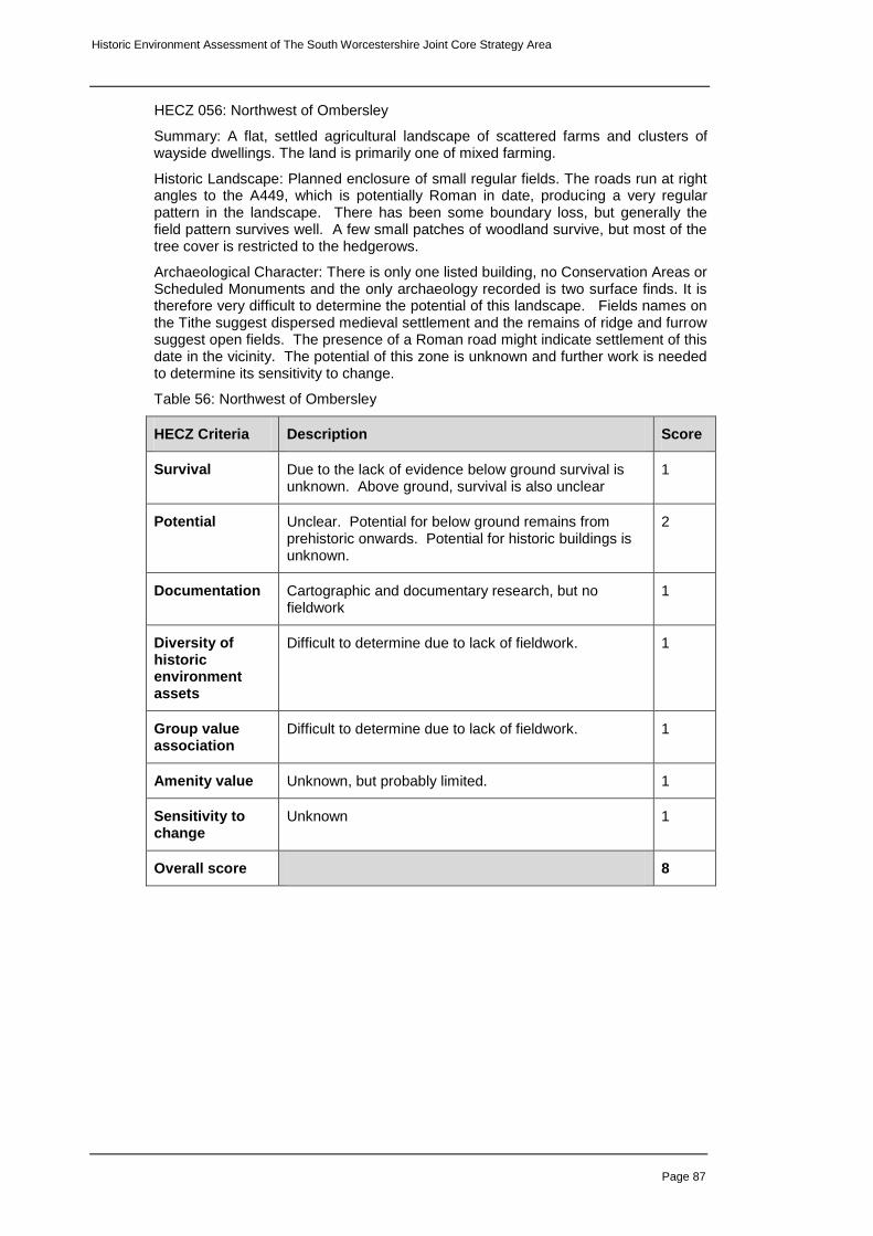
Historic Environment Assessment of The South Worcestershire Joint Core Strategy Area
Page 87
HECZ 056: Northwest of Ombersley
Summary: A flat, settled agricultural landscape of scattered farms and clusters of wayside dwellings. The land is primarily one of mixed farming.
Historic Landscape: Planned enclosure of small regular fields. The roads run at right angles to the A449, which is potentially Roman in date, producing a very regular pattern in the landscape. There has been some boundary loss, but generally the field pattern survives well. A few small patches of woodland survive, but most of the tree cover is restricted to the hedgerows.
Archaeological Character: There is only one listed building, no Conservation Areas or Scheduled Monuments and the only archaeology recorded is two surface finds. It is therefore very difficult to determine the potential of this landscape. Fields names on the Tithe suggest dispersed medieval settlement and the remains of ridge and furrow suggest open fields. The presence of a Roman road might indicate settlement of this date in the vicinity. The potential of this zone is unknown and further work is needed to determine its sensitivity to change.
Table 56: Northwest of Ombersley
HECZ Criteria Description Score
Survival Due to the lack of evidence below ground survival is unknown. Above ground, survival is also unclear
1
Potential Unclear. Potential for below ground remains from prehistoric onwards. Potential for historic buildings is unknown.
2
Documentation Cartographic and documentary research, but no fieldwork
1
Diversity of historic environment assets
Difficult to determine due to lack of fieldwork. 1
Group value association
Difficult to determine due to lack of fieldwork. 1
Amenity value Unknown, but probably limited. 1
Sensitivity to change
Unknown 1
Overall score 8

Historic Environment Assessment of The South Worcestershire Joint Core Strategy Area
Page 88
HECZ 057: East of Doverdale
Summary: A flat, settled agricultural landscape of scattered farms and clusters of wayside dwellings. The land is primarily one of mixed farming.
Historic Landscape: The zone is characterised by dispersed farmsteads and wayside dwellings along a network of lanes. Small patches of woodland survive, but tree cover is generally restricted to hedgerows. Piecemeal enclosure is the dominant field pattern. There has been a significant amount of boundary loss in places.
Archaeological Character: Buried remains and earthworks of a medieval moated site and deserted settlement survive around Doverdale. The moated site is Scheduled. No archaeological works have taken place in the zone, but there is potential for further archaeological remains associated with these features. Four chance finds of Neolithic date point to some prehistoric activity in the area, but the nature and extent of this is unknown. It is difficult to assess the potential of this zone given the lack of archaeological work.
Table 57: East of Doverdale
HECZ Criteria Description Score
Survival Some erosion of the landscape character. Excellent preservation of above ground archaeology around Doverdale.
2
Potential Likelihood of further medieval settlement remains, possibility of earlier deposits.
2
Documentation Limited documentary and cartographic sources. No archaeological works.
1
Diversity of historic environment assets
A diverse range of above and below ground features around Doverdale relating to the medieval settlement
3
Group value association
Reasonably coherent medieval and post-medieval landscape
2
Amenity value Limited 1
Sensitivity to change
It is difficult to determine sensitivity due to a lack of fieldwork, but the above and below ground archaeology near Doverdale is certainly sensitive. Any further below ground remains would also be sensitive
2
Overall score 13

Historic Environment Assessment of The South Worcestershire Joint Core Strategy Area
Page 89
HECZ 058: Kenswick to South of Wichenford
Summary: An area of soft rock, comprising mixed mudstones and sandstones producing a rolling, lowland topography and free-draining brown soils. The settlement is predominantly dispersed along a network of lanes, which run broadly north-west to south east. Woodland is a key character of this landscape.
Historic Landscape: Settlement remains dispersed with a few loosely agglomerated villages. The field pattern is largely comprised of irregular and sub-regular large enclosures with pockets of smaller-scale irregular fields in patches throughout the zone. The zone has characteristic small blocks of ancient semi-natural woodland linked by the historic hedgerow network.
Archaeological Character: The zone is characterised by multi-period archaeology and a moderate/high density of listed buildings, both wayside and scattered throughout the larger settlements. Medieval ridge and furrow, moated settlements (including the Scheduled moat at Kenswick) and communications form the principal, recorded assemblage of historic assets in this zone.
Table 58: Kenswick to South of Wichenford
HECZ Criteria Description Score
Survival Dispersed settlement pattern and historic piecemeal field pattern survives well. Moderate survival of medieval earthworks.
2
Potential High potential for below ground medieval archaeology around settlements.
3
Documentation HER. Field walking surveys, archaeological evaluation, excavation and building recording. Cartographic and documentary sources
3
Diversity of historic environment assets
Historic settlement pattern and fieldscapes. Medieval settlement and field system features. Diverse historic buildings stock.
3
Group value association
Characterised by dispersed historic farmstead pattern and post-medieval field pattern.
2
Amenity value Good Public Rights of Way access across much of the zone. Potential to develop access to semi-ancient natural woodlands. Overall potential remains unclear.
2
Sensitivity to change
Coherence of dispersed settlement pattern and the structure of the historic fieldscape together with potential buried archaeology would suffer if significant change occurred.
2
Overall score 17

Historic Environment Assessment of The South Worcestershire Joint Core Strategy Area
Page 90
HECZ 059: Ockeridge Wood
Summary: A gently undulating, wooded agricultural landscape of isolated brick farmsteads and wayside dwellings. The key characteristic of this zone is the woodland.
Historic Landscape: Large areas of ancient semi-natural woodland and replanted woodland dominate the zone. These are interspersed with small irregularly shaped patches of woodland and lots of trees in the hedgerows, producing a heavily wooded landscape. The field pattern is piecemeal enclosure, the majority of which is under pasture. There has been some boundary loss resulting in irregularly shaped fields. Settlement consists of dispersed farmsteads.
Archaeological Character: Very little archaeological work has been carried out in the zone. Cropmarks have been noted on aerial photographs and scatters of Roman pottery have been found on the surface, but no excavation has taken place. Any archaeology within the woodland remains unrecorded. A few listed and unlisted historic buildings survive. There are no Conservation Areas or Scheduled Monuments. It is difficult to assess the significance of any archaeological remains at this time.
Table 59: Ockeridge Wood
HECZ Criteria Description Score
Survival The historic landscape survives well, but archaeological survival is unknown.
2
Potential Potential for below-ground prehistoric and Roman archaeology. Potential for historic buildings and woodland archaeology.
3
Documentation HER, cartographic and documentary sources. 1
Diversity of historic environment assets
Difficult to asses the diversity as limited archaeological work has been carried out, but cropmark evidence, pottery scatters and medieval and post-medieval historic buildings suggest there is diversity.
2
Group value association
Coherent post medieval landscape and historic woodland.
2
Amenity value Good Public Rights of Way access across much of the zone. Potential to develop access to semi-ancient natural woodlands.
2
Sensitivity to change
The woodland and landscape character are sensitive to change. Any below-ground remains would also be sensitive.
2
Overall score 14

Historic Environment Assessment of The South Worcestershire Joint Core Strategy Area
Page 91
HECZ 060: Worcester City – outer (by James Dinn)
Summary: The zone is occupied by suburbs developed in the 19th and 20
th centuries.
Although research models suggest that this zone should be closely linked to the city core, little archaeological evidence for this has been recovered.
Historic Landscape: Encircling the city centre are large areas of spacious Victorian and Edwardian detached and semi-detached housing and terraces reflecting the city’s rapid 19
th century expansion. Further out 20
th century suburbs of varying
characters dominate the landscape. Some substantial areas of open space survive in the form of parks, playing fields, woodland and floodplain meadows.
Archaeological Character: there is a moderate distribution of listed and unlisted historic buildings, along with a small number of Scheduled Monuments and several conservation areas. The suburbs and outer edges of the city have been much less thoroughly investigated than the city centre, even those areas which have been developed since the 1990s, and there is a gap in our knowledge here. Archaeology from the prehistoric period onwards may survive across the zone, but the density and depth is certain to be lower outside the city centre.
Table 60: Worcester City - outer
HECZ Criteria Description Score
Survival Moderate survival of above ground remains from the medieval time to present. Locally, preservation of below ground remains including environmental deposits
2
Potential Potential for below ground archaeology from the Iron Age through to the post-medieval including environmental deposits
3
Documentation There is a moderate amount of documentation, cartographic and photographic sources. Also HER, survey and archaeological works.
2
Diversity of historic environment assets
A moderately diverse range of below and above ground features, including evidence for earlier prehistoric (flint scatters), Iron Age and Roman (buried features), medieval (including moated sites) and post-medieval activity.
2
Group value association
There is little clear patterning for any period before the post-medieval.
1
Amenity value Excellent potential for marketing the historic development of the city and its immediate hinterland.
3
Sensitivity to change
Surviving remains, including landscape scale features such as woodland, are highly sensitive to change.
2
Overall score 15

Historic Environment Assessment of The South Worcestershire Joint Core Strategy Area
Page 92
HECZ 061: Hampton Lovett
Summary: An open, flat, lowlying landscape of amalgamated piecemeal enclosure. The farming is predominantly arable.
Historic Landscape: Patches of irregularly shaped woodland, including ancient semi-natural, are scattered across the landscape and trees survive in hedgerows. The settlement is dispersed farmsteads and wayside dwellings on a network of winding lanes. There has been significant boundary loss changing the character of the landscape.
Archaeological Character: The south east of the zone contains significant below-ground Roman archaeology, including two Scheduled areas. Further archaeology from the Roman period onwards is likely to be found here and along the Roman road, which stretches northwards through the zone. There is potential for significant medieval archaeology in the centre of the zone around St Mary's Church, Hampton Lovett.
Table 61: Hampton Lovett
HECZ Criteria Description Score
Survival Below-ground survival is excellent where excavations have taken place. The landscape has survived less well.
3
Potential Geophysics and field walking suggest further below-ground remains from all periods are likely across the zone, particularly in the south
3
Documentation Documentary, cartographic, field walking, excavation, geophysics, aerial photos.
3
Diversity of historic environment assets
A diverse range of below-ground archaeology in terms of period and type, but little above ground remains.
2
Group value association
A coherent Roman landscape and a medieval deserted settlement
2
Amenity value Limited as most of the archaeology is below-ground, potential for interpretation of the Roman fort and camp.
1
Sensitivity to change
The below-ground remains are highly sensitive to change.
2
Overall score 16

Historic Environment Assessment of The South Worcestershire Joint Core Strategy Area
Page 93
HECZ 062: The Malvern Hills
Summary: A landscape dominated by the granite outcrop of the Malverns and in contrast to the surrounding gently rolling lowlands. It is characterised by its steep topography, shallow mineral soils and extensive areas of common and heathland. Historic Landscape: The large-scale and open, exposed character is heightened by the dramatic form of the topography. The lower slopes are often tree covered, but the upper slopes tend to be open heathland. There are few Listed or historic buildings as the hills are largely unsettled. Settlement tends to be confined to the lower hills on either side of the zone.
Archaeological Character: The Malverns have been settled since at least the Bronze Age. Earthworks survive of an Iron Age Hillfort and later settlement. Quarries from prehistoric times onwards scatter the hills. Little excavation has taken place, with the archaeological records tending to consist of field walking, earthwork surveys and aerial photographic interpretations. Where excavation has taken place, the survival of deposits from the Bronze Age onwards has been good.
Table 62: The Malvern Hills
HECZ Criteria Description Score
Survival Excellent earthworks and below-ground remains from prehistoric times.
3
Potential Potential for further below-ground archaeology of all periods.
3
Documentation Extensive surveys, documentary and cartographic evidence. Little excavation.
2
Diversity of historic environment assets
A diverse range of below-ground prehistoric archaeology.
2
Group value association
A coherent prehistoric landscape. 3
Amenity value High potential 3
Sensitivity to change
This landscape is highly sensitive to change. 3
Overall score 19

Historic Environment Assessment of The South Worcestershire Joint Core Strategy Area
Page 94
HECZ 063: Three Counties
Summary: A gently rolling low-lying landscape of predominantly pastoral farmland on poor soils.
Historic Landscape: An area of planned enclosure of former common characterised by straight roads and very regular field patterns. Areas of regular woodland are scattered across the zone. The key characteristic of this landscape is its regularity.
Archaeological Character: It is difficult to determine the potential of this area as little archaeological work has been carried out. Where recorded, the ridge and furrow and other earthworks have been ploughed out and little else survives above-ground. Cropmarks suggest that below-ground archaeology of earlier settlement may survive in the area, but the lack of fieldwork makes the potential of this unknown.
Table 63: Three Counties
HECZ Criteria Description Score
Survival Known survival is poor. Above-ground features have been ploughed out.
1
Potential Cropmarks indicate some potential, but the lack of fieldwork makes it difficult to determine.
2
Documentation Documentary and cartographic. Little fieldwork. 1
Diversity of historic environment assets
Unknown 1
Group value association
Unknown 1
Amenity value Limited 1
Sensitivity to change
Below-ground sensitivity is unknown. 1
Overall score 8

Historic Environment Assessment of The South Worcestershire Joint Core Strategy Area
Page 95
HECZ 064: West of Malvern
Summary: A largely wooded landscape with a sloping, in places steeply undulating, topography running along the western edge of the Malverns.
Historic Landscape: Large, irregularly shaped ancient woodlands and wooded streamlines, typically forming an interlocking pattern with surrounding hedged fields. Much of the woodland is ancient semi-natural or ancient replanted and many of the trees are of significant antiquity. The settlement is predominantly dispersed along a network of winding lanes.
Archaeological Character: The Malvern Hills Woodland Survey has identified a large number of earthwork features, such as wood banks, trackways, hollow ways and lynchets. Other surveys and field walking suggest prehistoric settlement in the area. Little excavation has been carried out, but any below-ground remains are likely to survive well beneath the pasture and woodland.
Table 64: West of Malvern
HECZ Criteria Description Score
Survival Excellent landscape survival. Good historic built environment.
3
Potential High potential for any below-ground remains to have survived well. Good landscape potential.
3
Documentation Limited below-ground archaeological evidence. Extensive field survey. Cartographic and documentary research.
2
Diversity of historic environment assets
Medieval and post-medieval earthwork features, good historic built environment and coherent landscape.
3
Group value association
A coherent wooded landscape with earthwork features surviving well.
2
Amenity value Good Public Rights of Way access across much of the zone. Potential to develop access to semi-ancient natural woodlands. Overall potential remains unclear.
2
Sensitivity to change
Above and below-ground remains sensitive to change. 2
Overall score 17

Historic Environment Assessment of The South Worcestershire Joint Core Strategy Area
Page 96
HECZ 065: Upton and Lower Severn
Summary: This zone is comprised of alluvial river flood plain bordered by low undulating sand and gravel river terraces. The settlement pattern is one of low-level dispersal.
Historic Landscape: The zone has a diverse pattern of small to medium, irregular enclosed riverside grazing pasture contrasted with areas of larger sub-regular enclosures characterising the arable terraces. The historic dispersed low-density settlement pattern is still extensive throughout the zone whereas Upton-Upon-Severn has expanded considerably during 20th century. Extensive areas of traditional orchards have been lost as a result of Upton's expansion.
Archaeological Character: Extensive below ground prehistoric and Romano-British settlements on the terraces and ritual features of national and regional importance located along the alluvial plain. The latter often associated with palaeochannels, which preserve nationally important environmental deposits. The medieval settlement pattern remains intact with some survival of ridge and furrow earthworks, common pasture, water meadows irrigation features and a range of listed buildings.
Table 65: Upton and Lower Severn
HECZ Criteria Description Score
Survival In un-quarried areas below ground historic features survive well. The historic settlement and field pattern also survives well.
2
Potential High potential for survival of below ground features in un-quarried areas.
3
Documentation Extensive HER data, extensive evaluation and excavation records. River Severn Archaeological Assessment.
3
Diversity of historic environment assets
Multi-period below ground features and extensive prehistoric landscape features. Multi-period field pattern and dispersed settlements.
3
Group value association
Extensive prehistoric settlement and ritual features surviving within the remains of their prehistoric landscape context.
3
Amenity value Limited in heavily farmed areas and quarry zones, but opportunities to develop promotion of commons and riverside access.
2
Sensitivity to change
Below ground deposits and historic landscape pattern sensitive in un-quarried areas.
3
Overall score 19

Historic Environment Assessment of The South Worcestershire Joint Core Strategy Area
Page 97
HECZ 066: The Eastern Avon Valley
Summary: This zone is comprised of alluvial river flood plain bordered by low undulating sand and gravel river terraces. The settlement pattern is predominantly nucleated, although there is little settlement within the zone as it is flood plain.
Historic Landscape: The zone has a diverse pattern of medium to large, regular and irregular enclosed riverside grazing pasture. The land use is predominately arable.
Archaeological Character: Extensive below ground prehistoric and Romano-British settlements on the terraces and ritual features of national and regional importance located along the alluvial plain. The latter often associated with palaeochannels, which preserve nationally important environmental deposits. There is some survival of ridge and furrow earthworks, common pasture and water meadows irrigation features. The extensive ploughing of this area may have damaged the shallower archaeological remains, but will have had little effect on the environmental deposits.
Table 66: The Eastern Avon Valley
HECZ Criteria Description Score
Survival Below ground prehistoric features survive well. 2
Potential High potential for survival of below ground features. 3
Documentation Extensive HER data, evaluation and excavation records.
2
Diversity of historic environment assets
Multi-period below ground features and extensive prehistoric landscape features.
3
Group value association
Extensive prehistoric settlement and ritual features surviving within the remains of their prehistoric landscape context.
3
Amenity value Opportunities to develop promotion of riverside access. 2
Sensitivity to change
Below ground deposits sensitive. 2
Overall score 17

Historic Environment Assessment of The South Worcestershire Joint Core Strategy Area
Page 98
HECZ 067: Norton and Harvington
Summary: An area of intermediate topography, with lias clay and a resultant free draining, base rich clay soil and associated fruit growing and orchards.
Historic Landscape: The settlement pattern is nucleated, set in a landscape of intensive arable farming. The field pattern is parliamentary and planned enclosure, with significant boundary loss. Tree cover is sparse and mostly confined to the poorly maintained hedgerows.
Archaeological Character: There are a number of Listed and unlisted historic buildings, mostly confined within the villages of Norton and Lenchwick. Extensive archaeological field walks, surveys and excavations have revealed a settled landscape from prehistoric times onwards. Below-ground evidence survives well, although in places its potential will have been reduced by the intensive arable cultivation.
Table 67: Norton and Harvington
HECZ Criteria Description Score
Survival Good below-ground survival. Earthwork survival less good due to the 20
th century land use. Historic
buildings survive well.
2
Potential Potential for further below-ground archaeology 2
Documentation Extensive cartographic, documentary and field work. 3
Diversity of historic environment assets
A diverse range of multi period above and below-ground remains
3
Group value association
A coherent prehistoric landscape. The medieval and post-medieval landscape has suffered due to plough damage and field amalgamation.
2
Amenity value Limited 1
Sensitivity to change
The historic buildings in the villages and the below-ground archaeology are highly sensitive to change.
3
Overall score 16

Historic Environment Assessment of The South Worcestershire Joint Core Strategy Area
Page 99
HECZ 068: Offenham and the Littletons
Summary: A low lying river terrace of mixed sands and gravels, with sandy, free draining soils, supporting an arable land use.
Historic Landscape: The settlement pattern is nucleated, within a landscape of regular planned enclosure. The dominant character of the area is market gardening and the associated glasshouses and nurseries cover large parts of the zone.
Archaeological Character: A large number of listed and unlisted historic buildings survive within the zone, almost entirely confined to the historic cores of the villages. There have been a large number of archaeological interventions, which have found extensive archaeological deposits from prehistoric times onwards.
Table 68: Offenham and the Littletons
HECZ Criteria Description Score
Survival Good survival of below-ground archaeology. 2
Potential Excellent potential for further below-ground archaeology.
3
Documentation Extensive documentary and cartographic evidence and archaeological fieldwork.
3
Diversity of historic environment assets
A diverse range of multi-period below-ground archaeology and above ground features.
3
Group value association
A coherent Roman landscape 2
Amenity value Limited 1
Sensitivity to change
The below-ground archaeology and historic buildings are sensitive to change.
2
Overall score 16

Historic Environment Assessment of The South Worcestershire Joint Core Strategy Area
Page 100
HECZ 069: Upper Teme Corridor
Summary: An area of alluvial drift with a low lying topography and freely draining wetland soils. The inherent land use is pastoral, and is largely unsettled, derived from areas of former meadowland and grazing marsh. The land often rises quite sharply on either side of the zone, unlike the Lower Teme Corridor, where the landscape is generally flat.
Historic Landscape: A mixture of both regular and irregular field fields enclosing the flood plane and hams. The zone is principally under permanent pasture with isolated parcels of arable land. The entire zone is prone to flooding.
Archaeological Character: High potential for waterlogged paleoenvironmental deposits, wooden artefacts and structures, and cultural occupation deposits sealed within the alluvial layers. Relic prehistoric settlement, boundary and ritual features sealed beneath and contained within alluvium. Little archaeological work has been carried out here, but the potential is thought to be high.
Table 69: Upper Teme corridor
HECZ Criteria Description Score
Survival Organic deposits will be well preserved in waterlogged soils. Structural features and artefacts sealed beneath protective alluvial layers.
3
Potential Likelihood of well preserved organic, environmental and structural remains within alluvial deposits. Prehistoric ritual and boundary features. Medieval fish weirs and timber structures.
3
Documentation HER, fieldwalking and landscape survey documents. 1
Diversity of historic environment assets
Likelihood of diverse archaeological features and deposits ranging from organic to structural, multi-period archaeology.
3
Group value association
Environmental deposits preserved covering a potential 10,000 year period. Prehistoric ritual sites. Coherent post-medieval field system.
3
Amenity value Potential for promotion of the historic environment in relation to river corridor exploitation and the development of seasonal managed grazing.
2
Sensitivity to change
Highly sensitive to change. 3
Overall score 18

Historic Environment Assessment of The South Worcestershire Joint Core Strategy Area
Page 101
HECZ 070: Tenbury to St Michael's
Summary: A gently rolling landscape of small scale pastureland with patches of irregularly shaped woodland.
Historic Landscape: The landscape is dominated by small and irregular piecemeal enclosure, with planned enclosure of former common land around Oldwood Common. The settlement is historically dispersed farmsteads and loosely agglomerated villages along a network of winding lanes. There has been little boundary loss and the landscape survives well. The patches of woodland and hedgerow trees create a reasonably wooded landscape.
Archaeological Character: A number of Listed buildings exist dispersed across the zone. There has been little archaeological work in the zone, a rapid survey of Oldwood Common and a findspot of a possible Roman brooch in a back-garden, therefore it is difficult to determine the archaeological potential of the area. Should archaeology exist, then it is likely to be well preserved below the permanent pasture.
Table 70: Tenbury to St Michael's
HECZ Criteria Description Score
Survival Archaeologically unknown, due to limited survey and an absence of archaeological excavation or building recording. The landscape survives well.
2
Potential There is potential for both below-ground remains surviving well and the historic built environment.
2
Documentation Limited fieldwork, cartographic and documentary sources.
1
Diversity of historic environment assets
Unknown 1
Group value association
Unknown 1
Amenity value Good PROW access across an intact historic landscape.
2
Sensitivity to change
The landscape is highly sensitive, the below-ground remains are unknown.
2
Overall score 11
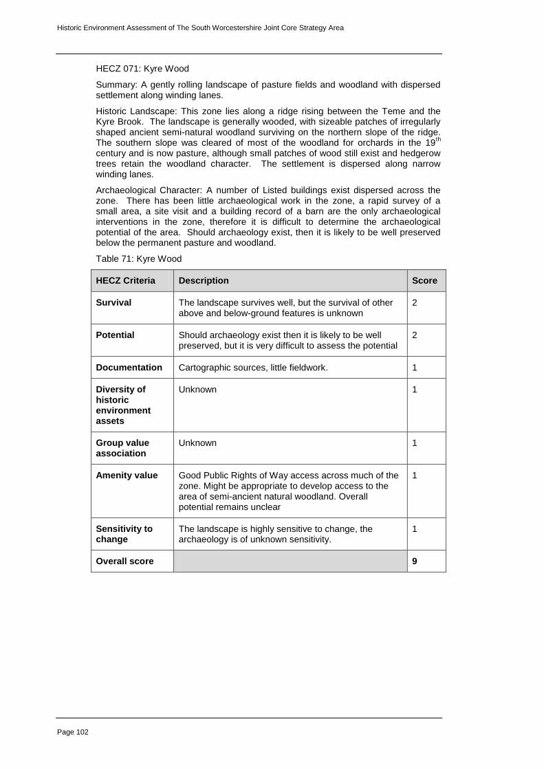
Historic Environment Assessment of The South Worcestershire Joint Core Strategy Area
Page 102
HECZ 071: Kyre Wood
Summary: A gently rolling landscape of pasture fields and woodland with dispersed settlement along winding lanes.
Historic Landscape: This zone lies along a ridge rising between the Teme and the Kyre Brook. The landscape is generally wooded, with sizeable patches of irregularly shaped ancient semi-natural woodland surviving on the northern slope of the ridge. The southern slope was cleared of most of the woodland for orchards in the 19
th
century and is now pasture, although small patches of wood still exist and hedgerow trees retain the woodland character. The settlement is dispersed along narrow winding lanes.
Archaeological Character: A number of Listed buildings exist dispersed across the zone. There has been little archaeological work in the zone, a rapid survey of a small area, a site visit and a building record of a barn are the only archaeological interventions in the zone, therefore it is difficult to determine the archaeological potential of the area. Should archaeology exist, then it is likely to be well preserved below the permanent pasture and woodland.
Table 71: Kyre Wood
HECZ Criteria Description Score
Survival The landscape survives well, but the survival of other above and below-ground features is unknown
2
Potential Should archaeology exist then it is likely to be well preserved, but it is very difficult to assess the potential
2
Documentation Cartographic sources, little fieldwork. 1
Diversity of historic environment assets
Unknown 1
Group value association
Unknown 1
Amenity value Good Public Rights of Way access across much of the zone. Might be appropriate to develop access to the area of semi-ancient natural woodland. Overall potential remains unclear
1
Sensitivity to change
The landscape is highly sensitive to change, the archaeology is of unknown sensitivity.
1
Overall score 9

Historic Environment Assessment of The South Worcestershire Joint Core Strategy Area
Page 103
HECZ 072: Kyre Wooded Estatelands
Summary: Dispersed farmsteads set in a gently rolling landscape of mixed farming and small patches of ancient semi-natural woodland.
Historic Landscape: A hard rock area of mixed mudstones and sandstones, with free draining brown soils and an intermediate rolling topography. The land use is mixed farming and the tree cover comprises relic ancient woodland often associated with densely scattered hedgerow oaks. The settlement pattern is dispersed farmsteads and wayside dwellings, associated with a planned enclosure field pattern.
Archaeological Character: As with other zones in the north west of the county, there has been little archaeological work. The field-walking and rapid surveys that have been carried out here have found archaeological remains in the form of find spots (suggesting below-ground archaeology from prehistoric times onwards) and earthwork features (from the medieval period onwards). Any archaeology in this area is likely to be well preserved due to the nature of the past land use. There is also potential for excellent survival of the historic built environment.
Table 72: Kyre Wooded Estatelands
HECZ Criteria Description Score
Survival Good landscape survival and earthwork and historic buildings. Below-ground is unknown.
2
Potential Field walking suggests that below-ground archaeology could exist from all periods. If it does, survival is likely to be good. Potential for historic buildings is good.
2
Documentation Limited cartographic, field work and documentary sources.
1
Diversity of historic environment assets
A range of earthworks and buildings from the medieval and post-medieval periods.
2
Group value association
A coherent medieval and post-medieval landscape. 2
Amenity value Unknown, a good PROW network exists across the zone.
1
Sensitivity to change
The landscape is sensitive to change as are the historic buildings. Any below-ground remains would also be highly sensitive.
2
Overall score 12

Historic Environment Assessment of The South Worcestershire Joint Core Strategy Area
Page 104
HECZ 073: Hanley Swan and Welland
Summary: A flattish landscape of enclosed former common land on poorly draining soils derived from fluvio-glacial drift.
Historic Landscape: Enclosed former common land characterised by straight post medieval roads which cut across earlier winding lanes dotted with irregular wayside settlement. The land use is largely arable with little tree cover aside from alongside watercourses and field boundaries. Fields are generally large and regular with evidence of field boundary loss although remnants of enclosed strip fields survive in the vicinity of Hanley Swan and some ridge and furrow is recorded to the west of the zone.
Archaeological Character: Archaeological fieldwork within the zone has been limited but small scale works and petrological analysis of pottery from further afield implies that this area may have been a centre for pottery production in the medieval period or earlier. However the below ground survival of this industry and other archaeological sites is unknown. The extant remains of Little Malvern Priory are a scheduled ancient monument.
Table 73: Hanley Swan and Welland
HECZ Criteria Description Score
Survival Dispersed settlement pattern and historic piecemeal field pattern survives well although above ground archaeology is unlikely to survive.
2
Potential Archaeological fieldwork and finds suggest there is potential for below ground archaeology, particularly for the survival of pottery manufacturing sites of Roman or medieval date.
2
Documentation Limited documentation from small scale archaeological fieldwork, cartographic and documentary sources.
2
Diversity of historic environment assets
Known historic environment assets limited to the medieval and post medieval periods.
2
Group value association
A coherent medieval and post medieval landscape 3
Amenity value The disused line of the former Malvern to Evesham railway is now a footpath which, with other PROWs in the area provides access to the landscape.
2
Sensitivity to change
Below ground deposits and historic landscape pattern sensitive to development.
2
Overall score 15

Historic Environment Assessment of The South Worcestershire Joint Core Strategy Area
Page 105
HECZ 074: Castlemorton, Hollybed and Combegreen Commons
Summary: An area of unenclosed common land with scattered settlement on undulating fluvial glacial deposits at the foot of the Malvern Hills. The landscape is largely rough grazed heathland.
Historic Landscape: A survival of unenclosed open common land characterised by grazed grassland with bracken, gorse scrub and scattered trees. Settlement is scattered along unfenced roads and rough tracks interspersed with isolated farms. Settlements within the zone, Combe Green, Huntsbridge and Chandler's Cross display a scattered settlement pattern characteristic of piecemeal on common land and a ragged edge to parts of the common implies small scale encroachment.
Archaeological Character: Earthwork evidence of small scale quarrying survives across the zone, generally in the form of small undated pits although there is more extensive evidence of this activity on Combegreen Common to the south. Well preserved holloways associated with this and other activities also survive on Combegreen Common and there are also earthworks on Castlemorton Common related to the Second World War defence of Britain
Table 74: Castlemorton, Hollybed and Combegreen Commons
HECZ Criteria Description Score
Survival Excellent landscape survival with an unknown but potentially high survival of below-ground archaeology
3
Potential Potential for well preserved below-ground archaeology of all periods.
3
Documentation Limited documentation of archaeological activity within the zone. HER, cartographic and documentary sources.
2
Diversity of historic environment assets
A range of earthwork and cropmark features are recorded in the HER
2
Group value association
A coherent medieval landscape 3
Amenity value High potential; the commons provide amenable access to the historic landscape.
3
Sensitivity to change
The landscape is highly sensitive to change. 3
Overall score 19

Historic Environment Assessment of The South Worcestershire Joint Core Strategy Area
Page 106
HECZ 075: Castlemorton and Druggers End
Summary: A soft rock area of mudstones, with a low lying, gently rolling topography and poorly draining soils with a medium to large regular field pattern and scattered settlement amid mixed farmland.
Historic Landscape: A landscape of planned, regular enclosure, with some boundary loss. Tree cover is sparse and mostly confined to hedgerows. Settlement comprises wayside dwellings and isolated farms.
Archaeological Character: Recorded archaeological sites are fairly sparse across the zone as a whole but there are medieval earthworks around the village of Castlemorton and to the east of Welland. Castlemorton castle mound is a scheduled ancient monument and both within and medieval settlement earthworks are recorded to the south of Church Farm while a holloway and an area of ridge and furrow are recorded to the south-west of the village. There is some potential for below ground remains to the east of Welland where there is documentary evidence for a windmill and some undated earthworks survive. A relatively dense scatter of historic listed and non listed buildings are recorded across the zone.
Table 75: Castlemorton and Druggers End
HECZ Criteria Description Score
Survival Well preserved post medieval landscape. Preservation of above ground archaeology around Castlemorton.
2
Potential Potential for medieval settlement remains in the vicinity of Castlemorton and east of Welland. Archaeological potential across the remainder of the zone unknown.
2
Documentation Archaeological investigation within the zone is limited to two watching briefs carried out in Castlemorton with negative results.
1
Diversity of historic environment assets
A range of earthworks and buildings from the medieval and post-medieval periods.
2
Group value association
A coherent medieval and post-medieval landscape. 3
Amenity value There is open access to Castlemorton Castle mound and a network of footpaths across the area.
2
Sensitivity to change
The landscape and setting of the historic buildings are sensitive to change.
2
Overall score 14

Historic Environment Assessment of The South Worcestershire Joint Core Strategy Area
Page 107
HECZ 076: Longdon and Eldersfield Marshes
Summary: An area of low lying, flat, alluvial drift, with poorly drained wetland soils. It is largely unsettled, derived from areas of former meadowland and grazing marsh. Land use is largely pastoral, with an irregular field pattern and scattered streamside and hedgerow trees.
Historic Landscape: A landscape of former marshland enclosed and drained largely in the 18
th and 19
th Centuries. In the vicinity of Birtsmorton Court there are large
fields characteristic of parliamentary enclosure but in the main, fields in this zone are small and irregular, probable a result of piecemeal enclosure of the landscape following drainage. To the south of Birtsmorton is a well preserved area of open parkland with large scattered mature trees and an avenue.
Archaeological Character: The area is sparsely settled and largely pastoral so below-ground archaeology is likely to be little disturbed. An archaeological walkover in 2002 concluded that there was potential for the survival of Iron Age and Roman deposits on the eastern side of Longdon Marsh. An enclosure cropmark is recorded on the east side of Eldersfield Marsh and Roman pottery has been recovered from the west. There is a considerable potential in this area for the preservation of waterlogged deposits and palaeoenvironmental material. Ridge and furrow is preserved in the area of Longdon Marsh and there are watermeadows on Eldersfield Marsh. Birtsmorton Court is a moated medieval manor house with associated church and manor farm. The settlement is recorded on the HER as a deserted medieval village and excavation in the vicinity has revealed below-ground medieval features.
Table 76: Longdon and Eldersfield Marshes
HECZ Criteria Description Score
Survival Well preserved medieval and post medieval landscape.
2
Potential Considerable potential for the survival of Iron Age and Roman deposits in Longdon Marsh and for the preservation of waterlogged deposits and palaeoenvironmental remains across the zone. Potential for the preservation of medieval settlement in the vicinity of Birtsmorton.
3
Documentation Archaeological activity in the area has been limited. HER and cartographic sources
2
Diversity of historic environment assets
Whilst most of the archaeological potential is unknown, there are recorded sites and from a range of periods within the zone.
2
Group value association
A coherent medieval and post medieval landscape. 2
Amenity value There is a potential for promotion of access to this distinctive landscape.
2
Sensitivity to change
The landscape is highly sensitive to change. 3
Overall score 16

Historic Environment Assessment of The South Worcestershire Joint Core Strategy Area
Page 108
HECZ 077: Pendock to Chase End Street
Summary: An area of soft rock, of mixed mudstones and sandstones, with an intermediate undulating topography and free draining soils. This is an area of largely pastoral land use, with tree cover represented by thinly scattered hedgerow and field trees together with groups of trees associated with settlements.
Historic Landscape: An area of moderately dispersed settlement characterised by isolated farmsteads and scattered wayside dwellings. Farming is mixed and fields are generally of small to moderate scale with occasional larger arable fields the result of field amalgamation over the last 150 years. Areas of semi-natural woodland survive at Gadbury Bank and Berrow Hill.
Archaeological Character: Archaeological activity in the zone has largely been confined to the Pendock and Sledge Green areas where a systematic fieldwalking survey collected pottery including Roman and medieval forms. The areas surveyed included the location of an enclosure cropmark and extant medieval earthworks to the west of Cleeve House. Clusters of medieval features are also recorded at Chase End Street and Camer's Green. Gadbury Bank, a small Iron Age hillfort surrounded by semi natural woodland is a scheduled ancient monument and there is also a possible hillfort at Berrow Hill.
Table 77: Pendock to Chase End Street
HECZ Criteria Description Score
Survival Little boundary loss contributes to well preserved post medieval landscape.
2
Potential Potential for the survival of Iron Age, Roman and medieval deposits, particularly in the vicinity of Pendock and Gadfield Bank.
3
Documentation Extensive fieldwalking survey across a central swathe of the zone.
2
Diversity of historic environment assets
A range of archaeological assets from the prehistoric to modern periods is recorded on the HER
3
Group value association
A coherent medieval and post medieval landscape. 2
Amenity value Good Public Rights of Way access across much of the zone. Potential to develop access to semi-ancient natural woodlands and hillfort.
2
Sensitivity to change
The landscape and distinctive pattern of small fields sensitive to change.
2
Overall score 16

Historic Environment Assessment of The South Worcestershire Joint Core Strategy Area
Page 109
HECZ 078: Land adjacent to Hollybank
Summary: An area of intermediate, undulating topography, derived from a soft rock mixture of mudstones and sandstones, with free draining, brown soils. The land use is predominantly pastoral with isolated farms and tree cover comprising relic patches of ancient woodland and tree laden field boundaries.
Historic Landscape: The landscape is characterised by large regular fields which in part are enclosed from the adjacent commons. Settlement is confined to two isolated farms and occasional wayside dwellings in a largely unoccupied landscape.
Archaeological Character: There is no recorded archaeological activity within the zone although various features are recorded on the HER. To the east, adjacent to Coombegreen Common there is a cluster of extant medieval and post medieval earthwork settlement features and north of Hollybush a ploughed out mound is probably a prehistoric feature.
Table 78: Land adjacent to Hollybank
HECZ Criteria Description Score
Survival Good landscape and earthwork survival. 2
Potential There is considerable potential for below-ground remains in the vicinity of
3
Documentation No archaeological documentation but HER and cartographic documentation.
2
Diversity of historic environment assets
Recorded monuments range in date from the prehistoric to post medieval periods.
3
Group value association
A cohesive medieval and post medieval landscape with good association of medieval settlement monuments adjacent to Coombegreen Common.
3
Amenity value Potential to develop access to ancient semi-natural woodland. Limited Public Rights of Way but good access provided from adjacent commonland
2
Sensitivity to change
Landscape sensitive to change. 3
Overall score 18

Historic Environment Assessment of The South Worcestershire Joint Core Strategy Area
Page 110
HECZ 079: Malvern Hills South Ridge
Summary: The east facing slope of the south ridge of the Malvern Hills comprising impoverished soils largely occupied by ancient semi-natural woodland on the steep slopes with unenclosed rough grazing on the summit.
Historic Landscape: Unenclosed rough grazing and heathland on the summit of the ridge with mature woodland on steep slopes. The zone is crossed by Whiteleaved Oak and Hollybush cuttings, both well established Malvern crossings which have attracted scattered settlement.
Archaeological Character: Archaeological activity comprises a survey of the steep woodland below Midsummer Hill camp, the larger part of which lies across the county boundary immediately to the west. The scheduled area of the hillfort extends across the entire width of the ridge. Medieval and post medieval quarries and associated features are scattered across the steep slope and there is a listed building in Hollybush cutting.
Table 79: Malvern Hills South Ridge
HECZ Criteria Description Score
Survival A well preserved prehistoric landscape 3
Potential High potential for the preservation of prehistoric and medieval remains, particularly on the ridge summit.
3
Documentation Little archaeological intervention but HER and cartographic documentation.
2
Diversity of historic environment assets
A diverse range of prehistoric and medieval archaeology.
2
Group value association
A coherent prehistoric landscape. 3
Amenity value High potential. Good Access. 3
Sensitivity to change
The landscape is highly sensitive to development. 3
Overall score 19

Historic Environment Assessment of The South Worcestershire Joint Core Strategy Area
Page 111
HECZ 080: Hanley Castle estate farmlands
Summary: An area of flattish, lowland topography with large regular fields, mainly arable fields with mature trees and nucleated settlement.
Historic Landscape: A very regular field pattern with frequent mature deciduous trees dotted across the landscape is characteristic of estate farmland and enclosed parkland. Settlement is nucleated with isolated farms. Immediately north of Hanley Castle is an area of parkland, the garden of Severn End comprising open grassland and mature trees including three avenues.
Archaeological Character: The area, particularly the immediate vicinity of Hanley Swan has been subject to frequent, largely non intrusive, archaeological fieldwork including fieldwalking, geophysical survey and metal detector survey. A cluster of medieval features in and around Hanley Castle includes the castle itself which survives as an earthwork and is a scheduled ancient monument. Evaluation north west of the village has demonstrated the survival of below-ground medieval deposits and there are medieval settlement earthworks to the east. Ridge and furrow survives to the west of the village as well as water management features associated with the Pool Brook. Roman pottery has been recovered during fieldwalking and the cropmark of an enclosure is recorded within the parkland. There are numerous listed buildings in and around Hanley Castle including Severn End, a Victorian replica of a late medieval house destroyed by fire.
Table 80: Hanley Castle estate farmlands
HECZ Criteria Description Score
Survival A well preserved medieval and post medieval landscape
3
Potential Possibility of Romano-British below ground archaeology, likelihood of medieval and post-medieval remains.
3
Documentation Extensive archaeological fieldwork. 3
Diversity of historic environment assets
Known archaeology largely of medieval date although some indications of features of Roman date
2
Group value association
Below ground survival is unknown. Above ground a coherent medieval and post medieval landscape exists with earthworks and historic buildings.
3
Amenity value The parkland castle and medieval village of Hanley Castle are all of high amenity value.
3
Sensitivity to change
The area is distinctive and highly sensitive to change 3
Overall score 20

Historic Environment Assessment of The South Worcestershire Joint Core Strategy Area
Page 112
HECZ 081: Tunnel Hill and environs
Summary: A mixed area of medium to large arable fields to the south and smaller, less regular pastoral fields to the north.
Historic Landscape: An area of medium to large scale regular fields, largely arable, the larger of which are the result of field amalgamation in the last 100 years. Smaller and less regular pastoral fields characteristic of piecemeal enclosure survive towards the north of the zone. Tunnel Hill largely comprises 20
th Century houses although
there is a historic core to the settlement.
Archaeological Character: Little archaeological activity has taken place within the zone. Unstratified Iron Age and Roman pottery from south of the Norwegian cottage are suggestive of an occupation site, but generally there is little evidence as to the presence or nature of below-ground archaeology. There is a scatter of listed buildings across the zone and some sites relating to the WWII defence of Britain are recorded as having existed in Tunnel Hill.
Table 81: Tunnel Hill and environs
HECZ Criteria Description Score
Survival Despite boundary loss the landscape survives well, but the survival of other above and below-ground features is unknown
2
Potential There is potential for the survival of below-ground archaeological remains particularly to the south of Norwegian Cottage. The survival of deposits may have been compromised by ploughing.
2
Documentation HER, listed buildings records, documentary research. 1
Diversity of historic environment assets
Pottery has been recovered from the Iron Age and Roman periods and historic buildings within the zone date from the 17
th-19
th Centuries.
2
Group value association
A relatively intact post-medieval landscape. 2
Amenity value There are limited footpaths into the area and no above ground archaeology recorded on the HER, although there is a scatter of historic buildings.
2
Sensitivity to change
The landscape is relatively sensitive to change. 2
Overall score 13

Historic Environment Assessment of The South Worcestershire Joint Core Strategy Area
Page 113
HECZ 082: Estate Farmlands; Longdon Heath to Bushley Green
Summary: An area of large regular fields defined by mature hedgerows and interspersed with frequent plantations and tree belts. Apart from scattered settlement associated with areas of enclosed common land, settlement is nucleated.
Historic Landscape: An area of medium to large, fairly regular fields interspersed with frequent small coverts, plantations and windbreaks which are a distinctive characteristic of this area. Much of this landscape is enclosed parkland and estate farm and mature trees are scattered through many of the fields. Areas of unenclosed parkland survive around Hill House, Holdfast Hall and Ham Court. Also within this landscape are isolated patches of enclosed common land with scatted wayside settlement as at Longdon Heath and Bushley Green but otherwise settlement is generally nucleated with scattered farms.
Archaeological Character: Archaeological fieldwork in the area has been limited to several non intrusive surveys. There is a thin scatter of listed and unlisted historic buildings, mostly 17
th century in date. A number of the farmsteads show evidence
that they were once moated and there are at least two moats that still contain water. RIdge and furrow earthworks in the southern part of the zone, west of Bushley Green, are evidence of the pre-enclosure landscape.
Table 82: Estate Farmlands; Longdon Heath to Bushley Green
HECZ Criteria Description Score
Survival A well preserved post medieval landscape of former parkland and estate farm.
3
Potential Below-ground survival of archaeological remains is not known.
2
Documentation There has been limited archaeological intervention in the area. HER and cartographic sources.
2
Diversity of historic environment assets
Apart from a possible prehistoric or Roman enclosure, all known historic environment assets are of medieval or later date.
2
Group value association
Good association of post-medieval parkland and estate farm.
3
Amenity value There is a good network of public footpaths crossing the zone and the parkland has amenity value.
2
Sensitivity to change
The landscape is distinctive and sensitive to change. 2
Overall score 16

Historic Environment Assessment of The South Worcestershire Joint Core Strategy Area
Page 114
HECZ 083: Corse Lawn and Hardwicke Green
Summary: A soft rock area of mudstones with a gently rolling lowland topography and free draining brown soils.
Historic Landscape: A landscape small irregular fields characteristic of piecemeal enclosure interspersed with larger fields the product of field amalgamation. Some relict enclosed strip fields survive in the vicinity of Corse Green which is a linear village on the B4211 but largely settlement consists of scattered houses and farms on small winding lanes.
Archaeological Character: Limited archaeological activity has taken place within the zone apart from earthwork survey. Within the zone, there are several undated earthworks, including an enclosure to the north-east of Pigeon House. Moats are recorded at three farms, two of which still hold water. There are settlement earthworks at Lucas Farm and a length of holloway north of this. A possible Bronze Age barrow lies in the east of the zone and defences of uncertain age are recorded on Berth Hill to the east. Several farmhouses in the area are listed buildings, generally dating from the 17
th Century or later.
Table 83: Corse Lawn and Hardwicke Green
HECZ Criteria Description Score
Survival A well preserved post medieval landscape. 2
Potential Survival of below-ground archaeology is unknown 2
Documentation HER, field survey, documentary and cartographic sources.
2
Diversity of historic environment assets
Monuments and buildings range from prehistoric to post medieval
3
Group value association
A coherent medieval and post-medieval landscape. 2
Amenity value There is a dense network of footpaths across this area which cross extant earthworks in places
2
Sensitivity to change
The landscape is sensitive to change. 2
Overall score 15

Historic Environment Assessment of The South Worcestershire Joint Core Strategy Area
Page 115
HECZ 084: Longdon and Piper's End
Summary: A mixed rolling landscape of arable and pastoral fields with isolated farms and hamlets. Fields are medium to large in size in the Longdon area but smaller and less regular to the south where settlement is more scattered.
Historic Landscape: In the Longdon area, settlement is almost entirely concentrated within the village and the fields are larger and more regular while to the south while at Long Green and the Rampings, settlement is scattered along roads and fields are long, thin and characteristic of piecemeal enclosure achieved through amalgamation of strip furlongs.
Archaeological Character: No archaeological intervention is recorded as having taken place within the zone. There are a number of listed buildings within the village of Longdon, which is little changed over the last 100 years. Ridge and furrow is recorded on the north and south sides of the village. Moat house in the village, a Grade II* Listed early 17th century timber framed manor house with the moat extant on two sides is a scheduled ancient monument and Longdon Hall to the south of the village is a 16
th Century House on an earlier core.
Table 84: Longdon and Piper's End
HECZ Criteria Description Score
Survival A largely intact medieval and post-medieval landscape 3
Potential There is potential for the survival of medieval deposits, particularly in the vicinity of Longdon. The archaeological potential for the survival of deposits from other periods is unknown.
2
Documentation There is no record of archaeological fieldwork or survey but a number of entries on the HER and cartographic sources
1
Diversity of historic environment assets
All known historical assets are medieval or later in date.
2
Group value association
Good association between medieval earthworks and historic buildings.
3
Amenity value There is a good network of footpaths across the zone and the village of Longdon has a concentration of historic buildings.
2
Sensitivity to change
The landscape is sensitive to change 2
Overall score 15

Historic Environment Assessment of The South Worcestershire Joint Core Strategy Area
Page 116
HECZ 085: Ryall and Ripple
Summary: An area of flat, low lying river terrace sands and gravels, with sandy brown soils characterised by large, regular arable fields and localised gravel extraction.
Historic Landscape: The landscape of large regular fields is the result of field amalgamation over the last 100 years and as such the historic landscape has been eroded to a large degree. Settlement is generally clustered with isolated farms.
Archaeological Character: There is considerable potential for the survival of archaeological deposits on the gravel terraces and this is borne out by the numerous cropmarks particularly in the area around Saxon's Lode where several enclosures, ring ditches and possible trackways are recorded. To the east the Roman Road from Gloucester to Worcester crosses from north to south and there is a conjectured Roman road north and south of Ripple which runs adjacent to a Roman fort in the centre of the village. To the north of Ripple is the site of a Civil War battle and there are clusters of medieval monuments recorded on the HER in the vicinity of Ripple and Ryall as well as possible settlements at Ryall and Naunton. The disused railway from Malvern to Ashchurch road crosses the zone from north to south. Extensive archaeological survey including evaluation and fieldwalking has been carried out within the zone. There are several listed buildings in Ripple and Uckinghall and Uckinghall cross is a scheduled ancient monument.
Table 85: Ryall and Ripple
HECZ Criteria Description Score
Survival The historic landscape has been eroded through field amalgamation and localised gravel extraction but below ground archaeology is likely to survive well with a potential for the survival of waterlogged deposits.
2
Potential Evidence for the survival of below-ground prehistoric, Roman and medieval archaeological deposits.
3
Documentation There have been a number of archaeological surveys carried out within the zone and numerous entries on the HER and well as cartographic evidence.
3
Diversity of historic environment assets
There is evidence for the survival of deposits of Neolithic to modern date.
3
Group value association
Good association of probable prehistoric cropmarks, Roman roads and fort in Ripple and medieval buildings earthworks and historic buildings.
3
Amenity value Uckinghall and Ripple contain a suite of visible items of historic interest.
2
Sensitivity to change
There is likely to be considerable survival of below ground archaeological deposits and therefore the landscape is highly sensitive to change.
3
Overall score 19

Historic Environment Assessment of The South Worcestershire Joint Core Strategy Area
Page 117
HECZ 086: Earl's Croome to Upper Strensham
Summary: An area of soft rock, comprising mixed sandstones and mudstones, producing a rolling lowland topography and free draining brown soils. This is a landscape of large regular and irregular arable fields interspersed with smaller scale pasture land and tree cover comprising discrete plantations, coverts and groups of trees.
Historic Landscape: The area is quite sparsely populated with settlement clustered on Baughton, Earl's Croome and Upper and Lower Strensham. The former marshland at Smith Moor is entirely unpopulated. Tree plantations and windbreaks characteristic of estate lands are present in the north of the zone and south of Earl's Croome there is a small area of parkland. Croome Ridge is a prominent central feature in this landscape topped with lines of trees. Some field amalgamation has occurred in the last 150 years with widespread loss of orchards but the landscape is generally unchanged apart from the intrusion of the M5 motorway.
Archaeological Character: Apart from a single negative evaluation, recorded archaeological work within the zone has been non intrusive. The Roman road from Worcester to Gloucester crosses the zone to the west and there is another conjectured road between Upper Strensham and Hill Croome. Fieldwalking along the line of the Roman road has identified a scatter of Roman material. The earthwork remains of a castle at Lower Strensham are a scheduled ancient monument and well preserved settlement earthworks with ridge and furrow in the vicinity demonstrate that this is a shrunken medieval village. There are extant, scheduled moats at Earl's Croome and Manor Farm.
Table 86: Earl's Croome to Strensham
HECZ Criteria Description Score
Survival A relatively well preserved post medieval landscape. 2
Potential The below ground potential for this area is largely unknown although scatters of Roman pottery suggest that buried archaeology may survive.
2
Documentation There have been a number of largely non intrusive archaeological surveys carried out within the zone as well as entries on the HER and cartographic evidence.
2
Diversity of historic environment assets
Recorded archaeological deposits range from Roman to post medieval.
2
Group value association
There is a good association of medieval monuments across the landscape, with small settlements such as Lower Strensham displaying a wide range of medieval settlement features.
3
Amenity value There are good public rights of way across the zone and accessible earthworks at Lower Strensham and Earl's Croome.
3
Sensitivity to change
The landscape is sensitive to change. 2
Overall score 16

Historic Environment Assessment of The South Worcestershire Joint Core Strategy Area
Page 118
HECZ 087: Defford Airfield
Summary: Defford airfield is situated on the former heathland of Defford Common where poorly draining soils lie over Lias clays. The airfield comprises three runways, several hangars, ancillary buildings and radar installations. The intervening lands are now farmed arable fields.
Historic Landscape: Defford airfield was constructed in 1941 as a wartime measure and continued in military use until 1957. The airstrip is now used by for light aircraft flying and as a radar base. Prior to the construction of the airfield, the land was a mix of the open heathland of Defford Common and small, regular fields, the result of piecemeal enclosure at the edge of common lands.
Archaeological Character: Little is known of the below ground archaeology in the zone. The construction of the airfield, particularly the buildings will have had an impact on below ground archaeology but this may have been minimal. Two enclosure cropmarks are recorded to the south of the airstrips and watercourses also remain in this area raising the possibility of the survival of waterlogged deposits or palaeoenvironmental remains. The only recorded archaeological intervention within this area is salvage recording along the route of the Strensham to Worcester Aqueduct in 1992. No archaeological sites are recorded as having been recorded within this stretch.
Table 87: Defford Airfield
HECZ Criteria Description Score
Survival A reasonably well preserved WWII airfield. 2
Potential Although the landscape has been substantially altered, there is still potential for below-ground survival of archaeological features and the possibility of waterlogged deposits to the south where watercourses survive.
2
Documentation There is little archaeological documentation within this area. HER and cartographic sources.
1
Diversity of historic environment assets
Possible Roman and prehistoric deposits survive, visible as cropmarks. Medieval or post medieval ridge and furrow and a WWII airfield.
2
Group value association
Coherent WWII landscape. 2
Amenity value Opportunity to promote WWII heritage. 2
Sensitivity to change
The pre 1941 landscape has been substantially altered but the WWII landscape is sensitive to change
2
Overall score 13

Historic Environment Assessment of The South Worcestershire Joint Core Strategy Area
Page 119
HECZ 088: Birlingham and Defford
Summary: Gently sloping lowland of lias clay and river gravels free draining, base rich clay soils. The settlement pattern is nucleated and the land use predominantly arable, with the tree cover represented by scattered trees along hedgerows and watercourses.
Historic Landscape: An area dominated by medium to large arable fields largely the result of field amalgamation over the last 100 years. Tree cover is sparse although there are occasional small woods. Settlement is clustered on Defford and Birlingham but dispersed with row settlements, wayside farms and cottages set along sinuous narrow lanes. There is moderate assemblage of recorded historic buildings scattered throughout the zone, principally focused on Defford and farms. Ridge and furrow is recorded on the HER across the zone but particularly in the Defford and Woodmancote area, however most of this is now under the plough and this characteristic of the landscape has been much degraded.
Archaeological Character: Archaeological fieldwork in this area has been quite extensive but largely comprises non intrusive survey. South of Defford, adjacent to the River Avon, cropmark, geophysical and artefactual evidence of a late Iron Age to early Saxon settlement has been recorded and a Neolithic stone axe and human skeleton is recorded as having been found during railway works. Archaeological evaluation south west of Birlingham has revealed a circular feature and artefacts of prehistoric and Roman date have been found across the area. Enclosures and trackways have been identified as cropmarks west of Birlingham and south of Woodmancote.
Table 88: Birlingham and Defford
HECZ Criteria Description Score
Survival The historic landscape has been degraded by field amalgamation but survives reasonably well.
2
Potential There is good evidence of the survival of prehistoric to early medieval archaeology, particularly on the river terraces.
3
Documentation There are good records of archaeological fieldwork across the zone.
3
Diversity of historic environment assets
There is a good diversity of recorded archaeological features from Neolithic to post-medieval in date.
3
Group value association
On the gravel terrace and south of Defford in particular, there is artefactual, cropmark and geophysical evidence for the survival of prehistoric archaeology.
3
Amenity value The public footpath access across the zone is limited but Defford and Birlingham have numerous historic buildings.
2
Sensitivity to change
The landscape is reasonably sensitive to change. 2
Overall score 18

Historic Environment Assessment of The South Worcestershire Joint Core Strategy Area
Page 120
HECZ 089: Avon River Meadows
Summary: A flat landscape of river alluvium with poorly draining wetland soils. An unsettled area of former meadow and grazing marsh, with tree cover relating to the watercourses and hedgelines. The land use today is inherently pastoral.
Historic Landscape: A mixture of both regular and irregular field fields enclosing the flood plain and hams. The zone is principally under permanent pasture with parcels of arable land more prevalent towards Great Comberton. The entire zone is prone to flooding. An open area to the north of Eckington Bridge is common land.
Archaeological Character: Only one piece of archaeological fieldwork is recorded as having taken place in the zone. An archaeological evaluation in Gwen Finch Nature Reserve south of Birlingham recorded prehistoric to post medieval deposits. There are also crop marks recorded from the reserve and there is good reason to believe that archaeological deposits including waterlogged remains and palaeoenvironmental evidence will survive within or beneath alluvial deposits in the flood plain. Eckington Bridge a 16
th Century stone bridge is a scheduled ancient monument. Ridge and
furrow recorded in the valley is evidence that parts of the floodplain were formerly cultivated.
Table 89: Avon River Meadows
HECZ Criteria Description Score
Survival Despite some boundary loss, the small scale nature of the pasture fields remains and alluvial deposits are largely undisturbed.
2
Potential There is a high potential for the survival of below-ground deposits.
3
Documentation HER, documentary and cartographic sources 2
Diversity of historic environment assets
Deposits of prehistoric to post medieval date are known to survive on the floodplain.
3
Group value association
A good association of prehistoric features. 2
Amenity value A footpath runs adjacent to the river for much of this stretch of the river and there is common land to the north of Eckington Bridge.
3
Sensitivity to change
The landscape is highly sensitive to change. 3
Overall score 18

Historic Environment Assessment of The South Worcestershire Joint Core Strategy Area
Page 121
HECZ 090: Eckington and Bredon's Norton
Summary: An area of lias clay with free draining base rich clay soils and a rolling lowland topography. The settlement pattern is nucleated and the land use a mix of regular arable and pastoral regular fields with well preserved ridge and furrow in places. Historic Landscape: A landscape of very regular, medium sized regular fields, both arable and pastoral. Settlement is nucleated and confined largely to Eckington and Bredon's Norton with some isolated farms. Ridge and furrow is common and well preserved and it is notable that the relationship to existing field boundaries is mixed, suggesting that both piecemeal and formal enclosure was undertaken in this area. Parkland survives at Norton Park on the east side of Bredon's Norton.
Archaeological Character: This area has been subject to considerable archaeological survey, largely fieldwalking which has produced prehistoric and Roman artefacts. An archaeological evaluation and excavation on the north side of Eckington revealed Roman structures and a burial. Cropmarks are common across the zone and include several enclosures and occupation sites conjectured to be of Iron Age date including a scheduled ditched enclosure and possible henge at Nafford. There are numerous historic buildings recorded in Eckington and Bredon's Norton including Norton Park, an early 19
th Century House.
Table 90: Eckington and Bredon's Norton
HECZ Criteria Description Score
Survival A well preserved medieval and post medieval landscape
3
Potential Cropmarks are evidence of below ground archaeology and there is a high potential for the survival of remains from Neolithic to medieval. Very good potential for the survival of prehistoric and Roman below-ground archaeology.
3
Documentation There has been considerable archaeological fieldwork in this area. HER and Cartographic sources.
3
Diversity of historic environment assets
Crop marks and monuments from the Neolithic to post medieval periods
3
Group value association
A well preserved medieval landscape of historic buildings and ridge and furrow.
3
Amenity value There is good public access to this are and a range of historic buildings in Eckington and Bredon's Norton.
2
Sensitivity to change
The landscape is highly sensitive to change. 3
Overall score 20

Historic Environment Assessment of The South Worcestershire Joint Core Strategy Area
Page 122
HECZ 091: Bredon and Beckford
Summary: A gently rolling landscape of fluvio-glacial drift with free draining, base rich brown soils. The land use is arable and the settlement pattern nucleated with a low level of dispersal, associated with a regular field pattern, the tree cover relating to thinly scattered hedgerow and watercourse trees together with tree groups associated with settlement Historic Landscape: This zone, defined to the west by the River Avon and to the south by the Carran Brook, is one of small to medium sized regular, largely arable fields and nucleated settlement. Villages are generally small and little expanded from their historic cores apart from Bredon which has grown considerably over the last century.
Archaeological Character: On the strip of arable land to the north of the Carran Brook a dense pattern of cropmarks have been recorded including Neolithic to Iron Age enclosures, Bronze Age field systems and ring ditches, several of which are scheduled ancient monuments. South of Beckford an Iron Age settlement was excavated in the late 1960s and a Roman cemetery also recorded while excavations south of Kemerton have recorded Iron Age and Saxon settlement. Cropmarks relating to medieval settlement are recorded to the north of Bredon and ridge and furrow survives in this area, south of Kinsham and Beckford. Historic buildings are scattered amongst the villages. Notable is the tithe barn to the west of Bredon related to the former monastery.
Table 91: Bredon and Beckford
HECZ Criteria Description Score
Survival The landscape has been subject to some field amalgamation and boundary loss but the post medieval landscape survives well in general.
2
Potential There is very high potential for the survival of below ground archaeology from the Neolithic period onwards.
3
Documentation There has been considerable archaeological fieldwork and there is a dense spread of monuments recorded on the HER.
3
Diversity of historic environment assets
Archaeological features from all periods from the Neolithic onwards are recorded in this area.
3
Group value association
A good association of prehistoric archaeology. 3
Amenity value A fairly sparse public footpath network, but historic villages are well preserved.
2
Sensitivity to change
The landscape is highly sensitive to change 3
Overall score 19

Historic Environment Assessment of The South Worcestershire Joint Core Strategy Area
Page 123
HECZ 092: Bredon Hill
Summary: A limestone outlier of the Cotswold Hills, with an oolitic limestone cap. The soils on the summit are shallow, free draining and of a calcareous nature while the slopes are comprised of mixed siltstones and clays, with free draining brown soils. Historic Landscape: The flat plateau of the hill comprises large, regular arable fields characteristic of parliamentary enclosure with estate plantations and belts of trees whereas the steep edges are open heathland, ancient semi natural woodland, and small pasture fields with relics of historic parkland surviving at Overbury, Woollas Hall and Elmley Castle. Earthwork lynchets and ridge and furrow are indications that even some of the steeper slopes were formerly cultivated. Settlement is sparse on the plateau with occasional isolated farms whilst at the base of the slope there is some wayside settlement above villages.
Archaeological Character: While the summit of the hill is substantially altered by post-enclosure agriculture, the edges of the hill retain much evidence of prehistoric settlement and medieval agriculture. Kemerton Camp on the northern crest of the slope and the smaller Conderton Camp to the south are Iron Age hillforts and scheduled ancient monuments as is Elmley Castle a mottle and bailey earthwork to the north east. Enclosure cropmarks are recorded on the plateau and are standing stones to the west of the hill and within Kemerton Camp. Much of the archaeological fieldwork in the area was undertaken in the 1930s and 1950s although more recently Roman surface finds have been recovered from the Conderton area.
Table 92: Bredon Hill
HECZ Criteria Description Score
Survival A well preserved prehistoric and medieval landscape. 3
Potential High potential for the preservation of below-ground archaeological remains.
3
Documentation Archives from excavations on Kemerton and Conderton Camps survive.
3
Diversity of historic environment assets
Earthwork features survive from the Neolithic to Medieval periods.
3
Group value association
Good association of medieval earthworks and features. 3
Amenity value High amenity value with open access partiucarly to the north of the hill.
3
Sensitivity to change
Landscape very sensitive to change. 3
Overall score 21

Historic Environment Assessment of The South Worcestershire Joint Core Strategy Area
Page 124
HECZ 093: Ashton under Hill and Netherton
Summary: An area of fluvio-glacial drift derived as outwash from Bredon Hill with free draining base rich brown soils and a rolling topography rising gently to Bredon Hill to the west. Fertile soils support a predominantly arable land use.
Historic Landscape: The landscape is characterised by large, irregular fields, the product of field amalgamation interspersed with occasional compact plantations of trees. Settlement is nucleated; largely confined to the villages of Netherton and Ashton under Hill with isolated farms linked by sinuous medieval roads. There are few earthworks surviving due to the intensive agricultural nature of this zone.
Archaeological Character: There has been little archaeological fieldwork in the area apart from some isolated scatters of Roman finds and limited archaeological excavation. The Salt Way, a Saxon road crosses the zone from north to south, surviving both as a footpath and lane. In the north Netherton, now little more than a farm is a shrunken medieval including earthworks and a ruined chapel to the south of the farm. Ridge and furrow recorded from this area has largely been ploughed out. Several cropmarks of probable prehistoric origin survive in this area including a ditched enclosure which is a scheduled ancient monument. A scatter of historic buildings, some of which are listed, occurs across the zone, particularly within the conservation area of Ashton under Hill.
Table 93: Ashton under Hill and Netherton
HECZ Criteria Description Score
Survival The post medieval landscape survives reasonable well.
2
Potential There is potential for the survival of below ground prehistoric and medieval deposits.
2
Documentation Archaeological documentation is limited. HER and cartographic sources.
2
Diversity of historic environment assets
Recorded archaeological assets range from prehistoric to modern date.
2
Group value association
There is a good association of medieval settlement earthworks, historic buildings and recorded ridge and furrow.
2
Amenity value There is a reasonable public footpath network in the area, a part of which follows the Saltway, a Saxon road.
2
Sensitivity to change
The landscape is sensitive to change. 2
Overall score 14

Historic Environment Assessment of The South Worcestershire Joint Core Strategy Area
Page 125
HECZ 094: Sedgeberrow and Childswickham
Summary: A rolling lowland vale of lias clay with poorly draining base rich gleyed soils and a land use of large arable fields and some intensive farming. The settlement pattern is nucleated with tree cover relating to scattered hedgerow and watercourse trees. Historic Landscape: A low lying area dominated by large, regular arable fields, intensive farming including orchards and occasional small tree plantations. Settlement is nucleated generally although some more scattered in the area of Hinton on the Green, where common land has been enclosed.
Archaeological Character: Archaeological fieldwork in the area has included watching briefs on several large linear schemes, field walking and geophysical survey. Cropmarks are recorded intermittently across the area but particularly in the vicinity of Hinton on the Green where a Romano-British settlement is a scheduled ancient monument and west of Broadway. Roman settlement is recorded west of Wickhamford and east of Ashton under Hill and a Roman road is thought to run from Hinton on the Green to Ryknild Street. Two Saxon roads meet at Sedgeberrow. Medieval earthworks are recorded in the vicinity of Aston Somerville, and Sedgeberrow. There is a possibility of waterlogged remains and palaeoenvironmental evidence close to the Badsey Brook and River Isbourne.
Table 94: Sedgeberrow and Childswickham
HECZ Criteria Description Score
Survival The historic landscape is moderately well preserved. 2
Potential There is potential for the preservation of below ground archaeology and the survival of waterlogged remains close to rivers.
3
Documentation A moderate record of archaeological activity within the area.
2
Diversity of historic environment assets
The landscape is predominantly post-medieval in date. Cropmarks and survey are indications of prehistoric and Roman settlement.
2
Group value association
Good association of prehistoric cropmarks and also of medieval settlement remains.
2
Amenity value Little above ground archaeology and limited public footpaths, however one of these is the line of a possible Roman road.
2
Sensitivity to change
The landscape is moderately sensitive to change 2
Overall score 15

Historic Environment Assessment of The South Worcestershire Joint Core Strategy Area
Page 126
HECZ 095: Broadway Hill
Summary: A steeply sloping topography of mixed siltstones and clays, with free draining brown soils. The land use is pastoral with interlocking, or frequent, discrete, usually large, blocks of ancient woodland. The settlement pattern of scattered stone farmsteads and rural dwellings is associated with a piecemeal enclosure pattern. Historic Landscape: A landscape of small irregular fields characteristic of piecemeal enclosure and mixed woodland on the west facing scarp of the Cotswold Hills. A swathe of hillside is open land owned by the National Trust and the summit of Broadway Hill is a Country Park centred on Broadway Tower, a 19
th century folly. To
the south an area of parkland is associated with Middle Hill House. Settlement comprises scattered stone built farms and the house and buildings associated with Middle Hill House.
Archaeological Character: Limited archaeological fieldwork in the area comprising largely non intrusive work undertaken prior to construction of the Broadway bypass. An Anglo-Saxon cemetery of eight inhumations was excavated on the summit of Broadway Hill in 1955 after it was revealed during quarrying works. Willersley Hill Camp, an Iron Age hillfort and a long barrow lie immediately across the border with Gloucestershire to the east. Ridge and furrow survives as earthworks at the base of the hill.
Table 95: Broadway Hill
HECZ Criteria Description Score
Survival A well preserved medieval and post medieval landscape.
3
Potential There is a good potential for the preservation of below ground archaeology, particularly in the area of the Anglo Saxon cemetery and adjacent to Willersley Camp.
3
Documentation Archaeological fieldwork within this zone is limited. HER and cartographic sources.
2
Diversity of historic environment assets
A moderate diversity of archaeological features recorded on the HER.
2
Group value association
A well preserved post medieval landscape. 3
Amenity value Very strong amenity value with open access to the hillside and summit.
3
Sensitivity to change
The landscape is highly sensitive to change. 3
Overall score 19
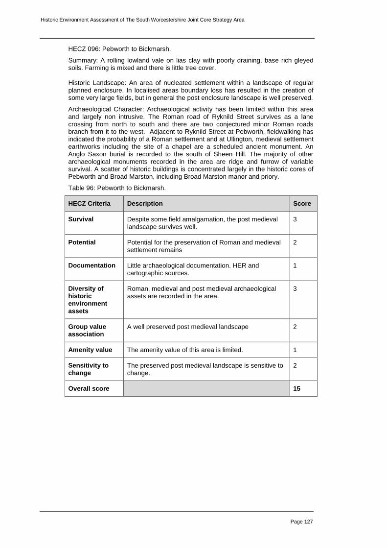
Historic Environment Assessment of The South Worcestershire Joint Core Strategy Area
Page 127
HECZ 096: Pebworth to Bickmarsh.
Summary: A rolling lowland vale on lias clay with poorly draining, base rich gleyed soils. Farming is mixed and there is little tree cover. Historic Landscape: An area of nucleated settlement within a landscape of regular planned enclosure. In localised areas boundary loss has resulted in the creation of some very large fields, but in general the post enclosure landscape is well preserved.
Archaeological Character: Archaeological activity has been limited within this area and largely non intrusive. The Roman road of Ryknild Street survives as a lane crossing from north to south and there are two conjectured minor Roman roads branch from it to the west. Adjacent to Ryknild Street at Pebworth, fieldwalking has indicated the probability of a Roman settlement and at Ullington, medieval settlement earthworks including the site of a chapel are a scheduled ancient monument. An Anglo Saxon burial is recorded to the south of Sheen Hill. The majority of other archaeological monuments recorded in the area are ridge and furrow of variable survival. A scatter of historic buildings is concentrated largely in the historic cores of Pebworth and Broad Marston, including Broad Marston manor and priory.
Table 96: Pebworth to Bickmarsh.
HECZ Criteria Description Score
Survival Despite some field amalgamation, the post medieval landscape survives well.
3
Potential Potential for the preservation of Roman and medieval settlement remains
2
Documentation Little archaeological documentation. HER and cartographic sources.
1
Diversity of historic environment assets
Roman, medieval and post medieval archaeological assets are recorded in the area.
3
Group value association
A well preserved post medieval landscape 2
Amenity value The amenity value of this area is limited. 1
Sensitivity to change
The preserved post medieval landscape is sensitive to change.
2
Overall score 15

Historic Environment Assessment of The South Worcestershire Joint Core Strategy Area
Page 128
HECZ 097: Badsey, Bretforton and Honeybourne
Summary: An area of lias clay with free draining base rich clay soils and a rolling lowland topography. Land use is largely arable with intensive glasshouse agriculture on the fringes of settlements. There are also localised areas of industry within the landscape. Historic Landscape: The landscape is one of regular, planned enclosure, except in the vicinity of Bretforton where remnants of enclosed strip fields survive. The historic settlement pattern is nucleated but 20
th Century ribbon development between
villages, localised industry and a prison have eroded this character to some degree. Badsey, Bretforton and Honeybourne have seen considerable expansion in the last 100 years and the villages have spread into the surrounding countryside. Honeybourne airfield which was operational in WWII has largely reverted to farmland, with an industrial estate to the south.
Archaeological Character: The Roman road of Ryknild Street survives as a lane crossing from north to south through Honeybourne and a branch to Hinton on the Green is postulated to exist. The number of enclosure cropmarks in the vicinity of Bretforton and scatters of Roman material from Honeybourne and Bretforton and Badsey are suggestive of a well populated late prehistoric and Roman landscape. At Badsey Fields to the east of the village a Romano-British occupation site includes an inhumation. Historic buildings are concentrated in the cores of the villages.
Table 97: Badsey, Bretforton and Honeybourne
HECZ Criteria Description Score
Survival The post enclosure landscape has not survived well. 1
Potential There is a strong potential for the survival of late prehistoric and Roman settlement remains.
3
Documentation Archaeological fieldwork within the zone has been relatively limited. HER and cartographic sources.
2
Diversity of historic environment assets
A diverse range of archaeological features are recorded on the HER from dating from prehistoric to modern.
3
Group value association
A well preserved suite of late prehistoric and Roman cropmarks.
2
Amenity value The amenity value of this area is limited. 1
Sensitivity to change
The landscape is sensitive to change. 2
Overall score 14

Historic Environment Assessment of The South Worcestershire Joint Core Strategy Area
Page 129
HECZ 098: Wickhamford and environs
Summary: An area of lias clay with free draining base rich clay soils and an intermediate rolling topography. Settlement and orchards are scattered along the A44. Historic Landscape: A landscape of medium sized regular fields characteristic of planned and parliamentary enclosure. Wickhamford was formerly a scattered settlement centred on the church and manor house to the north of the modern village, but 20
th Century expansion has produced a linear settlement of development
spread along the A44 interspersed with commercial orchards.
Archaeological Character: An extensive linear settlement has been identified through surface remains and geophysical survey in the centre of the village on either side of Badsey Brook and it is here that the postulated road from Hinton on the Green to Rycknild street crosses from east to west. Archaeological evaluation along the Honeybourne to Wormington pipeline identified Romano-British activity and evidence of medieval farming while cropmarks thought to represent Roman enclosures are recorded to the north of Broadway. A block of ridge and furrow survives both as cropmark and earthwork to the east of the modern village centred on Gorsehill Abbey Farm.
Table 98: Wickhamford and environs
HECZ Criteria Description Score
Survival A well preserved post medieval landscape eroded by linear development
2
Potential The below ground potential is high, particularly to the west of the village in the vicinity of the Badsey Brook where there is potential for the preservation of waterlogged deposits.
3
Documentation HER, fieldwalking geophysical survey, salvage recording and cartographic sources.
3
Diversity of historic environment assets
Below ground Roman and medieval features. The above ground remains are less diverse.
2
Group value association
A coherent post medieval landscape. 2
Amenity value The amenity value of this area is limited 1
Sensitivity to change
The landscape is sensitive to change. 2
Overall score 15

Historic Environment Assessment of The South Worcestershire Joint Core Strategy Area
Page 130
HECZ 099: Broadway Village
Summary: The village of Broadway lies at the foot of Fish Hill, a western escarpment of the Cotswolds on Lias Clay adjacent to a tributary of the Badsey Brook . The historic core of the village is centred on the wide High Street lined with grassy verges and stone roofed houses of Cotswold limestone. The village has seen considerable 20
th Century expansion to the north.
Historic Landscape: Broadway was a borough established in the 13
th Century when
the manor was held by the monastery at Pershore. The right to hold a market was granted at the same time but this fell into disuse prior to the 17th century and the village remained little changed until the 20th Century during which there was considerable expansion north of the High Street.
Archaeological Character: The listed and historic buildings are concentrated within the conservation area, centred upon the wide High Street and Church Street to the south. They largely comprise 16th and 17
th century stone roofed houses built of
Cotswold oolitic limestone although timber framed houses survive behind the High Street. Notable is The Abbott's Grange a 14
th century cruck timbered house standing
to the west of Church Street. The only pre medieval features recorded on the HER within the village are two ring ditches recorded as cropmarks from an aerial photograph pre-dating the houses which now cover this area.
Table 99: Broadway Village
HECZ Criteria Description Score
Survival The medieval character of the former borough survives well.
3
Potential There is considerable potential for the preservation of below ground remains from the medieval period onwards. .
3
Documentation There is a significant amount of documentation, cartographic and photographic sources. Also HER, survey and archaeological works.
3
Diversity of historic environment assets
A diverse range of medieval and post medieval features.
2
Group value association
A very well preserved medieval and early post medieval village.
3
Amenity value The village is picturesque and receives a large number of visitors annually.
3
Sensitivity to change
The village is highly sensitive to change. 3
Overall score 20

Historic Environment Assessment of The South Worcestershire Joint Core Strategy Area
Page 131
HECZ 100: Wyre Piddle and Fladbury
Summary: A low lying flat river terrace of mixed sands and gravels with sandy free draining soils, supporting an arable land use. Recent settlement is dispersed and there are small areas of intensive agriculture and light industry. Historic Landscape: A landscape of large arable fields with areas of gravel extraction, light industry and intensive agriculture. The field pattern is of planned enclosure that has been subject to boundary loss and field amalgamation. The settlement pattern is nucleated although 20
th Century development within the villages and the spread of
urban elements has eroded this pattern to some degree.
Archaeological Character: Extensive archaeological fieldwork in this area has been associated with the construction of the Wyre Piddle bypass, gravel extraction and intensive agriculture. Excavation has revealed well preserved late prehistoric and Roman settlement including features associated with salt production. Numerous further cropmarks have been recorded including a possible Neolithic cursus monument and several enclosures to the west of Fladbury and one area is a scheduled ancient monument. There is a good potential in this area for the preservation of waterlogged archaeological deposits. Two Saxon roads traverse the zone and cross at Fladbury Cross and a Saxon inhumation is recorded from Fladbury. Historic buildings and listed buildings are largely confined to the historic village centres.
Table 100: Wyre Piddle and Fladbury
HECZ Criteria Description Score
Survival The post medieval landscape has not survived well. However there is evidence for good preservation of below-ground features.
2
Potential Good survival of below ground archaeology has been demonstrated in this area
3
Documentation Substantial archaeological fieldwork documentation, HER and cartographic sources.
3
Diversity of historic environment assets
A diverse date range of recorded archaeological assets.
3
Group value association
A good association of late prehistoric and Roman settlement features.
3
Amenity value Little above ground archaeology and the amenity value is therefore limited.
1
Sensitivity to change
The below ground archaeology is sensitive to change. 3
Overall score 18

Historic Environment Assessment of The South Worcestershire Joint Core Strategy Area
Page 132
HECZ 101: The Lenches
Summary: An area of lias clay, forming a dissected, undulating plateau, with poorly draining soils fringed by woodland on the plateau edge. The land use is largely arable farming and the settlement pattern is one of small villages or hamlets, associated with a low level of dispersal and a sub-regular pattern of fields. Historic Landscape: A landscape of medium to large sub regular arable fields interspersed with ancient semi natural and replanted woodland, often on steeper slopes and extensive commercial orchards. Settlement is nucleated with scattered farms and hamlets, connected by sinuous lanes except in the environs of Church Lench where 20
th Century development has been more scattered. Field
amalgamation is marked in the Sherriff's Lench area. A well preserved area of parkland surrounds Rous Lench Court.
Archaeological Character: There has been little archaeological activity in this area apart from some metal detecting surveys. Recorded archaeological features are sparse and relate largely to medieval settlement and woodland earthworks although two Roman sites are recorded west of Sherriff's Lench and an Iron Age hillfort to the south on Tunnel Hill. Historic buildings are largely confined to the historic cores of villages of which the centres of Church Lench, Rous Lench and Atch Lench are conservation areas. The moat of the former Rous Lench Court survives within the parkland and is a scheduled ancient monument.
Table 101: The Lenches
HECZ Criteria Description Score
Survival A moderately well preserved post medieval landscape. 2
Potential The potential for below-ground archaeology is largely unknown. Some indication of Roman settlement to the south of the zone.
2
Documentation Little archaeological documentation 1
Diversity of historic environment assets
A moderate range of archaeological assets. 2
Group value association
A good association of historic buildings and medieval settlement features.
2
Amenity value Potential for promotion of access to semi natural woodland and associated earthwork features.
2
Sensitivity to change
The landscape is very sensitive to change 3
Overall score 14

Historic Environment Assessment of The South Worcestershire Joint Core Strategy Area
Page 133
HECZ 102: Hill and Moor to Kington
Summary: An area of soft rock mudstone and lias clay, with free draining brown soils and a rolling, lowland topography. The land use is mixed farming with pasture prevailing to the north. The settlement pattern is one of discrete with a low level of dispersal, associated with a regular pattern of fields, derived mainly from arable origins. Historic Landscape: A landscape of small to medium scale fields the result of planned or parliamentary enclosure. The land use is mixed with arable prevailing to the south of the zone where some field amalgamation has occurred and pasture to the north where remnants of enclosed strip fields survive in the vicinity of Flyford Flavel and Kington. The landscape character has been entirely altered in the construction of a large golf course a large golf course east of Bishampton. Settlement is largely nucleated with isolated farms. Archaeological Character: Archaeological fieldwork within the zone has been limited and apart from some quite extensive salvage recording to the east of Flyford Flavell comprises non intrusive survey. In the main, recorded archaeological features are of medieval date and include ridge and furrow of varying survival in the vicinity of villages, settlement earthworks east of Hill and the buried remains of a moated site with associated elements at Abbots Morton, a scheduled ancient monument. A Saxon road is recorded running southward from Bishampton. Extensive ridge and furrow in the Flyford Flavell area survives as cropmarks. An Iron Age enclosure cropmark is recorded east of Abberton and a finds assemblage east of Hill suggests a Roman occupation site may exist here. There is a scatter of historic buildings in the historic cores of villages and conservation areas in Abberton,and Abbot's Morton.
Table 102: Hill and Moor to Kington
HECZ Criteria Description Score
Survival The historic landscape survives reasonably well. 2
Potential The survival of below ground deposits is generally unknown, but there are indications of prehistoric and Roman settlement. Potential for the survival of waterlogged deposits close to the Whitsun and Piddle Brooks.
2
Documentation Archaeological documentation is quite sparse. HER and documentary sources
2
Diversity of historic environment assets
There is a moderate range of historic environment assets.
2
Group value association
A coherent medieval and post medieval landscape. 2
Amenity value A good network of footpaths as well as historic and listed buildings in villages.
2
Sensitivity to change
The landscape is reasonably sensitive to change. 2
Overall score 14

Historic Environment Assessment of The South Worcestershire Joint Core Strategy Area
Page 134
HECZ 103: Inkberrow and Knighton
Summary: An area of soft rock and lias clays with free draining brown soils and a rolling lowland topography. The settlement pattern comprises farmsteads and strings of wayside dwellings, associated with a medium to high level of dispersal, and a small to medium scale field pattern. Historic Landscape: An undulating area of mixed farming formed of small to medium sized regular pastoral fields and larger, less regular arable fields, the product of field amalgamation. This is particularly marked to the east of Inkberrow. South of Dormston and Knighton, relics of enclosed strip fields survive. Settlement is largely within villages but dispersed farms and wayside dwellings are scattered along sinuous lanes. Archaeological Character: Archaeological investigation within the area has been limited although an ongoing educational project centred on Thorn Farm to the south of Inkberrow has recorded medieval artefacts and buildings. There are three extant moats within the zone and those at Inkberrow and The Moat Farm west of Dormston are scheduled ancient monuments. The Piddle brook forms the southern boundary of this zone and here there is potential for the survival of waterlogged deposits. A post Roman boundary earthwork survives to the south of Inkberrow.
Table 103: Inkberrow and Knighton
HECZ Criteria Description Score
Survival The post medieval landscape survives reasonably well although the character has been eroded by field amalgamation.
2
Potential The below ground survival of archaeology is largely unknown in this area but there is potential for prehistoric of Roman archaeology and waterlogged deposits close to the Piddle Brook.
2
Documentation Little archaeological documentation. HER and cartographic sources.
1
Diversity of historic environment assets
Recorded assets within this zone largely relate to the medieval period.
1
Group value association
A good association between historic buildings and medieval landscape features.
2
Amenity value A good network of public footpaths and some survival of above ground archaeology.
2
Sensitivity to change
The landscape is reasonably sensitive to change 2
Overall score 12

Historic Environment Assessment of The South Worcestershire Joint Core Strategy Area
Page 135
HECZ 104: Holberrow Green and Cookhill
Summary: An area of soft rock, comprising mixed mudstones and sandstones, with free draining brown soils and an intermediate, rolling topography. The settlement pattern is one of farmsteads and strings of wayside dwellings, associated with a moderate to high level of dispersal and a small to medium scale field pattern. Historic Landscape: A landscape of well preserved small to medium sized regular fields characteristic of surveyed enclosure although relic enclosed strip fields survive in the vicinity of Holberrow Green. Villages are dispersed and notably linear in form, interspersed with sinuous lanes and scattered farms and wayside dwellings. Roadside common land survives to the west of Cookhill, a relic of the more extensive greens and commonland that formerly characterised villages in this area.
Archaeological Character: Very little archaeological fieldwork has been carried out within the zone and potential for the survival of below ground archaeology is generally unknown. The HER record is also sparse although three partially extant moats are recorded. Cookhill Priory, a Cistercian nunnery is now a farm but buildings including a chapel and earthworks including a mill mound and fishponds survive well and the complex is a scheduled ancient monument. A Roman road is also recorded as a part of this complex. The Saltway, a Roman road from Droitwich to Alcester crosses the zone and enclosure cropmarks are recorded slightly to the south west of Edgiock.
Table 104: Holberrow Green and Cookhill
HECZ Criteria Description Score
Survival A well preserved post enclosure landscape 3
Potential Cropmarks suggest survival of below ground archaeology in places.
2
Documentation Little archaeological documentation or HER data. 1
Diversity of historic environment assets
A moderate diversity of archaeological assets. 2
Group value association
A good association of medieval earthwork features. 2
Amenity value A good network of public footpaths combined with a well preserved enclosure landscape.
2
Sensitivity to change
This landscape is highly sensitive to change. 3
Overall score 15

Historic Environment Assessment of The South Worcestershire Joint Core Strategy Area
Page 136
HECZ 105: Earl's Common to Morton Underhill
Summary: An area of lias clay, with poorly draining, base rich soils and a rolling lowland topography. The settlement pattern is one of farmsteads and clusters of wayside cottages associated with a moderate to high level of dispersal and a small to medium scale field pattern. The land use is primarily pastoral and the tree cover comprises relic patches of ancient woodland often associated with densely scattered hedgerow oaks. Historic Landscape: A landscape of dispersed, notably linear villages linked by a network of straight lanes with scattered farms and houses. The fieldscape is generally regular and well preserved and there are indications in places of the relics of piecemeal enclosure. Several discrete blocks of semi-natural woodland remain. Archaeological Character: Archaeological investigation in this area has been very limited consisting of fieldwalking and earthwork survey. The majority of entries on the HER are medieval in date and are largely ridge and furrow which occurs widely across the zone. The Saltway Roman Road from Droitwich to Alcester crosses the zone and is still in use as a road.
Table 105: Earl's Common to Morton Underhill
HECZ Criteria Description Score
Survival A well preserved post enclosure landscape 3
Potential The archaeological survival of below ground archaeology is unknown but due to the predominance of pasture the potential is reasonably high.
2
Documentation Little archaeological documentation. HER and cartographic sources.
1
Diversity of historic environment assets
Apart from the Roman road, all recorded historic environment assts are medieval or post medieval in date.
1
Group value association
A good association of medieval and post medieval assets
2
Amenity value A dense network of public footpaths, including access to areas of ancient-natural woodland and the line of a Roman road.
2
Sensitivity to change
The landscape is sensitive to change. 2
Overall score 14

Historic Environment Assessment of The South Worcestershire Joint Core Strategy Area
Page 137
HECZ 106: Bradley Green
Summary: An area of lias clay, with poorly draining, base rich soils and a rolling lowland topography. The settlement pattern is one of farmsteads and clusters of wayside cottages associated with a moderate to high level of dispersal and a small to medium scale field pattern. Historic Landscape: The zone is characterised by small to medium sized fields, quite regular in character in the main but in places, particularly the vicinity of Bradley Green, clearly the results of enclosure of strip fields. Current farming practice is mixed with a predominance of pasture and riverside meadows survive along the course of two brooks. Settlement within this zone is centred on Bradley Green, a linear, dispersed village with frequent farms and the B4090 Saltway Road. Archaeological Character: The majority of archaeological assets recorded within the zone are ridge and furrow, the majority of which lies in pasture. Archaeological activity has been limited. There is potential for the preservation of waterlogged deposits along the lines of the Seeley and Bow Brooks. The Saltway Roman Road from Droitwich to Alcester is still in use and a projected Roman road branches to the south. Table 106: Bradley Green
HECZ Criteria Description Score
Survival A well preserved post medieval landscape. 3
Potential The preservation of below ground archaeology is unknown but the predominance of pasture may contribute to good survival. Potential for the survival of a Roman road and waterlogged deposits.
3
Documentation There has been little archaeological fieldwork in this area. HER and cartographic sources.
1
Diversity of historic environment assets
Assets within the zone are Roman, medieval and post medieval.
2
Group value association
A good group value of medieval earthworks, and historic buildings.
3
Amenity value A good network of public footpaths and a well preserved landscape with earthworks.
2
Sensitivity to change
The landscape is highly sensitive to change. 3
Overall score 17

Historic Environment Assessment of The South Worcestershire Joint Core Strategy Area
Page 138
HECZ 107: Hanbury and Woolmere Green Summary: An area of lias clay with poorly draining soils and an intermediate, rolling topography intersected with two Roman roads and sinuous lanes along which settlement is scattered. Historic Landscape: A landscape of small to medium sized regular fields interspersed with settlement scattered along sinuous lanes and the dispersed villages of Piper's Hill, Hanbury and Woolmere Green which line the B4091 road. Patches of ancient semi-natural woodland remain to the south of the zone in the Broughton Green area and on Pipers Hill a wooded area of common land which with the adjacent rise on which Hanbury Church stands are prominent features in this landscape. Archaeological Character: Extensive field survey has recorded a wide range of medieval landscape features, largely ridge and furrow centred in particular on Mere Hall to the south, Woolmere Green and Hanbury. The Saltway Roman road from Droitwich to Alcester crosses the zone from east to west and the B4091 which crosses from north to south is also thought to be Roman in origin. Indications of prehistoric settlement include a double-ditched enclosure cropmark south of Woolmere Green and a probable Iron Age Hillfort on Church Coppice. At the very west of the zone, a cropmark east of Dodderhill may represent a Saxon building. The village cross at Hanbury is a scheduled ancient monument and the Birmingham to Worcester Canal which crosses the zone to the west is a conservation area. Table 107: Hanbury and Woolmere Green
HECZ Criteria Description Score
Survival A well preserved post medieval landscape. 3
Potential Potential of Roman, post Roman and medieval below ground archaeology within the zone.
2
Documentation A good range of archaeological documentation and fieldwork.
3
Diversity of historic environment assets
A moderately diverse range of archaeological assets 2
Group value association
A well preserved landscape with some extant earthworks.
3
Amenity value Semi natural woodlands and earthworks reachable by PROW.
3
Sensitivity to change
The landscape is sensitive to change. 2
Overall score 18

Historic Environment Assessment of The South Worcestershire Joint Core Strategy Area
Page 139
HECZ 108: Cutnall Green to Upton Warren
Summary: An area of soft rock, comprising mixed mudstones and sandstones producing a rolling, lowland topography and free draining brown soils. The landscape is one of small to medium sized fields with sinuous lanes and scattered settlement. The Salwarpe River and two braiding tributaries cross the zone from north to south. Historic Landscape: A low lying area of small to medium sized fields both regular and irregular in places. The land use is mixed and some arable fields have been amalgated. Settlement is scattered along sinuous lanes. The River Salwarpe crosses the zone to the east as well as the Elmley and Elmbridge Brooks which join the river to the south in Droitwich. Discrete blocks of orchard and semi-natural woodland survive and to the west there is a well preserved park and garden at Elmley Lovett Lodge. The M5 motorway crosses the zone to the east and here ribbon development on the line of the A38 and gravel extraction has eroded the character of the landscape to some degree. Archaeological Character: Archaeological activity within the zone has been quite sparse and little is known of below ground survival of archaeological remains. However the zone is crossed by the line of the Roman road from Droitwich to Lickey, presently the A38 and a postulated Roman road from Droitwich to Greensforge, now a minor road. As well, the Roman town of Droitwich is close and the potential for the Roman settlement in this zone is therefore quite high. The conjectured route of Godham way, a Saxon Road also crosses and possible Saxon earthworks are recorded at Upton Warren and Elmley Lovett. Medieval settlement earthworks at Elmley Lovett are protected as a scheduled ancient monument and settlement is also recorded at Wyken Farm. A number of features relating to the WWII defence of Britain are recorded to the north of Wychbold. There is a considerable potential for the preservation of waterlogged archaeological remains in the vicinity of watercourses.
Table 108: Cutnall Green to Upton Warren
HECZ Criteria Description Score
Survival The historic landscape survives reasonably well 2
Potential There is a strong potential for the survival of below-ground deposits.
3
Documentation Relatively little archaeological activity. Documentary and cartographic sources.
2
Diversity of historic environment assets
A reasonable diversity of historic assets 2
Group value association
Relatively coherent medieval and post-medieval landscape.
2
Amenity value A good network of PROWs in a reasonably well preserved historic landscape.
2
Sensitivity to change
The landscape is sensitive to change 2
Overall score 15

Historic Environment Assessment of The South Worcestershire Joint Core Strategy Area
Page 140
HECZ 109: Summerfield and Torton
Summary: A semi-industrialised landscape of regular fields and scattered settlement interspersed with industrial estates partly built around a disused RAF depot site. Historic Landscape: The semi industrialised outer rim of Hartlebury. A landscape of mixed arable, pastoral and intensive farming. To the west the regular field pattern survives as part of the planned enclosure of Hartlebury Common while to the east a less regular pattern has been subject to field amalgamation and large arable fields dominate. Settlement is scattered with dispersed villages and wayside houses. There are four industrial estates within the zone, two of which are small and based within former RAF depots. Archaeological Character: Archaeological fieldwork within the zone is generally small scale and based around Torton. There are relatively few archaeological assets recorded on the HER in this area and generally comprise post medieval features in the Torton area. Some features related to the WWII defence of Britain survive within the zone and three cropmarks are recorded.
Table 109: Summerfield and Torton
HECZ Criteria Description Score
Survival The character historic landscape has been eroded by industrialisation.
1
Potential The survival of below ground deposits is largely uninvestigated but cropmarks and the discovery of a polished flint axe at Torton suggest that there is some potential for prehistoric activity.
2
Documentation A moderate record of archaeological activity. 2
Diversity of historic environment assets
A limited range of historic environment assets. 1
Group value association
Some association of WWII defence features. 2
Amenity value The amenity value of this area is limited. 1
Sensitivity to change
The landscape is not very sensitive to change. 1
Overall score 10

Historic Environment Assessment of The South Worcestershire Joint Core Strategy Area
Page 141
HECZ 110: Hartlebury and Crossway Green
Summary: An area of soft rock sandstone with sandy, free draining soils and an intermediate rolling topography. The settlement pattern is one of farmsteads and strings of wayside dwellings associated with a moderate to high level of dispersal and small to medium scale field pattern. Historic Landscape: A landscape of large sub-regular arable fields, the product in the main of boundary loss in a former landscape of small regular fields although relicts of strip field survive to the west of Crossway Green and at Lineholt. Settlement is dispersed reasonably dispersed and Crossway Green is a good example of piecemeal settlement of common land. Twentieth Century development has been most marked in the villages of Warlesley and Hartlebury which have almost joined. A large golf course to the south of the zone lies on part of the former Lineholt Common. Bishop's Wood the relict of a larger wood is recorded as ancient semi natural woodland and an area of parkland associated with Waresley House has been partly built over but retains its character to some degree. Archaeological Character: Archaeological activity within the zone has been limited to non-intrusive survey and individual finds. These include Mesolithic flints, a Neolithic arrowhead from Crossway Green as well as Roman and medieval pottery recovered during fieldwalking north of Hartlebury. Recorded monuments are largely medieval and post medieval and include ridge and furrow from the south of the zone. Historic buildings are scattered across the zone though most prolific in Hartlebury
Table 110: Hartlebury and Crossway Green
HECZ Criteria Description Score
Survival The historic landscape survives moderately well. 2
Potential The below ground potential for the survival of historic features is largely unknown but cropmarks indicate there may be some survival.
2
Documentation Little archaeological documentation. 1
Diversity of historic environment assets
Little diversity of historic assets. 1
Group value association
Some association of ridge and furrow and the historic field pattern in the south of the zone.
2
Amenity value The amenity value is fairly limited. 2
Sensitivity to change
The landscape is not particularly sensitive to change. 1
Overall score 11

Historic Environment Assessment of The South Worcestershire Joint Core Strategy Area
Page 142
HECZ 111: Hartlebury Common
Summary: A gently rolling, lowland area of terrace sands and gravels, with free draining sandy soils. This unsettled, unwooded landscape is unenclosed, with a land use of rough grazing. A broad range of archaeological earthworks survive on the common attesting to a considerable span of occupation. Historic Landscape: Unenclosed heathland comprising rough grazing with sporadic tree cover, gorse and plantation interspersed with well used pathways. There is no settlement on the common. The A4025 Stourport to Worcester Road crosses to the west and is unfenced. The common is a fragment of a much wider area subject to enclosure but its present extent is unchanged since the late 19
th Century.
Archaeological Character: The common has been subject to landscape survey and a suite of historic assets dating from the Mesolithic period onwards are recorded. These include several Iron Age earthworks, a Roman trackway and a number of extant earthworks including a platform and boundary ditch thought to be Saxon in date. The majority of features are of medieval and post medieval date and include holloways, trackways and numerous areas of localised quarrying. Several features related to the WWII defence of Britain are also recorded as having existed on the common. A desk based assessment undertaken in 2003 suggested that there is no evidence that the common has ever been ploughed and the potential for the survival of below-ground deposits in therefore high.
Table 111: Hartlebury Common
HECZ Criteria Description Score
Survival A well preserved medieval and earlier landscape. 3
Potential Very high potential for the preservation of below ground deposits of a considerable date range.
3
Documentation Archaeological landscape survey, desk based assessment and numerous HER records.
3
Diversity of historic environment assets
A diverse range of archaeological assets. 3
Group value association
A good association of features with a wide date range. 3
Amenity value The common is freely accessible and has a wide range of visible historic assets.
3
Sensitivity to change
The common is highly sensitive to change. 3
Overall score 21

Historic Environment Assessment of The South Worcestershire Joint Core Strategy Area
Page 143
HECZ 112: Witley Court
Summary: Witley Court was a large Italianate mansion converted in the nineteenth century from an earlier Jacobean house. The house was known for its opulence and gardens adorned with impressive stone fountains. The house was extensively damaged in a fire of 1937 and apart from the church, the site was subsequently abandoned. Restoration since 1972 has established Witley Court as a tourist attraction. Historic Landscape: Witley Court is set within restored gardens which extend north, east and west of the ruined house. These include formal areas, ponds and a string of spring fed lakes in the base of the slight valley to the north. The larger parkland is now largely set to arable but restoration of former plantations destroyed following the fire has restored the character to some extent. . Archaeological Character: All archaeological assets within the zone relate to the parkland. The Court complex includes the house, orangery, stables, courtyard and church all of which are listed buildings and included as a part of a scheduled ancient monument. Other buildings within the gardens and parkland include a garden house and Villa Fiore, engine house and water mill as well as various other individual houses and lodges. A cropmark to the south east of the house may relate to former garden features.
Table 112: Witley Court
HECZ Criteria Description Score
Survival Despite the fire and subsequent neglect, the ruin of the house and garden survive well and are under restoration.
3
Potential Potential for the preservation of former landscape features or elements related to the earlier house.
3
Documentation Substantial documentation of house and garden. 3
Diversity of historic environment assets
A diverse range of buildings and features relating to the court.
2
Group value association
Excellent group value of buildings and parkland. 3
Amenity value The site is open to the public and attracts visitors year round.
3
Sensitivity to change
The landscape is highly sensitive to change. 3
Overall score 20

Historic Environment Assessment of The South Worcestershire Joint Core Strategy Area
Page 144
HECZ 113: Shrawley and Frog Pool
Summary: A hilly area of sandstone, with free draining, base-poor, sandy soils and an intermediate, undulating topography. The tree cover comprises interlocking, or frequent, usually large, discrete blocks of ancient woodland and settlement is scattered. Historic Landscape: A hilly reasonably wooded landscape defined to the east by the River Severn and crossed to the north by the Dick Brook. Ancient semi natural woodland occurs in discrete blocks including the large Shrawley Wood, and in sinuous lines following contours and watercourses. Fields on the lower slopes have been subject to field amalgamation and are largely arable but landscape survival is better in the vicinity of Frog Pool where the pattern of small irregular fields is suggestive of piecemeal enclosure. The village of Frog pool is dispersed and linear and settlement elsewhere is scattered along lanes. Archaeological Character: Recorded archaeological assets within the zone are relatively sparse and generally medieval or post medieval in date. A group of medieval features including settlement earthworks is recorded in the area of Shrawley and to the north east Oliver's mound is a castle motte which has been subject to various non intrusive archaeological surveys. The potential for survival of below-ground deposits is generally unknown but the cropmark of a temporary Roman camp to the south of Shrawley and settlement earthworks are indications of survival.
Table 113: Shrawley and Frog Pool
HECZ Criteria Description Score
Survival Some loss of landscape character in field amalgamation but generally the landscape character survives well.
2
Potential There is potential for the preservation of below ground deposits and woodland earthwork features.
2
Documentation A thin scatter of assets recorded on the HER and relatively little archaeological fieldwork documentation.
1
Diversity of historic environment assets
A moderate diversity of historic environment assets. 2
Group value association
A good association of medieval settlement features in the vicinity of Shrawley.
2
Amenity value Access to woodland and earthwork features in the vicinity of Shrawley.
2
Sensitivity to change
The landscape is sensitive to change. 2
Overall score 13

Historic Environment Assessment of The South Worcestershire Joint Core Strategy Area
Page 145
HECZ 114: Suckley and Knightwick
Summary: A hard rock area of mixed mudstones and sandstones, with free draining brown soils and an intermediate, rolling topography. The land use is mixed farming and the tree cover comprises relic ancient woodland often associated with densely scattered hedgerow oaks. Historic Landscape: A landscape of small to medium sized irregular fields interspersed with discrete blocks of ancient semi natural and replanted woodland. In places a regular pattern of planned enclosure is apparent overlaid on a more organic pattern and relic enclosed strip fields survive south of Suckley. Settlement is scattered particularly in the area of Suckley Green and Suckley Knowl in which an organic pattern of encroachment is apparent. There are a number of commercial orchards in this area as well as hopyards and vineyards. Archaeological Character: There has been little archaeological fieldwork within the zone. The historic environment record records a scatter of archaeological features and a relatively dense scatter of historic listed and non listed buildings including a formerly moated site of Suckley Court. The disused Worcester to Leominster railway crosses the zone from east to west and some associated buildings survive. There is some potential for the survival of waterlogged deposits close to the Leigh Brook to the south of the zone.
Table 114: Suckley and Knightwick
HECZ Criteria Description Score
Survival A well preserved post medieval landscape. 2
Potential The below-ground survival of archaeological deposits is unknown but due to the predominance of pasture, woodland and orchard, it may be good.
2
Documentation Very little archaeological fieldwork in this area and sparse assets recorded on the HER.
1
Diversity of historic environment assets
A range of historic buildings and landscape features. 2
Group value association
A good association of historic buildings and a post medieval landscape.
2
Amenity value A good network of public rights of way and numerous historic buildings.
2
Sensitivity to change
The landscape is very sensitive to change. 3
Overall score 14

Historic Environment Assessment of The South Worcestershire Joint Core Strategy Area
Page 146
HECZ 115: Mamble and Bayton
Summary: A rolling hard rock plateau of mixed shale and sandstone with poorly drained soils. The land use is mixed farming, the settlement pattern one of farmsteads and clusters of wayside dwellings associated with a moderate to high level of dispersal and a small to medium scale field pattern. Tree cover comprises relic patches of ancient woodland, often associated with densely scattered hedgerow oaks and streamside tree cover. Historic Landscape: Settlement is nucleated with some scattered farms although Bayton Common shows a more dispersed pattern characteristic of encroachment of commonland. Fields are generally irregular and predominantly small and pastoral although some large arable fields in the area of Bayton are the product of boundary loss. Discrete blocks of ancient woodland remain largely centred on watercourses including the large Wissett's Wood. A well preserved area of parkland is associated with the Georgian Shakenhurst Manor to the west of the zone. Archaeological Character: Little archaeological fieldwork has been carried out in this area and there are few asserts recorded on the Historic Environment Record. Sodington Hall south of Mamble is a moated site and scheduled ancient monument. A Roman brick kiln was recorded here during building works in the early 20
th
Century. Mamble lies on the Wyre Forest coal deposits and several collieries were formerly active in this area. An archaeological survey in 1997 identified earthworks and soilmarks associated with the industry. The village of Bayton is a conservation area and historic buildings are largely concentrated here and in Mamble. A shrunken medieval village is recorded at Carton Farm and two cropmarks are also recorded in the zone. Any archaeology in this area is likely to be well preserved due to the nature of the past land use.
Table 115: Mamble and Bayton
HECZ Criteria Description Score
Survival Good survival of a post-medieval landscape. 2
Potential Potential for below-ground deposits unknown. 2
Documentation Limited cartographic, field work and documentary sources.
2
Diversity of historic environment assets
A range of earthworks and buildings from the medieval and post-medieval periods.
2
Group value association
A coherent medieval and post-medieval landscape. 2
Amenity value A good PROW network and historic buildings. 2
Sensitivity to change
The landscape is sensitive to change. 2
Overall score 14
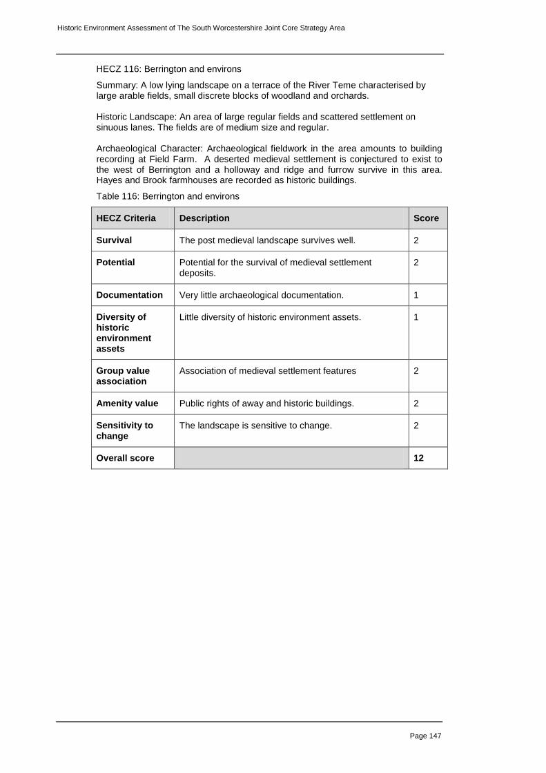
Historic Environment Assessment of The South Worcestershire Joint Core Strategy Area
Page 147
HECZ 116: Berrington and environs
Summary: A low lying landscape on a terrace of the River Teme characterised by large arable fields, small discrete blocks of woodland and orchards. Historic Landscape: An area of large regular fields and scattered settlement on sinuous lanes. The fields are of medium size and regular. Archaeological Character: Archaeological fieldwork in the area amounts to building recording at Field Farm. A deserted medieval settlement is conjectured to exist to the west of Berrington and a holloway and ridge and furrow survive in this area. Hayes and Brook farmhouses are recorded as historic buildings.
Table 116: Berrington and environs
HECZ Criteria Description Score
Survival The post medieval landscape survives well. 2
Potential Potential for the survival of medieval settlement deposits.
2
Documentation Very little archaeological documentation. 1
Diversity of historic environment assets
Little diversity of historic environment assets. 1
Group value association
Association of medieval settlement features 2
Amenity value Public rights of away and historic buildings. 2
Sensitivity to change
The landscape is sensitive to change. 2
Overall score 12

Historic Environment Assessment of The South Worcestershire Joint Core Strategy Area
Page 148
HECZ 117: Bockleton Commons
Summary: A landscape of enclosed common land characterised by wayside settlement scattered along sinuous lanes, interspersed with discrete blocks of woodland and relic commonland. Historic Landscape: Regular medium sized fields are the product of planned enclosure but the prevalence as Common as a place name in this area and a relic of commonland surviving as a wide verge between Romers Common and Sallings Common is testament to the former land use in this area. Settlement is in clusters along sinuous lanes and there are small patches of regular plantation. A well preserved area of parkland surrounds Cockspur Hall, now a field study centre. Archaeological Character. No archaeological fieldwork is recorded as having taken place in this zone and recorded archaeological assets are sparse in this area. Earthworks are recorded north east of Middle Quinton and there is a cluster of post medieval features in the vicinity of Hill Farm. The church at Bockleton may have Saxon origins.
Table 117: Bockleton Commons
HECZ Criteria Description Score
Survival The medieval and post medieval landscape survives well.
2
Potential The potential for survival of below ground archaeology is unknown in this area.
2
Documentation Archaeological documentation relating to this area is very sparse.
1
Diversity of historic environment assets
Little diversity of historic environment assets. 1
Group value association
A coherent medieval and post medieval landscape. 2
Amenity value Potential for development of access to an interesting landscape.
2
Sensitivity to change
The landscape is sensitive to change. 2
Overall score 12

Historic Environment Assessment of The South Worcestershire Joint Core Strategy Area
Page 149
HECZ 118: Kyre Green wooded hillside
Summary: A steeply sloping hard rock plateau edge, of sandstone, with impoverished sandy soils. The tree cover comprises interlocking, or frequent, usually large, discrete blocks of ancient woodland. Isolated farmsteads and a pastoral land use further characterise the area.
Historic Landscape: A hillside landscape of isolated farmsteads and small to medium sized regular fields interspersed with blocks of ancient woodland. Some field amalgamation has taken place but generally the post enclosure landscape is well preserved.
Archaeological Character: There is no record of archaeological fieldwork having taken place in this zone and recorded archaeological assets are sparse. Garmsley Camp is a univallate hillfort on the county boundary within a scheduled area and slightly to the west of this is a conjectured medieval settlement. The remaining recorded assets are post medieval features derived from cartographic sources. Any archaeology in this area is likely to be well preserved due to the nature of the past land use.
Table 118: Kyre Green wooded hillside
HECZ Criteria Description Score
Survival Good landscape survival and historic buildings. Below-ground is unknown.
2
Potential The potential for below ground archaeology is unknown but if it does, survival is likely to be good.
2
Documentation Limited cartographic, field work and documentary sources.
1
Diversity of historic environment assets
The diversity of recorded assets is limited. 1
Group value association
A coherent medieval and post-medieval landscape. 2
Amenity value A good PROW network exists across the zone. Potential to improve access to Garmsley Camp and ancient woodland.
2
Sensitivity to change
The landscape is sensitive to change as are the historic buildings. Any below-ground remains would also be highly sensitive.
2
Overall score 12

Historic Environment Assessment of The South Worcestershire Joint Core Strategy Area
Page 150
HECZ 119: Knighton and Knighton Common
Summary: A hard rock area of mixed mudstones and sandstones, with free draining brown soils and an intermediate rolling topography. The land use is mixed farming and the tree cover comprises relic ancient woodland often associated with densely scattered hedgerow oaks. The settlement pattern is one of farmsteads and wayside dwellings, associated with a moderate to high level of dispersal and a small to medium scale field pattern. Historic Landscape: An irregular hilly landscape on the northern side of the Teme Valley rising to the gently undulating plateau of Knighton Common. Settlement is dispersed, comprising wayside dwellings scattered along sinuous lanes. Fields are small to medium in size and a mix of regular and irregular, suggestive of surveyed enclosure imposed on a partially enclosed landscape. Land use is largely pastoral but orchards and hop fields are also common and ancient semi-natural and replanted woodland survives as discrete blocks or following watercourses. Archaeological Character: Archaeological fieldwork within the zone is limited to watching brief and fieldwalking at Church farm Knighton on Teme,in which medieval pottery and worked flints of unknown date were recovered. There are few recorded assets within the zone and these are all of medieval or post medieval date. These include the line of the incomplete Leominster to Stourport Canal which survives as a well preserved earthwork, and the disused line of the Teme Valley railway.
Table 119: Knighton and Knighton Common
HECZ Criteria Description Score
Survival A well preserved post medieval landscape. 2
Potential Fieldwalking has demonstrated potential for survival of prehistoric deposits.
2
Documentation Little archaeological documentation. 1
Diversity of historic environment assets
Little diversity of known assets. 1
Group value association
Good association of key former transport routes. 2
Amenity value Some potential for promoting access along the lines of the canal and railway lines.
2
Sensitivity to change
The landscape is sensitive to change. 2
Overall score 12

Historic Environment Assessment of The South Worcestershire Joint Core Strategy Area
Page 151
HECZ 120: Berrow Green and Shelsey Beauchamp wooded hillsides
Summary: A hilly ridge of mixed shales and limestones with a prominent wooded scarp overlooking the Teme Valley. The land use is pastoral and the tree cover comprises interlocking, or frequent, usually large, discrete blocks of ancient woodland. Historic Landscape: A landscape of irregular fields characteristic of piecemeal enclosure interspersed with woodland much of it considered to be ancient semi-natural woodland. The settlement pattern is one of farmsteads and rural dwellings with settlement scattered along lanes. Land use is pasture with traditional orchards. Placenames such as Kingswood Common and The Green imply enclosed commonland and Southwood and Ladywood Commons are still open access. Archaeological Character: Recorded archaeological activity here is limited and there are few archaeological assets recorded in this zone although these include two hillforts, Berrow Hill north of Berrow Green and the much larger Woodbury Hill with an associated field system. Both are scheduled ancient monuments. A scatter of medieval and post medieval features include well preserved earthworks of a possible deserted settlement, north east of Pound Farm. The cropmark of an enclosure is recorded at Ham Green.
Table 120: Berrow Green and Shelsey Beauchamp wooded hillsides
HECZ Criteria Description Score
Survival Good survival of prehistoric monuments and post medieval landscape.
2
Potential The below ground survival of archaeological deposits is unknown but due to the land use what there is will survive well. There is also potential for earthworks related to woodland management.
2
Documentation There is relatively little archaeological documentation relating to this landscape.
1
Diversity of historic environment assets
A moderate diversity of monuments. 2
Group value association
Good association of hillforts and related features. 2
Amenity value Dense PROW network including part of the Worcestershire Way and with access to ancient woodland Woodbury hillfort and a picnic site on Ankerdine Hill.
3
Sensitivity to change
The landscape is very sensitive to change. 3
Overall score 15

Historic Environment Assessment of The South Worcestershire Joint Core Strategy Area
Page 152
HECZ 121: Great Witley, Astley and Dunley
Summary: An undulating landscape of arable cultivation and woodland. The tree cover comprises interlocking, or frequent, usually large, discrete blocks of ancient woodland. The settlement pattern is one of farmsteads and strings of wayside dwellings, associated with a medium to high level of dispersal. Historic Landscape: A landscape characterised by wooded hills and small to medium sized arable fields, the larger a result of field amalgamation. A smaller scale piecemeal field pattern of survives to the east of Astley. Ancient semi natural woodland is in discrete regular blocks and sinous lines following watercourses. Settlement is dispersed with isolated farms and scattered wayside houses on small lanes. Archaeological Character: Recorded archaeological activity largely relates to salvage recording along the length of the Blackstone to Astley Aqueduct in 1994. Little of archaeological significance was recorded in this stretch. Recorded archaeological monuments within the zone comprise a thin scatter of medieval and post medieval assets with a cluster centred on the site of Astley Priory. An extant moat survives at Home Farm to the south west of Great Witley. Historic buildings are to be found in Great Witley, Dunley and in the vicinity of Astley.
Table 121: Great Witley, Astley and Dunley
HECZ Criteria Description Score
Survival The landscape survives reasonably well. 2
Potential Potential for below ground archaeology and woodland earthworks.
2
Documentation Archaeological documentation very limited. 1
Diversity of historic environment assets
Little diversity of recorded historic environment assets. 1
Group value association
Association of medieval assets, historic buildings 2
Amenity value A good network of PROWs and historic buildings in villages.
2
Sensitivity to change
The landscape is sensitive to change. 2
Overall score 12

Historic Environment Assessment of The South Worcestershire Joint Core Strategy Area
Page 153
HECZ 122: Clifton upon Teme wooded plateau
Summary: A dissected undulating, hard rock plateau of mixed mudstone and sandstone with a steeply sloping sandstone scarp overlooking the Teme Valley. The tree cover comprises interlocking, or frequent, usually, large discrete blocks of ancient woodland. Isolated farmsteads and a pastoral land use further characterise the area. Historic Landscape: Apart from Clifton on Teme the area is sparsely settled and characterised by isolated farms and wayside dwellings scattered along straight lanes. Ancient semi natural woodland survives in irregular blocks, following watercourses and on the steeply sloping east facing scarp of the plateau as it drops to the Teme. The fields are regular, mostly arable and medium to large in size having been subject to boundary loss in places. Archaeological Character: In character with the north west of the county little archaeological fieldwork has been carried out in this area however archaeological assets are relatively numerous. A cluster of medieval features are recorded in Clifton on Teme including earthworks relating to settlement. The village was a medieval borough associated with an ecclesiastical centre which may have Saxon origins. A Roman fortlet on Sapey Common on the edge of the county was excavated in 1933 and survives as an earthwork. The road from the fortlet through Clifton and beyond to Woodmanton farm is probably Roman in origin. A moat partially survives at Woodmanton Farm. Homme Castle on the floodplain of the River Teme survives as an earthwork motte which is scheduled as an ancient monument and the centre of Clifton on Teme is a conservation area.
Table 122: Clifton upon Teme wooded plateau
HECZ Criteria Description Score
Survival The historic landscape and some earthwork features survive reasonably well.
2
Potential Potential for Roman and medieval deposits. 2
Documentation Few records of archaeological fieldwork. 1
Diversity of historic environment assets
Reasonable diverse range of assets of Roman and later date.
2
Group value association
Good association of Roman features 2
Amenity value Good assess to the landscape and visible earthwork features.
2
Sensitivity to change
The landscape is sensitive to change. 2
Overall score 13

Historic Environment Assessment of The South Worcestershire Joint Core Strategy Area
Page 154
HECZ 123: Upper Rochford to Stanford on Teme
Summary: The southern terrace of the River Teme, an undulating landscape of small to medium sized regular and irregular fields with scattered settlement, orchards and hopyards Historic Landscape: Historically this area was devoted to growing apples and hops and though land use is now more mixed, orchards and hopyards though are still a characteristic feature of the landscape. Fields are small to medium sized and settlement is generally clustered around farms. Gardens, parkland and landscape features are associated with Stanford Court including fishponds and a shrubbery and parkland south of Rochford House includes an icehouse and incorporates a medieval moat. Archaeological Character: Archaeological fieldwork has been limited in this zone and records of archaeological assets are similarly sparse. Rochford was included in a rapid survey of sites in the Tenbury and a cluster of medieval features and a possible Roman road were recorded here. There is documentary evidence for a castle motte at Eastham and a moat is recorded at Court Farm which may be within a shrunken settlement. Building recording has been carried out on two farms within the zone.
Table 123: Upper Rochford to Stanford on Teme
HECZ Criteria Description Score
Survival A well preserved post medieval landscape. 2
Potential Good potential for the survival below ground deposits, particularly in established orchards.
2
Documentation Limited archaeological documentation. 1
Diversity of historic environment assets
A reasonable diversity of historic environment assets from the medieval and post medieval periods.
2
Group value association
A coherent post medieval landscape. 2
Amenity value A good network of PROWs and an accessible landscape.
2
Sensitivity to change
The landscape is highly sensitive to change 3
Overall score 14

Historic Environment Assessment of The South Worcestershire Joint Core Strategy Area
Page 155
HECZ 124: Stoke Bliss and Hanley William wooded plateau.
Summary: A plateau of mixed mudstone and sandstone, with free draining brown soils edged by steep wooded scarps. Tree cover comprises relic patches of ancient woodland, often associated with densely scattered hedgerow oaks and streamside trees. The land use is mixed farming, the settlement pattern one of farmsteads and strings of wayside dwellings.
Historic Landscape: The plateau edge is heavily wooded while the interior is a landscape of small irregular fields interspersed with discrete blocks of woodland and more commonly, sinuous woodland following stream courses. Land use is largely pastoral except in the area of Highwood where larger arable fields have been created through field amalgamation. Settlement comprises isolated farms and dispersed settlement and this is particularly marked around Broad Heath which is enclosed common land. An area of parkland associated with Hanley Court is well preserved although the northern part is now arable farmland. Archaeological Character: Archaeological fieldwork has been limited in this zone and records of archaeological assets are also sparse. Earthworks including medieval settlement and a possible Iron Age field boundary were recorded during rapid survey at Hanley William the site of a hermitage exists at Southstone Rock in the south of the zone. Historic buildings both listed and non listed are scattered widely across the zone with a marked concentration in the area of Broad Heath and Hanley Child. .
Table 124: Stoke Bliss and Hanley William wooded plateau.
HECZ Criteria Description Score
Survival The post medieval landscape survives well. 2
Potential The potential for below ground deposits is unknown but survival in this zone is likely to be good.
2
Documentation Relatively sparse archaeological documentation 1
Diversity of historic environment assets
A moderate diversity of archaeological deposits dating from the prehistoric period onwards.
2
Group value association
A coherent post medieval landscape. 2
Amenity value A good PROW network allowing access to a well preserved post medieval landscape.
2
Sensitivity to change
The landscape is very sensitive to change. 3
Overall score 14

Historic Environment Assessment of The South Worcestershire Joint Core Strategy Area
Page 156
HECZ 125: Martley and environs
Summary: A soft rock area of mixed sandstone and mudstone, with free draining brown soils and an intermediate, undulating topography. The tree cover comprises relic patches of ancient woodland, often associated with densely scattered hedgerow oaks and streamside trees. Historic Landscape: A well preserved landscape of small to medium sized irregular fields interspersed with regular blocks of semi-natural woodland and streamside trees. The land use is mixed farming and the settlement pattern that of farmsteads, wayside dwellings and linear settlement along lanes. Archaeological Character: A swathe of medieval and post medieval features are recorded in and around Martley including extant earthworks, watermeadows and the site of a castle at Castle Hill. A Bronze Age enclosure earthwork survives east of Hill Side and the road south of Ross Green is recorded as a Post Roman trackway
Table 125: Martley and environs
HECZ Criteria Description Score
Survival The post medieval landscape survives well 2
Potential There is a potential for the survival of below-ground archaeology.
2
Documentation Limited archaeological fieldwork. HER and cartographic sources.
2
Diversity of historic environment assets
A good diversity of recorded assets from the prehistoric to modern.
2
Group value association
A coherent post medieval landscape. 2
Amenity value A good PROW network provides access to this well preserved landscape.
2
Sensitivity to change
The landscape is reasonably sensitive to change. 2
Overall score 14

Historic Environment Assessment of The South Worcestershire Joint Core Strategy Area
Page 157
HECZ 126: Abberley plateau
Summary: A rolling hard rock plateau of mixed shale and sandstone with poorly drained soils. The land use is mixed farming, the settlement pattern one of farmsteads and clusters of wayside dwellings associated with a moderate to high level of dispersal and a small to medium scale field pattern. Historic Landscape: A mixed landscape of small to medium sized regular and irregular fields both pastoral and arable. Ancient semi natural woodland survives around Pensax and above Abberley To the south east of Abberley the former strip field pattern is fossilised in field boundaries while to the west, enclosed commonland is evident in place names, scattered settlement and relic commonland. Parkland associated with Abberley Hll has been partially enclosed but survives well in the vicinity of the Hall itself and includes Abberley Clock tower, a prominent feature in this landscape. Archaeological Character: Archaeological fieldwork within this zone is limited to an episode of building recording in Abberley. The Wyre Forest coalfield extends in this direction and a number of former collieries and mineshafts are recorded around Abberley area as well as a brickworks. The centre of Abberley is a conservation area and historic buildings are widely scattered across the zone.
Table 126: Abberley plateau
HECZ Criteria Description Score
Survival The landscape survives reasonably well. 2
Potential Potential for below-ground deposits is unknown but survival is likely to be good and may include small scale industrial features.
2
Documentation Very little archaeological documentation from this landscape.
1
Diversity of historic environment assets
A moderate diversity of historic monuments from the medieval to modern periods.
2
Group value association
Good association of industrial features. 2
Amenity value A good PROW network and potential for development of access to former mining areas.
2
Sensitivity to change
The landscape is sensitive to change. 2
Overall score 13

Historic Environment Assessment of The South Worcestershire Joint Core Strategy Area
Page 158
HECZ 127: Frith Common to Stanford Bridge
Summary: An undulating northern terrace of the Teme valley with a landscape of small to medium sized irregular fields interspersed with frequent ancient semi natural woodland particularly on the edge of the plateau to the north. Historic Landscape: A landscape of piecemeal enclosure between discrete blocks and sinuous stream edge lines of semi natural woodland. Orchards formerly dominated this area and the last century has seen considerable loss but they are still a common characteristic of this area as are hopyards. Settlement is generally scattered along lanes descending from the plateau to the main valley route from Tenbury to Worcester. As their names suggest Frith Common and Pensax Common are enclosed commonland, relics of which remain at Pensax. Archaeological Character: Archaeological fieldwork within this zone comprises building recording and salvage recording on the Eardiston to Menithwood sewerage scheme which recorded occupation from Neolithic to modern periods. Elsewhere a thin scatter of medieval and post medieval deposits scattered across the zone include a colliery and tram road at Pensax.
Table 127: Frith Common to Stanford Bridge
HECZ Criteria Description Score
Survival A well preserved post medieval landscape. 2
Potential Cropmarks and salvage recording suggest that prehistoric and Roman sites may survive in this zone.
2
Documentation Very limited archaeological documentation. 1
Diversity of historic environment assets
A good date range of archaeological assets 2
Group value association
A cohesive post medieval landscape. Good association of industrial features.
2
Amenity value A well preserved landscape and accessible landscape with traditional land use.
2
Sensitivity to change
The landscape is sensitive to change. 2
Overall score 13

Historic Environment Assessment of The South Worcestershire Joint Core Strategy Area
Page 159
HECZ 128: Little Witley and Witton Hill
Summary: An area of estate farmland comprising medium to large arable fields on soft rock, comprising mixed sandstones and mudstones, with free draining brown soils and an intermediate undulating topography
Historic Landscape: Fomerly part of the Great Witley estate this is a landscape of planned enclosure characterised by medium to large very regular fields. Land use is split between arable and extensive commercial orchards. Settlement comprises isolated farms and scattered wayside houses. Archaeological Character: Fieldwalking and metal detecting survey south of Little Witley has recovered Romano-British objects and the cropmark of an Iron Age enclosure is recorded to the south east of Prickley Farm. A moat is recorded south of Ockeridge.
Table 128: Little Witley and Witton Hill
HECZ Criteria Description Score
Survival Well preserved post enclosure landscape 2
Potential Roman finds and a cropmark are suggestive of survival of below ground archaeology.
2
Documentation A reasonable record of historic assets. 2
Diversity of historic environment assets
A good diversity of recorded assets from the prehistoric to modern.
2
Group value association
A coherent post medieval landscape. 2
Amenity value A moderate amenity value. 2
Sensitivity to change
The landscape is sensitive to change. 2
Overall score 14