historic environment assessment for bromsgrove … · 2. 2010 bromsgrove district council study 2.1...
TRANSCRIPT
Adam Mindykowski Emily Gough and Emma Hancox
with contributions from Vanessa Clarke and Steve Crowther
21st June 2010 Revised final report
© Historic Environment and Archaeology Service,
Worcestershire County Council
Historic Environment and Archaeology Service, Worcestershire County Council, Woodbury, University of Worcester, Henwick Grove, Worcester WR2 6AJ
Historic Environment Assessment For
Bromsgrove District Council
Report 1757

2

Contents Part 1 Project summary Part 2 Detailed report 1. Background......................................................................................................................... 3 1.1 Reasons for the project ..................................................................................................... 3
1.1.1 Project policy and wider framework links .................................................................. 3 1.2 Project parameters ........................................................................................................... 3 1.3 Previous historic environment assessments in Worcestershire ....................................... 3
1.3.1 Outline assessment of RSS areas, 2006 .................................................................. 3 1.3.2 Worcester Growth Point scoping report, 2007 .......................................................... 4
2. 2010 Bromsgrove District Council study ......................................................................... 5 2.1 Aims .................................................................................................................................. 5 3. Methods ............................................................................................................................... 6 3.1 Methodological background .............................................................................................. 6 3.2 Preparation of Historic Environment Record data ............................................................ 6
3.2.1 Introduction to the HER ............................................................................................. 6 3.2.2 Preparation and selection of records ......................................................................... 6
3.3 Preparation of Landscape Description Units (LDUs) ........................................................ 9 3.4 Definition of Historic Environment Character Zones (HECZ) ........................................... 9 3.5 Production of character statements and HECZ assessment criteria .............................. 10
3.5.1 Summary of assessment themes and scoring criteria ............................................ 10 3.5.2 Issues affecting scoring ........................................................................................... 12
4. Summary and consideration of the assessment results ............................................. 14 4.1 Key outcomes of the assessment ................................................................................... 14
4.1.1 Grouping of assessment themes ............................................................................. 14 4.2 Issues of survival, potential and sensitivity to change .................................................... 18
4.2.1 Historic Environment Survival and Potential maps: ................................................ 20 4.2.2 Historic Environment Sensitivity to Change map: ................................................... 21
4.3 Assessment of coherence and diversity ......................................................................... 24 4.3.1 Historic Environment Diversity map: ....................................................................... 25
4.4 Opportunities for historic environment conservation and promotion within masterplanning and Green Infrastructure design ...................................................................... 28
4.4.1 Historic Environment Amenity map: ........................................................................ 28 4.4.2 Deficiencies, needs and opportunities..................................................................... 30
5. Publication summary ....................................................................................................... 31 6. Summary of sources for masterplanning ...................................................................... 32 7. The archive........................................................................................................................ 33 8. Acknowledgements .......................................................................................................... 33 9. Personnel .......................................................................................................................... 33 10. Bibliography .................................................................................................................. 33 11. Abbreviations ................................................................................................................ 33 WCC: Worcestershire County Council ...................................................................................... 34 12. General periods for the historic environment ........................................................... 34 Appendix 1: .............................................................................................................................. 35 Historic Environment Character Statements Bromsgrove District Council ...................... 35 13. Historic Environment Character Zones (HECZ)......................................................... 36 Appendix 2: .............................................................................................................................. 74 Historic Landscape Character statement for the Bromsgrove urban area ....................... 74 Appendix 3: .............................................................................................................................. 94 Historic Environment statement for the setting of Bromsgrove District strategic development option sites - as of May 2010 .......................................................................... 94
2
Historic Environment Assessment for Bromsgrove District Council
Part 1 Project summary
An Historic Environment Assessment was carried out on behalf of Bromsgrove District Council (BDC). The project was jointly funded by BDC and English Heritage and was designed to provide a strategic level, integrated historic environment evidence base to support policy and Green Infrastructure documents aimed at shaping future development strategy. The project combined county landscape character mapping with Historic Environment Record data and an outline Historic Landscape Character assessment. The results have produced 36 distinctive Historic Environment Character Zones, which are supported by character statements assessing historic environment survival, potential, documentation, diversity, group value, sensitivity and amenity potential. The project has provided an immediate assessment of the historic environment; however the methodology also provides capacity for re-evaluation at key future stages. Archaeological survival and potential varies across the Bromsgrove District. Raison d'êtres for this include marked differences in historic landscape character, archaeological features present and 20
th century land management. Some areas
of high survival are well known, others perhaps less so. All areas have some amenity value and there is a need to develop networks that may enhance the amenity value of moderate and low scoring zones through the provision of enhanced access, conservation and promotion of the historic environment. These opportunities will become clear through an integrated approach to Green Infrastructure study, and the subsequent development of a strategy, that should identify and develop areas where valued historic environment features, habitats, landscape, blue infrastructure and access co-exist. A detailed study set in the context of the existing evidence base will ensure that Green Infrastructure design can both enhance the historic environment and develop an appropriate mitigation strategy where different environmental themes conflict in terms of their conservation requirements.

Part 2 Detailed report
1. Background
1.1 Reasons for the project
The project was commissioned by Bromsgrove District Council (BDC) and was only possible as a result of funding support provided by both the Council and English Heritage. The brief was to carry out an Historic Environment Assessment (HEA) in order to form part of the evidence base for Green Infrastructure study.
1.1.1 Project policy and wider framework links
In November 2008, Worcestershire County Council produced a draft technical working paper for Planning and Green Infrastructure aimed at providing the first iteration of an integrated environmental framework (WCC November 2008). The document is part of a multi-stage process that aims to provide an over-arching Green Infrastructure framework that will link district strategies and provide a strategic guide for all types of environmental and developmental planning. The results of the Bromsgrove District Council HEA will be integrated with a similar study being produced for Redditch Borough Council during 2010 and a previous study produced in 2009 for the South Worcestershire Joint Core Strategy Area (SWJCS). The SWJCS area covers Wychavon District Council, Malvern Hills District Council and Worcester City Council.
The combined results from the three studies will be used to inform version 2 of the technical working paper, which is being drafted for publication in spring 2010.
1.2 Project parameters
The project conforms to the Standard and Guidance for Archaeological Desk-Based Assessments (IfA 2008) and to a project proposal of January 2010, prepared by Worcestershire Historic Environment and Archaeology Service.
1.3 Previous historic environment assessments in Worcestershire
1.3.1 Outline assessment of RSS areas, 2006
A brief outline of Historic Environment Character for the RSS assessment areas around Kidderminster, Bromsgrove, Redditch, Evesham, Pershore, Droitwich Spa and Malvern was produced in 2006 (WHEAS, November 2006). The study centred on quantifying the diverse range of historic assets recorded on the County Council HER at that time. By including County designated assets the study deliberately avoided the shortcomings of landscape scale assessments that only consider nationally designated assets (Scheduled Monuments, Listed Buildings, Registered Parks and Gardens and Registered Battlefields) although these assets were included within the overall assessment. A series of maps illustrating the locations of different classifications of assets were produced for a 1 kilometre buffer zone around each town. The aims were to highlight diversity and show gaps in the record due to lack of investigations. In addition, a short descriptive statement was produced for each buffer zone that aimed to capture the essential HLC attributes

4
within each zone. The Worcestershire HLC project had not commenced at the time of the study. HLC statements were therefore drawn from a rapid map-based assessment of each buffer zone using broad type HLC character descriptions.
1.3.2 Worcester Growth Point scoping report, 2007
In May 2007 the historic environment and archaeological services of Worcestershire County Council and Worcester City Council prepared a scoping report as a first stage study to inform the Green Infrastructure Strategy process for the Worcester new growth point project.
Through this work, and following discussion with Worcestershire County Council Planning Officers, it became clear that, in order to ensure consistency and to avoid duplication of effort in serving the needs of the emerging pattern of strategic planning documents, it would be an advantage to have a consistent, countywide historic environment assessment that could be easily fed into wider strategic documents. This is particularly important within the context of the Worcestershire two-tier system and the multiplicity of sub-county core strategies. It was concluded that a countywide Historic Environment Assessment would generate a more informed understanding of the capacity of the county to accommodate potential new development, and to explore development of a Green Infrastructure strategy to both conserve and enhance historic environment landscapes and assets.

2. 2010 Bromsgrove District Council study
2.1 Aims
In February 2010 Worcestershire Historic Environment and Archaeology Service, English Heritage and the Planning Officers of Bromsgrove District Council agreed that an historic environment assessment for the district would follow an adapted methodology based on the Shropshire County Council ‘Shrewsbury New Growth Point Historic Environment Assessment’ project design. This would effectively complete the third stage of the desired countywide coverage. In order to address external short-term deadlines, this study would proceed in a number of stages. This reflects that, whilst there is an urgent need for a base level of information to inform the current strategic planning process, a full analysis will only be possible with the completion of the Historic Landscape Characterisation (HLC). A project proposal was submitted to the BDC Officers and English Heritage. The proposal was accepted and commenced immediately with funding support from both organisations.
Figure 1. The Study Area.

6
3. Methods
3.1 Methodological background
A methodology designed to combine and assess different historic environment datasets has emerged from work carried out in the south and south-eastern counties of England in response to proposed large scale housing developments. These projects set out to merge Historic Landscape Characterisation (HLC) data with the more site-specific based data held within Historic Environment Records (HERs). The initial assessment methodology was developed in partnership between English Heritage, Essex and Kent County Councils for the Thames Gateway Project (2004) and was further developed by Essex County Council at District scale. In 2007, Shropshire County Council carried out an historic environment assessment for the Shrewsbury New Growth Point area. The Shrewsbury project adopted the assessment criteria developed by Essex County Council with one principle distinction. The methodology merged HLC data with Landscape Description Units (LDU), defined in the Shropshire Landscape Characterisation Assessment, to create a redefined set of character polygons which were then merged with HER data to complete the assessment (Wigley, forthcoming).
3.2 Preparation of Historic Environment Record data
3.2.1 Introduction to the HER
The Historic Environment Record maintained by Worcestershire Historic Environment and Archaeology Service is the principal record of historic environment assets in Worcestershire. The HER embraces all known assets drawn from a diverse range of sources. In addition to holding records of above and below ground historic environment features, the HER also holds data relating to nationally designated assets (SM, RB, RPG and LB). The evolution from a Sites and Monuments Record (SMR) to an Historic Environment Record in 2004 marked a shift towards the development of a more holistic record that now includes data on ancient trees, palaeoenvironmental data, selected geological records, historic town deposit modelling and the definition of historic landscape components. There are also links to related sources such as reports on research and investigation projects and historic documentation.
The HER records spatially the location of archaeological investigations both fieldwork and desk-based. The record is underpinned by a suite of historic and modern map sources, aerial photographs and character maps, all managed within a GIS package.
3.2.2 Preparation and selection of records
In line with similar characterisation studies, selected HER data was abstracted from the record to show the distribution of assets and key landscape features and areas.
Selected HER layers were converted to point data to enable assessment based on the distribution of assets, the type of evidence and broad period. These datasets are:
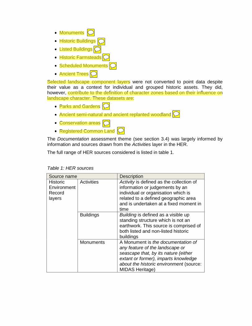
Monuments
Historic Buildings
Listed Buildings
Historic Farmsteads
Scheduled Monuments
Ancient Trees
Selected landscape component layers were not converted to point data despite their value as a context for individual and grouped historic assets. They did, however, contribute to the definition of character zones based on their influence on landscape character. These datasets are:
Parks and Gardens
Ancient semi-natural and ancient replanted woodland
Conservation areas
Registered Common Land
The Documentation assessment theme (see section 3.4) was largely informed by information and sources drawn from the Activities layer in the HER.
The full range of HER sources considered is listed in table 1.
Table 1: HER sources
Source name Description
Historic Environment Record layers
Activities Activity is defined as the collection of information or judgements by an individual or organisation which is related to a defined geographic area and is undertaken at a fixed moment in time
Buildings Building is defined as a visible up standing structure which is not an earthwork. This source is comprised of both listed and non-listed historic buildings
Monuments A Monument is the documentation of any feature of the landscape or seascape that, by its nature (either extant or former), imparts knowledge about the historic environment (source: MIDAS Heritage)

8
Parks and Gardens
A layer that is embedded within Monuments recording ornamental and designed landscapes, and areas of landscape with designed characteristics such as historic woodland, parkland type plantation, or designed water features
GIS layers from English Heritage
Listed Buildings A point layer based on all Listings that pre-date 1999. Not all locations are accurate, however, at a strategic assessment scale the accuracy is sufficient to allow assessment of LB density
Scheduled Monuments
Nationally designated historic assets that are mapped as a layer in the Historic Environment Record based on the Schedule Descriptions provided by English Heritage. The mapped areas are a guide. Only English Heritage hold the definitive maps for Scheduled Monuments
Historic environment project layers
Historic Farmsteads Characterisation
This project aims to develop an integrated understanding of farmstead character, survival and current use within their landscape and settlement context; using early 20th century ordnance survey mapping as a baseline for recording
Other layers available via the County Council GIS
Ancient semi-natural woodland
Woodland that has persisted in the landscape since approximately 1600AD
Ancient replanted woodland
Woodland where the original native tree cover has been felled and replaced by plantation often during the 20th century
Conservation areas
"An area of special architectural interest, the character or appearance of which it is desirable to preserve or enhance" (source Section 69 of the Planning (Listed Buildings and Conservation Areas) Act 1990)
Worcestershire Ancient Trees
Records showing the locations of ancient and veteran trees drawn from a Worcestershire Biological Records Centre project
Common land Land in Worcestershire which was registered under The Commons Registration Act 1965
Digital OS Master Map 1:2,500
Digital vector map of the modern landscape

map/image sources
OS 1:10,560 series publication date 1843-1893.
Historic raster map
OS 1:2,500 series publication date 1884-1889.
Historic raster map
Getmapping Air Photo coverage 2005
The most recent aerial photographic coverage available on the County GIS
Google Earth Aerial photographic coverage of various dates used for comparison with County GIS coverage
3.3 Preparation of Landscape Description Units (LDUs)
The Landscape Description Units layer is one of two polygon map layers produced by Worcestershire County Council's Landscape Team for the Landscape Character Assessment. As well as having value as indicators of landscape character the LDUs provide a landscape context for HER records. A copy of the LDU layer with most of the existing attribute data removed was loaded into GIS
3.4 Definition of Historic Environment Character Zones (HECZ)
The data and layers described above were loaded into GIS software, which offers a practical and flexible method of comparing data. The process examined the data for patterns in the distribution of historic environment assets within each layer. It also identified areas of group value related across one or more layers and similarly areas of diversity across the range of layers. Using this method it was possible to identify areas with similar archaeological character. For example, areas defined by surviving extensive below ground archaeology or where features are broadly of a similar period.
The historic buildings, Listed Buildings and historic farmsteads layers were compared to assess the distribution and relationship between historic buildings and their setting within the landscape.
This assessment was carried out in relation to the existing LDU mapping, selected historic Ordnance Survey mapping and aerial photographic coverage. It was therefore possible to make an assessment of the historic landscape character in any given area.
By combining the above, it was possible to define areas of distinctive or related historic environment character to create an integrated evidence base; the Historic Environment Character Zone. A total of 36 HECZ were defined entirely or partially within the area of Bromsgrove District. The next stage involved preparation of a character statement and thematic assessment of each character zone. It is important to stress that this study is the first iteration of a strategic assessment. Once the county Historic Landscape Character project is complete, this data should be used to deepen the assessment of landscape character and sensitivity.

10
3.5 Production of character statements and HECZ assessment criteria
Each HECZ is supported by three short statements, an introductory summary to set the context followed by summaries of historic landscape and archaeological character attributes for the zone.
This is followed by an assessment of the zone based on seven themes:
Survival
Potential
Documentation
Diversity
Group value
Amenity
Sensitivity to change
Each theme has been scored between 1 and 3, with 3 being the highest value. The definition of assessment themes and scoring methodology is based on the method employed by Shropshire Council for the Shrewsbury New Growth Point Assessment (Wigley forthcoming). This method is rooted in the approach developed for the Rochford District Historic Environment Characterisation Project (Brown, Clarke and Havis, 2006). It must be understood that at this strategic assessment level the numerical assessment is indicative. The scores must therefore be taken in relation to the overall character description statements.
3.5.1 Summary of assessment themes and scoring criteria
Survival – based on current Historic Environment Record assets, land-use and the impact of previous development
3 – High preservation of many known assets
2 – Moderate preservation of many assets or few recorded assets, but little disturbance within the zone
1 – Low or unknown preservation due to heavy impact or low density of Historic Environment Records
Potential – assessment of likelihood for the presence of additional historic environment features
3 – A range of high quality assets probably survive in the zone due to a lack of heavy impact
2 – Some existing impact from development, long-term arable land-use or limited known historic assets due to a lack of investigation
1 – Existing widespread impact from development, or quarrying, or potential is unknown due to a low density of records

Documentation – an assessment of previous, investigation, field survey (including: field walking, field evaluation, excavation, salvage recording, building recording and landscape survey), research, archive and historic documentation
3 – A wide range of the above
2 – Some of the above
1 – Few or none of the above
Diversity – an assessment of the range of assets present in each zone based on date/period (e.g. Iron Age, medieval), or evidence type (e.g. structural, below ground, environmental, earthworks or landscape)
3 – A wide range of assets in date and evidence
2 – A moderate range of assets in date and evidence
1 – Few know assets or many assets of a limited date range or evidence type
Group value – an assessment of coherence in the historic environment by period, evidence type or both
3 – Contains a wide range of assets related in either date, type or both
2 – Contains a moderate range of assets related in either date, type or both
1 – Contains few assets of similar date or type
Amenity value – identifies historic environment attributes within the zone with a potential to be promoted as part of Green Infrastructure provision or enhanced public access
3 – The historic environment provides a major contribution towards defining sense of place. There are constraints and significant opportunities for conservation and promotion that should be addressed in masterplanning and Green Infrastructure design.
2 – The historic environment contributes towards local distinctiveness and sense of place. This may be specific elements of the historic landscape or historic environment features or a combination of both. Constraints and opportunities for conservation and promotion should be addressed during masterplanning and Green Infrastructure design.
1 – The historic environment does not appear to contribute strongly towards defining sense of place. However, the full potential may be unknown and there is, therefore, scope for further investigations. These should be carried out as part of masterplanning and Green Infrastructure design to identify constraints and opportunities.

12
Sensitivity to change – identifies sensitivity based on the impact of medium to large-scale development
3 – Medium to large-scale development will have a significant impact on the historic environment.
2 – Medium to large-scale development will have a considerable impact on the historic environment.
1 – The historic environment could accommodate medium to large-scale development although specific assets may suffer adverse effects.
The integrated assessment is then expressed through an overall score, which is the sum total of scores from the seven criteria.
3.5.2 Issues affecting scoring
Where a score of 1 has been applied this does not, in every case, indicate a low historic environment value. The assessment of historic environment data has been reliant on existing information and sources held in the Worcestershire HER. In common with all other local authorities, the HER is largely populated with records drawn from the following activities:
Archaeological investigations carried out as part of development control conditions of assessment and mitigation
Archaeological assessments and investigations carried out in conjunction with aggregates extraction
Archaeological investigations carried out in conjunction with large infrastructure installation and upgrade projects, such as utilities and road building
Previous landscape-scale or urban historic environment assessments
Private and academic survey and research
There is, therefore, a tendency for HER information to be concentrated within, or on the fringes of, larger villages and towns where domestic and industrial re-development or expansion has taken place, adjacent to major road and utility networks, in areas of significant aggregate extraction and in areas of arable farming where surface artefacts and below ground archaeological features have been widely researched. By contrast, rural areas with a lower settlement density and higher ratio of woodland and/or pasture are considered to be under-represented in the HER as they have not been the subject of detailed archaeological investigation. Current research being undertaken as part of the HLF led Grow with Wyre project offers a prime example of where a heavily wooded, sparsely populated landscape has been revealed as a complex, multi-period historic environment.

Figure 2: Assessment of historic environment research and investigation for Bromsgrove District Council, along with Redditch Borough Council for comparison.

14
4. Summary and consideration of the assessment results
4.1 Key outcomes of the assessment
The project has identified and characterised 36 HECZ partially or completely within the BDC area (Appendix A includes all 36 statements, plus 2 others that are entirely outside BDC but border the boundary; HECZ 107 and 108). These are strategic level indicative character assessments In the majority of cases, the base Landscape Description Units were either altered or merged to reflect clear patterns in the association between the historic environment and landscape. Decision processes developed for the county Historic Landscape Character Project were used, particularly to assess historic field patterns in their chronological framework. In retrospect, had HLC mapping been available for this assessment, the final results may have varied to some degree. Nonetheless, by applying HLC assessment techniques as part of the HEA assessment process, the essential HLC attributes and trends have been successfully captured. It has been possible to validate this by respective comparison, of selected HECZ, in those areas where the HLC has been completed.
The individual scores for each of the seven assessment themes, discussed in section 3.5, were combined to provide an overall score for each HECZ. The score range spans from 7 to 19 with the majority of HECZ in Bromsgrove District scoring 16 or above.
4.1.1 Grouping of assessment themes
In the following section the seven assessment themes have been grouped together to reflect their conceptual relationships, for example, there is a direct link between the survival of historic environment features and the potential for additional features and sites being present in the same zone. It must me stressed that all seven themes interact and therefore contribute towards assessments of sensitivity, opportunity (amenity) and the overall score in each zone.
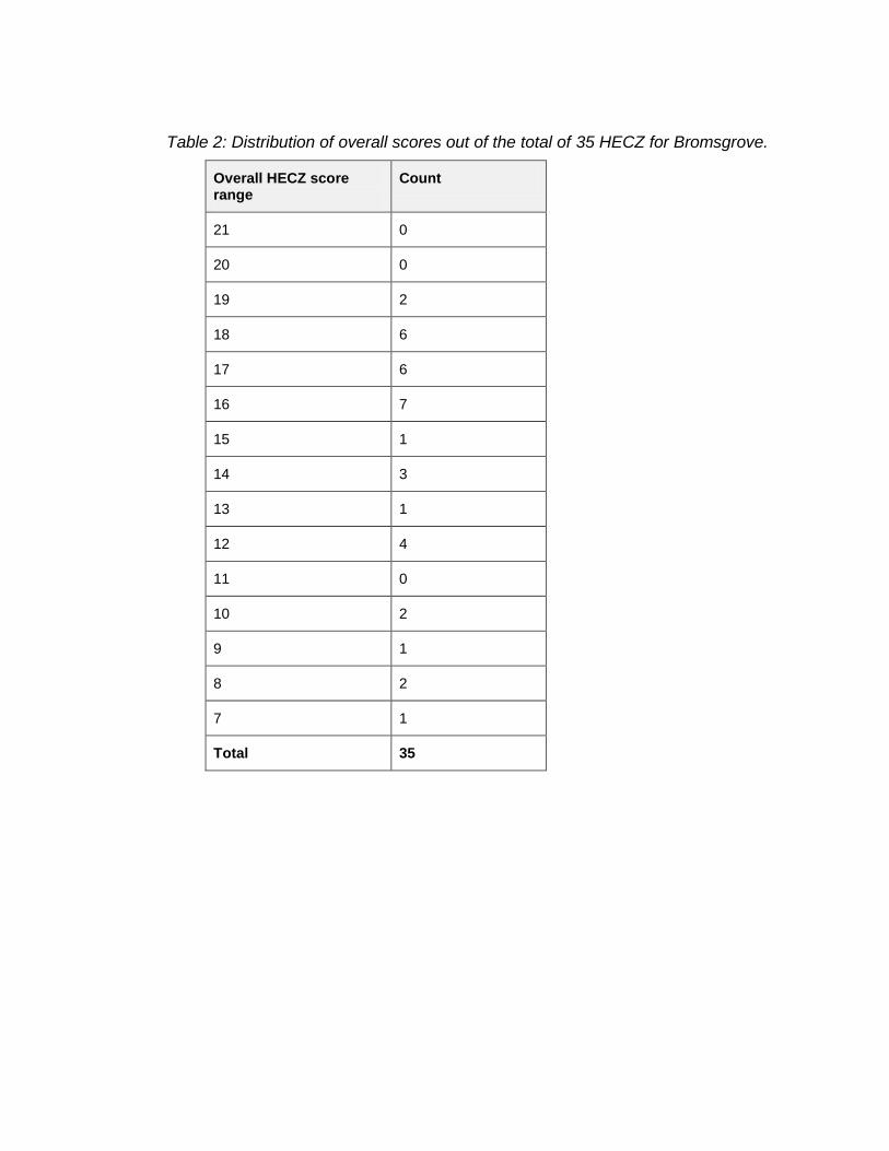
Table 2: Distribution of overall scores out of the total of 35 HECZ for Bromsgrove.
Overall HECZ score range
Count
21 0
20 0
19 2
18 6
17 6
16 7
15 1
14 3
13 1
12 4
11 0
10 2
9 1
8 2
7 1
Total 35

16

Figure 3: Overall scores for the assessment area, along with Redditch Borough Council for comparison.

18
4.2 Issues of survival, potential and sensitivity to change
4.21 Historic Environment: survival
Survival – based on current Historic Environment Record assets, land-use and the impact of previous development.
3 – High preservation of many known assets
2 – Moderate preservation of many assets or few recorded assets, but little disturbance within the zone.
1 – Low or unknown preservation due to heavy impact or low density of Historic Environment Records.
Figure 4: Assessment of historic environment survival across Bromsgrove District Council, along with Redditch Borough Council for comparison.

Historic Environment: potential
Potential – assessment of likelihood for the presence of additional historic environment features
3 – A range of high quality assets probably survive in the zone dur to alack of heavy impact.
2 – Some existing impact from development, long term arable land use or limited known historic environment assets due to a lack of investigation.
1 – Existing widespread impact from development, or quarrying, or potential is unknown due to a low density of records.
Figure 5: Assessment of historic environment potential across Bromsgrove District Council, along with Redditch Borough Council for comparison.
20
4.2.1 Historic Environment Survival and Potential maps:
Survival mapping records the range of known historic environment assets measured against the broad impacts of development, aggregate extraction and, to some extent, rural land use.
Although it's not possible, within the scope of this assessment, to ascertain site intrinsic factors such as the depth of ploughing or the affects of soil erosion from weathering and run off, it is possible, using aerial photographic sources, to identify broad trends in rural land use and consider their impact. For example, in areas of intensive cultivation there will likely be a negative impact to below ground archaeology. Impact will vary depending on factors such as topography and crop regime, nonetheless, at the level of HECZ assessment the effect of broad trends can be estimated with moderate confidence.
The majority of HECZ, within Bromsgrove District, are considered to have a moderate to high level of survival. Only 6 zones have a survival rating of low/unknown. In the majority of these cases the low/unknown rating appears to be directly associated with poor representation in the HER and the impact of 20
th
century development on the historic character of the landscape and built environment.
Zones with a high survival rating are well represented on the HER and have a significantly intact, historic landscape with a predominantly pastoral or mixed farming economy.
The high proportion of Green Belt, throughout the district, has preserved a relatively coherent post medieval landscape. Large scale 20
th century development has
largely overwritten historic landscape character in those undesignated areas such as Hagley Village and Hollywood.
The historic built environment is well represented within Bromsgrove Historic Town and Bromsgrove Urban Area (HECZ 149 and 150). This is in contrast with Redditch where many historic buildings were lost during the construction of the New Town during the 1960s and 1970s.
Out of 526 late early 20th century farmsteads recorded within Bromsgrove District
13.5% are recorded as being lost or demolished (compared to 10.1% throughout the county), 24% have experienced more than 50% alteration and 62.5% have experienced less than 50% alteration.
A large proportion of surviving farmsteads, throughout the district, have undergone some level of conversion. The conversion of traditional farm buildings to commercial or domestic use is considered a positive outcome as the future maintenance, of the great majority of them, is now dependant on a new role outside of agriculture. However, development strategies for re-use should be informed by regional and local differences in patterns of settlement, redundancy, dereliction and conversion and a consistent framework for understanding how farmsteads contribute to local distinctiveness and landscape character, working from a landscape setting towards the farmstead as a whole and finally individual buildings and their component parts.

Potential mapping assesses the 'potential for' unknown historic assets based on current records held within the HER. Assessment can be logically linked with survival; where there is good survival the presence of additional features can be presumed, with reasonable confidence, to be significant. High potential can also be assumed in those zones whereby the impact of development and intensive farming is less evident.
Historic environment potential has to be understood in the abstract. Zones that have an intact historic field pattern can not produce more boundaries and hedgerows. However, by contrast, the deep alluvial deposits associated with river corridors, such as at Belbroughton (HECZ 159), and palaeolchannels preserve ancient environmental materials, organic artefacts and structures and multi-period features sealed beneath the upper alluvial layers. These are not visible on the surface, but are highly susceptible to impact from the deep excavations imposed by development.
Potential is considered moderate to high throughout the majority of Bromsgrove. This reflects the predominance of Green Belt and the preservation, under pasture, of a significantly coherent post medieval landscape throughout the zones.
Potential is also moderate to high in those zones with a long history of urbanisation, such as Bromsgrove Historic Town (HECZ150) as deeply stratified structures, features and deposits of multi period origin are likely to survive.
4.2.2 Historic Environment Sensitivity to Change map:
This map has been generated from an assessment of the impact of medium to large-scale development on the historic environment within each character zone. The types of sensitivity present vary within each zone. Each zone is scored between 1 and 3, with 3 being the highest value.
3 (High) – Medium to large scale development will have a significant impact on the historic environment
2 (Medium) – Medium to large scale development will have a considerable impact on the historic environment
1 (Low/Unknown) – The historic environment could accommodate medium to large scale development although specific assets may suffer adverse affects

22
Figure 6: Assessment of impact and sensitivity to change across Bromsgrove District Council, along with Redditch Borough Council for comparison.
At a strategic scale, there are notable patterns in sensitivity distribution and range. Some of the zones that have a high sensitivity rating, for example, Hagley Hall Registered Park and Garden (HECZ 151), are perhaps obvious, as they have a high density of historic environment features with high potential for additional below ground archaeological deposits.
Other zones with high sensitivity perhaps require more explanation, given that the reasons for high sensitivity may not be immediately apparent.
A high sensitivity rating for Uffmoor Wood (HECZ 158) and Batemans Green (HECZ 164), for example, is largely due to the well preserved, locally distinctive

historic landscape associated with each zone. At Batemans Green, a locally distinctive sub circular field pattern with Highfields Farm, Oaks Farm and Malthouse Farm at its nucleus is a dominant characteristic. This unusual field pattern may represent the remains of an earlier infield – outfield system, or alternatively may be associated with flax production; a significant local industry throughout the post medieval period. The 1
st Edition OS map records a similar sub circular field pattern
to the north east of Batemans Green. This field system has now been largely overwritten by 20
th century development at Hollywood.

24
4.3 Assessment of coherence and diversity
4.31 Historic Environment: group value
Group Value – an assessment of coherence in the historic environment by period, evidence type of both
3 – Contains a wide range of assets related in either date, type of both
2 – Contains a moderate range of assets related in either date, type or borth
1 – Contains few assets of similar date or type
Figure 7: Assessment of historic environment group value across Bromsgrove District Council, along with Redditch Borough Council for comparison.

Assessment of group value has particular relevance towards aiding an understanding of setting and place. This may be a visual experience, for example, dispersed settlement along sinuous lanes, areas of well preserved medieval earthworks, historic hedgerows, relic parkland or commons.
By contrast, group value, might be defined by below ground archaeological features; for example the remains of prehistoric or Romano-British settlement, that contribute significantly towards the historic environment of a particular zone.
Group value assessment also provides a specific indicator of sensitivity as any loss or weakening of coherence, in those character zones with a high group value rating, will weaken overall historic environment character and potentially impact on the setting of related historic assets.
This theme also provides an indicator of opportunities that could inform Green Infrastructure design. For example, zones with a significantly intact historic field pattern, ancient woodland, medieval moated sites or areas of relic parkland may offer specific opportunities for integration into Green Infrastructure networks and open space. Equally, the protection of high value below ground archaeology might be achieved through the allocation of open space that limits ground disturbance within a development area. The group value theme does not identify specific areas of sensitivity at a site level, but does aim to define areas where these constraints and opportunities are likely to be encountered.
Throughout Bromsgrove District group value is considered high in areas with very different historic environment and landscape characteristics. The planned Chartist Settlement at Dodford (HECZ 155), for example, has medieval and 19
th century
historic environment features with significant group value, including an assemblage of 19
th century Chartist cottages. In comparison Hagley Hall Registered Park and
Garden (HECZ 151) has a nationally significant, 18th century, designed landscape
with associated historic buildings, and nationally significant prehistoric earthworks. Uffmoor Wood (HECZ 158), with its significantly intact medieval and post medieval agricultural landscape is in complete contrast to the coherent post medieval industrial landscape associated with the Tutnall and Finstall HECZ (174), both zones, however, are considered to have significant group value.
4.3.1 Historic Environment Diversity map:
Diversity – an assessment of the range of assets present in each zone based on date/period (e.g. Iron Age, medieval), or evidence type (e.g. Structural, below ground, environmental, earthworks or landscape)
3 – A wide range of assets in date and evidence
2 – A moderate range of assets in date and evidence
1 – Few known assets or many assets of a limited date range or evidence type

26
Figure 8: Assessment of historic environment diversity across Bromsgrove District Council, along with Redditch Borough Council for comparison.
At a strategic scale of assessment, diversity is a key attribute of the historic environment. Assessment can identify and classify distinctive areas where multi-period historic assets are present as well as those zones which contain a wide range of assets of different types. It could be suggested that zones with a lower group value will have a higher diversity score and vice-versa; however, this is not necessarily always the case. HECZ 151 (Hagley Hall Registered Park and Garden), for example, is considered to have both high group value and high diversity value.
Historic environment diversity, perhaps, presents extra challenges, but also opportunities for planning and Green Infrastructure design. The range of constraints and opportunities for protection and enhancement will be greater given that buildings, earthworks, paleoenvironmental remains, below ground archaeology and relic landscapes each demand very different responses within an integrated strategy to deliver effective solutions.
Hewell Grange, Bordesley Abbey and Alvechurch Parks (HECZ 148), Holt End to Weatheroak Hill (HECZ 133), Clent Hills (HECZ 153), Romsely (HECZ 156) Lickey and Blackwell (HECZ 163), The Heaths (HECZ 165), Headley Heath (HECZ 166), and Chaddesley Wood (HECZ 169) are also considered to have a high diversity rating due to their diverse range of multi period historic environment assets.

28
4.4 Opportunities for historic environment conservation and promotion within masterplanning and Green Infrastructure design
4.4.1 Historic Environment Amenity map:
This map has been generated from an assessment of the actual and/or potential value of the historic environment to contribute towards Green Infrastructure design in each zone. The assessment has considered uniqueness, key historic environment landmarks, good public access and the potential for promoting the historic environment for the benefit of public interest, educational value and place making. Again, each zone is scored between 1 and 3, with 3 being the highest value.
3 (High) – The historic environment provides a major contribution towards defining sense of place. There are constraints and significant opportunities for conservation and promotion that should be addressed in masterplanning and Green Infrastructure design.
2 (Medium) – The historic environment contributes towards local distinctiveness and sense of place. This may be specific elements of the historic landscape and historic environment features or a combination of both. Constraints and opportunities for conservation and promotion should be addressed during masterplanning and Green Infrastructure design.
1 (Low/Unknown) – The historic environment does not appear to contribute strongly towards defining sense of place. However, the full potential may be unknown and there is, therefore, scope for further investigation. These should be carried out as part of masterplanning and Green Infrastructure design to identify constraints and opportunities.
The development of opportunities to conserve historic environment features and landscapes while promoting their contribution towards defining identify and a sense of place should be a key objective in Green Infrastructure design. Historic Environment features can contribute towards achieving multi-functional objectives in connection with landscape, biodiversity, recreation, access and climate change mitigation. Version 1 (and later editions) of the Technical Research Paper for Green Infrastructure (WCC 2008) aims to develop these specific groups of historic environment features. Their relationship with Green Infrastructure themes can be defined as follows:
Green Infrastructure historic environment networks: hedgerows, green lanes, canals, disused railway lines.
Green Infrastructure historic environment open space/green space: orchards, designed landscapes (e.g. parkland), permanent pasture with earthworks (e.g. ridge and furrow), land with extensive below ground archaeology, ancient semi natural woodland and ancient replanted woodlands.

Green Infrastructure historic environment interfaces with Blue Infrastructure: ponds, water filled quarries and clay pits, canals, bogs, palaeochannels and alluvial soils.
Figure 9: Assessment of historic environment potential to promote sense of place across Bromsgrove District Council, along with Redditch Borough Council for comparison.
The mapping clearly demonstrates that some potential for promotion and conservation exists throughout the entire assessment area. Zones with a high amenity score are concentrated to the north west of Bromsgrove and to the north of the district around the Clent Hills and Romsley. This is predominantly the result of the co-existence between high value, high density historic assets and high value landscapes, often with ancient semi natural woodland and public open spaces.

30
It is important to note that zones with a low score are not necessarily devoid of historic environment interest, nor are they degraded landscapes without other environmental potential, although areas of degraded landscape will, of course, influence scoring. In some cases these are zones where the historic environment is not well recorded. In others they reflect the impact of 20
th century development
4.4.2 Deficiencies, needs and opportunities
The most obvious area of weakness in the Historic Environment Assessment is the effect of 'weighting' in the scoring cased by a bias in the density of records held in the Historic Environment Record (see Figure 2). The primary source of data in the Historic Environment Record is drawn from investigations linked to planning conditions that follow guidelines set out in PPGs15/16 (now PPS5); the upgrade, or installation of major utility services and other major infrastructure developments, such as road building, and aggregates extraction. This results in higher densities of records in urban centres and areas of suburban expansion, along major infrastructure routes and in areas of quarrying; for example, the lower Severn Valley in Worcestershire.
There are pockets, or areas of high record density elsewhere, however, they tend to be isolated and often the result of independent research and field investigation. The opposite situation of a low density in records often occurs in areas of the County that are more remote, less densely populated that have not historically been effected by major developmental impacts.
The bias in record density is a factor that affects all Historic Environment Records across the country. The direct affect on the HEA is clearly demonstrated at both ends of the density scale; for example, urban areas and places where quarrying is taking place all score high. The high score may not accurately represent the level of survival. Equally, were the score is low this can be the result of a lack of previous investigations and does not necessarily indicate a lack of historic environment features. This underpins the need for site masterplanning to ensure detailed investigations are undertaken in order to establish fully the intricate variables that will be present on any site, to measure loss, survival and identify potential and therefore opportunities for conservation and enhancement.
Across all zones, diverse types of historic environment features and landscape attributes are subject to the same level of impact from development. By contrast, the opportunities for mitigation and conservation are more intricate requiring detailed assessment and understanding during site masterplanning.
The development of opportunities to conserve historic environment features and landscapes and promote their contribution towards defining identity and a sense of place should be a key objective in Green Infrastructure provision. Specific groups of historic environment features, and their relationship with Green Infrastructure themes, can be defined as follows:
Green Infrastructure historic environment networks: hedgerows, green lanes, canals, disused railway lines;

Green Infrastructure historic environment open space/green space: orchards, designed landscape (e.g. parkland), permanent pasture with earthworks (e.g. ridge and furrow), land with extensive below ground archaeology, ancient semi-natural and ancient replanted woodlands;
Green Infrastructure historic environment water features: ponds, water filled quarries and clay pits, canals, bogs, palaeochannels and alluvial soils.
The amenity map provides a basis with which to explore how areas of high value can be linked through the development and enhancement of Green Infrastructure networks. There is also a need to develop networks that may enhance the amenity value of moderate and low scoring zones through the provision of enhanced access, conservation and promotion of the historic environment. These opportunities will become clear through an integrated approach to Green Infrastructure study, and the subsequent development of a strategy, that should identify and develop areas where valued historic environment features, habitats, landscape, blue infrastructure and access coexist. A detailed study set in the context of the existing evidence base will ensure that Green Infrastructure design can both enhance the historic environment and develop an appropriate mitigation strategy where different environmental themes conflict in terms of their conservation requirements.
5. Publication summary
The Service has a professional obligation to publish the results of archaeological projects within a reasonable period of time. To this end, the Service intends to use this summary as the basis for publication through local or regional journals. The client is requested to consider the content of this section as being acceptable for such publication.
An Historic Environment Assessment was carried out on behalf of Bromsgrove District Council. The project was designed to provide an integrated historic environment evidence base to support policy and Green Infrastructure documents aimed at shaping future development strategy. The project combined county landscape character mapping with Historic Environment Record data and an outline Historic Landscape Character assessment. The results have produced 36 distinctive Historic Environment Character Zones, which are supported by character statements assessing historic environment survival, potential, documentation, diversity, group value, sensitivity and amenity potential for each zone. The project has provided an immediate assessment of the historic environment; however, the methodology also provides the capacity for re-evaluation at key future stages.

32
6. Summary of sources for masterplanning
Specialist advice:
Worcestershire Historic Environment and Archaeology Service (County Historic Environment Record covering Bromsgrove District)
Worcester City Council Archaeological Service
District Conservation Officers (Bromsgrove District Council)
District landscape officers (Bromsgrove District Council)
English Heritage Documents:
Historic Environment Assessment for Bromsgrove District Council
Planning for Landscape, Biodiversity and the Historic Environment in the development of Green Infrastructure Strategies in Worcestershire, Technical Research Paper: Version 2, Worcestershire County Council
Revised historic environment content for the Worcester Green Infrastructure Study
Planning Policy Statement 5: Planning for the Historic Environment
District Conservation Area Appraisals (Bromsgrove District Council) Sources:
Sites or monuments registered on the County Historic Environment Record
Sites or monuments on the Worcester City Historic Environment Record
District Listed Buildings records
English Heritage record of Scheduled Monuments, Registered Battlefields and Registered Parks and Gardens
Worcestershire (and West Midlands) Historic Farmsteads Characterisation Project (English Heritage and Regional Local Authorities)
Historic Landscape Characterisation Project for Worcestershire (Worcestershire Historic Environment and Archaeology Service)

7. The archive
The archive consists of:
GIS based map coverage for the BDC area and supporting digital documentation.
The project archive is intended to be placed at:
Worcestershire Historic Environment and Archaeology Service Woodbury University of Worcester Henwick Grove Worcester WR2 6AJ Tel: 01905 855455 Fax: 01905 855035
8. Acknowledgements
The Service would like to thank Vanessa Clarke (BBC) and Andy Wigley (SC) for their guidance during the development of the HEA methodology and to Mike Dunphey, Judith Carstairs and Sumi Lai (BDC) and Amanda Smith (EH) for their kind assistance in the successful conclusion of this project.
9. Personnel
The character statements were written by Emma Hancox and Emily Gough. The report preparation was undertaken by Adam Mindykowski, Emma Hancox and Emily Gough. The project manager responsible for the quality of the project was Adam Mindykowski. The Historic Landscape Character statement for Bromsgrove was prepared by Vanessa Clarke and Steve Crowther.
10. Bibliography
IFA, 1999 Standard and guidance for archaeological desk-based assessment, Institute of Field Archaeologists.
WCC 2008, Planning for Landscape, Biodiversity and the Historic Environment in the development of Green Infrastructure Strategies in Worcestershire, Technical Research Paper: version 1, WCC unpublished document.
Worcestershire Landscape Character Assessment http://gis.worcestershire.gov.uk/website/lca/viewer.htm
11. Abbreviations
BBC: Bedford Borough Council
BDC: Bromsgrove District Council
Cropmarks: The visible effect on the development of arable crops caused by the presence of below ground historic environment features

34
HEA: Historic Environment Assessment
HER: Historic Environment Record.
HECZ: Historic Environment Character Zones
HLF: Heritage Lottery Fund
PPG15 Planning Policy Guidance 15 (PPG15): provides a full statement of Government policies for the identification and protection of historic buildings, conservation areas and other elements of the historic environment.
Planning Policy Guidance 16 (PPG16): sets out the Secretary of State's policy on archaeological remains on land, and how they should be preserved or recorded both in an urban setting and in the countryside (source: www.communities.gov.uk).
Palaeochannels: ancient silted up river channels, or other watercourses that are often associated with well-preserved organic remains and historic environment features
Ridge and furrow: large-scale earthworks associated with former medieval and post-medieval open-field communal farming that appear as a distinctive corrugated surface
SC: Shropshire Council
WHEAS: Worcestershire Historic Environment and Archaeology Service
WCC: Worcestershire County Council
12. General periods for the historic environment
Palaeolithic -500000 BC to -10001 BC
Mesolithic -10000 BC to -4001 BC
Neolithic -4000 BC to -2351 BC
Bronze Age -2350 BC to -701 BC
Iron Age -800 BC to 42 AD
Romano-British 43 AD to 409 AD
Post-roman (Early medieval) 410 AD to 1065 AD
Medieval 1066 AD to 1539 AD
Post- medieval 1540 AD to 1900 AD
Modern 1901 AD to 2050 AD

Appendix 1:
Historic Environment Character Statements Bromsgrove District Council
Figure 10. Locations of the Bromsgrove HECZ. The colours are purely a visual aid and not interpretative.

36
13. Historic Environment Character Zones (HECZ) HECZ 107: Hanbury and Woolmere Green Summary: An area of lias clay with poorly draining soils and an intermediate, rolling topography intersected by two Roman roads and sinuous lanes, along which settlement is scattered. Historic Landscape: A landscape of small to medium sized regular fields interspersed with settlement scattered along sinuous lanes and the dispersed villages of Piper's Hill, Hanbury and Woolmere Green, which line the B4091 road. Ancient semi-natural woodland survives to the south of the zone in the Broughton Green area. A wooded area of common land on Pipers Hill and the adjacent rise, on which Hanbury Church stands, are prominent features in this landscape. Archaeological Character: Extensive field survey has recorded a wide range of medieval landscape features, largely ridge and furrow, centred in particular on Mere Hall to the south, Woolmere Green and Hanbury. The Saltway Roman road from Droitwich to Alcester crosses the zone from east to west and the B4091, which crosses from north to south, is also thought to be Roman in origin. Indications of prehistoric settlement include a double-ditched enclosure cropmark south of Woolmere Green and a probable Iron Age Hillfort on Church Coppice. At the very west of the zone, a cropmark, east of Dodderhill, may represent a Saxon building. The village cross at Hanbury is a Scheduled Ancient Monument and the Birmingham to Worcester Canal, which crosses the zone to the west, is a Conservation area. Table 107: Hanbury and Woolmere Green
HECZ Criteria Description Score
Survival A well preserved post medieval landscape. 3
Potential Potential Romano British, post Roman and medieval below ground archaeology.
2
Documentation A good range of archaeological documentation and fieldwork.
3
Diversity of historic environment assets
A moderately diverse range of archaeological assets 2
Group value association
A well preserved landscape with some extant earthworks.
3
Amenity value Ancient semi natural woodlands and earthworks accessible by PRoW.
3
Sensitivity to change
The landscape is sensitive to change. 2
Overall score 18

` HECZ 108: Cutnall Green to Upton Warren
Summary: An area of soft rock, comprising mixed mudstones and sandstones producing a rolling, lowland topography and free draining brown soils. The landscape is one of small to medium sized fields with sinuous lanes and scattered settlement. The River Salwarpe and two braiding tributaries cross the zone from north to south. Historic Landscape: A low lying area of small to medium sized, regular and irregular fields. Land use is mixed and some arable fields have been amalgamated. Settlement is scattered along sinuous lanes. The River Salwarpe crosses the zone to the east and the Elmley and Elmbridge Brooks join the river to the south in Droitwich. Discrete blocks of traditional orchard and ancient semi- natural woodland survive and to the west there is a well preserved park and garden at Elmley Lovett Lodge. The M5 motorway crosses the zone to the east. Ribbon development on the line of the A38 and gravel extraction has eroded the character of the landscape to some degree. Archaeological Character: Archaeological activity throughout the zone has been minimal; consequently the survival of below ground archaeological remains is uncertain. However, the zone is crossed by the line of the Roman road from Droitwich to Lickey, presently the A38, and a postulated Roman road from Droitwich to Greensforge, now a minor road. The Roman town of Droitwich is close and the potential for Romano - British settlement is therefore quite high. The conjectural route of Godham Way, a Saxon Road, also crosses the zone and possible Saxon earthworks are recorded at Upton Warren and Elmley Lovett. Earthworks associated with medieval settlement at Elmley Lovett are a designated Scheduled Ancient Monument. Medieval settlement is also recorded at Wyken Farm. A number of features relating to the WWII defence of Britain are recorded to the north of Wychbold. There is considerable potential for the preservation of waterlogged archaeological remains in the vicinity of watercourses.
Table 108: Cutnall Green to Upton Warren
HECZ Criteria Description Score
Survival The historic landscape survives reasonably well 2
Potential There is strong potential for surviving below-ground deposits.
3
Documentation Relatively little archaeological activity has been undertaken. Documentary and cartographic sources.
2
Diversity of historic environment assets
A reasonable diversity of historic assets 2
Group value association
Relatively coherent medieval and post-medieval landscape.
2
Amenity value A good network of PRoW in a reasonably well preserved historic landscape.
2
Sensitivity to change
The landscape is sensitive to change 2
Overall score 15

38
HECZ 129: Mappleborough Green
Summary: An area of rolling lowland topography, overlying soft mudstones, with a free draining brown soil. The historic tree cover within the Worcestershire part of this zone comprises scattered oaks in historic hedgerows. There are significant areas of modern plantation.
Historic Landscape: Piecemeal and Parliamentary enclosures, characterised by small to medium scale fields, line the Birmingham Road as it runs northwards through the zone. Mappleborough Green, a loosely agglomerated, linear village, forms the main settlement. Elsewhere in the zone, settlement is characterised by dispersed farmsteads and wayside cottages. Land use is predominantly pastoral.
Archaeological Character: The main road running through Mappleborough Green is certainly medieval in date and there is conjectural evidence which suggests that the road is Roman in origin. There are a series of moated farmsteads along the road, three of which are in Worcestershire, and there is potential, throughout the zone, for further below ground archaeology associated with medieval settlement. In the north of the zone, along the edge of the Winyates Green triangle, a tree-lined, cobbled road survives as a green lane. This road, considered to be post-Roman in date, leaves the Birmingham Road by Lower House Farm and runs northwards to the Saltway in Holt End.
Table 129: Mappleborough Green
HECZ Criteria Description Score
Survival Much of the known archaeology has been damaged by the New Town, although some features, like the moat at Breaches Farm, survive well.
2
Potential Potential for below ground settlement associated with the medieval or earlier village of Mappleborough Green.
3
Documentation HER, documentary and cartographic sources, no archaeological works currently undertaken.
2
Diversity of historic environment assets
Medieval and post-medieval settlement. 2
Group value association
A reasonably coherent narrative of settlement development can be observed throughout the landscape
2
Amenity value There is low potential for amenity value, although use could be made of the PRoW that lead out to the Warwickshire Countryside, particularly the post-Roman road, which is a PRoW and Special Wildlife Site.
1
Sensitivity to change
The development of the New Town has already had a significant impact on the historic character of the landscape.
1
Overall score 13

HECZ 132: Church Hill and Winyates Green Summary: In the north of the zone the Church Hill housing estate lies to the west of the brook and an industrial estate to the east. Ipsley Alders Nature Reserve and the Winyates and Winyates Green housing estates are located to the south of the zone.
Historic Landscape: The north of the zone was historically in Beoley Parish, the south in Ipsley; the boundary between the two being marked by Blacksoils Brook. The 1
st Edition OS map
records regular enclosure of former parkland. Former field boundaries survive throughout the housing estates. Archaeological Character: There are no listed and only two historic buildings within the zone. Various surveys and excavations indicate that below ground survival is reasonable. Below-ground archaeology from the Romano - British period onwards is likely to exist, particularly in the north of the zone where the Roman road meets the ancient Saltway, and under Moon's Moat First School, where aerial photographic sources record a possible enclosure. Environmental deposits are considered likely along the brooks and at Moon's Moat, Iplsey Alders and the fishponds. The dams of the medieval fishponds still exist to a height of 3 metres. Table 132: Church Hill and Winyates Green
HECZ Criteria Description Score
Survival Poor survival of historic buildings. Good survival of hedgerow boundaries and earthworks.
2
Potential Potential for further below-ground remains, particularly environmental deposits along the brooks and remains associated with the fishponds.
3
Documentation Documentary and cartographic sources, HER, survey and excavation work.
3
Diversity of historic environment assets
Below and above ground features of medieval date. 2
Group value association
The surviving features form a coherent medieval landscape.
2
Amenity value Potential to engage local population with the historic environment. Archaeological remains include large earthworks that are easily accessible. Areas of public open space.
2
Sensitivity to change
The zone could take a reasonable amount of change, providing that the historic boundaries and earthworks were maintained.
2
Overall score 16

40
HECZ: 133: Holt End to Weatheroak Hill
Summary: An area of intermediate, undulating topography, derived from a soft rock mixture of mudstones and sandstones, with free draining, mixed brown soils.
Historic Landscape: The land use is predominantly pastoral with a settlement pattern of farmsteads and wayside dwellings associated with a moderate to high level of dispersal. Tree cover comprises relic patches of ancient woodland often in association with densely scattered hedgerow oaks and streamside tree cover. The ancient saltway and Roman road add significant time depth to the road network. This is a complex landscape with a post medieval piecemeal enclosure pattern, characterised by medium sized fields which are quite regular in the main. In places, particularly the vicinity of Weatheroak Hill, the field pattern is clearly the result of the enclosure of strip fields.
Archaeological Character: Two Scheduled Ancient Monuments, a number of Listed Buildings and the Beoley Conservation Area comprise the designated assets within this zone. There are a large number of undesignated above and below ground features including the Roman road and earthwork ridge and furrow. Table 133: Holt End to Weatheroak
HECZ Criteria Description Score
Survival Good survival of the historic landscape and below and above ground archaeological features.
3
Potential There is high potential for further above and below ground archaeology.
3
Documentation A reasonable number of archaeological investigations, documentary and cartographic evidence.
2
Diversity of historic environment assets
A wide range of above and below ground features, landscapes and buildings.
3
Group value association
A coherent landscape, although slightly degraded in places.
2
Amenity value A good network of PRoW and a well preserved landscape with earthworks.
2
Sensitivity to change
Parts of this zone are highly sensitive to change, other areas have some capacity.
3
Overall score 18

HECZ 143: Dunstall Court to Whitford Bridge Summary: An area of lias clay with poorly draining soils and a rolling lowland topography. Historic Landscape: The settlement pattern is one of farmsteads and clusters of wayside cottages associated with a moderate to high level of dispersal and a small to medium scale field pattern. Land use is mixed and the tree cover comprises a few relic patches of ancient woodland often associated with densely scattered hedgerow oaks. Archaeological Character: The character of the historic landscape is significantly intact. There are also a considerable number of historic and Listed Buildings. Archaeological features include earthworks and buried remains. Archaeological fieldwork and spot finds indicates good below ground survival. Table 143: Dunstall Court to Whitford Bridge
HECZ Criteria Description Score
Survival A coherent landscape with surviving below and above ground archaeological features.
3
Potential There is high potential for further remains 3
Documentation Some documentary and cartographic sources, good archaeological fieldwork.
2
Diversity of historic environment assets
A diverse range of above and below ground archaeological features.
2
Group value association
A coherent medieval and post-medieval landscape. 3
Amenity value A good PRoW network with access to the canal and potential for marketing the landscape and historic farmsteads.
2
Sensitivity to change
This area is highly sensitive to change 3
Overall score 18
42
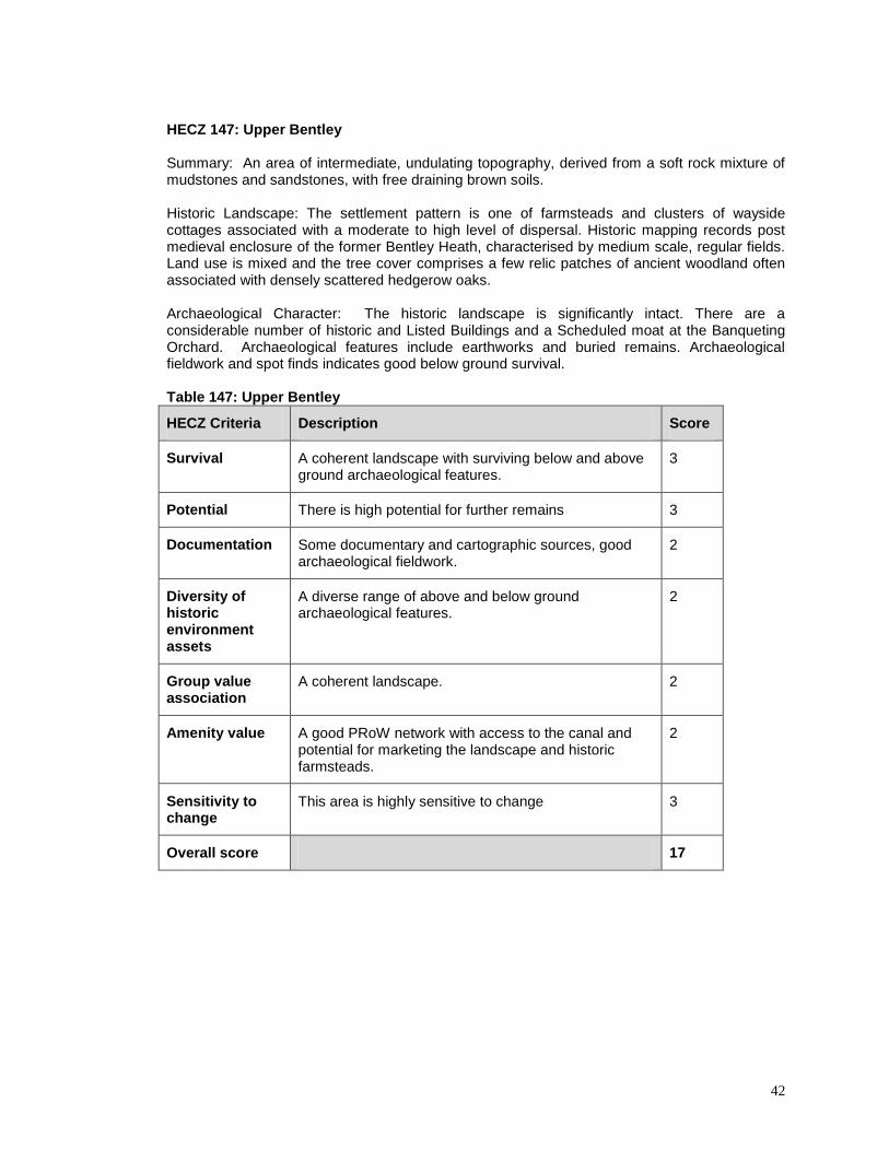
HECZ 147: Upper Bentley Summary: An area of intermediate, undulating topography, derived from a soft rock mixture of mudstones and sandstones, with free draining brown soils. Historic Landscape: The settlement pattern is one of farmsteads and clusters of wayside cottages associated with a moderate to high level of dispersal. Historic mapping records post medieval enclosure of the former Bentley Heath, characterised by medium scale, regular fields. Land use is mixed and the tree cover comprises a few relic patches of ancient woodland often associated with densely scattered hedgerow oaks. Archaeological Character: The historic landscape is significantly intact. There are a considerable number of historic and Listed Buildings and a Scheduled moat at the Banqueting Orchard. Archaeological features include earthworks and buried remains. Archaeological fieldwork and spot finds indicates good below ground survival. Table 147: Upper Bentley
HECZ Criteria Description Score
Survival A coherent landscape with surviving below and above ground archaeological features.
3
Potential There is high potential for further remains 3
Documentation Some documentary and cartographic sources, good archaeological fieldwork.
2
Diversity of historic environment assets
A diverse range of above and below ground archaeological features.
2
Group value association
A coherent landscape. 2
Amenity value A good PRoW network with access to the canal and potential for marketing the landscape and historic farmsteads.
2
Sensitivity to change
This area is highly sensitive to change 3
Overall score 17

HECZ 148: Hewell Grange, Bordesley and Alvechurch Parks. Summary: A gently undulating wooded landscape over mixed mudstones and sandstones, with free draining, mixed brown soils.
Historic Landscape: The ancient saltway, the probable Roman road and the prehistoric ridge way add significant time depth to the road network. The settlement pattern is one of farmsteads and strings of wayside dwellings associated with a moderate to high level of dispersal. This is a complex landscape of piecemeal and Parliamentary enclosure with some later field amalgamation and reorganisation. Land use is pastoral and the tree cover comprises interlocking, or frequent, usually large, discrete blocks of ancient woodland. There are large areas of parkland, both relic and surviving.
Archaeological Character: Hewell Grange is a Registered Park and the Worcester and Birmingham Canal a Conservation Area. Alluvial deposits survive along the River Arrow floodplain. There are a large number of Listed and unlisted historic buildings, mainly associated with parkland features and the dispersed farmsteads. There are also numerous above and below ground archaeological features dating from the Bronze Age onwards. Table 148: Hewell Grange, Bordesley and Alvechurch Parks
HECZ Criteria Description Score
Survival Significantly intact historic landscape and surviving below and above ground archaeological features.
2
Potential There is high potential for further above and below ground archaeology.
3
Documentation Numerous archaeological investigations, documentary and cartographic sources, HLC
3
Diversity of historic environment assets
A wide range of above and below ground features, landscapes and buildings.
3
Group value association
A coherent landscape, although slightly degraded in places.
2
Amenity value A good PRoW network with links to the Worcester and Birmingham Canal Conservation Area.
2
Sensitivity to change
Parts of this zone are highly sensitive to change, other areas have some capacity.
2
Overall score 17

44
HECZ: 149: Bromsgrove Urban Area
Summary: A large area of 20th century housing and industrial development around a medieval and post-medieval core. The soils are mainly the typical brown earths of the Crediton association to the north and Bromsgrove association to the south. The underlying geology consists of Triassic Bromsgrove Sandstone. Historic Landscape: Significant landscape change, a result of urban expansion since the 1950s and 1960s, has largely overwritten previous historic landscape characters. Cartographic sources record post medieval piecemeal enclosure, possibly of former medieval open fields and possible areas of Parliamentary enclosure. The settlement pattern, outside of the town, was formally one of farms, and clusters of wayside dwellings, associated with a moderate level of dispersal. Archaeological Character: The majority of archaeological assets recorded date to the post medieval period; features associated with 18
th and 19
th century manufacturing are
predominant. Thirteen Listed Buildings, predominantly of 18th and 19
th century date are
recorded. The Roman Road from Droitwich runs centrally through the parish in a south west – north east direction. Cropmarks and accidental finds, including residual prehistoric flints, indicates that there was prehistoric and Romano - British activity in the vicinity of the modern town. Table 149: Bromsgrove Urban Area
HECZ Criteria Description Score
Survival Poorly represented in the HER therefore survival of historic environment features largely unknown.
1
Potential Moderate potential for below ground archaeology, particularly associated with 18
th/19
th century
manufacturing and earlier features and deposits along the line of the Roman road.
2
Documentation HLC Project: Pilot Study, HER, documentation, cartographic and photographic sources. Moderate archaeological fieldwork and building recording.
3
Diversity of historic environment assets
The majority of archaeological assets date to the post medieval period. However, the Roman Road, cropmark and artefactual evidence indicates earlier activity.
2
Group value association
Lack of overall coherence due to the impact of piecemeal 20
th century development.
1
Amenity value Potential for promoting the development of the historic town core and creation of links between urban greenspace and rural historic assets beyond the town.
2
Sensitivity to change
Low sensitivity due to fragmented character. Some higher risk areas adjacent to the historic core and the Roman road.
1
Overall score 12

Historic Environment Assessment for Bromsgrove District Council
Page 45
HECZ: 150: Bromsgrove Historic Town
Summary: A small medieval market town enclosed by 20th century housing and industrial development. The historic town lies in the valley of the Spadesbourne Brook and the soils are typical brown earths overlying Triassic Bromsgrove Sandstone. Historic Landscape: The main axis of the town is the south west – north east orientated Roman road from Droitwich. Currently, no evidence of pre-medieval occupation on the site of the town has been recorded, although there is a moderate potential for the presence of below ground archaeology. Bromsgrove was probably the site of an Anglo-Saxon minster and possibly an Anglo-Saxon burh. The town developed in the second half of the 12th century. In 1533 cloth was permitted to be manufactured; production continued to be an important industry into the 18th century. From the 17th century the manufacture of nails became increasingly significant, and by 1778 this was a staple industry. Manufacture continued to be significant until the end of the 19th century. Bromsgrove flourished in the 19th century and significantly expanded; partially in response to the opening of the Birmingham and Gloucester Railway line from Cheltenham to Gloucester and the completion of the Lickey Incline. Archaeological Character: The historic core of Bromsgrove contains buried archaeology, artefacts and environmental deposits dating from the medieval and post medieval periods, with some potential for pre-medieval archaeology. There is a distinctive assemblage of 17
th to 19
th century Listed and non-
listed historic buildings present in the historic core, which is a designated Conversation Area.
Table 150: Bromsgrove Historic Town
HECZ Criteria Description Score
Survival Listed and non-listed historic buildings survive well with moderate survival of post-medieval archaeology.
3
Potential Moderate potential of surviving below ground medieval and post medieval archaeology and earlier archaeology associated with the Roman road.
2
Documentation HLC Project: Pilot Study, HER, a significant amount of documentation, cartographic and photographic sources, minimal archaeological fieldwork.
3
Diversity of historic environment assets
Currently limited evidence for multi-period archaeology, but a reasonably diverse range of post-medieval features and buildings.
2
Group value association
Coherent post-medieval and 19th century built
environment. Likely to be associated with contemporary archaeology.
2
Amenity value Potential for promoting the development of the historic town core and creation of links between urban greenspace and rural historic assets beyond the town.
3
Sensitivity to change
Historic built environment highly sensitive to change. 3
Overall score 18

Historic Environment Assessment for Bromsgrove District Council
Page 46
HECZ 151: Hagley Hall Registered Park and Garden Summary: An 18
th century designed landscape, with a degraded planned private enclosure pattern to
the north, situated on a steeply sloping hard rock plateau edge, of sandstone, with impoverished sandy soils. Tree cover compromises large, discrete blocks of ancient woodland and parkland plantation. Historic Landscape: Hagley Hall Registered Park and Garden is, like many designed landscapes, the product of several phases of design over a number of centuries. Nash records a deer park at Hagley, during the reign of Edward III (1312 – 21), which became disparked, potentially during the Civil War. The manor of Hagley was purchased in 1565 by John Lyttleton, whose descendant Sir George Lyttleton is credited with transforming the estate, in the ‘picturesque style’, during the late 1740s and 1750s. Hagley Hall, constructed in approximately 1754, replaced an earlier manor house. The northern part of the park, separated from the rest of the Hagley demesne by the A456 Birmingham Road, takes in the southern slope of Wychbury Hill, which is crowned by Wychbury Ring, a Scheduled Iron Age hillfort. Earthworks associated with medieval settlement and farming are identifiable south of Wychbury Hill.
Archaeological Character: A significant assemblage of extant archaeological features, including, the Listed 13
th century parish church, five Listed parkland structures and Listed Buildings along Hall Drive
and Hall Lane. Earthworks associated with medieval and prehistoric settlement, including a Scheduled Iron Age hillfort. Table: 151: Hagley Hall Registered Park and Garden
HECZ Criteria Description Score
Survival A significant assemblage of surviving historic environment features associated with an 18
th century
designed landscape, medieval and prehistoric settlement.
3
Potential High potential for below ground archaeology associated with medieval and prehistoric settlement
3
Documentation HER, significant documentation, cartographic and photographic sources. Salvage recording and landscape survey.
2
Diversity of historic environment assets
A diverse assemblage of historic environment features dating from the late prehistoric to the post medieval period.
3
Group value association
Post medieval and prehistoric features with significant group value.
3
Amenity value Restricted access to the area of parkland surrounding Hagley Hall, otherwise a reasonable PRoW network
2
Sensitivity to change
Any development on the borders of the registered park and garden and scheduled hillfort are likely to have a significant impact on their setting.
3
Overall score 19

Historic Environment Assessment for Bromsgrove District Council
Page 47
HECZ 152: Hagley Village Summary: An area of soft rock sandstone, with sandy free draining soils and an intermediate, rolling topography
Historic Landscape: Comparison of the historic and modern OS maps records extensive 20
th century
expansion, a direct consequence of the fact that Hagley is part of the 4% of Bromsgrove not designated as Green Belt. The 1
st Edition OS map records two distinct settlements, Hagley and Lower Hagley,
along with a number of farmsteads and wayside dwellings associated with a low level of dispersal. Previous historic landscape character is characterised by post medieval, planned, enclosure, of possible former medieval open fields. Archaeological Character: There are only two Listed Buildings, Hagley Station footbridge and Osborne House; both date to the 19
th century. Evaluation, in 1998, recorded possible Romano - British
settlement to the north of Hollier's Farm (Kinver Drive). Discoveries of an unstratified Neolithic axe and Mesolithic flint are indicative of prehistoric activity in the area. Station Road is designated as Hagley Conservation Area. Table 152: Hagley Village
HECZ Criteria Description Score
Survival Poorly represented in the HER therefore survival of historic environment features largely unknown. 20
th
century development has overwritten the historic landscape and has had significant impact on the built environment.
1
Potential Some potential for below ground archaeology. 2
Documentation There has been minimal archaeological fieldwork carried out within the zone, HER, cartographic sources
1
Diversity of historic environment assets
Two listed buildings, possible Romano-British settlement and evidence of prehistoric activity.
2
Group value association
Few historic environment assets of similar date or nature.
1
Amenity value Opportunity to engage local population with those neighbouring HECZ with significant historic environment value.
2
Sensitivity to change
Low sensitivity due to extensive 20th century
development and fragmented character. 1
Overall score 10

Historic Environment Assessment for Bromsgrove District Council
Page 48
HECZ 153: Clent Hills Summary: A steeply sloping hard rock plateau edge, of sandstone, with impoverished sandy soils. The settlement pattern is characterised by clusters of wayside dwellings and scattered farmsteads with a moderate to high level of dispersal. Tree cover compromises large blocks of woodland including ancient semi natural woodland and plantation.
Historic Landscape: The 1
st Edition OS map records a large expanse of open common or heath to the
north, now largely wooded, and post medieval piecemeal enclosure to the south. Comparison of the historic and modern OS maps suggests that the historic field pattern survives significantly intact. The influence of the Hagley Estate is notable, with a Victorian folly, 'The Four Stones', and a cottage associated with Sanderson Miller, recorded on the crest of the Clent Hills. Although surveyed in Worcestershire in Domesday, Clent was soon afterwards annexed to Staffordshire. It remained part of Staffordshire until 1832. In the 16th and 17th centuries the chief trade was scythe-making. This was followed by nail-making; a significant local industry until the late 19th century.
Archaeological Character: The majority of recorded historic environment features, such as the mill and mill ponds at Clatterbach, date to the post medieval period. Probable medieval lynchets and boundary ditches have been recorded on the crest of the Clent Hills; around 'Hill Cottage' and earthworks associated with Iron Age defence have been noted at Walton Hill. Fieldwalking on Walton Hill has unearthed unstratified prehistoric flints. Table 153: Clent Hills
HECZ Criteria Description Score
Survival Survival of historic environment features largely unknown. Intact post medieval enclosure pattern. Historic farmsteads with minimal loss of farm buildings.
2
Potential Significant potential for surviving above and below ground historic environment features.
3
Documentation HER, documentation, cartographic and photographic sources, moderate archaeological survey.
2
Diversity of historic environment assets
Recorded historic environment assets date from the prehistoric to post medieval period.
3
Group value association
Poorly represented in the HER therefore the group value of potential surviving historic environment features is largely unknown.
1
Amenity value A well preserved post medieval landscape with a good network of PRoW. Significant potential for the promotion of historic environment and landscape features.
3
Sensitivity to change
A significantly intact post medieval landscape with high sensitivity to change.
3
Overall score 17

Historic Environment Assessment for Bromsgrove District Council
Page 49
HECZ 154: Hollywood Summary: An area of predominantly 20
th century settlement associated with a gently rolling plateau of
boulder clay with poorly draining soils. Historic Landscape: The 1
st Edition OS map records a combination of 19
th century geometric enclosure
of former heathland, post medieval piecemeal enclosure and an unusual sub circular field pattern, with May Farm and the Pack Horse Inn at its nucleus, which may represent the remains of an earlier infield–outfield system or, alternatively, may be associated with flax production. Flax production and tanning were significant local industries throughout the post medieval period and continued to be of importance until the end of the 19
th century. Extensive post WWII urban expansion has overwritten any previous
historic landscape characteristics. Archaeological Character: The Historic Environment Record records only a handful of historic environment features within this zone. Recorded features include unstratified prehistoric flints, discovered in Chantry Close in 1967 and 'The Portway', an ancient road running north - south through Wythall and Beoley. Houndsfield Farm is considered to have been the location of a medieval grange, associated with Bordesley Abbey. Table 154: Hollywood
HECZ Criteria Description Score
Survival Poor survival of recorded historic environment and historic landscape features.
1
Potential The potential for below ground archaeology is uncertain. Preservation is potentially minimal due to the extent of 20
th century expansion.
2
Documentation HER, cartographic sources, minimal archaeological field work
1
Diversity of historic environment assets
Recorded historic environment features date from the prehistoric to post medieval period.
2
Group value association
Few historic environment assets of similar date or nature.
1
Amenity value Moderate potential for promoting the historic development of the zone and wider landscape.
2
Sensitivity to change
Extensive post WWII urban expansion has overwritten any previous historic landscape characteristics.
1
Overall score 10

Historic Environment Assessment for Bromsgrove District Council
Page 50
HECZ 155: Chartist Settlement, Dodford Summary: Mid 19
th century, planned settlement established by the Chartist Land Company and
associated with an area of intermediate, undulating topography, derived from a soft rock mixture of mudstones and sandstones, with free draining brown soils. Historic Landscape: Feargus O’Connor, a prominent member of the Chartists, developed a scheme in 1845 that became known as the National Land Company. He planned to settle ordinary workers on smallholdings of three to four acres, each with a cottage, so that they could be self-sufficient and would be entitled to vote. This 19
th century, planned settlement developed around a small 12
th century priory.
The small Augustinian priory cell for prior and perhaps two canons was founded in 1184-6, incorporated with the Premonstratensian Abbey at Halesowen in 1332 (annexed in 1464) and dissolved in 1536. Archaeological Character: A surviving, mid 19
th century, planned Chartist settlement with a significant
assemblage of Listed, 19th century Chartist cottages. The extant 'Dodford Priory' incorporates the
remains of a 12th century Augustinian priory and is grade II* Listed. Dodford Priory stands on a former
moated site, now Scheduled. Dodford Chartist Settlement is a designated Conservation Area. Table 155: Chartist Settlement, Dodford
HECZ Criteria Description Score
Survival A surviving, mid 19th century, planned Chartist
settlement that developed around a 12th century
Augustinian priory and moated site, now Scheduled
3
Potential High potential for below ground archaeology associated with the 12
th century Augustinian priory and
moated site.
3
Documentation HER, documentary, cartographic and photographic sources, minimal archaeological fieldwork.
2
Diversity of historic environment assets
A wide range of assets dating to the medieval period and 19
th century.
2
Group value association
Medieval and 19th century historic environment
features, with significant group value 3
Amenity value Potential for promoting the development of Chartist settlement and Dodford's medieval core
3
Sensitivity to change
Large scale development to the north west of Bromsgrove could have considerable impact on the historic environment character of the zone
2
Overall score 18

Historic Environment Assessment for Bromsgrove District Council
Page 51
HECZ 156: Romsley Summary: A dissected undulating plateau of hard rock sandstone with free draining, base-poor, brown soils. The land use is pastoral and the tree cover comprises large relic patches of ancient woodland and secondary woodland. The settlement pattern is one of farmsteads and wayside dwellings associated with a moderate to high level of dispersal. Historic Landscape: The historic landscape is characterised by post medieval piecemeal enclosure of former woodland, open pasture and discrete blocks of medieval open field; distinguishable by small to medium scale, irregular fields with sinuous boundaries. Evidence of the encroachment of agricultural land into woodland (assarting) is identifiable around Ell Wood and Great Farley Wood. The historic field boundary pattern is significantly intact but condition is often poor. In 1904 a large area of land including the Chadwich Manor Estate was purchased by the Cadbury family. The bulk of this was then given to the National Trust. Parts of the northern sections of the Chadwich Manor Estate were sold to Worcestershire County Council in 1972 and now form part of Waseley Hills Country Park. Rednal Hill, Cofton Hill, Lickey Warren, Pinfield Wood and the Rose Hill Estate, purchased by Birmingham Council during the 20
th century, now comprise the Lickey Hills Country Park.
Archaeological Character: The majority of recorded historic environment features can be dated to the medieval and post medieval periods. The zone has two listed, and a number of unlisted, buildings. The ridgeway, running north-south from Kitwell House to Romsley, is considered to be a possible former salt way. A second saltway 'The Upper Saltway' ran from Droitwich through Bromsgrove over the Lickeys. Archaeological fieldwork has unearthed unstratified prehistoric flints and a hand axe.
Table 156: Romsley
HECZ Criteria Description Score
Survival Survival of historic environment features largely unknown. Significantly intact post medieval piecemeal enclosure pattern. Some loss of historic farmsteads.
2
Potential Significant potential for surviving above and below ground features. The predominance of pasture may contribute to good survival.
3
Documentation HER, cartographic, documentary and photographic sources, moderate archaeological analysis, including landscape survey.
2
Diversity of historic environment assets
Recorded historic environment assets dating from the prehistoric to post medieval period.
3
Group value association
A notable range of historic environment assets dating to the medieval period.
2
Amenity value Extensive PRoW network. Significant potential for promoting historic environment assets at Waseley Hills and Lickey Hills Country Parks.
3
Sensitivity to change
A well preserved post medieval landscape with high sensitivity to change.
3
Overall score 18

Historic Environment Assessment for Bromsgrove District Council
Page 52
HECZ 157: Frankley Summary: A dissected undulating plateau of hard rock sandstone, with free draining, base-poor brown soils. The land use is predominately pastoral and the tree cover comprises relic patches of ancient woodland. The settlement pattern is one of farmsteads and wayside dwellings associated with a moderate to high level of dispersal.
Historic Landscape: The 1
st Edition OS map records post medieval piecemeal enclosure of former
woodland, open pasture and medieval open field, characterised by small to medium scale, irregular fields with sinuous boundaries. The historic field boundary pattern is in declining condition due to intensification of agriculture and urban pressure. The M5 motorway traverses the zone in a south west – north east direction and the Bartley and Frankley Reservoirs have had a significant impact to the historic character of the landscape, to the north of Frankley Lodge Farm.
Archaeological Character: The majority of recorded historic environment features are concentrated around the Scheduled moated site at Frankley Hall. Earthworks associated with a deserted medieval village have been recorded to the east of the grade II* Listed, 15
th century, Church of St. Leonard.
Cropmarks, associated with a field system and enclosure, of uncertain date, are identifiable, on aerial photographic sources, to the east of Penny Fields. Unstratified prehistoric flints have been recovered during field walking. Table 157: Frankley
HECZ Criteria Description Score
Survival A reasonably well preserved landscape, under pressure. Earthworks associated with medieval settlement and farming. Minimal loss of historic farm buildings.
2
Potential High potential for below ground archaeology, particularly in the vicinity of the scheduled moated site at Frankley Hall.
3
Documentation HER, cartographic, documentary and photographic sources.
2
Diversity of historic environment assets
The majority of recorded historic environment features are of medieval date. Cropmarks of uncertain date. Unstratified prehistoric flints.
2
Group value association
A significant assemblage of medieval historic environment assets
3
Amenity value A good network of PRoW. Moderate potential for the promotion of historic environment and landscape features.
2
Sensitivity to change
A landscape under increasing pressure of urban development. Some potential for development to the north east of the zone
2
Overall score 16

Historic Environment Assessment for Bromsgrove District Council
Page 53
HECZ 158: Uffmoor Wood Summary: An area of intermediate, rolling topography, forming part of an undulating plateau, comprised of mixed shale and sandstone (of the upper coal measures), with poorly draining, base-poor soils. The settlement pattern is one of farmsteads and wayside dwellings associated with a moderate to high level of dispersal. The land use is pastoral and the tree cover comprises relic patches of ancient woodland. Historic Landscape: The 1
st Edition OS map records post medieval piecemeal enclosure of former
woodland, medieval open field and waste, characterised by small to medium scale, irregular fields with sinuous boundaries, and earlier, possibly medieval/early post medieval encroachment of agricultural land into Uffmoor Wood (assarting). Comparison of the 1
st Edition OS map and 2005 aerial mapping
indicates that the historic field pattern survives predominantly intact. Archaeological Character: An assemblage of earthworks, including some thirty house platforms, associated with medieval settlement at Kelmstowe. Survival is classified as poor with earthworks of no definitive pattern. The settlement of Kelmstowe developed around the, grade I Listed, 12
th century
church. A second possible deserted medieval village is recorded to the south of the moated site at Breach Farm. A wood bank and ditch boundary, enclosing Uffmoor Wood is considered to be medieval/early post medieval in date. A ring ditch, of probable Bronze Age date, is recorded to the east of Hagley Wood.
Table 158: Uffmoor Wood
HECZ Criteria Description Score
Survival Well preserved medieval and post medieval landscape. Earthworks associated with medieval settlement and farming. Minimal loss of historic farm buildings.
3
Potential Significant potential for surviving above and below ground historic environment features.
3
Documentation HER, cartographic and documentary sources, salvage recording undertaken in 1999, along the Frankley to Monument Lane Pipeline
2
Diversity of historic environment assets
Recorded historic environment assets are predominantly of medieval date. The prehistoric ring ditch indicates earlier activity. Post medieval built heritage.
2
Group value association
A range of historic environment assets associated with medieval settlement and farming.
3
Amenity value A good PRoW network linking areas of ancient semi natural woodland. Good potential for the promotion of historic environment and landscape features.
3
Sensitivity to change
A well preserved medieval and post medieval landscape with high sensitivity to change.
3
Overall score 19

Historic Environment Assessment for Bromsgrove District Council
Page 54
HECZ 159: Belbroughton Summary: A soft rock area of sandstone, with free draining, sandy brown soils and an intermediate, undulating topography. This is an area of mixed farming with a settlement pattern of farmsteads and clusters of wayside dwellings associated with a moderate to high level of dispersal Historic Landscape: The enclosure pattern is characterised by small to medium scale, regular, fields with straight boundaries. Comparison of the historic and modern OS maps indicates that the historic field boundary pattern survives moderately intact, although boundary loss is considered to have eroded that small-scale feel. The condition of surviving hedgerows is often poor. Urban development is considered to have had moderate impact around the village of Belbroughton. Archaeological Character: The majority of archaeological assets recorded within this zone are mills associated with the post medieval manufacture of scythes, hay and chaff knives and edge tools. Earthworks associated with the deserted medieval settlement of Belne, have been recorded in the curtlidge of the grade II* Listed, 13
th century chapel, north of Bell Hall. 'Beolne' is recorded as being
part of the estates of the Bishop of Worcester in 817. Bell End Mill was initially used for corn grinding, but developed as a scythe grinding mill, during the post medieval period. 18
th – 19
th century designed
landscapes are identifiable at Bell Hall, Yew Tree House and Bradford House. There are a significant number of Listed Buildings, the majority of which date to the 17
th and 18
th centuries. The village of
Belbroughton is a Conservation Area. Table 159: Belbroughton
HECZ Criteria Description Score
Survival Historic landscape character is moderately intact. Good survival of above and below ground archaeological features.
2
Potential High potential for further above and below ground archaeological remains.
3
Documentation Documentary and cartographic sources, HER, some building recording.
2
Diversity of historic environment assets
Reasonably diverse range of earthworks and buildings. Moderately intact post medieval landscape.
2
Group value association
A coherent post medieval landscape with associated features.
2
Amenity value Some potential for marketing the historic core of Belbroughton.
1
Sensitivity to change
This landscape is sensitive to change, but could accommodate some development.
2
Overall score 14

Historic Environment Assessment for Bromsgrove District Council
Page 55
HECZ 160: Catshill and Lickey End Summary: An area of soft rock sandstone with impoverished sandy soils and an intermediate, rolling topography. This zone contains the, largely 20
th century developments, of Catshill, Upper Catshill,
Lickey End and Marlbrook. Historic Landscape: The historic settlement pattern, characterised by farmsteads and strings of wayside dwellings associated with a moderate to high level of dispersal, has been largely overwritten, by large scale, 20
th century, nucleated development, notably around Catshill, Upper Catshill and Lickey End.
The post medieval field pattern has been significantly eroded and boundary loss has been considerable. The M42/M5 interchange has had a significant impact on the historic landscape. Archaeological Character: There are no Scheduled Ancient Monuments or Conservation Areas and only 8 Listed Buildings recorded within the zone. There are a reasonably large number of monuments recorded in the HER including the Roman Ryknild Street, which survives as an earthwork across part of the zone and was excavated in 1959. Further up the road, a watching brief in 2001 found no archaeological remains, indicating that survival is variable. Archaeological deposits associated with the road may exist throughout the zone. The survival of archaeological features, under pasture, is uncertain but potentially of significance. Table 160: Catshill and Lickey End
HECZ Criteria Description Score
Survival Historic landscape character is significantly degraded; however, individual features survive reasonably well.
2
Potential Moderate potential for additional archaeological deposits, although survival is potentially limited in developed areas.
2
Documentation Some documentary, HER and cartographic sources. Limited archaeological investigation.
1
Diversity of historic environment assets
The diversity of assets is considered poor, although earthworks, cropmarks and historic buildings are recorded from several periods.
1
Group value association
Limited coherence due to 20th century development 1
Amenity value Limited amenity value. 1
Sensitivity to change
The impact on below ground archaeology is unknown, but there is some risk due to good preservation in areas outside of the 20
th century development.
1
Overall score 9

Historic Environment Assessment for Bromsgrove District Council
Page 56
HECZ 161: Bourneheath Summary: An area of soft rock sandstone with impoverished sandy soils and an intermediate, rolling topography. The settlement pattern is one of farmsteads and strings of wayside dwellings, associated with a moderate to high level of dispersal, and some 20
th century expansion around the Stourbridge
Road and Bournheath. Land use is mixed and the tree cover comprises thinly scattered hedgerow and streamside trees together with groups of trees associated with settlements. Historic Landscape: The 1
st Edition OS map records a distinctive small-scale, regular field pattern
associated with post medieval enclosure of former open common/heath and evidence of earlier piecemeal enclosure. The settlement pattern is predominantly dispersed although 20
th century
expansion and infill has altered historic landscape character between Fairfield and Bourneheath. Archaeological Character: The presence and extent of below ground archaeological remains is largely unknown; a consequence of limited detailed archaeological investigation and HER records. Archaeological evaluation at land close to the Sandy Lane quarry revealed little information. Nonetheless, there is some potential for medieval archaeology where historic wayside settlement occurs. There is also some potential for prehistoric below ground archaeology based on scattered records in adjacent zones. 4 Listed Buildings of 17
th to 19
th century date.
Table 161: Bourneheath
HECZ Criteria Description Score
Survival Well preserved historic field pattern. Scattered post-medieval historic buildings in the west of the zone. Survival of below ground archaeology is largely unknown.
2
Potential Limited detailed investigation and HER records. Some potential for below ground archaeology in areas unaffected by modern development.
2
Documentation HER, limited field evaluation. 1
Diversity of historic environment assets
Poor HER records and lack of archaeological investigation. The majority of recorded information dates from the late medieval and post-medieval periods.
1
Group value association
A largely intact historic field pattern. The dispersed settlement pattern survives in the west of the zone.
2
Amenity value Potential to promote, protect and integrate the field pattern into Green Infrastructure design and create links with ASN in HECZ169
2
Sensitivity to change
The historic field pattern and dispersed settlement in the west of the zone is sensitive to development. The impact on below ground archaeology is unknown, but there is some risk due to good preservation in areas outside of the 20
th century development.
2
Overall score 12

Historic Environment Assessment for Bromsgrove District Council
Page 57
HECZ 162: Bell Heath and Madley Heath Summary: An area of soft rock sandstone with impoverished sandy soils and an intermediate, rolling topography. Historic Landscape: A landscape dominated by large scale, 18
th – 19
th century, geometric enclosure of
former open heath. Earlier piecemeal enclosure of the heath has created an equally distinctive radial pattern of fields, focused on the five ways junction at Bell Heath. This landscape has a distinctive character defined by its network of predominantly straight roads and lanes; a characteristic feature of areas of former unenclosed heath and common. The settlement pattern is low-density and dispersed Archaeological Character: The presence and extent of below ground archaeological features is largely unknown due to a lack of detailed investigation. The zones land use history suggests limited disturbance of below ground archaeology, consequently prehistoric and/or Romano-British historic environment features could potentially be well preserved. Table 162: Bell Heath and Madley Heath
HECZ Criteria Description Score
Survival A moderately intact post medieval field pattern and distinctive road network. The presence of below ground archaeology is largely unknown due to limited archaeological investigation.
2
Potential Potential is largely unknown, however, preservation of prehistoric and/ or Romano-British remains may be considerable given the historic land use and the limited impact of development. There has been some impact from quarrying.
2
Documentation HER, limited salvage recording and landscape survey. 1
Diversity of historic environment assets
Scattered post-medieval buildings. Some potential for Romano British and prehistoric below ground archaeology. Moderately intact post medieval field pattern.
1
Group value association
Good survival of the locally distinctive road network. 2
Amenity value Potential to promote, protect and integrate the field pattern into Green Infrastructure design and create links with ASN woodland in HECZ156.
2
Sensitivity to change
The locally distinctive post medieval field pattern and low density settlement pattern is considered sensitive to change. Development could impact upon well preserved below ground archaeological remains.
2
Overall score 12
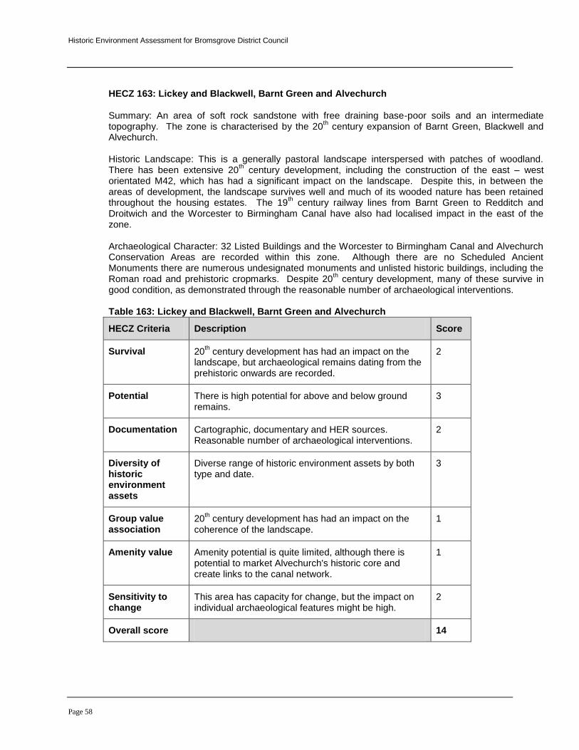
Historic Environment Assessment for Bromsgrove District Council
Page 58
HECZ 163: Lickey and Blackwell, Barnt Green and Alvechurch Summary: An area of soft rock sandstone with free draining base-poor soils and an intermediate topography. The zone is characterised by the 20
th century expansion of Barnt Green, Blackwell and
Alvechurch. Historic Landscape: This is a generally pastoral landscape interspersed with patches of woodland. There has been extensive 20
th century development, including the construction of the east – west
orientated M42, which has had a significant impact on the landscape. Despite this, in between the areas of development, the landscape survives well and much of its wooded nature has been retained throughout the housing estates. The 19
th century railway lines from Barnt Green to Redditch and
Droitwich and the Worcester to Birmingham Canal have also had localised impact in the east of the zone. Archaeological Character: 32 Listed Buildings and the Worcester to Birmingham Canal and Alvechurch Conservation Areas are recorded within this zone. Although there are no Scheduled Ancient Monuments there are numerous undesignated monuments and unlisted historic buildings, including the Roman road and prehistoric cropmarks. Despite 20
th century development, many of these survive in
good condition, as demonstrated through the reasonable number of archaeological interventions. Table 163: Lickey and Blackwell, Barnt Green and Alvechurch
HECZ Criteria Description Score
Survival 20th century development has had an impact on the
landscape, but archaeological remains dating from the prehistoric onwards are recorded.
2
Potential There is high potential for above and below ground remains.
3
Documentation Cartographic, documentary and HER sources. Reasonable number of archaeological interventions.
2
Diversity of historic environment assets
Diverse range of historic environment assets by both type and date.
3
Group value association
20th century development has had an impact on the
coherence of the landscape. 1
Amenity value Amenity potential is quite limited, although there is potential to market Alvechurch's historic core and create links to the canal network.
1
Sensitivity to change
This area has capacity for change, but the impact on individual archaeological features might be high.
2
Overall score 14

Historic Environment Assessment for Bromsgrove District Council
Page 59
HECZ 164: Batemans Green Summary: A gently rolling plateau of boulder clay with poorly draining soils and a pastoral land use. The settlement pattern is one of farmsteads and strings of wayside dwellings, associated with a moderate to high level of dispersal. Historic Landscape: The 1
st Edition OS map records an unusual sub circular field pattern, with
Highfields Farm, Oaks Farm and Malthouse Farm at its nucleus. This may represent the remains of an earlier infield–outfield system or, alternatively, may be associated with flax production. Flax production and tanning were significant local industries throughout the post medieval period and continued to be of importance until the end of the 19
th century. Comparison of the 1
st Edition OS Map and 2005 aerial
mapping indicates that this locally distinctive historic field pattern survives significantly intact. Archaeological Character: The majority of archaeological assets recorded, within this zone, date to the medieval period. Highfields Farm and Oaks Farm are former moated sites and ridge and furrow earthworks, to the north of Highfields Farm, indicate that during the medieval period the landscape was more open and, in part, under arable cultivation. Holly Farmhouse, dating to the 17
th century, is the only
Listed Building. Table 164: Batemans Green
HECZ Criteria Description Score
Survival A well preserved, locally distinctive, post medieval, historic field pattern. Surviving earthworks, under pasture.
3
Potential The preservation of below ground archaeology is unknown but the predominance of pasture may contribute to good survival.
2
Documentation HER, cartographic sources, no recorded archaeological field work
2
Diversity of historic environment assets
The majority of recorded historic environment assets are associated with medieval settlement and farming.
1
Group value association
A range of medieval historic environment assets, including moats and field systems, under pasture
3
Amenity value A reasonable PRoW network. Potential for promoting the historic development of the zone to neighbouring urban areas.
2
Sensitivity to change
A well preserved, locally distinctive enclosure pattern highly sensitive to change.
3
Overall score 16

Historic Environment Assessment for Bromsgrove District Council
Page 60
HECZ 165: The Heaths Summary: A gently rolling plateau of boulder clay with poorly draining soils. The majority of this zone is in Warwickshire. Historic Landscape: The 1
st Edition OS map records 18
th – 19
th century Parliamentary enclosure,
characterised by small to medium scale regular fields with straight boundaries, of former open heath, Land use is predominantly pastoral and tree cover comprises relics of ancient semi natural woodland and densely scattered hedgerow oaks. The settlement pattern is one of farmsteads and strings of wayside dwellings, associated with a moderate to high level of dispersal. Archaeological Character: The Scheduled Ancient Monument 'Berry Mound Iron Age hillfort' lies in the north of the zone. There are no designated Conservation Areas and few Listed Buildings. A moderate number of undesignated archaeological features are recorded. There have been several archaeological interventions in the north of the zone, around Berry Mound, and potential for further prehistoric archaeology is high. Archaeological works in the southern part of the zone have been limited, but the potential here is also considered high, given the intact nature of the landscape and the lack of cultivation. Table 165: The Heaths
HECZ Criteria Description Score
Survival Reasonably coherent 18th – 19
th century enclosed
landscape and known heritage assets. 2
Potential High potential for undesignated historic buildings, high potential for below-ground deposits due to a lack of arable farming.
3
Documentation Limited fieldwork, some HER data, cartographic and documentary sources.
1
Diversity of historic environment assets
A diverse range of assets from prehistoric earthworks to post-medieval farm buildings and WWII installations.
3
Group value association
It is likely that the historic farm buildings do form a coherent body of evidence, but more evidence is required. The post-medieval landscape is intact with minimal boundary loss.
2
Amenity value A good PRoW network. Potential for promoting the historic development of the zone to neighbouring urban areas, particularly around Berry Mound.
2
Sensitivity to change
A well preserved, locally distinctive landscape, highly sensitive to change.
3
Overall score 16

Historic Environment Assessment for Bromsgrove District Council
Page 61
HECZ 166: Headley Heath Summary: A gently rolling plateau of boulder clay with poorly draining soils. Historic Landscape: Historic mapping records a combination of 18
th – 19
th century planned enclosure,
characterised by small to medium scale regular fields with straight boundaries and earlier post medieval piecemeal enclosure, characterised by small to medium scale irregular fields with more sinuous boundaries. The small scale field pattern to the north east of the zone, around Hollywood Farm, may be associated with the post medieval flax industry. During the medieval period the landscape appears to have been dominated by open field cultivation and heath. The modern landscape is predominately pastoral and tree cover comprises relics of ancient woodland often associated with densely scattered hedgerow oaks. The settlement pattern is one of farmsteads and strings of wayside dwellings, associated with a moderate to high level of dispersal. Archaeological Character: The Scheduled moated site at Blackgrave Farm, lies in the southern part of the zone. There are a number of Listed Buildings and a small part of the Worcester to Birmingham Canal Conservation Area before it disappears into the Wasthill tunnel. There is a wide range of undesignated archaeological features including a Roman settlement on Ryknield Street, numerous fields of earthwork ridge and furrow and several moated sites. There have been few archaeological investigations here, but those that have been carried out have shown excellent below-ground preservation. Table 166: Headley Heath
HECZ Criteria Description Score
Survival Significantly intact historic landscape. A wide range of archaeological features and historic buildings.
2
Potential Excellent potential for multi period above and below ground archaeological remains.
3
Documentation Documentary, photographic and cartographic sources, HER data, limited fieldwork.
2
Diversity of historic environment assets
A diverse range of multi-period assets. 3
Group value association
A coherent post-medieval landscape with little boundary loss and medieval and post-medieval features.
2
Amenity value Reasonable potential to market the historic environment to neighbouring urban areas.
2
Sensitivity to change
This landscape is significantly intact and, in places, locally distinctive. It is highly sensitive to change.
3
Overall score 17

Historic Environment Assessment for Bromsgrove District Council
Page 62
HECZ 167: Wythall Heath Summary: A gently rolling plateau of boulder clay with poorly draining soils. Historic Landscape: The 1
st Edition OS map records late 18
th century, Parliamentary enclosure of
former heath and waste ground. Land use is pastoral and tree cover comprises relics of ancient woodland often associated with densely scattered hedgerow oaks. The settlement pattern is one of farmsteads and strings of wayside dwellings, associated with a moderate to high level of dispersal. Archaeological Character: There are no Scheduled Ancient Monuments or Conservation Areas and few Listed Buildings. A reasonable number of undesignated monuments survive, including a large number of pits. These pits may be associated with the flax industry, which dominated Wythall in the 19
th century.
RAF Wythall was opened in 1939 as the HQ of No. 6 Balloon Barrage Centre, responsible for the balloon defence of the southern part of Birmingham and Coventry. In July 1965 forty three acres, which included disused hangars, were sold by auction and in February 1967 a further 18 acres were sold and have now become Wythe Heath Mobile Homes Park. Archaeological works are limited to building recordings and a spot find of a Romano-British coin.
Table 167: Wythall Heath
HECZ Criteria Description Score
Survival Significant boundary loss and 20th century
development. Survival of known above and below ground features is limited.
1
Potential There is some potential, but it is difficult to gauge due to a lack of archaeological fieldwork. Potential for historic buildings is moderate.
2
Documentation Limited cartographic documentary and HER sources. Limited fieldwork
1
Diversity of historic environment assets
Diversity assessment is different due to the lack of fieldwork, but it is considered to be low or moderate.
1
Group value association
The historic buildings may form a coherent body of evidence, but more information is required.
1
Amenity value Limited potential for the promotion of the historic environment and historic landscape to surrounding urban areas.
1
Sensitivity to change
The degraded nature of the landscape means that it has capacity to change
1
Overall score 8

Historic Environment Assessment for Bromsgrove District Council
Page 63
HECZ 168: Holy Cross Summary: An area of soft rock sandstone, with sandy free draining soils and an intermediate, rolling topography. Historic Landscape: This is a large scale, predominantly arable, landscape, with a settlement pattern of discrete small villages or hamlets, associated with a low level of dispersal. The 1
st Edition OS map
records 18th – 19
th century Parliamentary enclosure, characterised by small to medium scale regular
fields with straight boundaries. This 18th – 19
th century landscape re-organisation is considered to have
overwritten an earlier piecemeal enclosure pattern. During the medieval period the landscape would have been open and predominantly arable. Tree cover comprises discrete plantations together with coverts and groups of trees. Comparison of the historic and modern OS maps indicates considerable loss of historic boundaries. There is also localised impact from modern development and the construction of the A449.
Archaeological Character: There are 42 Listed Buildings, the majority of which are located in the Conservation Areas of Holy Cross and Clent villages. There are no Scheduled Ancient Monuments. Several 18
th and 19
th century parks and designed landscapes are recorded, but any remains have been
much degraded by modern farming. There are a reasonable number of known archaeological assets. Some, including a water filled moat, survive well; others have been ploughed out/filled in. Very little archaeological fieldwork has been carried out throughout the zone. Table 168: Holy Cross
HECZ Criteria Description Score
Survival Good survival of historic buildings and monuments, but some landscape degradation.
2
Potential Historic buildings, in particular, have significant potential. The potential for below ground remains may have been compromised by ploughing in some areas, but is generally considered good.
3
Documentation A reasonable range of documentary, cartographic and HER sources. Limited fieldwork.
1
Diversity of historic environment assets
A reasonably diverse range of monument types, but generally of one time period.
2
Group value association
A relatively coherent post-medieval landscape, but some loss of landscape and monuments.
2
Amenity value A good PRoW network. Potential for promoting the historic environment, particularly the historic buildings.
2
Sensitivity to change
Parts of this landscape are sensitive to change, but there is capacity in other areas.
2
Overall score 14

Historic Environment Assessment for Bromsgrove District Council
Page 64
HECZ 169: Chaddesley Wood Summary: An area of intermediate, undulating topography, derived from a soft rock mixture of mudstones and sandstones, with free draining brown soils. Historic Landscape: This is a pastoral landscape with a post medieval piecemeal enclosure pattern, characterised by small to medium scale, irregular, fields with sinuous boundaries. The post medieval enclosure pattern is predominantly intact, although there has been significant boundary loss in places. The settlement pattern is characterised by farmsteads and wayside dwellings associated with a moderate to high level of dispersal. Tree cover comprises large relic patches of ancient woodland, notably Pepper Wood and Chaddesley Wood, often in association with densely scattered hedgerow oaks and streamside tree cover. Archaeological Character: The Scheduled Ancient Monument of Barrow Hill survives in the north-west and a number of Listed Buildings are scattered throughout the zone. There is a wide variety of undesignated historic environment assets including earthworks and below ground archaeology, along with a large number of traditional farm buildings. The woodland nature reserves provide an opportunity for the promotion of the historic environment. Table 169: Chaddesley Wood
HECZ Criteria Description Score
Survival Moderately intact historic landscape, excellent survival of earthworks.
2
Potential Significant potential for above and below ground archaeological features, including historic buildings. The pastoral landscape suggests that preservation may be considerable.
3
Documentation Cartographic, documentary and photographic sources, HER data, some fieldwork.
2
Diversity of historic environment assets
A diverse range of archaeological features from the prehistoric onwards.
3
Group value association
A coherent post-medieval landscape. 2
Amenity value A good PRoW network linking areas of ancient semi natural woodland. Good potential for the promotion of historic environment and landscape features.
3
Sensitivity to change
The landscape is highly sensitive to change, but some areas do have development capacity.
2
Overall score 17
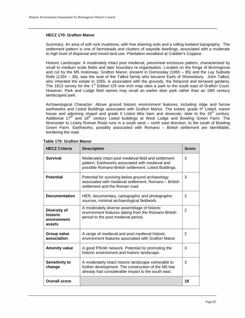
Historic Environment Assessment for Bromsgrove District Council
Page 65
HECZ 170: Grafton Manor Summary: An area of soft rock mudstone, with free draining soils and a rolling lowland topography. The settlement pattern is one of farmsteads and clusters of wayside dwellings, associated with a moderate to high level of dispersal and mixed land use. Plantation woodland at Cobbler's Coppice. Historic Landscape: A moderately intact post medieval, piecemeal enclosure pattern, characterised by small to medium scale fields and later boundary re-organisation. Located on the fringe of Bromsgrove and cut by the M5 motorway. Grafton Manor, present in Domesday (1065 – 85) and the Lay Subsidy Rolls (1334 – 36), was the seat of the Talbot family who became Earls of Shrewsbury. John Talbot, who inherited the estate in 1555, is associated with the grounds, the fishpond and terraced gardens. The 1813 survey for the 1
st Edition OS one inch map sites a park to the south east of Grafton Court.
However, Park and Lodge field names may recall an earlier deer park rather than an 18th century landscaped park. Archaeological Character: Above ground historic environment features, including ridge and furrow earthworks and Listed Buildings associated with Grafton Manor. The extant, grade II* Listed, manor house and adjoining chapel and grade II Listed tithe barn and dovecote, date to the 16
th century.
Additional 17th and 18
th century Listed buildings at West Lodge and Bowling Green Farm. The
Worcester to Lickey Roman Road runs in a south west – north east direction, to the south of Bowling Green Farm. Earthworks, possibly associated with Romano – British settlement are identifiable, bordering the road.
Table 170: Grafton Manor
HECZ Criteria Description Score
Survival Moderately intact post medieval field and settlement pattern. Earthworks associated with medieval and possible Romano-British settlement. Listed Buildings.
3
Potential Potential for surviving below ground archaeology associated with medieval settlement, Romano – British settlement and the Roman road
3
Documentation HER, documentary, cartographic and photographic sources, minimal archaeological fieldwork.
2
Diversity of historic environment assets
A moderately diverse assemblage of historic environment features dating from the Romano-British period to the post medieval period.
2
Group value association
A range of medieval and post medieval historic environment features associated with Grafton Manor
2
Amenity value A good PRoW network. Potential for promoting the historic environment and historic landscape.
3
Sensitivity to change
A moderately intact historic landscape vulnerable to further development. The construction of the M5 has already had considerable impact to the south east.
3
Overall score 18

Historic Environment Assessment for Bromsgrove District Council
Page 66
HECZ 171: Park Gate
Summary: An area of intermediate, undulating topography, derived from a soft rock mixture of mudstones and sandstones, with free draining brown soils. The land use is mixed and the settlement pattern one of farmsteads and wayside dwellings associated with a moderate to high level of dispersal. Historic Landscape: A post medieval, piecemeal enclosure pattern, characterised by small to medium scale fields with later boundary re-organisation. The field pattern to the north west of Warridge Lodge Farm is predominately intact; throughout the remainder of the zone extensive 20
th century field
amalgamation has significantly degraded historic landscape character. Located on the fringe of Bromsgrove and cut by the M5 and M42 motorways. Extant ridge and furrow earthworks, to the south east of Woodcote Manor Farm and north of Warridge Lodge Farm, are indicative of medieval open field cultivation. Archaeological Character: Medieval earthworks associated with moated sites at Woodcote Manor and Warridge Lodge Farm. 8 listed buildings dating from the 17
th to 19
th centuries. A ring ditch and
enclosures, of unknown date, recorded on aerial photographs. Table 171: Park Gate
HECZ Criteria Description Score
Survival A significantly degraded post medieval, piecemeal, enclosure pattern to the east of the zone. A more intact post medieval enclosure pattern and evidence of medieval settlement and farming to the west.
2
Potential Potential for medieval, and possibly earlier, below ground archaeology.
3
Documentation HER, documentary, cartographic and photographic sources, minimal archaeological fieldwork.
2
Diversity of historic environment assets
A range of medieval and post medieval historic environment features. Below ground archaeology of possible earlier date.
2
Group value association
Historic environment features associated with medieval settlement and farming. Post medieval built heritage dating from the 17
th to 19
th centuries.
2
Amenity value A good PRoW network. Moderate potential for promoting the historic environment and historic landscape.
3
Sensitivity to change
Moderate potential to accommodate development to the east of the zone.
2
Overall score 16

Historic Environment Assessment for Bromsgrove District Council
Page 67
HECZ 172: Hopwood Summary: An area of intermediate, undulating topography, derived from a soft rock mixture of mudstones and sandstones, with free draining, mixed brown soils.
Historic Landscape: The 1
st Edition OS map records 18
th – 19
th century re-organisation of an earlier
piecemeal enclosure pattern, characterised by small to medium scale sub regular fields with a mixture of straight and more sinuous boundaries and possible planned private enclosure around the grade II Listed, 15
th century, Cofton Hall. Land use is predominantly pastoral and the settlement pattern is
characterised by farmsteads and wayside dwellings associated with a moderate to high level of dispersal Comparison of the 1
st Edition and modern OS maps indicates moderate boundary loss and
aerial photographs suggest that a reasonable proportion of surviving hedgerows might be in poor condition. The motorway has had a significant impact in the south of the zone. Archaeological Character: The Worcester to Birmingham Canal Conservation Area runs centrally through this zone and includes The Upper and Lower Bittle Reservoirs which were constructed in 1836. There are 29 historic buildings recorded, 14 of which are Listed. There are no Scheduled Ancient Monuments, but there are a wide range of undesignated assets including earthworks and buried remains. Archaeological works are limited to building surveys with the exception of an evaluation off Old Rectory Lane. This evaluation unearthed isolated Roman finds, but discovered no evidence of occupation. Table 172: Hopwood
HECZ Criteria Description Score
Survival A reasonably coherent historic landscape, albeit with some boundary loss. Some impact from modern development. Archaeological remains and historic buildings have reasonable survival.
2
Potential There is potential for further above and below ground archaeological features.
2
Documentation Limited documentary, cartographic and HER sources. Limited fieldwork.
1
Diversity of historic environment assets
Reasonably diverse medieval and post-medieval features, but no earlier archaeology known at present.
2
Group value association
No strong coherence, but limited archaeological fieldwork could mean that this does exist.
1
Amenity value Moderate PRoW network. Potential for promoting the historic environment along canal walks.
2
Sensitivity to change
Parts of this landscape are sensitive to change, but there is capacity.
2
Overall score 12
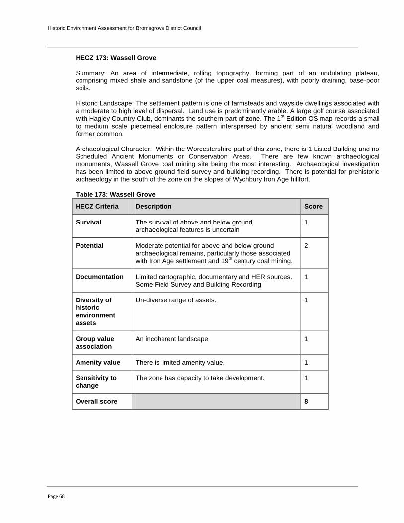
Historic Environment Assessment for Bromsgrove District Council
Page 68
HECZ 173: Wassell Grove Summary: An area of intermediate, rolling topography, forming part of an undulating plateau, comprising mixed shale and sandstone (of the upper coal measures), with poorly draining, base-poor soils. Historic Landscape: The settlement pattern is one of farmsteads and wayside dwellings associated with a moderate to high level of dispersal. Land use is predominantly arable. A large golf course associated with Hagley Country Club, dominants the southern part of zone. The 1
st Edition OS map records a small
to medium scale piecemeal enclosure pattern interspersed by ancient semi natural woodland and former common. Archaeological Character: Within the Worcestershire part of this zone, there is 1 Listed Building and no Scheduled Ancient Monuments or Conservation Areas. There are few known archaeological monuments, Wassell Grove coal mining site being the most interesting. Archaeological investigation has been limited to above ground field survey and building recording. There is potential for prehistoric archaeology in the south of the zone on the slopes of Wychbury Iron Age hillfort. Table 173: Wassell Grove
HECZ Criteria Description Score
Survival The survival of above and below ground archaeological features is uncertain
1
Potential Moderate potential for above and below ground archaeological remains, particularly those associated with Iron Age settlement and 19
th century coal mining.
2
Documentation Limited cartographic, documentary and HER sources. Some Field Survey and Building Recording
1
Diversity of historic environment assets
Un-diverse range of assets. 1
Group value association
An incoherent landscape 1
Amenity value There is limited amenity value. 1
Sensitivity to change
The zone has capacity to take development. 1
Overall score 8

Historic Environment Assessment for Bromsgrove District Council
Page 69
HECZ 174: Tutnall and Finstall Summary: An area of soft rock sandstone (triassic) with free draining, sandy, base-poor soils and an intermediate undulating topography. The zone is on the eastern fringe of Bromsgrove and is bisected by the Worcester and Birmingham Canal. Historic Landscape: The 1
st Edition OS map records a combination of post medieval piecemeal and
later, possibly 19th century, planned enclosure. Comparison of the historic and modern OS maps
indicates that the historic field boundary pattern survives moderately intact. Land use is predominantly pastoral and settlement consists of the villages of Finstall and Tutnall nestled in a landscape of farmsteads and strings of wayside dwellings, associated with a moderate to high level of dispersal.
Archaeological Character: A large number of historic and Listed Buildings survive within the zone (149), the majority of which relate to the canal and Tardebigge Wharf. The canal Conservation Area includes the wharf and reservoir. There are no Scheduled Ancient Monuments within the zone, however, there is a diverse range of undesignated monuments including earthwork moats, ridge and furrow and quarries. Archaeological fieldwork has been limited, but where carried out, has produced good results. Table 174: Tutnall and Finstall
HECZ Criteria Description Score
Survival Moderately intact post medieval enclosure pattern. Historic buildings dating from the 15
th to 19
th century.
Industrial archaeology.
2
Potential Potential for above and below ground historic environment features from all periods.
3
Documentation HER, documentary, cartographic and photographic sources, reasonable amount of archaeological fieldwork.
2
Diversity of historic environment assets
A moderately diverse assemblage of recorded historic environment features mostly dating to the medieval and post medieval periods.
2
Group value association
A coherent post-medieval landscape, particularly the quarries, lime kilns and industry associated with the canal.
3
Amenity value Moderate PRoW network. Potential for promoting the historic environment along canal walks.
2
Sensitivity to change
A moderately intact historic landscape vulnerable to further development to the south of Bromsgrove.
2
Overall score 16

Historic Environment Assessment for Bromsgrove District Council
Page 70
HECZ 175: Stoke Prior Summary: An area of soft rock, comprising mixed mudstones and sandstones producing a rolling, lowland topography and free draining brown soils. Historic Landscape: The 1
st Edition OS map records a combination of post medieval piecemeal and
later, possibly 19th century, planned enclosure, notably around Stokefarm Reformatory and Tan
House. Comparison of the historic and modern OS maps indicates that the historic field boundary pattern survives moderately intact. Stoke Prior is on the southern fringe of Bromsgrove and is bisected by the River Salwarpe, Birmingham and Gloucester Railway and Worcester and Birmingham Canal. 20
th century development is recorded to the south of Shaw Lane. The Grange, now Avoncroft College
and Museum of Buildings, is shown as a small park on the 1st Edition OS map.
Archaeological Character: The Stoke Works, founded by J Corbett in 1828 and purchased by the Salt Union in 1888, is considered one of the most complete and compact salt works in the world. The HER records a Grade I Listed, 12
th century, parish church, 10 Listed Buildings dating from the 15
th to 19
th
centuries and post medieval mills (now predominately lost), including needle scouring mills and corn mills, along the Salwarpe and Sugar Brook. The conjectural route of the Bromsgrove to Hanbury, Roman road, runs centrally through the zone. Table HECZ 175: Stoke Prior
HECZ Criteria Description Score
Survival Moderately intact post medieval enclosure pattern. Listed buildings dating from the 15
th to 19
th century.
The Stoke Works.
2
Potential Potential below ground historic environment features associated with deposits along the line of the Roman road and the Salwarpe and around the church.
3
Documentation HER, documentary, cartographic and photographic sources, no archaeological fieldwork.
2
Diversity of historic environment assets
A moderately diverse assemblage of recorded historic environment features dating to the Romano-British, medieval and post medieval periods.
2
Group value association
A limited range of surviving, above ground, historic environment features.
1
Amenity value Moderate PRoW network. Potential for promoting the historic environment along river and canal walks.
2
Sensitivity to change
A moderately intact historic landscape vulnerable to further development to the south of Bromsgrove.
3
Overall score 15

Historic Environment Assessment for Bromsgrove District Council
Page 71
HECZ 176: The Black Country Urban Area. Summary: This zone is characterised by the 20
th century urban sprawl that is the southern edge of the
West Midlands Conurbation. Most of this zone is outside Worcestershire, with just small areas of Rubery and Cofton Hackett being within the County. Historic Landscape: There is little left of the historic landscape in the Worcestershire part of the zone, which comprises 20
th century semi-detached housing on large estates. The road network survives in
places and the course of the Callow Brook remains unchanged. Archaeological Character: Gannow Green Scheduled moated site lies on the County boundary. There are no Listed Buildings or Conservation Areas within the Worcestershire part of this zone. Unlisted historic buildings include The Cofton Aeroworks, formerly The Austin Car Company, which produced various aircraft at Cofton during WWII. After WWII it became a Royal Navy Armament Depot until about 1950. With the exception of the monuments immediately adjacent to Gannow Green moated site, there are few archaeological features surviving. Table 176: The Black Country Urban Area
HECZ Criteria Description Score
Survival A significantly degraded historic landscape with minimal individual features. Some unlisted historic buildings.
1
Potential There is limited potential for further archaeology given the extensive urban development, but pockets of below ground archaeology might exist. Potential, additional historic buildings.
1
Documentation Limited cartographic and documentary sources. 1
Diversity of historic environment assets
An un-diverse range of features or periods. 1
Group value association
There is little coherence. 1
Amenity value There is limited potential. 1
Sensitivity to change
This area has capacity to change. 1
Overall score 7

Historic Environment Assessment for Bromsgrove District Council
Page 72
HECZ 177: Sandstone Estate Lands Summary: An area of soft sandstone with an intermediate, undulating topography and impoverished sandy soils. Historic Landscape: A predominantly arable landscape with an ordered 18
th – 19
th century, regular,
enclosure pattern. There is also an ordered pattern of large plantations, together with parkland and belts of trees. The settlement pattern is one of small villages and hamlets, associated with a low level of dispersal. Comparison of the historic and modern OS maps indicates that this 18
th – 19
th century
landscape is significantly intact, although there has been some boundary loss. Archaeological Character: There is a Conservation Area in the village of Churchill and 17 Listed Buildings scattered throughout the zone. The Scheduled Ancient Monument of Baches Forge is located in the centre of the zone and there are a significant number of unlisted buildings and above and below ground, multi period archaeological features. The HER records a large number (81) of archaeological activities. Table 177: Sandstone Estate Lands
HECZ Criteria Description Score
Survival Significantly intact 18th – 19
th century enclosed
landscape. Excellent above and below ground survival. 3
Potential The large number of surface finds recovered indicates potential below ground, multi period, remains. However, the extent of cultivation indicates that preservation may be poor.
2
Documentation Excellent. Documentary, cartographic, HER data and a wide range of archaeological works.
3
Diversity of historic environment assets
A diverse range of multi-period assets. 2
Group value association
A coherent post-medieval landscape. 3
Amenity value A good PRoW network and potential to market assets such as Baches Forge and the historic built environment.
2
Sensitivity to change
Generally highly sensitive, but some areas have capacity for change.
2
Overall score 17
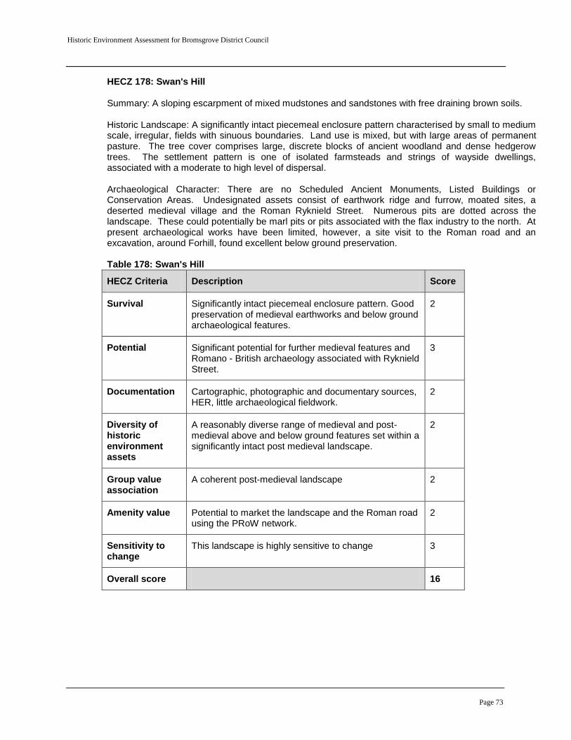
Historic Environment Assessment for Bromsgrove District Council
Page 73
HECZ 178: Swan's Hill Summary: A sloping escarpment of mixed mudstones and sandstones with free draining brown soils. Historic Landscape: A significantly intact piecemeal enclosure pattern characterised by small to medium scale, irregular, fields with sinuous boundaries. Land use is mixed, but with large areas of permanent pasture. The tree cover comprises large, discrete blocks of ancient woodland and dense hedgerow trees. The settlement pattern is one of isolated farmsteads and strings of wayside dwellings, associated with a moderate to high level of dispersal.
Archaeological Character: There are no Scheduled Ancient Monuments, Listed Buildings or Conservation Areas. Undesignated assets consist of earthwork ridge and furrow, moated sites, a deserted medieval village and the Roman Ryknield Street. Numerous pits are dotted across the landscape. These could potentially be marl pits or pits associated with the flax industry to the north. At present archaeological works have been limited, however, a site visit to the Roman road and an excavation, around Forhill, found excellent below ground preservation. Table 178: Swan's Hill
HECZ Criteria Description Score
Survival Significantly intact piecemeal enclosure pattern. Good preservation of medieval earthworks and below ground archaeological features.
2
Potential Significant potential for further medieval features and Romano - British archaeology associated with Ryknield Street.
3
Documentation Cartographic, photographic and documentary sources, HER, little archaeological fieldwork.
2
Diversity of historic environment assets
A reasonably diverse range of medieval and post-medieval above and below ground features set within a significantly intact post medieval landscape.
2
Group value association
A coherent post-medieval landscape 2
Amenity value Potential to market the landscape and the Roman road using the PRoW network.
2
Sensitivity to change
This landscape is highly sensitive to change 3
Overall score 16

Historic Environment Assessment for Bromsgrove District Council
Page 74
Appendix 2:
Historic Landscape Character statement for the Bromsgrove urban area
Historic Environment Assessment for Bromsgrove District Council
Page 75
Historic Landscape Character background
As a result of a 1991 Government White Paper, English Heritage sponsored a series of mostly county-based Historic Landscape Characterisation (HLC) projects, the first having been undertaken in Cornwall in 1994. The main object of study by HLC is the present landscape as created by human action in the past and our perception of it in the present. Many HLC projects have now been completed across the country, with the original methodology evolving through practice and reflecting changes in technology and local variations, although each subsequent development has retained the core structure and principals of the initial approach. The Worcestershire HLC project commenced in 2006 and the overall aim of the project is to digitally record and map the current historic landscape character of Worcestershire, using a range of sources, including modern and historic maps and aerial photographs. The end result of the HLC project will be a series of contiguous shapes that share common similarities, as defined by a thesaurus of Historic Landscape Character Types. The project does not seek to answer every question about the historic landscape, but focuses on one important factor: surviving time-depth, the legibility of the past in the present landscape. For HLC, time-depth is the way in which former landscape character, patterns and change can still be seen in the present-day landscape, and comprise of elements such as residential and civic settlement, industry, land-use and the mixture of enclosed and unenclosed lands, communications, woodlands, orchards and parklands. The HLC dataset provides information, not judgements, identifying traces of the past within the modern landscape, recognising that essentially the landscape has its present character because of the changes it has undergone over the past millennia. HLC data can help ensure that the historic dimension in the landscape is taken into account alongside those of the natural environment when proposed changes are considered, to better inform management strategies and conservation issues at local, regional and national levels, and to provide an evidence base for the purposes of spatial planning. In addition, the HLC project results will provide a platform for past-oriented research and its results engage and inform the County’s communities about their own local distinctive historic landscape. Before Historic Landscape Characterisation, no satisfactory method existed for identifying the historic character of the whole landscape. HLC establishes a holistic approach to the historic landscape, providing a base-map for a better appreciation of separate places. However, HLC is not concerned to preserve the landscape unchanged, or to return it to some past point in its evolution. Nor is HLC a means to protect the past landscape, but rather assist the management of the present landscape's history and origins, and address how future change can sensitively respect local character and diversity.
Bromsgrove Urban Area Bromsgrove Urban Area was chosen as pilot study area B in the Worcestershire Historic Landscape Characaterisation (HLC) Pilot Study. The pilot study area was reduced in size

Historic Environment Assessment for Bromsgrove District Council
Page 76
from that originally proposed in the Worcestershire HLC Project Design (Historic Environment and Archaeology Service. 2006. 18-19). The urban area of Bromsgrove comprises a large area of 20
th century housing and industrial development around the
medieval and post medieval core of the old town. The latter lies at a height of between 95m and 80m OD in the valley of the Spadesbourne Brook, which runs from the Lickey Hills to the north east, of the town, eventually joining the River Salwarpe to the south west. The underlying geology consists of Triassic Bromsgrove Sandstone (Hereford and Worcester County Council. 1996).
Bromsgrove HLC: Previous Character based on the 1840 Tithe map
The HLC Previous Character of Bromsgrove based on the 1840 Tithe Map (WR 6378/WR 6372 from WRO BA1572 X760/46) (Figure 28) documents field systems at that time consisting of mainly post-medieval piecemeal enclosure, possibly of the former medieval open field system. There are also possible areas of Parliamentary Enclosure, but this is tentative as the 1802 Parliamentary Enclosure map no longer survives and areas of meadow survive adjacent to watercourses. In 1840, Sidemoor village is still physically separated from Bromsgrove and the remaining settlement pattern is predominantly one of isolated farms and clusters of wayside dwellings.
Crown copyright. All rights reserved. Worcestershire County Council 100015914. For reference purposes only. No further copies may be made.

Historic Environment Assessment for Bromsgrove District Council
Page 77
Bromsgrove HLC: Previous Character based on the 1st Edition OS map (1:2500 County Series 1885-1886) Using the 1st Edition OS map (1:2500 County Series 1885-1886), little landscape change has occurred since the 1840 Tithe map of Bromsgrove was produced (Figure 29). Some field amalgamation has taken place on the fringes of settlement and there has been a decline in meadowland surviving next to watercourses. The historic town is still separate from Sidemoor village, however, and the remaining settlement pattern is still one of scattered isolated farmsteads and wayside dwellings.

Historic Environment Assessment for Bromsgrove District Council
Page 78
Bromsgrove’s HLC Current Character based on OS Mastermap 2007/8
The Worcestershire HLC mapping of pilot study area B records the significant scale of landscape change in and around Bromsgrove parish since the 1950s and 1960s (Figure 30) that has largely overwritten the previous historic landscape characters. Most of this landscape change has occurred as a result of modern urban expansion, and consequently there is a related increase in the range of Civic (CVL) HLC types such as hospitals and schools, as well as Ornamental, Parkland and Recreational (OPR) HLC types such as playing fields, golf courses and sports grounds. On the fringes of settlement, there have been further field amalgamation and the reorganisation of numerous fields in response to the construction of the M5 and M42 motorways.
Crown copyright. All rights reserved. Worcestershire County Council 100015914. For reference purposes only. No further copies may be made.

Historic Environment Assessment for Bromsgrove District Council
Page 79
Vanessa Clarke and Steve Crowther
Crown copyright. All rights reserved. Worcestershire County Council 100015914. For reference purposes only. No further copies may be made.

Historic Environment Assessment for Bromsgrove District Council
Page 80
Historic Landscape Character descriptions that apply to Bromsgrove BROAD TYPE: DESIGNED LANDSCAPE (ORNAMENTAL, PARKLAND AND RECREATIONAL Areas of land that can be identified as having a predominantly designed aspect to them. OPR3 Public Open Space Areas of land that generally have some degree of formal landscaping and are managed for public recreation or sport, usually in an urban context comprising amenity areas such as playing fields and public parks and may include ornamental lakes, flower beds, tennis courts and play areas etc. Also includes land termed ‘Recreation Area’. These will mostly be identifiable from Ordnance Survey mapping and from the Worcestershire Phase 1 Habitat Mapping (search on management code GL12 which identifies urban parks and sports fields and GL1 –amenity grassland). Time-depth: Current &/or previous type Those which still appear to be used as public open space will be recorded as ‘Current’; however a number may have been given over to housing and the built environment and thus will be recorded as ‘Previous types’. Most likely to have originated in the late 19th and early 20th centuries (period of origin will be recorded via a drop down box in the Access database and a tick-box will signify whether or not the area of ‘public open space’ appears on the 1st Edition OS mapping).
OPR6 Golf Course Areas identified as golf courses as symbolised or annotated on current Ordnance Survey mapping. Golf courses may be identified by their distinctive morphology of links, with bunkers and associated woodland strips. In addition, a check can be made against the Worcestershire Phase 1 Habitat Mapping data (search on management field using codes GL11 – Golf Course) The majority have been created in the late 20th century reflecting the increase in leisure and recreation, although some may have earlier origins i.e. converting existing Parks and Gardens for the purposes of leisure. Time-depth: Current &/or previous type The majority have been created in the late 20th century reflecting the increase in leisure and recreation, although some may have earlier origins i.e. converting existing Parks and Gardens for the purposes of leisure. A few golf courses will date back to the late 19th century and the map source will indicate the date of the golf course. Period of origin will also be recorded via a drop down box in the Access database and a tick-box will signify whether or not the ’golf course’ appears on the 1st Edition OS mapping.
OPR7 Sports Ground Modern sports ground/field and stadia identified as such from current Ordnance Survey mapping but will be restricted to those of a larger size (>1 hectare). The mapping of smaller sports fields/ areas associated with schools will not be recorded. Sports grounds are where one

Historic Environment Assessment for Bromsgrove District Council
Page 81
or more sports may be played e.g. tennis courts, bowling greens and also includes land defined as ‘Playing Field’ or stadiums where sport is played professionally. These will mostly be identifiable from Ordnance Survey mapping and from the Worcestershire Phase 1 Habitat Mapping (search on management code GL12 – identifies urban parks and sports fields). Time-depth: Current &/or previous type Period of origin will be recorded via a drop down box in the Access database and a tick-box will signify whether or not the ‘Sports Ground’ appears on the 1st Edition OS mapping).
OPR11 Cemetery Areas identified as formally laid out cemeteries from the current and previous Ordnance Survey mapping; these will generally include the larger municipal cemeteries and not small church cemeteries. They will typically date to the 19th and 20th centuries. OS mapping can be checked against the Worcestershire Phase 1 Habitat Mapping data (search under management code UA41 – ‘Churchyards and Cemeteries’). Time-depth: Current &/or previous type Period of origin will be recorded via a drop down box in the Access database and a tick-box will signify whether or not the area of ‘cemetery’ appears on the 1st Edition OS mapping.
BROAD TYPE: CIVIC AND COMMERCIAL Areas of land that have a predominantly civil or commercial use and are distinct on a landscape scale i.e. large contiguous areas which form characteristic units that have a distinct impact on and have clearly influenced the landscape, forming patterns perceptible at a broad scale (>1 hectare).
CVL3 Educational Establishment Building complex used as a place for public education, including schools, colleges and universities as marked on the OS 1st Edition and/or modern mapping, usually named and annotated as such. Some modern schools may be a reuse of former Parkland. Schools of historic origin may be reused for example as private dwellings, commercial etc. Time-depth: Current &/or previous type Most will be modern buildings dating from the 1950’s onwards but many schools have their origins in the 19th century as local schools and workhouses (however, the majority of these will not be visible at a landscape scale). Period of origin will be recorded via a drop down box in the Access database and a tick-box will signify whether or not the ’school’ appears on the 1st Edition OS mapping
CVL4 Hospital

Historic Environment Assessment for Bromsgrove District Council
Page 82
This HLC type will only include areas of large hospital complexes as marked on the OS 1st Edition and/ or modern mapping, usually named and annotated as such. Some modern hospitals may be a reuse of former Parkland. Time-depth: Current &/or previous type Thus may occur in any time horizon within the database. Period of origin will be recorded via a drop down box in the Access database and a tick-box will signify whether or not the ’hospital’ appears on the 1st Edition OS mapping.
CVL6 Hotel Generally, large hotel complexes, that are clearly marked on current Ordnance Survey mapping. These are often found outside or on the edge of major settlements. Time-depth: Current &/or previous type Period of origin will be recorded via a drop down box in the Access database and a tick-box will signify whether or not the ’hotel’ appears on the 1st Edition OS mapping
CVL7 Commercial and Retail Areas of large warehouse stores, commercial areas and retail parks marked as such on the Ordnance Survey mapping. These areas may be found on the edge of urban areas and have large car parks. Time-depth: Current &/or previous type Period of origin will be recorded via a drop down box in the Access database and a tick-box.
CVL8 Leisure Centre Areas marked as leisure centres, swimming pools or other leisure activity areas on current Ordnance Survey mapping. Time-depth: Current &/or previous type
Period of origin will be recorded via a drop down box in the Access database. BROAD TYPE: INDUSTRIAL AND EXTRACTIVE Areas of land that have been identified as having a predominantly industrial component or are related to the extractive industries. The latter usually have a greater impact upon the landscape than the former. The extractive sites are mapped directly from the current and previous OS mapping and using the Aggregates Sustainability Levy Funded (ASLF) project data. Those landscape features which represent the after-use of quarries i.e. landfill sites or recreational lakes (e.g. WVF2), are mapped as such within their respective Broad Groups and not as ‘filled-in quarries’ etc. Their origin/former use as an extractive site will be flagged up using the ‘Previous type’. The status of the site i.e. inactive or active etc. and whether it is pre or post 1st Edition OS mapping and period of origin will also be recorded via drop-down boxes within the Access database.

Historic Environment Assessment for Bromsgrove District Council
Page 83
Modern large-scale industry is mostly distinguished from smaller industrial complexes and factories by being named on OS current mapping as oil refineries, power stations etc and by their large scale. Industrial complexes and factories situated within urban areas are recorded as modern expansion of settlements.
IND7 Mill Complexes Groups of mill complexes situated along a rivers edge. These will be identifiable from current and previous OS mapping and the HER. Time-depth: Current &/or previous type
IND6 Utilities Industrial areas, which can be identified as related to the utility industry. This type will generally include electricity power stations, large sewage and water treatment works to smaller utilities such as Gas Works and Water Towers. Most of this modern large-scale industry will be named on the current OS mapping as power stations etc. and be identified by their large scale. Check against the Worcestershire Phase 1 Habitat Mapping data (search under management code ‘UA2 –Industrial/Commercial’) Time-depth: Current &/or previous type Most of the utility infrastructure was constructed in the mid to late 20th century but will include earlier survivals dating from the Victorian period and early 20th century.
BROAD TYPE: WOODLAND Areas of land that are predominantly covered by trees. Morphology e.g. sinuous and woodland type e.g. will be recorded via drop-down boxes within the Access database.
WDL3 Recent Woodland (Secondary) These are either planted or semi-natural woods with sinuous boundaries, which have not been continuously wooded since the year 1600AD but have acquired a tree cover on sites thought to have been former heathland, open fields or grazing land. Such woodland may arise by planting or through natural development of woodland on abandoned or ungrazed land. These sites may show similarities to ancient woodland depending on their age, their proximity to ancient sites and the presence of natural features (streams, ponds etc), although generally speaking their biological diversity is not as great as that of ancient woodland. Woodland identified by the Ordnance Survey mapping and Worcestershire Phase 1Habitat Mapping as being broad-leaved, mixed or coniferous and which have predominantly sinuous boundaries but is not designated as ‘Ancient’ by either the English Nature or Day Survey. The different woodland types will be recorded in a drop down menu within the Access database i.e. broadleaved, mixed or coniferous. Broad-leaved woodland with sinuous boundaries, whilst not being designated as ‘Ancient’ woodland may potentially contain fragments of older woodland. Mixed woods whilst also not being designated as ‘Ancient’ woodland may represent stands of older woodland colonised by or partially planted with conifers. Coniferous woodlands with predominantly sinuous boundaries are likely to represent plantations. Time-depth: Current &/or previous type

Historic Environment Assessment for Bromsgrove District Council
Page 84
Will be identified as a previous type where felled since the OS 1st Edition map.
WDL6 Woodland Plantation All managed and planted woodlands (>1ha) mostly with a rectilinear form and straight boundaries, which post-date and lie outside the boundaries of the Ancient Woodlands (as identified by English Nature), they are often planted as commercial concerns or as ornamental woodlands (in association with informal parklands) or maybe fox coverts; the latter may be associated with Planned Enclosure fields. Where less than 1 hectare in size, these will be recorded as part of the dominant field system or other broad group e.g. Parkland using a tick-box. Tree-type will be recorded via a drop down box. Check against the Worcestershire Phase 1 Habitat Mapping (search on management code WF2- ‘Plantation’). The commercial plantations (i.e. planted to generate income) are characterised by blocks of trees that are all of one age often consisting of only one or two species of tree, within each regular block of planting, very often the species planted were non-native species and in particular conifer, but many plantations were of broadleaves such as oak or beech and often plantations were a of mix conifer and broadleaves. They usually die when felled and are replaced by a new plantation. This forms the basis of modern forestry and most have been planted in the 20th century and thus will be absent from the 1st Edition OS mapping (recorded via a tick box in the Access database). Growth in earlier and usually smaller sized woodland plantation with a rectilinear form is noted in foxhunting country from the 18th century onwards where a number of woodland coverts proliferate and were also commonly placed on commons, waste and heaths. These form an important part of hunting landscape and will mostly be distinguished from commercial plantation by their appearance on 1st Edition OS mapping (via a tick box) and period. This category also provides for shelterbelts, a linear stand of trees, planted to provide a windbreak for settlement, livestock or crops. This group is of variable date, so mapping sources will indicate this. These woodlands are of either replanting of cleared woodlands, or inter-planting within existing woodland or new planting within pre-existing fields, or new shelterbelts, or new areas of woodland with no prior antecedent (i.e. not replanted ancient woodlands). They may also have been planted and felled between First Edition to modern mapping.
Time – depth: Current &/or previous type Woodlands, still surviving are ‘Current’ whereas those felled are a ‘Previous type’. Thus may occur in any time horizon within the database. Normally date from the 18th to 20th century. Deliberate plantations were very rare before the 17th century.
BROAD TYPE: ORCHARDS AND ALLOTMENTS Areas of land that can be identified as some form of small-scale horticulture i.e. for the production of small fruit, vegetables, mushrooms, hardy nursery stock, container-grown plants, bulbs and flowers grown in the open and glasshouse area. This type includes non-commercial

Historic Environment Assessment for Bromsgrove District Council
Page 85
and commercial orchards and market-garden smallholdings as well as modern nurseries and garden centres. There may well be more extensive areas of horticulture in small fields but is not readable readily Identifiable as such. Thus this general category is very likely to be under-represented. Whether present or not on the 1st Edition OS mapping and Post-War mapping is recorded in the Access database via drop-down boxes.
ORC1 Pre-1880’s Orchards This HLC type defines orchards that are marked on both the 1st Edition OS mapping and the modern base map using cartographic symbology or annotation. Orchards are either large commercial concerns or small orchards attached to larger homes or estates. In the case of the latter, the field edge may remain consistent through time, but use within can vary e.g. may start as an orchard, then be cleared, then be replanted as an orchard. The earlier commercial orchards appear to be defined by the pre-existing field systems in which they are planted. Later commercial orchards often remove existing boundaries and redefine field edges with new boundaries. Time-depth: Current &/or previous type As a land use may be current or a ‘Previous type’ and may be defined by a prior or contemporary enclosure pattern. If a ‘Previous type’, will be recorded on the 1st Edition OS mapping, but will have been grubbed up since then. Check by searching on Worcestershire Phase 1 Habitat Mapping management code WG6 – ‘Old Orchard grassland’ to potentially indicate a ‘Previous type’ where the unimproved grassland but not the orchard survives and using keyword ‘Orchard Remnant’ within grassland category. Thus may occur in any time horizon within the database. Orchards were a common feature of the medieval landscape (Rackham, 1990) although the earliest map evidence for orchards in Worcestershire is likely to be estate maps dating from the 17th and 18th centuries. However, there is unlikely to be sufficient and consistent map evidence from before the 19th century.
ORC2 Post 1880’s Orchards Orchards that are mapped directly from the current OS mapping (identifiable by the presence of orchard or glasshouse symbols) but absent from the 1st edition suggest potentially a more modern origin. It can be demonstrated that the orchard must been planted over the last 120 years, albeit possibly as replanting on the site of a former orchard after a gap. Check against using the Worcestershire Phase 1 Habitat Mapping (search under habitat code ‘Orchard – FT0, FT1, FT11, FT12, FT13, FT14, FT15, FT1Z, FT2, FT21’ or management using codes CL3, CL31, OM1-4) Time-depth: Current &/or previous type
ORC3 Nurseries/ Garden Centre

Historic Environment Assessment for Bromsgrove District Council
Page 86
Modern nurseries with glasshouses and garden centres. These are identified from modern Ordnance Survey mapping by glasshouse symbols and are often named. The area mapped includes the associated curtilage of the glasshouse and grounds. Check against the Worcestershire Phase 1 Habitat Mapping (search under management code using CL2 ‘Market Garden and Horticulture’). These sites are usually large commercial areas of market gardening, with associated glasshouses. In Worcestershire they mostly occur within the Vale of Evesham. Time-depth: Current &/or previous type Survives as ‘Current’ type or the glass houses have been demolished with the reuse of the land parcels i.e. a ‘Previous type’. Thus they may occur in any time horizon within the database.
ORC4 Allotment Small parcels of land rented/ leased by individuals to grow crops/ vegetables etc. Their mapped form may differ according to period of map, either by symbology and/ or annotation. On the 1st Edition OS mapping they are identified by characteristic small parcels often with diagonal markings, at times making a ‘herringbone’ pattern and may also be annotated as ‘allotments’ or ‘gardens’. At this date they are often close to settlement. Check against the Worcestershire Phase 1 Habitat Mapping (search under management using code UA33 – ‘Allotments’). Forms and shapes may differ according to the period they were set out, and they may be relatively small strips or large areas. The outline of these allotment areas may be defined by prior or possibly contemporary field systems.
Allotments represent more a form of land use rather than a specific morphological type. A drop down box in the Access database will record those allotments laid out prior to the 1st Edition OS mapping and those which were laid out during or post Second World War. Time-depth: Current &/or previous type Allotments may date from prior to the First Edition to 20th century in date. Their form may be dictated by a prior or contemporary enclosure pattern, as given on 1st Edition OS mapping. The 19th century saw the creation of allotments for communal gardening. Although generally regarded as 20th century in date, the pressure for urban allotment provision increased as a result of the spread of closely packed housing with small gardens. New Allotments were also created by wartime provisions and as part of new 20th century settlements.
BROAD TYPE: COMMUNICATIONS Areas of land that are related to some form of transportation. Most major transport systems will be of known dates of origin (as specified in secondary literature and HER records). A drop-down menu, as for all other HLC types will record period of origin
COM2 Motorways Motorways as marked on modern Ordnance Survey mapping. These will have occurred post 1960 and often dramatically alter the landscape, having a large impact. This type also includes associated infrastructure such as Service Stations, usually comprising restaurant and garage,
Historic Environment Assessment for Bromsgrove District Council
Page 87
sometimes a hotel. The M5 & M42 form significant landscape features running north to south and east to west respectively through Worcestershire, not only in how they dissect the landscape but also in terms of their impact on the surrounding area. Time-depth: Current type only Motorways were created from the early 1960s (M5).
COM4 Railways/Stations/Sidings Modern railways, stations and sidings on Ordnance Survey mapping. These will often include large areas either side of the railway that was formed as part of the construction process such as cuttings and embankments. This type will also include areas of land identifiable as a previously active railway line. These disused railway lines are often marked on current and previous Ordnance Survey mapping as ‘dismantled’/disused’ and when not redeveloped retain a specific landscape character. A drop-down box within the Access database will indicate status i.e. active, and inactive and a tick box will indicate whether pre or post 1st Edition OS mapping. Time-depth: Current &/or previous type For a railway that is no longer visible on the ground, this will be recorded as a ‘Previous type’. For those railways that are disused but still dominate the landscape, will be recorded as Current. Those lines that are still obviously part of the railway network will be recorded also as Current. This type dates from the 19th to 20th century.
BROAD ATTRIBUTE GROUP – SETTLEMENT Areas of land that have a predominantly populated and settled character; this also includes farms and farmsteads. The methodology of the Worcestershire HLC project demarcates settlement into two broad categories, modern (mostly 20th century) and then historic nucleated and dispersed settlement, which comprise the old centres of villages and towns, isolated farmsteads and hamlets etc depicted on the 19th century, 1st edition, 6-inch (1:10560) series (1843-1893). Most of the modern settlement is expected to be growth and expansion around the cores of historic towns and will be recorded as expansion and infill. It may also be focussed on other historic cores such as a farm building, hamlet or small village. A classification of different settlement types has been created to define rural settlement morphology within Worcestershire (with an additional two HLC types based on function); this has been based upon the successful Buckinghamshire methodology which has been used to produce a distinct distribution map of settlement (originally devised by Lewis, Dyer and Fox (1995)). The HLC settlement types will often fall beneath the 1ha min used for other HLC types, but settlements do contribute so much to landscape character that it is very important to record them. All settlement types will be recorded as to whether they appear on the 1st Edition Ordnance Survey mapping via a tick box in the Access database.
Historic Environment Assessment for Bromsgrove District Council
Page 88
SET1 Historic Town Areas that can be identified as the historic core of a town either through morphology (i.e. High Street and survival of narrow plots) identified from the Ordnance Survey mapping, information from the Worcestershire HER or by the EUS Central Marches Historic Town Surveys (CMHTS). In most cases of the latter they represent the extent of settlement either by the end of the medieval period or by the beginning of the 19th century, providing detail of medieval and earlier urban settlement. The distinction between the two is made via the period category in the current historic landscape character component of the database. Most historic cores show a degree of planning. Time-depth: Current type only This type is consistently a Current type; however its earlier origins maybe alluded to i.e. if a village is mapped on the 1st OS Edition or any earlier maps are consulted. The vast majority of Worcestershire’s towns originated between …. xxxxxxx from which they gradually developed their 19th century form. Many retain substantial medieval and post-medieval historic building stocks.
SET3 Modern Expansion Defined as the post-industrial expansion of settlement areas on the edge of an historic town. Usually defined by the limit of a settlement as marked on the current OS mapping compared to its historic core suggested by the 1st Ed. 6” map or EUS. It provides a measure of settlement growth over the past 120 years. This type usually focuses on an historic settlement that appears on the 1st Edition OS Mapping comprising an historic town, farm building, hamlet or small village. Although this type could be regarded as devoid of any historical character or value, modern settlement can possess complex urban character and as such is worthy of more detailed study at a later date. Some urban development disregards the earlier landscape pattern, particularly where such development took place on a large scale. In other areas, where the release of land occurred piecemeal, it is possible to recognise the pattern of the earlier agricultural landscape in the streets and boundaries of the modern settlement. Time-depth: Current type only Mostly 20th century.
SET4 Modern Infill Defined as the recent infill of settlement areas. Some of the EUS’s give an indication of 19th/20th century infill within the historic core e.g. Redditch. Otherwise, comparison between the OS 1st edition 6” mapping and current OS mapping will highlight areas of infill. Time-depth: Current type only Mostly 19th/20th century Notes: post-pilot study – modern expansion and modern infill could become a combined HLC type. Sometimes quite time-consuming to separate out the two.
Historic Environment Assessment for Bromsgrove District Council
Page 89
RURAL: Nucleated- A settlement pattern consisting mainly of villages with relatively few isolated farmsteads or hamlets. Large, nucleated villages are concentrated in a central band running from Northumberland into Somerset and Dorset. The communally managed farming strips around them, grouped into blocks of 2 or more common fields, were typically subject – at varying rates – to amalgamation and enclosure by tenants and landlords from the 14th century. The enclosure of remaining common fields and grazing land from the 18th century typically produced more large-scale and regular fields. This process of enclosure was often associated with the creation of new holdings and farmsteads.
SET5 Nucleated Cluster These are agglomerated settlements grouped at single point or cluster plan, sometimes around a focus such as a green, a market place or church. Identified from the 1st Edition OS Mapping and current OS mapping. Time-depth: Current &/or previous type Current types will be those on the modern OS mapping and if a ‘Previous type’ will appear on the 1st Edition OS mapping but not on the modern OS Mapping. The vast majority of Worcestershire’s historic settlements originated between the 8th and the 13th centuries from which they gradually developed their 19th century form. Many retain late medieval and post-medieval historic building stocks.
SET6 Nucleated Row A concentrated settlement that has properties focused along a road, sometimes displaying signs of regular planning. The nucleated village row is thought of as a classic medieval form, often relating properties to the open fields surrounding the settlement. Time-depth: Current &/or previous type Current types will be those on the modern OS mapping and if a ‘Previous type’ will appear on the 1st Edition OS mapping but not on the modern OS Mapping. The vast majority of Worcestershire’s historic settlements originated between the 8th and the 13th centuries from which they gradually developed their 19th century form. Many retain late medieval and post-medieval historic building stocks.
Dispersed settlement – Settlement predominantly consists of scattered, isolated farmsteads and small hamlets (small settlement with no ecclesiastical or lay administrative function) with few village centres. Dispersed settlement is typically associated with small and irregular fields, and the creation of farms in the medieval or earlier period from wood, marsh and moor. These landscapes are concentrated in the western part of the West Midlands.
SET7 Interrupted Row

Historic Environment Assessment for Bromsgrove District Council
Page 90
This form of settlement normally takes the form of farms and dwellings that occur intermittently along a road or highway. Time-depth: Current &/or previous type Current types will be those on the modern OS mapping and if a ‘Previous type’ will appear on the 1st Edition OS mapping but not on the modern OS Mapping. The vast majority of Worcestershire’s historic settlements originated between the 8th and the 13th centuries from which they gradually developed their 19th century form. Many retain late medieval and post-medieval historic building stocks.
SET13 Minor Dispersed Settlement For those areas of minor dispersed settlement which do not fall into either the ‘isolated farmstead’ or ‘smallholding category’. Mostly wayside cottages. Time-depth: Current &/or previous type. Current types will be those on the modern OS mapping and if a ‘Previous type’ will appear on the 1st Edition OS mapping but not on the modern OS Mapping. Current types will be those on the modern OS mapping and if a ‘Previous type’ will appear on the 1st Edition OS mapping but not on the modern OS Mapping. The vast majority of Worcestershire’s historic settlements originated between the 8th and the 13th centuries from which they gradually developed their 19th century form. Many retain late medieval and post-medieval historic building stocks.
SET8 Isolated Farmstead Single farmsteads and associated buildings situated away from any distinct settlement. They are often marked with a farm name. These will be identified from both the modern OS mapping and previous OS mapping and from the Historic Farmsteads shape file (point data only). Time-depth: Current &/or previous type Current types will be those on the modern OS mapping and if a ‘Previous type’ will appear on the 1st Edition OS mapping but not on the modern OS Mapping. Many have origins in the medieval period.
SET15 Industrial Planned Village A planned village or settlement. Includes Chartist Colony at Dodford.
BROAD TYPE: FIELDS AND ENCLOSED LAND Areas of field that are identified as being used as some form of agriculture. This will be predominantly enclosed land but includes previous medieval open fields. Enclosure of land may have occurred at an early date – possibly medieval and in a few rare cases, in the prehistoric period. In other areas open fields or common land was enclosed either by agreement, or in the 17th, 18th and 19th centuries, by act of parliament. There is a close association of open fields with areas of nucleated settlement.

Historic Environment Assessment for Bromsgrove District Council
Page 91
The HLC types take account of the physical character (morphology: patterning and composition) of boundary features and also time depth in terms of the extent, coherence and origins of these patterns within the present landscape. Where field systems contain areas of plantation and copses e.g. used for fox coverts (smaller than 1 hectare) this will be recorded in the database.
FEL6 Piecemeal Enclosure (pre 18th century irregular field system) Field systems that have been created out of the gradual, piecemeal enclosure of medieval open fields by informal verbal agreement between farmers seeking to consolidate their holdings and also sales (Johnson, 1996). They tend to take a less regular and structured form than HLC types FEL4 & 5. Evidentially, established on a field-by-field basis and often are small irregular fields with at least two boundaries of a reverse ‘s’ curve and/or dog-leg morphology and/or evidence for ridge and furrow, suggesting that they follow the boundaries of former medieval field strips. However, they can be of variable size and form, typically lacking any overall planning and generally reflecting their erratic creation and can be confused with woodland assarts or woodland intakes that generally have a similar appearance. However, they are usually larger and often slightly more regular than assarts and are further distinguished from them by the lack of scattered small woods and copses typical of assart field patterns. They are often associated with dispersed settlement, commons and greens. Identified by morphology apparent on modern and previous OS mapping. Time-depth: Current &/or previous type Where they have survived relatively untouched will be recorded as ‘Current’ or if adapted and altered in any way e.g. with later enclosure within or subsequent boundary loss, they are a ‘Previous type’. Some irregular piecemeal enclosure may be of medieval origin but where it overlies medieval ridge and furrow was most probably created between the 14th and 17th centuries either by enforced clearance of the open fields or by agreement.
FEL12 Planned Private Enclosure (Estate Fields) Small to large fields with very straight boundaries and a rectilinear form, which gives them a geometric planned appearance, presumably deriving from planned but mostly often unrecorded episodes of enclosure, although a small number of private agreements survive. This field pattern is often associated with very straight roads and dispersed farmsteads and frequently contains the remnants of medieval strip fields, both respecting and ignoring the layout of the open field furlongs. In most cases this HLC type results from a process of enclosure by formal agreement during the late 17th to 19th centuries. This entailed one or more proprietors acting together, with lawyers and surveyors establishing each parties rights and/or the extent of their property. The land in question was then re-allotted, either as consolidated holdings or in proportion to the rights exercised over them, and then enclosed.

Historic Environment Assessment for Bromsgrove District Council
Page 92
Morphologically, planned private enclosure is similar to parliamentary enclosure, although is not always laid out with quite the same precision. Planned private enclosure of wastes and open field will be identifiable particularly in areas where the extents of parliamentary enclosure are already known and will be identified by morphology apparent on modern and previous OS mapping (any data on Parliamentary enclosure should help identify this type, by default).
Time-depth: Current &/or previous type Where they have survived relatively untouched will be recorded as ‘Current’ or if adapted and altered, a ‘Previous type’. Most will be 18th to 19th century in date but some will pre-date the 18th century and may be contemporary with piecemeal enclosure.
FEL13 Field Amalgamation (boundary loss) Large irregular fields often with sinuous boundaries where field amalgamation has occurred since the OS 1st edition map. Will have a drop down box within the attributes table to indicate the legibility of the previous type e.g. if has a high legibility will have suffered little boundary loss and if it has a low legibility it will have suffered a high degree of boundary loss. This will allow the degree of boundary loss from a historic field pattern to be recorded and will aid management decisions. At the extreme will include regular fields, greater than 8 hectares in size, dating to the Post-War period with low legibility of the previous type i.e. 20th century prairie fields. Time-depth: Current type only This mostly represents field boundary loss since the 1950’s due to mechanisation, changes in agricultural practices, often as a result of the Common Agricultural Policy (CAP). This may range from the loss of a single boundary (i.e. two fields merged into one) or may field boundaries being removed to form a single field. The resultant field is a hybrid and palimpsest, with edges that may have several periods of origin. This system may also contain relict elements of former boundaries within the field e.g. a field edge that does not connect to form a fully enclosed field enclosure.
FEL16 Modern Subdivision This landscape type can vary but is usually regular in morphology. Usually these enclosures have been created as a consequence of subdividing an older landscape type into smaller allotments for personal ownership and pony paddocks. This type is found mostly in …with greater concentration found next to settlements and more urbanised areas. Other locations are next to modern infrastructure development such as roadways and bypasses where older field patterns have been disrupted and reorganised e.g. a modern roadway subdividing pre-existing field systems. Time-depth: Current &/or previous type Where they have survived relatively untouched will be recorded as ‘Current’ or if adapted and altered, a ‘Previous type’. 20th century in date.
FEL18 Field Reorganisation

Historic Environment Assessment for Bromsgrove District Council
Page 93
Modern adaption and substantial reorganisation of existing field boundaries, rewriting earlier field system. More than modern subdivision or field amalgamation and frequently occur next to railways and motorways. Time-depth: Current &/or previous type Can be identified from modern or historic OS mapping.

Historic Environment Assessment for Bromsgrove District Council
Page 94
Appendix 3:
Historic Environment statement for the setting of Bromsgrove District strategic development option sites - as of May 2010

Historic Environment Assessment for Bromsgrove District Council
Page 95
Historic Environment statement for the setting of Bromsgrove District strategic development option sites - as of May 2010
Historic environment assessment and setting
The evidence base underpinning this statement is comprised of three sources:
The Historic Environment Assessment for Bromsgrove District Council (provides broad landscape setting and assessments of survival, potential and sensitivity).
Worcestershire Historic Landscape Characterisation Project (provides detailed historic landscape assessment).
Worcestershire Historic Environment Record (provides details and locations of known historic environment sites and features).
Site specific background Criteria used to assess the historic environment in this document (taken from the District HEA report)
Survival – based on current records, land-use and the impact of existing development
Potential – an assessment of the likelihood for the presence of additional historic environment features
Documentation – record of previous research and related sources
Diversity – assesses the range of multi-period, or multi-evidence type features (structural, below/above ground, landscape) and landscape attributes
Group value – identifies where there is a strong coherence by period or evidence type
Amenity value – identifies historic environment attributes within the zone with potential to be conserved and promoted as part of Green Infrastructure or amenity provision.
Sensitivity to change – identifies sensitivity to change based on the impact of medium to large-scale development
Historic environment assessment context for the current strategic sites
The Perryfields (BDC20) and Whitford Farm (BDC80) strategic sites are located within Historic Environment Character Zone 171 (Bromsgrove HEA, 2010). The characteristics of this zone are:
A post-medieval, piecemeal enclosure field pattern, characterised by small to medium scale fields with later boundary re-organisation. The field pattern to the north west of Warridge Lodge Farm is predominately intact; throughout the remainder of the zone extensive 20th century field amalgamation has significantly degraded historic landscape character. Located on the fringe of Bromsgrove and cut by the M5 and M42 motorways. Extant ridge and furrow

Historic Environment Assessment for Bromsgrove District Council
Page 96
earthworks, to the south east of Woodcote Manor Farm and north of Warridge Lodge Farm, are indicative of medieval open field cultivation. There are medieval earthworks associated with moated sites at Woodcote Manor and Warridge Lodge Farm. 8 listed buildings dating from the 17th to 19th centuries. A ring ditch and enclosures, of unknown date, recorded on aerial photographs.
The assessment table for HECZ 171 below has been taken directly from the Historic Environment Assessment. Each Historic Environment Character Zone is assessed using seven themes with each theme scored between 1 and 3; with 3 being the highest value.
HECZ 171
HECZ Criteria Description Score
Survival A significantly degraded post medieval, piecemeal, enclosure pattern to the east of the zone. A more intact post medieval enclosure pattern and evidence of medieval settlement and farming to the west.
2
Potential Potential for medieval, and possibly earlier, below ground archaeology.
3
Documentation HER, documentary, cartographic and photographic sources, minimal archaeological fieldwork.
2
Diversity of historic environment assets
A range of medieval and post medieval historic environment features. Below ground archaeology of possible earlier date.
2
Group value association
Historic environment features associated with medieval settlement and farming. Post medieval built heritage dating from the 17
th to
19th centuries.
2
Amenity value A good Public Rights of Way network. Moderate potential for promoting the historic environment and historic landscape.
3
Sensitivity to change
Moderate potential to accommodate development to the east of the zone.
2
Overall score 16

Historic Environment Assessment for Bromsgrove District Council
Page 97
The Norton Farm strategic site (BDC81A) is associated with Historic Environment Character Zones 149 and 160. The characteristics of these zones are:
HECZ 149 A large area of 20th century housing and industrial development around the medieval and post-medieval urban centre. Significant landscape change, a result of urban expansion since the 1950s and 1960s, has largely overwritten previous historic landscape characters. Cartographic sources record post medieval piecemeal enclosure, possibly of former medieval open fields and possible areas of Parliamentary enclosure. The settlement pattern, outside of the town, was formally one of farms, and clusters of wayside dwellings, associated with a moderate level of dispersal. The majority of archaeological assets recorded date to the post medieval period; features associated with 18th and 19th century manufacturing are predominant. Thirteen Listed Buildings, predominantly of 18th and 19th century date are recorded. The Roman Road from Droitwich runs centrally through the parish in a south west – north east direction. Cropmarks and accidental finds, including residual prehistoric flints, indicates that there was prehistoric and Romano - British activity in the vicinity of the modern town. HECZ 149
HECZ Criteria Description Score
Survival Poorly represented in the HER therefore survival of historic environment features largely unknown.
1
Potential Moderate potential for below ground archaeology, particularly associated with 18
th/19
th century manufacturing and earlier
features and deposits along the line of the Roman road.
2
Documentation HLC Project: Pilot Study, HER, documentation, cartographic and photographic sources. Moderate archaeological fieldwork and building recording.
3
Diversity of historic environment assets
The majority of archaeological assets date to the post medieval period. However, the Roman Road, cropmark and artefactual evidence indicates earlier activity.
2
Group value association
Lack of overall coherence due to the impact of piecemeal 20
th century development.
1

Historic Environment Assessment for Bromsgrove District Council
Page 98
Amenity value Potential for promoting the development of the historic town core and creation of links between urban greenspace and rural historic assets beyond the town.
2
Sensitivity to change
Low sensitivity due to fragmented character. Some higher risk areas adjacent to the historic core and the Roman road.
1
Overall score 12
HECZ 160 This zone contains the, largely 20th century developments, of Catshill, Upper Catshill, Lickey End and Marlbrook. The historic settlement pattern, characterised by farmsteads and strings of wayside dwellings associated with a moderate to high level of dispersal, has been largely overwritten, by large scale, 20th century, nucleated development, notably around Catshill, Upper Catshill and Lickey End. The post medieval field pattern has been significantly eroded and boundary loss has been considerable. The M42/M5 interchange has had a significant impact on the historic landscape. There are no Scheduled Ancient Monuments or Conservation Areas and only 8 Listed Buildings recorded within the zone. There are a reasonably large number of monuments recorded in the HER including the Roman Ryknild Street, which survives as an earthwork across part of the zone and was excavated in 1959. Further up the road, a watching brief in 2001 found no archaeological remains, indicating that survival is variable. Archaeological deposits associated with the road may exist throughout the zone. The survival of archaeological features, under pasture, is uncertain but potentially of significance.
HECZ 160
HECZ Criteria Description Score
Survival Historic landscape character is significantly degraded; however, individual features survive reasonably well.
2
Potential Moderate potential for additional archaeological deposits, although survival is potentially limited in developed areas.
2
Documentation Some documentary, HER and cartographic sources. Limited archaeological investigation.
1
Diversity of historic
The diversity of assets is considered poor, although earthworks, cropmarks and historic
1

Historic Environment Assessment for Bromsgrove District Council
Page 99
environment assets
buildings are recorded from several periods.
Group value association
Limited coherence due to 20th century
development 1
Amenity value Limited amenity value. 1
Sensitivity to change
The impact on below ground archaeology is unknown, but there is some risk due to good preservation in areas outside of the 20
th century
development.
1
Overall score 9
The Land at Caspidge (LDBDC19) and Land at Finstall (BDC85) strategic sites are both within Historic Environment Character Zone 174. The characteristics of this zone are:
The zone is on the eastern fringe of Bromsgrove and is bisected by the Worcester and Birmingham Canal. The 1st Edition OS map records a combination of post medieval piecemeal and later, possibly 19th century, planned enclosure. Comparison of the historic and modern OS maps indicates that the historic field boundary pattern survives moderately intact. Land-use is predominantly pastoral and settlement consists of the villages of Finstall and Tutnall nestled in a landscape of farmsteads and strings of wayside dwellings, associated with a moderate to high level of dispersal. A large number of historic and Listed Buildings survive within the zone (149), the majority of which relate to the canal and Tardebigge Wharf. The canal Conservation Area includes the wharf and reservoir. There are no Scheduled Ancient Monuments within the zone, however, there is a diverse range of undesignated monuments including earthwork moats, ridge and furrow and quarries. Archaeological fieldwork has been limited, but where carried out, has produced good results.
HECZ 174
HECZ Criteria Description Score
Survival Moderately intact post medieval enclosure pattern. Historic buildings dating from the 15
th to
19th century. Industrial archaeology.
2
Potential Potential for above and below ground historic environment features from all periods.
3
Documentation HER, documentary, cartographic and photographic sources, reasonable amount of archaeological fieldwork.
2

Historic Environment Assessment for Bromsgrove District Council
Page 100
Diversity of historic environment assets
A moderately diverse assemblage of recorded historic environment features mostly dating to the medieval and post medieval periods.
2
Group value association
A coherent post-medieval landscape, particularly the quarries, lime kilns and industry associated with the canal.
3
Amenity value Moderate PRoW network. Potential for promoting the historic environment along canal walks.
2
Sensitivity to change
A moderately intact historic landscape vulnerable to further development to the south of Bromsgrove.
2
Overall score 16
The Stoke Prior (LDBDC139) strategic site is located within Historic Environment Character Zone 175. The characteristics of this zone are:
The 1st Edition OS map records a combination of post medieval piecemeal and later, possibly 19th century, planned enclosure, notably around Stoke Farm Reformatory and Tan House. Comparison of the historic and modern OS maps indicates that the historic field boundary pattern survives moderately intact. Stoke Prior is on the southern fringe of Bromsgrove and is bisected by the River Salwarpe, Birmingham and Gloucester Railway and Worcester and Birmingham Canal. 20th century development is recorded to the south of Shaw Lane. The Grange, now Avoncroft College and Museum of Buildings, is shown as a small park on the 1st Edition OS map. The Stoke Works, founded by J Corbett in 1828 and purchased by the Salt Union in 1888, is considered one of the most complete and compact salt works in the world. The HER records a Grade I Listed, 12th century, parish church, 10 Listed Buildings dating from the 15th to 19th centuries and post medieval mills (now predominately lost), including needle scouring mills and corn mills, along the Salwarpe and Sugar Brook. The conjectural route of the Bromsgrove to Hanbury, Roman road, runs centrally through the zone. HECZ 175
HECZ Criteria Description Score
Survival Moderately intact post medieval enclosure pattern. Listed buildings dating from the 15
th to
19th century. The Stoke Works.
2

Historic Environment Assessment for Bromsgrove District Council
Page 101
Potential Potential below ground historic environment features associated with deposits along the line of the Roman road and the Salwarpe and around the church.
3
Documentation HER, documentary, cartographic and photographic sources, no archaeological fieldwork.
2
Diversity of historic environment assets
A moderately diverse assemblage of recorded historic environment features dating to the Romano-British, medieval and post medieval periods.
2
Group value association
A limited range of surviving, above ground, historic environment features.
1
Amenity value Moderate PRoW network. Potential for promoting the historic environment along river and canal walks.
2
Sensitivity to change
A moderately intact historic landscape vulnerable to further development to the south of Bromsgrove.
3
Overall score 15
Historic environment survival and potential (see also map 1) The survival of historic environment features across all zones containing strategic sites has been compromised to some extent by modern development expansion, changes in land-use (notably the intensification of farming during the 20th c) and construction of the M5. Despite modern impact, there remains a high potential for below ground archaeology being present across the zones. The existing evidence and historic landscape context suggests that periods of below ground archaeology most likely to encountered are Romano-British, medieval and post-medieval. The Roman road, medieval farmsteads and settlement and post-medieval urban expansion and industry all provide a context for below ground in Bromsgrove and its surrounding landscape. That is not to say that archaeology from other periods (such as prehistoric) will not be present just that evidence for this is currently limited. Existing evidence within the context of the Historic Environment Assessment clearly indicates that all strategic sites require further evaluation in order to fully assess historic environment survival and potential.

Historic Environment Assessment for Bromsgrove District Council
Page 102
Map 1: historic environment assessment of potential

Historic Environment Assessment for Bromsgrove District Council
Page 103
Sensitivity to change (see also map 2) Understanding sensitivity to change relative to the strategic sits is dependent on assessing the key survival, potential and sensitivities of each strategic site and its setting. This can only be effectively achieved through a programme of site-based investigations. Nonetheless, it is possible to outline some general sensitivity at this strategic level. Further loss of historic field patterns and hedgerows is a key area of sensitivity. Historic field boundaries contribute towards local distinctiveness and offer opportunities for delivering multi-functional objectives in Green Infrastructure design (such as providing wildlife corridors with historic landscape conservation). The extent of below ground archaeology is currently unknown, however, all below ground structures, deposits and any preserved environmental remains will be sensitive to development. As discussed above, there is a likelihood that Romano-British, medieval and post-medieval archaeology will be encountered during development. The nature and true extent of this can only be established though detailed field evaluation.
Map 2: historic environment assessment of sensitivity to change

Historic Environment Assessment for Bromsgrove District Council
Page 104
Principles of development The historic environment is a fundamental and integrated part of the landscape. There will inevitably be an impact on the historic environment from development, however, this can be managed through an approach that aims to:
Establish the priorities and level of investigation necessary through early consultation with local government historic environment and conservation officers, and where appropriate, English Heritage
Carry out an investigation of the historic environment (of the site and its setting) through an appropriate programme of works as set out in PPS5
Minimise impact to the historic environment and manage change through informed design
Promote interpretation and access to strengthen an appreciation of sense of place
Design multi-functional Green Infrastructure objectives that deliver conservation of historic assets in partnership with other environmental objectives
Both masterplanning and Green Infrastructure design are key processes where there are opportunities to minimise the impact to, protect and promote areas and assets of historic environment value within the site. Links to Green Infrastructure assets beyond the site should be created in order to promote connectivity and access to the wider historic environment. A programme of investigation should be commissioned by the developer to expand the evidence base, which will in turn, inform detailed site planning, explore opportunities to mitigate loss and conserve historic assets as part of development and green infrastructure design.

Historic Environment Assessment for Bromsgrove District Council
Page 105
Map 3: historic environment assessment of amenity (Green Iinfrastructure) potential
Key Green Infrastructure objectives include:
Allocation of open space and green space where this can afford protection to high value / sensitive, below ground archaeology. Detailed site investigations will need to be carried out in order to identify the locations and extent of below ground archaeology
Provision of interpretation to promote the historic environment evolution and local context of the site
Conservation, restoration and replanting of historic hedgerows to strengthen Historic Landscape Character will also provide links for wildlife and biodiversity enhancement.

Historic Environment Assessment for Bromsgrove District Council
Page 106
Creation of access and enhancement of existing Public Rights of Way network to provide links to historic environment sites and special landscapes beyond the site boundaries.
Planning Policy Statement 5 currently sets the policy framework for investigations of the historic environment. The document sets out procedures the developer should follow to commission investigations to assess all historic assets, as defined, both within the development site and its wider landscape setting. The requirements for conservation, mitigation and interpretation will be subject to the outcomes and analysis of those investigations. The results will support detailed planning advice and any requirement for detailed conditions, which is typically a phased programme of works. A key objective in Green Infrastructure design should be the development of opportunities to conserve historic environment features and landscapes, and to promote their contribution towards defining local identity and 'sense of place'. These objectives will best be met as part of multi-functional objectives that conserve, promote and enhance historic assets in partnership with other environmental features, such as local habitat and landscape.
Sources for planning
Specialist advice:
Worcestershire Historic Environment and Archaeology Service (County Historic Environment Record covering Bromsgrove District)
District Conservation Officer (Bromsgrove)
District and County Landscape Officers
English Heritage Documents:
The Historic Environment Assessment for Bromsgrove District Council, Worcestershire Historic Environment and Archaeology Service
Planning for Landscape, Biodiversity and the Historic Environment in the development of Green Infrastructure Strategies in Worcestershire, Technical Research Paper: Version 2, Worcestershire County Council
Planning Policy Statement 5: Planning for the Historic Environment Sources:
Worcestershire Historic Environment Record
District Listed Buildings records
English Heritage Scheduled Monuments records