hillslope processes - british columbiahillslope processes occur on a complex template, composed of a...
TRANSCRIPT

213
introduction
Understanding and managing landslides and soil erosion can be challenging in British Columbia. Hillslope processes occur on a complex template, composed of a wide array of topographies, climates, geologies, and ecosystems (Chapter 2, “Physiography of British Columbia”).
British Columbia is a diverse province with mountain ranges and incised plateaus. The moun-tainous topography is responsible for creating a variety of climates. On the Coast, mountain slopes support rainforests under a maritime climate, and at higher elevations have an extensive cover of snow and ice. The interior mountains are drier and colder in winter. In the southern Interior, some valleys are semi-arid grasslands. In the northern Interior, mountain ranges and plateaus have sporadic perma-frost.
Underlying these climates and topographies is a diverse geology. Bedrock types and surficial materi-als vary greatly throughout the province (Chapter 2, “Physiography of British Columbia”). In general though, bedrock types range from flat-lying sedi-mentary rock in the northeast, to faulted and folded sedimentary rocks in the Rocky Mountains, extru-sive volcanics in the central Interior, and igneous intrusive rock on the Coast. Surficial sediments are eroded from this bedrock and re-deposited by gla-
ciers, water, wind, and mass movement. Some sedi-ments are deposited directly by glaciers (till), some settle out in running water (fluvial), in lakes (lacus-trine/glaciolacustrine), or in seas (marine/glacioma-rine), and others are deposited by wind (eolian) or by landslides (colluvium).
This chapter is divided into three parts. The first describes landslides and landslide processes, the sec-ond explains soil erosion and related processes, and the third examines the reading and interpretation of the landscape. However, several important geo-morphic processes are not included in this chapter. Although snow avalanches are important hazards in western Canada, with thousands occurring each year and claiming more than 10 lives annually, a treatment of these avalanche processes is beyond the scope of this chapter. Snow avalanches are further discussed in Chapter 9 (“Forest Management Effects on Hillslope Processes”), and an excellent discussion of snow avalanche processes is given in the Ministry of Forests and Range’s Land Management Handbook 55 (Weir 2002). Periglacial processes, such as niva-tion and solifluction, are also ubiquitous in British Columbia’s mountains. Although these processes may play a role in the priming of alpine areas for debris flows and rock slides, a large body of literature already exists on periglacial geomorphology.
Hillslope Processes
Chapter 8
Marten Geertsema, James W. Schwab, Peter Jordan, Thomas H. Millard, and Terrence P. Rollerson
214
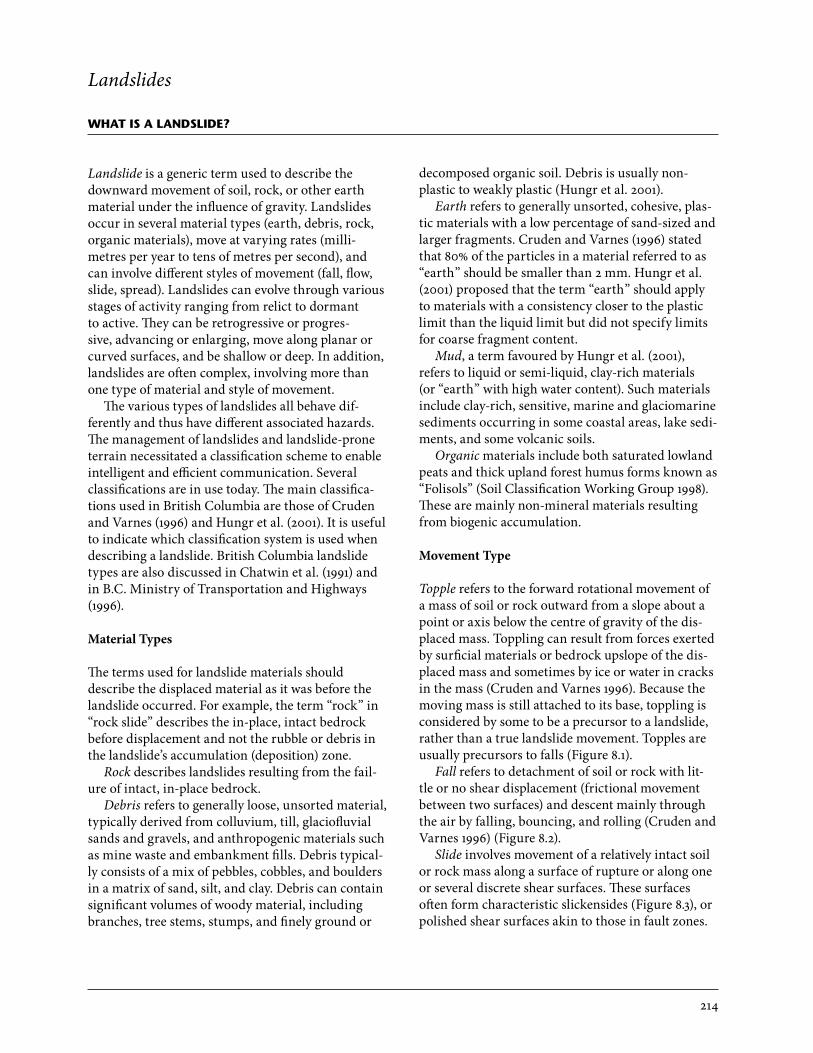
Landslides
what is a landslide?
Landslide is a generic term used to describe the downward movement of soil, rock, or other earth material under the influence of gravity. Landslides occur in several material types (earth, debris, rock, organic materials), move at varying rates (milli-metres per year to tens of metres per second), and can involve different styles of movement (fall, flow, slide, spread). Landslides can evolve through various stages of activity ranging from relict to dormant to active. They can be retrogressive or progres-sive, advancing or enlarging, move along planar or curved surfaces, and be shallow or deep. In addition, landslides are often complex, involving more than one type of material and style of movement.
The various types of landslides all behave dif-ferently and thus have different associated hazards. The management of landslides and landslide-prone terrain necessitated a classification scheme to enable intelligent and efficient communication. Several classifications are in use today. The main classifica-tions used in British Columbia are those of Cruden and Varnes (1996) and Hungr et al. (2001). It is useful to indicate which classification system is used when describing a landslide. British Columbia landslide types are also discussed in Chatwin et al. (1991) and in B.C. Ministry of Transportation and Highways (1996).
Material Types
The terms used for landslide materials should describe the displaced material as it was before the landslide occurred. For example, the term “rock” in “rock slide” describes the in-place, intact bedrock before displacement and not the rubble or debris in the landslide’s accumulation (deposition) zone.
Rock describes landslides resulting from the fail-ure of intact, in-place bedrock.
Debris refers to generally loose, unsorted material, typically derived from colluvium, till, glaciofluvial sands and gravels, and anthropogenic materials such as mine waste and embankment fills. Debris typical-ly consists of a mix of pebbles, cobbles, and boulders in a matrix of sand, silt, and clay. Debris can contain significant volumes of woody material, including branches, tree stems, stumps, and finely ground or
decomposed organic soil. Debris is usually non- plastic to weakly plastic (Hungr et al. 2001).
Earth refers to generally unsorted, cohesive, plas-tic materials with a low percentage of sand-sized and larger fragments. Cruden and Varnes (1996) stated that 80% of the particles in a material referred to as “earth” should be smaller than 2 mm. Hungr et al. (2001) proposed that the term “earth” should apply to materials with a consistency closer to the plastic limit than the liquid limit but did not specify limits for coarse fragment content.
Mud, a term favoured by Hungr et al. (2001), refers to liquid or semi-liquid, clay-rich materials (or “earth” with high water content). Such materials include clay-rich, sensitive, marine and glaciomarine sediments occurring in some coastal areas, lake sedi-ments, and some volcanic soils.
Organic materials include both saturated lowland peats and thick upland forest humus forms known as “Folisols” (Soil Classification Working Group 1998). These are mainly non-mineral materials resulting from biogenic accumulation.
Movement Type
Topple refers to the forward rotational movement of a mass of soil or rock outward from a slope about a point or axis below the centre of gravity of the dis-placed mass. Toppling can result from forces exerted by surficial materials or bedrock upslope of the dis-placed mass and sometimes by ice or water in cracks in the mass (Cruden and Varnes 1996). Because the moving mass is still attached to its base, toppling is considered by some to be a precursor to a landslide, rather than a true landslide movement. Topples are usually precursors to falls (Figure 8.1).
Fall refers to detachment of soil or rock with lit-tle or no shear displacement (frictional movement between two surfaces) and descent mainly through the air by falling, bouncing, and rolling (Cruden and Varnes 1996) (Figure 8.2).
Slide involves movement of a relatively intact soil or rock mass along a surface of rupture or along one or several discrete shear surfaces. These surfaces often form characteristic slickensides (Figure 8.3), or polished shear surfaces akin to those in fault zones.

215
FIGURE 8.1 Flexural topple in limestone in the Rocky Mountains northeast of Prince George. (Photo: M. Geertsema)
FIGURE 8.2 Examples of (a) rock fall, (b) sand fall, and (c) earth topple and fall near the British Columbia towns of Prince Rupert, Williams Lake, and Terrace, respectively. (Photos: M. Geertsema)
a b c

216
like behaviour often depends on water entrainment after the initial failure. Hungr et al. (2001) restricted use of the term “flow” to channelized movement.
Avalanche is often used to describe an unconfined flow, and is especially used for rapid landslides that have long run-out distances (Figure 8.5). Debris avalanches and rock avalanches are commonly oc-curring types.
Spread is extension of a cohesive soil or rock mass and subsidence of the fractured mass of cohesive material into a softer, underlying material (Cruden and Varnes 1996). Spreads may result from the lique-faction or flow and extrusion of soft or weak materi-als underlying competent materials. An example of bedrock spread is shown in Figure 8.6.
Complex landslides involve more than one type of material, and consequently involve more than one type of movement. Large rock slides can change behaviour when the displaced rock mass moves downslope and impacts other materials. Three com-mon scenarios include rock slides that transform into earth flows, debris flows, or debris avalanches (Figure 8.7).
Sliding can be translational (the surface of rupture is sub-planar or undulating) or rotational (the surface of rupture is curved and concave and is sometimes referred to as a “slump”), or intermediate or a com-bination of the two (rotational-translational). The displaced mass initially remains intact, but as the detached material slides further, the displaced mass tends to break up. When the disrupted mass begins to flow, the landslide is no longer termed a “slide” (Cruden and Varnes 1996) but is instead referred to as a “complex slide-flow.”
Flow involves the movement of a mass with signif-icant internal distortion or disruption (Figure 8.4). Flows have multiple dissipated shear surfaces distrib-uted throughout the mass. A flow-like landslide will often begin as a slide moving along a rupture sur-face, but then continues as a flow down unconfined surfaces (e.g., debris avalanche) and (or) confined channels (e.g., debris flow), and can travel for long distances. In granular materials, the initial sliding movement leads very quickly to complete disinte-gration, producing flow-like motion characterized by nearly complete remoulding of the moving mass (Cruden and Varnes 1996; Hungr et al. 2001). Flow-
FIGURE 8.3 Slides, such as this earth slide near Fort St. John, have discrete shear surfaces. The rupture surface here is polished and is known as a slickenside. (Photos: M. Geertsema)

217
FIGURE 8.5 Rock avalanche near Chisca River west of Fort Nelson. (Photo: M. Geertsema)
FIGURE 8.4 Mud flows following a rainstorm in the Peace River area. Sliding in the source areas gives way to flowing in the narrow transport zones. The landslides shown are about 100 m long. (Photo: M. Geertsema)

218
FIGURE 8.6 Rock spread west of Fort Nelson. The ridges are transverse to the direction of movement. (Photo: M. Geertsema)
FIGURE 8.7 Illustrations showing various rock slide interactions upon impact with soil. (Modified from Geertsema et al. 2006a)
what causes landslides?
It is important to distinguish between the causes and triggers of landslides. In the broad sense, cause is the sum of factors that renders a slope unstable; trigger is the final, possibly small, event that leads to the ulti-mate point of slope failure. Causal factors of instabil-ity include preconditions such as weathering, glacial erosion, river erosion, geologic structure, tectonics, changes in climate, wildfire, deforestation, and road
construction. The trigger may be an earthquake, increase in surface loading (surcharge), intense or prolonged rainfall, or river undercutting of a slope.
If an increase in landslides in a specific area is evident, it is useful to look for changes in potential causal factors. Some disturbances result in large-scale changes to forested watersheds. Wildfires (Can-non 2001; Sanborn et al. 2006) and logging practices

219
(Schwab 1983; Rood 1984; Jakob 2000; Guthrie 2002) are known to cause debris slides and flows. Changes in climate can also be important (Chapter 19, “Climate Change Effects on Watershed Processes in British Columbia”). Global climate warming may be affecting landslide rates in mountain ranges around the world (see “The Influence of Climate on Slope Stability” below).
Landslide Triggers
Numerous inherent (internal) and variable (external) forces interact to control or modify hillslope stabil-ity. Principal among these factors are changes in strength–stress relationships on a slope over geologic time. The importance or effectiveness of a specific factor is determined by the local geologic and hydro-logic conditions. The factors modifying slope stabil-ity are discussed in numerous publications. Jakob and Hungr (editors, 2005) have provided an in-depth presentation on debris-flow phenomena. Landslide Investigation and Mitigation (Turner and Schuster [editors] 1996) provides a detailed discussion on large and complex landslides. In British Columbia, Chatwin et al. (1991) have discussed landslides in a forest management context. Sidle and Ochiai (2006) have also provided an overview of management ef-fects on landslides within a global context.
A landslide trigger is the external force that acts on a slope to increase shear stress, which results in a landslide. The trigger attributed to the landslide is the driving force that has set off the landslide on a predisposed unstable slope. The triggers discussed within a British Columbia context are earthquakes and climate (meteorological conditions, intense rain-fall and rapid snowmelt, long-term climate trends, frost wedging, and thawing permafrost). Vallance (2005) offered an in-depth presentation of direct and indirect effects of volcanic eruptions, a trigger of large debris flows (lahars), and hence these are not discussed here. However, massive landslides have occurred in the vicinity of eruptive centres, particu-larly within the Garibaldi volcanic belt (e.g., Devas-tation Glacier landslide [Patton 1976]; Rubble Creek landslide [Moore and Mathews 1978]; and Dusty Creek, Mount Cayley [Clague and Souther 1982]).
EarthquakesGround shaking caused by earthquakes has trig-gered catastrophic landslides around the world. Earthquakes increase stress, increase temporary pore-water pressures, and decrease soil strength.
The overall effect of ground motion depends on the topographic and geological setting. Generally, an earthquake greater than Magnitude 6 is required to trigger landslides (G. Rogers, Pacific Geoscience Centre, Sidney B.C., pers. comm., 2001). The Mag-nitude 9.2 earthquake that occurred March 28, 1964, in Alaska’s Prince William Sound caused landslides in marine sediments and rock slides–avalanches on mountain slopes. Near Fairbanks, Alaska, the large inland Magnitude 7.9 Denali Fault earthquake of November 3, 2002, preceded by a Magnitude 6.7 event on October 23, 2002, triggered many rock falls, snow avalanches, and a large rock avalanche. British Columbia’s short recorded history and sparsely pop-ulated area provide only a few anecdotal reports of earthquake-triggered landslides. Vancouver Island’s largest historic earthquake (Magnitude 7.3) occurred on June 23, 1946, in the vicinity of Forbidden Plateau, central Vancouver Island, and caused numerous landslides including submarine landslides (Hodg-son 1946; Mathews 1979; Rogers 1980). The largest historic earthquake recorded in Canada occurred on August 22, 1949, off the west coast of Graham Island, Haida Gwaii (formerly known as the Queen Charlotte Islands). This Magnitude 8.1 earthquake was believed to have caused extensive rock fall, debris slides, and debris avalanches. Geologists with the Geological Survey of Canada working on the northern end of Graham Island recorded that they could not stand up during the event, which lasted 5 minutes. The Prince Rupert Daily News, on August 28 and 30, 1949, provided several eyewitness ac-counts: a fisheries patrol boat anchored at Lockeport, Kulunkwoi Bay, reported the crashing of rocks and timber downslope, and the next day many new slide scars were visible; a logging camp on the north shore of Cumshewa Inlet received heavy damage, and new slides were reported all along Cumshewa Inlet. Me-teorological conditions before the 1949 earthquake likely aggravated the occurrence of slope failures. The field observations of Alley and Thomson (1978) noted that many large landslide areas on the north-ern part of Graham Island were characterized by forest cover of similar age and species, suggesting that rock slides and debris avalanches may have been triggered by the 1949 earthquake or a large prehis-toric earthquake. Schwab (1997, 1998) and Martin et al. (2002) indicated that the majority of the debris avalanches and debris flows on the north coast and Haida Gwaii were triggered by large precipitation events. Nevertheless, large 100- to 300-year-old land-slides are visible on Haida Gwaii. Likewise, many

220
pre-historic landslides were identified on Vancou-ver Island (VanDine and Evans 1992). These large landslides on Haida Gwaii, Vancouver Island, and the mainland were likely caused by a combination of factors with a probable earthquake trigger.
The influence of climate on slope stability
PrecipitationIn a simple sense, the occurrence of landslides will increase in relation to the amount and duration of precipitation; however, slope factors may be more complicated and thus preclude a simple analysis. Some landslides respond rapidly to rainfall, oth-ers have delayed responses. In any case, antecedent conditions have been shown to be very important. In general, soils must become saturated, allowing the build-up of pore pressures. Threshold pore pressures develop more rapidly in shallow materials than in deeper materials. Landslides that respond rapidly to changes in precipitation include shallow debris slides, debris flows, and some rock falls. Landslides that have delayed responses to changes in precipita-tion and temperature are usually the larger, deeper-seated rock slides, earth slides, and earth flows.
Rapid response landslidesIn mountainous areas of British Columbia, shallow debris slides, debris avalanches, and debris flows are typically associated with heavy rainfall or rapid snowmelt, provided threshold conditions are met. Precipitation attributes that influence pore water pressure are antecedent storm precipitation, storm duration, total rainfall, and precipitation intensity. Studies from many parts of the world document the response of rainstorms of different intensity and duration for various geologic settings (Wieczorek and Glade 2005). In British Columbia, only a few studies attempt to link type of storms, antecedent meteorological conditions, and precipitation in-tensity and duration as triggers of shallow hillslope failures. However, most landside investigations use probable climatic triggers to describe the event. For example, the 1978 storm in Rennell Sound, Haida Gwaii, triggered 264 debris avalanches and debris flows (Schwab 1983). A meteorological station located at sea level in the centre of a study area recorded the cumulative precipitation over a 3-day period with two intense 12-hour periods of 120 and 110 mm of
rainfall. Unfortunately, rainfall at higher elevation was probably underestimated and the time of the many slope failures can only be approximated. The climatological station located at Rennell Sound was relatively close to the debris flow activity; however, the general problem with landslide studies through-out British Columbia is a sparse climatological network located at valley-bottom sites that are not representative of weather at the location of landslide activity. Satellite images, combined with weather radar and synoptic radiosonde,1 provide a record of upper air masses and synoptic climatology and may aid future studies in areas of sparse climatic stations (Egginton 2005).
Following devastating debris flows in the early 1980s, Church and Miles (1987) undertook a detailed analysis of meteorological antecedents for case studies in the Howe Sound area and eastern Fraser Valley. A remarkably wet period in the early 1980s was the best correlate found for the increased debris flow activity. The described meteorological condi-tions for debris-flow–triggering storms based on regional climatological stations show no exceptional events. Eyewitness reports, however, suggest that locally intense cells of precipitation, not recorded in the regional rain gauge network, are likely impor-tant. Such locally intense precipitation is sometimes generated by convective cells embedded in a frontal storm. Free convection of warm air is enhanced by the impingement of the air stream and rapid forced lifting on mountain slopes. Church and Miles (1987) concluded that the traditional hydrometeorological indices, based on routine meteorological measure-ments, are unlikely to provide consistent indications of the likelihood for debris flows to occur.
On Haida Gwaii, Hogan and Schwab (1991) stud-ied rainfall characteristics before and during verified debris flow events. They compared the temporal frequency of slope failures to antecedent precipita-tion trends for time scales ranging from years to days. Over the longer time scale, a positive correla-tion was found between annual moisture conditions and the reported frequency of hillslope failure; however, annual moisture was less significant than precipitation over shorter periods (months or days) preceding a slope failure. On the shorter time scale, only the months immediately preceding slope failure were important in conditioning the hillslope to fail-ure. The most important situation leading to a high
1 Upper Air Observing System measures temperature, pressure, humidity, wind speed, and wind direction.
221
frequency of slope failures was continuously wet weather before the landslide-triggering storm. Pre-cipitation values required to trigger slope failures are regularly exceeded during fall and winter months on Haida Gwaii and British Columbia’s north coast.
Jakob and Weatherly (2003) studied landslide-triggering storms on the North Shore Mountains of British Columbia’s south coast. Data were collected for 18 storms that triggered landslides and 18 storms that did not. Data included antecedent rainfall, rainfall intensity-duration during storm events, and discharge exceedance of a small watershed. Through discriminant function analysis, the authors sepa-rated landslide-triggering storms from storms that did not trigger landslides. This analysis indicated that antecedent conditions are more important in developing a threshold for landslide initiation than short-term rainfall intensities alone, which fail to include hydrologic effects such as snowmelt and antecedent rainfall. The 28-day antecedent precipita-tion amounts are critical in bringing soil moisture to saturation levels conducive to landslides. Jakob and Weatherly (2003) concluded that considerable amounts of precipitation are required to saturate for-est soils to the point where a landslide is likely, once an intensity threshold is exceeded. They also found
the 6-hour rainfall intensity during a storm to be significant because it causes already-wet soils to gen-erate positive pore-water pressures, which further decrease the effective strength of the soil.
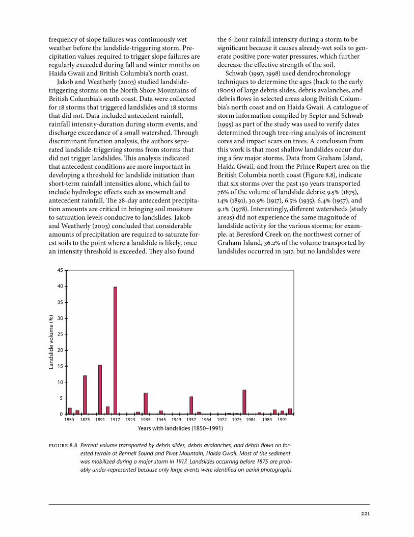
Schwab (1997, 1998) used dendrochronology techniques to determine the ages (back to the early 1800s) of large debris slides, debris avalanches, and debris flows in selected areas along British Colum-bia’s north coast and on Haida Gwaii. A catalogue of storm information compiled by Septer and Schwab (1995) as part of the study was used to verify dates determined through tree-ring analysis of increment cores and impact scars on trees. A conclusion from this work is that most shallow landslides occur dur-ing a few major storms. Data from Graham Island, Haida Gwaii, and from the Prince Rupert area on the British Columbia north coast (Figure 8.8), indicate that six storms over the past 150 years transported 76% of the volume of landslide debris: 9.5% (1875), 14% (1891), 30.9% (1917), 6.5% (1935), 6.4% (1957), and 9.1% (1978). Interestingly, different watersheds (study areas) did not experience the same magnitude of landslide activity for the various storms; for exam-ple, at Beresford Creek on the northwest corner of Graham Island, 36.2% of the volume transported by landslides occurred in 1917, but no landslides were
FIGURE 8.8 Percent volume transported by debris slides, debris avalanches, and debris flows on for-ested terrain at Rennell Sound and Pivot Mountain, Haida Gwaii. Most of the sediment was mobilized during a major storm in 1917. Landslides occurring before 1875 are prob-ably under-represented because only large events were identified on aerial photographs.
0
5
10
15
20
25
30
35
40
45
1850 1875 1891 1917 1923 1935 1945 1949 1957 1964 1972 1975 1984 1989 1991
Years with landslides (1850–1991)
Lan
dsl
ide
volu
me
(%)

222
experienced in the watershed in 1978. Overall, the data suggest that British Columbia’s north coast has yet to re-experience meteorological conditions simi-lar to the event of October 28 to November 19, 1917.
Most precipitation on the British Columbia north coast is associated with frontal systems that pass across the region from the Pacific Ocean (Chapter 3, “Weather and Climate”). Loci of warm-wet condi-tions shift north or south depending on the prevail-ing storm track in the Pacific (Karanka 1986). Most landslide-triggering storms involve a warm front followed by a cold front (Jakob et al. 2006). The events appear to involve a flow in the lower part of the atmosphere, extending south to incorporate sub-tropical moisture. Jakob et al. (2006) found that the following combination of meteorological conditions is associated with the occurrence of debris slides, debris avalanches, and debris flows:
• warmfrontswithstrongSE–SW winds at the 850-mb level
• warmfrontsthatextendsouthoverthePacificOcean, bringing much additional moisture to north coastal British Columbia
• warmfrontswithhighfreezinglevels• astrongjetstreamwithairflowarcingnorthof
the region and W–SW winds exceeding 90 knots at the 250-mb level
These meteorological conditions prevailed during landslide-triggering storms in 2003 and again in 2004. The event on October 25, 2003 triggered many large landslides, with 12 reported in the vicinity of
Prince Rupert alone (see Chapter 3, “Weather and Climate,” Figure 3.16, for satellite photograph show-ing moisture transport during the October 2003 event). Landslides on November 4, 2004 severed a natural gas pipeline serving Prince Rupert and closed Highway 16, the only highway link to the city (Geertsema et al. 2006a).
Delayed response landslidesLarger, and especially deeper, landslides tend to have delayed responses to precipitation. It takes time for water to infiltrate and saturate potential slide masses. Geertsema et al. (2006a, 2007) studied large landslides in northern British Columbia. They found that some large landslides in soil occurred after long periods of above-average precipitation. The large earth flow spread at Mink Creek (see “Flows and Slides in Sensitive Clays” below) occurred after a 10-year wet period (Figure 8.9). Many flow slides in glaci-omarine sediments occurred in the Terrace area 2000–3000 years ago when the climate was wetter (Geertsema and Schwab 1997). This suggests that long-term climate trends may influence these deeper landslides.
Individual rainstorms, rain-snowmelt events, and outburst floods can indirectly trigger landslides by increasing peak flows in streams. High water flows are known to increase bank erosion. Many land-slides are triggered by bank erosion (Figure 8.10). An example is the June 2002 rain-on-snow event that resulted in a flood flow from the Gillis Mountain area in central British Columbia. The flood triggered
40
20
0
-20
-40
-60
-80
-100
-120
landslide
1953 1957 1961 1965 1969 1973 1977 1981 1985 1989 1993 1997 2001
Cum
ulat
ive
devi
atio
n fr
om m
ean
(%)
Year
FIGURE 8.9 Percent cumulative deviation from mean precipitation at Terrace airport from 1953 to 2002. (Modified from Geertsema et al. 2006b). The Mink Creek landslide occurred after a decade of increased precipitation.

223
numerous shallow debris slides, destabilized an al-luvial fan, and washed out a bridge.
Temperature Landslides in mountainous regions may be especially responsive to increases in tem-perature. Two important factors may be the debut-tressing of valley walls as a result of glacier melting and retreat, and the thawing of permafrost. Recent research has shown that 20th-century retreat of glaciers in British Columbia has debuttressed rock slopes, causing deep-seated slope deformation, joint expansion, and catastrophic failure (Evans and Clague 1994; Holm et al. 2004; Geertsema et al. 2006a). Mountain permafrost appears to be degrad-ing, especially in the last decade, decreasing the sta-bility of slopes (Davies et al. 2001; Harris et al. 2001: Gruber and Haeberli 2007). Recent large rock slides in the European Alps have been attributed to thaw of mountain permafrost (Dramis et al. 1995; Bottino et al. 2002; Noetzli et al. 2003), and permafrost thaw may also play a role in initiating large rock slides in northern British Columbia.
In addition to debuttressing and permafrost degradation, changes to the dynamics, amount, and seasonal distribution of snow and rain can have
a significant impact on the stability of slopes. For example, the sudden and delayed melt of above-aver-age snowpacks can lead to increased occurrence of landslide events caused by increases in pore pressure.
Whatever the cause, large natural landslides appear to be increasing in frequency in northern British Columbia. When comparing the 1970s and 1980s to the last two decades, Geertsema et al. (2007) reported a near tripling of rock slides and a 2.5-fold increase in large soil landslides. Rock slides in particular have occurred in years of above-aver-age temperature and at least one of the rock slides was confirmed to have permafrost in its main scarp. Thawing permafrost could contribute to the destabi-lization of slopes.
Large rock slides have happened in recently degla-ciated areas as well as in areas that have been ice-free for most of the Holocene. Half of the rock slides in northern British Columbia reported by Geertsema et al. (2006a) occurred on steep rock walls above glaciers. They suggested that glacier thinning under a warming climate following the Little Ice Age had destabilized many slopes through the debuttressing of steep rock walls.
In British Columbia, the Pacific Decadal Oscilla-
FIGURE 8.10 Small flows within a larger landslide along the Prophet River shows partial reactivation of a landslide. The movements were triggered during a rainstorm in July 2001. The larger (deeper) landslide appears to be influenced by bank erosion. (Photo: M. Geertsema)
224
tion (PDO) strongly influences temperature and, to a lesser extent, precipitation patterns in 20–30 year cycles (Egginton 2005; Chapter 3, “Weather and Climate”). The last decade of the current warm phase of the PDO, which started in 1977, was a period of
frequent rock slides. We need to extend our com-parison of landslide frequency and the PDO beyond the current phase into the past and also to investi-gate the link, if any, between landslides events and El Niño–Southern Oscillation.
Landslides are common in mountain regions around the world, and British Columbia is no exception. The varied geology, topography, and climate result in several landslide types. Shallow debris slides and flows are especially common on the coast. Rapid flows and spreads (flow slides) are common in some lake sediments in northeastern British Columbia and in glaciomarine sediments near the coast. Large rotational rock slides (slumps) are common in glacial sediments and volcanic bedrock in the Interior. Rock avalanches occur in various settings in mountainous regions of the province. Many of the larger land-slides are complex, involving more than one style of movement and often more than one type of material.
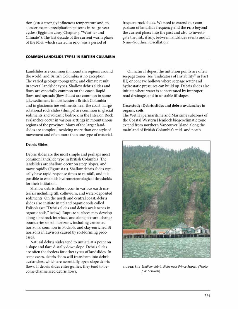
Debris Slides
Debris slides are the most simple and perhaps most common landslide type in British Columbia. The landslides are shallow, occur on steep slopes, and move rapidly (Figure 8.11). Shallow debris slides typi-cally have rapid response times to rainfall, and it is possible to establish hydrometeorological thresholds for their initiation.
Shallow debris slides occur in various earth ma-terials including till, colluvium, and water-deposited sediments. On the north and central coast, debris slides also initiate in upland organic soils called Folisols (see “Debris slides and debris avalanches in organic soils,” below). Rupture surfaces may develop along a bedrock interface, and along textural change boundaries or soil horizons, including cemented horizons, common in Podzols, and clay-enriched Bt horizons in Luvisols caused by soil-forming proc-esses.
Natural debris slides tend to initiate at a point on a slope and flare distally downslope. Debris slides are often the feeders for other types of landslides. In some cases, debris slides will transform into debris avalanches, which are essentially open-slope debris flows. If debris slides enter gullies, they tend to be-come channelized debris flows.
common landslide tyPes in British columBia
On natural slopes, the initiation points are often seepage zones (see “Indicators of Instability” in Part III) or concave hollows where seepage water and hydrostatic pressures can build up. Debris slides also initiate where water is concentrated by improper road drainage, and in unstable fillslopes.
Case study: Debris slides and debris avalanches in organic soilsThe Wet Hypermaritime and Maritime subzones of the Coastal Western Hemlock biogeoclimatic zone extend from northern Vancouver Island along the mainland of British Columbia’s mid- and north
FIGURE 8.11 Shallow debris slides near Prince Rupert. (Photo: J.W. Schwab)
225
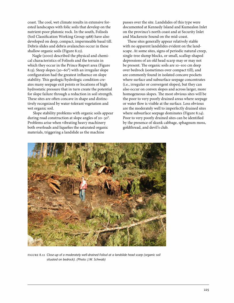
coast. The cool, wet climate results in extensive for-ested landscapes with folic soils that develop on the nutrient-poor plutonic rock. In the south, Folisols (Soil Classification Working Group 1988) have also developed on deep, compact, impermeable basal till. Debris slides and debris avalanches occur in these shallow organic soils (Figure 8.12).
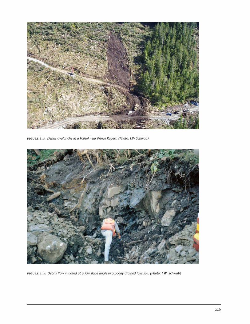
Nagle (2000) described the physical and chemi-cal characteristics of Folisols and the terrain in which they occur in the Prince Rupert area (Figure 8.13). Steep slopes (30–60°) with an irregular slope configuration had the greatest influence on slope stability. This geologic/hydrologic condition cre-ates many seepage exit points or locations of high hydrostatic pressure that in turn create the potential for slope failure through a reduction in soil strength. These sites are often concave in shape and distinc-tively recognized by water-tolerant vegetation and wet organic soil.
Slope stability problems with organic soils appear during road construction at slope angles of 20–30°. Problems arise when vibrating heavy machinery both overloads and liquefies the saturated organic materials, triggering a landslide as the machine
passes over the site. Landslides of this type were documented at Kennedy Island and Kumealon Inlet on the province’s north coast and at Security Inlet and Mackenzie Sound on the mid-coast.
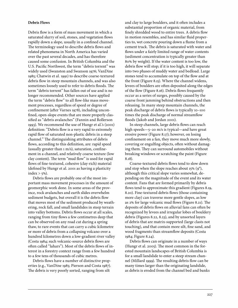
These sites generally appear relatively stable with no apparent landslides evident on the land-scape. At some sites, signs of periodic natural creep, single-tree slump blocks, or small, scallop-shaped depressions of an old head scarp may or may not be present. The organic soils are 10–100 cm deep over bedrock (sometimes over compact till), and are commonly found in isolated concave pockets where surface and subsurface seepage concentrates (i.e., irregular or convergent slopes), but they can also occur on convex slopes and across larger, more homogeneous slopes. The most obvious sites will be the poor to very poorly drained areas where seepage or water flow is visible at the surface. Less obvious are the moderately well to imperfectly drained sites where subsurface seepage dominates (Figure 8.14). Poor to very poorly drained sites can be identified by the presence of skunk cabbage, sphagnum moss, goldthread, and devil’s club.
FIGURE 8.12 Close-up of a moderately well-drained Folisol at a landslide head scarp (organic soil situated on bedrock). (Photo: J.W. Schwab)
226
FIGURE 8.14 Debris flow initiated at a low slope angle in a poorly drained folic soil. (Photo: J.W. Schwab)
FIGURE 8.13 Debris avalanche in a Folisol near Prince Rupert. (Photo: J.W Schwab)
227
Debris Flows
Debris flow is a form of mass movement in which a saturated slurry of soil, stones, and vegetation flows rapidly down a slope, usually in a confined channel. The terminology used to describe debris flows and related phenomena in North America has varied over the past several decades, and has therefore caused some confusion. In British Columbia and the U.S. Pacific Northwest, the term “debris torrent” was widely used (Swanston and Swanson 1976; VanDine 1985; Chatwin et al. 1991) to describe coarse-textured debris flow in steep mountain channels, and was also sometimes loosely used to refer to debris floods. The term “debris torrent” has fallen out of use and is no longer recommended. Other sources have applied the term “debris flow” to all flow-like mass move-ment processes, regardless of speed or degree of confinement (after Varnes 1978), including uncon-fined, open-slope events that are more properly clas-sified as “debris avalanches” (Fannin and Rollerson 1993). We recommend the use of Hungr et al.’s (2001) definition: “Debris flow is a very rapid to extremely rapid flow of saturated non-plastic debris in a steep channel.” The distinguishing attributes of debris flows, according to this definition, are: rapid speed (usually greater than 1 m/s), saturation, confine-ment in a channel, and relatively coarse texture (low clay content). The term “mud flow” is used for rapid flows of fine-textured, cohesive (clay-rich) material (defined by Hungr et al. 2001 as having a plasticity index > 5%).
Debris flows are probably one of the most im-portant mass movement processes in the amount of geomorphic work done. In some areas of the prov-ince, rock avalanches and earth slides overwhelm sediment budgets, but overall it is the debris flow that moves most of the sediment produced by weath-ering, rock fall, and small landslides in steep terrain into valley bottoms. Debris flows occur at all scales, ranging from tiny flows a few centimetres deep that can be observed on any road cut during a spring thaw, to rare events that can carry a cubic kilometre or more of debris from a collapsing volcano over a hundred kilometres down a low-gradient river valley (Costa 1984; such volcanic-source debris flows are often called “lahars”). Most of the debris flows of in-terest in a forestry context range from a few hundred to a few tens of thousands of cubic metres.
Debris flows have a number of distinctive prop-erties (e.g., VanDine 1985; Pierson and Costa 1987). The debris is very poorly sorted, ranging from silt
and clay to large boulders, and it often includes a substantial proportion of organic material, from finely shredded wood to entire trees. A debris flow in motion resembles, and has similar fluid proper-ties to, wet concrete pouring down a flume from a cement truck. The debris is saturated with water and flows under a fairly limited range of water contents (sediment concentration is typically greater than 80% by weight). If the water content is too low, the debris flow will stop; if it is too high, it will separate into two phases of muddy water and bedload. Large stones tend to accumulate on top of the flow and at the front (Figure 8.15). Where the channel widens, levees of boulders are often deposited along the edges of the flow (Figure 8.16). Debris flows frequently occur as a series of surges, possibly caused by the coarse front jamming behind obstructions and then releasing. In many steep mountain channels, the peak discharge of debris flows is typically 10–100 times the peak discharge of normal streamflow floods (Jakob and Jordan 2001).
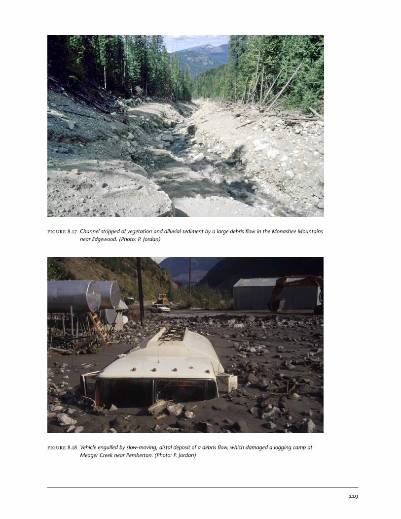
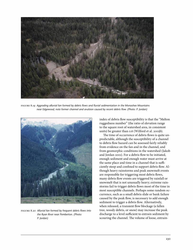
In steep channels, large debris flows can reach high speeds—5–20 m/s is typical—and have great erosive power (Figure 8.17); however, on losing confinement on a fan, they move much more slowly, covering or engulfing objects, often without damag-ing them. They can surround automobiles without breaking windows or scratching the paint (Figure 8.18).
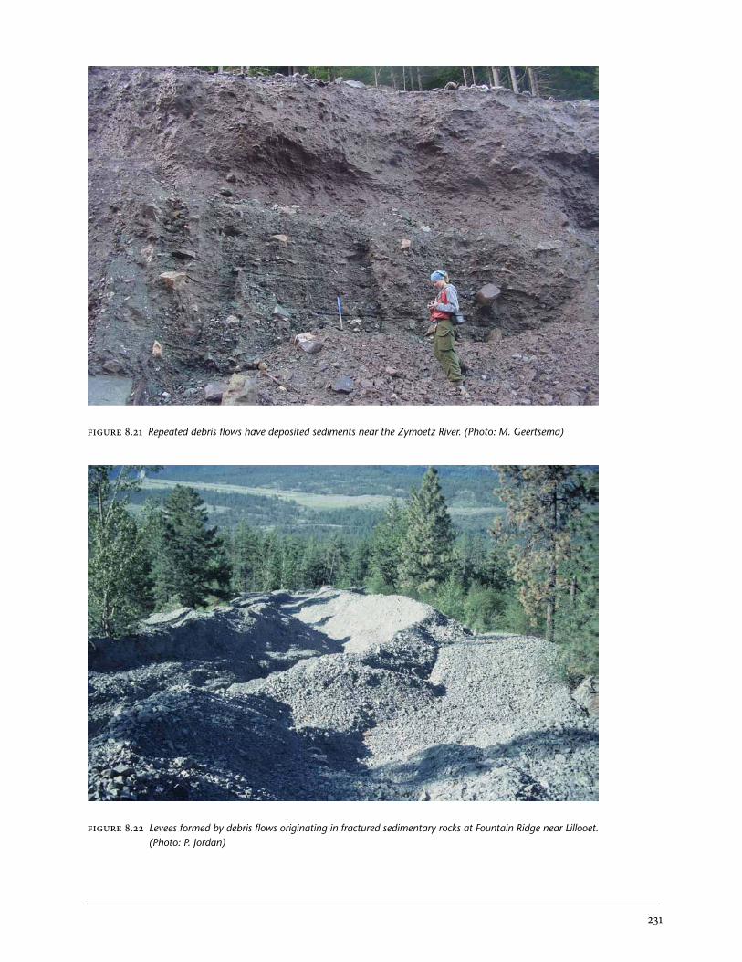
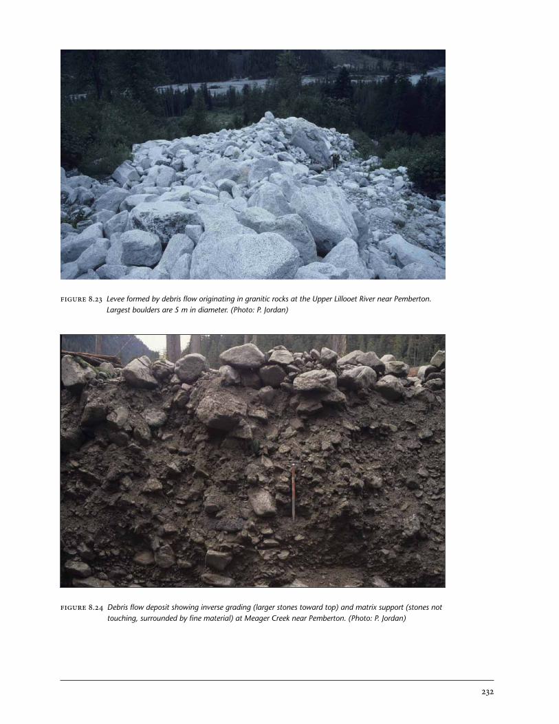
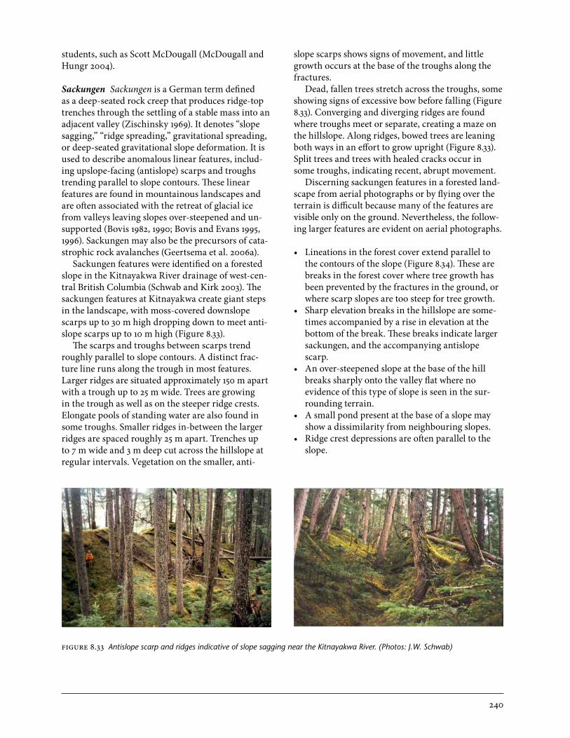
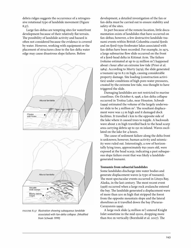
Coarse-textured debris flows tend to slow down and stop when the slope reaches about 15% (9°), although this critical slope varies somewhat, de-pending on the magnitude of the event and its water content. Fans that are formed primarily by debris flows tend to approximate this gradient (Figures 8.19, 8.20). Fine-textured debris flows (those containing more clay) can traverse more gentle slopes, as low as 2% for large volcanic mud flows (Figure 8.21). The deposits of debris flows on alluvial fans can often be recognized by levees and irregular lobes of bouldery debris (Figures 8.22, 8.23), and by unsorted layers of debris that are matrix-supported (large clasts not touching), and that contain more silt, fine sand, and wood fragments than streamflow deposits (Costa 1984; Figure 8.24).
Debris flows can originate in a number of ways (Hungr et al. 2005). The most common in the for-ested mountain landscapes of British Columbia is for a small landslide to enter a steep stream chan-nel (Millard 1999). The resulting debris flow can be many times larger than the originating landslide, as debris is eroded from the channel bed and banks

228
when the debris flow moves down the channel. Most open-slope debris slides lack sufficient water content to flow under their own weight. A landslide into a channel may dam the stream, and the dam soon breaks, producing a slurry with the proper water content to flow as a debris flow. Alternatively, a rapidly moving landslide may overtake and consume water flowing in the channel, transforming into a debris flow. Another common mechanism that enhances transport is that unusually high stream-flow in a small, steep channel may undercut the streambanks, causing a temporary dam, which when failure occurs, results in a debris flow. Yet another mechanism (well described in the literature from Japan, where higher rainfall intensities occur than in Canada) is that unusually high streamflow in a small, steep channel may cause the channel bed itself to fail, reaching a sufficiently high sediment concen-tration through entrainment of streambed and bank material to transform into a debris flow (Takahashi 1981).
In western Canada, debris flows tend to be re-stricted to channels with drainage basins of about 1–10 km2, which contain channels steeper than about 50% in their upper reaches, and which are nowhere less steep than about 15% (VanDine 1985). A simple
FIGURE 8.15 Bouldery debris flow deposits at Lower Arrow Lake near Burton. (Photo: P. Jordan)
FIGURE 8.16 Steep debris flow fan at Salal Creek near Pemberton. (Photo: P. Jordan)
229
FIGURE 8.17 Channel stripped of vegetation and alluvial sediment by a large debris flow in the Monashee Mountains near Edgewood. (Photo: P. Jordan)
FIGURE 8.18 Vehicle engulfed by slow-moving, distal deposit of a debris flow, which damaged a logging camp at Meager Creek near Pemberton. (Photo: P. Jordan)
230
FIGURE 8.19 Aggrading alluvial fan formed by debris flows and fluvial sedimentation in the Monashee Mountains near Edgewood; note former channel and avulsion caused by recent debris flow. (Photo: P. Jordan)
FIGURE 8.20 Alluvial fan formed by frequent debris flows into the Ryan River near Pemberton. (Photo: P. Jordan)
index of debris flow susceptibility is that the “Melton ruggedness number” (the ratio of elevation range to the square root of watershed area, in consistent units) be greater than 0.6 (Wilford et al. 2005b).
The time of occurrence of debris flows is quite un-predictable, although the susceptibility of a channel to debris flow hazard can be assessed fairly reliably from evidence on the fan and in the channel, and from geomorphic conditions in the watershed (Jakob and Jordan 2001). For a debris flow to be initiated, enough sediment and enough water must arrive at the same place and time in a channel that is suffi-ciently steep and confined to support debris flow. Al-though heavy rainstorms and peak snowmelt events are responsible for triggering most debris flows, many debris flow events are triggered by rainfall or snowmelt that is not unusually heavy; extreme rain-storms fail to trigger debris flows most of the time in most susceptible channels. Perhaps some random oc-currence, such as a small debris slide or bank failure caused by the peak flow, is necessary to add enough sediment to trigger a debris flow. Alternatively, when released, a transient flow blockage (a fallen tree, woody debris, or snow) may increase the peak discharge to a level sufficient to entrain sediment by scouring the channel. The volume of loose, entrain-
231
FIGURE 8.21 Repeated debris flows have deposited sediments near the Zymoetz River. (Photo: M. Geertsema)
FIGURE 8.22 Levees formed by debris flows originating in fractured sedimentary rocks at Fountain Ridge near Lillooet. (Photo: P. Jordan)
232
FIGURE 8.24 Debris flow deposit showing inverse grading (larger stones toward top) and matrix support (stones not touching, surrounded by fine material) at Meager Creek near Pemberton. (Photo: P. Jordan)
FIGURE 8.23 Levee formed by debris flow originating in granitic rocks at the Upper Lillooet River near Pemberton. Largest boulders are 5 m in diameter. (Photo: P. Jordan)

233
able material stored in a steep channel provides some indication of the possible volume of a future debris flow, assuming all the material is mobilized (Hungr et al. 2005).
An almost unlimited supply of debris is possible in watersheds dominated by active slope processes such as rock fall (Bovis and Jakob 1999). In such wa-tersheds, debris flows may occur annually, or more often if rainstorm events generate enough stream-flow; however, in most forested watersheds or alpine areas with competent rock, debris flows are infre-quent. On many steep stream channels, debris flows occur at average intervals of several decades on the Coast, to several centuries in the Interior. Follow-ing debris flow events, stream channels go through a cycle in which debris in the channel is slowly replen-ished by rock fall, tree fall, and soil creep (Jakob et al. 2005). After several decades or centuries, a critical hydrologic event occurs that triggers a debris flow, and the accumulated debris in the channel is carried away. Disturbances in a watershed, such as logging, road construction, or wildfire, can cause hydrologic changes that lead to greater peak streamflow, or they can cause small slope failures that enter the channel. Both these changes can greatly increase the prob-ability of a debris flow in a channel.
Flows and Spreads in Sensitive Clays
Rapid landslides may occur on extremely low gradi-ents in some low-lying areas of the British Columbia coast. They occur in fine-textured sediments that may be prone to sudden liquefaction. The sediments can be relatively strong in the undisturbed state, but a small vibration or load can make them flow like wet porridge. Such materials are referred to as “sen-sitive clays.” In the extreme states, when the undis-turbed strength is more than 30 times greater than the remoulded strength, such sediments are called “quick clays.”
The British Columbia coastline was submerged by the weight of a large ice sheet during the last glaciation (Clague 1989). As the ice retreated, the sea migrated inland with the retreating ice fronts. Glaciomarine sediments composed of rock flour, silt, and clay minerals were deposited in the sea. In fresh-water, clay particles tend to settle much more slowly than the larger silt particles. In salt water, clays and silts aggregate together forming floccules and settle in a random orientation. Negative, repulsive charges on the clay particles are neutralized by cations such
as Na+ and Ca2+ in seawater. The resulting sediment has an open structure with high water content. The positive charges of the salts maintain the interparti-cle bonds.
As the glaciers melted, the land began to rebound isostatically, rising as much as 230 m above present- day sea level (McCuaig 2000). This exposed the glaciomarine sediments to rainfall and groundwater. Salts in the clays were gradually leached out of the sediments. Salt content would decrease from an ini-tial 30 g/L to below 1 g/L. With a lower salt content, repulsive forces between particles increased, leaving the saturated, porous sediment prone to collapse.
An imposed load, vibration, or bank erosion can trigger collapse of the sedimentary structure in sensitive glaciomarine deposits, causing liquefaction. During liquefaction, the weight of the soil is trans-ferred from the solids to the pore water.
Examples of landslides in sensitive claysIn preparation for widening the British Columbia highway between Kitimat and Terrace in 1962, earth fills were placed beside the highway on sensitive clays soils. When the loads failed, two enormous landslides occurred May and June. These landslides, which both flowed into Lakelse Lake, destroyed sec-tions of the highway (Figure 8.25).
In winter 1993/94, a similar landslide flowed into Mink Creek (Figure 8.26), a tributary of Lakelse River, moving 2.5 million m3 of mud. The land-slide failed on a nearly flat slope of just over 2°. The landslide likely began with a small failure along the creek, which exposed sensitive clays further in the slope. Once the sensitive materials were exposed, the landslide retrogressed rapidly, eating its way into the slope.
Landslides of this nature often move as spreads or flows. Flows tend to occur in materials with lower shear strengths than spreads. Flows may also occur where a thick zone is sensitive. Spreads are more likely to occur where a thin zone is sensitive. In flows, ridges (if they occur) are oriented paral-lel to movement direction. In spreads, ridges are transverse to movement. The Mink Creek landslide was complex, displaying both spreading and flowing behaviour (Figure 8.27).
In 2003 a large flow in sensitive clays ruptured a natural gas pipeline between Terrace and Prince Rupert (Schwab et al. 2004). The landslide cut off the natural gas supply to Prince Rupert for 10 days. The landslide also dammed Khyex River.

234
FIGURE 8.25 One of two destructive, sensitive clay landslides at Lakelse Lake, 1962 showing a) fluid mud in the zone of depletion, b) debris accumulation in Lakelse Lake, and c) damage to vehicles. (Photos: Terrace Library)
a
b
c

235
FIGURE 8.26 The Mink Creek earth flow spread illustrates a rapid failure on a nearly flat gradient. (Photo: M. Geertsema)
FIGURE 8.27 Transverse ridges of spreading (S) give portions of the Mink Creek landslide a ribbed appearance; the central part of the slide experienced more complete liquefaction and became a flow (F). (Modified from Geertsema and Torrance 2005)

236
Large Earth Flows
Large, slow-moving earth flows, involving millions of cubic metres at individual sites, are common along the incised valleys of interior British Colum-bia’s dissected plateaus (Bovis 1985). Some gigantic landslides, such as the Sheslay slide in northwestern British Columbia (Souther 1971), cover tens of square kilometres and may involve billions of cubic metres of material. These large landslides occur in weak, fine-textured sedimentary and volcanic bedrock, or in the softened materials derived from the bedrock. Typically, the landslides have lateral ridges and lobate tongues and often have transverse ridges (Figure 8.28). Although these landslides resemble flows, movement generally occurs along discrete shear surfaces, with the body of the landslide mov-ing as a rigid plug. For this reason, the movements may more accurately be described as “slides” rather than flows, and some researchers refer to these types of landslides as “mudslides” (e.g., Hutchinson 2004; Picarelli et al. 2005). Most of these landslides display very slow seasonal movement in response to ground-
water fluctuations, and have been more active in the past, when climate was wetter, than at present.
Rock Avalanches
Rock avalanches involve the initial failure and subsequent disintegration of large rock masses on mountain slopes and the rapid downslope movement of this debris to a lower slope. Documented cases involve volumes of more than 10 million m3. These landslides often attain velocities in excess of 100 km/hr, sometimes exceeding 300 km/hr. The veloc-ity of rock avalanches depends not only on slope gradient, but also on the thickness of the debris wave; thus, greater velocities may be attained where the debris is channelized, and lower velocities where it is able to spread and thin.
Catastrophic movements in rock avalanches last for a matter of minutes. The conditions that weaken a rock mass for catastrophic sudden failure can take thousands of years. Globally, a common triggering mechanism for rock avalanches is seismic activ-ity (Keefer 1984). The historic rock avalanches in
FIGURE 8.28 Pavilion earth flow; note the transverse ridges in the zone of accumulation. (Photo: J. Ryder)

237
northern British Columbia have not been associ-ated with earthquakes (Geertsema et al. 2006a). For some, there have been no apparent triggers. Other movements have been associated with intense and prolonged rainfall.
An important consideration is not only the trig-ger, but also the preconditions that make the slopes susceptible to movement. These preconditions include:
• developmentoffracturesorjointsdippingdownslope;
• progressivereductionofcohesionalongshearplanes;
• developmentoflowfrictionanglesandlowre-sidual strength along weak planes; and
• verticalreliefandsteepslopes.
In British Columbia, rock avalanches have oc-curred in the following major settings (Figure 8.29):
• cirquewallsaboveglaciers• onsedimentarydipslopes• inassociationwithslowmountainslopedeforma-
tion
Cirque wall failureCirque walls tend to be steep and are often frac-tured. Fracturing probably occurs as a result of stress release such as the removal of glacial ice buttressing, or from exposure to modern weathering processes such as freeze–thaw cycling. A 1999 rock avalanche involving rock fall from a cirque wall occurred in the Rocky Mountains near McBride (Figure 8.30). The landslide was associated with heavy, prolonged rainfall (Geertsema et al. 2006a).
Downslope dipping bedrockLong run-out rock slides are sometimes initiated on dipping sedimentary rock slopes, particularly in fault zones. West of Fort Nelson, two rock ava-lanches had detachment zones on 27–36° west-dip-ping strata (Geertsema et al. 2006a). Exposed rock on these dip slopes tended to be weak shale but occasionally sandstone would be exposed (Figure 8.31). On steeper slopes, failures would occur more continually, preventing the conditions for a single movement of a large volume of rock. If the slopes are too shallow, the rock masses will not gain enough energy to travel at a high velocity.
Deforming mountain slopesMountain slope deformation is common in northern British Columbia. These sagging slopes, or sackun-gen, are often the result of glacial debuttressing fol-lowing deglaciation (see “Sackungen” below). These features are especially common in weak volcanic and sedimentary bedrock. Slope sagging may also be at-tributed to differential zones of weakness in bedrock, weathering, and tectonic activity.
During the last glaciation, glaciers gouged out valleys, putting stress on rock masses. When the glaciers melted, isostatic adjustments of the Earth’s crust and lateral adjustments from valley walls caused some mountain slopes to sag. Such sagging is often a precursor to rock avalanching (Figure 8.32).
Most rock avalanches are complex landslides that frequently start out as frictional rock slides, but then transform into debris avalanches or debris flows when impacting and entraining soil lower on the slopes. Run-out models that incorporate these various phases of rock slides have been developed in British Columbia by Oldrich Hungr and his PhD
FIGURE 8.29 Illustration showing the settings for rock avalanches in British Columbia. (Modified from Geertsema et al. 2006a)

238
FIGURE 8.30 Rock fall from this cirque wall above the Kendall Glacier, 45 km northwest of McBride, disintegrated and transformed into a rock avalanche with more than 1 km of run-out in July 1999. The landslide was associated with prolonged, heavy rainfall. (Photo: C. Erickson)
FIGURE 8.31 The Tetsa rock avalanche was triggered by disintegrating rock masses on dip slopes of approximately 30° in the Rocky Mountain foothills; note the run-up on the valley wall opposite the landslide. (Photo: M. Geertsema)

239
FIGURE 8.32 The 2002 Pink Mountain rock slide–debris avalanche was associated with mountain slope deformation (Geertsema et al. 2006c). (a) Note ongoing deformation on the mountain, and (b) an older scarp and tension fractures above the 2002 landslide. (Photos: M. Geertsema)
a
b
240
students, such as Scott McDougall (McDougall and Hungr 2004).
Sackungen Sackungen is a German term defined as a deep-seated rock creep that produces ridge-top trenches through the settling of a stable mass into an adjacent valley (Zischinsky 1969). It denotes “slope sagging,” “ridge spreading,” gravitational spreading, or deep-seated gravitational slope deformation. It is used to describe anomalous linear features, includ-ing upslope-facing (antislope) scarps and troughs trending parallel to slope contours. These linear features are found in mountainous landscapes and are often associated with the retreat of glacial ice from valleys leaving slopes over-steepened and un-supported (Bovis 1982, 1990; Bovis and Evans 1995, 1996). Sackungen may also be the precursors of cata-strophic rock avalanches (Geertsema et al. 2006a).
Sackungen features were identified on a forested slope in the Kitnayakwa River drainage of west-cen-tral British Columbia (Schwab and Kirk 2003). The sackungen features at Kitnayakwa create giant steps in the landscape, with moss-covered downslope scarps up to 30 m high dropping down to meet anti-slope scarps up to 10 m high (Figure 8.33).
The scarps and troughs between scarps trend roughly parallel to slope contours. A distinct frac-ture line runs along the trough in most features. Larger ridges are situated approximately 150 m apart with a trough up to 25 m wide. Trees are growing in the trough as well as on the steeper ridge crests. Elongate pools of standing water are also found in some troughs. Smaller ridges in-between the larger ridges are spaced roughly 25 m apart. Trenches up to 7 m wide and 3 m deep cut across the hillslope at regular intervals. Vegetation on the smaller, anti-
slope scarps shows signs of movement, and little growth occurs at the base of the troughs along the fractures.
Dead, fallen trees stretch across the troughs, some showing signs of excessive bow before falling (Figure 8.33). Converging and diverging ridges are found where troughs meet or separate, creating a maze on the hillslope. Along ridges, bowed trees are leaning both ways in an effort to grow upright (Figure 8.33). Split trees and trees with healed cracks occur in some troughs, indicating recent, abrupt movement.
Discerning sackungen features in a forested land-scape from aerial photographs or by flying over the terrain is difficult because many of the features are visible only on the ground. Nevertheless, the follow-ing larger features are evident on aerial photographs.
• Lineationsintheforestcoverextendparalleltothe contours of the slope (Figure 8.34). These are breaks in the forest cover where tree growth has been prevented by the fractures in the ground, or where scarp slopes are too steep for tree growth.
• Sharpelevationbreaksinthehillslopearesome-times accompanied by a rise in elevation at the bottom of the break. These breaks indicate larger sackungen, and the accompanying antislope scarp.
• Anover-steepenedslopeatthebaseofthehillbreaks sharply onto the valley flat where no evidence of this type of slope is seen in the sur-rounding terrain.
• Asmallpondpresentatthebaseofaslopemayshow a dissimilarity from neighbouring slopes.
• Ridgecrestdepressionsareoftenparalleltotheslope.
FIGURE 8.33 Antislope scarp and ridges indicative of slope sagging near the Kitnayakwa River. (Photos: J.W. Schwab)

241
The sackungen features at Kitnayakwa signify an unstable, sagging slope. Another landslide could occur at any time in this deeply weathered, over-steepened, unsupported glacial debuttressed slope through seasonal and climatic cycle effects on groundwater and (or) from earthquake shock.
Complex Landslides
If one examines any landslide closely enough, complexity will be found; however, some landslides clearly involve distinct materials and separate move-ment types. For example, rock slides will often trig-ger much larger secondary movements in soil, which would not have been possible without the initial slide. Two examples are presented below.
Rock slide – earth flowSometime around 1979, a rotational rock slide (slump) involving an estimated 2–3 million m3 of material triggered an earth flow of 15 million m3 in a clay-rich diamict near Muskwa River, west of Fort Nelson (Figure 8.35). The landslide travelled more than 3 km on a 3.5° slope (Geertsema and Cruden 2008). Such a long, low-gradient movement in this type of soil is impossible without invoking some type of dynamic loading (Geertsema and Schwab 2006). Hutchinson and Bhandari (1971) explained such behaviour by a process called “undrained loading.” In this case, the rock slide became a dynamic load for the clay soil. The load transfer caused pore-water
FIGURE 8.34 Old landslides (blue outline) and transverse sackungen ridges (red) at the Kitnayakwa River. The landslides are about 220+ and 460+ years old. The largest landslide involved about 9.5 million m3 of material. The bedrock is a highly fractured and crumbling, well-bedded, fine-grained, crystal-lithic tuff. (Photo interpreta-tion: J.W. Schwab)
FIGURE 8.35 Muskwa rock slide–earth flow, west of Fort Nelson. (Photo: M. Geertsema)

242
pressures in the soil to increase, and because the groundwater could not readily escape from clay-rich soil, liquefaction within the clay occurred, mobiliz-ing the mass to instability in what would otherwise have been relatively stable ground.
Rock slide – debris avalanche – debris flowIn late June 2002, a rock slide west of Smithers im-pacted glacial till above Harold Price Creek (Figure 8.36). After travelling 1.3 km, the rock slide trans-formed into a debris avalanche, and after 2.2 km the landslide entered a gully and changed into a debris flow, travelling a total of 4 km in three different phases. The initial frictional rock slide impacted, partially liquefied, and entrained glacial sediments, transforming the movement into a debris avalanche.
Most of the rock rubble was left upslope of this. The thinly spread debris avalanche entered a gully, which confined the moving mass into a debris flow.
Landslide-generated Tsunamis
In British Columbia, landslide-generated tsunamis are not well recorded and the majority likely remain unknown. Two main types have been documented: (1) displacement waves generated by subaqueous (underwater) landslides, and (2) those created by subaerial (on land) landslides.
Tsunamis from subaqueous landslidesActive fans and deltas are high-energy fluvial systems subject to continuous and progressive sediment loading. Where these deposits are underlain by soft muds, they may be prone to large-scale slumps, earth flows, or flow slides, as a result of site loading (natural or human-caused), vibration from heavy machinery, undercutting, interruption of intertidal drainage, and high artesian pressures.
Fan-deltas are common along the sidewalls of coastal fjords and also on steep-sided, long, narrow, fjord-type lakes in mountainous areas of British Columbia. The geomorphology of fan-deltas has been studied and described in coastal fjords (Prior and Bornhold 1988, 1990; Bornhold and Harper 1998). The processes are similar in freshwater lakes. Fan-deltas have developed over the last 8 000–12 000 years, commencing with the high-energy, sediment-laden meltwater during deglaciation of fjord-side drainage basins. Rivers continue to supply sediment during spring freshets and floods with the aggradation of sediments over the delta through multiple distributary channels on its surface with deposition in various layers of cobbles, gravels, and sands. Materials at depth generally include complex layers of interstratified muds, sands, and gravels. A fan-delta at first glance often appears as a relatively flat, unassumingly stable landform, but evidence of a historic failure is sometimes revealed as a steep, exposed head scarp along the fan-delta face. Large portions of fan-delta surfaces are submerged. Submerged materials perched on the steeply sloping faces are generally highly unstable. The evidence of landslide activity on fan-deltas is often concealed because landslide features are under water; however, the delta front can be viewed through side-scan sonar imagery. Debris slides and debris flows are displayed as a slight trough and debris lobe. The presence of crescent-shaped slide scarps and blocky
FIGURE 8.36 A complex landslide (2002) at Harold Price Creek, near Smithers: (a) a rock slide trans-formed into a debris avalanche, which in turn transformed into (b) a debris flow, travelling a total distance of 4 km. (Photos: M. Geertsema)
a
b
243
debris ridges suggests the occurrence of a retrogres-sive rotational type of landslide movement (Figure 8.37).
Large fan-deltas are tempting sites for waterfront development because of their relatively flat terrain. The possibility of landslide activity and hazard is often not considered because the evidence is covered by water. However, working with equipment or the placement of structures close to the fan-delta water edge may cause disastrous slope failures. Before
development, a detailed investigation of the fan or fan-delta must be carried out to ensure stability and safety of the sites.
In part because of the remote location, little docu-mentation exists of landslides that have occurred on fan-deltas; however, a few destructive landslide-tsu-nami events within British Columbia coastal fjords and on fjord-type freshwater lakes associated with fan-deltas have been recorded. For example, in 1975, a large submarine flow slide occurred on the front of a fjord-head delta in Kitimat Arm. The failure (volume estimated at up to 55 million m3) happened about 1 hour after an extreme low tide (Prior et al. 1984). According to Murty (1979), the slide generated a tsunami up to 8.2 m high, causing considerable property damage. Site loading (construction activi-ties) under conditions of high pore-water pressures, created by the extreme low tide, was thought to have triggered the slide.
Damaging landslides are not restricted to marine coastlines. On October 6, 1998, a fan-delta collapse occurred in Troitsa Lake, near Houston. Schwab (1999) estimated the volume of the largely underwa-ter slide to be 3 million m3. The resultant displace-ment wave was 1.5 m high and it damaged dock facilities. It travelled 1 km to the opposite side of the lake where it caused trees to topple. A backwash wave about 2 m high travelled back to the head scarp area carrying debris up to 150 m inland. Waves oscil-lated on the lake for 4 hours.
The cause of sediment failure along the delta front is unknown; however, human activity and seismic-ity were ruled out. Interestingly, a row of horizon-tally lying trees, approximately 650 years old, were exposed at the head scarp, indicating a past subaque-ous slope failure event that was likely a landslide-generated tsunami.
Tsunamis from subaerial landslidesSome landslides discharge into water bodies and generate displacement waves (a type of tsunami). The most spectacular events occurred in Lituya Bay, Alaska, in the last century. The most recent event (1958) occurred when a large rock avalanche entered the bay. The landslide generated a displacement wave of more than 500 m high that stripped the forest from the opposite mountain slope and the lateral shorelines as it travelled down the bay (Pararas- Carayannis 1999).
A large rock slide (4 million m3) entered Knight Inlet sometime in the mid-1500s, dropping more than 800 m vertically (Bornhold et al. 2007). The
FIGURE 8.37 Illustration showing subaqueous landslide associated with fan-delta collapse. (Modified from Schwab 1999)

244
resulting tsunami destroyed the village of Kwalate, and about 100 (or possibly more) of its First Nations inhabitants. The wave height was estimated at 2–6 m.
In 1946, a Magnitude 7.2 earthquake triggered a 1.5 million m3 rock avalanche from the north face of Mount Colonel Foster on Vancouver Island that entered Landslide Lake (Evans 1989). The resultant tsunami wave ran up a maximum height of 51 m, washing away the forest in its path.
The most recent landslide-generated tsunami occurred in 2007 at Chehalis Lake, about 40 km north of Chilliwack (Figure 8.38). The event results were first observed December 6, 2007, with the event likely occurring December 3–4 during heavy rains.
A large, jointed mass of quartz diorite estimated at 3 million m3, slid about 450–600 vertical metres into the lake. When the rock mass entered Chehalis Lake, it caused at least one wave that eroded the shoreline in some places to a height of more than 18 m. At the south end of the lake, 8 km from the slide location, the maximum wave height was 6.5 m. Trim lines were observed in the Chehalis River downstream of Chehalis Lake, indicating that a wave contin-ued down the river. The displaced water continued downriver at least 14 km to the Chehalis alluvial fan, where large volumes of fresh woody debris were evident. Landslides entering rivers can also create displacement waves.
FIGURE 8.38 The 2007 Chehalis rock slide triggered a large displacement wave. (Photo: B.C. Ministry of Forests and Range, Recreation, Sites and Trails Branch)
245
Erosion
tyPes of erosion
Erosion is generally considered the gradual wearing away of the Earth’s surface by water, wind, glaciers, and frost action. Erosion is a generic term for a group of processes in which materials are loosened or worn away and simultaneously moved from one place to another. Erosion is intimately related to chemical and physical weathering of rock and other materials on and below the surface. Forest fires, logging, grazing, tillage, mining, road building, and other phenomena that remove surface vegetation can increase erosion rates. Wave action is an important component of shoreline erosion, and both ice jams and high streamflow erode riverbanks. Erosion is ac-companied by transport and sedimentation.
The geomorphic processes of soil erosion and landsliding exist along a continuum. In this section, we consider various forms of water erosion ranging from splash erosion to rill erosion. We also consider piping (a type of subsurface erosion), washouts, gul-lies, and fire-generated erosion leading to landslides.
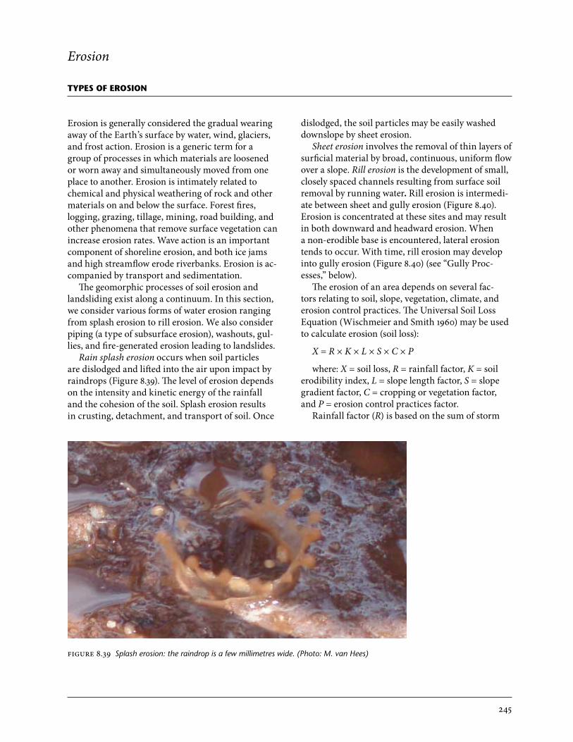
Rain splash erosion occurs when soil particles are dislodged and lifted into the air upon impact by raindrops (Figure 8.39). The level of erosion depends on the intensity and kinetic energy of the rainfall and the cohesion of the soil. Splash erosion results in crusting, detachment, and transport of soil. Once
dislodged, the soil particles may be easily washed downslope by sheet erosion.
Sheet erosion involves the removal of thin layers of surficial material by broad, continuous, uniform flow over a slope. Rill erosion is the development of small, closely spaced channels resulting from surface soil removal by running water. Rill erosion is intermedi-ate between sheet and gully erosion (Figure 8.40). Erosion is concentrated at these sites and may result in both downward and headward erosion. When a non-erodible base is encountered, lateral erosion tends to occur. With time, rill erosion may develop into gully erosion (Figure 8.40) (see “Gully Proc-esses,” below).
The erosion of an area depends on several fac-tors relating to soil, slope, vegetation, climate, and erosion control practices. The Universal Soil Loss Equation (Wischmeier and Smith 1960) may be used to calculate erosion (soil loss):
X = R × K × L × S × C × P
where: X = soil loss, R = rainfall factor, K = soil erodibility index, L = slope length factor, S = slope gradient factor, C = cropping or vegetation factor, and P = erosion control practices factor.
Rainfall factor (R) is based on the sum of storm
FIGURE 8.39 Splash erosion: the raindrop is a few millimetres wide. (Photo: M. van Hees)

246
energy and intensity and will generally be specific to a given region or area. Soil erodibility index (K) provides an estimate of how erodible the local soil is and, therefore, will be site-specific. In general, soils with low cohesion (e.g., sandy soils derived from fluvial or glaciofluvial deposits) will have a high in-dex, and soils with high cohesion (e.g., silty or clayey soils derived from basal tills) will have a lower index. Slope length factor (L) is determined by the length of the slope at a specific slope gradient. This slope gra-dient defines the slope gradient factor (S). Together, these factors (LS) may be considered the “topograph-ic” factor. Long, steep slopes will be more susceptible to erosion than short, gentle slopes because of the greater volume of water running off the slope and a higher flow energy. The topographic factor will depend on site conditions; however, it may be pos-sible to alter the topographic factor through treat-ments such as re-sloping or terracing. The cropping or vegetation factor (C) reflects the cover provided by vegetation or other material (e.g., mulch, erosion control matting), with higher cover yielding a lower cropping factor. Appropriate revegetation treatment can lead to a reduced cropping factor. The erosion
control practices factor (P) depends on the applica-tion of non-vegetative erosion control practices, such as installation of check dams or silt fencing and surface roughening. Any such treatments can reduce this factor.
Hydraulic connectivity refers to the “connection” of hillslope areas to larger creeks or streams beyond the toe of the hillslope. In areas of direct hydraulic connectivity, any sediment that reaches a hillslope creek is transported directly downstream at a sig-nificant gradient (i.e., greater than 5%) to locations where it may result in adverse effects to water quality or aquatic resources. For areas with no connectiv-ity, the hillslope stream must flow into a swamp or lake and trap sediment. Indirect connectivity may occur where the hillslope stream flows through a lower-gradient reach (typically less than 5% gradient for a minimum length of 100 m) before connecting with any stream reach with water quality or resource values.
Surface erosion from rain splashing and sheet wash delivers fine sediment to streams. Landslides such as debris flows tend to deliver coarser materials.
FIGURE 8.40 Rill and gully erosion along the Chilcotin River. Gullies are eroded into weakly cemented glaciolacustrine deposits (right) and into shallow rills in less cohesive colluvial deposits (left). Both gullies and rills on the lower 20 m of the slope were washed away after inundation from a landslide dam. (Photo: M. Geertsema)
247
Gully Processes
Gullies are small, steep, and incised drainages on hillslopes. Gullied terrain may indicate a geomor-phically active area that is sensitive to forest man-agement activities. Landslides common in gullies include debris slides and debris flows. With increas-ing water concentration, debris floods and floods also occur.
Gully MorphologyIn general, two types of gullies occur in British Columbia. The first type is incised into deep surficial materials, typically glacial till, and glaciofluvial or glaciolacustrine sediments. The second type is in-cised into bedrock. Often gullies formed in bedrock are the result of differing bedrock types, competency and structure, and groundwater conditions. In some locations, smaller gullies lie parallel to each other across an open slope (dissected terrain), and other gullies are tributary to one another, forming den-dritic gully systems.
Gullies are divided into a number of zones: the headwall, sidewall, transport zone (or channel base), and mouth. Often a depositional fan is present downslope of the gully mouth. The headwall is the uppermost part of the gully system, and is typically a concave-shaped area shallowly incised into the hillslope. Headwalls in unconsolidated materials fre-quently exhibit soils with moderate or poorer drain-age and are often the site of slope failures. Headwalls can be subtle features and are not always recognized.
The transport zone of the gully is what many people recognize as “the gully.” It is typically V- or U-shaped, with steep sidewalls forming the sides of the V or U. The transport zone usually carries surface discharge along the channel at the base of the V or U. Sidewalls can range from a metre to tens of metres in height. The Forest Practices Code (B.C. Ministry of Forests 2001) defined gullies as those with sidewalls greater than 3 m in height. Similarly, sidewall gradients are generally steeper than 50% (27°) but in some cases are less steep. The size of the channel in the gully will depend on the amount of surface water draining into the gully as well as any groundwater that emerges from the gully sidewalls or from the base of the gully. Defining drainage area for gullies can be difficult, since groundwater move-ment on adjacent open slopes may or may not deliver subsurface flows towards the gully.
A fan is often located at the mouth of the gully unless the gully discharges into a larger stream or lake. The fan is a conical-shaped deposit formed by sediment and woody debris discharged from the gully. Where the gully channel discharges onto the fan, it may be incised into the fan deposits or it may flow across the fan surface. Channels that are incised into the fan surface may emerge onto the fan surface at a location further downslope. Where a channel flows across the surface of a fan with little incision, it may avulse (a complete or partial change in channel location). On many fans, multiple channel locations are the result of avulsions. Many fans below gullies are subject to debris flow deposition. Many gullies are relict features of deglaciation, particularly in the Interior, and are no longer active. Relict fans (“pa-raglacial fans”) below these gullies may have had little or no sedimentation for millennia; however, development can re-activate gully processes. In some cases, fans are a combination of relict surfaces and active surfaces. Additional information on fans is available in Wilford et al. (2005b) and Millard et al. (2006).
Landslides in GulliesWithin gullies, the steep slopes and drainage con-centrations result in a range of possible hazards. Steep headwalls and sidewalls are often sites of slope failures (usually debris slides). Debris slides that enter the gully channel may continue down the channel as a debris flow, a result of the contribution of water from the channel.
Almost all gully debris flows in British Columbia initiate from a debris slide or other slope failure from a headwall or sidewall. In one study of debris flows in coastal British Columbia, only 2% of debris flows initiated from high water discharges in the channel (Millard 1999). A debris slide from headwalls is most likely to initiate channelized debris flows because it maintains a directional momentum on entering a gully channel to which it is already closely aligned. In contrast, most debris slides from gully sidewalls need to turn almost 90° to continue down the gully channel. This loss of momentum results in more debris slides depositing in the gully channel. In the Interior of British Columbia, in-channel initiation of debris flows as a result of high-discharge events appears to be more common.
Since confined debris flows travel much farther than unconfined debris flows, most gully debris

248
flows reach the fan or valley bottom. Debris floods and flows from gullies can result in significant aggradation of streams and fans.
High water discharge rates in gullies can typically result in water floods or debris floods. Water floods are the typical type of flood, transporting coarse sediment as bedload and with woody debris floating on the surface of the flow. Large discharge events supplied with large volumes of sediment can achieve sediment concentrations sufficient to support smaller clasts in a slurry, resulting in a debris flood. Debris floods may be four times larger than water floods expected in the same channel and are more destruc-tive.
Piping
Piping is subsurface soil erosion (Parker and Higgins 1990). Pipes may be exposed as cavernous openings in eroding banks (Figure 8.41). Terrain undergoing subsurface erosion often exhibits hollows or col-lapsed depressions aligned along routes of subsur-
face erosion. Classic examples are strings of collapse features forming beaded gullies common in silt fans derived from glaciolacustrine deposits in the Thompson-Okanagan area (Evans and Buchanan 1976).
These features, combined with an accompanying cave or pipe, are generally observed in arid climates in landforms composed of silt and clay. The term “piping” is also used to describe soil pipes and (or) water movement in forest soils, particularly along root channels and small erosion conduits in surficial materials. In some cases, piping may contribute to landslides and washouts.
Washouts (rapid erosion of seepage faces) have been observed in glaciofluvial sands, silts, and gravels throughout British Columbia. Some ex-amples include: the grand campus washout of 1935 at the University of British Columbia, Vancouver (Williams 1966); the Maryhill gravel pit washout, Coquitlam River valley (Allen 1957); caving erosion in the Lower Mainland (Hungr and Smith 1985); gully erosion / caving erosion found in the Coquit-lam River valley (Siebert 1987); and seepage-face erosion (Parker and Higgins 1990). Catastrophic seepage-face erosion was also observed at Bowser River in 1995, a result of the diversion of a small stream by beaver onto a glaciofluvial terrace of sands and silts—no surface water flow reached the cata-strophically formed gully. The most spectacular is the Donna Creek wash-out flow of 1992 described by Schwab (1997, 2000, 2001).
A schematic representation of catastrophic seep-age-face erosion is presented in Figure 8.42. Under normal conditions, seepage exits the slope without causing erosion as the ground slope of the seepage face has adjusted to the highest recurrent seepage exit gradient2 and resulting seepage forces. A change in the discharge conditions results in an increase in seepage exit gradient above a critical value. This increase in exit gradient may result from a rapid in-crease in groundwater discharge or sudden removal of material from the seepage face by a landslide or by running water. If the resultant erosion is of suf-ficient intensity, the retreating seepage face uncovers material with greater groundwater pressure, the exit gradient increases, and a continuing chain reaction results (O. Hungr, University of British Columbia, Earth and Ocean Science, Vancouver, B.C., pers. comm., 1997).
FIGURE 8.41 Pipe exposed on a bank of the Chilcotin River. (Photo: M. Geertsema)
2 Seepage exit gradient is the slope of the piezometric surface adjacent to the drainage discharge point.
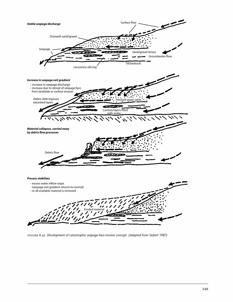
249
FIGURE 8.42 Development of catastrophic seepage-face erosion concept. (Adapted from Siebert 1987)
Stable seepage discharge
Increase in seepage exit gradient
Material collapses, carried away by debris flow processes
Process stabilizes
Outwash sand/gravel
Seepage
Surface flow
Sand/gravel lensesGroundwater flow
Till/bedrock
Perched water table
Cavities/layers filled with water
Debris slide exposessaturated layers
Debris flow
Eroded material
Lacustrine silt/clay
– increase in seepage discharge– increase due to retreat of seepage face from landslide or surface erosion
– excess water inflow stops (seepage exit gradient returns to normal)– or all available material is removed
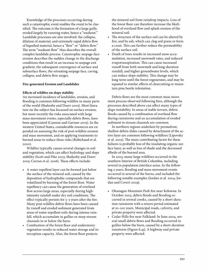
250
Knowledge of the processes occurring during such a catastrophic event enables the event to be clas-sified. The outcome is the formation of a large gully, eroded largely by running water, hence a “washout.” Landslide processes are also involved: the collapse, dilation of material, and extremely rapid debris flow of liquefied material, hence a “flow” or “debris flow.” The term “washout-flow” thus describes the overall complex landslide process. Catastrophic seepage-face erosion describes the sudden change in the discharge conditions that result in an increase in seepage exit gradient, the subsequent convergence of surface and subsurface flows, the retreating seepage face, caving, collapse, and debris flow surges.
Fire-generated Erosion and Landslides
Effects of wildfire on slope stabilityAn increased incidence of landslides, erosion, and flooding is common following wildfire in many parts of the world (Shakesby and Doerr 2005). Most litera-ture on the subject has focussed on surface erosion, but more recently the risks associated with large mass movement events, especially debris flows, have been appreciated (Cannon and Gartner 2005). In the western United States, considerable resources are ex-pended on assessing the risk of post-wildfire erosion and mass movement, and on applying treatments to burned areas to reduce these risks (Robichaud et al. 2000).
Wildfire typically causes several changes in soil and vegetation, which can affect hydrology and slope stability (Scott and Pike 2003; Shakesby and Doerr 2005; Curran et al. 2006). These effects include:
• Awater-repellentlayercanbeformedjustbelowthe surface of the mineral soil, caused by the deposition of hydrophobic compounds that are volatilized by burning of the forest floor. Water repellency can cause the generation of overland flow across large areas, especially during high-intensity rainfall under dry soil conditions. The effect typically persists for 3–5 years after the fire. Many post-wildfire debris flows have been caused by runoff and eroded sediment generated from areas of water-repellent soils during intense rain-fall, which accumulate in gullies or steep stream channels in or below the burn.
• Combustionoftheforestfloorandunderstoreyvegetation results in reduced water storage and in-terception capacity. Also, the forest floor protects
the mineral soil from raindrop impacts. Loss of the forest floor can therefore increase the likeli-hood of overland flow and splash erosion of the mineral soil.
• Thestructureofthesurfacesoilcanbealteredbyfire, and by ash, which can clog soil pores or form a crust. This can further reduce the permeability of the surface soil.
• Deathoftrees results in increased snow accu-mulation, increased snowmelt rates, and reduced evapotranspiration. This can cause increased runoff from both snowmelt and long-duration rainfall, and higher groundwater levels, which can reduce slope stability. This change may be long-term until the forest regenerates, and may be equated to similar effects of clearcutting or moun-tain pine beetle infestation.
Debris flows are the most common mass move-ment process observed following fires, although the processes described above can affect many types of slope instability. In areas of stable terrain, debris floods caused by a combination of overland flow during rainstorms and an accumulation of eroded sediment in stream channels are common.
In northern regions underlain by permafrost, shallow debris slides caused by detachment of the ac-tive layer are common following wildfires (Lipovsky et al. 2005). The main contributing factor for these failures is probably loss of the insulating organic sur-face layer, as well as loss of shade and the decreased albedo of the burned area.
In 2003, many large wildfires occurred in the southern Interior of British Columbia, including several in population interface areas. In the follow-ing 2 years, flooding and mass movement events occurred in several of the burns, and included the following notable examples (Jordan et al. 2004; Jor-dan and Covert 2009).
• OkanaganMountainParkfirenearKelowna:InOctober 2003, debris floods and flooding oc-curred in several creeks, caused by a short-dura-tion rainstorm with a return period estimated at 10–100 years. Municipal roads, culverts, and private property were affected.
• CedarHillsfirenearFalkland:InJune2004,sev-eral small debris flows and flooding occurred in gullies below the burn, caused by a short-duration rainstorm (Figure 8.43). A highway and private property were affected.
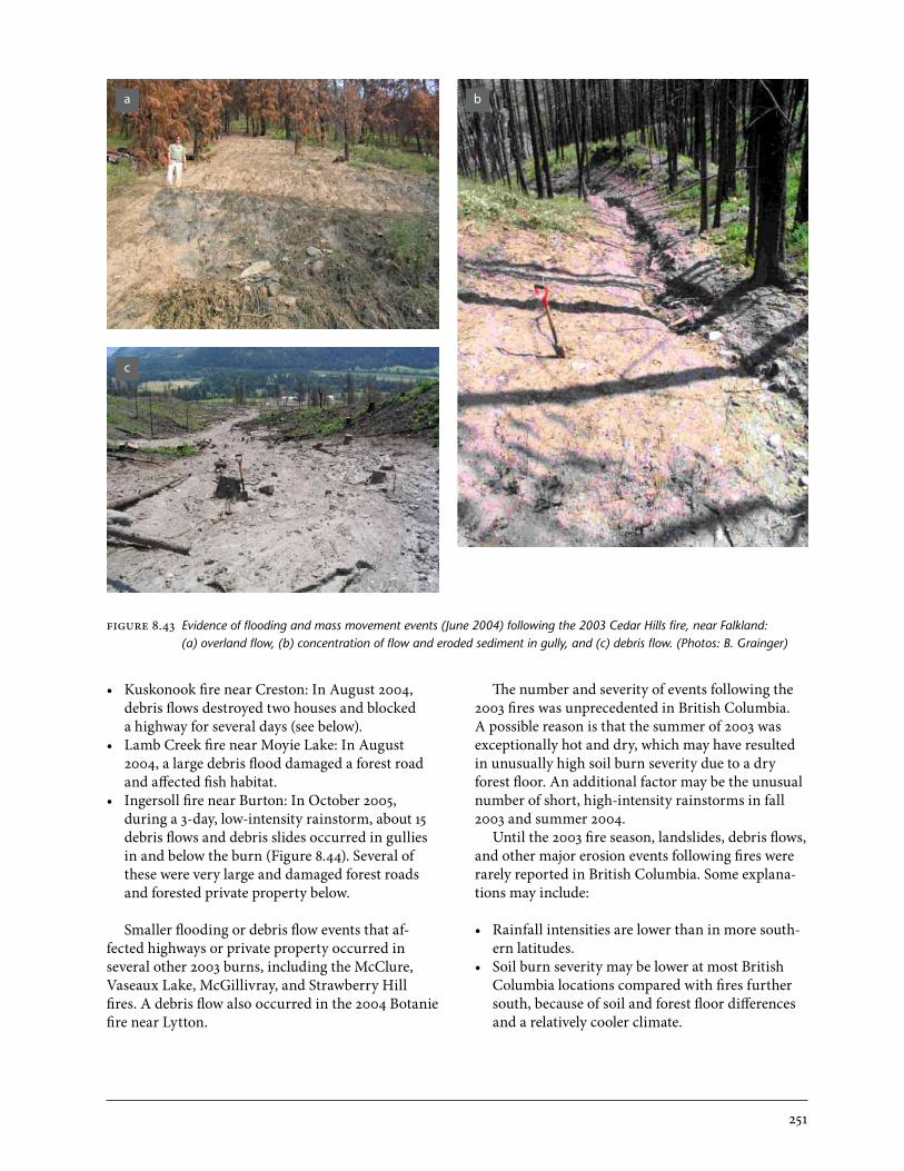
251
• KuskonookfirenearCreston:InAugust2004,debris flows destroyed two houses and blocked a highway for several days (see below).
• LambCreekfirenearMoyieLake:InAugust2004, a large debris flood damaged a forest road and affected fish habitat.
• IngersollfirenearBurton:InOctober2005,during a 3-day, low-intensity rainstorm, about 15 debris flows and debris slides occurred in gullies in and below the burn (Figure 8.44). Several of these were very large and damaged forest roads and forested private property below.
Smaller flooding or debris flow events that af-fected highways or private property occurred in several other 2003 burns, including the McClure, Vaseaux Lake, McGillivray, and Strawberry Hill fires. A debris flow also occurred in the 2004 Botanie fire near Lytton.
The number and severity of events following the 2003 fires was unprecedented in British Columbia. A possible reason is that the summer of 2003 was exceptionally hot and dry, which may have resulted in unusually high soil burn severity due to a dry forest floor. An additional factor may be the unusual number of short, high-intensity rainstorms in fall 2003 and summer 2004.
Until the 2003 fire season, landslides, debris flows, and other major erosion events following fires were rarely reported in British Columbia. Some explana-tions may include:
• Rainfallintensitiesarelowerthaninmoresouth-ern latitudes.
• SoilburnseveritymaybeloweratmostBritishColumbia locations compared with fires further south, because of soil and forest floor differences and a relatively cooler climate.
FIGURE 8.43 Evidence of flooding and mass movement events (June 2004) following the 2003 Cedar Hills fire, near Falkland: (a) overland flow, (b) concentration of flow and eroded sediment in gully, and (c) debris flow. (Photos: B. Grainger)
a b
c
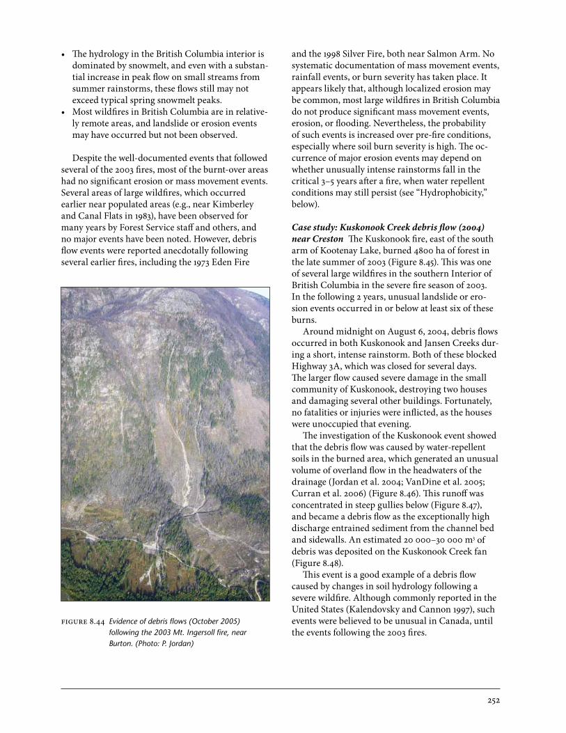
252
• ThehydrologyintheBritishColumbiainteriorisdominated by snowmelt, and even with a substan-tial increase in peak flow on small streams from summer rainstorms, these flows still may not exceed typical spring snowmelt peaks.
• MostwildfiresinBritishColumbiaareinrelative-ly remote areas, and landslide or erosion events may have occurred but not been observed.
Despite the well-documented events that followed several of the 2003 fires, most of the burnt-over areas had no significant erosion or mass movement events. Several areas of large wildfires, which occurred earlier near populated areas (e.g., near Kimberley and Canal Flats in 1983), have been observed for many years by Forest Service staff and others, and no major events have been noted. However, debris flow events were reported anecdotally following several earlier fires, including the 1973 Eden Fire
and the 1998 Silver Fire, both near Salmon Arm. No systematic documentation of mass movement events, rainfall events, or burn severity has taken place. It appears likely that, although localized erosion may be common, most large wildfires in British Columbia do not produce significant mass movement events, erosion, or flooding. Nevertheless, the probability of such events is increased over pre-fire conditions, especially where soil burn severity is high. The oc-currence of major erosion events may depend on whether unusually intense rainstorms fall in the critical 3–5 years after a fire, when water repellent conditions may still persist (see “Hydrophobicity,” below).
Case study: Kuskonook Creek debris flow (2004) near Creston The Kuskonook fire, east of the south arm of Kootenay Lake, burned 4800 ha of forest in the late summer of 2003 (Figure 8.45). This was one of several large wildfires in the southern Interior of British Columbia in the severe fire season of 2003. In the following 2 years, unusual landslide or ero-sion events occurred in or below at least six of these burns.
Around midnight on August 6, 2004, debris flows occurred in both Kuskonook and Jansen Creeks dur-ing a short, intense rainstorm. Both of these blocked Highway 3A, which was closed for several days. The larger flow caused severe damage in the small community of Kuskonook, destroying two houses and damaging several other buildings. Fortunately, no fatalities or injuries were inflicted, as the houses were unoccupied that evening.
The investigation of the Kuskonook event showed that the debris flow was caused by water-repellent soils in the burned area, which generated an unusual volume of overland flow in the headwaters of the drainage (Jordan et al. 2004; VanDine et al. 2005; Curran et al. 2006) (Figure 8.46). This runoff was concentrated in steep gullies below (Figure 8.47), and became a debris flow as the exceptionally high discharge entrained sediment from the channel bed and sidewalls. An estimated 20 000–30 000 m3 of debris was deposited on the Kuskonook Creek fan (Figure 8.48).
This event is a good example of a debris flow caused by changes in soil hydrology following a severe wildfire. Although commonly reported in the United States (Kalendovsky and Cannon 1997), such events were believed to be unusual in Canada, until the events following the 2003 fires.
FIGURE 8.44 Evidence of debris flows (October 2005) following the 2003 Mt. Ingersoll fire, near Burton. (Photo: P. Jordan)

253
Hydrophobicity Soils that repel water are hydropho-bic. Normally, soils have a high absorptive capacity for water such that water applied to coarse-textured soils will readily infiltrate the soil (DeBano et al. 1967); however, some soils repel water. These soils are referred to as “non-wettable,” “water repellent,” or “hydrophobic.” In wettable soil, a strong attraction exists between dry soil particles and water. In hydro-phobic soil, mineral particles are usually coated with non-polar organic materials that repel water. In wa-ter-repellent soils, drops of water form surface beads. Measuring the slope of the wetting angle between a droplet of water and the ground surface indicates the degree of hydrophobicity (Figure 8.49).
In British Columbia, forest fires sometimes cre-
ate hydrophobic layers in soil. Thick acidic humus, coarse-textured soils, high-intensity fires, and pro-longed periods of intense heat are important factors for the creation of water-repellent soil. Hydropho-bic substances are released from humus forms and condense at depth. Extremely high surface tempera-tures may actually destroy surface hydrophobicity, but cause a subsurface water-repellent layer to form deeper in the soil (perhaps 1–10 cm in depth).
With a hydrophobic layer at depth restricting infiltration, surface soil may become saturated fol-lowing precipitation, leading to overland flow, soil detachment, and erosion. The eroded material may coalesce into shallow landslides, or fill gullies and transform into debris flows.
FIGURE 8.45 View over Kuskonook and Jansen Creek watersheds, burned in 2003 fire. (Photo: D. Nichol)

254
FIGURE 8.46 Soil erosion caused by overland flow on burned soils. (Photo: M. Curran)
FIGURE 8.47 Gully erosion in headwaters of Kuskonook Creek. (Photo: P. Jordan)
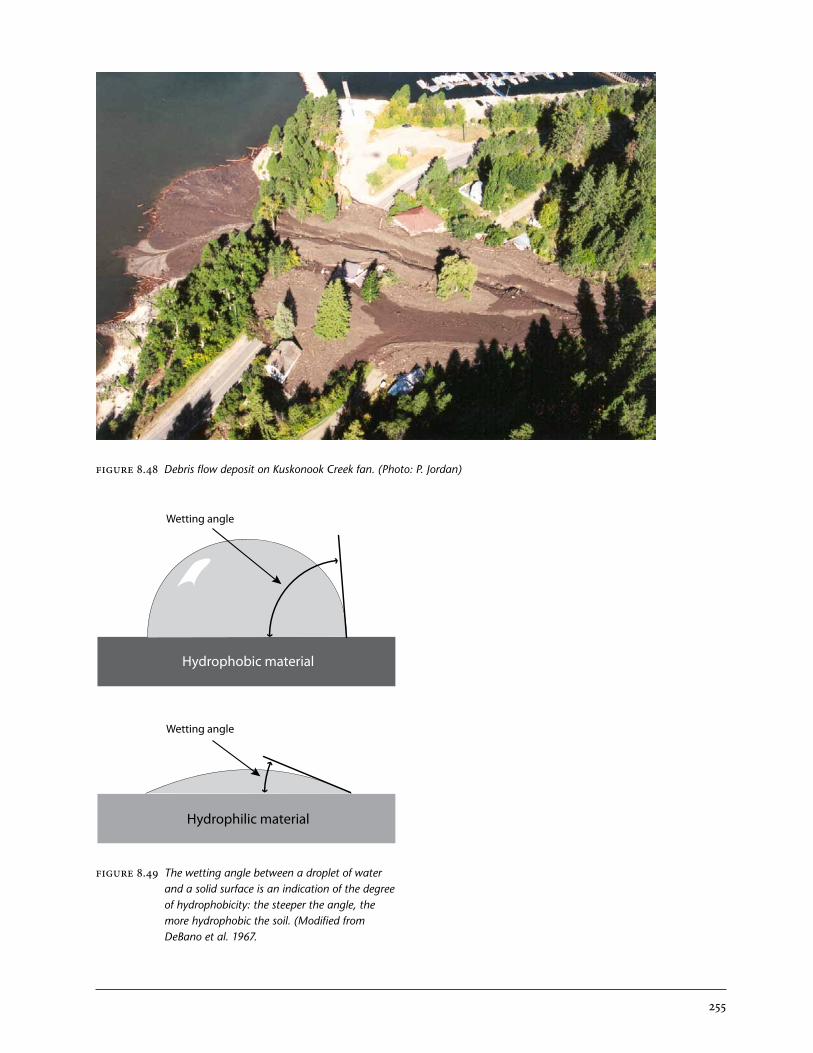
255
FIGURE 8.48 Debris flow deposit on Kuskonook Creek fan. (Photo: P. Jordan)
Hydrophobic material
Hydrophilic material
Wetting angle
Wetting angle
FIGURE 8.49 The wetting angle between a droplet of water and a solid surface is an indication of the degree of hydrophobicity: the steeper the angle, the more hydrophobic the soil. (Modified from DeBano et al. 1967.

256
indicators of instaBility
Field terrain stability analysis requires an eye for detail to read subtle changes in the landscape and on aerial photographs. It not only requires an under-standing of geomorphic processes, but also of local ecosystems.
Aerial Photograph Interpretation
Field investigations are usually preceded by aerial photograph interpretation. Sometimes unstable ter-rain is easy to recognize. Fresh, unvegetated scars often indicate recent landslide activity. Unstable terrain and old landslides that are overgrown with vegetation are more difficult to discern. Unvegetated and vegetated linear tracks are usually indicative of debris slides or flows. Debris flows usually have moderately steep fans, but the debris may also enter directly into powerful streams that remove the mate-rial, preventing fans from developing.
Flows tend to have ridges aligned in the direction of movement, whereas spreads and rotational slides (slumps) have ridges transverse to movement. Some-times spreads and slumps transform into flows as the slope over which they move becomes steeper, or as material becomes progressively weaker.
Deep-seated landslides tend to have arcuate main scarps, often with wet depressions, referred to as “sag ponds.” Over time, the ponds may drain or become filled with peat. The negative surface expression of zones of depletion is to be contrasted with the posi-tive surface expression of zones of accumulation. Lobate and hummocky surfaces are also characteris-tic of landslide deposits.
Field Interpretation
Many diagnostic features of past and potential land-slides can be noted in the field. Indicators of instabil-ity are manifested in surface expression, vegetation, rock, and soil.
Tension fractures, spoon-shaped depressions, ridges, scarps, antislope scarps, seepage, and ponds on hillslopes may all be indicative of unstable ter-rain. Lower down the slope, one might find ridges, hummocks, lobes, or rubble. Rotational slides may daylight (emerge at the surface) in rivers or streams, pushing up the river bed (Figure 8.50).
Water-loving vegetation on slopes indicates seep-age and is often associated with unstable terrain. The linear tracks of vegetation seen on aerial photo-graphs may also be recognizable on the ground. Old-er trees adjacent to the younger vegetation may bear scars or have persistent mud lines on their trunks. In addition to scars, trees may display pronounced in-clination or curvature. Trees tend to lean upslope at the head of landslides, and downslope on lobes, but this can be highly variable. In spreads and rotational landslides, trees tend to lean in the direction of rota-tion of the ridges and blocks formed beneath them. In some cases, trees may be split when they strad-dle a tension crack. Although trees typically display swelling at their bases, debris on fans may bury the lower parts of trees. Absence of buttswell should alert an observer to a burial event (Figure 8.51). Logs entrained in debris flows tend to be severely abraded (Figure 8.52).
Deposits formed by landslides may display a wide range of textural and morphological characteristics depending on the type of landslide. Deposits range from coarse angular blocks resulting from rock avalanches to fine-textured mud flow deposits. In general, landslide deposits display perturbation, but some translational landslides transport mate-rial with little to no internal disturbance. Typical colluvial soils are loose, with angular clasts. Debris flow clasts are often matrix-supported. Buried soils indicate repeated deposition events.
Reading and Interpreting the Landscape

257
FIGURE 8.50 Upturned rotational landslide toe exposed (arrow) in Kiskatinaw River, near Dawson Creek.; this landslide is sensitive to toe erosion by the river. (Photo: M. Geertsema)

258
FIGURE 8.52 Severely abraded log entrained in the 2002 Zymoetz rock slide–debris flow, near Terrace; the log is oriented in the direction of flow. (Photo: M. Geertsema)
FIGURE 8.51 Balsam poplars buried in debris-flow deposits near Chetwynd; note the absence of buttswell. (Photo: M. Geertsema)
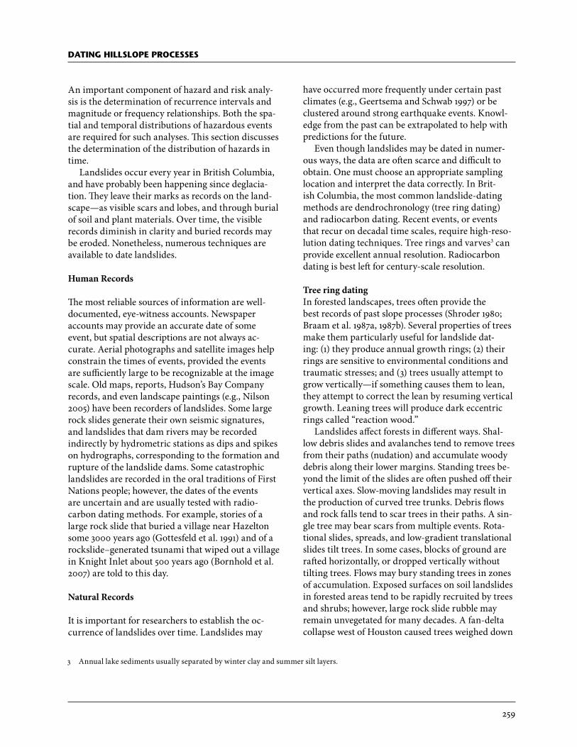
259
dating hillsloPe Processes
An important component of hazard and risk analy-sis is the determination of recurrence intervals and magnitude or frequency relationships. Both the spa-tial and temporal distributions of hazardous events are required for such analyses. This section discusses the determination of the distribution of hazards in time.
Landslides occur every year in British Columbia, and have probably been happening since deglacia-tion. They leave their marks as records on the land-scape—as visible scars and lobes, and through burial of soil and plant materials. Over time, the visible records diminish in clarity and buried records may be eroded. Nonetheless, numerous techniques are available to date landslides.
Human Records
The most reliable sources of information are well-documented, eye-witness accounts. Newspaper accounts may provide an accurate date of some event, but spatial descriptions are not always ac-curate. Aerial photographs and satellite images help constrain the times of events, provided the events are sufficiently large to be recognizable at the image scale. Old maps, reports, Hudson’s Bay Company records, and even landscape paintings (e.g., Nilson 2005) have been recorders of landslides. Some large rock slides generate their own seismic signatures, and landslides that dam rivers may be recorded indirectly by hydrometric stations as dips and spikes on hydrographs, corresponding to the formation and rupture of the landslide dams. Some catastrophic landslides are recorded in the oral traditions of First Nations people; however, the dates of the events are uncertain and are usually tested with radio-carbon dating methods. For example, stories of a large rock slide that buried a village near Hazelton some 3000 years ago (Gottesfeld et al. 1991) and of a rockslide–generated tsunami that wiped out a village in Knight Inlet about 500 years ago (Bornhold et al. 2007) are told to this day.
Natural Records
It is important for researchers to establish the oc-currence of landslides over time. Landslides may
have occurred more frequently under certain past climates (e.g., Geertsema and Schwab 1997) or be clustered around strong earthquake events. Knowl-edge from the past can be extrapolated to help with predictions for the future.
Even though landslides may be dated in numer-ous ways, the data are often scarce and difficult to obtain. One must choose an appropriate sampling location and interpret the data correctly. In Brit-ish Columbia, the most common landslide-dating methods are dendrochronology (tree ring dating) and radiocarbon dating. Recent events, or events that recur on decadal time scales, require high-reso-lution dating techniques. Tree rings and varves3 can provide excellent annual resolution. Radiocarbon dating is best left for century-scale resolution.
Tree ring datingIn forested landscapes, trees often provide the best records of past slope processes (Shroder 1980; Braam et al. 1987a, 1987b). Several properties of trees make them particularly useful for landslide dat-ing: (1) they produce annual growth rings; (2) their rings are sensitive to environmental conditions and traumatic stresses; and (3) trees usually attempt to grow vertically—if something causes them to lean, they attempt to correct the lean by resuming vertical growth. Leaning trees will produce dark eccentric rings called “reaction wood.”
Landslides affect forests in different ways. Shal-low debris slides and avalanches tend to remove trees from their paths (nudation) and accumulate woody debris along their lower margins. Standing trees be-yond the limit of the slides are often pushed off their vertical axes. Slow-moving landslides may result in the production of curved tree trunks. Debris flows and rock falls tend to scar trees in their paths. A sin-gle tree may bear scars from multiple events. Rota-tional slides, spreads, and low-gradient translational slides tilt trees. In some cases, blocks of ground are rafted horizontally, or dropped vertically without tilting trees. Flows may bury standing trees in zones of accumulation. Exposed surfaces on soil landslides in forested areas tend to be rapidly recruited by trees and shrubs; however, large rock slide rubble may remain unvegetated for many decades. A fan-delta collapse west of Houston caused trees weighed down
3 Annual lake sediments usually separated by winter clay and summer silt layers.

260
by sediment in root wads to float vertically in a lake for some weeks before sinking. Landslides that impound streams may drown trees upstream of the landslide dam. Over time, sediments accumulating in the temporary lakes may bury the trees.
Master chronologies can extend tree ring records back in time over a considerably longer span than living trees. The technique involves the statistical matching of ring sequences from living and fossil trees. Such cross-dating is far superior to radiocar-bon dating of fossil trees, but established chron-ologies are region-specific and time consuming to obtain. Brian Luckman (University of Western Ontario) has developed a master chronology for the Rocky Mountains, and Dan Smith (University of Victoria) has developed one for the Coast Moun-tains.
NudationLandslides tend to remove vegetation from slopes, resetting the plant successional clock. New recruit-ment of trees and shrubs on landslides facilitates landslide dating by providing a minimum age for an event’s deposit. Some species are rapid invaders, such as Alnus, Betula, Salix, and Picea, and these are use-ful for obtaining minimum dates of a landslide.
Dating landslides from new colonizing trees is not as simple as it might seem, as many potential sources of error exist. Trees may not appear within the first year following the landslide and may colonize at varying times. It is not always sufficient to date the oldest trees either, as many translational landslides transport trees in the vertical position (Figure 8.53). These trees simply continue to grow. Even if large trees are tilted during landslide transport, seedlings and small saplings may be transported without tilt-ing, and these may be difficult to distinguish from post–landslide-colonizing plants. Another source of error lies in the difficulty of finding the first growth ring. Minor subsequent movements may result in staggered colonization.
If the colonizing vegetation is significantly differ-ent from that of the surrounding forests (e.g., Salix in a Picea matrix), one can be more confident in the trees providing a reasonable minimum date of the landslide. The technique is best used on debris slides, and rock and debris avalanches where little of the original surface is preserved. In landslides that carry rafts of surface material, large sample sizes are recommended. More precise and accurate dates can be obtained from the analysis of reaction wood in leaning trees and from tree scars.
FIGURE 8.53 Rafted red alder in the Khyex landslide near Prince Rupert. Ring counts of these trees would over estimate the age of the landslide. (Photo: M. Geertsema)

261
InclinationThe inclination (or leaning) of trees produces reac-tion wood, which in cross-section shows dark eccen-tric rings rather than normal light concentric rings (Figure 8.54d). Reaction wood can be used to directly date landslide events. In sudden movements, the change can be abrupt, often with the tree curving up to grow vertically again. Sometimes, a lateral branch takes over vertical dominance (Figure 8.54b).
Gradual or episodic movement can also be re-corded in trees as can a change in the direction of tilting. Trees tend to be tilted upslope on rotational slide blocks and downslope on lobes. Trees can be tilted in multiple directions (“jackstrawed”) in hum-mocky deposits or in areas with many small failures within a larger landslide body.
Trees can lean for many reasons other than from
landslide movement (Figure 8.55). Trees often tilt in random directions in hummocky, permafrost ter-rain. They may tilt towards openings in the forest, exhibiting phototrophism, or growing towards the light. Trees may lean due to wind, particularly in shallow soils. Trees may be curved due to snowpack creep.
Corrasion (Scarring)Corrasion of tree bark can result from the impact of rocks, debris, or other trees (Figure 8.56). Scars yield direct dates of landslide events. A single tree can record multiple events by displaying multiple scars of varying ages. However, scars can also result from numerous non-landslide events, including the fall of neighbouring trees, animal gnawing, and frost damage.
FIGURE 8.54 Trees displaying variable responses to mass movement: (a), (c), and (d) show slow, episodic mass movement; (b) shows sudden, rapid movement that topples a tree and causes a lateral branch to assume apical dominance. (d) Note the various times and directions of reaction wood (arrows), which indicates leaning in different directions. (Photos: M. Geertsema)
a b
c d

262
FIGURE 8.55 Trees can lean for reasons other than slope instability: (a) trembling aspen near Dawson Creek display growth towards the light; (b) black spruce leaning due to ice dynamics in hummocky permafrost terrain west of Fort Nelson. (Photos: M. Geertsema)
FIGURE 8.56 Tree scars: (a) scarred western hemlock on debris flow levee; (b) four separate debris flow scars shown on one tree cookie. (Photos: (a) M. Geertsema; (b) J.W. Schwab)
BurialFlows in the lower, distal portions of landslides may partially bury trees without causing mortality. Evidence of burial may be lack of buttswell, and the sprouting of adventitious roots in the newly formed ground surface (Wilford et al. 2005a). Trees may also respond to the stress of burial by undergoing growth suppression. Response is often not immediate, and thus less reliable than scars and reaction wood for landslide dating.
DrowningMany landslides form lakes when streams are dammed, or when closed depressions (e.g., sag ponds) are formed on the landslide surface. Trees inundated by standing water may die as a result of drowning (Figure 8.57). Careful cross-dating of drowned tree ring sequences to those of pre-slide living trees can yield a landslide date; however, trees may not die in the first season of inundation, and
a
b
a b

263
FIGURE 8.57 Landslides often dam rivers, inundating their floodplains: (a) in 2007 a rock slide–debris avalanche in northwestern British Columbia impounded the Todagin River, drowning spruce trees; (b) spruce trees drowned by a landslide that occurred in the mid-1600s at Halden Creek in northeastern British Columbia (Geertsema and Clague 2006). The lake filled with sediment, preserving the trees. After the dam broke, and the lake drained, bank erosion exhumed the tree. (Photos: [a] M. Geertsema; [b]. J. Clague)
a
b

264
large sample sizes are needed. In cases where the drowned trees do not overlap in age with living trees, radiocarbon dating of organic layers in lake sedi-ments behind the landslide dam can be used.
Varve chronologiesVarves, or annual rhythmic sedimentary couplets that occur in certain types of lakes, typically include a silty summer layer and a clayey winter layer. Clay-size particles take longer to settle out of suspension than larger grain sizes, and are thus the only sedi-ment left to settle out of lake water in winter. Epi-sodes of increased sedimentation point to periods of increased instability in watersheds (e.g., Menounos et al. 2006). Sometimes, the distal portions of large debris flows enter lakes. Varve counting above and below such event beds, often in combination with other marker beds such as tephras, can provide precise and accurate dates of the events, but poten-tial sources of error exist. For example, varves can be difficult to count because of ambiguities in the sedi-ment record. The spatial distribution of the sources of the sediment and the landslide deposits usually remain unknown. The data collection is also ex-pensive and time consuming. The method has been applied to the dating of large submarine mud flows in Saanich Inlet (Blais-Stevens and Clague 2001).
Radiocarbon Dating
Radiocarbon dating is one of the most common and useful methods of dating prehistoric landslide deposits. It is useful for century-scale resolution, but can also be used for decadal timescales by using statistical techniques on more than one date.
Living plants take up CO2 from the atmosphere. Animals also take up this carbon because they either eat plants or eat other animals that have eaten plants. Two stable isotopes of carbon occur: 12C and 13C. The approximate relative ratios of 12C and 13C are 99% and 1%, respectively. The unstable 14C isotope undergoes radioactive decay and has a half-life of 5730 years. 14C occurs in trace amounts (1.2 x 10⁻¹⁰%) that vary slightly over time. Because the atmospheric produc-tion of 14C is not uniform, tree rings have been used to produce absolute calibration of radiocarbon data. The calibration curve plots radiocarbon age against calendar age.
When an organism dies, it ceases to take up CO2, and thus sets the radiocarbon clock. By measuring the declining proportion of 14C relative to total C, the approximate age of the item can be determined.
Conventional radiocarbon dating involves the counting of beta-rays given off as a decay product. The newer Accelerator Mass Spectrometry (AMS) dating method actually counts atoms, and requires much smaller sample sizes.
Radiocarbon dates can be improved by statisti-cal methods such as wiggle matching (Figure 8.58). Using a technique described by Bronk Ramsey et al. (2001), Geertsema and Clague (2006) radiocarbon dated both the pith and outer rings of trees buried by landslide debris near Fort Nelson. Counting the rings between the inner and outer sampled wood al-lowed for wiggle matching of the radiocarbon dates to improve the statistical precision (Figure 8.58).
Buried wood, charcoal, and basal peat are com-monly radiocarbon dated to determine landslide ages. Where datable material overlies a landslide, a minimum age is given, whereas a landslide overlying a datable organic layer yields a maximum age for the event.
Lichenometry
Lichenometry is the dating of lichens by measuring their nominal diameter (Figure 8.59). This tech-nique has been applied to the dating of landslides that expose rock faces and produce boulders. It has been especially useful in Europe, where calibration of Rhizocarpon spp. growth on gravestones is pos-sible. Although tried in British Columbia, the lack of growth curves and rigorous statistical sampling has thus far precluded its widespread use. The combina-tion of lichenometry with dendrochronology, AMS radiocarbon dating, and surface exposure dating could help establish growth curves for localized areas of the province.
Simple Comparative and Observational Dating
In many cases, the age of landslides exceeds the age of the trees on their surfaces. Datable elements may exist, but in routine terrain stability field assess-ments and mapping it is impractical and prohibi-tively expensive to use expensive dating techniques. Fortunately, landscape indicators provide clues about the age of landslides. These include soil develop-ment, degree of acidification, thickness of peat in depressions, rounding and degradation of ridges and scarps, rock colour, and lichen cover. A few examples are given below.
When a landslide removes surface soil, it sets back the pedogenic clock (Geertsema and Pojar 2007).

265
Soil-forming processes begin anew in the unweath-ered soil or rock. For example, a Podzol (a well-de-veloped soil; Soil Classification Working Group 1998) may be removed, restarting the cycle from Regosol to Brunisol to Podzol. Although soil development rates vary with climate and texture, a landslide with a Brunisol should be younger than that of a neighbouring landslide with a Podzol. It needs to be stressed that pre-slide soil horizons can be preserved in rafted blocks and, therefore, a careful evaluation of the context is essential.
Surface soils in forested areas are often more acidic than deeper soils. Testing pH, or simply test-ing for effervescence with hydrochloric acid, can dis-tinguish between younger and older surfaces in areas where carbonate-rich parent material is evident. For example, exposed depth material at the Mink Creek landslide near Terrace had a pH of 8 in sharp contrast to acidic surface soil with a pH of less than 5. Over time, the high-pH soil would be expected to become acidic.
Many landslides contain water-filled depressions, both in zones of depletion (usually sag ponds) and in zones of accumulation. Organic sediments often accumulate in these ponds, eventually forming peat. Although peat compacts over time, variable thickness of peat in landslide depressions may give some indication of relative age (e.g., Geertsema and Schwab 1997).
Sharp edges of landslide scarps and ridges de-grade, becoming more rounded with time (Keaton and Degraff 1996). This is especially true for soil landslides. In some landslides, ridges degrade rap-idly, whereas in others ridges persist for millennia, especially in the drier interior of the province. The relative ages of fractures in bedrock can be distin-guished, in part on the basis of physical weathering of the rock. In general, older landslides will have a more established drainage network and more sub-dued relief than fresh landslides.
Rock slide and rock fall scars expose fresh, un-weathered rock faces. These often have a lighter tone than the greyish, weathered (often lichen-covered) areas surrounding unweathered rock. On aerial pho-tographs, fresh rock slides have light tones. Without resorting to full lichenometric analysis, a compari-son of lichen absence to extensive lichen cover can indicate the relative ages of two surfaces.
FIGURE 8.58 Wiggle matching improves the precision of radiocarbon dating: (a) the rings of this cot-tonwood log buried by landslide debris near Fort Nelson were counted, and radiocarbon dates obtained from the pith and outer wood; (b) the dates were then wiggle matched with the ring count, improving the precision of the calibrated radiocarbon dates from 110 and 130 year errors to 25 and 45 year errors at 68 and 95% prob-abilities, respectively. This suggests that the kill date of the tree occurred sometime around 1388 AD ±12.5 years at the 1 sigma confidence level. (Modified from Geertsema and Clague 2006)
Rel
ativ
e p
rob
abili
ty
0.8
0.6
0.4
0.2
0.0
HC12-1 kill date : 644 ± 46
1000 1100 1200 1300 1400 1500
Calendar date
b
a

266
FIGURE 8.59 (a) Lichen-covered rubble in a bedrock spread southeast of Tumbler Ridge; (b) close-up of Rhizocarpon species. In lichenometry, several measurements are made from the centre to the outside of the thallus to provide an average measurement of radial growth. (Photos: M. Geertsema)
a
b

267
summary
British Columbia’s diverse physiography, geology, soils, and climate zones provide a unique template that hosts a wide variety of landslide types and ero-sion processes. Our mountainous topography results in steep slopes, great local relief, and high precipita-tion, all of which predispose much of the province to landslide activity. Because landslide types can have drastically different consequences, it is important to distinguish between them. For instance, a slow-mov-ing earth slide has different impacts than a rock ava-lanche, although both are classified as “landslides.” Preconditioning factors, such as weathering, glacial erosion, river erosion, geologic structure, earth-quakes, permafrost thaw, wildfire, deforestation, and road construction, can all lead to landsliding. The ultimate trigger may be heavy rainfall, snowmelt, undercutting, an increase in surface loading, or an earthquake.
Erosion is often a precursor of landsliding, and plays an important role in landscape evolution. For example, rain splash, and sheet, rill, and chan-nel erosion contribute to the formation of gullies. Erosion can also occur beneath the ground surface in pipes. Wildfires can cause surface erosion, partly through the creation of water-repellent soils, as well as through the loss of the protective forest floor. Ero-sion can lead to the “charging” of gullies and stream channels with sediment, which can ultimately lead to damaging debris flows.
The landscape holds records and provides clues about past and potential hillslope processes. Veg-etation, slope geometry, and microtopography can reveal important information. For example, wet-site indicators on slopes, tilted trees, spoon-shaped de-pressions, and hummocky lobes are all signs of slope instability. This evidence can be seen on air photos, and also in the field.
Determining when a landslide occurred is an important component of establishing return periods or landslide frequencies. Dating landslides is accom-plished in many ways, including the examination of air photos and written records. A common method of dating landslides is through dendrochronol-ogy. Trees may bear scars, or reaction wood, from multiple landslide events. Interpreting the tree rings permits the establishment of landslide frequencies. Other dating methods used in British Columbia include lichenometry, varve counting, and radiocar-bon dating.
Land use changes, such as road construction, tim-ber harvesting, and urbanization, can significantly increase the likelihood of landslides by changing the course of surface and subsurface drainage or by loading or undercutting slopes. Chapter 9 (“Forest Management Effects on Hillslope Processes”) dis-cusses some of the effects of land use, in particular forest management, on landslide hazard.
references
Allen, J.F. 1957. Landslides, washouts and mud flows in the Lower Fraser Valley, B.C. BASc thesis. Univ. British Columbia, Vancouver, B.C.
Alley, N.F. and B. Thomson. 1978. Aspects of envi-ronmental geology, parts of Graham Island, Queen Charlotte Islands. B.C. Min. Environ., Resour. Anal. Br. Victoria, B.C. Bull. No. 2.
B.C. Ministry of Forests. 2001. Gully assessment pro-cedure guidebook, 4th edition, version 4.1. For. Pract. Br., Victoria, B.C. For. Pract. Code B.C. Guideb. www.for.gov.bc.ca/tasb/legsregs/fpc/fpcguide/GULLY/GAPGdbk-Web.pdf.
B.C. Ministry of Transportation and Highways. 1996. Natural hazards in British Columbia. Geotech. Materials Br., Victoria, B.C.
Blais-Stevens, A. and J.J. Clague. 2001. Paleoseismic signature in late Holocene sediment cores from Saanich Inlet, British Columbia. Mar. Geol. 175:131–148.
Bornhold, B.D. and J.R. Harper. 1998. Engineering geology of the coastal and nearshore Canadian Cordillera. In: Engineering geology: a global view from the Pacific Rim. Proc., 8th Int. Con-gr., Int. Assoc. Eng. Geol. Environ., Vancouver, B.C. D.P. Moore and O. Hungr (editors). A.A. Balkema, Rotterdam, Netherlands, 1:63–75.

268
Bornhold, B.D., J.R. Harper, D. McLaren, and R.E. Thomson. 2007. Destruction of the First Na-tions village of Kwalate by a rock avalanche-generated tsunami. Atmos. Ocean 45:123–128.
Bottino, G., M. Chiarle, A. Joly, and G. Mortara. 2002. Modelling rock avalanches and their relation to permafrost degradation in glacial environments. Permafrost Periglac. Process. 13:283–288.
Bovis, M.J. 1982. Uphill facing antislope scarps in the Coast Mountains southwest British Columbia. Geol. Soc. Am. Bull. 93:804–812.
_______. 1985. Earthflows in the Interior Plateau, southwest British Columbia. Can. Geotech. J. 22:313–334.
_______. 1990. Rockslope deformation at Affliction Creek, southern Coast Mountains, British Co-lumbia, Canada. Can. J. Earth Sci. 27:243–254.
Bovis, M.J. and S.G. Evans. 1995. Rock slope move-ments along the Mount Currie “fault scarp,” southern Coast Mountains, British Columbia. Can. J. Earth Sci. 32:2015–2020.
_______. 1996. Extensive deformations of rock slopes in southern Coast Mountains, southwest Brit-ish Columbia, Canada. Eng. Geol. 44:163–182.
Bovis, M.J. and M. Jakob. 1999. The role of debris supply conditions in predicting debris flow ac-tivity. Earth Surf. Process. Land. 24:1039–1054.
Braam, R.R., E.E.J. Weiss, and P.A. Burrough. 1987a. Dendrogeomorphological analysis of mass movement: a technical note on the research method. Catena 14:585–589.
_______. 1987b. Spatial and temporal analysis of mass movement using dendrochronology. Catena 14:573–584.
Bronk Ramsey, C., J. van der Plicht, and B. Weninger. 2001. ‘Wiggle matching’ radiocar-bon dates. Radiocarbon 43:381–389.
Cannon, S.H. 2001. Debris-flow generation from recently burned watersheds. Environ. Eng. Geosci. 7:321–341.
Cannon, S.H. and J.E. Gartner. 2005. Wildfire related debris flow from a hazards perspective. In: Debris-flow hazards and related phenome-na. M. Jakob and O. Hungr (editors). Springer-Praxis, Berlin, Germany, pp. 321–344.
Chatwin, S.C., D.E. Howes, J.W. Schwab, and D.N. Swanston. 1994. A guide for management of landslide-prone terrain in the Pacific North-west. 2nd ed. B.C. Min. For., Res. Br., Victoria, B.C. Land Manag. Handb. No. 18. www.for.gov.bc.ca/hfd/pubs/docs/Lmh/Lmh18.pdf (Ac-cessed May 2010).
Church, M. and M.J. Miles. 1987. Meteorological antecedents to debris flow in southwestern British Columbia: some case histories. In: Debris flows/avalanches: process, recognition, and mitigation. J.E. Costa and G.F. Wieczoreck (editors). Geol. Soc. Am., Boulder, Colo. Rev. Eng. Geol. 7:63–79.
Clague, J.J. (compiler). 1989. The Quaternary geology of the Canadian Cordillera. In: Quaternary geology of Canada and Greenland. R.J. Fulton (editor). Geol. Surv. Can., Ottawa, Ont. Geol-ogy of Canada, Vol. 1. (Also Geological Society of America. The Geology of North America, Vol. K-1), pp. 17–96.
Clague, J.J. and J.G. Souther. 1982. The Dusty Creek landslide on mount Cayley, British Columbia. Can. J. Earth Sci. 19:524–539.
Costa, J.E. 1984. Physical geomorphology of debris flows. In: Developments and applications of geomorphology. J.E. Costa and P.J. Fleisher (editors). Springer-Verlag, Berlin, Germany, pp. 268–317.
Cruden, D.M. and D.J. Varnes. 1996. Landslide types and processes. In: Landslides investigation and mitigation. A.K. Turner and R.L. Schuster (editors). Natl. Res. Counc., Transport. Res. Brd., Washington, D.C. Spec. Rep. No. 247, pp. 36–75.
Curran, M.P., B. Chapman, G.D. Hope, and D. Scott. 2006. Large scale erosion and flood after wild-fires: understanding the soil conditions. B.C. Min. For. Range, Res. Br., Victoria, B.C. Tech. Rep. No. 030. www.for.gov.bc.ca/hfd/pubs/Docs/Tr/Tr030.htm (Accessed March 2010).
Davies, M.C.R., O. Hamza, and C. Harris. 2001. The effect of rise in mean annual temperature on the stability of rock slopes containing ice-filled discontinuities. Permafrost Periglac. Process. 12:137–144.
DeBano, L.F., J.F. Osborne, J.F. Krammes, and J. Letey. 1967. Soil wettability and wetting agents:
269
our current knowledge of the problem. U.S. Dep. Agric. For. Serv., Pac. S.W. For. Range Exp. Stn., Berkeley, Calif. Res. Pap. PSW 43.
Dramis, F., M. Govi, M. Guglielmin, and G. Mor-tara. 1995. Mountain permafrost and slope sta-bility in the Italian Alps: the Val Pola landslide. Permafrost Periglac. Process. 6:73–82.
Egginton, V.N. 2005. Historical climate variability from the instrumental record in Northern Brit-ish Columbia and its influence on slope stabil-ity. MSc thesis. Simon Fraser Univ., Burnaby, B.C.
Evans, S.G. 1989. The 1946 Mount Colonel Foster rock avalanche and associated displacement wave, Vancouver Island, British Columbia. Can. Geotech. J. 26:447–452.
Evans, S.G. and R.G. Buchanan. 1976. Geotechnical problems associated with silt deposits in the South Thompson Valley, British Columbia. Dep. Highways, Geotech. Materials Br., Victo-ria, B.C. Interim Rep.
Evans, S.G. and J.J. Clague. 1994. Recent climatic change and catastrophic geomorphic processes in mountain environments. Geomorphology 10:107–128.
Fannin, R.J. and T.P. Rollerson. 1993. Debris flows: some physical characteristics and behaviour. Can. Geotech. J. 30:71–81.
Geertsema, M. and J.J. Clague. 2006. 1000-year re-cord of landslide dams at Halden Creek, north-eastern British Columbia. Landslides 3:217–227.
Geertsema, M., J.J. Clague, J.W. Schwab, and S.G. Ev-ans. 2006a. An overview of recent large land-slides in northern British Columbia, Canada. Eng. Geol. 83:120–143.
Geertsema, M., D.M. Cruden, and J.W. Schwab. 2006b. A large, rapid landslide in sensitive glacioma-rine sediments at Mink Creek, northwestern British Columbia, Canada. Eng. Geol. 83:36–63.
Geertsema, M. and D.M. Cruden. 2008. Travels in the Canadian Cordillera. In: 4th Can. Conf. Geohazards. May 20–24, 2008. Quebec City, Que.
Geertsema, M., V.N. Egginton, J.W. Schwab, and J.J. Clague. 2007. Landslides and historic climate in northern British Columbia. In: Landslides
and climate change: challenges and solutions. R. McInnes, J. Jakeways, H. Fairbank, and E. Mathie (editors). Taylor and Francis, London, U.K., pp. 9–16.
Geertsema, M., O. Hungr, S.G. Evans, and J.W. Schwab. 2006c. A large rock slide–debris ava-lanche at Pink Mountain, northeastern British Columbia, Canada. Eng. Geol. 83:64–75.
Geertsema, M. and J.J. Pojar. 2007. Influence of landslides on biophysical diversity: a perspec-tive from British Columbia. Geomorphology 89:55–69.
Geertsema, M. and J.W. Schwab. 1997. Retrogres-sive flowslides in the Terrace-Kitimat, British Columbia area: from early post-deglaciation to present and implications for future slides. Proc., 11th Vancouver Geotech. Soc. Symp., Vancouver, B.C., pp. 115–133.
_______. 2006. Challenges with terrain stabil-ity mapping in northern British Columbia. Streamline Watershed Manag. Bull. 10:18–26. www.forrex.org/publications/streamline/ISS34/Streamline_Vol10_No1_art4.pdf (Accessed May 2010).
Geertsema, M. and J.K. Torrance. 2005. Quick clay from the Mink Creek landslide near Terrace, British Columbia: geotechnical properties, mineralogy, and geochemistry. Can. Geotech. J. 42:907–918.
Gottesfeld, A.S., R.W. Mathewes, and L.M. Johnson-Gottesfeld. 1991. Holocene debris flows and environmental history, Hazelton area, British Columbia. Can. J. Earth Sci. 8:1583–1593.
Gruber, S. and W. Haeberli. 2007. Permafrost in steep bedrock slopes and its temperature-re-lated destabilization following climate change. J. Geophys. Res. 112, F02S18, DOI:10.1029/2006JF000547.
Guthrie, R.H. 2002. The effects of logging on fre-quency and distribution of landslides in three watersheds on Vancouver Island, British Co-lumbia. Geomorphology 43(3–4):273–292.
Harris, C., M.C.R. Davies, and B. Etzelmüller. 2001. The assessment of potential geotechnical haz-ards associated with mountain permafrost in a warming global climate. Permafrost Periglac. Process. 12:145–156.

270
Hodgson, E.A. 1946. British Columbia earthquake. J. Roy. Astron. Soc. Can. 40:285–319.
Hogan, D.L. and J.W. Schwab. 1991. Meteorological conditions associated with hillslope failures on the Queen Charlotte Islands. B.C. Min. For., Victoria, B.C. Land Manag. Rep. No. 73. www.for.gov.bc.ca/hfd/pubs/Docs/Mr/Lmr/Lmr073.pdf (Accessed May 2010).
Holm, K., M.J. Bovis, and M. Jakob. 2004. The land-slide response of alpine basins to post-Little Ice Age glacial thinning and retreat in south-western British Columbia. Geomorphology 57:201–216.
Hungr, O., S.G. Evans, M.J. Bovis, and J.N. Hutchin-son. 2001. Review of the classification of land-slides of the flow type. Environ. Eng. Geosci. 7:221–238.
Hungr, O., S. McDougall, and M. Bovis. 2005. En-trainment of material by debris flows. In: De-bris flow hazards and related phenomena. M. Jakob and O. Hungr (editors). Springer-Praxis, Berlin, Germany, pp. 135–158.
Hungr, O. and D. Smith. 1985. Landslides and development in the Lower Mainland, British Columbia. B.C. Prof. Eng. 36:11–14.
Hutchinson, J.N. 2004. Review of flow-like mass movements in granular and fine-grained materials. In: Proc., International workshop on occurrence and mechanism of flow-like land-slides in natural slopes and earthfills. Sorrento, May 14–16, 2003. L. Picarelli (editor). Patron Editore, Bologna, Italy.
Hutchinson, J.N. and R. Bhandhari. 1971. Undrained loading: a fundamental mechanism of mud flows and other mass movements. Geotech-nique 21:353–358.
Jakob, M. 2000. The impacts of logging on landslide activity at Clayoquot Sound, British Columbia. Catena 38:279–300.
Jakob, M., M. Bovis, and M. Oden. 2005. The signifi-cance of channel recharge rates for estimating debris-flow magnitude and frequency. Earth Surf. Process. Land. 30:755–766.
Jakob, M., K. Holm, O. Lange, and J. Schwab. 2006. Hydrometeorological thresholds for landslide
initiation and forest operation shutdowns on the north coast of British Columbia. Landslides 3:228–238.
Jakob, M. and O. Hungr (editors). 2005. Debris flow hazards and related phenomena. Springer-Praxis, Berlin, Germany.
Jakob, M. and P. Jordan. 2001. Design flood estimates in mountain streams—the need for a geomor-phic approach. Can. J. Civil Engin. 28: 425–439.Jakob, M. and H. Weatherly. 2003. A hydrom-eterological threshold for landslide initiation on the north shore mountains of Vancouver British Columbia. Geomorphology 54:137–156.
Jakob, M. and H. Weatherly. 2003. A hydroclimatic threshold for landslide initiation on the North Shore Mountains of Vancouver, British Colum-bia. Geomorphology 54:137–156.
Jordan, P. and S.A. Covert. 2009. Debris flows and floods following the 2003 wildfires in south-ern British Columbia. Environ. Eng. Geosci. 15:217–234.
Jordan, P., M. Curran, and D. Nicol. 2004. Debris flows caused by water repellent soils in recent burns in the Kootenays. Div. Eng. Geosci. For. Sector, Assoc. Prof. Eng. Geosci. B.C. Aspect 9(3):4–9.
Kalendovsky, M.A. and S.H. Cannon. 1997. Fire-induced water-repellent soils: an annotated bibliography. U.S. Geol. Surv., Golden, Colo. Open-file Rep. 97-720. http://pubs.usgs.gov/of/1997/720/pdf/OFR-97-720.pdf (Accessed May 2010).
Karanka, E.J. 1986. Trends and fluctuations in precipitation and stream runoff in the Queen Charlotte Islands. B.C. Min. For., Res. Br., Vic-toria, B.C. Land Manag. Rep. No. 40. www.for.gov.bc.ca/hfd/pubs/Docs/Mr/Lmr/Lmr040.pdf (Accessed May 2010).
Keaton, J.R. and J.V. DeGraff. 1996. Surface obser-vation and geologic mapping. In: Landslides investigation and mitigation. A.K. Turner and R.L. Schuster (editors). Natl. Res. Counc., Transport. Res. Brd. Washington, D.C. Spec. Pap. No. 247, pp. 178–230.
Keefer, D.K. 1984. Landslides caused by earthquakes. Geol. Soc. Am. Bull. 95:406–421.

271
Lang, A., J. Moya, J. Corominas, L. Schrott, and R. Dikau. 1999. Classic and new dating methods for assessing the temporal occurrence of mass movements. Geomorphology 30:33–52.
Lipovsky, P.S., J. Coates, A.G. Lewkowicz, and E. Trochim. 2005. Active-layer detachments fol-lowing the summer 2004 forest fires near Daw-son City, Yukon. In: Yukon exploration and geology 2005. D.S. Emond, L.H. Weston, G.D. Bradshaw, and L.L. Lewis (editors). Yukon Geol. Surv., Whitehorse, Y.T., pp. 175–194.
Martin, Y., K. Rood, J.W. Schwab, and M. Church. 2002. Sediment transfer by shallow landsliding in the Queen Charlotte Islands, British Colum-bia. Can. J. Earth Sci. 39(2):189–205.
Mathews, W.H. 1979. Landslides of central Vancou-ver Island during the 1946 earthquake. Bull. Seismol. Soc. Am. 69(2):445–450.
McCuaig, S.J. 2000. Glacial history of the Nass River region. PhD thesis. Simon Fraser Univ., Burnaby, B.C.
McDougall, S. and O. Hungr. 2004. A model for the analysis of rapid landslide motion across three-dimensional terrain. Can. Geotech. J. 41:1084–1097.
Menounos, B., E. Schiefer, and O. Slaymaker. 2006. Nested temporal-scale sediment yield est-imates, Coast Mountains, British Columbia, Canada. Geomorphology 79:114–129.
Millard, T.H. 1999. Debris flow initiation in coastal British Columbia gullies. B.C. Min. For., Vancouver For. Reg., Nanaimo, B.C. Tech. Rep. No. TR-002. www.for.gov.bc.ca/RCO/research/georeports%5Ctr002.pdf (Accessed May 2010).
Millard, T.H., D.J. Wilford, and M.E. Oden. 2006. Coastal fan destabilization and forest manage-ment. B.C. Min. For. Range, Coast For. Reg., Nanaimo, B.C. Tech. Rep. No. TR-034. www.for.gov.bc.ca/rco/research/georeports/ tr-034.pdf (Accessed May 2010).
Moore, D.P. and D.J. Mathews. 1978. The rubble Creek landslide, southwestern British Colum-bia. Can. J. Earth Sci. 15:1039–1052.
Murty, T.S. 1979. Submarine slide-generated water waves in Kitimat Inlet, British Columbia. J. Geophys. Res. 84:7777–7779.
Nagle, H.K. 2000. Folic debris slides near Prince Rupert, British Columbia. MSc thesis. Univ. Alberta, Edmonton, Alta.
Nilson, E. 2005. From landscape painting to remote sensing: reconstructing 200 years of land-cover change in Central Europe. Gottinger Geogra-phische Abhandlungen 113:331–339.
Noetzli, J., C. Huggel, M. Hoelzle, and W. Haeberli. 2003. GIS-based modelling of rock/ice ava-lanches from Alpine permafrost areas. Com-put. Geosci. 10:161–178.
Pararas-Carayannis, G. 1999. Analysis of mechanism of the giant tsunami generation in Lituya Bay on July 9, 1958. In: Abstracts, Tsunami Symp. 1999, May 25–27, 1999, Honolulu, Hawaii. http://users.tpg.com.au/users/tps-seti/tsym.html (Accessed May 2010).
Parker, G.G., Jr. and C.G. Higgins. 1990. Piping and pseudokarst in drylands, with case studies by G.G. Parker, Sr., W.W. Wood. In: Groundwater geomorphology: the role of subsurface water in earth surface processes and landforms. C.G. Higgins and D.R. Coates (editors). Geol. Soc. Am., Boulder, Colo. Spec. Pap. No. 252, pp. 77–110.
Patton, F.D. 1976. The Devastation Glacier slide, Pemberton, B.C. In: Program and abstracts, Geol. Assoc. Can., Cordillera Sect., pp. 26–27.
Picarelli, L., G. Urcioli, M. Ramodini, and L. Comegna. 2005. Main features of mudslides in tectonized highly fissured clay shales. Land-slides 1:15–30.
Pierson, T.C. and J.E. Costa. 1987. A rheologic clas-sification of subaerial sediment-water flows. In: Debris flows/avalanches: process, recognition, and mitigation. J.E. Costa and G.F. Wieczoreck (editors). Geol. Soc. Am., Boulder, Colo. Rev. Eng. Geol. 7:1–12.
Prior, D.B. and B.D. Bornhold. 1988. Submarine morphology and processes of fjord fan deltas and related high-gradient systems: modern examples from British Columbia. In: Fan deltas: sedimentology and tectonic settings. W. Nemee and R.J. Steel (editors). Blackie and Son, London, U.K., pp. 125–143.

272
_______. 1990. The underwater development of Holocene fan deltas. In: Coarse-grained deltas. A. Colella and D.B. Prior (editors). Int. Assoc. Sedimentol. Spec. Publ. No. 10, pp. 75–90.
Prior, D.B., B.D. Bornhold, and M.W. Johns. 1984. Depositional characteristics of a submarine debris flow. J. Geol. 92:707–727.
Robichaud, P.R., J.L. Beyers, and D.G. Neary. 2000. Evaluating the effectiveness of post-fire re-habilitation treatments. U.S. Dep. Agric. For. Serv., Rocky Mtn. Res. Stn., Fort Collins, Colo. Gen. Tech. Rep. RMRS-GTR-63.
Rogers, G.C. 1980. A documentation of soil failure during the British Columbia earthquake of 23 June, 1946. Can. Geotech. J. 17:122–127.
Rood, K.M. 1984. An aerial photograph inventory of the frequency and yield of mass wasting on the Queen Charlotte Islands, British Columbia. B.C. Min. For., Victoria, B.C. Land Manag. Rep. No. 34. www.for.gov.bc.ca/hfd/pubs/Docs/Mr/Lmr/Lmr034.pdf (Accessed May 2010).
Sanborn, P., M. Geertsema, A.J.T. Jull, and B. Hawkes. 2006. Soil charcoal evidence for Ho-locene fire-related sedimentation in an inland temperate rain forest, east central British Co-lumbia, Canada. The Holocene 16:415–427.
Schwab, J.W. 1983. Mass wasting: October–November 1978 storm, Rennell Sound, Queen Charlotte Islands, British Columbia. B.C. Min. For., Victoria, B.C. Res. Note No. 91. www.for.gov.bc.ca/hfd/pubs/Docs/Mr/Scanned-Rn/Rn067-Rn100/Rn091.pdf (Accessed May 2010).
_______. 1997. Historical debris flows, British Co-lumbia north coast. In: Proc., Forestry geotech-nique and resource engineering, Richmond, B.C. BiTech Publishers, Vancouver, B.C.
_______. 1998. Landslides on the Queen Charlotte Islands: processes, rates, and climatic events. In: Carnation Creek and Queen Charlotte Is-lands fish/forestry workshop: applying 20 years of coastal research to management solutions. D.L. Hogan, P.J. Tschaplinski, and S. Chatwin (editors). B.C. Min. For. Res. Br., Victoria, B.C. Land Manag. Handb. No. 41, pp. 41–47. www.for.gov.bc.ca/hfd/pubs/docs/Lmh/Lmh41-1.pdf (Accessed May 2010).
_______. 1999. Tsunamis on Troitsa Lake, Brit-ish Columbia. B.C. Min. For., For. Sci. Sect., Smithers, B.C. Exten. Note No. 35. www.for.gov.bc.ca/rni/Research/Extension_notes/Enote35.pdf (Accessed May 2010).
_______. 2000. Donna Creek washout-flow. B.C. Min. For., Prince Rupert For. Reg., For. Sci. Sect., Exten. Note No. 42. www.for.gov.bc.ca/rni/Research/Extension_notes/Enote42.pdf (Accessed May 2010).
_______. 2001. Donna Creek washout-flow: what did we learn? In: Terrain stability and forest management in the interior of British Colum-bia: Workshop proceedings. May 23–25, 2001. Nelson, B.C. P. Jordan and J. Orban (editors). B.C. Min. For., For. Sci. Sect., place Tech. Rep. No. 003. pp. 1–13. www.for.gov.bc.ca/hfd/pubs/Docs/Tr/Tr003/Schwab.pdf (Accessed May 2010).
Schwab, J.W., M. Geertsema, and A. Blais-Stevens. 2004. The Khyex River landslide of Novem-ber 28, 2003, Prince Rupert British Columbia, Canada. Landslides 1:243–246.
Schwab, J.W. and M. Kirk. 2003. Sackungen on a forested slope, Kitnayakwa River. B.C. Min. For., Prince Rupert For. Reg., Prince Rupert, B.C. Exten. Note No. 47. www.for.gov.bc.ca/rni/research/Extension_Notes/Enote47.pdf (Ac-cessed May 2010).
Scott, D. and R. Pike. 2003. Wildfires and watershed effects in the southern B.C. interior. Streamline Watershed Manag. Bull. 7(3):1–4. www.forrex.org/publications/streamline/ISS26/streamline_vol7_no3_art1.pdf (Accessed March 2010).
Septer, D. and J.W. Schwab. 1995. Rainstorm and flood damage: northwest British Columbia 1891–1991. B.C. Min. For., Res. Br., Victoria, B.C. Land Manag. Handb. No. 31. www.for.gov.bc.ca/hfd/pubs/docs/Lmh/Lmh31.pdf (Ac-cessed May 2010).
Shakesby, R.A. and S.H. Doerr. 2005. Wildfire as a hydrological and geomorphological agent. Earth Sci. Rev. 74:269–307.
Shroder, J.F. 1980. Dendrogeomorphology: review and new techniques of tree-ring dating. Prog. Phys. Geogr. 4:161–188.
273
Sidle, R.C. and H. Ochiai. 2006. Landslides: pro-cesses, prediction, and land use. Water Resour. Monogr. Vol. 18. Am. Geophys. Union, Wash-ington, D.C.
Siebert, S.A. 1987. A case history of a catastrophic erosion in the Coquitlam valley, B.C. BSc the-sis. Geol. Eng. Program, Univ. British Colum-bia, Vancouver, B.C.
Soil Classification Working Group. 1998. The Cana-dian system of soil classification. 3rd edition. Natl. Res. Counc. Press, Ottawa, Ont. Agric. Agri-Food Can. Publ. No. 1646.
Souther, J.G. 1971. Geology and mineral deposits of Tulsequah map-area, British Columbia (104K). Geol. Surv. Can., Dep. Energy, Mines, and Resources, Ottawa, Ont. Memoir No. 362.
Swanston, D.N. and F.J. Swanson. 1976. Timber harvesting, mass erosion, and steepland forest geomorphology in the Pacific Northwest. In: Geomorphology and engineering. D.R. Coates (editor). Dowden, Hutchinson, and Ross, Stroudsburg, Pa., pp. 199–221.
Takahashi, T. 1981. Debris flow. Ann. Rev. Fluid Mech. 13:57–77.
Turner, A.K. and R.L. Schuster (editors). 1996. Landslides investigation and mitigation. Natl. Res. Counc., Transport. Res. Brd., Washington, D.C. Spec. Rep. No. 247.
Vallance, J.W. 2005. Volcanic debris flows. In: De-bris-flow hazards and related phenomena. M. Jakob and O. Hungr (editors). Springer-Praxis, Berlin, Germany, pp. 247–274.
VanDine, D.F. 1985. Debris flows and debris torrents in the southern Canadian cordillera. Can. Geo-tech. J. 22:44–68.
VanDine, D.F. and S.G. Evans. 1992. Large landslides on Vancouver Island, British Columbia. In: Geotechnique and natural hazards: a sympo-sium sponsored by the Vancouver Geotechni-cal Society and the Canadian Geotechnical
Society, May 6–9, 1992. BiTech Publishers, Vancouver B.C. pp. 193–197.
VanDine, D.F., R.F. Rodman, P. Jordan, and J. Du-pas. 2005. Kuskonook Creek: an example of a debris flow analysis. Landslides 2:257–265.
Varnes D.J. 1978. Slope movement types and process-es. In: Landslides, analysis and control. R.L. Schuster and R.J. Krizek (editors). Transport. Res. Brd., Natl. Acad. Sci. Spec. Rep. No. 176, pp. 11–33.
Weir, P. 2002. Snow avalanche management in for-ested terrain. B.C. Min. For., Res. Br., Victoria, B.C. Land Manag. Handb. No. 55. www.for.gov.bc.ca/hfd/pubs/Docs/Lmh/Lmh55.pdf (Ac-cessed May 2010).
Wieczorek, G.F. and T. Glade. 2005. Climatic factors influencing occurrence of debris flows. In: De-bris flow hazards and related phenomena. M. Jakob and O. Hungr (editors). Springer-Praxis, Berlin, Germany, pp. 325–362.
Wilford, D.J., P. Cherubini, and M.E. Sakals. 2005a. Dendroecology: a guide for using trees to date geomorphic and hydrologic events. B.C. Min. For., Res. Br., Victoria, B.C. Land Manag. Handb. No. 58. www.for.gov.bc.ca/hfd/pubs/Docs/Lmh/Lmh58.pdf (Accessed May 2010).
Wilford, D.J., M.E. Sakals, and J.L Innes. 2005b. Forest management on fans: hydrogeomor-phic hazards and general prescriptions. B.C. Min. For., Res. Br., Victoria, B.C. Land Manag. Handb. No. 57. www.for.gov.bc.ca/hfd/pubs/Docs/Lmh/Lmh57.pdf (Accessed March 2010).
Williams, M. 1966. The grand campus washout. Univ. British Columbia Alumni Chron. 20:9–11.
Wischmeier, W.H. and D.D. Smith, 1960. A universal soil-loss equation to guide conservation farm planning. Trans. Int. Congr. Soil Sci. 7:418–425.
Zischinsky, U. 1969. Uber sackungen. Rock Mechan. 1:30–52.
