highlights - asx.com.au
TRANSCRIPT

Vital intersects ultra-high grade, near-surface REO at Nechalacho
Highlights
● Ultra-high grades – among highest grades of rare earth projects globally – intersected at
Nechalacho, Canada
● Shallow ultra-high grade rare earth intersections at North T starter pit at Nechalacho
● Best results include:
○ 2.4m at 38.4% total rare earth oxides (TREO) (8.1% Nd Pr) from 13m
○ 5.1m at 22.9% TREO (5.2% Nd Pr) from 12m
○ 5.4m at 19.0% TREO (4.3% Nd Pr) from 2m
○ 2.4m at 29.6 %TREO (6.9% Nd Pr) from 26m
● High value Nd/Pr content of rare earths estimated at impressive level of 23.5% TREO
● Extensive bastnaesite mineralisation intersected that is amenable to concentration into
35%+ via conventional ore sorting technology with excellent metallurgical characteristics
with 97% recoveries
● All intersections contained within 30m of surface
● Results to be incorporated into an updated JORC resource due before end of Q1 2020.
Vital Metals Ltd (ASX:VML) is pleased to announce it has received outstanding results from a 2019
drilling and re-assaying program at its North T resource contained within its 100%-owned Nechalacho
Rare Earth Project, Northwest Territories, Canada.
Significant results include 2.4m at 38.4% total rare earth oxides (TREO) from 13m, 5.1m at 22.9%
TREO from 12m, 5.4m at 19.0% TREO from 2m and 2.4m at 29.6% TREO. The project boasts an
impressive light rare earth oxides (LREO) resource of 94.7 million tonnes at 1.46% TREO in the
measured, indicated and inferred JORC 2012 categories (See ASX announcement 13 December 2019).
Vital Metals Managing Director Geoff Atkins said: “These results are particularly significant – among the highest grades of any rare earth project in the world. The exceptional REO grades, with up to 8.1% NdPr, are being reported almost at surface, an ideal outcome for our plan to produce a high-grade REO concentrate from Nechalacho. This drilling is testing the near-surface Bastnaesite Zone at our North T deposit, which is expected to be our starter pit of the operation. The company is moving very quickly, and we expect to release an updated Resource incorporating these results before the end of March 2020.”
Fig 1. High grade bastnaesite mineralisation (red) from North T deposit
ASX / Media Announcement 19 February 2020
For
per
sona
l use
onl
y

North T Zone 2019 drilling and resampling
Nechalacho’s North T Zone is a small, high-grade REO deposit about 2km north of the much larger
Upper Zone. The North T Zone contains two distinct zones of REO mineralisation, a Bastnaesite
Subzone near the surface with an underlying Xenotime Subzone. Vital Metals is considering the
Bastnaesite Subzone in the North T Zone as a potential high-grade start-up.
Bastnaesite mineralisation at North T exhibits excellent concentration and metallurgical
characteristics. Vital believes that the bastnaesite mineralisation is one of the very few REO projects
globally where mineralisation can produce a 35%+ grade REO concentrate via conventional ore
sorting technology without the use of chemicals or water (see ASX announcement 5 December 2019).
The cost of concentrating ore without the use of water and chemicals is substantially lower than a
typical REO concentration process requiring extensive crushing, chemicals and a capital intensive
cracking and leaching plant with associated tailings dam and storage facilities costs.
Further, the bastnaesite mineralisation has excellent metallurgical characteristics with 97% recoveries
of the rare earths into solution via sulphuric acid leach (see ASX announcement 13 December 2019).
Fig 2. Cross section of North T Zone
For
per
sona
l use
onl
y

Drilling and Resampling
Vital’s 2019 drilling and resampling of historical drill core aimed to define the limits of the Bastnaesite
Subzone and upgrade the mineral resource categories to Measured and Indicated suitable for mining
studies. Vital completed 19 shallow diamond core holes for 794m, and total of 38 holes and 86.7 m of
historical diamond core was reassayed for the full suite of rare earth elements.
The 2019 program was successful in redefining the zone through the extension of REO mineralisation
to the limits of the Bastnaesite Subzone at North T. Vital expects data from the program will result in
a resource model suitable for mining studies. The combination of new drilling and resampling of
historical drill core defined the limits of the North T Zone bastnasite mineralisation on a nominal 15 by
15 metre drill pattern, giving a high level of confidence of the contained mineralisation.
Fig 3. Drill collars – North T Zone
For
per
sona
l use
onl
y

Historical drill core is from drilling programs in the 1980s, which targeted beryllium in the Xenotime
Subzone. Much of the Bastnaesite Subzone from the ‘80s was either unsampled or only assayed for
some rare earth oxides. The targeting of the Xenotime Subzone also resulted in the limits of the
Bastnaesite Subzone being open in most directions.
Most of Vital’s 2019 drill holes and the resampled historical holes intersected significant REO in the
Bastnaesite Subzone. The combination of resampling of the historical holes and the 2019 drilling
program has extended and defined the outer limits of the Bastnaesite Subzone.
Some of the better intersections are shown in the following table.
Hole Name From To Interval (m) TREO Grade (%) Nd2O3/Pr6O11(%)
83-16 26.1 28.5 2.4 29.6 6.9
84-78 16.7 18.0 1.3 35.3 8.1
85-99 13.3 16.8 3.5 25.7 5.8
85-109 4.9 7.5 2.6 26.9 5.9
85-110 13.0 15.4 2.4 38.4 8.2
19-128 2.6 8.0 5.4 19.0 4.3
19-130 2.7 4.7 2.0 28.9 6.5
19-131 12.2 17.3 5.1 22.9 5.2
Table 1: Selected high-grade intervals in the Bastnaesite Subzone
Appendix 3 has a complete list of significant TREO intersections including the grades of the individual light rare earth oxides. ENDS This announcement has been approved by the Board of Vital Metals. Contact: Mr Geoff Atkins Managing Director
Vital Metals Ltd Phone: +61 2 8823 3100 Email: [email protected]
Nathan Ryan Investor/Media Relations NWR Communications +61 420 582 887 [email protected]
ABOUT VITAL METALS Vital Metals Limited (ASX:VML) is an explorer and developer focussing on rare earths, technology metals and gold projects. Our projects are located across a range of jurisdictions in Canada, Africa and Germany. Nechalacho Rare Earth Project The Nechalacho project is a high grade, light rare earth (bastnaesite) project located at Nechalacho in the Northwest Territories of Canada and has potential for a start-up operation exploiting high-grade, easily accessible near surface mineralisation. The Nechalacho Rare Earth Project hosts within the Upper Zone, a measured, indicated and inferred JORC Resource of 94.7MT at 1.46% TREO. Wigu Hill Project The Company has signed a project development and option agreement with Montero Mining & Exploration Ltd, to acquire and develop the Wigu Hill Project located near Kisaki in Tanzania. The Wigu Hill project is a light rare earth element deposit and consists of a large carbonatite complex with bastnaesite mineralisation with a NI 43-101 Inferred resource estimate of 3.3Mt at 2.6% LREO5 including 510,000t @ 4.4% LREO5 on 2 of 10 possible drill targets. Nahouri Gold Project – Burkina Faso The Nahouri Gold Project (100% Vital) is located in southern Burkina Faso. The Project is made up of three contiguous permits; the Nahouri, Kampala and Zeko exploration permits. The Project is located in highly prospective Birimian Greenstone terrain with 400 sq km of contiguous tenements lying on the trend of the Markoye Fault Corridor.
For
per
sona
l use
onl
y

Aue Project – Germany The Aue Project (100% Vital) is located in the western Erzgebirge area of the German state of Saxony. The permit, comprising an area of 78 sq km is located in the heart of one of Europe’s most famous mining regions surrounded by several world class mineral fields. Historical mining and intensive exploration work carried out between from the 1940s and 1980s showed high prospectivity of the Aue permit area for cobalt, tungsten, tin, uranium and silver mineralisation. Qualified/Competent Persons Statement Nechalacho Rare Earth Project The information in this report relating to Exploration Results at the Nechalacho Rare Earths Project is based on, and fairly represents, information and supporting documentation prepared for Vital by Avalon Advanced Materials Inc. and Mr Brendan Shand. Mr Shand is a Competent Person and a member of the Australasian Institute of Mining and Metallurgy and an employee of the Company. Mr Shand has sufficient experience that is relevant to the style of mineralisation and type of deposit under consideration and to the activity being undertaken to qualify as a Competent Person as defined in the 2012 Edition of the ‘Australian Code for Reporting of Exploration Results, Mineral Resources and Ore Reserves’. Mr Shand consents to the inclusion in the report of the matters based on his information in the form and context in which it appears. ASX Listing Rule Information Nechalacho Rare Earth Project The Nechalacho Rare Earth Project hosts within the Upper Zone, a measured, indicated and inferred JORC Resource of 94.7MT at 1.46% TREO at 0.3% Nd203 cutoff grade (25.2% NdPr), comprised of a Measured Resource of 286,563T at 2.7% TREO (24.2% NdPr), an Indicated Resource of 1.6MT at 2.4% TREO (24.2% NdPr), and an Inferred Resource of 1.3Mt at 2.2% TREO (24.2% NdPr). The Company originally announced this resource on 13 December 2019 (Announcement) and confirms that it is not aware of any new information or data that materially affects the information included in the Announcement. All material assumptions and technical parameters disclosed in the Announcement that underpin the estimates continue to apply and have not materially changed. Wigu Hill Project The Company has previously disclosed the foreign estimates in compliance with ASX Listing Rule 5.12 in the announcement dated 25 June 2019 titled “Vital to Transform into Rare Earth Oxide Developer” (“Announcement”). The Company is not in possession of any new information or data relating the foreign estimates that materially impacts on the reliability of the estimates or the Company’s ability to verify the foreign estimates in accordance with Appendix 5A (JORC Code). The Company confirms that the supporting information provided in the Announcement continues to apply and has not materially changed Investors should note that the Mineral Resource estimate for the Wigu Hill Rare Earth Project is a foreign estimate and is not reported in accordance with the JORC Code. A competent person has not done sufficient work to classify this foreign estimate as a mineral resource in accordance with the JORC Code and it is uncertain that following further exploration or evaluation work that this foreign estimate will be able to be reported as a mineral resource in accordance with the JORC Code.
For
per
sona
l use
onl
y

JORC Code, 2012 Edition – Table 1 report – North T Zone Bastnaesite Subzone
Section 1 Sampling Techniques and Data (Criteria in this section apply to all succeeding sections.)
Criteria JORC Code explanation Commentary
Sampling techniques
• Nature and quality of sampling (eg cut channels, random chips, or specific specialised industry standard measurement tools appropriate to the minerals under investigation, such as down hole gamma sondes, or handheld XRF instruments, etc). These examples should not be taken as limiting the broad meaning of sampling.
• Include reference to measures taken to ensure sample representivity and the appropriate calibration of any measurement tools or systems used.
• Aspects of the determination of mineralisation that are Material to the Public Report.
• In cases where ‘industry standard’ work has been done this would be relatively simple (eg ‘reverse circulation drilling was used to obtain 1 m samples from which 3 kg was pulverised to produce a 30 g charge for fire assay’). In other cases more explanation may be required, such as where there is coarse gold that has inherent sampling problems. Unusual commodities or mineralisation types (eg submarine nodules) may warrant disclosure of detailed information.
• Resampling of historical diamond drill core are half splits of drill core from which samples had previously been taken. In rare cases where additional samples had previously been taken the samples are quarter splits of drill core. For the 2019 diamond drill program all the samples are half splits of drill core.
• Samples were collected from the bastnaesite mineralisation with lengths ranging 0.45 to 3.51 metres. The typical sample length was between 1.0 and 2.5 metres. The sampling lengths were dictated by the lithology of the core.
• All drill core samples were crushed to 90% <2 mm, then 1 kg was riffle split. The 1 kg splits from the samples taken in the summer programs of 2018 and 2019 were then pulverized to 90% <106 µm, whereas those from the fall 2019 samples were pulverized to 85% <75 µm.
• For the summer 2018 and summer 2019 resampling programs, the samples were assayed using a combination of ICP-MS and XRF techniques. Where both XRF and ICP-MS analyses were available for a sample, the XRF assay was used above 500 ppm REE. Two samples were analyzed via ICP-AES. For the 2019 drill core samples and samples from the historic core taken in the fall 2019 resampling program, only XRF assaying was done.
• The accuracy of the assaying has been validated through a combination of using standards with a known grade, inserting field blanks, performing reject and pulp duplicates and sending a number of samples to a second external laboratory as a check.
Drilling techniques
• Drill type (eg core, reverse circulation, open-hole hammer, rotary air blast, auger, Bangka, sonic, etc) and details (eg core diameter, triple or standard tube, depth of diamond tails, face-sampling bit or other type, whether core is oriented and if so, by what method, etc).
• BQ- and HQ-diameter core drilling for the historical drilling and HQ diameter core for the 2019 drill program
Drill sample recovery
• Method of recording and assessing core and chip sample recoveries and results assessed.
• Measures taken to maximise sample recovery and ensure representative
• Good core recovery in outcropping and sub-cropping competent rock with little weathering, a report by Currie (2003) indicates core recoveries >95% for the historical core. Good core recovery was observed for the 2019 drill
For
per
sona
l use
onl
y

Criteria JORC Code explanation Commentary
nature of the samples.
• Whether a relationship exists between sample recovery and grade and whether sample bias may have occurred due to preferential loss/gain of fine/coarse material.
program.
• The geological nature of the mineralization in the Bastnaesite Subzone (coarse bastnaesite), in many cases, is such that the risk of biased sampling is somewhat reduced.
Logging • Whether core and chip samples have been geologically and geotechnically logged to a level of detail to support appropriate Mineral Resource estimation, mining studies and metallurgical studies.
• Whether logging is qualitative or quantitative in nature. Core (or costean, channel, etc) photography.
• The total length and percentage of the relevant intersections logged.
• Historic and 2019 geological drill logs completed by an experienced professional geoscientist were used to delimit the outer pegmatite contacts.
• Qualitative logging, no systematic core photography available for historic core. For the 2019 drill program, core photographs are available.
• Most drill core is still on site, as half core, and can be viewed.
• Total length of the logged North T-Zone core is 6841 m and the core are 100% logged.
Sub-sampling techniques and sample preparation
• If core, whether cut or sawn and whether quarter, half or all core taken.
• If non-core, whether riffled, tube sampled, rotary split, etc and whether sampled wet or dry.
• For all sample types, the nature, quality and appropriateness of the sample preparation technique.
• Quality control procedures adopted for all sub-sampling stages to maximise representivity of samples.
• Measures taken to ensure that the sampling is representative of the in situ material collected, including for instance results for field duplicate/second-half sampling.
• Whether sample sizes are appropriate to the grain size of the material being sampled.
• From the historic core, half core splits were prepared from core that had not previously been sampled, for previously sampled core the remaining half splits were sampled, and in rare cases quarter core splits were sampled where this was the only remaining material.
• Half core splits were sampled for the 2019 drill program.
• The remaining half or quarter core samples from the historic cores essentially represent core duplicates and showed good reproducibility compared to the historic analyses, indicating that half/quarter core sampling is adequate.
• For each sampled interval the entire interval was either half split or quarter split to ensure a representative sample of the interval. The sampled core was crushed before assaying to ensure the material from the entire interval was analysed during the assaying process.
• Duplicates of both the coarse-crushed (<2 mm) rejects and of the assay pulps were analysed and showed good reproducibility of the REE assays, indicating that both materials are sufficiently homogeneous.
• The core sample intervals honour the contacts of the bastnaesite mineralization zones, thus providing adequate sample coverage.
Quality of assay data and laboratory tests
• The nature, quality and appropriateness of the assaying and laboratory procedures used and whether the technique is considered partial or total.
• For geophysical tools, spectrometers, handheld XRF instruments, etc, the parameters used in determining the analysis including instrument make and
• The assay methods for the REE include lithium borate fusion followed by ICP-MS or XRF analysis and are thus considered total.
• Analyses of pulp duplicates by a secondary laboratory were carried out to ensure assay accuracy.
For
per
sona
l use
onl
y

Criteria JORC Code explanation Commentary
model, reading times, calibrations factors applied and their derivation, etc.
• Nature of quality control procedures adopted (eg standards, blanks, duplicates, external laboratory checks) and whether acceptable levels of accuracy (ie lack of bias) and precision have been established.
• External REE standards supplied by Avalon Advanced Materials Inc. and inserted in the field, and external REE standards inserted by the laboratory (ALS) were analysed with each batch of assays to ensure the assaying procedures gave accurate results.
• Field blanks were inserted to monitor contamination; results were acceptable.
• Laboratory blank levels were acceptable.
• Core duplicates yielded acceptable reproducibility.
• Both reject and pulp duplicates yielded acceptable results.
Verification of sampling and assaying
• The verification of significant intersections by either independent or alternative company personnel.
• The use of twinned holes.
• Documentation of primary data, data entry procedures, data verification, data storage (physical and electronic) protocols.
• Discuss any adjustment to assay data.
• The assay data was collated by Volker Moeller of Avalon Advanced Materials Inc and verified by Brendan Shand of Cheetah Resources.
• For the Bastnaesite Subzone samples the entire data set was downloaded from the ALS portal and converted to oxides. No assay data was manually inserted reducing the likelihood of human data entry errors.
• Geology tables distinguishing pegmatite and host rock syenite were created from the original drill logs
Location of data points
• Accuracy and quality of surveys used to locate drill holes (collar and down-hole surveys), trenches, mine workings and other locations used in Mineral Resource estimation.
• Specification of the grid system used.
• Quality and adequacy of topographic control.
• All historic holes were surveyed at the time by a professional surveyor – Thomson Underwood McLellan Surveys Ltd of Yellowknife.
• Wardrop completed check surveys of 3 drill holes in 2006.
• 13 historic drill hole collars were re-surveyed by a professional surveyor in 2018 and the locations were reproduced within 2.6 m, with an average deviation of 2.3 m. This is considered sufficient accuracy for the purpose here.
• The grid system used is UTM NAD83 Zone 12 N, currently the standard system used in the area.
• Historic collar locations were recorded in UTM NAD27 Zone 12 N and converted to NAD83.
• A good agreement was observed between the collar elevations and a 2010 satellite topography survey.
• The 2019 drill holes were surveyed by a professional surveyor (Sub-Arctic Geomatics Ltd.) who used local survey reference points to ensure accuracy. F
or p
erso
nal u
se o
nly

Criteria JORC Code explanation Commentary
Data spacing and distribution
• Data spacing for reporting of Exploration Results.
• Whether the data spacing and distribution is sufficient to establish the degree of geological and grade continuity appropriate for the Mineral Resource and Ore Reserve estimation procedure(s) and classifications applied.
• Whether sample compositing has been applied.
• The drill hole spacing is approximately 15 by 15 m over the Bastnaesite Subzone.
• The drill hole spacing is considered to be adequate for the measured resource confidence category.
• For the Bastnaesite Subzone the compositing was set to 0.5 metres to ensure all samples were included in the estimation process and assign appropriate spatial influence to each composite.
Orientation of data in relation to geological structure
• Whether the orientation of sampling achieves unbiased sampling of possible structures and the extent to which this is known, considering the deposit type.
• If the relationship between the drilling orientation and the orientation of key mineralised structures is considered to have introduced a sampling bias, this should be assessed and reported if material.
• Most drill holes were drilled at or close to right angles to the orientation of the bastnaesite mineralisation reducing any chance of bias produced by the drill hole orientation.
Sample security
• The measures taken to ensure sample security. • The historic programs included standard provisions for sample security and storage
• 2018 and 2019 assay samples were sealed using zip locks, and multiple samples were placed in rice bags sealed with zip locks. Independent lab verified sealed sample integrity upon receipt.
• Analyses for elements such as rare earths, niobium and beryllium are unlikely to be altered as a result of insecurity of samples such as contamination.
Audits or reviews
• The results of any audits or reviews of sampling techniques and data. • The historic sample methods were externally reviewed by Wardrop, a large Canadian independent engineering company, in 2006/2007 and considered adequate for resource estimation purposes. This included a four-day site visit in 2006.
Section 2 Reporting of Exploration Results (Criteria listed in the preceding section also apply to this section.)
Criteria JORC Code explanation Commentary
Mineral tenement and land tenure status
• Type, reference name/number, location and ownership including agreements or material issues with third parties such as joint ventures, partnerships, overriding royalties, native title interests, historical sites, wilderness or national park and environmental settings.
• The North T-Zone is located on Mining Lease NT-3179 registered to Avalon Advanced Materials Inc. and expires 21 May 2027. On June 24, 2019, Avalon Advanced Materials Inc. announced that it has entered into a definitive agreement with Cheetah Resources Pty Ltd. to transfer ownership of the
For
per
sona
l use
onl
y
Criteria JORC Code explanation Commentary
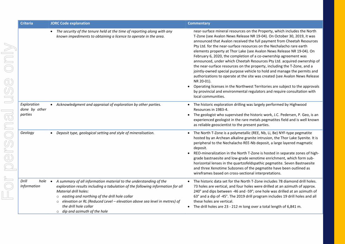
• The security of the tenure held at the time of reporting along with any known impediments to obtaining a licence to operate in the area.
near-surface mineral resources on the Property, which includes the North T-Zone (see Avalon News Release NR 19-04). On October 30, 2019, it was announced that Avalon received the full payment from Cheetah Resources Pty Ltd. for the near-surface resources on the Nechalacho rare earth elements property at Thor Lake (see Avalon News Release NR 19-04). On February 6, 2020, the completion of a co-ownership agreement was announced, under which Cheetah Resources Pty Ltd. acquired ownership of the near-surface resources on the property, including the T-Zone, and a jointly-owned special purpose vehicle to hold and manage the permits and authorizations to operate at the site was created (see Avalon News Release NR 20-01).
• Operating licenses in the Northwest Territories are subject to the approvals by provincial and environmental regulators and require consultation with local communities.
Exploration done by other parties
• Acknowledgment and appraisal of exploration by other parties. • The historic exploration drilling was largely performed by Highwood Resources in 1983-4.
• The geologist who supervised the historic work, J.C. Pedersen, P. Geo, is an experienced geologist in the rare metals pegmatites field and is well known as reliable geoscientist to the present parties.
Geology • Deposit type, geological setting and style of mineralisation. • The North T-Zone is a polymetallic (REE, Nb, Li, Be) NYF-type pegmatite hosted by an Archean alkaline granite intrusion, the Thor Lake Syenite. It is peripheral to the Nechalacho REE-Nb deposit, a large layered magmatic deposit.
• REO-mineralization in the North T-Zone is hosted in separate zones of high-grade bastnaesite and low-grade xenotime enrichment, which form sub-horizontal lenses in the quartzofeldspathic pegmatite. Seven Bastnaesite and three Xenotime Subzones of the pegmatite have been outlined as wireframes based on cross-sectional interpretations.
Drill hole Information
• A summary of all information material to the understanding of the exploration results including a tabulation of the following information for all Material drill holes: o easting and northing of the drill hole collar o elevation or RL (Reduced Level – elevation above sea level in metres) of
the drill hole collar o dip and azimuth of the hole
• The historic data set for the North T-Zone includes 78 diamond drill holes. 73 holes are vertical, and four holes were drilled at an azimuth of approx. 240° and dips between -46 and -59°; one hole was drilled at an azimuth of 63° and a dip of -45°. The 2019 drill program includes 19 drill holes and all these holes are vertical.
• The drill holes are 23 - 212 m long over a total length of 6,841 m.
For
per
sona
l use
onl
y

Criteria JORC Code explanation Commentary
o down hole length and interception depth o hole length.
• If the exclusion of this information is justified on the basis that the information is not Material and this exclusion does not detract from the understanding of the report, the Competent Person should clearly explain why this is the case.
• See the attached appendices for the details of each of the holes and the assay intervals used for the resource estimation.
Data aggregation methods
• In reporting Exploration Results, weighting averaging techniques, maximum and/or minimum grade truncations (e.g. cutting of high grades) and cut-off grades are usually Material and should be stated.
• Where aggregate intercepts incorporate short lengths of high-grade results and longer lengths of low-grade results, the procedure used for such aggregation should be stated and some typical examples of such aggregations should be shown in detail.
• The assumptions used for any reporting of metal equivalent values should be clearly stated.
• Where there was more than 1 assay for an interval a weighted average was used for the grade of the interval. The weighted average was calculated by using the following formula. Interval grade= (Sum of (Assay length X assay grade) )/(total interval length)
• No capping was applied as no outliers were observed.
Relationship between mineralisation widths and intercept lengths
• These relationships are particularly important in the reporting of Exploration Results.
• If the geometry of the mineralisation with respect to the drill hole angle is known, its nature should be reported.
• If it is not known and only the down hole lengths are reported, there should be a clear statement to this effect (eg ‘down hole length, true width not known’).
• The intervals reported closely approximate the true width of the mineralisation as most holes intersect at right angles to the dip of the mineralisation.
• The sample intervals are suitable for the mineralisation.
• The drill holes intersect the deposit at approximately right angles to the orientation of the orebody which is the ideal orientation.
• The orientation of the holes to the mineralization is well established.
Diagrams • Appropriate maps and sections (with scales) and tabulations of intercepts should be included for any significant discovery being reported These should include, but not be limited to a plan view of drill hole collar locations and appropriate sectional views.
• See figures in this ASX release for maps and section.
Balanced reporting
• Where comprehensive reporting of all Exploration Results is not practicable, representative reporting of both low and high grades and/or widths should be practiced to avoid misleading reporting of Exploration Results.
• All intervals used in the Mineral Resource estimation are reported Appendix 3.
Other substantive exploration data
• Other exploration data, if meaningful and material, should be reported including (but not limited to): geological observations; geophysical survey results; geochemical survey results; bulk samples – size and method of treatment; metallurgical test results; bulk density, groundwater, geotechnical and rock characteristics; potential deleterious or contaminating substances.
• Not applicable.
• Deleterious and contaminating materials are not present except for some thorium as is commonly present in rare earth deposits and well established with respect to levels. F
or p
erso
nal u
se o
nly

Criteria JORC Code explanation Commentary
Further work • The nature and scale of planned further work (eg tests for lateral extensions or depth extensions or large-scale step-out drilling).
• Diagrams clearly highlighting the areas of possible extensions, including the main geological interpretations and future drilling areas, provided this information is not commercially sensitive.
• No additional drilling is required on the Bastnaesite Subzone. There is confidence the outer limits of the Bastnaesite Subzone have been delineated. Mining and processing studies are on-going.
For
per
sona
l use
onl
y

Appendix 2: List of Drill Holes – North T Zone
For
per
sona
l use
onl
y

Hole ID Northing Easting Elevation Length (m) Azimuth Dip
83-1 6888706.4 416489.38 245 60.96 0 -90
83-2 6888724.4 416478.13 244.82 122.83 0 -90
83-3 6888750.4 416463.35 244.6 60.96 0 -90
83-4 6888683.4 416462.95 246.28 60.96 0 -90
83-5 6888706.4 416448.51 246.07 90.83 0 -90
83-6 6888736.4 416435.88 244.56 152.4 0 -90
83-8 6888760.9 416420.2 244.7 60.96 0 -90
83-9 6888777.9 416448.63 244.56 60.96 0 -90
83-10 6888807.4 416431.88 244.11 60.96 0 -90
83-11 6888796.4 416403.57 244.11 60.96 0 -90
83-12 6888762.9 416491.79 244.91 60.96 0 -90
83-13 6888738.9 416507.85 244.89 60.96 0 -90
83-15 6888668.4 416471.01 245.56 60.96 0 -90
83-16 6888789.9 416473.35 245.47 60.96 0 -90
83-17 6888805.4 416502.2 245.92 61 0 -90
83-18 6888780.9 416517.29 245.61 60.96 0 -90
83-33 6888654.9 416480.29 245.59 152.4 0 -90
83-34 6888681.4 416503.2 245.3 127.1 0 -90
83-35 6888728.4 416455.73 244.76 60.96 0 -90
83-36 6888691.4 416515.66 245.31 60.96 0 -90
83-37 6888691.4 416515.66 245.31 76.2 240 -46.26
83-38 6888717.4 416503.48 245.26 60.96 0 -90
83-39 6888717.4 416503.48 245.26 76.2 241.09 -46.36
83-40 6888693.9 416471.63 246.24 60.96 0 -90
83-41 6888674.9 416485.16 245.76 60.96 0 -90
83-42 6888670.4 416506.63 245.51 121.92 0 -90
83-43 6888744.4 416484.7 245.14 60.96 0 -90
83-44 6888662.9 416527.45 245.59 60.96 0 -90
84-46 6888731.4 416492.2 244.86 60.96 0 -90
84-47 6888731.4 416492.2 244.86 60.96 240 -46
For
per
sona
l use
onl
y

84-48 6888715.4 416464.82 244.7 60.96 0 -90
84-49 6888715.4 416464.82 244.7 76.2 63 -46
84-50 6888685.9 416479.48 245.78 60.96 0 -90
84-51 6888707.9 416509.32 245.1 60.96 0 -90
84-52 6888678.4 416523.1 245.28 60.96 0 -90
84-53 6888661.9 416493.95 245.43 61 0 -90
84-54 6888757.4 416477.35 244.75 60.96 0 -90
84-55 6888766.4 416455.73 244.52 60.96 0 -90
84-56 6888773.4 416470.07 245.02 60.96 0 -90
84-57 6888661.4 416458.48 245.56 61 0 -90
84-62 6888697.4 416491.98 245.05 60.96 0 -90
84-63 6888699.9 416452.7 246.24 61 0 -90
84-64 6888723.9 416444.7 244.5 60.96 0 -90
84-65 6888737.4 416470.7 244.73 60.96 0 -90
84-66 6888752.4 416496.85 244.66 60.96 0 -90
84-67 6888744.9 416449.32 244.49 60.96 0 -90
84-68 6888755.9 416443.1 244.5 60.96 0 -90
84-75 6888724.9 416466.98 244.46 191.11 0 -90
84-76 6888771.9 416452.76 244.81 212.45 0 -90
84-77 6888791.4 416440.23 244.81 191.11 0 -90
84-78 6888821.4 416426.73 244.36 114.91 0 -90
84-79 6888764.9 416473.82 244.83 178.92 0 -90
84-80 6888656.4 416516.85 245.24 78.33 0 -90
84-81 6888800.9 416454.51 245.47 84.43 0 -90
84-82 6888783.4 416427.79 244.44 89 0 -90
84-83 6888750.4 416446.26 244.74 105.77 0 -90
84-84 6888629.9 416535.88 246.18 84.43 0 -90
84-85 6888603.4 416543.48 246.18 40.23 0 -90
84-86 6888575.9 416558.13 247.14 63.09 0 -90
84-87 6888546.4 416573.95 249.6 73.76 0 -90
84-88 6888609.4 416550.63 245.28 78.33 0 -90
For
per
sona
l use
onl
y

84-89 6888580.9 416565.04 246.48 76.81 0 -90
85-94 6888798.4 416488.13 245.67 75.29 0 -90
85-95 6888815.9 416478.48 245.79 63.09 0 -90
85-96 6888828.9 416471.13 245.38 57.45 0 -90
85-97 6888806.9 416464.35 245.41 31.09 0 -90
85-98 6888820.9 416456.7 245.32 68.88 0 -90
85-99 6888834.4 416448.7 244.93 61.72 0 -90
85-100 6888823.9 416492.91 245.57 53.95 0 -90
85-101 6888814.9 416444.63 245.1 75.28 0 -90
85-102 6888800.4 416418.76 244.12 63.7 0 -90
85-103 6888773.4 416409.88 244.23 54.86 0 -90
85-104 6888771.9 416503.6 245.2 49.98 0 -90
85-105 6888777.9 416482.38 245.33 77.11 0 -90
85-106 6888759.9 416510.1 244.85 46.48 0 -90
85-107 6888792.9 416510.1 245.6 60.05 0 -90
85-108 6888785.9 416496.1 245.58 72.24 0 -90
85-109 6888834.4 416417.95 243.81 57 0 -90
85-110 6888812.4 416411.95 243.96 61.57 0 -90
85-111 6888768.4 416432.6 244.05 86.56 0 -90
85-112 6888749.9 416428.23 244.04 65.53 0 -90
85-113 6888783.9 416460.57 245.21 36 0 -90
85-114 6888780.4 416461.76 244.81 102.71 0 -90
86-115 6888806.4 416518.57 245 166.73 243 -59
86-116 6888636.19 416599.6 245.07 108.81 241 -55.5
86-117 6888607.12 416611.02 245.48 84.43 241 -50
86-118 6888521.59 416659.25 247.33 85.65 241 -48.5
19-119 6888766.04 416523.96 244.278 23 0 -90
19-120 6888785.77 416528.11 245.163 30 0 -90
19-121 6888794.07 416518.96 245.388 34 0 -90
19-122 6888813.81 416495.31 245.157 40 0 -90
19-123 6888805.81 416480.84 245.176 49 0 -90
For
per
sona
l use
onl
y

19-124 6888796.72 416467.2 245.12 52 0 -90
19-125 6888833.09 416484.93 245.225 48 0 -90
19-126 6888840 416462.83 244.496 47 0 -90
19-127 6888845.92 416439.15 244.349 40 0 -90
19-128 6888839.03 416427.42 243.944 50.5 0 -90
19-129 6888842.37 416411.12 243.67 45 0 -90
19-130 6888828.21 416435.67 244.472 35 0 -90
19-131 6888824.4 416403.44 243.567 25 0 -90
19-132 6888804.41 416396.84 243.034 53 0 -90
19-133 6888785.17 416412.34 243.417 51 0 -90
19-134 6888782.85 416443.05 244.386 47 0 -90
19-135 6888765.15 416442.33 243.633 46 0 -90
19-136 6888768.63 416485.3 244.54 35 0 -90
19-137 6888759.25 416459.52 244.178 44 0 -90
For
per
sona
l use
onl
y

Appendix 3: List of Drill Hole intercepts in the Bastnaesite Subzone
Hole ID From To Length La2O3 (%) CeO2 (%) Pr6O11 (%) Nd2O3 (%) LREO (%) TREO (%)
83-10 19.2 20.7 1.5 2.8 5.4 0.6 1.9 10.7 11.0
83-12 19.2 20.8 1.6 2.5 5.2 0.6 2.2 10.5 10.9
83-12 23.2 23.9 0.7 4.7 9.5 1.1 3.8 19.1 19.8
83-16 26.1 28.5 2.4 7.3 14.6 1.6 5.3 28.7 29.6
83-17 14.6 17.7 3.0 0.4 0.8 0.1 0.3 1.5 1.6
83-17 20.7 21.6 0.9 1.5 3.1 0.3 1.1 6.1 6.3
83-6 16.3 17.4 1.1 0.9 1.8 0.2 0.7 3.5 3.7
83-8 19.8 20.6 0.8 2.7 5.3 0.6 1.8 10.4 10.7
83-9 33.8 36.0 2.1 0.7 1.4 0.2 0.7 2.9 4.3
84-46 7.3 9.8 2.4 1.6 3.2 0.4 1.3 6.4 6.7
84-47 11.6 14.3 2.7 1.0 2.1 0.2 0.9 4.2 4.4
84-54 26.2 27.6 1.4 0.5 1.0 0.1 0.5 2.1 3.0
84-56 32.5 36.0 3.5 0.6 1.2 0.1 0.5 2.5 3.2
84-68 19.7 20.6 0.9 0.9 1.7 0.2 0.7 3.5 3.7
84-68 26.9 30.4 3.5 0.5 1.0 0.1 0.4 2.1 2.2
84-76 29.1 30.5 1.4 0.9 1.9 0.2 0.8 3.8 3.9
84-77 26.5 29.1 2.6 2.9 5.9 0.7 2.4 11.9 12.4
84-78 16.7 18.0 1.3 8.8 17.4 1.9 6.2 34.4 35.3
84-79 19.7 22.7 3.0 3.6 7.1 0.8 2.5 14.0 14.5
84-81 25.3 26.4 1.1 5.3 10.7 1.2 4.3 21.5 22.3
84-82 35.4 37.5 2.1 2.7 5.6 0.6 2.2 11.1 11.6
84-82 39.0 40.8 1.8 2.7 5.5 0.6 2.2 11.1 11.5
85-94 15.3 15.8 0.5 2.4 5.1 0.6 2.1 10.2 10.6
85-94 20.4 23.0 2.6 4.0 8.1 0.9 3.1 16.0 16.5
85-95 18.0 18.9 0.9 3.8 7.5 0.8 2.9 15.0 15.6
85-95 20.1 21.3 1.2 6.4 12.8 1.4 4.7 25.3 26.1
85-96 15.2 20.6 5.4 3.1 6.0 0.7 2.1 11.9 12.2
85-97 25.9 27.7 1.8 4.0 8.1 0.9 3.1 16.1 16.8
85-98 18.0 19.5 1.5 2.0 4.0 0.5 1.6 8.0 8.3
For
per
sona
l use
onl
y

85-98 20.7 22.1 1.4 5.9 11.3 1.2 3.9 22.4 23.0
85-99 13.3 16.8 3.5 6.5 12.8 1.4 4.4 25.1 25.7
85-100 9.6 10.4 0.8 6.6 13.3 1.5 5.0 26.4 27.2
85-101 19.5 20.6 1.0 7.2 14.1 1.5 5.0 27.8 28.7
85-102 15.1 19.7 4.6 0.9 1.7 0.2 0.7 3.5 4.8
85-103 14.2 15.4 1.2 1.1 2.2 0.2 0.8 4.3 4.5
85-104 11.6 13.4 1.8 1.4 2.8 0.3 1.1 5.6 5.8
85-104 18.4 20.4 2.0 3.0 6.2 0.7 2.5 12.4 12.9
85-105 23.5 24.4 0.9 1.4 2.8 0.3 1.1 5.6 5.9
85-106 9.6 11.4 1.8 2.7 5.7 0.7 2.4 11.6 12.2
85-107 20.6 21.3 0.8 5.7 10.9 1.1 3.8 21.5 22.2
85-108 19.8 22.6 2.7 2.3 4.9 0.6 1.9 9.7 10.0
85-109 4.9 7.5 2.6 7.0 13.3 1.4 4.5 26.2 26.9
85-110 10.4 11.0 0.6 6.1 12.5 1.4 4.9 24.9 25.8
85-110 13.0 15.4 2.4 9.9 19.0 2.0 6.2 37.0 38.4
85-112 8.2 9.0 0.8 1.1 2.2 0.3 0.9 4.5 4.7
85-114 27.3 28.0 0.8 2.5 5.0 0.5 1.8 9.9 10.2
86-115 22.9 23.9 1.1 1.1 2.2 0.2 0.8 4.2 4.4
19-119 2.5 4.0 1.5 0.9 1.6 0.2 0.6 3.3 3.4
19-120 No significant intersection
19-121 11.0 12.6 1.6 1.6 3.3 0.4 1.3 6.5 6.8
19-122 17.0 21.2 4.2 1.0 1.8 0.2 0.6 3.5 3.6
19-123 14.5 21.7 7.2 1.9 3.8 0.4 1.4 7.6 7.8
19-124 15.9 18.8 2.9 0.9 1.8 0.2 0.7 3.7 3.8
19-124 22.8 26.9 4.2 2.9 5.8 0.6 2.1 11.4 11.8
19-125 8.3 9.8 1.5 4.8 9.8 1.1 3.6 19.3 19.9
19-126 14.0 16.8 2.8 0.7 1.4 0.2 0.5 2.8 2.9
19-126 21.0 23.0 2.0 0.7 1.3 0.1 0.4 2.6 2.7
19-127 4.0 8.7 4.7 2.2 4.5 0.5 1.7 8.9 9.1
19-127 14.0 15.5 1.5 1.0 1.7 0.2 0.5 3.3 3.4
19-127 21.8 24.0 2.2 0.9 1.7 0.2 0.5 3.3 3.4
19-128 2.6 8.0 5.4 4.7 9.4 1.0 3.3 18.5 19.0
For
per
sona
l use
onl
y

19-129 13.0 17.0 4.0 0.5 1.0 0.1 0.3 2.0 2.1
19-130 2.7 4.7 2.0 7.3 14.4 1.6 4.9 28.2 28.9
19-131 12.2 17.3 5.1 5.7 11.3 1.2 4.0 22.3 22.9
19-132 6.1 10.0 3.9 0.7 1.3 0.1 0.5 2.6 2.6
19-133 18.0 20.5 2.5 0.8 1.6 0.2 0.6 3.1 3.4
19-134 39.0 41.0 2.0 0.4 0.8 0.1 0.4 1.7 2.8
19-135 38.1 38.7 0.6 1.9 4.1 0.5 1.8 8.2 8.9
19-135 44.0 46.0 2.0 0.3 0.7 0.1 0.4 1.5 3.1
19-136 19.6 22.9 3.3 2.7 5.6 0.6 2.2 11.1 11.5
19-137 No significant intersection
For
per
sona
l use
onl
y