high grade lithium results at morabisi for lodgement · 10/25/2017 · turesi tt17-01 grab 234695...
TRANSCRIPT
25 October 2017
HIGH GRADE LITHIUM RESULTS AT MORABISI – Up to 2.63% Li2O
Highlights
• Up to 2.63% Li2O sampled from in-situ pegmatite in Trench #1 at Turesi.
• Numerous samples over 2% Li2O indicate potential for large Li-pegmatite zone with
both Spodumene & Polylithionite reported.
• Mapped Lithium bearing pegmatites have strong correlation with scintillometer
readings.
• Elevated Lithium analyses from grab sampling of in-situ pegmatites exposed during
trenching.
• Confirmation of exploration thesis that Lithium rich pegmatites exist beneath
weathered overburden.
• At Turesi additional trenches are planned to confirm pegmatite dip and strike, prior
to planning a drilling program.
• Banka drilling and ground penetrating radar programs to commence at Robello in the coming weeks.
Greenpower Energy Ltd (ASX: Greenpower, “GPP”, “Company”) is pleased to provide the following update regarding field activities at the Morabisi Lithium/REE Project (“Project”).
Summary of Progress – Turesi & Banakaru Trenching
Greenpower confirms that Initial trenching at Turesi and Banakaru has now been completed with additional trenching planned at Turesi to confirm the dip and strike of the pegmatites in November.
Three trenches at Turesi have been dug (803m) and two trenches in Banakaru (887m). Follow-up stream sediment sampling was carried out at the East Camp lithium target in order to better define the target area prior to any trenching. Sample collection totals are shown in Table 2.
Turesi Lithium Update
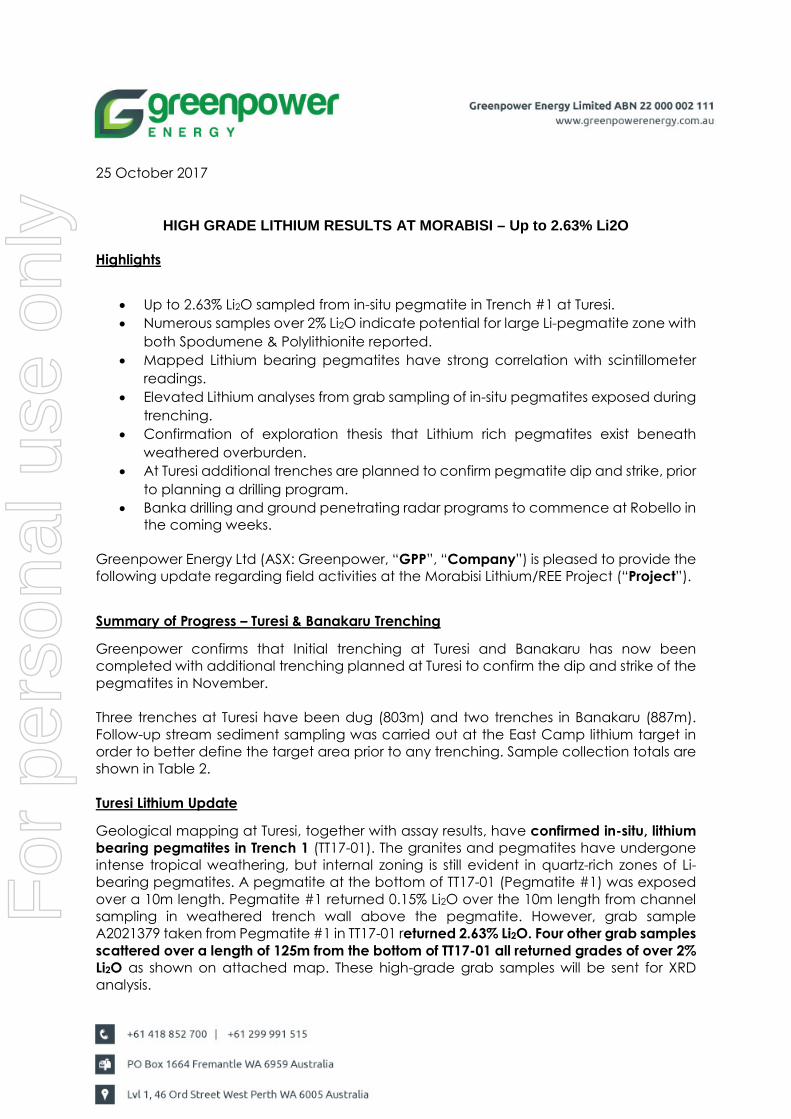
Geological mapping at Turesi, together with assay results, have confirmed in-situ, lithium bearing pegmatites in Trench 1 (TT17-01). The granites and pegmatites have undergone intense tropical weathering, but internal zoning is still evident in quartz-rich zones of Li-bearing pegmatites. A pegmatite at the bottom of TT17-01 (Pegmatite #1) was exposed over a 10m length. Pegmatite #1 returned 0.15% Li2O over the 10m length from channel sampling in weathered trench wall above the pegmatite. However, grab sample A2021379 taken from Pegmatite #1 in TT17-01 returned 2.63% Li2O. Four other grab samples scattered over a length of 125m from the bottom of TT17-01 all returned grades of over 2% Li2O as shown on attached map. These high-grade grab samples will be sent for XRD analysis.
For
per
sona
l use
onl
y
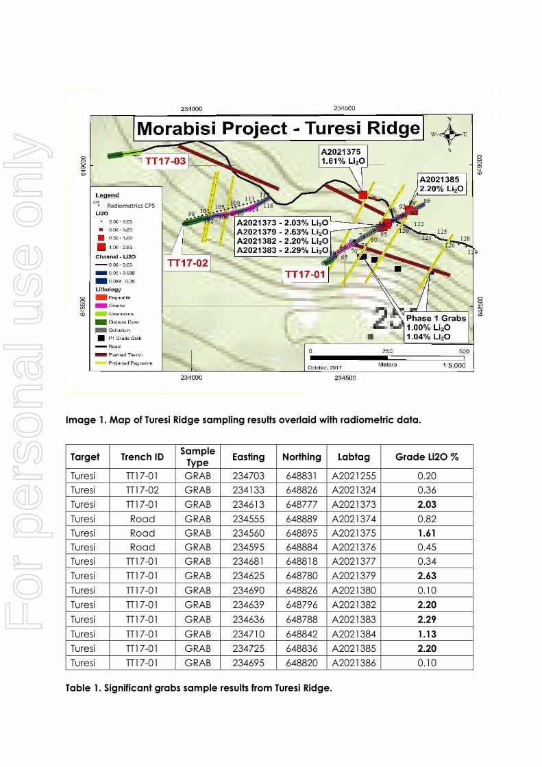
Image 1. Map of Turesi Ridge sampling results overlaid with radiometric data.
Target Trench ID Sample
Type Easting Northing Labtag Grade Li2O %
Turesi TT17-01 GRAB 234703 648831 A2021255 0.20
Turesi TT17-02 GRAB 234133 648826 A2021324 0.36
Turesi TT17-01 GRAB 234613 648777 A2021373 2.03
Turesi Road GRAB 234555 648889 A2021374 0.82
Turesi Road GRAB 234560 648895 A2021375 1.61
Turesi Road GRAB 234595 648884 A2021376 0.45
Turesi TT17-01 GRAB 234681 648818 A2021377 0.34
Turesi TT17-01 GRAB 234625 648780 A2021379 2.63
Turesi TT17-01 GRAB 234690 648826 A2021380 0.10
Turesi TT17-01 GRAB 234639 648796 A2021382 2.20
Turesi TT17-01 GRAB 234636 648788 A2021383 2.29
Turesi TT17-01 GRAB 234710 648842 A2021384 1.13
Turesi TT17-01 GRAB 234725 648836 A2021385 2.20
Turesi TT17-01 GRAB 234695 648820 A2021386 0.10
Table 1. Significant grabs sample results from Turesi Ridge.
For
per
sona
l use
onl
y
Turesi trench mapping indicates the Li-bearing pegmatites are striking between 190 and 210 degrees and dipping steeply (~60 degrees) toward the west. Pegmatite #1 (TT17-01) was exposed over a 10m length before being covered by transported material, and has a sharp upper contact with diabase dyke. Below pegmatite #1, 171m of transported weathered material was mapped. First pass channel sampling collected two 3m channel samples with an average grade of 0.23% Li2O. Two Li-bearing pegmatitic veining zones occur within TT17-01 from 42 – 65 m (0.10% % Li2O) and 112 – 132 m (0.16% % Li2O).
Within the transported material, below Pegmatite #1, abundant boulders up to 50cm were identified containing Quartz and green mica/polylithionite. Grab samples within these graded up to 2.63% Li2O. It is very encouraging to observe Li-pegmatites in-situ together with transported/collapsed material over 180m in the trench. This could suggest a zone of Li-pegmatites greater than 90m in true width.
Along the road between TT17-01 and TT17-02, pegmatitic quartz, green mica/polylithionite boulders were scattered over 100m and three samples were taken. Grab sample A2021375 from the road returned 1.61% Li2O (see Table1).
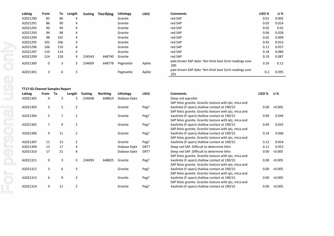
TT17-02 intersected a 10m wide intensely weathered pegmatite with an average grade of 0.11% Li2O with upper and lower diabase dyke contacts. Mica-rich floats in transported material at 162m returned 0.36% Li2O. This is a positive indication of additional Li-pegmatites in the immediate area that were not identified in the trench.
Scintillometer readings with anomalous total count correlate strongly with Li-bearing pegmatites and transported material zones containing Li-rich pegmatitic boulders.
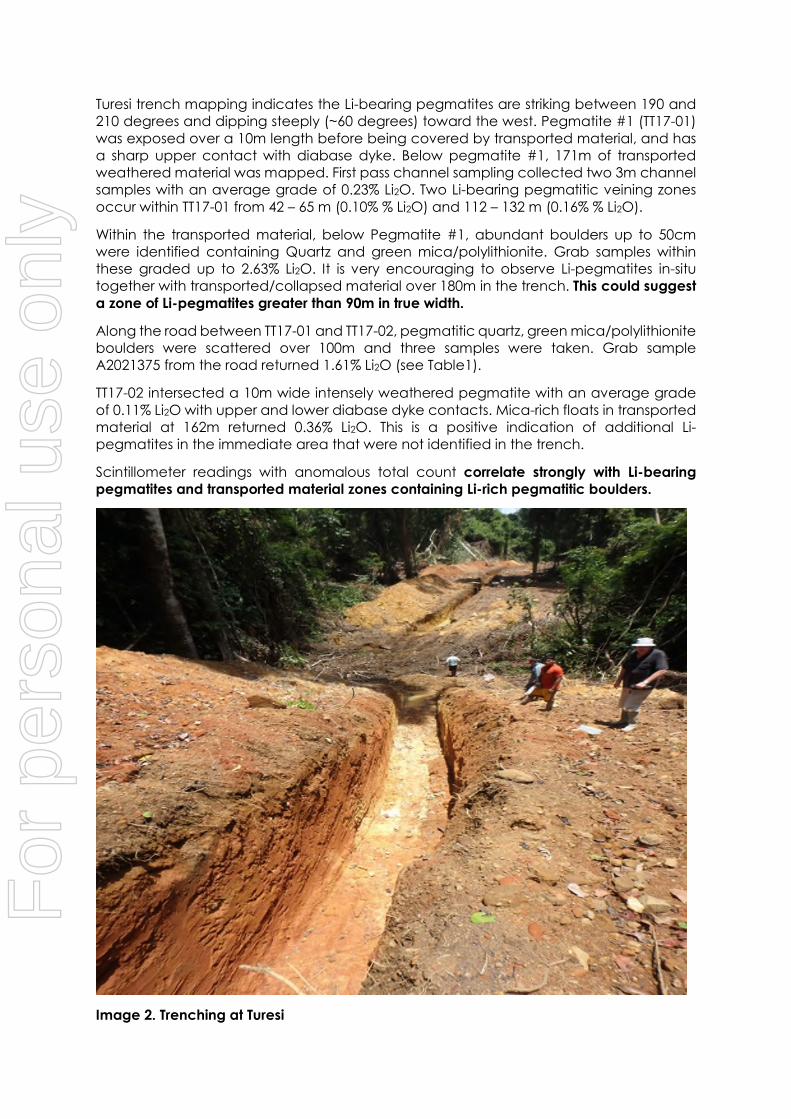
Image 2. Trenching at Turesi
For
per
sona
l use
onl
y

Banakaru Trenching
Banakaru trenches are located on the northern slope of Banakaru Mountain. Banakaru mountain is capped by west-northwest striking diabase dyke which has preserved the underlying greenstone rocks. The Banakaru trenches are strategically located to follow up on strong Cs, Rb and Be geochemical anomalies identified in the Phase 1 stream sediment sampling program and aimed at intersecting a 30m wide white clay zone along strike to the east.
TB17-02 encountered two zones of high kaolinite alteration from 68 – 90 m and 470 – 490 m. TB17-01 encountered greenstone rocks the entire length. Analyses are pending and will be reported to shareholders once received.
Summary of Progress – Robello
Field crews have now established camp at Robello creek, near the historic mining operations. A 7km trail has been completed towards Heavy Creek and will be used by the GSM crew to complete the Robello and Heavy creek area scintillometer surveys in addition to collecting stream sediment samples.
Changes to the original exploration program now include the use of a Banka Drill to evaluate the Ta-Nb and REE alluvials at Robello and Heavy Creek. Banka drilling will commence in the coming weeks. Ground penetrating radar (GPR) will also be used to help define the volume of alluvial sediments and base gravel layer.
Work in progress
A crew has returned to Turesi where additional trenches are being planned and a scintillometer grid is being cut to follow up on the high-grade Li2O results.
Field crews are also located at Robello where trail construction to Heavy Creek continues. In the coming weeks a Banka drill will be mobilised to site where an alluvial drill sampling program will be conducted along with a GPR survey.
For
per
sona
l use
onl
y

Sampling
The following table summarizes sampling at the Morabisi project to date
Target Location Channel Grab Stream Total Analysis
Turesi TT17-01 39 8 47 Complete
Turesi TT17-02 20 5 25 Complete
East Camp East Camp 12 12 Pending
Robello Tailings 3 3 Pending
Banakaru TB17-02 2 2 Pending
Banakaru TB17-02 31 31 Pending
Turesi TT17-01 & Rd 5 13 17 Complete
Robello Tailings 3 3 Pending
Banakaru TB17-02 40 40 Pending
Banakaru TB17-01 59 59 Pending
total 239
Table 2. Morabisi Sampling totals
* A detailed breakdown of sampling analysis is included as an appendix to this announcement.
Greenpower Executive Chairman, Gerard King:
“Initial trenching results thus far appear to justify Greenpower’s decision to pursue a green energy strategy following the early sampling results which show the presence of Lithium in severely weathered material.
Importantly the initial trenching results indicate the presence of Lithium analyses greater than those encountered in the Pilgangoora. The programme at Turesi has linked radiometric traverse results, elevated Lithium analyses from saprolite sampling and elevated Lithium analyses from grab sampling of pegmatites exposed during the trenching. The widespread nature of the results encountered in weathered rock supports Greenpower’s initial view that the Morabisi project could rival the Pilgangoora province in size.”
ENDS For further information: Gerard King Chairman of the Board
For
per
sona
l use
onl
y
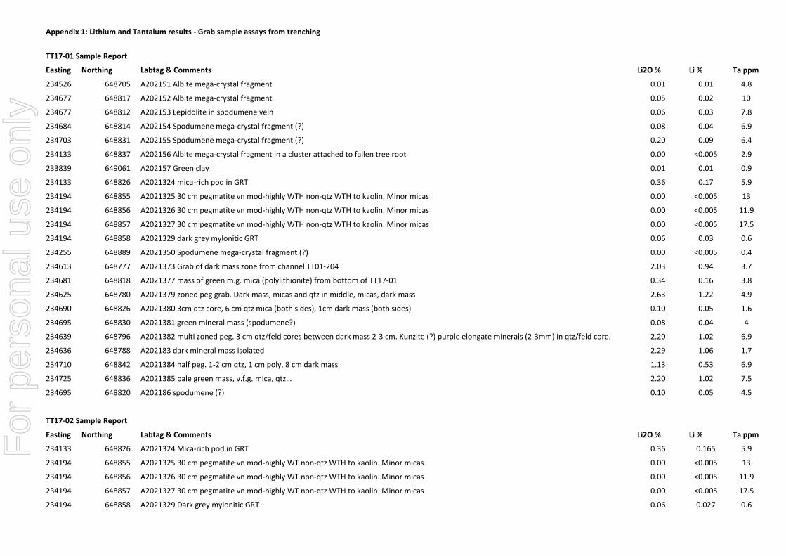
Appendix 1: Lithium and Tantalum results - Grab sample assays from trenching
TT17-01 Sample Report
Easting Northing Labtag & Comments Li2O % Li % Ta ppm
234526 648705 A202151 Albite mega-crystal fragment 0.01 0.01 4.8
234677 648817 A202152 Albite mega-crystal fragment 0.05 0.02 10
234677 648812 A202153 Lepidolite in spodumene vein 0.06 0.03 7.8
234684 648814 A202154 Spodumene mega-crystal fragment (?) 0.08 0.04 6.9
234703 648831 A202155 Spodumene mega-crystal fragment (?) 0.20 0.09 6.4
234133 648837 A202156 Albite mega-crystal fragment in a cluster attached to fallen tree root 0.00 <0.005 2.9
233839 649061 A202157 Green clay 0.01 0.01 0.9
234133 648826 A2021324 mica-rich pod in GRT 0.36 0.17 5.9
234194 648855 A2021325 30 cm pegmatite vn mod-highly WTH non-qtz WTH to kaolin. Minor micas 0.00 <0.005 13
234194 648856 A2021326 30 cm pegmatite vn mod-highly WTH non-qtz WTH to kaolin. Minor micas 0.00 <0.005 11.9
234194 648857 A2021327 30 cm pegmatite vn mod-highly WTH non-qtz WTH to kaolin. Minor micas 0.00 <0.005 17.5
234194 648858 A2021329 dark grey mylonitic GRT 0.06 0.03 0.6
234255 648889 A2021350 Spodumene mega-crystal fragment (?) 0.00 <0.005 0.4
234613 648777 A2021373 Grab of dark mass zone from channel TT01-204 2.03 0.94 3.7
234681 648818 A2021377 mass of green m.g. mica (polylithionite) from bottom of TT17-01 0.34 0.16 3.8
234625 648780 A2021379 zoned peg grab. Dark mass, micas and qtz in middle, micas, dark mass 2.63 1.22 4.9
234690 648826 A2021380 3cm qtz core, 6 cm qtz mica (both sides), 1cm dark mass (both sides) 0.10 0.05 1.6
234695 648830 A2021381 green mineral mass (spodumene?) 0.08 0.04 4
234639 648796 A2021382 multi zoned peg. 3 cm qtz/feld cores between dark mass 2-3 cm. Kunzite (?) purple elongate minerals (2-3mm) in qtz/feld core. 2.20 1.02 6.9
234636 648788 A202183 dark mineral mass isolated 2.29 1.06 1.7
234710 648842 A2021384 half peg. 1-2 cm qtz, 1 cm poly, 8 cm dark mass 1.13 0.53 6.9
234725 648836 A2021385 pale green mass, v.f.g. mica, qtz… 2.20 1.02 7.5
234695 648820 A202186 spodumene (?) 0.10 0.05 4.5
TT17-02 Sample Report
Easting Northing Labtag & Comments Li2O % Li % Ta ppm
234133 648826 A2021324 Mica-rich pod in GRT 0.36 0.165 5.9
234194 648855 A2021325 30 cm pegmatite vn mod-highly WT non-qtz WTH to kaolin. Minor micas 0.00 <0.005 13
234194 648856 A2021326 30 cm pegmatite vn mod-highly WT non-qtz WTH to kaolin. Minor micas 0.00 <0.005 11.9
234194 648857 A2021327 30 cm pegmatite vn mod-highly WT non-qtz WTH to kaolin. Minor micas 0.00 <0.005 17.5
234194 648858 A2021329 Dark grey mylonitic GRT 0.06 0.027 0.6
For
per
sona
l use
onl
y
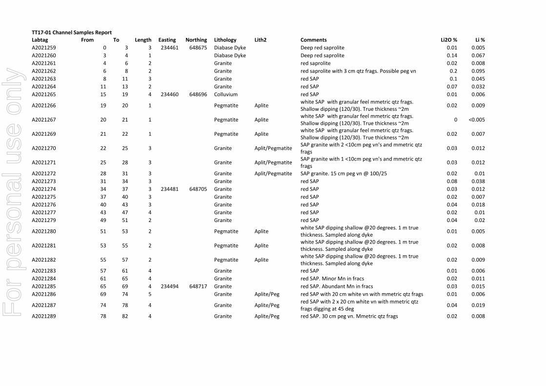
TT17-01 Channel Samples Report
Labtag From To Length Easting Northing Lithology Lith2 Comments Li2O % Li %
A2021259 0 3 3 234461 648675 Diabase Dyke Deep red saprolite 0.01 0.005
A2021260 3 4 1 Diabase Dyke Deep red saprolite 0.14 0.067
A2021261 4 6 2 Granite red saprolite 0.02 0.008
A2021262 6 8 2 Granite red saprolite with 3 cm qtz frags. Possible peg vn 0.2 0.095
A2021263 8 11 3 Granite red SAP 0.1 0.045
A2021264 11 13 2 Granite red SAP 0.07 0.032
A2021265 15 19 4 234460 648696 Colluvium red SAP 0.01 0.006
A2021266 19 20 1 Pegmatite Aplite white SAP with granular feel mmetric qtz frags. Shallow dipping (120/30). True thickness ~2m
0.02 0.009
A2021267 20 21 1 Pegmatite Aplite white SAP with granular feel mmetric qtz frags. Shallow dipping (120/30). True thickness ~2m
0 <0.005
A2021269 21 22 1 Pegmatite Aplite white SAP with granular feel mmetric qtz frags. Shallow dipping (120/30). True thickness ~2m
0.02 0.007
A2021270 22 25 3 Granite Aplit/Pegmatite SAP granite with 2 <10cm peg vn's and mmetric qtz frags
0.03 0.012
A2021271 25 28 3 Granite Aplit/Pegmatite SAP granite with 1 <10cm peg vn's and mmetric qtz frags
0.03 0.012
A2021272 28 31 3 Granite Aplit/Pegmatite SAP granite. 15 cm peg vn @ 100/25 0.02 0.01
A2021273 31 34 3 Granite red SAP 0.08 0.038
A2021274 34 37 3 234481 648705 Granite red SAP 0.03 0.012
A2021275 37 40 3 Granite red SAP 0.02 0.007
A2021276 40 43 3 Granite red SAP 0.04 0.018
A2021277 43 47 4 Granite red SAP 0.02 0.01
A2021279 49 51 2 Granite red SAP 0.04 0.02
A2021280 51 53 2 Pegmatite Aplite white SAP dipping shallow @20 degrees. 1 m true thickness. Sampled along dyke
0.01 0.005
A2021281 53 55 2 Pegmatite Aplite white SAP dipping shallow @20 degrees. 1 m true thickness. Sampled along dyke
0.02 0.008
A2021282 55 57 2 Pegmatite Aplite white SAP dipping shallow @20 degrees. 1 m true thickness. Sampled along dyke
0.02 0.009
A2021283 57 61 4 Granite red SAP 0.01 0.006
A2021284 61 65 4 Granite red SAP. Minor Mn in fracs 0.02 0.011
A2021285 65 69 4 234494 648717 Granite red SAP. Abundant Mn in fracs 0.03 0.015
A2021286 69 74 5 Granite Aplite/Peg red SAP with 20 cm white vn with mmetric qtz frags 0.01 0.006
A2021287 74 78 4 Granite Aplite/Peg red SAP with 2 x 20 cm white vn with mmetric qtz frags digging at 45 deg
0.04 0.019
A2021289 78 82 4 Granite Aplite/Peg red SAP. 30 cm peg vn. Mmetric qtz frags 0.02 0.008 For
per
sona
l use
onl
y
Labtag From To Length Easting Northing Lithology Lith2 Comments Li2O % Li %
A2021290 82 86 4 Granite red SAP 0.01 0.005
A2021291 86 90 4 Granite red SAP 0.03 0.014
A2021292 90 94 4 Granite red SAP 0.02 0.01
A2021293 94 98 4 Granite red SAP 0.06 0.028
A2021294 98 102 4 Granite red SAP 0.02 0.009
A2021295 102 106 4 Granite red SAP 0.03 0.013
A2021296 106 110 4 Granite red SAP 0.12 0.057
A2021297 110 114 4 Granite red SAP 0.18 0.084
A2021299 114 118 4 234543 648740 Granite red SAP 0.19 0.087
A2021300 0 3 3 234609 648778 Pegmatite Aplite pale brown SAP dyke ~6m thick best Scint readings over 200
0.26 0.12
A2021301 3 6 3 Pegmatite Aplite pale brown SAP dyke ~6m thick best Scint readings over 201
0.2 0.095
TT17-02 Channel Samples Report
Labtag From To Length Easting Northing Lithology Lith2 Comments Li2O % Li %
A2021302 0 3 3 234048 648814 Diabase Dyke Deep red saprolite
A2021303 3 5 2 Granite Peg? SAP felsic granite. Granitic texture with qtz, mica and kaolinite (F-spars) shallow contact at 190/15 0.00 <0.005
A2021304 5 7 2 Granite Peg? SAP felsic granite. Granitic texture with qtz, mica and kaolinite (F-spars) shallow contact at 190/15 0.09 0.044
A2021305 7 9 2 Granite Peg? SAP felsic granite. Granitic texture with qtz, mica and kaolinite (F-spars) shallow contact at 190/15 0.09 0.042
A2021306 9 11 2 Granite Peg? SAP felsic granite. Granitic texture with qtz, mica and kaolinite (F-spars) shallow contact at 190/15 0.14 0.066
A2021307 11 13 2 Granite Peg? SAP felsic granite. Granitic texture with qtz, mica and kaolinite (F-spars) shallow contact at 190/15 0.12 0.054
A2021309 13 17 4 Diabase Dyke GRT? Deep red SAP. Difficult to determine litho 0.11 0.052
A2021310 17 21 4 Diabase Dyke GRT? Deep red SAP. Difficult to determine litho 0.00 <0.005
A2021311 0 3 3 234093 648825 Granite Peg? SAP felsic granite. Granitic texture with qtz, mica and kaolinite (F-spars) shallow contact at 190/15 0.00 <0.005
A2021312 3 6 3 Granite Peg? SAP felsic granite. Granitic texture with qtz, mica and kaolinite (F-spars) shallow contact at 190/15 0.00 <0.005
A2021313 6 9 3 Granite Peg? SAP felsic granite. Granitic texture with qtz, mica and kaolinite (F-spars) shallow contact at 190/15 0.00 <0.005
A2021314 9 11 2 Granite Peg? SAP felsic granite. Granitic texture with qtz, mica and kaolinite (F-spars) shallow contact at 190/15 0.00 <0.005 F
or p
erso
nal u
se o
nly

Labtag From To Length Easting Northing Lithology Lith2 Comments Li2O % Li %
A2021316 15 18 3 Colluvium MetaSed deep red SAP. Transported material includes metaseds and GRT floats 0.00 <0.005
A2021317 18 21 3 Granite Peg? SAP felsic granite. Granitic texture with qtz, mica and kaolinite (F-spars) shallow contact at 190/15 0.02 0.008
A2021319 21 24 3 Granite Peg? SAP felsic granite. Granitic texture with qtz, mica and kaolinite (F-spars) shallow contact at 190/15 0.02 0.01
A2021320 24 27 3 Granite Peg? SAP felsic granite. Granitic texture with qtz, mica and kaolinite (F-spars) shallow contact at 190/15 0.01 0.005
A2021321 27 30 3 Granite red SAP. 50 cm pods of mica rich or qtz rich 0.04 0.018
A2021322 30 33 3 Granite red SAP. 50 cm pods of mica rich or qtz rich 0.00 <0.005
A2021323 33 36 3 234133 648826 Granite red SAP. 50 cm pods of mica rich or qtz rich 0.05 0.023
0.03 0.014
Competent Person Statement
I, John Adrian Watts on 25 October 2017 confirm that:
- I have read and understood the requirements of the 2012 Edition of the Australasian Code for Reporting of Exploration Results, Mineral Resources and Ore Reserves (“2012 JORC Code”).
- I am a Competent Person as defined by the 2012 JORC Code, having more than five years’ experience which is relevant to the style of mineralisation and type of deposit described in the Report, and to the activity for which I am accepting responsibility.
- I am a Fellow of The Australasian Institute of Mining and Metallurgy and a Fellow of the IOMMM.- This statement fairly represents documentation prepared by myself on behalf of my employer, Australian Exploration Field Services Pty Ltd. - I consent to the release of this document to the ASX.
For
per
sona
l use
onl
y
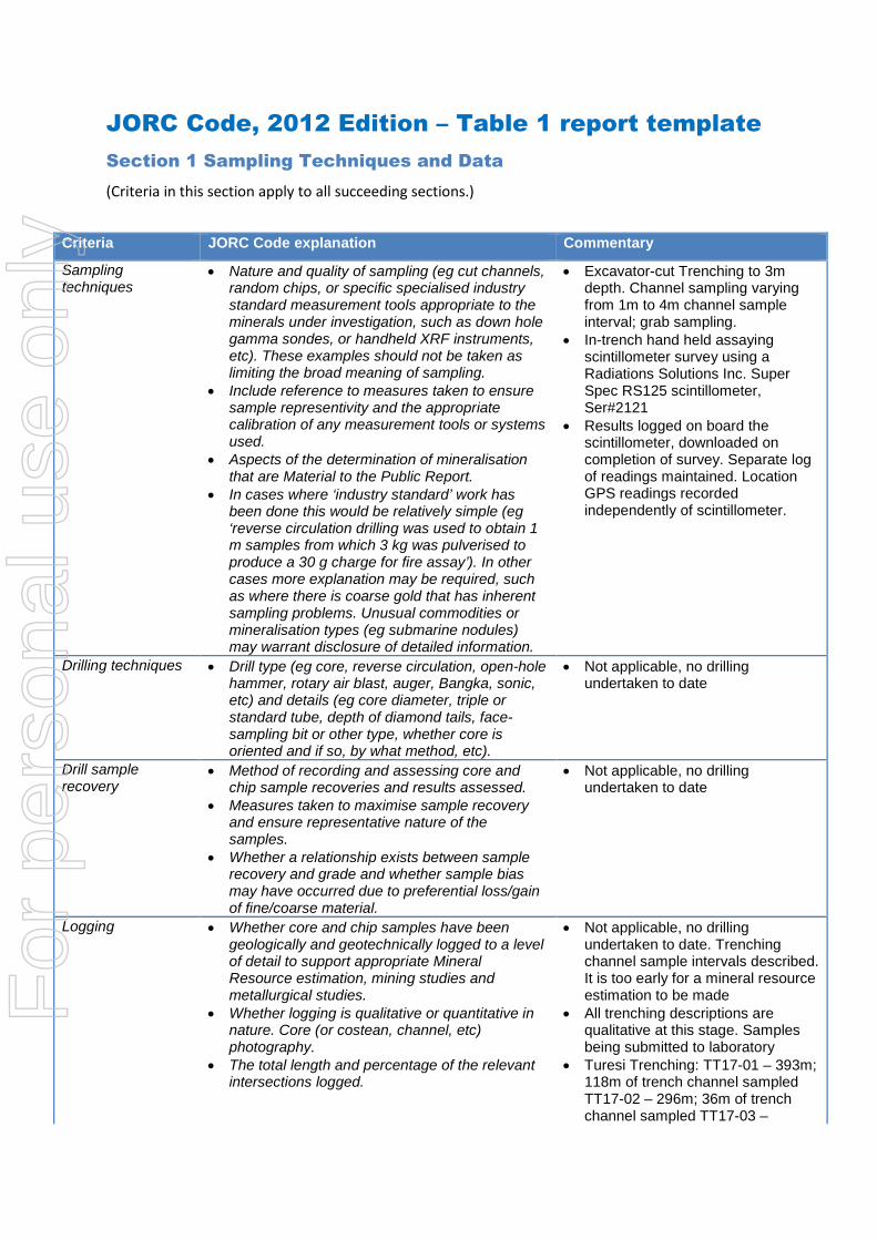
JORC Code, 2012 Edition – Table 1 report template
Section 1 Sampling Techniques and Data
(Criteria in this section apply to all succeeding sections.)
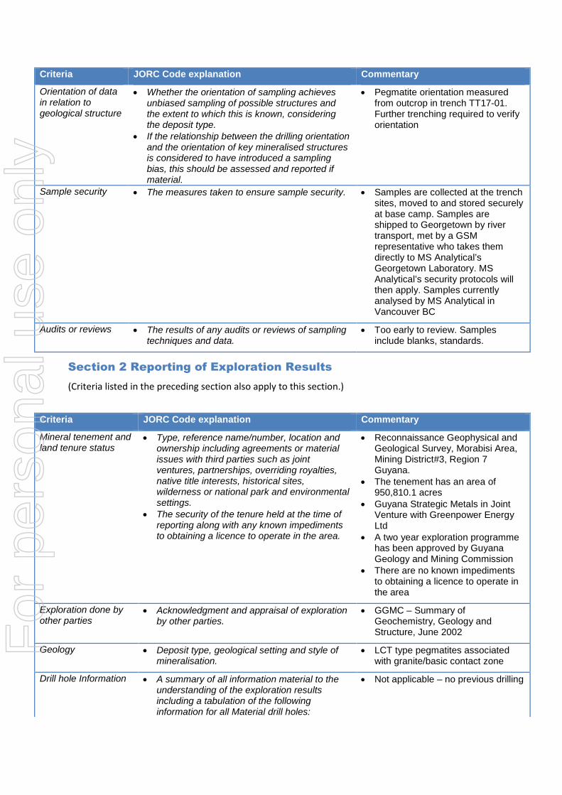
Criteria JORC Code explanation Commentary
Sampling techniques
• Nature and quality of sampling (eg cut channels, random chips, or specific specialised industry standard measurement tools appropriate to the minerals under investigation, such as down hole gamma sondes, or handheld XRF instruments, etc). These examples should not be taken as limiting the broad meaning of sampling.
• Include reference to measures taken to ensure sample representivity and the appropriate calibration of any measurement tools or systems used.
• Aspects of the determination of mineralisation that are Material to the Public Report.
• In cases where ‘industry standard’ work has been done this would be relatively simple (eg ‘reverse circulation drilling was used to obtain 1 m samples from which 3 kg was pulverised to produce a 30 g charge for fire assay’). In other cases more explanation may be required, such as where there is coarse gold that has inherent sampling problems. Unusual commodities or mineralisation types (eg submarine nodules) may warrant disclosure of detailed information.
• Excavator-cut Trenching to 3m depth. Channel sampling varying from 1m to 4m channel sample interval; grab sampling.
• In-trench hand held assaying scintillometer survey using a Radiations Solutions Inc. Super Spec RS125 scintillometer, Ser#2121
• Results logged on board the scintillometer, downloaded on completion of survey. Separate log of readings maintained. Location GPS readings recorded independently of scintillometer.
Drilling techniques • Drill type (eg core, reverse circulation, open-hole hammer, rotary air blast, auger, Bangka, sonic, etc) and details (eg core diameter, triple or standard tube, depth of diamond tails, face-sampling bit or other type, whether core is oriented and if so, by what method, etc).
• Not applicable, no drilling undertaken to date
Drill sample recovery
• Method of recording and assessing core and chip sample recoveries and results assessed.
• Measures taken to maximise sample recovery and ensure representative nature of the samples.
• Whether a relationship exists between sample recovery and grade and whether sample bias may have occurred due to preferential loss/gain of fine/coarse material.
• Not applicable, no drilling undertaken to date
Logging • Whether core and chip samples have been geologically and geotechnically logged to a level of detail to support appropriate Mineral Resource estimation, mining studies and metallurgical studies.
• Whether logging is qualitative or quantitative in nature. Core (or costean, channel, etc) photography.
• The total length and percentage of the relevant intersections logged.
• Not applicable, no drilling undertaken to date. Trenching channel sample intervals described. It is too early for a mineral resource estimation to be made
• All trenching descriptions are qualitative at this stage. Samples being submitted to laboratory
• Turesi Trenching: TT17-01 – 393m; 118m of trench channel sampled TT17-02 – 296m; 36m of trench channel sampled TT17-03 –
For
per
sona
l use
onl
y
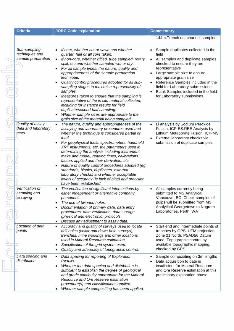
Criteria JORC Code explanation Commentary
144m.Trench not channel sampled
Sub-sampling techniques and sample preparation
• If core, whether cut or sawn and whether quarter, half or all core taken.
• If non-core, whether riffled, tube sampled, rotary split, etc and whether sampled wet or dry.
• For all sample types, the nature, quality and appropriateness of the sample preparation technique.
• Quality control procedures adopted for all sub-sampling stages to maximise representivity of samples.
• Measures taken to ensure that the sampling is representative of the in situ material collected, including for instance results for field duplicate/second-half sampling.
• Whether sample sizes are appropriate to the grain size of the material being sampled.
• Sample duplicates collected in the field
• All samples and duplicate samples checked to ensure they are representative
• Large sample size to ensure appropriate grain size
• Reference Samples included in the field for Laboratory submissions
• Blank Samples included in the field for Laboratory submissions
Quality of assay data and laboratory tests
• The nature, quality and appropriateness of the assaying and laboratory procedures used and whether the technique is considered partial or total.
• For geophysical tools, spectrometers, handheld XRF instruments, etc, the parameters used in determining the analysis including instrument make and model, reading times, calibrations factors applied and their derivation, etc.
• Nature of quality control procedures adopted (eg standards, blanks, duplicates, external laboratory checks) and whether acceptable levels of accuracy (ie lack of bias) and precision have been established.
• Li analysis by Sodium Peroxide Fusion, ICP-ES.REE Analysis by Lithium Metaborate Fusion, ICP-MS
• External laboratory checks via submission of duplicate samples
Verification of sampling and assaying
• The verification of significant intersections by either independent or alternative company personnel.
• The use of twinned holes. • Documentation of primary data, data entry
procedures, data verification, data storage (physical and electronic) protocols.
• Discuss any adjustment to assay data.
• All samples currently being submitted to MS Analytical Vancouver BC. Check samples of pulps will be submitted from MS Analytical Georgetown to Nagrom Laboratories, Perth, WA
Location of data points
• Accuracy and quality of surveys used to locate drill holes (collar and down-hole surveys), trenches, mine workings and other locations used in Mineral Resource estimation.
• Specification of the grid system used. • Quality and adequacy of topographic control.
• Start end and intermediate points of trenches by GPS. UTM projection, Zone 21 North, PSAD56 Datum used. Topographic control by available topographic mapping, checked by GPS
Data spacing and distribution
• Data spacing for reporting of Exploration Results.
• Whether the data spacing and distribution is sufficient to establish the degree of geological and grade continuity appropriate for the Mineral Resource and Ore Reserve estimation procedure(s) and classifications applied.
• Whether sample compositing has been applied.
• Sample compositing on 3m lengths • Data acquisition to date is
insufficient for Mineral Resource and Ore Reserve estimation at this preliminary exploration phase.
For
per
sona
l use
onl
y
Criteria JORC Code explanation Commentary
Orientation of data in relation to geological structure
• Whether the orientation of sampling achieves unbiased sampling of possible structures and the extent to which this is known, considering the deposit type.
• If the relationship between the drilling orientation and the orientation of key mineralised structures is considered to have introduced a sampling bias, this should be assessed and reported if material.
• Pegmatite orientation measured from outcrop in trench TT17-01. Further trenching required to verify orientation
Sample security • The measures taken to ensure sample security. • Samples are collected at the trench sites, moved to and stored securely at base camp. Samples are shipped to Georgetown by river transport, met by a GSM representative who takes them directly to MS Analytical’s Georgetown Laboratory. MS Analytical’s security protocols will then apply. Samples currently analysed by MS Analytical in Vancouver BC
Audits or reviews • The results of any audits or reviews of sampling techniques and data.
• Too early to review. Samples include blanks, standards.
Section 2 Reporting of Exploration Results
(Criteria listed in the preceding section also apply to this section.)
Criteria JORC Code explanation Commentary
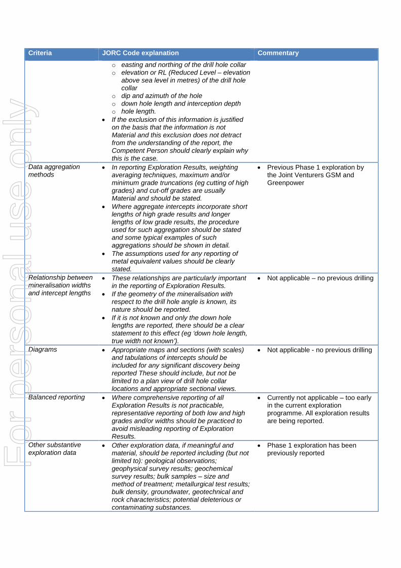
Mineral tenement and land tenure status
• Type, reference name/number, location and ownership including agreements or material issues with third parties such as joint ventures, partnerships, overriding royalties, native title interests, historical sites, wilderness or national park and environmental settings.
• The security of the tenure held at the time of reporting along with any known impediments to obtaining a licence to operate in the area.
• Reconnaissance Geophysical and Geological Survey, Morabisi Area, Mining District#3, Region 7 Guyana.
• The tenement has an area of 950,810.1 acres
• Guyana Strategic Metals in Joint Venture with Greenpower Energy Ltd
• A two year exploration programme has been approved by Guyana Geology and Mining Commission
• There are no known impediments to obtaining a licence to operate in the area
Exploration done by other parties
• Acknowledgment and appraisal of exploration by other parties.
• GGMC – Summary of Geochemistry, Geology and Structure, June 2002
Geology • Deposit type, geological setting and style of mineralisation.
• LCT type pegmatites associated with granite/basic contact zone
Drill hole Information • A summary of all information material to the understanding of the exploration results including a tabulation of the following information for all Material drill holes:
• Not applicable – no previous drilling
For
per
sona
l use
onl
y
Criteria JORC Code explanation Commentary
o easting and northing of the drill hole collar o elevation or RL (Reduced Level – elevation
above sea level in metres) of the drill hole collar
o dip and azimuth of the hole o down hole length and interception depth o hole length.
• If the exclusion of this information is justified on the basis that the information is not Material and this exclusion does not detract from the understanding of the report, the Competent Person should clearly explain why this is the case.
Data aggregation methods
• In reporting Exploration Results, weighting averaging techniques, maximum and/or minimum grade truncations (eg cutting of high grades) and cut-off grades are usually Material and should be stated.
• Where aggregate intercepts incorporate short lengths of high grade results and longer lengths of low grade results, the procedure used for such aggregation should be stated and some typical examples of such aggregations should be shown in detail.
• The assumptions used for any reporting of metal equivalent values should be clearly stated.
• Previous Phase 1 exploration by the Joint Venturers GSM and Greenpower
Relationship between mineralisation widths and intercept lengths
• These relationships are particularly important in the reporting of Exploration Results.
• If the geometry of the mineralisation with respect to the drill hole angle is known, its nature should be reported.
• If it is not known and only the down hole lengths are reported, there should be a clear statement to this effect (eg ‘down hole length, true width not known’).
• Not applicable – no previous drilling
Diagrams • Appropriate maps and sections (with scales) and tabulations of intercepts should be included for any significant discovery being reported These should include, but not be limited to a plan view of drill hole collar locations and appropriate sectional views.
• Not applicable - no previous drilling
Balanced reporting • Where comprehensive reporting of all Exploration Results is not practicable, representative reporting of both low and high grades and/or widths should be practiced to avoid misleading reporting of Exploration Results.
• Currently not applicable – too early in the current exploration programme. All exploration results are being reported.
Other substantive exploration data
• Other exploration data, if meaningful and material, should be reported including (but not limited to): geological observations; geophysical survey results; geochemical survey results; bulk samples – size and method of treatment; metallurgical test results; bulk density, groundwater, geotechnical and rock characteristics; potential deleterious or contaminating substances.
• Phase 1 exploration has been previously reported F
or p
erso
nal u
se o
nly
Criteria JORC Code explanation Commentary
Further work • The nature and scale of planned further work (eg tests for lateral extensions or depth extensions or large-scale step-out drilling).
• Diagrams clearly highlighting the areas of possible extensions, including the main geological interpretations and future drilling areas, provided this information is not commercially sensitive.
• Further trenching at Turesi as indicated on accompanying plan to more accurately determine pegmatite orientation Drilling contemplated as following step.
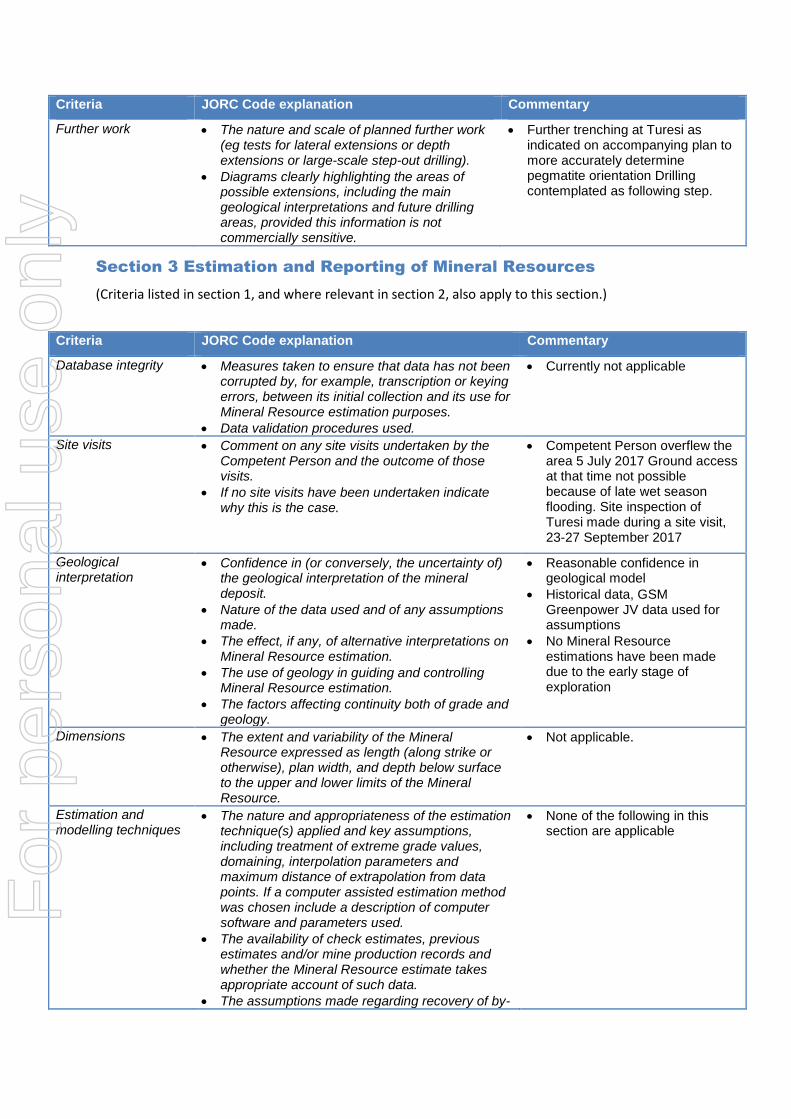
Section 3 Estimation and Reporting of Mineral Resources
(Criteria listed in section 1, and where relevant in section 2, also apply to this section.)
Criteria JORC Code explanation Commentary
Database integrity • Measures taken to ensure that data has not been corrupted by, for example, transcription or keying errors, between its initial collection and its use for Mineral Resource estimation purposes.
• Data validation procedures used.
• Currently not applicable
Site visits • Comment on any site visits undertaken by the Competent Person and the outcome of those visits.
• If no site visits have been undertaken indicate why this is the case.
• Competent Person overflew the area 5 July 2017 Ground access at that time not possible because of late wet season flooding. Site inspection of Turesi made during a site visit, 23-27 September 2017
Geological interpretation
• Confidence in (or conversely, the uncertainty of) the geological interpretation of the mineral deposit.
• Nature of the data used and of any assumptions made.
• The effect, if any, of alternative interpretations on Mineral Resource estimation.
• The use of geology in guiding and controlling Mineral Resource estimation.
• The factors affecting continuity both of grade and geology.
• Reasonable confidence in geological model
• Historical data, GSM Greenpower JV data used for assumptions
• No Mineral Resource estimations have been made due to the early stage of exploration
Dimensions • The extent and variability of the Mineral Resource expressed as length (along strike or otherwise), plan width, and depth below surface to the upper and lower limits of the Mineral Resource.
• Not applicable.
Estimation and modelling techniques
• The nature and appropriateness of the estimation technique(s) applied and key assumptions, including treatment of extreme grade values, domaining, interpolation parameters and maximum distance of extrapolation from data points. If a computer assisted estimation method was chosen include a description of computer software and parameters used.
• The availability of check estimates, previous estimates and/or mine production records and whether the Mineral Resource estimate takes appropriate account of such data.
• The assumptions made regarding recovery of by-
• None of the following in this section are applicable
For
per
sona
l use
onl
y
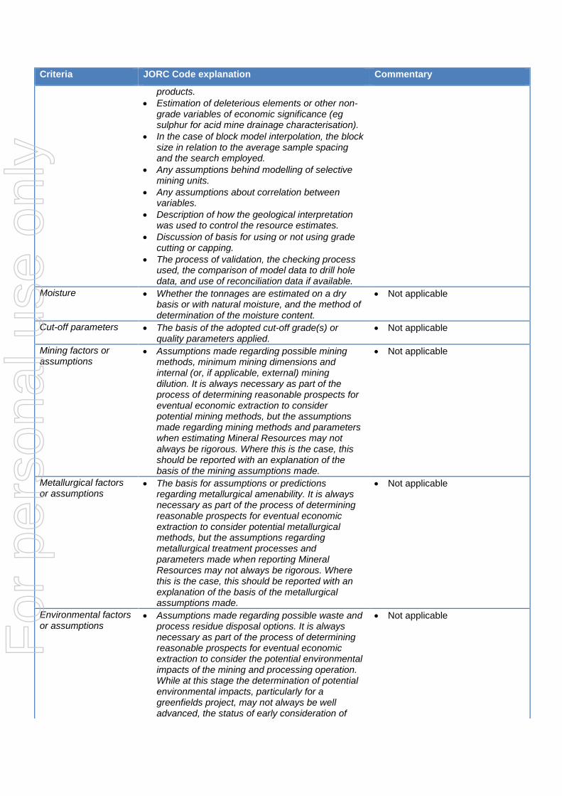
Criteria JORC Code explanation Commentary
products. • Estimation of deleterious elements or other non-
grade variables of economic significance (eg sulphur for acid mine drainage characterisation).
• In the case of block model interpolation, the block size in relation to the average sample spacing and the search employed.
• Any assumptions behind modelling of selective mining units.
• Any assumptions about correlation between variables.
• Description of how the geological interpretation was used to control the resource estimates.
• Discussion of basis for using or not using grade cutting or capping.
• The process of validation, the checking process used, the comparison of model data to drill hole data, and use of reconciliation data if available.
Moisture • Whether the tonnages are estimated on a dry basis or with natural moisture, and the method of determination of the moisture content.
• Not applicable
Cut-off parameters • The basis of the adopted cut-off grade(s) or quality parameters applied.
• Not applicable
Mining factors or assumptions
• Assumptions made regarding possible mining methods, minimum mining dimensions and internal (or, if applicable, external) mining dilution. It is always necessary as part of the process of determining reasonable prospects for eventual economic extraction to consider potential mining methods, but the assumptions made regarding mining methods and parameters when estimating Mineral Resources may not always be rigorous. Where this is the case, this should be reported with an explanation of the basis of the mining assumptions made.
• Not applicable
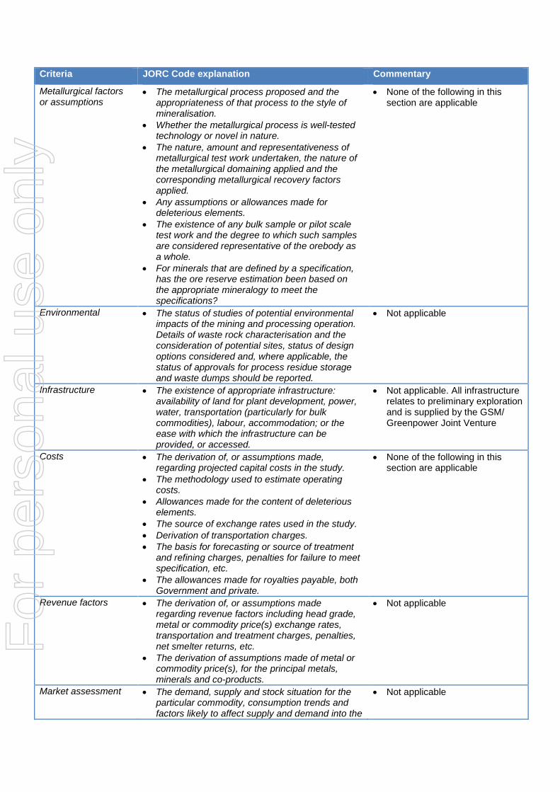
Metallurgical factors or assumptions
• The basis for assumptions or predictions regarding metallurgical amenability. It is always necessary as part of the process of determining reasonable prospects for eventual economic extraction to consider potential metallurgical methods, but the assumptions regarding metallurgical treatment processes and parameters made when reporting Mineral Resources may not always be rigorous. Where this is the case, this should be reported with an explanation of the basis of the metallurgical assumptions made.
• Not applicable
Environmental factors or assumptions
• Assumptions made regarding possible waste and process residue disposal options. It is always necessary as part of the process of determining reasonable prospects for eventual economic extraction to consider the potential environmental impacts of the mining and processing operation. While at this stage the determination of potential environmental impacts, particularly for a greenfields project, may not always be well advanced, the status of early consideration of
• Not applicable
For
per
sona
l use
onl
y
Criteria JORC Code explanation Commentary
these potential environmental impacts should be reported. Where these aspects have not been considered this should be reported with an explanation of the environmental assumptions made.
Bulk density • Whether assumed or determined. If assumed, the basis for the assumptions. If determined, the method used, whether wet or dry, the frequency of the measurements, the nature, size and representativeness of the samples.
• The bulk density for bulk material must have been measured by methods that adequately account for void spaces (vugs, porosity, etc), moisture and differences between rock and alteration zones within the deposit.
• Discuss assumptions for bulk density estimates used in the evaluation process of the different materials.
• Not applicable
Classification • The basis for the classification of the Mineral Resources into varying confidence categories.
• Whether appropriate account has been taken of all relevant factors (ie relative confidence in tonnage/grade estimations, reliability of input data, confidence in continuity of geology and metal values, quality, quantity and distribution of the data).
• Whether the result appropriately reflects the Competent Person’s view of the deposit.
• Not applicable
Audits or reviews • The results of any audits or reviews of Mineral Resource estimates.
• Not applicable
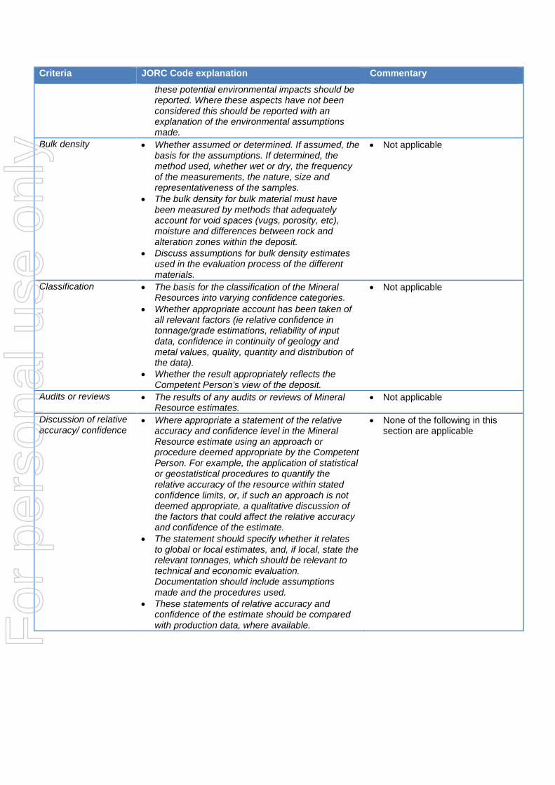
Discussion of relative accuracy/ confidence
• Where appropriate a statement of the relative accuracy and confidence level in the Mineral Resource estimate using an approach or procedure deemed appropriate by the Competent Person. For example, the application of statistical or geostatistical procedures to quantify the relative accuracy of the resource within stated confidence limits, or, if such an approach is not deemed appropriate, a qualitative discussion of the factors that could affect the relative accuracy and confidence of the estimate.
• The statement should specify whether it relates to global or local estimates, and, if local, state the relevant tonnages, which should be relevant to technical and economic evaluation. Documentation should include assumptions made and the procedures used.
• These statements of relative accuracy and confidence of the estimate should be compared with production data, where available.
• None of the following in this section are applicable
For
per
sona
l use
onl
y

Section 4 Estimation and Reporting of Ore Reserves
(Criteria listed in section 1, and where relevant in sections 2 and 3, also apply to this section.)
Criteria JORC Code explanation Commentary
Mineral Resource estimate for conversion to Ore Reserves
• Description of the Mineral Resource estimate used as a basis for the conversion to an Ore Reserve.
• Clear statement as to whether the Mineral Resources are reported additional to, or inclusive of, the Ore Reserves.
• Not applicable
Site visits • Comment on any site visits undertaken by the Competent Person and the outcome of those visits.
• If no site visits have been undertaken indicate why this is the case.
• Competent Person overflew the area 5 July 2017 Ground access at that time not possible because of late wet season flooding. Competent Person visited Turesi Trenches, Banakarau Trenches, Robello Creek Old Mine,23-27 September 2017
Study status • The type and level of study undertaken to enable Mineral Resources to be converted to Ore Reserves.
• The Code requires that a study to at least Pre-Feasibility Study level has been undertaken to convert Mineral Resources to Ore Reserves. Such studies will have been carried out and will have determined a mine plan that is technically achievable and economically viable, and that material Modifying Factors have been considered.
• Not applicable
Cut-off parameters • The basis of the cut-off grade(s) or quality parameters applied.
• Not applicable
Mining factors or assumptions
• The method and assumptions used as reported in the Pre-Feasibility or Feasibility Study to convert the Mineral Resource to an Ore Reserve (i.e. either by application of appropriate factors by optimisation or by preliminary or detailed design).
• The choice, nature and appropriateness of the selected mining method(s) and other mining parameters including associated design issues such as pre-strip, access, etc.
• The assumptions made regarding geotechnical parameters (eg pit slopes, stope sizes, etc), grade control and pre-production drilling.
• The major assumptions made and Mineral Resource model used for pit and stope optimisation (if appropriate).
• The mining dilution factors used. • The mining recovery factors used. • Any minimum mining widths used. • The manner in which Inferred Mineral Resources
are utilised in mining studies and the sensitivity of the outcome to their inclusion.
• The infrastructure requirements of the selected mining methods.
• None of the following in this section are applicable
For
per
sona
l use
onl
y
Criteria JORC Code explanation Commentary
Metallurgical factors or assumptions
• The metallurgical process proposed and the appropriateness of that process to the style of mineralisation.
• Whether the metallurgical process is well-tested technology or novel in nature.
• The nature, amount and representativeness of metallurgical test work undertaken, the nature of the metallurgical domaining applied and the corresponding metallurgical recovery factors applied.
• Any assumptions or allowances made for deleterious elements.
• The existence of any bulk sample or pilot scale test work and the degree to which such samples are considered representative of the orebody as a whole.
• For minerals that are defined by a specification, has the ore reserve estimation been based on the appropriate mineralogy to meet the specifications?
• None of the following in this section are applicable
Environmental • The status of studies of potential environmental impacts of the mining and processing operation. Details of waste rock characterisation and the consideration of potential sites, status of design options considered and, where applicable, the status of approvals for process residue storage and waste dumps should be reported.
• Not applicable
Infrastructure • The existence of appropriate infrastructure: availability of land for plant development, power, water, transportation (particularly for bulk commodities), labour, accommodation; or the ease with which the infrastructure can be provided, or accessed.
• Not applicable. All infrastructure relates to preliminary exploration and is supplied by the GSM/ Greenpower Joint Venture
Costs • The derivation of, or assumptions made, regarding projected capital costs in the study.
• The methodology used to estimate operating costs.
• Allowances made for the content of deleterious elements.
• The source of exchange rates used in the study. • Derivation of transportation charges. • The basis for forecasting or source of treatment
and refining charges, penalties for failure to meet specification, etc.
• The allowances made for royalties payable, both Government and private.
• None of the following in this section are applicable
Revenue factors • The derivation of, or assumptions made regarding revenue factors including head grade, metal or commodity price(s) exchange rates, transportation and treatment charges, penalties, net smelter returns, etc.
• The derivation of assumptions made of metal or commodity price(s), for the principal metals, minerals and co-products.
• Not applicable
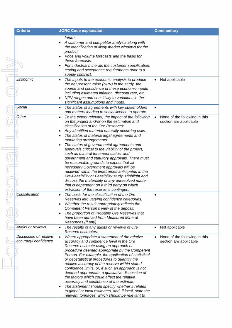
Market assessment • The demand, supply and stock situation for the particular commodity, consumption trends and factors likely to affect supply and demand into the
• Not applicable
For
per
sona
l use
onl
y
Criteria JORC Code explanation Commentary
future. • A customer and competitor analysis along with
the identification of likely market windows for the product.
• Price and volume forecasts and the basis for these forecasts.
• For industrial minerals the customer specification, testing and acceptance requirements prior to a supply contract.
Economic • The inputs to the economic analysis to produce the net present value (NPV) in the study, the source and confidence of these economic inputs including estimated inflation, discount rate, etc.
• NPV ranges and sensitivity to variations in the significant assumptions and inputs.
• Not applicable
Social • The status of agreements with key stakeholders and matters leading to social licence to operate.
•
Other • To the extent relevant, the impact of the following on the project and/or on the estimation and classification of the Ore Reserves:
• Any identified material naturally occurring risks. • The status of material legal agreements and
marketing arrangements. • The status of governmental agreements and
approvals critical to the viability of the project, such as mineral tenement status, and government and statutory approvals. There must be reasonable grounds to expect that all necessary Government approvals will be received within the timeframes anticipated in the Pre-Feasibility or Feasibility study. Highlight and discuss the materiality of any unresolved matter that is dependent on a third party on which extraction of the reserve is contingent.
• None of the following in this section are applicable
Classification • The basis for the classification of the Ore Reserves into varying confidence categories.
• Whether the result appropriately reflects the Competent Person’s view of the deposit.
• The proportion of Probable Ore Reserves that have been derived from Measured Mineral Resources (if any).
•
Audits or reviews • The results of any audits or reviews of Ore Reserve estimates.
• Not applicable
Discussion of relative accuracy/ confidence
• Where appropriate a statement of the relative accuracy and confidence level in the Ore Reserve estimate using an approach or procedure deemed appropriate by the Competent Person. For example, the application of statistical or geostatistical procedures to quantify the relative accuracy of the reserve within stated confidence limits, or, if such an approach is not deemed appropriate, a qualitative discussion of the factors which could affect the relative accuracy and confidence of the estimate.
• The statement should specify whether it relates to global or local estimates, and, if local, state the relevant tonnages, which should be relevant to
• None of the following in this section are applicable
For
per
sona
l use
onl
y

Criteria JORC Code explanation Commentary
technical and economic evaluation. Documentation should include assumptions made and the procedures used.
• Accuracy and confidence discussions should extend to specific discussions of any applied Modifying Factors that may have a material impact on Ore Reserve viability, or for which there are remaining areas of uncertainty at the current study stage.
• It is recognised that this may not be possible or appropriate in all circumstances. These statements of relative accuracy and confidence of the estimate should be compared with production data, where available.
For
per
sona
l use
onl
y