high grade gold mineralisation at satulinmÄki … · 1.08.2016 · the first drill test by avalon...
TRANSCRIPT
1 August 2016
HIGH GRADE GOLD MINERALISATION AT SATULINMÄKI
TARGETED FOR FOLLOW-UP DRILLING
Highlights
Planning for gold exploration drilling is advancing, with data compilation
over the Satulinmäki and Riukka gold prospects in Finland now completed.
Satulinmäki identified as the highest priority and diamond drill follow-up is
scheduled to commence after the completion of the drilling programme at
our nearby Kietyönmäki lithium pegmatite (expected to be Q4, 2016).
Diamond drilling was completed at Satulinmäki by the Geological Survey
of Finland (GTK) during the period 2001 to 2005, and returned very
encouraging results, including:
o 25.0m @ 3.17 g/t Au from 50m downhole in drill hole R391,
including;
3.0m @ 9.3 g/t Au, and
4.0m @ 10.3 g/t Au
o 3.0m @ 5.9 g/t Au from 33.9m downhole in drill hole R414
o 10.0m at 2.7 g/t Au from 15m downhole in drill hole R416
o 4.0m @ 5.2 g/t Au from 101.3m downhole in drill hole R419
Rock saw channel sampling in outcrop above hole R391 over a 5.0m length
returned results between 1.9 and 8.5 g/t Au.
Historical geophysical data comprising detailed ground magnetics and
Induced Polarisation is being sourced to define additional targets.
Avalon Minerals Ltd (ASX: AVI) (‘Avalon’) is pleased to provide an update on the
Satulinmäki and Riukka gold prospects located within the Tammela Project claims in
southern Finland, which also hosts the Kietyönmäki lithium pegmatite project being
explored by Avalon (figure 1 below).
Both the Satulinmäki and Riukka prospects were drilled by the Finnish Geological Survey
(GTK) during the period 2001 to 2005 with highly encouraging results.
At Satulinmäki 60 shallow holes were completed for a total of 4727m, which only tested
the plane of mineralisation to a depth of 80m below surface.
At Riukka, 40 shallow holes were completed for a total of 3350m and also only tested to
a vertical depth of 60m.
The Satulinmäki prospect has been selected by Avalon as the highest priority target to
initially follow-up based on its intense and complex quartz veining and alteration.
For
per
sona
l use
onl
y

At Satulinmäki, clear drill targets exist at depth, below the better historical intersections (see figure 2
below). Targets also exist along strike where preliminary structural interpretations suggest historical
drilling may not have tested all scenarios.
The first drill test by Avalon will be to follow the high grade zone at Satulinmäki to depth to extend the
mineralisation zone beyond the current shallow 70m of vertical extent. Intersections in this zone range
for 3m to 10m wide, and contain grades of between 1.4 g/t and 10.3 g/t.
The immediate target zone is interpreted to have a steep shoot geometry and has a strike extent of at
least 100m. Additional target zones exist along strike.
Tabulation of key results from previous drilling at Satulinmäki by GTK:
The gold prospects are located within a regional NW trending structural domain, but locally appear to be
controlled by E-W and NE trending structures and veins. Avalon has applied for exploration reservations
that cover approximately 30km of strike of the interpreted main structure controlling gold mineralisation.
Access to the proposed drill site requires minimal logistical planning as it is located in a timbered area
adjacent to farmland and supported by a good road network and local towns.
Drill Hole Prospect
Year
Drilled
Down hole;
From (m)
Intersection
Width (m) Au g/t
EOH depth
(m)
R328 Satulinmäki 2001 40.3 1.0 17.8 67.3
R330 Satulinmäki 2001 59.5 1.0 5.6 102.0
and 73.0 8.5 1.4
and 85.5 5.0 2.1
R334 Satulinmäki 2002 30.2 4.0 1.5 85.1
R344 Satulinmäki 2002 72.5 1.0 15.0 80.9
R389 Satulinmäki 2004 73.0 8.0 1.4 83.7
incl. 75.0 1.0 8.2
R391 Satulinmäki 2004 50.0 25.0 3.2 81.7
incl. 54.0 3.0 9.3
incl. 66.0 4.0 10.3
R413 Satulinmäki 2005 51.3 25.0 1.7 85.2
incl. 51.3 1.0 9.8
incl. 62.3 1.0 8.6
incl. 74.3 1.0 6.2
R414 Satulinmäki 2005 33.9 3.0 5.9 93.0
R416 Satulinmäki 2005 15.0 10.0 2.7 101.3
R418 Satulinmäki 2005 78.0 2.0 8.8 101.8
R419 Satulinmäki 2005 101.3 4.0 5.2 139.2
R422 Satulinmäki 2005 64.0 3.0 4.0 100.3
R428 Satulinmäki 2005 63.0 7.0 1.6 79.3
For
per
sona
l use
onl
y

Figure 1: Diagram showing the location of the Satulinmäki and Riukka gold prospects relative to the
Kietyönmäki lithium pegmatite project. Background colours are topography with red being highest
elevation, and approximately 40m greater than the lowest blue colours.
For
per
sona
l use
onl
y

Figure 2: 3D modelling of gold mineralisation at Satulinmäki showing multiple zones of gold
mineralisation that are open at depth. Drilling has only tested the mineralised horizon to approximately
80m below surface.
For
per
sona
l use
onl
y

Figure 3: Photograph showing quartz veined and sulphidic outcrop at the Satulinmäki gold prospect and
the 2003 GTK 5m channel sample which returned assay results of between 1.9 g/t and 8.5 g/t Au. Drill
hole R391 was drilled below this outcrop and returned values of 25.0m @ 3.17g/t Au including 3.0m @
9.3g/t Au, and 4.0m @ 10.3g/t Au.
Table showing comparison of GTK and Nortec selected samples
Hole_ID From (m) To (m)Interval
(m)
Gold
(g/t)Comments Hole_ID From (m) To (m)
Interval
(m)
Gold
(g/t)Comments
R329 13.4 20.5 7.1 1.67 Nortec sampling R329 14.4 15.4 1 0.9 GTK sampling and assays
16.4 19.4 3 3.33 GTK sampling and assays
R330 51 88.7 37.7 1.03 Nortec sampling R330 51 53 2 0.92 GTK sampling and assays
including 58.5 61.5 3 3.85 Nortec sampling 59.5 60.5 1 5.55 GTK sampling and assays
including 84.2 88.7 4.5 3.37 Nortec sampling 73 81.45 8.45 1.4 GTK sampling and assays
85.45 90.45 5 2.09 GTK sampling and assays
R334 29.2 34.2 5 1.6 Nortec sampling R334 30.2 34.2 4 1.53 GTK sampling and assays
R340 20.8 31.8 11 0.48 Nortec sampling R340 27.8 28.8 1 0.6 GTK sampling and assays
30.8 31.8 1 0.8 GTK sampling and assays
R385 13 15 2 1.57 Nortec sampling R385 13 15 2 3.74 GTK sampling and assays
R386 40 43 3 0.56 Nortec sampling R386 40 41 1 0.81 GTK sampling and assays
For
per
sona
l use
onl
y

About Avalon
Avalon has an advanced portfolio of exploration and development projects in Scandinavia. The portfolio
comprises:
1. The Kietyönmäki lithium pegmatite project in southern Finland which is scheduled for a 3,000m
resource drilling program commencing in late August 2016. The project is part of an earn-in JV
with Canadian company Nortec Minerals, where Avalon can earn up to an 80% interest (see
ASX announcement dated 19th May 2016). Historical drilling by the Geological Survey of Finland
(GTK) identified a high grade lithium pegmatite deposit including diamond drill intersections of
up to 18m at 1.8% Li2O. Proposed work will deliver a mineral resource estimate and preliminary
metallurgical studies by the end of 2016.
2. The Viscaria Copper project in northern Sweden which has a completed Scoping Study and is
moving towards PFS and permitting to allow for mine development. The project has a mineral
resource estimate of 52.4 Mt at 1.2% Cu, and a Mining Inventory considered for the 2016
Scoping Study Update (see ASX announcement dated 5th April 2016) of 18Mt at 1.2% Cu.
Considerable exploration upside exists and low technical risk extensional drill targets have been
defined to increase the resource estimate.
3. The Satulinmäki and Riukka gold prospects in southern Finland. These prospects have received
shallow diamond drilling by GTK and are now the subject of plans for follow-up drilling by Avalon.
Intersections include 25m @ 3.17g/t Au from 50m downhole, including 3m @ 9.3g/t Au, and 4m
@ 10.3g/t Au in drill hole R391 at Satulinmaki.
4. A portfolio of early stage lithium exploration projects in Sweden and Finland. These cover areas
of documented lithium bearing pegmatite rocks and are being advanced to allow for drill testing
in 2017.
For further information please visit www.avalonminerals.com.au or contact:
Mr Malcolm Norris
Managing Director
Avalon Minerals Ltd
Tel: 07 3368 9888
Email: [email protected]
For
per
sona
l use
onl
y
APPENDIX 1
The following Table and Sections are provided to ensure compliance with the JORC Code (2012 Edition)
TABLE 1 – Section 1: Sampling Techniques and Data
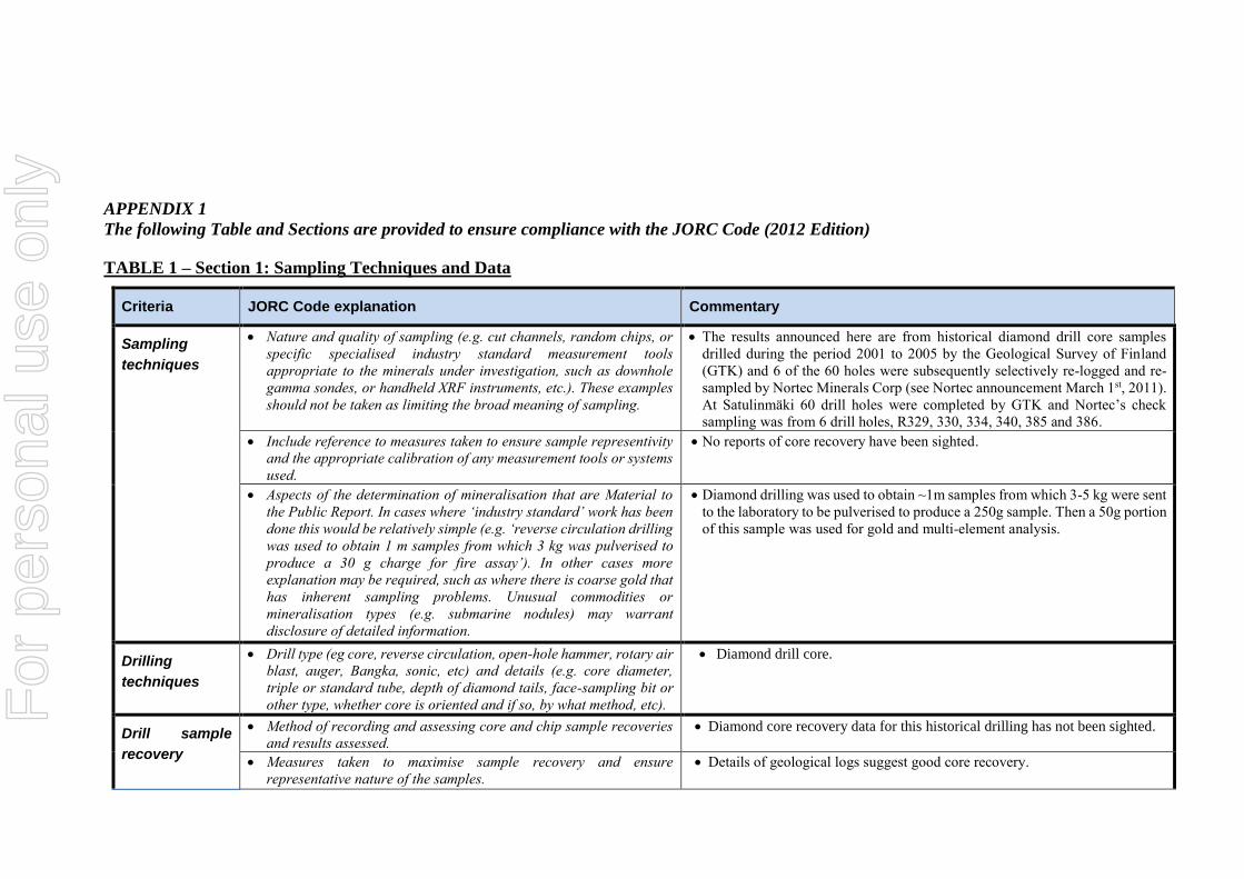
Criteria JORC Code explanation Commentary
Sampling
techniques
Nature and quality of sampling (e.g. cut channels, random chips, or
specific specialised industry standard measurement tools
appropriate to the minerals under investigation, such as downhole
gamma sondes, or handheld XRF instruments, etc.). These examples
should not be taken as limiting the broad meaning of sampling.
The results announced here are from historical diamond drill core samples
drilled during the period 2001 to 2005 by the Geological Survey of Finland
(GTK) and 6 of the 60 holes were subsequently selectively re-logged and re-
sampled by Nortec Minerals Corp (see Nortec announcement March 1st, 2011).
At Satulinmäki 60 drill holes were completed by GTK and Nortec’s check
sampling was from 6 drill holes, R329, 330, 334, 340, 385 and 386.
Include reference to measures taken to ensure sample representivity
and the appropriate calibration of any measurement tools or systems
used.
No reports of core recovery have been sighted.
Aspects of the determination of mineralisation that are Material to
the Public Report. In cases where ‘industry standard’ work has been
done this would be relatively simple (e.g. ‘reverse circulation drilling
was used to obtain 1 m samples from which 3 kg was pulverised to
produce a 30 g charge for fire assay’). In other cases more
explanation may be required, such as where there is coarse gold that
has inherent sampling problems. Unusual commodities or
mineralisation types (e.g. submarine nodules) may warrant
disclosure of detailed information.
Diamond drilling was used to obtain ~1m samples from which 3-5 kg were sent
to the laboratory to be pulverised to produce a 250g sample. Then a 50g portion
of this sample was used for gold and multi-element analysis.
Drilling
techniques
Drill type (eg core, reverse circulation, open-hole hammer, rotary air
blast, auger, Bangka, sonic, etc) and details (e.g. core diameter,
triple or standard tube, depth of diamond tails, face-sampling bit or
other type, whether core is oriented and if so, by what method, etc).
Diamond drill core.
Drill sample
recovery
Method of recording and assessing core and chip sample recoveries
and results assessed.
Diamond core recovery data for this historical drilling has not been sighted.
Measures taken to maximise sample recovery and ensure
representative nature of the samples.
Details of geological logs suggest good core recovery.
For
per
sona
l use
onl
y

Criteria JORC Code explanation Commentary
Whether a relationship exists between sample recovery and grade
and whether sample bias may have occurred due to preferential
loss/gain of fine/coarse material.
No relationship between sample recovery and grade has been established.
Logging Whether core and chip samples have been geologically and
geotechnically logged to a level of detail to support appropriate
Mineral Resource estimation, mining studies and metallurgical
studies.
Drill samples were logged for lithology. No further studies were undertaken.
Whether logging is qualitative or quantitative in nature. Core (or
costean, channel, etc.) photography.
Drill samples were logged for lithology and hence logging is qualitative. Core
was photographed and selected intervals have been viewed.
The total length and percentage of the relevant intersections logged. All drill holes were logged in full from start to finish of the hole, based on
historical reports. Nortec then re-logged selected intervals.
Sub-sampling
techniques and
sample
preparation
If core, whether cut or sawn and whether quarter, half or all core
taken.
Half core was sampled and the remaining core is stored in GTK’s core storage
facility. The core was logged at GTK’s Loppi core archive. After logging the
core was cut in half by saw for those holes drilled between 2002 and 2005,
and by hand splitter for holes drilled in 2001.
If non-core, whether riffled, tube sampled, rotary split, etc. and
whether sampled wet or dry.
Core samples.
For all sample types, the nature, quality and appropriateness of the
sample preparation technique.
The whole half-core sample was ground by a swing mill at GTK’s Kuopio or
Rovaniemi laboratories. The analyses were undertaken at GTK’s Espoo and
Rovaniemi laboratories. Assays by Notec were submitted to ALS Chemex in
Outokumpu for Ore grade Gold by fire assay with an AAS finish (FA-AAS)..
Quality control procedures adopted for all sub-sampling stages to
maximise representivity of samples.
There is no record of specific QAQC processes during the historical drilling
or on the check assays, although assays from both GTK and Nortec were
consistent with one another hence providing confidence in the results.
Measures taken to ensure that the sampling is representative of the in
situ material collected, including for instance results for field
duplicate/second-half sampling.
No record of these procedures.
Whether sample sizes are appropriate to the grain size of the material
being sampled.
Sample sizes are considered to be appropriate and correctly represent the style
and type of mineralisation.
For
per
sona
l use
onl
y

Criteria JORC Code explanation Commentary
Quality of
assay data and
laboratory tests
The nature, quality and appropriateness of the assaying and
laboratory procedures used and whether the technique is considered
partial or total.
The major method used by GTK was fire assay (plus ICP-AES) from a 50
gram subsample (method code 705P). Gold from the first drill cores (DH 326-
DH331) was analysed by GFAAS from aqua regia leach Hg-coprecipitation
and using 20g subsamples (method 522U). In addition, ICP-AES analyses by
partial leaching (aqua regia digestion, method code 511P) were used for
samples from holes D326-D347 and ICP-MS analyses from holes D379-
D389.
Samples taken by Nortec were submitted to ALS Chemex in Outokumpu for
Ore grade Gold by fire assay with an AAS finish (FA-AAS). Best intercepts
were calculated using a cut-off grade of 0.4g/t Gold and a maximum internal
waste of 2 metres.
For geophysical tools, spectrometers, handheld XRF instruments,
etc., the parameters used in determining the analysis including
instrument make and model, reading times, calibrations factors
applied and their derivation, etc.
No handheld XRF measurements were taken on this hole.
Nature of quality control procedures adopted (e.g. standards, blanks,
duplicates, external laboratory checks) and whether acceptable
levels of accuracy (i.e. lack of bias) and precision have been
established.
Re-sampling by Nortec confirmed earlier assay results received by the
Geological Survey of Finland (GTK).
Verification of
sampling and
assaying
The verification of significant intersections by either independent or
alternative company personnel.
Verification of GTK results by subsequent sampling by Nortec.
The use of twinned holes. Twin holes have not been drilled in this area.
Documentation of primary data, data entry procedures, data
verification, data storage (physical and electronic) protocols.
Nortec data and the Finnish Geological Survey (GTK) data have been sighted
in reports.
Discuss any adjustment to assay data. Assay data were not adjusted.
Location of
data points
Accuracy and quality of surveys used to locate drill holes (collar and
down-hole surveys), trenches, mine workings and other locations
used in Mineral Resource estimation.
Hole locations are shown on detailed maps from GTK 2006 report Kärkkäinen
et. al.
Specification of the grid system used. The current projection used for map preparation in Finland is ETRS-
TM35FIN, with Datum EUREF89
Quality and adequacy of topographic control. No reports of topographic control have been sighted.
For
per
sona
l use
onl
y
Criteria JORC Code explanation Commentary
Data spacing
and
distribution
Data spacing for reporting of Exploration Results. The historical drilling was comprised of 60 drill holes on multiple traverses at
approximately 10 and 40m apart.
Whether the data spacing and distribution is sufficient to establish
the degree of geological and grade continuity appropriate for the
Mineral Resource and Ore Reserve estimation procedure(s) and
classifications applied.
Sufficient continuity in both geology and mineralisation has been established
based on geological mapping and cross-section representation.
Whether sample compositing has been applied. No sample compositing was done.
Orientation of
data in relation
to geological
structure
Whether the orientation of sampling achieves unbiased sampling of
possible structures and the extent to which this is known, considering
the deposit type.
Drilling orientations were considered appropriate for the interpreted structures
controlling mineralisation.
If the relationship between the drilling orientation and the orientation
of key mineralised structures is considered to have introduced a
sampling bias, this should be assessed and reported if material.
The company does not believe that any sample bias had been introduced which
could have a material effect.
Sample
security
The measures taken to ensure sample security. Nortec’s sampling procedures indicate individual samples were given due
attention.
Audits or
reviews
The results of any audits or reviews of sampling techniques and data. No audits were completed.
For
per
sona
l use
onl
y

TABLE 1 – Section 2: Exploration Results
Criteria JORC Code explanation Commentary
Mineral
tenement and
land tenure
status
Type, reference name/number, location and ownership including
agreements or material issues with third parties such as joint ventures,
partnerships, overriding royalties, native title interests, historical
sites, wilderness or national park and environmental settings.
The Satulinmäki gold occurrence is covered by approved exploration claims,
under the Finnish Mining Act.
The security of the tenure held at the time of reporting along with any
known impediments to obtaining a licence to operate in the area.
Exploration claims are valid and are held by Nortec Minerals Corp. Avalon has
a joint venture with Nortec to explore the claims.
Exploration
done by other
parties
Acknowledgment and appraisal of exploration by other parties. The historic drilling at Satulinmäki was undertaken by the Finnish Geological
Survey in 1985, and was re-logged and re-sampled by Nortec Minerals Corp.
in 2010.
Geology Deposit type, geological setting and style of mineralisation. The Satulinmäki gold occurrence is interpreted to be an orogenic gold system
hosted by a series of quartz veins.
Drill hole
Information
A summary of all information material to the understanding of the
exploration results including a tabulation of the following information
for all Material drill holes:
a. easting and northing of the drill hole collar
b. elevation or RL (Reduced Level – elevation above sea level in
metres) of the drill hole collar
c. dip and azimuth of the hole
d. down hole length and interception depth
e. hole length.
Details of the drill holes discussed in this announcement are referenced to
Nortec Minerals Corp reports at http://www.nortecminerals.com/index.php.
60 drill holes were completed by GTK on multiple traverses. Holes were drilled
at mainly -45 degree angles. The deepest hole was to 139.2m EOH at -60
degrees which tested to ~100m below surface.
If the exclusion of this information is justified on the basis that the
information is not Material and this exclusion does not detract from
the understanding of the report, the Competent Person should clearly
explain why this is the case.
Information included above. For
per
sona
l use
onl
y

Criteria JORC Code explanation Commentary
Data
aggregation
methods
In reporting Exploration Results, weighting averaging techniques,
maximum and/or minimum grade truncations (e.g. cutting of high
grades) and cut-off grades are usually Material and should be stated.
The Weighted Averaging method is used to calculate drill hole intersections for
the gold grade based on the assay results received, and the down hole width of
the assayed interval.
Where aggregate intercepts incorporate short lengths of high grade
results and longer lengths of low grade results, the procedure used for
such aggregation should be stated and some typical examples of such
aggregations should be shown in detail.
Weighted averaging method used.
The assumptions used for any reporting of metal equivalent values
should be clearly stated.
Metal Equivalents have not been applied.
Relationship
between
mineralisation
widths and
intercept
lengths
If the geometry of the mineralisation with respect to the drill-hole
angle is known, its nature should be reported.
The orientations of the mineralised horizons is interpreted to be sub-vertical
based on geological mapping and cross-sectional interpretation.
If it is not known and only the down hole lengths are reported, there
should be a clear statement to this effect (e.g. ‘down hole length, true
width not known’).
See above – estimated true widths are approximately 60% of intersected widths
based on cross section construction.
Diagrams Appropriate maps and sections (with scales) and tabulations of
intercepts should be included for any significant discovery being
reported. These should include, but not be limited to a plan view of
drill hole collar locations and appropriate sectional views.
Reporting of historical holes only. No significant discovery reported here.
Balanced
reporting
Where comprehensive reporting of all Exploration Results is not
practicable, representative reporting of both low and high grades
and/or widths should be practiced to avoid misleading reporting of
Exploration Results.
Historical results only and this is stated in the text
Other
substantive
Other exploration data, if meaningful and material, should be
reported) including (but not limited to): geological observations;
geophysical survey results; geochemical survey results; bulk samples
– size and method of treatment; metallurgical test results; bulk
No other significant geological data has been reviewed at this stage.
For
per
sona
l use
onl
y

Criteria JORC Code explanation Commentary
exploration
data
density, groundwater, geotechnical and rock characteristics;
potential deleterious or contaminating substances.
Further work The nature and scale of planned further work (e.g. tests for lateral
extensions or depth extensions or large-scale step-out drilling).
Comprehensive data compilation is ongoing. The GTK have extensive open
file data available. Field work is ongoing during 2016, with follow-up drilling
expected in Q4 2016.
Diagrams clearly highlighting the areas of possible extensions,
including the main geological interpretations and future drilling
areas, provided this information is not commercially sensitive.
Additional exploration reservation areas have been applied for which cover the
interpreted extensions of the prospective domains.
For
per
sona
l use
onl
y