heritage impact assessment report
TRANSCRIPT

HERITAGE IMPACT ASSESSMENT REPORT 46-66 William Street North, (Former Town of Lindsay), City ofKawartha Lakes, Ontario
Date: November 23, 2020
Prepared for:
J. Eighteen Group
Prepared by: MacNaughton Hermsen Britton Clarkson Planning Limited (MHBC) 200-540 Bingemans Centre DriveKitchener, ON N2B 3X9T: 519 576 3650F: 519 576 0121
Our File: ‘20359A”

Heritage Impact Assessment 46-66 William Street, Lindsay, Ontario
November 23, 2020 MHBC | i
TABLE OF CONTENTSPROJECT PERSONNEL .......................................................................................................................................................................... 1
GLOSSARY OF ABBREVIATIONS ...................................................................................................................................................... 1
Acknowledgement of Indigenous Communities ............................................................................................................... 2
EXECUTIVE SUMMARY ......................................................................................................................................................................... 3
1.0 INTRODUCTION ............................................................................................................................................................................... 4
1.1 DESCRIPTION OF SUBJECT PROPERTY .......................................................................................................................... 4
1.2 HERITAGE STATUS ..................................................................................................................................................................... 6
1.3 SCOPE AND CONTENT OF THE HIA ................................................................................................................................ 6
2.0 POLICY CONTEXT ............................................................................................................................................................................ 7
2.1 THE ONTARIO PLANNING ACT .......................................................................................................................................... 7
2.2 PROVINCIAL POLICY STATEMENT (2020) ..................................................................................................................... 7
2.3 CITY OF KAWARTHA LAKES OFFICIAL PLAN .............................................................................................................. 8
3.0 THE DOWNTOWN LINDSAY HERITAGE CONSERVATION DISTRICT PLAN (2017) .................................. 10
3.1 THE DOWNTOWN LINDSAY HCD ................................................................................................................................. 10
3.2 STATEMENT OF CULTURAL HERITAGE VALUE ...................................................................................................... 11
4.0 DESCRIPTION OF PROPOSED DEVELOPMENT ............................................................................................................ 13
5.0 IMPACT ANALYSIS ....................................................................................................................................................................... 15
5.1 INTRODUCTION ....................................................................................................................................................................... 15
5.2 IMPACT ANALYSIS .................................................................................................................................................................. 16
5.2.1 Impact of Shadows ...................................................................................................................................................... 17
5.2.2 Impact of the Obstruction of Views ................................................................................................................... 17
5.2.3 Impact of Land Disturbances ................................................................................................................................. 17
5.3 CONFORMITY WITH THE OFFICIAL PLAN ................................................................................................................. 18
6.0 ALTERNATIVES, MITIGATION AND CONSERVATION RECOMMENDATIONS ..................................... 19
6.1 ALTERNATIVES .......................................................................................................................................................................... 19
6.2 MITIGATION AND CONSERVATION MEASURES .................................................................................................... 19

Heritage Impact Assessment 46-66 William Street, Lindsay, Ontario
November 23, 2020 MHBC | ii
7.0 CONCLUSION ......................................................................................................................................................................... 20
8.0 BIBLIOGRAPHY ....................................................................................................................................................................... 21
APPENDIX A – LOCATION MAP .................................................................................................................................................. 23
APPENDIX B –SITE PLAN ................................................................................................................................................................. 24
APPENDIX C– URBAN DESIGN BRIEF ........................................................................................................................................ 25
APPENDIX D– SHADOW STUDY ................................................................................................................................................. 26
APPENDIX E– HIA TERMS OF REFERENCE ............................................................................................................................. 27
APPENDIX F–CURRICULUM VITAE ............................................................................................................................................. 28
Disclaimer: Due to the Covid-19 pandemic, in-person research has been limited and therefore, this report may not be able to reference relevant hard copy sources that are within collections that are temporarily closed to the public.

Heritage Impact Assessment 46-66 William Street, Lindsay, Ontario
November 23, 2020 MHBC | 1
PROJECT PERSONNEL Dan Currie, MA, MCIP, RPP, CAHP
Managing Director of Cultural Heritage
Senior Review, Co-author
Rachel Redshaw, MA, HE Dipl, CAHP
Heritage Planner Research, Co-author
GLOSSARY OF ABBREVIATIONS CHVI Cultural Heritage Value or Interest
HIA Heritage Impact Assessment
HCD Heritage Conservation District
MHBC MacNaughton Hermsen Britton Clarkson Planning Limited
MHSTCI Ministry of Heritage, Sport, Tourism and Culture Industries
OHA Ontario Heritage Act
OHTK Ontario Heritage Toolkit
O-REG 9/06 Ontario Regulation 9/06 for determining cultural heritage significance
PPS 2020 Provincial Policy Statement (2020)

Heritage Impact Assessment 46-66 William Street, Lindsay, Ontario
November 23, 2020 MHBC | 2
Acknowledgement of Indigenous Communities This Cultural Heritage Impact Assessment acknowledges that the subject property located at 44-46 William Street North, Town of Lindsay is situated within territory of the Haudenosauneega, Anishinabewaki and Mississauga. These lands are acknowledged as being associated with Treaty 20, 1818 (www.native-land.ca 2020).
This document takes into consideration the cultural heritage of indigenous communities including their oral traditions and history when available and related to the scope of work.
‘

Heritage Impact Assessment 46-66 William Street, Lindsay, Ontario
November 23, 2020 MHBC | 3
EXECUTIVE SUMMARY The subject lands located at 46-66 William Street North (corner of William and Wellington Streets) in the former Town of Lindsay are proposed to be redeveloped for a 10 storey high-rise apartment building with 207 rental apartment units to accommodate seniors and retirees. The proposed development requires an Official Plan amendment and a zoning bylaw amendment to allow for the proposed height and density of the building.
The subject lands do not contain cultural heritage resources; however, the lands are within the vicinity of the Downtown Lindsay Heritage Conservation District. As such, the City of Kawartha Lakes has required that a Heritage Impact Assessment be completed to determine if the proposed development will result in any negative impacts to the nearby Heritage Conservation District.
This Heritage Impact Assessment has assessed the potential impacts of the proposed development at 46-66 William Street on the heritage attributes and heritage value of the nearby Downtown Lindsay Heritage Conservation District consistent with the requirements of the City of Kawartha Lakes Terms of Reference for Heritage Impact Assessments. The assessment concludes that the proposed development will have no negative impact on the nearby HCD. Since there are no negative impacts anticipated, there are no mitigation measures or conservation measures recommended.

Heritage Impact Assessment 46-66 William Street, Lindsay, Ontario
November 23, 2020 MHBC | 4
1.0 INTRODUCTIONThe purpose of this Heritage Impact Assessment is to assess the impact of the proposed development at 46-66 William Street North, Town of Lindsay on the adjacent Downtown Lindsay Heritage Conservation District.
It is an objective of the City of Kawartha Lakes to conserve and enhance the City’s cultural and heritage resources as per Section 10.2 of the Official Plan. As a precautionary measure, the City requires a Heritage Impact Assessment when development is proposed on properties located adjacent to a protected heritage property. This report will analyze the impact of the proposed development upon the existing heritage conservation district and provide mitigation, conservation measures and/ or alternative development options as required.
1.1 DESCRIPTION OF SUBJECT PROPERTY The subject property is located at 46-66 William Street North. The lands are legally described as Part of Lot 5, south side of Wellington Street and Part of Lot 5, North Side of Peel Street, former Town of Lindsay, City of Kawartha Lakes.
The lands are on the east side of William Street at the corner of Wellington Street and backing onto McDonnel Park and the Scugog River. The lands are within the central commercial area of Lindsay and are surrounded by a range of commercial properties and medium density residential uses.
The lands are comprised of two separate properties. The northern property contains an asphalt parking lot and a commercial/office building that currently houses an insurance company. The southern lot currently contains a gravel parking lot. The lands are relatively flat, with the exception of a steep embankment located along the eastern lot line. The subject lands are devoid of vegetation, with the exception of some larger trees and shrubs along the embankment.

Heritage Impact Assessment 46-66 William Street, Lindsay, Ontario
November 23, 2020 MHBC | 5
Figure 1: Aerial view of subject lands (Source: EcoVue Consulting Services Inc., February 13, 2020)

Heritage Impact Assessment 46-66 William Street, Lindsay, Ontario
November 23, 2020 MHBC | 6
1.2 HERITAGE STATUS
The subject lands are not included on the City of Kawartha Lakes Municipal Heritage Register as either a listed or designated property. The subject lands are not included within the Downtown Lindsay Heritage Conservation District. The subject lands do not contain identified cultural heritage resources and are not considered protected heritage property. The lands are near the Downtown Lindsay Heritage Conservation District but they are not adjacent to any property that is designated under Part IV of the Ontario Heritage Act or listed on the Municipal Heritage Register.
1.3 SCOPE AND CONTENT OF THE HIA
The City of Kawartha Lakes has an approved Terms of Reference that sets out the scope and content for heritage impact assessments (attached as Appendix E). The Terms of Reference identify that the City will require an HIA when development is proposed adjacent to an identified heritage resource. Adjacent is defined as lands that are contiguous to a heritage property or which are near to a heritage property and separated by a road, trail, right-of-way, greenspace / park or similar, or whose location has the potential to impact a heritage property, as defined in the City’s Official Plan. Given that the subject lands do not contain cultural heritage resources, City staff have scoped the requirements of the HIA. Specifically, a statement of cultural heritage value and assessment of the subject lands under O.Reg. 9/06 of the OHA will not be required. This HIA includes all other components as required by the City’s Terms of Reference for Heritage Impact Assessments.

Heritage Impact Assessment 46-66 William Street, Lindsay, Ontario
November 23, 2020 MHBC | 7
2.0 POLICY CONTEXT
2.1 THE ONTARIO PLANNING ACT The Planning Act makes a number of provisions respecting cultural heritage, either directly in Section 2 of the Act or Section 3 respecting policy statements and provincial plans. In Section 2, the Planning Act outlines 18 spheres of provincial interest that must be considered by appropriate authorities in the planning process. Regarding cultural heritage, Subsection 2(d) of the Act provides that:
The Minister, the council of a municipality, a local board, a planning board and the Municipal Board, in carrying out their responsibilities under this Act, shall have regard to, among other matters, matters of provincial interest such as, ...
(d) the conservation of features of significant architectural, cultural, historical,archaeological or scientific interest;
The Planning Act therefore provides for the overall broad consideration of cultural heritage resources through the land use planning process.
2.2 PROVINCIAL POLICY STATEMENT (2020) In support of the provincial interest identified in Subsection 2 (d) of the Planning Act, and as provided for in Section 3, the Province has refined policy guidance for land use planning and development matters in the Provincial Policy Statement, 2020 (PPS). The PPS is “intended to be read in its entirety and the relevant policy areas are to be applied in each situation”. This provides a weighting and balancing of issues within the planning process. When addressing cultural heritage planning, the PPS provides for the following:
2.6.1 Significant built heritage resources and significant cultural heritage landscapes shall be conserved.
The PPS 2020 also states in Sub-section 2.6.3 that,

Heritage Impact Assessment 46-66 William Street, Lindsay, Ontario
November 23, 2020 MHBC | 8
Planning authorities shall not permit development and site alteration on adjacent lands to protected heritage property except where the proposed development and site alteration has been evaluated and it has been demonstrated that the heritage attributes of the protected heritage property will be conserved.
The following definitions are provided in Section 6.0: Heritage attributes: means the principal features or elements that contribute to a protected heritage property’s cultural heritage value or interest, and may include the property’s built, constructed, or manufactured elements, as well as natural landforms, vegetation, water features, and its visual setting (e.g. significant views or vistas to or from a protected heritage property). Protected Heritage Property: means property designated under Parts IV, V or VI of the Ontario Heritage Act; property subject to a heritage conservation easement under Parts II or IV of the Ontario Heritage Act; property identified by the Province and prescribed public bodies as provincial heritage property under the Standards and Guidelines for Conservation of Provincial Heritage Properties; property protected under federal legislation, and UNESCO World Heritage Sites. Significant: e) in regard to cultural heritage and archaeology, resources that have been determined to have cultural heritage value or interest. Processes and criteria for determining cultural heritage value or interest are established by the Province under the authority of the Ontario Heritage Act.
2.3 CITY OF KAWARTHA LAKES OFFICIAL PLAN
Section 10.2 of the Official Plan states that it is an objective of the City to conserve and enhance the City’s cultural and heritage resources. The cultural heritage policies are contained in section10.5 and include:
a) The City shall encourage the conservation and preservation of its significant built heritage resources, significant cultural heritage landscapes and significant archaeological resources.
c) Development in areas considered to be of architectural or historical value shall have regard for the conservation and preservation of architecture or historic buildings, features or sites therein.

Heritage Impact Assessment 46-66 William Street, Lindsay, Ontario
November 23, 2020 MHBC | 9
d) The City recognizes that the City’s heritage resources include individual buildings, group of buildings, streetscapes, neighbourhoods, landscaping and landmarks. For the purpose of this section, the term “building” is considered to include both buildings and structures and the term “conserve” is generally considered to mean retention of the existing form, material and integrity of site.
g) The City shall ensure land development adjacent to protected heritage properties are not adversely impacting identified heritage attributes of these properties.
The term adjacent, as applied to protected heritage properties, is not defined in the Official Plan.

Heritage Impact Assessment 46-66 William Street, Lindsay, Ontario
November 23, 2020 MHBC | 10
3.0 THE DOWNTOWN LINDSAY
HERITAGE CONSERVATION DISTRICT PLAN (2017) 3.1 THE DOWNTOWN LINDSAY HCD The subject lands are located near the Downtown Lindsay Heritage Conservation District. In 2017, the City designated lands within the downtown core as a Heritage Conservation District (see Figure 2). The HCD is bounded by Peel Street, Lindsay Street South, Russell Street West and Sussex Street South. As shown on Figure 2 the subject lands are outside the HCD and separated by the Peel Street right-of-way and the property at 44 William Street.
Figure 2: Boundary of Downtown Lindsay Heritage Conservation District; red outline indicates location of subject lands (Source: Downtown Lindsay Heritage Conservation District Plan, 2017)

Heritage Impact Assessment 46-66 William Street, Lindsay, Ontario
November 23, 2020 MHBC | 11
3.2 STATEMENT OF CULTURAL HERITAGE VALUE A statement of the heritage district’s cultural heritage value is provided in Section 2.2 of the HCD Plan and is as follows:
The Downtown Lindsay study area offers a capsule history of the town. Within it is evidence of the original town site plan and the land uses that were developed as the town matured. Along Kent Street, itself distinctive because of its width, concentration of 19th and early 20th century buildings and terminal vista, are components of military, rail, commercial and institutional history. The street names echo the titled aristocracy and royalty of the early British Empire. The area is the cultural, economic and political hub of Lindsay and, to some extent, of the City of Kawartha Lakes and beyond. The area’s heritage value lies both in its collection of individually important properties and in its combination of these resources within a compact urban form. The area has value because of properties that represent key stages of the town’s development, because the area is relatively unchanged, homogeneous and intact, and because it offers examples of some of the best buildings and commercial and institutional streetscapes in Lindsay. Overall, the study area’s heritage value lies in its collection of significant heritage properties and in its concentration of material and associative cultural heritage resources that are integral to the town’s identity.
The heritage attributes of the District are stated in Section 2.3 of the HCD Plan and are as follows:
Architecture that generally follows a common 2-3 storey brick vernacular commercial style, predominantly Italianate Revival with some Second Empire and eclectic styles;
The largely uniform massing, setback and bay widths of many buildings; Architectural details at cornices, window surrounds and ground floor entrances and display
windows on many buildings; Public open spaces that are concentrated at Queen’s Square and the civic complex (with the
addition of the closed portion of Victoria Street on market days); Overall spatial pattern/boundary features of a mixed use main street bookended by public land
uses (Armoury and Academy Theatre); Vegetation pattern of ornamental tree, shrub and perennial/annual plantings in Queen’s Park
and the civic complex grounds, with the formal planting along the central median on Victoria Street as an added element;
Historical association with the town’s origins and, especially, the rebuilding of the downtown following the 1860s fire;
Landmarks that include the Armoury/Queen’s Square/civic complex at one end and the Academy Theatre block at the other; and

Heritage Impact Assessment 46-66 William Street, Lindsay, Ontario
November 23, 2020 MHBC | 12
Historic views east to the Academy Theatre block and west to the Armoury and up the hill; keyhole views to and from the street via walkways to the rear yards and laneways.
The conservation and development policies of the HCD Plan are contained in Section 2.6. The policies of the HCD Plan only apply to the lands that are located within the HCD boundary. The only policy that references property outside the HCD is Policy 2.6.2 which states that an HIA is required for development on properties adjacent to the HCD to assure that the heritage values and attributes of the HCD will be conserved.
The HCD Plan does not contain specific policies on views or view corridors. However, the heritage attributes listed in Section 2.3 of the Plan state that the views east and west up Kent Street that are terminated on the east by the Academy Theatre Block and of the Armory to the west are important attributes of the District. Views from the District along William Street, or any of the other streets in the District, are not identified as significant views.

Heritage Impact Assessment 46-66 William Street, Lindsay, Ontario
November 23, 2020 MHBC | 13
4.0 DESCRIPTION OF PROPOSED
DEVELOPMENT The applicants, J. Eighteen Ltd., are proposing to redevelop a site (subject lands) on the corner of William and Wellington Streets in the former Town of Lindsay. The primary component of the development will be a 10- storey high rise apartment building with 207 rental apartment units that will focus on accommodating seniors and retirees. The residential units will be located within the upper 9 floors of the building. The first floor will be retail commercial space and approximately 157 square metres of restaurant space.
Figure 3: Site plan for proposed development (Source: EcoVue Consulting Services Inc., June 10, 2020)

Heritage Impact Assessment 46-66 William Street, Lindsay, Ontario
November 23, 2020 MHBC | 14
A combination of surface and underground parking will be provided on-site. The surface parking lot will be located along the eastern lot line and will feature 17 spaces. The surface parking area will also include pick-up/drop off spaces located within a “cut-out” portion of the first floor (underneath parts of the upper nine floors). Underground parking will be accessed via an entrance on the south side of the property.
Figure 4: Coloured renderings of proposed development (Source: Z Square Consulting Inc. 2020) The building will be designed in the modern style and accented with mostly neutral colours (greys, whites, etc.) As with a typical apartment building, residents will have access to a multi-functional rooftop amenity space and rooftop garden. In addition to the rooftop, the units will feature large window openings in order to provide residents with views of the surrounding landscape, which includes the adjacent Scugog River and downtown Lindsay. The slanted overhanging roof with off-centre concave pitch, which will cover the rooftop amenity space, is intended to accent the building from faraway distances. Portions of the western and north face of the building will be “stepped” back from the street at the higher floors in order to decrease massing impacts at the street level.

Heritage Impact Assessment 46-66 William Street, Lindsay, Ontario
November 23, 2020 MHBC | 15
5.0 IMPACT ANALYSIS
5.1 INTRODUCTION
There are three classifications of impacts a proposed development may have on an identified cultural heritage resource: beneficial, neutral or adverse. Beneficial effects may include such actions as retaining a property of cultural heritage value, protecting it from loss or removal, maintaining restoring or repairing heritage attributes, or making sympathetic additions or alterations that allow for a continued long-term use and retain heritage building fabric. Neutral effects have neither a markedly positive or negative impact on a cultural heritage resource. Adverse effects may include the loss or removal of a cultural heritage resource, unsympathetic alterations or additions that remove or obstruct heritage attributes, the isolation of a cultural heritage resource from its setting or context, or the addition of other elements that are unsympathetic to the character or heritage attributes of a cultural heritage resource. Adverse effects may require strategies to mitigate their impact on cultural heritage resources.
The impacts of a proposed development or change to a cultural heritage resource may be direct or indirect. They may occur over a short term or long term duration, and may occur during a pre-construction phase, construction phase or post-construction phase. Impacts to a cultural heritage resource may also be site specific or widespread, and may have low, moderate or high levels of physical impact.
The following sub-sections of this report provide an analysis of the impacts which may occur as a result of the proposed development.
Destruction: of any, or part of any significant heritage attributes or features; Alteration: that is not sympathetic, or is incompatible, with the historic fabric and
appearance: Shadows: created that alter the appearance of a heritage attribute or change the viability
of a natural feature or plantings, such as a garden; Isolation: of a heritage attribute from its surrounding environment, context or a significant
relationship; Direct or Indirect Obstruction: of significant views or vistas within, from, or of built and
natural features;

Heritage Impact Assessment 46-66 William Street, Lindsay, Ontario
November 23, 2020 MHBC | 16
A change in land use: such as rezoning a battlefield from open space to residential use,allowing new development or site alteration to fill in the formerly open spaces;
Land disturbances: such as a change in grade that alters soils, and drainage patterns thatadversely affect a cultural heritage resource.
5.2 IMPACT ANALYSIS
The following chart evaluates the impact of the proposed development on the subject property to the adjacent cultural heritage resource. These impacts are based on the heritage attributes outlined in sub-section 3.2 of this report.
Table 1.0 Adverse Impacts Impact Level of Impact Analysis Destruction or alteration of heritage attributes
No impact The proposed development will not result in the destruction or alteration of any heritage properties or attributes of the HCD.
Shadows No impact The proposed development will not result in shadows that negatively impact heritage attributes. A shadow study was completed and submitted with the planning applications (see Appendix D). The shadow study identifies that proposed building does not result in shadows that extend to the Heritage Conservation District (see Sub-section 5.2.1).
Isolation No impact The proposed development does not isolate the HCD and associated heritage attributes from their surrounding environment, context or significant relationship.
Direct or Indirect Obstruction of Views
No impact The proposed development does not obstruct significant views within the Heritage Conservation District (see Sub-section 5.2.2.).
A Change in Land Use No impact There will be no change in land use.
Land Disturbance No impact There are no expected land disturbances as a result of the new construction that will impact heritage resources in the HCD (see section 5.2.3).

Heritage Impact Assessment 46-66 William Street, Lindsay, Ontario
November 23, 2020 MHBC | 17
5.2.1 Impact of Shadows
The new building is proposed to be 10 storeys in height. A shadow study was prepared by the applicants and is included in Appendix ‘D’. The subject lands are located to the north of the Heritage District and shadows cast by the new building will generally be directed away from the HCD. The shadow study shows that even at the winter solstice when shadowing is at its greatest, the new building will not cast shadows on the properties within the HCD.
5.2.2 Impact of the Obstruction of Views
The City’s Terms of Reference (and The Ontario Heritage Tool Kit) identify that one of the potential negative impacts that can occur from a new development is the “direct or indirect obstruction of significant views or vista within, from or to built and natural features”. It is important to note the reference to “significant views”. This means that any impacts are assessed on views that have been identified as significant as per the definition in the PPS 2020 (i.e. have been evaluated under O. Reg 9/06 of the Ontario Heritage Act). The HCD Plan identifies that the significant views in the HCD are the views east and west up Kent Street. The Plan also identifies “keyhole views to and from the street via walkways to the rear yards and laneways” as significant views. While the location of these “keyhole views” is not identified specifically in the HCD Plan, the description is clear that these views are those that are within the boundary of the HCD and are not views to or from lands that are outside the HCD. The proposed development is 10 storeys in height and is taller than any of the buildings within the HCD. Therefore, it will be visible from some locations within the Heritage District and will be visible in the background view in some places. However, the proposed development will not obstruct the significant views that are identified in the Heritage Conservation District Plan.
5.2.3 Impact of Land Disturbances
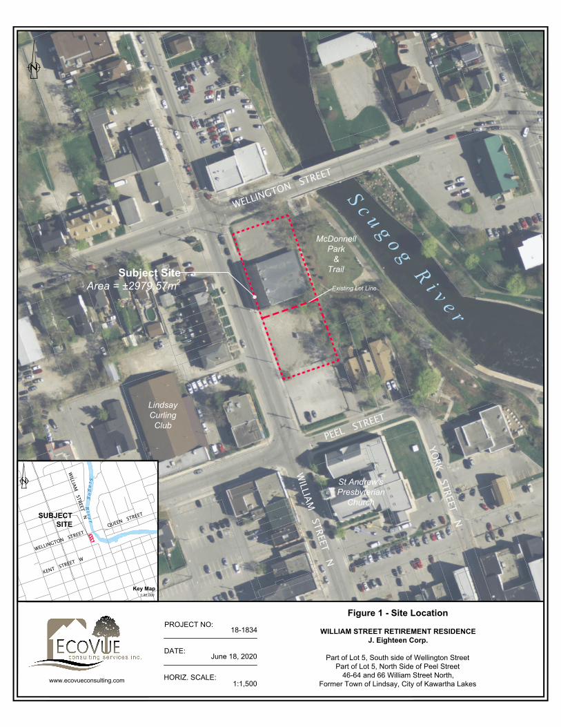
The subject lands are approximately 50 metres from 34 William Street North which includes the St. Andrews Presbyterian Church, which is the nearest property in the HCD to the subject lands. In addition, the subject lands and the HCD are separated by the Peel Street right-of way and the municipal parking lot at the corner of William and Peel Streets. Given the separation distance, there are no expected impacts due to vibrations during construction of the new building.

Heritage Impact Assessment 46-66 William Street, Lindsay, Ontario
November 23, 2020 MHBC | 18
5.3 CONFORMITY WITH THE OFFICIAL PLAN
The City of Kawartha Lakes Official Plan identifies that cultural heritage resources are to be conserved and protected and that development adjacent to protected heritage resources is only permitted if it has been demonstrated that there is no impact on the resources. The impact analysis in Section 5.2 of this report identifies that the proposed development will not result in the loss of any identified cultural heritage resources and that there will be no negative impacts to adjacent heritage resources. Therefore, the proposed development complies with the cultural heritage policies in Section 10.5 of the City of Kawartha Lakes Official Plan.
Heritage Impact Assessment 46-66 William Street, Lindsay, Ontario
November 23, 2020 MHBC | 19
6.0 ALTERNATIVES, MITIGATION AND
CONSERVATION RECOMMENDATIONS
6.1 ALTERNATIVES The City of Kawartha Lakes Terms of Reference for Heritage Impact Assessments requires the consideration of development alternatives that would avoid or limit the negative impact on heritage resources. Alternative development options have not been explored in this HIA since the assessment of the proposed development has concluded that it will result in no negative impacts to the Heritage Conservation District and the properties within the District.
6.2 MITIGATION AND CONSERVATION MEASURES There are no cultural heritage resources located on the subject lands and the impact assessment in Section 5.0 of this report has identified that there will be no adverse impacts on adjacent or nearby heritage resources. Therefore, no mitigation or conservation measures are necessary.
As noted in section 5.2.3 the proposed new building on the subject lands is located approximately 50 metres from St. Andrews Presbyterian Church, which is the nearest property located within the HCD. Based on the distance between the sites, there is no expected impact to the church, or other buildings in the HCD, due to vibrations related to the construction of the new building on the subject lands. However, as the building design and site plan are further refined through the Site Plan process, and there are changes to the plan that would indicate that there could be impacts of vibration during construction, the City could require a vibration monitoring plan as part of the Site Plan Approval process.

Heritage Impact Assessment 46-66 William Street, Lindsay, Ontario
November 23, 2020 MHBC | 20
7.0 CONCLUSION
This Heritage Impact Assessment has assessed the potential impacts of the proposed development at 46-66 William Street on the heritage attributes and heritage value of the nearby Downtown Lindsay Heritage Conservation District consistent with the requirements of the City of Kawartha Lakes Terms of Reference for Heritage Impact Assessments. The assessment concludes that the proposed development will have no negative impact on the nearby HCD. Since there are no negative impacts anticipated, there are no mitigation measures or conservation measures needed or recommended.
Respectfully submitted,
Rachel Redshaw, MA, HE Dipl., CAHP Dan Currie, MA, MCIP, RPP, CAHP Heritage Planner, MHBC Partner, MHBC

Heritage Impact Assessment 46-66 William Street, Lindsay, Ontario
November 23, 2020 MHBC | 21
8.0 BIBLIOGRAPHY
Blumenson, John. Ontario Architecture: A Guide to Styles and Building Terms 1874 to the Present. Fitzhenry and Whiteside, 1990.
Bray Heritage, LHC Inc., Baird Sampson Neuert Architects. Downtown Lindsay Heritage Conservation District Plan. June 2017 (PDF)
City of Kawartha Lakes. Heritage Impact Assessment Terms of Reference. 2020 (PDF).
EcoVue Consulting Services Inc. Planning Justification Report: William Street Retirement Residence, 46-64 and 66 William Street North, Former Town of Lindsay, City of Kawartha Lakes. February 14, 2020 rev June 11, 2020 (PDF).
EcoVue Consulting Services Inc. Shadow Impact Analysis: William St. Seniors’ Apartment Residence. June 18, 2020 (PDF).
Google Maps & Google Earth Pro. “46-66 William Street North, Town of Lindsay, ON”, November 2020.
Government of Canada. Parks Canada. Standards and Guidelines for the Conservation of Historic Places in Canada. 2010.
Ministry of Tourism, Culture and Sport. Ontario Heritage Tool Kit: Heritage Resources in the Land Use
Planning Process, InfoSheet #2, Cultural Heritage Landscapes . Queens Printer for Ontario, 2006.
Ministry of Tourism, Culture and Sport. Ontario Heritage Tool Kit: Heritage Resources in the Land Use
Planning Process, InfoSheet #5 Heritage Impact Assessments and Conservation Plans . Queens Printer for Ontario, 2006.
Ontario Heritage Trust. Well-Preserved; The Ontario Heritage Foundation’s Manual of Principles and
Practice for Architectural Conservation. Boston Mills Press, 1998.

Heritage Impact Assessment 46-66 William Street, Lindsay, Ontario
November 23, 2020 MHBC | 22
Ontario Ministry of Tourism Culture and Sport. Ontario Heritage Act Ontario Heritage Act 2005, R.S.O. 1990, c. 0.18 . Retrieved from the Government of Ontario website: https://www.ontario.ca/laws/statute/90o18.
Ontario Ministry of Affairs and Housing. Ontario Provincial Policy Statement 2020. S.3 the Ontario Planning Act R.S.O 1996. Retrieved from the Government of Ontario website: Provincial Policy Statement, 2020 - Under the Planning Act (ontario.ca)
Z Square Consulting and EcoVue Consulting Services Inc. Comprehensive Urban Design Analysis. August 19, 2020 (PDF).

Heritage Impact Assessment 46-66 William Street, Lindsay, Ontario
November 23, 2020 MHBC | 23
APPENDIX A – LOCATION MAP

WELLINGTON STREET
PEEL STREET
WILLIAM
STREET N
OR
TH
SCUGOG RIVER
PEEL STREET
HERITAGE CONSERVATION DISTRICT BOUNDARY
HERITAGE CONSERVATION DISTRICT BOUNDARY
J. Eighteen Group,Lindsay, Ontario
LEGEND
Subject LandsSCALE Not to Scale
DATE: November 23,2020
north
K:\20359A-WILLIAM ST-LINDSAY\REPORT\LOCATION PLAN.DWG
200-540 BINGEMANS CENTRE DR. KITCHENER, ON, N2B 3X9P: 519.576.3650 F: 519.576.0121 | WWW.MHBCPLAN.COM
PLANNINGURBAN DESIGN& LANDSCAPEARCHITECTUREMHBC
FILE: 20359A
DRN: LHB
Data Source: City of Kawartha Lakes
Figure
Location Plan46 - 64 William Street N.,Town of Lindsay,City of Kawartha Lakes
Downtown Lindsay Heritage ConservationDistrict Boundary

Heritage Impact Assessment 46-66 William Street, Lindsay, Ontario
November 23, 2020 MHBC | 24
APPENDIX B –SITE PLAN

S c u g o g R i v e r
EX. TOP O
F BANK
HORIZ. SCALE:
DATE:
www.ecovueconsulting.com
PROJECT NO:
1:1,500
June 10, 2020
18-1834
Figure 2 - Site Plan
WILLIAM STREET RETIREMENT RESIDENCEJ. Eighteen Corp.
Part of Lot 5, South side of Wellington StreetPart of Lot 5, North Side of Peel Street
46-64 and 66 William Street North,Former Town of Lindsay, City of Kawartha Lakes

Heritage Impact Assessment 46-66 William Street, Lindsay, Ontario
November 23, 2020 MHBC | 25
APPENDIX C– URBAN DESIGN BRIEF

COMPREHENSIVE URBAN DESIGN ANALYSIS
19/08/2020
William Street Retirement Residence
In support of an Official Plan and Zoning By-law
Amendment located at 46-64 and 66 William Street North,
Former Town of Lindsay, City of Kawartha Lakes
Prepared By: Z Square Consulting and EcoVue Consulting Services Inc.

Comprehensive Urban Design Analysis
Page 1
Comprehensive Urban Design Analysis W I L L I A M S T R E E T R E T I R E M E N T R E S I D E N C E
INTRODUCTION This Comprehensive Urban Design Analysis was prepared for J. Eighteen Corporation, in
support of an Official Plan and Zoning By-law Amendment on the subject property.
The development is proposed to occur on a 0.3 hectare (0.74 acres) parcel that spans two
municipal properties, making up 46-66 William Street North in the former Town of Lindsay,
in the City of Kawartha Lakes. The property is located in Downtown Lindsay, on the corner
of Wellington Street and William Street North. The proposal consists of a 10-storey rental
apartment residence, outfitted with 207 units aimed at older and retirement-aged residents.
In addition to the units, the ground floor of the building will consist of leasable office/retail
space.
Vision
This project is intended to enhance downtown Lindsay through the construction of a 10-
storey mixed-use building in close proximity to a number of services and amenities.
The gross floor area of the residential portion of the high-rise apartment building will be
13,061 square metres (140,587 square feet) over 9 floors, with the ground floor consisting of
636 square metres of retail and office space. The apartment will offer surface parking to
residents and visitors, as well as underground parking for residents – 17 surface spaces and
69 underground spaces. Of the total 86 parking spaces, 3 will be barrier-free spaces. The
surface area parking will include a pick-up/drop-off area for residents.
FIGURE 1 - SITE PLAN LOCATION

Comprehensive Urban Design Analysis
Page 2
The architectural design of the structure will be geared towards a modern-and-neutral
toned aesthetic, focusing on features that will compliment the neighbourhood. Landscaping
along the eastern lot line will enhance the existing vegetation adjacent to the subject
property. The main entrance of the building will contain a stepped-in ground floor. The
upper floors will be cantilevered above the edges of the ground floor in order to provide
additional ground level space for the pick-up/drop-off area.
FIGURE 2 – CLOSE-UP SITE PLAN LOCATION
Context
The site is currently designated the Central Commercial (CC) Zone in the Town of Lindsay
Comprehensive Zoning By-law 2000-75. The property is surrounded by the north, west, and
south by Central Commercial (CC) Zoning, with a mixture of land uses – the Williamson
Chrysler Dodge Jeep Ram car dealership is located immediately to the north; a Circle K
convenience store, a row of residential townhomes
and municipal offices are located to the west; and
south of the subject lands is a municipal parking lot.
McDonnell Park, a riverside park with walking paths
is located immediately east of the site.
The location of the proposed building is appropriate
given the surrounding land uses. As noted, the
surrounding area includes a wide spectrum of land
uses and building styles, with no established
architectural character. Building heights within the
immediate area are generally between 2 and 3
storeys.
FIGURE 3 - ZONING OF SUBJECT AREA AND
NEIGHBOURING PROPERTIES

Comprehensive Urban Design Analysis
Page 3
LANDSCAPING The proposed landscaping theme for this development will be designed to compliment the
architecture of the structure while providing some natural spaces and vegetation amid the
downtown location.
Landscaping will include a mix of deciduous and coniferous trees, as well as some woody
shrubs and perennials. More specifically, it will involve the planting of the following Ontario
native species, to be located in planting beds along the entrance to the building from
Wellington Street, in front of the underground parking entrance on William Street North, as
well as the east lot line, adjacent to the surface parking lot:
1. Balsam Fir (Abies balsamea);
2. Canadian Serviceberry (Amelanchier canadensis);
3. Eastern Flowering Dogwood (Cornus florida);
4. Eastern Redbud (Cercis canadensis);
5. Hosta 'Blue Angel' (Sieboldiana); and
6. Karl Foerster Feather Reed Grass (Calamagrostis acutiflora 'Karl Foerster')
INTERNAL CIRCULATION The interior surface parking lot will be accessed via driveway entrance from William Street
North. The driveway will provide access to an interior loop-system, in which residents can
either enter the underground parking, or continue around the loop to the pick-up/drop-off
area. Upon exiting the driveway, vehicles can go both North and South on William Street.
The parking area will be located behind the proposed building in order to provide a walkable
and appealing streetscape along William and Wellington streets.
Existing sidewalks along Wellington Street and William Street North will be enhanced and
widened in order to provide maximum accessibility to proposed apartment entrance and
storefronts within the first floor of the building.
Parking
There will be a total number of 86 parking spaces, which includes a surface parking lot and
underground parking. The surface parking lot will be accessed via William Street North, and
provide 17 at grade parking spaces, 3 of which will be barrier-free. The surface parking area
will also include pick-up/drop off spaces located within a “cut-out” portion of the first floor
(underneath parts of the upper nine floors).
Access to underground parking spaces will be via a ramp on the south side of the property.
Underground parking will consist of 69 spaces. Three (3) stairwells and two (2) elevators will
provide pedestrian access from underground parking garage to the surface level inside and
outside of the building. The driveways will be finished with asphalt.
Public Transportation
The Town of Lindsay operates a municipal bussing system, known as Lindsay Transit. Within
200 metres of the subject property, there are three (3) bus stops on the Lindsay Transit
Green Line. Without any transfers required, the Green Line provides access to downtown

Comprehensive Urban Design Analysis
Page 4
Kent Street, Lindsay Square mall, and various grocery centres. In addition to Lindsay Transit,
non-car owning residents can use services such as Kawartha Lakes Taxi.
BUILT FORM
The subject lands located on the corner of
William and Wellington Streets. The design
of the proposed building is intended to
accent and enhance this intersection, which
features existing commercial uses on the
northeast and southwest corners.
The 10-storey high rise apartment building
is a series of 207 rental apartment units,
underground parking, gym, residents'
lounge, library, roof top gardens and a
public restaurant and retail space on ground
level to accommodate increasing elderly
housing demand.
The building will be designed in the modern style and accented with mostly neutral colours
(greys, whites, etc.) As with a typical apartment building, residents will have access to a multi-
functional rooftop amenity space and rooftop garden. In addition to the rooftop, the units will
feature large window openings in order to
provide residents with views of the
surrounding landscape, which includes the
adjacent Scugog River and downtown
Lindsay. The slanted overhanging roof with
off-centre concave pitch, which will cover
the rooftop amenity space, is intended to
accent the building from faraway distances.
Portions of the western and north face of the
building will be “stepped” back from the
street at the higher floors in order to
decrease massing impacts at the street level.
As noted, the building will be constructed
next to McDonnell Park. The building’s location
at the edge of the downtown, adjacent to open space, will ensure that height impacts to the
existing built form will be minimizes. While it is understood that the building will be much taller
than nearby buildings, the location of the building in proximity McDonnell Park, combined with
the lack of a consistent architectural theme or character within the immediate area, will ensure
that the building not negatively impact the surrounding neighbourhood from a design
perspective.
FIGURE 4 - RENDERINGS PREPARED BY Z SQUARE CONSULTING

Comprehensive Urban Design Analysis
Page 5
Respectfully Submitted,
ECOVUE CONSULTING SERVICES INC.
J. Kent Randall B.E.S. MCIP RPP Principal Planner ________________________________________
Mengdi Zhen, MArch, BEnvD, OAA, MRAIC
Architect | Z SQUARE GROUP

Heritage Impact Assessment 46-66 William Street, Lindsay, Ontario
November 23, 2020 MHBC | 26
APPENDIX D– SHADOW STUDY

311 George St. N. Suite 200 Peterborough, ON K9J 3H3
T 705.876.8340 | F 705.742.8343
www.ecovueconsulting.com
Shadow Impact Analysis In Support of Official Plan and Zoning By-law Amendments William St. Seniors’ Apartment Residence
Prepared for: J. Eighteen Corp. EcoVue Reference No.: 18-1843 Date: June 18, 2020

Table of Contents
i
BACKGROUND ................................................................................................................... 1
1.1 PROPOSED DEVELOPMENT ............................................................................................. 1
SHADOW CAST ANALYSIS ............................................................................................... 4
2.1 METHODOLOGY ................................................................................................................. 4
➢ Study Area ......................................................................................................................... 4
➢ Shadow Duration/Coverage Measurements ...................................................................... 5
➢ Peak Period (Time of Year) ............................................................................................... 5
2.2 SHADOW IMPACTS ............................................................................................................ 5
2.2.1 Peak Period – April 21st ............................................................................................. 5
2.2.2 Peak Period – September 21st ................................................................................... 6
2.2.3 Sidewalks .................................................................................................................. 9
2.2.4 Solar Panels .............................................................................................................. 9
2.3 SUMMARY ........................................................................................................................... 9
CONCLUSION ................................................................................................................... 11

Table of Figures
ii
Figure 1 – Site Location .......................................................................................................... 2
Figure 2 – Concept Plan .......................................................................................................... 3
Figure 3 – Shadow Analysis (April) ........................................................................................ 7
Figure 4 – Shadow Analysis (September) ............................................................................. 8
Figure 5 – Existing Solar Panel Conflict Analysis (Solar Panels) ......................................10
Appendices
Appendix A – Architectual Design Description

Shadow Impact Analysis 46-64 & 66 William Street, Lindsay
City of Kawartha Lakes June 18, 2020
1
BACKGROUND
The following Shadow Impact Analysis has been provided in support of a development at the properties
known legally as Part of Lot 5, south side of Wellington Street and Part of Lot 5, North Side of Peel Street,
former Town of Lindsay, City of Kawartha Lakes, identified municipally as 46-64 and 66 William Street
North (see: Figure 1 – Site Location). The development includes the construction of a 10-storey high
rise apartment building with 207 rental units that will be geared to seniors and retirees. An Official Plan
amendment (OPA) and Zoning By-law amendment (ZBA) are required in order to permit the development
on the subject lands. As per pre-consultation comments provided by the City of Kawartha Lakes staff, a
Shadow Impact Analysis is required as part of the submission of OPA and ZBA applications.
The purpose of this Analysis is to show how the proposed high-rise building will cast shadows from
sunlight on adjacent land uses and space at various times of the year. Given that the proposed building
will be quite higher than buildings on the surrounding lands, it is important to demonstrate that the shadow
cast from the building will not negatively impact those adjacent properties. Since the City of Kawartha
Lakes does not have guidelines for shadowing, the parameters and scope of this study have been derived
from best management practices and methodologies for shadowing studies used throughout Ontario.
1.1 Proposed Development
The proposed 10-storey apartment building will be situated adjacent to the intersection of William and
Wellington Streets (see Figure 2 – Concept Plan) and will rise approximately 41 metres above street
level.
The building will be designed in the modern style and accented with mostly neutral colours (greys, whites,
etc.) in order to blend with the surrounding area. The upper floors will be cantilevered above the edges
of the ground floor in order to provide additional space at ground level for a drop-off and pick-up area.
The stepped-in first floor will also provide adequate site triangles at the corner of William and Wellington
Streets.
The mechanical room on the roof will be accented with a slanted overhanging roof with an off-centre
concave pitch. For a visual rendering of the proposed apartment building, see Appendix A –
Architectural Design Description).
WELLINGTON STREET
WILLIAM
STREET N
PEEL STREET
YORK STREET N
Subject SiteArea = ±2979.57m2
Existing Lot Line
S c u g o g R i v e r
McDonnellPark
&Trail
St Andrew'sPresbyterian
Church
LindsayCurling
Club
WELLINGTON STREET
WILLIAM
STREET NSUBJECTSITE
S c u g o g
QUEEN STREET
KENT STREET W
R i v e r
HORIZ. SCALE:
DATE:
1:1,500www.ecovueconsulting.com
June 18, 2020
PROJECT NO:18-1834
Figure 1 - Site Location
WILLIAM STREET RETIREMENT RESIDENCEJ. Eighteen Corp.
Part of Lot 5, South side of Wellington StreetPart of Lot 5, North Side of Peel Street
46-64 and 66 William Street North,Former Town of Lindsay, City of Kawartha Lakes
Key Map1:30,000

S c u g o g R i v e r
EX. TOP O
F BANK
HORIZ. SCALE:
DATE:
www.ecovueconsulting.com
PROJECT NO:
1:1,500
June 18, 2020
18-1834
Figure 2 - Site Plan
WILLIAM STREET RETIREMENT RESIDENCEJ. Eighteen Corp.
Part of Lot 5, South side of Wellington StreetPart of Lot 5, North Side of Peel Street
46-64 and 66 William Street North,Former Town of Lindsay, City of Kawartha Lakes

Shadow Impact Analysis 46-64 & 66 William Street, Lindsay
City of Kawartha Lakes June 18, 2020
4
SHADOW CAST ANALYSIS
As noted above, the City of Kawartha Lakes does not have guidelines or standards related to analyzing
shadows cast from mid and high-rise structures. As such, our analysis has been conducted in the context
of typical guidelines from other municipalities. In this case, we have used guidelines and parameters from
the City of Mississauga, Town of Milton, and Town of Whitby as the basis for our methodology approach.
2.1 Methodology
The purpose of this Study is to determine shadowing impacts from the proposed building on the following
land uses and activities:
1. Private Residential Amenity Space (front and rear yards)
2. Public Spaces (parks, school yards, etc.)
3. Sidewalks
4. Solar Panels
All of these land uses or activities rely on the presence of consistent sunlight during the day in order to
function. It is understood that some shadowing will occur during daytime hours at various times during
the year. However, the impact of the shadowing is measured by the total shadow coverage and the
duration of that coverage, as discussed below.
➢ Study Area
The area subject to this study has been determined by using the following formulae:
1. 4 times (4x) the building height to the north, east and west
2. 1.5 times (1.5x) the building height to the south
The Study area is shown on the Shadow Plans in Figures 3-5 of this report.

Shadow Impact Analysis 46-64 & 66 William Street, Lindsay
City of Kawartha Lakes June 18, 2020
5
➢ Shadow Duration/Coverage Measurements
Each of the land uses and activities noted above have been allotted the following duration and coverage
standards:
a) Private Residential Amenity Space/Public Spaces – a maximum of 50% of the space covered
in shade for no more than 2 hours.
b) Sidewalks – a minimum of 60% of the opposing sidewalks will receive direct sunlight for at least
3 hours between the hours of 10:00 a.m. and 3:00 p.m.
c) Solar Panels – panels are not covered in shade for more than 2 hours.
➢ Peak Period (Time of Year)
At this latitude, shadows reach their maximum extent (in both length and impact) in all directions on the
following dates and times during non-winter periods (peak periods), due to the angle of the sun and length
of daylight:
1. April 21st at 11:00 a.m., 1:00 p.m., 3:00 p.m., and 5:00 p.m.
2. September 21st at 11:00 a.m., 1:00 p.m., 3:00 p.m., and 5:00 p.m.
Sunset on the above dates typically occurs at 7:00 p.m. and 6:00 p.m., respectively. The shadow cast
from the building at the above times (shown in 2-hour intervals) is shown on Figures 3 and 4. Shadow
impacts to solar panels have been identified through locating those amenities/uses within the study area
and determining the time of year when the longest shadows appear (December 21st). This is shown on
Figure 5 – Existing Solar Panel Conflict Analysis (December). Although shadows are longest at this
time of year, the April and September periods are important for measuring impact to amenity space as
outdoor spaces are typically not often used during winter months.
2.2 Shadow Impacts
2.2.1 Peak Period – April 21st
The shadow cast from the proposed building will not result in sustained coverage of private or public
amenity space within the study area during the peak period of April 21st, as shown on Figure 3 and
summarized in Table 1 below. No greater than 38.14% of any public or private amenity space will be
covered by shadows for more than 2 hours during the daytime. The greatest impact from shadowing will

Shadow Impact Analysis 46-64 & 66 William Street, Lindsay
City of Kawartha Lakes June 18, 2020
6
be to McDonnell West Park, which is located between the subject lands and the Scugog River. Only a
small portion of the rear yards (between 13 and 18%) of the nearby residential properties on Peel Street
will be covered by shadows at 5:00 p.m. No existing solar panels in the study area are affected by
shadowing at this time of year.
Table 1 – Shadow Coverage/Duration for Impacted Properties, April 21st
Uses/Properties Impacted Type of Land Use
Maximum Shadow Coverage of Amenity Space
Duration of Maximum Coverage (hrs)
McDonnell Park West Public Park 38% =/< 2:00
McDonnell Park East Public Park 35% =/< 2:00
2 Peel Street Residential 16% =/< 2:00
4 Peel Street Residential 18% =/< 2:00
6 Peel Street Residential 13% =/< 2:00
2.2.2 Peak Period – September 21st
As shown on Figure 3 and summarize in Table 2 below, the shadow cast from the proposed building will
not result in sustained coverage of private or public amenity space within the study area during the peak
period of September 21st. Although there will be 62.79% shadow coverage on McDonell Park East at
5:00 p.m. (which exceeds the maximum coverage noted above) this coverage will only last up to 1 hour
due to the 6:00 p.m. sunset. Aside from McDonnell Park East, no greater than 35.23% of any public or
private amenity space will be covered by shadows for more than 2 hours during the daytime. As on April
21st, only three (3) residential properties on Peel Street will be impacted by the shadowing from the
proposed building. That said, no greater than 5.09% of the rear yard of one of those properties (4 Peel
Street) will be covered by shadows at any given point during the daytime.
Table 2 – Shadow Coverage/Duration for Impacted Properties, September 21st
Uses/Properties Impacted Type of Land Use
Maximum Shadow Coverage of Amenity Space
Duration of Maximum Coverage (hrs)
McDonell Park West Public Park 35% =/< 2:00
McDonell Park East Public Park 63% =/< 2:00
2 Peel Street Residential 4% =/< 2:00
4 Peel Street Residential 5% =/< 2:00
6 Peel Street Residential 1% =/< 2:00

WILLIA
M STR
EET NO
RTH
WELLINGTON STREET
PEEL STREET
QUEEN STREETLIND
SAY STR
EET NO
RTH
McDonnellParkWest
McDonnellParkEast
WILLIA
M STR
EET NO
RTH
WELLINGTON STREET
PEEL STREET
QUEEN STREETLIND
SAY STR
EET NO
RTH
McDonnellParkWest
McDonnellParkEast
WILLIA
M STR
EET NO
RTH
WELLINGTON STREET
PEEL STREET
QUEEN STREETLIND
SAY STR
EET NO
RTH
246
McDonnellParkWest
McDonnellParkEast
WILLIA
M STR
EET NO
RTH
WELLINGTON STREET
PEEL STREET
QUEEN STREETLIND
SAY STR
EET NO
RTH
McDonnellParkWest
McDonnellParkEast
WILLIAM
STREET NORTH
WILLIAM STREET RETIREMENT RESIDENCEJ. Eighteen Corp.
Part of Lot 5, South side of Wellington StreetPart of Lot 5, North Side of Peel Street
46-64 and 66 William Street North,Former Town of Lindsay, City of Kawartha Lakes
APRIL 21ST - 11:00AM APRIL 21ST - 1:00PM
APRIL 21ST - 3:00PM APRIL 21ST - 5:00PM
FIGURE 3 - SHADOW ANALYSIS (APRIL)
PROJECT No.:
HORIZ. SCALE:
REVISION DATE:
APPROVED BY:MC 18-1834
1:4,000PLOT DATE:
Peterborough ON K9J 3H3Tel: 705-876-8340 Fax: 705-742-8343
311 George St. N., Suite 200
EcoVue Consulting Services Inc.
www.ecovueconsulting.com
JUNE 19 2020
DRAWN BY:
JUNE 19 2020
NOTES:
- No cast shadows on amenity/recreation spaces- No cast shadows on adjacent sidewalk (William Street North)- 32.54% shadow coverage on adjacent sidewalk
NOTES:
- 3.47% shadow coverage on "McDonell Park West"- No cast shadows on adjacent sidewalk (William Street North)- 13.81% shadow coverage on adjacent sidewalk
NOTES:
- 24.81% shadow coverage on "McDonell Park West"- No cast shadows on adjacent sidewalk (Wellington Street)- No cast shadows on adjacent sidewalk (William Street North)
NOTES:
- 38.14% shadow coverage on "McDonell Park West"- 34.97% shadow coverage on "McDonell Park East"- 15.98% shadow coverage on 2 Peel St.- 17.51% shadow coverage on 4 Peel St.- 12.95% shadow coverage on 6 Peel St.- No cast shadows on adjacent sidewalk (Wellington Street)- No cast shadows on adjacent sidewalk (William Street North)
LEGEND
PRIVATE/PUBLIC RECREATIONAL AREAS
SCUGOG RIVER
SUBJECT PROPERTY
PROPOSED BUILDING
EXISTING BUILDINGFIG-3

WILLIA
M STR
EET NO
RTH
WELLINGTON STREET
PEEL STREET
QUEEN STREETLIND
SAY STR
EET NO
RTH
McDonnellParkWest
McDonnellParkEast
WILLIA
M STR
EET NO
RTH
WELLINGTON STREET
PEEL STREET
QUEEN STREETLIND
SAY STR
EET NO
RTH
McDonnellParkWest
McDonnellParkEast
SEPTEMBER 21, 5PM
WILLIA
M STR
EET NO
RTH
WELLINGTON STREET
PEEL STREET
QUEEN STREETLIND
SAY STR
EET NO
RTH
246
McDonnellParkWest
McDonnellParkEast
SEPTEMBER 21, 3PMW
ILLIAM
STREET N
OR
TH
WELLINGTON STREET
PEEL STREET
QUEEN STREETLIND
SAY STR
EET NO
RTH
McDonnellParkWest
McDonnellParkEast
WILLIAM
STREET NORTH
WILLIAM STREET RETIREMENT RESIDENCEJ. Eighteen Corp.
Part of Lot 5, South side of Wellington StreetPart of Lot 5, North Side of Peel Street
46-64 and 66 William Street North,Former Town of Lindsay, City of Kawartha Lakes
SEPTEMBER 21ST - 11:00AM SEPTEMBER 21ST - 1:00PM
SEPTEMBER 21ST - 3:00PM SEPTEMBER 21ST - 5:00PM
PROJECT No.:
HORIZ. SCALE:
REVISION DATE:
APPROVED BY:MC 18-1834
1:4,000PLOT DATE:
Peterborough ON K9J 3H3Tel: 705-876-8340 Fax: 705-742-8343
311 George St. N., Suite 200
EcoVue Consulting Services Inc.
www.ecovueconsulting.com
JUNE 19 2020
DRAWN BY:
JUNE 19 2020
NOTES:
- No cast shadows on amenity/recreation spaces- No cast shadows on adjacent sidewalk (William Street North)- 30.04% shadow coverage on adjacent sidewalk (Wellington Street)
NOTES:
- 6.14% shadow coverage on "McDonell Park West"- No cast shadows on adjacent sidewalk (William Street North)- 30.40% shadow coverage on adjacent sidewalk (Wellington Street)
NOTES:
- 25.69% Shadow Coverage on "McDonell Park West"- 1.94% Shadow Coverage on "McDonell Park East"- No cast shadows on adjacent sidewalk (Wellington Street)- No cast shadows on adjacent sidewalk (William Street North)
NOTES:
- 35.23% Shadow Coverage on "McDonell Park West"- 62.79% Shadow Coverage on "McDonell Park East"- 4.37% Shadow Coverage on 2 Peel St.- 5.09% Shadow Coverage on 4 Peel St.- 1.35% Shadow Coverage on 6 Peel St.- No cast shadows on adjacent sidewalk (Wellington Street)- No cast shadows on adjacent sidewalk (William Street North)
LEGEND
PRIVATE/PUBLIC RECREATIONAL AREAS
SCUGOG RIVER
SUBJECT PROPERTY
PROPOSED BUILDING
EXISTING BUILDING FIGURE 4 - SHADOW ANALYSIS (SEPTEMBER) FIG-4

Shadow Impact Analysis 46-64 & 66 William Street, Lindsay
City of Kawartha Lakes June 18, 2020
9
2.2.3 Sidewalks
As noted above, no more than 40% of the sidewalks directly opposite the proposed building should be
covered in shadows for greater than 3 hours during the hours of 10:00 a.m. to 3:00 p.m. on the peak
period dates of April 21st and September 21st. Shadowing of opposing sidewalks is shown on Figures 3
and 4.
As seen on these figures, the opposing sidewalks receive significant sunlight throughout the day, with no
greater than 33% shadow coverage on any opposing sidewalk. Furthermore, the duration of this
maximum shadow coverage on opposing sidewalks does not exceed 2 hours during peak periods.
2.2.4 Solar Panels
As shown on Figure 5 – Existing Solar Panel Conflict Analysis (December), there are four (4)
separate rooftop solar panel arrays that have been identified within the study area. Solar panels should
not be covered for greater than 2 hours at any point in the year. Figure 4 shows shadows cast during the
daylight hours of December 21st, where the sun is lowest in the sky and the longest shadows appear. As
seen Figure 4, all of the identified solar panels in the study area are not impacted by the shadow cast
from the proposed building.
2.3 Summary
In accordance with the parameters established in the methodology, the proposed 10-storey apartment
building will not create shadowing impacts to the surrounding land uses within the study area. Although
it will affect some amenity space at various times of the day, the shadow from the proposed building will
not cover a large portion of any space or activity area for a sustained period of time.

WILLIA
M STR
EET NO
RTH
WELLINGTON STREET
PEEL STREET
QUEEN STREETLIND
SAY STR
EET NO
RTH
McDonnellParkWest
McDonnellParkEast
WILLIA
M STR
EET NO
RTH
WELLINGTON STREET
PEEL STREET
QUEEN STREETLIND
SAY STR
EET NO
RTH
McDonnellParkWest
McDonnellParkEast
WILLIA
M STR
EET NO
RTH
WELLINGTON STREET
PEEL STREET
QUEEN STREETLIND
SAY STR
EET NO
RTH
McDonnellParkWest
McDonnellParkEast
WILLIAM
STREET NORTH
WILLIAM STREET RETIREMENT RESIDENCEJ. Eighteen Corp.
Part of Lot 5, South side of Wellington StreetPart of Lot 5, North Side of Peel Street
46-64 and 66 William Street North,Former Town of Lindsay, City of Kawartha Lakes
DECEMBER 21ST - 10:00AM
PROJECT No.:
HORIZ. SCALE:
REVISION DATE:
APPROVED BY:MC 18-1834
1:4,000PLOT DATE:
Peterborough ON K9J 3H3Tel: 705-876-8340 Fax: 705-742-8343
311 George St. N., Suite 200
EcoVue Consulting Services Inc.
www.ecovueconsulting.com
JUNE 19 2020
DRAWN BY:
JUNE 19 2020
NOTES:
- No shading effect on existing solar panels
LEGEND
PRIVATE/PUBLIC RECREATIONAL AREAS
SCUGOG RIVER
SUBJECT PROPERTY
PROPOSED BUILDING
EXISTING BUILDING
DECEMBER 21ST - 12:00PM
DECEMBER 21ST - 2:00PM
EXISTING SOLAR PANELS (ROOF MOUNTED)
NOTES:
- No shading effect on existing solar panels
NOTES:
- No shading effect on existing solar panels
FIGURE 5 - EXISTING SOLAR PANEL CONFLICTANALYSIS
(SOLAR PANELS)FIG-5

Shadow Impact Analysis 46-64 & 66 William Street, Lindsay
City of Kawartha Lakes June 18, 2020
11
CONCLUSION
This Shadow Impact Analysis Study attempts to determine how shadows cast from a proposed 10-storey
seniors apartment building may impact surrounding land uses and open space amenities. A methodology
for determining shadow impacts was developed on the basis of three (3) other municipal guidelines. As
demonstrated herein, the shadow cast from the proposed apartment building will meet the parameters
set out in this study. Therefore, the proposed development will not negatively impact surrounding land
uses and amenity spaces from a shadowing perspective.
Respectfully Submitted,
ECOVUE CONSULTING SERVICES INC.
J. Kent Randall B.E.S. MCIP RPP Principal Planner

Shadow Impact Analysis 46-64 & 66 William Street, Lindsay
City of Kawartha Lakes June 18, 2020
12
Appendix A Architectural Design Description
Z Square Consulting


Heritage Impact Assessment 46-66 William Street, Lindsay, Ontario
November 23, 2020 MHBC | 27
APPENDIX E– HIA TERMS OF REFERENCE

Heritage Impact Assessments
Terms of Reference
A Heritage Impact Assessment (HIA) is a study to determine the impact of a proposed development on
the cultural heritage value of a property and to recommend an overall approach to the conservation of
the heritage resource. The assessment results in a report that identifies all heritage resources present
on a site, provides an evaluation of those resources and makes recommendations regarding
conservation methods and/or mitigation that would minimize the impact of the proposed
development. HIAs are important planning tools to ensure that heritage values and attributes are
considered in the land development process.
The study will be based on a thorough understanding of the significance and heritage attributes of the
cultural heritage resource, identify the proposed development or alteration will have, and consider and
recommend mitigation and conservation strategies that best conserves the resources within the
context of the proposed development.
Minimal intervention should be the guiding principle for all work.
Policy Context
An HIA is intended required to determine compliance of a proposed development with heritage policies
and assist staff with analysis and report preparation. The rationale for requiring a heritage impact
assessment arises from:
The Ontario Heritage Act
Section 2(d) of the Planning Act
Section 2.6 of the Provincial Policy Statement (2020)
The City of Kawartha Lakes Official Plan, Sections 10.5—Heritage Policies and 35.11 Appendix K—
Heritage Impact Assessment

Heritage impact assessments should be based on accepted conservation principles and guidelines
including:
The Standards and Guidelines for the Conservation of Historic Places in Canada (Parks Canada)
Heritage Conservation Principles for Land Use Planning (Ontario Ministry of Tourism, Culture and
Sport)
Eight Guiding Principles in the Conservation of Historic Properties (Ontario Ministry of Tourism,
Culture and Sport)
Standards and Guidelines for the Conservation of Provincial Heritage Properties (Ontario Ministry of
Tourism, Culture and Sport)
Well-Preserved: The Ontario Heritage Foundation’s Manual of Principles and Practice for
Architectural Conservation (Ontario Heritage Trust)
The Appleton Charter for the Protection and Enhancement of the Built Environment (ICOMOS)
When is a Heritage Impact Assessment Required
In accordance with the policies in the PPS (2020) and the City of Kawartha Lakes’ Official Plan, a
heritage impact assessment is required when there is a proposed alteration, demolition, or
development involving or adjacent to an identified heritage resource. This includes properties which
are:
Designated individually under Part IV of the Ontario Heritage Act
Located in a Heritage Conservation District designated under Part V of the Ontario Heritage Act
Listed on the City’s Heritage Register
Adjacent to designated properties, heritage conservation districts, or listed properties.
The City’s Official Plan also allows the City to request an HIA for any property which is deemed to
exhibit cultural heritage value, even if it is not designated or listed.
For the purpose of an HIA, adjacent means lands that are contiguous to a heritage property or which
are near to a heritage property and separated by a road, trail, right of way, walkway, greenspace/park
or similar, or whose location has the potential to impact a heritage property, as defined in the City’s
Official Plan.
HIAs are triggered by certain types of applications which include, but are not limited to:
Official Plan Amendment
Zoning By-law Amendment
Plan of Subdivision
Site Plan
Consent
Minor Variance
Heritage Alteration Permit
Demolition Permit
Depending on the scope of the proposed project, a heritage impact assessment may not be required.

Minimum Content Requirements
An HIA submitted to the City will contain, but is not limited to, the following sections. The report must
clearly analyze the historic value of the site, the impact of the proposed development, and appropriate
mitigation measures specific to the property and its heritage attributes, history and context. Staff may
scope or expand the HIA in consultation with the applicant to develop a modified terms of reference
specific the proposed project, as appropriate. The scope of the HIA will be established at a
preconsultation meeting.
1. Introduction
A location and site plan of the current property, showing any adjacent heritage properties if
applicable.
A fulsome written description of the site, identifying significant features, buildings, landscapes and
vistas and associated photographs clearly showing the identified features. Sites with adjacent
heritage properties should identify the heritage features of the adjacent property and their
relationship to the site.
Present owner contact information.
2. Research and Analysis
A comprehensive history of the site and its development as documented in pictorial and textual
records and on-site evidence
A chronological description of the development of any structures on the site include original
construction, additions, demolitions and major alterations, with substantiated dates of construction
An evaluation of the heritage significance of the site with specific emphasis on its architectural/
physical features, historical associations with the community, and situation of the site in the local
context
Description and maps of any known archaeological resources. Properties with known
archaeological resources will require a separate archaeological assessment prepared in accordance
with Ministry of Heritage, Sport, Tourism and Culture Industries requirements
Reproductions of any relevant visual and archival material including maps, historic photographs,
surveys, drawings, land title records, assessments etc.
3. Statement of Cultural Heritage Value
A statement of cultural heritage value or interest and description of heritage attributes of the
heritage resource(s), in accordance with Ontario Regulation 9/06
A summary of the Regulation 9/06 criteria outlining which criteria the heritage resource(s) meets
and how
The statement and criteria summary will be based on current analysis of the site and pre-existing
heritage descriptions
The statement and summary will be written in such a way that does not respond or anticipate any
current or proposed interventions to the site

4. Assessment of Current Conditions
Comprehensive written description of the current physical condition of the heritage resource, both
interior and exterior
Current photographs of the property, including, but not limited to:
i. Contextual views of the property to showing its relationship with surrounding
properties
ii. Exterior views of each elevation of all buildings and structures
iii. Views of the property including all significant landscape features
iv. Interior views of each room of the building
v. Close-up views of all significant architectural features (i.e. brackets, trim,
cornices, windows, etc.)
5. Description of Proposed Development
A written description of the proposed development
Conceptual drawings and site plans clearly illustrating the proposed future use of the site
Description and drawings should include which heritage features are proposed for retention and
which are considered for removal or alteration
For proposals adjacent to a heritage resource, the drawings and site plans should indicate the
location of the adjacent heritage resource and the relationship of the proposed development to it
6. Impact of Development on Heritage Attributes
A discussion of the potential impact the development will have on the site, or adjacent site, and its
heritage attributes, both positive and negative
Positive impacts may include:
i. Restoration of heritage features including replacement of missing, documented
attributes
Ii. Restoration or enhancement of existing streetscape
Iii. Adaptive re-use of a heritage resource to ensure long-term viability
Iv. Access to new funds to allow new or continued protection of a heritage
resource
Negative impact may include, but are not limited to:
i. Destruction of any, or part of any, significant heritage attributes
ii. Alteration that is not sympathetic to, or is incompatible with, the historic fabric
and appearance of a heritage resource
iii. Shadows created that alter the appearance of a heritage attribute or change the
viability of a natural feature or planting
iv. Isolation of a heritage attribute from its surrounding environment, context or
significant relationship
v. Direct or indirect obstruction of significant views or vista within, from or to built
and natural features
vi. A change in land use that affects a property’s heritage value

7. Mitigation and Conservation Strategies
An assessment of alternative options, mitigation measures and conservation methods that would
avoid or limit the negative impact on the heritage resource. Mitigation methods include, but are
not limited to:
i. Alternative development approaches
ii. Isolating development and site alteration from significant built and natural herit-
age features
iii. Design guidelines that harmonize mass, setback, setting and materials
iv. Limiting height and density
v. Allowing only compatible infill and additions
vi. Reversible alterations
If a property cannot be conserved, a full analysis explaining why these conclusions have been
drawn
Short term and long term maintenance and conservation strategies and any additional site-specific
studies or plans that might be required
Alternative and strategies should have consideration for relevant heritage policies as applicable
8. Recommendations and Executive Summary
Concise summary of the findings of the report, including significance of the site, the potential need
for additional plans and assessments, and mitigation strategies
Clear recommendations regarding the most appropriate course of action for the subject property
and its heritage resources
The recommendations and summary must address the following questions:
i. Does the property meet the criteria for designation under Ontario Regulation
9/06?
ii. Why does or does not the property meet the criteria?
Iii. Regardless of meeting the criteria, can the structure feasibly be integrated into
the proposed development?
9. Appendices
A complete bibliography including all sources consulted
A summary of the author’s qualifications

Qualified Heritage Professional
A heritage impact assessment will be prepared by a qualified heritage professional such as a heritage
planner, heritage architect, and heritage landscape architect with appropriate qualifications, demon-
strated knowledge of heritage conservation principles, and who has undertaken historical research and
evaluation of cultural heritage resources.
Heritage consultants must be members in good standing of the Canadian Association of Heritage Pro-
fessionals (CAHP). Consultants who are not CAHP members but who hold equivalent qualifications may
be considered. The background and qualifications of the heritage consultant(s) must be included in the
report. The consultant preparing the report must also be independent from the planning, consulting or
engineering firm making the development application or working on behalf of the applicant.
In addition, any archaeological component of the assessment must be carried out by a licensed profes-
sional archaeologist as required by provincial law and must follow provincial standards and guidelines
for archaeological assessments.
Peer Review
The City of Kawartha Lakes reserves the right to request an independent peer review of the heritage
impact assessment at the applicant’s cost if a peer review is deemed necessary by the Director of Devel-
opment Services. Peer reviews will evaluate the assessments provided in the submitted report. These
reviews may include, but are not limited to, addressing inconsistencies, factual errors, discrepancies, in-
appropriate conservation advice not consistent with recognized standards, omissions, and misrepresen-
tations.
Submission
The heritage impact assessment is to be submitted in two hard copies and a PDF. Staff will review the
submission for completeness and advise the applicant if additional information is required. Submissions
will be reviewed within 20 working days unless a longer time is agreed upon by the municipality and the
applicant or if the application requires peer review.
Inquiries regarding heritage impact assessments may
be directed to:
Economic Development Officer—Heritage Planning
180 Kent Street West, Lindsay
(705) 324-9411 ext. 1366

Heritage Impact Assessment 46-66 William Street, Lindsay, Ontario
November 23, 2020 MHBC | 28
APPENDIX F–CURRICULUM VITAE

1
CONTACT 540 Bingemans Centre Drive, Suite 200 Kitchener, ON N2B 3X9 T 519 576 3650 x 744 F 519 576 0121 [email protected] www.mhbcplan.com
CURRICULUMVITAE
Dan Currie, MA, MCIP, RPP, CAHP
Dan Currie, a Partner and Managing Director of MHBC’s Cultural Heritage Division, joined MHBC Planning in 2009, after having worked in various positions in the public sector since 1997 including the Director of Policy Planning for the City of Cambridge and Senior Policy Planner for the City of Waterloo. Dan provides a variety of planning services for public and private sector clients including a wide range of cultural heritage policy and planning work including strategic planning, heritage policy, heritage conservation district studies and plans, heritage master plans, heritage impact assessments and cultural heritage landscape studies. PROFESSIONAL ASSOCIATIONS Full Member, Canadian Institute of Planners Full Member, Ontario Professional Planners Institute Professional Member, Canadian Association of Heritage Professionals SELECTED PROJECT EXPERIENCE Heritage Conservation District Studies and Plans Alton Heritage Conservation District Study, Caledon (underway) Port Stanley Heritage Conservation District Plan (underway) Port Credit Heritage Conservation District Plan, Mississauga Town of Cobourg Heritage Conservation District Plan updates Rondeau Heritage Conservation District Study & Plan, Chatham Kent, Barriefield Heritage Conservation District Plan Update, Kingston Victoria Square Heritage Conservation District Study, Markham Bala Heritage Conservation District Study and Plan, Township of Muskoka Lakes Downtown Meaford Heritage Conservation District Study and Plan Brooklyn and College Hill Heritage Conservation District Plan, Guelph Garden District Heritage Conservation District Study and Plan, Toronto Heritage Master Plans and Management Plans City of Guelph Cultural Heritage Action Plan Town of Cobourg Heritage Master Plan Burlington Heights Heritage Lands Management Plan City of London Western Counties Cultural Heritage Plan
EDUCATION 2006 Masters of Arts (Planning) University of Waterloo 1998 Bachelor of Environmental Studies University of Waterloo 1998 Bachelor of Arts (Art History) University of Saskatchewan

2
CONTACT 540 Bingemans Centre Drive, Suite 200 Kitchener, ON N2B 3X9 T 519 576 3650 x 744 F 519 576 0121 [email protected] www.mhbcplan.com
CURRICULUMVITAE
Dan Currie, MA, MCIP, RPP, CAHP
Cultural Heritage Evaluations MacDonald Mowatt House, University of Toronto City of Kitchener Heritage Property Inventory Update Niagara Parks Commission Queen Victoria Park Cultural Heritage Evaluation Designation of Main Street Presbyterian Church, Town of Erin Designation of St Johns Anglican Church, Norwich Cultural Heritage Landscape evaluation, former Burlingham Farmstead, Prince Edward County Heritage Impact Assessments Heritage Impact Assessment for Pier 8, Hamilton Homer Watson House Heritage Impact Assessment, Kitchener Expansion of Schneider Haus National Historic Site, Kitchener Redevelopment of former industrial facility, 57 Lakeport Road, Port Dalhousie Redevelopment of former amusement park, Boblo Island Redevelopment of historic Waterloo Post Office Redevelopment of former Brick Brewery, Waterloo Redevelopment of former American Standard factory, Cambridge Redevelopment of former Goldie and McCullough factory, Cambridge Mount Pleasant Islamic Centre, Brampton Demolition of former farmhouse at 10536 McCowan Road, Markham Heritage Assessments for Infrastructure Projects and Environmental Assessments Heritage Assessment of 10 Bridges within Rockcliffe Special Policy Area, Toronto Blenheim Road Realignment Collector Road EA, Cambridge Badley Bridge EA, Elora Black Bridge Road EA, Cambridge Heritage and Cultural Heritage Landscape Assessment of Twenty Mile Creek Arch Bridge, Town of Lincoln Heritage Evaluation of Deer River, Girven, Burnt Dam and MacIntosh Bridges, Peterborough County Conservation Plans Black Bridge Strategic Conservation Plan, Cambridge Conservation Plan for Log house, Beurgetz Ave, Kitchener Conservation and Construction Protection Plan - 54 Margaret Avenue, Kitchener

3
CONTACT 540 Bingemans Centre Drive, Suite 200 Kitchener, ON N2B 3X9 T 519 576 3650 x 744 F 519 576 0121 [email protected] www.mhbcplan.com
CURRICULUMVITAE
Dan Currie, MA, MCIP, RPP, CAHP
Tribunal Hearings: Local Planning Appeal Tribunal & Conservation Review Board Port Credit Heritage Conservation District (LPAT) Demolition 174 St Paul Street (Collingwood Heritage District) (LPAT) Brooklyn and College Hill HCD Plan (LPAT) Rondeau HCD Plan (LPAT) Designation of 108 Moore Street, Bradford (CRB) Redevelopment of property at 64 Grand Ave, Cambridge (LPAT) Youngblood subdivision, Elora (LPAT) Designation of St Johns Church, Norwich (CRB - underway) Designation of 27 Prideaux Street, Niagara on the Lake (CRB – underway) MASTER PLANS, GROWTH MANAGEMENT STRATEGIES AND POLICY STUDIES Town of Frontenac Islands Marysville Secondary Plan Niagara-on-the-Lake Corridor Design Guidelines Cambridge West Master Environmental Servicing Plan Township of West Lincoln Settlement Area Expansion Analysis Ministry of Infrastructure Review of Performance Indicators for the Growth Plan Township of Tiny Residential Land Use Study Port Severn Settlement Area Boundary Review City of Cambridge Green Building Policy Township of West Lincoln Intensification Study & Employment Land Strategy Ministry of the Environment Review of the D-Series Land Use Guidelines Meadowlands Conservation Area Management Plan City of Cambridge Trails Master Plan City of Kawartha Lakes Growth Management Strategy DEVELOPMENT PLANNING Provide consulting services and prepare planning applications for private sector clients for:
• Draft plans of subdivision • Consent • Official Plan Amendment • Zoning By-law Amendment • Minor Variance • Site Plan

1
CONTACT 540 Bingemans Centre Drive, Suite 200 Kitchener, ON N2B 3X9 T 519 576 3650 x751 F 519 576 0121 [email protected] www.mhbcplan.com
CURRICULUMVITAE
Rachel Redshaw, MA, H.E. Dipl.
Rachel Redshaw, a Heritage Planer with MHBC, joined the firm in 2018. Ms. Redshaw has a Bachelor of Arts in Anthropology and Celtic Studies and a Master of Arts in World Heritage and Cultural Projects for Development. Ms. Redshaw completed her Master’s in Turin, Italy; the Master’s program was established by UNESCO in conjunction with the University of Turin and the International Training Centre of the ILO. Rachel is member of the Canadian Association of Heritage Professionals. Ms. Redshaw provides a variety of heritage planning services for public and private sector clients. Ms. Redshaw has worked for years completing cultural heritage planning in a municipal setting. She has worked in municipal building and planning departments and for the private sector to gain a diverse knowledge of building and planning in respect to how they apply to cultural heritage. Rachel enjoys being involved in the local community and has been involved in the collection of oral history, in English and Gaelic, and local records for their protection and conservation and occasionally lecturers on related topics. Her passion for history and experience in archives, museums, municipal building and planning departments supports her ability to provide exceptional cultural heritage services.
PROFESSIONAL ASSOCIATIONS Intern Member, Canadian Association of Heritage Professionals (CAHP)
PROFESSIONAL HISTORY 2018 - Present Heritage Planner, MacNaughton Hermsen Britton Clarkson Planning Limited 2018 Building Permit Coordinator, (Contract) Township of Wellesley 2018 Building Permit Coordinator (Contract) RSM Building Consultants 2017 Deputy Clerk, Township of North Dumfries 2015-2016 Building/ Planning Clerk Township of North Dumfries
EDUCATION 2011 Higher Education Diploma Cultural Development/ Gaelic Studies Sabhal Mòr Ostaig, University of the Highlands and Islands 2012 Bachelor of Arts Joint Advanced Major in Celtic Studies and Anthropology Saint Francis Xavier University 2014 Master of Arts World Heritage and Cultural Projects for Development The International Training Centre of the ILO in partnership with the University of Turin, Politecnico di Torino, University of Paris 1 Pantheon- Sorbonne, UNESCO, ICCROM, Macquarie University www.linkedin.com/in/rachelredshaw

2
CONTACT 540 Bingemans Centre Drive, Suite 200 Kitchener, ON N2B 3X9 T 519 576 3650 x751 F 519 576 0121 [email protected] www.mhbcplan.com
CURRICULUMVITAE
Rachel Redshaw, MA, H.E. Dipl.
2009-2014 Historical Researcher & Planner Township of North Dumfries 2012 Translator, Archives of Ontario 2012 Cultural Heritage Events Facilitator (Reminiscence Journey)
and Executive Assistant, Waterloo Region Plowing Match and Rural Expo
2011 Curatorial Research Assistant Highland Village Museum/ Baile nan Gàidheal
PROFESSIONAL/COMMUNITY ASSOCIATIONS 2019-2020 Intern Member, Canadian Association of Heritage
Professionals 2017-2020 Member, AMCTO 2018-2019 Member of Publications Committee, Waterloo Historical
Society 2018 Member, Architectural Conservancy of Ontario- Cambridge 2018 - 2019 Secretary, Toronto Gaelic Society 2012 -2017 Member (Former Co-Chair & Co-Founder), North Dumfries
Historical Preservation Society 2011 - 2014 Member, North Dumfries Municipal Heritage Committee 2013 Greenfield Heritage Village Sub-committee, Doors Open
Waterloo Region 2012 Volunteer Historical Interpreter, Doon Heritage Village, Ken
Seiling Waterloo Region Museum 2008-2012 Member, Celtic Collections, Angus L. Macdonald Library 2012-2013 Member (Public Relations), Mill Race Folk Society 2011 Member, University of Waterloo Sub-steering Committee for
HCD Study, Village of Ayr, North Dumfries 2010-2011 Member (volunteer archivist), Antigonish Heritage Museum
AWARDS / PUBLICATIONS / RECOGNITION 2019 Waterloo Historical Society Publication, Old Shaw: The Story
of a Kindly Waterloo County Roamer 2014 Master’s Dissertation, The Rise of the City: Social Business
Incubation in the City of Hamilton 2014 Lecture, A Scot’s Nirvana, Homer Watson House and
Gallery

3
CONTACT 540 Bingemans Centre Drive, Suite 200 Kitchener, ON N2B 3X9 T 519 576 3650 x751 F 519 576 0121 [email protected] www.mhbcplan.com
CURRICULUMVITAE
Rachel Redshaw, MA, H.E. Dipl.
2013 Lecture, The Virtual Voice of the Past: The Use of Online Oral Accounts for a Holistic Understanding of History, University of Guelph Spring Colloquium
2012-2013 Gaelic Events Facilitator, University of Guelph 2012-2015 Intermediate Gaelic Facilitator, St. Michael’s College,
University of Toronto 2012 Nach eil ann tuilleadh: An Nòs Ùr aig nan Gàidheal (BA
Thesis) Thesis written in Scottish Gaelic evaluating disappearing Gaelic rites of passage in Nova Scotia.
2012 Waterloo Historical Society Publication, Harvesting Bees and Feasting Tables: Fit for the Men, Women and Children of Dickie Settlement and Area, Township of North Dumfries
2007-2012 25 historical publications in the Ayr News (access to some articles http://ayrnews.ca/recent )
PROFESSIONAL DEVELOPMENT COURSES 2020 Condo Director Training Certificate (CAO) 2018 Building Officials and the Law (OBOA Course) 2017-2018 AMCTO Training (MAP 1) 2017 AODA Training 2010 Irish Archaeological Field School Certificate
COMPUTER SKILLS · Microsoft Word Office · Bluebeam Revu 2017 · ArcGIS · Keystone (PRINSYS) · Municipal Connect · Adobe Photoshop · Illustrator · ABBYY Fine Reader 11 · Book Drive

4
CONTACT 540 Bingemans Centre Drive, Suite 200 Kitchener, ON N2B 3X9 T 519 576 3650 x751 F 519 576 0121 [email protected] www.mhbcplan.com
CURRICULUMVITAE
Rachel Redshaw, MA, H.E. Dipl.
SELECT PROJECT EXPERIENCE 2018-2020 CULTURAL HERITAGE IMPACT ASSESSMENTS
· Peterborough Lift Lock and Trent-Severn Waterway (TSW), National Historic Sites, Development for 380 Armour Road, City of Peterborough
· City of Waterloo Former Post Office, Development for 35-41 King Street North, City of Waterloo, Phase II
· Consumers’ Gas Station B, Development for 450 Eastern Avenue, City of Toronto
· 82 Weber Street East, City of Kitchener · 87 Scott Street, City of Kitchener · 2348 Sovereign Street, Town of Oakville (Phase I) · Carriage House Restaurant, 2107-2119 Old Lakeshore Road, City of
Burlington · 34 Manley Street, Village of Ayr, Township of North Dumfries · Quinte’s Isle Campark, 558 Welbanks Road, Prince Edward County
(LPAT) · 174 St. Paul Street, Town of Collingwood (LPAT) · 30-40 Margaret Avenue, City of Kitchener · McDougall Cottage and Historic Site, Development for 93 Grand
Avenue South, City of Kitchener · 60 Broadway, Town of Orangeville · 45 Duke Street, City of Kitchener · 383-385 Pearl Street, City of Burlington · Old Kent Brewery, 197 Ann Street, City of London · St. Patrick’s Catholic Elementary School, (SPCES), 20 East Avenue
South, City of Hamilton · 2325 Sunningdale Road, City of London · 250 Allendale Road, City of Cambridge · 110 Deane Avenue, Town of Oakville · 249 Clarence Street, City of Vaughan · 2-16 Queen Street West, City of Cambridge (Hespeler)
Specific for Relocation of Heritage Buildings
· 1395 Main Street, City of Kitchener · 10379 & 10411 Kennedy Road, City of Markham · 50-56 Weber Street West & 107 Young Street, City of Kitchener
(temporary relocation of 107 Young St)

5
CONTACT 540 Bingemans Centre Drive, Suite 200 Kitchener, ON N2B 3X9 T 519 576 3650 x751 F 519 576 0121 [email protected] www.mhbcplan.com
CURRICULUMVITAE
Rachel Redshaw, MA, H.E. Dipl.
CULTURAL HERITAGE SCREENING REPORT · Kelso Conservation Area, Halton County
CULTURAL HERITAGE EVALUATION REPORTS
· 52 King Street North, City of Kitchener · Sarnia Collegiate Institute and Technical School (SCITS), 275
Wellington, City of Sarnia (Municipal contingency study) · 10536 McCowan Road, City of Markham · Former Burns Presbyterian Church, 155 Main Street, Town of Erin
(Designation Report) · Former St. Paul’s Anglican Church, 23 Dover Street, Town of
Otterville, Norwich Township (CRB) · 6170 Fallsview Boulevard, City of Niagara Falls
CONSERVATION PLANS
· City of Waterloo Former Post Office, 35-41 King Street North, City of Waterloo
· 82 Weber Street East, City of Kitchener · 87 Scott Street, City of Kitchener · 107 Young Street, City of Kitchener (Temporary relocation) · 1395 Main Street, City of Kitchener (Relocation) · 10379 & 10411 Kennedy Road, City of Markham (Relocation)
Cultural Heritage Conservation Protection Plans (Temporary protection for heritage building during construction)
· 12 & 54 Margaret Avenue, City of Kitchener · 45 Duke Street, City of Kitchener · 82 Weber Street West and 87 Scott Street, City of Kitchener
DOCUMENTATION AND SALVAGE REPORTS
· 57 Lakeport Road City of St. Catharines · Gaslight District, 64 Grand Avenue South, City of Cambridge · 242-262 Queen Street South, City of Kitchener (Photographic
Documentation Report) · 721 Franklin Boulevard, City of Cambridge
HERITAGE PERMIT APPLICATIONS
· 35-41 King Street North, City of Waterloo (Old Post Office), Phase II (alteration to building with a municipal heritage easement, Section 37, OHA)

6
CONTACT 540 Bingemans Centre Drive, Suite 200 Kitchener, ON N2B 3X9 T 519 576 3650 x751 F 519 576 0121 [email protected] www.mhbcplan.com
CURRICULUMVITAE
Rachel Redshaw, MA, H.E. Dipl.
· 50-56 Weber Street West & 107 Young Street, City of Kitchener (demolition and new construction within HCD)
· 30-40 Margaret Avenue, City of Kitchener (new construction within HCD)
· 249 Clarence Street, City of Vaughan (alteration within HCD) · 174 St. Paul Street, Town of Collingwood (demolition within HCD)
MASTER PLANS/ HERITAGE CHARACTER STUDY
· Elgin, Central and Memorial Neighbourhoods, Municipality of Clarington