heave and solifluction on slopes - arlis
TRANSCRIPT

1 INTRODUCTION
The purpose of this paper is to present informationcollected over the past 15 years that suggests thatsolifluction movements are a result of frost heavingand subsequent thawing, and that creep is not a signif-icant part of the process. In this paper the term solifluc-tion is used to refer to the down-slope movement ofsaturated lobes of primarily granular materials, whetherthe movement occurs over frozen or thawed terrain.This definition of solifluction combines the meaningsof solifluction and gelifluction as presented in French(1996) and van Everdingen (1998). This paper presentsexamples of data that have been collected that seem tosupport the idea that solifluction is closely related tofrost heave and that creep is a negligible part of theoverall movement. The following are the reasons forthis hypothesis:
1. Creep of frozen ground is dependent on constantnear thawing temperatures. If ground temperaturesare too cold there is no creep and if they are toowarm the ground thaws.
2. Surficial features such as solifluction lobes experi-ence extreme variation in ground temperaturesbecause they are shallow features that usually canfeel all the changes in air temperature.
3. Ground temperatures have less fluctuation withdepth and thus creep is more likely to occur at depth.
4. Creep is slow and continuous once it starts untilthere is a load change or temperature change.
5. All soils flow when adequately loosened and saturated.
6. Surficial freezing can trap groundwater perched nearthe surface causing pore pressures to rise.
7. A freeze front with water available to it will expandpore space in most soils making them looser bylowering their density.
8. Solifluction is usually found on slopes wherebedrock or impermeable soils are found under a thinmantle of more permeable soils.
9. Many solifluction lobes consist of saturated sandsand gravels.
2 VSM HEAVE ON A DISCONTINUOUSPERMAFROST SLOPE
TAPS consists of about 644 km of belowground (B/G)pipe and an equal length of aboveground (A/G) pipe.The A/G pipe is supported on 46 cm pipe piles (fre-quently referred to as VSMs or vertical support mem-bers), some of which are cooled by passive coolingdevices called heat pipes. The A/G support systemconsists of two piles, a crossbeam, and a sliding shoethat is clamped to the 122 cm pipe and which slides onthe crossbeam.
Along TAPS there are several slopes that have beenmonitored for almost 15 years. The results of the mon-itoring on two of these slopes are reported in Tart &Anderson (2002a, b). The monitoring has consisted ofcontinuous and/or periodic ground and air temperaturemeasurements, sporadic ground water level measure-ments, some settlement measurements, periodic VSMmovement measurements, periodic inclinometer mea-surements, and continuous measurements of the relativeposition of the shoe and crossbeam on the abovegroundstructure. As a result of these measurements, trends ofmovements have been established for the slopes andthe structures on the slopes.
One of the movements that have been studied in detailis the heaving of piles in areas where the ground isthawed beneath the pipes as reported in Tart & Ferrell(2002). In places where this heave occurs, surficialsliding has also occurred. These areas are typically
1135
Heave and solifluction on slopes
R.G. Tart, Jr.Golder Associates Inc., Anchorage, Alaska, USA
ABSTRACT: The Trans Alaska Pipeline System (TAPS) traverses three major mountain ranges. The pipeline routecrosses significant lengths of rolling terrain with many steep slopes interspersed in these hills. Some of the slopesare in permafrost and others are in thawed ground. In both cases shallow granular overburden, whether naturallydeposited or placed as pipeline workpad, on these slopes moves producing solifluction features on the slopes.Solifluction features are sometimes very evident around the piles that support the pipeline for approximately onehalf of its length. The formation of these solifluction features, whether in naturally deposited materials or in man-made fills, is believed by the author to be closely related to the frost heave and the trapping of near surfacegroundwater by an advancing freeze front. This paper compares the solifluction-like features and frost heavefound along the pipeline workpad to the formation of solifluction lobes on undisturbed natural slopes.
Permafrost, Phillips, Springman & Arenson (eds)© 2003 Swets & Zeitlinger, Lisse, ISBN 90 5809 582 7

underlain by thawed moderately consolidated siltyclays, which were formed by an ancient glacial lakethat covered this area. Most slopes are results ofdrainages that have cut these lake sediments leavingsteep approaches to streams. The pipeline was con-structed by flattening some of the steeper slopes, andthen placing a sand and gravel workpad on the surfaceof the graded slope to provide access for constructionand maintenance.
In spring and early summer, sections of the workpadcan soften in some locations, resulting in flow-likedownslope movements in some of these areas. Figure 1shows a picture of the workpad materials flowingaround a pile and this is conceptualized in a sketch inFigure 2. Thermistor and inclinometer data from thevicinity, in which the flowing has been observed, arepresented in Figures 3 and 4. Figure 3 shows the typicalhigh variations in surficial ground temperature in theactive layer and thawed ground below the active layerat this site. Figure 4 shows near surface ground move-ments. Harris & Davies (2000) show similar movementdata in laboratory tests they performed that simulatedconditions similar to those found on this slope.
In a few areas along the pipeline route, VSMs haveheaved and/or settled. When this has occurred, instru-mentation has been setup to monitor these movementsto make certain the movements do not impact theintegrity of the A/G system. Figure 5 shows some of theinstrumentation used to record continuously the relative
movement of a shoe along the cross beam. Figure 6compares the record of these continuous measurementsof the relative movement to a simultaneous record ofthe air temperature. The relative movement of the shoe
1136
Figure 1. Workpad flowing around a pile.
Figure 2. Conceptual sketch of flow around a pile.
Figure 3. Ground temperatures at flowing site.
Figure 4. Ground displacement at flowing site.
Figure 5. Shoe monitoring instrumentation.

is primarily a result of the movement of the piles as theyheave and settle each year. However, the pipe itselfmoves with changing flow rates and oil temperatures.Therefore, the primary use of these instruments wasto determine the times of movement, not the magni-tudes. Figure 6 shows that movements start in the falland stop in summer when temperatures are well abovefreezing.
Short lengths of the workpad soften and flow in earlysummer on a limited number of slopes. A series ofconceptual sketches are introduced in Figures 7, 8, 9and 10 and will be used to explain the process that theauthor believes results in workpad flow. The fall orlate summer is represented in Figure 7. At this time,the surface water and groundwater permeates thegranular workpad and perches and flows on the
impermeable silty clay. Figure 8 represents late fall orwinter as the active layer begins to freeze. The freezingfront proceeds downwards until it meets an undulationof the clay strata that then can block the perchedgroundwater flow. Some pore pressure may build upin the granular workpad, but certainly water is readilyavailable to the freezing front. This water expands as itfreezes and may develop ice lenses. It causes over-saturation and heaving of the workpad. In some casesthe water is forced to the surface and forms icing layerson the ground surface. As shown in Figure 9, thawingbegins in spring. At that time the workpad is wet andloose, and in some places wet enough to flow until itdrains adequately and stops moving. This is shown inFigure 10. The result is a solifluction lobe or moundaround a pile, as shown in Figure 1.
The remainder of this paper will discuss other exam-ples of slope movements in frozen terrain, some ofwhich the author believes are not related to the solifluc-tion process, and others that are.
3 CREEP ON A WARM PERMAFROST SLOPE
As stated earlier, one reason the author believes thatsolifluction is not influenced by creep is that creep isonly significant for a very small ground temperaturerange. In the following example, creep on a slope hasbeen monitored for more than 10 years. The creepoccurs continuously in an ice-rich silt layer and
1137
Figure 6. Continuous temperature and movement.
Figure 7. Perched seepage in early fall.
Figure 8. Frozen zone advancing in winter.
Figure 9. Thawing begins in early spring.
Figure 10. Workpad flow in later spring.

terminates at the contact of this layer with low ice-content silty sand. The slope covers an area of about2.5 km2. Inclinometers, surface survey monuments,and thermistors are located throughout the area. TAPScrosses this area with an A/G section on a cleared work-pad. The creep slide plane is below the pad and thebottoms of the piles so that the plane appears inde-pendent of the pipeline and its workpad. It is occurringin a zone of stable ground temperatures just below 0°C.
Figures 11 and 12 show temperature and displace-ment data for one of the fastest moving locations in thisarea. This is in a relatively undisturbed area, locatedabout 150 m from the pipeline workpad. This site creepsbecause it is so ice rich and is just below a temperatureof 0°C, that has remained essentially constant below adepth of about 4 m for more than ten years. The iceprovides the latent heat resistance to thawing, which isresponsible for keeping the temperature constant. Thedisplacement data presented only covers two seasons
because the displacements are so large that the origi-nal inclinometer casings became inaccessible and hadto be replaced by those shown in the figure.
4 BULGING SPOIL PILES, NATURALLANDSLIDES, AND DEBRIS FLOWS
Tart (1996) reports several landslide phenomena thatare related to the confining of near surface groundwaterby the freezing of the ground surface. Figure 13 showsnatural landslides in a discontinuous permafrost area.The author believes that this is a result of the sameprocess that results in solifluction. It is likely that therewere seeps at these landslide locations. The freezingactive layer confined these seeps in the fall and winter.The landslide footprint became saturated and heavedthroughout the winter. In spring, the loose saturated sur-face materials began to slide. These “skin” slides areprimarily saturated surficial materials.
At a coal mine site in Alaska, the spoils of the min-ing operation are fine silty sands, which resulted fromthe breakdown of weakly bonded sandstone that hadbeen moved during the mining process. The extractedmineral is found between layers of this sandstone andthus huge volumes of spoil are generated as the min-eral is extracted. In some locations, this spoil has beenplaced over slow flowing springs. The permeability ofthe spoil was assumed to be sufficient to allow thesprings to drain. This assumption may have been cor-rect in summer. In winter, ground freezing containsthe spring water, causing bulging and significantdownslope movement of the spoil. A photograph ofthese moving spoil piles is presented in Figure 14. Themovements are so large that standard inclinometercasings can be made inaccessible in a single season. Alarge rock buttress has been used with success to stopsome of the advancing of the spoil piles.
It is further suspected that other types of landslides,debris flows and/or rock avalanches, as shown in the
1138
Figure 11. Ground creep displacements.
Figure 12. Ground temperatures at creeping site. Figure 13. Natural landslides in discontinuous permafrost.
pictures in Figures 15 and 16, are results of the samemechanism. Movements are dependent on water beingavailable for freezing, a granular upper stratum, andan impermeable under layer. These are just larger
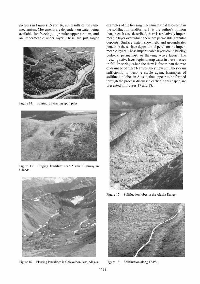
examples of the freezing mechanisms that also result inthe solifluction landforms. It is the author’s opinionthat, in each case described, there is a relatively imper-meable layer over which there are permeable granulardeposits. Surface water, snowmelt, and groundwaterpenetrate the surface deposits and perch on the imper-meable layers. These impermeable layers could be clay,bedrock, permafrost, or thawing active layers. Thefreezing active layer begins to trap water in these massesin fall. In spring, when the thaw is faster than the rateof drainage of these features, they flow until they drainsufficiently to become stable again. Examples ofsolifluction lobes in Alaska, that appear to be formedthrough the process discussed earlier in this paper, arepresented in Figures 17 and 18.
1139
Figure 14. Bulging, advancing spoil piles.
Figure 15. Bulging landslide near Alaska Highway inCanada.
Figure 16. Flowing landslides in Chickaloon Pass, Alaska.
Figure 17. Solifluction lobes in the Alaska Range.
Figure 18. Solifluction along TAPS.

5 CONCLUSIONS
Based on the data reported and the observations of theauthor, it is his opinion that the mechanism of the for-mation of solifluction lobes and some of the other well-documented permafrost and cold regions landforms onslopes is essentially the same as the process observedand monitored on the TAPS slopes with the flowingworkpads. Further, the process of heaving and theresulting mass density reduction is a key element in thedevelopment of flowing surficial materials that is char-acteristic of these cold regions landforms. The data thathave been collected over the past ten years imply thereis an explanation to these landforms that could be fur-ther verified with instrumentation methods similar tothose used to collect the data presented in this paper.
ACKNOWLEDGEMENTS
The author appreciates the support and assistance provided by Alyeska Pipeline Service Company in thepreparation of this paper and their allowing the publi-cation of data that have been developed as part ofAlyeska’s continuing maintenance and monitoring ofthis slope. The author gives special thanks to Mr. EldenJohnson of Alyeska Pipeline Service Company whowas instrumental in making the information presentedavailable.
REFERENCES
French, H.M. 1996. The Periglacial Environment, 2ndEdition. Essex: Longman Limited.
Van Everdingen, R.O. 1998. Multi-Language Glossary ofPermafrost and Related Ground-Ice Terms. Universityof Calgary: International Permafrost Association.
Harris, C. & Davies, M.C.R. 2000. Gelifluction: Observa-tions from Large Scale Laboratory Simulations, Arctic,Anarctic, and Alpine Research 32(2): 202–207.
Tart, R.G., Jr. 1983. Winter Constructed Gravel Islands.Proceedings of Fourth International Conference onPermafrost, Fairbanks, Alaska, USA.
Tart, R.G., Jr. 1996. Permafrost. Chapter 25. LandslidesInvestigation and Mitigation. Special Report 247.Washington, DC, USA: National Academy of Sciences.
Tart, R.G., Jr. & Anderson, S.L. 2002a. 2001 Slope StabilityMonitoring Summary Treasure Creek. Anchorage,Alaska, USA: Golder Associates Inc. report to AlyeskaPipeline Service Company.
Tart, R.G., Jr. & Anderson, S.L. 2002b. 2001 Slope StabilityMonitoring Summary Squirrel Creek. Anchorage,Alaska, USA: Golder Associates Inc. report to AlyeskaPipeline Service Company.
Tart, R.G., Jr. & Ferrell, J.E. 2002. Performance of theSquirrel Creek Slopes: Steep Slopes on DiscontinuousPermafrost. Proceedings of the 11th InternationalConference on Cold Regions Engineering, ASCE,Anchorage, Alaska, USA.
1140