he qingcheng ccop technical secretariat, bangkok, … · comparative research of groundwater...
TRANSCRIPT

Comparative research of groundwater management in the coastal areas in Southeast Asia
Land Subsidence Monitoring in ChinaLand Subsidence Monitoring in Chinagg
HE QingchengHE Qingcheng
CCOP Technical Secretariat, Bangkok, Thailand
E-mail: heqc@ccop or thE-mail: [email protected]
Coordinating Committee for Geoscience Programmes in East and Southeast Asia (CCOP)
OutlineOutlineOutlineOutline
Land subsidence in China
Land subsidence monitoring in ChinaLand subsidence monitoring in China
Case study
---Shanghai
---Tianjin---Tianjin
Coordinating Committee for Geoscience Programmes in East and Southeast Asia (CCOP)

Distribution of Land Subsidence in China
Tianjin
Fen-Wei Faulted basin
North China Plain
XI’ANShanghai
Yangtze River Delta
Three major subsidence regions in China
North China Plain Yangtze River Delta Fen-Wei Faulted Basin
Coordinating Committee for Geoscience Programmes in East and Southeast Asia (CCOP)
North China Plain, Yangtze River Delta, Fen Wei Faulted Basin
Tianjin, Shanghai and Xi’an
Distribution of Land Subsidence in ChinaThere are more than 50 subsidence cities mainly in the three regions y g
Coordinating Committee for Geoscience Programmes in East and Southeast Asia (CCOP)

As large as 79 000 squareAs large as 79,000 square kilometers of land has dropped more than 200
illi t d b t 50Coordinating Committee for Geoscience Programmes in East and Southeast Asia (CCOP)
millimeters and about 50 cities have wide-spread land subsidence.
Land subsidence in China
In the Yangtze River Delta
About 10,000 square kilometers of land has dropped more than 200 mm.
-2980-2800
The accumulative subsidence of Shanghai and Wuxi are 2980mm and 2800mm, respectively.
-1200Accumulative subsidence contour in the Yangtze Delta(until 2010)
Coordinating Committee for Geoscience Programmes in East and Southeast Asia (CCOP)

L d b id iL d b id i th Y tth Y t
Land subsidence in China
Land subsidence in Land subsidence in the Yangtze the Yangtze River DeltaRiver Delta----Shanghai RegionShanghai Region
Between 2002 and 2006, the
land subsidence in the whole
city was controlled to a certaincity was controlled to a certain
extent, and the average
sinking rate was 12.7mm/a.sinking rate was 12.7mm/a.
Between 2006 and 2010, the
cumulative subsidence
amount of most areas was
relatively small, between 0-
25mm. The area of
accumulative subsidence
0Coordinating Committee for Geoscience Programmes in East and Southeast Asia (CCOP)
greater than 50mm amounted
to 162km2 .Accumulative subsidence contour in Shanghai(2006-2010)
Land subsidence in China
Land subsidence in the YangtzeLand subsidence in the Yangtze
In Su-Xi-Chang region of
Jiangsu province:Land subsidence in the Yangtze Land subsidence in the Yangtze River Delta River Delta
----SuSu--XiXi--Chang RegionChang Region
g p
Land subsidence originally
appeared in 1955, and three
regional subsiding cones
formed in Suzhou, Wuxi and
Ch h iChangzhou city.
In recent ten years,
subsiding rate hassubsiding rate has
decreased greatly due to
prohibition and limitation ofp
groundwater withdrawal.
Now the area of subsiding
Coordinating Committee for Geoscience Programmes in East and Southeast Asia (CCOP)
rate greater than 10mm/a is
about 500km2 .
Expension tendency of subsiding aera in Su-Xi-Chang
Region in different period(1986,1991,2002)

Land subsidence in China
Land subsidence in the Land subsidence in the In Hang-Jia-Hu plain of Zhejiang
province:Yangtze River Delta Yangtze River Delta ----HangHang--JiaJia--Hu RegionHu Region
p
Land subsidence originated inabout 1964, In late 1970s-early1980 l d b id1980s, land subsidencedeveloped rapidly;
Since 2006, land subsidence Since 2006, land subsidencewas efficiently controlled byprohibiting and limiting
d t ithd l U tilgroundwater withdrawal. Until2010, the areas of subsiding rategreater than 10mm/a were aboutg195km2, decreasing 92% ascompared to 2005.
Coordinating Committee for Geoscience Programmes in East and Southeast Asia (CCOP)
Accumulative subsidence contour
in Hang-Jia-Hu plain(1964-2010)
Land subsidence in China
Ti ji
Sketch map of Land subsidence in the North China Plain
The Bohai SeaBeijing
Tianjin
The East China Sea
Cangzhou
The East China Sea
The maximum accumulative subsidence was 3300mm in Tanggu area of Tianjin.In 2009 the area of subsiding rate in Tianjin region greater than 10mm/a andIn 2009, the area of subsiding rate in Tianjin region greater than 10mm/a and 50mm/a was 6800 km2 and 1300 km2 ,respectively.
Coordinating Committee for Geoscience Programmes in East and Southeast Asia (CCOP)

Land subsidence in China
Factors for land subsidence
Geological conditions:g
thick soft sediments with high compressibility
Dynamic conditions: Dynamic conditions:
(1) groundwater overdraft;
(2) engineering construction(2) engineering construction
Rapid expansion and development of industrialization and urbanization are also most important factors for land subsidence.
Coordinating Committee for Geoscience Programmes in East and Southeast Asia (CCOP)
Land subsidence in China
A water tower in Tianjin was cracked due to land subsidence
Coordinating Committee for Geoscience Programmes in East and Southeast Asia (CCOP)

Land subsidence in China
Coordinating Committee for Geoscience Programmes in East and Southeast Asia (CCOP)
The walls of houses was cracked due to land subsidence.
Land subsidence in China
Coordinating Committee for Geoscience Programmes in East and Southeast Asia (CCOP)
The mouth of wells disjointed from ground

Land subsidence in China
The navigation capacity of bridges were greatly decreased.
Coordinating Committee for Geoscience Programmes in East and Southeast Asia (CCOP)
Land subsidence in China
Floods and storm tides occurred frequently in the coastal cities
Coordinating Committee for Geoscience Programmes in East and Southeast Asia (CCOP)
Floods and storm tides occurred frequently in the coastal cities(Tianjin,October 11, 2003)

Land subsidence in China
The tidal dike has been reinforced for several times in many coastal cities
Coordinating Committee for Geoscience Programmes in East and Southeast Asia (CCOP)
The tidal dike has been reinforced for several times in many coastal cities
Land subsidence in China
Estimate of total economic loss due to land :
Economic loss due to land subsidence
st ate o tota eco o c oss due to a d
Shanghai is ¥13 billion yuan (2001-2010), or ¥ 300billion yuan (1921-2010).y ( )
Su-Xi-Chang region is ¥17 billion yuan until 2000.
Hang-Jia-Hu region is ¥56 billion yuan (1964-2004).g g y ( )
Tianjin city is about ¥120 billion yuan until 2003.
the average total loss is ¥9-10 billion/ag
the annual direct loss is ¥0.8-1.0 billion yuan
The total economic loss consists of direct and indirectThe total economic loss consists of direct and indirectloss, and indirect loss accounts for 80-90% of the totaleconomic loss.
Coordinating Committee for Geoscience Programmes in East and Southeast Asia (CCOP)
Land subsidence monitoring in China
Since 1999, China Geological Survey (CGS) started the NationalProgram on Investigation and Monitoring of Land Subsidence.
Borehole extensometers and automatic monitoring system;
Global positioning systems(GPS);
InSAR(Interferometric Synthetic Aperture Radar);
Leveling measurements;gAutomatic monitoring system for groundwater levels.
Coordinating Committee for Geoscience Programmes in East and Southeast Asia (CCOP)
Land subsidence monitoring in China
Groundwater monitoring:Groundwater level:625 wells;Groundwater quality: 285wells;
Borehole ExtensometerGroundwater quality: 285wells;
Automatic monitoring points: 72 points.
Extensometer
Land subsidence monitoring:Benchmark on bedrock: 72 points;Borehole extensometer: 83 points;
GPS
Borehole extensometer: 83 points;Ground crack monitoring: 8 points.GPS roving stations: 554 points.GPS t t ki t tiGPS permanent tracking stations:
12 points.Automatic monitoring points: 72
Investigation and monitoring works i th Y t i d lt
points.
Coordinating Committee for Geoscience Programmes in East and Southeast Asia (CCOP)
in the Yangtze river delta

Land subsidence monitoring in China
InSAR (Interferometric Synthetic Aperture Radar):
2covering 67000 km2.
Investigation and monitoring
works in the works in the Yangtze river
delta delta
Coordinating Committee for Geoscience Programmes in East and Southeast Asia (CCOP)
Land subsidence monitoring in China
Shanghai deployed facilities like leveling nodes, borehole extensometers
and bedrock bench marks in different geological formation areas along
project lines, and had formed a land subsidence backbone network that is
independent but still tightly associated with the leveling network of the
t l itcentral city.
Engineering Land Subsidence Monitoring Network in Urban Areas of Shanghai city
Coordinating Committee for Geoscience Programmes in East and Southeast Asia (CCOP)
Areas of Shanghai city

Land subsidence monitoring in China
Groundwater monitoring:
G d t l l 436 ll
GPS
Groundwater level:436 wells;
Land subsidence monitoring:
Benchmark on bedrock: 2 points;Benchmark on bedrock: 2 points;Borehole extensometer: 17 points;GPS roving stations: 45 points;L li d 1742 i tLeveling nodes: 1742 points.
Investigation and monitoring works in Tianjin Region
Coordinating Committee for Geoscience Programmes in East and Southeast Asia (CCOP)
Land subsidence in ChinaLand subsidence in ChinaLand subsidence in ChinaLand subsidence in China
Coordinating Committee for Geoscience Programmes in East and Southeast Asia (CCOP)

Shanghai CityShanghai City
Coordinating Committee for Geoscience Programmes in East and Southeast Asia (CCOP)
Major cities & regions with land Major cities & regions with land subsidence in Eastern Chinasubsidence in Eastern China
Land subsidence induced by the exploitation of Land subsidence induced by the exploitation of ground waterground water
This picture shows the bund This picture shows the bund before 100 yeas. The embankment before 100 yeas. The embankment did not exist at that timedid not exist at that timedid not exist at that time. did not exist at that time.
This picture presents the currentThis picture presents the currentThis picture presents the current This picture presents the current bund, the embankment have been bund, the embankment have been rise several times since it was rise several times since it was builtbuilt
Coordinating Committee for Geoscience Programmes in East and Southeast Asia (CCOP)
built.built.

Coordinating Committee for Geoscience Programmes in East and Southeast Asia (CCOP)The monitor net of water table in Shanghai
The water table of the 4th confined The water table of the 4th confined aquifer in Shanghai in 2007aquifer in Shanghai in 2007
-10
-5
-35
-30
-25
-20
-15
水位标高(m)
-55
-50
-45
-40
35
地下水
宝山大场地区(宝001-01S) 浦东高桥地区(浦077-01)
金山枫泾地区(金247-01C) 青浦白鹤地区(青030-02W)
The change feature of water table of the
1961 1966 1971 1976 1981 1986 1991 1996 2001 2006
年
The change feature of water table of the 4th confined aquifer since 1961
Coordinating Committee for Geoscience Programmes in East and Southeast Asia (CCOP)

Na ionNa ion
Mineralization
Cl ionCl ion
Based on the longBased on the long--term monitor of term monitor of ground water, the chemical component ground water, the chemical component
f d t i Sh h if d t i Sh h i
Coordinating Committee for Geoscience Programmes in East and Southeast Asia (CCOP)
The monitor net of groundwater quality in Shanghai area
of ground water in Shanghai area was of ground water in Shanghai area was stable.stable.
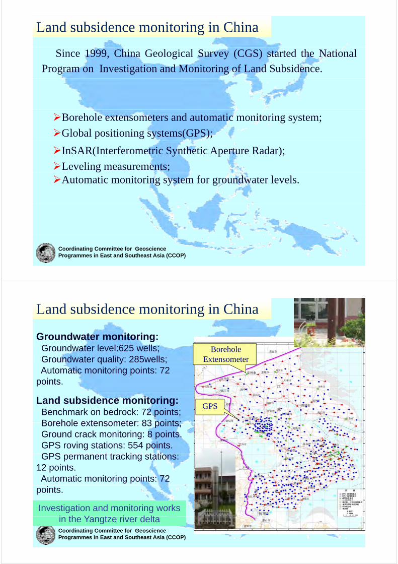
The monitor of land subsidenceThe monitor of land subsidence
Coordinating Committee for Geoscience Programmes in East and Southeast Asia (CCOP)
The monitor net of land subsidence

The monitor station for land subsidenceThe monitor station for land subsidence
Coordinating Committee for Geoscience Programmes in East and Southeast Asia (CCOP)
Coordinating Committee for Geoscience Programmes in East and Southeast Asia (CCOP)
The benchmark net used for monitoring land subsidence in the central city

Precise leveling g
Coordinating Committee for Geoscience Programmes in East and Southeast Asia (CCOP)
SITUATION OF SHANGHAI LAND SUBSIDENCESITUATION OF SHANGHAI LAND SUBSIDENCE
St t d i t f d t i i d Structure and variety of groundwater mining and artificial recharge
Huangpu River Yangtz River
There are total five confined aquifers. The 4th aquifer is the main exploitation layer.Before 1964, groundwater was excessly mined, which resulted in serious land subsidence.Groundwater mining have been restricted sinceGroundwater mining have been restricted since 1964, artificial recharge have been utilized.Now, through adjusting mining plan, the quantity of mining is gradually decreasing.
Coordinating Committee for Geoscience Programmes in East and Southeast Asia (CCOP)The changes of pumping groundwater and artificial
recharge

General situation of land subsidence
Through leveling survey, the landmark which lies to Shanghai Ningbo road has reflected the land subsidence at that time between 1910 and 1919From 1921 to 1948, land subsidence is more visible than before.Between 1949 and 1965, land subsidence is serious, especially between 1957 and 1961.From 1966 to now, land subsidence has been controlled through decreasing exploitation.
Coordinating Committee for Geoscience Programmes in East and Southeast Asia (CCOP)
Land subsidence Land subsidence isoline Land subsidence isoline
Land subsidence volume (mm)
isoline between 1980 and 1995 of the whole city
between 1995and 2001 of the whole city
Land subsidence isoline between 2001and 2006 of the whole city
Coordinating Committee for Geoscience Programmes in East and Southeast Asia (CCOP)
1980-1995 1995-2001 2001-2006

With the rate increasing, the diversity ofdiversity of Shanghai land subsidence is
i ibl ivisible in space.The data of subsidence separated from each other seriously, what y,indicated the difference for sedimentationsedimentation. That has impact on municipal infrastructure
Coordinating Committee for Geoscience Programmes in East and Southeast Asia (CCOP)
infrastructure.
ANAYLSIS OF INFLUENCED FACTORS OF ANAYLSIS OF INFLUENCED FACTORS OF SHANGHAI LAND SUBSIDENCESHANGHAI LAND SUBSIDENCESHANGHAI LAND SUBSIDENCESHANGHAI LAND SUBSIDENCE
larger-scale construction, subsidence accelerated
excess exploitation in the early period
exploitation was strictly controlled and land subsidence became stable
Before 1966, groundwater mining is primary factor of land subsidence, which resulted in serious land subsidence. From 1966 to 1990, government have adopted prevention and cure measures to control land subsidence the setting velocity has been kept within the minimum range
Coordinating Committee for Geoscience Programmes in East and Southeast Asia (CCOP)
subsidence ,the setting velocity has been kept within the minimum range. Since 1990, large-scale construction is another main factor, which accelerated land subsidence.

Groundwater mining is remain the primary factor of Shanghai land subsidence
Com deformationm
pre
ssion(m
m)
water level
time(Groundwater level(m)
Historically, excess groundwater miningHistorically, excess groundwater mining has resulted in groundwater level decreasing, and groundwater level descent funnel is formed which will induce seriousfunnel is formed, which will induce serious land subsidence.Cay layers is non-elastic , the compression of which has the character of
Coordinating Committee for Geoscience Programmes in East and Southeast Asia (CCOP)
compression of which has the character of hysteresis. So, when groundwater level ascends, land subsidence still continue.
LAND SUBSIDENCE MONITORINGLAND SUBSIDENCE MONITORING
Shanghai has established monitoring network of land subsidence, including land subsidence monitoring station, groundwater level monitoring well extensometer GPS andgroundwater level monitoring well, extensometer, GPS, and others. Generally, leveling is the primary method to master the state of Shanghai land subsidence also GPS and INSAR techniqueof Shanghai land subsidence, also GPS and INSAR technique are used every to monitor the land subsidence.
INSar
LandLand subsidence monitoring station
GPSleveling
Groundwater recharging
Groundwater level
extensometer
leveling
Coordinating Committee for Geoscience Programmes in East and Southeast Asia (CCOP)
g gwell
level monitoring well
Monitoring station f l dof land
subsidence
Coordinating Committee for Geoscience Programmes in East and Southeast Asia (CCOP)
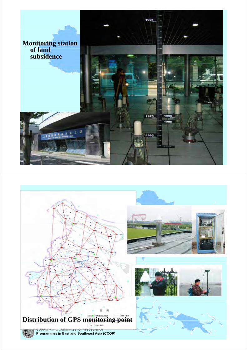
Distribution of GPS monitoring pointCoordinating Committee for Geoscience Programmes in East and Southeast Asia (CCOP)
Distribution of GPS monitoring point

Distribution of groundwaterCoordinating Committee for Geoscience Programmes in East and Southeast Asia (CCOP)
Distribution of groundwater level monitoring well
Control of land subsidence in ShanghaiControl of land subsidence in Shanghai
By control of exploitation, recharging of groundwater,
adjusting the level of groundwater exploitation, etc., j g g p , ,
land subsidence was controlled well.
Recharging well (shallow aquifer)Recharging well (deep aquifer)
Coordinating Committee for Geoscience Programmes in East and Southeast Asia (CCOP)
g g ( q )g g ( p q )

Land subsidence in Tianjin Land subsidence in Tianjin
Coordinating Committee for Geoscience Programmes in East and Southeast Asia (CCOP)
Tianjin is a coastal city and a major economic centre in the north of China It covers an area of 11000Km2 with about 10 million people.
Distribution of Land subsidence
Tianjin accumulativeland subsidencefrom 1967 to 2009from 1967 to 2009
Accumulative landAccumulative land subsidence in Tanggu district of Tianjin reached 3.3m.
Coordinating Committee for Geoscience Programmes in East and Southeast Asia (CCOP)

Distribution of Land Subsidence Distribution of Land Subsidence
The land subsidence has exceeded 8000 K 2 d th l
In recent years, with development of
lKm2 and the several cones of depressionoccurred
economy, several new centers of land subsidenceoccurred.
The maximum
subsidence appeared.
The maximum accumulative subsidence is over 3.3m at present.
And the rates of these
area were more than
40mm/a.
Coordinating Committee for Geoscience Programmes in East and Southeast Asia (CCOP)
Tianjin began to utilize groundwater resources in1923. According to historical leveling points, land subsidence happened, along with the development of
d t
Land subsidence history
10000Q(m 10 /a)4
groundwater.
8000Serious period 100Mm3/a
6000
110
100
S(mm/a)
G h i d
100Mm /a80-100mm/a
Controlled
4000
90
80
70
Growth period 12-100Mm3/a10-100mm/a
Controlled period 20Mm3/a10-20mm/a
400060
50
40
Initial period 12Mm3/a
2000 30
20
10
12Mm /a10-20mm/a
Coordinating Committee for Geoscience Programmes in East and Southeast Asia (CCOP)1920 1930 1940 1950 1960 1970 1980 1990 2000
0
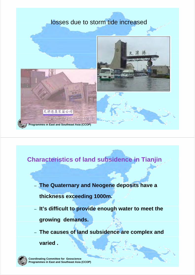
losses due to storm tide increasedlosses due to storm tide increased
Coordinating Committee for Geoscience Programmes in East and Southeast Asia (CCOP)
Characteristics of land subsidence in TianjinCharacteristics of land subsidence in Tianjin
– The Quaternary and Neogene deposits have a
thickness exceeding 1000m.
– It’s difficult to provide enough water to meet the
growing demands.growing demands.
– The causes of land subsidence are complex and
varied .
Coordinating Committee for Geoscience Programmes in East and Southeast Asia (CCOP)

Unconsolidated soil nature consolidation
Natural factors
Neotectonic movement
S l l i iSea level rising
Coordinating Committee for Geoscience Programmes in East and Southeast Asia (CCOP)the causes of land subsidence can be divided into two kinds
Petroleum productionArtificial factors
geothermal development
Gas production
groundwater over-exploitation
Coordinating Committee for Geoscience Programmes in East and Southeast Asia (CCOP)the causes of land subsidence can be divided into two types
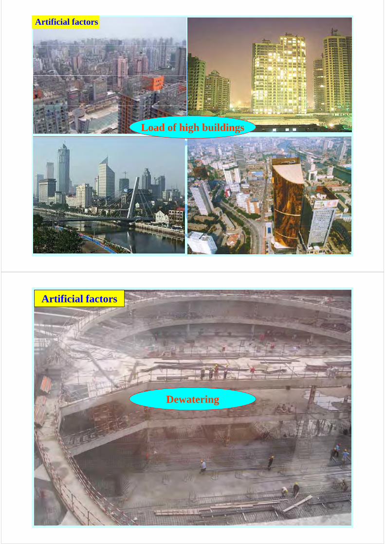
Artificial factors
Load of high buildings
Coordinating Committee for Geoscience Programmes in East and Southeast Asia (CCOP)
Artificial factors
Dewatering
Coordinating Committee for Geoscience Programmes in East and Southeast Asia (CCOP)

Thank ou forThank you for your
attention!!attention!!
Coordinating Committee for Geoscience Programmes in East and Southeast Asia (CCOP)