hazardous materials technical report - colorado … corridor revised environmental assessment...
TRANSCRIPT
Hazardous Materials Technical Report For the C-470 Corridor Revised Environmental Assessment July 2015 Submitted To: CDOT Region 1 2000 S. Holly Street Denver, CO 80222 Submitted By: Wilson & Company 1675 Broadway, Suite 200 Denver, CO 80202


C-470 Corridor Revised Environmental Assessment
Hazardous Materials Technical Report 1
Following this introductory page, the entire contents of the report were prepared by Summit Technology in 2013.
INTRODUCTION
This C-470 Revised Environmental Assessment (EA) Hazardous Materials Technical Report examines hazardous material conditions that may be encountered during construction of proposed improvements to Colorado State Highway C-470, between Kipling Parkway and Interstate 25, in the southwestern portion of the Denver metropolitan area. C-470 is located about 13 miles south of downtown Denver. It passes through Arapahoe, Douglas, and Jefferson counties, as shown in Figure 1. CDOT and FHWA prepared the Revised EA for the 13.75-mile portion of C-470 between Kipling Parkway and Interstate 25 (I-25) to address congestion and delay, and to improve travel time reliability for C-470 users. Figure 1. C-470 Corridor and Surrounding Vicinity
Completion of the C-470 Revised EA was delayed beyond original expectations, resulting in the passage of more than one year from the completion of the hazardous materials ESA. Therefore, per standard CDOT practice, an updated data base search was performed in 2015. CDOT provided the data to Wilson & Company, preparer of the EA. Wilson & Company reviewed the updated database, compared it to the 2013 ESA findings, and found no new hazardous material sites reported. Including six appendices that are listed in its table of contents, the 2013 ESA prepared by for Wilson & Company totaled 2,291 pages. The six appendices are part of the administrative record for this Revised EA, but are not included in this Hazardous Materials Technical Report. The 53 pages which follow this introductory page comprise the main portion of the Summit Technical Resources 2013 ESA for the C-470 Corridor.

C-470 Corridor Revised Environmental Assessment
Hazardous Materials Technical Report 2
This page intentionally blank.

Draft Phase I Environmental Site Assessment Environmental Re-Evaluation of C-470 South Kipling Parkway to Interstate 25
Jefferson and Douglas Counties, Colorado
Project Information WCI Job No. 11-100-31702
Prepared For: Wilson & Company, Inc.
5755 Mark Dabling Boulevard, Suite 220 Colorado Springs, Colorado 80919
Colorado Department of Transportation
Region 6 2000 South Holly
Denver, Colorado 80222
Prepared By: SUMMIT Technical Resources, Inc.
5460 Ward Road, Suite 205 Arvada, Colorado 80002
July 29, 2013
SUMMIT Technical Resources, Inc. Phase I Environmental Site Assessment
draft_phase_i_esa_c470_072913.docx EX-1
EXECUTIVE SUMMARY
Summit Technical Resources, Inc. (SUMMIT), conducted a Phase I Environmental Site Assessment (ESA) for the Colorado Department of Transportation (CDOT), Region 6, Environmental Re-Evaluation of C-470 project, from South Kipling Parkway to Interstate 25 (I-25), in Jefferson, Arapahoe, and Douglas Counties, Colorado (Site). The site visit was performed on June 10, 2013 by Mr. Andy Sagen and Ms. Darcy Schradeya (SUMMIT).
The purpose of the inspection was to visually obtain information indicating the likelihood of potential environmental conditions in connection with the Site. This report includes a summary of the records review and site visit, as well as copies of supporting documentation and the CDOT Form 881, Initial Site Inspection Checklist which was completed for this project.
A total of eleven sites were identified as a site of potential concern presenting recognized environmental conditions or historic recognized environmental conditions.
• JEFFCO Road and Bridge located at 9509 West Ute Avenue, Littleton, Colorado is a site of concern based on known contamination, and proximity to the Site.
• Bowen Farms located at 3220 West County Line Road, Littleton, Colorado is a site of concern based on known contamination, and proximity to the Site.
• Chevron located at 201 East County Line Road, Littleton, Colorado is a site of concern based on known contamination, and proximity to the Site.
• Jiffy Lube located at 1650 East County Line Road, Highlands Ranch, Colorado is a site of concern based on known contamination, and proximity to the Site.
• County Line Disposal located at 8422 South Colorado Boulevard, Littleton, Colorado, is a site of concern based on known groundwater contamination, and the proximity and upgradient location to the Site.
• Centennial Water and Sanitation located at 8606 Canongate Lane, Littleton, Colorado is a site of concern based on known contamination, and proximity to the Site.
• Dry Cleaning Station located at 6086 East County Line Road, Littleton, Colorado is a site of concern based on possible contamination, and proximity to the Site.
• AAMCO located at 6028 East County Line Road, Littleton, Colorado is a site of concern based on possible contamination, and proximity to the Site.
• Heritage Cleaners located at 7132 East County Line Road, Littleton, Colorado is a site of concern based on possible contamination, and proximity to the Site.
• K & G Stores located at 7130 East County Line Road, Littleton, Colorado is a site of concern based on known contamination, and proximity to the Site.
• 7-Eleven located at 8750 S Yosemite Street, Lone Tree, Colorado is a site of concern based on known contamination, and proximity to the Site.

SUMMIT Technical Resources, Inc. Phase I Environmental Site Assessment
draft_phase_i_esa_c470_072913.docx EX-2
Lead-based paint was not detected at the Quebec Street Bridge. A number of transformers (potential for polychlorinated biphenyl [PCB]-containing materials) were observed inside and within close proximity of the CDOT right-of-way (ROW). Appropriate demolition, handling, and disposal practices for these hazardous materials, as required by regulatory guidelines, should be followed during demolition activities associated with the C-470 project.

SUMMIT Technical Resources, Inc. Phase I Environmental Site Assessment
draft_phase_i_esa_c470_072913.docx i
Phase I Environmental Site Assessment
Table of Contents
Executive Summary ................................................................................................................................ EX-1 1.0 Introduction ................................................................................................................................... 1-1
1.1 Scope of Services, Methodology, and Limitations .............................................. 1-1 1.2 Exceptions, Deviations, and Data Gaps ............................................................... 1-3 1.3 Historic and Regulatory Resources Used ............................................................ 1-4 1.4 Definitions............................................................................................................ 1-6
2.0 General Site Information ............................................................................................................... 2-1 2.1 Project Description ............................................................................................... 2-1 2.2 Site Description .................................................................................................... 2-1
2.2.1 Geology .................................................................................................... 2-2 2.2.2 Hydrogeology .......................................................................................... 2-2
2.3 Regulatory Review Summary .............................................................................. 2-3 3.0 Findings ........................................................................................................................................ 3-1
3.1 Segment 1............................................................................................................. 3-1 3.1.1 Topographic Map Review ........................................................................ 3-2 3.1.2 Aerial Photo Review ................................................................................ 3-3 3.1.3 FEMA Flood Zones ................................................................................. 3-4 3.1.4 Transformers, Electrical Features, and Miscellaneous Items .................. 3-4 3.1.5 Lead-Based Paint ..................................................................................... 3-5
3.2 Segment 2............................................................................................................. 3-5 3.2.1 Topographic Map Review ........................................................................ 3-7 3.2.2 Aerial Photo Review ................................................................................ 3-8 3.2.3 FEMA Flood Zones ................................................................................. 3-8 3.2.4 Transformers, Electrical Features, and Miscellaneous Items .................. 3-9 3.2.5 Lead-Based Paint ..................................................................................... 3-9
3.3 Segment 3............................................................................................................. 3-9 3.3.1 Topographic Map Review ...................................................................... 3-10 3.3.2 Aerial Photo Review .............................................................................. 3-11 3.3.3 FEMA Flood Zones ............................................................................... 3-11 3.3.4 Transformers, Electrical Features, and Miscellaneous Items ................ 3-12 3.3.5 Lead-Based Paint ................................................................................... 3-12
3.4 Segment 4........................................................................................................... 3-12 3.4.1 Topographic Map Review ...................................................................... 3-17 3.4.2 Aerial Photo Review .............................................................................. 3-18 3.4.3 FEMA Flood Zones ............................................................................... 3-19 3.4.4 Transformers, Electrical Features, and Miscellaneous Items ................ 3-19 3.4.5 Lead-Based Paint ................................................................................... 3-19
3.5 Segment 5........................................................................................................... 3-19 3.5.1 Topographic Map Review ...................................................................... 3-21 3.5.2 Aerial Photo Review .............................................................................. 3-22 3.5.3 FEMA Flood Zones ............................................................................... 3-23 3.5.4 Transformers, Electrical Features, and Miscellaneous Items ................ 3-23 3.5.5 Lead-Based Paint ................................................................................... 3-23

SUMMIT Technical Resources, Inc. Phase I Environmental Site Assessment
draft_phase_i_esa_c470_072913.docx ii
4.0 Opinions and Conclusions ............................................................................................................ 4-1 4.1 Segment 1............................................................................................................. 4-1 4.2 Segment 2............................................................................................................. 4-1 4.3 Segment 3............................................................................................................. 4-1 4.4 Segment 4............................................................................................................. 4-2 4.5 Segment 5............................................................................................................. 4-4 4.6 Other Items for Consideration ............................................................................. 4-4
5.0 Certification and Qualifications .................................................................................................... 5-1 5.1 Certification ......................................................................................................... 5-1 5.2 Qualifications ....................................................................................................... 5-1
6.0 References ..................................................................................................................................... 6-1
Figures
Figure 1 Site Location Map Figure 2 Segment 1 Figure 3 Segment 2 Figure 4 Segment 3 Figure 5 Segment 4 Figure 6 Segment 5
Appendices
Appendix A Environmental Data Resources, Inc. DataMap™ Well Search Report (on CD only)
Appendix B Environmental Data Resources, Inc. DataMap™ Area Study (on CD only) Appendix C Historical Topographic Maps (on CD only) Appendix D Goodbee & Associates LLC, Hazardous Material Technical Report, 2005 (on CD
only) Appendix E Site Photographs Appendix F Colorado Department of Transportation Form 881 Initial Site Assessment
Checklist

SUMMIT Technical Resources, Inc. Phase I Environmental Site Assessment
draft_phase_i_esa_c470_072913.docx iii
Acronyms
AAI All Appropriate Inquiry AIRS Aerometric Information Retrieval System AST aboveground storage tank ASTM American Society for Testing and Materials bgs below ground surface CAP Corrective Action Plan CDLE Colorado Department of Labor and Employment CDOT Colorado Department of Transportation CERC-NFRAP Comprehensive Environmental Response Compensation and Liability
Information System-No Further Remedial Action Planned CFR Code of Federal Regulations CORRACTS RCRA Corrective Action Sites COSMIX Colorado Springs Metro Interstate Expansion COSTIS Colorado Storage Tank Information System DOD Department of Defense EA Environmental Assessment EDR Environmental Data Resources, Inc. ERNS Emergency Response Notification System ESA Phase I Environmental Site Assessment FEMA Federal Emergency Management Agency FINDS Facility Index System ISA Checklist CDOT Form 881, Initial Site Inspection Checklist Kumar Kumar and Associates LBP lead-based paint LPG liquid petroleum gas LUST leaking underground storage tank MESA Modified Environmental Site Assessment NEPA National Environmental Policy Act NFA No Further Action OPS Oil and Public Safety OSHA Occupational Safety and Health Administration PADS PCB Activity Database PCB polychlorinated biphenyl RBSL risk-based screening level RCRA Resource Conservation and Recovery Act RCRA-NonGen RCRA-Non Generators RCRA-SQG RCRA-Small Quantity Generator RCRS-CESQG RCRA-Conditionally Exempt Small Quantity Generator ROW right-of-way SCR Site Characterization Report SSF Site Summary Form SUMMIT Summit Technical Resources, Inc. TCLP Toxicity Characteristic Leaching Procedure UMCR Upper Monument Creek USAF Academy U.S. Air Force Academy USEPA U.S. Environmental Protection Agency USGS United States Geological Survey UST underground storage tank WWTF wastewater treatment facility
SUMMIT Technical Resources, Inc. Phase I Environmental Site Assessment
draft_phase_i_esa_c470_072913.docx 1-1
1.0 Introduction
Summit Technical Resources, Inc. (SUMMIT), conducted a Phase I Environmental Site Assessment (ESA) for the Colorado Department of Transportation (CDOT), Region 6 Environmental Re-Evaluation of C-470, from South Kipling Parkway to I-25 (Site), in Jefferson, Arapahoe, and Douglas Counties, Colorado.
The site visit was performed on June 10, 2013 by Mr. Andy Sagen and Ms. Darcy Schradeya (SUMMIT). The purpose of the inspection was to visually obtain information indicating the likelihood of potential environmental conditions in connection with the Site. The Site was traversed by foot at major intersections, and visually observed from the roadway between intersections. The weather during the site visit was sunny and dry, with an average temperature approximately 85 degrees Fahrenheit and winds up to 20 miles per hour. Traffic along C-470 was constant, with heavier traffic at the intersections.
For discussion purposes in this report, the Site is broken into five segments, moving west to east along C-470:
Segment 1 – The intersection of C-470 and South Kipling Parkway to just west of South Santa Fe Drive.
Segment 2 – The intersection of C-470 and South Santa Fe Drive to just west of South Broadway.
Segment 3 – The intersection of C-470 and South Broadway to just west of South University Boulevard.
Segment 4 – The intersection of C-470 and South University Boulevard to just west of South Quebec Street.
Segment 5 – The intersection of C-470 and South Colorado Boulevard to the intersection of C-470 and I-25.
This report includes the following figures and appendices for reference. Figure 1 presents the location of the Site, Figures 2 through 6 show each of the Segments along with selected sites identified in the regulatory database report completed by Environmental Data Resources (EDR). Appendix A includes the EDR DataMap ™ Well Search Report. Appendix B includes the EDR DataMap ™ Area Study. Topographic maps are included in Appendix C. A Hazardous Material Technical Report (HMTR) completed by Goodbee & Associates LLC in 2005 (Goodbee 2005) for the Site. is included in Appendix D. Site photographs are included in Appendix E. Appendix F includes a completed CDOT Form 881, Initial Site Assessment Checklist (ISA Checklist).
1.1 Scope of Services, Methodology, and Limitations
This ESA was performed in general accordance with American Society for Testing and Materials (ASTM) E1527-05, Standard Practice for Environmental Site Assessments: Phase I Environmental Site Assessment Process and the U.S. Environmental Protection Agency All Appropriate Inquiries (AAI) Final Rule at 40 Code of Federal Regulations [CFR] Part 312. The

SUMMIT Technical Resources, Inc. Phase I Environmental Site Assessment
draft_phase_i_esa_c470_072913.docx 1-2
ESA is also a requirement of the National Environmental Policy Act (NEPA) for federally funded projects. Deviations from the ASTM standard are discussed in Section 1.2 below. In accordance with the Scope of Services and SUMMIT’s understanding of CDOT’s requirements for this project, the objectives of this ESA were to:
• Perform historical and regulatory records review for the Site;
• Conduct a visual inspection of the Site;
• Provide completed CDOT Form 881 for the Site;
• Review the HMTR and identify any Site conditions which have changed since the completion of the 2005 report.
This ESA report has been prepared for the exclusive use of CDOT for the sole purpose of assisting in the evaluation of current and/or historical environmental conditions associated with the Site. The purpose of this ESA is to identify, to the extent feasible, recognized environmental conditions and historical recognized environmental conditions in connection with the Site.
The findings of this ESA, as represented within this report, must be viewed in recognition of certain limiting conditions. The scope of work commissioned for this project represents a reasonable inquiry, consistent with good commercial practice, in accordance with ASTM Standard E 1527-05 and the USEPA AAI Final Rule (40 CFR 312). The intent of this report is not as an exhaustive investigation, nor does it include an evaluation of issues that are not addressed in the ASTM Standard. This assessment is intended to reduce, but not eliminate, the level of uncertainty regarding the potential for current and/or historical environmental conditions associated with the Site.
The findings presented herein are based upon observations of Site conditions as of the date the assessment was performed and the findings and conclusions presented herein should not be assumed to apply to conditions or operating practices on this property occurring subsequent to actual on-site investigation. During the course of this assessment, the consultant has relied on information provided by outside sources, including but not limited to Site owner(s) and/or operator(s), appropriate local government officials, regulatory agencies and reasonably ascertainable standard records sources. For the purposes of this assessment, such third-party information is assumed to be accurate unless otherwise noted, and the consultant cannot verify, nor does the consultant guarantee the information obtained from third-party sources. Additionally, it should be noted that the accessibility of data may be limited, particularly in regard to historical Site uses. Any such limitations that are essential to the conclusions of the Site assessment have been identified in the Phase I ESA report.
There are additional considerations CDOT may wish to address in connection with a Phase I ESA. These services are outside the scope of work considered for a Phase I ESA as defined in the ASTM Standard E 1527-05. Examples of additional, but not all inclusive, considerations are listed
below:
• Archeological, Historical, or other Cultural Resources

SUMMIT Technical Resources, Inc. Phase I Environmental Site Assessment
draft_phase_i_esa_c470_072913.docx 1-3
• Asbestos-Containing Materials
• Lead in Drinking Water
• Wetlands
• Ecological Resources
• Regulatory Compliance
• Industrial Hygiene
• Indoor Air Quality
• Occupational Safety and Health Hazards
• Radon
• Threatened or Endangered Plants and Animals
• Biological Agents
• Mold
The opinions submitted in this report are based upon the site observations, data obtained from records and historical sources, and the anticipated use of the Site. The opinions provided herein may change if the CDOT project scope or project Site changes, or if the CDOT project scope requires direct exposure to documented contamination. Nature and extent of soil or groundwater contamination was not evaluated as part of this ESA. 1.2 Exceptions, Deviations, and Data Gaps
A city directory review, environmental lien search, property tax files review, land title records review, building department records review, and interviews of current and historic property owners were not conducted/completed for the Site as these resources are not considered reasonably ascertainable due to the size of the Site (an approximate 14-mile long corridor). Only the visible land surface, features, and property conditions were observed during the site visit. Not all properties were immediately accessible and were therefore observed from a distance. Due to constant traffic conditions which presented a safety issue, SUMMIT personnel did not traverse the CDOT right-of-way (ROW) between major intersections. A visual inspection was conducted from the vehicle during numerous passes, and major observations were noted. Inspections of building interiors were not conducted as part of the scope of services. Historical resources were not readily available in 5 year increments, however the dates available were sufficient to assist with identification of historic Site uses, and the general uses of the adjacent properties. A limited records review was conducted for sites of concern identified by the regulatory database search. Only available digital (on-line) records were reviewed in order to provide an overall summary of environmental conditions/actions which have occurred at any sites of concern. As part of a CDOT MESA, lead-based paint (LBP) samples are required to be collected from any surfaces with suspect LBP expected to be affected by construction activities (e.g. modification or demolition). One LBP sample was collected from the bridge for Quebec Street. This was the
SUMMIT Technical Resources, Inc. Phase I Environmental Site Assessment
draft_phase_i_esa_c470_072913.docx 1-4
only location where paint was observed and attainable during the site visit. Paint was also observed on the Furniture Row railing located adjacent to CDOT ROW. The Furniture Row railing was not sampled for lead as it is located on private property. Refer to Section 3 for a summary of the LBP results A review of available Sanborn Fire Insurance Maps found that maps were available for Denver, Golden, Littleton, and Castle Rock. Denver, Golden, and Castle Rock are not include in any part of the study area. The maps available Littleton did not include the study area. Therefore, no Sanborn Fire Insurance Maps were available for the Site. 1.3 Historic and Regulatory Resources Used
This section provides a summary of the resources reviewed for this project.
• United States Geological Survey (USGS) Store Map Locator and Downloader: http://store.usgs.gov/b2c_usgs/usgs/maplocator/(ctype=areaDetails&xcm=r3standardpitrex_prd&carea=%24ROOT&layout=6_1_61_48&uiarea=2)/.do. The following available digital maps were downloaded on June 3, 2013: Littleton, Colorado, 7.5-Minute Quadrangle – 1942, 1950, 1957, 1965,
(photorevised 1971, 1980) and 2011. Highlands Ranch, 7.5-Minute Quadrangle – 1942, 1949, 1957, 1965,
(photorevised 1971, 1980, and 1994), and 2011. Parker, Colorado, 7.5-Minute Quadrangle – 1942, 1949, 1957, 1965,
(photorevised 1971, 1980, and 1994) and 2011. Denver East, Colorado, 30-Minute Quadrangle – 1890, 1981. Denver West, Colorado, 30-Minute Quadrangle – 1899, 1983.
• USGS National Geologic Map Database http://ngmdb.usgs.gov/ngmdb/ngmdb_home.html. The following geologic maps were reviewed on January 26, 2012: Geology of the Littleton Quadrangle, Jefferson, Douglas, and Arapahoe Counties,
Colorado: U.S. Geological Survey Bulletin 1121-L, Scott, G.R., 1962., 1:24,000, http://ngmdb.usgs.gov/Prodesc/proddesc_20820.htm. Image Creation Date: MAY. 11, 2011.
Geologic Map of the Highlands Ranch Quadrangle, Arapahoe and Douglas Counties, Colorado: U.S. Geological Survey Geologic Quadrangle Map GQ-1413, Maberry, J.O., and Lindvall, R.M., 1977., 1:24,000, http://ngmdb.usgs.gov/Prodesc/proddesc_10947.htm. Image Creation Date: MAY. 11, 2011.
Geologic map of the Parker quadrangle, Arapahoe and Douglas Counties, Colorado: U.S. Geological Survey Miscellaneous Geologic Investigations Map I-770-A, Maberry, J.O., and Lindvall, R.M., 1972., 1:24,000,

SUMMIT Technical Resources, Inc. Phase I Environmental Site Assessment
draft_phase_i_esa_c470_072913.docx 1-5
http://ngmdb.usgs.gov/Prodesc/proddesc_9555.htm. Image Creation Date: MAY. 11, 2011."
• Federal Emergency Management Agency (FEMA) Issued Flood Maps for Jefferson, Arapahoe, and Douglas Counties, Colorado: https://msc.fema.gov/webapp/wcs/stores/servlet/CategoryDisplay?catalogId=10001&storeId=10001&categoryId=12001&langId=-1&userType=G&type=1&future=false. The following FEMA map panels were reviewed on July 22, 2013:
0859C0405E, 08059C0410E, 08005C0433K, 08005C0434K, 08035C0009F, 08035C0009F, 08035C0028F, 08005C045K, 08005C0458K, 08035C0033F, 08035C0034F, 08059C0415E, , 08035C0016F, 08035C0017F, 08035C0036F, 08035C0037F, 08035C0041F, 08035C0042F, 08035C0061F
• FEMA Flood Map Viewer: https://msc.fema.gov/webapp/wcs/stores/servlet/FemaWelcomeView?storeId=10001&catalogId=10001&langId=-1
• FEMA Flood Zone definitions: https://msc.fema.gov/webapp/wcs/stores/servlet/info?storeId=10001&catalogId=10001&langId=-1&content=floodZones&title=FEMA%2520Flood%2520Zone%2520Designations
• University of Colorado at Boulder, Sanborn Fire Insurance Map Collection, Jefferson, Arapahoe, and Douglas Counties, Colorado: http://libcudl.colorado.edu/sanborn/central.asp
• Google Earth Aerial Photographs, 1937, 1955, 1993, 1999, 2002, 2007, and 2012.
• USGS Ground Water Atlas of the United States, Arizona, Colorado, New Mexico, Utah, HA 730-C, 1995
• EDR DataMap ™ Area Study, June 4, 2013.
• EDR DataMap ™ Well Search Report, June 4, 2013.
• Colorado Department of Labor and Employment (CDLE), Oil Inspection Section, Oil and Public Safety (OPS), Colorado Storage Tank Information System (COSTIS) records: http://costis.cdle.state.co.us/ois2000/home.asp.
• U.S. Environmental Protection Agency (USEPA), Envirofacts: http://www.epa.gov/enviro/facts/cerclis/search.html.
For both the EDR Area Study and the Well Search Report, a 1000-foot buffer was selected from the centerline of C-470 (and associated interchanges). The search radius was expanded to 1 mile outside this buffer for all regulatory databases, which meets or exceeds the minimum ASTM search distances for the standard environmental record sources.

SUMMIT Technical Resources, Inc. Phase I Environmental Site Assessment
draft_phase_i_esa_c470_072913.docx 1-6
1.4 Definitions
Recognized environmental conditions, as defined in ASTM E1527-05, are conditions that indicate “the presence or likely presence of any hazardous substances or petroleum products on a property under conditions that indicate an existing release, a past release, or a material threat of a release of any hazardous substances or petroleum products into structures on the property or into the ground, groundwater, or surface water of the property.” Historic recognized environmental conditions are defined by ASTM as “an environmental condition which in the past would have been considered a recognized environmental condition, but which may or may not be considered a recognized environmental condition currently. ... If a past release of any hazardous substances or petroleum products has occurred in connection with the property and has been remediated, with such remediation accepted by the responsible regulatory agency (for example, as evidenced by the issuance of a no further action letter or equivalent), this condition shall be considered an historical recognized environmental condition ... If this historical recognized environmental condition is determined to be a recognized environmental condition at the time the Phase I Environmental Site Assessment is conducted, the condition shall be identified as such ...” Conditions determined to be de minimis are not recognized environmental conditions. FEMA flood zones identified as part of this ESA, and associated definitions are as follows:
Zone A: “Areas subject to inundation by the 1-percent-annual-chance flood event generally determined using approximate methodologies. Because detailed hydraulic analyses have not been performed, no Base Flood Elevations or flood depths are shown. Mandatory flood insurance purchase requirements and floodplain management standards apply.”
Zone AE: “Areas subject to inundation by the 1-percent-annual-chance flood event determined by detailed methods. Base Flood Elevations are shown. Mandatory flood insurance purchase requirements and floodplain management standards apply.”
Zone AH: “Areas subject to inundation by 1-percent-annual-chance shallow flooding (usually areas of ponding) where average depths are between one and three feet. Base Flood Elevations derived from detailed hydraulic analyses are shown in this zone. Mandatory flood insurance purchase requirements and floodplain management standards apply.”

SUMMIT Technical Resources, Inc. Phase I Environmental Site Assessment
draft_phase_i_esa_c470_072913.docx 2-1
2.0 General Site Information
The following section summarizes the project description, and the overall Site description based on site visit observations and records review including geologic maps, topographic maps, and groundwater resources. This section also includes a summary of the regulatory records search. Detailed findings for each Segment of the Site are included in Section 3.
2.1 Project Description
In February 2006, a CDOT C-470 Environmental Assessment (EA) recommended implementation of tolled express lanes along 14 miles of C-470 between South Kipling Parkway and I-25. The majority of this segment was planned for implementation of the tolled express lanes with a barrier-separated typical section and a typical width of 162 feet. Access to the tolled express lanes was planned with slip ramps into and out of the lanes at strategic locations, along with direct connection ramps at Colorado Boulevard, Quebec Street, and I-25. Since 2006, no subsequent environmental decision document was completed for this project, and project implementation has not begun. Interchange improvements at C-470/ Santa Fe Drive (e.g., southbound to eastbound flyover ramp) received separate environmental clearance and have been constructed.
The C-470 Corridor Coalition, which was formed in February 2011, is a cooperative effort involving local governments and CDOT. The Coalition’s purpose is to recommend and implement a plan to pay for improvements to C-470.
In February 2013, the Coalition Policy Committee unanimously approved a new option to implement tolled express lanes, but with a revised typical section and revised access concept. The proposed typical section replaces the original barrier separation with a painted (buffer) separation, and increases shoulder widths. The proposed improvements also include the addition of multiple auxiliary lanes at strategic locations along C-470 where on-ramp to off-ramp spacing is close, and where the auxiliary lane will provide an operational improvement to C-470. Thus, some portions of the corridor will have auxiliary lanes, and other portions will not. The new proposed sections are with typical widths of 154 feet and 174 feet. Access to the tolled express lanes is planned with ingress and egress slip ramps and weaving zones, strategically placed along the corridor.
2.2 Site Description
The Site includes an approximate 14-mile long corridor of CDOT ROW along C-470 between South Kipling Parkway and I-25. The ROW varies in width throughout the corridor, depending on the location. The Site includes the undeveloped ROW on either side of C-470 and associated interchanges along with the roadways which are concrete or asphalt paved. The undeveloped land was generally covered with native grasses, bushes, weeds, and trees. No evidence of dumping or stressed vegetation was observed. Numerous utilities were located inside the ROW, including buried fiber optic cable lines, gas lines, and electric lines which were located throughout the entire Site in the ROW on the both sides of C-470, and a number of transformers (refer to Section 3).
SUMMIT Technical Resources, Inc. Phase I Environmental Site Assessment
draft_phase_i_esa_c470_072913.docx 2-2
2.2.1 Geology
The C-470 corridor is found in the Colorado Piedmont section of the Great Plains physiographic province (USGS 1995). The Colorado Piedmont is located at the base of the foothills of the Front Range in north central Colorado and is situated along the western flank of the Denver Basin. The geologic setting along the C-470 corridor includes bedrock and variable thicknesses of surficial deposits that overlie the bedrock. The bedrock is moderately hard while the surficial deposits are unconsolidated. Sedimentary rock layers dip steeply east from the flank of the Front Range eastward into the Denver Basin, then rise much more gradually up the eastern flank of the basin in eastern Colorado. The bedrock within the corridor is all of sedimentary origin.
Four major bedrock units are present in the corridor area and consist of:
1. Undifferentiated Denver and Arapahoe Formations which are primarily interbedded sandstone.
2. Laramie Formation, which consists of shale, siltstone, and sandstone. 3. Fox Hills Sandstone, 4. Pierre Shale.
Surficial material that overlay the bedrock formations are composed of alluvium, colluvium, and loess. These deposits vary considerably in depth and are composed predominantly of cobbles, gravel, sand, silt, and clay deposits.
2.2.2 Hydrogeology
Ground-water associated with the C-470 corridor is located within the Denver basin. The Denver Basin extends from the Front Range foothills east to near Limon, and from Greeley south to near Colorado Springs. The Denver Basin includes four main bedrock aquifers. All four Denver Basin aquifers are located in the C-470 corridor, and include the Dawson, Denver, Arapahoe, and Laramie-Fox Hills Aquifers.
The Denver aquifer system is the major aquifer system underlying the corridor (USGS 1995). The Denver aquifer system is a consolidated-rock aquifer system with shale, silty claystone, and interbedded sandstone. Beds of lignite and carbonaceous siltstone and shale are common. Sandstone is generally andesitic, lenticular, and moderately consolidated. The Denver aqufer is confined in the central part. Contains a water table only near outcrops, is moderately permeable and may yield as much as 200 gallons per minute.
The aquifers are generally confined, except in areas where water-table conditions exist in the upper parts of the aquifers. Shallow unconfined aquifers contained in the alluvium are most likely to be impacted by hazardous material sites identified along the C-470 corridor. Groundwater flow in these aquifers is largely controlled by surface topography and is generally towards streams and rivers. Groundwater flows from higher to lower water table elevation. Areas of shallow, unconfined groundwater are present along the corridor.
The EDR DataMap ™ Well Search Report (EDR2013a) which is included in Appendix A, identified numerous groundwater wells within the 1000-foot buffer and within the 1-mile radius

SUMMIT Technical Resources, Inc. Phase I Environmental Site Assessment
draft_phase_i_esa_c470_072913.docx 2-3
of the buffer. Wells registered to the USGS provided groundwater elevation data for the various aquifers underlying the Site. Shallow groundwater within the Arapahoe Conglomerate Member of the Laramie Formation occurred at approximately 200 to 270 feet below ground surface (bgs). Other wells which appear to be screened within the shallow groundwater aquifer had a groundwater depths ranging from 9 to 25 feet bgs. Wells screened within the Dawson Aquifer had groundwater depths ranging from as shallow as 31 feet bgs, to 125 feet bgs. Privately owned wells did not provide any depth to groundwater measurements. Private well usage was noted as domestic, household use only, or municipal.
2.3 Regulatory Review Summary
As stated in Section 1.3, a 1000-foot buffer was selected from the centerline of C-470 (and associated interchanges). The search radius was expanded to 1 mile outside this buffer for all regulatory databases. The following table summarizes the number of sites identified in the associated federal, state, and local records found in the EDR DataMap ™ Area Study (EDR 2013b), which is included in Appendix B. The sites are broken into two categories: sites located within the 1000-foot buffer, and sites outside the 1000-foot buffer. Section 3 includes detailed discussions for sites located with the 1000-foot buffer. Sites located outside the 1000-foot buffer were determined to be at a sufficient enough distance from the project Site as to not pose a concern and are not discussed in this report.
Record and Brief Description
Number of Sites Within
the 1000-foot Buffer
Number of Sites Outside the 1000-foot
Buffer FEDERAL RECORDS
CERC-NFRAP: Comprehensive Environmental Response Compensation and Liability Information System-No Further Remedial Action Planned contains archived sites that have been removed from the inventory of CERCLIS sites and EPA has determined that no further action is required.
0 2
CORRACTS: Resource Conservation and Recovery Act (RCRA) Corrective Action Sites provides a list of handlers with RCRA Corrective Action Activity.
1 7
DOT OPS: Department of Transportation, Office of Pipeline Safety Incident and Accident data.
0 3
ERNS: Emergency Response Notification System provides information on reported releases of oil and hazardous substances. 4 13
FINDS: Facility Index System provides “pointers” to other sources of information that contain more detail. 46 212
FTTS: FTTS tracks administrative cases and pesticide enforcement actions and compliance activities related to FIFRA, TSCA and EPCRA (Emergency Planning and Community Right-to-Know Act) over the previous five years.
3 5
HIST FTTS: A complete administrative case listing from the FIFRA/TSCA Tracking System (FTTS) for all ten EPA regions. The information was obtained from the National Compliance Database (NCDB).
3 5

SUMMIT Technical Resources, Inc. Phase I Environmental Site Assessment
draft_phase_i_esa_c470_072913.docx 2-4
Record and Brief Description
Number of Sites Within
the 1000-foot Buffer
Number of Sites Outside the 1000-foot
Buffer ICIS: The Integrated Compliance Information System (ICIS) supports the information needs of the national enforcement and compliance program as well as the unique needs of the National Pollutant Discharge Elimination System (NPDES) program.
1 4
MLTS: The Material Licensing Tracking System is maintained by the Nuclear Regulatory Commission and contains a list for approximately 8,100 sites which possess or use radioactive materials and are subject to NRC licensing requirements.
0 3
RCRS-CESQG: RCRA-Conditionally Exempt Small Quantity Generator, generates less than 100 kg of hazardous waste, or less than 1 kg of acutely hazardous waste per month.
10 39
RCRA-LQG: Resource Conservation and Recovery Act (RCRA) large quantity generators (LQGs) generate over 1,000 kilograms (kg) of hazardous waste, or over 1 kg of acutely hazardous waste per month.
0 1
RCRA-NonGen: RCRA-Non Generators do not presently generate hazardous waste.
15 54
RCRA-SQG: RCRA-Small Quantity Generator, generates between 100 kg and 1000 kg of hazardous waste per month.
6 8
RMP: The Risk Management Program Rule (RMP Rule) was written when Congress passed the Clean Air Act Amendments of 1990, requiring EPA to publish regulations and guidance for chemical accident prevention at facilities using extremely hazardous substances.
0 1
SSTS: Section Seven Tracking System (SSTS) of the Federal Insecticide, Fungicide and Rodenticide Act, as amended (92 Stat. 829) requires all registered pesticide-producing establishments to submit a report to the Environmental Protection Agency by March 1st each year.
1 0
TRIS: The Toxic Chemical Release Inventory System identifies facilities that release toxic chemicals to the air, water, and land in reportable quantities under SARA Title III, Section 313. The source of this database is the U.S. EPA.
0 4
TSCA: The Toxic Substances Control Act identifies manufacturers and importers of chemical substances included on the TSCA Chemical Substance Inventory list.
1 0
US AIRS: The database is a sub-system of Aerometric Information Retrieval System (AIRS). AFS contains compliance data on air pollution point sources regulated by the U.S. EPA and/or state and local air regulatory agencies.
16 66
US HIST CDL: A listing of clandestine drug lab locations. 0 1 US MINES: Mines Master Index File 2 1 US HIST CDL: A listing of clandestine drug lab locations. 0 1

SUMMIT Technical Resources, Inc. Phase I Environmental Site Assessment
draft_phase_i_esa_c470_072913.docx 2-5
Record and Brief Description
Number of Sites Within
the 1000-foot Buffer
Number of Sites Outside the 1000-foot
Buffer STATE AND LOCAL RECORDS
CA HAZNET: Lists and tracks hazardous waste from the generator, through the transporter, to a TSD facility. 0 1
CO AIRS: Aerometric Information Retrieval System listing of Colorado Air Pollution Control Division permits and emissions data. 13 51
CO ASBESTOS: Asbestos abatement and demolition projects. 2 30 CO AST: Registered aboveground storage tanks. 14 39 CO CDL: Meth lab locations that were reported to the Department of Health and Environment. 2 5
CO DRYCLEANERS: A list of drycleaner facilities. 4 12 CO ERNS: State reported spills. 15 61 CO LAST: A listing of leaking aboveground storage tank sites. 0 2 CO LUST: Colorado Leaking Underground Storage Tank provides an inventory of LUST sites. 12 24
CO LUST TRUST: LUST reimbursement application. 3 10 CO MINES: This dataset represents permitted mines in the State of Colorado 8 7
CO NPDES: National Pollutant Discharge Elimination System listing of permitted facilities from the Colorado Water Quality Control Division.
5 22
CO SWF/LF: The Solid Waste Facilities/Landfill Sites records typically contain an inventory of solid waste disposal facilities or landfills in a particular state.
0 1
CO UST: Registered underground storage tanks. 22 62 NY MANIFEST: Lists and tracks hazardous waste from the generator, through the transporter, to a treatment, storage, and disposal (TSD) facility.
1 1
OK COMPLAINT: Environmental complaints report to the Oklahoma corporation commission. 0 2
PROPRIETARY RECORDSEDR US HIST AUTO STAT: Listings of potential gas station/filling station/service station sites that were available to EDR researchers that fall within a category of information EDR classifies as "High Risk Historical Records", or HRHR.
36 115
EDR US HIST CLEANERS: Listings of potential dry cleaner sites that were available to EDR researchers that fall within a category of information EDR classifies as "High Risk Historical Records", or HRHR.
6 48
All other regulatory databases searched did not return any identified sites.

SUMMIT Technical Resources, Inc. Phase I Environmental Site Assessment
draft_phase_i_esa_c470_072913.docx 3-1
3.0 Findings
The following section summarizes the findings of the site visit (including observed transformers), review of the 2005 HTMR (Goodbee 2005), review of historical resources (aerial photographs, topographic maps, FEMA maps), and regulatory database results for each Segment outlined in Section 1. The Environmental Data Resources, Inc. DataMap™ Well Search Report (EDR 2013a) is included in Appendix A. The EDR DataMap ™ Area Study (EDR 2013b) is included in Appendix B. Topographic maps are included in Appendix C. Site photographs are included in Appendix D. Aerial photographs are available on Google Earth, and FEMA maps/data are only available for viewing on line (see Section 1 for links).
3.1 Segment 1
Segment 1 encompasses the intersection of C-470 and South Kipling Parkway to just west of South Santa Fe Drive (Figure 2).
A total of fourteen sites were listed in the database search conducted by EDR that were within the 1000-foot buffer. After review, five potential sites of concern were found. These sites were more thoroughly and visibly investigated within this Segment.
Site Name and EDR Site ID Site Address Type
Distance from Site
Extent
Site Description
JEFFCO Road and Bridge (ID 304)
9509 W. Ute Ave. Littleton, CO 80128
CO ERNS 0
Work and storage area for road and bridge construction supplies.
Southside Auto & Marine (ID 232)
8537 S. Reed St. Littleton, CO 80128
EDR US Hist Auto Stat
1000
Site 232 is an auto shop. Asphalt outside the shop is stained with oil/grease and only half the lot is paved. Site 236 appears to be a cell phone tower located in a large box atop the auto shop.
Cell phone tower atop Southside Auto & Marine (ID 236)
8580 S. Saulsbury St. Littleton, CO 80128
EDR US Hist Auto Stat
Western Paving Landfill (no site ID)
8347 Blakeland Dr. Littleton, CO 80125
Landfill
1000
Near Chatfield Lake, south of C-470. Currently, there is a building material supply store at the address listed.
Falcon Bluffs Middle School (ID 246)
8449 S. Garrison St. Littleton, CO 80128
FINDS 1000
A 113,571 square feet school building for grades 6-8.
JEFFCO Road and Bridge (ID 304) is a work and storage area for road and bridge construction supplies located south and cross gradient of C-470. It has five underground storage tanks (UST) which include: one 1,000-gallon waste oil tank, one 1,000-gallon gasoline tank, one 4,000-gallon diesel tank, and three 1,000-gallon diesel tanks (Goodbee 2005). The EDR 2013b reported a case of illegal dumping in 1997 where an unknown quantity of oil was dumped in the shop’s

SUMMIT Technical Resources, Inc. Phase I Environmental Site Assessment
draft_phase_i_esa_c470_072913.docx 3-2
storm water retention pond. Surface water was impacted; cleanup included breaking up and removing impacted ice, vacuuming 1,500 gallons of water/oil into a roll-off, and placing it in absorbent (material) pigs. Since this site is located within the Site extent and a spill has occurred, this property may pose a risk to the corridor. (Photo 10)
The EDR report shows two sites to be classified as “High Risk Historical Records” defined as unique and sometimes proprietary data about past sites and operations that typically create environmental concerns, but may not show up in current government records searches. ESR sites 232 and 236 consist of a shop that has switched names between Southside Auto and Marine Inc. and Chatfield Auto Body since 1999, and a suspected cell phone tower disguised as a large box-shaped structure atop the auto body shop. Upon investigation, the half paved parking lot had many grease and oil stains. Although this property is located upgradient to C-470, due to the distance from the ROW and no reported spills, this site likely does not pose a concern to the subject Site. (Photos 11, 12, 13) The Western Paving Landfill, near Chatfield Lake, is now the site of Professional Build, a building materials and supply dealer. The HMTR (Goodbee 2005) shows that the landfill was identified from the State Historic Landfill list, which was developed by CDPHE in the 1980s and is often inaccurate. Tri-County Health Department records indicated that wastes from this site were disposed in the 1960’s at a landfill located in Adams County. Historic records report all material was moved and disposed of in a landfill located in Adams County. This property is at a distance of more than 1000 feet from the corridor. Therefore, this property likely does not pose a concern to the subject Site.
Falcon Bluffs Middle School (ID 246) was selected as a FINDS to investigate due to the distance (~1000 feet) from ROW. The EDR report identified this site to be on a list of the NCES (National Center for Education Statistics), the primary federal entity for collecting and analyzing data related to education in the United States and other nations and the institute of education sciences. This site was not visually inspected and does not appear to pose a concern to the subject Site due to its distance from ROW and because further research found no indication of hazardous environmental substances at the site.
3.1.1 Topographic Map Review
This Segment is included on the Littleton, Colorado 7.5-Minute Quadrangle and the Denver West, Colorado 30-Minute Quadrangle.
The 1899 Denver West map show undeveloped land with no roads visible on the map. One rail line (Colorado and Southern) crosses the current CDOT ROW near Platte Canyon Drive.
The 1983 Denver West maps show that highway C-470 along with Wadsworth Boulevard and Platte Canyon Drive have all been constructed. C-470 however does not extend to the west of Wadsworth. Residential development of the north side of C-470 is extensive and continues to the Platte Canyon Drive to the east. A gravel pit is visible just north of C-470 between Platte Canyon drive and the Platte River. The Colorado and Southern Railroad line is not visible on the map.
SUMMIT Technical Resources, Inc. Phase I Environmental Site Assessment
draft_phase_i_esa_c470_072913.docx 3-3
The 1942 and 1950 Littleton map shows primarily undeveloped land. County Highway 75 is visible at or near the current locations of Platte Canyon Drive, C-470 and south Wadsworth Blvd. The town of Chatfields and the Colorado and Southern rail line is located near current CDOT ROW and Platte Canyon Drive.
The 1957 Littleton map shows small gravel pit located near the town of Chatfields and numerous other pits located along the Platte River in the current CDOT ROW. The Colorado and Southern rail line is no longer visible, but a irrigation ditch is visible near the same area.
The 1965 Littleton map shows residential development north of the current CDOT ROW. Wadsworth Boulevard (Colorado Highway 121) has been constructed.
The 1971 Littleton map shows the completion of C-470 between Wadsworth and Santa Fe Drive. Continued residential development has occurred north of C-470. The completion of Chatfield Dam and Reservoir is visible to the south of C-470. A large gravel pit located just north of C-470 between Platte Canyon Drive and the Platte River.
The 1980 Littleton map shows continued development north of C-470.
The 2011 Littleton maps shows the completion of C-470 west of Wadsworth Boulevard and South Kipling Parkway. Significant development continues north of C-470, and is representative of current conditions.
Minor development within the CDOT ROW was observed during the topographic maps review. The development listed above likely does not pose a concern to the subject corridor.
3.1.2 Aerial Photo Review
The 1937 aerial photo shows all of section 1 is undeveloped farm and ranch land. A road that roughly aligns with Platte Canyon Drive is present.
No significant changes noted in the 1955 aerial photo with the exception of a few homes appearing near mile marker (MM) 15 on what is now highway C-470.
The 1993 aerial photo shows significant changes. The current configuration of highway C-470 is present. The area where the Jefferson County Road and Bridge Shop is currently located southeast of South Kipling Parkway and C-470 intersection has been graded and cleared, but no structures, pits or piles are visible in the photo. To the east of Wadsworth and south of C-470, Chatfield Reservoir and Dam has been constructed. Substantial residential development north of C-470 to the east and west of the Wadsworth Boulevard intersection and additional residential areas north of C-470 continuing to the Platte Canyon Drive intersection. A large gravel pit is located just north of C-470 between Plate River Canyon Drive and the Platte River.
The 1999 aerial photo shows areas north of the South Kipling Parkway/C-470 intersection have been graded and are ready for development. The Jefferson County Road and Bridge Shop has been erected and sits in its current location southeast of the intersection. Continued residential development has filled in most open areas located north of C-470 between South Kipling Parkway and Platte Canyon Drive.

SUMMIT Technical Resources, Inc. Phase I Environmental Site Assessment
draft_phase_i_esa_c470_072913.docx 3-4
The 2002 aerial photo shows that the area north of the South Kipling Parkway/C-470 intersection has undergone development and contains retail stores and restaurants. No other significant developments are visible.
Continued residential/commercial development on the north side of C-470 is visible from 2004 to 2007. The gravel pit located north of C-470 between Platte Canyon Drive and the Platte River has been filled in with water. Little development is visible from 2007 to 2012.
Minor development within the CDOT ROW was observed during the photographic review. The development listed above likely does not pose a concern to the subject corridor.
3.1.3 FEMA Flood Zones
FEMA Intranetix Viewer flood maps identify two 100-year floodplains within Segment 1 (refer to Section 1 for flood zone definitions):
• The Massey Draw flood zone is identified by the FEMA flood map viewer as Zone A (map 08059C0415E). It crosses the highway just west of the intersection at Kipling Street, runs along C-470 to the north, and crosses C-470 again where it flows into Chatfield Lake (south of C-470) at approximately 0.5 miles east of South Wadsworth Boulevard along C-470.
• The South Platte River flood zone is identified as by the FEMA flood map viewer as Zone AE (map 08005C0433K). It crosses the C-470 highway approximately a mile west of South Santa Fe Drive.
3.1.4 Transformers, Electrical Features, and Miscellaneous Items
The following items were observed during the visual site assessment.
• At MM 12.9, a traffic flow stoplight with a controller box was observed at the on-ramp from South Kipling Parkway onto east-bound C-470.
• At MM 12.5, a transformer on a power pole was observed approximately 15 feet north of ROW. The lines appear new, however PCBs may be present. (Photos 9)
• At MM 13.3, a power line crosses the highway, but no transformer spotted.
• At MM 13.9, a traffic flow stoplight with a controller box was observed at the on-ramp from Wadsworth Boulevard onto east-bound C-470.
• At MM 14.1, a power line crosses the highway, but no transformer observed.
• At MM 14.6, a power line crosses the highway, but no transformer observed.
• At MM 15.4, a transformer on a power pole was observed north of ROW, including the power line crossing the highway here. (Photograph 8)

SUMMIT Technical Resources, Inc. Phase I Environmental Site Assessment
draft_phase_i_esa_c470_072913.docx 3-5
• At MM 15.9, a traffic flow stoplight with a controller box was observed at the on-ramp from Santa Fe Drive onto west-bound C-470.
3.1.5 Lead-Based Paint
No samples of possible LBP were collected from this segment during the site investigation. The bridges above South Kipling Parkway and Wadsworth Boulevard both consisted of unpainted concrete barriers along the edges of the overpass, and an unpainted retaining wall was observed at approximately MM 15.5.
3.2 Segment 2
Segment 2 encompasses the intersection of C-470 and South Santa Fe Drive to just west of South Broadway (Figure 3).
A total of nine sites were listed in the database search conducted by EDR that were within the 1000-foot buffer. After review, five potential sites of concern were found. These sites were more thoroughly and visibly investigated within this Segment.
Site Name and EDR Site ID Site Address Type
Distance from Site
Extent Site Description
B&R Engineering Service-Ace Cleaners (ID 161)
135 W. County Line Road
CO DRYCLEANERS, AIRS, RCRA nonGen/ NLR
500
Located downgradient and north of County Line Road. No violations.
Bowen Farms (ID 207)
3220 W. County Line Rd. Littleton, CO 80126
CO UST, LUST, CO AST 0
Located cross gradient and north of C-470. 4 permanently closed USTs.
ID 244 3330 W. County Line Rd. Highlands Ranch, CO 80129
CO ERNS
0
Located cross gradient north of C-470.
Bluff Apartment Complex (ID 225)
600 W. County Line Rd. Littleton, CO 80129
CO ERNS 0
Large apartment complex located downgradient from C-470.
Highland Ranch Healthcare Center (ID 216 and 218)
206 W. County Line Rd. Littleton, CO 80129
CO ERNS
0
Large medical complex located downgradient from C-470.
200 W. County Line Rd. Littleton, CO 80129

SUMMIT Technical Resources, Inc. Phase I Environmental Site Assessment
draft_phase_i_esa_c470_072913.docx 3-6
B&R Engineering Service - Ace Cleaners (ID 161) is a dry cleaners that the EDR report shows has operated from at least 2000 until the time of the report. Tetrachloroethylene is listed as "used on site". Multiple records show compliance with the state and no violations were found by EDR. The site is located downgradient and at a distance of 500 feet with no violations. This property likely does not pose a concern to the subject corridor.
Bowen Farms (ID 207) was not located upon visual investigation. However, it is likely that the address refers to a field located adjacent to CDOT ROW north of C-470 and south of County Line Road. The EDR report indicates it is a CO LUST site with 4 permanently closed tanks: one gasoline UST, two gasoline above ground storage tanks (ASTs), and one diesel AST. The LUST was installed in 5/12/1978 and a confirmed release occurred on 10/10/2006. A site visit occurred 11/3/2006 and the closure letter was issued 12/8/2006 and referenced LT RBSLs or lower than Risk Based Screening Levels (RBSLs). Since this site is located within the Site extent and a leak has occurred on the property, the property may pose a risk to the subject corridor.
EDR site 244 was also not located during visual inspection. Adjacent to the Bowen Farms lot, the site is north of C-470, but a portion of the property is within the Site extent. The EDR report indicates that during construction in 2007, plumbers were testing drains with fresh water in a newly constructed building when an overflow event occurred. The water used to test the system overflowed to the storm drain catch basin. It was reported after testing for chlorine that none of the overflow impacted waters of the state and no actual sewage was introduced into the system. Even though the property is within the site extent no water or soil was impacted on the site. This property likely does not likely pose a concern to the subject Site.
The Bluffs Apartment Complex (ID 225) is a CO ERNS site. A portion of the property is located within the Site extent. The EDR report indicates that in 1996 a mercury spill occurred at the apartments when children had been playing with 12-15 vials of mercury. The land and groundwater were unaffected, but the surface water of McClellan Reservoir was impacted when vials were found in the storm sewer. The storm sewer runs along County Line Road from the apartment complex to McClellan Reservoir. McClellan Reservoir is located more than 500 feet from the Site extent. Due to the distance from the subject Site, the fact that most of this property is downgradient from C-470, this site likely does not pose a concern to the subject Site. (Photo 15)
EDR sites 216 and 218 (Photo 14) are both located in the Highlands Ranch Healthcare Center, a large medical complex located downgradient north of C-470. The EDR report indicates that on 2/11/2011 a spill occurred at site 216. Ninety gallons of diesel fuel spilled due to a failed generator trailer. About 10 gallons went into the storm drain and traveled approximately 250 feet to the outfall into a depressed area of land. The depressed area of land is located north of the Healthcare Center at a distance of about 800 feet. Custom Environmental was called and jetted out the storm sewer line, removed all impacted snow and excavated impacted soil near the outfall of the storm drain, and disposed of the material at a landfill. Water samples were also collected. Site 218 in the same area reports a 3.75 fluid ounce mercury spill in 2011. A blood pressure devise failed and mercury was spilled in an interior room. The physician sucked the mercury up in a syringe and placed in a urine collection container. Mercury Instruments USA responded to the clean up call. EDR 2013 states "The clean-up company was concerned because the readings for mercury in the indoor air were as high as 30 mg/cubic meter in one room and the contractor

SUMMIT Technical Resources, Inc. Phase I Environmental Site Assessment
draft_phase_i_esa_c470_072913.docx 3-7
wants to close down." EDR Sites 216 and 218 likely do not pose a concern to the subject Site, as the mercury spill occurred indoors and was cleaned up, and the diesel spill was responded to and cleaned up. Additionally both sites are located downgradient of the Site extent.
3.2.1 Topographic Map Review
This Segment is included on the Littleton, Colorado 7.5-Minute Quadrangle, Highlands Ranch, Colorado 7.5-Minute Quadrangle, Denver East, Colorado 30-Minute Quadrangle and the Denver West, Colorado 30-Minute Quadrangle.
The 1890 Denver East map shows undeveloped land with one road visible near the location of South Broadway.
The 1899 Denver West map show undeveloped land with no roads visible on the map. One rail line (Denver and Silverton) crosses the current CDOT ROW near Santa Fe Drive.
The 1942 and 1950 Littleton map shows Santa Fe Drive, County Line Road, and the Highline canal. The Atchison Topeka and Santa Fe and Denver and Rio Grande rail line run north to south and are located just east of Santa Fe Drive.
The 1942 and 1949 Highlands Rand map shows that the area around current CDOT ROW is undeveloped. South Broadway terminates at County Line Road. No other development visible on map.
The 1957 Littleton map shows a country club located to the northwest of the current C-470, Santa Fe Drive interchange. a few homes are starting to show up both north and south of current CDOT ROW. Two gravel pits are visible at the intersection of County Line Road (County Road 31) and the Highline Canal.
No significant changes noted in the 1957 Highland Ranch map.
The 1965 maps shows the completion of McLellan Reservoir located north of County Line Road. More homes appear both north and south of CDOT ROW.
No significant changes noted in the 1965 Highland Ranch map.
The 1965 Littleton map (photo revised 1971) shows the completion of C-470 heading west at Santa Fe Drive.
The 1965 Highlands Ranch map (photo revised 1971) shows little change with the exception of a power line that crosses current CDOT ROW near the intersection with the highline canal. The power line continues to a substation located north of County Line Road.
The 1965 (photo revised 1980) Littleton map shows the area has not changed since 1971.
The 1965 (photo revised 1980) Highlands Ranch map shows the area has not changed since 1971.

SUMMIT Technical Resources, Inc. Phase I Environmental Site Assessment
draft_phase_i_esa_c470_072913.docx 3-8
The 1965 (photo revised 1994) Highlands Ranch map shows the completion of C-470 with bike path to the north. A pipeline that heads west and south exits a pump station located south of C-470 approximately .75 miles west of the South Broadway interchange. Two buildings are now located northwest of the C-470 and South Broadway interchange.
The 2011 Littleton map shows the completion of C-470 east of Santa Fe Drive recreating the interchange that was visible on the 1980 map. A interchange is also visible at Lucent Boulevard.
The 2011 Highlands Ranch map shows an apartment complex has been constructed just west of the two buildings northwest of South Broadway interchange. The two buildings are in the same location as Highland Ranch Medical Center (ID 216, 218). While the apartment complex is in the same location as the Bluff Apartment Complex (ID 225). Minor development within the CDOT ROW was observed during the topographic maps review. The development listed above likely does not pose a concern to the subject corridor.
3.2.2 Aerial Photo Review
The 1937 aerial photo shows all of Segment 2 is undeveloped farm and ranch land. Roads that roughly align with County Line Road and South Broadway are present. Highline Canal can be seen intersecting with current CDOT ROW just east of the Santa Fe Drive interchange.
No significant changes noted in the 1955 aerial photo.
The 1993 aerial photo shows that construction of C-470 is underway. The South Broadway interchange is complete and extends to the west for about one mile. Area between unfinished portion of C-470 and Santa Fe Drive is still undeveloped farmland.
The 1999 aerial photo shows the completion of C-470 between South Broadway and Santa Fe Drive, including the interchange at Lucent Boulevard. Extensive development has and is taken place south of C-470 particularly between Lucent Boulevard and South Broadway. The north side of C-470 is undeveloped south of County Line Road.
No significant changes noted in the 2002 aerial photo.
Continued residential/commercial development on the south side of C-470 is visible in the 2007 aerial photos.
The 2012 aerial photo shows clearing and the addition of housing north of C-470 just east of Santa Fe Drive. Continued development south of C-470 has nearly developed all areas south of the highway.
Minor development within the CDOT ROW was observed during the photographic review. The development listed above likely does not pose a concern to the subject corridor.
3.2.3 FEMA Flood Zones
According to the FEMA Intranetix Viewer flood maps, there are no 100-year floodplains of concern within Segment 2. However, the FEMA flood map (08035C0036F) shows the Dad
SUMMIT Technical Resources, Inc. Phase I Environmental Site Assessment
draft_phase_i_esa_c470_072913.docx 3-9
Clark Gulch has potential to connect across C-470 with the Highline Canal as a Zone A flood zone, but it states that the 1% annual chance flood discharge will be contained in a culvert north of C-470 approximately 0.5 miles west of South Broadway.
3.2.4 Transformers, Electrical Features, and Miscellaneous Items
No transformers were observed in the CDOT ROW within this Section, however these observations should be confirmed prior to construction activities, and appropriate handling of materials (PCBs if present) should be conducted.
3.2.5 Lead-Based Paint
No samples of possible LBP were collected from this segment during the site investigation. The intersection of Santa Fe Drive and C-470, a bridge at MM 17.1, the overpass at the intersection of Lucent Boulevard and C-470, and a bridge at MM 18.7 did not contain painted surfaces.
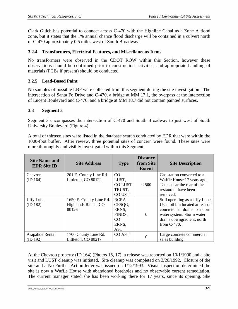
3.3 Segment 3
Segment 3 encompasses the intersection of C-470 and South Broadway to just west of South University Boulevard (Figure 4).
A total of thirteen sites were listed in the database search conducted by EDR that were within the 1000-foot buffer. After review, three potential sites of concern were found. These sites were more thoroughly and visibly investigated within this Segment.
Site Name and EDR Site ID Site Address Type
Distance from Site
Extent Site Description
Chevron (ID 164)
201 E. County Line Rd. Littleton, CO 80122
CO LUST, CO LUST TRUST, CO UST
< 500
Gas station converted to a Waffle House 17 years ago. Tanks near the rear of the restaurant have been removed.
Jiffy Lube (ID 182)
1650 E. County Line Rd. Highlands Ranch, CO 80126
RCRA-CESQG, ERNS, FINDS, CO ERNS, AST
0
Still operating as a Jiffy Lube. Used oil bin located at rear on concrete that drains to a storm water system. Storm water drains downgradient, north from C-470.
Arapahoe Rental (ID 192)
1700 County Line Rd. Littleton, CO 80217
CO AST 0 Large concrete commercial sales building.
At the Chevron property (ID 164) (Photos 16, 17), a release was reported on 10/1/1990 and a site visit and LUST cleanup was initiated. Site cleanup was completed on 3/20/1992. Closure of the site and a No Further Action letter was issued on 1/12/1993. Visual inspection determined the site is now a Waffle House with abandoned boreholes and no observable current remediation. The current manager stated she has been working there for 17 years, since its opening. She

SUMMIT Technical Resources, Inc. Phase I Environmental Site Assessment
draft_phase_i_esa_c470_072913.docx 3-10
further explained the tanks were located at the rear of the restaurant and had been removed. EDR confirms the 3 tanks are closed. The LUSTs have been closed and granted an NFA. The granting of an NFA is based upon contaminates not migrating off of the property. Since this site is located within close proximity to the subject Site, and a spill has occurred, this property may pose a risk to the corridor.
EDR site 182 is a Jiffy Lube (RCRA-CESQG, ERNS, FINDS, CO ERNS) still in operation. During the site visit, a used oil bin was observed at the rear of the building set on concrete. The concrete drains to the storm sewer system. Lead and benzene are known hazardous wastes stored on-site. The 2013 EDR report indicates there are 3 ASTs, two for lube oil and one for waste oil. In 2001, the facility received a notice of violation from the state regarding used oil from the generators. The site achieved compliance 10 days later. According to the CO ERNS report from 2007, an anonymous caller complained there was a dumping of materials, including motor oil, transmission fluid, and ethylene glycol, down the drain daily. This site is also a Conditionally Exempt Small Quantity Generator Site (CESQG). The storm water from this property may have impacted the area within the Site extent. It is noted that the site has a history of dumping, and therefore other dumping activities may have occurred that went unreported. Since this site is located within the Site extent and dumping of contaminates has occurred, this property may pose a risk to the corridor. (Photo 18)
The EDR report indicated that Arapahoe Rental (ID 192) contained a liquefied petroleum gas (LPG) AST that is now permanently closed. The site used to be part of the Division of Oil & Public Safety for Denver, Colorado before being converted to a large, cement building that houses the current commercial property. The property is located within the Site extent, however no reports of a spill have occurred. This property does not likely pose a risk to the subject Site.
3.3.1 Topographic Map Review
This Segment is included on the Highlands Ranch, Colorado 7.5-Minute Quadrangle, and the Denver West, Colorado 30-Minute Quadrangle.
The 1890 Denver East map shows undeveloped land with one road visible near the location of South Broadway.
The 1942 Highlands Ranch map shows that the area around current CDOT ROW is undeveloped. The improved portion of South Broadway terminates at County Line Road, but a unimproved road continues to the south crossing the current C-470 ROW. No other development visible on map.
No significant changes noted in the 1949 Highland Ranch map
No significant changes noted in the 1957 Highland Ranch map.
The 1965 Highland Ranch map shows an aqueduct that transects the current C-470 ROW just west of the University Boulevard interchange.
No significant changes noted in the Highlands Ranch map (photo revised 1971).

SUMMIT Technical Resources, Inc. Phase I Environmental Site Assessment
draft_phase_i_esa_c470_072913.docx 3-11
No significant changes noted in the Highlands Ranch map (photo revised 1980).
The 1965 (photo revised 1994) Highlands Ranch map shows the completion of C-470 with bike path to the north. Extensive residential development both north and south of C-470. Four larger possible commercial buildings are visible north of C-470 west of the University interchange.
The 2011 Highlands Ranch map shows storage units, car lots, and retail stores between C-470 and County Line Road.
No development within the CDOT ROW was observed in any of the topographic maps with the exception of the highway C-470, an undeveloped road, and an aqueduct.
3.3.2 Aerial Photo Review
The 1937 aerial photo shows all of section 3 is undeveloped farm and ranch land. Roads that roughly align with County Line Road and South Broadway are present. Unimproved road continues south from intersection of County Line Road and South Broadway and crosses current C-470 ROW.
No significant changes noted in the 1955 aerial photo.
The 1993 aerial photo shows that construction of C-470 is complete. The South Broadway and South University Boulevard interchanges are complete. Extensive residential development has taken place north and south of C-470. A retail shopping center has been built just to the west of the South University Boulevard interchange between County Line Road and C-470. Three additional building have been built to west of the shopping center that appear commercial in nature. along with a storage unit complex.
The 1999 aerial photo shown continued residential development north and south of C-470. Most areas are developed around C-470 with the exception of a strip of undeveloped land between County Line Road and C-470 that extends from the South Broadway interchange east for approximately 0.6 miles.
No significant changes noted in the 2002 aerial photo.
No significant changes noted in the 2007 aerial photo.
No significant changes noted in the 2012 aerial photo.
No development within the CDOT ROW was observed in any of the photographs with the exception of the highway C-470 and the unimproved road visible in the 1937 and 1955 photos.
3.3.3 FEMA Flood Zones
According to the FEMA Intranetix Viewer flood maps, there are no 100-year floodplains of concern within Segment 3.
SUMMIT Technical Resources, Inc. Phase I Environmental Site Assessment
draft_phase_i_esa_c470_072913.docx 3-12
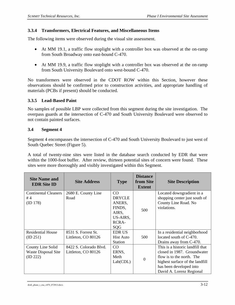
3.3.4 Transformers, Electrical Features, and Miscellaneous Items
The following items were observed during the visual site assessment.
• At MM 19.1, a traffic flow stoplight with a controller box was observed at the on-ramp from South Broadway onto east-bound C-470.
• At MM 19.9, a traffic flow stoplight with a controller box was observed at the on-ramp from South University Boulevard onto west-bound C-470.
No transformers were observed in the CDOT ROW within this Section, however these observations should be confirmed prior to construction activities, and appropriate handling of materials (PCBs if present) should be conducted.
3.3.5 Lead-Based Paint
No samples of possible LBP were collected from this segment during the site investigation. The overpass guards at the intersection of C-470 and South University Boulevard were observed to not contain painted surfaces.
3.4 Segment 4
Segment 4 encompasses the intersection of C-470 and South University Boulevard to just west of South Quebec Street (Figure 5).
A total of twenty-nine sites were listed in the database search conducted by EDR that were within the 1000-foot buffer. After review, thirteen potential sites of concern were found. These sites were more thoroughly and visibly investigated within this Segment.
Site Name and EDR Site ID Site Address Type
Distance from Site
Extent Site Description
Continental Cleaners # 4 (ID 178)
2680 E. County Line Road
CO DRYCLEANERS, FINDS, AIRS, US-AIRS, RCRA-SQG
500
Located downgradient in a shopping center just south of County Line Road. No violations.
Residential House (ID 251)
8531 S. Forrest St. Littleton, CO 80126
EDR US Hist Auto Station
500 In a residential neighborhood located south of C-470. Drains away from C-470.
County Line Solid Waste Disposal Site (ID 222)
8422 S. Colorado Blvd. Littleton, CO 80126
CO ERNS, Meth Lab(CDL) 0
This is a historic landfill that closed in 1987. Groundwater flow is to the north. The highest surface of the landfill has been developed into David A. Lorenz Regional

SUMMIT Technical Resources, Inc. Phase I Environmental Site Assessment
draft_phase_i_esa_c470_072913.docx 3-13
Site Name and EDR Site ID Site Address Type
Distance from Site
Extent Site Description
Park, a sports complex with artificial grass playing fields and a BMX track.
Centennial Water and Sanitation (ID 272)
8606 Canongate Ln. Littleton, CO 80130
CO ERNS, AST
0 Lift station for wastewater. Located on or near golf course south of C-470 ROW.
Conoco (ID 201)
5653 County Line Pl. Littleton, CO 80126
EDR US Hist Auto Stat 0
Currently a Conoco Station combined with a Quick Lube auto shop and car wash north of C-470. The paved parking lot drains to County Line Pl, then to Holly St.
Safelite Autoglass/My Auto Service Center/Just Brakes (ID 198)
5701 E. County Line Road Littleton, CO 80126
EDR US Hist Auto Stat 0
A group of auto shops up gradient and north of C-470. Site appears well kept.
Dry Cleaning Station (ID 184)
6086 E. County Line Road
CO DRYCLEANERS, AIRS, FINDS, US-AIRS, RCRA_SQG
0
North and downgradient from C-470. Appeared well kept at the time of the visit. Concrete drains north to County Line Road.
Clean Shine Car Wash (ID 184)
6028 E. County Line Road Littleton, CO 80126
CO ERNS
0
North and downgradient from C-470. Appeared well kept at the time of the visit. Concrete drains north to County Line Road.
AAMCO Transmissions (ID 184)
6028 E. County Line Road Littleton, CO 80126
LUST, UST
0
North and downgradient from C-470. Appeared well kept at the time of the visit. Concrete drains north to County Line Road.
Jim and Co. Auto Services (ID 188)
6328 E. County Line Road Highlands Ranch, CO 80126
EDR US Hist Auto Stat 0
Auto shop north of C-470 in a strip mall downgradient from the highway.
Courtesy Auto Care (ID 189)
6828 E. County Line Road Highlands Ranch, CO 80126
EDR US Hist Auto Stat 0
Auto shop north of C-470.
Brakes Plus - Highlands Ranch East (ID 190)
7040 E. County Line Road Highlands Ranch, CO 80126
EDR US Hist Auto Stat 0
Brakes Plus with a service station located north and downgradient of C-470. Asphalt drains west, then

SUMMIT Technical Resources, Inc. Phase I Environmental Site Assessment
draft_phase_i_esa_c470_072913.docx 3-14
Site Name and EDR Site ID Site Address Type
Distance from Site
Extent Site Description
south to a retention area between C-470 and County Line Road.
Heritage Cleaners # 8 (ID 191)
7132 E. County Line Road
CO DRYCLEANERS, FINDS, RCRA-SQG, EDR-HIST CLEANERS
0
North and downgradient from C-470.
K&G Stores (ID 191)
7130 E. County Line Road
UST, LUST 0 North and downgradient from
C-470. Goodyear Auto Service Center (ID 156)
8273 S. Quebec St. Centennial, CO 80112
CO ERNS
500
This location is north and downgradient to C-470. Used oil containers are located in the rear of the building and behind a locked gate. The parking lot drains southeast into a retention basin near the northwest corner of Quebec and County Line Road.
Residential House (ID 295)
3729 E. Mallard Dr. Highlands Ranch, CO 80126
CO ERNS, CDL (Meth Lab)
1000
Residential house in a residential neighborhood.
Continental Cleaners #4 (ID 178) is a dry cleaner. Tetrachloroethylene is listed as "used on site". Multiple records show compliance with the state and no violations were found by EDR. This property is located downgradient and at a distance of 500 feet with no violations, and therefore likely does not pose a concern to the subject corridor.
EDR Site 251 is a house in a residential neighborhood south of C-470 (Photo 21). The site is cross gradient from the highway and water is likely to drain away from C-470. The EDR report explains that where the house sits now used to be a Chevron gas station, but does not give the date of operation or reason for listing. During the aerial photograph review, the 1955 photo shows no development in the area. The next photo in 1993 shows the construction for the existing subdivision with undeveloped land adjacent to the property. It is unlikely that this property was a Chevron Station. Based on site observations and database review, this property likely does not pose a concern to the subject corridor.
SUMMIT Technical Resources, Inc. Phase I Environmental Site Assessment
draft_phase_i_esa_c470_072913.docx 3-15
The County Line Waste Disposal Site (ID 222) is a solid waste municipal landfill (Photos 6, 7, 19, 20) located near the northeast corner of Colorado Boulevard and C-470. It operated from the 1960’s until its closure in 1987. The landfill is owned by Arapahoe County and maintained by Waste Management Inc. Since closure, the South Suburban Recreation District has leased a part of the landfill and constructed a sports complex with artificial grass playing fields and a BMX-track. As a part of the post-closure plan, the Colorado Department of Public Health and Environment (CDPHE) requires groundwater and methane monitoring. Currently, Waste Management Inc. monitors groundwater quality via a natural attenuation remedial action program. Quarterly methane monitoring is also required and excess methane is flared in a structure located near the southwest corner of the landfill. Contaminated groundwater is present at the landfill. A plume was identified along the northern part of the landfill (opposite C-470 ROW). Groundwater flows to the north and the plume migrated off-site in that direction. As a result, a groundwater barrier was installed near the northern end of the landfill and contaminated groundwater was pumped and treated by the Englewood wastewater Treatment Plant. A remedial action program using natural attenuation is now in progress. A methane flare is situated in the southwest corner of the landfill, and the southern methane collection wells are visible from C-470. According to Waste Management Inc., methane in the northern monitoring wells was sometimes problematic and exceedances were observed. All methane-monitoring wells have been in compliance with State requirements since the additional piping was installed. The EDR report also showed evidence of criminal activity at the site in 2004. A boxed meth lab in a briefcase was found containing suspected iodine, hypophosphorus acid, naptha, acetone and HMWMD. Caldwell Environmental was notified for cleanup. The landfill was in place when C-470 was originally constructed. Since this site is located within the Site extent and a construction disturbance within the landfill area could occur, this property may pose a risk to the corridor.
Centennial Water and Sanitation (ID 272) is a lift station that is listed as a CO ERNS and AST site that was not located during site investigation. The AST was installed in 1992 and continues to be in use. The AST contains diesel fuel and no leaks or spills have been reported. The address in the EDR report plots to the Links Golf Course at Highlands Ranch where the lift station is believed to be located. The EDR report indicates two incidents involving untreated wastewater have occurred. In 2003, a force main line was hit and severed, releasing a limited amount of wastewater into the pit dug for a 42 inch main line. Most of the wastewater was contained in the pit and removed, however a small amount overflowed and impacted an adjacent waterway. The impact was reported as minimal. In 2005, there was an overflow of untreated domestic wastewater that entered a dewatering manhole adjacent to the site. The water that entered the manhole was pumped to the western tributary arm of the Big Dry Creek. As a result of the incident, a check valve was installed on the dewatering overflow line. Since the location of the spill may be located within the Site extent, this property may pose a risk to the corridor.
The Conoco gas station (ID 201) located north of C-470 was found to be an EDR US Historical Auto Station and was investigated due to its proximity to C-470. Previous names for this property include Auto Nation USA Neighborhood Service (2003) and Magic Rabbit Carwash & Lube Co (2010-2011) (EDR 2013b). The visual inspection determined that water drains away from the highway. Because no hazardous record of violations or spills were found and drainage is away from the corridor assumes, this property does not appear to pose a concern to the subject Site. (Photo 29)
SUMMIT Technical Resources, Inc. Phase I Environmental Site Assessment
draft_phase_i_esa_c470_072913.docx 3-16
Safelite Autoglass/My Auto Service Center/Just Brakes (ID 198) are all located in a building located north of C-470. The EDR report identifies it as a EDR US Historical Auto Station and reports it to have remained a Just Brakes since 2001. The building appears well kept and there are no records of hazardous spills or violations. This property likely does not pose a concern to the subject Site. (Photo 24)
Dry Cleaning Station (ID 184) is a dry cleaners that EDR shows has operated from at least 2000 until the time of the report. Tetrachloroethylene is listed as "used on site". Multiple records show compliance with the State and no violations were found by EDR. The property is located within the Site extent. Since this site is located within the Site extent, and because highly mobile chlorinated solvents are used, this property may pose a risk to the corridor.
Clean Shine Car Wash (ID 184) is a CO ERNS site. The property is located north and downgradient from C-470. The concrete is well kept and water appears to flow north, away from C-470 towards County Line Road. The EDR report indicates a spill occurred in 1997 when a driver punctured a hole in a diesel tank causing it to spill onto the street, entering a plugged storm drain. Thirty-five gallons of diesel/water mix were pumped from the storm drain and contaminated materials were disposed of at CSI in Bennett, Colorado. Because this site drains away from the highway and the affected material and areas were cleaned up, this property does not likely pose a concern to the subject Site.
AAMCO Transmission (ID 184) is a UST and LUST site. A leak was confirmed on 12/4/2001 and a site characterization was performed. Closure of the site occurred on 5/20/2002 with results less than risk based screening levels (RBSLs). Both LUST and USTs are permanently closed. , Since the property is located within the Site extent, and a spill has occurred, this property may pose a risk to the subject corridor.
Jim and Co. Auto Services (ID 188) and Courtesy Auto Care (ID 189) are auto repair shops that are located within the Site extent. During the site visit, the property appeared well kept. Both sites are listed as EDR US Historical Auto Stations under the names Jim & CO Auto Services Inc. (2005, 2011-2012) and County Line Import Automotive (2006-2010), and Courtesy Auto Care (2011), respectively. There are no reports of violations or spills, and therefore these sites likely do not likely pose a risk to the subject corridor. (Photos 22, 23)
Brakes Plus-Highlands Ranch East (ID 190) is also an EDR US Historical Auto Station. Name changes for this site include Brakes Plus (2005, 2007, 2008, 2010, 2011, 2012), Brakes Plus Car Care Center (2006), and Brakes Lube Tune (2009). The building’s asphalt drains to the west then south out to a retention area between C-470 and County Line Road downgradient from the highway. There are no reports of violations or spills, and therefore this property likely does not pose a risk to the subject corridor. (Photo 25)
Heritage Cleaners # 8 (ID 191) is a dry cleaner. Tetrachloroethylene is listed as "used on site". Records show compliance with the state and no violations were found by EDR. The site is located within the Site extent. Since this site is located within the Site extent, and because highly mobile chlorinated solvents are used, the property may pose a risk to the corridor.

SUMMIT Technical Resources, Inc. Phase I Environmental Site Assessment
draft_phase_i_esa_c470_072913.docx 3-17
K & G Stores (ID 191) is a gas station that EDR reports as a LUST and UST, which is located within the Site extent. The site contained 3 USTs that were installed in 1986. The tanks were closed in 2002. A confirmed release occurred 12/13/2002. The site was monitored and closure was approved on 10/14/2004. Since this site is located within the Site extent and a spill has occurred, this property may pose a risk to the corridor.
Goodyear Auto Service Center (ID 156) is located downgradient of C-470. The parking lot drains to the southeast into a retention basin located near the northwest corner of South Quebec Street and County Line Road. There is a used oil bin at the rear of the building behind a locked gate (Photo 26). The EDR report indicates that in 2006, it was brought to Goodyear’s attention that the AST used for waste oil leaked, ran across the asphalt, and entered a storm drain detention area. Goodyear enlisted Safety Clean to drain the tank, clean up the asphalt, and try to dam the spill away from the storm drain. It was uncertain how much oil was released. Because this site is downgradient and drains away from C-470, it is not likely a concern to the subject Site.
EDR site 295 is listed as a CO ERNS and CDL- or meth lab- site. The EDR report indicates the residence was used as a fixed facility for criminal intent involving meth production in 2004. The South Metro Drug Task Force responded initially to the situation, and Caldwell Environmental was notified for clean-up activities. Due to the distance from ROW (~1000 feet), and reported cleanup actions, this site does not appear to pose a concern to the subject Site.
3.4.1 Topographic Map Review
This Segment is included on the Highlands Ranch, Colorado 7.5-Minute Quadrangle, and the Denver West, Colorado 30-Minute Quadrangle.
The 1890 Denver East map shows undeveloped land with one road visible just east of the current University Boulevard. The road is referred to as Old Colorado Road on the map. Old Colorado Road crosses the current C-470 ROW just east of the University Boulevard interchange and heads south.
The 1942 Highlands Ranch map shows that the area around current CDOT ROW is undeveloped. The Old Colorado Road shown on the 1890 map is not shown. Daniels Park Road continues south from County Line Road and crosses the current C-470 ROW.
No significant changes noted in the 1949 Highland Ranch map
No significant changes noted in the 1957 Highland Ranch map.
The 1965 Highland Ranch map shows gravel pit located near the intersection of Big Dry Creek and the current ROW of C-470.
The 1965 (photo revised 1971) Highlands Ranch map shows the addition of four buildings north of the current C-470 ROW and west of the gravel pit. The location of the four buildings is located in a similar location to the current radio facility. A large rectangular area shown as disturbed is visible just north of the current ROW of C-470. The area is roughly 2000 feet by

SUMMIT Technical Resources, Inc. Phase I Environmental Site Assessment
draft_phase_i_esa_c470_072913.docx 3-18
1500 feet and is located in the general area of the County Line Waste Disposal site (EDR ID 122).
No significant changes noted in the 1965 (photo revised 1980) Highlands Ranch map.
The 1965 (photo revised 1994) Highlands Ranch map shows the completion of C-470 with bike path to the north. Disturbed area at the location of the County Line Waste Disposal Site is no longer shown on the map. Residential development north of County Line Road. Numerous larger buildings are visible north of C-470 and south of County Line Road. The larger buildings are visible in two large groups. The first located just east of the University Boulevard interchange, the second is located west of Holly Street and east of the Quebec Street interchange. Two radio facilities are visible. The first radio facility is located north of C-470 just west of Dry Creek and a second is located South of C-470 south and just east of Daniels Park Road.
The 2011 Highlands Ranch map shows the extensive development of the highlands ranch residential subdivision south of C-470. Residential and retail development is completed north of C-470, leaving no undeveloped land. A park is now visible in the same location as the former landfill. No development within the CDOT ROW was observed in any of the topographic maps with the exception of the highway C-470, an Daniels Park Road. The County Line Waste Disposal Site is located very near C-470, but it appears on the maps that C-470 was diverted to the south to avoid the former landfill
3.4.2 Aerial Photo Review
The 1937 aerial photo shows all of Segment 4 is undeveloped farm and ranch land. Roads that roughly align with County Line Road and Daniels Park Road are present. Daniels Park Road continues south from County Line Road and crosses the current C-470 ROW.
The 1955 aerial photo shows an disturbed area located at the same location as a gravel pit visible on the 1965 topographic map. The gravel pit is located near the intersection of Big Dry Creek and the current ROW of C-470.
The 1993 aerial photo shows that construction of C-470 is complete. The Quebec and University Boulevard interchanges are complete. Extensive residential development has taken place north and south of C-470. A retail shopping center has been built just to the east of the University interchange between County Line Road and C-470. Additional retail shopping has been built just to the west of the Quebec Street interchange between County Line Road and C-470. The County Line Disposal Site is visible. The landfill is covered with grass and methane vents are visible. No disposal activities are present at this time and it appears that the landfill is closed.
The 1999 aerial photo shown continued residential development north and south of C-470. Most areas are developed around C-470. A BMX track is visible in the area of the County Line Disposal Site.
No significant changes noted in the 2002 aerial photo.

SUMMIT Technical Resources, Inc. Phase I Environmental Site Assessment
draft_phase_i_esa_c470_072913.docx 3-19
No significant changes noted in the 2007 aerial photo with the exception of the building of recreational fields on the former landfill.
No significant changes noted in the 2012 aerial photo.
3.4.3 FEMA Flood Zones
According to FEMA Intranetix Viewer flood maps, there are no 100-year floodplains of concern within Segment 4. A short section of the highway in this Segment was unavailable for print through the FEMA website. Upon further investigation, Focus Map 21 of the EDR 2013 report contained this missing section, and confirmed that there are no 100-year floodplains within Segment 4.
3.4.4 Transformers, Electrical Features, and Miscellaneous Items
The following items were observed during the visual site assessment.
• At MM 21.3, a Telecom tower was observed about 100 feet south of ROW. Photo 1 shows what appears to be a utility box for the tower. Photo 2 shows the actual building associated with the Telecom tower.
• At MM 22.7, there are five radio towers located approximately 200 feet north of ROW. (Photograph 5)
• At MM 23.9, a traffic flow stoplight with a control box was observed at the on-ramp from South Quebec St. onto west-bound C-470.
No transformers were observed in the CDOT ROW within this Section, however these observations should be confirmed prior to construction activities, and appropriate handling of materials (PCBs if present) should be conducted.
3.4.5 Lead-Based Paint
No samples of possible LBP were collected from this segment during the site investigation. The overpass guard rails at the intersections of C-470 and South University Boulevard, and C-470 and Colorado Boulevard, did not contain painted surfaces. A bridge’s textured surface at MM 22.7 appeared to be flaking, yet it did not contain paint so a sample was not collected.
3.5 Segment 5
Segment 5 encompasses the intersection of C-470 and South Quebec Street to the Intersection of C-470 and I-25 (Figure 6).
A total of twenty-nine sites were listed in the database search conducted by EDR that were within the 1000-foot buffer. After review, five potential sites of concern were found. These sites were more thoroughly and visibly investigated within this Segment.

SUMMIT Technical Resources, Inc. Phase I Environmental Site Assessment
draft_phase_i_esa_c470_072913.docx 3-20
Site Name and EDR Site ID Site Address Type
Distance from Site
Extent Site Description
7-Eleven (ID 309)
8750 S Yosemite St Lone Tree, CO 80124
FINDS, USAIRS, CO LUST
0
Located southwest of C-470 with the gradient falling away to the west, downgradient/cross gradient form the highway. The tanks are located on the west side of the gas pumps.
Fairway Collision Center (ID 273)
8500 S Valley Hwy Englewood, CO 80112
CO ERNS 1000
Located north of E-470 and east of I-25. Downgradient. During site visit the entire area the was graded dirt.
Fairway Auto Service Center (ID 302)
8550 S Valley Hwy Englewood, CO 80112
EDR US Hist Auto Stat
500
Crest Apartment Building (ID 370)
10049/10051 Park Meadows Dr. Lone Tree, CO 80124
EDR US Hist Auto Stat 1000
These locations are in a large residential apartment building cross gradient to C-470.
The Retreat at Park Meadows (ID 373)
10200 Park Meadows Dr. Lone Tree, CO 80124
EDR US Hist Auto Stat 1000
An apartment complex south of the I-25 intersection. Cross gradient.
7-Eleven (ID 309) is south and downgradient /cross gradient of C-470 (Photo 30). According to the EDR report, it contained two LUSTs closed in 2003 and 2010, and currently has two gasoline USTs in use. AIRS has determined the site emits amounts of benzene and volatile organic compounds to fit the criteria of a hazardous air pollutants site. All reported monitoring efforts showed the site remains in compliance with procedural requirements. The location is within the Site extent. Since this site is located within the Site extent and a spill has occurred, the site may pose a risk to the corridor.
During the site visit, the addresses of Fairway Collision Center (ID 273) and Fairway Auto Service Center’s (ID 302) had been demolished. The site was cleared and only dirt was observed. No debris or signs of contamination was observed. Fairway Collision Center (ID 273) is listed in the EDR report as a CO ERNS. In 2010, a caller reported to the EPA that an unknown smell seemed to be coming from a drain and that “Employees” were getting sick (not further specified). Other customers claimed it to be a sewer type smell, but the report does not contain information about any follow-up measures taken. The Fairway Auto Service Center’s (ID 302) address is adjacent to the Fairway Collision Center and was listed as an EDR US Hist Auto Station under the name Fairway Auto Service, Inc. in 2012. The site is located downgradient and at a distance of a 1000 feet or more from the Site. This site also had a reported sewer smell. An odor in the sewer system would not represent a risk to construction in the area. Therefore, these sites are not likely to pose a concern to the subject corridor. (Photo 33)

SUMMIT Technical Resources, Inc. Phase I Environmental Site Assessment
draft_phase_i_esa_c470_072913.docx 3-21
The Crest Apartment Buildings (ID 370) and The Retreat at Park Meadows (ID 373) currently are both apartment complexes listed as EDR US Hist Auto Stations under the names Select Auto Broker, LLC (2005) and Sejon Oil & Gas Co Inc (2006-2007), and Everything Mobile Inc. (2004-2005), respectively. Historic topographic maps and aerial photographs were reviewed and no evidence of an auto station or repair shop were observed. The two properties were undeveloped until recently. First sign of development was the current apartment building located at the sites currently. Due to the distance from ROW and no reported hazards, these sites likely do not pose a concern to the subject Site. (Photos 31, 32)
3.5.1 Topographic Map Review
This Segment is included on the Highlands Ranch, Colorado 7.5-Minute Quadrangle, Parker, Colorado 7.5-Minute Quadrangle and the Denver East, Colorado 30-Minute Quadrangle.
The 1890 Denver East map shows undeveloped land with County Line Road and a road that heads south and crosses the current ROW of C-470. The road is referred to as Happy Canyon Road on the map. Happy Canyon crosses the current C-470 ROW near the current interchange with I-25 and heads south.
The 1942 Highlands Ranch map shows that the area around current CDOT ROW is undeveloped. County Line Road is visible.
The 1942 Parker map shows large undeveloped areas with a road named Happy Canyon Road. Happy Canyon Road crosses the current C-470 ROW near the current interchange with I-25 and heads south.
No significant changes noted in the 1949 Highland Ranch map.
No significant changes noted in the 1949 Parker map.
No significant changes noted in the 1957 Highland Ranch map.
The 1957 Parker map shows that Happy Canyon Road is now named Highway 87 and is shown as under construction.
No significant changes noted in the 1965 Highland Ranch map.
The 1965 Parker map shows that Hwy 87 is now named I-25 and an interchange at County Line Road has been constructed.
No significant changes noted in the 1965 (photo revised 1971) Highland Ranch map.
The 1965 (photo revised 1971) Parker map shows a frontage road runs down the east side of I-25 from County Line Road to the south. A number of small building that appear to be a ranch are located near the current location of the C-470 and I-25 interchange.
The 1965 (photo revised 1980).Highlands Ranch map shows residential development south of the current C-470 ROW. An un-named road crosses the C-470 ROW just west of the current I-25 interchange.

SUMMIT Technical Resources, Inc. Phase I Environmental Site Assessment
draft_phase_i_esa_c470_072913.docx 3-22
No significant changes noted in the 1965 (photo revised 1980) Parker map.
The 1965 (photo revised 1994) Highlands Ranch map shows the completion of C-470 with bike path to the north. Residential development to the north of County Line is visible along with continued development south of C-470. Columbine Hospital is visible near the Quebec Street interchange. A fire Station is also visible south of C-470 at Yosemite. A large office building is now visible south of C-470 between Yosemite and the current street of Acres Green.
The 1965 (photo revised 1994) Parker map shows the completion of C-470 along with the interchange to I-25. Larger building possible office space is constructed north northeast of the I-25 interchange.
The 2011 Highlands Ranch map shows continued residential development north and south of C-470. A interchange has been constructed at Yosemite and park meadows mall and numerous retail is now present north of C-470 that continues to the west to Quebec Street. South of C-470 office buildings and retail is visible near the C-470 ROW. The 2011 Parker map shows continued development of office buildings north and south of E-470 and east of I-25. North of C-470 and west of I-25 Park meadows mall is now visible. South of C-470 and west of I-25 development of office buildings and apartments are visible. No development within the CDOT ROW was observed in any of the topographic maps with the exception of the construction of highway C-470 and a few intersecting roads.
3.5.2 Aerial Photo Review
The 1937 aerial photo shows all of section 4 is undeveloped farm and ranch land. Roads that roughly align with County Line Road and historic Happy Canyon Road are present.
The 1955 aerial photo shows no significant change.
The 1993 aerial photo shows that construction of C-470 and I-25 is complete. The Quebec Street and I-25 interchanges are complete. Extensive residential development has taken place north and south of C-470. Office buildings are now located north of E-470 and east of I-25. Construction on Park Meadows Mall has begun. An office building is located between Yosemite and Acres Green. Area south of C-470 between Yosemite and I-25 remains undeveloped.
The 1999 aerial photo shown continued residential development north and south of C-470 The Yosemite interchange is complete. Park Meadows Mall has been completed and other retail now fills the area between C-470, County Line Road, Quebec Street and I-25. South of C-470 many retail and office buildings have been constructed south of C-470. The area south of C-470 between Yosemite and I-25 is under heavy construction with apartment and office buildings.
The 2002 aerial photo shows continued development.
No significant changes noted in the 2007 aerial photo.

SUMMIT Technical Resources, Inc. Phase I Environmental Site Assessment
draft_phase_i_esa_c470_072913.docx 3-23
No significant changes noted in the 2012 aerial photo with the exception of a new bridge at the Quebec Street interchange.
No development within the CDOT ROW was observed in any of the aerial photos with the exception of the construction of highway C-470 and a few intersecting roads.
3.5.3 FEMA Flood Zones
FEMA identifies two 100-year floodplains within Segment 5 (refer to Section 1 for flood zone definitions):
• FEMA Intranetix Viewer flood maps 08035C0033F and 08035C0041F both show Big Dry Creek as having a winding, narrow-banded Zone AE flood plain that seems to cross underneath a C-470 bridge, directly south of where County Road 29/South Holly Street ends (halfway between South Colorado Boulevard and South Quebec Street). However, the map also states that a 1% annual chance flood discharge/floodway will be contained in a constructed channel on the north side of the highway.
• According to the FEMA Intranetix Viewer flood maps (map 08035C0034F), a narrow band along the local Willow Creek, is identified as a Zone A floodplain. It crosses C-470 approximately 1 mile west of the intersection of South Yosemite St. and C-470 and follows the Willow Creek Trail.
3.5.4 Transformers, Electrical Features, and Miscellaneous Items
The following items were observed during the visual site assessment.
• At MM 24.1, a traffic flow stoplight with a control box was observed at the on-ramp from South Quebec Street onto east-bound C-470.
• At MM 25.9, a traffic flow stoplight with an electronic box with a controller was observed at the on-ramp from I-25 onto west-bound C-470.
No transformers were observed in the CDOT ROW within this Section, however these observations should be confirmed prior to construction activities, and appropriate handling of materials (PCBs if present) should be conducted.
3.5.5 Lead-Based Paint
One paint sample was collected from the railing of a pedestrian bridge at the intersection of South Quebec Street and C-470 (Photos 27, 28). Reservoirs Environmental, Inc. Lab results on July 3, 2013 indicate that the paint sample at this location was found to be below the reporting limit for lead. Other sites investigated in this segment during the site visit include a bridge over a drainage basin at MM 24.2, the bridge at the intersection of Yosemite and C-470, and the bridge and railings at the intersection of I-25 and C-470. None of these sites were found to have painted surfaces. A railing located on a small retaining wall for a Furniture Row Retail Complex (Photo 4) was observed to have paint. The railing was located on private property immediately adjacent to CDOT ROW. However the paint was not sampled for lead as it was on private property.

SUMMIT Technical Resources, Inc. Phase I Environmental Site Assessment
draft_phase_i_esa_c470_072913.docx 4-1
4.0 Opinions and Conclusions
SUMMIT has performed a Phase I ESA in conformance with the scope and limitations of ASTM E 1527-05 for the Site. Any exceptions to, or deletions from, this practice are described in Section 1 of this report. This assessment has revealed no evidence of recognized environmental conditions in connection with the Site except for the sites discussed below. Additionally, other items to be noted are discussed below.
4.1 Segment 1
One Segment 1 site has been determined to present recognized environmental conditions, historic recognized environmental conditions, or toxic materials have been identified which should be handled in accordance with all applicable regulations.
JEFFCO Road and Bridge (ID 304) is a work and storage area for road and bridge construction supplies located south and cross gradient of C-470. It has five underground storage tanks (UST): one 1000-gallon waste oil tank, one 1000-gallon gasoline tank, one 4000-gallon diesel tank, and three 1000-gallon diesel tanks (Goodbee 2005). The EDR report indicates a case of illegal dumping in 1997 where an unknown quantity of oil was dumped in the shop’s storm water retention pond. Surface water was impacted. Cleanup included breaking up and removing impacted ice, vacuuming 1500 gallons of water/oil into a roll-off, and placing it in absorbent (material) pigs. Since this site is located within the Site extent and a spill has occurred, this property may pose a risk to the subject corridor.
4.2 Segment 2
One Segment 2 site has been determined to present recognized environmental conditions, historic recognized environmental conditions, or toxic materials have been identified which should be handled in accordance with all applicable regulations.
Bowen Farms (ID 207) was not located upon visual investigation. However it is likely that the address refers to a field located adjacent to CDOT ROW north of C-470 and south of County Line Road. The EDR report indicates it is a CO LUST site with four permanently closed tanks: one gasoline UST, two gasoline ASTs, and one diesel AST. The LUST was installed in 5/12/1978 and a confirmed release occurred on 10/10/2006. A site visit occurred 11/3/2006 and a closure letter was issued 12/8/2006 which referenced lower than RBSLs. Since this site is located within the Site extent and a leak has occurred on the property, this property may pose a risk to the subject corridor.
4.3 Segment 3
Two Segment 3 sites have been determined to present recognized environmental conditions, historic recognized environmental conditions, or toxic materials have been identified which should be handled in accordance with all applicable regulations.
A release was reported at the Chevron site (ID 164) on 10/1/1990, and a site visit and LUST cleanup was initiated. Site cleanup was completed on 3/20/1992. Closure of the site and a No Further Action letter was issued on 1/12/1993. Visual inspection determined the site is now a

SUMMIT Technical Resources, Inc. Phase I Environmental Site Assessment
draft_phase_i_esa_c470_072913.docx 4-2
Waffle House with abandoned boreholes and no observable current remediation. The current manager, who has worked at the site 17 years since its opening indicated the tanks were located at the rear of the restaurant and had been removed. Since this site is located within close proximity to the Site extent and a spill has occurred, this property may pose a risk to the corridor.
EDR Site 182 is a Jiffy Lube (RCRA-CESQG, ERNS, FINDS, CO ERNS) still in operation. During the site investigation, a used oil bin was located at the rear of the building set on concrete. The concrete drains to the storm sewer system. Lead and benzene are known hazardous wastes stored on-site. The EDR report indicates there are three ASTs, two for lube oil and one for waste oil. In 2001, the facility received a notice of violation from the state regarding used oil from the generators and achieved compliance 10 days later. According to the CO ERNS report from 2007, an anonymous caller complained there was a dumping of materials, including motor oil, transmission fluid, and ethylene glycol, down the drain daily. The storm water from this property may have impacted the area within the Site extent. Since this site is located within the Site extent and a documented history of dumping of contaminates has occurred, this property may pose a risk to the corridor.
4.4 Segment 4
Six Segment 4 sites have been determined to present recognized environmental conditions, historic recognized environmental conditions, or toxic materials have been identified which should be handled in accordance with all applicable regulations.
The County Line Waste Disposal Site (ID 222) is a solid waste municipal landfill located near the northeast corner of Colorado Boulevard and C-470. It operated from the 1960’s until its closure in 1987. The landfill is owned by Arapahoe County and maintained by Waste Management Inc. Currently, Waste Management Inc. monitors groundwater quality via a natural attenuation remedial action program. Quarterly methane monitoring is also required and excess methane is flared in a structure located near the southwest corner of the landfill. Contaminated groundwater is present at the landfill. A plume was identified along the northern part of the landfill (opposite C-470 ROW). Groundwater flows to the north and the plume migrated off-site in that direction. As a result, a groundwater barrier was installed near the northern end of the landfill and contaminated groundwater was pumped and treated by the Englewood Wastewater Treatment Plant. A remedial action program using natural attenuation is now in progress. A methane flare is situated in the southwest corner of the landfill and the southern methane collection wells are visible from C-470. According to Waste Management Inc., methane in the northern monitoring wells was sometimes problematic and exceedances were observed. All methane-monitoring wells have been in compliance with State requirements since the additional piping was installed. The EDR report also showed evidence of criminal activity at the site in 2004. A boxed meth lab in a briefcase was found containing suspected iodine, hypophosphorus acid, naptha, acetone and HMWMD. Caldwell Environmental was notified for cleanup. The landfill was in place when C-470 was originally constructed. Since this site is located within the Site extent and a construction disturbance within the landfill area could occur, this property may pose a risk to the corridor.
Centennial Water and Sanitation (ID 272) is a lift station that is listed as a CO ERNS and AST site which was not located during site investigation. The AST was installed in 1992 and

SUMMIT Technical Resources, Inc. Phase I Environmental Site Assessment
draft_phase_i_esa_c470_072913.docx 4-3
continues to be in use. The AST contains diesel fuel and no leaks or spills have been reported. The address in the EDR report plots to the Links Golf Course at Highlands Ranch where the lift station is believed to be located. The EDR report indicates two incidents involving untreated wastewater have occurred. In 2003, a force main line was hit and severed, releasing a limited amount of wastewater into the pit dug for a 42-inch main line. Most of the wastewater was contained in the pit and removed, however a small amount overflowed and impacted an adjacent waterway. The impact was reported as minimal. In 2005, there was an overflow of untreated domestic wastewater that entered a dewatering manhole adjacent to the site. The water that entered the manhole was pumped to the western tributary arm of the Big Dry Creek. As a result of the incident, a check valve was installed on the dewatering overflow line. Since the location of the spill may be located within the Site extent, this property may pose a risk to the subject corridor.
Dry Cleaning Station (ID 184) is a dry cleaners that EDR shows has operated from at least 2000 until the time of the report. Tetrachloroethylene is listed as "used on site". Multiple records show compliance with the state and no violations were found by EDR. This property is located within the Site extent, and because highly mobile chlorinated solvent are used, the site may pose a risk to the corridor.
AAMCO Transmission (ID 184) is a UST and LUST site. A leak was confirmed on 12/4/2001 and a site characterization was performed. Closure of the site occurred on 5/20/2002 with results less than RBSLs. Since this property is located within the Site extent and a spill has occurred, this property may pose a risk to the corridor.
Heritage Cleaners # 8 (ID 191) is a dry cleaner. Tetrachloroethylene is listed as "used on site". Records show compliance with the state and no violations were found by EDR. This property is located within the Site extent, and because highly mobile chlorinated solvent are used, the site may pose a risk to the subject corridor. K & G Stores (ID 191) is a gas station that EDR reports as a LUST and UST. The site contained three USTs that were installed in 1986 and closed in 2002. A confirmed release occurred 12/13/2002. The site was monitored and closure was approved on 10/14/2004. Since this property is located within the Site extent and a spill has occurred, this property may pose a risk to the subject corridor.
Based on the results of the LBP sampling conducted by SUMMIT in 2013, LBP is not present at the Quebec Street bridge. However SUMMIT was not to access private property to test for LBP. All work should be conducted with appropriate engineering controls and work practices, and should be conducted by properly trained and protected personnel as required by OSHA regulations. Cutting, grinding, or demolition activities where LBP is present, can cause a release of dust or fumes containing lead into the air, creating a breathing hazard to workers. Therefore, demolition activities involving LBP are covered under the Occupational Safety and Health Administration (OSHA) Construction Industry Standard for Lead (29 CFR, Part 1926.62). Strict controls for grinding, cutting, or abrading of LBP should be should be implemented during construction/demolition activities to ensure compliance with OSHA provisions and to reduce potential lead dust or fumes.

SUMMIT Technical Resources, Inc. Phase I Environmental Site Assessment
draft_phase_i_esa_c470_072913.docx 4-4
4.5 Segment 5
One segment 5 site has been determined to present recognized environmental conditions, historic recognized environmental conditions, or toxic materials have been identified which should be handled in accordance with all applicable regulations.
7-Eleven (ID 309) is south and downgradient /cross gradient of C-470. According to the 2013 EDR report, it contained two LUSTs closed in 2003 and 2010 and currently has two gasoline USTs in use. Since this site is located within the Site extent and a spill has occurred, this property may pose a risk to the subject corridor.
4.6 Other Items for Consideration
FEMA Intranetix Viewer flood maps identify two 100-year floodplains within Segment 1. One crosses the highway just west of the intersection at Kipling Street, runs along C-470 to the north, and crosses C-470 again where it flows into Chatfield Lake (south of C-470) at approximately 0.5 miles east of South Wadsworth Boulevard along C-470. The second one crosses C-470 approximately a mile west of South Santa Fe Drive.
FEMA Intranetix Viewer flood maps indicate there are no 100-year floodplains of concern within Segment 2. However, the FEMA flood map shows the Dad Clark Gulch has potential to connect across C-470 with the Highline Canal, but it states that the 1% annual chance flood discharge will be contained in a culvert north of C-470 approximately 0.5 miles west of South Broadway.
FEMA identifies two 100-year floodplains within Segment 5. One appears to cross underneath a C-470 bridge, directly south of where County Road 29/South Holly Street ends (halfway between South Colorado Boulevard and South Quebec Street). However, the map also states that a 1% annual chance flood discharge/floodway will be contained in a constructed channel on the north side of the highway. The second crosses C-470 approximately 1 mile west of the intersection of South Yosemite and C-470 and follows the Willow Creek Trail.
As summarized above, one LBP sample was collected within Segment 4 from the Quebec Street bridge and was found to not contain lead above the detection limit. Painted guard rails were observed on a number of sites within the Site extent, however samples were not collected because the rails were located on private property. Waste materials generated during demolition which have LBP require a hazardous waste determination as outlined in 40 CFR 262.11 and 261.24. Waste characterization should be conducted on all materials coated with LBP by collection of representative composite samples of the wastestream, and analysis for metals by the Toxicity Characteristic Leaching Procedure (TCLP). Any materials which exceed the TCLP limit for lead of 5 parts per million in the leachate must be disposed of as hazardous waste. Materials that do not exceed this limit may be disposed of as solid waste at an appropriate landfill.
A number of transformers were observed inside or within close proximity to the CDOT ROW. If the transformers are impacted by the construction activities, then appropriate handling and disposal of any PCB-containing materials (if present) as required by regulatory guidelines should be followed during construction activities associated with the C-470 expansion.

SUMMIT Technical Resources, Inc. Phase I Environmental Site Assessment
draft_phase_i_esa_c470_072913.docx 5-1
5.0 Certification and Qualifications
5.1 Certification
We have the specific qualifications based on education, training, and experience to assess a property of the nature, history, and setting of the subject property. We have developed and performed the all appropriate inquiries in conformance with the standards and practices set forth in 40 CFR Part 312, with the exception of the items discussed in Section 1 of this report.
Andy Sagen Environmental Professional Completing the Site Visit and Phase I ESA
Geologist
Monique R. Ammidown, P.G. Environmental Professional Reviewing the Phase I ESA
Senior Geologist, Project Manager
5.2 Qualifications
Ms. Ammidown has worked in the environmental consulting industry for over 15 years, conducting Phase I ESAs throughout Colorado and across the United States. The ESAs have been conducted in general accordance with the ASTM Standard Practice for Environmental Site Assessments: Phase I Environmental Site Assessment Process (Practices E 1527-97, E 1527-00, and E 1527-05), and the USEPA AAI Final Rule (40 CFR Part 312). In some instances, at the request of the client, the scope of work has included additional issues outside the standard practice. Her experience also includes Phase II ESAs, remedial investigations, Environmental Baseline Studies, as well as various field types of work and sampling activities. Ms. Ammidown has a B.S. Degree in Geology, and an M.E. Degree in Geographic Information Systems, both from the University of Colorado at Denver, and is a registered Professional Geologist in the State of Wyoming. Additionally, Ms. Ammidown is a Certified Asbestos Building Inspector in Colorado and Utah, and a Certified Lead-Based Paint Inspector in Colorado.
Mr. Sagen has over 7 years of environmental consulting experience including conducting Phase I and Phase II ESAs, site characterizations, remedial investigations, facility investigations, sampling, well installation, and various types of soil, surface water, and groundwater investigations. Mr. Sagen has conducted soil and groundwater sampling and analysis, emergency response, hazardous material management, and field data acquisition for several contaminated sites. He has a B.S. Degree in Geology from Adams State College, and is a Certified Asbestos Building Inspector and Lead-Based Paint Inspector in Colorado.
SUMMIT Technical Resources, Inc. Phase I Environmental Site Assessment
draft_phase_i_esa_c470_072913.docx 6-1
6.0 References
Goodbee 2005. C-470 Corridor, Hazardous Materials Technical Report. March 2005.
USGS 1995. U.S. Geological Survey Ground Water Atlas of the United States, Arizona, Colorado, New Mexico, Utah, HA 730-C, 1995.
EDR 2013b. Environmental Data Resources, Inc. DataMap ™ Area Study, June 4, 2013.
EDR 2012a. Environmental Data Resources, Inc. DataMap ™ Well Search Report, June 4, 2013.

SUMMIT Technical Resources, Inc. Phase I Environmental Site Assessment
Figures

SOUT
H KI
PLIN
G PA
RKWA
Y
PLAT TECA
NYON
SANT
A FE D
RIVE
WADS
WORT
H BO
ULEV
ARD
BROA
DWAY
UNIVE
RSITY
BOU
LEVA
RD
Luce
nt Bo
uleva
rd
COLO
RADO
BOUL
EVAR
D
QUEB
EC ST
REET
YOSE
MITE
STR
EET
Copyright:© 2013 Esri, DeLorme, NAVTEQ, TomTom, Source: Esri, DigitalGlobe, GeoEye, i-cubed,USDA, USGS, AEX, Getmapping, Aerogrid, IGN, IGP, swisstopo, and the GIS User Community
Prepared for: Prepared by:
LegendApprox. SiteExtent
MilepostMarkersHighway
RailroadStream
±
0 3,200 6,400Feet
1 in = 8,333.33 feet
Figure 1 Site Location MapEnvironmental Re-Evaluation of C-470, South Kipling Parkway to I-25, Jefferson and Douglas Counties, Colorado
North American Datum 1983Universal Transverse Mercator
Zone 13 N, Meters
S:\Summit 2012\CDOT\Region_6\C470_Reassessment\GIS
Aerial Photo Courtesy of Google Earth, 7/1/13
UV105

SOUT
H KIP
LING
PARK
WAY
PL ATTE
CANY
ON
SANT
A FE D
RIVE
WADS
WORT
H BO
ULEV
ARD
Jeffco Maintenance Shop9509 W. Ute Ave.
Southside Auto & Marine8537 S. Reed St.
Cell Phone Tower atop Southside Auto & Marine8580 S. Saulsbury St.
Western Paving Landfill8347 Blakeland Dr.
Copyright:© 2013 Esri, DeLorme, NAVTEQ, TomTom, Source: Esri, DigitalGlobe, GeoEye, i-cubed,USDA, USGS, AEX, Getmapping, Aerogrid, IGN, IGP, swisstopo, and the GIS User Community
Prepared for: Prepared by:
LegendApprox. SiteExtent
MilepostMarkersHighway
RailroadStream
±
0 950 1,900Feet
1 in = 2,500 feet
Figure 2 Segment 1 - C-470 and South Kipling Parkwayto Just West of South Santa Fe Drive
Environmental Re-Evaluation of C-470, South Kipling Parkway to I-25, Jefferson and Douglas Counties, Colorado
North American Datum 1983Universal Transverse Mercator
Zone 13 N, Meters
S:\Summit 2012\CDOT\Region_6\C470_Reassessment\GIS
Aerial Photo Courtesy of Google Earth, 7/1/13
UV105
Sites Identified in Redulatory Database (only sites with mappable addresses shown)

SANT
A FE D
RIVE
BROA
DWAY
Lucent Boulevard
Bluff Appartment Complex600 W County Line Rd.
Highlands Ranch Healthcare Center206 W. Countyline Rd.
Copyright:© 2013 Esri, DeLorme, NAVTEQ, TomTom, Source: Esri, DigitalGlobe, GeoEye, i-cubed,USDA, USGS, AEX, Getmapping, Aerogrid, IGN, IGP, swisstopo, and the GIS User Community
Prepared for: Prepared by:
LegendApprox. SiteExtent
Milepost MarkersHighway
RailroadStream
±
0 630 1,260Feet
1 in = 1,666.67 feet
Figure 3 Segment 2 - C-470 and South Santa Fe Driveto Just West of South Broadway
Environmental Re-Evaluation of C-470, South Kipling Parkway to I-25, Jefferson and Douglas Counties, Colorado
North American Datum 1983Universal Transverse Mercator
Zone 13 N, Meters
S:\Summit 2012\CDOT\Region_6\C470_Reassessment\GIS
Aerial Photo Courtesy of Google Earth, 7/1/13
UV105
Sites Identified in Redulatory Database (only sites with mappable addresses shown)

BROA
DWAY
UNIVE
RSITY
BOUL
EVAR
D
Highlands Ranch Healthcare Center206 W. Countyline Rd.
Chevron201 E. County Line Rd.
Jiffy Lube1650 E. County Line Rd.
Copyright:© 2013 Esri, DeLorme, NAVTEQ, TomTom, Source: Esri, DigitalGlobe, GeoEye, i-cubed,USDA, USGS, AEX, Getmapping, Aerogrid, IGN, IGP, swisstopo, and the GIS User Community
Prepared for: Prepared by:
LegendApprox. SiteExtent
Milepost MarkersHighway
RailroadStream
±
0 400 800Feet
1 in = 1,041.67 feet
Figure 4 Segment 3 - C-470 and Broadwayto Just West of South University Boulevard
Environmental Re-Evaluation of C-470, South Kipling Parkway to I-25, Jefferson and Douglas Counties, Colorado
North American Datum 1983Universal Transverse Mercator
Zone 13 N, Meters
S:\Summit 2012\CDOT\Region_6\C470_Reassessment\GIS
Aerial Photo Courtesy of Google Earth, 7/1/13
UV105
Sites Identified in Redulatory Database (only sites with mappable addresses shown)
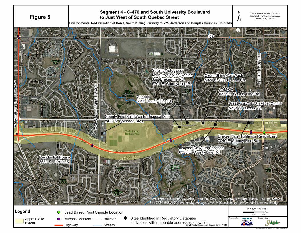
UNIVE
RSITY
BOUL
EVAR
D
COLO
RADO
BOU
LEVA
RD
QUEB
EC ST
REET
Residential House8531 S. Forrest St.
County Line Solid Waste Disposal Site8422 S. Colorado Blvd.
Conoco5653 County Line Pl.
Safelite Autoglass/My Auto Service Center/Just Brakesline Rd. 5701 E. County Line Pl.
Clean Shine Car Wash6028 E. County Line Rd.
AAMCO6328 E. County Line Rd.
Jim and Co. Auto Services6328 E. County Line Rd.
Brakes Plus Highlands Ranch East7040 E. County Line Rd.
Goodyear Auto Services Center8273 S. Quebec St.
Copyright:© 2013 Esri, DeLorme, NAVTEQ, TomTom, Source: Esri, DigitalGlobe, GeoEye, i-cubed,USDA, USGS, AEX, Getmapping, Aerogrid, IGN, IGP, swisstopo, and the GIS User Community
Prepared for: Prepared by:
LegendApprox. SiteExtent
Milepost MarkersHighway
RailroadStream
±
0 670 1,340Feet
1 in = 1,767.36 feet
Figure 5Segment 4 - C-470 and South University Boulevardto Just West of South Quebec Street
Environmental Re-Evaluation of C-470, South Kipling Parkway to I-25, Jefferson and Douglas Counties, Colorado
North American Datum 1983Universal Transverse Mercator
Zone 13 N, Meters
S:\Summit 2012\CDOT\Region_6\C470_Reassessment\GIS
Aerial Photo Courtesy of Google Earth, 7/1/13
UV105
Sites Identified in Redulatory Database (only sites with mappable addresses shown)
Lead Based Paint Sample Location

QUEB
EC ST
REET
Clean Shine Car Wash6028 E. County Line Rd.
YOSE
MITE
STR
EET
7-Eleven8750 S Yosemite St.
Fairway Collision Center8500 S Valley Highway
Crest Appartment Building10049/10051 Park Meadows Dr.
The Retreat at Park Meadows10200 Park Meadows Dr.
Copyright:© 2013 Esri, DeLorme, NAVTEQ, TomTom, Source: Esri, DigitalGlobe, GeoEye, i-cubed,USDA, USGS, AEX, Getmapping, Aerogrid, IGN, IGP, swisstopo, and the GIS User Community
Prepared for: Prepared by:
LegendApprox. SiteExtent
Milepost MarkersHighway
RailroadStream
±
0 540 1,080Feet
1 in = 1,416.67 feet
Figure 6 Segment 5 - C-470 and South Quebec Streetto the Intersection of C-470 and I-25
Environmental Re-Evaluation of C-470, South Kipling Parkway to I-25, Jefferson and Douglas Counties, Colorado
North American Datum 1983Universal Transverse Mercator
Zone 13 N, Meters
S:\Summit 2012\CDOT\Region_6\C470_Reassessment\GISAerial Photo Courtesy of Google Earth, 7/1/13
UV105
Sites Identified in Redulatory Database (only sites with mappable addresses shown)
Lead Based Paint Sample Location