have you heard of ishango? - museum of natural … ishango... · in north-kivu are among the most...
TRANSCRIPT

HAVE YOU HEARD OF
ISHANGO?

55
8
910
12
12
12
13
13
14
17
1818
19
19
20
Virunga National Park
Lake Edward
GEOGRAPHICAL CONTEXT
THE ISHANGO ARCHAEOLOGICAL SITE
Rock Layers (Stratigraphy)
Dating the Layers
Archaeological Remains
Human Remains
Who Lived in Ishango 25,000 Years Ago?
What was Life Like in Ishango?
Harpoons and Barbed Points
Quartz Tools
What Is It?
What’s So Special about It?
Theories
Counting Sticks
THE ISHANGO CARVED BONE
CONTENTS

Jean de Heinzelin on the bank of Lake Edward in 1950

12 3
4
GEOGRAPHICAL CONTEXT THE VIRUNGA NATIONAL PARK
Ishango, that’s a literary competition? The name of a small bone? An oratorio? A symbol of scientific research? It’s all of those things, but originally it was an African village!
Ishango is in the north-east of the Democratic Republic of Congo (formally known as Zaire), in the North-Kivu province, in the Virunga National Park (virunga.org). The park’s 790,000 hectares cover more than 13% of the province. The Virunga Park was created in 1925, making it the oldest protected park in Africa. Formally known as the Albert Park, it was created to protect mountain gorillas who were threatened by poachers in the twenties. This agree-ment also ensured that the park was protected from deforestation.
The park was classed as a UNESCO world heritage site in 1979, and was reclassified as ‘heritage in danger’ in 1994, because of the Rwandan genoci-de. The human population in the area suddenly increased due to the influx of refugees fleeing the conflict. They needed resources such as wood and game, and as a result, the ecosystems at the border of the park were thrown out of balance.
geographical context 5
The capital, Kinshasa
The Virunga National Park
North-Kivu
Political map of Africa:
1 Democratic Republic of Congo2 Republic of Congo3 Uganda4 Rwanda
Map of the Democratic Republic of Congo

The north-western region of Congo is one of a variety of landscapes, each more beautiful than the last. Dense fo-rests dominate the area but there are also savannahs and wetlands. Mountain ranges like the Virunga and Ruwen-zori mountains are over 5,000 metres high and surround equatorial glaciers.
The rugged landscape and altitudes of 800 to 5,109m (the highest point of the Ruwenzori mountains), give the North-Kivu province a very varied climate. It progresses from equatorial, to high altitude tropical, to alpine in the uppermost areas.
Mount Stanley with the Margherita Peak (5,109m) on the right and Alexandra Peak (5,091m) on the left.
On the Butuvu trail at an altitude of 2,600m above sea level The Margherita Peak glacier was climbed by Jean de Heinzelin (see below) and his team in 1952
Rich Biodiversity
6 geographical context
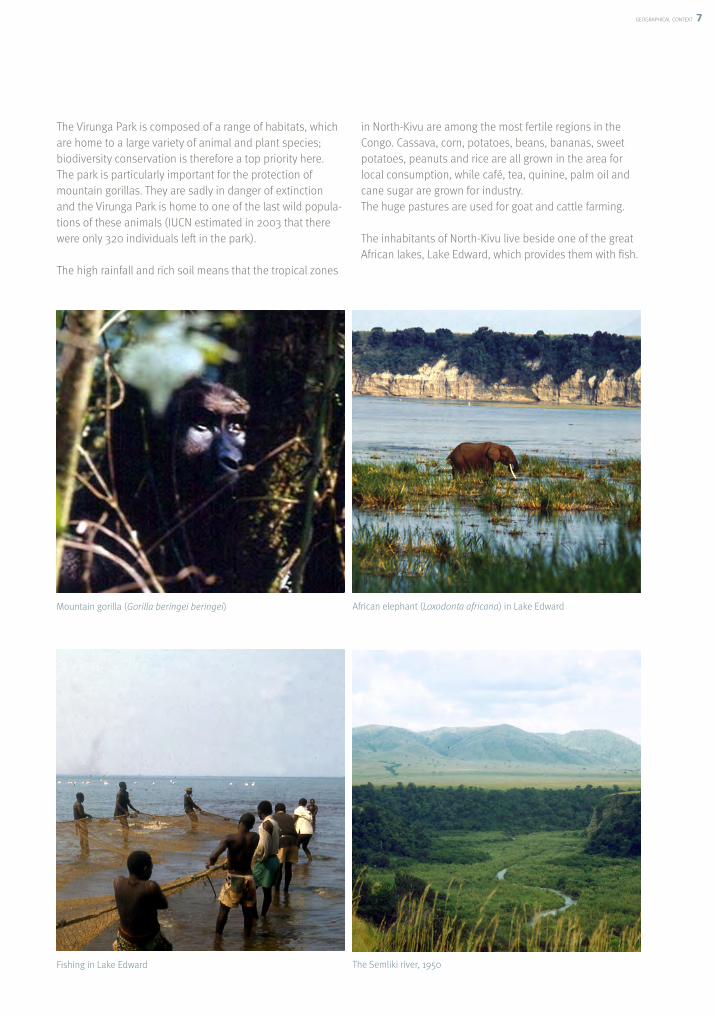
The Virunga Park is composed of a range of habitats, which are home to a large variety of animal and plant species; biodiversity conservation is therefore a top priority here. The park is particularly important for the protection of mountain gorillas. They are sadly in danger of extinction and the Virunga Park is home to one of the last wild popula-tions of these animals (IUCN estimated in 2003 that there were only 320 individuals left in the park).
The high rainfall and rich soil means that the tropical zones
in North-Kivu are among the most fertile regions in the Congo. Cassava, corn, potatoes, beans, bananas, sweet potatoes, peanuts and rice are all grown in the area for local consumption, while café, tea, quinine, palm oil and cane sugar are grown for industry.The huge pastures are used for goat and cattle farming.
The inhabitants of North-Kivu live beside one of the great African lakes, Lake Edward, which provides them with fish.
Mountain gorilla (Gorilla beringei beringei)
Fishing in Lake Edward
African elephant (Loxodonta africana) in Lake Edward
The Semliki river, 1950
geographical context 7

The lake EdwardLake Edward is the 15th biggest lake in Africa. It straddles the Ugandan and Congolese border in the Western Rift* Valley. It is fed by several rivers and flows northwards via the Semliki river where it eventually joins Lake Albert. This system, along with Lake Victoria, is the source of the White Nile.
The Congolese side of the lake is part of the Virunga National Park, and the Ugandan side is part of the Queen Elizabeth National Park.
8 geographical context
Lake Edward in NumbersLength: 77kmWidth: 40kmSurface Area: 2,150km²Altitude: 912m above sea levelMaximum Depth: 117mAverage Depth: 30m
A rift is formed when magma pushes up through the Earth’s crust (1), then retreats (2). The crust then collapses (3).This leaves behind a valley bordered by two mountain ranges.
Lake Edward
Lake George
Lake AlbertLake Kioga
Lake Victoria
Lake Kivu
Lake Tanganvika
Lake Malawi
1
2
3
Earth’s crust
Magma
�
�
�
*FORMATION OF A RIFT

the ishango archaeological site 9
The site was discovered in 1935 by Hubert Damas, a zoologist from Liège University, during one of several scien-tific research trips to what was then known as the Albert Park. While digging a hole for a survey he was doing as part of his observations, Damas came across the remains of ancient human activity: human bones and bone harpoon heads.
As the site was not relevant to his research, Damas did not explore it further, but mentioned his discovery in a publi-cation, stating that the area could be the target of a later in-depth expedition. This was to be carried out by Jean de Heinzelin during archaeological excavations that took place in 1950 and 1959.
IshangoKatanda
A close-up of the area around Lake Edward, of Ishango and Katanda (two major African archaeological zones)
Jean de Heinzelin (1920-1998) was a geologist at the Royal Belgian Institute of Natural Sciences from 1946 to 1985. He was also a professor at Brussels and Ghent universities. He specialized in geology and the archaeology of Palaeolithic Africa.
Lake Edward
Volcanoes Katwe
Lake George
DemocraticRepublic of Congo
Equator
0 50km
Mounts Rwenzori
Sem
liki
THE ISHANGO ARCHAEOLOGICAL SITEThe banks of Lake Edward are home to an important archaeological site, which was named after an ancient village that is close by.

10 the ishango archaeological site
The StratigraphyJean de Heinzelin was a geologist by trade, but was passi-onate about archaeology. At Ishango his aim was twofold: he wanted to learn more about the history of the lake and mankind. In order to do this he decided to dig a large slice out of the upper end of the lake shore.
In doing so he was able to observe and draw the different layers of sediment that had built up over time. This is known as stratigraphy.

the ishango archaeological site 11
1. Jean de Heinzelin proved that the water level of the lake was a lot higher in the past; it regularly flooded the green and blue parts of the diagram. Only the brown and black areas had never been submerged as the water level of the lake dropped after these later layers were deposited. They were laid down later on by runoff and human activity. A Bantu group had recently lived there; the two beige zones are the remains of a settlement, where poles had been driven into the soil.
2. There is also evidence of volcanic activity. This is linked to the nearby presence of the Katwe volcanic field (see the map on page 9). The black layer is made up of volcanic ash spread by recent inhabitants.
The blue layers are made of volcanic ash that was gradually deposited by the wind.
3. Humans had lived there during prehistoric times, because significant quantities of archaeological remains were collected in the majority of the layers. The oldest human settlements in Ishango are 25, 000 years old!
What did they find out?
Here is a simplified version of the cross-section diagram where each layer is illustrated by a different pattern. The stratigraphy was over 4m high and 23m long. The bottom overhung the lake by just less than 10m.

12 the ishango archaeological site
Dating the Layers
Archaeological Remains
The position of the stratigraphic layers tells us the order of events (relative dating).But in order to know the exact date of when they took place (absolute dating), physicochemical analyses must be carried out in the laboratory. At Ishango, carbon 14 dating has identified several layers that are over 20,000 years old, the oldest of which are 25,000 years old.
Human Remains At Ishango, there are thousands of remains. They include human and animal bones and bones made from quartz and bone. Most of them were found in the lower layers of the stratigraphy and are between 20,000 and 25,000 years old. The remains of prehistoric settlements have not been found.
So many human and animal bones, and that the man-made objects made from bone, have survived millen-nia because they did not have time to degrade, they were
fossilised quickly due to the volcanic ash present in the sediment environment. These mineralised bones are dark brown, which is very different from their original colour.
Approximately a hundred human bones were unearthed during Jean de Heinzelin’s excavations. These bones were spread out, came from several individuals and came from the ‘N.F.Pr.’ layer (the main fossil layer), which can be seen in cross-section diagram on page 11. No complete skeletons were found.
Generally speaking, archaeological remains are all the traces left by the presence of humankind in the past. That might mean human bones, abandoned objects or the ruins of a settlement. It could also be footsteps, rock carvings, food remains, or even a hole dug in the ground or material brought to the Ishango by humans such as the ash (shown in the black layer in the stratigraphy diagram of the of cross-section).
In order to date the stratigraphic events, we know that the upper layers of the cross-section were the last to
be deposited, and are therefore the most recent, while the deeper layers are older.
This allows us to date the discoveries found within the layers; an Antique helmet is more recent than a
prehistoric axe, but older than a mobile phone!
Human bones unearthed in1935, 1950 and 1959 (a complete adult human skeleton comprises 206 bones)

the ishango archaeological site 13
Who lived in Ishango 25,000 years ago?
How did the Ishangoans live?
The human bones found at Ishango are those of Homo sapiens sapiens. Very few Prehistoric bones belonging to anatomically modern humans have been discovered and this is why the Ishango bones are so scientifically important.
We interviewed the anthropologist Isabelle Crevecoeur to find out more about the remains:
Isabelle, where are the missing bones? Without a doubt they’re preserved somewhere in the soil at Ishango, because the entire site has not yet been excavated. Unless they’ve been swept into the lake, in which case they would be lost…
Is Ishango a graveyard, or did the bones end up there because of something else, were they washed up for example? The evidence shows that the bones hadn’t travelled far in water, nor been left in Ishango by predators; either of these scenarios would have led to damaged bones, but they are actually in very good condition. The excavation of the stratigraphy cross-section didn’t reveal graves either, so given what scientists currently
know (or don’t know!); I can’t answer your question with any certainty.
How many people were there?Approximately one hundred bones found at Ishango came from at least nine people: four adults, one teenager, two children and two babies. These few individuals only represent a fraction of the population, but the study of their bones provides us with general information about the Ishangoans’ appearance.
What were they like?The inhabitants of Ishango were humans from our species, but they had some archaic characteristics, in other words, they still had some of their ancestors’ features, so they were slightly different from humans nowadays.
The prehistoric inhabitants made use of the abundant resources on the banks of Lake Edward all year round. They did not have to travel long distances to find food or basic resources like the majority of people who lived further north, who were nomads who had to follow animal migrations. The Ishangoans, like all hunter-gatherer populations, really understood their environment; they only exploited a small area. Amongst the remains found were numerous fish bones, as well as those of mammals such as hippopotamus, warthog, otter, buffalo, and several species of antelope. Equally there were the remains of birds such as ibis, pelican and spoonbill. These bones show signs of having been cut up, indicating that these animals were eaten. There was something to suit every taste in terms of protein!
On the other hand, in terms of the plant material that was consumed, we do not know much: vegetables break down very quickly and rarely left traces that survive the course of time. Nevertheless, because of the grindstones found at the site, we can speculate that the biggest of them were used to grind wild grains.
What was the Ishangoan settlement like?
The abundant resources allow us to assume that the Ishangoans had a sedentary lifestyle based around the lake. This settlement has not yet been located so we do not know what it looked like or what it was made of.
14 the ishango archaeological site
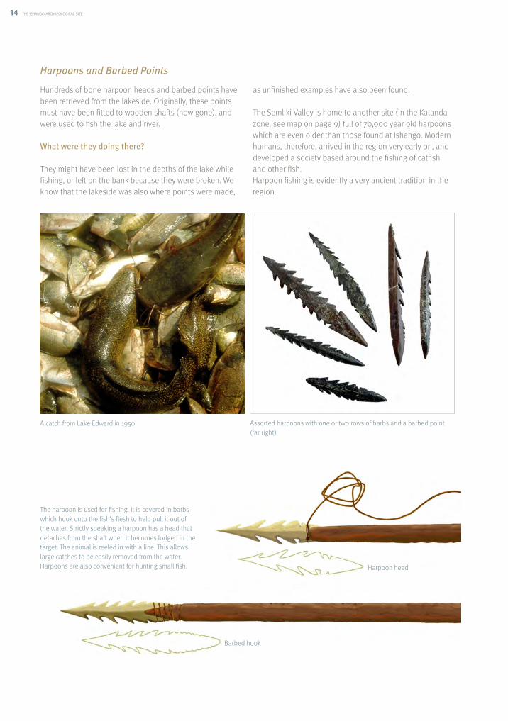
Harpoons and Barbed Points
Hundreds of bone harpoon heads and barbed points have been retrieved from the lakeside. Originally, these points must have been fitted to wooden shafts (now gone), and were used to fish the lake and river.
What were they doing there?
They might have been lost in the depths of the lake while fishing, or left on the bank because they were broken. We know that the lakeside was also where points were made,
as unfinished examples have also been found.
The Semliki Valley is home to another site (in the Katanda zone, see map on page 9) full of 70,000 year old harpoons which are even older than those found at Ishango. Modern humans, therefore, arrived in the region very early on, and developed a society based around the fishing of catfish and other fish.Harpoon fishing is evidently a very ancient tradition in the region.
A catch from Lake Edward in 1950 Assorted harpoons with one or two rows of barbs and a barbed point (far right)
The harpoon is used for fishing. It is covered in barbs which hook onto the fish’s flesh to help pull it out of the water. Strictly speaking a harpoon has a head that detaches from the shaft when it becomes lodged in the target. The animal is reeled in with a line. This allows large catches to be easily removed from the water. Harpoons are also convenient for hunting small fish. Harpoon head
Barbed hook

the ishango archaeological site 15
Making Barbed Points and Harpoons
The unfinished harpoons enable us to understand how they were made:
Stone polisher and sketch of stone harpoons.
1. A bone splinter was shaped by chipping it with a stone.
2. The splinter was then polished with a stone polisher made from abrasive rock to give it its streamlined shape.
3. The barbs were cut out of either side with the help of a quartz cutting tool.

16 the ishango archaeological site
Different types of harpoons have been found: they are testament to a technological evolution.
Les couches supérieures ne contenaient pas de harpons.
The points from the deepest layers are quite small and have lots of barbs on two sides. These objects show three possible fittings, which indicate that there were harpoons and barbed points.
The points that come from the ‘Main Fossil Layer’ (‘N.F.Pr.’) have fewer barbs, which allows for deeper incision. This is a technological advancement because the more spaced out they are, the better they catch fish. We can also observe longer versions, perhaps for a special purpose, such as larger catches. These points only show one kind of fitting, they were all detachable, and therefore like “true” harpoons.
The middle examples show a remarkable return to a techni-que that was used in Katanda: they got rid of a row of barbs. This meant that the hooks went deeper and caught prey better. We also find two types of fitting: detachable and fixed points.

the ishango archaeological site 17
The banks of Lake Edward also provided Ishangoans with lots of cut quartz material. This rock is present in a very hard translucent to pearly white crystal form. The quartz was used as the primary material for tool-making, cutting or scraping.
The Ishangoans must not have had to do much to unearth their primary material; rivers swept pebbles containing veins of quartz to the lake in abundance.
Quartz tools were used to make tools out of softer mate-rials such as bone (used in harpoon-making for example) and undoubtedly wood too, despite the fact that no wooden objects have been found to prove this theory.
These quartz shards could have been used while fitted to a handle or left unattached.
Quartz Tools
Quartz blade (enlarged) Chopper (stone tool) with cut edges (real size: 4.8cm)

18
18 the carved ishango bone
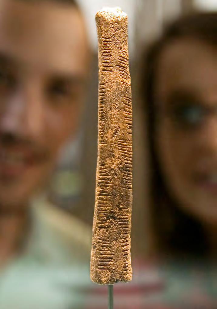
THE CARVED ISHANGO BONE WHAT IS IT?
Among the millions of objects discovered at Ishango by Jean de Heinzelin’s team, some are more interesting than others. One in particular has been in the spotlight and become a star of African archaeology- the carved Ishango bone.
It is known as ‘the Ishango Bone’.It is an object made from a piece of quartz and a bone handle. Its structure alone makes it a remarkable object, as there are very few surviving prehistoric composite tools. The very fine quartz at one end could have been used for precise work, such as the ritual scarification of skin, for example.The bone handle has been narrowed, scraped, polished and engraved, so we can no longer tell what kind of bone it is, although we do know it belonged to a mammal.
The four sides of the Ishango Bone with the quartz mounted to one end of the bone

19
the carved ishango bone 19
What is so interesting about it?
Hypotheses
The Ishango Bone’s handle is its claim to fame, because the decoration has been raising questions about its possi-ble meaning since its discovery. The handle is carved with 168 parallel marks. These lines are positioned in groups of parallel lines split into columns on three sides of the handle.
Jean de Heinzelin established the hypothesis that this group of lines represented numbers. In several historic periods it was common to write numbers using lines. From there Heinzelin looked for a possible mathematical connection to link these different numbers. What he found led him to believe that the bone was proof of advanced
mathematics, unprecedented for such an early period. Here are some observations and interpretations expressed by Jean de Heinzelin in his 1957 article on the Ishango site: Central ColumnThe central column shows a number and its double: three and six, four and eight, five and ten, and two numbers that do not fit this pattern (five and seven).
Right Column Right ColumnFrom this side the numbers could have a link with the number ten, a well-known number base. Therefore we have: 11 = 10 + 1 21 = 20 + 1 19 = 20 – 1 9 = 10 - 1
Left ColumnThe Ishangoans would have known that eleven, thirteen, seventeen and nineteen are the prime numbers between ten and twenty. A prime number is a number that can only be divided by two numbers: itself and one.
The 168 lines distributed on the 3 sides of the handle. To view them all simultaneously here is an “unrolled”
drawing of the bone.
The total number of lines in each column is a multiple of twelve. = 60 = 48 = 60

20
20 the carved ishango bone
-Other researchers have shared their interpretations of the marks:
The mathematicians Dirk Huylebrouk and Vladimir Pletser looked into Jean de Heinzelin’s ideas about number notation, and came to the conclusion that the bone was a kind of sliding scale which involved variations of the three and four base numbers, and by extension of base number twelve (3x4). However, they concluded that there was not enough proof to confirm an understanding of prime numbers.
Alexander Marshack, a Harvard archaeologist, also believes it is a system of number notation, but one which is related to the lunar calendar.
Olivier Keller, another mathematician, cautions against the temptation to project our modern culture of viewing numbers everywhere onto the bone. In his opinion, it is a habit that prevents the viewer from noticing other forms of symbols, those which are present in a range of media (on bones, stones and cave art) from the Upper Palaeolithic era and which also deserve a thorough investigation.
Interesting isn’t it? Especially when you keep in mind that it’s 25,000 years old…
If one day one of the mathematical hypotheses is confir-med, it means that Palaeolithic humans already had a well-developed understanding of mathematics. This raises yet more questions: what did they use it for? Why did they mix several calculation bases? Was this knowledge shared among all of them? Was it used by fishermen?
Even today, the Ishango site still has not revealed all of its secrets; the Semliki Valley still hides other prehistoric sites. This region of Africa has been inhabited by Homo sapiens sapiens for at least 100,000 years. We still lack a lot of information to truly understand the ancient Ishangoans’ lifestyle, settlement and way of thinking.
Therefore, sooner or later, archaeologists must return to the banks of Lake Edward to complete the puzzle that was started in the fifties. No doubt, the missing pieces are still hidden in the ground…
‘Counting Sticks’ in GeneralSo-called prehistoric “notched sticks” made from bone, ivory or antler are not rare, they have been found around the world.The notches are generally thought to be marks represen-ting counting by pairing*; the mark could symbolize an object, a day or a person; the invention of numbers was not necessary as they could count by associating a mark with an entity (like those above).
The use of this kind of stick continues among those who have not learned to count. Until recently, in Europe shepherds who could not count used counting sticks to calculate the number of sheep in their flocks. They made a mark for every animal taken to pasture, and then had to
gather as many sheep as there was marks.This very simple tool is well-known and there is a whole range of similar ancient items.
*in this case, the paring of an entity with the line it represents

credits 21
Created By: Association pour la Diffusion de l’Information archéologique (ADIA)
Royal Belgian Institute of Natural Sciences (RBINS)29 Vautier Street, 1000 Brussels
Contact: [email protected]
Created as part of the RBINS research project “Creation of a platform for digitalisation and interactive research, priori-tising the dissemination of scientific knowledge among Bruxelles-Capitale universities and museums , with a focus on the Ishango collection, of which the bone has become the symbol of science and research in the Bruxelles-Capitale region” subsidised by the Bruxelles-Capitale region.
Cover© RBINS
p. 2© Thierry Hubin /RBINS
p. 3© RBINS
p. 6© Albert Backer
p. 6© RBINS
p. 6© RBINS
p. 7© Robert Six
p. 7© RBINS
p. 7© RBINS
p. 7© RBINS
p. 8© RBINS
p. 9© Thierry Hubin /RBINS
p. 10© RBINS
p. 10© RBINS
p. 12© RBINS
p. 12© RBINS
p. 13© Aude van Driessche / RBINS
p. 14© RBINS
p. 14© RBINS
p. 15© RBINS
p. 15© RBINS
p. 17© RBINS
p. 17© RBINS
p. 18© RBINS