harrison street/oakland avenue community …
TRANSCRIPT
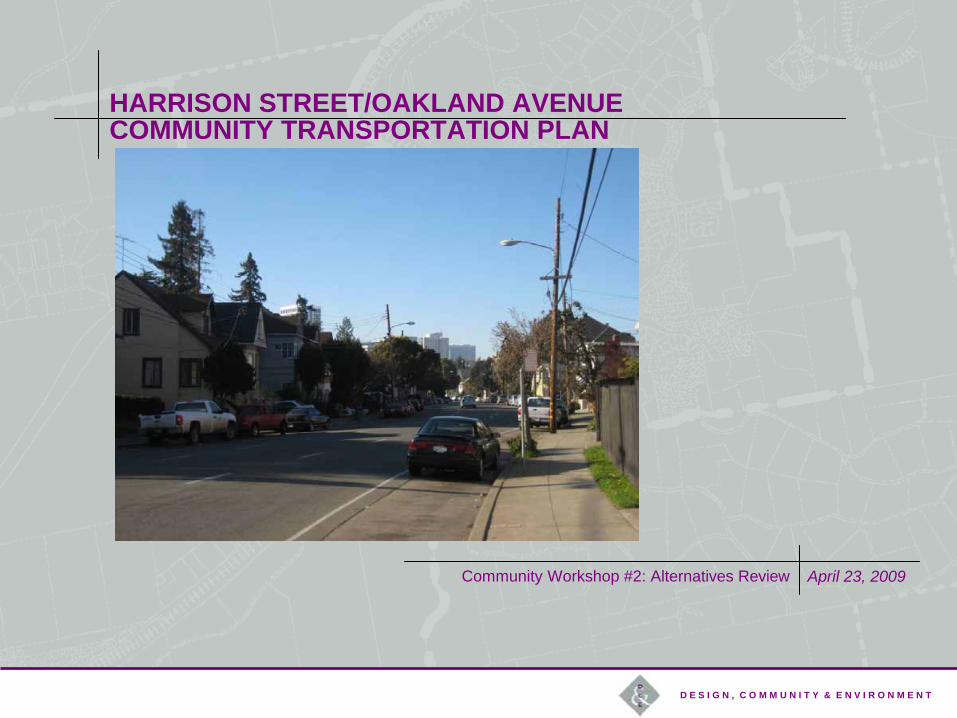
Community Workshop #2: Alternatives Review April 23, 2009
D E S I G N , C O M M U N I T Y & E N V I R O N M E N T
HARRISON STREET/OAKLAND AVENUE COMMUNITY TRANSPORTATION PLAN
Key Project Staff:
Alisa Shen, Project Manager, Christina Ferracane, Planner, City of Oakland Strategic Planning Division
Project Technical Advisory Committee (TAC) Members
Project Community Steering Committee (CSC) Members
Bruce Brubaker, John Hykes & Sadie Mitchell of DC&E, Design Consultants and Landscape Architects
Kamala Parks, Dowling Associates, Traffic Analysis
HARRISON STREET/OAKLAND AVENUE COMMUNITY TRANSPORTATION PLAN
INTRODUCTIONS
PROJECT OVERVIEW
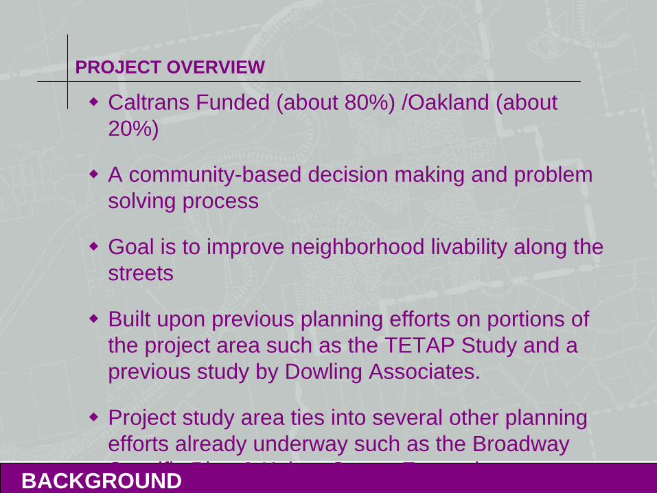
Caltrans Funded (about 80%) /Oakland (about 20%)
A community-based decision making and problem solving process
Goal is to improve neighborhood livability along the streets
Built upon previous planning efforts on portions of the project area such as the TETAP Study and a previous study by Dowling Associates.
Project study area ties into several other planning efforts already underway such as the Broadway Specific Plan & Kaiser Center Expansion. BACKGROUND
PROJECT OVERVIEW
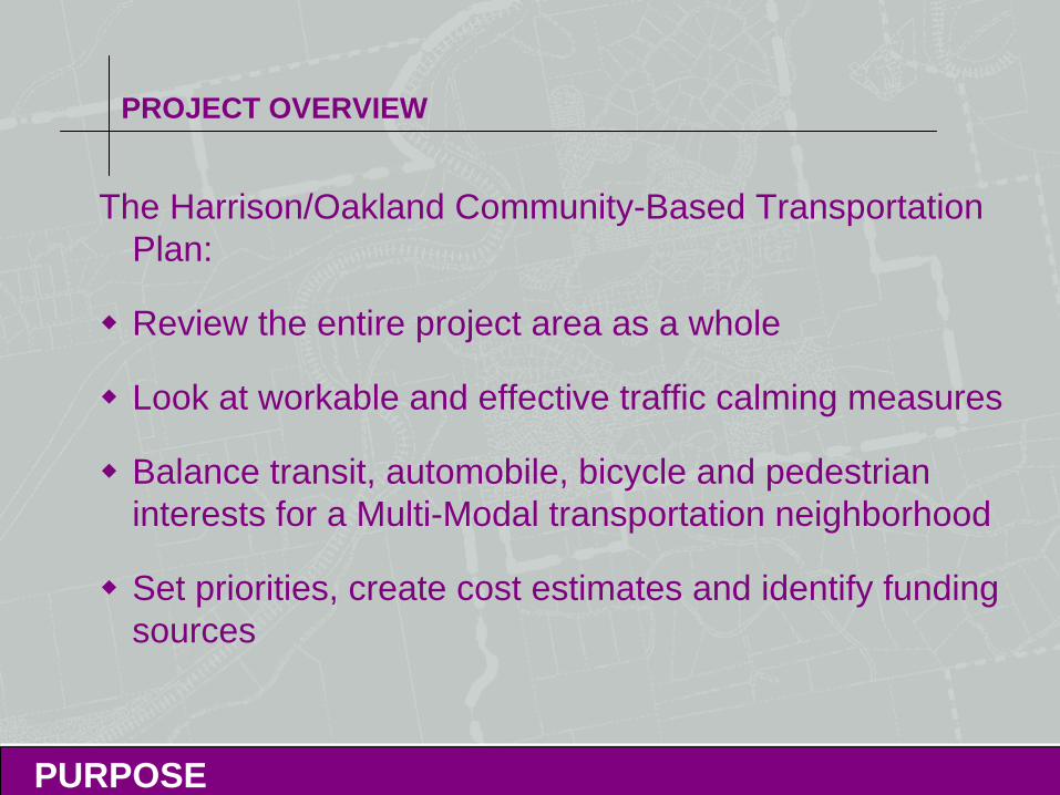
The Harrison/Oakland Community-Based Transportation Plan:
Review the entire project area as a whole
Look at workable and effective traffic calming measures
Balance transit, automobile, bicycle and pedestrian interests for a Multi-Modal transportation neighborhood
Set priorities, create cost estimates and identify funding sources
PURPOSE
PROJECT OVERVIEW
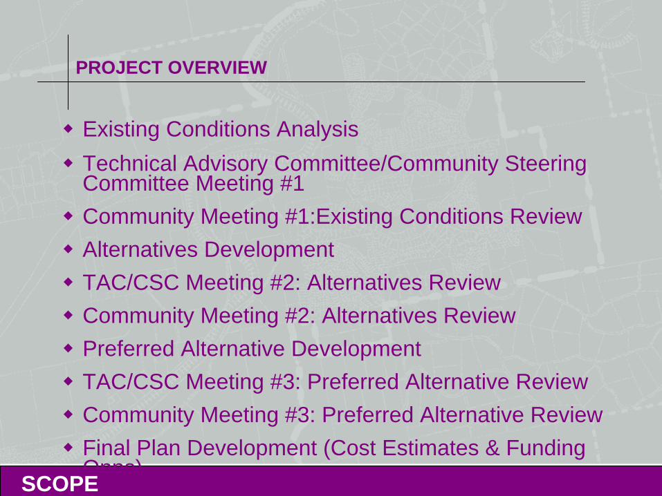
Existing Conditions AnalysisTechnical Advisory Committee/Community Steering Committee Meeting #1Community Meeting #1:Existing Conditions Review Alternatives DevelopmentTAC/CSC Meeting #2: Alternatives ReviewCommunity Meeting #2: Alternatives ReviewPreferred Alternative DevelopmentTAC/CSC Meeting #3: Preferred Alternative ReviewCommunity Meeting #3: Preferred Alternative ReviewFinal Plan Development (Cost Estimates & Funding Opps)
SCOPE
WORKSHOP #2: ALTERNATIVES REVIEW
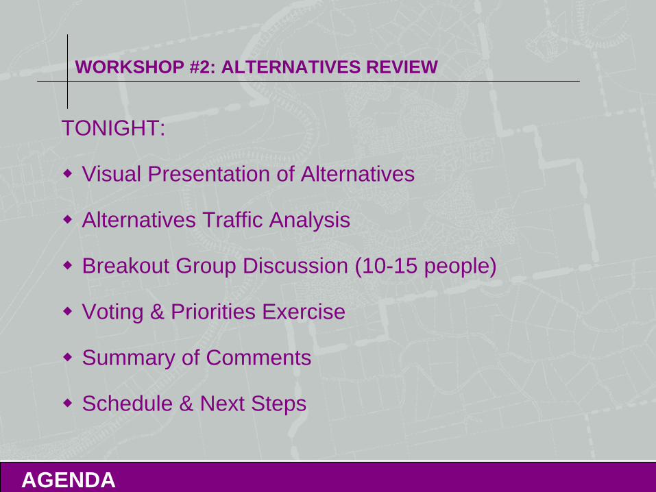
TONIGHT:
Visual Presentation of Alternatives
Alternatives Traffic Analysis
Breakout Group Discussion (10-15 people)
Voting & Priorities Exercise
Summary of Comments
Schedule & Next Steps
AGENDA
PROJECT AREA OVERVIEW
EXISTING CONDITIONS
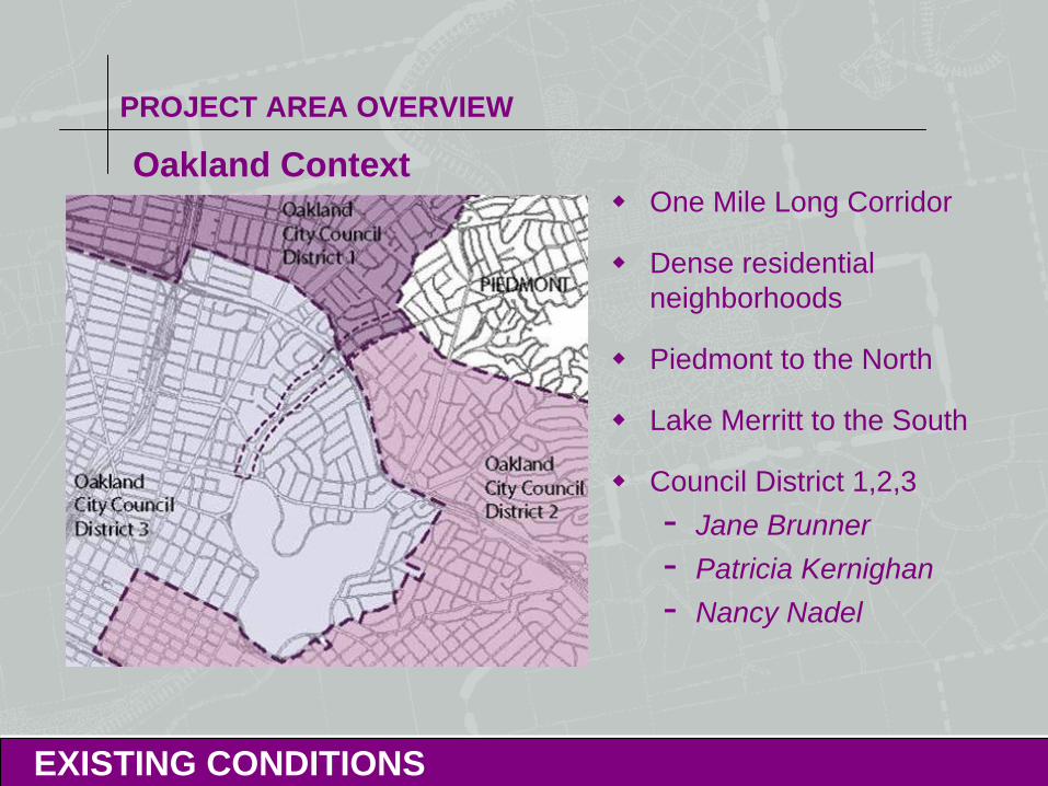
Oakland ContextOne Mile Long Corridor
Dense residential neighborhoods
Piedmont to the North
Lake Merritt to the South
Council District 1,2,3- Jane Brunner- Patricia Kernighan- Nancy Nadel
PROJECT AREA OVERVIEW
EXISTING CONDITIONS
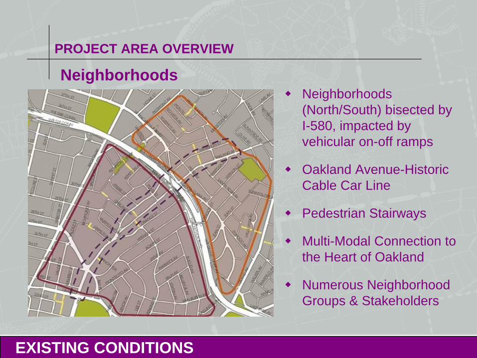
NeighborhoodsNeighborhoods (North/South) bisected by I-580, impacted by vehicular on-off ramps
Oakland Avenue-Historic Cable Car Line
Pedestrian Stairways
Multi-Modal Connection to the Heart of Oakland
Numerous Neighborhood Groups & Stakeholders
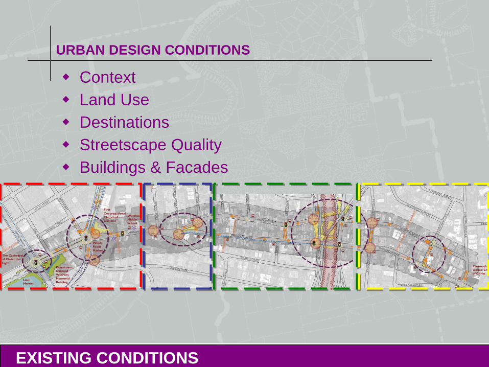
URBAN DESIGN CONDITIONS
EXISTING CONDITIONS
ContextLand UseDestinationsStreetscape QualityBuildings & Facades
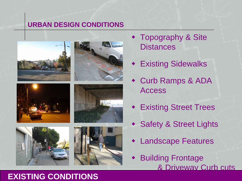
URBAN DESIGN CONDITIONS
EXISTING CONDITIONS
Topography & Site Distances
Existing Sidewalks
Curb Ramps & ADA Access
Existing Street Trees
Safety & Street Lights
Landscape Features
Building Frontage& Driveway Curb cuts
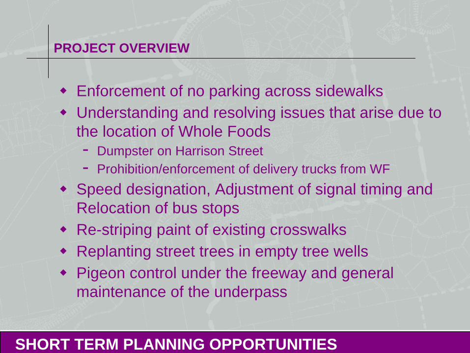
PROJECT OVERVIEW
SHORT TERM PLANNING OPPORTUNITIES
Enforcement of no parking across sidewalksUnderstanding and resolving issues that arise due to the location of Whole Foods- Dumpster on Harrison Street- Prohibition/enforcement of delivery trucks from WF
Speed designation, Adjustment of signal timing and Relocation of bus stopsRe-striping paint of existing crosswalksReplanting street trees in empty tree wellsPigeon control under the freeway and general maintenance of the underpass
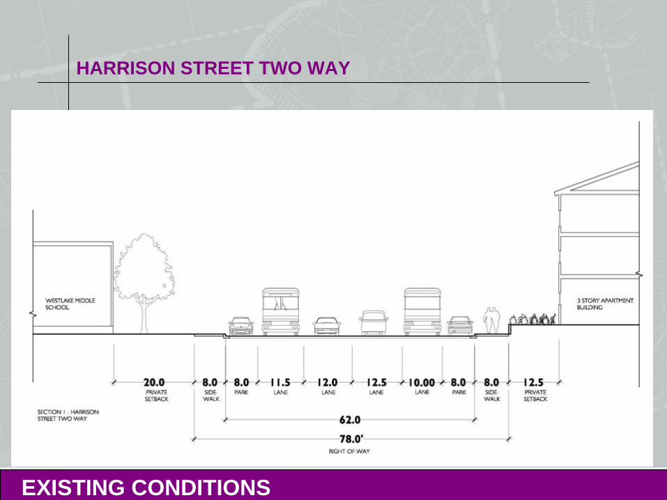
HARRISON STREET TWO WAY
EXISTING CONDITIONS
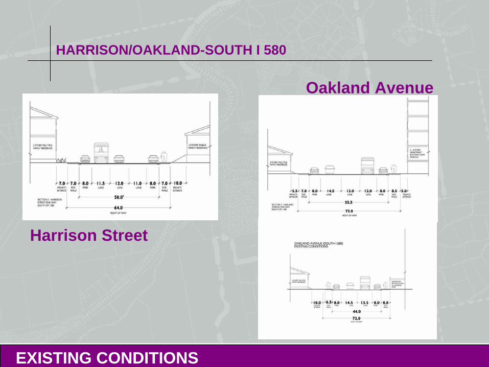
HARRISON/OAKLAND-SOUTH I 580
EXISTING CONDITIONS
Harrison Street
Oakland Avenue
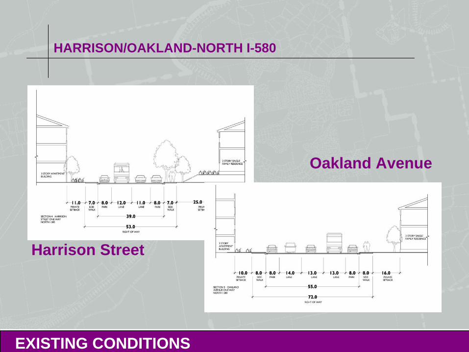
HARRISON/OAKLAND-NORTH I-580
EXISTING CONDITIONS
Harrison Street
Oakland Avenue
EXISTING CONDITIONS
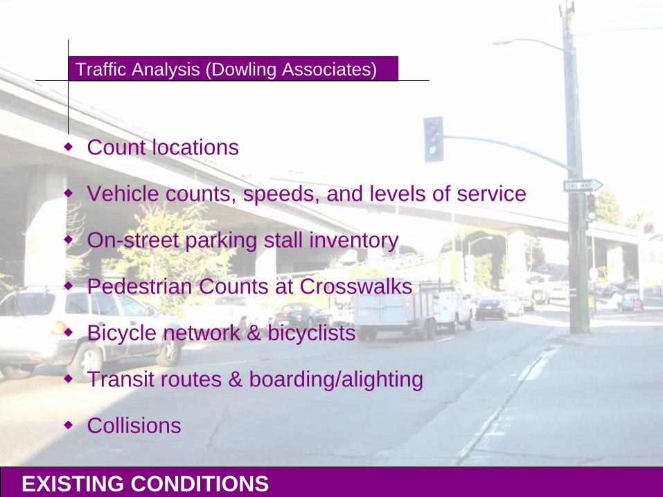
Traffic Analysis (Dowling Associates)
Count locations
Vehicle counts, speeds, and levels of service
On-street parking stall inventory
Pedestrian Counts at Crosswalks
Bicycle network & bicyclists
Transit routes & boarding/alighting
Collisions
ALTERNATIVES IN-BRIEF
MULTI-MODAL TRANSPORTATION DESIGN
Harrison Street & Oakland Avenueprimarily residential uses with a mix of
institutional and commercial usesAll modes of travel must be considered- Pedestrians (ADA Issues)- Bicyclists- Buses- Vehicles
Maintain Connectivity throughout CityImpact to Economic Vitality of the Downtown CoreOakland Designated as a Transit-first City
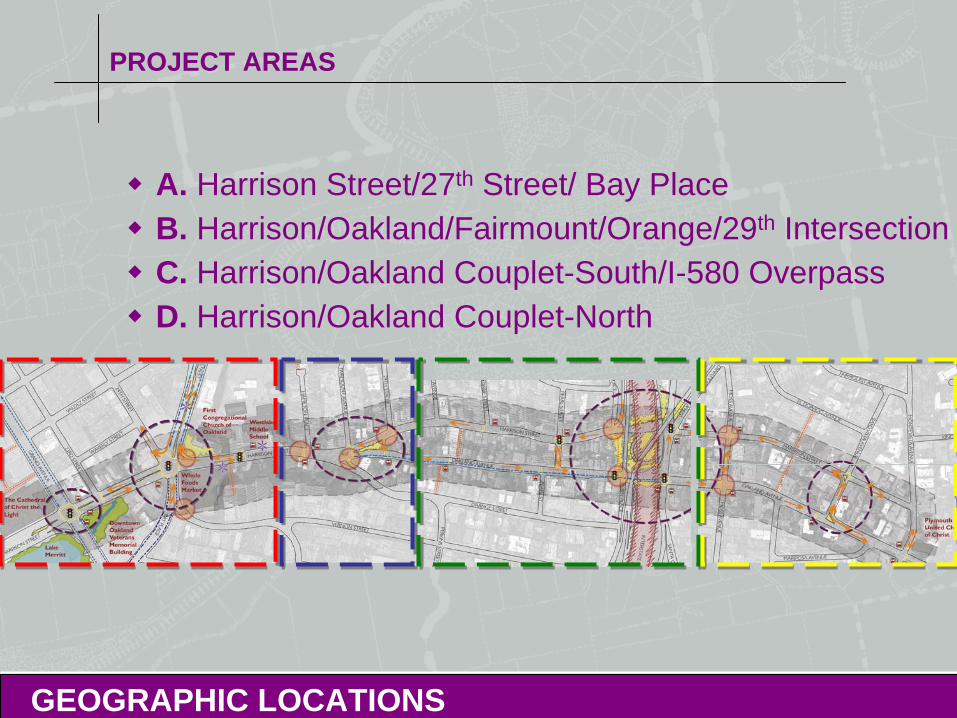
PROJECT AREAS
A. Harrison Street/27th Street/ Bay Place B. Harrison/Oakland/Fairmount/Orange/29th IntersectionC. Harrison/Oakland Couplet-South/I-580 OverpassD. Harrison/Oakland Couplet-North
GEOGRAPHIC LOCATIONS
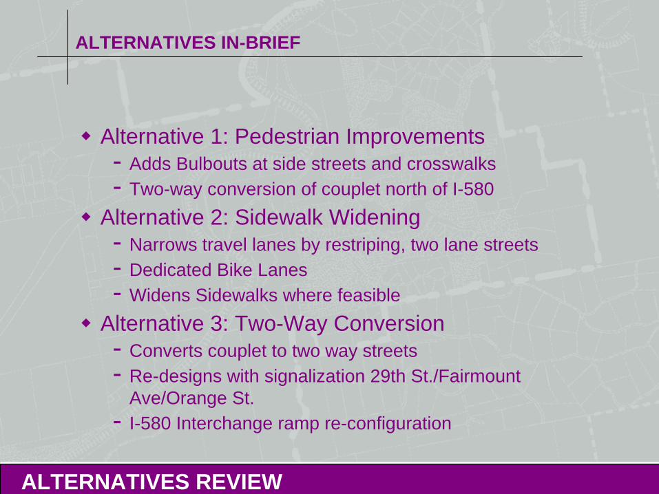
ALTERNATIVES IN-BRIEF
Alternative 1: Pedestrian Improvements- Adds Bulbouts at side streets and crosswalks- Two-way conversion of couplet north of I-580
Alternative 2: Sidewalk Widening- Narrows travel lanes by restriping, two lane streets- Dedicated Bike Lanes- Widens Sidewalks where feasible
Alternative 3: Two-Way Conversion- Converts couplet to two way streets- Re-designs with signalization 29th St./Fairmount
Ave/Orange St.- I-580 Interchange ramp re-configuration
ALTERNATIVES REVIEW
ALTERNATIVES IN-BRIEF
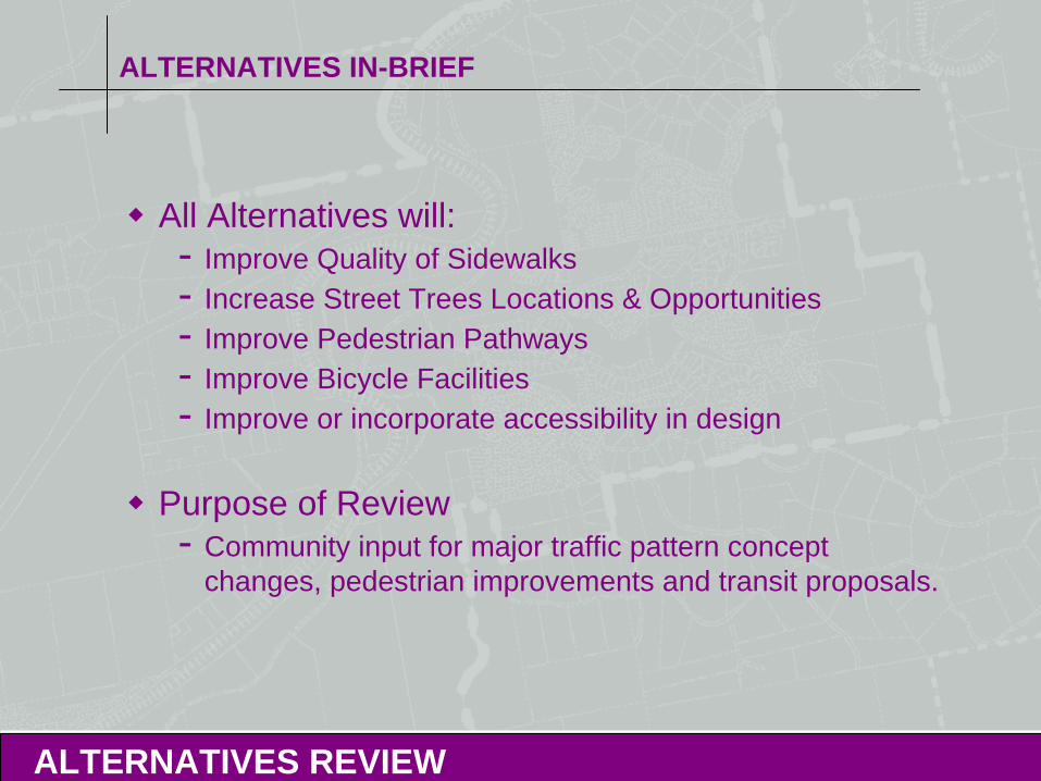
All Alternatives will:- Improve Quality of Sidewalks- Increase Street Trees Locations & Opportunities- Improve Pedestrian Pathways- Improve Bicycle Facilities - Improve or incorporate accessibility in design
Purpose of Review- Community input for major traffic pattern concept
changes, pedestrian improvements and transit proposals.
ALTERNATIVES REVIEW
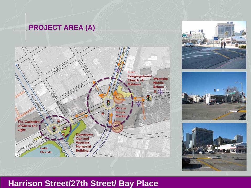
PROJECT AREA (A)
Harrison Street/27th Street/ Bay Place
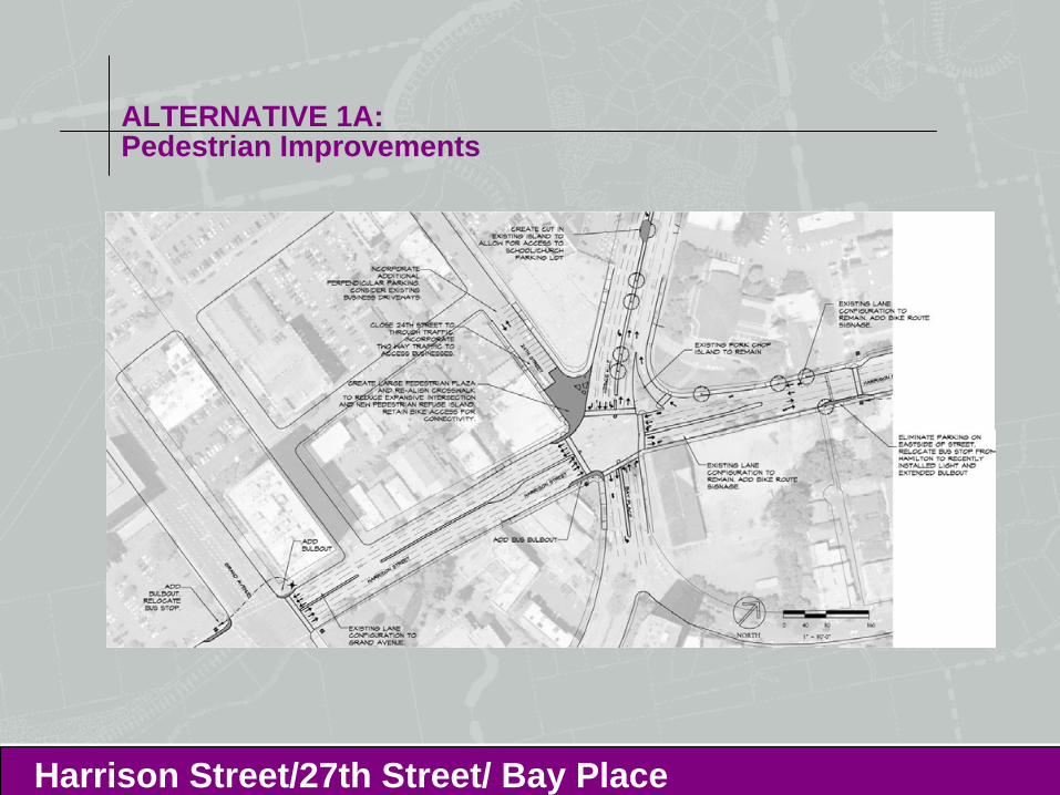
ALTERNATIVE 1A:Pedestrian Improvements
Harrison Street/27th Street/ Bay Place
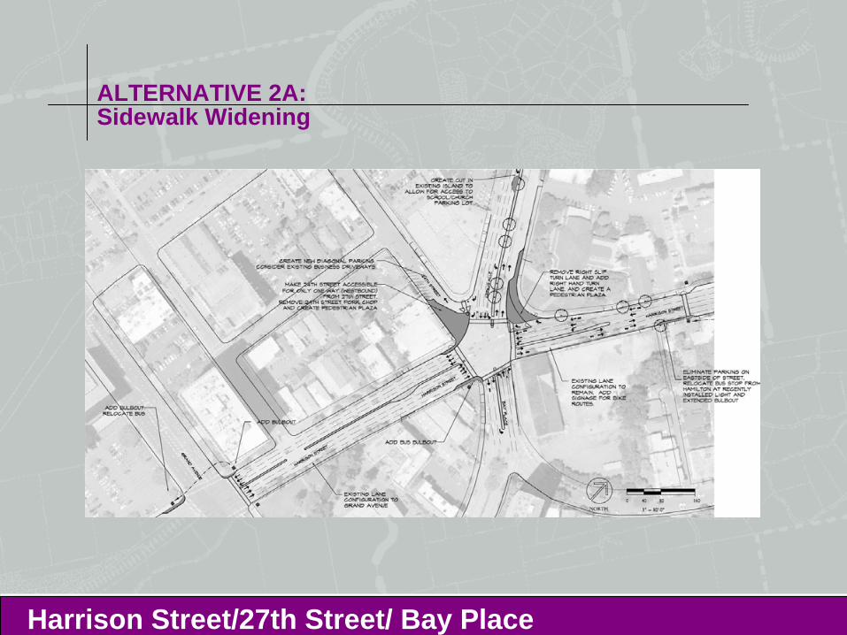
ALTERNATIVE 2A:Sidewalk Widening
Harrison Street/27th Street/ Bay Place
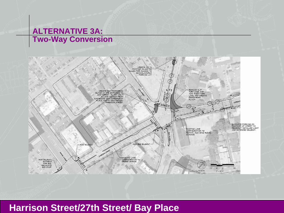
ALTERNATIVE 3A:Two-Way Conversion
Harrison Street/27th Street/ Bay Place
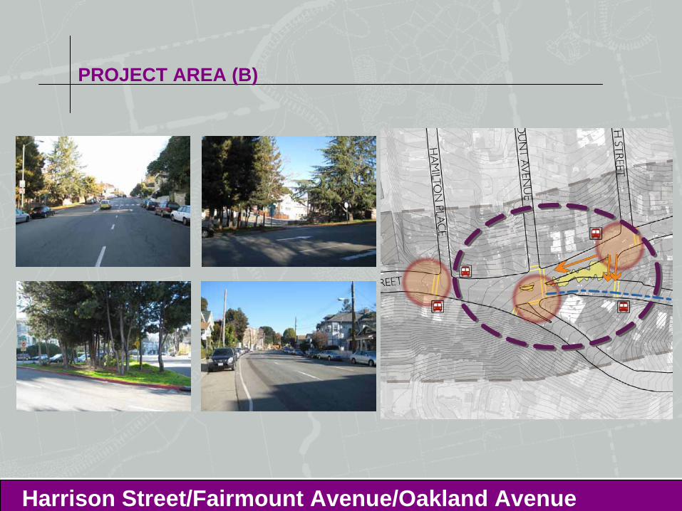
PROJECT AREA (B)
Harrison Street/Fairmount Avenue/Oakland Avenue
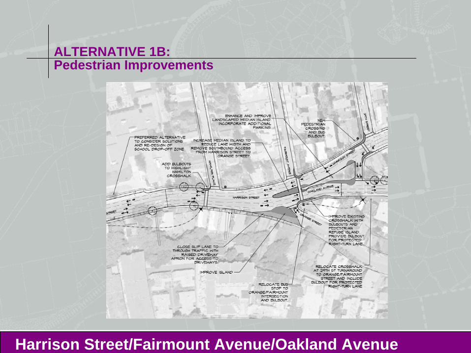
ALTERNATIVE 1B: Pedestrian Improvements
Harrison Street/Fairmount Avenue/Oakland Avenue
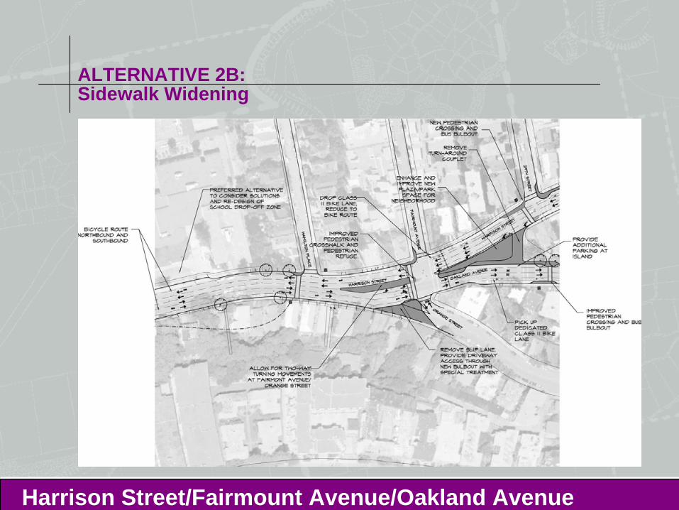
ALTERNATIVE 2B: Sidewalk Widening
Harrison Street/Fairmount Avenue/Oakland Avenue
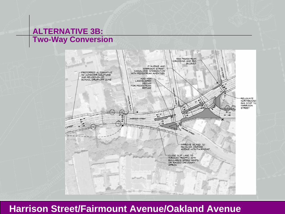
ALTERNATIVE 3B: Two-Way Conversion
Harrison Street/Fairmount Avenue/Oakland Avenue
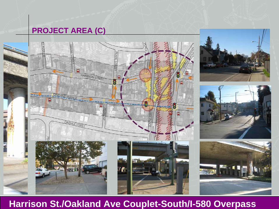
PROJECT AREA (C)
Harrison St./Oakland Ave Couplet-South/I-580 Overpass
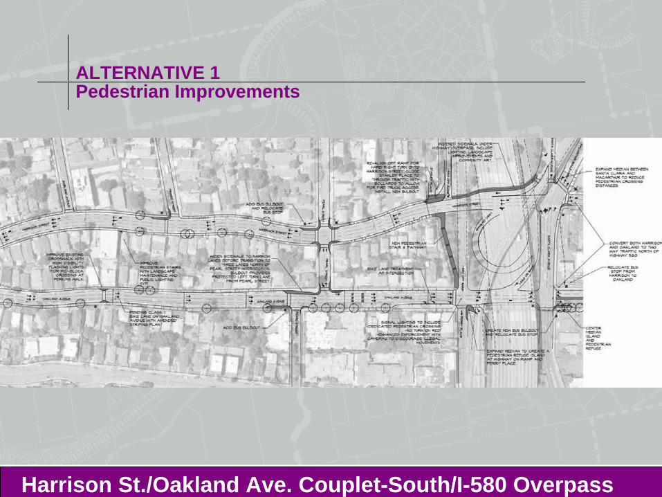
ALTERNATIVE 1Pedestrian Improvements
Harrison St./Oakland Ave. Couplet-South/I-580 Overpass
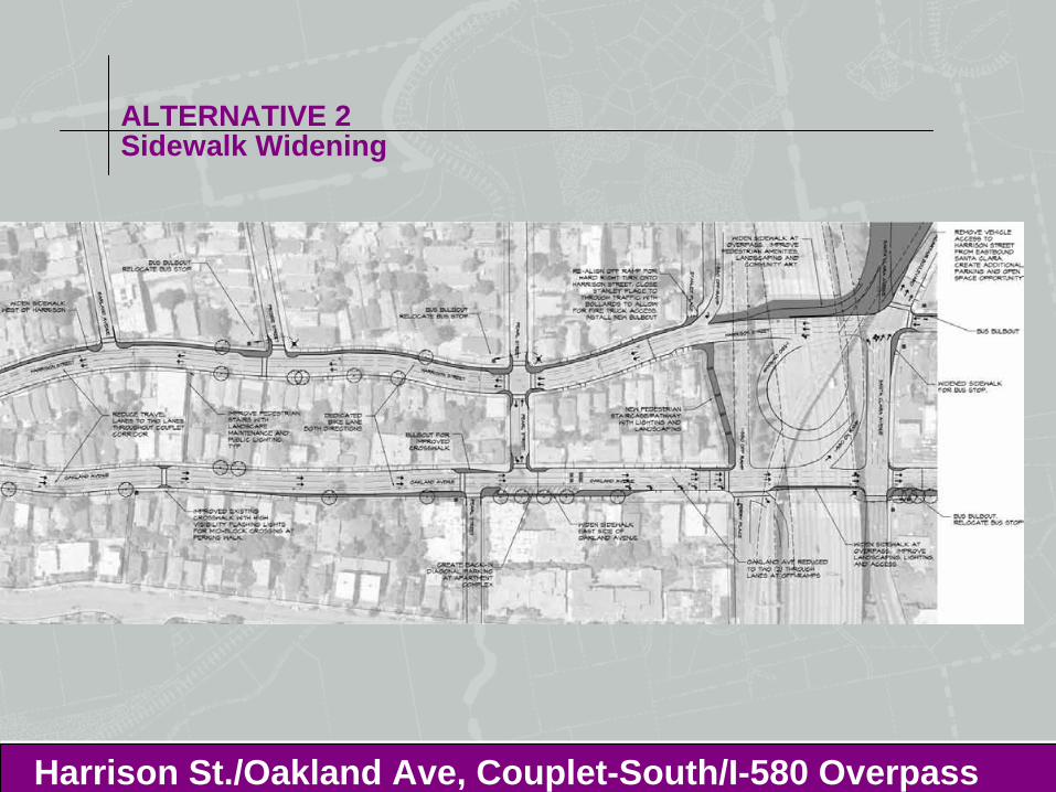
ALTERNATIVE 2Sidewalk Widening
Harrison St./Oakland Ave, Couplet-South/I-580 Overpass
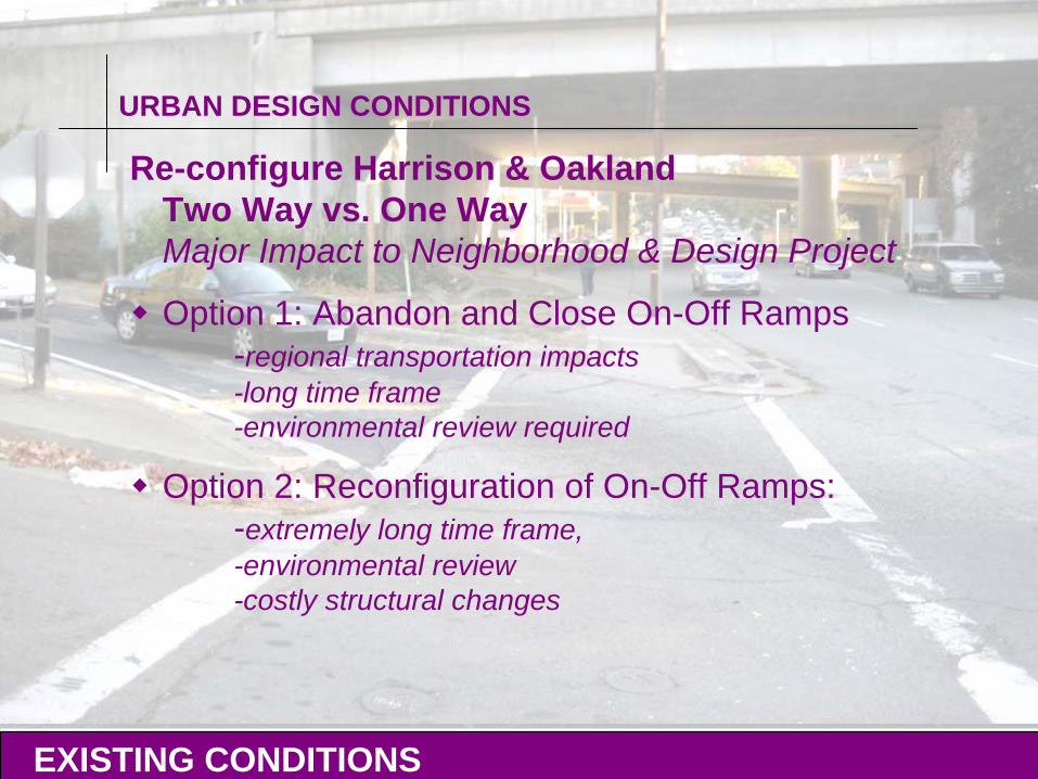
URBAN DESIGN CONDITIONS
Re-configure Harrison & Oakland Two Way vs. One Way Major Impact to Neighborhood & Design Project
Option 1: Abandon and Close On-Off Ramps-regional transportation impacts-long time frame-environmental review required
Option 2: Reconfiguration of On-Off Ramps:-extremely long time frame, -environmental review -costly structural changes
EXISTING CONDITIONS
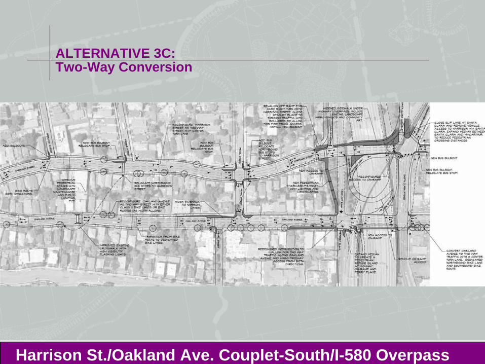
ALTERNATIVE 3C:Two-Way Conversion
Harrison St./Oakland Ave. Couplet-South/I-580 Overpass
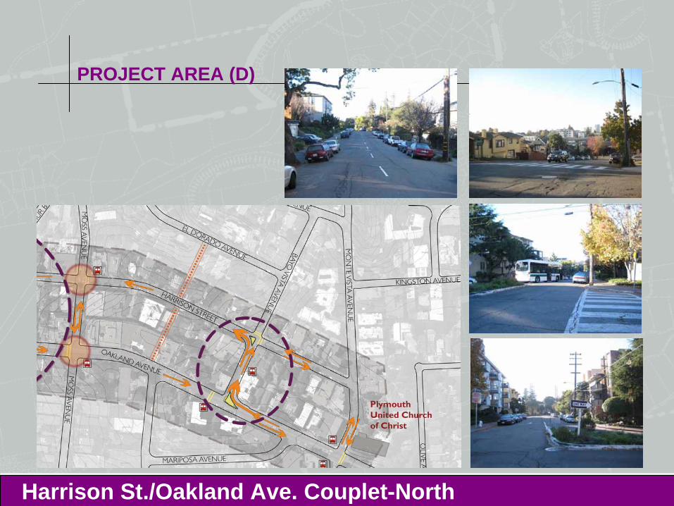
PROJECT AREA (D)
Harrison St./Oakland Ave. Couplet-North
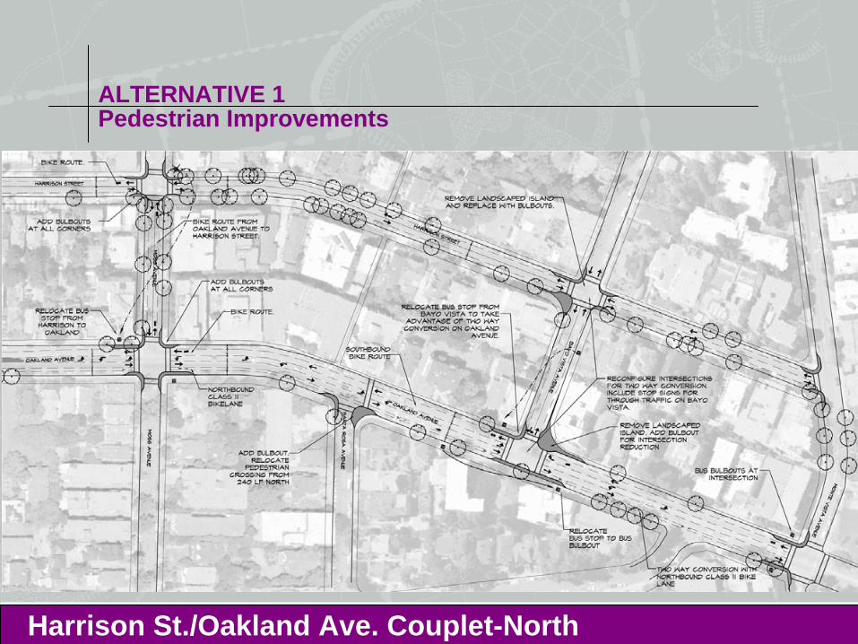
ALTERNATIVE 1Pedestrian Improvements
Harrison St./Oakland Ave. Couplet-North
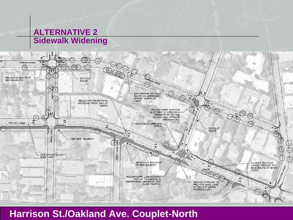
ALTERNATIVE 2Sidewalk Widening
Harrison St./Oakland Ave. Couplet-North
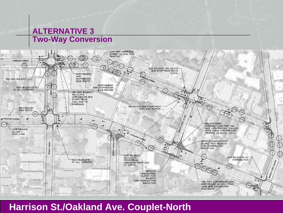
ALTERNATIVE 3Two-Way Conversion
Harrison St./Oakland Ave. Couplet-North
ALTERNATIVES ANALYSIS
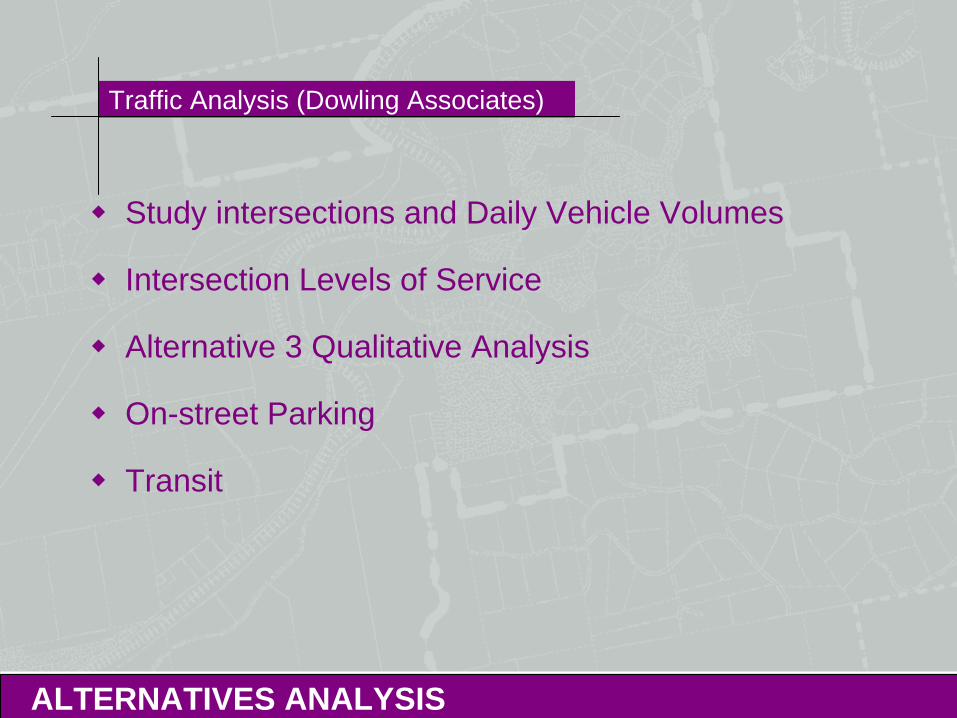
Traffic Analysis (Dowling Associates)
Study intersections and Daily Vehicle Volumes
Intersection Levels of Service
Alternative 3 Qualitative Analysis
On-street Parking
Transit
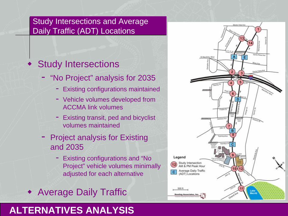
Study Intersections and Average Daily Traffic (ADT) Locations
ALTERNATIVES ANALYSIS
Study Intersections- “No Project” analysis for 2035
- Existing configurations maintained- Vehicle volumes developed from
ACCMA link volumes- Existing transit, ped and bicyclist
volumes maintained
- Project analysis for Existing and 2035
- Existing configurations and “No Project” vehicle volumes minimally adjusted for each alternative
Average Daily Traffic
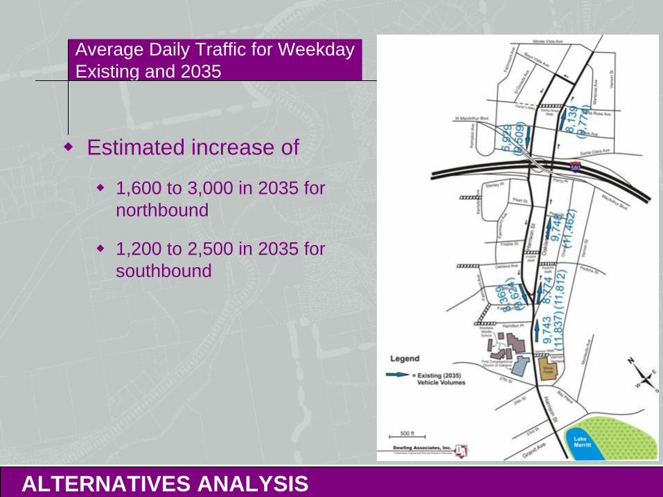
Average Daily Traffic for Weekday Existing and 2035
ALTERNATIVES ANALYSIS
Estimated increase of
1,600 to 3,000 in 2035 for northbound
1,200 to 2,500 in 2035 for southbound
Alternatives Analysis
ALTERNATIVES ANALYSIS
Project Alternatives 1 and 2 analyzed in detail
Project Alternative 3 qualitatively assessed
Intersection analysis of all three alternatives at:
Harrison St & 27th St/ 24th St/ Bay Pl
Vernon St & Bay Pl
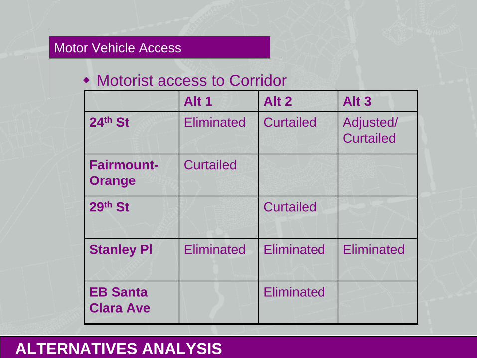
Motor Vehicle Access
ALTERNATIVES ANALYSIS
Motorist access to CorridorAlt 1 Alt 2 Alt 3
24th St Eliminated Curtailed Adjusted/ Curtailed
Fairmount- Orange
Curtailed
29th St Curtailed
Stanley Pl Eliminated Eliminated Eliminated
EB Santa Clara Ave
Eliminated
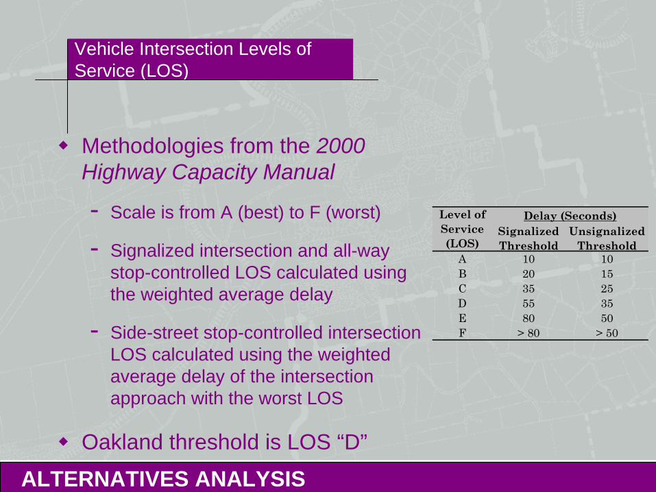
Vehicle Intersection Levels of Service (LOS)
ALTERNATIVES ANALYSIS
Methodologies from the 2000 Highway Capacity Manual
- Scale is from A (best) to F (worst)
- Signalized intersection and all-way stop-controlled LOS calculated using the weighted average delay
- Side-street stop-controlled intersection LOS calculated using the weighted average delay of the intersection approach with the worst LOS
Oakland threshold is LOS “D”
Signalized Threshold
Unsignalized Threshold
A 10 10B 20 15C 35 25D 55 35E 80 50F > 80 > 50
Level of Service(LOS)
Delay (Seconds)
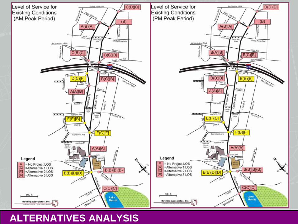
Existing Intersection LOS: Substandard Operations
ALTERNATIVES ANALYSIS
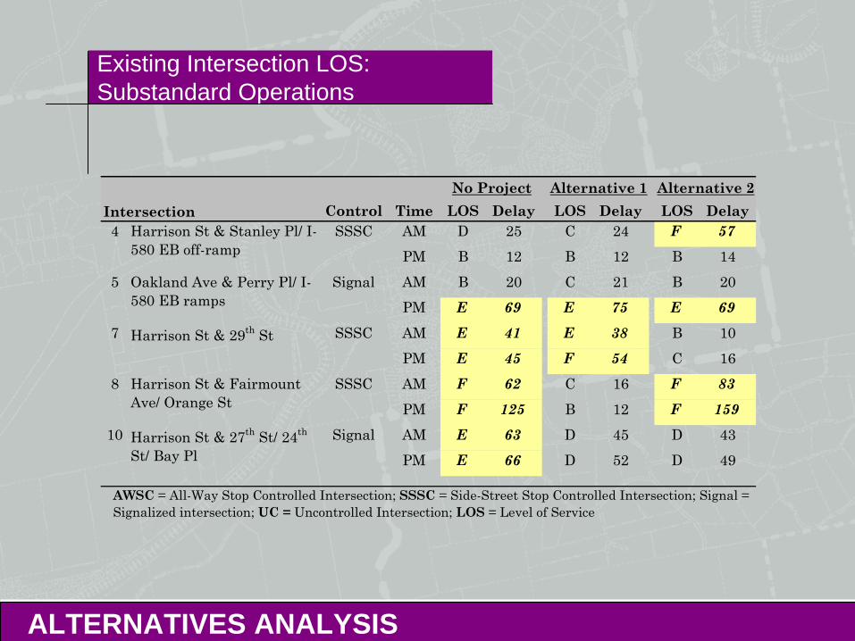
Existing Intersection LOS: Substandard Operations
ALTERNATIVES ANALYSIS
Control Time LOS Delay LOS Delay LOS Delay4 AM D 25 C 24 F 57
PM B 12 B 12 B 145 AM B 20 C 21 B 20
PM E 69 E 75 E 697 AM E 41 E 38 B 10
PM E 45 F 54 C 168 AM F 62 C 16 F 83
PM F 125 B 12 F 15910 AM E 63 D 45 D 43
PM E 66 D 52 D 49
Harrison St & Stanley Pl/ I-580 EB off-ramp
Oakland Ave & Perry Pl/ I-580 EB ramps
Harrison St & 29th St
Harrison St & Fairmount Ave/ Orange St
Harrison St & 27th St/ 24th
St/ Bay Pl
Intersection
Signal
SSSC
AWSC = All-Way Stop Controlled Intersection; SSSC = Side-Street Stop Controlled Intersection; Signal = Signalized intersection; UC = Uncontrolled Intersection; LOS = Level of Service
No Project Alternative 1 Alternative 2
SSSC
Signal
SSSC
Existing Intersection LOS: Substandard Operations
ALTERNATIVES ANALYSIS
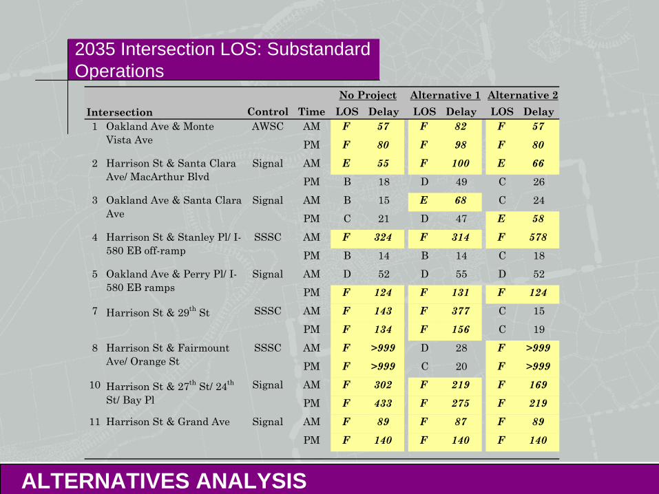
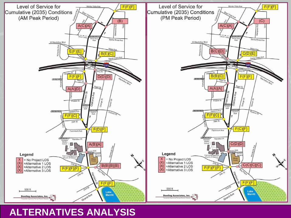
2035 Intersection LOS: Substandard Operations
ALTERNATIVES ANALYSIS
Control Time LOS Delay LOS Delay LOS Delay1 AM F 57 F 82 F 57
PM F 80 F 98 F 802 AM E 55 F 100 E 66
PM B 18 D 49 C 263 AM B 15 E 68 C 24
PM C 21 D 47 E 584 AM F 324 F 314 F 578
PM B 14 B 14 C 185 AM D 52 D 55 D 52
PM F 124 F 131 F 1247 AM F 143 F 377 C 15
PM F 134 F 156 C 198 AM F >999 D 28 F >999
PM F >999 C 20 F >99910 AM F 302 F 219 F 169
PM F 433 F 275 F 21911 AM F 89 F 87 F 89
PM F 140 F 140 F 140
Alternative 1 Alternative 2
SSSC
Signal
Signal
SSSC
Harrison St & Fairmount Ave/ Orange St
Harrison St & 27th St/ 24th
St/ Bay Pl
No ProjectIntersection
Oakland Ave & Monte Vista Ave
Harrison St & Santa Clara Ave/ MacArthur Blvd
AWSC
Oakland Ave & Santa Clara Ave
Signal
Harrison St & Stanley Pl/ I-580 EB off-ramp
Oakland Ave & Perry Pl/ I-580 EB ramps
Harrison St & Grand Ave
Harrison St & 29th St
Signal
SSSC
Signal
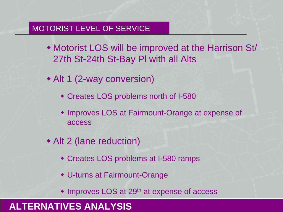
MOTORIST LEVEL OF SERVICE
ALTERNATIVES ANALYSIS
Motorist LOS will be improved at the Harrison St/ 27th St-24th St-Bay Pl with all Alts
Alt 1 (2-way conversion)
Creates LOS problems north of I-580
Improves LOS at Fairmount-Orange at expense of access
Alt 2 (lane reduction)
Creates LOS problems at I-580 ramps
U-turns at Fairmount-Orange
Improves LOS at 29th at expense of access
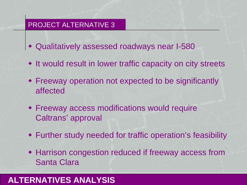
PROJECT ALTERNATIVE 3
ALTERNATIVES ANALYSIS
Qualitatively assessed roadways near I-580
It would result in lower traffic capacity on city streets
Freeway operation not expected to be significantly affected
Freeway access modifications would require Caltrans’ approval
Further study needed for traffic operation’s feasibility
Harrison congestion reduced if freeway access from Santa Clara
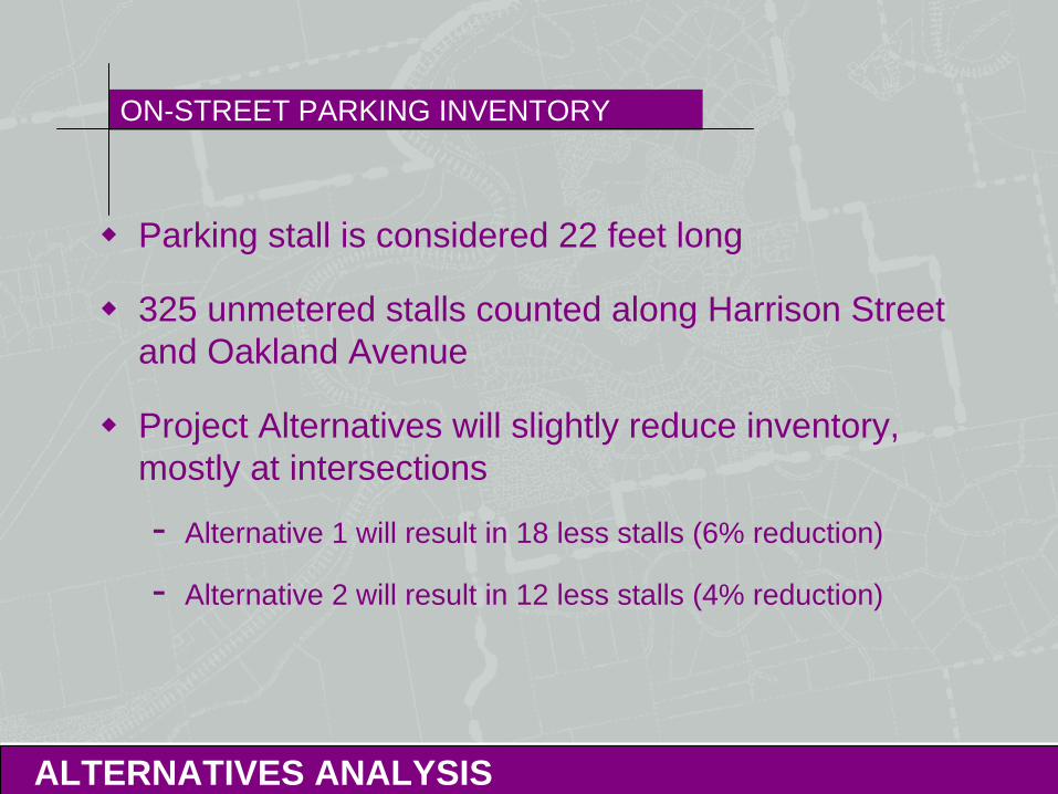
ON-STREET PARKING INVENTORY
ALTERNATIVES ANALYSIS
Parking stall is considered 22 feet long
325 unmetered stalls counted along Harrison Street and Oakland Avenue
Project Alternatives will slightly reduce inventory, mostly at intersections
- Alternative 1 will result in 18 less stalls (6% reduction)
- Alternative 2 will result in 12 less stalls (4% reduction)
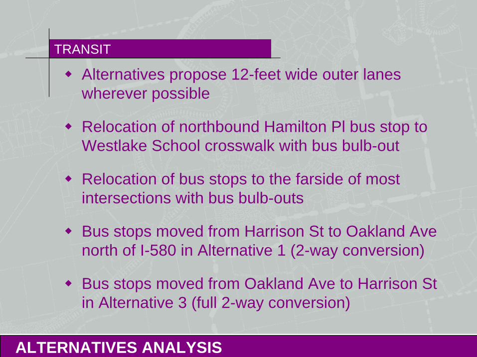
TRANSIT
ALTERNATIVES ANALYSIS
Alternatives propose 12-feet wide outer lanes wherever possible
Relocation of northbound Hamilton Pl bus stop to Westlake School crosswalk with bus bulb-out
Relocation of bus stops to the farside of most intersections with bus bulb-outs
Bus stops moved from Harrison St to Oakland Ave north of I-580 in Alternative 1 (2-way conversion)
Bus stops moved from Oakland Ave to Harrison St in Alternative 3 (full 2-way conversion)
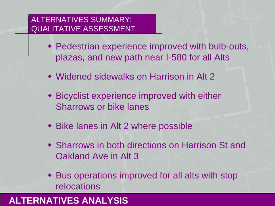
ALTERNATIVES SUMMARY: QUALITATIVE ASSESSMENT
ALTERNATIVES ANALYSIS
Pedestrian experience improved with bulb-outs, plazas, and new path near I-580 for all Alts
Widened sidewalks on Harrison in Alt 2
Bicyclist experience improved with either Sharrows or bike lanes
Bike lanes in Alt 2 where possible
Sharrows in both directions on Harrison St and Oakland Ave in Alt 3
Bus operations improved for all alts with stop relocations
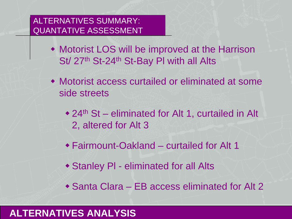
ALTERNATIVES SUMMARY: QUANTATIVE ASSESSMENT
ALTERNATIVES ANALYSIS
Motorist LOS will be improved at the Harrison St/ 27th St-24th St-Bay Pl with all Alts
Motorist access curtailed or eliminated at some side streets
24th St – eliminated for Alt 1, curtailed in Alt 2, altered for Alt 3
Fairmount-Oakland – curtailed for Alt 1
Stanley Pl - eliminated for all Alts
Santa Clara – EB access eliminated for Alt 2
ALTERNATIVES SUMMARY
ALTERNATIVES ANALYSIS
Alternatives will generally improve the pedestrian, bicycling, and transit experience
Preferred alternative will most likely require some mitigations to improve motorist LOS
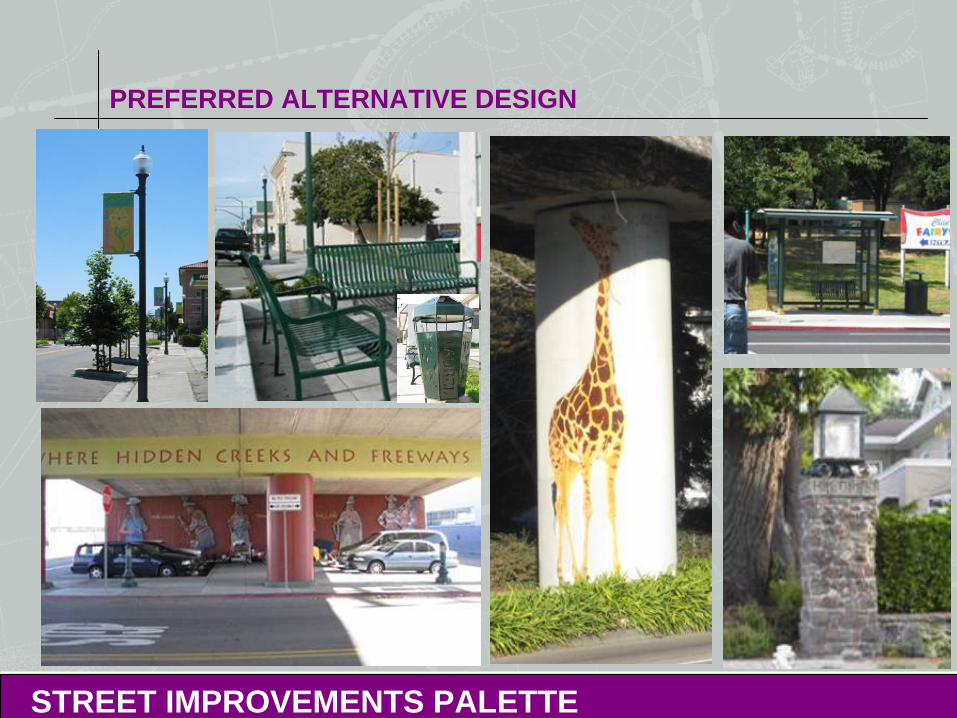
PREFERRED ALTERNATIVE DESIGN
STREET IMPROVEMENTS PALETTE
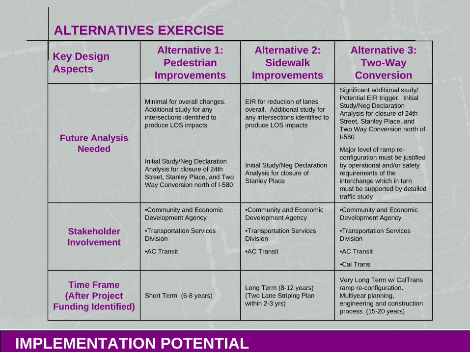
ALTERNATIVES EXERCISE
IMPLEMENTATION POTENTIAL
Key Design Aspects
Alternative 1: Pedestrian
Improvements
Alternative 2: Sidewalk
Improvements
Alternative 3: Two-Way
Conversion
Future Analysis Needed
Minimal for overall changes. Additional study for any intersections identified to produce LOS impacts
EIR for reduction of lanes overall. Additional study for any intersections identified to produce LOS impacts
Significant additional study/ Potential EIR trigger. Initial Study/Neg Declaration Analysis for closure of 24th Street, Stanley Place, and Two Way Conversion north of I-580
Initial Study/Neg Declaration Analysis for closure of 24th Street, Stanley Place, and Two Way Conversion north of I-580
Initial Study/Neg Declaration Analysis for closure of Stanley Place
Major level of ramp re- configuration must be justified by operational and/or safety requirements of the interchange which in turn must be supported by detailed traffic study
Stakeholder Involvement
•Community and Economic Development Agency
•Community and Economic Development Agency
•Community and Economic Development Agency
•Transportation Services Division
•Transportation Services Division
•Transportation Services Division
•AC Transit •AC Transit •AC Transit
•Cal Trans
Time Frame (After Project
Funding Identified)Short Term (6-8 years)
Long Term (8-12 years) (Two Lane Striping Plan within 2-3 yrs)
Very Long Term w/ CalTrans ramp re-configuration. Multiyear planning, engineering and construction process. (15-20 years)
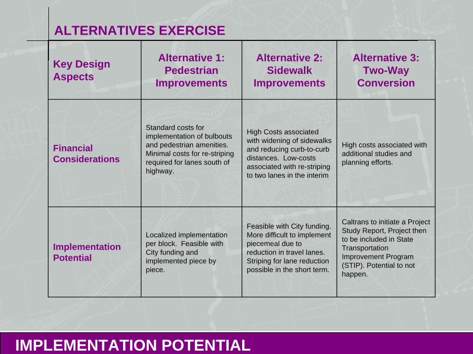
ALTERNATIVES EXERCISE
IMPLEMENTATION POTENTIAL
Key Design Aspects
Alternative 1: Pedestrian
Improvements
Alternative 2: Sidewalk
Improvements
Alternative 3: Two-Way
Conversion
Financial Considerations
Standard costs for implementation of bulbouts and pedestrian amenities. Minimal costs for re-striping required for lanes south of highway.
High Costs associated with widening of sidewalks and reducing curb-to-curb distances. Low-costs associated with re-striping to two lanes in the interim
High costs associated with additional studies and planning efforts.
Implementation Potential
Localized implementation per block. Feasible with City funding and implemented piece by piece.
Feasible with City funding. More difficult to implement piecemeal due to reduction in travel lanes. Striping for lane reduction possible in the short term.
Caltrans to initiate a Project Study Report, Project then to be included in State Transportation Improvement Program (STIP). Potential to not happen.

ALTERNATIVES VOTING EXERCISE
BREAK OUT GROUPS
A B C D
1
2
3
ALTERNATIVES VOTING EXERCISE
Geographic Area Discussions
Voting Exercise
Discussion of Pros vs. Cons to establish Goals
Discuss Goals to Prioritize Improvements
Group Leader Summaries
BREAK OUT GROUPS
NEXT STEPS
Preferred Alternative Development (DC&E): April 27-May 22, 2009
Preferred Alternative Traffic Analysis (Dowling) May 26-June 8, 2009
TAC/CSC (Review/Meeting): June 15-25, 2009
Community Workshop #3: July 23, 2009
Location To Be Determined
Community Workshop #2: Alternatives Review April 23, 2009
D E S I G N , C O M M U N I T Y & E N V I R O N M E N T
HARRISON STREET/OAKLAND AVENUE COMMUNITY TRANSPORTATION PLAN
Questions?
Alisa Shen, Project Manager, [email protected] Ferracane, [email protected] Websitewww.oaklandnet.com/strategicplanning