hardy m. strozier, inc. - wordpress.com · www 2 the planning associates hardy m. strozier, inc....
TRANSCRIPT

1
The Planning Associates Hardy M. Strozier, Inc. 495 E. RINCON STREET, SUITE 212
CORONA, CALIFORNIA 92879 TELEPHONE: (951) 444-5600 TELECOPIER: (951) 880-0529
WWW.THEPLANNINGASSOCIATES.NET
Date: August 19, 2015 Memo to: Scott Thayer
Senior Vice President Castle & Cooke (C&C)
From: Hardy Strozier, MPA, AICP Principal Planner The Planning Associates (TPA)
Re: Evaluation and Interpretation of ACOE and CDFW Entitlements for Castle and Cooke’s Saddle Creek Golf Course located in Copperopolis, California Introduction and Background This letter summarizes The Planning Associates evaluation and interpretation of state and federal entitlement agreements and permits for Castle & Cooke’s Saddle Creek Golf Course located in Copperopolis, California. The recent California extended drought has called into question what golf course elements, features, and mitigation areas require man-made irrigation and the types and duration of irrigation for each “element.” Included in this discussion are explanations of regulations guiding the trimming or maintenance of vegetation in or near golf course water related elements. The Saddle Creek Golf Course entitlement goes back some 17 years and beyond. Much local knowledge of the intended water uses on the golf course has been lost. In addition, much of the current usage of water on the golf course “elements” has been surmised by professionals, some correct, and some incorrect. This letter summarizes TPA’s forensic investigation of the Saddle Creek Golf Course entitlements, including personal interviews and telephone discussions with professional real estate business staffs, consultants, and attorneys involved with the entitlement process. In addition, this letter illustrates the process in which TPA had collected primary entitlement documents for an independent assessment of the entitlement conditions, design, watering requirements, and maintenance of the golf course elements.

2
The Planning Associates Hardy M. Strozier, Inc. 495 E. RINCON STREET, SUITE 212
CORONA, CALIFORNIA 92879 TELEPHONE: (951) 444-5600 TELECOPIER: (951) 880-0529
WWW.THEPLANNINGASSOCIATES.NET
TPA Qualifications The Planning Associates is a boutique planning firm experienced in entitlement permitting for major development projects including golf courses. TPA’s staffs education and experience in urban planning and water resources planning has allowed the firm to coordinate with and permit various types of projects through the United States Army Corps of Engineers (ACOE), California Department of Fish and Wildlife (CDFW), California Regional Water Quality Control Boards (CRWQB) and the United States Fish and Wildlife Service (USFWS) for over 35 years. TPA has prepared numerous jurisdictional and wetlands habitat mitigation and monitoring programs. TPA is also familiar with both native and non-native landscape architecture, irrigation, and biological functions and values, including stream and lake morphology in and around golf courses. TPA manages many mitigation sites for various clients with expertise in golf course design, construction, environmental mitigation, and course management. The language and graphics within the various entitlement documents for the Saddle Creek Golf Course in Copperopolis is not readily and easily understood by the layman, businessman or public official. This information may be unfamiliar due to their lack of interaction among biology, landscape architecture and the language art and common practice of the state and federal agencies. In fact, there is confusion among the interviewed professionals as to the history and intent of the resource agency agreements. In addition, there is a clear lack of understanding of the permits that govern the installation and operations of the existing and created mitigation features and elements in and around the Saddle Creek Golf Course. Overall, the current and past managers of both local governmental agencies with oversight authority and Castle & Cooke’s past and present management staff are unclear on the exact direction provided by the entitlement documents. Intent of this Study The intent of this study is to evaluate pertinent entitlement documents and answer questions on how the jurisdictional and non-jurisdictional natural and man-made elements (ponds, wetlands, creeks, marshes, detention basins), operate hydrologically within the Saddle Creek Golf Course, which are based on the reviewed entitlement documents. This report will provide and reference a short summary of facts and also provide the baseline data that allowed TPA to arrive at the below noted summary of conclusions. TPA has also tried to set out specific questions raised by the operator on the on-going monitoring and maintenance responsibilities between the Community Service District (CSD) and Saddle Creek Golf Course (SCGC).
3
The Planning Associates Hardy M. Strozier, Inc. 495 E. RINCON STREET, SUITE 212
CORONA, CALIFORNIA 92879 TELEPHONE: (951) 444-5600 TELECOPIER: (951) 880-0529
WWW.THEPLANNINGASSOCIATES.NET
What are Jurisdictional Waters and Wetlands? To begin this discussion it is important to understand that not all state and federal jurisdictional waters are wetlands, but generally, all wetlands are jurisdictional waters. These various terms are defined in Environmental Protection Agency (EPA) and Army Corps of Engineers (ACOE) guidance. For example, a state or federal jurisdictional water element can be a relatively dry ephemeral desert stream. A wetland can be a pond, a Bog, or a marsh. Wetlands have certain defined characteristics in federal law and regulations. Wetlands must contain water or hydrology for a certain part or duration of the year. In addition, wetlands must have certain types of soil characteristics with dominant plants being water “loving” or obligate. A created wetland, such as within the Saddle Creek Golf Course, may not have all these characteristics, but may have functions equivalent to a natural wetland within the “human” managed biological systems on-site. When can plant species trimming occur within state and federal jurisdictional areas? State and federal law do not prohibit trimming of vegetation in or near jurisdictional waters: ponds, streams, catchments, etc. Riparian vegetation naturally reestablishes easily near jurisdictional features following trimming. The only trimming limitation by law would be no trimming during the avian nesting season when birds have nearby active nests that could be disturbed by the trimming. Trimming is always permitted outside the bird nesting season and during the nesting season, trimming may occur with the advice of an on-site biologist to direct the trimming away from nesting birds. Habitat is not ordinarily protected by or through state and federal law. Rare or endangered plant species are not protected by federal law on private property. There are no rare or endangered species identified in any of the Saddle Creek Golf Course documents. Trimming and maintenance may be the subject of a Habitat Mitigation and Monitoring Plan. Trimming within established, created or restored jurisdictional riparian areas normally require periodic trimming and thinning of native and non-native habitat for maintaining beneficial wildlife use, and this is exactly the position of the Alexander plan for trimming and maintenance on every type of feature on SCGC (Alexander Page 2). Summary of Conclusions
1. The Saddle Creek Golf Couse wetland, jurisdictional design and operational management “elements” are directed and governed by two (2) principal documents (Agreement and Permit), and two (2) state/federal agencies. A. Corps of Engineers Nationwide Permit 26 No. 199100807, December 14,
1994.

4
The Planning Associates Hardy M. Strozier, Inc. 495 E. RINCON STREET, SUITE 212
CORONA, CALIFORNIA 92879 TELEPHONE: (951) 444-5600 TELECOPIER: (951) 880-0529
WWW.THEPLANNINGASSOCIATES.NET
B. California Department of Fish and Game (now CDFW) Stream or Lake
Alteration Agreement, September 19, 1994.
2. The principal operational documents derived from the Corps permit that directs the form, function, and management of all wetland, jurisdictional elements, and credit and no credit features referenced in the Corps document and are herein relative order of importance:
A. Saddle Creek Golf Club, Copperopolis California, Wetland Maintenance &
Monitoring Plan by Ralph J. Alexander & Associates dated February 13, 1998.
B. Sierra Engineering Associates, LTD., Saddle Creek 1999 Record Drawing Wetland Mitigation Plan and Protected Area Exhibit Map for Wetlands U.S. Army Corps Permit NP 26-199100807.
C. Declaration of Restrictions, June 12, 1998. D. Quality Control Agreement between Saddle Creek Golf Club, L.P, Castle &
Cooke Saddle Creek, Inc., Saddle Creek Community Services District and Calaveras County Water District, February 10, 1994.
E. Water and Sewer Service Facilities Agreement between Calaveras County Water District and Cloudburst Partners, March 8, 1994.
F. The required annual mitigation and monitoring report(s) validate the implementation of the above 2A. and 2B. key documents.
Alexander and Sierra Engineering
The Alexander and Sierra Engineering reports/mapping form the key management documents identifying and describing the operational characteristics and management guidance to the managers of the golf course. The Alexander and Sierra Engineering maps describe mitigation elements generally outside golf play areas that relate to the implementation actions found within the Corps and CDFW jurisdictional waters mitigation documents. The Alexander and Sierra Engineering plans are the key documents that must be followed by the Community Services District (CSD) and Saddle Creek Golf Course (SCGC) in the management of the “wetland” and other described mitigation elements on the golf course. The Declaration of Restrictions protective easements and covenants required by the Corps permit cite both the Alexander and Sierra Engineering documents for final direction to subsequent regulators (Corps and CDFW), or by the operation, maintenance and monitoring of the mitigation areas within the golf course (CSD and SCGC).
3. Not all jurisdictional “wetland” elements or features are required to be “wet” or
irrigated year round. A clear distinction is made in the above documents (2A. and 2B.) between and among the following features and elements listed below.

5
The Planning Associates Hardy M. Strozier, Inc. 495 E. RINCON STREET, SUITE 212
CORONA, CALIFORNIA 92879 TELEPHONE: (951) 444-5600 TELECOPIER: (951) 880-0529
WWW.THEPLANNINGASSOCIATES.NET
A. Annual or perennial wetlands and plant life (biota) required to contain or receive water year round.
B. Seasonal ephemeral wetlands or grasslands, which only require hydration from winter rains, and not receiving water year round from man-made irrigation.
C. Storm water multi-function detention facilities (ponds/catchments) may contain some water at operator’s discretion for aesthetic golf play purposes, but are permitted to dry or become low in water elevation, so that during the winter months they are designed to contain a certain volume of hydrologic storm “peaks” when the major storm(s) arrive, and thereby these hydrologic systems reduce storm water runoff leaving the site, benefiting the entire down-stream water quality related eco-system in the valley.
D. Golf course architectural features such as ponds, or catchments that may lie within defined jurisdictional easements, but are hydrated and maintained (cattail removals permitted) at the discretion of the golf course operator. These golf course landscape design features are sometimes called in the documents above as “no credit” areas and act more as golf course architectural features, as opposed to year round created and preserved natural wetland mitigation. “No credit” is the term given to features looking similar to a created wetland, but in the opinion of the regulatory agency(s) provides no biology/morphology mitigation credit for the impacts of the project construction on jurisdictional waters because they are integral to golf course play (Alexander Page3).
E. Golf course irrigation “itself” (tees, fairways, greens and grassed side slope areas) are a defined source of regular man-made and natural hydrology for the annual/perennial jurisdictional wetland basins, filter native grasses and ponds generally located off the golf course perimeter. A reduction in golf course irrigation, such as to the grassed side slopes, due to drought regulations or local water agency policies can affect the hydrology and biology of the ponds and the perimeter wetland grasslands that receive water flow from the intended golf course design. The “wetlands” systems on the golf course operate as a naturalized interrelated/integrated system taking and directing water from the golf course down slope into the ponds and filtered at the golf course and pond edges. These interrelated year round and ephemeral systems help retain water runoff “on site” so as not to or minimize golf course waters from entering into the main natural off-site jurisdictional areas of Littlejohns Creek.
4. Maintenance of all ponds, streams, wetlands, features, detention basins are
required pursuant to various levels and types of maintenance for each mitigation and golf course feature. (Alexander Page 1, Section I, A.).

6
The Planning Associates Hardy M. Strozier, Inc. 495 E. RINCON STREET, SUITE 212
CORONA, CALIFORNIA 92879 TELEPHONE: (951) 444-5600 TELECOPIER: (951) 880-0529
WWW.THEPLANNINGASSOCIATES.NET
A. Included maintenance measures are weed control, trash removal, erosion control, pruning and appropriate water flow regimes, where applicable.
B. All planted areas shall be weeded to encourage the success of native plant material and to discourage ruderal or weedy species from establishing populations.
C. The removal of trash and fill in the wetlands areas shall be performed on a regular basis.
D. Pruning may be required to keep weedy vegetation, especially willows, from clogging the channels and access ways. Non-woody plants such as cattails may also need to have regular thinning to keep the cattails from “clogging” the wetlands and reducing wetland capacity.
E. If erosion is determined to be a problem, measures shall be taken to divert or slow runoff prior to replanting.
F. No-Credit Areas are wetland areas designated on the Wetlands Mitigation and Restoration Plans. These areas have been developed and planted as Wetland Areas; however, because of various resource agency determined factors, such as proximity to the golf course play areas, these no-credit areas will be maintained, but not to the same strict standards as the preservation and mitigation wetland areas. “These no-credit areas will not be monitored by the CSD” (Alexander, Page 3). The no-credit wetland areas vegetation will be periodically thinned for golf safety, golf playability and golf shot/play visibility. Please refer to the Alexander L-1 tables for wetland and pond areas receiving no acreage mitigation credit; example Pond J on Hole 8, and Pond F-1 on Hole 9 and 10. It is the intent of the Alexander management report on the No-Credit areas that the golf course superintendent will be the monitor and be responsible for the maintenance of the no-mitigation credit areas since these areas are primarily for golf play wetland-like elements, not regulatory agency permit/agreement mitigation.
5. Both the Alexander and Sierra Engineering, and Corps directed guidance
management documents identify the following jurisdictional water element acreages and hydrology required outside the golf course perimeter:
A. Total Seasonal Wetlands (irrigated by winter rain only) 5.41 acres B. Total Perennial Wetlands (year round irrigation) 3.60 acres C. Total Wetlands: 9.01 acres
Each golf course wetland area feature totaled above, (seasonal wetland, perennial wetland, and filter marsh), is detailed in both the Alexander and Sierra Engineering plans for approximately 25 ponds and 14 wetland features located on the golf course areas. Fifteen of these above noted ponds and features (from Alexander L-1) are no-credit mitigation/golf play areas and these no-credit areas

7
The Planning Associates Hardy M. Strozier, Inc. 495 E. RINCON STREET, SUITE 212
CORONA, CALIFORNIA 92879 TELEPHONE: (951) 444-5600 TELECOPIER: (951) 880-0529
WWW.THEPLANNINGASSOCIATES.NET
or features do not factor or count into or for the total 9.01 resource agency approved and Alexander report memorialized mitigation acres.
The Planning Associates derived the definitions of ‘Perennial’ and ‘Seasonal’ systems requiring some form of natural or man-made irrigation from the Alexander and Sierra Engineering documents noted as: • Perennial – a water source that is continuous throughout the entire year and man-made irrigation may or may not be required for the intended use of the water. Alexander further defines this irrigation term as: “Perennial wetland areas will have a natural or man-made year round flow depending on the terrain and will have a broad flow channel. Not all perennial ponds or features require irrigation” (Alexander L-1). • Seasonal – a water source is intermittent or ephemeral based only on the storm events and time of year, usually the winter months. Seasonal elements or features on the golf course do not require man-made irrigation. Alexander further defines seasonal as: “Seasonal Wetland areas are similar to perennial areas but have a natural seasonal water flow and generally have a broader and flatter flow channel. Boulders are used as low dams in order to allow the spread of water flow. Seasonal wet ponds will not have a consistent year-round flow and gradually dry out during the summer” (Alexander L-1). • Perennial plants in the Alexander plan are generally those native species, usually grasses, (which may die off during the winter months, but reappear during springtime), and which grow year round and are not normally required to be re-planted or require continuous irrigation and form the primary first down slope off the golf course water run-off filter element. • All other features outside the tees, green and fairways (and rough), but within the golf play area will not require irrigation, such as “no-credit” creek, detention or pond features, but may be irrigated by the golf course operator at his/her discretion without CSD monitoring (Alexander Page 3, No Credit Areas).
TPA Saddle Creek Golf Course Aerial Exhibit 1 The attached aerial Exhibit 1 produced by The Planning Associates, is a reproduction of Ralph Alexander and Associates Wetland Mitigation and Restoration Plan overlaid onto a 2015 Google aerial imagery. This exhibit highlights all 25 ponds in yellow and all 14 wetlands in blue, with the corresponding acreages of the wetland and no-credit areas displayed in the attached chart. Exhibit 1 confirms that all wetlands and ponds have been built and are existing today in the field. In addition, Exhibit 1 displays all fifteen existing golf course features that are not requiring year round irrigation or monitoring for wetland protection or mitigation. These golf course features also serve as receiving
8
The Planning Associates Hardy M. Strozier, Inc. 495 E. RINCON STREET, SUITE 212
CORONA, CALIFORNIA 92879 TELEPHONE: (951) 444-5600 TELECOPIER: (951) 880-0529
WWW.THEPLANNINGASSOCIATES.NET
ponds which are ponds that receive overflow water from larger nearby ponds (Pond F-1) and emergency ponds (Pond E). This system is in place to protect the integrity of Littlejohns Creek from receiving potential contaminated water from the golf course. Finally, there is one dedicated detention basin, which serves the golf course (near Wetland C) at the corner of Oak Creek Drive and Knolls Drive. This detention basin does not need to sustain water year round. Recommendations The above key documents noted in 2A. and 2B. are unintendedly complicated to understand and they do not lend themselves easily to a clear interpreation of the directed and narrow mitigation management of the jurisdictional and golf course play design elements (No-Credit). This written evaluation with the above Alexander key documents will not by itself permit a simple management course of action on a day to day basis. TPA recommends that a clearer 3rd “in house” management guide be developed to more easily permit the operations (trimming, irrigation, dredging, etc.) of the 25 ponds, 14 golf course features, storm water elements and no-credit areas. This recommended management document would be a simplified written and graphic depiction of operation areas broken down “hole by hole-feature by feature” according to the report direction provided by Sierra Engineering and Ralph Alexander, (1994). TPA understands from consultant interviews that this third level management document was previously recommended to C&C, but not prepared. This type of simplified document is a normal practice following issued technical permits and HMMP’s and greatly benefits the on-going management of the mitigation resources and greatly reduces confusion among the regulator and land owner. Meetings should also be immediately arranged for a short tutorial with verbal and written information in order to instruct the public and private “staffs” on the use of the recommended (Alexander, 1998) management “explanation” document to both the golf course superintendent and golf club manager along with the CSD manager, especially among their respective field representatives who’s monitoring and maintenance “boots are on the ground.” This meeting or series of meetings should include field inspections and field understandings of the direction from the Alexander/Sierra reports and plans on what elements require CSD monitoring and inspections and which elements are the sole responsibility of the golf course operators and owners. Copies of this report and all relevant documents should be placed on file with both public and private groups (C&C and CSD) in both hard copies and digital computer files to be used by both current and future personnel. TPA recommends that golf holes with dying Bermuda grass areas be replaced with native grasses similar to golf play on PGA and U.S Open links courses. TPA can make recommendations to the golf course superintendent to determine which native grass can be implemented as a water saving and aesthetic approach to the California drought.

9
The Planning Associates Hardy M. Strozier, Inc. 495 E. RINCON STREET, SUITE 212
CORONA, CALIFORNIA 92879 TELEPHONE: (951) 444-5600 TELECOPIER: (951) 880-0529
WWW.THEPLANNINGASSOCIATES.NET
EXHIBIT 1

1
The Planning Associates Hardy M. Strozier, Inc. 495 E. RINCON STREET, SUITE 212
CORONA, CALIFORNIA 92879 TELEPHONE: (951) 444-5600 TELECOPIER: (951) 880-0529
WWW.THEPLANNINGASSOCIATES.NET
Date: March 22, 2016
Memo to: Scott Thayer
From: Hardy Strozier BA, MPA, JD, AICP
Megan MacKay BS, MS
Re: Copperopolis Saddle Creek Golf Course Environmental Pond Water Measurements Introduction, Background and Summary The TPA assignment is to prepare a follow up study and report evaluation of water demand for the Saddle Creek Golf Course pond and environmental mitigation/water dependent elements. TPA previously provided a report dated August 19, 2015, researching and evaluating the “permit” requirements for water usage in the golf course environmental ponds and associated water elements. This previous report is attached. In order to better gauge the Saddle Creek Golf Course’s short and long term water demand needs, we have conducted research, and calculations of the pond’s and other water dependent element’s water usage throughout a 12 month period. The intent of this report is to allow the owner and public agencies responsible for water related mitigation to better plan, budget, and provide the necessary water for the golf course water elements required by various agency permits. In this report we will be evaluating four different types of water elements; Ephemeral – these water elements are seasonal and will be dry or wet dependent on natural rainfall and not man made irrigation, Perennial – these water elements are annual and require man made irrigation to meet their permit required water levels, Hybrid – these water elements are both seasonal and annual, and a portion of the pond is required to remain hydrated while the remaining portion may be dry and fluctuate based on natural rainfall, Unregulated – these water elements are for golf play and aesthetic purposes, they can by dry or hydrates at the will of the Saddle Creek Golf Course and are unregulated by any public agency. Distinguishing these four types of water elements is critical in order to calculate the amount of water which is actually required for each pond according to the permits. Our research, findings, and subsequent calculations provides the golf course with a total savings of 7,574,476 gallons (23.25 acre feet) of water annually. This savings provides a reduction of water use on the permit regulated and non- permit regulated features of over 50 % of irrigation water over a 12 month period. This irrigated water savings derives from no longer needing to provide water for the seasonal and unregulated water elements on the golf course during times of draught. The unregulated and seasonal elements are defined within the environmental permits and associated referenced management plan (See Alexander Plan Attached) for the Saddle Creek Golf Course.

2
The Planning Associates Hardy M. Strozier, Inc. 495 E. RINCON STREET, SUITE 212
CORONA, CALIFORNIA 92879 TELEPHONE: (951) 444-5600 TELECOPIER: (951) 880-0529
WWW.THEPLANNINGASSOCIATES.NET
Pond Holding Capacities Pitto and Associates, the principal Civil Engineer on the Saddle Creek Golf Course project, created the original detailed civil engineering design for the golf course and its many water elements. Based on the original civil engineering course design Pitto and Associates provided us a Pond Detail Chart (Exhibit A), on this chart each of the golf course pond or water dependent element holding capacities in cubic feet were calculated and recorded. There are 26 ponds on the golf course and all were evaluated for water usage. Some of Pitto and Associates pond volume data was combined for several ponds noted in Exhibit A. For example, the volume for ponds F-2 and F-3 are combined with pond F-1 (See attached exhibit A for all combined pond information). While this combination makes it a bit more difficult to determine how much water is needed for certain individual ponds, we have estimated the individual pond amounts from this data, and determined it will not affect the estimate of overall water needs for the Saddle Creek Golf Course. Pond Type Determination We then reviewed the memo “Evaluation and Interpretation of ACOE and CDFW Entitlements for Castle and Cooke’s Saddle Creek Golf Course located in Copperopolis, California”(Permit Evaluation and Interpretation memo) written by TPA earlier this year (August 19, 2015). The Permit Evaluation and Interpretation memo (Exhibit B) distinguished what golf course elements, features, and mitigation areas required man-made irrigation and which areas only required water from natural sources i.e. rainfall. The report also identified unregulated ponds. The distinction between seasonal and perennial was made as follows:
“Not all jurisdictional “wetland” elements or features are required to be “wet” or irrigated year round. A clear distinction is made in the above documents (2A1 and 2B2.) between and among the following features and elements listed below.
A. Annual or perennial wetlands and plant life (biota) required to contain or receive water year
round.
B. Seasonal ephemeral wetlands or grasslands, which only require hydration from winter rains, and not receiving water year round from man-made irrigation.” (Permit Evaluation and Interpretation Memo August 19th 2015)
Included in the Permit Evaluation and Interpretation memo is a graphic taken in part from the Golf Course Water Management Plan by Alexander and Associates (Exhibit B pg 9) which denotes the number of acres in each water dependent element that are Perennial, Seasonal, Hybrid, or Filter Marshes. As you will see in the chart, the four different water element types (Ephemeral, Perennial, Hybrid, and Unregulated) of water elements are all represented. For example Pond A is a Hybrid; with 0.16 acres seasonal, 0.31 acres perennial, and 0.05 acres
1 Saddle Creek Golf Club, Copperopolis California, Wetland Maintenance & Monitoring Plan by Ralph J. Alexander & Associates dated February 13, 1998. 2 Sierra Engineering Associates, LTD., Saddle Creek 1999 Record Drawing Wetland Mitigation Plan and Protected Area Exhibit Map for Wetlands U.S. Army Corps Permit NP 26-199100807.

3
The Planning Associates Hardy M. Strozier, Inc. 495 E. RINCON STREET, SUITE 212
CORONA, CALIFORNIA 92879 TELEPHONE: (951) 444-5600 TELECOPIER: (951) 880-0529
WWW.THEPLANNINGASSOCIATES.NET
filter marsh. Thus for Pond A only the 0.31 acres is required to hold water all year, the rest of the pond may fluctuate with natural rainfall. Perennial Percentage Calculation In order to translate acreage of each pond into a tangible amount of water need, we decided to calculate a percentage of each of the ponds that is perennial, that is hydrated year around. Data regarding the surface area of each pond differed slightly between the Permit Evaluation and Interpretation memo and the Pond Detail Chart provided by Pitto and Associates, so first we calculated the area of each pond using the numbers from the Permit Evaluation and Interpretation memo which were gathered from the Alexander Management Plan, both of which are attached. We added the number of Seasonal (Ephemeral), Perennial, and Filter Marsh acres for each pond to get an area in acres for each pond. As an example Pond A has: 0.16 seasonal acres 0.31 perennial acres + 0.05 filter marsh acres = 0.52 acres total for Pond A Then to find the percentage of each pond that is perennial we divided the individual pond’s perennial acreage by the individual pond’s total acreage and multiplied by 100%.
Continuing with Pond A as an example: 0.31 perennial acres = 60% of Pond A is perennial 0.52 total acres x 100% We then calculated the baseline volume for each individual pond that would need to remain hydrated to meet the perennial required levels as required by the permits and management plan. The formula we used includes the percentage we calculated as described above as well as the volume data provided in the Pitto and Associates “Pond Detail Chart”. For each pond we multiplied the individual pond’s perennial percentage by the individual pond’s volume in gallons. Pond A for example: 55,000 gallons total volume for Pond A 60% of Pond A is perennial
55,000 gallons x 60 %= 33,000 gallons to hydrate the perennial portion of Pond A
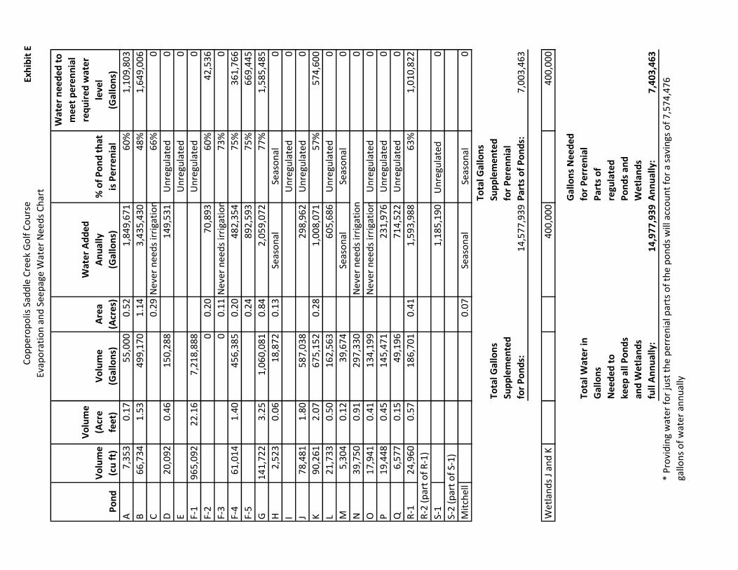
We used this formula and approach for all the ponds that are regulated by the permit and management plan, of the 26 ponds 16 are regulated by permits and the management plan (the other 10 ponds are unregulated pursuant to the Alexander Management Plan). These amounts are shown in the Baseline Water Needs Chart (Exhibit C). The total number of gallons to meet the perennial holding capacities for all regulated water elements is 2,139,529. This calculation will serve as a baseline, but will not serve as our final number since it does not account for evaporation and ground seepage.

4
The Planning Associates Hardy M. Strozier, Inc. 495 E. RINCON STREET, SUITE 212
CORONA, CALIFORNIA 92879 TELEPHONE: (951) 444-5600 TELECOPIER: (951) 880-0529
WWW.THEPLANNINGASSOCIATES.NET
Past Water Usage In the most recent past, it was thought that all of the ponds at Saddle Creek Golf Course had to be kept full. However, with last year’s drought and CCWD’s reduced water deliveries to the Golf Course (both raw water and treated water from their plant), the Community Services District (“CSD”) responsible for maintaining the ponds, and Saddle Creek Golf Course were concerned that the lack of water could place the regulatory permits from the Army Corps of Engineers, the Water Board, and Fish and Wildlife in jeopardy of not being able to comply with the conditions of the various permits. However, through our research, we discovered that not all the ponds were to be treated equally; some were not to receive artificial water. As a result of the ponds being kept full, the third party company who maintains the golf course, Golf Maintenance Services (“GMS”), kept track of the date and the amount of water added to each pond at that time. The data that GMS kept not only accounted for each pond’s holding capacity but evaporation and ground seepage as well. It is important to know while the water need numbers in Exhibit C are a place to start, Exhibit C does not take into account the data collected by GMS, and is more of a baseline holding capacity. Exhibit E however, does account for GMS’s data, and calculates an increment of additional water needed to meet the permit required levels of water for each pond because of evaporation and seepage. Golf Maintenance Services (GMS) was asked to review the historical golf course water demand data gathered throughout the year 2014. GMS provided to us the amount of water the golf course must add to each pond or water dependent element to keep it full throughout the year (Exhibit D). Again these amounts of water were added under the direction given to the golf course to keep all water elements full year round. The amounts of water in Exhibit D account for the elements holding capacity, evaporation loss, and pond water ground seepage. We had originally set out to calculate the evaporation and seepage rate for each pond, but found that the amount of water added in order to counter act those losses was a more efficient approach as GMS already had that data available. Perennial Pond Water In order to determine a more accurate amount of water that each water element will require annually, we used the data provided by GMS and the perennial percentage (hydrated volume for each pond) we calculated earlier in this process. We multiplied the amount of added water to an individual water element provided by GMS in his chart (Exhibit D), by the percentage of an individual water element that is considered perennial.
For example: In the year 2014, 1,849,671 gallons were added to Pond A to keep it full all year. We now know that only 60% of Pond A is required by permit to be hydrated.
1,849,671 gallons x 60%= 1,109,803 gallons needed to hydrate the perennial portion of Pond A

5
The Planning Associates Hardy M. Strozier, Inc. 495 E. RINCON STREET, SUITE 212
CORONA, CALIFORNIA 92879 TELEPHONE: (951) 444-5600 TELECOPIER: (951) 880-0529
WWW.THEPLANNINGASSOCIATES.NET
This calculation produced a larger number than the calculations shown in Exhibit C because it is the amount of water that is needed to meet the permit required perennial levels of the individual ponds accounting for seepage and evaporation. A wet or dry year would affect how much water would be added to the ponds to keep them at permit required levels. With more rain during a wet year less water would have to be added to each of the individual ponds to keep them at permit required levels. While the calculations shown in Exhibit E do not include a variable for rainfall, the calculation was done for the year 2014 which was particularly dry year. Since the calculation was done for a dry year we can assume that the amount of water needed for each pond could only be less than what is calculated in Exhibit E if it were a wetter year, with naturally occurring water entering the ponds. This calculation or formula was used for all 16 of the permit regulated ponds, and provided us with the number of gallons required to keep the perennial portion of each of the 16 permit required ponds or other water dependent elements hydrated per the permit requirements year round. These calculations can be found in the Evaporation and Seepage Water Needs Chart (Exhibit E). This calculation eliminates man made irrigation from the Ephemeral portions of the golf course’s water elements and accounts for water loss at each pond caused by evaporation and seepage giving us a more accurate number of gallons required for each water element. In GMS’s data there were several unregulated elements that were kept full year around. For the purpose of this report, because those elements are not required by permit to have water in them, we will be subtracting those water amounts and counting them as a water savings. Water Savings In order to get the most accurate overall water savings required by the permit and management plan, we added up the number of gallons required to annually meet the required Perennial water levels of the different golf course mitigation features found in Exhibit E. This water total came to 7,403,463 gallons annually. In the past, the ponds and other water dependent features have required 14,977,939 gallons of water annually. Overall, providing man made irrigation water for just the Perennial portions of the ponds and not the Ephemeral portions or unregulated ponds will save approximately 7,403,463 gallons of water each year. This savings is about a 49% water use reduction annually. Cost Savings Water provided by the Calaveras County Water District costs approximately $182.65 per acre foot. We performed most of our calculations using gallons, but for cost we will convert gallons to acre feet: Total # of gallons saved per year: 7,403,463 gallons # of gallons per acre foot: 325,851 gallons 7,403,463 gallons = 22.72 acre feet 325, 851 gallons per acre foot

6
The Planning Associates Hardy M. Strozier, Inc. 495 E. RINCON STREET, SUITE 212
CORONA, CALIFORNIA 92879 TELEPHONE: (951) 444-5600 TELECOPIER: (951) 880-0529
WWW.THEPLANNINGASSOCIATES.NET
Using the calculated total savings in acre feet we calculated the total cost savings annually: 22.72 x $182.65 = $4,149.81 Providing water for only the perennial portions of the regulated water elements will provide a savings of $4,149.81 annually. The Evaporation and Seepage Water Usage Chart (Exhibit E) breaks down the water needs for each pond, and summarizes the total water needs required by permit for the Saddle Creek Golf Course. This analysis resulted in the savings of approximate 7.5 million gallons of water each year.


9
The P
lannin
g A
ssocia
tes
Ha
rdy M
. S
tro
zie
r, In
c.
495
E. R
INC
ON
STR
EE
T, S
UIT
E 2
12
CO
RO
NA, C
ALI
FOR
NIA
928
79
TELE
PH
ON
E:
(951
) 444
-560
0 TE
LEC
OP
IER
: (9
51) 8
80-0
529
WW
W.T
HEP
LAN
NIN
GA
SS
OC
IATE
S.N
ET

Co
pp
ero
po
lis S
add
le C
ree
k G
olf
Co
urs
e
Bas
elin
e W
ate
r N
eed
s C
har
tEx
hib
it C
Po
nd
Vo
lum
e
(cu
ft)
Vo
lum
e
(Acr
e
feet
)
Vo
lum
e
(Gal
lon
s)
Are
a
(Acr
es)
% o
f P
on
d t
hat
is P
err
en
ial
# o
f G
allo
ns
nee
de
d t
o
me
et p
ere
nn
ial h
old
ing
cap
acit
y
A7
,35
30
.17
55
,00
00
.52
60
%3
3,0
00
B6
6,7
34
1.5
34
99
,17
01
.14
48
%2
39
,60
2
C?
0.2
96
6%
?
D2
0,0
92
0.4
61
50
,28
8U
nre
gula
ted
0
EU
nre
gula
ted
0
F-1
96
5,0
92
22
.16
7,2
18
,88
8U
nre
gula
ted
0
F-2
10
,61
5 (
of
F-1
)0
.24
79
,40
00
.20
60
%4
7,6
40
F-3
28
,95
3 (
of
F-1
)0
.66
21
6,5
68
0.1
17
3%
15
7,5
04
F-4
61
,01
41
.40
45
6,3
85
0.2
07
5%
34
2,2
89
F-5
0.2
47
5%
Par
t o
f F-
5
G1
41
,72
23
.25
1,0
60
,08
10
.84
77
%8
16
,26
2
H2
,52
30
.06
18
,87
20
.13
Seas
on
al0
IU
nre
gula
ted
0
J7
8,4
81
1.8
05
87
,03
8U
nre
gula
ted
0
K9
0,2
61
2.0
76
75
,15
20
.28
57
%3
84
,83
7
L2
1,7
33
0.5
01
62
,56
3U
nre
gula
ted
0
M5
,30
40
.12
39
,67
4Se
aso
nal
0
N3
9,7
50
0.9
12
97
,33
00
O
17
,94
10
.41
13
4,1
99
Un
regu
late
d0
P1
9,4
48
0.4
51
45
,47
1U
nre
gula
ted
0
Q6
,57
70
.15
49
,19
6U
nre
gula
ted
0
R-1
24
,96
00
.57
18
6,7
01
0.4
16
3%
11
8,3
96
R-2
(p
art
of
R-1
)P
art
of
R-1
S-1
Un
regu
late
d
0
S-2
(p
art
of
S-1
)P
art
of
S-2
Mit
chel
l0
.07
Seas
on
al0
2,1
39
,52
9*
Tota
l # o
f G
allo
ns
to m
ee
t th
e p
ere
nn
ial h
old
ing
cap
acit
ies
of
pe
rmit
an
d
man
age
me
nt
pla
n r
egu
late
d w
ate
r e
lem
en
ts:
* Th
is n
um
ber
is a
bas
elin
e m
easu
rem
ent,
it d
oes
no
t ac
cou
nt
for
any
loss
of
wat
er d
ue
to e
vap
ora
tio
n o
r gr
ou
nd
seep
age.
? D
ata
was
un
avai
lab
le in
th
e M
r. P
itto
Po
nd
Det
ail C
har
t (E
xhib
it A
)

Po
nd
s
A-
1,8
49
,67
1 g
allo
ns
B-
3,4
35
,43
0 g
allo
ns
C-
Nev
er n
eeds
to b
e fi
lled
D-1
49
,531
gal
lon
s
F-2
-70
,893
gal
lons
F-3
- N
ever
nee
ds
to b
e fi
lled
F-4
- 482
,35
4 g
allo
ns
F-5
- 892
,59
3 g
allo
ns
G-
2,0
59
,072
gal
lon
s
H-
Nev
er f
ille
d (
Sea
sonal
)
I- N
ever
fil
led
(S
easo
nal
)
J-
298
,96
2 g
allo
ns
K-
1,0
08
,071
gal
lon
s
L-
605
,686
gal
lons
M-
Sea
sonal
N-
Nev
er n
eeds
wat
er
O-
Nev
er n
eed
s w
ater
P-
231
,976
gal
lon
s
Q-
71
4,5
22
gal
lons
R-1
& R
-2 –
1,5
93
,98
8
S-1
& S
-2 –
1,1
85
,190
Wet
lan
ds
We
on
ly s
upp
lem
ent
Wet
land
s J
an
d K
fo
r a
tota
l o
f 4
00
,000
gal
lons
per
yea
r. 2
00
,000
per
wet
land
, th
e re
st a
re s
easo
nal
or
stay
full
and
do
n’t
req
uir
e
supp
lem
enta
l fi
ll.
To
tal
gall
on
s fo
r P
on
ds
an
d W
etla
nd
s: 1
5,1
66
,77
8 g
all
on
s
Co
pp
ero
po
lis S
add
le C
ree
k G
olf
Co
urs
e
Evap
ora
tio
n a
nd
See
pag
e W
ate
r N
eed
s C
har
tEx
hib
it E
Po
nd
Vo
lum
e
(cu
ft)
Vo
lum
e
(Acr
e
feet
)
Vo
lum
e
(Gal
lon
s)
Are
a
(Acr
es)
Wat
er
Ad
de
d
An
ual
ly
(Gal
lon
s)
% o
f P
on
d t
hat
is P
err
en
ial
Wat
er
nee
ded
to
me
et p
eren
nia
l
req
uir
ed w
ate
r
leve
l
(Gal
lon
s)
A7
,35
30
.17
55
,00
00
.52
1,8
49
,67
16
0%
1,1
09
,80
3
B6
6,7
34
1.5
34
99
,17
01
.14
3,4
35
,43
04
8%
1,6
49
,00
6
C0
.29
Nev
er n
eed
s ir
riga
tio
n6
6%
0
D2
0,0
92
0.4
61
50
,28
81
49
,53
1U
nre
gula
ted
0
EU
nre
gula
ted
0
F-1
96
5,0
92
22
.16
7,2
18
,88
8U
nre
gula
ted
0
F-2
00
.20
70
,89
36
0%
42
,53
6
F-3
00
.11
Nev
er n
eed
s ir
riga
tio
n7
3%
0
F-4
61
,01
41
.40
45
6,3
85
0.2
04
82
,35
47
5%
36
1,7
66
F-5
0.2
48
92
,59
37
5%
66
9,4
45
G1
41
,72
23
.25
1,0
60
,08
10
.84
2,0
59
,07
27
7%
1,5
85
,48
5
H2
,52
30
.06
18
,87
20
.13
Seas
on
al
Seas
on
al0
IU
nre
gula
ted
0
J7
8,4
81
1.8
05
87
,03
82
98
,96
2U
nre
gula
ted
0
K9
0,2
61
2.0
76
75
,15
20
.28
1,0
08
,07
15
7%
57
4,6
00
L2
1,7
33
0.5
01
62
,56
36
05
,68
6U
nre
gula
ted
0
M5
,30
40
.12
39
,67
4Se
aso
nal
Se
aso
nal
0
N3
9,7
50
0.9
12
97
,33
0N
ever
nee
ds
irri
gati
on
0
O
17
,94
10
.41
13
4,1
99
Nev
er n
eed
s ir
riga
tio
nU
nre
gula
ted
0
P1
9,4
48
0.4
51
45
,47
12
31
,97
6U
nre
gula
ted
0
Q6
,57
70
.15
49
,19
67
14
,52
2U
nre
gula
ted
0
R-1
24
,96
00
.57
18
6,7
01
0.4
11
,59
3,9
88
63
%1
,01
0,8
22
R-2
(p
art
of
R-1
)
S-1
1,1
85
,19
0U
nre
gula
ted
0
S-2
(p
art
of
S-1
)
Mit
chel
l0
.07
Seas
on
al
Seas
on
al0
Tota
l Gal
lon
s
Sup
ple
me
nte
d
for
Po
nd
s:
14
,57
7,9
39
Tota
l Gal
lon
s
Sup
ple
me
nte
d
for
Pe
ren
nia
l
Par
ts o
f P
on
ds:
7,0
03
,46
3
40
0,0
00
40
0,0
00
Tota
l Wat
er
in
Gal
lon
s
Ne
eded
to
keep
all
Po
nd
s
and
Wet
lan
ds
full
An
nu
ally
:1
4,9
77
,93
9
Tota
l Wat
er
in
Gal
lon
s N
ee
de
d
for
Pe
rre
nia
l
Par
ts o
f
regu
late
d
Po
nd
s an
d
We
tlan
ds
An
nu
ally
:7
,40
3,4
63
Wet
lan
ds
J an
d K
* P
rovi
din
g w
ater
fo
r ju
st t
he
per
ren
ial p
arts
of
the
po
nd
s w
ill a
cco
un
t fo
r a
savi
ngs
of
7,5
74
,47
6
gallo
ns
of
wat
er
ann
ual
ly