hardpan soils of the coastal plain of southern maryland soils of the coastal plain of southern...
TRANSCRIPT

Hardpan Soils of the
Coastal Plain of
Southern MarylandGEOLOGICAL SURVEY PROFESSIONAL PAPER 267-B

Hardpan Soils of the
Coastal Plain of
Southern MarylandBy C. C. NIKIFOROFF
GEOLOGY AND SOILS OF THE BRANDYWINE AREA, MARYLAND
GEOLOGICAL SURVEY PROFESSIONAL PAPER 267-B
A study of reconstruction oj
the environment in which
soil formation took place
UNITED STATES GOVERNMENT PRINTING OFFICE, WASHINGTON : 1955

UNITED STATES DEPARTMENT OF THE INTERIOR
Douglas McKay, Secretary
GEOLOGICAL SURVEY
W. E. Wrather, Director
For sale by the Superintendent of Documents, U. S. Government Printing Office Washington 25, D. C. - Price 15 cents (paper cover)

CONTENTS
Abstract.._ _______________________________Introduction .-_____-_-_-__-_________.___._Theoretical basis__-_--.--_----_----_-___.__
Parent material— __-__-_-__--_____-__Inherited and acquired soil characteristics. Paleopedology _ _ _______________________Buried and fossil soils_--_----_-_______-Soil evolution.___-._---___-__-______._
Page 4545464648495051
The hardpan soils of the Brandywine area. _. General morphology of Beltsville soil....Red mottling of the subsoil-___________The hardpan.__________-_---___-----Hypotheses about the origin of hardpan. Soils without hardpan.________________
Conclusion.._____________--__--_----.-_-.Literature cited.__________-___---_-___---.Index._ _____-_-__--_---.---------------.
Page 525253565759616263
ILLUSTRATIONS
FIGURE 35. Profile along Sunset Trail. 57
TABLES
TABLE 1. Mechanical composition of Beltsville and Chillum fine sandy loams.. _______2. Mechanical composition of Beltsville silt loam and Chillum loamy fine sand.
6262
in


GEOLOGY AND SOILS OF THE BRANDYWINE AREA, MARYLAND
HARDPAN SOILS OF THE COASTAL PLAIN OF SOUTHERN MARYLAND
By C. C. NIKIFOROFF*
ABSTRACT
Soil, a function of the environment, is a natural combination of parent material, landform, climate, and biotic factors. The concept of the parent material is vague, but this material is the source of virtually all inherited soil characteristics. Its alteration by atmospheric and biotic agencies imparts to the soil a series of new or acquired characteristics. Generally, ac quired characteristics are not fixed and are subject to changes by the environment. Some of these characteristics, however, are irreversible and upon being acquired are retained by the soil irrespective of environment. Thus, certain properties which were imparted to the soil during the earlier stages of evolution may be retained throughout the later stages, during which they would not develop anew. Evolution of soils consists of changes in the geographical pattern of distribution of different soils, rather than development of new forms or species. An area occupied now by certain soils may have been occupied by dif ferent soils in the past and may be occupied by still others in the future. The study of past stages of soil evolution is the field of paleopedology. In polygenetic soils the new characteristics are superimposed upon the remnants, of irreversible old features. In some places, however, old soils are buried under younger deposits so that more recent soils develop above the ancient. Soils that retain some features of the past stages of their evolution and buried soils might serve as valuable stratigraphic markers.
Soils of the Beltsville series in eastern Maryland are charac terized by an uncemented hardpan ranging in thickness from about 1 foot to more than 3 feet and covered by a mantle of mellow loamy material. This loamy layer consists largely of silt. These soils are developed from the upper loamy member of the Brandywine formation. In most places the material underlying the hardpan is marked by red mottling, the pattern of which indicates that mottling has been acquired after the deposition of sediments. Red mottling is suggestive of lateriza- tion. The present soils of the region are not lateritic. Appar ently this mottling was imparted to the soils during one of the earlier stages of evolution in which climatic conditions may have been conducive to laterization.
A conspicuous feature of the hardpan in Beltsville soils is the polygonal vertical cleavage resembling the pattern of large- scale mud cracks. The soils with such a hardpan occupy the undissected remnants of the upland deposits. Three hypotheses of the origin of the present hardpan are discussed, and the soils are compared with the associated soils lacking hardpans.
*D. S. Department of Agriculture, Soil Conservation Service.
Field data suggest that the hardpan may have been inherited by the present soils from the earlier stages of development which, presumably, took place under a periglacial climate. These stages should have been antedated by still earlier stages, during which the initial parent material was affected by lateri zation. It is suggested that laterization could have taken place during the Sangamon interglacial stage and hardpan develop ment during the Wisconsin stage.
INTRODUCTION
The original objectives of this study were to reex- amine some peculiar characteristics of hardpan soils on the Coastal Plain to determine if the earlier stages of development were indicated and to allow reconstruction of the environment in which soil formation took place. Some tentative suggestions on these subjects were made in a previous publication (Nikiforoff, Humbert, and Cady, 1948). However, the study is a problem not only for the soil scientist but also for the geologist.
The soils in question are developed from stratified Coastal Plain sediments which greatly complicate analysis of genetic profiles. These profiles are super imposed upon the lithologic units, the genesis and stratigraphy of which are not yet fully understood. A correct interpretation of these profiles, therefore, seems problematic until the pertinent geology can be clarified. Hence, a detailed geologic survey of a quadrangle was made and the problem studied jointly by a geologist and a soil scientist.
Geologists, geomorphologists, and other specialists who visited the area showed considerable interest in the project. About 50 members of the Geological So ciety of America spent the greater part of a day in the area on a field trip preceding the 1950 annual meetings. In the spring of 1951 the Friends of Pleisto cene held their annual convention in the same area. Among other visitors, were the late Kirk Bryan who offered valuable suggestions; C. B. Hunt who is now working on a similar problem; L. L. Ray with a group of his coworkers; C. S. Denny, L. C. Peltier, L. Leopold, W. Armstrong-Price, and others.
45
46 GEOLOGY AND SOILS OF THE BRANDYWINE AREA, MARYLAND
The interest shown by so many specialists is en couraging and much appreciated. Discussions in the field and by correspondence are being continued. The study now seems to be centered on problems of a more general character. Therefore, a short review of the theoretical basis for the analysis of these problems might be in order. This review forms the major part of the paper, and although no positive answer to the cardinal question has yet been found, some new data on the original subject are given.
THEORETICAL BASIS
PARENT MATERIAL
Development of soil represents alteration of the man tle rock by atmospheric and biotic agencies. Usually soil is defined as a product of alteration of the so-called "parent material" by environmental agencies. The word "product" in this definition, however, is objec tionable because it connotes a certain finality. After becoming an entity, the product, as commonly under stood, is no longer dependent upon the process by which it has been brought into being. Earlier, and perhaps more correctly soil has been defined as a function of environmental factors, rather than a product of their interactions (Dokuchaev, 1899). Function is defined by Webster as a "quality, trait or fact so related to an other (fact or facts) that it is dependent upon and varies with that other." Hence, a function is an entity only as long as the factors on which it depends continue to operate. Function changes when the factors which bring it into existence are altered. The phrase "func tion of the environment" describes the essence of soil more specifically than other terms, such as product or result. The pedogenic process is never finished, there fore the soil is merely a manifestation of its operation, rather than its result.
The environment of soil formation is defined as a combination of natural conditions under which this process operates, including climate, landform, vegeta tion, and parent material. Of these conditions, the parent material is the most difficult to define. As the words suggest, a parent material is an initial material which has been altered into soil. Naturally, this ma terial is not a "deus ex machina"; it has its own origin and its own "parent", or as regards soil, a sort of file grandparent material. Thus, one may consider the soil parent material as representing a stage of the geochem- ical process which acts upon the outermost layer of the lithosphere. During this stage a geologic body is changed into material which is not yet a soil, but merely a soil's parent material. In theory, it is not difficult to postulate such a sequence of events. These concepts, however, are abstract and have little practical value.
Usually, soil parent materials are thought to be the unconsolidated products of the weathering of rocks, whether hard or mellow. Hence, the soil's parent ma terial cannot be identified with loose mantlerock. Like any other rock, the mantle, if it consists of transported sediments and has a great thickness, is merely a source of the parent material of the soil. Only that part of the mantle which is directly affected by weathering in place, for example, the upper 10 to 20 feet, serves as parent material. Deeper portions of the mantle may or may not be similar to the top layer and may be altered by other deep-seated processes which do not affect the top layer.
Neither is hard rock a parent material. In some places a soil might develop from solid rock which may appear to be a parent of the thin residual soil. Such cases, however, are exceptions and it may be argued that the rock should have been rendered loose before the beginning of its transformation into an em bryonic soil. Although the parent material—which is neither the initial rock nor the resultant soil but merely a stage of the process—is not represented now by any part of the present soil profile, it should have been rep resented in the past, when the rock was pulverized but had not yet become a soil. The state of such a material during this stage of weathering is not well understood.
The inherent weakness of this theoretical concept, as a certain stage in the gradual decay of rocks, is that it presupposes some elusive boundary between two differ ent processes, or between two different stages of one continuous process—formation of the parent material and the transformation of this material into soil. It is not known precisely where this boundary is or what the difference is between the two processes.
Decay of rocks is commonly due to instability of these rocks under conditions other than those under which they were formed. This decay is the essence of weath ering. Formation of soil parent material is alteration of rocks by atmospheric agencies, that is the same forces which operate in the development of soil. When or where do these agencies stop working on development of a parent material and begin to act as factors of soil formation ?
Many authors have suggested that the specific pedo genic process begins with the introduction of biotic agencies into the interaction between parent material and its environment. Hence, there is a tendency to postulate the formation of parent materials as an essen tially abiotic physicochemical process and soil forma tion as a biochemical refining of the sterile mineral par ent material.
It can hardly be disputed that living matter plays a leading part in the drama of soil formation. How-

HARDPAN SOILS OF THE COASTAL PLAIN, SOUTHERN MARYLAND 47
ever, differentiation between the soil and its theoretical parent material is difficult because of the uncertainty of an entirely abiotic decay of rocks on the land sur face at any time since the first appearance of organ ized living matter—at least since the middle Paleozoic. Thus, the criterion of differentiation appears to be purely abstract and of questionable practical value.
Uncertainty as to the nature of the soil's parent ma terial apparently is so confusing that suggestions have been made to reject this concept and enlarge the con cept of soil formation to include the entire range of weathering. Jenny (1941, p. 12), states that weather ing is "one of the many processes of soil formation." His concept agrees with the broad definition of soil by the geologist but hardly will be accepted by prac tical soil scientists and, especially, by agronomists.
Furthermore, it hardly would solve the problem of parent material. Broadly defined, soil still would have its parent material which would have to be defined. The soil still is a function of certain factors of its for mation including the initial material. No soil can be adequately defined or described without sufficient in formation about the nature of its source or parent material. Agronomists and soil technologists believe that soil is the natural medium for the growth of plants. The thickness of this soil is only a few feet, in places less than 1 foot. The underlying material is the sub soil and the parent material. The geologists' concept of the soil is more inclusive. Geologists believe that soil may represent the whole geologic layer which is affected by atmospheric agencies, such as oxidation, leaching, and many other alterations of the initial ma terial. The thickness of this "soil" may amount to several tens of feet. It includes the soil proper as well as what is commonly referred to as the parent ma terial. The concept of the majority of soil scientists is less inclusive than that of geologists but broader than that of practical agronomists. According to Marbut, 1 soils range in thickness "from a mere film to a maximum of somewhat more than ten feet."
Parent material is defined in general terms, such as Peorian loess, Mankato ground moraine, Kecent al luvium, lacustrine clay, fanglomerate, Coastal Plain sediment, or residuum of some particular hard rock. Usually, some specific information about the Ethology, mechanical composition, and other physical and chemi cal characteristic of these materials is added. The most common terms used in these descriptions are: calcareous, well oxidized, stony, gravelly, compact, stratified, loose, old, leached, and sorted or unassorted.
1 Marbut, C. F., 1928, A scheme for soil classification: Proc. 1st Internat. Cong. Soil Sci. Comm. V, p. 1-31.
These different terms are mentioned to give some idea about the practical handling of the problem of the soil parent material. One may conclude that this ma terial is a certain, unconsolidated geologic surface for mation. There is nothing specific in these terms which would refer to the genetic relationship between soils and their parent materials. For descriptions of soils, however, not uncommonly the material of the C horizon is defined as parent material and sometimes as "unmod ified" parent material, which implies an assumption that a similar if not identical material has been modi fied into the A and B soil horizons. This assumption can hardly be accepted without reservations. It may be true that accumulation and deposition of certain sedi ments, such as glacial drifts, marine sediments, lacus trine deposits, or dune sands, had been completed be fore these deposits were exposed to attacks of pedogenic process and that these deposits were reasonably uni form throughout their thickness. It can be assumed that in soils developed from these sediments, the upper horizons have been formed by alteration of material similar to the C horizon. This is not true, however, of most other materials, whether residual or sedimentary. It is highly improbable that they could have been uni form from the surface downward. Alteration of any deposits by weathering, whether hard rock or a loose sediment, changes with depth in kind and intensity. Therefore, the mantle resulting from weathering ac quires a certain profile whether abiotic weathering has been or has not been accompanied by the biochemical pedogenic activity. Actual initial materials of the J., B, and C soil horizons could be significantly different from the beginning of the pedogenic remodeling of these materials.
However, in geologic perspective, the materials of the C horizon of a certain class of soils still might serve as parent of the overlying horizons. General weathering and soil formation are accompanied by solution and erosion which tend to remove a certain part of the prod ucts of the former processes and to enable the driving forces to penetrate deeper and attack the mantle at depth. Thus each genetic horizon in the zone of weathering might be subject to obliteration from the surface and forced to encroach upon the underlying horizons.
A profile of weathering, especially the outermost part of it, the soil profile—can be analyzed from the bottom upward (Bryan, 1946, p. 56). Each genetic horizon could represent a stage of remodeling of an initial material into one that is most nearly in equilibrium with the environment on the surface. In the natural arrangement in the profile, the deeper horizon repre sents the earlier stage of the process. Hence, each horizon consists of a material which previously was

48 GEOLOGY AND SOILS OF THE BRANDYWINE AREA, MARYLAND
similar to that of the next lower horizon and still earlier had passed through a series of changes repre sented by the sequence of all underlying horizons from the bottom upward. Consequently, the C horizon might represent the parent material of the B horizon and the latter—the parent material of the A.
Obviously, this interpretation of a genetic relation ship between the different horizons applies only to soils that are subject to removal from the top. It does not apply to soils that undergo upbuilding by sedi mentation. In this latter case genetic relationship be tween the horizons are reversed, specific properties of each horizon are erased from the bottom, thus leading to encroachment of the lower horizons upon the over lying ones.
Soils developing from stratified sediments present further problems. Each layer, whether several feet or a fraction of an inch thick, represents a different kind of parent material. In a general description it may be stated that a given soil is formed from stratified parent material, the latter being treated as a unity. In a detailed description, however, it would be specified that various genetic horizons of such a soil, or even various parts of a single horizon are formed from dif ferent parent materials. Thus, the emphasis in defini tion of the parent material may be shifted from the general geologic to the more specific lithologic character or to the mechanical composition of this material.
Because differences in parent materials are among the basic criteria for differentiation between soils, it is obvious that taxonomic and especially mapping units of soils are more narrowly defined than the geologic units. This is particularly true of soils formed from stratified sediments. Individuality of such soils is de termined largely by the character of the uppermost layer of sediments, provided that this layer is thick enough for the development of the A and B soil hori zons. A single geologic formation might be the source of different parent materials. For example, according to Hack (1955, p. 10) the Brandy wine formation in southern Maryland consist of two members, the basal gravel member and an upper loam member. Over a large part of the upland, underlain by this formation, the loamy mantle is removed by erosion exposing the basal gravel. This gravel is interbedded with layers or lenses of sand. Either loam, gravel, or sand may form the uppermost layer; and each one may be covered by a sheet of more recent sediments ranging from gravel to clay. Thus, a soil, developed from this formation might have as its parent material the basal gravel, a few feet of sand underlain by gravel, the silty loam of the upper member, or a sheet of recent overwash covering any one of the above.
Furthermore, each of these materials is altered dif ferently in unlike topographic and drainage situations and each of these alterations represents a separate map ping unit of soil. Thus a comparatively simple geologic map of an area becomes an intricate patchwork on the soil map on which a single geologic mapping unit may be broken into a score of soil units.
INHERITED AND ACQUIRED SOIL CHARACTERISTICS
Soil may be conceived as a sort of pedologic skin ac quired by geologic bodies in contact with the atmos phere. The thickness of this skin averages only a few feet. It is not uniform throughout the area underlain by any given geologic body but varies in thickness and other characteristics with the changes in forces acting upon this body.
Definition of soil as a function of the environment implies the dynamic nature of this entity. Soils are not fixed but respond and readjust to any change in en vironment. It is postulated that soils of any area may have been different in the past and may change in the future (Kossovich, 1911). The dynamic nature and capacity for evolution are the principal characteristics of soils which differentiate this thin but highly acti vated pedologic skin from the relatively static under lying geologic bodies.
The general character and physical makeup of pedo logic skin reflects the character of the initial material and the conditions under which its present "skin" has been acquired. During the pedogenic process some properties of the original material are lost or altered, whereas new characteristics are imparted to the residue. As a result of these changes, the pedologic skin acquires a definite morphological individuality or a specific "profile." Such an individuality is determined by char acteristics which can be divided into three general groups: inherited, acquired, or introduced.
Inherited soil characteristics.—These soil character istics are a carryover from the parent material. They represent the properties of the initial material which have not been obliterated and, presumably, could not be altered by the pedogenic process. They were present in the parent material, hence, they may serve as criteria for establishment of the soil's geologic parents. Pres ence of primary quartz, rutile, or zircon in the soil, for example, is an inherited characteristic because these minerals could not form in the soil otherwise.
Acquired characteristics.—The pedogenic process imparts acquired characteristics to the soil. Some parts of the soil may be bleached and the others darkened. Different parts of the pedologic skin may acquire new colors. Content of clay present in the parent material

HARDPAN SOILS OF THE COASTAL PLAIN, SOUTHERN MARYLAND 49
may increase in one soil horizon and decrease in an other. Secondary clay minerals that were absent in the initial material may form in the soil. Other sub stances such as carbonates that could have been present in calcareous materials may be entirely leached out. These are but a few examples of acquired soil char acteristics. None were present in the fresh parent material.
In some instances, it is rather difficult to differentiate between the acquired and inherited soil characteristics. The presence of quartz, rutile, garnet, or other chemi cally stable minerals is an inherited characteristic, but the relative content of these minerals may be an ac quired feature, if some changes in composition of the parent material have been caused by the pedogenic process. Content of titania in the soil or in some par ticular soil horizon may be several times greater than in the parent material. Such an increase in the relative content of titania is an acquired characteristic caused, perhaps, by the destruction and solution of other less stable substances. Presence or absence of carbonates or other salts may be either acquired or inherited characteristics. Under certain conditions carbonates and other salts are formed in soil developing from parent material that was free of these salts. A similar soil, however, can develop from originally calcareous material; thus, one part of its carbonates is inherited and the other acquired, and they cannot be differen tiated.
Introduced soil characteristics.—Soil characteristics absent in the initial material and not acquired under natural conditions may be introduced to the soil es pecially by man. Examples of these soil characteristics are mechanical mixing of the uppermost soil horizons by plowing, changing of the soil reaction by continuous liming, improvement of aeration of the soil by drain age of poorly drained land and the subsequent enhanced oxidation of the soil material, and changes in arid soils due to a continuous irrigation. Most of these intro duced characteristics exist only as long as the agency responsible is present. A few introduced characteris tics, however, might remain as lifelong scars on pedo- logic skin.
Evolution may affect especially the acquired charac teristics of the soil. These changes consist essentially of a gradual replacement of the older characteristics. A soil may change its color, reaction, consistency, struc ture, chemical composition, and almost every property acquired during the earlier stages of its evolution. Here, again, some acquired soil characteristics may vanish in a short time, others disappear less readily, whereas others may remain highly resistant to any alteration other than mechanical destruction by erosion.
315913—55.———2
Differentiation is possible between the reversible and relatively irreversible acquired soil characteristics. Perhaps the terms "unstable" and "stable" are better than reversible and irreversible. Irreversible or fixed acquired soil characteristics are of particular interest to stratigraphers because of the possible use as strati- graphic "markers." Furthermore, these irreversible characteristics might reveal the nature of the earlier stages of evolution of soil and the changes in the en vironment which should have been the driving force of such evolution.
PALEOPEDOLOGY
Paleopedology is still in its infancy but study in this field may become a valuable tool in geology.
The speed of evolution in soil depends upon the speed of changes in the environment. No matter how unstable a given characteristic, it cannot vanish faster than the specific condition under which it has been ac quired. Characteristics which are more difficult to eradicate might persist for some time after the change in environment took place. Hence, evolution in soil may lag behind the changes in environment. In cases of fixed irreversible characteristics, the lag may extend indefinitely. This hypothesis is subject to scrutiny by further study.
Most acquired soil characteristics are transitory. They are retained by the soil under stable environ mental conditions but disappear with changes in these conditions. A classic and well-understood example of such evolution is the so-called degradation of grassland soil due to climatic changes followed by the encroach ment of forest upon the prairie. In this process, most acquired characteristics of the original soil are rather drastically altered. In the final stage of degradation, hardly any traces of the nature of original soil are discernible.
Fixation of certain acquired characteristics is still largely unexplored. Perhaps, one of the most con spicuous manifestations of this process is the develop ment of hardpans. Hardpan is a secondarily indurated soil horizon. Usually, induration is effected by im pregnation of this horizon by some fluid or colloidally dispersed substance capable of irreversible solidification. The most common cementing substance is amorphous silica. Other cementing materials include ferric iron and other salts, especially the carbonates and gypsum. Hence, the hardpans might be classified as silica ce mented, iron cemented, lime cemented, gypsum ce mented, and so forth. The silica-cemented pans are, perhaps, the hardest and the most stable, although the iron-cemented and lime-cemented pans are probably more common.

50 GEOLOGY AND SOILS OF THE BRANDYWINE AREA, MARYLAND
It is assumed that induration of the hardpans takes place under conditions which permit liberation of po tential cementing substances and accumulation of these substances in certain soil horizons to be followed by ir reversible solidification capable of survival under con ditions different from those under which it took place. Such solidification, perhaps, is a case of local fossiliza- tion of the soil. From the pedologic viewpoint pan formation is rather a pathological development, anal- agous to biologic sclerosis. A normal soil is a dynamic system in every part of which continuous movements are taking place, whereas induration of any part of this system tends to stop this activity.
An example of development of this kind is the so- called lateritic crust, a common feature of the land scape in many parts of Australia where laterization does not take place at the present time.
Changes in relative content of certain minerals in other soil horizons represent the other group of fixed acquired soil characteristics. It is postulated that juvenile minerals crystallize under hydrothermal con ditions inside of the earth's crust and do not form in the zone of weathering where the less stable, including the majority of aluminosilicates and ferrisilicates, de compose. Decomposition of highly alterable feldspars and some ferromagnesian minerals is accompanied by a relative increase in content of the more stable minerals such as quartz or rutile. Obviously, if some particular primary minerals have been decomposed in one or an other soil horizon, then their content in this horizon will not be reestablished, no matter what changes occur in this soil in subsequent stages of its evolution. For ex ample, if the percentage of rutile or zircon in a certain soil horizon has been increased by destruction of the less stable minerals, subsequent evolution of the soil is unlikely to obliterate this change.
Formation of some specific vadose clay minerals and their accumulation in certain horizons is acquired char acteristic which might be carried over by the soil from one stage to another in evolution. Relative stability of individual clay minerals under variable conditions is still uncertain, hence presence or absence of some par ticular minerals of this group is not necessarily a safe criterion of evolution of soil. A general enrichment in clay of certain soil horizons, whether due to the kaolini- zation in place or by illuviation, apparently is a more reliable marker of pedogenic activity, provided that it can be ascertained that the clayey layer is not merely a mechanical layer inherited from stratified deposits.
Collectively these examples of fixed soil characteris tics may be considered residual. Being carried over from earlier into later stages of soil formation, these
relicts serve as markers to trace the pedogenic activity in the past.
These fixed characteristics which, presumably, can be inherited by the recent soils from the earlier stages of evolution are foreign in the present environment and would not be acquired under existing conditions. This assumption is merely a theory which has not yet passed critical examination. It may be true of Australian lateritic crusts. It may or may not be true in other in stances. What appears to be a lack of adjustment be tween certain observable features and their present surroundings may be our failure to coordinate the facts in their proper perspective.
Preservation of old acquired characteristics of the soil, or what is now believed to be such a preserva tion, provides the theoretical basis for the concept of so- called "polygenetic" soils, that is soils having charac teristics imparted to them at different times. The word polygenetic is defined in Webster as "having many dis tinct sources; originating at various places or times."
The term polygenetic and the underlying concept are open to criticism. All soils are subject to changes and it is conceivable that some records of earlier stages of evolution are common to most normal soils, although we have not yet learned to recognize them. Hence, the differentiation between polygenetic and monogenetic soils is difficult to substantiate.
BURIED AND FOSSIL SOILS
The polygenetic soils are those in which recently acquired characteristics are superimposed upon older profiles developed under different conditions. These soils are dealt with in one branch of paleopedology. The other branch of this science deals with "buried" and "fossil" soils. Unfortunately, the terms "buried" and "fossil" are, used by some writers interchangeably as if they were synonymous. A buried soil does not imply fossilization. A fossil soil, usually just a fos silized part of the soil, such as the hardpan, may or may not be buried. It could be deprived of its original mantle and still be a fossil. In buried soil the older profiles are not overlain by the recent ones, but are covered by some younger sediments, the outermost layer of which is altered into a recent soil. Hence, develop ment of the older (now buried) and recent soils are separated in time and space.
The thickness of sediments above the buried soil ranges from a few feet to many feet. Burial of older soil indicates that evolution had been interrupted by a period of sedimentation during which the rate of accumulation of fresh sediments was high enough to prevent pedogenic alteration until the sedimentation ceased.

HARDPAN SOILS OF THE COASTAL PLAIN, SOUTHERN MARYLAND 51
Chances of preservation of buried soil are poor, un less the burial was fast, took place under exceptionally favorable conditions, and was accompanied by quick fixation or fossilization. It has been stated earlier in this paper that soil is a dynamic system, which is the function of the environment. This system operates and maintains its organization because it is continuously activated by energy from the environment, especially by the energy of the sun, whether direct or through the intermediary of living matter. Without this energy normal operation of the soil is impossible. Burial, naturally, cuts off the old soil from the main source of its energy and renders it progressively more static until all normal functions of the system cease.
Many acquired characteristics including some of the most conspicuous ones, are manifestations of certain functions of the soil. They are maintained as long as these functions are performed but eventually are lost when the system ceases to operate, unless they are fixed by fossilization or some other means. Therefore many acquired characteristics depend upon the state of the soil system and are subject to changes with the state. The state of the buried soil is fundamentally different from the state of an active soil on the surface. Specific properties of the normally functioning living soil are lost in burial. Fixation of these alterable properties before this loss is seldom possible. Therefore, perfect preservation of whole profiles of ancient soils is un known. Not a single case of such a preservation has been discovered. Most reports about buried soils deal with certain marks which indicate merely that a certain material has been affected by the pedogenic process before being covered by younger deposits. Usually, these marks consist of conspicuous local oxidation or leaching of the affected material, decay of some un stable minerals, local enrichment in clay, bleaching, darkening or other peculiar changes in color and other similar features. Sometimes the arrangement of these marks gives the impression of a faint outline of the soil profile, although these marks seldom are clear enough to ascertain the correctness of such an impres sion.
Simonson (1941) described recently what he believes to represent fairly well preserved old soils developed from the upper part of Kansan till in southern Iowa and buried under Peorian loess. He states that "a light colored band 6 to 18 inches thick at the contact between the till and the overlying loess" marks many exposures in southern Iowa and that, usually, this band grades "into an underlying layer of heavy textured clay, com parable in thickness to the B horizon" of certain present soils of this region. It may be perfectly true that these bands do represent the horizons of an old soil, yet nei
ther the field data nor the data obtained by the labora tory study of the samples of these materials are suffi cient to prove such an interpretation.
These facts are neither surprising nor discouraging although they curtail considerably the field of paleo- pedology. Soil loses its former profile as a result of burial and can retain only certain fixed properties which may be referred to as paleopedogenic bones or fossils. Some of these fixed properties are invisible to the unaided eye and must be identified by petrographic and chemical analyses. Therefore, an inquiry into the problem of buried soils 2 and their significance as strati- graphic markers should follow the lines of a study of irreversible soil characteristics, such as changes in min- eralogical makeup of the soil—that is the chemically inert mineral framework of it.
Although little has been done so far in the field of paleopedology, this new tool of survey offers great potentiality. Recent investigations have been made by Hunt and Sokoloff (1950) in the Bonneville Lake basin and by Denny (1951) in Pennsylvania. Earlier investigations were made by Leighton and MacClin- tock (19i30), Simonson (1941), Bryan and Albritton (1943), Frye (1949), Kay (1949), and Richmond (1950).
The value of information which might be provided by paleopedological investigations will depend upon our ability to correlate the "paleopedologic bones" with specific conditions under which the ancient soils de veloped. Such a correlation is the aim of paleopedol ogy and finding of appropriate criteria for this cor relation is not beyond the realm of possibility.
SOIL EVOLUTION
Unlike biologic evolution, soil evolution is not the continual development of new forms and new species. General kinds of soil 3 hardly change throughout geo logic periods and probably do not change much from period to period but the pattern of geographical dis tribution of certain kinds of soil changes. The state ment that soils could have been different in the past and may change again in the future refers to the soil of a given area. An area could have been occupied by soils different from those which occupy it now and may be occupied by still others in the future. The old soils do not vanish entirely and the future soils are not wholly new. All soils belong to all times but are dis tributed in different places; and this distribution is subject to continuous change. Thus, evolution of soil
2 Recently a new name "paleosol" has been suggested for these forma tions or relicts of ancient pedogenic alteration of geologic bodies.
3 The term "kind" is used here in a broad sense. There are probably not more than a dozen general kinds of soil such as Podzol, Chernozem, and Laterite.
52 GEOLOGY AND SOILS OF THE BRANDYWINE AREA, MARYLAND
refers first to evolution of the geographical pattern of distribution of certain types of soil and second to the sequence of replacement of one kind of soil by another at any given point or area.
In one place or another, all these soils, past, present, and future, exist in all times and in each particular place are adjusted to their own environments. For example, it is unlikely that during the Sangamon inter- glacial stage somewhere 011 land there were some pe culiar soils which do not exist now, or that there are some recent soils which did not exist in Sangamon time. Hence there is opportunity to examine all kinds of soil and their coordination in the respective environment, without which paleopedological studies, probably, would not be too profitable. Correlation of various paleosols with the corresponding recent soils has not even been attempted as yet.
THE HARDPAN SOILS OF THE BRANDYWINE AREA
GENERAL MORPHOLOGY OF BELTSVILLE SOIL
In this study attention has been centered on the hard- pans in soils of the Beltsville series. Originally these soils were regarded by Marbut (1935, p. 33-34) as members of the Leonardtown series which included all hardpan soils in the northern part of the Coastal Plain. Similar hardpan soils in Tennessee, Kentucky, and some other southern States are grouped into the Grenada series. Recently, the old Leonardtown series has been divided into the Leonardtown and Beltsville series, the latter including the better-drained and more oxidized members of the older group, and the former—the im perfectly drained and less oxidized members. In earlier publications, the soil which is now referred to as Beltsville was called Leonardtown. The hardpan in these soils is not typical and some doubt exists as to whether it should be called a hardpan. This par ticular pan is not cemented as believed by Marbut and other earlier workers. Its hardness is due to compac tion and, presumably, interlocking of mineral particles. The hardpan is almost impermeable to water and plant roots, but chunks of it disintegrate in water.
The Beltsville hardpan ranges in thickness from about 1 foot to probably more than 3 feet although in most places the thickness is hardly more than 2 feet. The upper boundary of the pan is sharp if not abrupt, whereas the lower boundary is gradational; hence, values of the thickness are somewhat arbitrary. No where is the pan exposed on the surface. It is typically covered by a mellow loamy layer, which ranges in thickness from about 16 inches to more than 2 feet. In most places, however, thickness of this loamy man tle ranges from 18 to 24 inches. This loamy cover ap
parently is fairly well sorted and consists largely of silt and very fine sand. Content of clay is low in the upper part of the layer which corresponds to the A horizon of the soil. The clay content increases marked ly in the lower part representing the B horizon, just above the pan.
The mechanical composition of the pan is not uni form. Some pans consist largely of slit, others of het erogeneous materials containing an appreciable amount of sand, whereas others are rich in clays. In most places, the pans are mostly free of gravel, although solitary pebbles and even small pockets of gravel im bedded in the earthy matrix are not uncommon.
The material below the pan is varied. It may be sand or clay with or without pebbles or largely gravel in either sandy or clayey matrix. This poorly stratified, heterogenous material represents the upland deposits described by Hack (1955).
The term "upland deposits" is used tentatively by Hack to include the gravelly and loamy deposits which underlie the highest, plateaulike surface of the Coastal Plain. These deposits have been subdivided by geolo gists into several formations, including the Brandy- wine, Sunderland, and Wicomico formations in south ern Maryland. The definition of these formations has been subject to much controversy, and as they are litho- logically similar, the more inclusive term "upland de posits" is used here. The old surface of the southern Maryland seaboard was fairly smooth but subsequently dissected by many steep-walled valleys and ravines. Most of this dissection appears to be Pleistocene or younger. At the close of accumulation of the Coastal Plain sediments and before the inauguration of the re cent cycle of erosion, the older sediments, which range in age from Cretaceous to Miocene, were covered by a 40- to 60-foot thick layer of gravel, sand, and other poorly sorted material. According to Hack this man tle has been formed over a period of time beginning in the Miocene and ending in the Pleistocene.
Pleistocene and later erosion removed a large part ot these younger sediments and in many places uncovered the underlying Miocene and older formations and spread the gravel over other areas including some well- marked terraces in the valleys of major rivers.
The deposits of gravel undisturbed by the subsequent erosion are preserved over the areas which escaped dis section, such as the conspicuous Brandywine flat, as well as on the flattened tops of knobs and hills repre senting the remnants of the original upland in the now dissected areas.
The Brandywine formation and other upland de posits generally consist of two members, the basal gravelly layer and the overlying loamy layer. The loam

HARDPAN SOILS OF THE COASTAL PLAIN, SOUTHERN MARYLAND 53
rests on the gravel along an irregular and in many places gradational contact. This loamy layer is, or has been particularly susceptible to erosion by wind and water so that nearly everywhere some of this ma terial has been either removed or piled on top of the gravelly layer. Over much of the area this loamy layer is stripped entirely, leaving the underlying resistant gravel exposed. The thickness of the loamy layer aver ages about 15 to 20 feet and ranges from less than 1 foot to a maximum of about 30 feet. The extremes, however, are rare.
The basal member of the upland deposits is generally a sandy gravel but has a wide range in texture and in thickness. Beds of gravel as much as 40 feet thick are common although the average thickness ranges prob ably from 10 to 20 feet. The matrix of the gravel ranges from sandy to clayey and in places the gravel is inter- bedded with lenses of material free of pebbles and usual ly consisting of assorted fine sand or silt.
Stratigraphically and, perhaps, lithologically the Brandywine formation and similar upland deposits in Maryland and Virginia probably are similar to the beds in Kentucky and Tennessee which are referred to as the Pliocene and Pleistocene sediments by Roberts and Gildersleeve (1945). It is true, however, that the upland deposits in Maryland are underlain largely by the Miocene and locally by the Eocene and older for mations, whereas the Pliocene and Pleistocene sedi ments in Kentucky rest commonly on Eocene and older deposits. The Miocene deposits are conspicously ab sent. The Pliocene and Pleistocene beds in Kentucky are also capped by the loamy mantle, which is better sorted than the corresponding mantle in Maryland and is believed by certain investigators (Smith, 1942) and others to be an eolian loess. If such is the case, then the age of this loamy mantle and the underlying gravel are not the same. About 40 or 50 years ago the loamy layer of the upland deposits of southern Maryland also was referred to by some geologists as loesslike. Hack (1955) states, however, that no geologist "has ever proposed that any of the material of the upland actually might be loess." Hack considers the loamy layer an aqueous deposit.
Soils of the Beltsville and Leonardtown series, that is almost all hardpan soils of the region, are developed typically from the upper or loamy member of the up land. The minimum thickness required for full devel opment of the Beltsville soil profile appears to be about 3 to 4 feet, allowing for the formation of at least the upper part of the pan from this "loamy" layer. If the loam is less than 3 feet, then the pan was not formed. In a few places the hardpan extends for a few inches into a gravelly material underlying the loamy layer,
315913—55———3
but nowhere is the hardpan formed entirely from the gravelly layer, regardless of the texture of its matrix. The hardpan is also absent in soils developed from materials having a relatively high content of sand, especially in the upper soil horizons. Compaction of the soil material to pan consistency apparently is con ditioned by a certain mechanical composition. It is probable that the presence of not less than a certain minimum of silt and, perhaps, clay and not more than a certain maximum of gravel and sand were among the essential conditions which determined whether the hardpan could have been formed under an otherwise similar environment.
BED MOTTLING OF THE SUBSOIL
In most places the layer underlying the hardpan is marked by a conspicuous red mottling. Usually, a few faint mottles appear directly below the pan. They range in size from less than 1 to more than 2 inches in cross section. The color in the central parts of the mottles is deeper. Toward the periphery the red gradu ally fades and merges with that of the matrix. The mottling becomes denser with depth. Individual, usu ally, somewhat lobate mottles increase in number and become larger and more brilliantly red. At the same time the material between the mottles becomes bleached. About 1 to 2 feet below the level at which mottling be gins the neighboring mottles join to form an intricate reticular pattern of brilliantly red network in which are enmeshed blotches of nearly white or bluish-white ma terial. In some places the entire material is solidly red.
Mottling and reddening have been seen in clayey and sandy sediments and also in the matrix of gravel beds. In the gravel beds most of the pebbles are heavily coated with red, purple, yellow, or brown films. An especially striking reticular coloring, however, occurs in fairly compact clayey material.
The pattern of red mottling and its reticular form strongly suggest that this peculiar characteristic has been imparted to the upland deposits subsequent to the deposition of sediments. In other words, mottling and reddening represent a conspicuous alteration which took place after the accumulation of these sediments. Because the upland deposits accumulated during a pe riod of time "beginning in the Miocene and ending in the Pleistocene" (Hack, 1955, p. 37), it appears that such an alteration should occur not earlier than the latter part of the Pleistocene.
Reddening of the outer layer of the mantle rock sug gests laterization. Lateritic type of weathering is typi cal of tropical and subtropical climates. Laterization affects the mantle from the surface to a variable—in places very considerable—depth. Occurrence of beds,

54 GEOLOGY AND SOILS OF THE BRANDYWINE AREA, MARYLAND
which show signs of having been laterized, beneath a cover that shows no evidence of having been so acted upon, usually indicates either burial of the laterized material by younger sediments or a subsequent altera tion of the upper part of the previously laterized ma terial. In either case—especially where there has been subsequent alteration—there should have been a change in kind of weathering, from laterization to a different type. This change would require a change in the en vironment, first in climate, without which a change in the environment could hardly have been possible.
Burial of old laterized by younger unlaterized sedi ments, probably would be indicated by a stratigraphic break at the plane of contact between the two strata and a rather sharp boundary between these strata. Evolution of the lateritic soil, in all likelihood, would be characterized by the gradational boundary between the affected and unaffected parts of the profile. The gradational enhancement of red mottling with depth below the hardpan seems to indicate the probability of evolution of an old lateritic soil and, consequently, the existence of a sufficiently long period of time during which the outermost layer of the upland deposits should have been subject to effective laterization.
The present Gray-Brown Podzolic soils of the region are not laterized. If such a soil develops from a parent material which has not been previously affected by lateritic weathering, then it carries no sign of past or present laterization. If, however, soil develops from a laterized parent material and, especially, if it regen erates from an old lateritic soil, then the carryover of some characteristics which could have been acquired before the inauguration of podzolization is to be expected.
The probable conversion of an old lateritic soil into podzolic soil should be analagous to the conversion of a typical grassland soil, say Chernozem, into a secondary Podzol—a process better known as "degradation." General causes, mechanism and other details of desrada-
' O
tion of Chernozems are fairly well known and, usually, the term "degradation" is applied specifically to the conversion of this particular soil into Podzolic, although degradation of many other soils is not uncommon. Nothing is known so far, however, about the degrada tion of lateritic soils.
Theoretically, all soils are subject to inevitable changes, whether degradation or aggradation, when their environment changes and lateritic soils are no exception. A large group of the so-called Red Podzolic soils may consist largely of the degraded old lateritic soils. These soils are the commonest regional soils throughout the Piedmont and Coastal Plain in the southeastern States. Many soil scientists do not
accept an interpretation of the development of Red Podzolic soils through the degradation of hypothetical lateritic ancestors. Red Podzolic soils have some char acteristics that presumably a*re acquired due to lateriza tion and others that clearly indicate podzolization. A simultaneous operation of laterization and podzoliza tion is difficult to conceive. This difficulty led to the assumption that laterization probably antedated the more recent podzolization which imparted certain new properties to the original lateritic soil.
At the root of laterization and podolization is a thorough decomposition of aluminosilicates and the rupture of chemical bonds between silica and alumina and iron oxides. The principal difference between the two processes lies in what happens to the free oxides after their separation from one another. In lateriza tion, silica is leached leaving behind hydrated oxides of iron and alumina whereas, in podzolization, iron oxides and alumina are removed leaving behind the relatively immobile silica. Hence, the silica-sesqui- oxide ratio tends to be low, usually less than 2, in lateritic soils and high—more than 2—in Podzolic soils. Theoretically, the difference in behavior of free silica and sesquioxides in laterized and podzolized soils is due to the difference in reaction of the medium and, per haps, in the ratio between the rates of liberation and leaching of free bases.
Whatever may cause the difference in the effects of laterization and podzolization, the essence of lateriza tion is a relative enrichment of the soil in iron and alumina, whereas podzolization is an equally con spicuous relative enrichment of the upper soil horizon— the Az—in silica. Such characteristics apparently are mutually exclusive and preclude the simultaneous op eration of laterization and podzolization. This, how ever, would be true only if all silica were supplied only by the decomposition of aluminosilicates. .Mineralogi- cal analyses of the high-in-silica materials of the pod zolized soil horizons show that these materials consist chiefly of primary quartz. Hence, a relative increase in content of silica in the upper soil horizons may be due largely to an utter destruction of aluminosilicates and removal of all products of their decomposition in cluding the combined silica leaving behind a residue of primary quartz. Presumably, such an accumulation of residual quartz and hence, the development of the high- in-silica horizon accompanies laterization as well as podzolization, provided quartz was present in the parent rock. Free silica liberated in the decay of alumino silicates might be added to the residue of primary quartz and enhance the rate of silicification of the A horizon of a Podzol, while it would play no part in

HARDPAN SOILS OF THE COASTAL PLAIN, SOUTHERN MARYLAND 55
silicification of the corresponding horizon, of a later- itic soil.
Therefore, the presence of the high-in-silica—more correctly high-in-quartz—horizon capping a lateritic soil is not necessarily the result of degradation of an old lateritic soil or replacement of the lateritic weather ing by Podzolic. It might be a normal feature of laterization.
The complete profile of a Gray-Brown Podzolic soil, which is characteristic of the region, is underlain by laterized material and is quite different. The Gray- Brown Podzolic soils are characterized by a rather light buff or grayish-brown throughout their profiles. They have a loamy pale or yellowish-gray A horizon which ranges in thickness from 6 to about 10 inches and rests on the more clayey yellowish-brown B horizon. This horizon is about a foot thick and grades downward into a light-brown or mottled brownish-gray subsoil. Red mottling and red of any part of the profile are not essential features of these soils. Normal Gray-Brown Podzolic soils are free of these characteristics, which occur locally and become conspicuous in the regions in which the Podzolic process apparently is overlapping the earlier operation of lateritic weathering.
Mottling and general reddening may begin at the depth of only a few inches. In places the B horizon of the soil is distinctly red. In other cases, for ex ample, in the hardpan soils of southeastern Maryland, mottling begins at the depth of about 4 or 5 feet.
Throughout the region there are scattered isolated areas ranging in size from less than an acre to several square miles and underlain by the red or red mottled sediments. Soils of these areas might be red from the top to the bottom or bleached but slightly underneath the leafmold. Whether Podzolic process in these areas is chronically subdued or the rate of surface erosion is high enough to prevent the development of the normal- t o-the-region soil—is still an open question.
Marbut 4 pointed out that the A horizon of the red soils of the southeastern States is yellow or gray which appears to be due to podzolization, "a condition that these soils did not always possess." Marbut stated, "There is every reason to think . . . that the red color now dominant in the B horizon originally extended to the surface or much nearer to the surface than at the present time." However, Marbut thought that the change of the original red of the surface soil to yellow or gray could not be due to the change in climatic conditions and stated that "it has been suggested that their (soils') red color ... is an inheritance from a color that was impressed upon them when they were
* Lecture 16, p. 7, of mimeographed series given in the Graduate School of the U. S. Department of Agriculture in 1928.
developing at a former time when climatic conditions were different. . . . This suggestion does not corre spond with the true situation." His reasoning in sup port of such a conclusion is not convincing. Elsewhere in the same work, Marbut states, "it is apparent that the soil is first converted into a laterite by the lateritic process and after that it is attacked by the podzolization process" and that podzolic process "can operate . . . after the lateric process has completed its work." Mar- but further recognized that podzolization operates in the temperate climates and laterization in the tropical. Hence, if a soil had been first converted into a laterite and later transformed into podzolic, then a marked change in climate can be postulated.
More recently the genesis of Eed Podzolic soils has been discussed by Simonson (1950) in a paper dealing chiefly with formation of clay and its distribution in the profiles of Red-Yellow and Gray-Brown Podzolic soils. Probable evolution of these soils is mentioned. It is stated that "Red-Yellow Podzolic soils have been considered more lateritic in character than Gray-Brown Podzolic soils." Referring elsewhere in this paper to the occurrence of Gray-Brown Podzolic soils on "the youngest land surfaces in the region of Red-Yellow Podzolic soils," Simonson states that "these (gray- brown) soils appear to be in the early stages of horizon differentiation. It is believed that with the passing of time they will next assume the characteristics of the Red-Yellow Podzolic soils on young land surfaces and ultimately take on the profile features of the Red-Yel low Podzolic soils on older land surfaces." Thus Simon- son conceives of an evolutional process developing from an earlier podzolic stage toward a more advanced lateritic stage of Red Podzolic soils. This hypothesis is opposite that assumed by Marbut and others. Simon- son visualizes an ultimate defeat of the podzolic process by laterization.
Dealing with a transitory object that leaves no rec ord of changes in the past, it is difficult to ascertain its general trend of evolution. An intermediate state might represent a stage of either degradation or aggradation. Whether the first or the second is to be inferred, circumstantial evidence is the tentative basis for determination. Recent investigations in Pleisto cene stratigraphy, ecology, and climatology (Peltier, 1949) lend support to the earlier views which claim laterization antedated the current podzolization that is normal to the region. This theory may explain the presence of gray-brown soils, apparently unaffected by laterization, on "the youngest land surfaces," as re ported by Simonson, but not on the older, which could have been in existence when laterization still was the dominant feature of weathering.

56 GEOLOGY AND SOILS OF THE BRANDYWINE AREA, MARYLAND
Returning to the discussion of hardpan soils of south ern Maryland we recall the assumption that the earliest time, during which the supposed laterization of the Coastal Plains deposits could take place, should be in the late Pleistocene. Now we may ask if there is any evidence which would permit us to correlate this event with the late Pleistocene chronologically.
It has been pointed out that the red mottling of the sediments begins below the hardpan. The hardpan usually serves as a roof of the zone of red mottling. No traces of probable laterization of the parent material are preserved in the pan itself. Hence, if this material had been laterized, then the effects of such a process should have been lost before or during the development of the pan. In any event the cumulative laterization of the deposits should end before the formation of the pan. Therefore, if the geologic age of the pan can be ascertained, then the end of a period, during which laterization of the upland deposits took place, would be established.
THE HARDPAN
A peculiar characteristic of the hardpan in Beltsville soil is the pattern of its cleavage. Throughout its thick ness, the pan is split into large irregular blocks ranging from about iy2 to 2 feet in horizontal diameter. Planes of cleavage are marked by strong bleaching of the walls of fissures which produces conspicuous streaks on the exposures of the hardpan. In vertical planes, these ir regular light-colored streaks are roughly parallel, whereas in horizontal planes, they form a striking polygonal network.
Examination of these streaks on horizontal and verti cal cuts of the hardpan shows that the pan had been broken by cracks, similar to mud cracks, which were subsequently filled with mud and sealed. The crack fill consists chiefly of a rather dark clay. Walls of the cracks are bleached laterally for a distance ranging from a few millimeters to more than an inch back from the faces of the blocks. Beyond these bleached zones there are yellow to orange oxidized zones so that on cuts the bleached streaks are enclosed between rust- colored bands.
The streaks begin abruptly at the upper surface of the hardpan. Nowhere do they extend into the soft layer overlying the pan. The uppermost part of the pan, ranging in thickness from 1 to about 3 inches, usually shows a coarse platy structure having thin hori zontal layers of similarly bleached silty material. At the upper end, just beneath the platy layer, the streaks are widest and most conspicuous. They become nar rower, more irregular, and less conspicuous in color with depth. Few extend into the C horizon beyond the base of the hardpan, whereas the majority vanish near
the lower boundary of the pan. Thus, it appears that the cracks which broke the pan were widest at the top and gradually narrowed with depth.
All cracks are closed now but not all are sealed, so in places adjacent blocks can be separated from one another along the planes of cleavage. The fresh facets of blocks appear to be covered by glistening dark-gray colloidal films, frequently with the imprints of thin rootlets. Commonly, however, the blocks are firmly fastened to one another and lumps of the hardpan break across the old cleavages.
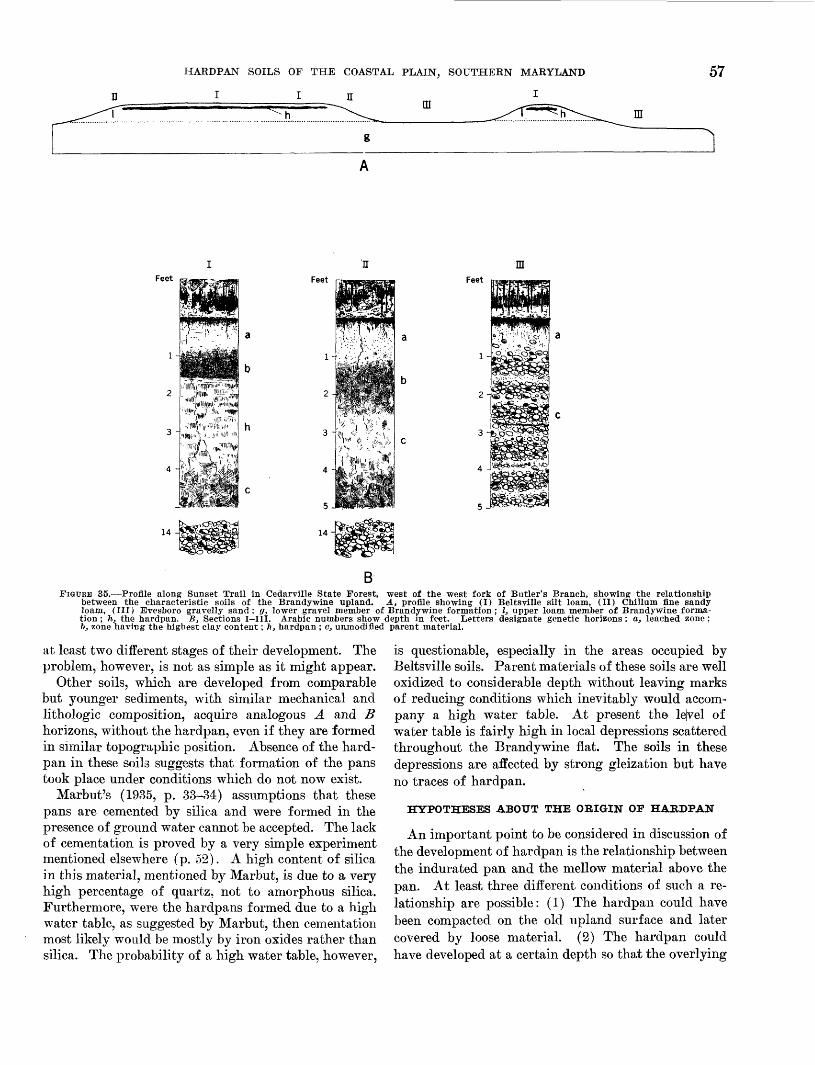
The hardpan soils of the region (fig. 35) typically occupy smooth level areas. They are conspicuously absent in regions that are hilly, rolling, or strongly undulating. The locality shown in figure 35 is the same as shown by Hack (1955, fig. 22). Marbut (1935, p. 33) states that
in the Coastal Plain region . . . certain remnants of an old smooth land surface, antedating the inauguration of the exist ing cycle of erosion, are still intact. A soil, Leonardtown silt loam, has been developed on these areas under the influence of a ground water surface lying, it seems, at about 3 feet beneath the surface of the ground. An indurated layer has developed at this level.
These hardpan soils are very well developed through out a fairly extensive flat on which the town of Brandy- wine is situated. Throughout this flat the hardpan forms a nearly continuous sheet broken in places by sandy ridges or swampy depressions, in which the hard- pan is absent. Along the margins of this flat, the land is dissected and the hardpan is found only in relatively elevated small flat-topped areas which presumably rep resent remnants of the once larger old flat. Some of these areas, now detached from the main body of the flat, are very small, hardly more than 200 feet in diame ter, and yet their flat tops are underlain by the typical hardpan. We may conclude that such a pattern of dis tribution of the hardpan soils lends support to Marbut's basic assumption that the pan formation has been as sociated with an old smooth surface, now largely dis sected by recent erosion.
Therefore, it can be assumed that the formation of the hardpan should be older than the present erosion. The other essential horizons of the hardpan soils, A and B horizons, have according to Marbut (1935, p. 34), "the usual characteristics of the podzolic soils of the region. They are normal A and B horizons." Essen tially the same horizons characterize soils occupying the present undulating or gently rolling and hilly post- erosional surface. Hence, these horizons most likely represent the most recent adjustment of the soil to present environment. This assumption was the first to suggest that Leonardtown and especially Beltsville soils might possess certain characteristics representing
HARDPAN SOILS OF THE COASTAL PLAIN, SOUTHERN MARYLAND
I I H m -=.,- -n
57
g
mFeet Feet Feet
14-
BFIGURE 35.—Profile along Sunset Trail in Cedarville State Forest, west of the west fork of Butler's Branch, showing the relationship
between the characteristic soils of the Brandy wine upland. A., profile showing (I) Beltsville silt loam, (II) Chillum fine sandy loam, (III) Evesboro gravelly sand; g, lower gravel member of Brandywine formation; I, upper loam member of Brandywine forma tion ; h, the hardpan. B, Sections I—III. Arabic numbers show depth in feet. Letters designate genetic horizons : a, leached zone ; bj zone having the highest clay content; li, hardpan ; c, unmodified parent material.
at least two different stages of their development. The problem, however, is not as simple as it might appear.
Other soils, which are developed from comparable but younger sediments, with similar mechanical and lithologic composition, acquire analogous A and B horizons, without the hardpan, even if they are formed in similar topographic position. Absence of the hard- pan in these soils suggests that formation of the pans took place under conditions which do not now exist.
Marbut's (1935, p. 33-34) assumptions that these pans are cemented by silica and were formed in the presence of ground water cannot be accepted. The lack of cementation is proved by a very simple experiment mentioned elsewhere (p. 52). A high content of silica in this material, mentioned by Marbut, is due to a very high percentage of quartz, not to amorphous silica. Furthermore, were the hardpans formed due to a high water table, as suggested by Marbut, then cementation most likely would be mostly by iron oxides rather than silica. The probability of a high water table, however,
is questionable, especially in the areas occupied by Beltsville soils. Parent materials of these soils are well oxidized to considerable depth without leaving marks of reducing conditions which inevitably would accom pany a high water table. At present the lejvel of water table is fairly high in local depressions scattered throughout the Brandywine flat. The soils in these depressions are affected by strong gleization but have no traces of hardpan.
HYPOTHESES ABOUT THE ORIGIN OF HARDPAN
An important point to be considered in discussion of the development of hardpan is the relationship between the indurated pan and the mellow material above the pan. At least three different conditions of such a re lationship are possible: (1) The hardpan could have been compacted on the old upland surface and later covered by loose material. (2) The hardpan could have developed at a certain depth so that the overlying
58 GEOLOGY AND SOILS OF THE BRANDYWINE AREA, MARYLAND
soft material is at least as old as the pan itself. (3) The existing hardpan might represent the remnants of an originally thicker pan, the upper part of which has been altered by weathering into the soft material cover ing the uiideconsolidated part remaining. The last of these three hypotheses was suggested by the late Kirk Bryan during his last visit to the area only a short time before he passed away.
If the hardpan has been covered by loose material after being formed, then there should be a stratigraphic break at the contact between the pan and the overlying soft layer. Such a break would indicate discontinuity of sedimentation for a certain length of time sufficient for the development of the pan, whether in the form of an indurated crust or merely compacted and ready for hardening at some later date, perhaps after burial under the soft sediments. Certain characteristics of the pan, especially its polygonal cleavage resembling the pattern of mud cracks and the platy structure of the material at the contact between the pan and the loamy layer, strongly suggest the probability of such a break. Some mineralogical data support a prob ability. These data, however, are too meager to be de cisive, whereas the data on mechanical composition of the pan and overlying soft material do not show any marks of a break at this level.
The other strong argument against the hypothesis of a stratigraphic break at the contact between the pan and its soft mantle is provided by a conspicuously con stant thickness of the loamy sediments above the pan. Wherever the pan is present, it is covered by about 18 to 24 inches of mellow material. It seems highly im probable that the recent sediments would be spread so evenly throughout all areas underlain by the hardpan.
The relatively constant depth of the surface of the hardpan supports the second hypothesis which suggests that from the very beginning hardpans should form at a certain depth. The hardpan could have been merely another genetic horizon below the normal B horizon. It may or may not develop under present environment, in fact, our data suggest that it does not develop now, but in time of formation such horizons could have been developing harmoniously with the others including the A and B. These older A and B horizons could have been different from their present counterparts and later altered by changes in the environment, whereas the hardpan would persist without any major change.
This hypothesis may be supported by analogy. True cemented hardpans are formed by irreversible cementation of the lower soil horizons. Conspicuous claypans also are formed due to local enhancement of hydrolytic decomposition of clay-forming minerals at a certain depth. However, analogy is not proof. The
fact that cementation or increase in effectiveness of hy drolytic action should take place at a certain depth rather than on the surface does not require that harden ing by compaction at such a shallow depth should follow the trend.
The general character and especially the cleavage of the hardpan might be used as an argument against this hypothesis. Strong polygonal cracking of the soil at a depth of about 2 feet without any effect upon the over lying layer is hardly possible. It is true that fragmen tation of clayey B horizons and development of coarse blocky or prismatic structure in these horizons are quite common. Hence, fairly strong cracking of the soil below the structureless or even laminated upper horizons is not unusual. It takes place, however, only in horizons having a high content of clay and overlain by friable silty and sandy materials. The cracking begins and ends at the boundaries of the clayey hori zon. This is not true of Beltsville soil. Content of clay in the B horizon of this soil, just above the pan, usually is much higher than in the pan and yet for some unknown reason cracking does not affect this horizon. Moreover, cracking which takes place in the clayey B horizons, including vertical cracking, usually breaks the soil into much smaller clods or prisms. Strong vertical cracking which breaks the heavy soil into blocks of comparable size and shape is also fairly common but, as a rule, these cracks are open on the surface.
The third alternative, for which we are indebted to the late Kirk Bryan, tends to compromise the contra dictions inherent in other hypotheses. Bryan suggested that the soil <jould have been compacted and probably hardened from the surface to the depth of the base of the present hardpan and that subsequent weathering, under conditions different from those under which the ancient soil was compacted, unconsolidated the upper part of the original pan and changed it into the A and B horizons of the present soil.
This plausible hypothesis eliminates the necessity to postulate the stratigraphic break at the contact between the remnants of the pan and the mellowed top layer and satisfactorily explains the absence of the effects of cracking in the material above the pan as well as the relatively uniform depth to the surface of the pan over so wide an area. According to this hypothesis the com pacted soil could have been broken by either mud cracks or frost cracks like those now breaking the Tundra soils. These cracks could have been widened by ice wedges; their walls could have been oxidized and bleached; the cracks could have been filled up with mud and sealed. Subsequent pedogenic development could have obliterated all these different marks in the present

HARDPAN SOILS OF THE COASTAL PLAIN, SOUTHERN MARYLAND 59
soil horizons without inflicting major changes in the lower part of the old hardpan.
Eemnants of hardpan under the B horizon might be responsible for several other things. It has been pointed out that the pan is compact enough to prevent free movement of water through it, except for an al most negligible percolation along unsealed cleavage planes. Therefore, much rain and especially melt wa ter is retained above the pan until it is evaporated or used by plants. This accelerated waterlogging of the soil just above the pan might be responsible for the de velopment here of platy structure and a conspicuously sharp boundary between the pan and the overlying B horizon. Even more certainly, it is responsible for the local slight gleization and faint mottling of the lower most part of the B. Obviously, these accessory char acteristics are acquired by the soil irrespective of any particular mode of origin of the pan.
Thus, it is probable that hardpan soils of the Coastal Plain represent an old surface. At the present time, these soils occupy but a small part of the region, the other part being occupied by soils without pans. Ab sence of hardpan in a given area could be due either to destruction of the pan by erosion or by weathering in place or because it never was formed. Destruction by erosion seems to be the more plausible.
SOILS WITHOUT HARDPAN
Very interesting and significant is the complete ab sence of naturally exposed ledges of hardpan along the borders of the remnants of old surfaces, exposures of which are such a conspicuous feature of all eroded areas underlain by "cemented" hardpans or crusts. The absence of exposures of the pans in this region likely is due to the lack of cementation and to the relative ease of slacking of merely compacted pans whenever erosion brings them within the grasp of weathering. These pans apparently melt away vertically and hori zontally as fast as their protective loamy mantle is removed or thinned by erosion. Therefore, the bound ary between the hardpan and the soil without a hardpan is always more or less gradational.
It is assumed that the old surface was smoother than the present, although it hardly was a perfect monoto nous plain. It could have been fairly level in some places and more or less undulating in others. Examples of both kinds of relief are preserved. In level areas, the hardpan extends almost horizontally and parallel to the surface and vanishes where the elevation of the present surface begins to drop. In other areas, how ever, the surface of the hardpan follows rather closely the configuration of the present gently undulating sur
face, suggesting that the relief of these particular areas, probably, is older than other topographic features of the region.
Somewhat less understood is the absence of hardpan in parts of the area which appears to be relatively undisturbed old surface. Such places are of two kinds, they are either swampy local depressions or areas under lain by sand. The hardpan is absent and, probably, did not form at any time in these places.
Scattered small sandy areas are particularly interest ing. Some of these areas represent bodies of sand shaped as preferentially oriented elongated ridges, relative elevation of which ranges from just a few feet to, perhaps, more than 10 feet. Ridges of this kind are a common topographic feature of the old surface in the Brandywine area. Not all of these are built of sand. Many consist of loam and clays, identical with those of the upper member of the Brandywine forma tion, and are capped with a veneer of fine sandy mate rial. These ridges are clearly erosional in origin (Hack, 1955, p. 20). Some of the ridges are fairly wide in cross section and conspicuously flat topped, whereas the narrower have a smoothly rounded cross-section profile. The soils on these ridges are the common hardpan soils of the old surface and have a somewhat more strongly leached and bleached A horizon forming the sandy veneer over the heavier underlying sediments. Some addition of the wind-borne fine sand to the material of this horizon cannot be ruled out, but fundamentally this horizon acquires its specific character due to the normal pedogenic process. In fact, the A horizon of most soils serves as a sort of shock absorber. It is subject to weathering and other mechanical disintegra tion which do not affect the deeper soil horizons.
The true sandy ridges are topographically similar and in many cases indiscernible from the erosional ridges described in the preceding paragraph, but con sist of well-sorted sand. Hack studied the stratigraphy of these "sand lentils" in some detail and concluded that these bodies of sand might represent the old dunes heaped on the upland deposits at times when the land was not occupied by vegetation capable of arresting wind action.
Soils of these sandy ridges have not been studied enough to warrant any definite conclusion. They were examined largely by auger borings, few of which were more than 10 feet deep. No traces of the hardpan or other marks of old soils which could have been buried under the sand were found in any examined site. Hence, it seems that if this sand had been piled upon the Brandywine formation by wind, then, perhaps, it should occur before the hardpan soils could develop in this area.

60 GEOLOGY AND SOILS OF THE BRANDYWINE AREA, MARYLAND
Surficial deposits of sand are not confined exclusively to the ridges. Other areas underlain by sand and scat tered throughout the level plain do not show noticeable topographic rises. In most places these thin beds of sand are underlain by gravel. Hack reports, however, that in some places the sand rests on "loam." Here again, as in the case of erosional ridges .covered by a thin layer of sandy material, careful attention must be given to the origin of the sandy veneer, the presence of which might be due either to the depositional stratifi cation or pedogenic alteration of the parent material.
It has been pointed out elsewhere that the horizontal extinction of the hardpan is typically gradational and that the development of the pan could have been con ditioned by certain local factors including the mechani cal composition of the parent material. The common geographical associate (a soil having a common bound ary) of Beltsville silt loam, which is a typical hardpan soil, is a pan-free soil tentatively classified as Chillum loamy fine sand (fig. 35, profile II). This latter soil has A and B horizons similar to those of Beltsville soil except for degree of development. As a rule, the pro file of Chillum soil is more strongly developed than that of Beltsville soil. The A and B horizons of the Chillum soil are thicker and more clearly differentiated as to the texture and color than those of the Beltsville. Hence, if these two soils are developed from similar parent materials, then their profiles would indicate that in Chillum soil this material has been altered more drastically and usually to a somewhat greater depth than in Beltsville soil.
The two soil series, Beltsville and Chillum, have a common textural type—the fine sandy loam; but the commonest member of the Beltsville series is the silt loam type, whereas the corresponding member of the Chillum series is loamy fine sand, on the other side of the textural type shared by both soil series. The three soil types—Beltsville silt loam, Beltsville and/or Chil lum fine sandy loam and Chillum loamy fine sand form a continuous series in the middle part of which is a transition from one taxonomic soil series to another. Such a transition is marked by the extinction of the hardpan. All soils of the Beltsville series are the hard- pan soils, whereas soils of the Chillum series do not have a hardpan, their B horizon grades into a relatively soft, though not necessarily friable C horizon.
Gradation-in-space from the hardpan Beltsville soil to the pan-free Chillum soil may be fairly sharp in one place, so that the two end members of a continuum are at a distance of less than 100 feet from one another, or may be very gradual, extending over a distance of several hundreds of feet. In some places, this transi tion is accompanied by a change in elevation so that
the Chillum soil tends to occupy areas having somewhat lower relative elevation than the neighboring areas of Beltsville soil. Such a topographic relationship, how ever, is not by any means exclusive. In other places, the tracts of Chillum soil are not on the periphery but within larger areas occupied by the Beltsville soil; and these tracts or islands may be somewhat elevated above the surrounding plain.
Gradation of the hardpan soils into the pan-free soil illustrates the horizontal extinction of the hardpan. With a gradual increase in content of sand in the upper soil horizon and an increase in thickness of this and the next lower or B horizon, the hardpan appears to sink deeper and to become thinner, less firmly hardened and less sharply limited on the top. Ultimately, it ap pears to fade away without any sharp line of demarca tion. It is a different and rather complicated question whether this order of change of soil profile in space—• for example, from point Xs to a point Z s , a few hundred feet away—represents a similar sequence of evolution of the soil at any fixed point—that is a change in time from Xt to a time Zt . The time Zt may represent a few hundred or thousands of years (Mkiforoff, 1942). The Chillum soil profile is decidely more strongly devel oped than the Beltsville profile. Such a difference in degree of development of the two soils, however, does not necessarily indicate a more advanced stage of evo lution of one of these soils. First, it is the consequence of adjustment of different soils to their respective en vironments, which might take place simultaneously in different areas.
Mechanical analyses of soils having the texture of fine sandy loam, one of which has a hardpan (Belts ville) and the other two without hardpans show similar particle-size distribution (table 1). Mechanical com positions of Beltsville silt loam and Chillum loamy fine sand are fundamentally different (table 2). The Chil lum soil contains 2 to 3 times as much sand as the Belts ville, but only a third or a fourth as much silt and clay. The differences between the two soils in relative con tent of sand may be due to the difference in composition of the parent materials or to the uneven effectiveness of pedogenic alteration of the similar initial materials. In the latter an increase in content of sand would be an acquired characteristic, the development of which would require an utter destruction of very large quanti ties of silt and clay which were present in the original material. Decomposition of the clay minerals in the A horizon, probably, is a common and normal process, but an utter destruction of such large quantities of silt, which consists mostly of quartz, is, in all likelihood, out of the question. It could have been possible only if this silt were composed predominantly of less stable
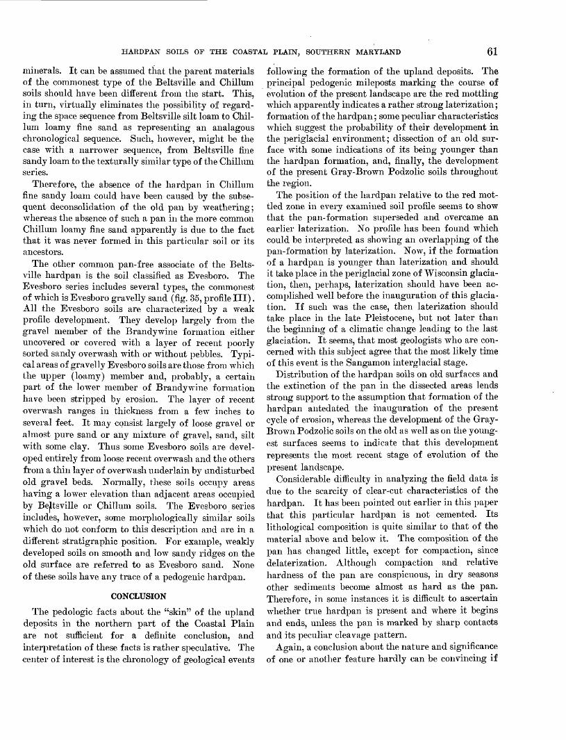
HARDPAN SOILS OF THE COASTAL PLAIN, SOUTHERN MARYLAND 61
minerals. It can be assumed that the parent materials of the commonest type of the Beltsville and Chillum soils should have been different from the start. This, in turn, virtually eliminates the possibility of regard ing the space sequence from Beltsville silt loam to Chil lum loamy fine sand as representing an analagous chronological sequence. Such, however, might be the case with a narrower sequence, from Beltsville fine sandy loam to the texturally similar type of the Chillum series.
Therefore, the absence of the hardpan in Chillum fine sandy loam could have been caused by the subse quent deconsolidation of the old pan by weathering; whereas the absence of such a pan in the more common Chillum loamy fine sand apparently is due to the fact that it was never formed in this particular soil or its ancestors.
The other common pan-free associate of the Belts ville hardpan is the soil classified as Evesboro. The Evesboro series includes several types, the commonest of which is Evesboro gravelly sand (fig. 35, profile III). All the Evesboro soils are characterized by a weak profile development. They develop largely from the gravel member of the Brandywine formation either uncovered or covered with a layer of recent poorly sorted sandy overwash with or without pebbles. Typi cal areas of gravelly Evesboro soils are those from which the upper (loamy) member and, probably, a certain part of the lower member of Brandywine formation have been stripped by erosion. The layer of recent overwash ranges in thickness from a few inches to several feet. It may consist largely of loose gravel or almost pure sand or any mixture of gravel, sand, silt with some clay. Thus some Evesboro soils are devel oped entirely from loose recent overwash and the others from a thin layer of overwash underlain by undisturbed old gravel beds. Normally, these soils occupy areas having a lower elevation than adjacent areas occupied by Bejltsville or Chillum soils. The Evesboro series includes, however, some morphologically similar soils which do not conform to this description and are in a different stratigraphic position. For example, weakly developed soils on smooth and low sandy ridges on the old surface are referred to as Evesboro sand. None of these soils have any trace of a pedogenic hardpan.
CONCLUSION
The pedologic facts about the "skin" of the upland deposits in the northern part of the Coastal Plain are not sufficient for a definite conclusion, and interpretation of these facts is rather speculative. The center of interest is the chronology of geological events
following the formation of the upland deposits. The principal pedogenic mileposts marking the course of evolution of the present landscape are the red mottling which apparently indicates a rather strong laterization; formation of the hardpan; some peculiar characteristics which suggest the probability of their development in the periglacial environment; dissection of an old sur face with some indications of its being younger than the hardpan formation, and, finally, the development of the present Gray-Brown Podzolic soils throughout the region.
The position of the hardpan relative to the red mot tled zone in every examined soil profile seems to show that the pan-formation superseded and overcame an earlier laterization. No profile has been found which could be interpreted as showing an overlapping of the pan-formation by laterization. Now, if the formation of a hardpan is younger than laterization and should it take place in the periglacial zone of Wisconsin glacia- tion, then, perhaps, laterization should have been ac complished well before the inauguration of this glacia- tion. If such was the case, then laterization should take place in the late Pleistocene, but not later than the beginning of a climatic change leading to the last glaciation. It seems, that most geologists who are con cerned with this subject agree that the most likely time of this event is the Sangamon interglacial stage.
Distribution of the hardpan soils on old surfaces and the extinction of the pan in the dissected areas lends strong support to the assumption that formation of the hardpan antedated the inauguration of the present cycle of erosion, whereas the development of the Gray- Brown Podzolic soils on the old as well as on the young est surfaces seems to indicate that this development represents the most recent stage of evolution of the present landscape.
Considerable difficulty in analyzing the field data is due to the scarcity of clear-cut characteristics of the hardpan. It has been pointed out earlier in this paper that this particular hardpan is not cemented. Its lithological composition is quite similar to that of the material above and below it. The composition of the pan has changed little, except for compaction, since delaterization. Although compaction and relative hardness of the pan are conspicuous, in dry seasons other sediments become almost as hard as the pan. Therefore, in some instances it is difficult to ascertain whether true hardpan is present and where it begins and ends, unless the pan is marked by sharp contacts and its peculiar cleavage pattern.
Again, a conclusion about the nature and significance of one or another feature hardly can be convincing if

62 GEOLOGY AND SOILS OF THE BRANDYWINE AREA, MARYLAND
it is based oil observations in one small area, even if this area is a recognized type locality. It is known that quite similar uncemented hardpans exist in the other parts of the Coastal Plain, for example, in Kentucky and Tennessee and elsewhere. The hardpan soils of Kentucky and the neighboring States, such as the Grenada soil, are in many respects similar to the Belts- ville soils of Maryland. Traces of what is believed to be the pre-Wisconsin laterization, perhaps, are more persistent and conspicuous in the subsoil of Kentucky soils, than those in soils of Maryland, but their relation to the hardpan is the same in all these soils. The cleavage of the Grenada hardpan appears to be more intricate and more irregular than that of the Beltsville pan, but both pans are broken rather than monolithic and marking of the cleavage planes is similar. Whether these similarities indicate that evolution of hardpan
TABLE 1.—Mechanical composition of Beltsville and CMllum fine sandy loams
Soil
Beltsville fine sandy loam _ ..........
Chillum fine sandy loam.. .............
Do..... ....
Horizon
AA B
CAABCAAB C
Depth(inches)
4-1012-18 30-3638-4470-854-10
12-1824-29 30-364-10
12-2034-44 50-70
Sand
72.963.9 64.879.222.869.570.865.3 58.966.264.072.9 84.7
Silt
Percent
21.728.9 14.45.2
52.324.622.516.3 22.127.428.514.4 7.6
Clay
5.47.2
20.815.624.95.96.7
18.4 19.06.47.5
12.77.7
1 Hardpan.
TABLE 2.—Mechanical composition of Beltsville silt loam and Chillum loamy fine sand
Soil
AB(')(>)CAA ABC
Depth(inches)
4-1018-24 24-3050-5870-801-46-12
20-3034-4242-50
Sand
25.929.7 49.531.832.985.183.1 86.937.627.5
Silt
Percent
61.745.8 33.137.033.311.313.1 9.7
35.655.1
Clay
12.424.5 17.431.233.83.63.8 3.4
26.817.4
1 Hardpan.
soils of Kentucky also was similar to that of the Mary land soils is still an open question. The probability cannot be ruled out, but the problem needs further study.
LITERATURE CITED
Bryan, Kirk, and Albritton, C. C., 1943, Soil phenomena as evidence of climatic changes: Am. Jour. Sci., v. 241, p. 469-490.
Bryan, W. H., 1946, The geological approach to the study of soils: Australian and New Zealand Assoc. Adv. Sci. Kept. 25, p. 52-70.
Denny, C. S., 1951, Pleistocene frost action near the border of the Wisconsin drift in Pennsylvania: Ohio Jour. Sci., v. 51, no. 3, p. 116-125.
Dokuchaev, V. V., 1899, On the theory of natural zones [inRussian] : St. Petersburg.
Frye, J. C., 1949, Use of fossil soils in Kansas Pleistocenestratigraphy: Kans. Acad. Sci. Trans. 52, p. 478-482.
Hack, J. T., 1955, Geology of the Brandywine area and origin of the upland of southern Maryland: U. S. Geol. Survey Prof. Paper 267-A, p. 1-43.
Hunt, C. B., and Sokoloff, V. P., 1950, Pre-Wisconsin soil in the Rocky Mountain region, a progress report: U. S. Geol. Survey Prof. Paper 221-G, p. 109-123.
Jenny, Hans, 1941, Factors of soil formation; a system of quantitative pedology: 281 p., New York, McGraw-Hill Book Co.
Kay, G. F., 1949, Pleistocene history and early man in America:Geol. Soc. America Bull., v. 50, p. 453-463.
Kossovich, P. S., 1911, Principles of soil science [in Russian] :pt. 2, sec. 1. St. Petersburg.
Leighton, M. M., and MacClintock, Paul, 1930, Weathered zonesin the drift sheets of Illinois: Jour. Geology, v. 38, p. 28-53.
Marbut, C. F., 1935, Soils of the United States: U. S. Dept.Agr., Atlas of Am. Agr., pt. 3, 98 p.
Nikiforoff, C. C., 1942, Fundamental formula of soil formation:Am. Jour. Sci., v. 240, no. 12, p. 847-866.
Nikiforoff, C. C., Humbert, Roger, and Cady, J. G., 1948, The hardpan in certain soils of the Coastal Plain: Soil Sci., v. 65, no. 2, p. 135-153.
Peltier, L. C., 1949, Pleistocene terraces of the Susquehanna River, Pennsylvania: Pa. Geol. Survey, 4th ser., Bull. G-23, 158 p.
Richmond, G. M., 1950, Interstadial soils as possible strati- graphic horizons in Wisconsin chronology [abs.]: Geol. Soc. America Bull., v. 61, p. 1497.
Roberts, J. K, and Gildersleeve, Benjamin, 1945, Geology and mineral resources of the Jackson Purchase region, Ken tucky: Kentucky Dept. Mines and Minerals, Geol. Div. Bull., ser. 8, no. 8, 126 p.
Simonson, R. W., 1941, Studies of buried soils formed from tillin Iowa: Soil Sci. Soc. America Proc., v. 6, p. 373-381.
———— 1950, Genesis and classification of Red-Yellow Podzolicsoils: Soil Sci. Soc. America Proc., v. 14, p. 316-319.
Smith, G. D., 1942, Illinois loess: Univ. 111. Agr. Exp. Sta. Bull. 490.

INDEX
PageAbstract ______________________________________ 45 Acknowledgments ____________________________ 45—46Acquired soil characteristics__—__________________ 48 Age of upland deposits__________________________ 52 Amorphous silica__———________________________ 49
Beltsville, series—________________________ 52, 53, 56, 57, 60 boundary of hardpan__________________________ 52 content of clay in__—_______________________ 58 mechanical composition_______________________ 60 thickness of hardpan—______________________ 52
loamy layer——————————————_______________ 52Brandywine formation—___________________ 48,52,53,59
basal gravelly member____—_________________ 48, 52thickness—————________________________ 53
upper loamy member________________________ 48, 52thickness—____________________________ 53
"Buried" and "fossil" soils, difference between-—__——____ 50
Cementing materials________________________Chillum series____________________________________________
content of sand————————__________________________mechanical composition________________________________
Classification of hardpans according to cementing materials____Comparison of cleavage of Beltsville and Grenada hardpans__ Content of titania in soil, significance of_____________________
Definition of soil______—_______________________________Degradation of grassland soil_________________________Difference in the effects of laterization and podzolization______Differentiation between reversible and irreversible character
istics —————————___________________________
Distribution of hardpan soils_______________________________Elongated ridges of sand_________________________________
origin —————————————————————————————————_____range in elevation——__________________________
Environment of soil formation, definition____________________Evesboro series-—————_—________________________________Evolution of lateritic soil______________________________
present landscape, formation of hardpan_________________pedogenic mileposts in—__________________________
"Function of the environment"____________________________
Genetic relationship between different horizons- Gradation from hardpan to pan-free soil____. Gray-Brown Podzolic soil, color__—______.
description—————————————__________thickness ____________________________
49606060496249
46,484954
49
565959594661546161
46
4860555555
Induration of hardpans______Inherited soil characteristics- Introduced soil characteristics-
Page__________________ 50 ___________________ 48 ___________________ 48
Lateritic crust___________________—————————————— 50Laterization _______________________________ 53, 54, 56Leonardtown series, composition of hardpan—————————— 52, 53, 57
division..________ ________________________ 52silica content of hardpan________————————————— 52
Marbut, C. F., quoted_______________________—— 47,55,56 Mechanical composition of soils________—_——-— 52, 53, 60, 62
Origin of hardpan, hypotheses. __________________ 57
Parent material, definition__________————————————— 47description of__——_——_———___————————————— 47effect of weathering on————__———————————————— 46formation by atmospheric agencies_————————— —— —— 46part of mantle that serves as_—————————————————— 46theoretical concept of__________—————————————— 46
Pattern of cleavage of hardpan————————————————————— 56, 62red mottling_—_—_—___—_—————————————————— 53
"Pedologic skin"_______________________——————— 48, 49Podzolization————— _..————————————————————————— 54, 55"Polygenetic" soils________——————————————————— 50Profile of weathering—_____________————————————— 47
Recent investigations in paleopedology—— ————— ——————— - 51Red mottling___——______—————————————————————— 53, 56Red Podzolic soils-————————————————————————————— 54, 55Red-Yellow Podzolic soils___————————————————————— 55
Soil(s) :definition ___.._______formation-_____________from stratified sediments- horizon (s)
___________________ 47 ____________________ 47 ____________________ 48 .____________________ 47
A________________________________ 47, 48, 52, 57, 58, 60B_______________________ 47, 48, 51, 52, 55, 56, 57, 58, 59, 60C______________..____________________ 47, 48, 56, 60
range in thickness———..—————————————————————— 47 Sunderland formation——————————————————————————— 52
Theoretical concept of parent material, abiotic physicochemicalprocess———————————————————————————— 46
biotic agencies_——————————————————————————— 46 inherent weakness—————————————————————————— 46
Upland deposits——————————————————————————————— 52, 53
Wicomico formation__________——————————————————— 52
63
O

Geology and Soils of the
Brandywine Area
Maryland
GEOLOGICAL SURVEY PROFESSIONAL PAPER 267
UNITED STATES GOVERNMENT PRINTING OFFICE, WASHINGTON : 1955

UNITED STATES DEPARTMENT OF THE INTERIOR
Douglas McKay, Secretary
GEOLOGICAL SURVEY
W. E. Wrather, Director

CONTENTS
[The letters in parentheses preceding the titles are those used to designate the separate chapters]Page
(A) Geology of the Brandywine area and origin of the upland of southern Maryland, by John T. Hack._________________ 1(B) Hardpan soils of the Coastal Plain of southern Maryland, by C. C. Nikiforoff-____--__-_-___--___-__---_----_----_ 45
in
