handout #1 - stanford university · pdf filehandout #1. course goal: ... elementary scattering...
TRANSCRIPT
EE355/GP265- Radar Remote Sensing: Fundamentals and Geophysical Application of Imaging RadarSystems
Syllabus
Howard Zebker
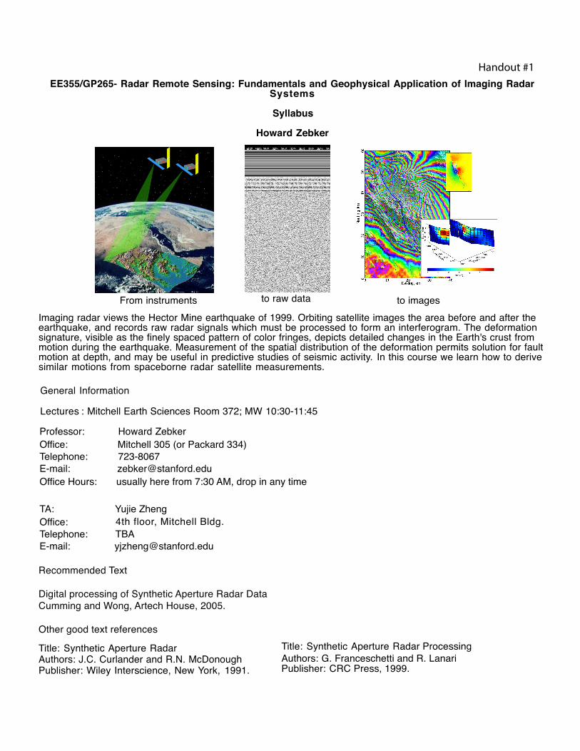
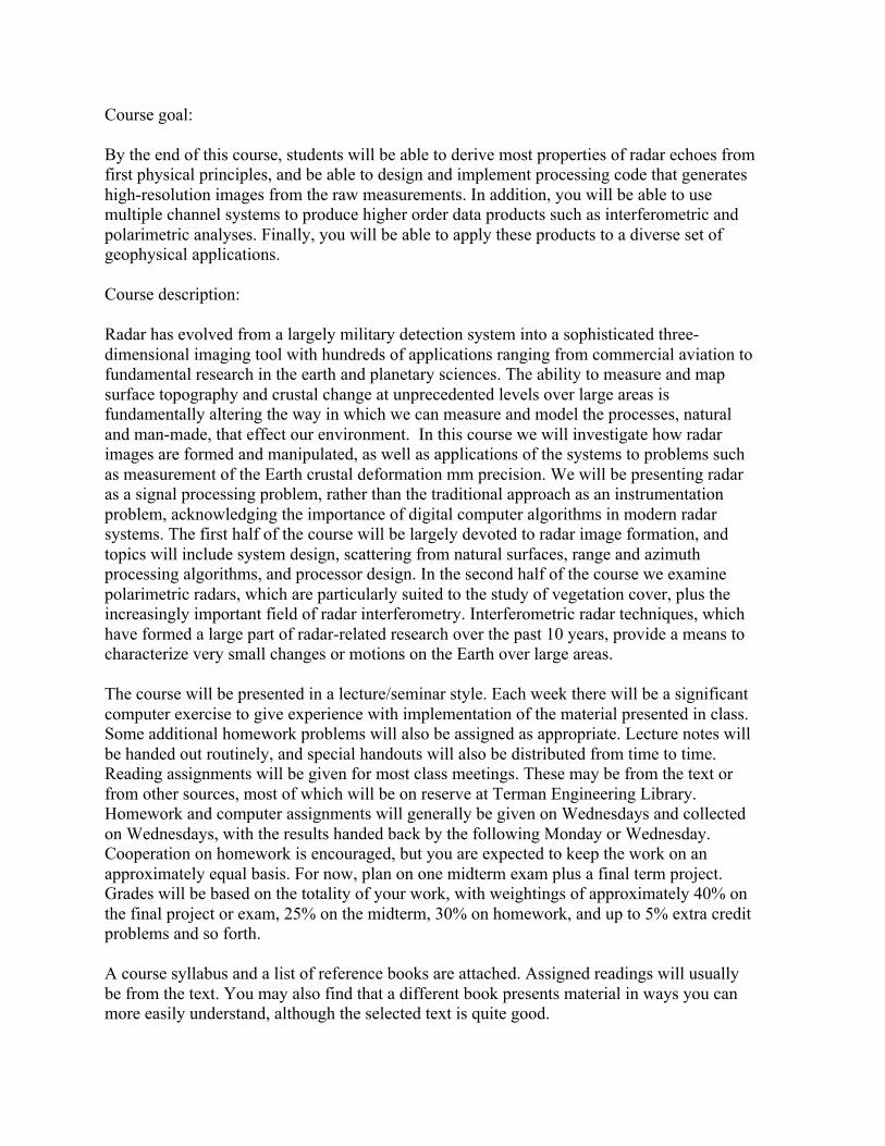
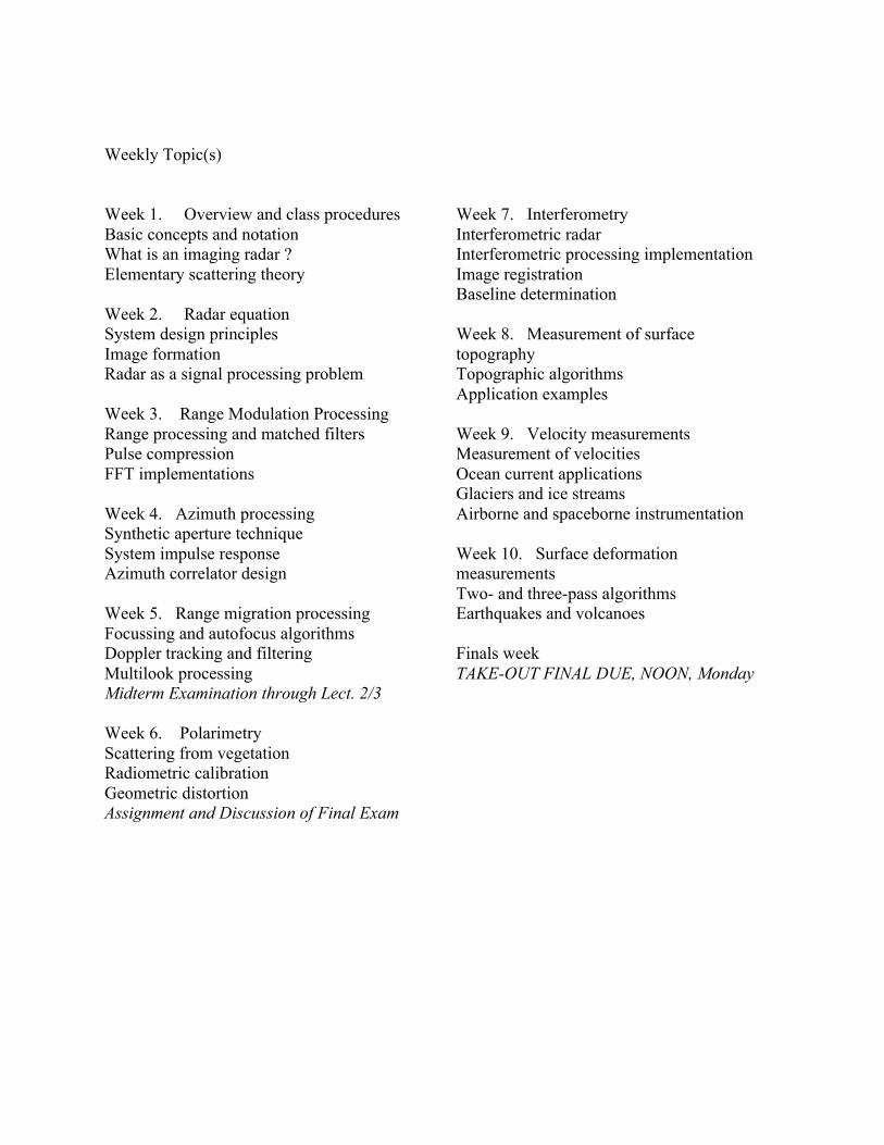
From instruments to raw data to imagesImaging radar views the Hector Mine earthquake of 1999. Orbiting satellite images the area before and after theearthquake, and records raw radar signals which must be processed to form an interferogram. The deformationsignature, visible as the finely spaced pattern of color fringes, depicts detailed changes in the Earth's crust frommotion during the earthquake. Measurement of the spatial distribution of the deformation permits solution for faultmotion at depth, and may be useful in predictive studies of seismic activity. In this course we learn how to derivesimilar motions from spaceborne radar satellite measurements.
General Information
Professor: Howard ZebkerOffice: Mitchell 305 (or Packard 334)Telephone: 723-8067E-mail: [email protected] Office Hours: usually here from 7:30 AM, drop in any time
TA: Yujie ZhengOffice:Telephone: TBAE-mail: [email protected]
Recommended Text
Digital processing of Synthetic Aperture Radar DataCumming and Wong, Artech House, 2005.
Other good text references
Title: Synthetic Aperture RadarAuthors: J.C. Curlander and R.N. McDonoughPublisher: Wiley Interscience, New York, 1991.
Lectures : Mitchell Earth Sciences Room 372; MW 10:30-11:45
4th floor, Mitchell Bldg.
Title: Synthetic Aperture Radar ProcessingAuthors: G. Franceschetti and R. Lanari Publisher: CRC Press, 1999.
Handout #1
Course goal: By the end of this course, students will be able to derive most properties of radar echoes from first physical principles, and be able to design and implement processing code that generates high-resolution images from the raw measurements. In addition, you will be able to use multiple channel systems to produce higher order data products such as interferometric and polarimetric analyses. Finally, you will be able to apply these products to a diverse set of geophysical applications. Course description: Radar has evolved from a largely military detection system into a sophisticated three-dimensional imaging tool with hundreds of applications ranging from commercial aviation to fundamental research in the earth and planetary sciences. The ability to measure and map surface topography and crustal change at unprecedented levels over large areas is fundamentally altering the way in which we can measure and model the processes, natural and man-made, that effect our environment. In this course we will investigate how radar images are formed and manipulated, as well as applications of the systems to problems such as measurement of the Earth crustal deformation mm precision. We will be presenting radar as a signal processing problem, rather than the traditional approach as an instrumentation problem, acknowledging the importance of digital computer algorithms in modern radar systems. The first half of the course will be largely devoted to radar image formation, and topics will include system design, scattering from natural surfaces, range and azimuth processing algorithms, and processor design. In the second half of the course we examine polarimetric radars, which are particularly suited to the study of vegetation cover, plus the increasingly important field of radar interferometry. Interferometric radar techniques, which have formed a large part of radar-related research over the past 10 years, provide a means to characterize very small changes or motions on the Earth over large areas. The course will be presented in a lecture/seminar style. Each week there will be a significant computer exercise to give experience with implementation of the material presented in class. Some additional homework problems will also be assigned as appropriate. Lecture notes will be handed out routinely, and special handouts will also be distributed from time to time. Reading assignments will be given for most class meetings. These may be from the text or from other sources, most of which will be on reserve at Terman Engineering Library. Homework and computer assignments will generally be given on Wednesdays and collected on Wednesdays, with the results handed back by the following Monday or Wednesday. Cooperation on homework is encouraged, but you are expected to keep the work on an approximately equal basis. For now, plan on one midterm exam plus a final term project. Grades will be based on the totality of your work, with weightings of approximately 40% on the final project or exam, 25% on the midterm, 30% on homework, and up to 5% extra credit problems and so forth. A course syllabus and a list of reference books are attached. Assigned readings will usually be from the text. You may also find that a different book presents material in ways you can more easily understand, although the selected text is quite good.
Weekly Topic(s) Week 1. Overview and class procedures Basic concepts and notation What is an imaging radar ? Elementary scattering theory Week 2. Radar equation System design principles Image formation Radar as a signal processing problem Week 3. Range Modulation Processing Range processing and matched filters Pulse compression FFT implementations Week 4. Azimuth processing Synthetic aperture technique System impulse response Azimuth correlator design Week 5. Range migration processing Focussing and autofocus algorithms Doppler tracking and filtering Multilook processing Midterm Examination through Lect. 2/3 Week 6. Polarimetry Scattering from vegetation Radiometric calibration Geometric distortion Assignment and Discussion of Final Exam
Week 7. Interferometry Interferometric radar Interferometric processing implementation Image registration Baseline determination Week 8. Measurement of surface topography Topographic algorithms Application examples Week 9. Velocity measurements Measurement of velocities Ocean current applications Glaciers and ice streams Airborne and spaceborne instrumentation Week 10. Surface deformation measurements Two- and three-pass algorithms Earthquakes and volcanoes Finals week TAKE-OUT FINAL DUE, NOON, Monday
REFERENCES Other books which may serve as useful references are listed below. These are on reserve in Terman Engineering Library, as well as the recommended texts. Bracewell, R. N., The Fourier Transform and Its Applications, McGraw-Hill, New York, 2nd edition, 1986. Carrara, W.G., R.S. Goodman, and R.M. Majewski, Spotlight Synthetic Aperture Radar: Signal Processing Algorithms, Artech House, Norwood, MA, 1995. Curlander, J.C. and R.N. McDonough, Synthetic Aperture Radar, Wiley Interscience, New York, 1991. Elachi, C., Introduction to the physics and techniques of remote sensing, Wiley, New York, 1987. Elachi, C., Spaceborne Radar Remote Sensing: Applications and Techniques, IEEE press, New York, 1988. Goodman, J.W., Introduction to Fourier Optics, McGraw-Hill, New York, 1968. Kraus, J.D. Radio Astronomy, McGraw-Hill, New York, 1966. (Later editions good also) Peebles, P.Z, Radar Principles, Wiley Interscience, New York, 1998. Press, W.H., B.P. Flannery, S.A. Teukolsky, and W.T. Vetterling, Numerical Recipes in C, the Art of Scientific Computing, Cambridge University Press, New York, 1988. (Any of the Numerical Recipes series will have useful algorithm information) Sabins, F., Remote Sensing, 3rd ed., Freeman, New York, 1996. Soumekh, M., Fourier Array Imaging, Prentice Hall, Englewood Cliffs, New Jersey, 1994. The following, though not on reserve, are also relevant and may be useful: Cook, C.E., and M. Bernfeld, Radar Signals, Academic Press, New York, 1967. Skolnik, M.I., Radar Handbook, McGraw-Hill, New York, 1970.