halstead - braintree district...halstead is in braintree district, on the north-west slopes of the...
TRANSCRIPT

1

HALSTEADHISTORIC TOWN ASSESSMENT REPORT
TABLE OF CONTENTS
INTRODUCTION 3
LOCATION AND TOPOGRAPHY 3
BRIEF HISTORY OF THE TOWN 3
EVIDENCE 4
LISTED BUILDINGS 5
SYNTHESIS 6
SUMMARY OF GENERAL IMPORTANCE OF THE TOWN 12
RESEARCH PRIORITIES 13
BIBLIOGRAPHY 14
APPENDICES
APPENDIX 1: Documentary sources 15
APPENDIX 2: Listed buildings 17
APPENDIX 3: Urban components list 21
FIGURES
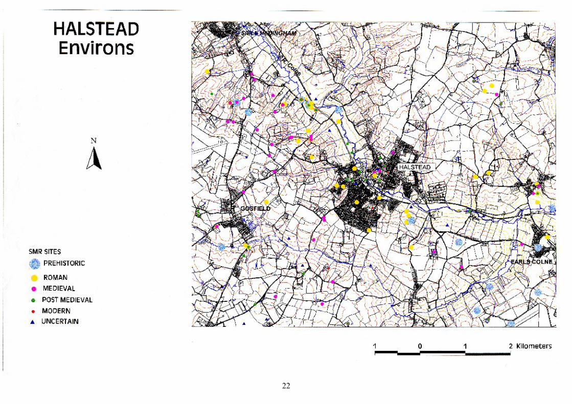
ENVIRONS 22
HISTORIC TOWN EXTENT 23
SMR & LISTED BUILDINGS 24
CARTOGRAPHIC EVIDENCE 25
FIELD WORK 26
MEDIEVAL INTERPRETATION 27
POST MEDIEVAL INTERPRETATION - General 28
POST MEDIEVAL INTERPRETATION – Town Centre 29
PLANNING CONSTRAINTS 30
2

HALSTEADHISTORIC TOWN ASSESSMENT REPORT
INTRODUCTION
This report is an archaeological and historical assessment of Halstead and forms part of the Essex Historic Towns Survey. This is an extensive urban survey as defined by English Heritage (1992a) of 32 historic settlements in Essex. This project, funded by English Heritage, forms part of a nationwide reassessment of the management of the urban archaeological resource. The project is being carried out by Essex County Council’s Planning Department and takes as its basis a survey carried out by the County Council in the early 1980’s. This was published as Historic Towns in Essex (Eddy and Petchey 1983) and adopted as Supplementary Planning Guidance by the County and District Councils.
This report has been compiled using a number of sources, including the Essex Sites and Monuments Record (ESMR), the List of Buildings of Architectural and Historical Interest, records held by the County Planning Department’s Historic Buildings Section, and various cartographic and documentary records (following an assessment of such records by Dr Chris Thornton of the Victoria County History, Essex). The preparation of this report has involved the addition of information to the ESMR database and the digitising of spatial data onto a Geographic Information System (GIS).
For the purposes of this study the Roman period is the time-span between 43-410, the Saxon period is 410-1066, the medieval period is 1066-1536, the post-medieval period is 1536-1900 and the modern period is 1900 to the present day. This corresponds to the period divisions used by the ESMR.
LOCATION AND TOPOGRAPHY
Halstead is in Braintree District, on the north-west slopes of the River Colne valley, where it is crossed by the road from Braintree to Sudbury. The sub-surface geology consists of glacial gravels. A stream runs from the vicinity of St Andrew’s Church down to the Colne, it is now piped.
BRIEF HISTORY OF THE TOWN
There is evidence for prehistoric and Roman activity in and around the town. In the Saxon period there was a settlement on the site, and by the time of the Domesday Survey there was a reasonably large population within the Halstead area, with an unusually high proportion of smallholders and freemen. In 1251 Abel de St Martin, who held one of the Halstead manors, was granted the right to hold a market, presumably on the site of the present town, and the settlement grew to be the dominant market-town in the area. The later post-medieval period saw the introduction of major changes to the town’s development because of the introduction of the weaving trade in the late eighteenth century and more significantly, the building of Courtauld’s silk factory in 1828. Courtaulds was essentially a paternalistic family business, that as the major employer in the town, played a most significant role in all aspects of urban life. In addition to the houses built for the employees of the factory, the Courtaulds also organised and funded a school, adult education classes, a library and institute, nursery, mother’s club, sick fund, amusement society, lodging house, Jubilee Fountain, Public Park, retirement homes and Cottage Hospital. In addition to Courtauld’s there were also a number of other significant employers, including the Tortoise and Portway Iron Foundries and Adams Brewery, and the town continued to retain a market and retail function.
3

EVIDENCE
DOCUMENTARY
Summary assessment of the documentary and cartographic evidenceby Chris Thornton (Victoria County History)
The historical records for Halstead appear to be quite plentiful. There is a very long series of court rolls for the Clare holdings in the town, known as the manor of Hipworth Hall, from the early fourteenth to the eighteenth century as well as reasonably frequent post-medieval rentals. In addition, series of manorial records for other estates in Halstead parish survive from the early seventeenth century onwards. There are also sizeable collections of deeds for the town in the Essex Record Office (ERO). For the modern town, the records of Halstead Urban District are available and important business records survive for the Courtauld’s factories. Among secondary sources see: Agrarian change and the cloth industry (ERO T/Z 75/19) and a thesis on the Mills of Sam. Courtauld and Co. Ltd. (ERO T/Z 75/11). Although only one pre-nineteenth century map has been found, dating to 1625, several of the nineteenth century maps provide good detail on the urban area. The early editions of the Ordnance Survey maps also contain much useful information. There is no major secondary work on Halstead.
Assessment of the place-name and documentary evidenceThe place-name Halstead is thought to refer to settlement on the valley-slope or heald (Rumble, 1935, 433). It is first referenced in 1086 in the Domesday Book (Rumble, 1983), when the main land-holders were William of Warenne, Richard the son of Count Gilbert, Waleran and Alfred, Richard’s reeve. In 1086 there was a total population of 9 villagers, 78 smallholders, 22 freemen and 8 slaves, with three mills and nineteen ploughs; the high numbers of freemen and smallholders is unusual. It is not known how many were living within the later Halstead urban area and how many throughout the rural district.ARCHAEOLOGICAL
Above ground remainsThe above ground remains include the Parish Church, the College of Canons, the street-pattern, Townford Mill and a selection of other buildings dating from the medieval to the post-medieval period. The most significant loss is the demolition of Courtaulds’ Silk Factory, which played such an important role in the development of the later post-medieval town.
ExcavationsThere have only been a few small archaeological interventions within Halstead, only one of which, the watching-brief on the area adjacent to Town Bridge, produced any significant information.
ESMR SITE DATE ARCHIVE LOCATION PUBLICATION9429 Adjacent to Town
Bridge<1975 Archive and finds: Not known Drury, P.J., 1975, Letter in the ESMR
9429 Town Bridge 1978 Archive: ESMR; Finds: None Eddy, MR. ECC Int. Rep. W/B 19789441 Old Courtauld Mill 1987 Archive: ESMR; Finds:
DiscardedAndrews, D. ECC Int. Rep. W/B 1987
17405 Rosemary Lane (Co-Op Yard)
1996 Archive: Bocking Place; Finds: Montrose Rd
Clarke, R., 1996, Rosemary Lane (Co-Op Yard), Halstead, Essex: Archaeological Evaluation, ECC Internal Report
Table 1: Excavated sites and watching-briefs
4
Finds
Medieval and post-medieval pottery by Helen Walker (Essex County Council Field Archaeology Group)No medieval or post-medieval pottery has been recovered from the urban area and further excavation will be needed before the pottery evidence can reveal anything about dating, trade, and socio-economic factors. However there are Hedingham ware production sites in the area of Halstead at Broak’s Wood (Walker 1992), Blackmore End and Greenstead Green Attwoods. The pottery needs to be assessed and published for the latter two sites.
LISTED BUILDINGSin consultation with Brenda Watkin and Dave Stenning (Listed Buildings)
The schedule of listed buildings provided in this report is derived from the List of Buildings of Special Architectural and Historical Interest. This List has been compiled over many years through the work of many inspectors and, as a result, the reliability of the List varies from District to District. Time was extremely limited and very few interiors were looked at, or even the rear wings of buildings. Where further research has been carried out on individual buildings, this has often shown the limitations of the List descriptions. The List for Halstead was originally compiled in 1978, but can be considered to be of fair reliability. It has been possible to supplement the information provided in the List through the knowledge and records of the County Historic Buildings and Design Section. There are 102 Listed Buildings in Halstead, of which one, the church, is Grade I, three are Grade II* and the remainder are Grade II. In date they range from the fourteenth to the nineteenth centuries, with the majority dating to the post-medieval period (see Table 2).
CENTURY NUMBER14 215 1216 1717 2718 1719 27
Table 2: Listed Buildings by date of origin
There are a number of buildings worthy of particular mention:-
• The College of Canons building is probably a later construction than the foundation date of the College, being probably late fifteenth century in origin. It is in effect an in-line house with open hall; later in the early sixteenth century the parlour was demolished and rebuilt behind the hall. The frontage may well have had a valuable commercial use, necessitate this movement of the domestic quarters. It is an example of church-type or high-status non-vernacular carpentry.
• Brick Barn Hall is an especially good example of a seventeenth century house, but with a cross-wing made out of the re-used thirteenth century timbers of an aisled hall.
• The Courtauld houses built in 1872 were intended for the skilled workers or mechanics. These had a living room, parlour and four bedrooms, with a scullery, coal house and W.C. to the ground floor. Town water was laid on to the sculleries and stair landing of each house. The cost ready for occupation of the fourteen dwellings was £4,895.
• The 1886 Courtauld houses in the Causeway were designed by the Essex architect George Cambell Sherrin, 1840-1906, whose other commissions for the Courtauld family included the cottage hospital at Halstead and the working men’s hall in Bocking. The
5

perspective view of the cottages was exhibited at the Royal Academy and later published in the British Architect, March 20 1885. Original plans from the Halstead Board of Health are deposited in the ERO (D/DUH Pb 2/40).• Both of the churches in Halstead had Victorian Parsonages designed by William
White, FSA 1825-1900. The parsonage house for Holy Trinity church was one of his early works, 1853, and warranted mention in Stefan Muthesius’s book The High Victorian Movement in Architecture, 1850-70. It was demolished in the late 1980’s (drawings and specifications still survive in the church of England archives). The parsonage house for St Andrews church was built in 1875 and demolished a hundred years later.
Other information gained from the Listed Building evidence has been incorporated in the period syntheses.
SYNTHESIS
PRE-URBAN SYNTHESIS
Prehistoric and RomanThere is some evidence for prehistoric activity in the area, in the form of stray finds of flint tools. There are a number of finds of Roman date from within the town, largely concentrated on the south side of the river, and it is though that there was a small settlement roughly in that area, although there is no evidence that it was urban in nature. Gestingthorpe villa is located a few miles to the north of the town and there were small Roman rural settlements scattered along the Colne valley both to the north and south of the present town.
SaxonThe place-name Halstead refers to a settlement on the valley-slope. However, the only evidence for Saxon occupation of the area comes from the Domesday Book, which records the presence of a reasonably large population with an unusually high number of freemen and smallholders.
URBAN SYNTHESIS
Medieval synthesis and components
In 1086 there was a reasonably large population within the Halstead area, with an unusually high proportion of smallholders and freemen. It is not known for certain that there was a settlement on the site of the later town, but as a crossing-place of the River Colne on the Braintree-Sudbury road it is a reasonable assumption. In 1251 Abel de St Martin, who held one of the Halstead manors, was granted the right to hold a market, presumably on the site of the present town. The de Veres made an attempt to suppress the market at Halstead on the grounds that it was taking trade from their market at Castle Hedingham, but this attempt failed and Halstead grew to be the dominant market-town in the area. There was also a thriving woollen industry in the later medieval period, with references to the presence of Flemish weavers in 1454.
6

The built-up area (TL 8133 3065)The built-up area was located along the main Braintree-Sudbury road. From north to south the road is sub-divided into Head Street, Market Hill, High Street and Bridge Street. Head Street is sited on the top of the hill, Manfield forms a back lane to the block of buildings on the eastern side of Head Street and Boisfield formed a back lane to the west of Head Street. The Church of St Andrew is located at the southern end of Head Street overlooking the slope down into the valley. Market Hill is located at the junction of the main road with Hedingham Road. The High Street drops steeply down to the river at which point it becomes Bridge Street. It is possible that the market grant of 1251 represents the expansion of an existing small market town, centred on a market area in Head Street, the expansion taking the form of the shift of the market to the Market Hill and High Street area and the development of large plots along the High Street and Bridge Street (Eddy and Petchey, 1983). Originally the river was crossed by a ford, but in the later medieval period a bridge was erected to the east of the ford and the line of the High Street shifted in that direction to form the kink at the bottom of the road.
The market (TL 8158 3075)There is documentary evidence that there was a market before 1251, probably located in Head Street, to the north of the church, in the area known as Chipping Hill. There is a reference dating to 1327 referring to the ‘old’ market area (Eddy and Petchey, 1983) to the north of the church. This area was infilled in the later medieval and post-medieval period.
Parish Church of St Andrew (TL 8152 3069)The church is located at the north-east end of the town on the crest of the slope. It is presumed that there was a late Saxon or early medieval predecessor to the present building, for which there is documentary evidence that it was in existence in 1276. The chancel, nave, and north and south aisles were entirely rebuilt in the middle of the fourteenth century. The walls are of flint and pebble rubble with limestone and clunch dressings. In the fifteenth century the north vestry, and the porches were added. There was also a west tower, located between the existing aisles.
The College of Canons (TL 8138 3067)The College of Canons (26-30 High Street) was probably erected in the late fifteenth century. The original license to found a chantry or college in Halstead for a master and eight priests had been granted in 1340 to Robert Bouchier, however it was his grandson who renewed the royal license and arranged for the building to take place. Although the new license allowed for a master and five chaplains, the documentary evidence suggests that there was only a master and a single chaplain in residence (Bamburger, 1992). The College was suppressed in 1545. The building itself is an in-line house with open hall; the rear of the building seems to have been used as the domestic area and the frontage for commercial use. The standard of carpentry is that used in the construction of churches or other high-status buildings.
Holy Trinity Chapel (TL 8085 3043)The place-name Chapel Hill refers to a chapel, dedicated to the Holy Trinity, which stood at the foot of the hill at the meeting of the Braintree and Gosfield Roads. The earliest reference to this structure is in a deed dating to 1413. Morant wrote in 1768 that the foundations were still visible shortly before his time. A shallow burial was found on the presumed site in 1931. Abels Manor House (TL 8141 3081)The demolition of three cottages (29-31 Hedingham Road) in the 1920’s revealed that they had originally formed a single timber-framed building This was identified at the time as the manor house for the Manor of Abels, and a reconstruction drawing was made by
7

Morton Matthew in 1930 based on on-site measurements (Potts, 1989). Dave Stenning (pers. comm.), having examined the drawing, has suggested that the reconstruction is not entirely accurate in the positioning of doors and windows, although a late medieval date is probable for the building as a whole. The building was demolished and two of the Courtauld houses erected in its place.
Bois Hall Manor House (TL 8175 3090)Bois Hall manor-house was located to the north of the old market-place on Head Street. Originally it was subservient to Abels Manor, but the positions were reversed in the eighteenth century. Demolition in the 1960’s of the post-medieval house that stood on the site revealed that it had an earlier predecessor. The Guildhall (Approx. TL 8123 3052)The guildhall was located at the southern end of the High Street, close to the bridge. There is some dispute over which building it actually was (Bamburger, 1992). One possible fifteenth century candidate was demolished in the mid-1970s.
MillsThe Domesday Book records the presence of three mills in the Halstead area. It is probable that one of these was located on the approximate site of Townsford Mill (TL 8130 3039) and the second was at the end of Box Mill Lane (TL 8093 3108). The third may have been Langleys Mill which was sited outside the urban area.
Post-medieval and modern synthesis and components
Halstead remained a small market-town throughout the early post-medieval period. However the later post-medieval period saw the introduction of major changes to the town development because of the introduction of the silk weaving trade in the eighteenth century and in particular, the building of Courtauld’s silk factory in 1828. Courtaulds was essentially a paternalistic family business and as the major employer in the town it played a most significant role in all aspects of urban life. In addition to the houses built for the employees of the factory, the Courtaulds also organised and funded a school, adult education classes, a library and institute, nursery, mother’s club, sick fund, amusement society, lodging house, Jubilee Fountain, Public Park, retirement homes and Cottage Hospital. In addition to Courtauld’s there were also a number of other significant employers, including the Tortoise and Portway Iron Foundries and Adams Brewery, and the town continued to retain a market and retail function.
The built-up area (TL 8133 3065)In the earlier post-medieval period the size of the town grew slowly but steadily as a small market town. A watching-brief on land adjacent to the Town Bridge (ESMR 9429) revealed that in the sixteenth and seventeenth centuries the land was raised and the first buildings erected on that area, suggesting that there was a pressure for space in the higher areas of the town. The end of the eighteenth and beginning of the nineteenth centuries saw the establishment of a cottage industry producing woollen cloth in the town. The older weavers’ houses, which were three storeyed brick structures, with the middle floor extending along the whole length of the row for use as a weavers workshop, date to this period. The nature of the built environment for the nineteenth and early twentieth century was heavily influenced by the presence of the Courtauld Factory. In the years between 1801 and 1861 the population of Halstead doubled, largely due to the employment opportunities for women in the new factory. Samuel Courtauld built some housing to encourage a workforce to settle. The earlier versions built before the construction of the factory also incorporated a weavers workshop on the second floor.
8

The larger and more imposing houses near the mill on the bank of the river were built for the mechanics and overseers. Examples of these include the houses on Factory Lane East built in 1872. The Mill Managers house was next to the mill and linked to the factory by a connecting door. The houses intended for the spinners and weavers were smaller and were scattered throughout the town. In addition numerous small cottages and houses were constructed in what had been the backyard area of the older buildings fronting on to the main roads. The Causeway had three rows of densely packed weavers’ cottages along its length, until 1886 when they were replaced by Courtauld houses. The Bridge Street area had been sparsely settled during the early medieval period due to the marshiness of the ground. However, in the nineteenth century a densely packed agglomeration of weaver’s dwellings grew up between Bridge Street and the river. These were demolished in the early 1970’s.
The Parish Church of St Andrew (TL 8152 3069)In the nineteenth century the west tower collapsed, the nave was then extended to infill the gap and a new tower was built to the west of this. The organ chamber is also nineteenth century. The church has been extensively restored.
Holy Trinity Church (TL 8087 3047)Holy Trinity Church was erected in 1843/4 to the design of Sir George Gilbert Scott. It was largely paid for by Mrs Mary Gee of Earls Colne, a considerable local benefactress. In 1987 the church was declared redundant, although it is still consecrated for baptisms and marriages. There was a chapel approximately in the location of the later church, which gave the street name Chapel Hill to the road, but no trace of this survives.
Congregational Church (TL 8154 3059)There were two Congregational Churches in the town, on Parsonage Street and on the High Street. The first Parsonage Street Church was erected in 1679, although not on its present site. In 1718 a brick-built meeting-hall was erected, which was replaced in 1862 by the present building. The High Street church, built in 1833 on the site of the present Post Office, was brick-built with three gables. In 1946, due to dwindling congregations, the two churches were amalgamated on the Parsonage Street site, which has since been closed.
Quaker meeting-house (TL 8162 3066)The first Quaker Meeting House in Halstead was built in 1670, situated off the High Street in the present Factory Lane East. In 1851 the Horner family built a new Meeting House on Colchester Road. It was converted to a factory in the 1960’s and the graveyard paved to make a car-park, the tomb-stones being placed around the boundary walls.
Baptist Chapel (TL 8144 3079)The original Baptist Chapel on Hedingham Road was formed from two cottages. These were replaced in 1816 by a purpose-built church, which was enlarged in 1834. This was demolished in 1968 and the current building erected.
The market-place (TL 8143 3068)The market moved from Chipping Hill to its current position at the top of the High Street in the early years of Elizabeth I’s reign. In 1705 the market area was paved and the market house may have been erected at about that date. The stocks and whipping-post were sited adjacent to the market-house. The weigh-bridge was located on the eastern side of the cross-roads. In the 1890’s the livestock element of the market was moved to Sale Yard between Colchester Road and Parsonage Road, where it remained until the outbreak of World War Two.
9

The market-house (TL 8146 3069)The market-house was erected in the early eighteenth century, on approximately the site of the present fountain. It was a two-storeyed timber-framed and brick-based structure with a little belfry; the upper storey was used for grain storage and the ground floor for vegetables, eggs etc. It was sold and removed in 1816.
The Town Hall (TL 8147 3073)The Town Hall was built in 1850. On the first floor was a large room used for public meetings and dances, whilst the ground floor was used as a Corn Exchange.
Bois Hall Manor House (TL 8175 3090)Bois Hall manor house was rebuilt in 1605 and altered considerably over the succeeding years, including the addition of a late Victorian brick front. By the eighteenth century Bois Hall had become the dominant manor in Halstead. The building was demolished in the 1960’s and Bois Hall Gardens built on the site of it and the adjoining Bois Hall Farm.
The Old Grammar School (TL 8135 3066)The Grammar School was founded in 1594 by Dame Mary Ramsey for forty free scholars. The school closed in 1906 and in 1907 the building was sold to the Conservative Club, at which date it was partly rebuilt.
The Cottage Hospital (TL 8139 3102)The Halstead Cottage Hospital was built in 1884, by George Courtauld as a memorial to his wife. An extension was added in 1920 as a memorial to George Courtauld himself.
The Halstead Union Workhouse (TL 8137 3110)The Union Workhouse, Hedingham Road was built in 1838 and consisted of a large brick building, ‘T’- shape in plan, with room for over three hundred inmates. It was closed as a workhouse in 1916, was used in 1917 for billeting soldiers on the way to the war and in 1918-9 as a German Prisoner of War camp. It was demolished in 1922 and Samuel Augustine Courtauld’s Homes of Rest were built on the site.
House of Correction (TL 8116 3054)The first House of Correction in Halstead stood in the vicinity of the later station, but his was burned down in 1781. In 1782 a replacement building was erected in Bridge Street, and had thirty-five cells, two treadwheel yards, an infirmary, magistrates’ room, five day rooms, women’s yard, kitchen and brew house. It was closed in 1841, and until 1851 the building was used as a police-station, before conversion to a flour mill. The structure was demolished in 1965 and the site re-developed.
The Corn Exchange (TL 8114 3050)The Corn Exchange, a large grey gault and red brick building on Bridge Street, was built in 1864-5 in the hope of generating income. The venture failed and the building was soon let out for the storage of goods. In 1903 it was decided to use the largely redundant building as a Technical School and the interior was re-modelled. The school closed in 1968 and the building became the Halstead Public Library in 1970.
Courtaulds Factory (TL 8132 3043)The later post-medieval history of Halstead is intimately linked with the Courtauld’s Factory and the Courtauld family. Townsford Mill was rebuilt in 1788 as a water-powered cornmill, and was converted to steam power in 1827, after which the owner was bankrupted. In 1828 Samuel Courtauld acquired the building for silk weaving, which continued here until 1832 when a power-loom factory was built on adjoining land on the north side of the river. By the 1850s Courtaulds was the largest producer of black
10

mourning crape in the country, with over 240 looms at work. In 1891 there were over a thousand looms in use at Halstead and the factory employed around 1400 people, mainly women. In the early twentieth century production switched to rayon. The factory was closed in 1982, demolished in 1986 and the site has been re-developed. Townsford Mill is till extant.
MillsThere were several mills in Halstead. At the end of Box Mill Lane were two mills (TL 8093 3108), a water-powered mill on the River Colne and a wind-powered mill. The former remained in use until 1926, the latter was blown into the river in 1882. The Town (Townsford) Mill, later part of the Courtauld silk-works (TL 8132 3043), was also water-powered, the surviving structure dates to 1788, when it was rebuilt. The North Mill (Frosts Mill) on Mill Chase, originally a post-mill, was in existence by c.1720 and was conveyed to the Frost family in 1770. In the early nineteenth century it was replaced by a smock mill on a brick base. In 1878 a steam mill was in use in the complex and a further storey added to the original two storey steam brick mill in 1897. In 1907 wind power was abandoned. It was partially dismantled in 1922, and in 1947 all but the ground storey was removed. The remaining portion is still in use as a workshop.
MaltingsThere were malthouses on Parsonage Lane(demolished) and off the High Street (demolished during the expansion of Courtauld’s Silk Factory) and Colne Road (converted), as well as at the Adams Brewery (see below). All are depicted on the first edition OS map.
Greenwood School (TL 8163 3092)Greenwood School was founded in 1865 by Lucy Greenwood as the Girls Industrial School. It consists of a rambling collection of school and domestic buildings, and incorporates the old workhouse that preceded the building of the Union Workhouse and the former chapel of the Strict Baptists.
The railway The Halstead and Colne Valley railway opened in 1860, but the station was not built until 1862 (TL 8109 3051). The railway closed in 1965 and the station was demolished in 1967.
The Tortoise Foundry (TL 8108 3065)The Tortoise Foundry, which manufactured the Tortoise stove, was located on Butler Road. It was in use from 1877 until 1975. It has been demolished and the site re-developed.
C. Portway and Son FoundryThis foundry was the sister company to the Tortoise Foundry. It manufactured cast mouldings for a wide variety of uses, including agricultural machinery, railings, school desks and dials for public clocks. It has been demolished and the site re-developed.
Paper Mill (TL 8121 3067)A Paper Mill was located in lower Chapel Street in the nineteenth century. The building has been converted into dwellings.
Adams Brewery (TL 8091 3050)In 1876 Thomas Adams bought the Stanton Grey Brewery on Trinity Street, re-naming it Adams’ Brewery. As a public-spirited family they ran the Halstead Volunteers, the
11

Volunteer Fire Brigade, the Navy Cadets and unusually the brewery complex included a chapel, which also served as a Mission and reading room. The Brewery was finally closed in the 1960’s, when many buildings were demolished, but the long store, the maltings range with part of the kiln, tun room and wine store now form part of the Halstead Urban District Council site. The chapel has been refurbished as a Local History Museum.
Tannery (TL 8121 3065)The Old Tan Yard was founded in 1573 by a John Woods, and located by the river on the site of the later Courtauld Mill. It was re-located in the early 1800’s to Chapel Street, where it remained in production until 1960. The site is now Chapel Street car-park.
Public Gardens (TL 8102 3044)Money raised in 1897 to provide a suitable memorial in Halstead for Queen Victoria’s Diamond Jubilee was used to create the Public Park, which officially opened in 1902.
Spigot Mortar BaseThere is a spigot mortar base dating to the Second World War located opposite the Woodmans Public House, Colchester Road. It was for use by the Home Guard in the defense of the town.
SUMMARY OF GENERAL IMPORTANCE OF THE TOWN
HISTORICAL AND ARCHAEOLOGICAL SUMMARYHalstead is of archaeological and historical importance, as an example of a small market town, and also of an industrial town in the later post-medieval period. In the latter period, its importance primarily lies as an example of a town dominated economically by a single employer.
There is evidence for prehistoric and Roman activity in and around the town. In the Saxon period there was a settlement on the site, and by the time of the Domesday Survey there was a reasonably large population within the Halstead area, with an unusually high proportion of smallholders and freemen. In 1251 Abel de St Martin, who held one of the Halstead manors, was granted the right to hold a market, presumably on the site of the present town, and the settlement grew to be the dominant market-town in the area, overtaking its neighbours at Castle Hedingham and Earls Colne. The later post-medieval period saw the introduction of major changes to the town’s development because of the introduction of the weaving trade in the late eighteenth century, in particular the building of Courtauld’s silk factory in 1828. Courtaulds was essentially a paternalistic family business and as the major employer in the town it played a most significant role in all aspects of urban life. In addition to the houses built for the employees of the factory, the Courtaulds also organised and funded a school, adult education classes, a library and institute, nursery, mother’s club, sick fund, amusement society, lodging house, Jubilee Fountain, Public Park, retirement homes and Cottage Hospital. In addition to Courtauld’s there were also a number of other significant employers, including the Tortoise and Portway Iron Foundries and Adams Brewery, and the town continued to retain a market and retail function.
12

SURVIVALThere have only been a few small archaeological interventions within Halstead, only one of which, the watching-brief on the area adjacent to Town Bridge, produced any significant information. Waterlogged deposits can be anticipated in the immediate vicinity of the River Colne, and also in deeper features such as wells and cess-pits. The cellar survey of Halstead has established that approximately 50% of the street frontage at the northern end of the High Street has been disturbed b cellaring. On the basis of information derived from rural sites in the immediate vicinity it is presumed that the soil conditions are conducive to the preservation of faunal remains and artefacts such as ceramics, metals and non-organic building materials. The historical records for Halstead are quite plentiful, including a long series of court rolls, deeds and important business records relating to the Courtauld’s factories. Halstead retains the appearance of a historic town of medieval origin, especially at the northern end of the High Street. There are some fine examples of medieval and post-medieval urban architecture within the town. Of particular interest are the domestic housing and municipal buildings erected by the Courtauld family. However, the nineteenth and early twentieth century industrial buildings of the Courtauld Factory complex have been demolished.
CURRENT PLANNING CONSTRAINTSThe majority of the medieval urban area is within the current Conservation Area, however much of the later post-medieval phase is located outside the Conservation Area. There are 102 Listed Buildings in Halstead, of which one, the church, is Grade I, three are Grade II* and the remainder are Grade II. There are a number of Sites of Importance for Nature Conservation in the vicinity of the town and the whole of the immediate landscape is a designated Special Landscape Area.
RESEARCH PRIORITIESThe understanding of the development and function of the small medieval and post-medieval town and the testing of theories on social action, economy, politics etc. have been highlighted as an important area of study at the national level (English Heritage, 1997; Ayres in Brown and Glazebrook, forthcoming).
The immediate research priorities for the medieval and post-medieval period are:-• Little fieldwork has been undertaken within Halstead to date, and there is still a need to
establish the presence and nature of medieval and post-medieval deposits within the urban area.
• The early development of Halstead from Late Saxon settlement to medieval market-town requires elucidation, as does the reasons for its growth to economic dominance over its immediate neighbours.
• Excavation will be needed before the medieval and post-medieval pottery evidence can reveal anything about dating, trade and distribution networks and socio-economic factors. The pottery from the Hedingham ware production sites in the vicinity of the town should be located, assessed and published, and the relationship with the town needs to be examined.
• The role of the cloth-trade and in particular the Courtauld Factory in the development of the post-medieval town and how it is represented in the archaeological and historical record is an important area of research and vital to our understanding of the morphology, economy and social history of Halstead.
• Halstead presents an opportunity to examine issues of economic and social patronage in the later post-medieval period, through the works of the Courtauld family, Mary Gee and the owners of the Adams Brewery.
13
BIBLIOGRAPHY
Adams, C. et al 1983 Under Control: Life in a nineteenth-century silk factory, Cambridge University Press
Bamburger, P. 1992 Discover Halstead: An historic guide, revised edition, pub. Halstead and District Local Historic Society
Brown, N. and Glazebrook, J. (eds.)
forthcoming Research and Archaeology: A framework for the Eastern Counties, 2 research agenda.
Copsey, G.R. 1987 Halstead and the Urban District Council, 1894-1974, pub. Halstead and District Local Historic Society
Corder-Birch, A. 1984 A centenary history of Halstead Hospital (1884-1984), pub. Halstead and District Local Historic Society
Eddy, M.R. and Petchey, M.R.
1983 Historic Towns in Essex: An Archaeological Survey of Saxon and Medieval towns, with guidance for their future planning , Essex County Council
English Heritage 1992 Managing the Urban Archaeological Resource, English Heritage limited circulation document
English Heritage 1997 English Heritage, Archaeology Division: Research Agenda (draft) English Heritage limited circulation document
Evans, W. 1886 Halstead Old and NewPotts, D. 1989 Halstead’s Heritage, pub. Halstead and District Local
History SocietyReaney, P.H. 1935 Place-names of Essex, CambridgeRippon, S. 1996 ‘Essex, c.700-1066’ in Bedwin, O. (ed.) The archaeology of
Essex: Proceedings of the Writtle conference, pp. 121-2, ECC Planning Dept.
Rumble, A. (ed.) 1983 Domesday Book - Essex, Phillimore:Chichester Walker, H., 1992 ‘Sible Hedingham, Broak’s Wood, Southey Green’, in
Bennett, A., ‘Work of the Essex County Council Archaeology Section, 1991’, Essex Archaeol. Hist. 23, 94
ACKNOWLEDGMENTSI would like to thank Mr Adrian Corder-Birch of the Halstead and District Local History Society for undertaking the cellar-survey of the historic town, and for his comments and advice on the text.
14

APPENDICES
APPENDIX 1: Documentary sources
Archive Classmark Number Date DescriptionE.R.O. D/DVz 1-5 1250-1562 Grants of fairs, court of piepowder, market etc.E.R.O. D/DCw T37 c. 1250-1412 Halstead deeds.P.R.O. SC6 1109/13 3-4 Edw. I Account rolls of Honor of Clare including Halstead.P.R.O. SC6 1109/15,18 14-15,17-18 Edw. I Account rolls of Honor of Clare including Halstead.B.L. Add. Ch. 24075; 13545 temp Edw. I; 1417 Grants in Halstead.B.L. Harl. Ch. 47 F. 11 1310 Conveyance of water-mills in Halstead.P.R.O. SC2 214/3 6-7, 11 Edw. II Courts of Clare Honor including Halstead.P.R.O. SC2 214/8 5-6 Edw. III Courts of Clare Honor including Halstead.P.R.O. SC6 1109/25 6-7 Edw. III Account roll of Honor of Clare, including Halstead.P.R.O. SC6 1110/2,5,7,9,24 7-8 to 24-25 Edw.
IIIAccount rolls of Honor of Clare including Halstead.
P.R.O. SC2 214/10 10 Edw. III Courts of Clare Honor including Halstead.P.R.O. SC2 116/1765 14-16 Edw. III Courts of Clare Honor including Halstead.P.R.O. SC6 1111/2 31-32 Edw. III Account rolls of Honor of Clare, including Halstead.P.R.O. SC6 1111/16 48-49 Edw. III Account rolls of Honor of ClareP.R.O. SC6 1111/24 3 Ric. II Accounts of lands of Honor of Clare, including
Halstead.P.R.O. SC2 116/1773 1-3 Hen. IV Courts of Clare Honor including Halstead.P.R.O. SC6 1112/14,16 6-9 Hen. IV Accounts of lands of Honor of Clare, including
Halstead.B.L. Eg. Roll 2181 1414-15 Account roll.E.R.O. T/A 317 1416-1581 Catalogue of deeds and draft court rolls of manor of
Harlow Bury.P.R.O. SC6 1114/2 1-2 Edw. IV Accounts of lands of Duchess of York including
Halstead.P.R.O. SC2 213/59-68 1/2 - 20/21 Edw. IV Courts of Clare Honor, including Hipworth Hall at
Halstead.P.R.O. SC2 1174-1794 5 Hen. IV - 1 Hen.
VIICourts of Clare Honor, including Halstead.
P.R.O. SC 12 22/71 Hen. VIII Part of a Valor.P.R.O. DL 43 3/1 Hen. VIII - Eliz. Detailed rentals of various manors of the Honor of
Clare, including Halstead.P.R.O. DL 43 3/4 Eliz. Survey of the boundaries of the manor of Halstead.P.R.O. DL 43 2/41 28 Eliz. Rental including Halstead.E.R.O. D/DVz 6-18 1577-1832 Court rolls of manor of Abells.E.R.O. D/DVz 83-6 c. 1603 Extracts from court rolls, manors of Boyes Hall,
Abells, Stansted.P.R.O. SC2 120-125 Jas I - Geo III. Books of Courts and General Courts for Clare Honor,
including Hipworth Hall at Halstead. See P.R.O. List and Index VI (1896) for full details.
E.R.O. T/B 15 1609 Rental Leeze le Rich incl. material on Halstead,E.R.O. D/DO M48A 1619 Rental of manor of Leeze le Rich/Lavenders,
contains some Halstead material.E.R.O. D/DVz 282 c. 1625 Estate map of Bois Hall showing buildings including
Bois Hall, Church, market-cross(house), all enlarged, as well as the town area (diagrammatically shown), almshouse, watermills.Scale: 20 in. to 1m.
E.R.O. D/DVz 31-38 1637-1830 Court rolls of manor of Stansted.E.R.O. D/DK M40 1656-1685 Court roll of Hipworth Hall.E.R.O. D/DK M97 1657 Rental, Hipworth Hall.E.R.O. D/Z 6 ante 1684 Terrier of chantry and gild lands.P.R.O. DL 43 3/2-3 1&2 P&M Rentals of Halstead.E.R.O. D/DC 17/1 1692 Rental, Hipworth Hall.E.R.O. D/DSm M57 1747 Rental of Hipworth Hall.E.R.O. D/DK M41 1750 Rental, Hipworth Hall.B.L. Add. MS. 24779, f.230b 1769 Terrier of parsonage.E.R.O. D/Z 2/7/22A, 22C;
2/18/21; 2/121775-1949 Land tax assessments.
15

E.R.O. D/DVz 303-13 1787-1907 Court books and papers, manor of Abels.P.R.O. SC2 172/16 18 Edw. II Court roll.B.L. Add. MS. 36362, ff.51b-57;
36436, f.3681824 Drawings of Halstead.
E.R.O. D/F 3/3/1-27 1830-1919 Records of Courtaulds Halstead factory.E.R.O. Q/RUm 1/77, 1/81 1841-2 Railway map showing buildings at NE end of
Halstead.Scale: 16 in. to 1m.E.R.O. D/CT 158 c. 1841 Tithe map.Scale: 20 in. to 1m.E.R.O. D/DSm P11 1853 Estate map with plan of dwellings in SW area of the
town showing the new church.Scale: 60 in. to 1m.E.R.O. D/DBm P18 1855 Estate map showing Halstead town in block plan
including the silk factory.Scale: 6.5 in. to 1m.E.R.O. D/DU 371/33 c. 1855 Town map/plan surveyed for the Local board of
Health. Names streets, roads and all buildings; Churches, chapels, Union workhouse, Courtaulds silk factory, Gasworks, Meeting-house, mills, in block plan.Scale: 8 in. to 1m.
E.R.O. D/DVz 314 1885 Terrier of manor of Stansted.E.R.O. D/UH 1894-1974 Halstead Urban District records.E.R.O. - - 19th C. George Suerrins drawings of the Caueseway
housingE.R.O. T/M 408/5 1947-51 Plan for Harlow New Town.E.R.O. D/F 3/3/28-124 Records of Courtaulds Halstead and Earls Colne
Mills.B.L. Add. MS. 6768, pp.24-5 n.d. Plan of remains of an old fortification at Stansted in
the parish of Halstead.
16

APPENDIX 2: Listed buildingsSerial No. Date Street No. Name Building Type GV Grade Material2/51 14 Head Street Parish Church of St. Andrew Church Y I2/89 14 Head Street 57 & 59 House Y II Timber framed, rendered1/2 15 Bridge Street Bull Hotel Hotel Y II Timber framed, plastered2/80 15 Head Street 1a, 1b & 1c House Y II Timber framed, brick2/17 15 Head Street 99 & 101 House Y II Timber framed, plastered2/14 15 Head Street 45 & 47 House Y II Timber framed, plastered1/26 15 High Street 26 Chantry College Y II*1/116 15 High Street 37 & 39 House Y II Timber framed, plastered1/31 15 High Street The White Hart Inn House Y II Timber framed, plastered1/27 15 High Street 32 The White House House Y II Timber framed, brick1/10007 15 High Street 19 House Y II Timber framed, rendered3/41 15 Mount Hill Blamsters House N II Timber framed, plastered3/7 15/16 Chapel Hill 7, 9-13 [odd] Y II Timber framed, plastered2/19 15/16 Head Street Chipping Hill House House Y II Timber framed2/15 15/16 Head Street 49 The Chase House Y II Timber framed, plastered1/113 15/16 High Street 21 House Y II Timber framed, plastered5/1 16 Box Mill Lane 25 House N II Timber framed, plastered2/79 16 Head Street Rose And Crown Public House Public House Y II Timber framed, plastered2/84 16 Head Street 15 & 17 House Y II Timber framed, plastered2/16 16 Head Street 71-77 House Y II Oak framed, plastered5/22 16 Hedingham Road Wash Farm House N II Timber framed, plastered1/36 16 High Street 49 & 51 House Y II Timber framed, plastered1/29 16 High Street 70-74 [even] House Y II Timber framed, plastered1/56 16 High Street 82 House Y II Timber framed, plastered1/24 16 High Street 18 & 20 House Y II Timber framed, plastered1/112 16 High Street 17 & 17a House Y II Timber framed, plastered1/114 16 High Street 25 House Y II Timber framed, plastered1/115 16 High Street 33 House Y II Timber framed, plastered1/33 16 High Street 41 & 43 House Y II Timber framed, plastered1/35 16 High Street 47 & 47a House Y II Timber framed, plastered1/109 16 High Street 5 & 7 House Y II Timber framed, plastered1/107 16 High Street 60 & 62 House Y II Timber framed, plastered1/19 16 Market Hill Occupied by Messrs Cant &
Messrs DoubledayHouse Y II Timber framed, brick
1/126 16 Parsonage Street 6 & 8 House Y II Timber framed, plastered1/96 16/17 Hedingham Road 9-15 [odd] House Y II Timber framed, plastered3/62 17 Berridge Road Slough Farmhouse House N II Timber framed, plastered4/10 17 Blue Bridge Brook Farmhouse House N II Timber framed, plastered1/132 17 Butler Road The Locomotive Public House Public House N II Brick, timber framed, plastered3/6 17 Chapel Hill 1-5 [odd] Y II Timber framed, plastered
17

3/67 17 Chapel Hill Bird In House Public House Public House N II Timber framed, plastered2/135 17 Head Street 34 & 36 House Y II Timber framed, plastered2/92 17 Head Street 91 House Y II Timber framed, plastered2/20 17 Head Street 28 House Y II Timber framed, plastered2/136 17 Head Street 38 House Y II Timber framed, plastered2/73 17 Head Street 6 House Y II Timber framed, plastered2/54 17 Head Street 32 & 32a House Y II Timber framed, brick2/74 17 Head Street 8 House Y II Timber framed, plastered2/13 17 Head Street 41 Barton House House Y II Timber framed, plastered2/86 17 Head Street 27-31 House Y II Timber framed, plastered, brick2/83 17 Head Street 11 & 13 House Y II Timber framed, plastered2/82 17 Head Street 5 & 7 House Y II Timber framed, plastered1/106 17 High Street Royal Oak Public House House Y II Timber framed, plastered1/108 17 High Street 1 House Y II Timber framed, plastered1/30 17 High Street 3 House Y II Timber framed, plastered1/110 17 High Street 9 & 11 House Y II Timber framed, plastered1/111 17 High Street 13 House Y II Timber framed, plastered1/105 17 High Street 40 & 42 House Y II Timber framed, plastered1/39 17 High Street 59 & 61 House Y II Timber framed, plastered1/117 17 High Street 65 & 67 House Y II Timber framed, plastered1/101 17 High Street 10 House Y II Timber framed, plastered1/34 17 High Street 45 House Y II Timber framed, plastered1/23 17 High Street 2 House Y II Timber framed, plastered1/18 17 High Street 99-107 [even] House Y II Timber framed, plastered1/37 17 High Street 53 & 55 House Y II Timber framed, plastered1/38 17 High Street 57 House Y II Timber framed, plastered1/127 17 Parsonage Street 10 House Y II Timber framed, plastered1/10001 17 Parsonage Street Halstead Pottery and Craft
StudioBakehouse Y II Timber framed, rendered
2/44 17 Parsonage Street Parsonage House House N II Timber framed, plastered3/47 17 Trinity Street Trinity House House Y II* Brick6/61 18 Balls Chase Balls Farmhouse House N II Brick4/17 18 Blue Bridge Blue Bridge Cottage House N II Brick1/4 18 Causeway Mill House House Y II1/66 18 Causeway Coach House to Mill House Coach House Y II Brick3/69 18 Chapel Hill Barn Barn N II Timber framed, weatherboared2/9 18 Colchester Road Red House House Y II Brick2/8 18 Colchester Road Broomhill House Y II Timber framed, plastered2/81 18 Head Street 3 House Y II Timber framed, plastered2/60 18 Head Street Three Tombs Tomb Y II2/77 18 Head Street 22-26 [even] House Y II Brick, timber framed, stuccoed2/137 18 Head Street 1n3 & 1n5 House Y II Timber framed, plastered
18

1/97 18 Hedingham Road 8 House Y II Timber framed, plastered5/98 18 Hedingham Road Barn Barn N II Timber framed, weatherboarded1/40 18 High Street 75 House Y II Timber framed,1/102 18 High Street 12 House Y II Brick, rendered, timber framed1/25 18 High Street 22 & 24 House Y II* Brick1/120 18 Market Hill Lloyds Bank Ltd Bank (Financial) Y II Stucco facade2/122 18 Mill Chase Mill & Mill Building, North Mills Smock Mill Y II Brick2/121 18 Mill Chase 23 Mill House House Y II Timber framed, plastered3/123 18 Mount Hill The Three Pigeons Public
HousePublic House N II Timber framed, plastered
2/130 18 Parsonage Street The Griffin Public House Public House N II Timber framed, plastered1/125 18 Parsonage Street 2 & 4 House Y II Timber framed, plastered2/42 18 Parsonage Street 9 House Y II Timber framed, plastered4/11 19 Blue Bridge Brick Barn Hall House N II Timber framed1/63 19 Bridge Street Branch Library Technical CollegeY II Brick1/64 19 Bridge Street 5-9 House Y II Timber framed, plastered1/65 19 Causeway Gatehouse to Mill House Gatehouse Y II Timber framed,rendered1/5 19 Causeway Old Townford Mill Mill Y II* Weatherboarded3/68 19 Chapel Hill Crowbridge Farm House House N II Brick2/70 19 Colchester Road Cemetery Lodge N II Flint, stone dressing1/72 19 Factory Lane 1-16 House N II Brick2/75 19 Head Street 14 House Y II2/18 19 Head Street 2 , 4 House Y II Brick, timber framed, plastered2/76 19 Head Street 2n House Y II Brick, timber framed, stuccoed2/94 19 Head Street 95 & 97 House Y II Brick2/78 19 Head Street Napier Arms Public House Public House Y II Brick2/93 19 Head Street 93 House Y II Brick2/85 19 Head Street 21, 23 House Y II Timber framed, plastered2/87 19 Head Street 33,35 House Y II Timber framed, brick2/88 19 Head Street 43 House Y II Timber frameded, plastered2/90 19 Head Street Greenwood School School Y II Brick, stuccoed2/91 19 Head Street 87 House Y II Brick2/95 19 Head Street Vetinary Surgery and stables Y II Brick, weatherboarded5/99 19 Hedingham Road The Howe House N II Brick1/103 19 High Street 28, 3na & 3nb House Y II Timber framed, plastered1/104 19 High Street 36 House Y II Brick1/100 19 Market Hill Drinking Fountain Drinking Fountain Y II Stone2/128 19 Parsonage Street 12 House Y II Brick, timber framed, plastered2/129 19 Parsonage Street Congregational Church Church N II Random dressed stone2/124 19 Parsonage Street 1-7 [odd] House Y II Gault brick, pebblework5/131 19 Sudbury Road 11 House N II Timber framed, plastered, brick1/10005 19 The Causeway Royal British Legion Club Working Mens Y II Flemish bond brick
19

Club1/10004 19 The Causeway 3-12 [consec] House Y II Flemish bond brick1/10003 19 The Causeway 1-2 House Y II Flemish bond brick3/133 19 Trinity Street Office & Stores Building, Office Y II Brick, flintwork panels3/48 19 Trinity Street The Old Mineral Water Works Mineral Water
WorksY II Brick
3/49 19 Trinity Street The Chestnuts House Y II Brick, plastered3/50 19 Trinity Street Pitchards N II Brick, plastered3/134 19 Trinity Street Holy Trinity Church Church Y B2/52 19 Weaver's Row 7-18 [consec] House N II Brick, stuccoed
20

APPENDIX 3: Urban components list
ID DESCRIPTIONMEDIEVAL773 BUILT-UP AREA774 MARKET775 PARISH CHURCH OF ST ANDREW776 COLLEGE OF CANONS777 HOLY TRINITY CHAPEL778 MANOR HOUSE779 GUILDHALL780 MILLS806 BOIS HALL MANORPOST-MEDIEVAL AND MODERN781 BUILT-UP AREA782 PARISH CHURCH OF ST ANDREW783 HOLY TRINITY CHURCH784 CONGREGATIONAL CHURCH785 QUAKER MEETING-HOUSE786 BAPTIST CHAPEL787 MARKET-PLACE788 MARKET-HOUSE789 TOWN HALL790 OLD GRAMMAR SCHOOL791 COTTAGE HOSPITAL792 HALSTEAD UNION WORKHOUSE793 HOUSE OF CORRECTION794 CORN EXCHANGE795 COURTAULD'S FACTORY796 MILLS797 GREENWOOD SCHOOL798 RAILWAY799 TORTOISE FOUNDRY800 C. PORTWAY AND SON FOUNDRY801 PAPER MILL802 ADAMS BREWERY803 TANNERY804 PUBLIC GARDENS805 SPIGOT MORTAR BASE807 BOIS HALL MANOR808 MALTINGS
21
22

23

24

25

26

27

28

29

30