haena cbsfa management plan
TRANSCRIPT
1
Management Plan for the
Hā‘ena Community-Based Subsistence Fishing Area, Kaua‘i
August 2016
Division of Aquatic Resources
Hawai‘i Department of Land and Natural Resources

2
ACKNOWLEDGEMENTS
Mahalo nui to the following, who supported the Hāʻena CBSFA management planning and
rule-making process:
Hui Maka‘āinana o Makana
Limahuli Garden and Preserve of the National Tropical Botanical Gardens
Hanalei to Hā‘ena Community Association
Hawai‘i Community Stewardship Network/ KUA (Kua`āina Ulu `Auamo)
OHA (Office of Hawaiian Affairs)
Harold K. L. Castle Foundation
University of Hawai`i at Mānoa, Department of Natural Resources and Environmental
Management
Fisheries Ecology Research Lab
Atherton Family Foundation
Hawai‘i Community Foundation
Kulamanu Charitable Fund at the Hawai‘i Community Foundation
National Fish & Wildlife Foundation
U.S. Fish and Wildlife Service
University of Hawai‘i at Mānoa, William S. Richardson School of Law
Hawai`i Conservation Alliance
Stanford University's Emmett Interdisciplinary Program in Environment and Resources
Individuals and organizations who provided input and testimony during the management
planning and rule-making process.
3
ABBREVIATIONS
CBSFA: Community-Based Subsistence Fishing Area
DAR: Division of Aquatic Resources
DLNR: Department of Land and Natural Resources
BLNR: Board of Land and Natural Resources
DOBOR: Division of Boating and Ocean Recreation
DOCARE: Division of Conservation and Resources Enforcement
HRS: Hawai‘i Revised Statutes
HAR: Hawai‘i Administrative Rules
SLH: Session Laws of Hawai‘i
4
TABLE OF CONTENTS
Introduction to Community-Based Subsistence Fishing Area Designations .................................. 6
Hā‘ena CBSFA Background ........................................................................................................... 7
Hā‘ena CBSFA Management Plan Purpose ................................................................................. 10
Hāʻena CBSFA Site Description .................................................................................................. 10
Historical Description ............................................................................................................... 10
Geographic Location ................................................................................................................. 14
Hāʻena CBSFA Management Goals and Objectives .................................................................... 18
Hāʻena CBSFA Management Activities ....................................................................................... 18
Regulated Activities .................................................................................................................. 18
Specially Permitted Activities ................................................................................................... 18
Methods Of Enforcement .......................................................................................................... 20
Division of Conservation and Resources Enforcement .................................................... 20
Makai Watch ..................................................................................................................... 20
Environmental Court ......................................................................................................... 21
Education and Outreach ............................................................................................................ 21
Monitoring and Evaluation Processes ....................................................................................... 22
Monitoring ........................................................................................................................ 22
Evaluation and Adaptive Learning ................................................................................... 22
Procedures for Resolving User Conflicts .................................................................................. 23
Collaborative Resolution .................................................................................................. 23
Legal Resolution ............................................................................................................... 24
Methods of Funding .................................................................................................................. 24
Legislative Funding .......................................................................................................... 24
Partner Collaborations ...................................................................................................... 24
Support Community-Based Co-Management Efforts ....................................................... 24
Management of Other Threats to Subsistence Fishing Resources ............................................ 25
Appendix A: Management Plan Framework for the Hā‘ena CBSFA........................................... 26
Appendix B: Frequently Asked CBSFA Questions and Answers .............................................. 27
5
Appendix C: ACT 241 Establishing the Hā‘ena CBSFA ........................................................... 30
Appendix D: Hawaiʻi Administrative Rules Chapter 13-60.8 for Hā‘ena CBSFA .................... 36
Appendix E: Overview of Hā‘ena CBSFA Planning Process (2006 - 2015) ............................... 52
Appendix F: Summary of Stakeholder Consultations (2006 - 2015) ........................................... 54
Appendix G: Research Informing Hāʻena CBSFA Management Planning ................................ 59
Hāʻena Specific Research Studies ............................................................................................. 59
Research on Traditional and Customary Practices of Hā‘ena .......................................... 59
Hāʻena Human Use Studies .............................................................................................. 60
Hāʻena Catch per Unit Effort Research ............................................................................ 60
Hāʻena Marine Ecological Assessments ........................................................................... 60
Other Research .......................................................................................................................... 61
Introduced Alien Aquatic Fish Species............................................................................. 61
Commercial Catch Reports ............................................................................................... 63
Appendix H: 2010 Hāʻena CBSFA Human Use Study ............................................................. 71
Appendix I: 2010 Hā‘ena Catch Per Unit Effort Study ............................................................... 75
Appendix J: 2011 Hā‘ena Reef Fish Assessment ...................................................................... 79
Appendix K: 2013-2014 Hāʻena Reef Fish Assessment .............................................................. 82
Appendix L: Special Activity Permit Activties with Delegated Approval Authority ................. 95
Appendix M: 2011 Community-based Management Proposal for the Hā‘ena CBSFA .............. 96
6
INTRODUCTION TO COMMUNITY-BASED SUBSISTENCE FISHING AREA
DESIGNATIONS
In the early 1990s, Governor John Waiheʻe convened a Task Force to determine the importance
of subsistence living on Moloka‘i, identify problems affecting subsistence practices, and
recommend policies and programs to improve the situation. As a result of the task force’s policy
recommendations, the legislature passed Hawaiʻi Revised Statutes (HRS) §188-22.6 in 1994
through Act 271, giving the Department of Land and Natural Resources (DLNR) the authority to
designate and manage community-based subsistence fishing areas (CBSFAs) to protect and
reaffirm fishing practices customarily and traditionally exercised for purposes of native
Hawaiian subsistence, culture, and religion. The measure was intended to provide the DLNR
with a means to effectuate its duty under Article XII Section 7 of the Hawai‘i State Constitution
to “protect all rights, customarily and traditionally exercised for subsistence, cultural and
religious purposes and possessed by ahupua‘a1 tenants who are descendants of native Hawaiians
who inhabited the Hawaiian islands prior to 1778, subject to the right of the State to regulate
such rights.” Under HRS §188-22.6, community groups or organizations may propose a CBSFA
designation, including a management plan and associated regulatory recommendations, to the
DLNR for consideration, and the DLNR may carry out fishery management strategies for these
areas by adopting rules in accordance with the administrative rule-making procedures for state
agencies outlined in HRS Chapter 91.
The best way to understand CBSFA designation is through the lens of the Hawaiian value of
aloha ‘āina, which emphasizes the connection between the environment and communities,
whereby if you care for the environment, the environment will care for you. CBSFAs represent
an agency-recognized avenue for local community groups to mālama i ke kai (take care of the
ocean) by proposing management measures informed by traditional and customary fishing and
management practices that were integral to sustaining the health and abundance of marine
resources for generations in the Hawaiian Islands. In this way, CBSFA designation represents a
collaborative co-management approach to fisheries management that is place-based, community-
driven, and culturally rooted.
1 The ahupua‘a is most commonly understood as a division of land running from the mountains (mauka) to the sea
(makai), often following the natural boundaries of a watershed. The ahupua‘a is representative of the traditional Hawaiian land tenure system which was designed to ensure access to all the resources required for residents’ survival from the ahupua‘a’s different zones including the upland/inland forest zone; agricultural zone; and the coastal zone. From: Minerbi, L. (1999). Indigenous management models and protection of the ahupua‘a. Social Process in Hawai‘i (39): 208–225.
7
Co-management can be defined as any form of collaborative management arrangement involving
some degree of shared management roles and responsibilities between the government and local
resource users.2 Such approaches are increasingly recognized as effective strategies for nearshore
marine resource management,3,4,5
and are in line with the DLNR’s mission to “Enhance, protect,
conserve and manage Hawaii’s unique and limited natural, cultural and historic resources held in
public trust for current and future generations of the people of Hawaii nei, and its visitors, in
partnership with others from the public and private sectors.”6
Whilst CBSFAs provide a mechanism for community groups to recommend regulations and
carry out management activities to support the State’s management of nearshore marine
resources (i.e. monitoring, outreach), the DLNR must determine the balance of interests and
actions necessary to manage marine resources and protect traditional and customary fishing
practices, and is ultimately responsible for designating and adopting and enforcing rules for
CBSFAs.7 DLNR relies on the best available information to inform its management decisions,
8,9
and CBSFAs promote informed management decisions through the integration of the best
available western and indigenous observational science and knowledge systems. In addition,
CBSFA designations or rules must be adopted in accordance with HRS Chapter 91, which
prescribes administrative rule-making procedures for state agencies to ensure due process and
consideration of all public interests.
HĀ‘ENA CBSFA BACKGROUND The ahupua‘a of Hā‘ena is the westernmost land in the moku (district) of Halele‘a on the
northwest coast of Kaua‘i. The ahupua‘a and its offshore waters, since time immemorial, have
been an important subsistence and cultural resource for native Hawaiians and local families (Act
241 Session Laws of Hawai‘i (SLH) 2006).
2 Sen, S., and Nielsen, J.R. (1996). Fisheries co-management: a comparative analysis. Marine Policy 20(5): p.405–
418. 3 Gutierrez, N.L., Hilborn, R., and Defeo, O. (2011). Leadership, social capital and incentives promote successful fisheries. Nature 470 (7334): p.386–389.
4 Aswani, S. et al. (2012). The way forward with ecosystem-based management in tropical contexts: reconciling with existing management systems. Marine Policy 36 (1): p.1–10.
5 Armitage, D.R. et al. (2009). Adaptive co-management for social–ecological complexity. Frontiers in Ecology and the Environment 7(2): p.95–102.
6 Hawai‘i Department of Land and Natural Resources Mission Statement: http://dlnr.hawaii.gov/
7 Hawai‘i State Constitution Article XII §7; Haw. Rev. Stat. §1-1; Ka Pa‘akai O Ka ‘Āina v. Land Use Commission, 94 Haw. 31 (2000); State v. Pratt, 127 Haw. 206 (2012)
8 See in re Water Use Permit Applications (Waiāhole), 94 Hawai‘i 97, 9 P.3d 409 (2000).
9 See in re Ashford, 50 Haw. at 316, 440 P.2d at 77 (1968); and in re Diamond and Blair v. Craig Dobbin and Wagner Engineering Services, Inc. and BLNR (2014).

8
In 1999, descendants of Hā‘ena formed a 501(c)3 nonprofit organization entitled Hui
Makaʻāinana o Makana to perpetuate Hawaiian culture as a way of life through the practice of
and participation in ahupuaʻa-based management in Hāʻena. As part of their ahupua‘a-based
management efforts, the Hui Maka‘āinana o Makana entered into a Memorandum of
Understanding with the Division of State Parks in 2000, to restore the loʻi kalo (taro terraces)
within the Hāʻena State Park and care for the park’s cultural sites. To further the Hui’s goal of
restoring Hawaiian values and stewardship practices through holistic and integrated ahupua‘a-
based management from ridge to reef, members of the Hā‘ena community and the Hui
Maka‘āinana o Makana successfully petitioned the Hawai‘i State Legislature for the ocean
waters of the Hā‘ena ahupua‘a to be designated as a Community-Based Subsistence Fishing Area
in 2006.
During interviews with cultural historian Kepa Maly,10
kūpuna (elders) from Hā‘ena noted a
decline in quality and abundance of fish. Many felt that the changes were caused by the loss of
the konohiki (overseer) system and kapu (laws) that once governed the fishery, which has led to
people taking more than they need, in addition to recreational overuse, coastal development, and
pollution. The Legislature similarly recognized the importance of Hā‘ena’s ocean waters as an
important subsistence fishery area, and that there has been “adverse impact to the fish stocks and
the integrity of coral reef habitats in the area” as a result of the “influx of visitors and a growing
problem of indiscriminate fishing” (Act 241 SLH 2006). In response, the Legislature determined
that a traditionally managed fishery was needed to maintain the fishery resources of the Hā‘ena
ahupua‘a. Addressing this identified need, Governor Linda Lingle signed Act 241 into law on
June 26, 2006, thus establishing a community-based subsistence fishing area for the ahupua‘a of
Hā‘ena under Hawai‘i Revised Statutes (HRS) §188-22.9. HRS §188-22.9 creates the authority
for the DLNR to consult with the Hā‘ena community and other interested parties to establish
fishery management rules and a management plan that will maintain a subsistence fishery based
on traditional management practices and regulations.
In consultation with the Department of Land and Natural Resources (DLNR) Division of Aquatic
Resources (DAR), the Hawaiʻi Community Stewardship Network (now Kua‘āina Ulu ‘Auamo
(KUA)) provided their expertise to facilitate a comprehensive participatory planning process in
collaboration with the Hui Maka‘āinana o Makana and Limahuli Gardens and Preserve. Through
this process, management recommendations were developed in consultation with a broad base of
stakeholders, including Hā‘ena residents, ocean users, permitted commercial businesses, and
other interested parties. In 2011, after five years of community consultations and compromise,
the resultant management recommendations entitled “2011 Community-based Management
10
Maly, K. and Maly, O. (2003). Hana Ka Lima, ‘Ai Ka Waha: A collection of historical accounts and oral history interviews with kama‘āina residents and fisher-people of lands in the Halele‘a-Na Pali Region on the island of Kaua‘i. [Online] http://uploads.worldlibrary.net/uploads/pdf/elib/collect/maly4/index/assoc/d0.dir/book.pdf
9
Proposal for the Hā‘ena CBSFA” (see Appendix M) were submitted to the DLNR for
consideration.
Research and interviews with kūpuna and families with ancestral ties to the ahupua‘a of Hā‘ena
identified the following customary resource management values and practices as important to
restoring the area’s fishery, and have been used to inform management recommendations for the
Hāʻena CBSFA.11
1. Ahupua‘a: holistic watershed management from mountains to sea.
2. Kuleana: rights based on responsibilities, mālama ‘āina/kai. Care for the place that cares
for you.
3. Ho‘omalu: protection, shelter, minimize disturbance of key habitat areas. Avoid
disrupting places important to fish feeding, resting, and spawning to ensure fish continue
to return to those places.
4. Ho‘omaha: rotate areas of use, let areas rest after harvest to allow stocks to recover. Be
flexible and responsive to the condition of the resource.
5. Lawa Pono: take only what you need, limit harvest so there’s still fish for next time.
6. Hō‘ihi: respect marine resources as beings and maintain respectful relationships with
them. Give thanks (i.e. throw first fish back, give offerings)
7. Mahele: share what you catch with others. Catch sharing builds community.
In addition, management planning and rule-making for the Hāʻena CBSFA was informed by the
best available science,11
relevant laws and mandates pertaining to the management of public trust
resources and the protection of traditional and customary practices, and recognized best
management practices. In accordance with the intent of Hā‘ena’s CBSFA designation under HRS
§188-22.9, DAR’s fishing rules that were adopted as Hawai‘i Administrative Rules (HAR)
Chapter 13-60.8, and the development of this management plan were also informed by the
management recommendations in the “2011 Community-based Management Proposal for the
Hā‘ena CBSFA” (see Appendix M), public testimonies and comments submitted to the DLNR,
community meetings, and consultations with stakeholders conducted by DLNR staff.
11
See Appendix G for research informing Hā‘ena CBSFA management planning
10
HĀ‘ENA CBSFA MANAGEMENT PLAN PURPOSE As specified in HAR Chapter 13-60.8, the purpose of this management plan is to inform the
adaptive management of marine resources within the Hā‘ena CBSFA by providing a framework
to assist the Department and the community in working in partnership to collaboratively monitor,
evaluate and manage the area (HAR Chapter 13-60.8). This plan outlines the management
activities the DLNR, the Hui Maka‘āinana o Makana and other interested community volunteers
within the Hā‘ena CBSFA are undertaking to support implementation of the Hāʻena CBSFA
rules (HAR Chapter 13-60.8).
While this CBSFA management plan is intended to encompass the co-management activities to
be conducted within the fishing area (HRS §188-22.9, HAR Chapter 13-60.80), it should be
noted that the Hā‘ena CBSFA is part of a larger community-based effort to restore Hawaiian
values and stewardship practices through holistic ahupua‘a-based management that recognizes
and responds to the connection between land and sea and strives to restore the necessary balance
of native species.12
While ahupua‘a management activities implemented outside the CBSFA
boundaries are beyond the scope of this management plan, the Hui Maka‘āinana o Makana,
Limahuli Gardens and Preserve, and/or other community volunteers and interested parties
continue to pursue holistic ahupua‘a management in collaboration with relevant agencies and
parties as needed to achieve their management goals. The DLNR is similarly committed to
working in partnership with others from the public and private sectors beyond the activities
outlined in this CBSFA management plan, to support integrated, ecosystem-based management
approaches that help enhance, protect, conserve and manage Hawaii’s public trust for current and
future generations.
HĀʻENA CBSFA SITE DESCRIPTION
HISTORICAL DESCRIPTION
Human settlement and subsistence in Hā‘ena began with occupation and settlement of Kē‘ē
Beach sometime before 1000 AD.13
After 1000 AD, occupation expanded at Kē‘ē, as well as
inland, utilizing a broader resource base, with further intensification occurring after 1400 AD
with the construction of the agricultural fields and lo‘i (irrigated terraces)13. Coastal sand dune
and beach settlement is well documented by the Land Commission Awards and in related
testimony recorded between 1848 and 1852.13
12
See Appendix M: 2011 Community-based Management Proposal for the Hā‘ena CBSFA 13
PBR Hawai`i and Associates Inc. (2015). “Draft Environmental Impact Statement.” Hā‘ena State Park Master Plan. Prepared for the State of Hawai‘i, Department of Land and Natural Resources, Division of State Parks. [Online] http://oeqc.doh.hawaii.gov/Shared%20Documents/EA_and_EIS_Online_Library/Kauai/2010s/2015-07-23-KA-5B-DEIS-Haena-State-Park_Master-Plan.pdf
11
Hā‘ena was an ideal settlement site because of the healthy fishery, rich alluvial soil, abundant
fresh water and proximity to forest resources. Historically habitation and agriculture were
centered along the alluvial plain. The lower valleys, or kula, were also used for agricultural
production, and evidence indicates that Hawaiians used even the upper valleys for agriculture.14
In addition to kalo (taro), Hawaiians grew sweet potatoes, bananas, sugar cane, ‘awa, and
coconut. Archaeological excavations of Hā‘ena’s coastal dunes also suggest the importance of
nearshore waters as a subsistence fishery for early inhabitants of the ahupua‘a. Shell fish and fish
bones were predominant findings during excavations, with nearshore fish species better
represented than pelagic species.15
Hā‘ena is filled with many wahi pana (storied places) with important cultural sites that are
sacred to native Hawaiians and important to the State as a whole. The following highlights a few
of the significant sites as described in the 2015 Hā`ena State Park Master Plan:15
• Kē‘ē: As the setting of one of the most famous mo‘olelo, Kē‘ē holds extreme cultural
importance and significance to Native Hawaiians and those who practice hula. Ka Ulu, a
heiau dedicated to Paoa, overlooks Kē‘ē from atop the cliffs and is Hā‘ena’s most sacred
and significant site. It is where the legendary love affair between Pele and Lohi‘au began.
• Coastal dunes: Archaeological excavations conducted within the sand dunes indicated
the widely distributed presence of at least one and sometimes multiple cultural layers and
an array of subsurface feature types (Site No. 30-02-7001). In all excavations, midden
analyses suggested, as could be expected, a reliance on marine resources with shell fish
and fish bone being well represented and predominant. Near shore fish species were
better represented than pelagic species despite the proximity of a reef channel and canoe
landing at Kē‘ē Beach that gives advantageous access to off-shore waters. Use of the
coastal sand dune and beach deposits primarily for settlement purposes, at least during
the late prehistoric and early historic period, is supported by the Land Commission
Awards and related testimony recorded between 1848 and 1852.16
• Ka Ulu a Paoa Heiau and Ke Ahu a Laka: A heiau (temple) dedicated to the worship
and practices of ‘aiha‘a and hula, including the highest level of the site named Ke Ahu a
Laka. Ka Ulu a Paoa translates to “the inspiration and growth of Paoa.” Paoa comes from
the formal name, “Kauakahiapaoa,” who was an ali‘i of Hā‘ena. He was a very close
friend of Lohi‘au, as well as a master of hula himself (Kehaulani Kekua, kumu hula and
cultural expert from Kaua’i, personal communication, November-December 2010).
14
From http://www.pacificworlds.com/haena/land/areas.cfm 15
PBR Hawai`i and Associates Inc. (2015). “Draft Environmental Impact Statement.” Hā‘ena State Park Master Plan. Prepared for the State of Hawai‘i, Department of Land and Natural Resources, Division of State Parks. [Online] http://oeqc.doh.hawaii.gov/Shared%20Documents/EA_and_EIS_Online_Library/Kauai/2010s/2015-07-23-KA-5B-DEIS-Haena-State-Park_Master-Plan.pdf
16 McEldowney, Holly. 2007. “Archaeological and Historical Background.” Prepared August 2007.
12
• Makana: Translated as “gift,” Makana is a triangular peak, prominent and unmistakable,
overlooking the Hāʻena State Park. ‘Oahi (firebrands) made up of hau (Hibiscus tiliaceus)
or pāpala (Charpentiera) wood whose soft core burns before the outer layers, were once
thrown from the top of this peak. Under the right conditions, the brands would fall and
rise, moving slowly a mile or more over the ocean, leaving a trail of glowing embers.
These exhibitions were normally reserved for very special celebrations or sacred
ceremonies such as chiefly graduations or visits.
Western contact was slower to reach Hā‘ena due to its remote nature. The 1900 Census recorded
seven households in Hā‘ena, all of which were comprised of native Hawaiians. Ten years later,
the census recorded fifteen residences, 97% identified as native Hawaiian.17
Demographic changes were brought about by the construction in the early 1900s of what is now
Hawai‘i Route 560 (listed on the National Register of Historic Places), along what used to be a
footpath used by Hawaiians, making it easier for immigrants to reach Hā‘ena. By the 1930s,
many areas once used for kalo production had been turned to pasture land for cattle. Additional
demographic and environmental shifts in Hā‘ena are attributed to the two tsunamis that occurred
in 1946 and 1957. These tsunamis flooded agricultural areas including lo‘i kalo (taro fields) and
fishponds, and they destroyed homes and displaced families. Hā‘ena’s demographic landscape
further changed in 1958 after neighboring Hanalei was featured in the film version of South
Pacific, precipitating waves of tourism and new vacation home construction.
Over the past century, the population of resource users in Hā‘ena has grown from 15 households
with 67 total residents in 1910,17
to 322 households and 431 residents in 2010, of which 22.7%
report identifying as native Hawaiian (See Table 1 below).18
Table 1. Changing Demographics in Hāʻena18
Demographic Attributes YEAR
1910 2000 2010
Total Population 67 300 431
Native Hawaiian Population 65 (97%) 109 (36%) 98 (23%)
Population Comprised of Other Races 2 (3%) 191 (64%) 333 (77%)
Total Number of Housing Units n/a 166 332
Households (occupied units) 15 116 166
17
United States Federal Census, 1910 18
U.S. Census Bureau. 2010. 2010 Demographic Profile, Hawai‘i, Hā‘ena CDP. Retrieved from: http://factfinder.census.gov/faces/tableservices/jsf/pages/productview.xhtml?src=CF
13
Today, Hā‘ena is still home to several families who can trace their lineal ties to the area and who
continue to practice traditional farming, hunting, and fishing. In addition, new residents (many
part-time) have come from around the world to make their home in Hā‘ena, which has also
altered the demographic and architectural landscape of Hā‘ena. The 2010 census found that of
50% of the 322 total households recorded were resident households, while 42.5% were listed as
seasonal/occasional use properties18, many of which are vacation rentals.
Adding to the growing number of resource users in Hā‘ena are the thousands of tourists that
make their way the area each day, totaling more than 700,000 visitors per year.19
Furthermore,
the trend in visitor numbers continues to be on the rise, as evidenced by visitor surveys
conducted between 1993 and 2013 for the Hā‘ena State Park (See Table 2 below).
Table 2: Visitor Counts to Hā‘ena State Park19
Year Month/ Season
Day of the Week
Visitors per Day Source Notes
1993 Off-peak 50 (average) The Keith Companies
2001 Peak season is during summer months.
1993 August 353 (average) The Keith Companies
2001
1998 September Friday 1,501 DLNR State Parks
1999 1,700 DLNR via
Stepath 2006
2008 August Holiday
Weekend 1,950 (est.) ATA 2011
Estimated based on 2.5 persons per vehicle
2010 February Wednesday 1,247 (est.) DLNR State Parks Counts only conducted from 9am-4pm. Estimated based on 2.5 persons per vehicle.
2011 July Monday 2,028
(761 cars) UH Hawaiian Studies
(informal count)
Measured from 9:00am-6:30pm. Includes 8 on bicycles, 14 hikers, 5 joggers, and 20 pedestrians.
A 2007 survey by State Parks and OmniTrak for the Hawai‘i Tourism Authority (HTA)
estimated that annual visitation to Hā‘ena averaged 708,000 visitors, of which approximately
19
PBR Hawai`i and Associates Inc. (2015). “Draft Environmental Impact Statement.” Hā‘ena State Park Master Plan. Prepared for the State of Hawai‘i, Department of Land and Natural Resources, Division of State Parks. [Online] http://oeqc.doh.hawaii.gov/Shared%20Documents/EA_and_EIS_Online_Library/Kauai/2010s/2015-07-23-KA-5B-DEIS-Haena-State-Park_Master-Plan.pdf

14
90% are from out-of-state. In addition, the survey recorded an average of 2,000 visitors per day
during the peak summer season, and about 1,000 per day during the non-peak season.19
Department of Transportation (DOT traffic counts conducted in June 2013 similarly recorded
high visitation to Hā‘ena, with 6,700 vehicles per counted per day, or roughly 3,350 traveling in
each direction, on the stretch of highway just before the County’s Hā‘ena Beach Park., which is a
roughly 55% increase since 2003.20
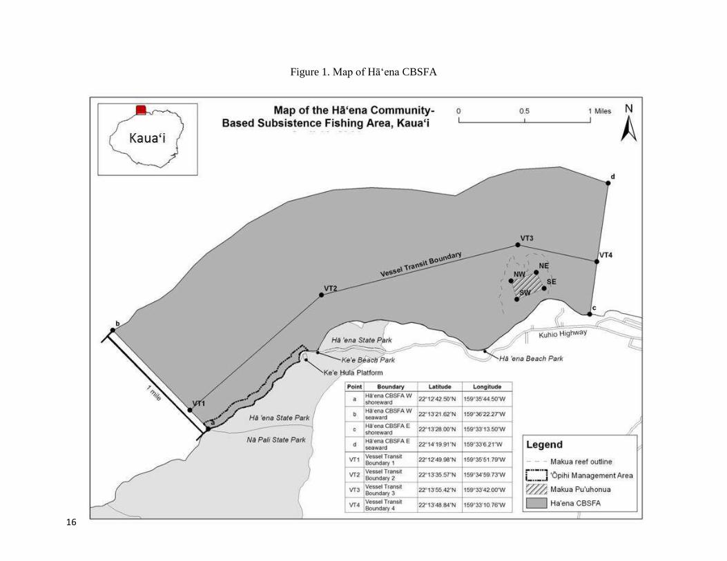
GEOGRAPHIC LOCATION
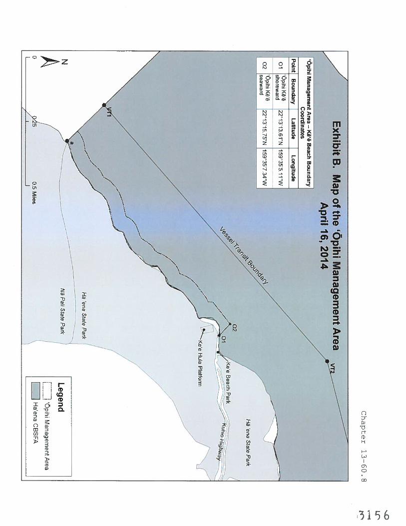
The Hā‘ena CBSFA is located on the North Shore of Kaua‘i, in the moku (district) of Halele‘a,
within the ahupua‘a of Hā‘ena. The ahupua‘a begins in the center of Naue Bay (22°13’28.00”N,
159°33’13.50”W) and extends approximately 3.5 miles north, past Kē‘ē Beach, to the cliffs
before Hanakapi‘ai, at the boundary between Hā‘ena State Park and Na Pali State Park
(22°12’42.50”N, 159°35’44.50”W). The Hā‘ena Community-Based Subsistence Fishing Area
extends along the ahupua‘a’s 3.5 miles of shoreline, from the high water mark to one mile out
(see Figure 1 on the following page).
MARINE ENVIRONMENT
The ahupua‘a of Hā‘ena is comprised of two valleys, each with a stream - Mānoa and Limahuli.
Limahuli stream drains through Limahuli Valley into the ocean, providing an important
freshwater input to Hā‘ena’s ocean environment.
Reefs along the Kaua‘i coast tend to be dominated by the corals Porites lobata (lobe coral) and
Pocillopora meandrina (cauliflower coral). Other common species include Montipora patula
(sandpaper rice coral), Montipora flabellata (blue rice coral), Leptastrea purpurea (crust coral)
and Montipora verrucosa (bracket coral). The coral reef habitat within the Hā‘ena CBSFA is
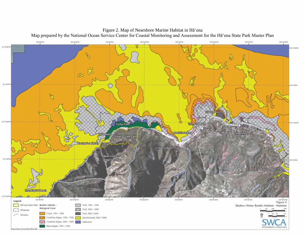
characterized by a high percentage of Turf (55.7% of total cover), while scleractinian corals,
macroalgae, unconsolidated substrate, and coralline algae are fairly evenly distributed, with
cover ranging from 8.8 to 12.6% (see map in Figure 2 below21
).22
Hawai‘i's Coral Reef Assessment and Monitoring Program (CRAMP) and other past studies of
fish populations in the nearshore waters of the ahupua‘a of Hā‘ena have identified 80 fish
20
State of Hawai‘i, Department of Transportation, Highways Division-Kaua‘i District (2007,2015). Biennial traffic counts 2003 and 2013.
21 SWCA Environmental Consultants (2010). “Marine Natural Resources and Recreation Assessment, Hā`ena State
Park, Kaua`i, Hawai`i.” Draft Environmental Impact Statement, Hā‘ena State Park Master Plan. Prepared for PBR
Hawai`i for the State of Hawai‘i Department of Land and Natural Resources, Division of State Parks. 43p.[Online]
http://oeqc.doh.hawaii.gov/Shared%20Documents/EA_and_EIS_Online_Library/Kauai/2010s/2015-07-23-KA-
5B-DEIS-Haena-State-Park_Master-Plan.pdf 22
See the Hā‘ena Ecological Reef Assessment Reports prepared by the Fisheries Ecology Research Lab in Appendix J and Appendix K.

15
species, with twice that many recorded seaward of the reef.21,22
Two lagoon areas, Kē‘ē and
Makua, have been cited by scientists and fishers alike as providing excellent habitat for juvenile
reef fishes.21,22
Threatened green sea turtles (Chelonia mydas), endangered hawksbill sea turtles (Eretmochelys
imbricata), endangered monk seals (Neomonachus schauinslandi), humpback whales
(Megaptera novaeangliae), and several dolphin species are present in the ocean waters of
Hā‘ena’s Community-Based Subsistence Fishing Area. In addition, the Hā‘ena CBSFA provides
habitat for the following sea bird species:
‘Ua‘u (Hawaiian Petrel, endangered)
‘A‘o (Newell’s Shearwater, endangered)
‘Akē`akē (Band-rumped storm petrel, endangered)
‘Ua`u kani (Wedge-tailed shearwater)
Koa`e (Tropic Bird)
`Ulili (Wandering taddler)
For more information on the marine environment of Hā‘ena, see the reports from reef fish
assessments conducted between 2011 and 2013 located in Appendix J and Appendix K.
16
Figure 1. Map of Hā‘ena CBSFA
17
Figure 2. Map of Nearshore Marine Habitat in Hā‘ena
Map prepared by the National Ocean Service Center for Coastal Monitoring and Assessment for the Hā‘ena State Park Master Plan
18
HĀʻENA CBSFA MANAGEMENT GOALS AND OBJECTIVES
The management goals for the Hā‘ena CBSFA per HAR Chapter 13-60.8 are:
Sustainably support the consumptive needs of the Hā‘ena ahupua‘a through culturally-rooted
community-based management;
Ensure the sustainability of nearshore ocean resources in the area through effective
management practices;
Preserve and protect nursery habitat for juvenile reef fishes;
Recognize and protect customary and traditional native Hawaiian fishing practices that are
exercised for subsistence, cultural, and religious purposes in the area; and
Facilitate the substantive involvement of the community in resource management decisions
for the area.
To achieve these goals, the following management objectives will guide management activities:
Establish rules that reflect traditional fishing and management practices.
Establish rules to address adverse impacts of tourism and ocean recreation activities on
marine resources and associated subsistence practices.
Increase the abundance of native fish species, limu kohu, he‘e, urchins, lobsters, ‘ōpihi and
other shellfish.
Increase percent coral cover by reducing human use impacts on coral reef resources.
HĀʻENA CBSFA MANAGEMENT ACTIVITIES
REGULATED ACTIVITIES
The Department manages fishing and harvesting activities within the Hā‘ena CBSFA through
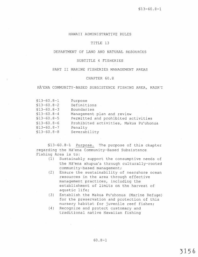
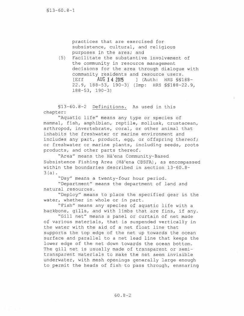
regulations set forth in HAR Chapter 13-60.8, effective August 14, 2015 (See Appendix D).
Additional county, state and federal laws also apply.
SPECIALLY PERMITTED ACTIVITIES
DLNR issues special activity permits pursuant to HRS §187A-6 to authorize activities otherwise
prohibited by law for scientific, educational, management, or propagation purposes.
Applications for special activity permits are reviewed by DLNR to ensure that the proposed
special activities are consistent with DLNR’s management goals and objectives. However, under
the authority of HRS §187A-6, the DLNR may issue permits to any person to take aquatic life,
possess or use fishing gear, or engage in any feeding, watching, or other such non-consumptive
activity related to aquatic resources, otherwise prohibited by law, in any part of the State, for
scientific, educational, management, or propagation purposes for up to one year in duration.
Under the existing authority of HRS §187A-6, any member of the public can apply for a special
activity exemption within the Hā‘ena CBSFA by submitting a special activity permit application
to DAR.

19
On October 24, 2014, at their bimonthly meeting, the BLNR adopted the Hā‘ena CBSFA rules.
At the same meeting, two individuals provided testimony requesting an exemption for the
commercial take of invasive species for management purposes. The BLNR instructed DAR staff
to explore this possibility under DAR’s existing special activity permits authority (HRS §187A-
6).
Special activity permit applications related to the removal of invasive species from the Hā‘ena
CBSFA for management purposes, including subsequent sharing (mahele) or sale to avoid waste,
will be considered by DAR under conditions prescribed by HRS §187A-6. As part of this
process, DAR must also consider applicable constitutional and case law relating to the protection
of native Hawaiian rights and practices and the management of public trust resources when
determining whether to issue special activity permits.23
DAR will evaluate each permit on a case-by-case basis and may impose special permit
conditions, as it deems appropriate, based on the activities proposed for exemption. Examples of
special conditions that may be considered include distance requirements (e.g., removal of
invasive species must occur 500 yards or greater from shore), monitoring requirements,
additional reporting requirements, and notice requirements prior to activity commencement.
All special activity permits DAR issues under HRS §187A-6 require approval from the Board of
Land and Natural Resources (BLNR) with the exception of relatively minor, non-destructive
activities for which the BLNR has delegated approval authority to the DLNR Chairperson.
delegated approval authority to the DLNR Chairperson delegated approval authority to the
DLNR Chairperson special activity permit activities for which the BLNR has delegated approval
authority to the DLNR Chairperson are enumerated in Appendix L.
In addition, all operators of commercial vessels, water craft or water sports equipment must
obtain a commercial use permit from Division of Boating and Ocean Recreation (DOBOR) to
operate on State ocean waters in accordance with HAR §13-256-3 and §13-256-4. Applicants
should submit a completed commercial use questionnaire along with all relevant documentation
to their nearest DOBOR district office for review, and any permits issued by DOBOR will be
valid for one year. The applicant and approval for such permits shall comply with the applicable
provisions stated in HAR §13-231-50 to 13-231-70. More information about the permit
application process and required documentation can be found online at:
http://dlnr.hawaii.gov/dobor/commercial-use-permit-qa/#Q8
A list of commercial activity operators that are authorized to operate in the Hāʻena CBSFA
under HAR §13-256-3 and §13-256-4 by DOBOR may be obtained by any member of the public,
23
See in re: Public Access Shoreline Hawai‘i v. Hawai‘i County Planning Commission, 1995; Kukui (Moloka‘i), Inc., 2007; and Wai‘ola o Moloka‘i, 2004.
20
at any time under the Hawaii Open Records Law HRS § 91-1 by submitting a formal request to
the DOBOR district office.
METHODS OF ENFORCEMENT
The following sections provide an overview of activities to enforce and enhance compliance with
HAR Chapter 13-60.8 within the Hā‘ena CBSFA.
Division of Conservation and Resources Enforcement
The DLNR’s Division of Conservation and Resources Enforcement (DOCARE) is responsible
for the enforcement of all state laws, rules and regulations related to natural resources
conservation and protection. To effectively enforce these rules, including HAR Chapter 13-60.8,
DOCARE:
Responds to reports of violations or suspected natural resource violations. Responses may
include, but are not limited to, dispatching an officer to the scene of the incident, an
immediate verbal or written acknowledgement of receipt of the complaint, and/or active
follow-up investigation of the incident;
Patrols state lands and waters to identify violations of applicable DLNR laws, rules and
regulations; and
Provides information and training to communities, organizations, and individuals related
to conservation and natural resources enforcement.
DOCARE’s roles & responsibilities are further enumerated in HRS §199-3, and additional
authorities of the DLNR related to civil natural resource violations and the BLNR’s police
powers outlined in HRS §199D and §199-4 respectively.
Makai Watch
The DLNR Makai Watch Program was established as a means to enhance the management of
coastal and near-shore marine resources by providing community members opportunities for
direct involvement in the DLNR’s marine resource management activities. Makai Watch
volunteers act as ‘eyes and ears’ of DOCARE, similar to Neighborhood Watch efforts, providing
a constructive and formal mechanism for communities to support DOCARE’s enforcement of
natural resource laws. As of November 22, 2014, the DLNR has officially recognized the State of
Hawai‘i Makai Watch Program, and communities identified in the Makai Watch strategy,
including Hāʻena, are pilot sites currently working on achieving compliance with Makai Watch
program standards and requirements.
To increase compliance and reduce illegal activities within the Hāʻena CBSFA, Hā‘ena Makai
Watch volunteers will engage in the following Makai Watch program activities:
Awareness Raising and Outreach (ARO): The primary role of Hā‘ena Makai Watch
volunteers is to promote understanding and compliance of marine resource regulations by
providing ocean users with useful, site-specific information related to sustainable fishing
practices, proper reef etiquette, cultural values and practices and applicable resource
regulations within the Hā‘ena CBSFA.
Observation and Incident Reporting (OIR): While Awareness Raising and Outreach help,
poaching and other detrimental activities may continue in some areas. To increase
compliance with marine resource laws, volunteers will receive training from DAR and
21
DOCARE staff to accurately identify violations, and safely observe and report them to
DOCARE. These trainings are open to all Makai Watch volunteers, as well as any other
interested members of the public.
Makai Watch program strategies, protocols, and training materials can be found online at:
http://dlnr.hawaii.gov/makaiwatch/
Contact the Hui Maka‘āinana o Makana for more information about Hāʻena Makai Watch
volunteer opportunities at [email protected] or [email protected].
Environmental Court
The State of Hawai‘i has established the Environmental Court following passage of Act 218,
SLH 2014. The court became operational on July 1, 2015 and is poised to adjudicate all criminal
environmental cases statewide. Criminal violations of the Hā‘ena CBSFA rules would be
scheduled on the Environmental Court calendar. By specifically focusing on environmental
cases, this court will enable more consistent prosecution of natural resource violations. This is
only the second such court established in the United States to focus on environmental cases and
demonstrates the State’s commitment to protect its natural resources. More information on the
environmental court is available online at:
http://www.courts.state.hi.us/special_projects/environmental_court.html.
EDUCATION AND OUTREACH
To promote awareness of and enhance compliance with the Hā‘ena CBSFA rules, DLNR’s
Division of Aquatic Resources (DAR) will support education and outreach efforts in Hā‘ena as
resources and capacity permit. Examples of the outreach efforts include:
1. Develop and install appropriate signage and marker buoys.
2. Provide information and updates about the Hā‘ena CBSFA rules on the DAR website.
3. Update and provide the public with free printed copies of DAR fishing regulations;
4. Support the Hā‘ena community’s CBSFA education and outreach events;
5. Develop education materials and conduct outreach to raise awareness of the Hā‘ena CBSFA
rules; and
6. Convene and participate in annual community meetings to provide updates to the public on
Hā‘ena CBSFA management activities.
Members of the Hui Maka‘āinana o Makana, Limahuli National Tropical Botanical Garden staff,
Makai Watch volunteers, and other interested parties may engage in the following education and
outreach activities to support CBSFA management:
1. Develop and disseminate education materials to raise public awareness of CBSFA rules and
native Hawaiian cultural values and perspectives.
2. Conduct educational programs for youth and community members that involve kūpuna
(elders) and knowledgeable makua (parents) to perpetuate the transmission of historical
knowledge and cultural values and practices.
3. Participate in annual DLNR community meetings to provide updates to the public on their
stewardship activities within the Hā‘ena CBSFA.

22
4. Support development of DAR education and outreach materials and implementation of DAR
CBSFA outreach initiatives.
MONITORING AND EVALUATION PROCESSES
Monitoring
Existing studies provide a useful baseline indicator of the status of marine resources within the
Hāʻena CBSFA prior to the adoption of CBSFA rules (See Appendix J and K).
To inform the adaptive management of marine resources within the Hā‘ena CBSFA, The
following indicators will be used to assess the status of marine resources within the Hāʻena
CBSFA:
1. Abundance of fish populations by species inside and outside of the makua pu‘uhonua area.
2. Abundance of limu kohu, urchins, and lobsters.
3. ‘Ōpihi abundance within the ‘ōpihi restoration area.
4. Percent coral cover.
DAR and others will seek funding and technical support to monitor the abundance of fish,
shellfish, and coral cover in accordance with DAR supported monitoring protocols.
Community-based monitoring methods may include:
‘Ōpihi monitoring using the ōpihi rapid assessment method.
Limu monitoring using the “Our Project in Hawaii’s Intertidal” (OPIHI) method.
Logs of fish catch, spawning seasons, and lunar cycles.
Water quality monitoring.
Contact the Hui Maka‘āinana o Makana for more information about volunteer opportunities
related to community-based monitoring initiatives in the Hāʻena CBSFA at
[email protected] or [email protected].
Monitoring will occur in year 1, 3 and year 5, or as capacity and resources permit.
Evaluation and Adaptive Learning
As part of the adaptive learning process inherent to collaborative management,24
and in
accordance with HAR Chapter 13-60.8-4, DLNR shall hold at least one meeting within the
Hā‘ena ahupua‘a at five, ten, and twenty years beginning from the effective date of the chapter,
to review the effectiveness of the Hā‘ena CBSFA, revise the management plan as needed, and
consider whether the geographic area should be modified. These meetings will be publicly
24
Olsson, P., Folke, C., and Berkes, F. (2004). Adaptive comanagement for building resilience in social-ecological systems. Environmental Management 34(1): p.75–90.
23
noticed in at least one newspaper of general circulation at the affected county level. Any
proposed management changes will first be subject to the public consultation processes outlined
in the “Community-Based Subsistence Fishing Area Designation Procedures Guide,” available
online at http://dlnr.hawaii.gov/coralreefs/files/2015/02/CBSFA-Designation-Procedures-
Guide_v.1.pdf. These public consultation processes will provide opportunities for public
discussions before any future regulatory amendments are adopted by the DLNR. If amendments
to the Hā‘ena CBSFA rules are proposed, DLNR is required to go through the public
consultation processes prescribed by HRS Chapter 91 and the Small Business Regulatory
Flexibility Act, HRS Chapter 201M. Combined, these mandates provide a minimum of five
public input opportunities before any boundary modification or rule amendments can be adopted.
Future submittals to the BLNR related to Hā‘ena CBSFA rule-making will include the most up-
to-date version of the management plan as supporting documentation.
PROCEDURES FOR RESOLVING USER CONFLICTS
There is growing evidence that community-based fisheries co-management is an effective way to
sustain aquatic resources and the livelihoods of communities depending on them,25,26
and DLNR
views community-based fisheries co-management through CBSFA designation as a constructive
and lawful avenue for communities to work with the State to address marine resource
management concerns and responsibly steward their resources.
An important component of successful co-management initiatives is the establishment of
mechanisms for discussing and resolving conflicts between ocean users.27,28
As such, this section
outlines two pathways for managing conflicts between ocean users should they arise:
Collaborative Resolution
As appropriate, DLNR may provide an independent avenue for resolving conflicts between ocean
resource users within CBSFAs to ensure volunteer and public safety, and promote the effective
management of public trust resources. This may include holding meetings to foster
communication among disputants, facilitate cooperative problem solving, and/or arbitrate
solutions to intractable conflicts between ocean users. If needed, legal action may also be taken.
25
Gutierrez, N.L., Hilborn, R., and Defeo, O. (2011). Leadership, social capital and incentives promote successful fisheries. Nature 470(7334): p.386–389.
26 Brown, D., Staples, D., and Funge-smith, S. (2005). Mainstreaming fisheries co-management in the Asia-Pacific. Paper prepared for the In Food and Agriculture Organization of the United Nations (ed). APFIC Regional Workshop on Mainstreaming Fisheries Co-management in Asia-Pacific, Siem Reap, Cambodia.
27 Ostrom E. (1990). Governing the commons: the evolution of institutions for collective action. New York: Cambridge University Press.
28 Pomeroy, R., Mcconney, P., and Mahon, R. (2003). Comparative Analysis of Coastal Resource Co-Management in the Caribbean. Caribbean Conservation Association, Barbados. p.30.

24
Members of the public are encouraged to contact DAR and/or DOCARE if conflicts arise related
to ocean resource management or use within the Hā’ena CBSFA.
Legal Resolution
The DLNR does not condone the use of threatening or other criminal behaviors by any member
of the public, nor does it authorize any member of the public to enforce natural resource laws.
Individuals that engage in threatening or other criminal behaviors may be subject to legal action
by the appropriate legal authorities.
Anyone who is being harassed or threatened, and feels that a law enforcement response is
necessary, should call 9-1-1 to request a police response, especially if the situation is an
emergency. The police will respond to 9-1-1 calls, and if necessary, can refer calls to DOCARE.
Violations in natural resources laws should be reported to DOCARE at 643-DLNR.
METHODS OF FUNDING
Funds for management and enforcement of the Hā‘ena CBSFA rules will be dependent on
legislative appropriation as well as other sources (e.g. contributions). Capacity to implement
management activities including monitoring and enforcement may be enhanced by partner
agencies, non-governmental organizations and community groups. The following sections
identify various methods of funding DLNR may pursue to support effective management of the
Hā‘ena CBSFA.
Legislative Funding
The DLNR requests funds from the Legislature every year to implement programs necessary to
manage public trust resources including:
Permanent positions to support the implementation of the DLNR’s mission (e.g.,
staff/officers to design policies, develop rules, enforce rules, and implement programs)
Operational costs to support program implementation (e.g., equipment and supplies,
outreach materials and events, and meeting coordination)
During the 2015 legislative session, DAR secured funds from the Legislature to support the
creation of a temporary civil service CBSFA planner position. This position is intended to
provide support and coordination for the Hā‘ena CBSFA and other community-based
management efforts. Efforts are ongoing to establish this position as a permanent civil service
position.
Partner Collaborations
DLNR seeks to partner with educational institutions, county, state, and federal agencies, non-
governmental organizations (NGOs), private foundations and other relevant donors with
priorities that align with the DLNR’s programmatic and management priorities, including
effective evaluation, monitoring, implementation and enforcement of the Hā‘ena CBSFA.
Support Community-Based Co-Management Efforts
Committed and responsible community groups and volunteers enhance DLNR’s marine resource
management efforts. As possible, the DLNR will submit letters of support for funding proposals
25
and support activities conducted by community groups that are aligned with the resource
protection mission of DLNR and management goals of the Hā‘ena CBSFA.
MANAGEMENT OF OTHER THREATS TO SUBSISTENCE FISHING RESOURCES
The Hā‘ena CBSFA is an important site for subsistence and cultural practices, recreational uses,
and tourism. Each year, Hā’ena attracts roughly 2000 visitors a day, which has resulted in
adverse impacts to fish stocks and coral reef habitats.29
Addressing impacts from this high level
of recreational use was noted as a primary rationale for the legislature’s designation of Hāʻena
CBSFA (Act 241, SLH 2006), and the resultant Hāʻena CBSFA statute grants the DLNR the
authority to develop rules in consultation with the inhabitants of the ahupua‘a of Hā‘ena and
other interested parties, for any activity that it deems appropriate for the management of public
trust resources or the protection for traditional and customary practices (HRS §188-22.9).
In 2011, the inhabitants of the ahupua‘a of Hā‘ena and other interested parties, including native
Hawaiians with ancestral ties to the area and regular non-extractive ocean users of the area, also
proposed boating and ocean recreation regulations to the DLNR in conjunction with the fishing
rules which were adopted under HAR Chapter §13-60.8-4. These proposed boating and
recreation regulations will be adapted into a rule package by the DLNR in accordance with the
Guidance for Preparation of CBSFA Proposals that was approved by the BLNR on December 12,
2014, the CBSFA Designation Procedures Guide, and the Chapter 91 administrative rule-making
procedures, which include opportunities for public review and comments.
“Guidance for Preparation of Community-based Subsistence Fishing Area Proposals” can be
found online at: http://files.hawaii.gov/dlnr/meeting/submittals/141212/F-3.pdf
The “CBSFA Designation Procedures Guide” can be found online at:
http://dlnr.hawaii.gov/coralreefs/files/2015/02/CBSFA-Designation-Procedures-Guide_v.1.pdf
29
PBR Hawai`i and Associates Inc. (2015). “Draft Environmental Impact Statement.” Hā‘ena State Park Master Plan. Prepared for the State of Hawai‘i, Department of Land and Natural Resources, Division of State Parks. [Online] http://oeqc.doh.hawaii.gov/Shared%20Documents/EA_and_EIS_Online_Library/Kauai/2010s/2015-07-23-KA-5B-DEIS-Haena-State-Park_Master-Plan.pdf
26
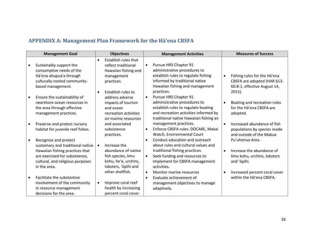
APPENDIX A: Management Plan Framework for the Hā‘ena CBSFA
Management Goal Objectives Management Activities Measures of Success
Sustainably support the consumptive needs of the Hā‘ena ahupua'a through culturally-rooted community-based management.
Ensure the sustainability of nearshore ocean resources in the area through effective management practices.
Preserve and protect nursery habitat for juvenile reef fishes.
Recognize and protect customary and traditional native Hawaiian fishing practices that are exercised for subsistence, cultural, and religious purposes in the area.
Facilitate the substantive involvement of the community in resource management decisions for the area.
Establish rules that reflect traditional Hawaiian fishing and management practices.
Establish rules to address adverse impacts of tourism and ocean recreation activities on marine resources and associated subsistence practices.
Increase the abundance of native fish species, limu kohu, he‘e, urchins, lobsters, ‘ōpihi and other shellfish.
Improve coral reef health by increasing percent coral cover.
Pursue HRS Chapter 91 administrative procedures to establish rules to regulate fishing informed by traditional native Hawaiian fishing and management practices.
Pursue HRS Chapter 91 administrative procedures to establish rules to regulate boating and recreation activities informed by traditional native Hawaiian fishing an management practices.
Enforce CBSFA rules: DOCARE, Makai Watch, Environmental Court
Conduct education and outreach about rules and cultural values and traditional fishing practices.
Seek funding and resources to implement for CBSFA management activities.
Monitor marine resources
Evaluate achievement of management objectives to manage adaptively.
Fishing rules for the Hāʻena CBSFA are adopted (HAR §13-60.8-1, effective August 14, 2015).
Boating and recreation rules for the Hā‘ena CBSFA are adopted.
Increased abundance of fish populations by species inside and outside of the Makua Pu‘uhonua Area.
Increase the abundance of limu kohu, urchins, lobsters and ‘ōpihi.
Increased percent coral cover within the Hāʻena CBSFA.

27
APPENDIX B: Frequently Asked CBSFA Questions and Answers
The following section provides clarification and answers to questions related to the Hā‘ena
CBSFA designation and CBSFAs in general, that emerged during the management planning and
rule-making process:
How did DLNR determine the Hā‘ena CBSFA boundary?
The Hā‘ena CBSFA boundaries are prescribed by the Hā‘ena CBSFA authorizing statute (HRS
§188-22.9(a)). DLNR is obligated to implement the provisions as stipulated by the Legislature.
Why do the Hā‘ena CBSFA rules include a clause about expansion?
The authorizing statute for the Hā‘ena CBSFA, HRS §188-22.9(c)(5) requires DLNR to consider
a process for expanding the Hā‘ena CBSFA into other ahupua‘a, and thus is referenced in the
DLNR rules (HAR Chapter 13-60.8-4). However, there are no plans to expand the Hā‘ena
CBSFA at this time. If a boundary expansion were proposed in the future, the public rule-making
process for CBSFA designation would be followed, which is outlined in the CBSFA Designation
Procedures Guide and HRS Chapter 91, and ensures opportunities for public discussions and
input before any amendments are adopted. The CBSFA Designation Procedures Guide is
available online at http://dlnr.hawaii.gov/coralreefs/files/2015/02/CBSFA-Designation-
Procedures-Guide_v.1.pdf
Why do the Hā‘ena CBSFA rules establish closed areas?
Closed (kapu) areas were traditionally used by native Hawaiians to maintain abundant fisheries,
and no take areas are similarly recognized as one of a suite of effective management tools the
DLNR relies upon today and considers on a case-by-case basis. With respect to Hā‘ena, the
establishment of no harvesting zones is required by legislative authorizing statute (HRS §188-
22.9(c)(4)), with specific boundaries finalized through the DLNR rule-making process. To
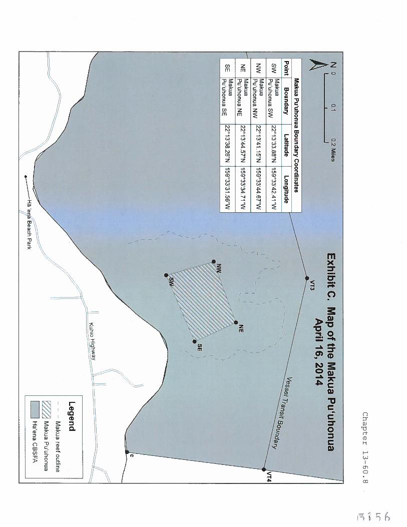
identify the specific boundaries of the no harvest zone (Makua Pu‘uhonua) in the Hā‘ena
CBSFA, DAR relied on expert kama‘āina knowledge of customary fishing and management
practices,30
findings from biological and social research studies,31
and the community’s
negotiated compromises with regular users of the area. Historical kama‘āina accounts identified
the Pu‘uhonua zone as an important nursery habitat for juvenile fish,30
and numerous ecological
assessments of Hā‘ena’s coral reef habitat and juvenile fish abundance substantiated these
historical accounts.31
Additionally, the community collaborated with graduate researchers to
conduct a human use study to understand the type, frequency, and location of different uses,32
30
See Appendix G for research on the Traditional and Customary Practices of Hā‘ena 31
See Appendix G for research on Human Use, Catch per Unit Effort, and Marine Ecological Assessments 32
See 2010 Hā‘ena CBSFA Human Use Study in Appendix H

28
and used this information to identify potentially affected ocean users to consult. As a result,
community members and potentially affected ocean users, particularly windsurfers, were able to
compromise on the Pu‘uhonua boundaries that were ultimately included in DLNR’s Hā‘ena
CBSFA rule package.
What precedent do the Hā‘ena CBSFA rules establish for management of other areas?
CBSFA rules adopted in one community do not set the foundation for similar rules to be adopted
in others. The Hā‘ena CBSFA is unique in that it was designated by the Hawai‘i State Legislature
under HRS §188-22.9 (Act 241, SLH 2006), and as a result, the Hā‘ena CBSFA has specific
provisions which are unique unto itself.
Other areas that may be considered for CBSFA designation have their own unique set of needs
that will be identified through the management planning and rule-making processes outlined in
the CBSFA Designation Procedures Guide, which is available online at
http://dlnr.hawaii.gov/coralreefs/files/2015/02/CBSFA-Designation-Procedures-Guide_v.1.pdf.
As such, the fisheries management strategies adopted in one area are not necessarily applicable
elsewhere, and regulations will differ according to the place-based issues, subsistence needs and
cultural practices at each proposed CBSFA site. As detailed in the CBSFA Designation
Procedures Guide, there are ample public input opportunities provided throughout any CBSFA
designation and rule-making process, at both the state and community level, which permit
affected interests to influence communities’ regulatory recommendations and DLNR’s proposed
and final rule packages.
Is there a sunset clause or process for revising rules?
There is no sunset clause in the Hā‘ena CBSFA statute, HRS §188-22.9, or administrative rule,
HAR Chapter 13-60.8-4. However, DLNR is required to review the effectiveness of the Hā‘ena
CBSFA five, ten, and twenty years after initial passage of rules. DLNR also has the authority to
amend or repeal rules or to establish emergency rules at any time pursuant to HRS Chapter 91, as
it deems appropriate based on the best available information. Any proposed amendment to the
Hā‘ena CBSFA rules will be subject to the public consultation and rule-making processes
outlined in the CBSFA Designation Procedures Guide and HRS Chapter 91 to ensure
opportunities for public discussions and input before any amendments are adopted. The CBSFA
Designation Procedures Guide is available online at
http://dlnr.hawaii.gov/coralreefs/files/2015/02/CBSFA-Designation-Procedures-Guide_v.1.pdf.
Do CBSFAs promote exclusive rights of access and use?
A common misunderstanding is that CBSFAs grant exclusive fishing rights or rights of access to
native Hawaiians or local community residents and exclude other members of the public. In
truth, anyone can conduct activities within a CBSFA as long they do so in accordance with the
rules established for the area. CBSFAs are not special interest areas, but rather areas with a
distinct management purpose. DLNR uses a variety of management tools to accomplish different
management objectives, which reflect the DLNR’s different management mandates and distinct
place-based management needs. The CBSFA designation is management tool that enables the
DLNR to effectuate its obligation to manage public trust resources for native Hawaiian use per
Hawai‘i State Constitution Article XII Section 4, and protect the reasonable exercise of
customary and traditional rights of native Hawaiian ahupuaʻa tenants to
29
support subsistence, cultural, and religious practices under Hawai‘i State Constitution Article
XII Section 7.
What is the definition of community in the context of CBSFAs?
In the context of CBSFAs, the term “community” refers a group of individuals who inhabit or
have ancestral ties to the ahupua’a and engage in, have knowledge of, or rely on traditional and
customary native Hawaiian fishing and gathering practices for native Hawaiian subsistence,
culture and religion. This definition of community is consistent with the Legislature’s intent that
DLNR “carry out fishery management strategies for such areas, through administrative rules
adopted pursuant to Chapter 91, for the purpose of reaffirming and protecting fishing practices
customarily and traditionally exercised for purposes of native Hawaiian subsistence, culture, and
religion.” (see Act 271 (1994); HRS §188-22.6).
In addition to community-based subsistence needs, CBSFA proposals are also required to
consider how designation would interfere with existing uses and activities in the area (HRS
§188-22.6). Furthermore, DLNR seeks and considers input from affected stakeholders and other
interested persons during rule-making in accordance with DAR’s CBSFA designation
procedures, and as required by HRS Chapter 91. Finally, DLNR must take into consideration its
own management mandates and priorities, as well as existing local, state, and federal laws and
policies.
A video explaining the term community-based in the context of CBSFAs has been produced by
the DLNR and is available at the following link: https://vimeo.com/135402703
Are members of the public permitted to enforce CBSFA rules?
DLNR supports responsible community stewardship and views CBSFAs as a constructive, state-
authorized avenue for communities to take action to address marine resource concerns and
steward their resources by proposing management recommendations to the DLNR based on
traditional Hawaiian values and practices.
DLNR does not condone nor authorize members of the public to enforce natural resource laws.
Engaging in threatening or other criminal behaviors may be subject to legal action and
prosecution, and will be dealt with accordingly by the appropriate legal authorities. Any member
of the public who feels harassed, and that a law enforcement response is necessary, should call
9-1-1, and request a police response. Violations in natural resources laws should be reported to
DOCARE at 643-DLNR.
Community volunteers that are actively engaged in CBSFA stewardship activities, will be
provided a Makai Watch program volunteer training, whether they are an officially designated as
a Makai Watch site or not. The purpose of this training is to ensure that community stewards
understand that DLNR does not authorize them to enforce natural resource laws, and provide
them with field observation guidelines and safety protocols for observing and reporting incidents
that ensure their personal safety, and the safety of others.
30
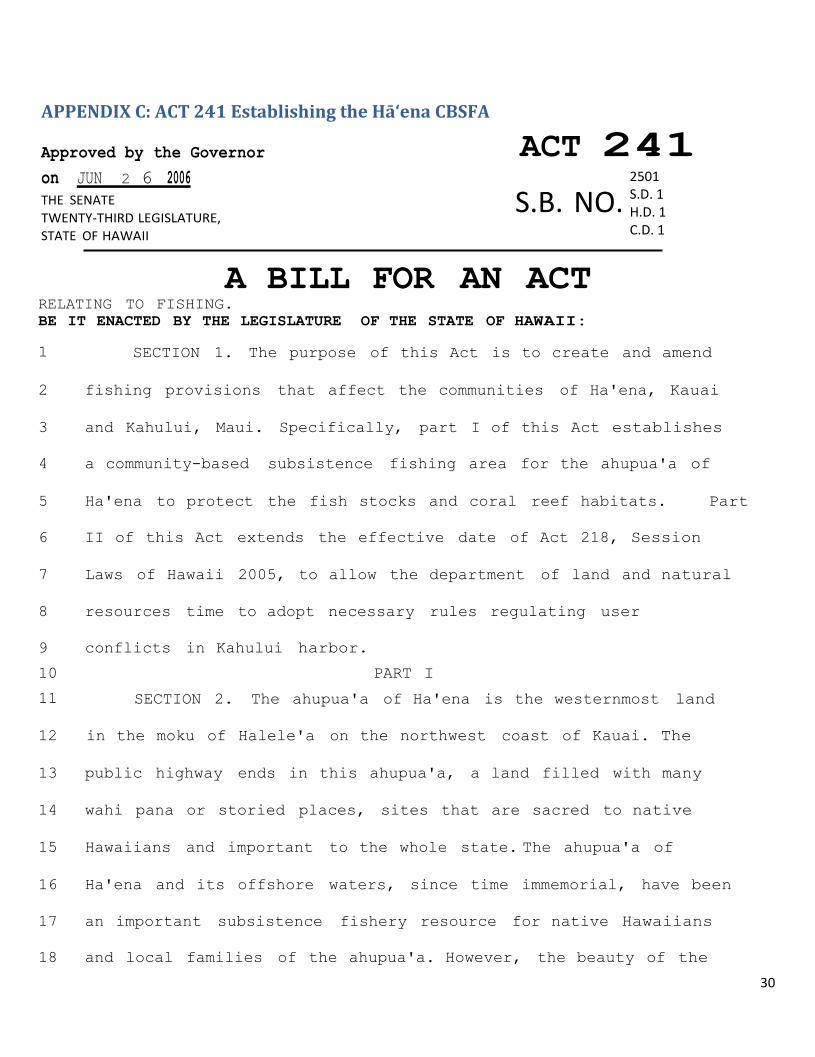
APPENDIX C: ACT 241 Establishing the Hā‘ena CBSFA
Approved by the Governor ACT 241
on JUN 2 6 2006
THE SENATE
TWENTY-THIRD LEGISLATURE,
STATE OF HAWAII
A BILL FOR AN ACT RELATING TO FISHING.
BE IT ENACTED BY THE LEGISLATURE OF THE STATE OF HAWAII:
1 SECTION 1. The purpose of this Act is to create and amend
2 fishing provisions that affect the communities of Ha'ena, Kauai
3 and Kahului, Maui. Specifically, part I of this Act establishes
4 a community-based subsistence fishing area for the ahupua'a of
5 Ha'ena to protect the fish stocks and coral reef habitats. Part
6 II of this Act extends the effective date of Act 218, Session
7 Laws of Hawaii 2005, to allow the department of land and natural
8 resources time to adopt necessary rules regulating user
9 conflicts in Kahului harbor.
10 PART I
11 SECTION 2. The ahupua'a of Ha'ena is the westernmost land
12 in the moku of Halele'a on the northwest coast of Kauai. The
13 public highway ends in this ahupua'a, a land filled with many
14 wahi pana or storied places, sites that are sacred to native
15 Hawaiians and important to the whole state. The ahupua'a of
16 Ha'ena and its offshore waters, since time immemorial, have been
17 an important subsistence fishery resource for native Hawaiians
18 and local families of the ahupua'a. However, the beauty of the
2501 S.D. 1 H.D. 1 C.D. 1
S.B. NO.
S.B.
31
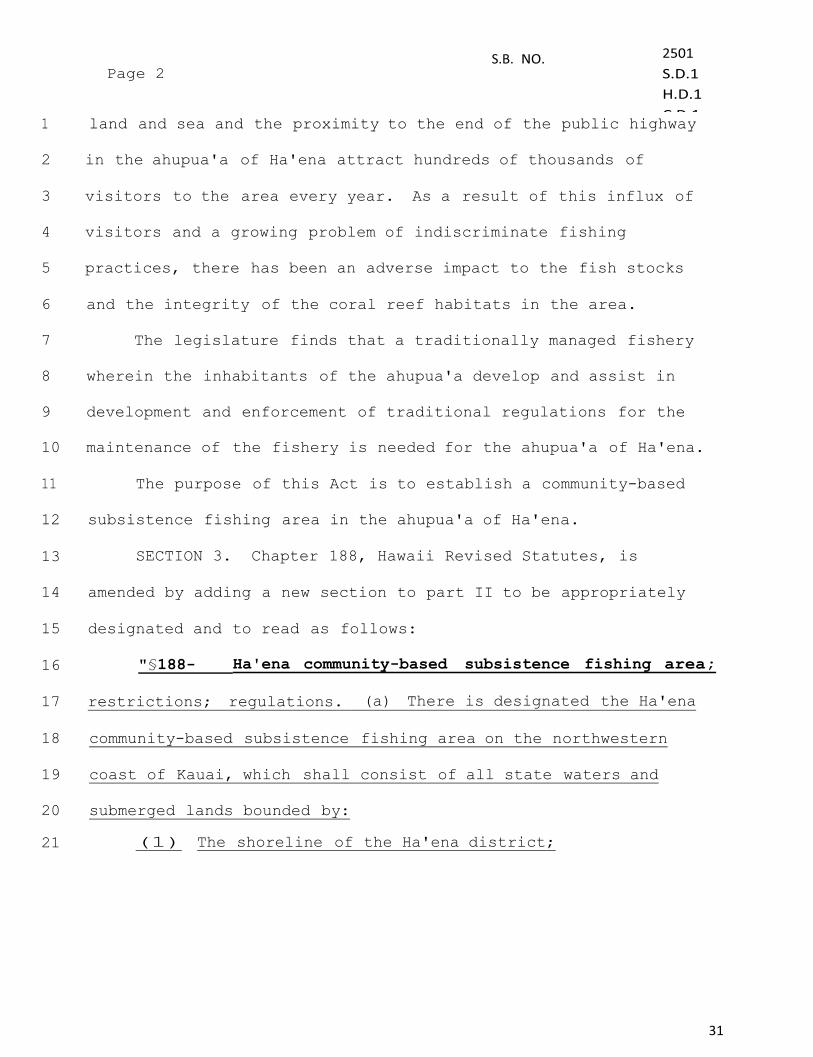
1 land and sea and the proximity to the end of the public highway
2 in the ahupua'a of Ha'ena attract hundreds of thousands of
3 visitors to the area every year. As a result of this influx of
4 visitors and a growing problem of indiscriminate fishing
5 practices, there has been an adverse impact to the fish stocks
6 and the integrity of the coral reef habitats in the area.
7 The legislature finds that a traditionally managed fishery
8 wherein the inhabitants of the ahupua'a develop and assist in
9 development and enforcement of traditional regulations for the
10 maintenance of the fishery is needed for the ahupua'a of Ha'ena.
11 The purpose of this Act is to establish a community-based
12 subsistence fishing area in the ahupua'a of Ha'ena.
13 SECTION 3. Chapter 188, Hawaii Revised Statutes, is
14 amended by adding a new section to part II to be appropriately
15 designated and to read as follows:
16 "§188- Ha'ena community-based subsistence fishing area;
17 restrictions; regulations. (a) There is designated the Ha'ena
18 community-based subsistence fishing area on the northwestern
19 coast of Kauai, which shall consist of all state waters and
20 submerged lands bounded by:
21 (1) The shoreline of the Ha'ena district;
S.B.
32
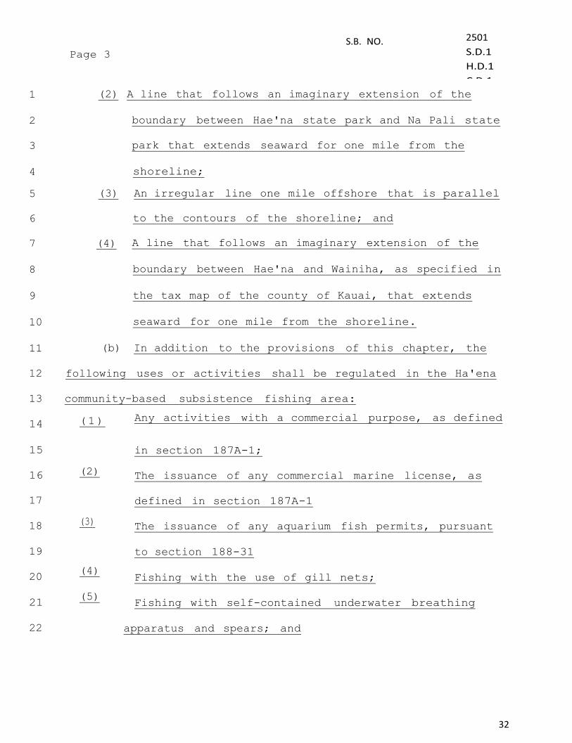
1 (2) A line that follows an imaginary extension of the
2 boundary between Hae'na state park and Na Pali state
3 park that extends seaward for one mile from the
4 shoreline;
5 (3) An irregular line one mile offshore that is parallel
6 to the contours of the shoreline; and
7 (4) A line that follows an imaginary extension of the
8 boundary between Hae'na and Wainiha, as specified in
9 the tax map of the county of Kauai, that extends
10 seaward for one mile from the shoreline.
11 (b) In addition to the provisions of this chapter, the
12 following uses or activities shall be regulated in the Ha'ena
13 community-based subsistence fishing area: 14 (1) Any activities with a commercial purpose, as defined
15
in section 187A-1;
16 (2)
The issuance of any commercial marine license, as
17
defined in section 187A-1
18 (3)
The issuance of any aquarium fish permits, pursuant
19
to section 188-31
20
(4) Fishing with the use of gill nets;
21
(5) Fishing with self-contained underwater breathing
22
apparatus and spears; and
33
S.B.
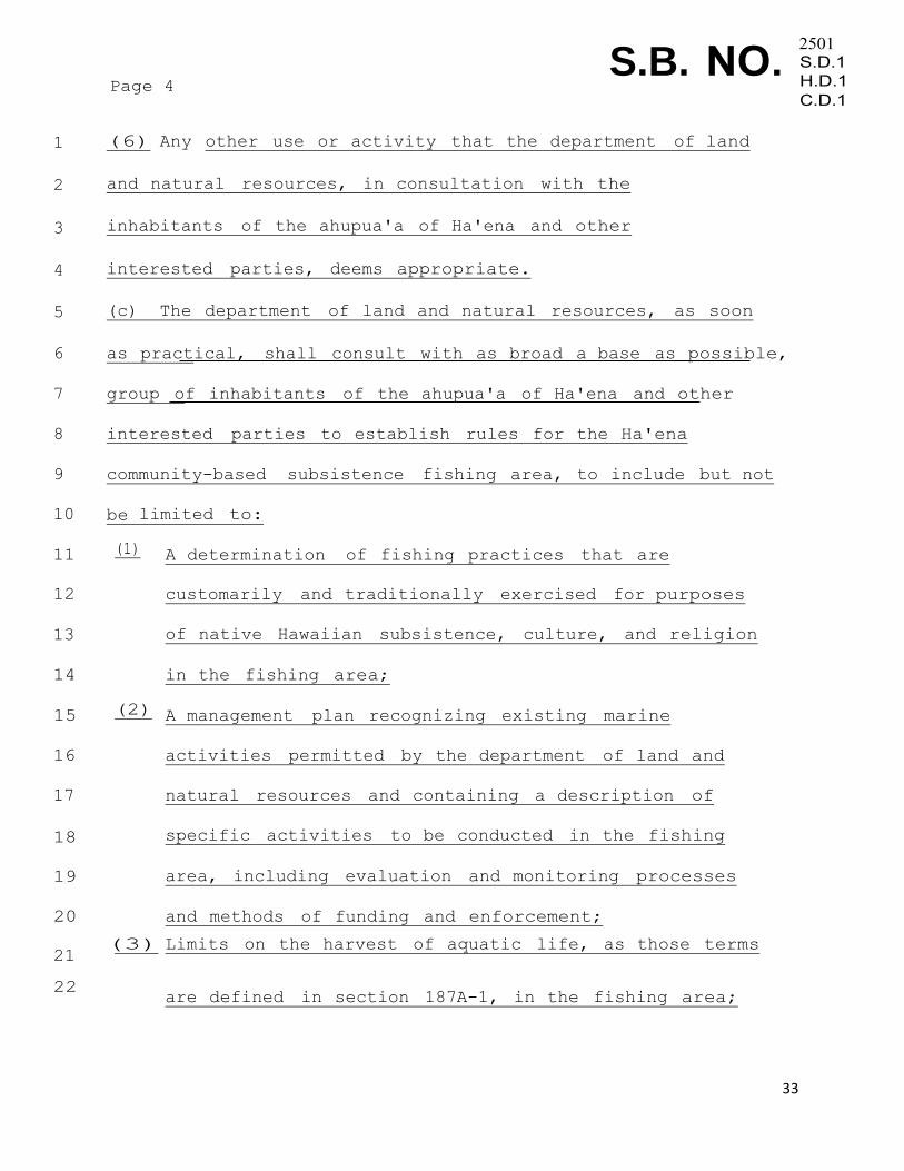
1 (6) Any other use or activity that the department of land
2 and natural resources, in consultation with the
3 inhabitants of the ahupua'a of Ha'ena and other
4 interested parties, deems appropriate.
5 (c) The department of land and natural resources, as soon
6 as practical, shall consult with as broad a base as possible,
7 group of inhabitants of the ahupua'a of Ha'ena and other
8 interested parties to establish rules for the Ha'ena
9 community-based subsistence fishing area, to include but not
10 be limited to:
11 (1)
A determination of fishing practices that are
12
customarily and traditionally exercised for purposes
13
of native Hawaiian subsistence, culture, and religion
14
in the fishing area;
15 (2) A management plan recognizing existing marine
16
activities permitted by the department of land and
17
natural resources and containing a description of
18
specific activities to be conducted in the fishing
19
area, including evaluation and monitoring processes
20
and methods of funding and enforcement;
21
(3) Limits on the harvest of aquatic life, as those terms
22 are defined in section 187A-1, in the fishing area;

34
S.B.
1 (4) The establishment of no harvesting zones within the
2 fishing area without depriving ahupua'a inhabitants of
3 access to traditional sources of subsistence; and
4 (5) A process for the expansion of the fishing area to
5 include other ahupua'a.
6 The department of land and natural resources shall adopt
7 rules pursuant to chapter 91 necessary for the purpose of this
8 section."
9 PART II
10 SECTION 4. The legislature finds that the department of
11 land and natural resources is in the process of adopting rules
12 regulating user conflicts in Kahului harbor and upon the
13 adoption of the rules, the provision of Act 218, Session
Laws of
14 Hawaii 2005, will be unnecessary. The legislature further finds
15 that the rule making process should be completed prior to June
16 2007.
17 The purpose of this part is to extend the effective date of
18 Act 218, Session Laws of Hawaii 2005, to allow the department
of
19 land and natural resources time to adopt necessary rules prior
20 to June 2007,
21 SECTION 5. Act 218, Session Laws of Hawaii 2005, is
22 amended by amending section 3 to read as follows:
35
S.B.
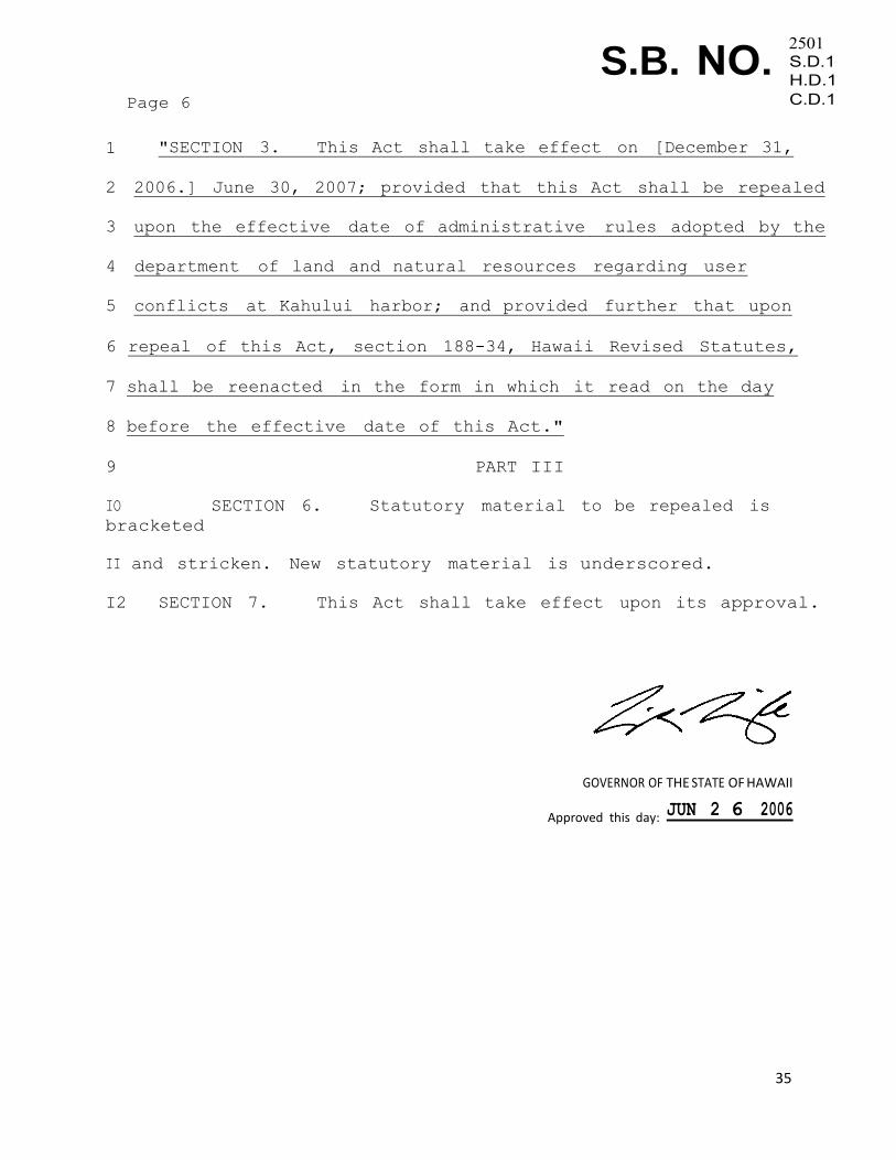
1 "SECTION 3. This Act shall take effect on [December 31,
2 2006.] June 30, 2007; provided that this Act shall be repealed
3 upon the effective date of administrative rules adopted by the
4 department of land and natural resources regarding user
5 conflicts at Kahului harbor; and provided further that upon
6 repeal of this Act, section 188-34, Hawaii Revised Statutes,
7 shall be reenacted in the form in which it read on the day
8 before the effective date of this Act."
9 PART III
IO SECTION 6. Statutory material to be repealed is
bracketed
II and stricken. New statutory material is underscored.
I2 SECTION 7. This Act shall take effect upon its approval.
GOVERNOR OF THE STATE OF HAWAII
Approved this day: JUN 2 6 2006
36
APPENDIX D: Hawaiʻi Administrative Rules Chapter 13-60.8 for Hā‘ena
CBSFA
DEPARTMENT OF LAND AND NATURAL RESOURCES
Adoption of Chapter 13-60.8
Hawaii Administrative Rules
October 24, 2014
Chapter 13-60.8, Hawaii Administrative Rules,
entitled "Ha'ena Community-Based Subsistence Fishing Area,
Kaua'i", is adopted.


52
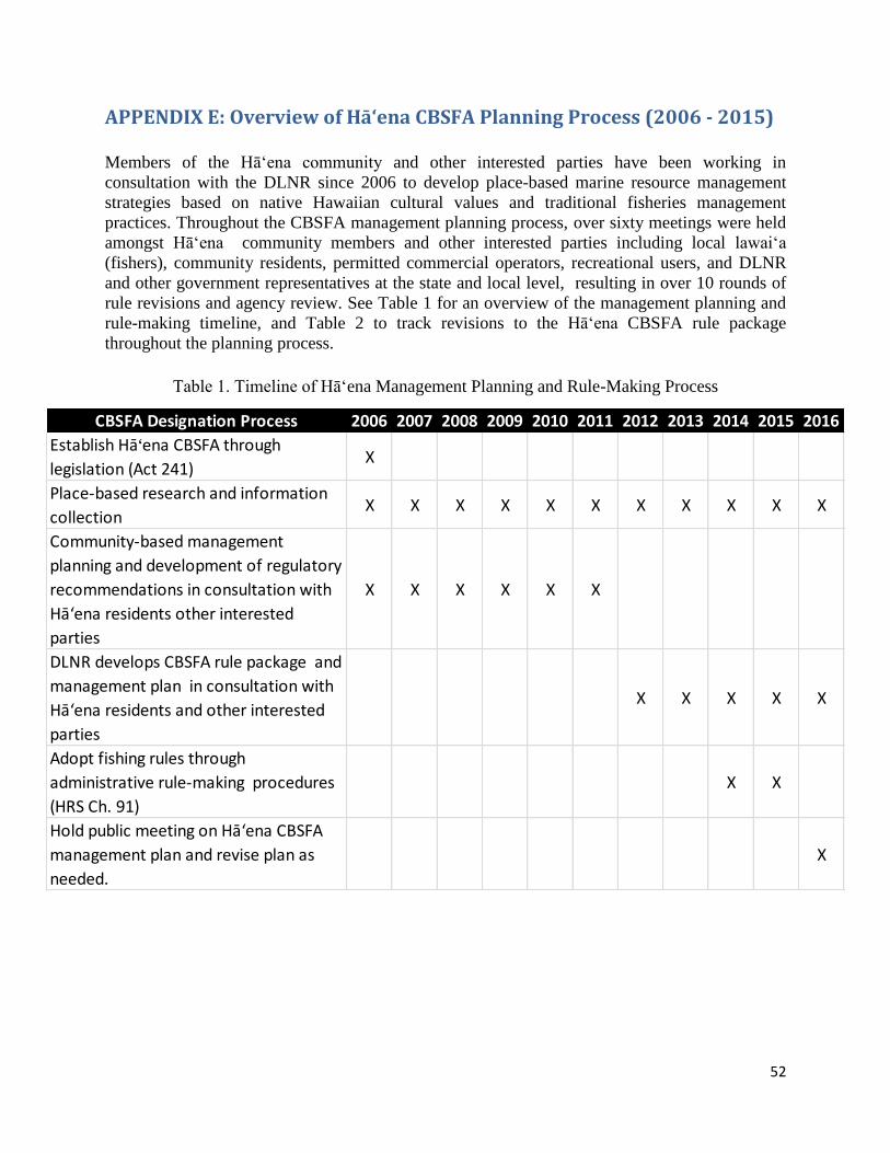
APPENDIX E: Overview of Hā‘ena CBSFA Planning Process (2006 - 2015)
Members of the Hāʻena community and other interested parties have been working in
consultation with the DLNR since 2006 to develop place-based marine resource management
strategies based on native Hawaiian cultural values and traditional fisheries management
practices. Throughout the CBSFA management planning process, over sixty meetings were held
amongst Hā‘ena community members and other interested parties including local lawai‘a
(fishers), community residents, permitted commercial operators, recreational users, and DLNR
and other government representatives at the state and local level, resulting in over 10 rounds of
rule revisions and agency review. See Table 1 for an overview of the management planning and
rule-making timeline, and Table 2 to track revisions to the Hā‘ena CBSFA rule package
throughout the planning process.
Table 1. Timeline of Hā‘ena Management Planning and Rule-Making Process
CBSFA Designation Process 2006 2007 2008 2009 2010 2011 2012 2013 2014 2015 2016
Establish Hā‘ena CBSFA through
legislation (Act 241)X
Place-based research and information
collectionX X X X X X X X X X X
Community-based management
planning and development of regulatory
recommendations in consultation with
Hā‘ena residents other interested
parties
X X X X X X
DLNR develops CBSFA rule package and
management plan in consultation with
Hā‘ena residents and other interested
parties
X X X X X
Adopt fishing rules through
administrative rule-making procedures
(HRS Ch. 91)
X X
Hold public meeting on Hā‘ena CBSFA
management plan and revise plan as
needed.
X

53
Table 2. Overview of Revisions to Hā‘ena CBSFA Regulatory Recommendations
RED = Recommendation DROPPED; BLUE Rule ADDED; BLACK = Recommendation KEPT =
Draft Management
Recommendation (2008)Final Rule Language (2015)
rotate recreational activities Transit Area Vessel Transit Boundary
no wind/kite boarding
Kayak Zones
Fish/Gather Only Zones
300 yard buffer around
fishers
cross reef only to harvest w/ certain gear
regulate boat mooring launch from Hā‘ena
Makua pu‘uhonua
(swim/snorkel only)
Makua pu‘uhonua
(no entry, smaller
areas)
Makua pu‘uhonua (no entry except
by permit)
‘ōpihi management area ‘ōpihi management area
Slot Limits
No fish feeding (but palu) No fish feeding
No commercial harvest No commercial harvest
No aquarium collecitng No slurp gunNo slurp gun. Can only use gears
specified as allowed by the rule.
‘ōpihi
No take of ‘ōpihi and other pūpū
through November 30, 2017. Bag
limit of 20 specimens per person
per day therafter.
limu - hand harvest only limu - hand harvest only
wanawana - bag limit: 5 per species per
person per day
lobster - hand harvest onlylobster - hand harvest only; bag
limit: 2 per person per day
he'e - hand harvest or stickhe'e - hand harvest or stick; bag
limit: 2 per person per day
No live shellsNo live shells, or take of
shells on SCUBA
No live shells, or take of shells on
SCUBA
2 pole limit 2 pole limit; 2 hooks per line
no spear guns, 3 prong OKno spear guns; pole spears (8' max)
allowed
No night spear fishing No night spearing
No lay net. Throw net, scoop
net, or attended pa‘ipa‘i or
surround net OK
No lay net. Throw net, scoop net,
or attended pa‘ipa‘i or surround
net OK. No scoop net at night. Pa'i
pa'i nets and surround nets must
be deployed from shore or vessel <
14'.
No Harvest on Scuba No Spear on SCUBA No Spear on SCUBA
No wetsuits
Mahele to the community
Require course for license
Adaptive Regular rule review Every 3 YearsEvery 5 years by Hā‘ena
fisheries council
5, 10, and 20 years after adoption,
DLNR holds 1 meeting in Hā‘ena
Species
General
Gear
Tradition
Evolution of Management Recommendations in
Consultation w/ the Community, Area Users,
and DLNR (2009-2013)
Zoning
54
APPENDIX F: Summary of Stakeholder Consultations (2006 - 2016)
In the bill that created the Hā‘ena CBSFA (S.B. N.O. 2501 S.D.1, H.D.1, C.D.1) the legislature
finds that “a traditionally managed fishery, wherein the inhabitants of the ahupua‘a of Hā‘ena
develop and assist in development and enforcement of traditional regulations for the maintenance
of the fishery is needed for the ahupua‘a of Hā‘ena.” Additionally, the same bill, now included in
the statute (HRS §188-22.9), mandates DLNR to consult with “as broad a base of ahupua‘a
inhabitants and other interested parties as possible” to establish rules and a management plan for
the Hā‘ena CBSFA.
Beginning in 2008, the Hawai‘i Community Stewardship Network’s (HCSN) worked in
consultation with the DLNR to facilitate a community-based CBSFA management planning
process, which provided opportunities for ahupua‘a inhabitants and other interested parties to
participate in the development of management recommendations based on traditional regulations
and management practices as required by the Hā‘ena CBSFA authorizing statute (HRS 188-
22.9). The Hawai‘i Community Stewardship Network, now Kua‘āina Ulu 'Auamo (KUA), is a
small nonprofit that works with communities in Hawai‘i upon request, to improve their capacity
to plan, implement, fund, evaluate, and adapt resource management practices and strategies.
At the request of DAR, members of the Hā‘ena community also conducted a human use study
with assistance from the staff at the Limahuli Garden and Preserve, staff at HCSN/KUA, and
Stanford University graduate and undergraduate students, to: (1) better understand the types and
frequency of human uses occurring in the area over time, (2) identify potentially affected
stakeholders, and (3) inform the stakeholder engagement and management planning process.
When the DLNR was confident that the community-based planning efforts had sufficiently
sought and considered input from members of the Hā‘ena community and other parties
potentially impacted by proposed management recommendations, the DLNR reviewed the
community-based management proposal, in addition to the best available information and
research (See Appendix G) to develop an agency supported draft CBSFA rule package. Once
drafted, DAR initiated the legally mandated public consultation process stipulated by the Chapter
91 administrative rule-making process for state agencies and HRS 201M Small Business
Regulatory Flexibility Act. The DLNR’s Hāʻena CBSFA rule-making process included the
following six public input opportunities:
May 23, 2014: BLNR meeting to approve public hearing (Honolulu; 6 calendar days’ notice)
June 18th
, 2014: Small Business Regulatory Review Board (SBRRB) meeting to recommend
rules for public hearing (6 calendar days’ notice) - Honolulu
August 28th,
2014 – October 17th
2014: Public comment period on the rules (state-wide)
October 3, 2014: Public hearing (30 days’ notice) - Hanalei, Kauai;
October 24th,
2014: BLNR meeting to adopt rules (6 calendar days’ notice) - Honolulu
January 28th
2015: SBRRB meeting to recommend rules for approval (6 calendar days’
notice) - Honolulu
55
The Hāʻena CBSFA statute (HRS 188-22.9) and Hāʻena CBSFA rules (HAR 13-60.) instruct
DLNR to consult with Hāʻena residents and other interested parties to create a management plan
for the CBSFA. This Hāʻena CBSFA Management Plan was therefore developed by the DLNR,
and was informed in part by the 2011 Community-based Management Proposal since it emerged
from an extensive, professionally facilitated community-based planning process in which Hāʻena
residents, other interested parties, and ocean users were consulted and compromised on the
proposed management recommendations prior to submission to the DLNR. In addition,
comments gathered during consultations with other stakeholders and members of the public, in
conjunction with the best available information and research (See Appendix G) informed
DLNR’s development of this Hāʻena CBSFA Management Plan. The following public notices
and opportunities to review and comment on this management plan were provided:
March 13, 2016: public notice of Hāʻena CBSFA Management Plan Public Meeting provided
in Star Advertiser, Garden Isle, DAR/DLNR website, and officially opens the written
comment period.
April 6, 2016: issuance of press release for the Hāʻena CBSFA Management Plan public
meeting
April 12, 2016: Hāʻena CBSFA Management Plan public meeting – Kilauea, Kaua‘i
April 26, 2016: Written comment period closed (6 weeks total) A full summary of community consultations and public input opportunities, mean attendance,
and presence of various interested parties informing the Hā'ena CBSFA management planning
process between 2006 and 2016 is provided in Table 1 below. In addition, overviews of public
participation and testimony on the Hā‘ena CBSFA rules during the public hearing and comment
period (August 28, 2014 – October 17, 2014), and on the Haena CBSFA Management Plan are
provided in Figures 1-4 below.
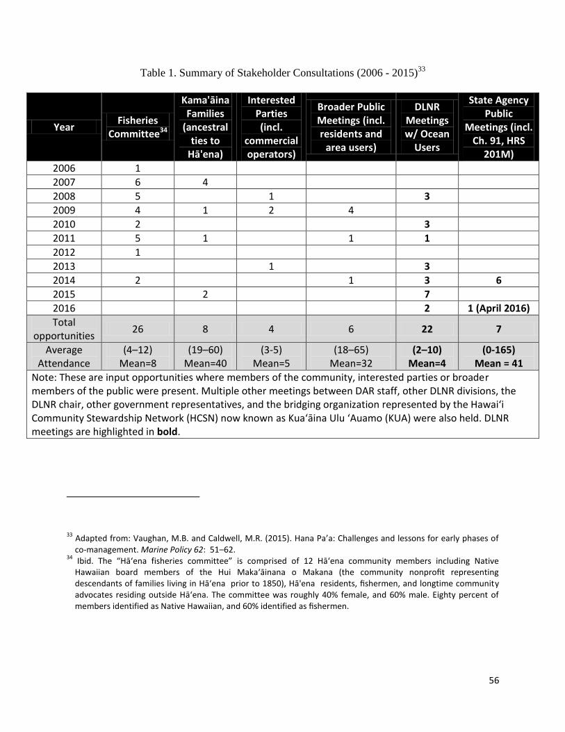
56
Table 1. Summary of Stakeholder Consultations (2006 - 2015)33
33
Adapted from: Vaughan, M.B. and Caldwell, M.R. (2015). Hana Pa’a: Challenges and lessons for early phases of co-management. Marine Policy 62: 51–62.
34 Ibid. The “Hā‘ena fisheries committee” is comprised of 12 Hā‘ena community members including Native Hawaiian board members of the Hui Maka‘āinana o Makana (the community nonprofit representing descendants of families living in Hā‘ena prior to 1850), Hā'ena residents, fishermen, and longtime community advocates residing outside Hā‘ena. The committee was roughly 40% female, and 60% male. Eighty percent of members identified as Native Hawaiian, and 60% identified as fishermen.
Year Fisheries
Committee34
Kama'āina Families
(ancestral ties to
Hā'ena)
Interested Parties (incl.
commercial operators)
Broader Public Meetings (incl. residents and
area users)
DLNR Meetings w/ Ocean
Users
State Agency Public
Meetings (incl. Ch. 91, HRS
201M)
2006 1
2007 6 4
2008 5
1
3
2009 4 1 2 4
2010 2
3
2011 5 1
1 1
2012 1
2013
1
3
2014 2
1 3 6
2015
2
7
2016 2 1 (April 2016)
Total opportunities
26 8 4 6 22 7
Average Attendance
(4–12) Mean=8
(19–60) Mean=40
(3-5) Mean=5
(18–65) Mean=32
(2–10) Mean=4
(0-165) Mean = 41
Note: These are input opportunities where members of the community, interested parties or broader members of the public were present. Multiple other meetings between DAR staff, other DLNR divisions, the DLNR chair, other government representatives, and the bridging organization represented by the Hawai‘i Community Stewardship Network (HCSN) now known as Kua‘āina Ulu ‘Auamo (KUA) were also held. DLNR meetings are highlighted in bold.
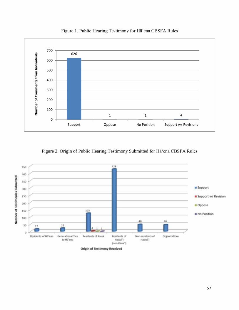
57
Figure 1. Public Hearing Testimony for Hā‘ena CBSFA Rules
Figure 2. Origin of Public Hearing Testimony Submitted for Hā‘ena CBSFA Rules
626
1 1 4 0
100
200
300
400
500
600
700
Support Oppose No Position Support w/ Revisions
Nu
mb
er
of
Co
mm
en
ts f
rom
Ind
ivid
ual
s
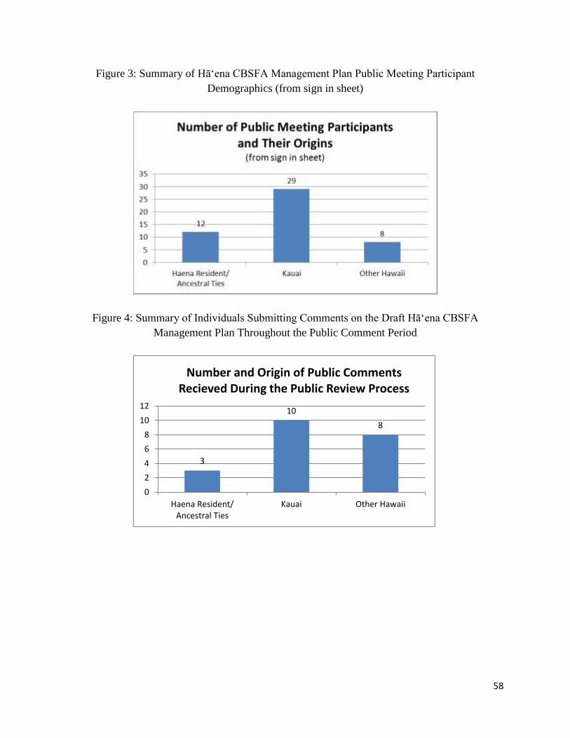
58
Figure 3: Summary of Hāʻena CBSFA Management Plan Public Meeting Participant
Demographics (from sign in sheet)
Figure 4: Summary of Individuals Submitting Comments on the Draft Hāʻena CBSFA
Management Plan Throughout the Public Comment Period
3
10
8
0
2
4
6
8
10
12
Haena Resident/Ancestral Ties
Kauai Other Hawaii
Number and Origin of Public Comments Recieved During the Public Review Process

59
APPENDIX G: Research Informing Hāʻena CBSFA Management Planning This section outlines the main data sources that were used to inform the Hāʻena CBSFA rules
and management plan. These include research on the following topics: Hā‘ena’s Traditional and
Customary Fishing Practices, Human Use of Hā‘ena’s Coastal Environment, Catch Per Unit
Effort, and Hā‘ena’s reef ecology. Additional research related to introduced alien aquatic fish
species and commercial catch was also used to inform the Hā‘ena CBSFA rules and management
plan, and although not specific to Hā‘ena, represents the best available information for decision-
making.
Hāʻena Specific Research Studies
Research on Traditional and Customary Practices of Hā‘ena
1. Vaughan, M.B. and Vitousek, P.M. (2013). Mahele: Sustaining communities through small-
scale inshore fishery catch and sharing networks. Pacific Science 67(3): 329-344. [Online]
https://pacificscience.files.wordpress.com/2013/02/pac-sci-early-view-67-3-3.pdf
2. Vaughan, M.B., Thompson, B.H., Vitousek, P.M., Ardoin, N.M., Caldwell, M., and
Fortmann, L. (2012). Holoholo i ka La‘i o Makua, collaborative community care and
management of coastal resources creating state law based on customary rules to manage a
near shore fishery in Hawai‘i (Doctoral dissertation). Emmett Interdisciplinary Program in
Environment and Resources, Stanford University. [Online]:
http://purl.stanford.edu/xb334mj6645
3. Orr, M. and Kaimipono Consulting Services LLC (2011). Hā‘ena State Park Master Plan/EIS
Cultural Impact Assessment. Prepared for PBR Hawai`i for the State of Hawai‘i Department
of Land and Natural Resources, Division of State Parks. p. 480-571. [Online]
http://oeqc.doh.hawaii.gov/Shared%20Documents/EA_and_EIS_Online_Library/Kauai/2010
s/2015-07-23-KA-5B-DEIS-Haena-State-Park_Master-Plan.pdf
4. Andrade, C. (2008). Hā‘ena: Through the eyes of the ancestors. University of Hawai‘i Press:
Honolulu.
5. Maly, K. and Maly, O. (2003). Hana Ka Lima, ‘Ai Ka Waha: A collection of historical
accounts and oral history interviews with kama‘āina residents and fisher-people of lands in
the Halele‘a-Na Pali Region on the island of Kaua‘i. [Online]
http://uploads.worldlibrary.net/uploads/pdf/elib/collect/maly4/index/assoc/d0.dir/book.pdf
See also: Summary of Hā‘ena oral history interviews submitted as testimony to the BLNR:
http://www.kumupono.com/Ocean%20Resources/Haena%20Fisheries_Notes_km_10242014
%20(2).pdf
6. Maly, K. and Maly, O. (2003). Ka Hana Lawai‘a: Summary of Detailed Findings from
Research on the History of Fishing Practices and Marine Fisheries of the Hawaiian Islands.
Honolulu, Hawai‘i.
60
Hāʻena Human Use Studies
1. Clark, J. (1992). Beach and Ocean Recreation Study, Hā‘ena, Kaua‘i. State of Hawai‘i
Department of Land and Natural Resources, Division of State Parks.
2. Stepath, C. and Save Our Seas (2011). Kē‘ē Lagoon and reef flat users baseline study,
Hā‘ena State Park, Hawai‘i, 1999-06-01 to 1999-08-15 (NODC Accession 0002277).
National Oceanographic Data Center, NOAA. Dataset. [http://data.nodc.noaa.gov/cgi-
bin/iso?id=gov.noaa.nodc:0002277#Documentation]
3. SWCA Environmental Consultants (2010). “Marine Natural Resources and Recreation
Assessment, Hā`ena State Park, Kaua`i, Hawai`i.” Draft Environmental Impact Statement,
Hā‘ena State Park Master Plan. Prepared for PBR Hawai`i for the State of Hawai‘i,
Department of Land and Natural Resources, Division of State Parks. 43p. [Online]
http://oeqc.doh.hawaii.gov/Shared%20Documents/EA_and_EIS_Online_Library/Kauai/2010
s/2015-07-23-KA-5B-DEIS-Haena-State-Park_Master-Plan.pdf
4. Vaughan, M.B. and Ardoin, N.M. (2014). The implications of differing tourist/resident
perceptions for community-based resource management: a Hawaiian coastal resource area
study. Journal of Sustainable Tourism 22(1): p.50–68.
5. Limahuli Garden and Preserve (2010). Hā‘ena Human Use Study. Unpublished Report on
file with State of Hawai‘i Department of Land and Natural Resources, Division of Aquatic
Resources. (See full report in Appendix H).
Hāʻena Catch per Unit Effort Research
1. Vaughan, M.B. and Vitousek, P.M. (2013). Mahele: Sustaining communities through small-
scale inshore fishery catch and sharing networks. Pacific Science 67(3): 329-344. [Online]
https://pacificscience.files.wordpress.com/2013/02/pac-sci-early-view-67-3-3.pdf
2. Limahuli Garden and Preserve (2010). Hā’ena Catch Per Unit Effort (CPUE) Survey.
Unpublished Report on file with State of Hawai‘i Department of Land and Natural
Resources, Division of Aquatic Resources. (See full report in Appendix I)
Hāʻena Marine Ecological Assessments
1. Stepath, C. and Save Our Seas (2011). Kē‘ē Lagoon and reef flat users baseline study,
Hā‘ena State Park, Hawai‘i, 1999-06-01 to 1999-08-15 (NODC Accession 0002277).
National Oceanographic Data Center, NOAA. Dataset. [http://data.nodc.noaa.gov/cgi-
bin/iso?id=gov.noaa.nodc:0002277#Documentation]
2. SWCA Environmental Consultants (2010). “Marine Natural Resources and Recreation
Assessment, Hā‘ena State Park, Kaua‘i, Hawai‘i.” Draft Environmental Impact Statement,
Hā‘ena State Park Master Plan. Prepared for PBR Hawai`i for the State of Hawai‘i
Department of Land and Natural Resources, Division of State Parks. 43p. [Online]
http://oeqc.doh.hawaii.gov/Shared%20Documents/EA_and_EIS_Online_Library/Kauai/2010
s/2015-07-23-KA-5B-DEIS-Haena-State-Park_Master-Plan.pdf

61
3. Friedlander, A.M. (2011). Hā‘ena Juvenile Reef Fish Assessment. Fisheries Ecology
Research Lab, University of Hawai‘i at Mānoa. Unpublished Report on file with State of
Hawai'i Department of Land and Natural Resources, Division of Aquatic Resources,
Honolulu. (See full report in Appendix J)
3. Friedlander, A.M., Goodell, W., and Stimuli’s, K. (2013-2014). Ecological Assessment of
Hā‘ena Reef Habitats. Fisheries Ecology Research Lab, University of Hawai‘i at Mānoa.
Unpublished Report on file with State of Hawai‘i Department of Land and Natural
Resources, Division of Aquatic Resources. (See full report in Appendix K)
Other Research
Introduced Alien Aquatic Fish Species
The Division of Aquatic Resources defines “invasive” species as “a species that is nonnative
(alien) to the ecosystem under consideration, and whose introduction causes or is likely to cause
economic or environmental harm, or harm to human health.”35
Three non-native reef fish species were introduced by the State as food fish in the late 1950s,
ta‘ape (Lutjanus kasmira/blueline snapper), to‘au (Lutjanus fulvus/blacktail snapper), and roi
(Cephalopholis argus/peacock grouper). All of these species are present in the nearshore waters
of the Hāʻena.36,37
Research to date has not found these introduced species to be a biological
concern in regards to native fisheries and habitats, but management actions of such species may
be considered should future research suggest that their control and eradication is a necessary and
viable option. A list of studies on this topic to date is provided below:
1. Russo, A.R., and Brock, R.E. (2010). A Survey of Selected Coral and Fish Assemblages
Adjacent to the Wai‘anae Ocean Outfall, O‘ahu, Hawai‘i, June, 2009. Honolulu, Hawaiʻi.
35
Shluker, A.D. (2003). “State of Hawaiʻi: Aquatic Invasive Species Management Plan.” State of Hawai‘i, Department of Land and Natural Resources, Division of Aquatic Resources. Honolulu, Hawaiʻi. [Online] http://dlnr.hawaii.gov/dar/files/2014/04/ais_mgmt_plan_final.pdf
36 SWCA Environmental Consultants (2010). “Marine Natural Resources and Recreation Assessment, Hā‘ena State Park, Kaua‘i, Hawai‘i.” Draft Environmental Impact Statement, Hā‘ena State Park Master Plan. Prepared for PBR Hawai`i for the State of Hawai‘i, Department of Land and Natural Resources, Division of State Parks. 43p. [Online] http://oeqc.doh.hawaii.gov/Shared%20Documents/EA_and_EIS_Online_Library/Kauai/2010s/2015-07-23-KA-5B-DEIS-Haena-State-Park_Master-Plan.pdf
37 Friedlander, A.M. (2011). Hā‘ena Juvenile Reef Fish Assessment. Fisheries Ecology Research Lab, University of Hawai‘i at Mānoa. Unpublished Report on file with State of Hawai'i, Department of Land and Natural Resources, Division of Aquatic Resources, Honolulu. (See full report in Appendix J)

62
[Online] http://www.nodc.noaa.gov/archive/arc0045/0084515/1.1/data/0-
data/Waianae2010%20Coral%20and%20Fish%20FINAL-01.pdf
2. See, K., Godwin, S., and Menza, C. (2009). “Nonindigenous and Invasive Species”. A
Marine Biogeographic Assessment of the Northwestern Hawaiian Islands. A. Friedlander, K.
Keller, L. Wedding, A. Clarke, and M. Monaco, eds. NOAA Tech. Memo. NOS NCCOS 84.
p. 275-290 [Online] http://ccma.nos.noaa.gov/ecosystems/sanctuaries/nwhi/chapter8.pdf
Studies on Roi (Cephalopholis argus)
3. Meyer, A.L. and Dierking, J. (2011). Elevated size and body condition and altered feeding
ecology of the grouper Cephalopholis argus in non-native habitats. Marine Ecology Progress
Series 439: 203 - 212. [Online]: http://www.int-res.com/abstracts/meps/v439/p203-212/
4. Dierking, J. and Meyer A.L. (2009). Prey regurgitation in the grouper Cephalopholis argus.
Journal of Applied Ichthyology 25: 600 - 602. [Online] http://uhbiology.kahikai.org/wp-
content/uploads/2012/01/Dierking-and-Meyer-09-prey-regurg-in-roi.pdf
5. Dierking, J., Williams, I.D., and Walsh, W.J. (2009). Diet composition and prey selection of
the introduced grouper species peacock hind (Cephalopholis argus) in Hawaiʻi. Fishery
Bulletin 107: 464 - 476.
6. Meyer, A.L. (2008). An ecological comparison of Cephalopholis argus between native and
introduced populations. PhD. Dissertation, University of Hawaiʻi. Honolulu, Hawaiʻi. 142 p.
[Online] http://scholarspace.manoa.hawaii.edu/handle/10125/20930
7. Dierking, J. (2007). Effects of the introduced predatory fish Cephalopholis argus on native
reef fish populations in Hawaiʻi. PhD Dissertation, University of Hawaiʻi at Mānoa,
Honolulu, Hawaiʻi. 125p. [Online]
http://www.fpir.noaa.gov/Library/HCD/Dissertation%20Jan%20Dierking.pdf
8. Shluker, A.D. (2003). “State of Hawaiʻi: Aquatic Invasive Species Management Plan.” State
of Hawai‘i, Department of Land and Natural Resources, Division of Aquatic Resources.
Honolulu, Hawaiʻi. [Online]
http://dlnr.hawaii.gov/dar/files/2014/04/ais_mgmt_plan_final.pdf
9. Walsh, W.J. (2003). Powerpoint presentation on findings from DLNR-DAR monitoring
studies on Hawai‘i Island. Unpublished presentation prepared for the State of Hawai‘i,
Department of Land and Natural Resources, Division of Aquatic Resources.
10. Birkeland, D., Walsh, W.J. and Dierking. J. (2002). “Feeding biology of the introduced fish
roi (Cephalopholis argus) and its impact on Hawaiian coral reef-fishes and fisheries”.
Unpublished proposal submitted to the Hawai‘i Coral Reef Initiative Research Program.

63
Studies on Ta‘ape (Lutjanus kasmira)
1. Schumacher, B.D. (2011). Habitat use and trophic ecology of the introduced snapper
Lutjanus kasmira and native goatfishes in Hawai‘i. PhD. Dissertation, University of Hawai‘i.
Honolulu, Hawai‘i. 230 p. [Online] http://nsgl.gso.uri.edu/hawau/hawauy11005.pdf
2. Schumacher, B.D. and Parrish, J.D. (2005). Spatial Relationships Between an Introduced
Snapper and Native Goatfishes on Hawaiian Reefs. Biological Invasions 7(6): 925–933.
[Online] http://dx.doi.org/10.1007/s10530-004-2983-6.
3. Friedlander, A.M., Parrish J.D., and DeFelice, R.C. (2002). “Ecology of the introduced
snapper Lutjanus kasmira (Forsskal) in the reef fish assemblage of a Hawaiian bay”. Journal
of Fish Biology 60:28-48.
4. Parrish, J.D., Aeby, G.S., Conklin, E.J., and Ivey, G.L. (2000). “Interactions of
nonindigenous blueline snapper (Ta‘ape) with native fishery species”. Final Report to the
State of Hawai‘i, Department of Land and Natural Resources, Division of Aquatic
Resources.
5. Kushima, J. (1989). “Ta‘ape Market Development Project”. Final Report. State of Hawai‘i,
Department of Land and Natural Resources, Division of Aquatic Resources.
6. Oda, D.K. and Parrish, J.D. (1981). “Ecology of commercial snapper and groupers
introduced to Hawaiian reefs”. Proceedings of the Fourth International Coral Reef
Symposium, Manila, 1981, Vol. 1:59-67.
Commercial Catch Reports
To help understand commercial fishing needs and potential impacts of adopting the Hāʻena
CBSFA rules on this sector, the State of Hawai‘i Division of Aquatic Resources (DAR)
compiled commercial catch reports submitted between 2006-201538
to evaluate general fishery
trends in the area over the past decade. A decade of commercial landings data was assessed to
inform consideration of commercial fishing interests during the CBSFA management planning
process.
Although the Hāʻena CBSFA boundary only extends from the shoreline to one mile out along
approximately three and half miles of coastline, it’s location falls within two map grid areas
associated with commercial catch reports, 502 and 503 , but predominantly lies within map grid
area 503 (see map in Figure 1 on following page). As such, the following summaries of
commercial landings include all catch from within 502 and 503 grid areas, which represents
38
At the time of writing, 2015 commercial landings included catch reported between January and June 2015.
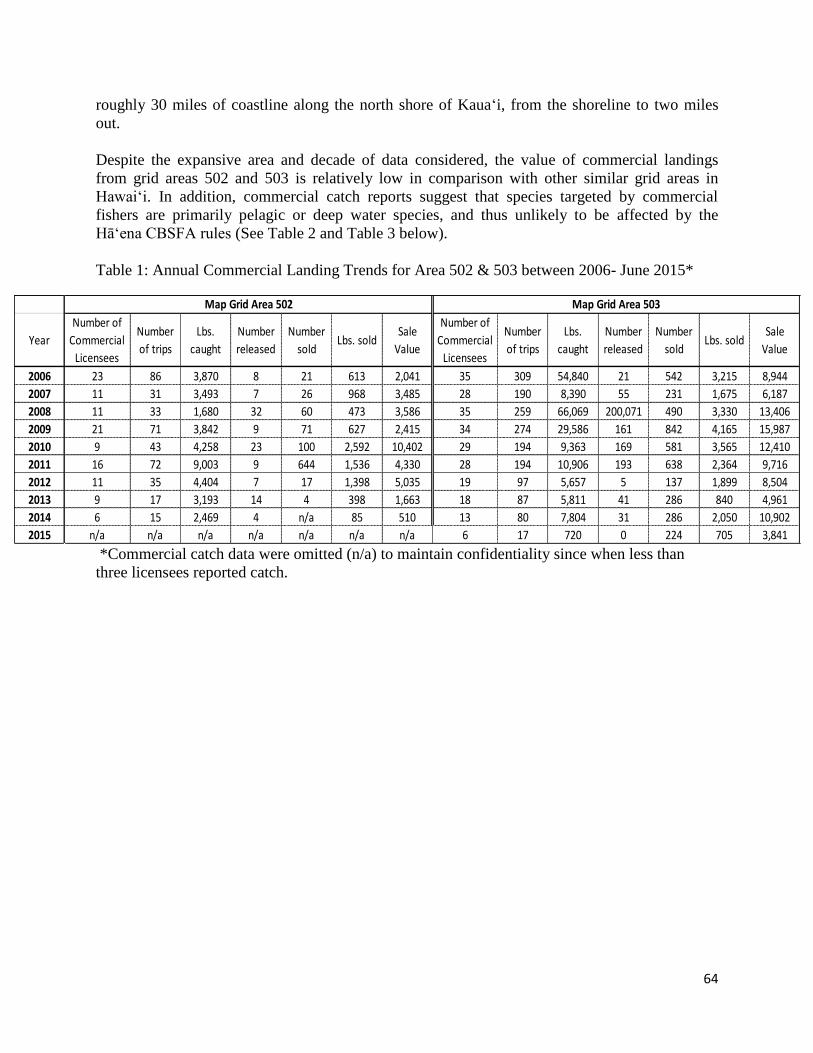
64
roughly 30 miles of coastline along the north shore of Kaua‘i, from the shoreline to two miles
out.
Despite the expansive area and decade of data considered, the value of commercial landings
from grid areas 502 and 503 is relatively low in comparison with other similar grid areas in
Hawai‘i. In addition, commercial catch reports suggest that species targeted by commercial
fishers are primarily pelagic or deep water species, and thus unlikely to be affected by the
Hāʻena CBSFA rules (See Table 2 and Table 3 below).
Table 1: Annual Commercial Landing Trends for Area 502 & 503 between 2006- June 2015*
*Commercial catch data were omitted (n/a) to maintain confidentiality since when less than
three licensees reported catch.
Year
Number of
Commercial
Licensees
Number
of trips
Lbs.
caught
Number
released
Number
soldLbs. sold
Sale
Value
Number of
Commercial
Licensees
Number
of trips
Lbs.
caught
Number
released
Number
soldLbs. sold
Sale
Value
2006 23 86 3,870 8 21 613 2,041 35 309 54,840 21 542 3,215 8,944
2007 11 31 3,493 7 26 968 3,485 28 190 8,390 55 231 1,675 6,187
2008 11 33 1,680 32 60 473 3,586 35 259 66,069 200,071 490 3,330 13,406
2009 21 71 3,842 9 71 627 2,415 34 274 29,586 161 842 4,165 15,987
2010 9 43 4,258 23 100 2,592 10,402 29 194 9,363 169 581 3,565 12,410
2011 16 72 9,003 9 644 1,536 4,330 28 194 10,906 193 638 2,364 9,716
2012 11 35 4,404 7 17 1,398 5,035 19 97 5,657 5 137 1,899 8,504
2013 9 17 3,193 14 4 398 1,663 18 87 5,811 41 286 840 4,961
2014 6 15 2,469 4 n/a 85 510 13 80 7,804 31 286 2,050 10,902
2015 n/a n/a n/a n/a n/a n/a n/a 6 17 720 0 224 705 3,841
Map Grid Area 502 Map Grid Area 503
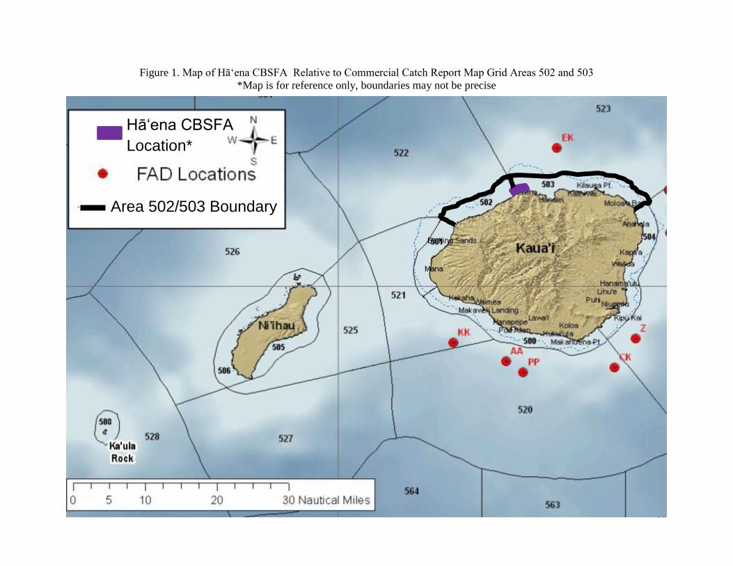
65
Figure 1. Map of Hā‘ena CBSFA Relative to Commercial Catch Report Map Grid Areas 502 and 503
*Map is for reference only, boundaries may not be precise
Hāʻena CBSFA
Location*
Area 502/503 Boundary
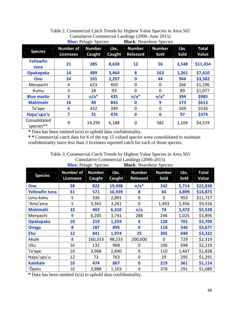
66
Table 2. Commercial Catch Trends by Highest Value Species in Area 502
Cumulative Commercial Landings (2006- June 2015)
Blue: Pelagic Species Black: Nearshore Species
Species Number of Licensees
Number Caught
Lbs. Caught
Number Released
Number Sold
Lbs. Sold
Total Value
Yellowfin tuna
21 285 8,630 12 56 3,548 $11,454
Opakapaka 14 489 3,464 8 163 1,261 $7,410
Ono 24 101 2,297 0 44 944 $3,582
Menpachi 4 623 450 0 0 266 $1,196
Kumu 3 28 93 0 0 89 $1,077
Blue marlin 3 n/a* 435 n/a* n/a* 394 $985
Mahimahi 16 40 843 0 9 173 $613
Ta‘ape 6 432 349 0 0 269 $536
Hapu‘upu‘u 7 31 476 0 6 97 $374
Consolidated species**
9 14,295 6,188 0 582 1,104 $4,519
* Data has been omitted (n/a) to uphold data confidentiality.
* * Commercial catch data for 6 of the top 15 valued species were consolidated to maintain
confidentiality since less than 3 licensees reported catch for each of those species.
Table 3. Commercial Catch Trends by Highest Value Species in Area 503
Cumulative Commercial Landings (2006-2015)
Blue: Pelagic Species Black: Nearshore Species
Species Number of Licensees
Number Caught
Lbs. Caught
Number Released
Number Sold
Lbs. Sold
Total Value
Ono 38 822 19,498 n/a* 242 5,714 $22,838
Yellowfin tuna 31 571 16,939 8 66 3,899 $14,873
Limu kohu 5 336 2,891 0 0 953 $11,727
‘Ama‘ama 5 3,365 3,261 0 1,493 2,456 $9,416
Mahimahi 32 403 6,410 n/a 74 1,472 $5,538
Menpachi 9 6,205 3,741 288 246 1,025 $3,895
Opakapaka 10 219 1,259 6 128 701 $3,700
Onaga 8 187 895 0 118 546 $3,677
Ehu 12 841 1,974 25 305 690 $3,322
Akule 8 160,333 98,233 200,000 0 729 $2,319
Uku 16 132 968 0 106 698 $2,219
Ta‘ape 10 3,968 2,840 0 110 1,447 $1,828
Hapu‘upu‘u 12 73 763 0 29 295 $1,291
Kalekale 10 474 867 0 219 361 $1,114
‘Ōpelu 10 3,988 1,103 0 378 291 $1,089 * Data has been omitted (n/a) to uphold data confidentiality.

67
Given the nature and geographic extent of the Hāʻena CBSFA rules, potential impacts of CBSFA
rules were anticipated to be greater on nearshore commercial fishing activities. To better
understand nearshore commercial fishers’ needs and the potential impacts of adopting CBSFA
rules on their commercial fishing activities, pelagic and deep water species were excluded from
analysis of commercial catch reports, with summarized results of commercial catch of nearshore
reef species, both in terms of highest value and highest catch provided in Table 4 and Table 5
below.
Table 4. Nearshore Commercial Catch Trends by Highest Value
Cumulative Commercial Landings for Areas 502 and 503 Combined (2006- June 2015)*
Nearshore Species
Number of Licensees
Number Caught
Lbs. Caught
Number Released
Number Sold
Lbs. Sold
Total Value
Limu kohu 7 388 4222 0 0 1104 $13,539
‘Ama‘ama 5 3365 3261 0 1493 2456 $9,416
Menpachi 13 6828 4190 288 246 1291 $5,091
Uku 30 153 1197 0 111 768 $2,498
Ta‘ape 16 4400 3188 0 110 1715 $2,364
Akule 12 162919 99645 200000 0 729 $2,319
‘Ōpelu 11 17604 3913 0 844 431 $1,789
Kumu 9 51 148 17 0 106 $1,204
Āholehole 4 1724 868 0 71 331 $1,203
Moana kale 4 155 368 14 24 208 $1,040
Moi 4 155 368 14 24 208 $1,040
Palani 6 251 584 0 117 448 $722
‘Ōʻiō 5 902 2839 0 260 437 $705
White ulua 13 93 1205 31 10 416 $547
Uhu parrot-misc. 7 76 271 0 24 130 $395 * Commercial catch data for near shore species were consolidated for areas 502 and 503 to
maintain confidentiality
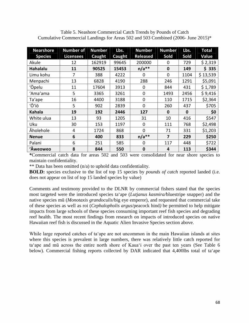
68
Table 5. Neashore Commercial Catch Trends by Pounds of Catch
Cumulative Commercial Landings for Areas 502 and 503 Combined (2006- June 2015)*
Nearshore Species
Number of Licensees
Number Caught
Lbs. Caught
Number Released
Number Sold
Lbs. Sold
Total Value
Akule 12 162919 99645 200000 0 729 $ 2,319
Hahalalu 11 90525 15453 n/a** 0 149 $ 335
Limu kohu 7 388 4222 0 0 1104 $ 13,539
Menpachi 13 6828 4190 288 246 1291 $5,091
‘Ōpelu 11 17604 3913 0 844 431 $ 1,789
‘Ama‘ama 5 3365 3261 0 1493 2456 $ 9,416
Taʻape 16 4400 3188 0 110 1715 $2,364
‘Ōʻiō 5 902 2839 0 260 437 $705
Kahala 19 192 2446 127 0 0 $0
White ulua 13 93 1205 31 10 416 $547
Uku 30 153 1197 0 111 768 $2,498
Āholehole 4 1724 868 0 71 331 $1,203
Nenue 6 400 833 n/a** 7 229 $250
Palani 6 251 585 0 117 448 $722
ʻĀweoweo 8 844 550 0 4 113 $344 *Commercial catch data for areas 502 and 503 were consolidated for near shore species to
maintain confidentiality.
** Data has been omitted (n/a) to uphold data confidentiality.
BOLD: species exclusive to the list of top 15 species by pounds of catch reported landed (i.e.
does not appear on list of top 15 landed species by value)
Comments and testimony provided to the DLNR by commercial fishers stated that the species
most targeted were the introduced species ta‘ape (Lutjanus kasmira/bluestripe snapper) and the
native species mū (Monotaxis grandoculis/big eye emperor), and requested that commercial take
of these species as well as roi (Cephalopholis argus/peacock hind) be permitted to help mitigate
impacts from large schools of these species consuming important reef fish species and degrading
reef health. The most recent findings from research on impacts of introduced species on native
Hawaiian reef fish is discussed in the Aquatic Alien Invasive Species section above.
While large reported catches of taʻape are not uncommon in the main Hawaiian islands at sites
where this species is prevalent in large numbers, there was relatively little catch reported for
ta‘ape and mū across the entire north shore of Kaua‘i over the past ten years (See Table 6
below). Commercial fishing reports collected by DAR indicated that 4,400lbs total of ta‘ape
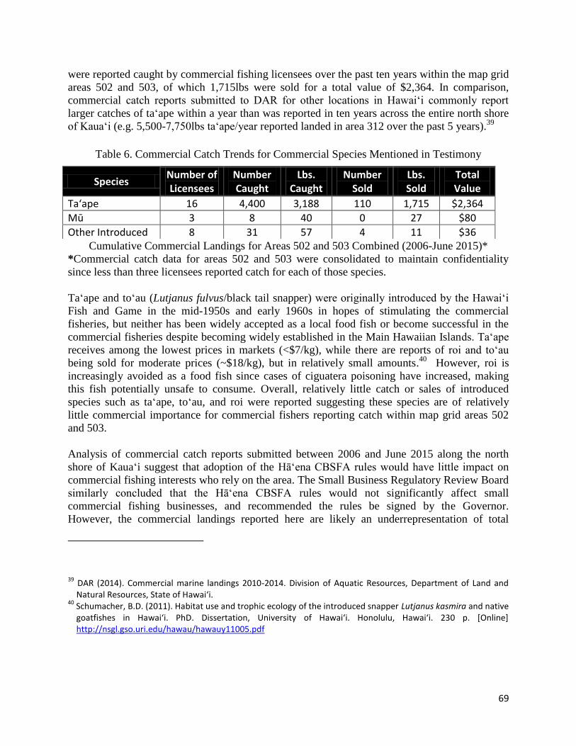
69
were reported caught by commercial fishing licensees over the past ten years within the map grid
areas 502 and 503, of which 1,715lbs were sold for a total value of $2,364. In comparison,
commercial catch reports submitted to DAR for other locations in Hawaiʻi commonly report
larger catches of ta‘ape within a year than was reported in ten years across the entire north shore
of Kaua‘i (e.g. 5,500-7,750lbs ta‘ape/year reported landed in area 312 over the past 5 years).39
Table 6. Commercial Catch Trends for Commercial Species Mentioned in Testimony
Cumulative Commercial Landings for Areas 502 and 503 Combined (2006-June 2015)*
*Commercial catch data for areas 502 and 503 were consolidated to maintain confidentiality
since less than three licensees reported catch for each of those species.
Ta‘ape and to‘au (Lutjanus fulvus/black tail snapper) were originally introduced by the Hawaiʻi
Fish and Game in the mid-1950s and early 1960s in hopes of stimulating the commercial
fisheries, but neither has been widely accepted as a local food fish or become successful in the
commercial fisheries despite becoming widely established in the Main Hawaiian Islands. Taʻape
receives among the lowest prices in markets (<$7/kg), while there are reports of roi and to‘au
being sold for moderate prices (~$18/kg), but in relatively small amounts.40
However, roi is
increasingly avoided as a food fish since cases of ciguatera poisoning have increased, making
this fish potentially unsafe to consume. Overall, relatively little catch or sales of introduced
species such as ta‘ape, to‘au, and roi were reported suggesting these species are of relatively
little commercial importance for commercial fishers reporting catch within map grid areas 502
and 503.
Analysis of commercial catch reports submitted between 2006 and June 2015 along the north
shore of Kaua‘i suggest that adoption of the Hāʻena CBSFA rules would have little impact on
commercial fishing interests who rely on the area. The Small Business Regulatory Review Board
similarly concluded that the Hā‘ena CBSFA rules would not significantly affect small
commercial fishing businesses, and recommended the rules be signed by the Governor.
However, the commercial landings reported here are likely an underrepresentation of total
39
DAR (2014). Commercial marine landings 2010-2014. Division of Aquatic Resources, Department of Land and Natural Resources, State of Hawai‘i.
40 Schumacher, B.D. (2011). Habitat use and trophic ecology of the introduced snapper Lutjanus kasmira and native goatfishes in Hawaiʻi. PhD. Dissertation, University of Hawaiʻi. Honolulu, Hawaiʻi. 230 p. [Online] http://nsgl.gso.uri.edu/hawau/hawauy11005.pdf
Species Number of Licensees
Number Caught
Lbs. Caught
Number Sold
Lbs. Sold
Total Value
Ta‘ape 16 4,400 3,188 110 1,715 $2,364
Mū 3 8 40 0 27 $80
Other Introduced 8 31 57 4 11 $36

70
commercial catch in these areas, highlighting the importance of collaborative data collection and
timely and accurate reporting of commercial catch by commercial fishers.
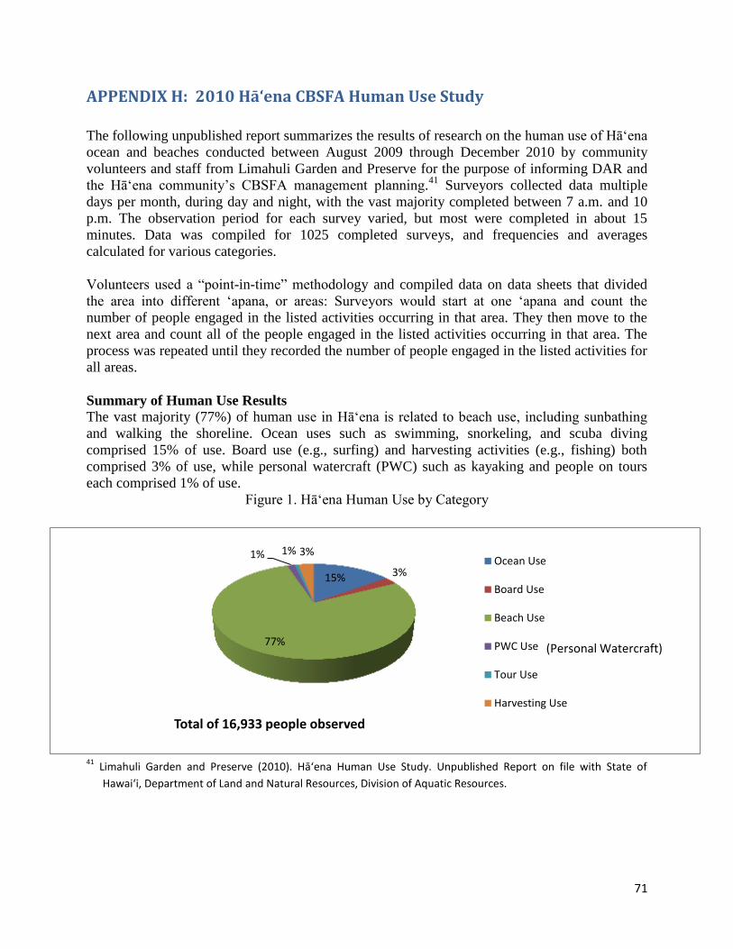
71
APPENDIX H: 2010 Hāʻena CBSFA Human Use Study
The following unpublished report summarizes the results of research on the human use of Hā‘ena
ocean and beaches conducted between August 2009 through December 2010 by community
volunteers and staff from Limahuli Garden and Preserve for the purpose of informing DAR and
the Hā‘ena community’s CBSFA management planning.41
Surveyors collected data multiple
days per month, during day and night, with the vast majority completed between 7 a.m. and 10
p.m. The observation period for each survey varied, but most were completed in about 15
minutes. Data was compiled for 1025 completed surveys, and frequencies and averages
calculated for various categories.
Volunteers used a “point-in-time” methodology and compiled data on data sheets that divided
the area into different ‘apana, or areas: Surveyors would start at one ‘apana and count the
number of people engaged in the listed activities occurring in that area. They then move to the
next area and count all of the people engaged in the listed activities occurring in that area. The
process was repeated until they recorded the number of people engaged in the listed activities for
all areas.
Summary of Human Use Results
The vast majority (77%) of human use in Hā‘ena is related to beach use, including sunbathing
and walking the shoreline. Ocean uses such as swimming, snorkeling, and scuba diving
comprised 15% of use. Board use (e.g., surfing) and harvesting activities (e.g., fishing) both
comprised 3% of use, while personal watercraft (PWC) such as kayaking and people on tours
each comprised 1% of use.
Figure 1. Hāʻena Human Use by Category
41
Limahuli Garden and Preserve (2010). Hā‘ena Human Use Study. Unpublished Report on file with State of
Hawai‘i, Department of Land and Natural Resources, Division of Aquatic Resources.
15% 3%
77%
1% 1% 3%
Total of 16,933 people observed
Ocean Use
Board Use
Beach Use
PWC Use
Tour Use
Harvesting Use
(Personal Watercraft)
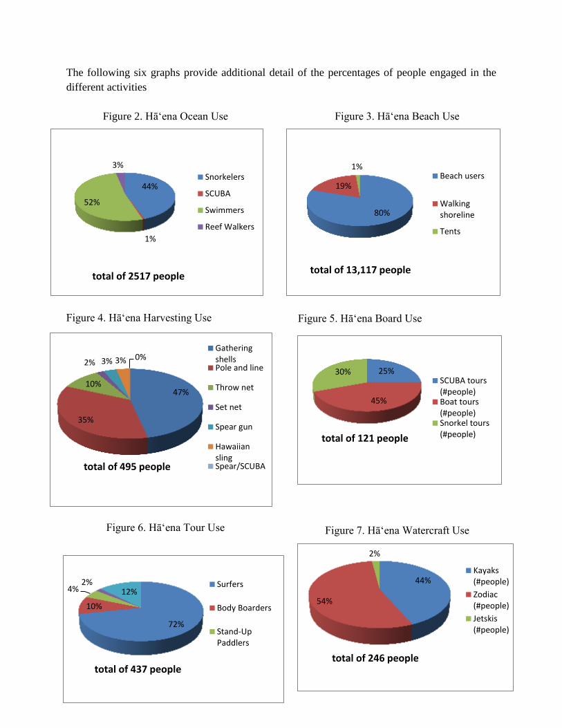
72
The following six graphs provide additional detail of the percentages of people engaged in the
different activities
Figure 2. Hāʻena Ocean Use Figure 3. Hāʻena Beach Use
Figure 4. Hāʻena Harvesting Use
Figure 6. Hāʻena Tour Use
Figure 5. Hāʻena Board Use
Figure 7. Hāʻena Watercraft Use
44%
1%
52%
3%
total of 2517 people
Snorkelers
SCUBA
Swimmers
Reef Walkers
80%
19%
1%
total of 13,117 people
Beach users
Walkingshoreline
Tents
47%
35%
10%
2% 3% 3% 0%
total of 495 people
GatheringshellsPole and line
Throw net
Set net
Spear gun
HawaiianslingSpear/SCUBA
72%
10%
4% 2%
12%
total of 437 people
Surfers
Body Boarders
Stand-UpPaddlers
25%
45%
30%
total of 121 people
SCUBA tours(#people)Boat tours(#people)Snorkel tours(#people)
44%
54%
2%
total of 246 people
Kayaks(#people)
Zodiac(#people)
Jetskis(#people)

73
Seasonal Changes in Human Use at Hā‘ena
Human use varied from one season to the next. The following chart illustrates the rise in human
use at Hā‘ena during the spring, the height of human use during summertime, and the decrease
through winter. The chart records the average number of people observed engaging in each
activity category during each observation period, by season. Survey observation periods varied,
but were usually completed within 15 minutes.
Figure 8. Hāʻena Human Use by Season
Changes in Hā‘ena Human Use by Time of Day
As might be expected, the number of people utilizing Hā‘ena varies by the time of day. Surveys
at Hā‘ena were collected at all times of day, enabling tracking throughout the 24-hour daily
cycle. Figure 9 below illustrates the human use of Hā‘ena throughout the six apana, or zones,
throughout the day. “Beach use” combines ocean use, boarding use, and beach use for simplicity.
Apana 1 and 4 were the most popular areas of Hā‘ena throughout the day during this study.
0.0
5.0
10.0
15.0
20.0
25.0
30.0
Spring Summer Fall Winter
Ave
rage
nu
mb
er o
f p
eop
le e
nga
ged
in
eac
h t
ype
of
acti
vity
per
rep
ort
Ocean Use
Boarding
Beach Use
PWC
Tours (#people)
Harvesting
(Personal Watercraft)

74
Figure 9. Human Use in Hā‘ena by Zones Throughout the Day
75
APPENDIX I: 2010 Hā‘ena Catch Per Unit Effort Study
The following unpublished report reflects the findings a Catch Per Unit Effort (CPUE) Study
conducted over 13 months between August 2009 and December 2010 by Limahuli Garden and
Preserve staff for the purpose of informing Hā‘ena CBSFA management planning .42
A total of 63 sampling events of approximately three hours each were completed, representing
60.6% of the original sampling target and roughly 190 hours of sampling (Table 1). Of the
sampling events completed, 32 fell on a weekend day, and 31 fell on a weekday. Dates were
randomly selected using random number assignment. Four different types of data were collected:
i. Events: Data collected about the sampling day, or “event.” Includes start/end time, date,
tides, weather information.
ii. Observations: Data collected about persons observed fishing. Surveyors observed fishing
activity from the shoreline using binoculars. Includes number of persons, gear used, and
fishing location/zone.
iii. Intercept Interviews: In‐person interviews with fishers. Includes number interviewed,
residence zip code, gear used, number of persons, and intended disposition of catch.
iv. Catch Recording: If anglers intercepted with catch, surveyors attempted to collect data on
catch. Includes number, size, weight, and disposition.
42
Limahuli Garden and Preserve (2010). Hā’ena CPUE survey. Unpublished Report on file with State of Hawai‘i, Department of Land and Natural Resources, Division of Aquatic Resources.
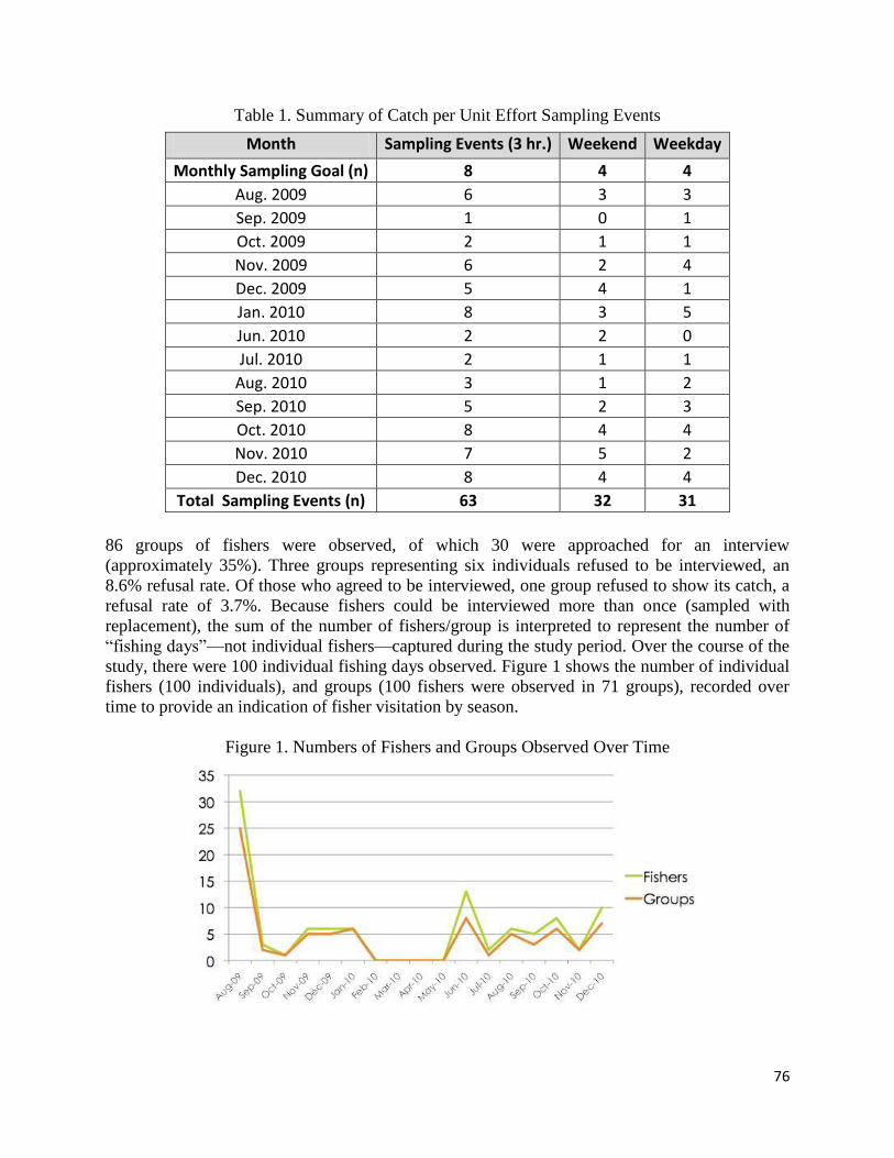
76
Table 1. Summary of Catch per Unit Effort Sampling Events
Month Sampling Events (3 hr.) Weekend Weekday
Monthly Sampling Goal (n) 8 4 4
Aug. 2009 6 3 3
Sep. 2009 1 0 1
Oct. 2009 2 1 1
Nov. 2009 6 2 4
Dec. 2009 5 4 1
Jan. 2010 8 3 5
Jun. 2010 2 2 0
Jul. 2010 2 1 1
Aug. 2010 3 1 2
Sep. 2010 5 2 3
Oct. 2010 8 4 4
Nov. 2010 7 5 2
Dec. 2010 8 4 4
Total Sampling Events (n) 63 32 31
86 groups of fishers were observed, of which 30 were approached for an interview
(approximately 35%). Three groups representing six individuals refused to be interviewed, an
8.6% refusal rate. Of those who agreed to be interviewed, one group refused to show its catch, a
refusal rate of 3.7%. Because fishers could be interviewed more than once (sampled with
replacement), the sum of the number of fishers/group is interpreted to represent the number of
“fishing days”—not individual fishers—captured during the study period. Over the course of the
study, there were 100 individual fishing days observed. Figure 1 shows the number of individual
fishers (100 individuals), and groups (100 fishers were observed in 71 groups), recorded over
time to provide an indication of fisher visitation by season.
Figure 1. Numbers of Fishers and Groups Observed Over Time
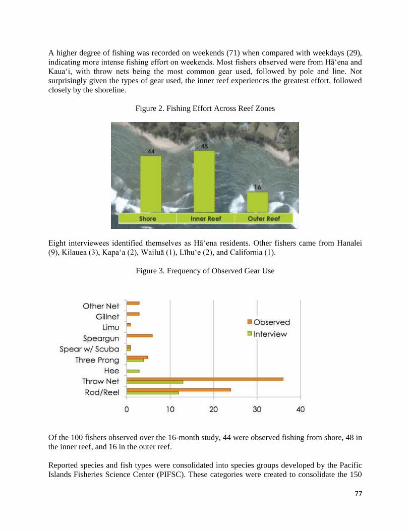
77
A higher degree of fishing was recorded on weekends (71) when compared with weekdays (29),
indicating more intense fishing effort on weekends. Most fishers observed were from Hā‘ena and
Kaua‘i, with throw nets being the most common gear used, followed by pole and line. Not
surprisingly given the types of gear used, the inner reef experiences the greatest effort, followed
closely by the shoreline.
Figure 2. Fishing Effort Across Reef Zones
Eight interviewees identified themselves as Hā‘ena residents. Other fishers came from Hanalei
(9), Kilauea (3), Kapa‘a (2), Wailuā (1), Līhu‘e (2), and California (1).
Figure 3. Frequency of Observed Gear Use
Of the 100 fishers observed over the 16-month study, 44 were observed fishing from shore, 48 in
the inner reef, and 16 in the outer reef.
Reported species and fish types were consolidated into species groups developed by the Pacific
Islands Fisheries Science Center (PIFSC). These categories were created to consolidate the 150
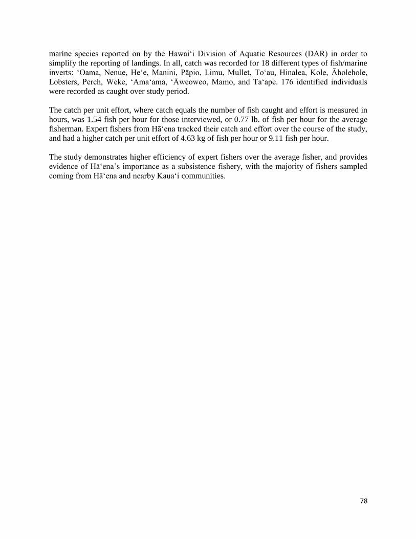
78
marine species reported on by the Hawaiʻi Division of Aquatic Resources (DAR) in order to
simplify the reporting of landings. In all, catch was recorded for 18 different types of fish/marine
inverts: ‘Oama, Nenue, He‘e, Manini, Pāpio, Limu, Mullet, To‘au, Hinalea, Kole, Āholehole,
Lobsters, Perch, Weke, ‘Ama‘ama, ‘Āweoweo, Mamo, and Ta‘ape. 176 identified individuals
were recorded as caught over study period.
The catch per unit effort, where catch equals the number of fish caught and effort is measured in
hours, was 1.54 fish per hour for those interviewed, or 0.77 lb. of fish per hour for the average
fisherman. Expert fishers from Hā‘ena tracked their catch and effort over the course of the study,
and had a higher catch per unit effort of 4.63 kg of fish per hour or 9.11 fish per hour.
The study demonstrates higher efficiency of expert fishers over the average fisher, and provides
evidence of Hā‘ena’s importance as a subsistence fishery, with the majority of fishers sampled
coming from Hā‘ena and nearby Kaua‘i communities.
79
APPENDIX J: 2011 Hā‘ena Reef Fish Assessment
The following unpublished report was prepared by the Fisheries Ecology and Research Lab
(FREL) of the University of Hawai‘i at Mānoa to provide scientific information to DAR and the
Hā‘ena community to inform CBSFA management planning.43
This report reflects the findings
ecological assessments of Hā‘ena reef habitats conducted by FREL during 2011 in Hāʻena
Kauaʻi .
RESEARCH OBJECTIVES
Examine the preferred habitat for newly settled and juvenile reef fishes at Makua, Kauaʻi. The
focus of this study was on parrotfishes, wrasses, and damselfishes, but other species were also
assessed to determine the importance of Makua as a juvenile nursery habitat for Hawaiian reef
fishes.
RESEARCH RATIONALE
In the Hawaiian Archipelago, shelter-dependent juvenile stages of many reef fishes and their
coral habitats are increasingly at risk from multiple anthropogenic stressors (e.g. overfishing and
habitat loss, coral bleaching and sedimentation, respectively44
).
RESULTS
Benthic Habitat Cover
The backreef habitat at Makua was dominated by limestone substrate with little turf algae (59%)
(See Table 1). This was followed by sand (21%), low encrusting Montipora corals such as M.
patula (sandpaper rice coral) and M. dilitata (velvet coral) (8%), reef rubble (8%), crustose
coralline algae (1%), and encrusting and mounding-massive Porites growth forms including P.
lutea (mound coral) and P. rus (plate and pilar coral) (1%).
Recruit Species
Recruit fish species at Makua were dominated by wrasses and parrotfishes (See Table 2). The
belted wrasse was the most common species (31% of the total), follow by the endemic saddle
wrasse (hinalea lauwili - 21%), and the commercially and culturally important redlip parrotfish
43
Friedlander, A.M. (2011). Hā‘ena Juvenile Reef Fish Assessment. Fisheries Ecology Research Lab, University of
Hawai‘i at Mānoa. Unpublished Report on file with State of Hawai'i, Department of Land and Natural Resources,
Division of Aquatic Resources, Honolulu. 44
DeMartini E.E., Anderson, T.W., Kenyon, J.C., Beets, J.P., and Friedlander, A.M. (2010). Management implications
of juvenile reef fish habitat preferences and coral susceptibility to stressors. Marine and Freshwater Research
(61): 532 - 540.
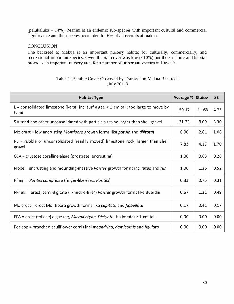
80
(palukaluka – 14%). Manini is an endemic sub-species with important cultural and commercial
significance and this species accounted for 6% of all recruits at makua.
CONCLUSION
The backreef at Makua is an important nursery habitat for culturally, commercially, and
recreational important species. Overall coral cover was low (<10%) but the structure and habitat
provides an important nursery area for a number of important species in Hawai‘i.
Table 1. Benthic Cover Observed by Transect on Makua Backreef
(July 2011)
Habitat Type Average % St.dev SE
L = consolidated limestone [karst] incl turf algae < 1-cm tall; too large to move by hand
59.17 11.63 4.75
S = sand and other unconsolidated with particle sizes no larger than shell gravel 21.33 8.09 3.30
Mo crust = low encrusting Montipora growth forms like patula and dilitata) 8.00 2.61 1.06
Ru = rubble or unconsolidated (readily moved) limestone rock; larger than shell gravel
7.83 4.17 1.70
CCA = crustose coralline algae (prostrate, encrusting) 1.00 0.63 0.26
Plobe = encrusting and mounding-massive Porites growth forms incl lutea and rus 1.00 1.26 0.52
Pfingr = Porites compressa (finger-like erect Porites) 0.83 0.75 0.31
Pknukl = erect, semi-digitate (“knuckle-like”) Porites growth forms like duerdini 0.67 1.21 0.49
Mo erect = erect Montipora growth forms like capitata and flabellata 0.17 0.41 0.17
EFA = erect (foliose) algae (eg, Microdictyon, Dictyota, Halimeda) ≥ 1-cm tall 0.00 0.00 0.00
Poc spp = branched cauliflower corals incl meandrina, damicornis and ligulata 0.00 0.00 0.00
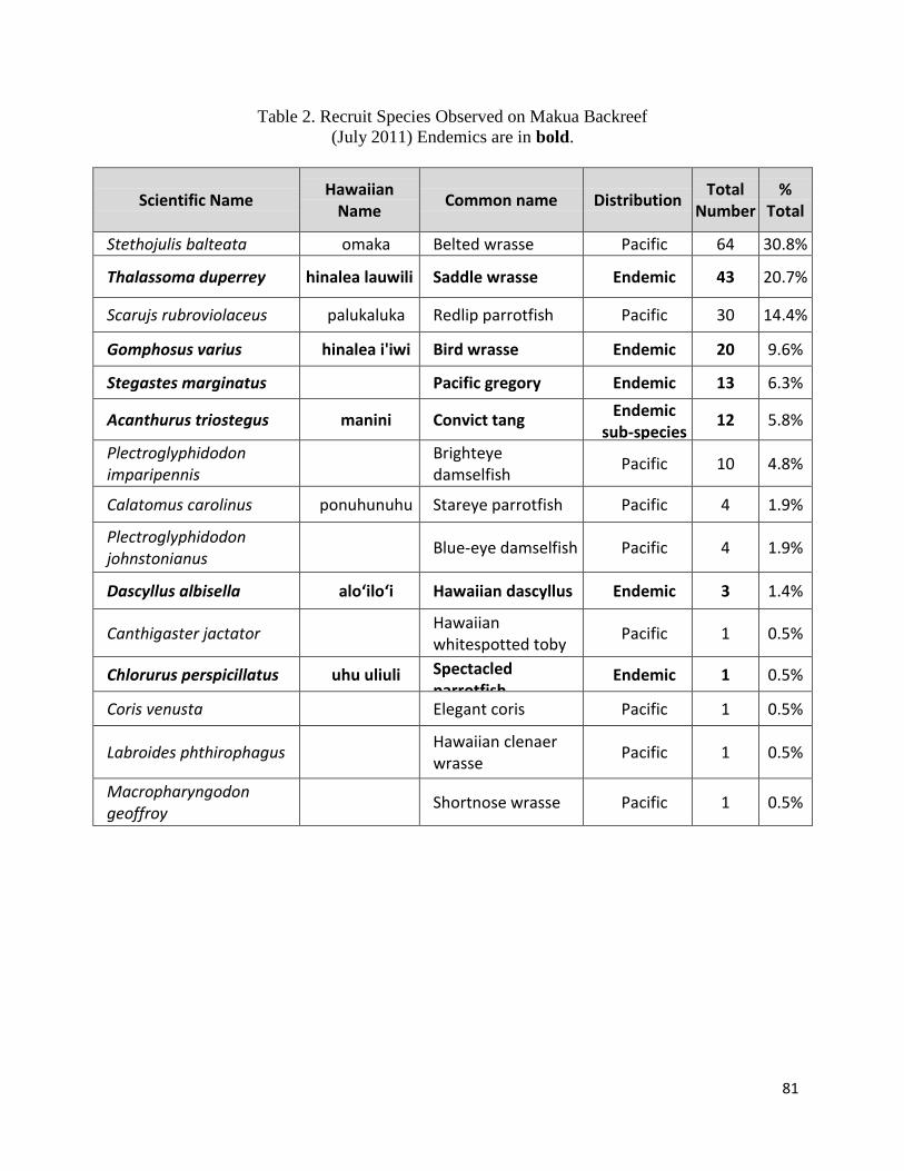
81
Table 2. Recruit Species Observed on Makua Backreef
(July 2011) Endemics are in bold.
Scientific Name Hawaiian
Name Common name Distribution
Total Number
% Total
Stethojulis balteata omaka Belted wrasse Pacific 64 30.8%
Thalassoma duperrey hinalea lauwili Saddle wrasse Endemic 43 20.7%
Scarujs rubroviolaceus palukaluka Redlip parrotfish Pacific 30 14.4%
Gomphosus varius hinalea i'iwi Bird wrasse Endemic 20 9.6%
Stegastes marginatus Pacific gregory Endemic 13 6.3%
Acanthurus triostegus manini Convict tang Endemic
sub-species 12 5.8%
Plectroglyphidodon imparipennis
Brighteye damselfish
Pacific 10 4.8%
Calatomus carolinus ponuhunuhu Stareye parrotfish Pacific 4 1.9%
Plectroglyphidodon johnstonianus
Blue-eye damselfish Pacific 4 1.9%
Dascyllus albisella alo‘ilo‘i Hawaiian dascyllus Endemic 3 1.4%
Canthigaster jactator Hawaiian whitespotted toby
Pacific 1 0.5%
Chlorurus perspicillatus uhu uliuli Spectacled parrotfish
Endemic 1 0.5%
Coris venusta Elegant coris Pacific 1 0.5%
Labroides phthirophagus Hawaiian clenaer wrasse
Pacific 1 0.5%
Macropharyngodon geoffroy
Shortnose wrasse Pacific 1 0.5%

82
APPENDIX K: 2013-2014 Hāʻena Reef Fish Assessment
The following unpublished report was prepared by the Fisheries Ecology and Research Lab
(FREL) of the University of Hawai‘i at Mānoa to provide scientific information to DAR and the
Hā‘ena community to inform CBSFA management planning.45
This report reflects the findings
ecological assessments of Hā‘ena reef habitats conducted by FREL during 2013-2014.
RESEARCH OBJECTIVES
The objective of the assessment was to determine the ecological importance of Makua back-reef
in comparison with other back-reef habitats at Hā‘ena, and to assess its role as a nursery habitat,
or pu‘uhonua (Figure 1).
Figure 1. Map of Habitat Zones and Pu‘uhonua Area within Hā‘ena CBSFA
45
Friedlander, A.M., Goodell, W., and Stamoulis, K. (2013-2014). Ecological Assessment of Hā‘ena Reef Habitats.
Fisheries Ecology Research Lab, University of Hawai‘i at Mānoa. Unpublished Report on file with State of Hawai‘i,
Department of Land and Natural Resources, Division of Aquatic Resources.

83
METHODS
Fish and benthic surveys were conducted on Makua and Kē‘ē reefs in Hā‘ena, Kaua‘i using
established methods. Randomly located transects were placed in the back-reef area (area between
the reef crest and the shoreline) and the fore-reef area (area on the outer side of the reef crest) for
each reef. A diver swam a 25 x 5m transect at a constant speed and identified to the lowest
possible taxon all fishes visible within 2.5 m to either side of the centerline (125-m2 transect
area). Swimming duration varied from 10–15min, depending on habitat complexity and fish
abundance. Total length (TL) of fish was estimated to the nearest centimeter.46
After swimming the transect once to survey adult fishes, surveyors then swam the same transect
again to record juvenile fishes within 2 m to the left of the centerline. Fishes less than or equal to
5cm total length were classified as juveniles for all fishes except butterfyfishes, surgeonfishes,
triggerfishes, and roi, which were classified as juveniles at 10cm or less.
Length estimates of adult fishes from visual censuses were converted to weight using the
following length–mass relationship: W = a(TL)b where the parameters a and b are constants for
the allometric growth equation, TL is total length in centimeters, and W is mass in grams.
Benthic surveys were conducted on the same transects as the fish using a point intercept method
with 0.5m2 quadrats. Two quadrats were randomly placed within each 5m segment of the
transect on alternating sides resulting in a total of ten quadrats per transect. Each quadrat was
strung with lines every 10cm resulting in 16 intersections. Benthic cover under each line
intersection of each quadrat was identified to the lowest possible taxon, resulting in a total of 160
points per transect.
RESULTS
Survey Effort
A total of 126 transects were conducted on Kē‘ē and Makua reefs in July 2013 and August 2014
(Figure 2). Of this total, 61 transects were conducted in the back-reef habitat, and 49 transects in
the fore-reef habitat (Table 1). Transect surveys were stratified between Kē‘ē and Makua reefs
(N = 59, N = 67, respectively). An additional 16 transects were conducted in the nearshore area
in 2014, to ensure representation of this habitat. These nearshore transects were pooled with
back-reef samples in analyses, after testing for similarity using analysis of similarities
(ANOSIM).47
46
Friedlander, A. M., Brown, E., and Monaco, M. E. (2007). Defining reef fish habitat utilization patterns in Hawai‘i:
comparisons between marine protected areas and areas open to fishing. Marine Ecology Progress Series 351:
221. 47
Clarke K. R. and Warwick, R. M. (2001). Change in Marine Communities: an Approach to Statistical Analysis and Interpretation. 2nd ed. Plymouth, UK: PRIMER-E Ltd
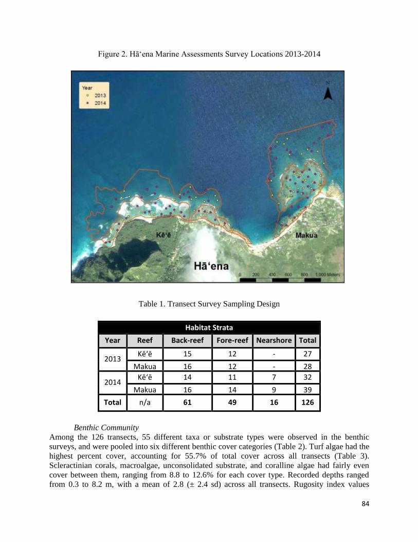
84
Figure 2. Hā‘ena Marine Assessments Survey Locations 2013-2014
Table 1. Transect Survey Sampling Design
Habitat Strata
Year Reef Back-reef Fore-reef Nearshore Total
2013 Kēʻē 15 12 - 27
Makua 16 12 - 28
2014 Kēʻē 14 11 7 32
Makua 16 14 9 39
Total n/a 61 49 16 126
Benthic Community
Among the 126 transects, 55 different taxa or substrate types were observed in the benthic
surveys, and were pooled into six different benthic cover categories (Table 2). Turf algae had the
highest percent cover, accounting for 55.7% of total cover across all transects (Table 3).
Scleractinian corals, macroalgae, unconsolidated substrate, and coralline algae had fairly even
cover between them, ranging from 8.8 to 12.6% for each cover type. Recorded depths ranged
from 0.3 to 8.2 m, with a mean of 2.8 (± 2.4 sd) across all transects. Rugosity index values
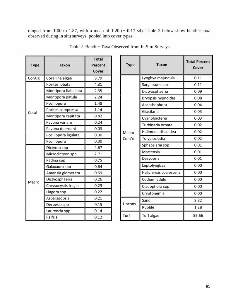
85
ranged from 1.00 to 1.87, with a mean of 1.20 (± 0.17 sd). Table 2 below show benthic taxa
observed during in situ surveys, pooled into cover types.
Table 2. Benthic Taxa Observed from In Situ Surveys
Type Taxon Total Percent
Cover
Macro
Cont’d
Lyngbya majuscula 0.11
Sargassum spp 0.11
Dictyosphaeria
cavernosa
0.09
Bryopsis hypnoides 0.08
Acanthophora
spicifera
0.04
Gracilaria
coronopifolia
0.03
Cyanobacteria 0.03
Turbinaria ornate 0.02
Halimeda discoidea 0.02
Tolypiocladia
glomerulata
0.02
Sphacelaria spp 0.01
Martensia
flabelliformis
0.01
Dasyopsis 0.01
Leptolyngbya
crosbyana
0.00
Halichrysis coalescens 0.00
Codium edule 0.00
Cladophora spp 0.00
Cryptonemia
umbraticola
0.00
Uncons Sand 8.82
Rubble 1.28
Turf Turf algae 55.66
Type Taxon
Total
Percent
Cover
CorAlg Coralline algae 8.79
Coral
Porites lobata 4.31
Montipora flabellata 2.35
Montipora patula 2.24
Pocillopora
meandrina
1.48
Porites compressa 1.14
Montipora capitata 0.82
Pavona varians 0.24
Pavona duerdeni 0.03
Pocillopora ligulata 0.00
Pocillopora
damicornis
0.00
Macro
Dictyota spp 4.67
Microdictyon spp 2.71
Padina spp 0.75
Galaxaura spp 0.64
Amansia glomerata 0.59
Dictyosphaeria
versluysii
0.26
Chrysocystis fraglis 0.23
Liagora spp 0.22
Asparagopsis
taxiformis
0.21
Derbesia spp 0.15
Laurencia spp 0.14
Ralfsia 0.12
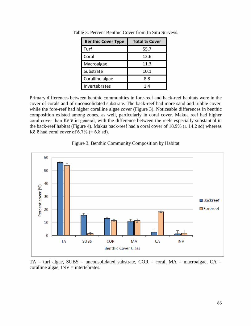
86
Table 3. Percent Benthic Cover from In Situ Surveys.
Primary differences between benthic communities in fore-reef and back-reef habitats were in the
cover of corals and of unconsolidated substrate. The back-reef had more sand and rubble cover,
while the fore-reef had higher coralline algae cover (Figure 3). Noticeable differences in benthic
composition existed among zones, as well, particularly in coral cover. Makua reef had higher
coral cover than Kē‘ē in general, with the difference between the reefs especially substantial in
the back-reef habitat (Figure 4). Makua back-reef had a coral cover of 18.9% (± 14.2 sd) whereas
Kē‘ē had coral cover of 6.7% (± 6.8 sd).
Figure 3. Benthic Community Composition by Habitat
TA = turf algae, SUBS = unconsolidated substrate, COR = coral, MA = macroalgae, CA =
coralline algae, INV = intertebrates.
Benthic Cover Type Total % Cover
Turf 55.7
Coral 12.6
Macroalgae 11.3
Substrate 10.1
Coralline algae 8.8
Invertebrates 1.4
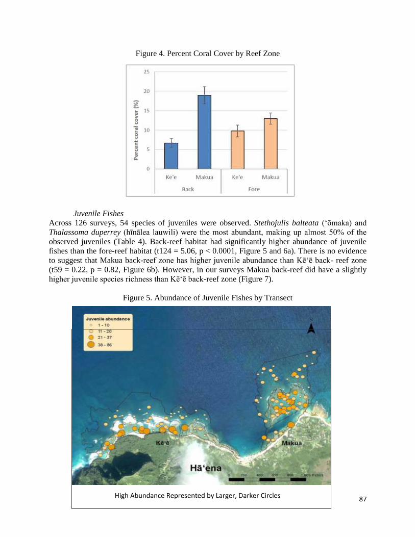
87
Figure 4. Percent Coral Cover by Reef Zone
Juvenile Fishes
Across 126 surveys, 54 species of juveniles were observed. Stethojulis balteata (ʻōmaka) and
Thalassoma duperrey (hīnālea lauwili) were the most abundant, making up almost 50% of the
observed juveniles (Table 4). Back-reef habitat had significantly higher abundance of juvenile
fishes than the fore-reef habitat (t124 = 5.06, p < 0.0001, Figure 5 and 6a). There is no evidence
to suggest that Makua back-reef zone has higher juvenile abundance than Kē‘ē back- reef zone
(t59 = 0.22, p = 0.82, Figure 6b). However, in our surveys Makua back-reef did have a slightly
higher juvenile species richness than Kē‘ē back-reef zone (Figure 7).
Figure 5. Abundance of Juvenile Fishes by Transect
High Abundance Represented by Larger, Darker Circles
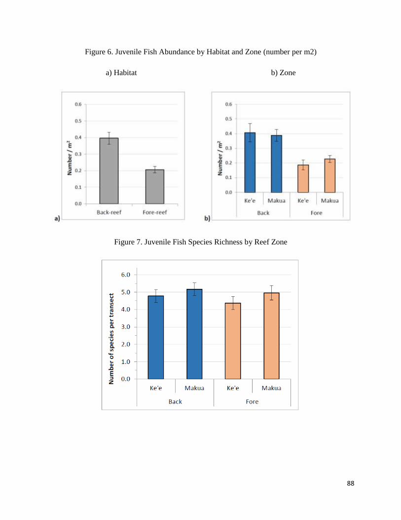
88
Figure 6. Juvenile Fish Abundance by Habitat and Zone (number per m2)
a) Habitat b) Zone
Figure 7. Juvenile Fish Species Richness by Reef Zone
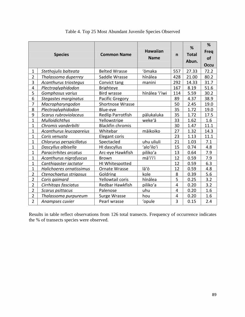
89
Table 4. Top 25 Most Abundant Juvenile Species Observed
Species Common Name Hawaiian
Name n
%
Total
Abun.
%
Freq
of
Occu
r 1 Stethojulis balteata Belted Wrasse ʻōmaka 557 27.33 72.2 2 Thalassoma duperrey Saddle Wrasse hīnālea
lauwili
428 21.00 80.2 3 Acanthurus triostegus Convict tang manini 292 14.33 31.7 4 Plectroglyphidodon
imparipennis
Brighteye
Damselfish
167 8.19 51.6 5 Gomphosus varius Bird wrasse hīnālea ʻiʻiwi 114 5.59 30.2 6 Stegastes marginatus Pacific Gregory 89 4.37 38.9 7 Macropharyngodon
geoffroy
Shortnose Wrasse 50 2.45 19.0 8 Plectroglyphidodon
johnstonianus
Blue-eye
Damselfish
35 1.72 19.0 9 Scarus rubroviolaceus Redlip Parrotfish pālukaluka 35 1.72 17.5 1
0
Mulloidichthys
flavolineatus
Yellowstripe
goatfish
wekeʻā 33 1.62 1.6 1
1
Chromis vanderbilti Blackfin chromis 30 1.47 11.1 1
2
Acanthurus leucopareius Whitebar
Surgeonfish
māikoiko 27 1.32 14.3 1
3
Coris venusta Elegant coris 23 1.13 11.1 1
4
Chlorurus perspicillatus Spectacled
parrotfish
uhu uliuli 21 1.03 7.1 1
5
Dascyllus albisella HI dascyllus ʻaloʻiloʻi 15 0.74 4.8 1
6
Paracirrhites arcatus Arc-eye Hawkfish pilikoʻa 13 0.64 7.9 1
7
Acanthurus nigrofuscus Brown
Surgeonfish
māʻiʻiʻi 12 0.59 7.9 1
8
Canthigaster jactator HI Whitespotted
toby
12 0.59 6.3 1
9
Halichoeres ornatissimus Ornate Wrasse lāʻō 12 0.59 4.8 2
0
Ctenochaetus strigosus Goldring
surgeonfish
kole 8 0.39 5.6 2
1
Coris gaimard Yellowtail coris hīnālea
ʻakilolo
5 0.25 3.2 2
2
Cirrhitops fasciatus Redbar Hawkfish pilikoʻa 4 0.20 3.2 2
3
Scarus psittacus Palenose
Parrotfish
uhu 4 0.20 1.6 2
4
Thalassoma purpureum Surge Wrasse hou 4 0.20 1.6 2
5
Anampses cuvier Pearl wrasse ʻopule 3 0.15 2.4
Results in table reflect observations from 126 total transects. Frequency of occurrence indicates
the % of transects species were observed.
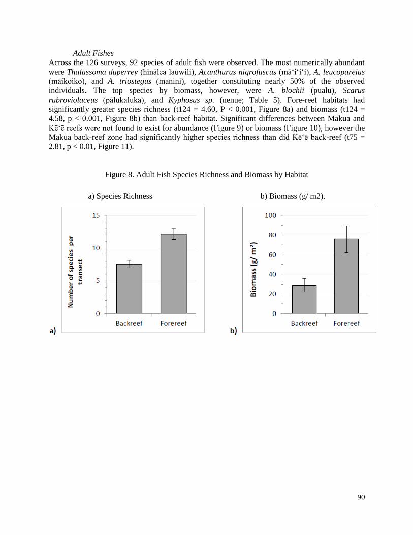
90
Adult Fishes
Across the 126 surveys, 92 species of adult fish were observed. The most numerically abundant
were Thalassoma duperrey (hīnālea lauwili), Acanthurus nigrofuscus (māʻiʻiʻi), A. leucopareius
(māikoiko), and A. triostegus (manini), together constituting nearly 50% of the observed
individuals. The top species by biomass, however, were A. blochii (pualu), Scarus
rubroviolaceus (pālukaluka), and Kyphosus sp. (nenue; Table 5). Fore-reef habitats had
significantly greater species richness (t124 = 4.60, P < 0.001, Figure 8a) and biomass (t124 =
4.58, p < 0.001, Figure 8b) than back-reef habitat. Significant differences between Makua and
Kē‘ē reefs were not found to exist for abundance (Figure 9) or biomass (Figure 10), however the
Makua back-reef zone had significantly higher species richness than did Kē‘ē back-reef (t75 =
2.81, p < 0.01, Figure 11).
Figure 8. Adult Fish Species Richness and Biomass by Habitat
a) Species Richness b) Biomass (g/ m2).
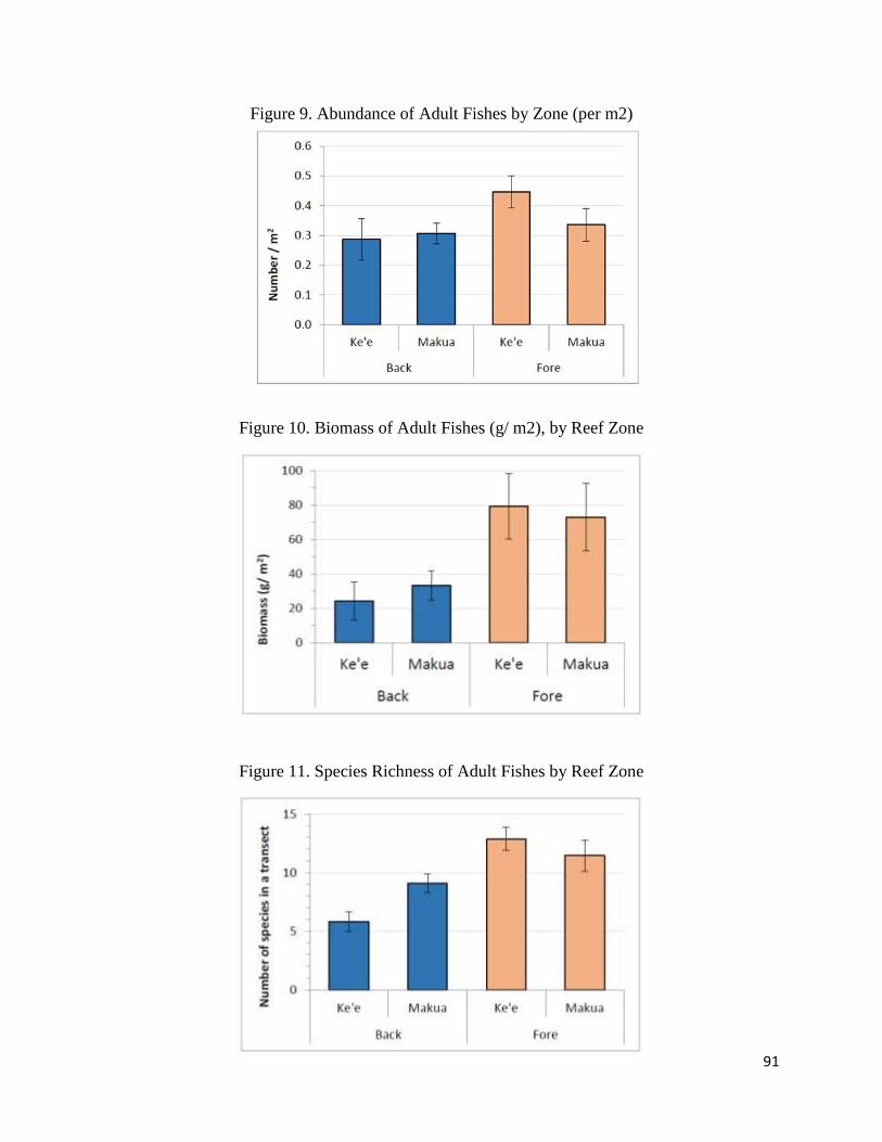
91
Figure 9. Abundance of Adult Fishes by Zone (per m2)
Figure 10. Biomass of Adult Fishes (g/ m2), by Reef Zone
Figure 11. Species Richness of Adult Fishes by Reef Zone
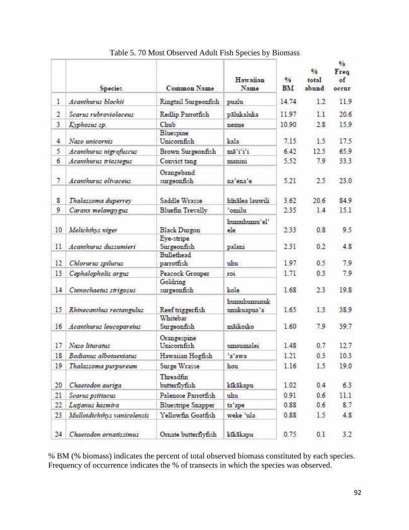
92
Table 5. 70 Most Observed Adult Fish Species by Biomass
% BM (% biomass) indicates the percent of total observed biomass constituted by each species.
Frequency of occurrence indicates the % of transects in which the species was observed.
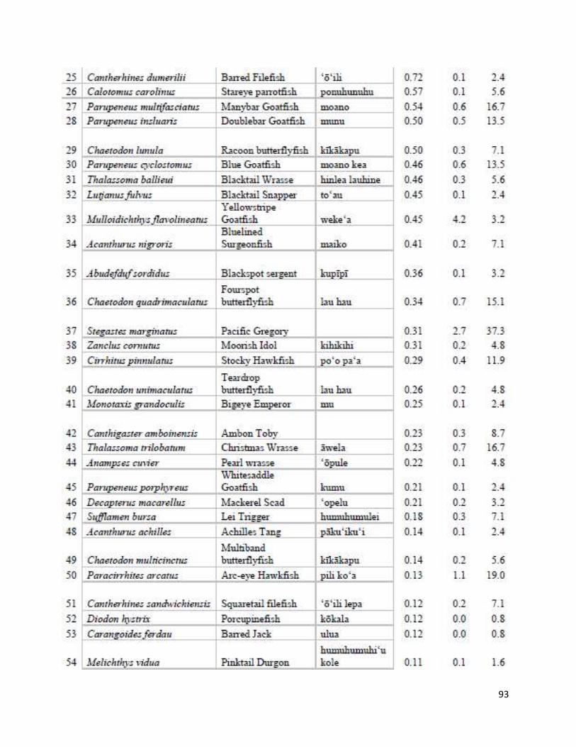
93
94
CONCLUSIONS
Back-reef habitats in the Hā‘ena nearshore reef systems are areas of high diversity and
abundance of juvenile fishes. Juveniles were more numerous in back-reef locations compared
with fore-reef habitats. In back-reef habitats, Makua Reef had significantly more species of adult
fishes than Kē‘ē reef. In the Makua and Kē‘ē reefs of Hā‘ena, back-reef habitat appears to be an
important area for reef fishes, particularly for juveniles. Juveniles grow in the protected habitat
of the back-reef, and then move to adult populations, a critical process for maintaining high
biomass in fore-reef habitats. As the back-reef habitats of Hāʻena reefs provide critical habitat
for juvenile reef fishes, measures should be taken to ensure that this habitat is maintained for
continued contribution to adult populations.
In surveys of adult fish, Makua back-reef had higher species richness than Kē`ē back-reef.
Makua reef exhibits a variety of habitats including sand which is important for schooling species
such as ‘ō‘iō and akule. Because of their mobility, populations of these fishes are difficult to
measure using transect-based methods and our surveys took place on hard-bottom only. Based on
our results and experience in the field, Makua back-reef appears to be an important area for adult
fish as well as juveniles. Due to its large channel and relatively deep water, predators have easy
access to Makua back-reef which may in part explain the lower abundance of juveniles compared
to Kē‘ē. Likely because it is well protected from waves and has high water flow, Makua back-
reef had the most healthy and diverse coral community in the area. Biodiversity is an indicator
of ecosystem health and a critical factor supporting coral reef resilience to human impacts and
climate change. These results provide evidence to suggest that Makua back-reef is a good
location to protect from fishing and other extractive, or destructive human uses.
95
APPENDIX L: Special Activity Permit Activities with Delegated Approval
Authority
At the Board of Land and Natural Resources (BLNR) meeting on October 24, 2008, the BLNR
approved special activity permit approval authority be delegated to the Chairperson of the
Department of Land and Natural Resources, after discussion and recommendation of approval by
DAR, for the following relatively minor, non destructive activities:
1. Collections of aquatic life (using either gear otherwise considered unlawful, or for
regulated species, the possession of which would otherwise be considered unlawful) for
public, private, charter schools (K-12) in Hawaii for classroom aquaria Regulated
species shall be capped at 10 specimens per permit.
2. Use of no more than 5 hand-held small-meshed nets or traps to take unregulated species.
3. Amendments to approved valid special activity permits where the amendment involves
the addition of assistants, or the take of regulated species of ten or less specimens in
total, not previously enwnerated as part of the original application.
4. Exemption from bottomfish vessel registration or commercial marine license
requirements when vessels are engaged in scientific research, either as part of a federal
grant or project, or as part of an official government agency study.
5. Exemption for vessels engaged in research for using plankton tows or stationary/floating
collectors, when the material used in the construct of a plankton net or floating collectors
would violate current minimum net mesh size laws, but its use is intended to collect
unregulated species.
6. Recognized Hawaii institutions where pennits are of a perennial nature (continuous, year
after year) for scientific research purposes, provided DAR agrees to the amounts of
specimens as reasonable, and is evaluated as non destructive, and provided that any
subsequent amendment with the exception of #3, above, shall not be approvable solely
by the chairperson.
7. Take of federally listed threatened or endangered species, provided that the applicant
demonstrate proof of possession of a valid federal permit for identical (proposed use)
purposes, and that it be limited to scientific purposes, or to enhance the propagation or
survival of the affected species.
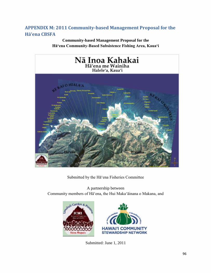
96
APPENDIX M: 2011 Community-based Management Proposal for the
Hā‘ena CBSFA Community-based Management Proposal for the
Hā‘ena Community-Based Subsistence Fishing Area, Kaua‘i
Submitted by the Hā‘ena Fisheries Committee
A partnership between
Community members of Hā‘ena, the Hui Maka‘āinana o Makana, and
Submitted: June 1, 2011
2
ACKNOWLEDGEMENTS Mahalo nui to the following, who supported the community’s work on this management plan: Atherton Family Foundation Hawai‘i Division of Aquatic Resources Hawai‘i Community Foundation Harold K. L. Castle Foundation Kulamanu Charitable Fund at the Hawai‘i Community Foundation National Fish & Wildlife Foundation U.S. Fish and Wildlife Service Mahalo to these participating agencies and organizations:
Hanalei to Hā‘ena Community Association Hawai‘i Community Stewardship Network Hui Maka‘āinana o Makana Limahuli Garden and Preserve of the National Tropical Botanical Gardens Stanford University's Emmett Interdisciplinary Program in Environment and Resources
3
ABBREVIATIONS CBSFA: Community-Based Subsistence Fishing Area DAR: Division of Aquatic Resources DLNR: Department of Land and Natural Resources DOBOR: Division of Boating and Ocean Recreation DOCARE: Division of Conservation and Resources Enforcement HRS: Hawai‘i Revised Statutes NOAA: National Oceanic and Atmospheric Administration
4
Table of Contents EXECUTIVE SUMMARY ..............................................................................................................................................7
Introduction ................................................................................................................................................................7
Basis for authority ...................................................................................................................................................8
Summary of process used since 2006 to develop the proposal.........................................................8
Summary of proposal .......................................................................................................................................... 10
SITE DESCRIPTION ................................................................................................................................................... 11
Location ..................................................................................................................................................................... 11
Land zoning and ocean area designations ................................................................................................ 11
Historical description .......................................................................................................................................... 12
Physical environment ......................................................................................................................................... 13
Use of the coastal area of Hā‘ena ................................................................................................................... 16
Critical resources and threats ......................................................................................................................... 25
MANAGEMENT APPROACH .................................................................................................................................. 30
Goal for the Hā‘ena Community-Based Subsistence Fishing Area ................................................. 30
Objectives for the Hā‘ena Community-Based Subsistence Fishing Area .................................... 30
Management strategies ...................................................................................................................................... 30
Monitoring plan...................................................................................................................................................... 31
Parameters ............................................................................................................................................................... 31
Putting it all together: Rationale behind the proposed DAR rules ................................................ 33
PROPOSED REGULATIONS AND ZONES ......................................................................................................... 35
Map of the Hā‘ena Community-Based Subsistence Fishing Area, Kaua‘i.................................... 43
Hā‘ena Community-Based Subsistence Fishing Area Eastern and Western Boundaries ... 43
Hā‘ena Community-Based Subsistence Fishing Area ‘Ōpihi Restoration Area ....................... 44
Hā‘ena Community-Based Subsistence Fishing Area Makua Pu‘uhonua Area ........................ 44
Transit Boundary for Vessels Carrying Restricted Fishing Gear .................................................... 45
Subzone Boundaries ............................................................................................................................................ 46
APPENDIX 1: Text of HRS Chapter 188 Section 22.6 “Designation of community based subsistence fishing area .......................................................................................................................................... 47
APPENDIX 2: ACT 241 Creating the Hā‘ena CBSFA ................................................................................... 48
APPENDIX 3: Letter from Kaua‘i Mayor Bernard P. Carvalho Jr. ........................................................ 53
5
APPENDIX 4: Letter from DOBOR’s Kaua‘i Branch Chief ........................................................................ 54
APPENDIX 5: Letter from DOCARE’s Kaua‘i Branch Chief ..................................................................... 55
APPENDIX 6: Letter from the Hanalei to Hā‘ena Community Association..................................... 56
APPENDIX 7: Community Support .................................................................................................................... 57
APPENDIX 8: Draft Budget .................................................................................................................................... 69

6
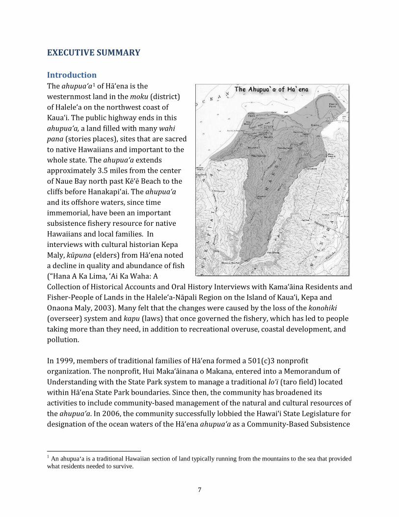
7
EXECUTIVE SUMMARY Introduction The ahupua‘a1
of Hā‘ena is the westernmost land in the moku (district) of Halele‘a on the northwest coast of Kaua‘i. The public highway ends in this ahupua‘a, a land filled with many wahi pana (stories places), sites that are sacred to native Hawaiians and important to the whole state. The ahupua‘a extends approximately 3.5 miles from the center of Naue Bay north past Kē‘ē Beach to the cliffs before Hanakapi‘ai. The ahupua‘a and its offshore waters, since time immemorial, have been an important subsistence fishery resource for native Hawaiians and local families. In interviews with cultural historian Kepa Maly, kūpuna (elders) from Hā‘ena noted a decline in quality and abundance of fish (“Hana A Ka Lima, ‘Ai Ka Waha: A Collection of Historical Accounts and Oral History Interviews with Kama‘āina Residents and Fisher-People of Lands in the Halele‘a-Nāpali Region on the Island of Kaua‘i, Kepa and Onaona Maly, 2003). Many felt that the changes were caused by the loss of the konohiki (overseer) system and kapu (laws) that once governed the fishery, which has led to people taking more than they need, in addition to recreational overuse, coastal development, and pollution.
In 1999, members of traditional families of Hā‘ena formed a 501(c)3 nonprofit organization. The nonprofit, Hui Maka‘āinana o Makana, entered into a Memorandum of Understanding with the State Park system to manage a traditional lo‘i (taro field) located within Hā‘ena State Park boundaries. Since then, the community has broadened its activities to include community-based management of the natural and cultural resources of the ahupua‘a. In 2006, the community successfully lobbied the Hawai‘i State Legislature for designation of the ocean waters of the Hā‘ena ahupua‘a as a Community-Based Subsistence
1 An ahupua‘a is a traditional Hawaiian section of land typically running from the mountains to the sea that provided what residents needed to survive.

8
Fishing Area. This document proposes a management plan and regulations for the Hā‘ena Community-Based Subsistence Fishing Area (CBSFA). Basis for authority Statutory authority to adopt fishing regulations rests with the Hawai‘i Department of Land and Natural Resources (DLNR) and the Governor. The Hawai‘i State Constitution provides for such authority in Article XI-1, titled “Conservation and Development of Resources.” Chapter 91 of the Hawai‘i Revised Statues, titled “Administrative Procedures,” provides the required process. Under Chapter 188 of the Hawai‘i Revised Statutes, titled “Fishing Rights and Regulations,” Section 22.6 provides DLNR the authority to designate Community-Based Subsistence Fishing Areas using the process described under Chapter 91. On June 26, 2006, Governor Linda Lingle signed into law SB2501 SD1 HD1 CD1: “A Bill for an Act Relating to Fishing” (Act 241), thus establishing, “a community-based subsistence fishing area for the ahupua‘a of Hā‘ena.” Act 241 empowers the Hā‘ena community, in consultation with DLNR and other interested parties, to recommend a management plan including fishery management rules to the DLNR. This proposed management plan and fishing regulations for the Hā‘ena Community-Based Subsistence Fishing Area are hereby submitted by the Hā‘ena Fisheries Committee—a group comprised of Hā‘ena community members, other interested parties, the nonprofit Hui Maka‘āinana o Makana, and Limahuli Garden and Preserve of the National Tropical Botanical Gardens—to the DLNR’s Division of Aquatic Resources (DAR) for its consideration. The proposal was developed in collaboration with DAR, and the submission of this proposal is supported by Kaua‘i County, the Kaua‘i Branch of the Division of Boating and Ocean Recreation, the Kaua‘i Branch of the Division of Conservation and Resources Enforcement, the Hanalei to Hā‘ena Community Association, the Hawai‘i Community Stewardship Network, and many individuals (see appendices 3-7), Summary of process used since 2006 to develop the proposal
1. Background social and biological research a. 2006-2007: Interviews with kama‘āina (long-time local) fishing families on
perceived changes to near-shore marine resources, impacts, and strategies to ensure healthy resources over the long term.
b. 2009 to present: The collection of data on the human use of the coastal areas of the Hā‘ena ahupua‘a to better assess what activities are taking place, when, where, and to what degree.
c. 2009: A rapid baseline benthic habitat assessment to assess baseline coral reef conditions in the nearshore areas of the CBSFA.

9
d. 2009 to present: A catch-per-unit-effort survey of the CBSFA to provide baseline information about the biological and sociological importance and health of the Hā‘ena fishery.
2. Community meetings to gather ideas and input a. 2006 to present: Meetings with the Hui Maka‘āinana o Makana, which led to
the establishment of a Fisheries Committee composed of community members (both members and nonmembers of the Hui), which met regularly to develop the draft management plan. These meetings were advertised through word of mouth and email, and average attendance was 12 people, mainly from local households. The Fisheries Committee met regularly throughout the entire process to keep it moving forward, to make decisions, and to relay information to and from the community.
b. 2008: Meeting with representatives of the commercial kayak operators who have commercial use permits for Hā‘ena.
c. 2008: Informal meetings and conversations with recreational users (surfers, kiteboarders, windsurfers).
d. January 31, 2009: Meeting of the kama‘āina families of Hā‘ena, with approximately 80 in attendance.
e. March 31, 2009: Meeting of the Hanalei-to-Hā‘ena Community Association with a focus on the fisheries rules. This meeting was advertised through the radio, flyers, ads in the paper, and word of mouth. Roughly 20 people attended.
f. April 24, 2009: Community meeting held at the Hanalei elementary school. The meeting was advertised through the paper, flyers, and word of mouth. Roughly 40 people attended, including local families and fishermen, recreational interests, and commercial interests.
g. April 16, 19-20, 2011: Meetings with the Hui Maka’āinana o Makana, State and County representatives, permitted commercial operators, and recreational users to inform them of the proposed rules and next steps.
h. April 29, 2011: Meeting with the kama‘āina families, via the Hui Maka‘āinana o Makana, to inform them of the proposed rules and next steps.
i. May 17, 2011: Community meeting via the Hanalei-to-Hā‘ena Community Association to inform attendees of the proposed rules and next steps. Sixty-five people attended.
3. Meetings with State, Federal, and County agencies a. 2006 to present: Regular meetings and negotiations with the Division of
Aquatic Resources. b. 2008 to present: Federal (National Oceanic and Atmospheric Administration) c. 2008 to present: State (Division of Boating and Ocean Recreation, Division of
Conservation and Resources Enforcement, and State Parks)
10
d. 2011: County 4. Late 2009-early 2011: Multiple attorney reviews of draft rules to develop the
required legal format and language. Two attorneys, an HCSN Legal Fellow, and a DAR Legal Fellow all assisted with developing the appropriate legal language.
Summary of proposal Act 241 designated the Hā‘ena Community-Based Subsistence Fishing Area as the ahupua‘a of Hā‘ena from the shoreline to one mile out. The ahupua‘a coastline is approximately 3.5 miles. The goal of the Hā‘ena Community-Based Subsistence Fishing Area is to sustainably support the consumptive needs of Hā‘ena’s people through culturally rooted, community-based management that recognizes and responds to the connection between land and sea and strives to restore the necessary balance of native species. Proposed rules for this area include additional gear restrictions, area restrictions, species restrictions, and bag limits to supplement existing DAR rules. Based on local and traditional ecological knowledge and practice, community perception, and scientific input, implementation of the management plan and new regulations should increase fishery abundance and biomass in addition to promoting Native Hawaiian traditional practices.
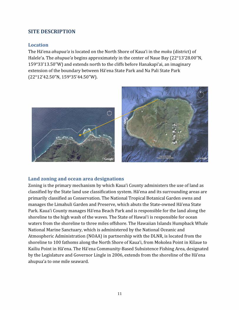
11
SITE DESCRIPTION Location The Hā‘ena ahupua‘a is located on the North Shore of Kaua‘i in the moku (district) of Halele‘a. The ahupua‘a begins approximately in the center of Naue Bay (22°13’28.00”N, 159°33’13.50”W) and extends north to the cliffs before Hanakapi‘ai, an imaginary extension of the boundary between Hā‘ena State Park and Na Pali State Park (22°12’42.50”N, 159°35’44.50”W).
Land zoning and ocean area designations Zoning is the primary mechanism by which Kaua‘i County administers the use of land as classified by the State land use classification system. Hā‘ena and its surrounding areas are primarily classified as Conservation. The National Tropical Botanical Garden owns and manages the Limahuli Garden and Preserve, which abuts the State-owned Hā‘ena State Park. Kaua‘i County manages Hā‘ena Beach Park and is responsible for the land along the shoreline to the high wash of the waves. The State of Hawai‘i is responsible for ocean waters from the shoreline to three miles offshore. The Hawaiian Islands Humpback Whale National Marine Sanctuary, which is administered by the National Oceanic and Atmospheric Administration (NOAA) in partnership with the DLNR, is located from the shoreline to 100 fathoms along the North Shore of Kaua‘i, from Mokolea Point in Kilaue to Kailiu Point in Hā‘ena. The Hā‘ena Community-Based Subsistence Fishing Area, designated by the Legislature and Governor Lingle in 2006, extends from the shoreline of the Hā‘ena ahupua‘a to one mile seaward.
12
Historical description The ahupua‘a of Hā‘ena has been settled since at least 500 AD. A healthy fishery, rich alluvial soil, abundant fresh water and proximity to forest resources made Hā‘ena an ideal habitation site. Habitation and agriculture historically was centered along the alluvial plain. The lower valleys, or kula, were also used for agricultural production, and evidence indicates that even the upper valleys were used by Hawaiians for agriculture (from http://www.pacificworlds.com/haena/land/areas.cfm). In addition to kalo (taro), Hawaiians grew sweet potatoes, bananas, sugar cane, ‘awa, and coconut. Hā‘ena is filled with important cultural sites, some of which are so famous that they are known throughout the archipelago. Among the most famous are:
o Kē‘ē: This was the home of Lohi‘au, an ali`i who became a lover of the goddess Pele. One of the greatest epics which is still told recalls the journey that Pele’s youngest sister, Hi‘iaka, took to bring Lohi‘au back to Pele on Hawai‘i island.
o Makana: Atop this majestic peak the sacred ‘oahi (firebrand) ceremony was once performed, and laua‘e of noted fragrance still grows.
o Ke-ahu-a-laka: A heiau (temple) dedicated to the art of hula is located directly above the heiau Ka-ulu-a-pā`oa, which was dedicated to the study of genealogy and history.
Western contact was slower to reach Hā‘ena due to its remote nature. The 1900 Census recorded seven households in Hā‘ena, all of which were comprised of Native Hawaiians. Ten years later, the census recorded fifteen residences—11 Native Hawaiian, two were Hawaiian with Asian boarders, and two were Asians who had introduced rice cultivation to the area. Demographic changes were brought about by the construction in the early 1900s of what is now Hawai‘i Route 560 (listed on the National Register of Historic Places) along what used to be a footpath used by Hawaiians, making it easier for immigrants to reach Hā‘ena. By the 1930s, many areas once used for kalo production had been turned to pasture land for cattle. Two tsunamis, one in 1946 and one in 1957, have been said to precipitate additional demographic and environmental shifts in Hā‘ena. These tsunamis flooded agricultural areas including lo‘i kalo (taro fields) and fishponds, and they destroyed homes. Families were displaced, as were native plant species. Then in 1958, neighboring Hanalei was featured in the film version of South Pacific; tourism and the construction of vacation homes by wealthy people from elsewhere since then has further altered the demographic landscape of Hā‘ena.
13
Today, Hā‘ena is still home to several families who can trace their lineal ties to the area and who still practice the traditions of farming, hunting, and fishing. New residents (many part-time) have come from around the world and altered the demographic and architectural landscape of Hā‘ena. As the area has received more and more attention for being beautiful, pristine, historic, and adventurous, thousands of tourists make their way to Hā‘ena each month. According to a 2007 Hawai‘i Tourism Authority State Park Visitor Survey, an estimated 708,400 people visit Hā’ena State Park at the end of the road in Hā‘ena each year; 90% of those are from out of state. Physical environment Hā‘ena has been and continues to be shaped by environmental conditions in the mountains and in the ocean. Two valleys, each with a stream, comprise the ahupua‘a of Hā‘ena—Mānoa and Limahuli. The area receives about 80 to 100 inches of rain annually, and the rain and streams have carved the land since its formation. From the ocean, the circular shape of Kaua‘i and lack of any nearby islands results in a situation of extremely high wave energy on all shorelines—especially on the North Shore during the winter months. Freshwater is an important component of the Hā‘ena environment, including the ocean environment. Limahuli Stream, which drains through Limahuli Valley into the ocean, “is one of the few virtually pristine streams remaining in Hawai‘i” and averages about five million gallons a day (Chipper Wichman, Director of the National Tropical Botanical Garden and descendant of Hā‘ena, from http://www.pacificworlds.com/haena/land/water.cfm). All five species of native Hawaiian freshwater fish, the ‘o‘opu, inhabit Limahuli stream. The dominant nearshore ecosystem is coral reef. Reefs along the Kaua‘i coast are dominated by the corals Porites lobata and Pocillopora meandrina, with other common species that include Montipora patula, Montipora flabellata, Leptastrea purpurea and Montipora verrucosa. Due to large winter swells, the North Shore supports hardy coral species; coral rubble is common. In September 2008, Hā‘ena community members, with technical assistance from the Hawai‘i Community Stewardship Network (HCSN) and NOAA, conducted a rapid assessment of the general benthic composition of the nearshore area of the Hā‘ena ahupua‘a. The entire 3.5-mile length of the ahupua‘a coastline was visually surveyed at a general depth of 10 to 20 feet. Results can be seen in the map on the following page.
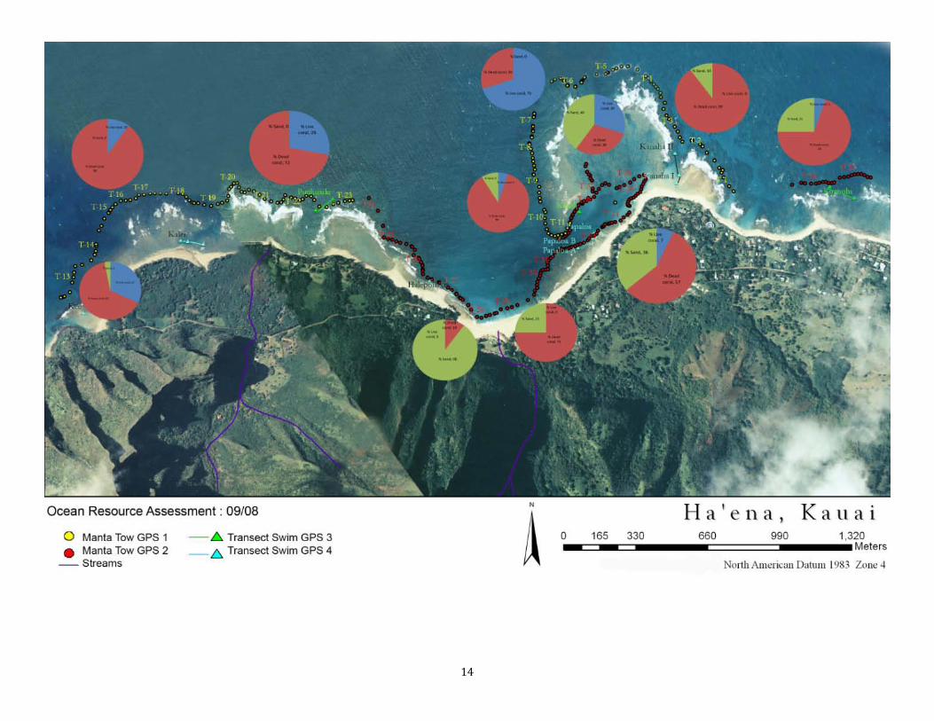
14
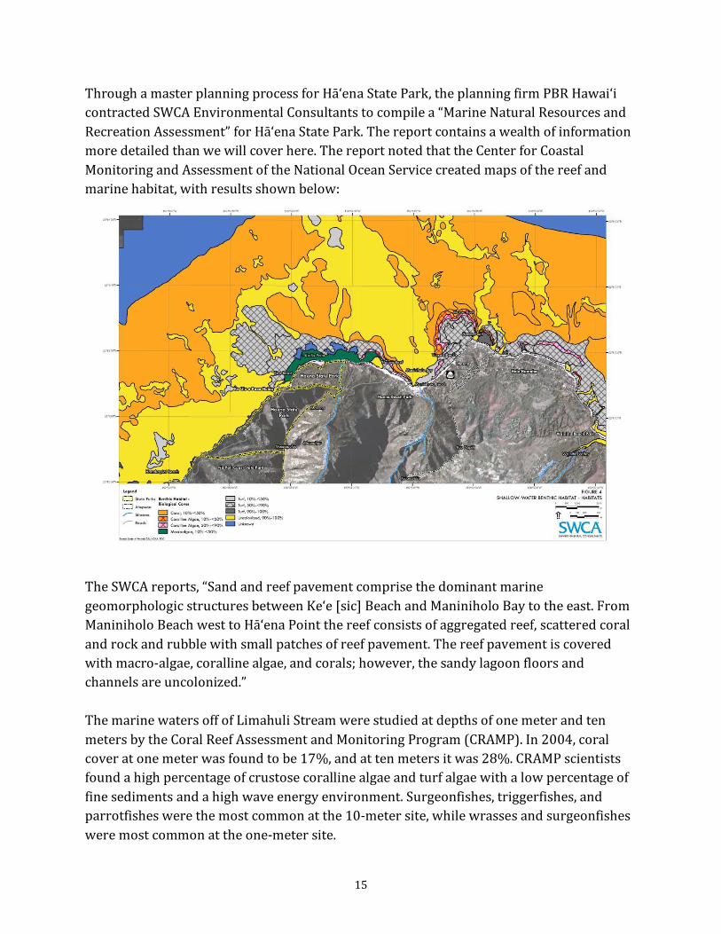
15
Through a master planning process for Hā‘ena State Park, the planning firm PBR Hawai‘i contracted SWCA Environmental Consultants to compile a “Marine Natural Resources and Recreation Assessment” for Hā‘ena State Park. The report contains a wealth of information more detailed than we will cover here. The report noted that the Center for Coastal Monitoring and Assessment of the National Ocean Service created maps of the reef and marine habitat, with results shown below:
The SWCA reports, “Sand and reef pavement comprise the dominant marine geomorphologic structures between Ke‘e [sic] Beach and Maniniholo Bay to the east. From Maniniholo Beach west to Hā‘ena Point the reef consists of aggregated reef, scattered coral and rock and rubble with small patches of reef pavement. The reef pavement is covered with macro-algae, coralline algae, and corals; however, the sandy lagoon floors and channels are uncolonized.” The marine waters off of Limahuli Stream were studied at depths of one meter and ten meters by the Coral Reef Assessment and Monitoring Program (CRAMP). In 2004, coral cover at one meter was found to be 17%, and at ten meters it was 28%. CRAMP scientists found a high percentage of crustose coralline algae and turf algae with a low percentage of fine sediments and a high wave energy environment. Surgeonfishes, triggerfishes, and parrotfishes were the most common at the 10-meter site, while wrasses and surgeonfishes were most common at the one-meter site.
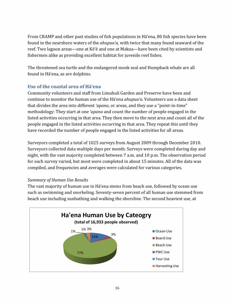
16
From CRAMP and other past studies of fish populations in Hā‘ena, 80 fish species have been found in the nearshore waters of the ahupua‘a, with twice that many found seaward of the reef. Two lagoon areas—one at Kē‘ē and one at Makua—have been cited by scientists and fishermen alike as providing excellent habitat for juvenile reef fishes. The threatened sea turtle and the endangered monk seal and Humpback whale are all found in Hā‘ena, as are dolphins. Use of the coastal area of Hā‘ena Community volunteers and staff from Limahuli Garden and Preserve have been and continue to monitor the human use of the Hā‘ena ahupua‘a. Volunteers use a data sheet that divides the area into different ‘apana, or areas, and they use a “point-in-time” methodology: They start at one ‘apana and count the number of people engaged in the listed activities occurring in that area. They then move to the next area and count all of the people engaged in the listed activities occurring in that area. They repeat this until they have recorded the number of people engaged in the listed activities for all areas. Surveyors completed a total of 1025 surveys from August 2009 through December 2010. Surveyors collected data multiple days per month. Surveys were completed during day and night, with the vast majority completed between 7 a.m. and 10 p.m. The observation period for each survey varied, but most were completed in about 15 minutes. All of the data was compiled, and frequencies and averages were calculated for various categories. Summary of Human Use Results The vast majority of human use in Hā‘ena stems from beach use, followed by ocean use such as swimming and snorkeling. Seventy-seven percent of all human use stemmed from beach use including sunbathing and walking the shoreline. The second heaviest use, at
15%3%
77%
1% 1% 3%
Ha'ena Human Use by Cateogry(total of 16,933 people observed)
Ocean Use
Board Use
Beach Use
PWC Use
Tour Use
Harvesting Use
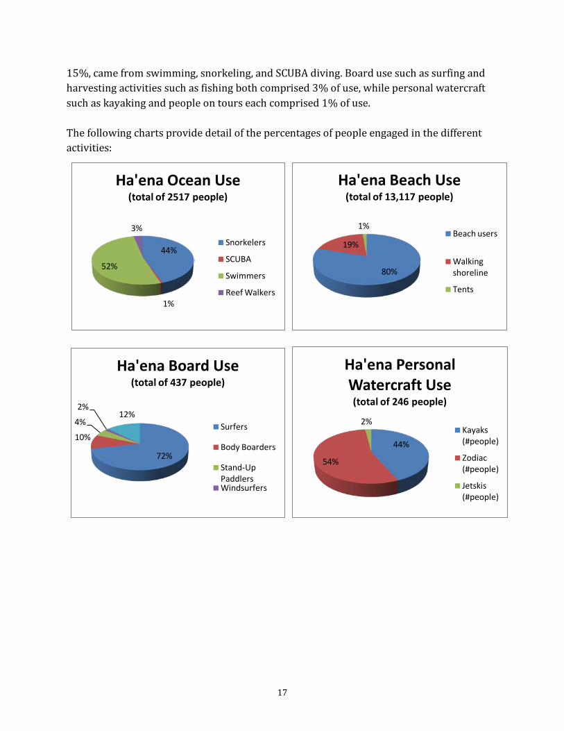
17
15%, came from swimming, snorkeling, and SCUBA diving. Board use such as surfing and harvesting activities such as fishing both comprised 3% of use, while personal watercraft such as kayaking and people on tours each comprised 1% of use. The following charts provide detail of the percentages of people engaged in the different activities:
44%
1%
52%
3%
Ha'ena Ocean Use(total of 2517 people)
Snorkelers
SCUBA
Swimmers
Reef Walkers
72%
10%
4%
2%12%
Ha'ena Board Use(total of 437 people)
Surfers
Body Boarders
Stand-Up PaddlersWindsurfers
80%
19%
1%
Ha'ena Beach Use(total of 13,117 people)
Beach users
Walking shoreline
Tents
44%
54%
2%
Ha'ena Personal Watercraft Use(total of 246 people)
Kayaks (#people)
Zodiac (#people)
Jetskis (#people)
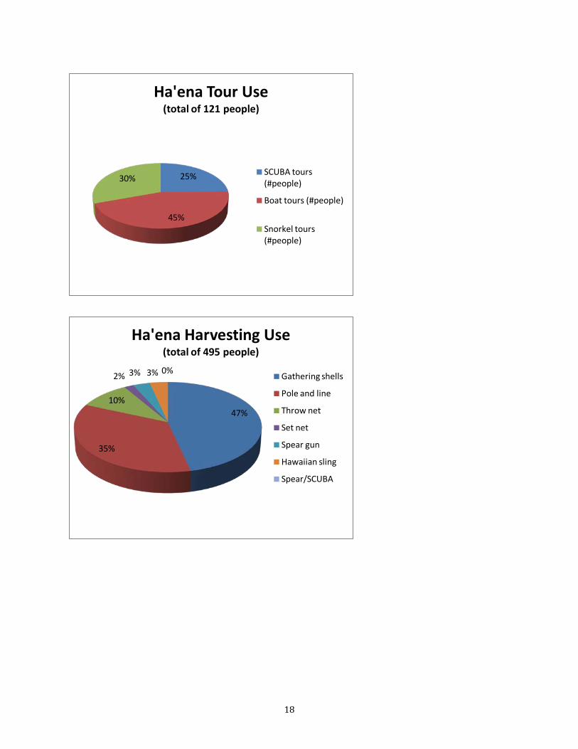
18
25%
45%
30%
Ha'ena Tour Use(total of 121 people)
SCUBA tours (#people)
Boat tours (#people)
Snorkel tours (#people)
47%
35%
10%
2% 3% 3% 0%
Ha'ena Harvesting Use (total of 495 people)
Gathering shells
Pole and line
Throw net
Set net
Spear gun
Hawaiian sling
Spear/SCUBA

19
Seasonal Changes in Human Use at Hā‘ena Human use varied from one season to the next. The following chart illustrates the rise in human use at Hā‘ena during the spring, the height of human use during summertime, and the decrease through winter. The chart records the average number of people observed engaging in each activity category during each survey period, by season (PWC=personal watercraft).
0.0
5.0
10.0
15.0
20.0
25.0
30.0
Spring Summer Fall Winter
Aver
age
num
ber o
f peo
ple
enga
ged
in e
ach
type
of a
ctiv
ity p
er re
port
Ha'ena Human Use by Season
Ocean Use
Boarding
Beach Use
PWC
Tours (#people)
Harvesting
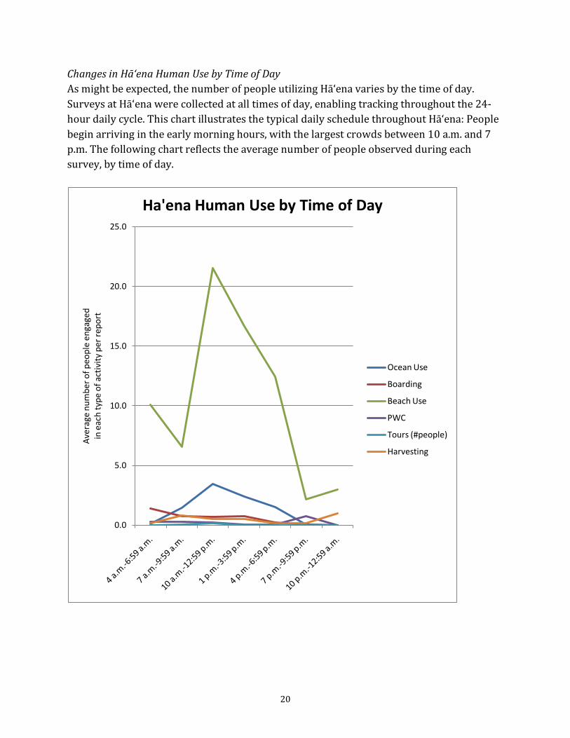
20
Changes in Hā‘ena Human Use by Time of Day As might be expected, the number of people utilizing Hā‘ena varies by the time of day. Surveys at Hā‘ena were collected at all times of day, enabling tracking throughout the 24-hour daily cycle. This chart illustrates the typical daily schedule throughout Hā‘ena: People begin arriving in the early morning hours, with the largest crowds between 10 a.m. and 7 p.m. The following chart reflects the average number of people observed during each survey, by time of day.
0.0
5.0
10.0
15.0
20.0
25.0
Aver
age
num
ber o
f peo
ple
enga
ged
in e
ach
type
of a
ctiv
ity p
er re
port
Ha'ena Human Use by Time of Day
Ocean Use
Boarding
Beach Use
PWC
Tours (#people)
Harvesting

21
Below is illustrated the human use of Hā‘ena throughout the six apana, or zones, throughout the day. For simplicity, “beach use” combines ocean use, boarding use, and beach use. To summarize, apana 1 and 4 are the most popular areas of Hā‘ena throughout the day.

22
Changes in Hā‘ena Human Use by Day of Week Finally, differences in human use between weekdays and weekends were analyzed. Very few differences were noted; perhaps surprisingly, weekdays showed slightly higher levels of human use than weekends, as illustrated below in the chart showing the average number of people engaged in each category of activity during each report period.
2.5
0.5
12.3
0.2 0.1 0.4
2.4
0.3
13.2
0.2 0.2 0.5
0.0
2.0
4.0
6.0
8.0
10.0
12.0
14.0
Ocean Use Boarding Beach Use PWC Tours (#people) Harvesting
Aver
age
num
ber o
f peo
ple
enga
ged
in e
ach
type
of a
ctiv
ity p
er re
port
Ha'ena Human Use:Weekday vs. Weekend
Weekend
Weekday
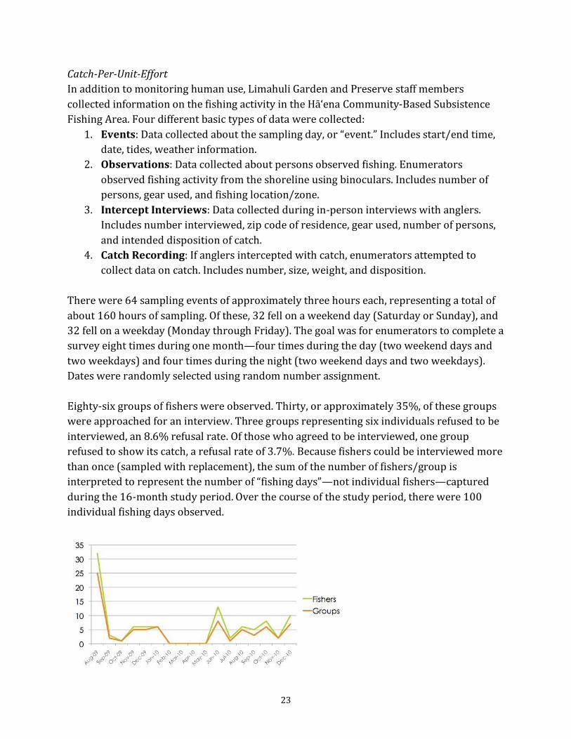
23
Catch-Per-Unit-Effort In addition to monitoring human use, Limahuli Garden and Preserve staff members collected information on the fishing activity in the Hā‘ena Community-Based Subsistence Fishing Area. Four different basic types of data were collected:
1. Events: Data collected about the sampling day, or “event.” Includes start/end time, date, tides, weather information.
2. Observations: Data collected about persons observed fishing. Enumerators observed fishing activity from the shoreline using binoculars. Includes number of persons, gear used, and fishing location/zone.
3. Intercept Interviews: Data collected during in‐person interviews with anglers. Includes number interviewed, zip code of residence, gear used, number of persons, and intended disposition of catch.
4. Catch Recording: If anglers intercepted with catch, enumerators attempted to collect data on catch. Includes number, size, weight, and disposition.
There were 64 sampling events of approximately three hours each, representing a total of about 160 hours of sampling. Of these, 32 fell on a weekend day (Saturday or Sunday), and 32 fell on a weekday (Monday through Friday). The goal was for enumerators to complete a survey eight times during one month—four times during the day (two weekend days and two weekdays) and four times during the night (two weekend days and two weekdays). Dates were randomly selected using random number assignment. Eighty-six groups of fishers were observed. Thirty, or approximately 35%, of these groups were approached for an interview. Three groups representing six individuals refused to be interviewed, an 8.6% refusal rate. Of those who agreed to be interviewed, one group refused to show its catch, a refusal rate of 3.7%. Because fishers could be interviewed more than once (sampled with replacement), the sum of the number of fishers/group is interpreted to represent the number of “fishing days”—not individual fishers—captured during the 16‐month study period. Over the course of the study period, there were 100 individual fishing days observed.
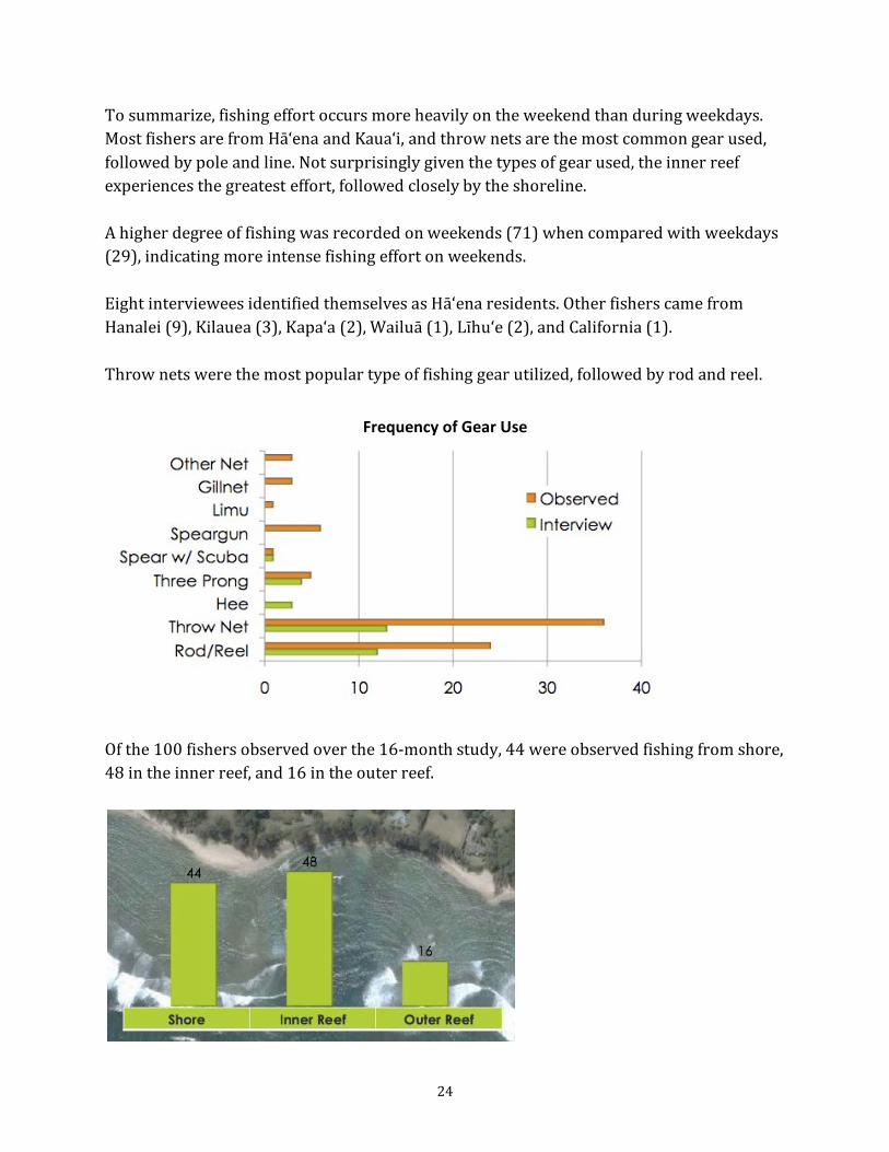
24
To summarize, fishing effort occurs more heavily on the weekend than during weekdays. Most fishers are from Hā‘ena and Kaua‘i, and throw nets are the most common gear used, followed by pole and line. Not surprisingly given the types of gear used, the inner reef experiences the greatest effort, followed closely by the shoreline. A higher degree of fishing was recorded on weekends (71) when compared with weekdays (29), indicating more intense fishing effort on weekends. Eight interviewees identified themselves as Hā‘ena residents. Other fishers came from Hanalei (9), Kilauea (3), Kapa‘a (2), Wailuā (1), Līhu‘e (2), and California (1). Throw nets were the most popular type of fishing gear utilized, followed by rod and reel.
Of the 100 fishers observed over the 16-month study, 44 were observed fishing from shore, 48 in the inner reef, and 16 in the outer reef.
Frequency of Gear Use

25
Reported species and fish types were consolidated into species groups developed by the Pacific Islands Fisheries Science Center (PIFSC). These categories were created to consolidate the 150 marine species reported on by the Hawaiʻi Division of Aquatic Resoures (DAR) in order to simplify the reporting of landings. In all, catch was recorded for 18 different types of fish/marine inverts: ‘Oama, Nenue, He‘e, Manini, Pāpio, Limu, Mullet, Toau, Hinalea, Kole, Āholehole, Lobsters, Perch, Weke, ‘Ama‘ama, ‘Āweoweo, Mamo, and Taape. 176 identified individuals were recorded as caught over study period. The vast majority of fishers interviewed intended to eat their catch (26), followed by giving part or all of the catch to others (11). Of those planning to give or share, nine intended to give to family members on Kaua‘i (two declined to disclose). No one interviewed said they planned to sell their catch, one person intended to use the catch as bait, and four interviewees said they planned to throw back whatever they caught. The catch-per-unit-effort, where catch equals the number of fish caught and effort is measured in hours, was 1.54 individuals per hour for those interviewed. In addition, several expert fishermen of Hā‘ena tracked their catch and effort over the course of the study, and their catch-per-unit-effort was significantly higher at 9.11 individuals per hour. The study indicated that expert fishers were significantly more efficient than the average fisher and that Hā‘ena is utilized primarily as a subsistence fishery, with the majority of fishers coming from Hā‘ena and nearby Kaua‘i communities. Most of the fish is consumed on-island by the fishers themselves and their family members and friends. Critical resources and threats Interviews with fishermen, conducted by cultural historian Kepa Maly in 2003 and by Hā‘ena community members Lahela Chandler Correa and Megan Juran in 2007 and 2008, indicated that the following nearshore fish species are important food fishes for the Hā‘ena community: akule (bigeye scad), moi (Pacific threadfin), ‘ama ‘ama (mullet), ‘oio (bonefish), nenue (rudderfish), aholehole (flagtail), aweoweo (Hawaiian bigeye), manini (convict tang), kala (bluespine unicornfish), oama (juvenile goatfish), kumu (whitesaddle goatfish), papio and ulua, he‘e (octopus), ula (lobsters), ‘a‘ama (crab), and several kinds of limu (seaweed). The Hā‘ena Fisheries Committee, composed mainly of representatives of Hā‘ena’s traditional families—most of whom fish—identified resources critical to cultural and subsistence use. They also rated the condition of those resources. The resources cited and their perceived condition are as follows:
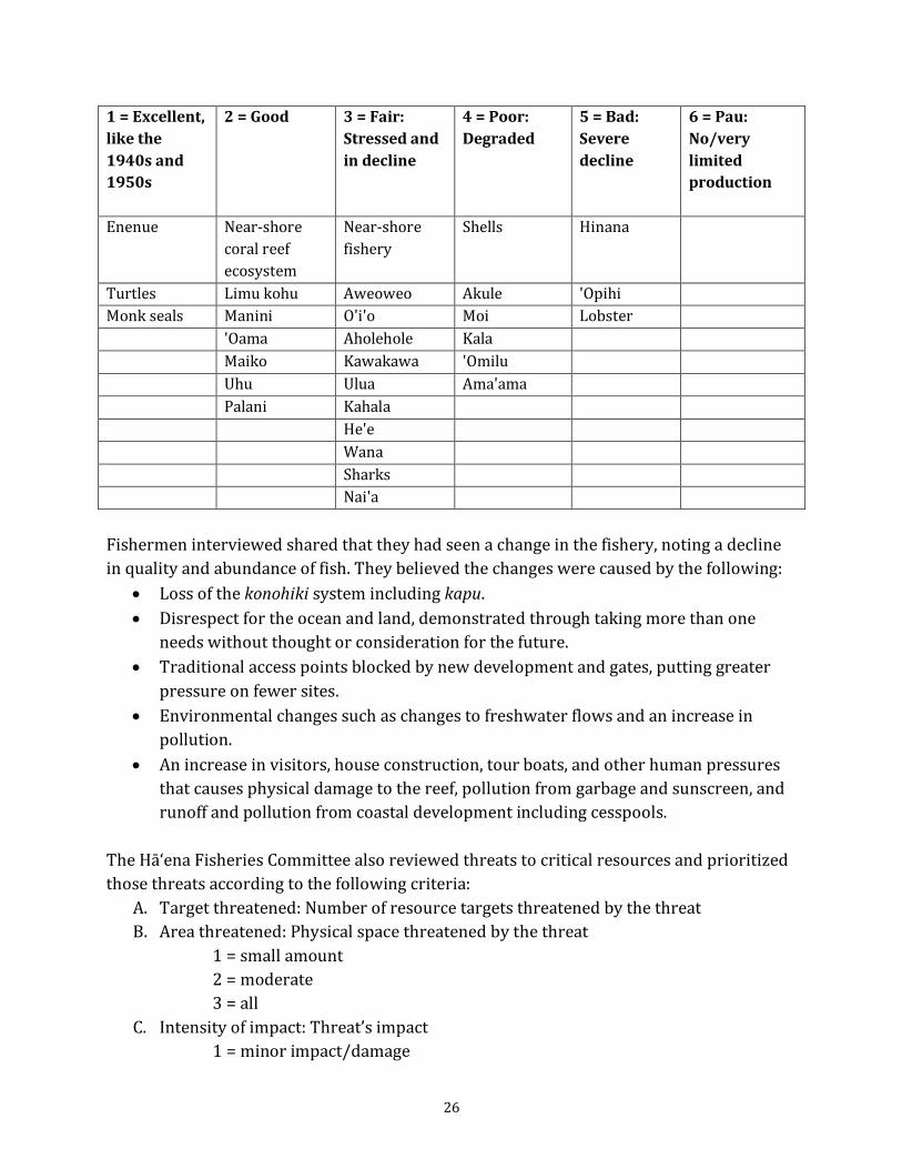
26
1 = Excellent, like the 1940s and 1950s
2 = Good
3 = Fair: Stressed and in decline
4 = Poor: Degraded
5 = Bad: Severe decline
6 = Pau: No/very limited production
Enenue Near-shore coral reef ecosystem
Near-shore fishery
Shells Hinana
Turtles Limu kohu Aweoweo Akule 'Opihi Monk seals Manini O'i'o Moi Lobster 'Oama Aholehole Kala Maiko Kawakawa 'Omilu Uhu Ulua Ama'ama Palani Kahala He'e Wana Sharks Nai'a Fishermen interviewed shared that they had seen a change in the fishery, noting a decline in quality and abundance of fish. They believed the changes were caused by the following:
• Loss of the konohiki system including kapu. • Disrespect for the ocean and land, demonstrated through taking more than one
needs without thought or consideration for the future. • Traditional access points blocked by new development and gates, putting greater
pressure on fewer sites. • Environmental changes such as changes to freshwater flows and an increase in
pollution. • An increase in visitors, house construction, tour boats, and other human pressures
that causes physical damage to the reef, pollution from garbage and sunscreen, and runoff and pollution from coastal development including cesspools.
The Hā‘ena Fisheries Committee also reviewed threats to critical resources and prioritized those threats according to the following criteria:
A. Target threatened: Number of resource targets threatened by the threat B. Area threatened: Physical space threatened by the threat
1 = small amount 2 = moderate 3 = all
C. Intensity of impact: Threat’s impact 1 = minor impact/damage
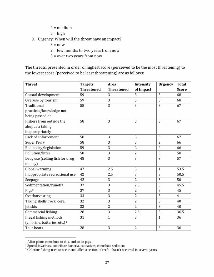
27
2 = medium 3 = high
D. Urgency: When will the threat have an impact? 3 = now 2 = few months to two years from now 3 = over two years from now
The threats, presented in order of highest score (perceived to be the most threatening) to the lowest score (perceived to be least threatening) are as follows: Threat Targets
Threatened Area Threatened
Intensity of Impact
Urgency Total Score
Coastal development 59 3 3 3 68 Overuse by tourism 59 3 3 3 68 Traditional practices/knowledge not being passed on
58 3 3 3 67
Fishers from outside the ahupua'a taking inappropriately
58 3 3 3 67
Lack of enforcement 58 3 3 3 67 Super Ferry 58 3 3 2 66 Bad policy/legislation 59 3 2 2 66 Pollution/litter 50 3 2 3 58 Drug use (selling fish for drug money)
48 3 3 3 57
Global warming 47 2.5 3 1 53.5 Inappropriate recreational use 42 2.5 3 3 50.5 Seepage 42 3 2 3 50 Sedimentation/runoff2 37 3 2.5 3 45.5 Pigs3 37 3 2 3 45 Overharvesting 33 3 2 3 41 Taking shells, rock, coral 32 3 2 3 40 Jet skis 33 2 2 3 40 Commercial fishing 28 3 2.5 3 36.5 Illegal fishing methods (chlorine, batteries, etc.)4
31
1 3 1 36
Tour boats 28 3 2 3 36
2 Alien plants contribute to this, and so do pigs. 3 Spread invasives, contribute bacteria, eat natives, contribute sediment 4 Chlorine fishing used to occur and killed a section of reef; it hasn’t occurred in several years.
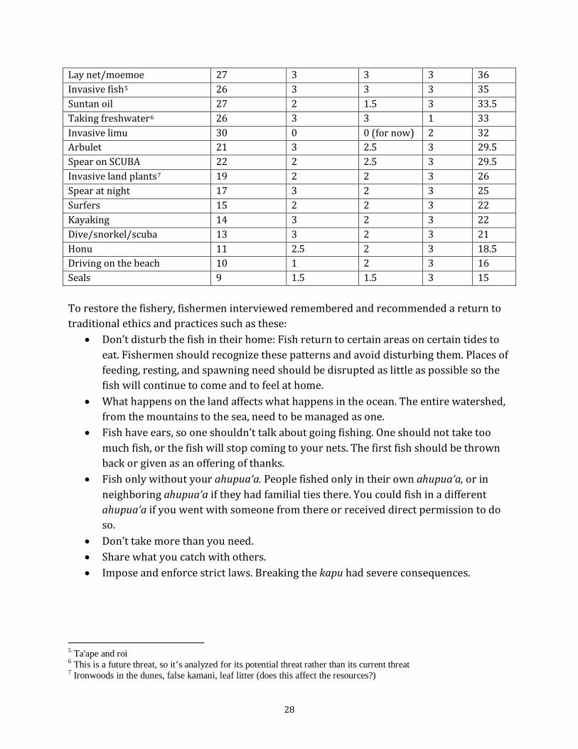
28
Lay net/moemoe 27 3 3 3 36 Invasive fish5 26 3 3 3 35 Suntan oil 27 2 1.5 3 33.5 Taking freshwater6 26 3 3 1 33 Invasive limu 30 0 0 (for now) 2 32 Arbulet 21 3 2.5 3 29.5 Spear on SCUBA 22 2 2.5 3 29.5 Invasive land plants7 19 2 2 3 26 Spear at night 17 3 2 3 25 Surfers 15 2 2 3 22 Kayaking 14 3 2 3 22 Dive/snorkel/scuba 13 3 2 3 21 Honu 11 2.5 2 3 18.5 Driving on the beach 10 1 2 3 16 Seals 9 1.5 1.5 3 15 To restore the fishery, fishermen interviewed remembered and recommended a return to traditional ethics and practices such as these:
• Don’t disturb the fish in their home: Fish return to certain areas on certain tides to eat. Fishermen should recognize these patterns and avoid disturbing them. Places of feeding, resting, and spawning need should be disrupted as little as possible so the fish will continue to come and to feel at home.
• What happens on the land affects what happens in the ocean. The entire watershed, from the mountains to the sea, need to be managed as one.
• Fish have ears, so one shouldn’t talk about going fishing. One should not take too much fish, or the fish will stop coming to your nets. The first fish should be thrown back or given as an offering of thanks.
• Fish only without your ahupua‘a. People fished only in their own ahupua‘a, or in neighboring ahupua‘a if they had familial ties there. You could fish in a different ahupua‘a if you went with someone from there or received direct permission to do so.
• Don’t take more than you need. • Share what you catch with others. • Impose and enforce strict laws. Breaking the kapu had severe consequences.
5 Ta'ape and roi 6 This is a future threat, so it’s analyzed for its potential threat rather than its current threat 7 Ironwoods in the dunes, false kamani, leaf litter (does this affect the resources?)

29
They also believed that educating tourists and commercial operators about cultural perspectives and values would help. A majority interviewees wanted to see tourism, some recreational activities, and commercial fishing regulated.
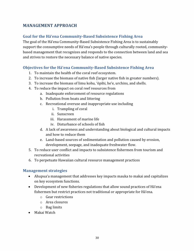
30
MANAGEMENT APPROACH Goal for the Hā‘ena Community-Based Subsistence Fishing Area The goal of the Hā‘ena Community-Based Subsistence Fishing Area is to sustainably support the consumptive needs of Hā‘ena’s people through culturally rooted, community-based management that recognizes and responds to the connection between land and sea and strives to restore the necessary balance of native species. Objectives for the Hā‘ena Community-Based Subsistence Fishing Area
1. To maintain the health of the coral reef ecosystem. 2. To increase the biomass of native fish (larger native fish in greater numbers). 3. To increase the biomass of limu kohu, ‘ōpihi, he‘e, urchins, and shells. 4. To reduce the impact on coral reef resources from
a. Inadequate enforcement of resource regulations b. Pollution from boats and littering c. Recreational overuse and inappropriate use including
i. Trampling of coral ii. Sunscreen
iii. Harassment of marine life iv. Disturbance of schools of fish
d. A lack of awareness and understanding about biological and cultural impacts and how to reduce them
e. Land-based sources of sedimentation and pollution caused by erosion, development, seepage, and inadequate freshwater flow.
5. To reduce user conflict and impacts to subsistence fishermen from tourism and recreational activities
6. To perpetuate Hawaiian cultural resource management practices Management strategies
• Ahupua‘a management that addresses key impacts mauka to makai and capitalizes on key ecosystem functions.
• Development of new fisheries regulations that allow sound practices of Hā‘ena fishermen but restrict practices not traditional or appropriate for Hā‘ena.
o Gear restrictions o Area closures o Bag limits
• Makai Watch
31
o Education and outreach: Outreach and awareness-raising through educational programs, signage, brochures, presentations, and volunteers providing information to visitors and local residents.
o Community assistance with enforcement: Community collaboration with DOCARE in observation and incident-reporting.
• Cultural and historical transmission: Educational programs for youth and community members and that involve kūpuna and knowledgeable makua.
• Community engagement in monitoring and evaluation of the Community-Based Subsistence Fishing Area.
Monitoring plan The proposed rules for the Hā‘ena Community-Based Subsistence Fishing Area includes the formation of a Fisheries Council similar to the West Hawai‘i Fisheries Council, which would be responsible for conducting a five-year review with community input. The following monitoring activities will contribute critical information to this review:
1. Baseline monitoring before the rules go into effect, using community volunteers and donated time from technical assistance providers.
a. Comparison of fish populations between the inside and outside of the Makua Pu‘uhonua Area
b. ‘Ōpihi monitoring in the ‘Ōpihi Restoration Area c. Limu monitoring
2. Annual fish monitoring (fish, he'e, urchins, shells, lobster), including monitoring of the inside and outside of the Makua Pu'uhonua Area, 'opihi monitoring, and limu monitoring) conducted by community volunteers with in-kind technical assistance
3. ‘Ōpihi Restoration Area monitoring just before the end of the three-year closure, then six months and one year after the end of the closure and the institution of the bag limit conducted by community volunteers with in-kind technical assistance
4. Four years from rules inception: a. Follow-up monitoring comparing the inside and outside of the Makua
Pu‘uhonua Area b. Follow-up catch-per-unit-effort monitoring c. Follow-up rapid benthic habitat assessment
Parameters Do the proposed rules…
Fall under the jurisdiction of the Division of Aquatic Resources? Seem to be able to pass the DLNR rule process as mandated by the Legislature in
Chapter 91? Adhere to U.S. and State constitutional law?

32
Strengthen, but not weaken, current State regulations? Seem simple to obey? Seem enforceable?
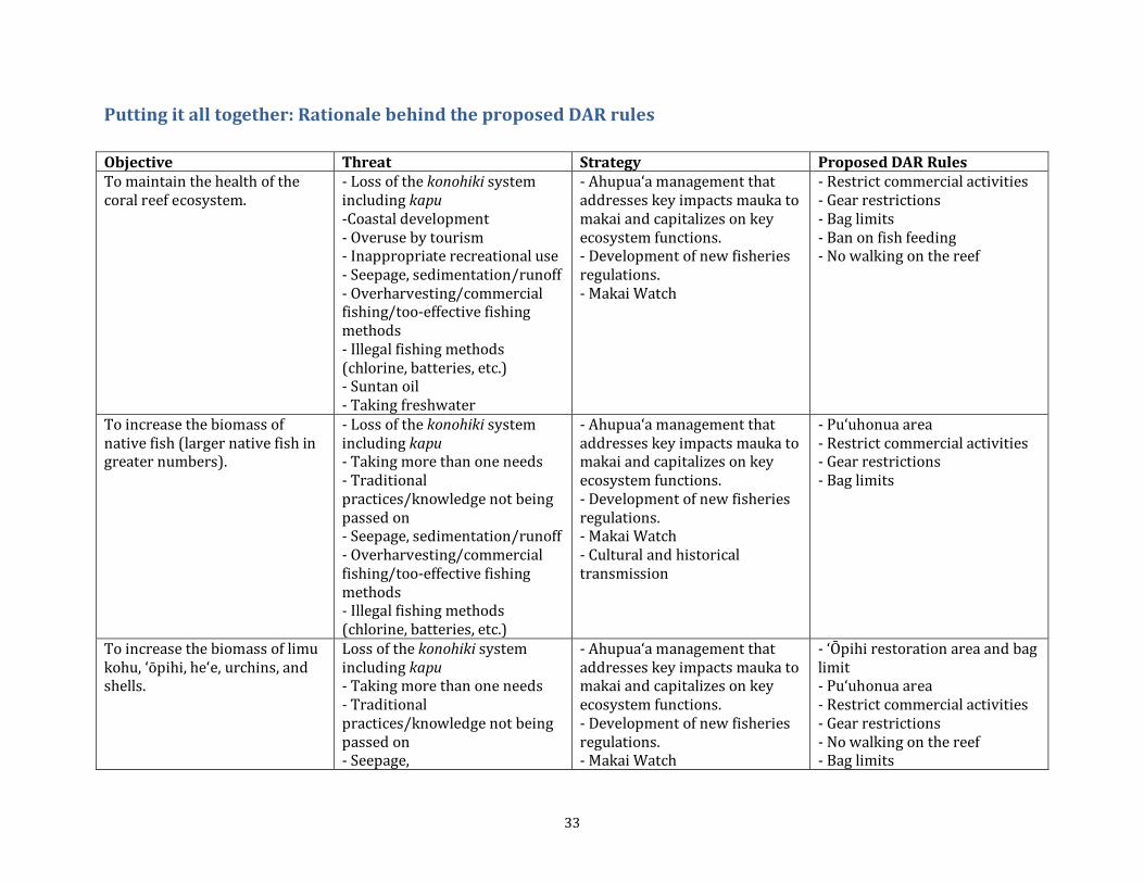
33
Putting it all together: Rationale behind the proposed DAR rules Objective Threat Strategy Proposed DAR Rules To maintain the health of the coral reef ecosystem.
- Loss of the konohiki system including kapu -Coastal development - Overuse by tourism - Inappropriate recreational use - Seepage, sedimentation/runoff - Overharvesting/commercial fishing/too-effective fishing methods - Illegal fishing methods (chlorine, batteries, etc.) - Suntan oil - Taking freshwater
- Ahupua‘a management that addresses key impacts mauka to makai and capitalizes on key ecosystem functions. - Development of new fisheries regulations. - Makai Watch
- Restrict commercial activities - Gear restrictions - Bag limits - Ban on fish feeding - No walking on the reef
To increase the biomass of native fish (larger native fish in greater numbers).
- Loss of the konohiki system including kapu - Taking more than one needs - Traditional practices/knowledge not being passed on - Seepage, sedimentation/runoff - Overharvesting/commercial fishing/too-effective fishing methods - Illegal fishing methods (chlorine, batteries, etc.)
- Ahupua‘a management that addresses key impacts mauka to makai and capitalizes on key ecosystem functions. - Development of new fisheries regulations. - Makai Watch - Cultural and historical transmission
- Pu‘uhonua area - Restrict commercial activities - Gear restrictions - Bag limits
To increase the biomass of limu kohu, ‘ōpihi, he‘e, urchins, and shells.
Loss of the konohiki system including kapu - Taking more than one needs - Traditional practices/knowledge not being passed on - Seepage,
- Ahupua‘a management that addresses key impacts mauka to makai and capitalizes on key ecosystem functions. - Development of new fisheries regulations. - Makai Watch
- ‘Ōpihi restoration area and bag limit - Pu‘uhonua area - Restrict commercial activities - Gear restrictions - No walking on the reef - Bag limits

34
sedimentation/runoff - Overharvesting/commercial fishing/too-effective fishing methods - Illegal fishing methods (chlorine, batteries, etc.) - Suntan oil - Taking freshwater
- Cultural and historical transmission
To reduce the impact on coral reef resources from: (a) inadequate enforcement of resources regulations; (b) pollution from boats and littering; (c) recreational overuse and inappropriate use including trampling of coral, sunscreen, harassment of marine life, and disturbance of schools of fish; (d) a lack of awareness and understanding about biological and cultural impacts and how to reduce them; and (e) land-based sources of sedimentation and pollution caused by erosion, development, seepage, and inadequate freshwater flow.
-Coastal development - Overuse by tourism - Traditional practices/knowledge not being passed on - Lack of enforcement - Pollution/litter - Inappropriate recreational use - Seepage, sedimentation/runoff
- Ahupua‘a management that addresses key impacts mauka to makai and capitalizes on key ecosystem functions. - Development of new fisheries regulations. - Makai Watch - Cultural and historical transmission - Community engagement in monitoring
- Pu‘uhonua area - No walking on the reef - Ban on fish feeding
To reduce user conflict and impacts to subsistence fishermen from tourism and recreational activities.
- Access points blocked - Overuse by tourism - Inappropriate recreational use
- Development of new fisheries regulations. - Makai Watch - Community engagement in monitoring
- Restrict commercial activities - No walking on the reef
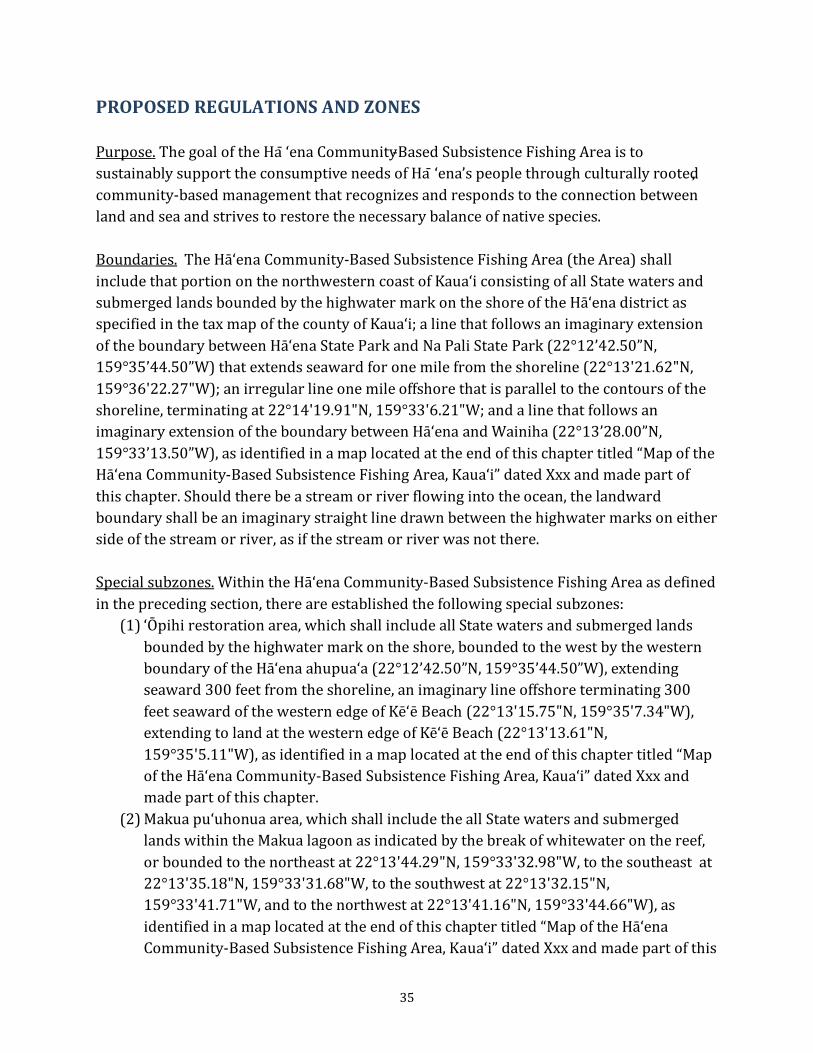
35
PROPOSED REGULATIONS AND ZONES Purpose. The goal of the Ha ‘ena Community-Based Subsistence Fishing Area is to sustainably support the consumptive needs of Ha ‘ena’s people through culturally rooted, community-based management that recognizes and responds to the connection between land and sea and strives to restore the necessary balance of native species. Boundaries. The Hā‘ena Community-Based Subsistence Fishing Area (the Area) shall include that portion on the northwestern coast of Kaua‘i consisting of all State waters and submerged lands bounded by the highwater mark on the shore of the Hā‘ena district as specified in the tax map of the county of Kaua‘i; a line that follows an imaginary extension of the boundary between Hā‘ena State Park and Na Pali State Park (22°12’42.50”N, 159°35’44.50”W) that extends seaward for one mile from the shoreline (22°13'21.62"N, 159°36'22.27"W); an irregular line one mile offshore that is parallel to the contours of the shoreline, terminating at 22°14'19.91"N, 159°33'6.21"W; and a line that follows an imaginary extension of the boundary between Hā‘ena and Wainiha (22°13’28.00”N, 159°33’13.50”W), as identified in a map located at the end of this chapter titled “Map of the Hā‘ena Community-Based Subsistence Fishing Area, Kaua‘i” dated Xxx and made part of this chapter. Should there be a stream or river flowing into the ocean, the landward boundary shall be an imaginary straight line drawn between the highwater marks on either side of the stream or river, as if the stream or river was not there. Special subzones. Within the Hā‘ena Community-Based Subsistence Fishing Area as defined in the preceding section, there are established the following special subzones:
(1) ‘Ōpihi restoration area, which shall include all State waters and submerged lands bounded by the highwater mark on the shore, bounded to the west by the western boundary of the Hā‘ena ahupua‘a (22°12’42.50”N, 159°35’44.50”W), extending seaward 300 feet from the shoreline, an imaginary line offshore terminating 300 feet seaward of the western edge of Kē‘ē Beach (22°13'15.75"N, 159°35'7.34"W), extending to land at the western edge of Kē‘ē Beach (22°13'13.61"N, 159°35'5.11"W), as identified in a map located at the end of this chapter titled “Map of the Hā‘ena Community-Based Subsistence Fishing Area, Kaua‘i” dated Xxx and made part of this chapter.
(2) Makua pu‘uhonua area, which shall include the all State waters and submerged lands within the Makua lagoon as indicated by the break of whitewater on the reef, or bounded to the northeast at 22°13'44.29"N, 159°33'32.98"W, to the southeast at 22°13'35.18"N, 159°33'31.68"W, to the southwest at 22°13'32.15"N, 159°33'41.71"W, and to the northwest at 22°13'41.16"N, 159°33'44.66"W), as identified in a map located at the end of this chapter titled “Map of the Hā‘ena Community-Based Subsistence Fishing Area, Kaua‘i” dated Xxx and made part of this
36
chapter. (3) Vessel transit boundary, for vessels transiting through the Area carrying fishing gear
restricted by the prohibited activities listed in section xx below, a line that follows an imaginary extension of the boundary between Hā‘ena State Park and Na Pali State Park (22°12’42.50”N, 159°35’44.50”W) that extends seaward for 1000 feet from the shoreline to 22°12'49.98"N, 159°35'51.79"W, then extends eastward to a point 1300 feet from the shoreline at 22°13'35.57"N, 159°34'59.73"W, then extends eastward to a point seaward of the Makua reef and lagoon and 2300 feet from the shoreline at 22°13'55.42"N, 159°33'42.00"W, then extends eastward to an imaginary extension of the boundary between Hā‘ena and Wainiha that is 2100 feet from the shoreline at 22°13'48.84"N, 159°33'10.76"W, as identified in a map located at the end of this chapter titled “Map of the Hā‘ena Community-Based Subsistence Fishing Area, Kaua‘i” dated Xxx and made part of this chapter.
General conditions. (a) Nothing in this chapter shall be construed as allowing within the Community-Based Subsistence Fishing Area any activity otherwise prohibited by law or rules adopted by another department of the state. (b) A table of designated subzones with their corresponding latitude and longitude coordinates is provided at the end of this chapter, entitled “Subzone Boundaries,” dated xxx. (c) Nothing in these rules shall be interpreted to limit or restrict Native Hawaiian customary and traditional rights, including, but not limited to, access for spiritual, religious, cultural, and subsistence purposes. Penalty. Any person found violating the provisions of this chapter, or the terms and conditions of any permit issued as provided by this chapter, shall be punished as provided by sections 187A-12.5 and 188-70, Hawaii Revised Statues, or may be otherwise provided by law. Asset forfeiture. Any equipment, article, instrument, aircraft, vehicle, vessel, business record, or natural resource used or taken in violation of this chapter, or the terms and conditions of any permit issued as provided by this chapter, may be seized and subject to forfeiture as provided by HRS section 199-7 and chapter 712A. Severability. If any provision of this chapter, or the application thereof, to any person or circumstance is held invalid, the invalidity does not affect other provisions or applications of the chapter which can be given effect without the invalid provision or application, and to this end the provisions of this chapter are severable. Definitions. As used in this chapter unless otherwise provided: “Commercial activity” means any activity including ocean recreation or that which involves
37
the taking of marine life for which compensation of any kind is received by any person; or any action, service, or goods that are provided, in exchange for compensation of any kind, regardless of whether the exchange occurs inside or outside of the Hā‘ena Community-Based Subsistence Fishing Area. Display of merchandise or demanding or requesting gifts, money, or services shall be considered commercial activity, including trade of such merchandise, gifts or services.8
"Daily bag limit" means the maximum number of an indicated animal allowed to be caught, taken, or kept per person per day. “Day” means a 24-hour period. “Department” means the Department of Land and Natural Resources. "Finfish" means any of various species of marine life that uses fins to swim, not including marine mammals or sea turtles. "Fish feeding" means deliberately introducing any food material, substance device, or chemical directly to or in the vicinity of any marine life, by any means for any purpose. "He'e" means any mollusk known as Octopus cyanea, Octopus ornatus, or any recognized synonym. “Hook-and-line” means a type of fishing gear consisting of a length of fishing line, to which is attached one or more hooks or other device for capturing marine life. A weight and a pole may also be used to aid in the placement of the fishing line in the water. “Kupe‘e” means an edible marine snail (Nerita polita) also known as ānuenue, ‘ele‘ele, kāni‘o, mahiole, palaoa, puna, ‘ula. "Lay net" means a panel or panels of net mesh made of various materials that is suspended vertically in the water with the aid of a float line that supports the top edge of the net upwards towards the water surface and opposite to a lead line that keeps the bottom edge of the net downward towards the ocean floor. “Limu” means any native marine algae including algae in the intertidal zone. “Live rock” means any rock or coral to which marine life is visibly attached or affixed.
8 From Section 13-230-8, HAR, Definitions
38
“Lobster” means any crustacean in the family Scyllaridae or the family Panulirus. This includes spiny lobster, slipper lobster, or other recognized synonyms. “Marine life” means any type or species of saltwater fish, shellfish, mollusks, crustaceans, coral, or other marine animals, including any part, product, egg, or offspring thereof; or seaweeds or other marine plants, including any part, product, seed, or root thereof. “ ‘Ōpihi” means any mollusk of the genus Cellana or a recognized synonym. The animal is also known as kō'ele, ‘ālinalina, maka-ia-uli, and limpets. “Pipipi” means a small mollusk including Theodoxus neglectus. “Pole-and-line” means a type of fishing gear consisting primarily of a pole and a length of fishing line. “Pūpū” means a general name for marine and land shells. “Purse seine net” means a type of fishing net made to hang vertically in the water with weights attached along the bottom of the net, floats attached along the top of the net, and a purse cable which acts as a drawstring to close the bottom of the net, used to encircle a school of fish. “Recreation” means a diversion such as a hobby or other leisure time activities9
.
“Reef” means any submerged fixed, natural object or structure that modifies ocean currents. “Scoop net” means a type of hand net consisting of a bag of mesh material attached to a frame to hold the bag open, and a handle. The net is small enough to use with one hand by one person. "Sea urchin" means invertebrate marine animals of the class Echinoidea, variously referred to as, but not limited to, wana, hālula, hā'uke'uke, hāwa'e or 'ina. “Sea shells” means the hard, protective outer layer grown by a mollusk. “Slurp gun” means a device with a plunger that sucks fish into a tube to capture them.
9 §13-250-5
39
“Snorkel” means a breathing apparatus consisting of a tube no more than two feet in length that is held in the mouth. “Spear” means any device or implement either hand held, released completely by the user (i.e., a projectile), or attached by a line to another device, which is used to impale marine life by means of a pointed or sharpened tip(s), including but not limited to trigger-style spear guns, arbalettes (arbalete), bow and arrow, Hawaiian slings, or three-prong spears. “Take” means to fish for, catch, injure, kill, remove, capture, confine, or harvest, or to attempt to fish for, catch, injure, kill, remove capture, confine, or harvest, marine life. The use of any gear, equipment, tool, or any means to fish for, catch, injure, kill, remove, capture, confine, or harvest, or to attempt to fish for, catch, capture, injure, kill, remove, confine, or harvest, marine life by any person who is in the water, or in a vessel on the water, or on or about the shore where marine life can be fished for, caught, injured, killed, removed, captured, confined, or harvested, shall be construed as taking. “Three-prong spear” means a device with a straight shaft ending in a prong which is used to impale marine life, which is manually cocked, which has no more than two rubbers attached, and which is no longer than eight feet in length from the tip of the prong to the end of the spear. “Underwater breathing apparatus” means any apparatus that provides a person with the means to breathe underwater. “Vessel” means any watercraft, used or capable of being used as a means of transportation on or in the water. Prohibited activities. It is unlawful for any person to engage in or attempt to engage in the following activities within the Area, except as may be allowed under sections xxx and xxx, or other applicable law:
(1) Conduct any commercial activity involving any form of ocean recreation or involving the take of marine life in the Hā‘ena Community-Based Subsistence Fishing Area, including but not limited to commercial tours, dive groups, sightseeing tours, hikes, guided services, or commercial fishing, with the exception of the three existing commercial use permits for Hā‘ena. (Auth: HRS §190-2, 190-3, 190-4.5) (Imp: HRS § 190-2, 190-3, 190-4.5)
(2) Fish for, catch, take, injure, kill, possess, or remove any live sea shell. (3) Use or possess a slurp gun to take any marine life, with the exception that a person
may possess a slurp gun on a vessel transiting through the Area as long as the vessel
40
is north of the vessel transit boundary described in section xx above. (4) Use or possess a spear to take any marine life with the exception that take with a
three-prong or Hawaiian sling spear is allowed, and with the exception that a person may possess a spear on a vessel transiting through the Area as long as the vessel is north of the vessel transit boundary described in section xx above.
(5) Use or possess a spear and underwater breathing apparatus while in the water or on a vessel, with the exception that a snorkel may be possessed or used, and with the exception that a person may possess a spear and underwater breathing apparatus on a vessel transiting through the Area as long as the vessel is north of the vessel transit boundary described in section xx above.
(6) Use or possess a spear while in the water or on a vessel during any time between sunset and sunrise, with the exception that a person may possess a spear between sunset and sunrise on a vessel transiting through the Area as long as the vessel is north of the vessel transit boundary described in section xx above.
(7) Use or possess underwater breathing apparatus to take sea shells, with the exception that take of empty shells while using a snorkel is allowed.
(8) Use or possess a scoop net, with the exception that a daily maximum of three individuals of any one species of marine life may be possessed or taken with a scoop net, and with the exception that people age 12 and under may use and possess a scoop net without this restriction.
(9) Use or possess a purse seine net, with the exception that a person may possess a purse seine net on a vessel transiting through the Area as long as the vessel is north of the vessel transit boundary described in section xx above.
(10) Use a lay net, except that lay nets may be used where at least two people are in the ocean and touching the net or are within five feet of the net as in the fishing practices commonly referred to as bang-bang or pa‘ipa‘i, or surround or ho‘opuni. Practices that use lay nets which do not require at least two people immersed in the ocean and touching the net or within five feet of the net at all times, such as in the practices known as lay/set/soak or moemoe, are not allowed.
a. All vessels used in surround net fishing must be 14 feet or smaller and launched from the beach in the Hā‘ena CBSFA.
b. It is unlawful for any person using a lay net to leave a lay net unattended at any time.
(11) Engage in or attempt to engage in fish feeding, with the exception that feeding fish for Native Hawaiian traditional and customary practices is allowed.
(12) Set foot on the reef or live rock, with the exception that a person engaged in harvesting, as evidenced by possession of a throw net, three-prong spear, or bag constructed of cotton or mesh; with the exception that a person may set foot on the reef or live rock only in the case of an emergency.
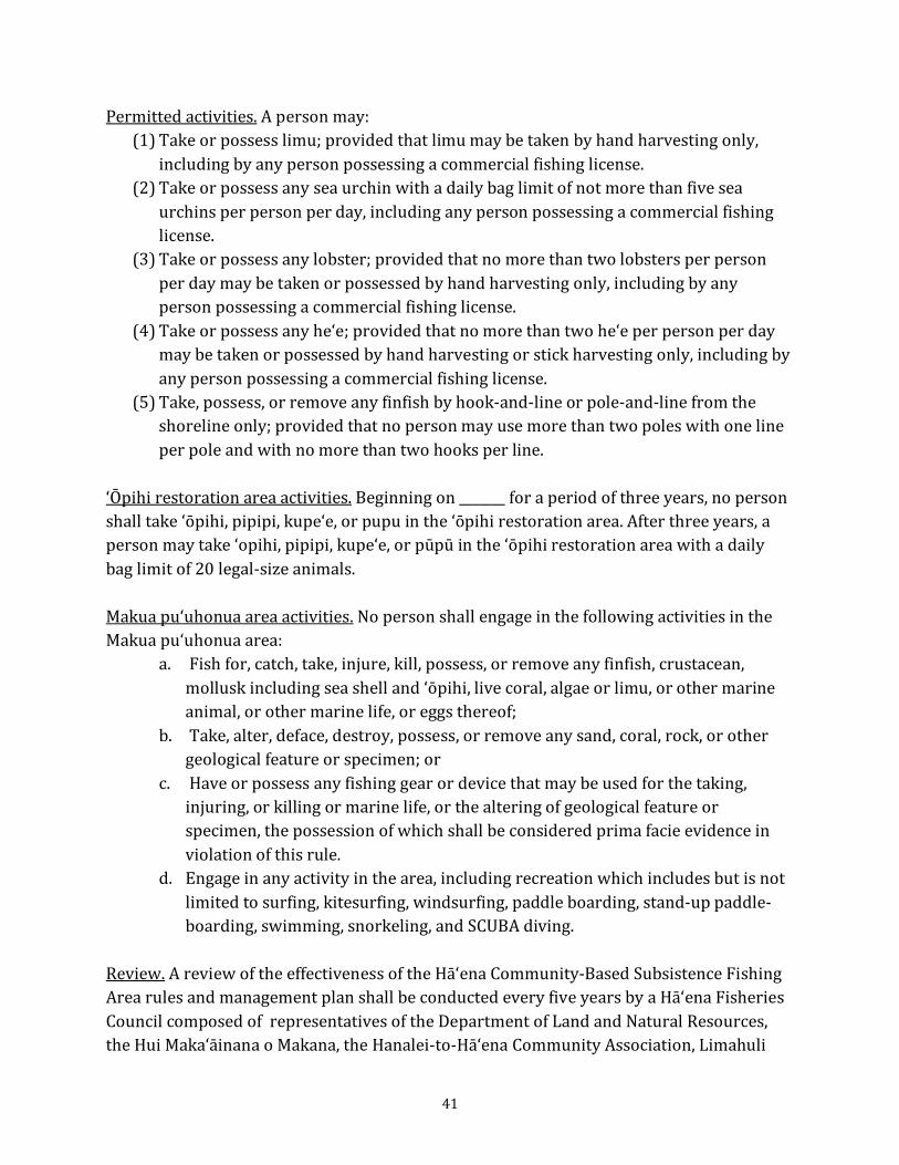
41
Permitted activities. A person may: (1) Take or possess limu; provided that limu may be taken by hand harvesting only,
including by any person possessing a commercial fishing license. (2) Take or possess any sea urchin with a daily bag limit of not more than five sea
urchins per person per day, including any person possessing a commercial fishing license.
(3) Take or possess any lobster; provided that no more than two lobsters per person per day may be taken or possessed by hand harvesting only, including by any person possessing a commercial fishing license.
(4) Take or possess any he‘e; provided that no more than two he‘e per person per day may be taken or possessed by hand harvesting or stick harvesting only, including by any person possessing a commercial fishing license.
(5) Take, possess, or remove any finfish by hook-and-line or pole-and-line from the shoreline only; provided that no person may use more than two poles with one line per pole and with no more than two hooks per line.
‘Ōpihi restoration area activities. Beginning on _______ for a period of three years, no person shall take ‘ōpihi, pipipi, kupe‘e, or pupu in the ‘ōpihi restoration area. After three years, a person may take ‘opihi, pipipi, kupe‘e, or pūpū in the ‘ōpihi restoration area with a daily bag limit of 20 legal-size animals.
Makua pu‘uhonua area activities. No person shall engage in the following activities in the Makua pu‘uhonua area:
a. Fish for, catch, take, injure, kill, possess, or remove any finfish, crustacean, mollusk including sea shell and ‘ōpihi, live coral, algae or limu, or other marine animal, or other marine life, or eggs thereof;
b. Take, alter, deface, destroy, possess, or remove any sand, coral, rock, or other geological feature or specimen; or
c. Have or possess any fishing gear or device that may be used for the taking, injuring, or killing or marine life, or the altering of geological feature or specimen, the possession of which shall be considered prima facie evidence in violation of this rule.
d. Engage in any activity in the area, including recreation which includes but is not limited to surfing, kitesurfing, windsurfing, paddle boarding, stand-up paddle-boarding, swimming, snorkeling, and SCUBA diving.
Review. A review of the effectiveness of the Hā‘ena Community-Based Subsistence Fishing Area rules and management plan shall be conducted every five years by a Hā‘ena Fisheries Council composed of representatives of the Department of Land and Natural Resources, the Hui Maka‘āinana o Makana, the Hanalei-to-Hā‘ena Community Association, Limahuli
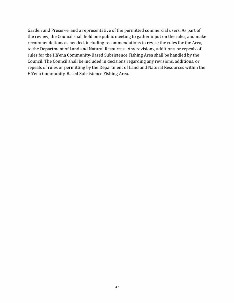
42
Garden and Preserve, and a representative of the permitted commercial users. As part of the review, the Council shall hold one public meeting to gather input on the rules, and make recommendations as needed, including recommendations to revise the rules for the Area, to the Department of Land and Natural Resources. Any revisions, additions, or repeals of rules for the Hā‘ena Community-Based Subsistence Fishing Area shall be handled by the Council. The Council shall be included in decisions regarding any revisions, additions, or repeals of rules or permitting by the Department of Land and Natural Resources within the Hā‘ena Community-Based Subsistence Fishing Area.
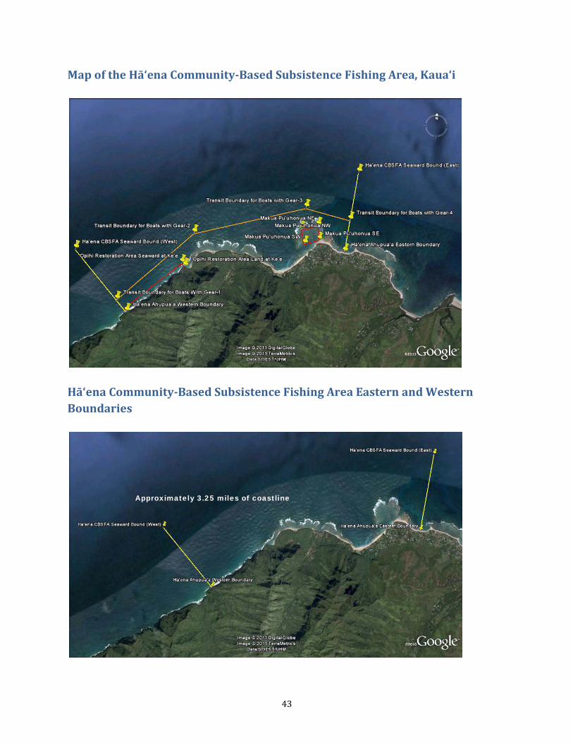
43
Map of the Hā‘ena Community-Based Subsistence Fishing Area, Kaua‘i
Hā‘ena Community-Based Subsistence Fishing Area Eastern and Western Boundaries
Approximately 3.25 miles of coastline
44
Hā‘ena Community-Based Subsistence Fishing Area ‘Ōpihi Restoration Area
Hā‘ena Community-Based Subsistence Fishing Area Makua Pu‘uhonua Area
Approximately 0.9 miles of coastline
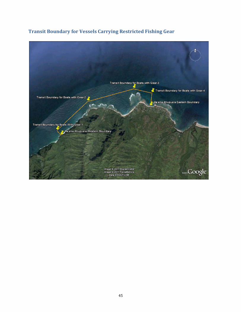
45
Transit Boundary for Vessels Carrying Restricted Fishing Gear

46
Subzone Boundaries Boundary Description Latitude Longitude Length from Shoreline,
as Applicable Ha'ena Ahupua'a Western Boundary
22°12'42.50"N 159°35'44.50"W
Ha'ena CBSFA Seaward Bound (West)
22°13'21.62"N 159°36'22.27"W One mile from the shoreline
Ha'ena CBSFA Seaward Bound (East)
22°14'19.91"N 159°33'6.21"W One mile from the shoreline
Ha'ena Ahupua'a Eastern Boundary
22°13'28.00"N 159°33'13.50"W
'Ōpihi Restoration Area Seaward Boundary (Kē‘ē)
22°13'15.75"N 159°35'7.34"W 300 feet from the shoreline
'Ōpihi Restoration Area Land Boundary (Kē‘ē)
22°13'13.61"N 159°35'5.11"W 300 feet from the shoreline
Makua Pu'uhonua NE 22°13'44.29"N 159°33'32.98"W Makua Pu'uhonua SE 22°13'35.18"N 159°33'31.68"W Makua Pu'uhonua SW 22°13'32.15"N 159°33'41.71"W Makua Pu'uhonua NW 22°13'41.16"N 159°33'44.66"W Transit Boundary for Boats With Gear-1
22°12'49.98"N 159°35'51.79"W 1000 feet from the shoreline
Transit Boundary for Boats with Gear-2
22°13'35.57"N 159°34'59.73"W 1300 feet from the shoreline
Transit Boundary for Boats with Gear-3
22°13'55.42"N 159°33'42.00"W 2300 feet from the shoreline
Transit Boundary for Boats with Gear-4
22°13'48.84"N 159°33'10.76"W 2100 feet from the shoreline
47
APPENDIX 1: Text of HRS Chapter 188 Section 22.6 “Designation of community based subsistence fishing area
48
APPENDIX 2: ACT 241 Creating the Hā‘ena CBSFA
49
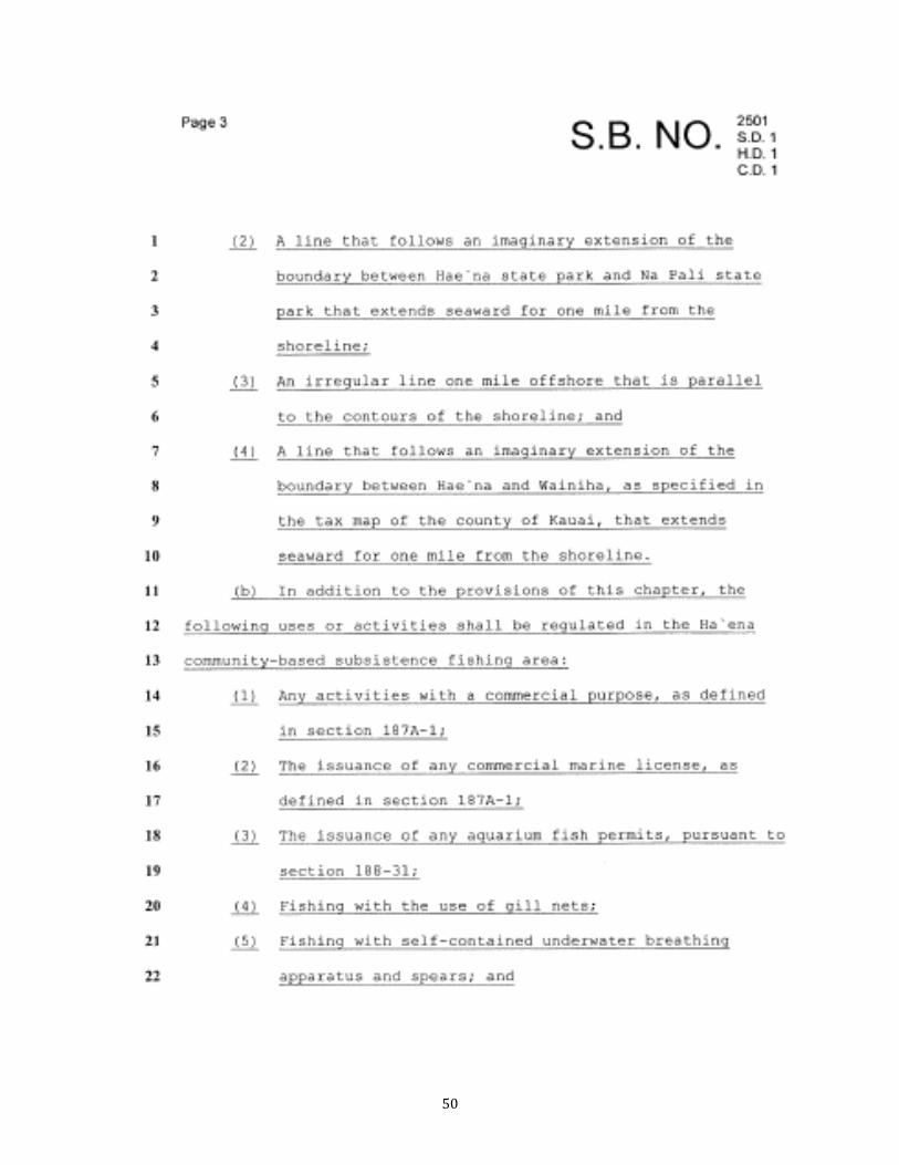
50
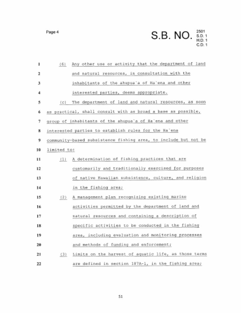
51

52
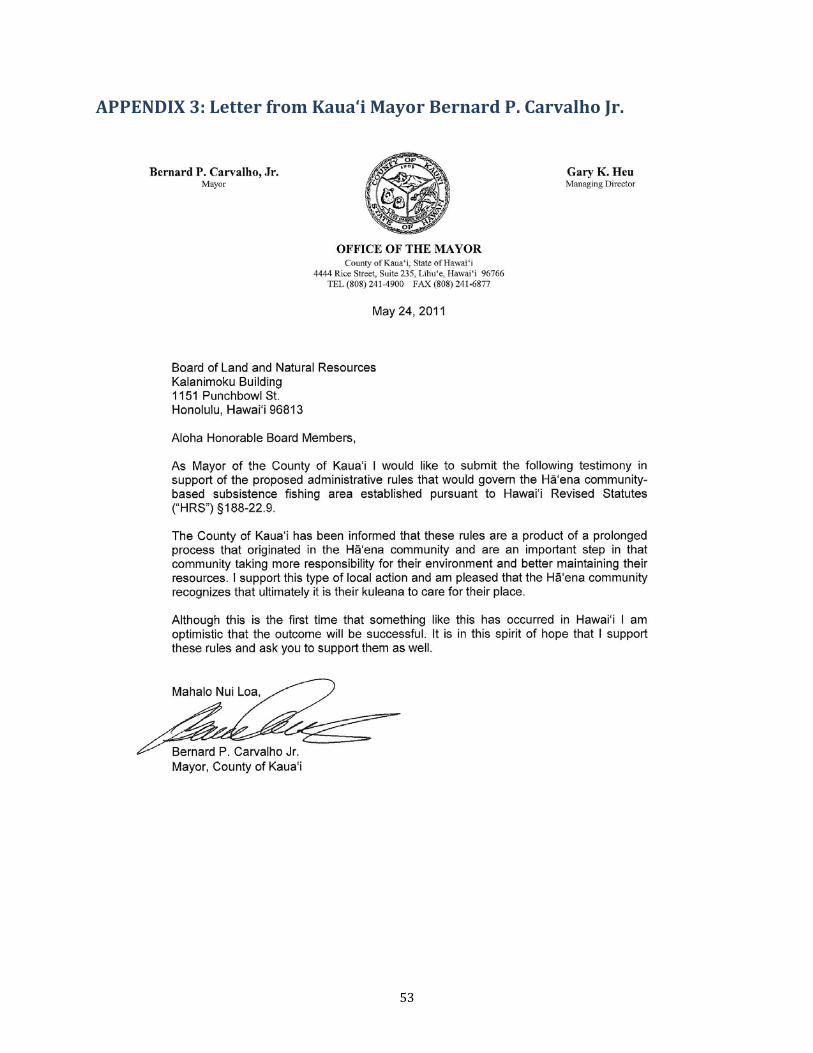
53
APPENDIX 3: Letter from Kaua‘i Mayor Bernard P. Carvalho Jr.
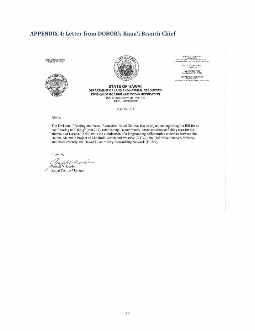
54
APPENDIX 4: Letter from DOBOR’s Kaua‘i Branch Chief
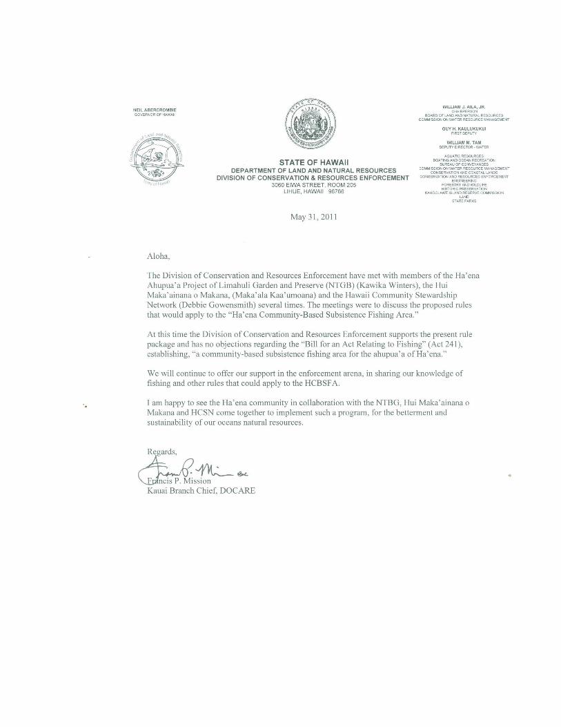
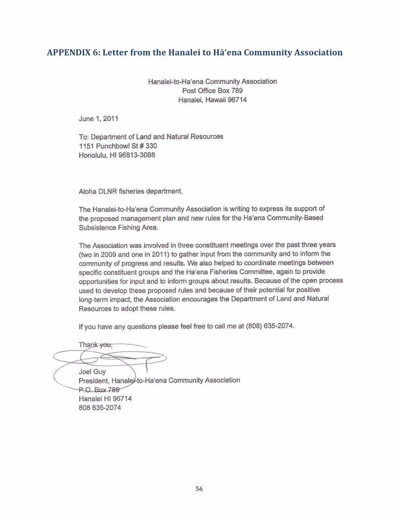
56
APPENDIX 6: Letter from the Hanalei to Hā‘ena Community Association
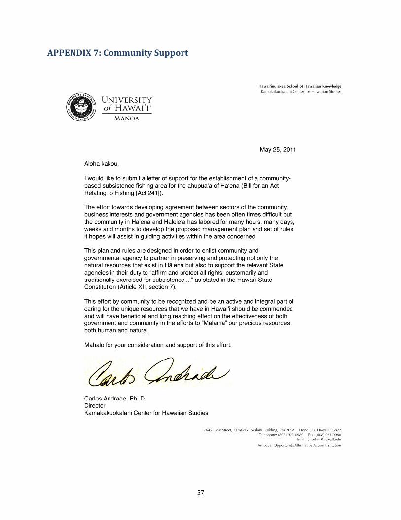
57
APPENDIX 7: Community Support
58
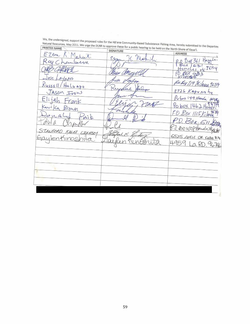
59
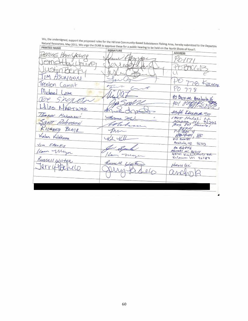
60
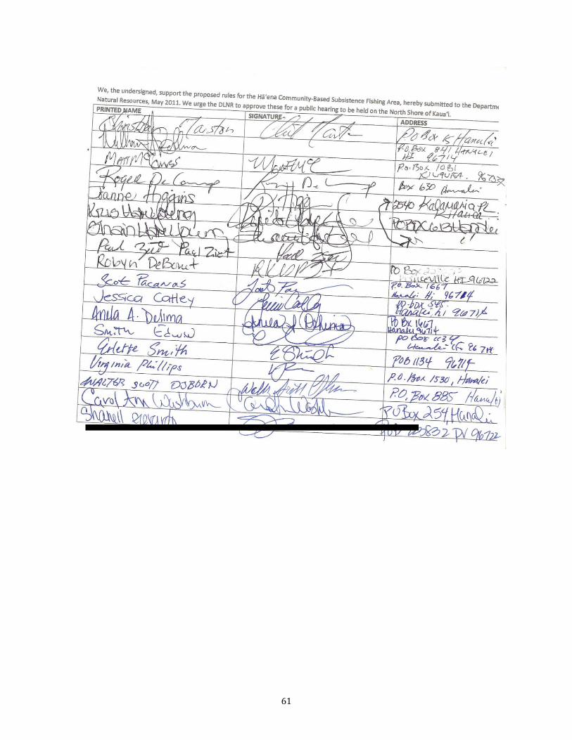
61

62
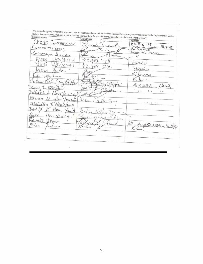
63
64
65
66
67
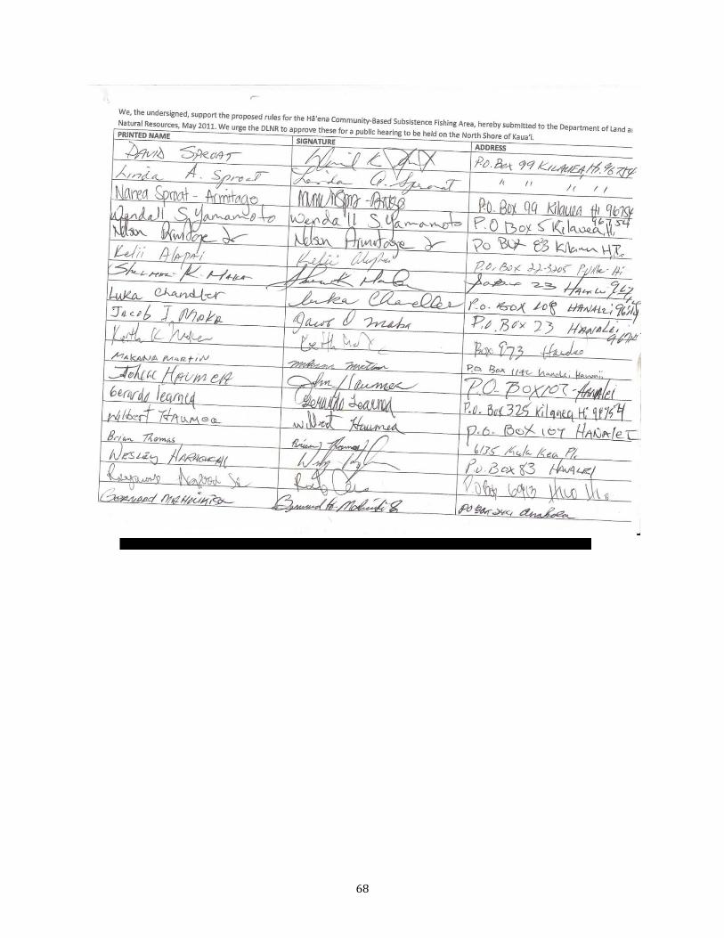
68
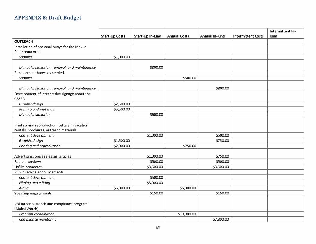
69
APPENDIX 8: Draft Budget
Start-Up Costs Start-Up In-Kind Annual Costs Annual In-Kind Intermittent Costs
Intermittent In-Kind
OUTREACH Installation of seasonal buoys for the Makua Pu'uhonua Area Supplies $1,000.00
Manual installation, removal, and maintenance $800.00 Replacement buoys as needed
Supplies $500.00
Manual installation, removal, and maintenance $800.00 Development of interpretive signage about the CBSFA Graphic design $2,500.00 Printing and materials $5,500.00 Manual installation $600.00
Printing and reproduction: Letters in vacation rentals, brochures, outreach materials Content development $1,000.00 $500.00 Graphic design $1,500.00 $750.00 Printing and reproduction $2,000.00 $750.00
Advertising, press releases, articles $1,000.00 $750.00 Radio interviews $500.00 $500.00 Ho'ike broadcast $3,500.00 $3,500.00 Public service announcements Content development $500.00 Filming and editing $3,000.00 Airing $5,000.00 $5,000.00 Speaking engagements $150.00 $150.00
Volunteer outreach and compliance program (Makai Watch) Program coordination $10,000.00 Compliance monitoring $7,800.00
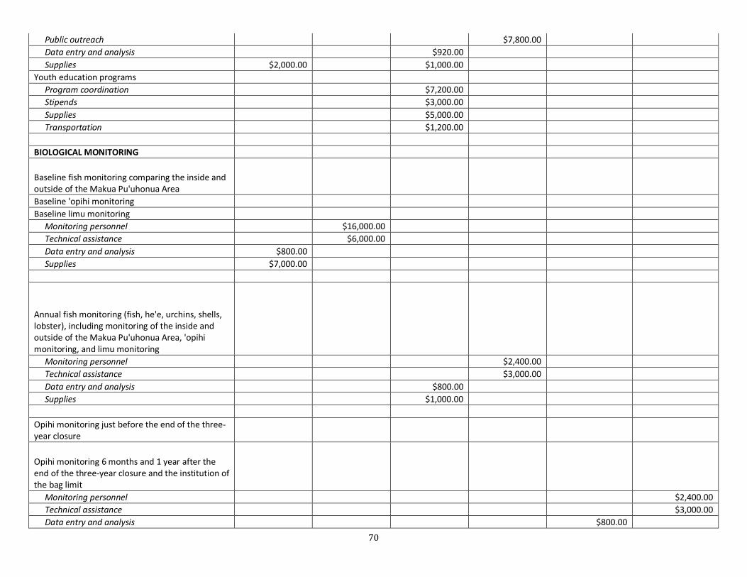
70
Public outreach $7,800.00 Data entry and analysis $920.00 Supplies $2,000.00 $1,000.00 Youth education programs Program coordination $7,200.00 Stipends $3,000.00 Supplies $5,000.00 Transportation $1,200.00 BIOLOGICAL MONITORING
Baseline fish monitoring comparing the inside and outside of the Makua Pu'uhonua Area Baseline 'opihi monitoring Baseline limu monitoring Monitoring personnel $16,000.00 Technical assistance $6,000.00 Data entry and analysis $800.00 Supplies $7,000.00
Annual fish monitoring (fish, he'e, urchins, shells, lobster), including monitoring of the inside and outside of the Makua Pu'uhonua Area, 'opihi monitoring, and limu monitoring Monitoring personnel $2,400.00 Technical assistance $3,000.00 Data entry and analysis $800.00 Supplies $1,000.00 Opihi monitoring just before the end of the three-year closure
Opihi monitoring 6 months and 1 year after the end of the three-year closure and the institution of the bag limit Monitoring personnel $2,400.00 Technical assistance $3,000.00 Data entry and analysis $800.00
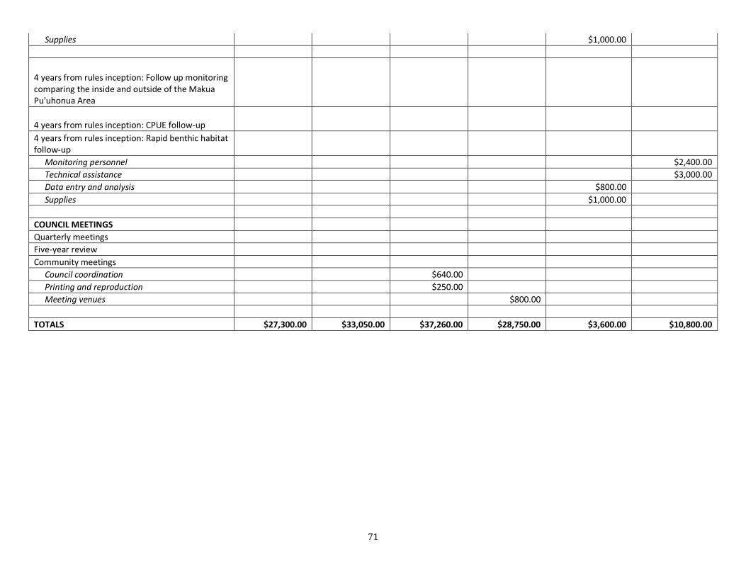
71
Supplies $1,000.00
4 years from rules inception: Follow up monitoring comparing the inside and outside of the Makua Pu'uhonua Area
4 years from rules inception: CPUE follow-up 4 years from rules inception: Rapid benthic habitat follow-up Monitoring personnel $2,400.00 Technical assistance $3,000.00 Data entry and analysis $800.00 Supplies $1,000.00 COUNCIL MEETINGS Quarterly meetings Five-year review Community meetings Council coordination $640.00 Printing and reproduction $250.00 Meeting venues $800.00 TOTALS $27,300.00 $33,050.00 $37,260.00 $28,750.00 $3,600.00 $10,800.00