gunnison sage-grouse centrocercus minimus conservation plan update
TRANSCRIPT

Gunnison Sage-grouse
Centrocercus minimus
Conservation Plan Update
San Juan County, Utah
February 2003

ii
PREAMBLE
The Gunnison Sage-grouse (Centrocercus minimus) inhabits a limited area in Colorado and Utah. San Juan County is the only place in Utah where Gunnison Sage-grouse populations are currently known to occur. On January 26, 2000 the U.S. Fish and Wildlife Service received a petition signed by representatives of the American Lands Alliance, Net Work Associates, The Larch Company, Biodiversity Legal Fund, Wild Utah Forest Campaign, and Sinapu requesting an emergency listing for the Gunnison Sage-grouse. The petitioners cited increasing habitat fragmentation, reduced and limited population distributions, and low and declining localized populations as the primary reasons for classifying the species as endangered. Prior to receiving the petition, the U.S. Fish and Wildlife Service had designated the species as a candidate for listing. In 1972, a total of 175 males were counted strutting on leks in San Juan County. By 1999, this had dropped to 43. In 1972, the sage-grouse population in San Juan County was estimated to be between 583 and 1,050 birds. In 2002, 35 males were counted on four leks. Based on this count, the current population is estimated to be between 178 and 308 birds. The San Juan County Gunnison Sage-grouse Working Group (SWOG) was formed in 1996 for the purpose of developing a conservation plan that could be implemented by state and federal wildlife resource agencies, private landowners, and local governments to benefit sage-grouse populations in the county. The conservation plan was finalized and signed in November 2000. SWOG believes that implementation of the conservation plan will ensure local ownership in future management and land-use decisions; respect private property rights; and embrace community economic, cultural, and social values. This update identifies conservation strategies that have been accomplished since SWOG was organized and the plan was signed. SWOG believes the actions implemented by private and public partners in San Juan County will help to restore Gunnison Sage-grouse habitats and populations while benefiting the local economy and community. Table of Contents
iii
Page PREAMBLE ................................................................................................................................... ii TABLE OF CONTENTS............................................................................................................... iii LIST OF TABLES AND FIGURES.............................................................................................. iv I. PLAN BACKGROUND......................................................................................................1 II. PLAN DEVELOPMENT- HABITAT CONSERVATION ASSESSMENT ......................4 III. PLAN IMPLEMENTATION - CONSERVATION STRATEGIES .................................17 IV. REFERENCES ..................................................................................................................31 V. APPENDICES ...................................................................................................................32
A. San Juan County Gunnison Sage-grouse Working Group Members.....................32 B. Vegetation Classifications and Definitions............................................................33 C. Habitat Mixture Seeded on CRP Land in San Juan County Gunnison
Sage-grouse Conservation Plan Area. .......................................................36 D. Gunnison Sage-grouse Conservation Brochure.....................................................37 E. Summary of Gunnison Sage-grouse Conservation Projects and Costs .................38

iv
List of Tables and Figures Figures Figure 1. Gunnison Sage-grouse Conservation Area. San Juan County, Utah...............................2 Figure 2. Gunnison Sage-grouse Conservation and Study Area Vegetation Map,
San Juan County, Utah.........................................................................................................6 Figure 3. Gunnison Sage-grouse spring and summer habitat use patterns and seasonal
movements, San Juan County, Utah ....................................................................................7 Figure 4. Gunnison Sage-grouse Working Group conservation projects, San Juan
County, Utah 2002.............................................................................................................11 Tables Table 1. Landownership in the Gunnison Sage-grouse Conservation Area ....................................3 Table 2. Number of males counted on leks in San Juan County, 1972-2002..................................5 Table 3. Vegetation conditions within the San Juan County Gunnison Sage-grouse
Conservation Plan Study Area, 2002...................................................................................8 Table 4. Percent cover of grasses, forbs, and shrubs at nest and reference sites for
2001 and 2002......................................................................................................................9
Table 5. Percent availability and use of cover types by sage-grouse hens with broods in 2001 and 2002 in San Juan County, UT ........................................................................12
Table 6. Vegetation height (cm) and percent cover of grasses, forbs, and shrubs at brood-use sites in 2001 and 2002 .......................................................................13
Table 7. Vegetation height (cm) and percent cover of grasses, forbs, and shrubs at brood-use sites and male Gunnison Sage-grouse locations in San Juan County, UT, 2001 ...............................................................................................14
Table 8. Simultaneous confidence intervals using the Bonferroni approach for utilization of vegetation types by male Gunnison Sage-grouse in 2001 and 2002.............................................................................................................................14
Table 9. Percent cover of grasses, forbs, and shrubs at reference sites

v
and male Gunnison Sage-grouse locations in San Juan County, UT, 2001 ............................................................................................................................14
Table 10. Percent cover of grasses, forbs, and shrubs used by broods,
broodless hens, and male Gunnison Sage-grouse in San Juan County, UT, 2002 ..............................................................................................................15
Table 11. Simultaneous confidence intervals using the Bonferroni approach
for utilization of vegetation types by non-brood rearing Gunnison Sage-grouse in 2002...........................................................................................................15

1
I. PLAN BACKGROUND A. Introduction and Purpose The San Juan County Gunnison Sage-grouse Working Group (SWOG) was formed in 1996 to identify and implement conservation strategies to reverse the decline of sage-grouse populations in the county. From the onset, SWOG has sought local citizen involvement and input. SWOG consists of public management agencies, private landowners, local citizens, and private conservation groups. A current list of SWOG members can be found in Appendix A. B. Conservation Area Description and Boundary San Juan County is located in southeastern Utah and consists of 7,821 square miles (Figure 1). Approximately 6% of the county (324,921 acres) consists of 208 privately-owned farms. In 1994, agriculture enterprises generated slightly over 10% of the county's total personal income. San Juan County ranks 5th among all Utah counties in total grain production. The San Juan County Gunnison Sage-grouse Conservation Area (CA) boundary was delineated using current and historic habitats, sage-grouse observations, and an assessment of the potential for remaining sagebrush areas in the county to provide suitable habitat (Figure 1). The CA encompasses rural areas, rural residential dwellings, and agricultural croplands (Table 1). The CA area consists of 970,660 acres. Thirty-eight percent (314,244 acres) is privately-owned. Within the CA, SWOG has delineated a core conservation area (CCA) consisting of 336,680 of which 89% (218,493 acres) is privately-owned. Within the CCA, SWOG has identified a conservation study area (CSA). The CSA consists of 59,744 acres. Over 93% (55,738 acres) of the SA is privately-owned. The area within the CA, but located outside of the CCA have been identified as a buffer area. While SWOG believes it necessary to include the buffer area in the CA because of the presence of sagebrush, we make no inferences regarding habitat potentials. The buffer area does not presently support Gunnison Sage-grouse. Table 1. Landownership in the Gunnison Sage-grouse Conservation Area. _____________________________________________________________________________ Area Total Acres Public Acres Private Acres Forest Service BLM State Tribe _____________________________________________________________________________ CA 970,066 195 457,333 65,271 10,862 314,224 (38%) CCA 336,680 - 24,835 3,483 - 218,493 (89%) SA 59,744 - 3,024 919 - 55,738 (93%) CA – Conservation Area, CCA – Core Conservation Area, CSA – Conservation Study Area

2
Figure I.

3
C. The Process Gunnison Sage-grouse in the county depend heavily on private lands for habitat (Table1). Thus, SWOG is committed to conserving and enhancing Gunnison Sage-grouse populations that occur on privately-owned land in the county and contribute to the economic viability of farms, ranches, and the local community. Landowner involvement in the Plan is strictly voluntary. The SWOG Conservation Plan (PLAN) consists of two parts. The first part is the Population and Habitat Conservation Assessment. The Assessment describes SWOG=s current understanding about the status of Gunnison Sage-grouse distributions, habitat conditions, and factors that may be affecting populations in the county. Research is ongoing to refine this information. The second part of the PLAN is the Conservation Strategy. The Strategy identifies PLAN goals and objectives, conservation actions, implementation schedules and responsibilities, evaluation guidelines, and monitoring requirements. The PLAN identifies conservation strategies to be implemented in guiding and coordinating management efforts across jurisdictional/land ownership boundaries to improve Gunnison Sage- grouse habitat conditions in the county. SWOG intended that the PLAN be a dynamic document. As new information is obtained or issues identified, SWOG updates the PLAN and modifies conservation strategies accordingly. This document summarizes the progress made to implement the PLAN. II. PLAN DEVELOPMENT - HABITAT CONSERVATION ASSESSMENT A. Current Population Status In 1972, 175 males were counted strutting on six leks in San
Juan County. In 2001 and 2002, 47 and 35 males, respectively, were counted on five and four leks, respectively (Table 2).
B. Population Objectives 1. Spring breeding populations
One objective of the PLAN is to reestablish a minimum estimated spring breeding population of 500 birds with 6-8 active leks each containing a three-year count average of 20-25 birds per lek. This increase would be measured from 1997 population estimates.
Current Status
In 1997 the population, based on lek surveys, was estimated to be between 125-140 birds. In 2002, the population was estimated to be between 175-308 birds based on counts of four leks. Only the Roring lek, achieved the 20-25 bird average. The increased number of males counted on this lek may have been the result of birds abandoning the East Seep Wash lek.

4
The current population estimate is 192-225 birds below the minimum desired population objective. The intent of the PLAN is to achieve this population goal by 2012.
2. Lek protection All current identified lek sites would be protected from future risk through leases, conservation easements, or in fee title. Current status Currently, two of the leks are protected. These include the Bureau of Land Management (BLM) lek (owned in fee title by the BLM) and Hickman Flat lek (part of a perpetual conservation easement on the Adam’s property). The Utah Division of Wildlife Resources (UDWR) and the BLM are pursuing conservation easements on the other leks. Currently SWOG is negotiating to secure an easement on the Roring lek and the surrounding areas. Discussions also have been initiated with the East Seep lek landowner (Figure 2) C. Habitat Objectives In 2000 and 2001, 14 Gunnison Sage-grouse were captured in the CSA and fitted with radio-collars (8 males and 6 females). We monitored the movements of the birds during the spring and summer. Based on their movements, we have defined the boundaries of the original core conservation study area (CCA) as presented in the PLAN. This area is now referred to as the conservation study area (CSA). The CSA consists of 59,744 acres (Figure 3). This area contains the primary breeding complexes. We are currently monitoring radio-collared birds to determine seasonal habitat use areas. 1. Breeding complexes An objective of the PLAN is to reestablish desired vegetation conditions on 50-75% of the areas located within two miles of lek sites (Figures 1 and 2). SWOG has defined desired vegetation conditions to include a canopy cover of 20-40% big sagebrush with an average height of 16 inches, 30% minimum grass canopy cover, and 10% minimum forb canopy cover. Current Status We have evaluated the existing vegetation conditions in the CSA. This evaluation was conducted by ground truthing LandSat imagery of the CSA. To ground truth the imagery we randomly established 50 training sites within the CSA (Figure 2). These sites were visited and the vegetation conditions documented. Definitions for the vegetation classifications can be found in Appendix B. After completing this fieldwork, we conducted a supervised classification of SA imagery. The results of this are presented in Table 3. Table 2. Number of strutting males counted on leks in San Juan County, 1972-2002.

5
Lek Counts 1970-2002 Figure 2
YEAR STRUTTING GROUNDS RORING EAST SEEP HICKMAN
FLAT BLM DODGE
POINT 1970 49 43 9 1971 51 61 2 1972 59 64 6 1973 48 31 7 1974 41 73 4 1975 27 51 21 1976 24 32 33 1977 18 40 50 1978 13 30 45 1979 5 17 39 1980 4 9 28 1981 21 39 1982 2 18 27 1983 9 15 35 1984 10 13 28 1985 7 9 16 1986 9 6 3 1987 10 8 3 1988 11 6 4 1989 16 11 3 1990 15 9 4 1991 11 8 5 1992 16 14 6 1993 17 18 3 1994 18 17 1995 16 14 8 1996 14 14 1997 13 6 6 1998 15 4 9 4 1999 22 1 9 6 5 2000 33 12 4 8 2001 25 3 12 4 3 2002 23 0 8 3 1
0
20
40
60
80
100
120
140
1970
1973
1976
1979
1982
1985
1988
1991
1994
1997
2000
DodgeBLMHickmanEast SeepRoring

6
Figure 3

7
Table 3. Vegetation classifications of Gunnison Sage-grouse breeding complex , San Juan County, UT, 2002. Vegetation Classification Acreage % Total* Objective Non-irrigated Agriculture 4688 17.7 Black-sage 4287 16.2 Big Sagebrush > 25 % Canopy 1523 5.7 > 20-40% Big Sagebrush < 25% Canopy 1706 6.4 Grass (Conservation Reserve Program) 13,533 51.1 > 30% Rangeland (Grass) 2908 10.9 *These totals are based on 100% of the area. The PLAN calls for achieving the objectives on 50-75% of the area.
Currently the acreages of cover types available for Gunnison Sage-grouse in the area defined as constituting the breeding complex exceed the PLAN objectives, except for the forb canopy cover (see Table 4 reference sites). The suitability of these cover types as nesting habitat is still under study. To assess Gunnison Sage-grouse habitat use patterns in the CSA and breeding complex, we captured 14 Gunnison Sage-grouse on or adjacent to two separate strutting grounds during March and April each year (6 in 2001, 8 in 2002). In 2001, all birds (1 hen, 5 males) were adults. In 2002 all the males (3/3) were adults and 60 % of the hens were juveniles (3/5). Four radio-collared females nested (1 in 2002, 3 in 2002). All of the nests were monitored and each hen successfully hatched a brood. All nests hatched between 21 May and 23 May. Allowing for 26 days of incubation, nests were initiated April 25-27. The only nest monitored in 2001 was located one mile from the nearest lek site. In 2002, nest sites were one-half mile and one and one-half miles from the nearest active strutting grounds. In 2001, the hen nested in black sage (Artemisia nova). In 2002, all the hens nested in agricultural land enrolled in the Conservation Reserve Program (CRP). These lands have been reseeded to a grass using a seed mixture provided by the UDWR. Vegetation measured at nest sites was compared to non-use sites in black sage and CRP/grassland cover classes. The vegetation measured at nest sites differed from non-use sites (P = 0.01). Nest sites had fewer grasses and forbs than non-use sites, but had more shrubs

8
(Table 4). All nests were located under sagebrush canopies. The average height of sagebrush around the nest sites was 8.5 inches (21.5 cm).
Table 4. Percent cover of grasses, forbs, and shrubs at Gunnison Sage-grouse nest and reference sites for 2001-02, San Juan County, UT.
Percent Cover
Nesting Reference
Grasses 6.0 34.7*
Forbs 0.5 8.8*
Shrubs 27.5 10.4*
* P-value ≤0.05 is significantly different
Based on this preliminary analysis, the breeding complex habitat in the CSA meets the minimum desired percent cover requirements established in the PLAN for grass and shrub cover, but is below the desired forb canopy cover objective. In the late 1980s many landowners within the CCA enrolled their lands in CRP. Most of the decline in non-irrigated agricultural land can be explained by CRP. In 1993, over 43,000 non-irrigated croplands were converted to CRP grasslands. Also, during this period, an additional 10,000 acres of cropland was converted to rangeland. Many of CRP contracts in the county expired in 1995. Based on new national CRP eligibility requirements, many of these lands and other agricultural lands located in the county would not have been eligible for enrollment in the program. SWOG worked with the Natural Resource Conservation Service (NRCS) and Farm Services Agency (FSA) to have San Juan County designated as a priority conservation area under CRP because of Gunnison Sage-grouse. Designation as a priority conservation area meant that agricultural land submitted for CRP enrollment consideration in the county did not have to meet the CRP erodibility index requirements to be eligible for the program. However, landowners could only qualify for the program if they agreed to implement approved wildlife conservation practices. As of February 2000, a total of 36,825 acres of private land within the CA had been enrolled in CRP. Approximately 32,667 acres were enrolled as a result of the Gunnison Sage-grouse conservation priority initiative. The UDWR, in conjunction with NRCS, developed a sage-grouse seed mixture for use in San Juan County (Appendix B). The total cost of reseeding these areas was $531,686. The UDWR and private landowners each paid $132,921 of this amount. Farm Services Agency (FSA) cost-shared for the remaining $265,844. The total cost of establishing CRP in San Juan County was $1,222,728. This includes the seed cost and $691,042

9
that was spent to prepare the land for seeding. Half of the costs of land preparation was paid for by the landowners ($345,521) and half was cost-shared by FSA. CRP leases generate in excess of $1,000,000 in annual income for participating landowners. The CRP program enabled SWOG to achieve grass and minimum shrub canopy cover objectives. We believe the forb cover has been affected by the severe drought condition the CA experienced in 2002 and grass competition. Some of the CRP lands in the CSA were grazed in 2002 under an emergency grazing declaration. NRCS considered the grazing to be a stand maintenance treatment. SWOG is monitoring these areas to see what effect the grazing had on canopy cover. SWOG also has initiated efforts to both hand plant and aerial seed CRP fields with sagebrush in areas that exhibit high bird use to augment existing sagebrush stands thus enhance canopy cover (Figure 4). These efforts are discussed in greater detail under Conservation Strategies. 2. Brood-rearing complexes The PLAN identifies the need to reestablish brooding rearing-complexes in the CSA. This will be done by enhancing vegetation conditions on 50-75% of the area located within 4 miles of known lek sites within the CCA over the next 10-year period. This area consists of 80,551 acres. Desired conditions include a canopy cover of 20-40% big sagebrush with an average height of 16 inches, 30% minimum grass canopy cover, and 10% minimum forb canopy cover. The height of the vegetation in wet meadow areas is to be greater than 4 inches between June 15- July 31 on over 75% of the area considered to be brood-rearing habitat. Current Status Based on analysis of LandSat imagery, the CCA meets the desired objective percent cover for grass (Table 5). In 2002, we measured vegetation composition in the brood-rearing area. Based on this effort we determined that the percent shrub, forb, and grass composition in the brooding-rearing area to be 11, 9, and 31%, respectively. These data support the LandSat analysis. The 9% forb approximates the 10% PLAN objective. To determine brood habitat use patterns in the SA, we monitored the three broods of hens that nested in the area. In 2001, one hen produced a successful brood. A brood was considered successful if ≤1 chick was recruited into the August population. In 2002, one of two broods monitored was successful. In both years, most chicks were lost within the first 14 days post-hatch. Figure 4.

10
Table 5. Vegetation classifications for Gunnison Sage-grouse brood-rearing habitat, San Juan County, UT, 2002.

11
_____________________________________________________________________________ Vegetation Classification Acreage % Total Objective Non-irrigated 8987 11% Black-sage 4287 5% Big sage < 25% 4352 5% > 20-40% Big Sage > 25% 7704 10% Grass/CRP 34,144 42% 30% Rangeland (Grass) 5536 7% Habitat selection by broods was combined for both years because of sample size limitations. Hens with broods selected CRP/grassland and big sagebrush more than any other cover type (Table 6). Agriculture, black sage, grazed rangelands, and bare ground were not used in proportion to their availability. The woodland/mountain shrub cover class was used in equal proportion to its availability. Black sage was only used in 2001; agriculture and woodland/mountain shrub were only used in 2002. Table 6. Percent availability and use of cover types by sage-grouse hens with broods in 2001 and 2002 in San Juan County, UT. Year
2001 2002
Cover Type Availability Use n Availability Use n
Wet meadow 0 0 0 0 0 0 Agriculture 0 0 0 27 11-a 2 Woodland/mtn. shrub 0 0 0 1 5 1 Black sage 85 8- 2 0 0 0 Big sagebrush 3 19+ 5 2 11+ 2 CRP/grassland 11 73+ 19 25 74+ 14 Rangeland 1 0- 0 0 0 0 Bare ground 1 0- 0 0 0 0 a + = Use greater than availability, no symbol = use in proportion to availability, - = use less than availability (P ≤ 0.0001) by Bonferroni confidence intervals.

12
The vegetation composition at brood-use sites in 2001 did not differ from non-use sites (P = 0.0001). Brood-use sites exhibited greater forb cover and less grass and shrub cover than non use sites (Table 7). Percent cover of grasses, forbs, and shrubs at brood-use sites did not differ between years (P = 0.002). Brood-use sites in 2001 had greater percent canopy cover of all vegetation types (Table 7). Although the vegetation height at brood rearing sites differed between years, the difference was not significant (P = 0.07) (Table 6). Table 7. The vegetation height (cm and in) and percent cover of grasses, forbs, and shrubs at brood-use sites in 2001 and 2002.
2001 2002
Height 18.8 (7.8 in) 12.2 (5.1in)
% Grasses 14.8 5.7*
% Forbs 9.5 1.7*
% Shrubs 6.1 2.8*
* P-values ≤ 0.05 are significantly different.
In 2001, we monitored four radio-collared males. All individuals were captured from the Roring lek site (Figure 2). They were often observed in the same flock. Flock size ranged from 2-18 individuals. We observed no mixed-sex flocks in 2001. In 2002, we monitored six radio-collared males and five radio-collared hens that did not have broods. Three of the males were the same individuals monitored in 2001. The other three males were captured on the Hickman Flat lek site. One of the broodless hens in 2002 was the brooding hen from 2001. The other four broodless hens were captured in 2002, three on the Roring lek and two on the Hickman Flat lek. The birds captured on the Hickman Flat lek were observed in mixed flocks while individuals captured on the Roring lek were only found in single-sex flocks. Mixed-sex flocks ranged in size from 4-18 individuals, single sex flocks had 1-16 individuals.
Percent cover of grasses, forbs, and shrubs at brood-use sites in 2001 differed from sites used by radio-collared males in the same year (P = 0.002). Sites used by males had greater grass cover than those used by the brood; the brood used sites with greater forb and shrub cover (Table 7). The height of vegetation at brood sites did not differ at sites used by males in 2001 (P = 0.06) (Table 8). Vegetation height did not differ between brood-use sites and sites used by males in 2002 (P = 0.5).
In both years, males selected the CRP/grassland and big sagebrush cover types (Table 9). In 2001, agriculture, woodland, and bare ground cover types were avoided; rangelands were used in proportion to their availability. In 2002, wet meadow, agriculture, black sagebrush, and bare ground cover types were avoided; woodlands and rangelands were used in proportion to their

13
availability. The percent cover of grasses, forbs and shrubs at sites used by males in 2001 did not differ from reference sites (P = 0.1) (Table 9). Reference sites had slightly greater percent cover of grasses, forbs, and shrubs than sites used by Gunnison Sage-grouse males. Table 8. The vegetation height (cm and in) and percent cover of grasses, forbs, and shrubs at brood-use sites and male Gunnison Sage-grouse locations in San Juan County, UT, 2001.
Brood Males
Height 18.8 (7.8in) 23.6 (9.8in)
% Grasses 14.8 28.3*
% Forbs 9.5 8.1*
% Shrubs 6.1 3.3*
* P-value ≤ 0.05 significantly different.
Table 9. Simultaneous confidence intervals using the Bonferroni approach for utilization of vegetation types by male Gunnison Sage-grouse in 2001 and 2002. 2001 2002 Confidence Interval Confidence Interval Cover Type Lower Upper Expected Lower Upper Expected Wet meadow 0.000 0.000 0.000 0.000 0.000 0.001- a Agriculture 0.113 0.215 0.331- 0.036 0.091 0.104- Woodland/mtn. shrub 0.000 0.000 0.028- 0.000 0.017 0.003 Black sagebrush 0.000 0.000 0.000 0.099 0.177 0.266- Big sagebrush 0.092 0.188 0.067+ 0.077 0.149 0.055+ CRP/grassland 0.623 0.751 0.565+ 0.561 0.671 0.426+ Rangeland 0.000 0.022 0.009 0.010 0.048 0.020 Bare Ground 0.000 0.000 0.001 0.013 0.014 0.127- a + = Use greater than availability, no symbol = use in proportion to availability, - = use less than availability (P ≤ 0.0001) by Bonferroni confidence intervals.
Table 10. Percent cover of grasses, forbs, and shrubs at reference sites and male

14
Gunnison Sage-grouse locations in San Juan County, UT, 2001. Males Reference
Grasses 28.3 33.2
Forbs 8.1 9.1
Shrubs 3.3 10.9
_____________________________________________ The percent cover of grasses, forbs, and shrubs at brood-use sites in 2002 did not differ from sites used by hens without broods (P = 0.5) (Table 10). The height of vegetation at brood-use sites in 2002 did not differ from sites used by hens without broods (P = 0.06). In addition, percent cover of grasses, forbs, and shrubs at brood-use sites in 2002 did not differ from sites used by radio-collared males (P = 0.4) (Table 11). Table 11. Percent cover of grasses, forbs, and shrubs used by broods, broodless hens, and male Gunnison Sage-grouse in San Juan County, UT, 2002.
Brood Broodless Hen Males
Height 12.2 20.1 14.5
Grasses 5.7 3.6 4.0
Forbs 1.7 1.2 2.3
Shrubs 2.8 11.6 3.8
Hens without broods did not use wet meadow, black sagebrush, and bare ground cover types in proportion to their availability. Agriculture and big sagebrush cover types were used relative to availability (Table 12). Table 12. Simultaneous confidence intervals using the Bonferroni approach for utilization
of vegetation types by non-brood rearing Gunnison Sage-grouse in 2002. Confidence Interval Cover Type Lower Upper Expected

15
Wet meadow 0.0000 0.0000 0.0007-a Agriculture 0.0372 0.1098 0.0743 Woodland 0.0000 0.0247 0.0017+b Black sagebrush 0.0734 0.1633 0.2964- Big sagebrush 0.1008 0.2004 0.1444 CRP/grassland 0.5361 0.6722 0.4402+b Rangeland 0.0147 0.0712 0.0091 Bare ground 0.0000 0.0000 0.0333- a - = use less than availability, no symbol = use in proportion to availability (P ≤ 0.0001) by Bonferroni confidence intervals. b + = use greater than availability (P ≤ 0.05) by Bonferroni confidence intervals. Use of wet meadows The PLAN established an objective of maintaining vegetation height in wet meadow areas of 4 inches or greater between June 15 - July 31 on over 75% of the area used as brood-rearing habitat. Based on analysis of LandSat imagery, we classified approximately 3700 acres within the core conservation area a wet meadow habitats (Figure 2). However, the broods we monitored did not frequent these areas. This observation could be attributed to the severe drought the area has been experiencing. This drought has affected water levels and dried up most of the wet meadows adjacent to nest and brood-rearing sites. Activities implemented by SWOG to address this issue are discussed under Conservation Strategies. 3. Wintering complexes An objective of the PLAN is to reestablish desired vegetation conditions on 50% of the areas located within the conservation study area, and 25% of the vegetation conditions within the buffer areas, over the next 10 year period. Desired conditions for winter habitat include a minimum of 15% canopy cover of big sagebrush vegetation that averages 12 inches in height on southerly and westerly aspects. Big sagebrush in drainages should exhibit a minimum of 30% canopy cover and average 20 inches in height. Small areas that exhibit denser sagebrush canopy cover (40% with an average height of 16 inches) should be interspersed throughout the wintering area on south and west slope aspects. Current Status We are currently conducting an assessment of winter habitat in the SA. This work will be conducted through 2005. 4. Corridors

16
An objective of the plan is reestablish and maintain contiguous travel corridors consisting of big sagebrush exhibiting >25% canopy coverage between breeding, brood rearing, and wintering complexes in the core area. This objective is to be achieved within the next 15 years. Current Status We are using information gathered from our Gunnison Sage-grouse habitat-use studies to identify and map corridors used by the San Juan County population to move between seasonal habitats. Based on movements of adult males and females, and juvenile females there appears to be little or no population interchange between birds who frequent the Roaring lek site located in the western part of the SA and birds who use the Hickman lek complexes in the eastern part of the CSA (Figure 3). Location data obtained from recent telemetry flights conducted to determine winter use sites indicate that two birds from the Roring lek have moved in close proximity of birds from the Hickman Flat lek. This suggests that the populations may interchange. Additional effort will be conducted this spring to capture juvenile males. Juvenile males are more likely to disperse to new lek sites.

17
III. PLAN IMPLEMENTATION - CONSERVATION STRATEGIES A. Desired Plan Outcomes Implementation of the PLAN will result in a broad base of local support necessary to coordinate management across land ownership and jurisdictional boundaries to ensure survival of the Gunnison Sage-grouse and the economic viability of San Juan County. To achieve this outcome, the PLAN has been designed to be a dynamic document that will be formally reviewed annually and updated as new information becomes available. Annual progress and quarterly reports have been provided to SWOG members. The success of this PLAN will be measured by changes in habitat conditions and Gunnison Sage- grouse population numbers in San Juan County. Another measure of success will be increased participation of local landowners, the community, public and private resource management and conservation agency and organization efforts in conservation actions. B. Conservation Strategies The strategies identified in the PLAN will be implemented and evaluated by SWOG. Although the strategies may be applied to approximately 336,680 acres identified as the core conservation sage-grouse habitat, priority will be placed on areas within the 59,744 acre conservation study area. The conservation study area contains essential Gunnison Sage-grouse breeding, nesting, and brood rearing habitat. C. Status Priority Implementation Actions by Conservation Strategy 1. Develop public support and funding base for the conservation plan.
Action: Communicate Conservation Plan goals, objectives, and accomplishments to other stakeholders in the agricultural, natural resources, and legislative community.
Strategies: Publish a San Juan County Gunnison Sage-grouse Conservation Plan
informational brochure for public distribution.
Status: An informational brochure describing the conservation planning efforts was printed and distributed in 2001 (Appendix D)
Host media interviews with SWOG representatives from the agricultural and wildlife conservation communities.
Status: SWOG members have been interviewed by local newspapers, the Salt Lake Tribune, Deseret News, and other media outlets.

18
Organize and conduct an annual San Juan County Gunnison Sage-grouse Conservation Festival to increase public awareness and support for local community efforts to restore the populations.
Status: The Gunnison Sage-grouse Festival concept has been postponed until SWOG is able assess the effects of increased public visitations on lek attendance. The UDWR in cooperation with Utah State University has hosted small group tours and lectures about Gunnison Sage-grouse conservation. The small, unadvertised tours appear to be meeting the demand for viewing the birds.
Develop a series of promotional items that carry a designer logo. These promotional items will be sold at local and regional retail outlets to increase the visibility and support of the county conservation efforts and generate revenue to support PLAN implementation.
Status: A local designer was contacted about developing a logo that could
used on caps and other apparel. Three dozen caps were embroidered with the logo and distributed to local landowners. In addition, we contacted a company known as Rag Bag, Inc. (www.ragbag.com) to develop additional promotional items. The company currently has a series of promotional clothing available that can be ordered on-line.
2. Monitoring and Evaluation
Action: Seek endorsement and funding of the San Juan County Gunnison Sage-grouse Conservation Plan through the Utah Department of Natural Resources Endangered Species Mitigation Fund, the Utah Legislature, and other sources.
Strategies: SWOG meets as a working group every six months to review PLAN
progress and implementation. Status: SWOG has met seven times since the Conservation Plan was
signed in March 2001. The working group uses the meetings to discuss conservation activities and plan future activities.
SWOG partners will contact their legislative representatives regarding the process and send letters of support to the executive director of the Department of Natural Resources, the Utah Governor=s Office, and Utah=s congressional delegation.

19
Status: SWOG members have contacted legislative and congressional representatives. Copies of the signed plan have been distributed to the local legislators, the Utah Governor’s Office and Utah’s Congressional delegation. SWOG members have written letters to the Executive Director of the Utah Department of Natural Resources to support the use of Utah Endangered Species Mitigation Funds to support the Adam’s Conservation Easement. Funding was received from the Fund to support the easement.
SWOG representatives will testify before the appropriate Utah
Legislature committees about the San Juan County Conservation Plan to increase legislator awareness and support for similar efforts in other areas of Utah.
Status: See above comments

20
Action: Monitor impacts of conservation strategies on sage-grouse habitat and population.
Strategies: SWOG will initiate an ongoing research program to monitor annual
sage-grouse population numbers and trends, monitor sage-grouse habitat use, nest success, mortality, and identify land uses action which may conflict with the goals and objectives of the PLAN. This work began in 2000.
Status: Graduate students from Utah State University have been monitoring Gunnison Sage-grouse populations and habitat-use pattern in response to management actions. The results of this research are reported in the update. Utah State University will continue this monitoring effort. The work is supported by funds provided by the UDWR, Bureau of Land Management, Quinney Professorship for Wildlife Conflict Management, Utah State University Extension, and the Jack H. Berryman Institute.
3. Species protection and population enhancement
Action: Monitor landscape sage-grouse habitat conditions to include land use
and vegetation changes in the conservation area.
Strategy: Utah State University will update the existing GIS land use database of the CA landscape vegetation and habitat conditions every five years. This update will allow SWOG to compare pre- and post-PLAN time periods to inventory and map habitat changes that resulted because of conservation strategy implementation.
Status: This work is continuing. In the update, we report on changes in vegetation conditions that have occurred since 1998.
Action: Delineate and map all lek sites within the conservation area, monitor
numbers of strutting cocks, estimate population numbers and trends, and determine priority brood rearing and wintering complexes.
Status: This work is on-going. The results of our effort to date are reported in this update.
Strategy: Conduct annual lek, brood, and winter surveys. Priority areas
identified will be added to the SWOG GIS data base. GPS locations of all nesting, brood rearing, and wintering complex will be recorded and sites delineated on the SWOG GIS data base.
Status: This work is ongoing and has been reported in this update.

21
Action: Increase the abundance and distribution of Gunnison sage-grouse.
Strategies: Enhance sage-grouse habitat conditions (See restoring and improving
habitat quality section). Status: This is reported on in the habitat section
Implement a predation management program. Status: For FY 2001, USDA Wildlife Services (WS) removed 21 coyotes prior to the breeding season. During this same period they placed 21 DRC-1339 eggs to protect the birds from raven predation. In FY 2002, WS removed 46 coyotes and place 291 DRC-1339 treated eggs. The eggs were placed in draw station to attract ravens. The county also offers a bounty on coyotes. Currently, the Gunnison Sage-grouse monitored are exhibiting high survival rates. However, we cannot state if the high survival rates are directly attributed to the predation management efforts. Reintroduce sage-grouse obtained from Colorado into restored habitats. Status: SWOG has discussed this option with Colorado. The merits of this action are being assessed and prioritized in the rangewide plan that is being drafted.
4. Restoring and Improving Habitat Quality (Figure 4) Action: Develop a vegetation management PLAN for the core area.
Strategies: Identify and GIS map existing and potential nesting, brood rearing,
wintering areas, and travel corridors to include land ownership. Status: Utah State University is continuing to do this work.
Work with SWOG partners to manage core and buffer areas to achieve defined sage-grouse habitat objectives.
Status: SWOG partners have completed a number of habitat projects (Figure 4). These projects include sagebrush seedings, rabbitbrush treatments on the Adam’s Easement and the development of guzzlers and sprinkler systems to provide water sources and wet meadow habitats.

22
We are continuing to monitor Gunnison Sage-grouse use of the water developments. In 2002, Utah State University purchased two remote sensing cameras to document bird use and other activity at the watering facilities. A complete list of the projects accomplished and the costs can be found in Appendix E. This worked was accomplished under a cost-share agreement with the Natural Resource Conservation Service Wildlife Habitat Improvement Program. Work with SWOG partners to develop and implement grazing management plans to achieve Gunnison sage-grouse habitat objectives.
Status: In early 2002, the state of Utah declared a drought emergency for San Juan County. The state petitioned USDA to open CRP land to domestic livestock grazing. The petition was granted. Several of our radio-collared sage-grouse inhabited some of the CRP land in the county that was opened to grazing. We monitored the habitat-use patterns of these birds in response to the presence of livestock. We also build exclosures in each CRP field that was grazed. These exclosures will allow us to assess the effects of grazing on future vegetation growth. These data will be available in the spring of 2003.
In addition, 1280 acres that are part of the Adam’s easement are being managed under a prescribed grazing program to enhance Gunnison Sage-grouse habitat conditions. By 2004 an additional 640 acres will be grazed according to established guidelines.
Work with the USU County Extension Office and the Utah Department of Agriculture and Food to identify and manage noxious weed species to improve sage-grouse habitat and livestock productivity. Status: We are working with the County Extension Office and the Natural Resource Conservation Service to monitor noxious weed infestation in the county.
Action: Protect critical lek, nesting, brood rearing, and wintering areas.
Strategies: Secure or acquire important habitats through fee title from willing
sellers, land exchanges, conservation easements, tax incentives,

23
voluntary cooperative agreements, CRP leases, grazing lease agreements, etc.
Status: The UDWR purchased a conservation easement from Bruce Adams (Figure 4). The easement covers 2,244 acres. The total cost of the easement was $336,600. The Department of Natural Resources Endangered Species Mitigation Fund contributed $182,600 toward the purchase. Other partners included the U.S. Fish and Wildlife Service ($99,000), The Nature Conservancy ($5,000), and an anonymous natural gas pipeline company ($50,000).
The easement protects one lek site and important sagebrush cover. The UDWR is currently negotiating a second easement to protect the Roaring lek site.
5. Reducing Physical Disturbance
Action: Disturbance that negatively impacts sage-grouse will be identified and
managed. This includes predation management, recreation use, construction and surface disturbances, and other uses that may conflict with critical biological periods.
Strategies: Delay or modify construction start up dates or hours to minimize impacts in sage-grouse nesting and brood rearing areas.
Status: When the UDWR reviews construction permits or applications for gas, oil, and/or pipeline developments in the study area, it identifies essential Gunnison Sage-grouse habitats and activity periods that the contractors should avoid.
Designate OHV use areas and other requirements.
Status: This map is currently being worked on. As soon as data regarding winter use areas are available, the map will be completed. Manage off-road travel in key sage-grouse areas.
Status: See the above comment
Implement predation management in key nesting, brooding rearing and wintering area. Status: USDA Wildlife Services is conducting a predation management program during critical periods

24

25
D. Implementation Schedules and Responsibilities (Revised December 2002)
San Juan County Gunnison Sage-grouse Working Group (SWOG) Conservation Strategies.
Implementation Schedule
Conservation and Management Strategies
Examples of ways to accomplish
When
Who
Develop Public Support and Funding Base
Provide information to the public, landowners and others that identifies sage-grouse habitat needs, conditions, and sage-grouse population levels. Identify concerns and opportunities to improve conditions for sage-grouse in this area.
Maps, newspaper articles, videos. Meetings with interested landowners. Publish a San Juan County Gunnison Sage-grouse Conservation Plan Brochure.
2000 - ongoing 2000 - ongoing Completed
SWOG, UDWR, USU, BI
Work with interested parties, landowners, and others to bring about a better understanding of sage-grouse needs, including the value and importance of sage-grouse and sage-grouse habitat, and provide a basis for sharing ideas and reaching agreement on ways to improve sage-grouse habitat and increase populations.
Meetings with interested landowners, government/regulatory entities (e.g. countries). Developing management plans, cooperative agreements, etc. Distribute information on: importance of sage-grouse; availability of incentive programs, BMPs, effects of certain land uses on grouse. Coordinate sage-grouse conservation actions with management plans for other wildlife species in San Juan County. Continue to work with other groups: Nature Conservancy, Envision Utah, RMEF, Soil Conservation Districts, Utah Farm Bureau, etc., in Colorado to further sage-grouse conservation efforts region wide. Communicate with other sage-grouse working groups.
2000 - ongoing 2000 - ongoing 2000 - ongoing 2000 - ongoing 2000 - ongoing 2000 - ongoing
SWOG SWOG SWOG, UDWR, USU Extension, NRCS SWOG, UDWR, USU Extension SWOG, UDWR, NRCS, Private Landowner, USU Extension BLM, NRCS, FWS SWOG

26
Implementation Schedule
Conservation and Management Strategies
Examples of ways to accomplish
When
Who
Incorporate economic, social, and cultural values into conservation practices.
Communication with San Juan County Commission and Communities. Encourage voluntary compliance and participation. Involve landowners and local communities in all aspects of sage-grouse conservation. San Juan County Sage-grouse Festival and promotional items.
2000 - ongoing 2000 - ongoing 2000 - ongoing 2004
SWOG SWOG SWOG SWOG, Utah Tourism, USU Extension, San Juan County Commissioner, UDWR
Maintain local control.
The Sage-grouse Working Group (must include landowners and local residents) and will act as advisory body to the County Commission and agencies. Provide for continual public input and involvement.
2000 - ongoing 2000 - ongoing
SWOG SWOG
Develop, improve, and encourage credibility and success.
Seek outside scientific review of projects.
As opportunities arise
USU Extension, UDWR, BI
Seek endorsement and funding for conservation plan
Meet with Utah legislature and congressional representatives. Meet with Utah Department of Natural Resources.
2000 - ongoing 2000 - ongoing
SWOG, UDWR, USU Extension SWOG, UDWR, USU Extension

27
Implementation Schedule
Conservation and Management Strategies
Examples of ways to accomplish
When
Who
Monitoring/Evaluation
SWOG
SWOG will meet every 6 months to review Plan implementation and progress Identify important sage-grouse habitat, limiting factors, and activities that have the potential to impact sage-grouse or their habitat. Identify and evaluate critical sage-grouse habitats.
Meetings will be held in San Juan County with the working group and the landowners. Habitat mapping and monitoring. Meetings with interested landowners. Joint-interagency/landowner evaluation, information sharing.
2000 - ongoing 2000 - ongoing 2000 - ongoing 2000 - ongoing
UDWR, USU Extension, BI
Continue to gather or initiate the collection of basic resource data to better understand and document conditions for sage-grouse, including response habitat.
Hire a graduate student to collect baseline habitat and population data. Habitat mapping and monitoring. Meetings with interested landowners. Joint-interagency/landowner evaluation, information sharing.
2000 - ongoing 2000 - ongoing 2000 - ongoing 2000 - ongoing
SWOG. UDWR, USU, BI, WS, USFWS, BLM
Species Protection and Population/Habitat Enhancement
Develop and encourage incentives for landowners and others to avoid or mitigate loss of sage-grouse habitat.
Land exchanges. Conservation Easements/Leases. Transferrable development rights. Payment for non-use. Application of specific land-use practices that benefit grouse. Reintroduce sage-grouse to restored habitats.
2000 - ongoing As opportunities arise As opportunities arise 2000 - ongoing 2000 - ongoing As opportunities arise
UDWR, FWS. SWOG, BLM, FS, Nature Conservancy, UDWR, NGOs UDWR, NGOS UDWR, NGOS UDWR, FWS, SWOG, NGOS Landowners UDWR, NRCS, SWOG, Private Landowner

28
Implementation Schedule
Conservation and Management Strategies
Examples of ways to accomplish
When
Who
Enhance and restore historic and existing sage-grouse habitat to offset loss of habitat elsewhere.
Reseeding or reclaiming areas, creating or protecting wet meadow areas, and implementing vegetation treatments (i.e., prescribed burning, Dixie harrowing, etc.) to rejuvenate habitats and maintain leks. Reintroduce sage-grouse into restored habitats.
Ongoing As opportunities arise
SWOG, UDWR, NRCS, USFWS Landowners, BLM UDWR
Prevent loss and fragmentation of habitat from construction of roads, utilities. Identify changes to county land use regulations which would benefit sage-grouse.
Relocation or modification of new utility lines, roads, development, etc. in key grouse habitat and provide recommendations to the county or lead agency. Pipeline or power line modifications. For example: seek a county resolution that supports and encourages the use of conservation easements, mitigation of non-critical habitat areas, and preventing loss of critical habitat.
As opportunities arise Ongoing Ongoing
SWOG, San Juan County Commissioner BLM, UDWR, San Juan County Commission SWOG, San Juan County Commission
Restoring or Improving Habitat Quality
Enhance existing riparian areas by creating or enhancing small wet areas to benefit sage-grouse nesting and brood rearing habitat.
Design and implement livestock grazing management practices to benefit riparian areas. Modify or adapt pipelines/springs to create small wet areas.
2000 - ongoing As opportunities arise
USU Extension, UDWR, FWS, NRCS Pipeline Companies, UDWR, BLM, FWS, and landowners
Reduce or modify situations that cause predation.
Modify power lines and wood fence posts (to remove raptor perches) in critical sage-grouse areas. Cut pinyon-juniper trees near leks and elsewhere within potential sage-grouse habitat to remove raptor perches.
As opportunities arise 2000 - ongoing
UDWR, BLM, SWOG, USDA, Wildlife Services, FWS UDWR, BLM, SWOG, USDA, Wildlife Services, FWS

29
Implementation Schedule
Conservation and Management Strategies
Examples of ways to accomplish
When
Who
Develop and use Best Management Practices to guide land uses to increase sage-grouse populations and improve sage-grouse habitat.
Implement local guidelines that describe: Livestock grazing practices that benefit sage-grouse. Living with sage-grouse in your backyard (control of dogs, etc.). Restoring and rehabilitating riparian areas. Proper land treatment design and construction that reduce impacts to sage-grouse (e.g., how and whereto Plan projects). Land development options.
2000 - ongoing As opportunities arise Ongoing As opportunities arise As opportunities arise As opportunities arise
SWOG, UDWR, BLM, USU Extension, NRCS SWOG, UDWR, BLM, USU Extension, NRCS SWOG, UDWR, BLM, USU Extension, NRCS SWOG, UDWR, BLM, USU Extension, NRCS SWOG, UDWR, BLM, USU Extension, NRCS SWOG, UDWR, BLM, USU Extension, NRCS
Improve sage-grouse habitat quality and improve vegetation cover, especially forbs and grasses in sage-grouse areas.
Developing and using sound grazing management practices. Planting and re-seeding with a high proportion of forbs. Designing vegetation treatments in sage-grouse areas to be compatible with sage-grouse needs. Improving ground cover in sage-grouse areas. Managing big game to avoid degrading sage-grouse habitat or recovery. Integrating weed management with grouse needs.
2000 - ongoing 2000 - ongoing 2000 - ongoing 2000 - ongoing 2000 - ongoing 2000 - ongoing
NRCS, USU Extension, UDWR Landowners SWOG UDWR, NRCS UDWR, NRCS, BLM, Landowners UDWR USU Extension, BLM, Landowner, NRCS

30
Implementation Schedule
Conservation and Management Strategies
Examples of ways to accomplish
When
Who
Increase opportunities for over-winter survival, escape cover near leks, nesting cover.
Improve quality of sagebrush dominated habitats by grazing management. Avoiding treatment projects that remove large strands of sagebrush in critical areas. Developing recommendations for managing sagebrush community as a whole, considering all uses.
2000 - ongoing As opportunities arise Ongoing
SWOG, NRCS, UDWR, USU Extension SWOG, NRCS, UDWR, USU Extension SWOG, NRCS, UDWR, USU Extension
Reducing Physical Disturbance to Sage-grouse/Predation Management
Mitigate or reduce conflicts with sage-grouse during critical biological periods and in critical habitats.
Delay or modify construction start up dates or hours to minimize impacts in sage-grouse nesting and brood rearing areas. Designate OHV use areas and other requirements. Manage off-road travel in key sage-grouse areas. Implement predation management in key nesting, brooding rearing and wintering area. Restrict public observation/lek viewing to 1 or 2 leks with 20-25 breeding males. All lek viewing would be conducted in accordance with established protocols to avoid disturbance
2000 - Ongoing As opportunities arise 2000 - Ongoing As opportunities arise 2000 -Ongoing
San Juan County Commission San Juan County Commission San Juan County Commission USDA Wildlife Services, UDWR Landowners, UDWR, BLM

31
IV. REFERENCES Beck, J. L. and D. L. Mitchell. 1997. Brief guidelines for maintaining and enhancing sage-
grouse habitat in private lands in Utah. Utah Division of Wildlife Resources Report. Salt Lake City, Utah. 9 pp.
Braun, C. E., T. Britt. And R. O. Wallestad. 1977. Guidelines for maintenance of sage-grouse habitat. Wildlife Society Bulletin 5:99-106. Commons, M. L. 1997. Movement and habitat use by Gunnision sage-grouse (Centrocercus minimius) in southeastern Colorado. M.S. Thesis. University of Manitoba, Winnipeg. 108 pp. Dunn, P.O. and C.E. Braun. 1986. Late summer-spring movements of juvenile sage-grouse.
Wilson Bulletin 98:83-92. Klebrenow, D.A. 1969. Sage-grouse nesting and brood habitat in Idaho. J. Wildl. Manage.
33:649-662. Wallestad, R.O. 1971. Summer movements and habitat use by sage-grouse broods in Central
Montana. J. Wildl. Manage. 35:129-136. Young, J.R., J.W. Hupp, J.W. Bradbury, and C.E. Braun. 1994. Phenotypic divergence of
secondary sexual traits among sage-grouse, Centrocercus urophasianus, populations. Anim. Behav. 47:1353-1362.

32
V. APPENDICES A. San Juan County Gunnison Sage-grouse Working Group Members
Bureau of Reclamation Farm Services Agency Natural Resource Conservation Service San Juan County Commission San Juan County Extension Office San Juan County Landowners Utah Division of Wildlife Resources Utah State University Extension Service Utah State University College of Natural Resources
Jack H. Berryman Institute U.S.D.A. Wildlife Services U.S. Fish and Wildlife Service

33
B. San Juan County Gunnison Sage-grouse Conservation Area Vegetation Classifications 1. Surface Water--class includes areas of open water. 2. Wet meadows--class includes drainages, ephemeral steams, creeks, springs, and other
riparian areas. Commonly associated plant species include; Carex spp., Typha spp., Scirpus spp., Salix spp., Artemisia tridentata, and other forbs and grasses.
3. Irrigated agriculture--class includes irrigated agriculture fields, mainly alfalfa,
Medicago spp. 4. Non-irrigated agriculture--class includes those fields in some sort of dry land farming. 5. Urban--class includes urban areas. 6. Pinyon/Juniper--class includes those areas where pinyon (Pinus edulis) and/or Utah
Juniper (Juniperous osteosperma) comprise more than 15% of the total vegetation in a given area. Commonly associated plant species include: Artemisia tridentata, Chrysothamnus spp., Quercus gambelii, Gutierrezia sarothrae, Purshia tridentata, Amelanchier alnifolia, Opuntia spp., Cordylanthus wrightii, Poa spp., Aristida spp., Bromus tectorum, Stipa spp., Oryzopsis hymenoides, Aster spp., and Crypto-gramic crust.
7. Black Sage--class includes those areas where Artemisia nova is the dominate vegetation.
Commonly associated plant species include: Artemisia tridentata, Chrysothamnus spp., Gutierrezia sarothrae, Atriplex canescens, Opuntia spp., Cordylanthus wrightii, Poa spp., Bromus tectorum, Agropyron cristatum, Agropyron smithii, Ceritoides lanata, Aster spp., and Crypto-gramic crust.
8. Pinyon/Juniper-mountain shrub--class includes those areas which contain less than
15% Pinyon pine (Pinus edulis) and/or Utah Juniper (Juniperous osteosperma) and greater than 25% shrubs. Commonly associated plant species include; Artemisia tridentata, Cercocarpus montanus, Chrysothamnus spp., Quercus gambelii, Gutierrezia sarothrae, Purshia tridentata, Amelanchier alnifolia, Opuntia spp., Cordylanthus wrightii, Ceritoides lanata, Wyethia amplexicalis, Poa spp., Aristida spp., Bromus tectorum, Stipa spp., Oryzopsis hymenoides, Agropyron cristatum, Agropyron smithii, Aster spp., and Crypto-gramic crust.
9. Big Sage >25% canopy cover--class includes those areas where big sagebrush
(Artemisia tridentata) is the dominate vegetation type. Commonly associated plant species include; Chrysothamnus spp., Artemisia nova, Gutierrezia sarothrae, Atriplex canescens, Purshia tridentata, Opuntia, spp., Cordylanthus wrightii, Ceritoides lanata, Wyethia amplexicalis, Poa spp., Aristida spp., Bromus tectorum, Bromus carinatus, Stipa spp., Oryzopsis hymenoides, Agropyron cristatum, Agropyron smithii, Aster spp., and Crypto-gramic crust.
10. Big Sage 15-25% canopy cover--class contains those areas where big sagebrush
(Artemisia tridentata) comprises at least 15% of the vegetation but not more than 25% of

34
the total vegetation type. In some cases this class may be invading some Conservation Reserve Program (CRP) fields. Commonly associated plant species include; Chrysothamnus spp., Artemisia nova, Gutierrezia sarothrae, Atriplex canescens, Purshia tridentata, Opuntia spp., Cordylanthus wrightii, Ceritoides lanata, Poa spp., Aristida, spp., Bromus tectorum, Bromus carinatus, Stipa spp., Oryzopsis hymenoides, Agropyron cristatum, Agropyron smithii, Aster spp., and Crypto-gramic crust.
11. Big Sage <15% canopy cover---class contains those areas where big sagebrush
(Artemisia tridentata) comprises less than 15% of the vegetation in a given area. In some cases this class may be invading some Conservation Reserve Program (CRP) fields. Commonly associated plant species include: Chrysothamnus spp., Artemisia nova, Gutierrezia sarothrae, Atriplex canescens, Purshia tridentata, Opuntia spp., Cordylanthus wrightii, Ceritoides lanata, Wyethia amplexicalis, Poa spp., Aristida spp., Bromus tectorum, Bromus carinatus, Stipa spp., Oryzopsis hymenoides, Agropyron cristatum, Agropyron smithii, and Aster, spp.
12. Mountain Shrub--class is dominated by Gambel=s Oak. Commonly associated plant
species include: Pinus edulis, Juniperous osteosperma, Artemisia tridentata, Cercocarpus montanus, Chrysothamnus spp., Quercus gambelii, Gutierrezia sarothrae, Purshia tridentata, Amelanchier alnifolia, Opuntia spp., Cordylanthus wrightii, Ceritoides lanata, Wyethia amplexicalis, Poa spp., Aristida spp., Bromus tectorum, Stipa spp., Oryzopsis hymenoides, Agropyron cristatum, Agropyron smithii, Aster spp., and Crypto-gramic crust.
13. Big Sage CRP mixture--class contains a fair amount of Artemisia tridentata, but is still
dominated by some sort of CRP seed mixture mainly, Agropyron spp., Bromus carinatus, and Medicago spp. Commonly associated plant species include: Chrysothamnus spp., Gutierrezia sarothrae, Poa spp., and Bromus tectorum.
14. CRP >70% canopy cover--class is dominated by CRP grasses and forbs, mainly Bromus
carinatus, and Medicago spp. Commonly associated plant species include: Agropyron cristatum, Agropyron smithii, Agropyron intermedium, Chrysothamnus spp., Gutierrezia sarothrae, Poa spp., Aristida spp., and Bromus tectorum.
15. CRP 40-70% canopy cover--class is dominated by CRP grasses and forbs, mainly
Agropyron spp. Commonly associated plant species include; Agropyron cristatum, Agropyron smithii, Agropyron intermedium, Bromus carinatus, Medicago spp., Chrysothamnus spp., Gutierrezia sarothrae, Poa spp., Aristida spp., and Bromus tectorum.

35
16. CRP 15-40% canopy cover--class is dominated by CRP grasses and forbs, mainly Agropyron cristatum. Commonly associated plant species include: Agropyron smithii, Agropyron intermedium, Bromus carinatus, Medicago spp., Chrysothamnus spp., Commonly associated plant Gutierrezia, Sarothrae, Poa spp., Aristida, spp., and Bromus tectorum.
17. Rangelands--class contains various vegetation types but was grazed too close to the
ground to allow vegetation to be placed into other classes. Commonly associated plant species include: Chrysothamnus spp., Gutierrezia sarothrae, Opuntia spp., Cordylanthus wrightii, Ceritoides lanata, Poa spp., Aristida spp., Bromus tectorum, Stipa spp., Oryzopsis hymenoides, Agropyron cristatum, Agropyron smithii, and Aster spp.
18. Bare ground--class contains mainly bare ground and rock where vegetation is less than
15% total canopy cover. 19. Unknown--class could not be placed into any of the above classes with the few
vegetation training sites collected in November 1997.
36
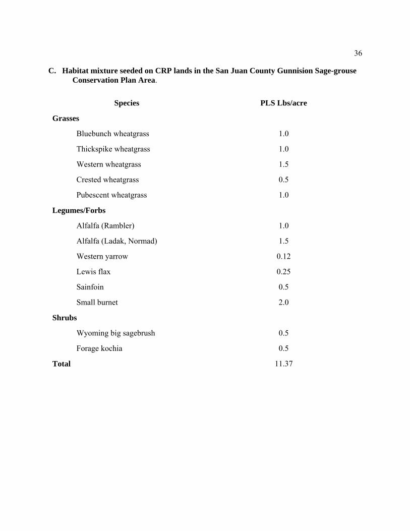
C. Habitat mixture seeded on CRP lands in the San Juan County Gunnision Sage-grouse Conservation Plan Area.
Species
PLS Lbs/acre
Grasses
Bluebunch wheatgrass
1.0
Thickspike wheatgrass
1.0
Western wheatgrass
1.5
Crested wheatgrass
0.5
Pubescent wheatgrass
1.0
Legumes/Forbs
Alfalfa (Rambler)
1.0
Alfalfa (Ladak, Normad)
1.5
Western yarrow
0.12
Lewis flax
0.25
Sainfoin
0.5
Small burnet
2.0
Shrubs
Wyoming big sagebrush
0.5
Forage kochia
0.5
Total
11.37

37
D. Gunnison Sage-grouse Conservation Brochure

38
E. Summary of Gunnison Sage-grouse Conservation Projects and Costs Project Location Acres Cost $ Status Wildlife Watering Facility Adams Easement N/A 3,151 Completed Pipeline Electric/Conventional Fencing for Livestock Exclusion Adams Easement N/A 20,034 Completed Brush Management/ Rabbit Adams Easement 150 1,800 Completed Prescribed Grazing Adams Easement 1,280 - Completed Prescribed Grazing Adams Easement 640 - 2004 Wildlife Watering Facility Adams Easement N/A 1,744 Completed Solar Pump Wildlife Water Development Adams Easement N/A 3,244 Completed and Tanks Range Planting Adams Easement 100 1,703 Completed Upland Habitat Improvement Adams Easement 2,240 - Ongoing

39
Wildlife Guzzlers Study Area N/A 1, 800 Completed Brush Management Adams Easement 240 7,600 Completed Range Planting Adams Easement 240 4,258 Completed Brush Management Adams Easement 80 1,722 2004 Range Planting Adams Easement 80 1,022 2004 Conservation Reserve Program Conservation Area 36,825 1,222,728 Completed Conservation Easement Adams Property 2,244 336,600 Completed