gunditjmara native title claim - landpedia
TRANSCRIPT

IN THE FEDERAL COURT OF AUSTRALIA VICTORIA DISTRICT REGISTRY
VID6004 of 1998 VID655 of 2006
B E T W E E N:
JOHN MAXWELL LOVETT, CHRISTINA ISABEL SAUNDERS, EUGENE SAMUEL LOVETT AND GEORGINA HELEN REDFERN ON BEHALF OF THE GUNDITJMARA PEOPLE
Applicant in VID6004 of 1998
EUGENE SAMUEL LOVETT AND MARIE THORNHILL ON BEHALF OF THE GUNDITJMARA PEOPLE
Applicant in VID655 of 2006
and
THE STATE OF VICTORIA AND OTHERS Respondents
ORDER
JUDGE MAKING ORDER: NORTH J
WHERE MADE: Mt ECCLES, VICTORIA
DATE OF ORDER: 30 MARCH 2007
VID 6004 of 1998
JOHN MAXWELL LOVETT, CHRISTINA ISABEL SAUNDERS, EUGENE SAMUEL LOVETT AND GEORGINA HELEN REDFERN ON BEHALF OF THE GUNDITJMARA PEOPLE
Applicant
STATE OF VICTORIA AND OTHERS Respondents
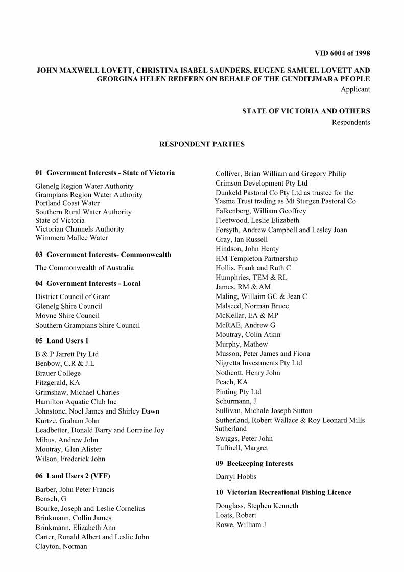
RESPONDENT PARTIES
01 Government Interests - State of Victoria
Glenelg Region Water Authority Grampians Region Water Authority Portland Coast Water Southern Rural Water Authority State of Victoria Victorian Channels Authority Wimmera Mallee Water
03 Government Interests- Commonwealth
The Commonwealth of Australia 04 Government Interests - Local
District Council of Grant Glenelg Shire Council Moyne Shire Council Southern Grampians Shire Council 05 Land Users 1
B & P Jarrett Pty Ltd Benbow, C.R & J.L Brauer College Fitzgerald, KA Grimshaw, Michael Charles Hamilton Aquatic Club Inc Johnstone, Noel James and Shirley Dawn Kurtze, Graham John Leadbetter, Donald Barry and Lorraine Joy Mibus, Andrew John Moutray, Glen Alister Wilson, Frederick John 06 Land Users 2 (VFF)
Barber, John Peter Francis Bensch, G Bourke, Joseph and Leslie Cornelius Brinkmann, Collin James Brinkmann, Elizabeth Ann Carter, Ronald Albert and Leslie John Clayton, Norman
Colliver, Brian William and Gregory Philip Crimson Development Pty Ltd Dunkeld Pastoral Co Pty Ltd as trustee for the Yasme Trust trading as Mt Sturgen Pastoral Co Falkenberg, William Geoffrey Fleetwood, Leslie Elizabeth Forsyth, Andrew Campbell and Lesley Joan Gray, Ian Russell Hindson, John Henty HM Templeton Partnership Hollis, Frank and Ruth C Humphries, TEM & RL James, RM & AM Maling, Willaim GC & Jean C Malseed, Norman Bruce McKellar, EA & MP McRAE, Andrew G Moutray, Colin Atkin Murphy, Mathew Musson, Peter James and Fiona Nigretta Investments Pty Ltd Nothcott, Henry John Peach, KA Pinting Pty Ltd Schurmann, J Sullivan, Michale Joseph Sutton Sutherland, Robert Wallace & Roy Leonard Mills Sutherland Swiggs, Peter John Tuffnell, Margret 09 Beekeeping Interests
Darryl Hobbs 10 Victorian Recreational Fishing Licence
Douglass, Stephen Kenneth Loats, Robert Rowe, William J

11 Victorian Commercial Fishing Licence
Abdiva Investments Pty Ltd Carson, Christopher Wayne Crapper, Tony Phillip Crowther, Rodney Ernest Double Eight Golden Eels' (Australia) Pty Ltd Eels Australis Pty Ltd Hollis, Gregory William Humphries, Dean Anthony Johnston, David Malcolm and Elizabeth Ann Le Page, Brampton and Jacqueline Linda Levings, Andrew LJ & SA Plummer Fishing Pty Ltd McDonald, Roderick Moncrieff, Alan and Tanya Nathan, Steven James Plummer, Glen Edward Plummer, Phillip A Price, Peter R Quarrell, Graham Richard Sandow, Peter William Smith, Richard John Thiele, Murray Edward Tober, Bert Davey Trymore Investments Pty Ltd
14 Forestry
Hancock Victorian Plantations Pty Ltd 15 Recreational Land Users
Cleary, David 21 Public Access 1
Port Of Portland Pty Ltd 22 Public Access 2
Powercor Australia Limited 23 Public Access 3
Broadcast Australia Pty Ltd SPI Powernet Pty Ltd 24 Telecommunication
Telstra Corporation 26 Indigenous Interests 2
Framlingham Aboriginal Trust 27 Petroleum Exploration
Alcoa Portland Aluminium TMOC Exploration Pty Ltd

VID 655 of 2006
EUGENE SAMUEL LOVETT AND MARIE THORNHILL ON BEHALF OF THE GUNDITJMARA PEOPLE
Applicant
STATE OF VICTORIA AND OTHERS Respondents
RESPONDENT PARTIES
01 Government Interests - State of Victoria
State of Victoria
03 Government Interests- Commonwealth
The Commonwealth of Australia 04 Government Interests - Local
Glenelg Shire Council Moyne Shire Council Southern Grampians Shire Council 05 Land Users 1
Dennis, Bryan William Kenneth Luke & Celia Elizabeth Somerville Luke Lewis, Gregory & Glenda Tipple, Kathryn & Kenneth Tonkin, Arnold John 06 Land Users 2 (VFF)
Crawford, Barry Keith and Patricia Margret 09 Beekeeping Interests
Falkenberg, William Geoffrey 10 Victorian Recreational Fishing Licence
Loats, Robert Mansell, Colin on behalf of the Far West Anglers' Association Rowe, William 11 Victorian Commercial Fishing Licence
88 Golden Eels Pty Ltd (Aust) Abdiva Investments Pty Ltd Carson, Christopher Wayne Crowther, Rodney Ernest Humphries, DA & JE Johnston, David Malcolm and Elizabeth Ann LJ & SA Plummer Fishing Pty Ltd McDonald, Roderick Osborne, Kenneth John Plummer, Glen Edward Plummer, Phillip A Sandow, Peter William Thiele, Murray Edward Trymore Investments Pty Ltd Western Victorian Eel Growers Group Pty Ltd 13 Forestry 1
New Forests Asset Management Pty Ltd 14 Forestry 2
Hancock Victorian Plantations Pty Ltd 15 Recreational Land Users
Cleary, David 22 Public Access 2
Powercor Australia Limited 24 Telecommunication
Telstra Corporation Limited 27 Petroleum Exploration
Alcoa Portland Aluminium TMOC Exploration Pty Ltd
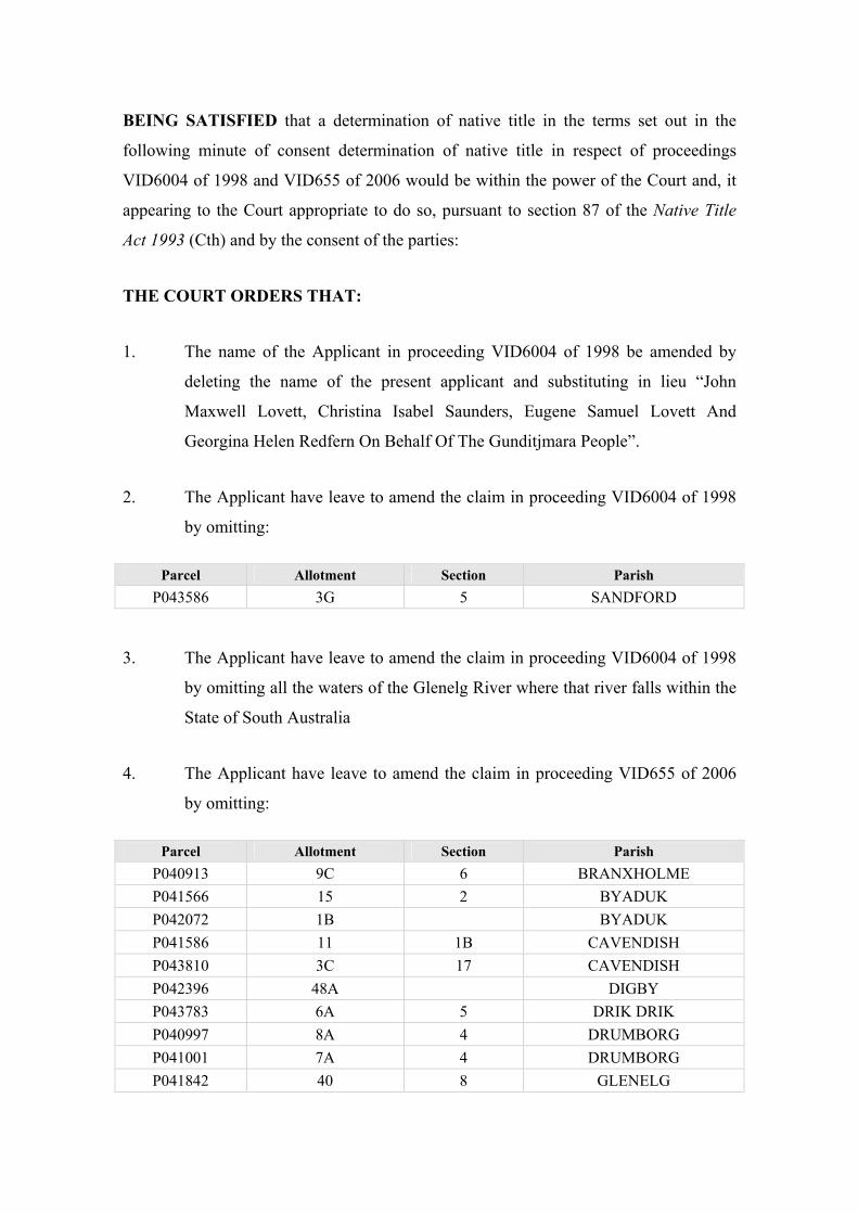
BEING SATISFIED that a determination of native title in the terms set out in the
following minute of consent determination of native title in respect of proceedings
VID6004 of 1998 and VID655 of 2006 would be within the power of the Court and, it
appearing to the Court appropriate to do so, pursuant to section 87 of the Native Title
Act 1993 (Cth) and by the consent of the parties:
THE COURT ORDERS THAT:
1. The name of the Applicant in proceeding VID6004 of 1998 be amended by
deleting the name of the present applicant and substituting in lieu “John
Maxwell Lovett, Christina Isabel Saunders, Eugene Samuel Lovett And
Georgina Helen Redfern On Behalf Of The Gunditjmara People”.
2. The Applicant have leave to amend the claim in proceeding VID6004 of 1998
by omitting:
Parcel Allotment Section Parish P043586 3G 5 SANDFORD
3. The Applicant have leave to amend the claim in proceeding VID6004 of 1998
by omitting all the waters of the Glenelg River where that river falls within the
State of South Australia
4. The Applicant have leave to amend the claim in proceeding VID655 of 2006
by omitting:
Parcel Allotment Section Parish P040913 9C 6 BRANXHOLME P041566 15 2 BYADUK P042072 1B BYADUK P041586 11 1B CAVENDISH P043810 3C 17 CAVENDISH P042396 48A DIGBY P043783 6A 5 DRIK DRIK P040997 8A 4 DRUMBORG P041001 7A 4 DRUMBORG P041842 40 8 GLENELG

6
P041842 40 8 GLENELG P041104 36 A HAMILTON NORTH P041105 36A A HAMILTON NORTH P041106 37 A HAMILTON NORTH P041117 6A 26 HAMILTON NORTH P043412 1A 4 HOTSPUR P041261 3 16 MACARTHUR P041261 3 16 MACARTHUR P042307 6C 2 MOCAMBORO P041908 4E 3 MYAMYN P042970 21A 2 NARRAWONG P042970 21A 2 NARRAWONG P041347 3D 13 PORTLAND P041348 3E 13 PORTLAND P041348 3E 13 PORTLAND P041349 3F 13 PORTLAND P041355 5D 3 PORTLAND P043584 3F 5 SANDFORD P043584 3F 5 SANDFORD P043624 3D 4 TARRAGAL
5. The State of South Australia is granted leave to withdraw as a party from
proceeding VID6004 of 1998.
6. There be a determination of native title in proceedings VID6004 of 1998 and
VID655 of 2006 in terms of the determination of native title that follows, in
relation to the land and waters covered by the proceedings within the location
identified in Schedule 1 of the determination.
7. Gunditj Mirring Traditional Owners Aboriginal Corporation shall hold the
determined native title in trust for the native title holders pursuant to s56(2) of
the Native Title Act 1993 (Cth).
8. There be no order as to costs.
Date the entry is stamped: 30 March 2007
Justice A.M. North
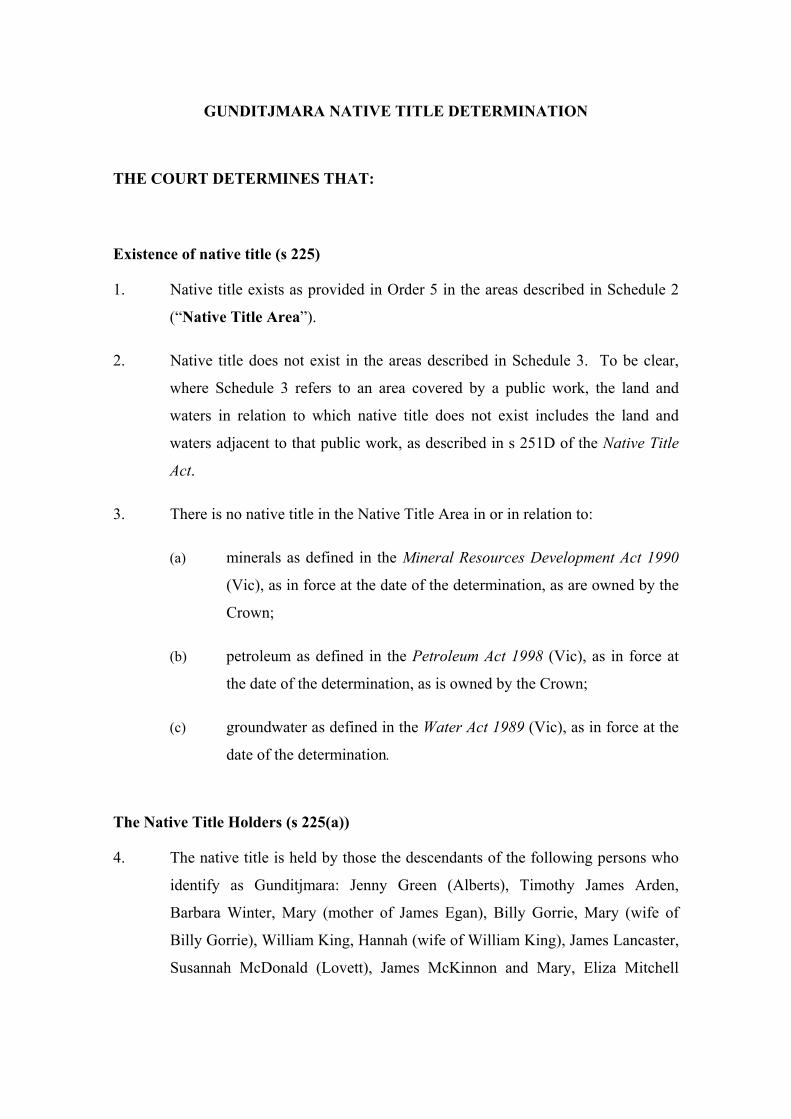
GUNDITJMARA NATIVE TITLE DETERMINATION
THE COURT DETERMINES THAT:
Existence of native title (s 225)
1. Native title exists as provided in Order 5 in the areas described in Schedule 2
(“Native Title Area”).
2. Native title does not exist in the areas described in Schedule 3. To be clear,
where Schedule 3 refers to an area covered by a public work, the land and
waters in relation to which native title does not exist includes the land and
waters adjacent to that public work, as described in s 251D of the Native Title
Act.
3. There is no native title in the Native Title Area in or in relation to:
(a) minerals as defined in the Mineral Resources Development Act 1990
(Vic), as in force at the date of the determination, as are owned by the
Crown;
(b) petroleum as defined in the Petroleum Act 1998 (Vic), as in force at
the date of the determination, as is owned by the Crown;
(c) groundwater as defined in the Water Act 1989 (Vic), as in force at the
date of the determination.
The Native Title Holders (s 225(a))
4. The native title is held by those the descendants of the following persons who
identify as Gunditjmara: Jenny Green (Alberts), Timothy James Arden,
Barbara Winter, Mary (mother of James Egan), Billy Gorrie, Mary (wife of
Billy Gorrie), William King, Hannah (wife of William King), James Lancaster,
Susannah McDonald (Lovett), James McKinnon and Mary, Eliza Mitchell

8
(Saunders), John Henry Rose, Lucy Sutton, James Sutton and Mary, Louisa
(mother of Agnes and Alex Taylor), and Andrew Winter.
The nature and extent of native title rights and interests (s 225(b))
and exclusiveness of native title (s 225(e))
5. Subject to Orders 6-9, the native title that exists in the Native Title Area
(“native title rights and interests”) consists of the non-exclusive:
(a) right to have access to or enter and remain on the land and waters;
(b) right to camp on the land and waters landward of the high water mark
of the sea;
(c) right to use and enjoy the land and waters;
(d) right to take the resources of the land and waters; and
(e) right to protect places and areas of importance on the land and waters.
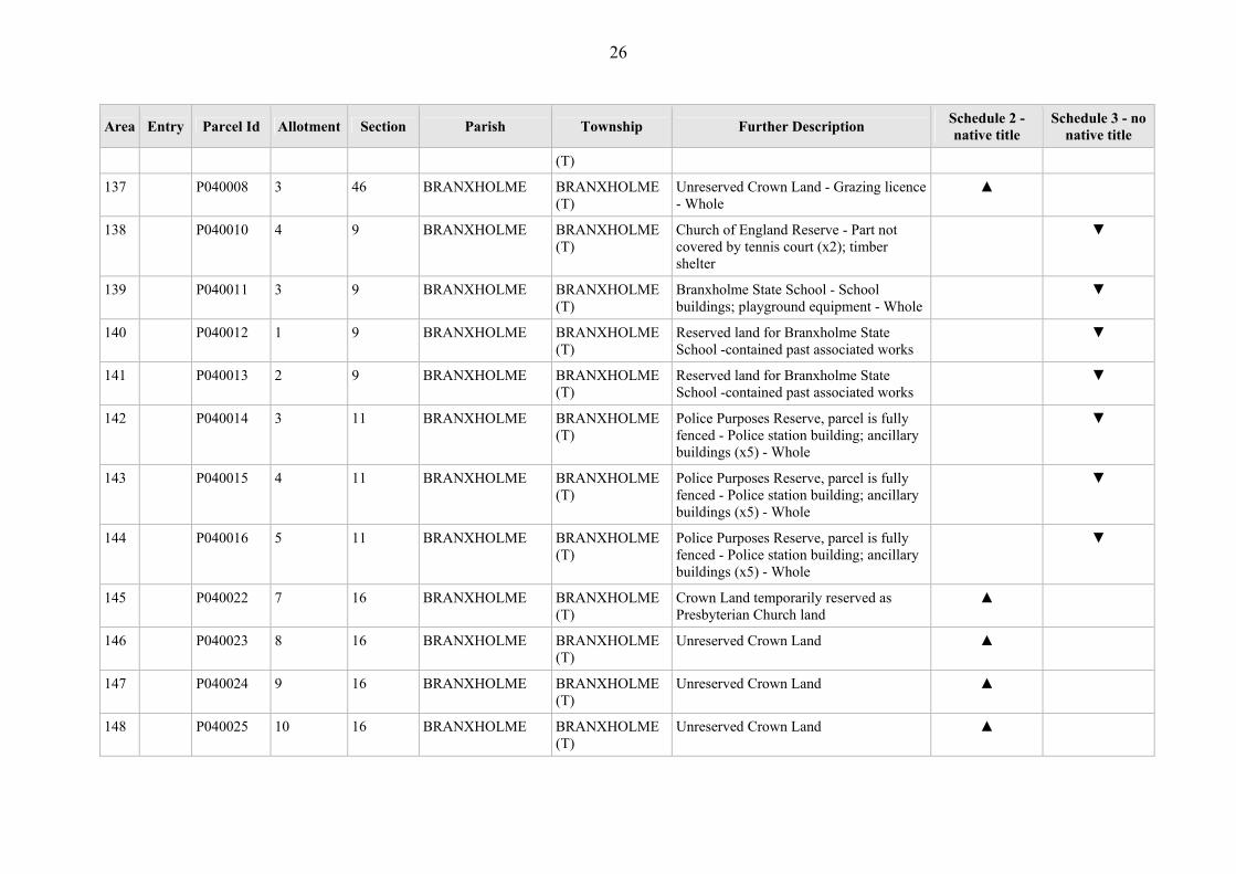
6. Insofar as the native title rights and interests may provide a right to take water
from waterways, that right is limited to a right to take water from waterways
for domestic and ordinary use.
7. The right in Order 5(e) does not entail a right to use physical force in a manner
that would be unlawful.
8. The native title rights and interests do not confer possession, occupation, use
and enjoyment of the land and waters on the native title holders to the
exclusion of all others.
9. The native title rights and interests are subject to and exercisable in accordance
with:
(a) the traditional laws and customs of the native title holders;
(b) the laws of the State in which the land or waters concerned are
situated and of the Commonwealth, including the common law.
9
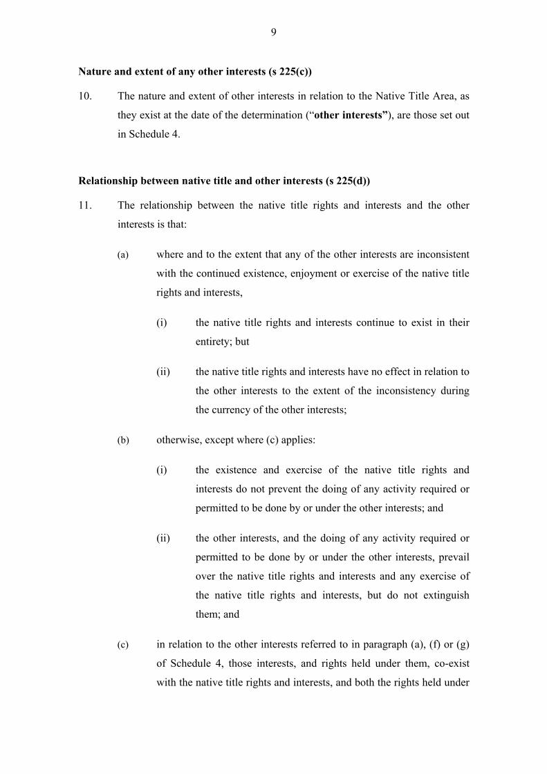
Nature and extent of any other interests (s 225(c))
10. The nature and extent of other interests in relation to the Native Title Area, as
they exist at the date of the determination (“other interests”), are those set out
in Schedule 4.
Relationship between native title and other interests (s 225(d))
11. The relationship between the native title rights and interests and the other
interests is that:
(a) where and to the extent that any of the other interests are inconsistent
with the continued existence, enjoyment or exercise of the native title
rights and interests,
(i) the native title rights and interests continue to exist in their
entirety; but
(ii) the native title rights and interests have no effect in relation to
the other interests to the extent of the inconsistency during
the currency of the other interests;
(b) otherwise, except where (c) applies:
(i) the existence and exercise of the native title rights and
interests do not prevent the doing of any activity required or
permitted to be done by or under the other interests; and
(ii) the other interests, and the doing of any activity required or
permitted to be done by or under the other interests, prevail
over the native title rights and interests and any exercise of
the native title rights and interests, but do not extinguish
them; and
(c) in relation to the other interests referred to in paragraph (a), (f) or (g)
of Schedule 4, those interests, and rights held under them, co-exist
with the native title rights and interests, and both the rights held under

10
the other interests and the native title rights must be exercised
reasonably.
Definitions and interpretation
12. In this determination, including its schedules, unless the contrary intention
appears, words and expressions have the same meaning as they have in Part 15
of the Native Title Act and:
“Crown” means the Crown in right of Victoria or the Crown in right of the
Commonwealth, as the case requires;
“Determination Area” means the land and waters referred to in Orders 1 and
2, being the land and waters of the areas described in the
Determination Area Table in Schedules 2 and 3, and being certain
lands and waters within the location described in Schedule 1;
“land” and “waters” respectively have the same meanings as in the Native Title
Act;
“Native Title Act” means the Native Title Act 1993 (Cth);
“Native Title Area” means the areas referred to in Order 1;
“native title rights and interests” means those rights and interests set out in
Order 5 always as subject to Orders 6 -9;
“other interests” means the interests referred to in Order 10, being the
interests set out in Schedule 4;
“public rights” means the other interests identified in paragraphs (a), (f) and
(g) of Schedule 4;
“public work” has the same meaning as in s 253 of the Native Title Act and, in
relation to any public work described in the Determination Area Table,
includes any adjacent land or waters referred to in s 251D of the Native
Title Act;

11
“waterway” has the same meaning as in s 3 of the Water Act 1989 (Vic) as in force
at the date of this determination.
13. In this determination including its schedules, in the event of an inconsistency
between a description of an area in a schedule and the depiction of that area on
the Determination Area Map in Schedule 5, the written description shall
prevail.
12
SCHEDULE 1 – Location of the Determination Area
External Perimeter within which the various areas comprising the Determination
Area are located
The Determination Area is located wholly within the following locations only and
comprises the particular allotments and areas identified in the Determination Area Table
and as generally shown on the Determination Area Map in Schedule 5.
Location 1
Commencing at the intersection of the boundary between the Shire of Glenelg and the
Shire of Moyne and the mean high water mark (coast) and extending south to a point
100m seaward of the mean low water mark; then generally westerly and generally
north-westerly along a buffer 100m seaward of the mean low water mark to Longitude
140.988031° east. Then north to the intersection with a point 100m west of the top of
the west bank of the Oxbow lake, then generally north-easterly along a buffer 100m
west of the top of the west bank to intersect a 100m buffer west of the top of the west
bank of the Glenelg river then generally north-westerly along a buffer 100m west of the
top of the west bank of that river to the South Australian / Victorian border; then north
along that border to a point 100m north of the top of the north bank of the Glenelg
River; then upstream along a buffer 100m north of the top of the north bank of that river
to the intersection with a buffer 100m west of the top of the west bank of the mouth of
the Wannon river; then upstream, along a buffer 100m north of the top of the north bank
of the Wannon River to Longitude 142.325156° east; then generally southerly through
the following coordinate points.
Longitude Latitude (east) (south)
142.324971 37.647563142.324624 37.651086142.324461 37.652733
Then south to the northern boundary of the Glenelg Highway road reserve at Longitude
142.324413° east, then generally southwesterly along the boundary of that highway
reserve to the centreline with the Tarrington-Strathkeller Road; Then southerly along

13
that road to the centreline of the Hamilton Highway; Then easterly along that highway
to with the centreline of the Yatchaw Road; Then southerly and generally south-
westerly along that road to the centreline of the Research Station Road; Then westerly
along that road to the centreline of the Mount Napier Road; Then south-south-easterly
along that road for approximately 3 kms to the intersection of the Mount Napier Road
and the centreline of Murroa-Buckley Swamp Road in Buckley Swamp; Then south-
south-westerly to the summit of Mount Napier; Then south-south-westerly to the
intersection of the centreline of the Byaduck-Penhurst Road and the centreline of the
Macarthur-Warrakook Road; Then southerly along the Macarthur-Warrabkook Road to
the centreline of the Macharthur-Penhurst Road; Then generally south-westerly along
that road for approximately 5.5 kms to the centreline of the Macarthur-Hawkesdale
Road; Then generally south-easterly along that road for approximately 800 metres to the
centreline of the Hamilton-Port Fairy Road; Then south-westerly along that road for
approximately 450 metres to the centreline of the Eumeralla River in Macarthur; Then
generally southerly, westerly and again southerly along that river to the centreline of the
Portland-Woolsthorpe Road; Then generally south-westerly and southerly along that
road to the centreline of Condons Road; Then southerly along that road to the centreline
of the Princes Highway; Then generally north-westerly along that highway to intersect
the boundaries of the Shire of Glenelg and the Shire of Moyne; Then generally
southerly along those boundaries to the commencement point.
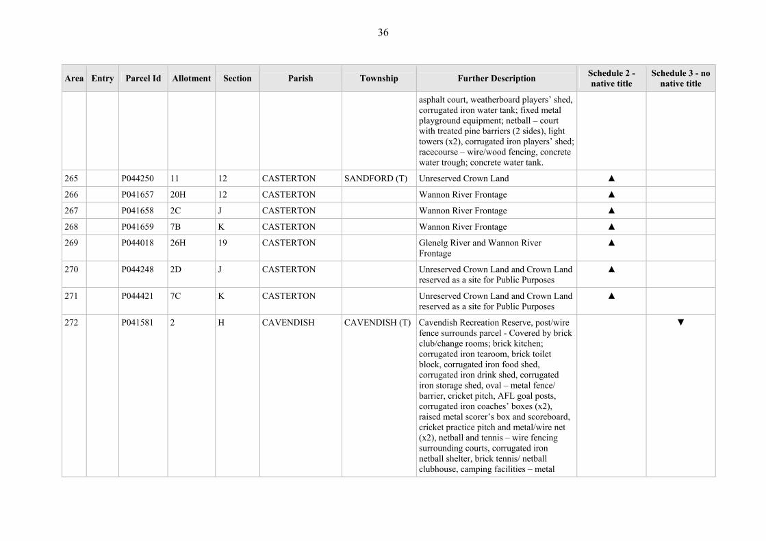
Notes
Reference Datum
Geographical coordinates have been provided by the NNTT Geospatial Unit and are
referenced to the Geocentric Datum of Australian 1994 (GDA94), in decimal degrees
and are based on the spatial reference data acquired from the various custodians at the
time.
Reference Data and Source:
• Mean Low Water Mark/Mean High Water Mark based on coastline data sourced
from Geoscience Australia (1998) and Dept of Sustainability & Environment
VIC (October 2006).
14
• River data based on Vicmap Hydro vector data (1:25,000) sourced from Dept of
Sustainability & Environment, VIC (Oct 2006).
• State borders based on Vicmap Shared vector data (1:25,000) sourced from Dept of
Sustainability and Environment.
• Cadastre information based upon Vicmap Property sourced from the Dept of
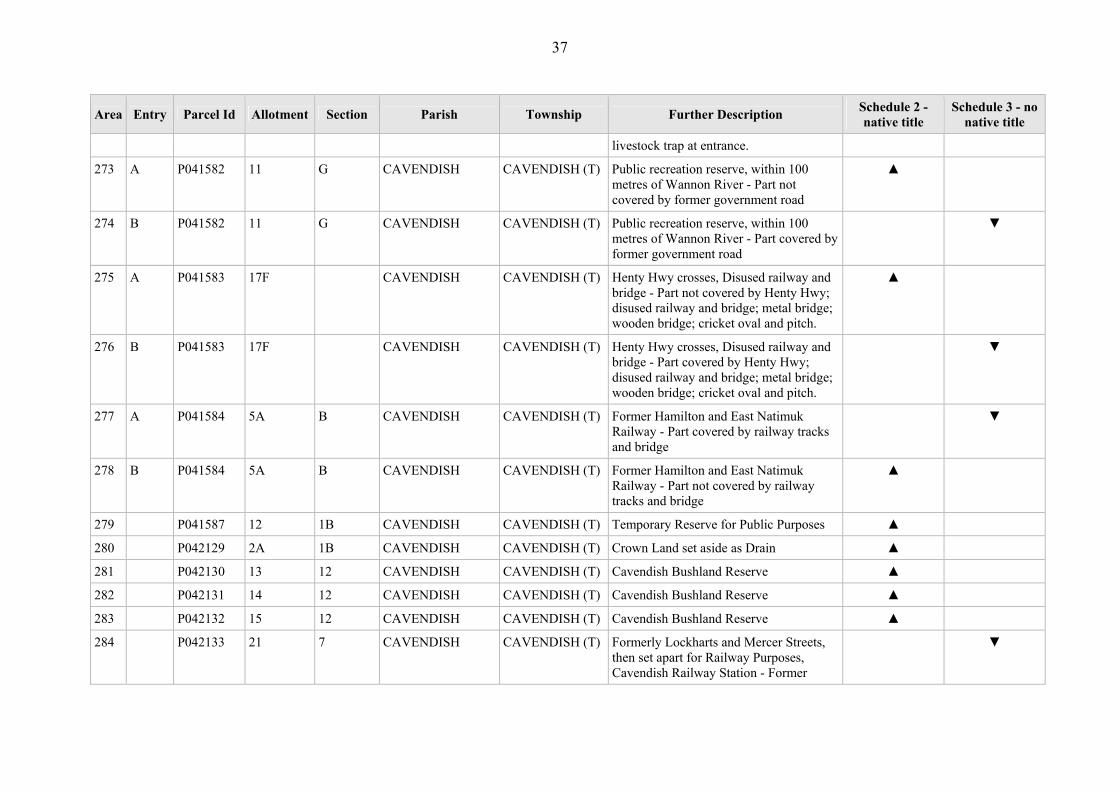
Sustainability and Environment (Oct 2006).
• Road information based upon Vicmap Transport vector data (1:25,000) sourced
from the Dept of Sustainability and Environment (Oct 2006).
• Shire boundary data based on LGA data sourced from the Dept of Sustainability and
Environment (Aug 2006)
• Area 9 in Schedule 4 of the Aboriginal and Torres Strait Islander Heritage
Protection Regulations 1984 (Cth)
15
SCHEDULES 2 and 3 – Determination Area & where native title does and does
not exist
Determination Area
The Determination Area comprises the land and waters of the areas described in the
Determination Area Table that follows and shown generally on the maps.
Note 1: In the Determination Area Table areas are generally identified using parcel numbers and
further described by official descriptions of allotment and section identifiers and parish and (where
applicable) township names. Parcel numbers are internal references used by the State of Victoria for
convenience and are shown on the maps. Where still further description appears useful and convenient,
or is necessary to distinguish between areas where native title exists and areas where it does not (as to
which, see Note 2), such further description is also included in the column headed “Further Description”.
Note 2: In many instances native title exists over part of a parcel but has been extinguished over the
balance of the parcel. In those instances, the parcel has two or more separate entries in the Determination
Area Table; distinguished by adding “A” and “B” respectively (and further letters if necessary) in the
column headed “Entry” next to the relevant parcel reference. The letter “A” is used for an area where
native title exists. The letter “B” is used for the part of a parcel where native title does not exist. Further
entries labelled with subsequent letters are used where multiple entries are need to identify the parts of a
parcel where native title does not exist. Where an entry refers to part of a parcel where native title has
been extinguished, the column headed “Further Description” contains a short reference to the act or fact
that has caused the extinguishment of the native title over those areas.
Note 3: The spatial extent of extinguishment has not been surveyed or otherwise fixed but is to be
determined by the spatial extent of the act or fact referred to under the column headed “Further
Description” (and which, in the case of a public work, will include the land and waters referred to in
s 251D of the Native Title Act). In a given parcel it is a possibility that, as a result of the spatial extent of
an act or fact being determined, native title may be found to have been extinguished over the entire
parcel.
Note 4: In the Determination Area Table, the numbers in the first column against each row are
sequential and for convenience of reference only.
Note 5: For the avoidance of doubt, there is only a determination in respect of the land and waters
identified in Schedules 2 and 3 to the extent those land and waters or parts thereof fall within the
boundary described in Schedule 1.

16
Where native title exists – Schedule 2, Order 1
Subject to Orders 6 to 9, native title exists in the land and waters of the areas and parts
of areas listed as being in Schedule 2 in the Determination Area Table that follows and
shown generally on the maps.
Where native title does not exist – Schedule 3, Order 2
Native title does not exist, because it has been wholly extinguished, in the land and
waters of the areas and parts of areas listed as being in Schedule 3 in the Determination
Area Table that follows and shown generally on the maps.

DETERMINATION AREA TABLE FOR PART A OF PROCEEDINGS VID6004 OF 1998 and VID655 OF 2006
Table of Areas referred to in Schedules 2 and 3 (See notes in Schedules 2 and 3)
Area Entry Parcel Id Allotment Section Parish Township Further Description Schedule 2 - native title
Schedule 3 - no native title
1 P041048 10C C ANNYA Unreserved Crown Land, watercourse ▲
2 P041049 5A C ANNYA Unreserved Crown Land ▲
3 P041050 6A B ANNYA Reserved Forest - Prior Freehold grant - Whole
▼
4 A P041051 21 A ANNYA Reserved Forest - Part not covered by Prior Freehold grant
▲
5 B P041051 21 A ANNYA Reserved Forest - Part covered by Prior Freehold grant
▼
6 P041052 13A A ANNYA Water Reserve ▲
7 P040834 3B 1 ARDONACHIE Condah Swamp (No 1) Drainage Area - covered by drain - Whole
▼
8 P040835 9A 1 ARDONACHIE Condah Swamp (No 1) Drainage Area - covered by drain- Whole
▼
9 P040836 13A 14 ARDONACHIE Condah Swamp (No 1) Drainage Area - covered by drain - Whole
▼
10 P040837 10A 15 ARDONACHIE Condah Swamp (No 1) Drainage Area - covered by drain - Whole
▼
11 P040838 1A 13A ARDONACHIE Mt Eccles National Park ▲
12 A P040841 1F 5 ARDONACHIE Water Reserve - Part not covered by road ▲
13 B P040841 1F 5 ARDONACHIE Water Reserve - part covered by road ▼
14 P040843 5A 9 ARDONACHIE Unreserved crown land ▲

18
Area Entry Parcel Id Allotment Section Parish Township Further Description Schedule 2 - native title
Schedule 3 - no native title
15 P043834 7C 8 ARDONACHIE Golf course - Prior Freehold grant - Whole
▼
16 P043991 1 15 ARDONACHIE Unreserved Crown Land, formerly part of Lake Condah Swamp - Prior Scheduled Interest - Whole
▼
17 P043992 1A 15 ARDONACHIE Unreserved Crown Land, formerly part of Lake Condah Swamp - Prior Scheduled Interest - Whole
▼
18 P043993 7A 14 ARDONACHIE Unreserved Crown Land, formerly part of Lake Condah Swamp - Prior Scheduled Interest - Whole
▼
19 P365506 3A 13A ARDONACHIE Mt Eccles National Park ▲
20 P365507 3B 13A ARDONACHIE Mt Eccles National Park ▲
21 P365508 12 ARDONACHIE Mt Eccles National Park- Prior Scheduled Interest -Whole
▼
22 P044212 1B 11 AUDLEY Crown Land forming part of operational Crown Land forming part of operational Ararat to Portland Railway - Part covered by railway track
▼
23 P041495 55E BAHGALLAH Glenelg River Frontage ▲
24 P041496 45D BAHGALLAH ▲
25 P041497 45E BAHGALLAH 100 Metre Buffer, Glenelg River ▲
26 P041498 45F BAHGALLAH 100 Metre Buffer, Glenelg River ▲
27 P041499 45G BAHGALLAH Glenelg River Frontage ▲
28 P041500 45H BAHGALLAH Glenelg River Frontage ▲
29 P041501 45J BAHGALLAH 100 Metre Buffer, Glenelg River ▲
30 P041510 29C BAHGALLAH 100 Metre Buffer, Glenelg River ▲

19
Area Entry Parcel Id Allotment Section Parish Township Further Description Schedule 2 - native title
Schedule 3 - no native title
31 P041511 30N BAHGALLAH Glenelg River Frontage ▲
32 A P041514 30M BAHGALLAH Glenelg River Frontage - Part not covered by overhead high voltage electricity power line; Killara Bridge
▲
33 B P041514 30M BAHGALLAH Glenelg River Frontage - Part covered by overhead high voltage electricity power line; Killara Bridge.
▼
34 A P041515 37E BAHGALLAH Glenelg River Frontage - Part not covered by overhead high voltage electricity power line.
▲
35 B P041515 37E BAHGALLAH Glenelg River Frontage - Part covered by overhead high voltage electricity power line.
▼
36 P041516 37D BAHGALLAH 100 Meter Buffer, Glenelg River- Prior Scheduled Interest - Whole
▼
37 P041518 44G BAHGALLAH 100 Metre Buffer, Glenelg River ▲
38 P370288 2001 BAHGALLAH Glenelg River Frontage ▲
39 P041053 19A BALROOK Reserved Forest ▲
40 P041054 19B BALROOK Formerly State Forest ▲
41 P041055 19C BALROOK Formerly State Forest ▲
42 P041056 19D BALROOK Formerly State Forest ▲
43 A P041057 19E BALROOK National Park - Part not covered by road ▲
44 B P041057 19E BALROOK National Park - Part covered by road ▼
45 P041058 10A BALROOK Reserved Forest ▲
46 P041059 34 BALROOK Balrook Natural Interest Reserve ▲
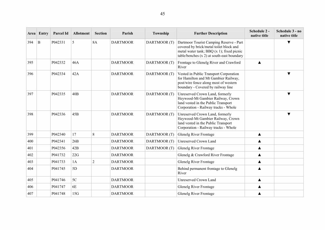
47 P041062 41B BALROOK Lower Glenelg National Park ▲
48 P042870 11 B BALROOK Unreserved Crown Land ▲

20
Area Entry Parcel Id Allotment Section Parish Township Further Description Schedule 2 - native title
Schedule 3 - no native title
49 P044375 37A BALROOK Unreserved Crown Land ▲
50 A P365789 38A BALROOK Pines Landing, Lower Glenelg National Park, includes frontage to Glenelg River - Part not covered by fixed table/seating on concrete slab; water tank and timber toilet block on concrete slab; timber boat launch; timber jetty
▲
51 B P365789 38A BALROOK Pines Landing, Lower Glenelg National Park, includes frontage to Glenelg River - Part covered by fixed table/seating on concrete slab; water tank and timber toilet block on concrete slab; timber boat launch; timber jetty.
▼
52 P365792 1A BALROOK Glenelg River Frontage, part of Lower Glenelg-
▲
53 P040862 80C BESSIEBELLE Reserved Forest ▲
54 P040863 81 BESSIEBELLE Reserved Forest ▲
55 P040864 82 BESSIEBELLE Reserved Forest ▲
56 P040865 83 BESSIEBELLE Reserved Forest ▲
57 P040866 86 BESSIEBELLE Reserved Forest ▲
58 P040867 78 BESSIEBELLE Reserved Forest ▲
59 P040868 24B1 BESSIEBELLE Unreserved Crown Land ▲
60 P040870 7B BESSIEBELLE Unreserved Crown Land ▲
61 P040871 8 BESSIEBELLE Reserved Forest- Prior Scheduled Interest - Whole
▼
62 P044021 39A BESSIEBELLE Unreserved Crown Land ▲
63 A P044140 66D BESSIEBELLE Part covered by Taylors Road ▼
64 B P044140 66D BESSIEBELLE Part not covered by Taylors Road ▲

21
Area Entry Parcel Id Allotment Section Parish Township Further Description Schedule 2 - native title
Schedule 3 - no native title
65 P044474 63D BESSIEBELLE Darlots Creek Frontage ▲
66 P374686 2001 BESSIEBELLE Unreserved Crown Land and part Crown Land reserved as a site for Public Purposes
▲
67 P043181 3A BOCHARA WANNON (T) Crown Land reserved for Public Recreation - Prior Freehold grant - Whole
▼
68 P043199 44 BOCHARA WANNON (T) Wannon River Frontage ▲
69 P043200 3B BOCHARA WANNON (T) Wannon River Frontage ▲
70 P043200 3B BOCHARA WANNON (T) Wannon River Frontage ▲
71 A P043201 43 BOCHARA WANNON (T) Wannon River Frontage - Part not covered by picnic table
▲
72 B P043201 43 BOCHARA WANNON (T) Wannon River Frontage - Part covered by picnic table
▼
73 P043202 40 BOCHARA WANNON (T) Public Recreation Reserve and part Unreserved Crown Land
▲
74 A P043203 39 BOCHARA WANNON (T) Wannon Falls Oval - Part not covered by football oval
▲
75 B P043203 39 BOCHARA WANNON (T) Wannon Falls Oval - Part covered by football oval
▼
76 A P043204 41 BOCHARA WANNON (T) Wannon Falls Oval, post/wire fence at eastern and southern boundaries - Part not covered by football oval
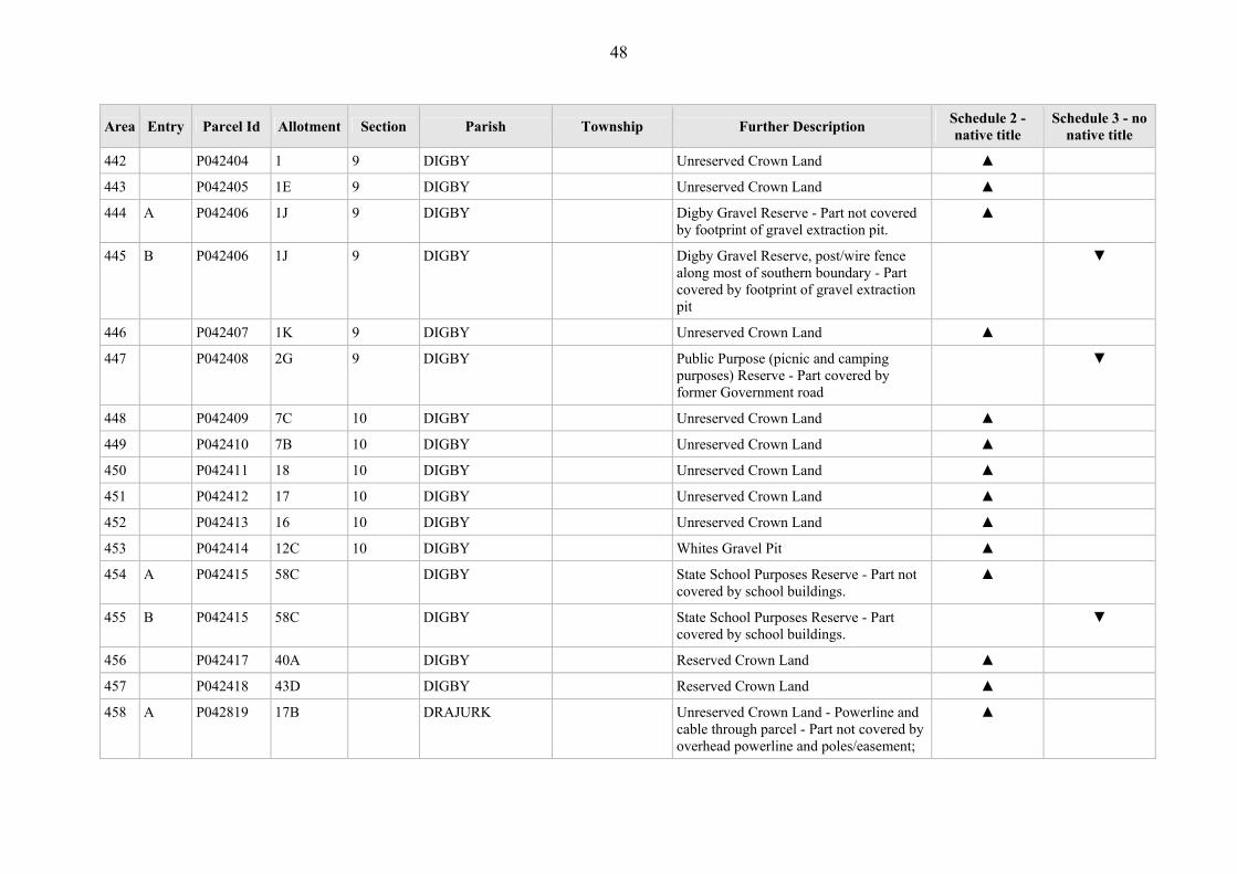
▲
77 B P043204 41 BOCHARA WANNON (T) Wannon Falls Oval, post/wire fence at eastern and southern boundaries - Part covered by football oval
▼
78 P043205 42 BOCHARA WANNON (T) Crown Land reserved as a site for Public Purposes - Prior Freehold grant and government road - Whole
▼

22
Area Entry Parcel Id Allotment Section Parish Township Further Description Schedule 2 - native title
Schedule 3 - no native title
79 P043207 13A BOCHARA WANNON (T) Crown Land reserved as a site for Public Purposes
▲
80 P043208 38 BOCHARA WANNON (T) Crown Land reserved as a site for Public Purposes
▲
81 P043209 38A BOCHARA WANNON (T) Crown Land reserved as a site for Public Purposes - Part not covered by road
▲
82 P366509 42A BOCHARA WANNON (T) Crown Land reserved as a site for Public Purposes - Part covered by road
▼
83 A P040874 1E 1B BOCHARA Wannon River Frontage - Part not covered by disused wooden railway bridge
▲
84 B P040874 1E 1B BOCHARA Wannon River Frontage - Part covered by disused wooden railway bridge
▼
85 P040875 1D 1B BOCHARA Wannon River Frontage ▲
86 P040876 1C 2A BOCHARA Wannon River Frontage ▲
87 A P040877 3B 4A BOCHARA Nigretta Falls Reserve - Part not covered by brick toilet block on concrete block; timber viewing platform; stone picnic area; steel windmill connected to water tank / stand; fixed timber table/ seating
▲
88 B P040877 3B 4A BOCHARA Nigretta Falls Reserve - Part covered by brick toilet block on concrete block; timber viewing platform; stone picnic area; steel windmill connected to water tank / stand; fixed timber table/ seating
▼
89 P040878 1B 4A BOCHARA Wannon River Frontage ▲
90 P040879 1C 5A BOCHARA Wannon River Frontage ▲
91 P040880 4C 8 BOCHARA Wannon River Frontage ▲
92 P040881 7E 8 BOCHARA Wannon River Frontage ▲

23
Area Entry Parcel Id Allotment Section Parish Township Further Description Schedule 2 - native title
Schedule 3 - no native title
93 P040882 7F 8 BOCHARA Wannon River Frontage, part of Grange Burn
▲
94 P040883 5D 11 BOCHARA Bochara Sand Reserve on Sandy Creek ▲
95 A P040885 12A BOCHARA Bochara Nature Study Reserve - Part not covered by stone monument and memorial plaque - Part not covered by road
▲
96 B P040885 12A BOCHARA Bochara Nature Study Reserve - Part covered by stone monument and memorial plaque - Part not covered by road
▼
97 C P040885 12A BOCHARA Bochara Nature Study Reserve - Part covered by road - Part not covered by stone memorial monument and memorial plaque
▼
98 A P040886 12B BOCHARA Unreserved Crown Land - Part not covered by former Government road
▲
99 B P040886 12B BOCHARA Unreserved Crown Land - Part covered by former Government road
▼
100 P040887 6C 2 BOCHARA Grange Burn Frontage ▲
101 P044023 7G 8 BOCHARA Grange Burn Frontage ▲
102 P044024 1A BOCHARA Unreserved Crown Land ▲
103 P367721 1G 1B BOCHARA Crown Land reserved as a site for Public Purposes - Prior Freehold grant - Whole
▼
104 P367722 4A 1B BOCHARA Crown Land reserved as a site for Public Purposes - Prior Freehold grant - Whole
▼
105 P367723 3A 12 BOCHARA Crown Land reserved as a site for Public Purposes - Prior Freehold grant - Whole
▼
106 P367724 10B BOCHARA Crown Land reserved as a site for Public ▼
24
Area Entry Parcel Id Allotment Section Parish Township Further Description Schedule 2 - native title
Schedule 3 - no native title
Purposes - Part covered by Prior Freehold grant
107 P367724 10B BOCHARA Crown Land reserved as a site for Public Purposes - Part covered by road
▼
108 P367725 5A 13 BOCHARA Crown Land reserved as a site for Public Purposes - Prior Freehold grant - Whole
▼
109 P367726 8A 14 BOCHARA Crown Land reserved as a site for Public Purposes - Prior Freehold grant - Whole
▼
110 P367727 5A 17 BOCHARA Crown Land reserved as a site for Public Purposes (Recreation & Conservation) - Prior Freehold grant - Whole
▼
111 P367728 11A 1 BOCHARA Crown Land reserved as a site for Public Purposes (Recreation & Conservation) - Prior Freehold grant - Whole
▼
112 P374687 2001 BOCHARA Unreserved Crown Land - Prior Freehold grant - Whole
▼
113 P040888 1C 7 BOLWARRA Surrey River Frontage ▲
114 P040889 1B 7 BOLWARRA Crown Land forming part of operational Crown Land forming part of operational Ararat to Portland Railway -covered by railway track - Whole
▼
115 A P040890 3A 7 BOLWARRA Surrey River Frontage - Part not covered by 60 metre easement for powerline
▲
116 B P040890 3A 7 BOLWARRA Surrey River Frontage - Part covered by 60 metre easement for powerline.
▼
117 P040891 E3 19 BOLWARRA Surrey River Frontage ▲
118 P040892 3A 11 BOLWARRA Nine Mile Flora and Fauna Reserve ▲
119 P040893 4 11 BOLWARRA Nine Mile Flora and Fauna Reserve ▲

25
Area Entry Parcel Id Allotment Section Parish Township Further Description Schedule 2 - native title
Schedule 3 - no native title
120 P040894 25 BOLWARRA Coastline ▲
121 P040895 C1 14 BOLWARRA Crown Land reserved as Recreation Reserve - Prior Freehold grant - Whole
▼
122 P040896 E 2 BOLWARRA Unreserved Crown Land - Prior Freehold grant - Whole
▼
123 P040898 F5 2 BOLWARRA Unreserved Crown Land ▲
124 P040899 F3 2 BOLWARRA Unreserved Crown Land ▲
125 P040901 F2 2 BOLWARRA Bolwarra Quarry and Water Reserve ▲
126 P040902 F4 2 BOLWARRA Unreserved Crown Land ▲
127 P040903 22 BOLWARRA Coastline, Coastal Reserve ▲
128 P040904 23 BOLWARRA Coastline, Coastal Reserve ▲
129 P040905 24 BOLWARRA Dutton Way Foreshore Reserve - Prior Freehold grant - Whole
▼
130 P367226 24A BOLWARRA Dutton Way Foreshore Reserve - Prior Freehold grant - Whole
▼
131 P042338 3A A BRAMBURRA Crown land set aside for Water Reserve ▲
132 P040003 2 42 BRANXHOLME BRANXHOLME (T)
Unreserved Crown Land - Grazing licence - Whole
▲
133 P040004 3A 34 BRANXHOLME BRANXHOLME (T)
Crown Land reserved for Public Hall purposes - Prior Freehold grant
▼
134 P040005 3 36 BRANXHOLME BRANXHOLME (T)
Branxholme Railway Station Grounds - covered by Prior Freehold grant - covered by railway station, grounds and railway line
▼
135 P040006 2 36 BRANXHOLME BRANXHOLME (T)
Water Supply Reseve ▲
136 P040007 1 36 BRANXHOLME BRANXHOLME Water Supply Reserve ▲
26
Area Entry Parcel Id Allotment Section Parish Township Further Description Schedule 2 - native title
Schedule 3 - no native title
(T)
137 P040008 3 46 BRANXHOLME BRANXHOLME (T)
Unreserved Crown Land - Grazing licence - Whole
▲
138 P040010 4 9 BRANXHOLME BRANXHOLME (T)
Church of England Reserve - Part not covered by tennis court (x2); timber shelter
▼
139 P040011 3 9 BRANXHOLME BRANXHOLME (T)
Branxholme State School - School buildings; playground equipment - Whole
▼
140 P040012 1 9 BRANXHOLME BRANXHOLME (T)
Reserved land for Branxholme State School -contained past associated works
▼
141 P040013 2 9 BRANXHOLME BRANXHOLME (T)
Reserved land for Branxholme State School -contained past associated works
▼
142 P040014 3 11 BRANXHOLME BRANXHOLME (T)
Police Purposes Reserve, parcel is fully fenced - Police station building; ancillary buildings (x5) - Whole
▼
143 P040015 4 11 BRANXHOLME BRANXHOLME (T)
Police Purposes Reserve, parcel is fully fenced - Police station building; ancillary buildings (x5) - Whole
▼
144 P040016 5 11 BRANXHOLME BRANXHOLME (T)
Police Purposes Reserve, parcel is fully fenced - Police station building; ancillary buildings (x5) - Whole
▼
145 P040022 7 16 BRANXHOLME BRANXHOLME (T)
Crown Land temporarily reserved as Presbyterian Church land
▲
146 P040023 8 16 BRANXHOLME BRANXHOLME (T)
Unreserved Crown Land ▲
147 P040024 9 16 BRANXHOLME BRANXHOLME (T)
Unreserved Crown Land ▲
148 P040025 10 16 BRANXHOLME BRANXHOLME (T)
Unreserved Crown Land ▲

27
Area Entry Parcel Id Allotment Section Parish Township Further Description Schedule 2 - native title
Schedule 3 - no native title
149 P040026 1 20 BRANXHOLME BRANXHOLME (T)
Unreserved Crown Land ▲
150 P040027 2 20 BRANXHOLME BRANXHOLME (T)
Unreserved Crown Land ▲
151 P040028 3 20 BRANXHOLME BRANXHOLME (T)
Unreserved Crown Land ▲
152 P040029 4 20 BRANXHOLME BRANXHOLME (T)
Unreserved Crown Land ▲
153 P040030 5 20 BRANXHOLME BRANXHOLME (T)
Unreserved Crown Land ▲
154 P040031 6 20 BRANXHOLME BRANXHOLME (T)
Unreserved Crown Land ▲
155 P040032 7 20 BRANXHOLME BRANXHOLME (T)
Unreserved Crown Land ▲
156 P040033 36A BRANXHOLME BRANXHOLME (T)
Arrandoovong Creek Frontage, eastern extension of McKellar Street
▲
157 P040034 35B BRANXHOLME BRANXHOLME (T)
Arrandoovong Creek Frontage ▲
158 P040035 25A BRANXHOLME BRANXHOLME (T)
Reserved Crown Land ▲
159 P040036 25B BRANXHOLME BRANXHOLME (T)
Unreserved Crown Land ▲
160 A P040037 33A BRANXHOLME BRANXHOLME (T)
Branxholme Swimming Pool - Part not covered by swimming pool and weir, SEC light pole and light.
▲
161 B P040037 33A BRANXHOLME BRANXHOLME (T)
Branxholme Swimming Pool - Part covered by swimming pool and weir, SEC light pole and light.
▼
162 P040038 7 16A BRANXHOLME BRANXHOLME Reserve - Covered by galvanised iron club ▼

28
Area Entry Parcel Id Allotment Section Parish Township Further Description Schedule 2 - native title
Schedule 3 - no native title
(T) rooms, kitchen, change rooms, timekeeper’s box and 2 coaches boxes; fenced netball court, netball change rooms, galvanised iron scorer’s shed and shelter shed; brick toilet block; timber footbridge over Arrandoovoong Creek; concrete bridge over Arrandoovong; cricket/football scoreboard; cricket pitch and steel pip fenced oval; cricket practice net and pitch
163 P040039 6 16A BRANXHOLME BRANXHOLME (T)
Arrandoovong Creek Frontage ▲
164 P040040 3 14A BRANXHOLME BRANXHOLME (T)
Arrandoovong Creek Frontage ▲
165 P040043 40B BRANXHOLME BRANXHOLME (T)
Reserved Crown Land ▲
166 P040044 11 22 BRANXHOLME BRANXHOLME (T)
Unreserved Crown Land - Grazing licence - Whole
▲
167 P040054 1 25 BRANXHOLME BRANXHOLME (T)
Unreserved Crown Land ▲
168 P040055 2 25 BRANXHOLME BRANXHOLME (T)
Unreserved Crown Land ▲
169 P040056 3 25 BRANXHOLME BRANXHOLME (T)
Unreserved Crown Land ▲
170 P040057 4 25 BRANXHOLME BRANXHOLME (T)
Unreserved Crown Land ▲
171 P040058 5 25 BRANXHOLME BRANXHOLME (T)
Unreserved Crown Land ▲
172 P040059 6 25 BRANXHOLME BRANXHOLME (T)
Unreserved Crown Land ▲

29
Area Entry Parcel Id Allotment Section Parish Township Further Description Schedule 2 - native title
Schedule 3 - no native title
173 P040060 7 25 BRANXHOLME BRANXHOLME (T)
Unreserved Crown Land ▲
174 P040061 8 25 BRANXHOLME BRANXHOLME (T)
Unreserved Crown Land ▲
175 P040062 9 25 BRANXHOLME BRANXHOLME (T)
Unreserved Crown Land ▲
176 P040063 10 25 BRANXHOLME BRANXHOLME (T)
Unreserved Crown Land ▲
177 P040064 8 20 BRANXHOLME BRANXHOLME (T)
Unreserved Crown Land ▲
178 P040065 9 20 BRANXHOLME BRANXHOLME (T)
Unreserved Crown Land ▲
179 P040066 10 20 BRANXHOLME BRANXHOLME (T)
Unreserved Crown Land ▲
180 P043824 31 BRANXHOLME BRANXHOLME (T)
Parcel previously included Garden Site Licence
▲
181 P044356 5A 36 BRANXHOLME BRANXHOLME (T)
Unreserved Crown Land ▲
182 P044357 4A 36 BRANXHOLME BRANXHOLME (T)
Unreserved Crown Land ▲
183 P374688 2001 BRANXHOLME BRANXHOLME (T)
Crown land vested in VICTRACK, part of the Portland-Hamilton/Casterton-Branxholme Railway - covered by railway tracks - Whole
▼
184 P040910 2B 4 BRANXHOLME Branxholme Water Reserve ▲
185 P040911 9B 1 BRANXHOLME Crown Land temporarily reserved for Sanitary Depot
▲
186 P040912 9B 6 BRANXHOLME Water Reserve ▲

30
Area Entry Parcel Id Allotment Section Parish Township Further Description Schedule 2 - native title
Schedule 3 - no native title
187 P040914 9D 6 BRANXHOLME Unreserved Crown Land, west of Cemetery and south of Water Reserve
▲
188 P040916 9B 12 BRANXHOLME Crown Land reserved for Public Recreation - Prior Freehold grant - Whole
▼
189 P042447 1 8 BROADWATER ORFORD (T) Shaw River Frontage ▲
190 A P042448 2 8 BROADWATER ORFORD (T) Orford Recreation Reserve - Part not covered by tennis court (x2); timber shelter.
▲
191 B P042448 2 8 BROADWATER ORFORD (T) Orford Recreation Reserve - Part covered by tennis court (x2); timber shelter.
▼
192 P042449 3 8 BROADWATER ORFORD (T) Orford Recreation Reserve - covered by hall, supper rooms, toilet; water tanks (x2).
▼
193 P042452 5 2 BROADWATER ORFORD (T) Unreserved Crown Land ▲
194 P042453 6 2 BROADWATER ORFORD (T) Roman Catholic Place of Public Worship Reserve
▲
195 P042454 7 2 BROADWATER ORFORD (T) Roman Catholic Place of Public Worship Reserve
▲
196 A P044457 45E BROADWATER Unreserved Crown Land - Part not covered by Prior Freehold grant
▲
197 B P044457 45E BROADWATER Unreserved Crown Land - Part covered by Prior Freehold grant
▼
198 P041639 27B A BULART Wannon River Frontage ▲
199 P041640 15A A BULART 100 Metre Buffer, Wannon River ▲
200 P041641 16B A BULART 100 Metre Buffer, Wannon River ▲
201 P041548 5 1 BYADUK BYADUK (T) Unreserved Crown Land ▲
202 P041549 12 1 BYADUK BYADUK (T) Crown Land temporarily reserved as a site for Public Recreation
▲

31
Area Entry Parcel Id Allotment Section Parish Township Further Description Schedule 2 - native title
Schedule 3 - no native title
203 P041550 15 1 BYADUK BYADUK (T) Crown Land temporarily reserved as a site for Public Recreation
▲
204 P041551 21 1 BYADUK BYADUK (T) Unreserved Crown Land ▲
205 P041552 22 1 BYADUK BYADUK (T) Unreserved Crown Land ▲
206 A P041553 22A 1 BYADUK BYADUK (T) Unreserved Crown Land - Part not covered by road
▲
207 B P041553 22A 1 BYADUK BYADUK (T) Unreserved Crown Land - Part covered by road
▼
208 P041554 30 1 BYADUK BYADUK (T) Crown Land temporarily reserved as a site for Supply of Stone
▲
209 P041559 46 1 BYADUK BYADUK (T) Scott's Creek passes through parcel ▲
210 A P041560 2B 2 BYADUK BYADUK (T) Byaduk Recreation Reserve, Scott’s Creek passes through parcel, post/wire fence surrounds most of parcel - Part not covered by tennis club rooms, weatherboard/iron; water pump shed – galvanised iron; SEC pole and line; pole and line; water pump shed; fixed playground equipment; 3 fenced asphalt tennis courts
▲
211 B P041560 2B 2 BYADUK BYADUK (T) Byaduk Recreation Reserve, Scott’s Creek passes through parcel, post/wire fence surrounds most of parcel - Part covered by tennis club rooms, weatherboard/iron; water pump shed – galvanised iron; SEC pole and line; pole and line; water pump shed; fixed playground equipment; 3 fenced asphalt tennis courts
▼
212 P041561 2 2 BYADUK BYADUK (T) Crown Land temporarily reserved as a site for Public Recreation - Prior Freehold
▼

32
Area Entry Parcel Id Allotment Section Parish Township Further Description Schedule 2 - native title
Schedule 3 - no native title
grant - Whole
213 P041562 20 2 BYADUK BYADUK (T) Crown Land temporarily reserved as a site for Cricket and Other Purposes of Public Recreation
▲
214 P041563 21 2 BYADUK BYADUK (T) Crown Land temporarily reserved as a site for Cricket and Other Purposes of Public Recreation
▲
215 P041564 22 2 BYADUK BYADUK (T) Crown Land temporarily reserved as a site for Cricket and Other Purposes of Public Recreation
▲
216 P041565 23 2 BYADUK BYADUK (T) Crown Land temporarily reserved as a site for Cricket and Other Purposes of Public Recreation
▲
217 P041567 1D 2 BYADUK BYADUK (T) Crown Land temporarily reserved as a site for a Mechanics Institute
▲
218 P041568 1E 2 BYADUK BYADUK (T) Puaduk Public Hall, Crown land temporarily reserved for a Mechanics Institute – Hall building - Whole
▼
219 P041569 1C 2 BYADUK BYADUK (T) Crown Land temporarily reserved as a site for Public Purposes
▲
220 P041570 1B 2 BYADUK BYADUK (T) Crown Land temporarily reserved as a site for Public Recreation - Prior Freehold grant - Whole
▼
221 A P041571 2A 2 BYADUK BYADUK (T) Scott's Creek passes through parcel - Part not covered by former Government Road
▲
222 B P041571 2A 2 BYADUK BYADUK (T) Scott's Creek passes through parcel - Part covered by former Government Road
▼
223 P041572 13A 2 BYADUK BYADUK (T) Scott's Creek passes through parcel ▲
224 P042069 44A BYADUK BYADUK Lynne Creek Frontage ▲

33
Area Entry Parcel Id Allotment Section Parish Township Further Description Schedule 2 - native title
Schedule 3 - no native title
NORTH (T)
225 P042070 50A BYADUK BYADUK NORTH (T)
Lynne Creek Frontage ▲
226 P042071 30A BYADUK BYADUK NORTH (T)
Lynne Creek Frontage ▲
227 P042073 4B BYADUK BYADUK NORTH (T)
Site for Water Supply Purposes ▲
228 P042074 17C BYADUK BYADUK NORTH (T)
Crown Land temporarily reserved as a site for Presbyterian Place of Public Worship and Ministers Dwelling
▲
229 P042075 17B BYADUK BYADUK NORTH (T)
Byaduk North Hall - Part not covered by school building; shelter; toilets (x2)
▲
230 P042075 17B BYADUK BYADUK NORTH (T)
Byaduk North Hall - Part covered by school building; shelter; toilets (x2)
▼
231 P042076 10 8 BYADUK BYADUK NORTH (T)
Crown Land temporarily reserved as a site for Mechanics Institute
▲
232 P374691 2001 BYADUK BYADUK NORTH (T)
Unreserved Crown Land - Road - Whole ▼
233 P041642 6D 18 BYADUK Weerangourt Creek Frontage ▲
234 P041645 6C 22 BYADUK Weerangourt Creek Frontage ▲
235 P041646 3C 21 BYADUK Water Reserve on Weerangourt Creek ▲
236 P041647 4C 21 BYADUK Weerangourt Creek Frontage ▲
237 P041648 13B 23 BYADUK Unreserved Crown Land ▲
238 A P365405 5A 23 BYADUK Part of Mt Napier State Park - Part not covered by road - Part not covered by Prior Scheduled Interest
▲
239 B P365405 5A 23 BYADUK Part of Mt Napier State Park - Part covered by Scheduled Interest
▼

34
Area Entry Parcel Id Allotment Section Parish Township Further Description Schedule 2 - native title
Schedule 3 - no native title
240 C P365405 5A 23 BYADUK Part of Mt Napier State Park - Part covered by road
▼
241 A P365599 14 23 BYADUK Part of Mt Napier State Park ▲
242 B P365599 14 23 BYADUK Part of Mt Napier State Park - Part covered by Prior Scheduled Interest
▼
243 P043059 22A 12 BYAMBYNEE Frontage to permanent stream, 100 links each side
▲
244 P043061 38 12 BYAMBYNEE Crown Reserve ▲
245 P043063 40B 11A BYAMBYNEE Recreation Reserve- Prior Freehold grant - Whole
▼
246 P043065 1Q 16 BYAMBYNEE Unreserved Crown Land ▲
247 P044501 17A 11 BYAMBYNEE Unreserved Crown Land ▲
248 A P041541 8A 18 CARAPOOK Wannon River Frontage - Part not covered by sealed bitumen, Ridge road & Grownbergs Bridge.
▲
249 B P041541 8A 18 CARAPOOK Wannon River Frontage - Part covered by sealed bitumen, Ridge Road & Grownbergs Bridge.
▼
250 P041542 10A 18 CARAPOOK Unreserved Crown Land, behind permanent frontage to Wannon River
▲
251 P041543 9A 18 CARAPOOK Unreserved Crown Land ▲
252 P041544 7A 18 CARAPOOK Unreserved Crown Land ▲
253 P041545 4A 18 CARAPOOK Wannon River Frontage ▲
254 P041546 10 18 CARAPOOK Unreserved Crown Land ▲
255 P041547 4A 19 CARAPOOK Wannon River Frontage ▲
256 P043145 12 12 CASTERTON SANDFORD (T) Wannon River Frontage ▲
257 P043146 6 13 CASTERTON SANDFORD (T) Wannon River Frontage ▲

35
Area Entry Parcel Id Allotment Section Parish Township Further Description Schedule 2 - native title
Schedule 3 - no native title
258 P043147 27 14 CASTERTON SANDFORD (T) Wannon River Frontage ▲
259 P043148 11A 12 CASTERTON SANDFORD (T) Frontage to anabrach of the Wannon River, within 100 Metres of Wannon River
▲
260 P043149 10 12 CASTERTON SANDFORD (T) Within 100 Metres of Wannon River ▲
261 P043150 8B 11 CASTERTON SANDFORD (T) Within 100 Metres of Wannon River ▲
262 P043161 26 14 CASTERTON SANDFORD (T) Unreserved Crown Land ▲
263 A P043162 24 14 CASTERTON SANDFORD (T) Sandford Racecourse Recreation Reserve, post/wire fence along northern/western/southern boundaries - Part not covered by football oval, goalposts, flexiboard change room (x1), corrugated iron player boxes (x2), light towers (x3), corrugated iron toilet shed; cement block/hardiplank clubrooms; hardiplank scorer’s box (raised); tennis – fenced asphalt court, weatherboard players’ shed, corrugated iron water tank; fixed metal playground equipment; netball – court with treated pine barriers (2 sides), light towers (x2), corrugated iron players’ shed; racecourse – wire/wood fencing, concrete water trough; concrete water tank.
▲
264 B P043162 24 14 CASTERTON SANDFORD (T) Sandford Racecourse Recreation Reserve, post/wire fence along northern/western/southern boundaries - Part covered by football oval, goalposts, flexiboard change room (x1), corrugated iron player boxes (x2), light towers (x3), corrugated iron toilet shed; cement block/hardiplank clubrooms; hardiplank scorer’s box (raised); tennis – fenced
▼
36
Area Entry Parcel Id Allotment Section Parish Township Further Description Schedule 2 - native title
Schedule 3 - no native title
asphalt court, weatherboard players’ shed, corrugated iron water tank; fixed metal playground equipment; netball – court with treated pine barriers (2 sides), light towers (x2), corrugated iron players’ shed; racecourse – wire/wood fencing, concrete water trough; concrete water tank.
265 P044250 11 12 CASTERTON SANDFORD (T) Unreserved Crown Land ▲
266 P041657 20H 12 CASTERTON Wannon River Frontage ▲
267 P041658 2C J CASTERTON Wannon River Frontage ▲
268 P041659 7B K CASTERTON Wannon River Frontage ▲
269 P044018 26H 19 CASTERTON Glenelg River and Wannon River Frontage
▲
270 P044248 2D J CASTERTON Unreserved Crown Land and Crown Land reserved as a site for Public Purposes
▲
271 P044421 7C K CASTERTON Unreserved Crown Land and Crown Land reserved as a site for Public Purposes
▲
272 P041581 2 H CAVENDISH CAVENDISH (T) Cavendish Recreation Reserve, post/wire fence surrounds parcel - Covered by brick club/change rooms; brick kitchen; corrugated iron tearoom, brick toilet block, corrugated iron food shed, corrugated iron drink shed, corrugated iron storage shed, oval – metal fence/ barrier, cricket pitch, AFL goal posts, corrugated iron coaches’ boxes (x2), raised metal scorer’s box and scoreboard, cricket practice pitch and metal/wire net (x2), netball and tennis – wire fencing surrounding courts, corrugated iron netball shelter, brick tennis/ netball clubhouse, camping facilities – metal
▼
37
Area Entry Parcel Id Allotment Section Parish Township Further Description Schedule 2 - native title
Schedule 3 - no native title
livestock trap at entrance.
273 A P041582 11 G CAVENDISH CAVENDISH (T) Public recreation reserve, within 100 metres of Wannon River - Part not covered by former government road
▲
274 B P041582 11 G CAVENDISH CAVENDISH (T) Public recreation reserve, within 100 metres of Wannon River - Part covered by former government road
▼
275 A P041583 17F CAVENDISH CAVENDISH (T) Henty Hwy crosses, Disused railway and bridge - Part not covered by Henty Hwy; disused railway and bridge; metal bridge; wooden bridge; cricket oval and pitch.
▲
276 B P041583 17F CAVENDISH CAVENDISH (T) Henty Hwy crosses, Disused railway and bridge - Part covered by Henty Hwy; disused railway and bridge; metal bridge; wooden bridge; cricket oval and pitch.
▼
277 A P041584 5A B CAVENDISH CAVENDISH (T) Former Hamilton and East Natimuk Railway - Part covered by railway tracks and bridge
▼
278 B P041584 5A B CAVENDISH CAVENDISH (T) Former Hamilton and East Natimuk Railway - Part not covered by railway tracks and bridge
▲
279 P041587 12 1B CAVENDISH CAVENDISH (T) Temporary Reserve for Public Purposes ▲
280 P042129 2A 1B CAVENDISH CAVENDISH (T) Crown Land set aside as Drain ▲
281 P042130 13 12 CAVENDISH CAVENDISH (T) Cavendish Bushland Reserve ▲
282 P042131 14 12 CAVENDISH CAVENDISH (T) Cavendish Bushland Reserve ▲
283 P042132 15 12 CAVENDISH CAVENDISH (T) Cavendish Bushland Reserve ▲
284 P042133 21 7 CAVENDISH CAVENDISH (T) Formerly Lockharts and Mercer Streets, then set apart for Railway Purposes, Cavendish Railway Station - Former
▼

38
Area Entry Parcel Id Allotment Section Parish Township Further Description Schedule 2 - native title
Schedule 3 - no native title
Government Road - Whole
285 A P042134 12B 12 CAVENDISH CAVENDISH (T) Formerly part Railway Line and Grounds - Part covered by Railway Line and Grounds
▼
286 B P042134 12B 12 CAVENDISH CAVENDISH (T) Formerly part Railway Line and Grounds - Part not covered by Railway Line and Grounds
▲
287 P042135 12A 12 CAVENDISH CAVENDISH (T) Unreserved Crown Land ▲
288 P042137 2A 10 CAVENDISH CAVENDISH (T) Crown Land temporarily reserved for Public Purposes - Prior Freehold grant - Whole
▼
289 P042138 1 9 CAVENDISH CAVENDISH (T) Crown Land temporarily reserved as site of State School Forest Plantation
▲
290 P042139 5A 13 CAVENDISH CAVENDISH (T) Unreserved Crown Land ▲
291 P042140 4 8 CAVENDISH CAVENDISH (T) Unreserved Crown Land ▲
292 A P042141 10 8 CAVENDISH CAVENDISH (T) Cavendish State School Reserve extension temporarily reserved as a site for a State School - Part not covered by playground area
▲
293 B P042141 10 8 CAVENDISH CAVENDISH (T) Cavendish State School Reserve extension temporarily reserved as a site for a State School - Part covered by playground area
▼
294 A P042142 11 8 CAVENDISH CAVENDISH (T) Cavendish State School Reserve extension temporarily reserved as a site for a State School - part not covered by playground area
▲
295 B P042142 11 8 CAVENDISH CAVENDISH (T) Cavendish State School Reserve extension temporarily reserved as a site for a State School - part covered by playground area
▼

39
Area Entry Parcel Id Allotment Section Parish Township Further Description Schedule 2 - native title
Schedule 3 - no native title
296 A P042143 12 8 CAVENDISH CAVENDISH (T) Cavendish State School Reserve extension temporarily reserved as a site for a State School - part not covered by playground area
▲
297 B P042143 12 8 CAVENDISH CAVENDISH (T) Cavendish State School Reserve extension temporarily reserved as a site for a State School - part covered by playground area
▼
298 A P042144 13 8 CAVENDISH CAVENDISH (T) Cavendish State School Reserve extension temporarily reserved as a site for a State School - part not covered by playground area
▲
299 B P042144 13 8 CAVENDISH CAVENDISH (T) Cavendish State School Reserve extension temporarily reserved as a site for a State School - part covered by playground area
▼
300 A P042145 14 8 CAVENDISH CAVENDISH (T) Cavendish State School Reserve extension temporarily reserved as a site for a State School - part not covered by playground area
▲
301 B P042145 14 8 CAVENDISH CAVENDISH (T) Cavendish State School Reserve extension temporarily reserved as a site for a State School - part covered by playground area
▼
302 A P042146 15 8 CAVENDISH CAVENDISH (T) Cavendish State School Reserve extension temporarily reserved as a site for a State School - part not covered by playground area
▲
303 B P042146 15 8 CAVENDISH CAVENDISH (T) Cavendish State School Reserve extension temporarily reserved as a site for a State School - part covered by playground area, part of School building
▼
304 P042147 16 8 CAVENDISH CAVENDISH (T) Former school site - covered by grant and former school buildings
▼

40
Area Entry Parcel Id Allotment Section Parish Township Further Description Schedule 2 - native title
Schedule 3 - no native title
305 P042148 17 8 CAVENDISH CAVENDISH (T) Former school site - Crown grant and former school buildings - Whole
▼
306 P043887 16 G CAVENDISH CAVENDISH (T) Cavendish Recreation Reserve - Prior Freehold grant - Whole
▼
307 P043888 9A G CAVENDISH CAVENDISH (T) Cavendish Recreation Reserve - Prior Freehold grant - Whole
▼
308 P043965 3A C CAVENDISH CAVENDISH (T) Unreserved Crown Land ▲
309 P043966 4A 2 CAVENDISH CAVENDISH (T) Cavendish Police Station - Police Station building - Whole
▼
310 P044119 4B 2 CAVENDISH CAVENDISH (T) Cavendish Police Station - House, Garage and shed - Whole
▼
311 A P367428 4C 2 CAVENDISH CAVENDISH (T) Old Cavendish Gaol - Part not covered by bluestone gaol; garage; toilet; cottage.
▲
312 B P367428 4C 2 CAVENDISH CAVENDISH (T) Old Cavendish Gaol - Part covered by bluestone gaol; garage; toilet; cottage.
▼
313 P041936 3G 4 CAVENDISH Within 100 Metres of Wannon River ▲
314 P043269 7A 2 CAVENDISH Wannon River Frontage ▲
315 P044034 6B 18 CAVENDISH Adjacent to Riley's Creek ▲
316 P044035 7B 18 CAVENDISH Barkers Creek and Walkers Creek Frontage
▲
317 P044222 3C 5 CAVENDISH Wannon River Frontage ▲
318 P044223 2F 4 CAVENDISH Wannon River Frontage ▲
319 A P041075 1A COBBOBOONEE Jackass Fern Gully Picnic Area - Part not covered by toilet block, footprint of picnic area, fire dams.
▲
320 B P041075 1A COBBOBOONEE Jackass Fern Gully Picnic Area - Part covered by toilet block, footprint of picnic area, fire dams.
▼

41
Area Entry Parcel Id Allotment Section Parish Township Further Description Schedule 2 - native title
Schedule 3 - no native title
321 A P041076 1B COBBOBOONEE Lower Glenelg National Park - Part not covered by road
▲
322 B P041076 1B COBBOBOONEE Lower Glenelg National Park - Part covered by road
▼
323 A P041077 12 A COBBOBOONEE Mount Kincaid - Part not covered by trigonometrical beacon; trigonometrical marker (x3).
▲
324 B P041077 12 A COBBOBOONEE Mount Kincaid - Part covered by trigonometrical beacon; trigonometrical marker (x3).
▼
325 P041078 13 A COBBOBOONEE Unreserved Crown Land ▲
326 P041079 14 A COBBOBOONEE Reserved Forest ▲
327 P041080 8A A COBBOBOONEE Unreserved Crown Land ▲
328 P041081 6B COBBOBOONEE Unreserved Crown Land ▲
329 P041082 12A COBBOBOONEE Fitzroy River Frontage ▲
330 P041083 13A COBBOBOONEE Fitzroy River Frontage Forest ▲
331 A P041084 2A COBBOBOONEE Crown Land reserved for Trigonometrical Station - Part not covered by trigonometrical beacon
▲
332 B P041084 2A COBBOBOONEE Crown land reserved for Trigonometrical Station - Part covered by trigonometrical beacon
▼
333 P044036 3A A COBBOBOONEE Unreserved Crown Land ▲
334 P369335 15 A COBBOBOONEE Reserved Forest ▲
335 P041701 25B COLERAINE Wannon River Frontage ▲
336 P041707 6E 10 CONDAH Darlot's Creek Frontage ▲
337 P041708 8A 5 CONDAH Darlot's Creek Frontage ▲

42
Area Entry Parcel Id Allotment Section Parish Township Further Description Schedule 2 - native title
Schedule 3 - no native title
338 P041709 9A 5 CONDAH Darlot's Creek Frontage ▲
339 P041710 1 14 CONDAH Lake Condah ▲
340 P041712 5 11 CONDAH Dunmore Wildlife Reserve ▲
341 P041713 5A 11 CONDAH Mount Eccles National Park ▲
342 P041714 4F 5 CONDAH Unreserved Crown Land ▲
343 P041715 4E 5 CONDAH Condah Main Drain Reserve- main drain ▼
344 P041718 8B 4 CONDAH Condah Main Drain Reserve- main drain ▼
345 P041719 8A 4 CONDAH Condah Swamp Drain Reserve - Drain - Whole
▼
346 P041720 1A 12 CONDAH Condah Main Drain Reserve- main drain ▼
347 P041724 5A 12 CONDAH Condah Swamp Drain Reserve - Drain - Whole
▼
348 P041727 1B 11 CONDAH Mission South Reserve ▲
349 P044046 4A 1 CONDAH Unreserved Crown Land ▲
350 P040976 2B 14 CROXTON WEST Grange Burn Frontage ▲
351 P042182 11 CURRACURT Reserved Forest ▲
352 P042183 9A CURRACURT Reserved Forest ▲
353 P042184 5C CURRACURT Unreserved Crown Land ▲
354 P042185 5B CURRACURT Unreserved Crown Land ▲
355 P042186 5A CURRACURT Unreserved Crown Land ▲
356 P042187 5 CURRACURT Unreserved Crown Land ▲
357 P042188 6 CURRACURT Reserved Forest ▲
358 P042189 8 CURRACURT Reserved Forest ▲
359 P042190 1D CURRACURT Reserved Forest ▲

43
Area Entry Parcel Id Allotment Section Parish Township Further Description Schedule 2 - native title
Schedule 3 - no native title
360 P042191 2D CURRACURT Unreserved Crown Land ▲
361 P042192 4C CURRACURT Unreserved Crown Land ▲
362 P042193 3F CURRACURT Unreserved Crown Land ▲
363 P042194 3G CURRACURT Unreserved Crown Land ▲
364 P042195 13C CURRACURT Springbourne Creek Frontage ▲
365 P042196 22D CURRACURT Unreserved Crown Land ▲
366 P042197 24H CURRACURT Camping and Water Reserve ▲
367 P042198 25F CURRACURT Reserved Forest- Prior Freehold grant - Whole
▼
368 P042199 26B CURRACURT Reserved Forest ▲
369 P042200 26C CURRACURT Reserved Forest ▲
370 P042201 19D CURRACURT Reserved Forest ▲
371 P042202 17 CURRACURT Reserved Forest ▲
372 P042203 14B CURRACURT Reserved Forest- Prior Scheduled Interest - Whole
▼
373 P042204 14D CURRACURT Prior Scheduled Interest -Whole ▼
374 P042205 14E CURRACURT Reserved Forest- Prior Scheduled Interest - Whole
▼
375 P042206 14F CURRACURT Springbourne Creek Frontage ▲
376 P042207 13D CURRACURT Unreserved Crown Land ▲
377 A P042208 16A CURRACURT Reserved Forest, post/wire fence at south/west corner of parcel - Part not covered by dam; formed gravel road (x 2) - Short Road and Back Road; major earthworks - gravel extraction mound/pit.
▲
378 B P042208 16A CURRACURT Reserved Forest, post/wire fence at ▼

44
Area Entry Parcel Id Allotment Section Parish Township Further Description Schedule 2 - native title
Schedule 3 - no native title
south/west corner of parcel - Part covered by dam; formed gravel road (x 2) - Short Road and Back Road; major earthworks - gravel extraction mound/pit.
379 P042209 12 CURRACURT Unreserved Crown Land ▲
380 P042311 1A 17 DARTMOOR DARTMOOR (T) Glenelg River Frontage ▲
381 P042312 1B 17 DARTMOOR DARTMOOR (T) Unreserved Crown Land ▲
382 P042313 12A DARTMOOR DARTMOOR (T) Glenelg River Frontage ▲
383 P042314 4A DARTMOOR DARTMOOR (T) Glenelg River Frontage ▲
384 P042315 20 DARTMOOR DARTMOOR (T) Unreserved Crown Land ▲
385 P042316 21 DARTMOOR DARTMOOR (T) Unreserved Crown Land ▲
386 P042317 22 DARTMOOR DARTMOOR (T) Unreserved Crown Land ▲
387 P042319 25B DARTMOOR DARTMOOR (T) Glenelg River Frontage ▲
388 P042320 6 12 DARTMOOR DARTMOOR (T) Glenelg River Frontage ▲
389 P042328 1B 8A DARTMOOR DARTMOOR (T) Part Public Purpose Reserve. Vested in the Public Transport Corporation as part of Heywood and Mt Gambier Railway - Covered by railway line and bridge
▼
390 P042329 3 8A DARTMOOR DARTMOOR (T) Dartmoor Tourist Camping Reserve ▲
391 A P042330 4 8A DARTMOOR DARTMOOR (T) Reserve for Public Purposes ▲
392 B P042330 4 8A DARTMOOR DARTMOOR (T) Reserve for Public Purposes - Part covered by road
▼
393 A P042331 5 8A DARTMOOR DARTMOOR (T) Dartmoor Tourist Camping Reserve - Part not covered by brick/metal toilet block and metal water tank; BBQ (x 1); fixed picnic table/benches (x 2) at south-east boundary
▲
45
Area Entry Parcel Id Allotment Section Parish Township Further Description Schedule 2 - native title
Schedule 3 - no native title
394 B P042331 5 8A DARTMOOR DARTMOOR (T) Dartmoor Tourist Camping Reserve - Part covered by brick/metal toilet block and metal water tank; BBQ (x 1); fixed picnic table/benches (x 2) at south-east boundary
▼
395 P042332 46A DARTMOOR DARTMOOR (T) Frontage to Glenelg River and Crawford River
▲
396 P042334 42A DARTMOOR DARTMOOR (T) Vested in Public Transport Corporation for Hamilton and Mt Gambier Railway, post/wire fence along most of western boundary - Covered by railway line
▼
397 P042335 40B DARTMOOR DARTMOOR (T) Unreserved Crown Land, formerly Heywood-Mt Gambier Railway, Crown land vested in the Public Transport Corporation - Railway tracks - Whole
▼
398 P042336 45B DARTMOOR DARTMOOR (T) Unreserved Crown Land, formerly Heywood-Mt Gambier Railway, Crown land vested in the Public Transport Corporation - Railway tracks - Whole
▼
399 P042340 17 8 DARTMOOR DARTMOOR (T) Glenelg River Frontage ▲
400 P042341 26B DARTMOOR DARTMOOR (T) Unreserved Crown Land ▲
401 P042356 42B DARTMOOR DARTMOOR (T) Glenelg River Frontage ▲
402 P041732 22G DARTMOOR Glenelg & Crawford River Frontage ▲
403 P041733 1A 2 DARTMOOR Glenelg River Frontage ▲
404 P041745 5D DARTMOOR Behind permanent frontage to Glenelg River
▲
405 P041746 5C DARTMOOR Unreserved Crown Land ▲
406 P041747 6E DARTMOOR Glenelg River Frontage ▲
407 P041748 15G DARTMOOR Glenelg River Frontage ▲

46
Area Entry Parcel Id Allotment Section Parish Township Further Description Schedule 2 - native title
Schedule 3 - no native title
408 P041749 2B DARTMOOR Unreserved Crown Land, formerly Heywood-Mt Gambier Railway, Crown land vested in the Public Transport Corporation - Railway tracks - Whole
▼
409 P041750 2A A DARTMOOR Unreserved Crown Land ▲
410 P041751 10B A DARTMOOR Crawford River Frontage ▲
411 P044230 5A 2 DARTMOOR Glenelg River Frontage ▲
412 P370898 1 A DARTMOOR Unreserved Crown Land - Prior Scheduled Interest - Whole
▼
413 P043087 1A 10 DIGBY DIGBY (T) Crown Land temporarily reserved for a site for Public Garden and Water Supply
▲
414 P043092 2 3 DIGBY DIGBY (T) Crown Land temporary reserved as Forest Reserve
▲
415 P043093 11 7 DIGBY DIGBY (T) Digby Public Hall and Recreation Reserve - Prior Freehold grant - Whole
▼
416 A P043094 8 7 DIGBY DIGBY (T) Digby Mechanics Institute - Part not covered by hall
▲
417 B P043094 8 7 DIGBY DIGBY (T) Digby Mechanics Institute - Part covered by hall
▼
418 P043095 43A DIGBY DIGBY (T) Recreation Reserve, Stokes River Frontage - Part not covered by asphalt tennis courts; concrete cricket pitch.
▲
419 P043095 43A DIGBY DIGBY (T) Recreation Reserve, Stokes River Frontage - Part covered by asphalt tennis courts; concrete cricket pitch.
▼
420 P043097 51 DIGBY DIGBY (T) Stokes River passes through parcel ▲
421 P043098 41A DIGBY DIGBY (T) Stokes River passes through parcel ▲
422 P043099 40A DIGBY DIGBY (T) Stokes River passes through parcel ▲

47
Area Entry Parcel Id Allotment Section Parish Township Further Description Schedule 2 - native title
Schedule 3 - no native title
423 P043100 8A 17 DIGBY DIGBY (T) Unreserved Crown Land ▲
424 P043101 9A 18 DIGBY DIGBY (T) Unreserved Crown Land ▲
425 P042387 6A 10 DIGBY Unreserved Crown Land vested in Victorian Plantations Corporation - Prior Freehold grant - Whole
▼
426 P042388 13C 10 DIGBY Crown land set aside for Spring ▲
427 P042389 9B 10 DIGBY Unreserved Crown Land ▲
428 P042390 11D 8 DIGBY Branxholme Casterton Railway - Railway tracks - Whole
▼
429 P042391 10A 7 DIGBY Unreserved Crown Land ▲
430 P042392 8A 7 DIGBY Emu Creek Frontage ▲
431 P042393 1J DIGBY Unreserved Crown Land ▲
432 P042394 1K DIGBY Unreserved Crown Land ▲
433 P042395 1L DIGBY Unreserved Crown Land ▲
434 P042397 6A 3 DIGBY Unreserved Crown Land ▲
435 P042398 9E DIGBY River Stokes Frontage ▲
436 A P042399 4F 5 DIGBY Digby Preservation of Natural Features Reserve - Part not covered by closed government road
▲
437 B P042399 4F 5 DIGBY Digby Preservation of Natural Features Reserve - Part covered by closed government road
▼
438 P042400 55C DIGBY Unreserved Crown Land ▲
439 P042401 19 10 DIGBY Unreserved Crown Land ▲
440 P042402 1C1 9 DIGBY Unreserved Crown Land ▲
441 P042403 1D1 9 DIGBY Unreserved Crown Land ▲
48
Area Entry Parcel Id Allotment Section Parish Township Further Description Schedule 2 - native title
Schedule 3 - no native title
442 P042404 1 9 DIGBY Unreserved Crown Land ▲
443 P042405 1E 9 DIGBY Unreserved Crown Land ▲
444 A P042406 1J 9 DIGBY Digby Gravel Reserve - Part not covered by footprint of gravel extraction pit.
▲
445 B P042406 1J 9 DIGBY Digby Gravel Reserve, post/wire fence along most of southern boundary - Part covered by footprint of gravel extraction pit
▼
446 P042407 1K 9 DIGBY Unreserved Crown Land ▲
447 P042408 2G 9 DIGBY Public Purpose (picnic and camping purposes) Reserve - Part covered by former Government road
▼
448 P042409 7C 10 DIGBY Unreserved Crown Land ▲
449 P042410 7B 10 DIGBY Unreserved Crown Land ▲
450 P042411 18 10 DIGBY Unreserved Crown Land ▲
451 P042412 17 10 DIGBY Unreserved Crown Land ▲
452 P042413 16 10 DIGBY Unreserved Crown Land ▲
453 P042414 12C 10 DIGBY Whites Gravel Pit ▲
454 A P042415 58C DIGBY State School Purposes Reserve - Part not covered by school buildings.
▲
455 B P042415 58C DIGBY State School Purposes Reserve - Part covered by school buildings.
▼
456 P042417 40A DIGBY Reserved Crown Land ▲
457 P042418 43D DIGBY Reserved Crown Land ▲
458 A P042819 17B DRAJURK Unreserved Crown Land - Powerline and cable through parcel - Part not covered by overhead powerline and poles/easement;
▲

49
Area Entry Parcel Id Allotment Section Parish Township Further Description Schedule 2 - native title
Schedule 3 - no native title
underground cable (within same easement)
459 B P042819 17B DRAJURK Unreserved Crown Land - Powerline and cable through parcel - Part covered by overhead powerline and poles/easement; underground cable (within same easement)
▼
460 P042820 17A DRAJURK Glenelg River Frontage ▲
461 A P042065 4E DRIK DRIK DRIK DRIK (T) Drik Drik Recreation Reserve - Part not covered by corrugated iron/timber pavilion shed; fixed table/ seating (x1); concrete/stone BBQ(x1)
▲
462 B P042065 4E DRIK DRIK DRIK DRIK (T) Drik Drik Recreation Reserve - Part covered by corrugated iron/timber pavilion shed; fixed table/ seating (x1); concrete/stone BBQ(x1)
▼
463 P042067 16 DRIK DRIK DRIK DRIK (T) Unreserved Crown Land ▲
464 A P043827 4D DRIK DRIK DRIK DRIK (T) Unreserved Crown Land - Part not covered by PMG line
▲
465 B P043827 4D DRIK DRIK DRIK DRIK (T) Unreserved Crown Land - Part covered by PMG line
▼
466 P043828 4C DRIK DRIK DRIK DRIK (T) Unreserved Crown Land ▲
467 A P043762 16B A DRIK DRIK Crawford River Frontage - Part not covered by high voltage overhead powerline; timber bridge; timber bridge; concrete bridge; water measuring gauge;
▲
468 B P043762 16B A DRIK DRIK Crawford River Frontage - Part covered by high voltage overhead powerline; timber bridge; timber bridge; concrete bridge; water measuring gauge;
▼

50
Area Entry Parcel Id Allotment Section Parish Township Further Description Schedule 2 - native title
Schedule 3 - no native title
469 A P043763 13D A DRIK DRIK Wildlife Reserve - Part not covered by road
▲
470 B P043763 13D A DRIK DRIK Wildlife Reserve - Part covered by road ▼
471 P043764 14 A DRIK DRIK Unreserved Crown Land ▲
472 P043765 10A A DRIK DRIK Crawford River Frontage ▲
473 P043766 13 A DRIK DRIK Unreserved Crown Land ▲
474 A P043767 1C 1 DRIK DRIK Reserved Forest - Part not covered by road
▲
475 B P043767 1C 1 DRIK DRIK Reserved Forest - Part covered by road ▼
476 P043768 1D 1 DRIK DRIK Reserved Forest ▲
477 P043769 1B 1 DRIK DRIK Glenelg River Frontage ▲
478 P043770 2B 2 DRIK DRIK Glenaulin Creek Frontage ▲
479 P043771 5B 1 DRIK DRIK Glenaulin Creek Frontage ▲
480 P043772 4B 2 DRIK DRIK Glenelg River Frontage ▲
481 P043773 9 2 DRIK DRIK Unreserved Crown Land ▲
482 P043774 8 2 DRIK DRIK Unreserved Crown Land ▲
483 P043775 7 2 DRIK DRIK Reserve for Conservation of Natural Interest
▲
484 P043777 9C 7 DRIK DRIK Crown Land temporarily reserved for Public Hall and Public Recreation - covered by Prior Freehold grant - Whole
▼
485 P043778 10 3 DRIK DRIK Reserve for Conservation of Natural Interest
▲
486 P043779 11 3 DRIK DRIK Glenelg River Frontage ▲
487 P043780 6B 3 DRIK DRIK Unreserved Crown Land ▲
488 P043782 1B 5 DRIK DRIK Unreserved Crown Land ▲

51
Area Entry Parcel Id Allotment Section Parish Township Further Description Schedule 2 - native title
Schedule 3 - no native title
489 P043784 2F 5 DRIK DRIK Unreserved Crown Land ▲
490 P043787 5E 4 DRIK DRIK Glenelg River Frontage ▲
491 P043788 2 9 DRIK DRIK Reserved Forest ▲
492 A P043790 11 12 DRIK DRIK Lower Glenelg National Park - Part not covered by road
▲
493 B P043790 11 12 DRIK DRIK Lower Glenelg National Park - Part covered by road
▼
494 A P043791 5 14 DRIK DRIK Johnson's Grazing Block - Part not covered by Prior Freehold grant - Part not covered by firedams (x 3), concrete culvert
▲
495 B P043791 5 14 DRIK DRIK Johnson's Grazing Block - Part covered by Prior Freehold grant
▼
496 C P043791 5 14 DRIK DRIK Johnson's Grazing Block - Part covered by firedams (x 3), concrete culvert
▼
497 P043792 10 12 DRIK DRIK Reserved Forest ▲
498 A P043793 9 12 DRIK DRIK Reserved Forest - Part not covered by Prior Freehold grant - Part not covered by formed gravel road (x2), firedam
▲
499 B P043793 9 12 DRIK DRIK Reserved Forest - Part covered by formed gravel road (x2), firedam
▼
500 C P043793 9 12 DRIK DRIK Reserved Forest - Part covered by Prior Freehold grant
▼
501 A P043795 5A 11 DRIK DRIK Crown Land vested in Victorian Plantations Corporation - Part not covered by road - Part not covered by Prior Freehold grant
▲
502 B P043795 5A 11 DRIK DRIK Crown Land vested in Victorian Plantations Corporation - Part covered by
▼

52
Area Entry Parcel Id Allotment Section Parish Township Further Description Schedule 2 - native title
Schedule 3 - no native title
road
503 C P043795 5A 11 DRIK DRIK Crown Land vested in Victorian Plantations Corporation - Part covered by Prior Freehold grant
▼
504 A P043797 5A 11 DRIK DRIK Reserved Forest - Part not covered by Prior Freehold grant
▲
505 B P043797 7 13 DRIK DRIK Reserved Forest - Part covered by Prior Freehold grant
▼
506 P043802 7 14 DRIK DRIK Unreserved Crown Land - covered by Prior Freehold grant
▼
507 P043805 22C A DRIK DRIK Heywood–Mt Gambier Railway -Railway tracks - Whole
▼
508 P043806 12B A DRIK DRIK Heywood–Mt Gambier Railway - Railway tracks - Whole
▼
509 P043807 13E A DRIK DRIK Unreserved Crown Land ▲
510 P043808 15E A DRIK DRIK Unreserved Crown Land ▲
511 P043809 15D A DRIK DRIK Heywood–Mt Gambier Railway - Part not covered by railway track
▼
512 P044049 7A 5 DRIK DRIK Unreserved Crown Land ▲
513 A P367783 5B 11 DRIK DRIK Crown Land vested in Victorian Plantations Corporation - Part not covered by road
▲
514 B P367783 5B 11 DRIK DRIK Crown Land vested in Victorian Plantations Corporation - Part covered by road
▼
515 P368082 9D 7 DRIK DRIK Crown Land temporarily reserved for Public Hall and Public Recreation - Part covered by Prior Freehold grant
▼

53
Area Entry Parcel Id Allotment Section Parish Township Further Description Schedule 2 - native title
Schedule 3 - no native title
516 P370385 8B 12 DRIK DRIK Reserved Forest ▲
517 P370386 8C 12 DRIK DRIK Reserved Forest ▲
518 P370387 2001 DRIK DRIK Reserved Forest ▲
519 P370388 2002 DRIK DRIK Unreserved Crown Land ▲
520 P373119 2003 DRIK DRIK Reserved Forest - former Government road - Whole
▼
521 P373120 2004 DRIK DRIK Reserved Forest - former Government road - Whole
▼
522 P373121 2005 DRIK DRIK Reserved Forest - former Government road - Whole
▼
523 P373122 2007 DRIK DRIK Reserved Forest ▲
524 P373123 2006 DRIK DRIK Reserved Forest - former Government road - Whole
▼
525 P374637 8A 12 DRIK DRIK Reserved Forest ▲
526 P374639 9A 12 DRIK DRIK Reserved Forest ▲
527 P374640 2008 DRIK DRIK Reserved Forest ▲
528 P374642 2009 DRIK DRIK Reserved Forest ▲
529 P374643 2010 DRIK DRIK Reserved Forest ▲
530 P374652 5A 14 DRIK DRIK Reserved Forest ▲
531 P040251 58A DRUMBORG HEYWOOD (T) Fitzroy River Frontage ▲
532 A P040253 37A DRUMBORG HEYWOOD (T) Reserved for Roman Catholic Church Purposes, Church in North-East corner of parcel - Part not covered by Church building
▲
533 B P040253 37A DRUMBORG HEYWOOD (T) Reserved for Roman Catholic Church Purposes, Church in North-East corner of parcel - Part covered by Church building
▼

54
Area Entry Parcel Id Allotment Section Parish Township Further Description Schedule 2 - native title
Schedule 3 - no native title
534 P040267 30A DRUMBORG HEYWOOD (T) Heywood Recreation Reserve ▲
535 P040268 30B DRUMBORG HEYWOOD (T) Unreserved Crown Land - Part covered by road
▲
536 P040269 30C DRUMBORG HEYWOOD (T) Public Gradens Reserve ▲
537 P040981 1A 7 DRUMBORG Reserved Forest - covered by Prior Freehold grant
▼
538 P040982 1A 10 DRUMBORG Reserved Forest- Covered by Prior Freehold
▼
539 A P040983 15G DRUMBORG Unreserved Crown land - Part not covered by easement for overhead power lines
▲
540 B P040983 15G DRUMBORG Unreserved Crown land - Part covered by easement for overhead power lines
▼
541 P040984 5G DRUMBORG Water and Camping Reserve- ▲
542 A P040985 8F DRUMBORG Crown land vested in Victorian Rail Track - Part not covered by railway tracks
▲
543 B P040985 8F DRUMBORG Crown land vested in Victorian Rail Track - Part covered by railway tracks
▼
544 P040986 6D DRUMBORG Crown land vested in Victorian Rail Track - Railway tracks - Whole
▼
545 A P040987 12E DRUMBORG Wildlife Reserve ▲
546 B P040987 12E DRUMBORG Wildlife Reserve - Part covered by Prior Freehold grant
▼
547 P040988 12G DRUMBORG Crown Land reserved for the Management of Wildlife - Prior Freehold grant - Whole
▼
548 P040989 21B DRUMBORG Unreserved Crown Land ▲
549 P040990 2A 1 DRUMBORG Unreserved Crown Land ▲
550 P040991 28E DRUMBORG Unreserved Crown Land ▲

55
Area Entry Parcel Id Allotment Section Parish Township Further Description Schedule 2 - native title
Schedule 3 - no native title
551 P040992 28D DRUMBORG Crown land vested in Victorian Rail Track - Part not covered by railway tracks
▼
552 P040993 23D DRUMBORG Fitzroy River Frontage ▲
553 P040994 4C 2 DRUMBORG Fitzroy River Frontage and Washpool Creek Frontage
▲
554 P040995 8A 2 DRUMBORG Fitzroy River Frontage ▲
555 P040996 7A DRUMBORG Crown land vested in Victorian Rail Track - Part not covered by railway tracks
▼
556 P040998 18F DRUMBORG Unreserved Crown Land ▲
557 P040999 31E DRUMBORG Crown Land reserved for Public Purposes (Public Hall and Recreation) - Prior Freehold grant - Whole
▼
558 P041000 31F DRUMBORG Drumborg Public Hall - Part not covered by public hall; shed; oval; tennis courts.
▼
559 P044050 16E DRUMBORG Unreserved Crown Land ▲
560 P044051 8A 6 DRUMBORG Crown Land forming part of operational Ararat to Portland Railway, Crown land vested in Victorian Rail Track – Part not covered by railway tracks
▼
561 P044478 23F DRUMBORG Fitzroy River Frontage ▲
562 A P022013 91A DUNKELD Wannon River Frontage - Part not covered by new bridge and sealed road; old bridge and sealed road
▲
563 B P022013 91A DUNKELD Wannon River Frontage - Part covered by new bridge and sealed road; old bridge and sealed road
▼
564 A P041002 4P DUNMORE Darlot's Creek Frontage, Coustley's Road crosses parcel - Part not covered by Coustley's Road (Shire Road)
▲

56
Area Entry Parcel Id Allotment Section Parish Township Further Description Schedule 2 - native title
Schedule 3 - no native title
565 B P041002 4P DUNMORE Darlot's Creek Frontage, Coustley's Road crosses parcel - Part covered by Coustley's Road (Shire Road)
▼
566 P041003 4N DUNMORE Unreserved Crown Land ▲
567 P041004 1A8 DUNMORE Darlots Creek Frontage ▲
568 A P041005 1A9 DUNMORE Darlots Creek Frontage - Part not covered by footprint of 60m wide easement for high voltage electricty powerline.
▲
569 B P041005 1A9 DUNMORE Darlots Creek Frontage - Part covered by footprint of 60m wide easement for high voltage electricty powerline.
▼
570 P041006 1A7 DUNMORE Darlot's Creek Frontage ▲
571 P041007 3J DUNMORE Reserved Forest ▲
572 A P041008 23A DUNMORE Reserved Forest - Part not covered by road
▲
573 B P041008 23A DUNMORE Reserved Forest - Part covered by road ▼
574 P041009 13B DUNMORE Wildlife Reserve ▲
575 P041011 22B DUNMORE Wildlife Reserve ▲
576 P041014 70C DUNMORE Eastern frontage to Lake Condah ▲
577 A P041015 50A DUNMORE Reserved National Park - Part not covered by road - Part not covered by Prior Freehold grant
▲
578 B P041015 50A DUNMORE Reserved National Park - Part covered by road
▼
579 C P041015 50A DUNMORE Reserved National Park - Part covered by Prior Freehold grant
▼
580 P041016 29A DUNMORE Reserved Forest ▲
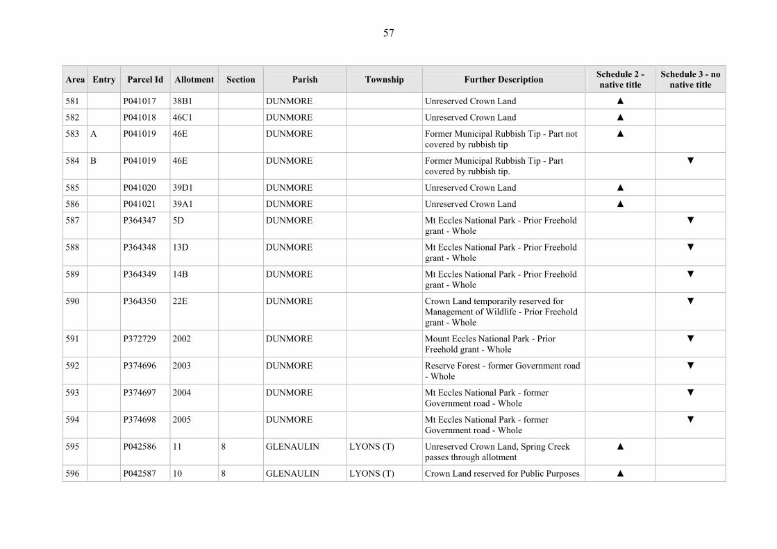
57
Area Entry Parcel Id Allotment Section Parish Township Further Description Schedule 2 - native title
Schedule 3 - no native title
581 P041017 38B1 DUNMORE Unreserved Crown Land ▲
582 P041018 46C1 DUNMORE Unreserved Crown Land ▲
583 A P041019 46E DUNMORE Former Municipal Rubbish Tip - Part not covered by rubbish tip
▲
584 B P041019 46E DUNMORE Former Municipal Rubbish Tip - Part covered by rubbish tip.
▼
585 P041020 39D1 DUNMORE Unreserved Crown Land ▲
586 P041021 39A1 DUNMORE Unreserved Crown Land ▲
587 P364347 5D DUNMORE Mt Eccles National Park - Prior Freehold grant - Whole
▼
588 P364348 13D DUNMORE Mt Eccles National Park - Prior Freehold grant - Whole
▼
589 P364349 14B DUNMORE Mt Eccles National Park - Prior Freehold grant - Whole
▼
590 P364350 22E DUNMORE Crown Land temporarily reserved for Management of Wildlife - Prior Freehold grant - Whole
▼
591 P372729 2002 DUNMORE Mount Eccles National Park - Prior Freehold grant - Whole
▼
592 P374696 2003 DUNMORE Reserve Forest - former Government road - Whole
▼
593 P374697 2004 DUNMORE Mt Eccles National Park - former Government road - Whole
▼
594 P374698 2005 DUNMORE Mt Eccles National Park - former Government road - Whole
▼
595 P042586 11 8 GLENAULIN LYONS (T) Unreserved Crown Land, Spring Creek passes through allotment
▲
596 P042587 10 8 GLENAULIN LYONS (T) Crown Land reserved for Public Purposes ▲

58
Area Entry Parcel Id Allotment Section Parish Township Further Description Schedule 2 - native title
Schedule 3 - no native title
(Preservation of Landscape)
597 A P042588 11 7 GLENAULIN LYONS (T) Lyons Public Hall and Recreation Reserve - Part not covered by tennis courts.
▲
598 B P042588 11 7 GLENAULIN LYONS (T) Lyons Public Hall and Recreation Reserve - part covered by tennis courts.
▼
599 P042589 10 4 GLENAULIN LYONS (T) Heywood to Mt Gambier Railway, Crown land vested in Victorian Rail Track – Part not covered by railway tracks.
▼
600 P042590 5 5 GLENAULIN LYONS (T) Unreserved Crown Land ▲
601 P042591 6 5 GLENAULIN LYONS (T) Unreserved Crown Land ▲
602 P042592 7 5 GLENAULIN LYONS (T) Unreserved Crown Land ▲
603 P042593 8 5 GLENAULIN LYONS (T) Unreserved Crown Land ▲
604 P042594 9 5 GLENAULIN LYONS (T) Unreserved Crown Land ▲
605 P042595 10 5 GLENAULIN LYONS (T) Unreserved Crown Land ▲
606 P042596 5 7 GLENAULIN LYONS (T) Unreserved Crown Land ▲
607 P042597 6 7 GLENAULIN LYONS (T) Unreserved Crown Land ▲
608 P042598 9 7 GLENAULIN LYONS (T) Unreserved Crown Land ▲
609 P042599 10 7 GLENAULIN LYONS (T) Unreserved Crown Land ▲
610 P042600 8A 2 GLENAULIN LYONS (T) Lyons Fire Brigade Shed - Part not covered by shed.
▼
611 A P042602 16 2 GLENAULIN LYONS (T) Former school - Part not covered by school; shed; toilet (x2).
▲
612 B P042602 16 2 GLENAULIN LYONS (T) Former school - Part covered by school; shed; toilet (x2).
▼
613 P042869 10 B GLENAULIN Reserved Forest ▲
614 P042871 31B GLENAULIN Unreserved Crown Land ▲

59
Area Entry Parcel Id Allotment Section Parish Township Further Description Schedule 2 - native title
Schedule 3 - no native title
615 P042872 16G GLENAULIN Drainage reserve ▲
616 P042873 34C GLENAULIN Crown Land set aside as Drainage Reserve
▲
617 P042874 11D GLENAULIN Crawford River Frontage ▲
618 P042875 11B GLENAULIN Reserved Forest ▲
619 P042876 11C GLENAULIN Reserved Forest ▲
620 P042877 9A GLENAULIN Reserved Forest ▲
621 P042878 31A GLENAULIN Unreserved Crown Land ▲
622 P042879 33A A GLENAULIN Mt Gambier to Heywood Railway - Railway tracks - Whole
▼
623 P042880 5C B GLENAULIN Heywood to Mt Gambier Railway, Crown land vested in Victorian Rail Track – Railway tracks - Whole
▼
624 A P042882 2B B GLENAULIN Heywood to Mt Gambier Railway, Crown land vested in Victorian Rail Track – Part not covered by railway tracks.
▲
625 B P042882 2B B GLENAULIN Heywood to Mt Gambier Railway, Crown land vested in Victorian Rail Track – Part covered by railway tracks.
▼
626 A P042883 2C B GLENAULIN Heywood to Mt Gambier Railway, Crown land vested in Victorian Rail Track – Part not covered by railway tracks.
▲
627 B P042883 2C B GLENAULIN Heywood to Mt Gambier Railway, Crown land vested in Victorian Rail Track – Part covered by railway tracks.
▼
628 A P042884 2D B GLENAULIN Heywood to Mt Gambier Railway, Crown land vested in Victorian Rail Track – Part not covered by railway tracks.
▲

60
Area Entry Parcel Id Allotment Section Parish Township Further Description Schedule 2 - native title
Schedule 3 - no native title
629 B P042884 2D B GLENAULIN Heywood to Mt Gambier Railway, Crown land vested in Victorian Rail Track – Part covered by railway tracks.
▼
630 P042885 31B A GLENAULIN Reserved Forest ▲
631 P042886 24B A GLENAULIN Crawford River Frontage ▲
632 P042887 3D A GLENAULIN Behind Crawford River Frontage ▲
633 P042888 13A A GLENAULIN Reserved Forest ▲
634 A P042889 24A A GLENAULIN Reserved Forest - Part not covered by Prior Freehold grant
▲
635 B P042889 24A A GLENAULIN Reserved Forest - Part covered by Prior Freehold grant
▼
636 A P042890 25A A GLENAULIN Reserved Forest - Part not covered by Prior Scheduled Interest
▲
637 B P042890 25A A GLENAULIN Reserved Forest - Part covered by Prior Scheduled Interest
▼
638 P042891 20A A GLENAULIN Reserved Forest ▲
639 P042892 30B A GLENAULIN Reserved Forest ▲
640 P042893 30A A GLENAULIN Reserved Forest ▲
641 P042894 7B GLENAULIN Crawford River Frontage ▲
642 P042895 9B GLENAULIN Crawford River Frontage ▲
643 P042896 9C GLENAULIN Crawford River Frontage ▲
644 P042897 4B GLENAULIN Crawford River Frontage ▲
645 P042898 5D GLENAULIN Crawford River Frontage ▲
646 P042899 5E GLENAULIN Drainage Reserve, containing the Crawford River
▲
647 P043826 31A A GLENAULIN Heywood to Mt Gambier Railway, Crown ▼

61
Area Entry Parcel Id Allotment Section Parish Township Further Description Schedule 2 - native title
Schedule 3 - no native title
land vested in Victorian Rail Track – Railway tracks - Whole
648 P043826 31A A GLENAULIN Crown Land Reserve - Prior Freehold grant - Whole
▼
649 P043870 2 A GLENAULIN Reserved Forest - Prior Freehold grant - Whole
▼
650 P043871 2B A GLENAULIN Reserve Forest - Prior Freehold grant - Whole
▼
651 P043872 3E A GLENAULIN Crown Land licenced under Victoria Plantations Corporation - Prior Freehold grant - Whole
▼
652 P043873 6 A GLENAULIN Unreserved Crown Land - Prior Freehold grant - Whole
▼
653 P043874 13 A GLENAULIN Unreserved Crown Land - Prior Freehold grant - Whole
▼
654 P043877 11A GLENAULIN Unreserved Crown Land - Prior Freehold grant - Whole
▼
655 A P044060 5A A GLENAULIN Crown Land licences under Victorian Plantations Corporation - Part covered by Prior Freehold grant
▼
656 B P044060 5A A GLENAULIN Crown Land licenced under Victoria Plantations Corporation - Part covered by road
▼
657 P367763 21A GLENAULIN Crown Land licenced under Victoria Plantations Corporation - Prior Freehold grant - Whole
▼
658 P367764 1A GLENAULIN Crown Land licenced under Victoria Plantations Corporation - covered by Prior Freehold grant
▼

62
Area Entry Parcel Id Allotment Section Parish Township Further Description Schedule 2 - native title
Schedule 3 - no native title
659 A P367769 23A GLENAULIN Crown Land licenced under Victoria Plantations Corporation - Part not covered by Prior Freehold grant; Part not covered by road
▲
660 B P367769 23A GLENAULIN Crown Land licenced under Victoria Plantations Corporation - Part covered by Prior Freehold grant
▼
661 C P367769 23A GLENAULIN Crown Land licenced under Victoria Plantations Corporation - Part covered by road
▼
662 P367778 12 B GLENAULIN Crown Land vested in Victorian Plantations Corporation
▲
663 P367779 13 B GLENAULIN Crown Land vested in Victorian Plantations Corporation
▲
664 A P367780 14 B GLENAULIN Crown Land vested in Victorian Plantations Corporation – Part not covered by road
▲
665 B P367780 14 B GLENAULIN Crown Land vested in Victorian Plantations Corporation - Part covered by road
▼
666 P368273 15 B GLENAULIN Reserved Forest ▲
667 P368274 16 B GLENAULIN Reserved Forest ▲
668 P369470 2C A GLENAULIN Reserved Forest - former Government road - Whole
▼
669 P373118 2001 GLENAULIN Unreserved Crown Land - Prior Freehold grant - Whole
▼
670 P374378 2002 GLENAULIN Unreserved Crown Land - Prior Freehold grant - Whole
▼
671 P402881 7C B GLENAULIN Heywood to Mt Gambier Railway, Crown ▼
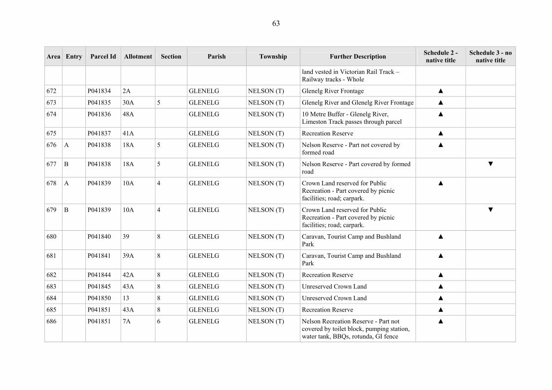
63
Area Entry Parcel Id Allotment Section Parish Township Further Description Schedule 2 - native title
Schedule 3 - no native title
land vested in Victorian Rail Track – Railway tracks - Whole
672 P041834 2A GLENELG NELSON (T) Glenelg River Frontage ▲
673 P041835 30A 5 GLENELG NELSON (T) Glenelg River and Glenelg River Frontage ▲
674 P041836 48A GLENELG NELSON (T) 10 Metre Buffer - Glenelg River, Limeston Track passes through parcel
▲
675 P041837 41A GLENELG NELSON (T) Recreation Reserve ▲
676 A P041838 18A 5 GLENELG NELSON (T) Nelson Reserve - Part not covered by formed road
▲
677 B P041838 18A 5 GLENELG NELSON (T) Nelson Reserve - Part covered by formed road
▼
678 A P041839 10A 4 GLENELG NELSON (T) Crown Land reserved for Public Recreation - Part covered by picnic facilities; road; carpark.
▲
679 B P041839 10A 4 GLENELG NELSON (T) Crown Land reserved for Public Recreation - Part covered by picnic facilities; road; carpark.
▼
680 P041840 39 8 GLENELG NELSON (T) Caravan, Tourist Camp and Bushland Park
▲
681 P041841 39A 8 GLENELG NELSON (T) Caravan, Tourist Camp and Bushland Park
▲
682 P041844 42A 8 GLENELG NELSON (T) Recreation Reserve ▲
683 P041845 43A 8 GLENELG NELSON (T) Unreserved Crown Land ▲
684 P041850 13 8 GLENELG NELSON (T) Unreserved Crown Land ▲
685 P041851 43A 8 GLENELG NELSON (T) Recreation Reserve ▲
686 P041851 7A 6 GLENELG NELSON (T) Nelson Recreation Reserve - Part not covered by toilet block, pumping station, water tank, BBQs, rotunda, GI fence
▲
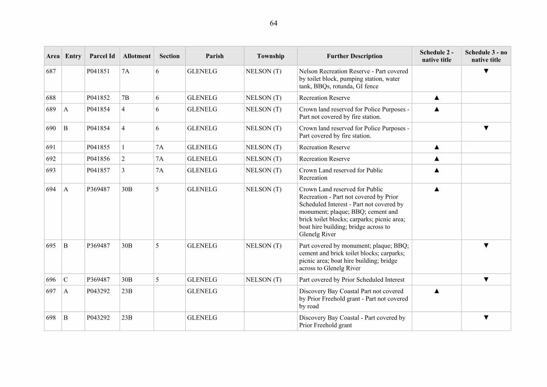
64
Area Entry Parcel Id Allotment Section Parish Township Further Description Schedule 2 - native title
Schedule 3 - no native title
687 P041851 7A 6 GLENELG NELSON (T) Nelson Recreation Reserve - Part covered by toilet block, pumping station, water tank, BBQs, rotunda, GI fence
▼
688 P041852 7B 6 GLENELG NELSON (T) Recreation Reserve ▲
689 A P041854 4 6 GLENELG NELSON (T) Crown land reserved for Police Purposes - Part not covered by fire station.
▲
690 B P041854 4 6 GLENELG NELSON (T) Crown land reserved for Police Purposes - Part covered by fire station.
▼
691 P041855 1 7A GLENELG NELSON (T) Recreation Reserve ▲
692 P041856 2 7A GLENELG NELSON (T) Recreation Reserve ▲
693 P041857 3 7A GLENELG NELSON (T) Crown Land reserved for Public Recreation
▲
694 A P369487 30B 5 GLENELG NELSON (T) Crown Land reserved for Public Recreation - Part not covered by Prior Scheduled Interest - Part not covered by monument; plaque; BBQ; cement and brick toilet blocks; carparks; picnic area; boat hire building; bridge across to Glenelg River
▲
695 B P369487 30B 5 GLENELG NELSON (T) Part covered by monument; plaque; BBQ; cement and brick toilet blocks; carparks; picnic area; boat hire building; bridge across to Glenelg River
▼
696 C P369487 30B 5 GLENELG NELSON (T) Part covered by Prior Scheduled Interest ▼
697 A P043292 23B GLENELG Discovery Bay Coastal Part not covered by Prior Freehold grant - Part not covered by road
▲
698 B P043292 23B GLENELG Discovery Bay Coastal - Part covered by Prior Freehold grant
▼
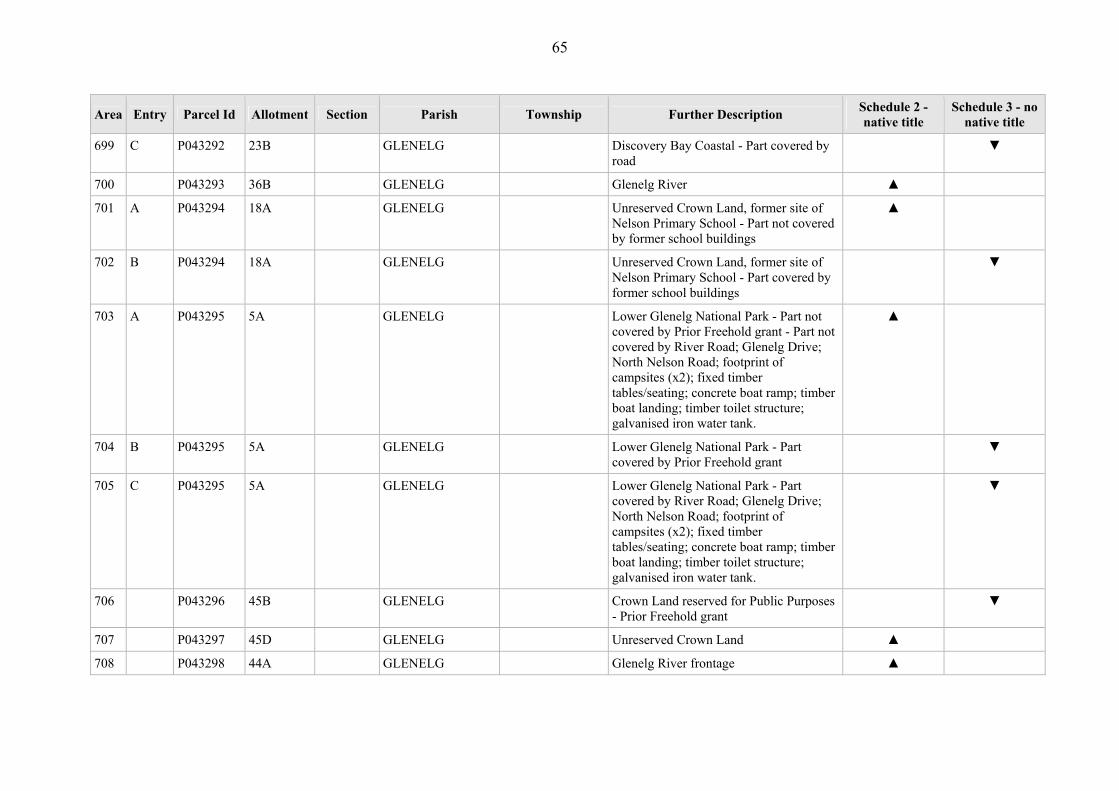
65
Area Entry Parcel Id Allotment Section Parish Township Further Description Schedule 2 - native title
Schedule 3 - no native title
699 C P043292 23B GLENELG Discovery Bay Coastal - Part covered by road
▼
700 P043293 36B GLENELG Glenelg River ▲
701 A P043294 18A GLENELG Unreserved Crown Land, former site of Nelson Primary School - Part not covered by former school buildings
▲
702 B P043294 18A GLENELG Unreserved Crown Land, former site of Nelson Primary School - Part covered by former school buildings
▼
703 A P043295 5A GLENELG Lower Glenelg National Park - Part not covered by Prior Freehold grant - Part not covered by River Road; Glenelg Drive; North Nelson Road; footprint of campsites (x2); fixed timber tables/seating; concrete boat ramp; timber boat landing; timber toilet structure; galvanised iron water tank.
▲
704 B P043295 5A GLENELG Lower Glenelg National Park - Part covered by Prior Freehold grant
▼
705 C P043295 5A GLENELG Lower Glenelg National Park - Part covered by River Road; Glenelg Drive; North Nelson Road; footprint of campsites (x2); fixed timber tables/seating; concrete boat ramp; timber boat landing; timber toilet structure; galvanised iron water tank.
▼
706 P043296 45B GLENELG Crown Land reserved for Public Purposes - Prior Freehold grant
▼
707 P043297 45D GLENELG Unreserved Crown Land ▲
708 P043298 44A GLENELG Glenelg River frontage ▲

66
Area Entry Parcel Id Allotment Section Parish Township Further Description Schedule 2 - native title
Schedule 3 - no native title
709 A P044074 45C GLENELG Unreserved Crown Land - Part not covered by 9.144m wide easement for power line.
▲
710 B P044074 45C GLENELG Unreserved Crown Land - Part covered by 9.144m wide easement for power line.
▼
711 P044342 14A A GLENELG Unreserved Crown Land - former Government road
▼
712 P044346 36C GLENELG Glenelg River Frontage ▲
713 P044347 36D GLENELG Glenelg River Frontage ▲
714 P044348 36E GLENELG Adjacent to Glenelg River permanent frontage
▲
715 P366411 23A GLENELG Discovery Bay Coastal Park ▲
716 A P043425 9A 3 GORAE Reserved Forest - Part not covered by Prior Scheduled Interest - Part not covered by road - Part not covered by Prior Freehold grant
▲
717 B P043425 9A 3 GORAE Reserved Forest - Part covered by Prior Scheduled Interest
▼
718 C P043425 9A 3 GORAE Reserved Forest - Part covered by road ▼
719 D P043425 9A 3 GORAE Reserved Forest - Part covered by Prior Freehold grant
▼
720 P043426 20D 3 GORAE Unreserved Crown Land ▲
721 P043427 7B 3 GORAE Reserved Forest ▲
722 P043428 8D 3 GORAE Reserved Forest ▲
723 P043429 4D 5 GORAE Crown Land reserved for site of Public Hall and Public Recreation - Prior Freehold grant - Whole
▼
724 P043430 4C 5 GORAE Crown Land reserved for site of Public ▼

67
Area Entry Parcel Id Allotment Section Parish Township Further Description Schedule 2 - native title
Schedule 3 - no native title
Hall and Public Recreation - Prior Freehold grant - Whole
725 A P043431 5F 5 GORAE Heathmere Recreation Reserve - Part not covered by Prior Freehold grant - Part not covered by timber/wire chicken shed; galvanised iron storage shed; galvanised iron pump shed; concrete underground open water drain; timber/galvanised iron wood storage shed (south boundary of parcel); bluestone scout hall; steel radio towers (x 2); galvanised iron shed (south of scout hall)
▲
726 B P043431 5F 5 GORAE Heathmere Recreation Reserve - Part covered by Prior Freehold grant
▼
727 C P043431 5F 5 GORAE Heathmere Recreation Reserve - Part covered by timber/wire chicken shed; galvanised iron storage shed; galvanised iron pump shed; concrete underground open water drain; timber/galvanised iron wood storage shed (south boundary of parcel); bluestone scout hall; steel radio towers (x 2); galvanised iron shed (south of scout hall)
▼
728 P043432 29A 5 GORAE Ararat – Portland Railway - covered by railway track.
▼
729 P043433 25A 4 GORAE Crown Land set aside for Water Reserve ▲
730 P043434 23A 4 GORAE Gorae Reserve ▲
731 P043435 15A 4 GORAE Ararat–Portland Railway - Railway track - Whole
▼
732 P043436 6A 1 GORAE Ararat–Portland Railway - Railway track - Whole
▼
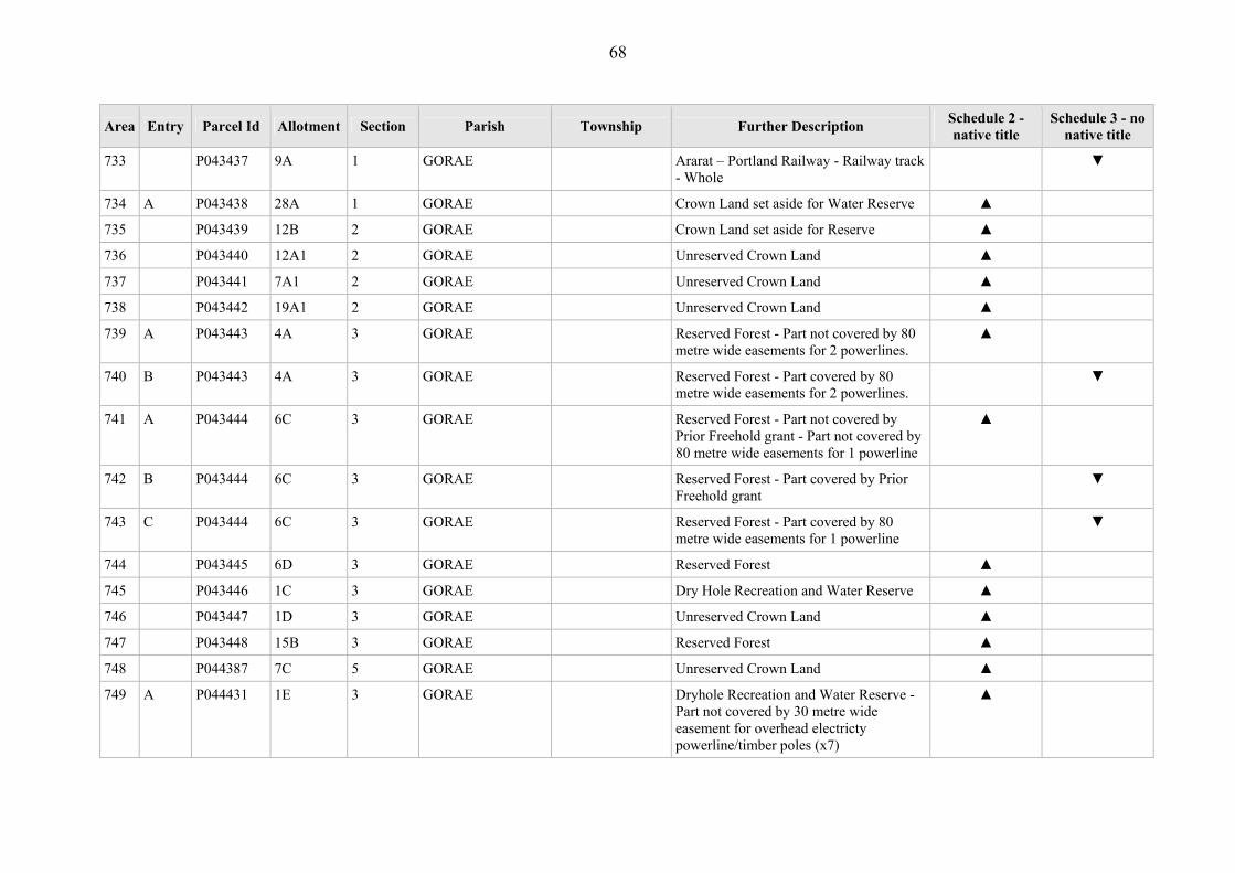
68
Area Entry Parcel Id Allotment Section Parish Township Further Description Schedule 2 - native title
Schedule 3 - no native title
733 P043437 9A 1 GORAE Ararat – Portland Railway - Railway track - Whole
▼
734 A P043438 28A 1 GORAE Crown Land set aside for Water Reserve ▲
735 P043439 12B 2 GORAE Crown Land set aside for Reserve ▲
736 P043440 12A1 2 GORAE Unreserved Crown Land ▲
737 P043441 7A1 2 GORAE Unreserved Crown Land ▲
738 P043442 19A1 2 GORAE Unreserved Crown Land ▲
739 A P043443 4A 3 GORAE Reserved Forest - Part not covered by 80 metre wide easements for 2 powerlines.
▲
740 B P043443 4A 3 GORAE Reserved Forest - Part covered by 80 metre wide easements for 2 powerlines.
▼
741 A P043444 6C 3 GORAE Reserved Forest - Part not covered by Prior Freehold grant - Part not covered by 80 metre wide easements for 1 powerline
▲
742 B P043444 6C 3 GORAE Reserved Forest - Part covered by Prior Freehold grant
▼
743 C P043444 6C 3 GORAE Reserved Forest - Part covered by 80 metre wide easements for 1 powerline
▼
744 P043445 6D 3 GORAE Reserved Forest ▲
745 P043446 1C 3 GORAE Dry Hole Recreation and Water Reserve ▲
746 P043447 1D 3 GORAE Unreserved Crown Land ▲
747 P043448 15B 3 GORAE Reserved Forest ▲
748 P044387 7C 5 GORAE Unreserved Crown Land ▲
749 A P044431 1E 3 GORAE Dryhole Recreation and Water Reserve - Part not covered by 30 metre wide easement for overhead electricty powerline/timber poles (x7)
▲

69
Area Entry Parcel Id Allotment Section Parish Township Further Description Schedule 2 - native title
Schedule 3 - no native title
750 B P044431 1E 3 GORAE Dryhole Recreation and Water Reserve - Part covered by 30 metre wide easement for overhead electricty powerline/timber poles (x7)
▼
751 P044432 1F 3 GORAE Dryhole Recreation and Water Reserve - Covered by sealed asphalt tennis courts and surrounding pole and wire fence (x2); fixed timber playground equipment; cricket - oval pitch/wicket
▼
752 P044433 1G 3 GORAE Reserved Forest ▲
753 P043410 8C 8 GRASSDALE Crown Land set aside as Quarry ▲
754 P044075 2E 10 GRASSDALE Unreserved Crown Land ▲
755 A P044076 2D 10 GRASSDALE Casterton-Branxholme Railway - Part not covered by railway tracks
▲
756 B P044076 2D 10 GRASSDALE Casterton-Branxholme Railway - Part covered by railway tracks
▼
757 A P042758 7A 17 GREENHILLS Unreserved Crown Land - covered by Condah Main Drain - Managed by CMA
▼
758 P042767 3C 20 GREENHILLS Unreserved Crown Land - Covered by Condah Main Drain. Managed by CMA
▼
759 P042772 16A 21 GREENHILLS Unreserved Crown Land - Covered by Condah Main Drain. Managed by CMA
▼
760 P042774 4B 2 GREENHILLS Crown Reserve for Water ▲
761 P042793 7 14 GREENHILLS State Forest vested in Victorian Plantations Corporation - prior Freehold Grant - Whole
▼
762 P042803 3A 19 GREENHILLS Unreserved Crown Land - Part not covered by Condah Main Drain - Part not covered by road
▼
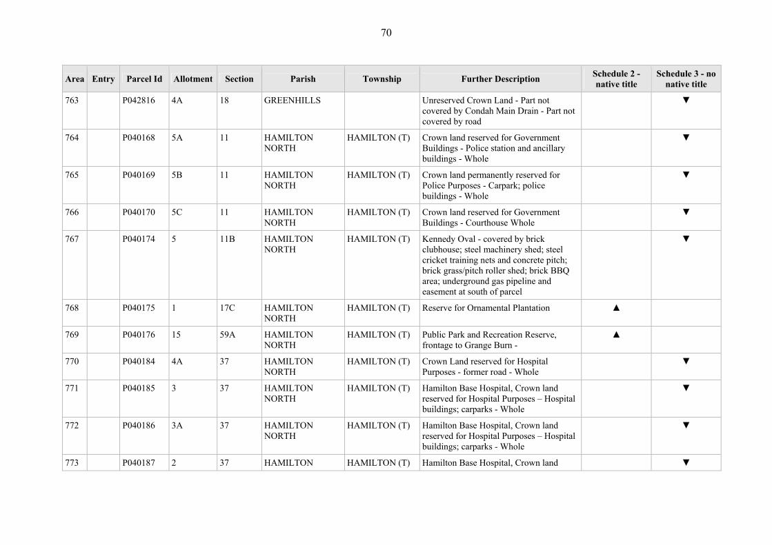
70
Area Entry Parcel Id Allotment Section Parish Township Further Description Schedule 2 - native title
Schedule 3 - no native title
763 P042816 4A 18 GREENHILLS Unreserved Crown Land - Part not covered by Condah Main Drain - Part not covered by road
▼
764 P040168 5A 11 HAMILTON NORTH
HAMILTON (T) Crown land reserved for Government Buildings - Police station and ancillary buildings - Whole
▼
765 P040169 5B 11 HAMILTON NORTH
HAMILTON (T) Crown land permanently reserved for Police Purposes - Carpark; police buildings - Whole
▼
766 P040170 5C 11 HAMILTON NORTH
HAMILTON (T) Crown land reserved for Government Buildings - Courthouse Whole
▼
767 P040174 5 11B HAMILTON NORTH
HAMILTON (T) Kennedy Oval - covered by brick clubhouse; steel machinery shed; steel cricket training nets and concrete pitch; brick grass/pitch roller shed; brick BBQ area; underground gas pipeline and easement at south of parcel
▼
768 P040175 1 17C HAMILTON NORTH
HAMILTON (T) Reserve for Ornamental Plantation ▲
769 P040176 15 59A HAMILTON NORTH
HAMILTON (T) Public Park and Recreation Reserve, frontage to Grange Burn -
▲
770 P040184 4A 37 HAMILTON NORTH
HAMILTON (T) Crown Land reserved for Hospital Purposes - former road - Whole
▼
771 P040185 3 37 HAMILTON NORTH
HAMILTON (T) Hamilton Base Hospital, Crown land reserved for Hospital Purposes – Hospital buildings; carparks - Whole
▼
772 P040186 3A 37 HAMILTON NORTH
HAMILTON (T) Hamilton Base Hospital, Crown land reserved for Hospital Purposes – Hospital buildings; carparks - Whole
▼
773 P040187 2 37 HAMILTON HAMILTON (T) Hamilton Base Hospital, Crown land ▼

71
Area Entry Parcel Id Allotment Section Parish Township Further Description Schedule 2 - native title
Schedule 3 - no native title
NORTH reserved for Hospital Purposes – Hospital buildings; carparks - Whole
774 P040188 1 37 HAMILTON NORTH
HAMILTON (T) Hamilton Base Hospital, Crown land reserved for Hospital Purposes - Hospital buildings; carparks - Whole
▼
775 P040189 1 35 HAMILTON NORTH
HAMILTON (T) Public Garden Reserve ▲
776 A P040190 2 35 HAMILTON NORTH
HAMILTON (T) Crown land reserved for Public Gardens - Part not covered by carpark.
▲
777 B P040190 2 35 HAMILTON NORTH
HAMILTON (T) Crown land reserved for Public Gardens - Part covered by carpark.
▼
778 P040191 9 47 HAMILTON NORTH
HAMILTON (T) Unreserved Crown Land - former Government road - Whole
▼
779 P040192 10 47 HAMILTON NORTH
HAMILTON (T) Unreserved Crown Land - former Government road - Whole
▼
780 P040193 11 47 HAMILTON NORTH
HAMILTON (T) Unreserved Crown Land - former Government road - Whole
▼
781 P040194 11A 47 HAMILTON NORTH
HAMILTON (T) Unreserved Crown Land - former Government road - Whole
▼
782 P040196 2 54A HAMILTON NORTH
HAMILTON (T) Melville Oval - Covered by galvanised iron/timber Grandstand; galvanised iron BBQ/Drinks shed; Iron Memorial gates and ticket box; metal entrance gates; brick Judge's Box; steel Fire Training Tower; asphalt netball courts - fenced, scoreboards; playground equipment; cricket oval; brick Coach's box; brick toilet block; marble cenotaph (statue); brick change rooms and kitchen; timber/galvanised iron clubrooms; electric powered lights; footpaths - asphalt/gravel;
▼

72
Area Entry Parcel Id Allotment Section Parish Township Further Description Schedule 2 - native title
Schedule 3 - no native title
pole
783 P040197 1 54A HAMILTON NORTH
HAMILTON (T) Melville Oval - Covered by change rooms and kitchen, club rooms, toilet, storage shed and shelter
▼
784 P040202 18A 78 HAMILTON NORTH
HAMILTON (T) Crown land reserved for State School Purposes - covered by School buildings and grounds - Whole
▼
785 P040203 18B 78 HAMILTON NORTH
HAMILTON (T) Crown land reserved for State School Purposes - covered by School buildings and grounds, part covered by former 3m wide drain - Whole
▼
786 P040204 7B 79 HAMILTON NORTH
HAMILTON (T) Crown land reserved for State School Purposes - covered by School buildings and grounds - Whole
▼
787 P040210 2A 101 HAMILTON NORTH
HAMILTON (T) Hamilton Railway Station Grounds -Covered by railway line; brick stationhouse; galvanised iron freight shed; radio tower; steel freight/goods shelter; galvanised iron storage shed; colorbond office building; steel structure for raising railway sleepers; galvanised iron amentities shed; timber firebox; galvanised iron storage shed/timber landing (x2); weatherboard sand shed; various electric power lights/poles; pole
▼
788 P040215 1 10 HAMILTON NORTH
HAMILTON (T) Hamilton Botanical Gardens -Covered by weatherboard Caretakers shed; brick toilet block; iron/stone entrance gates; galvanised iron machinery office; galvanised iron machinery sheds; metal shade house and shade nets; galvanised iron/wire netting animal enclosures; galvanised iron/timber Rotunda;
▼
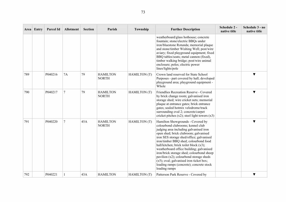
73
Area Entry Parcel Id Allotment Section Parish Township Further Description Schedule 2 - native title
Schedule 3 - no native title
weatherboard/glass hothouse; concrete fountain; stone/electric BBQs under iron/bluestone Rotunda; memorial plaque and stone/timber Wishing Well; post/wire aviary; fixed playground equipment; fixed BBQ tables/seats; metal cannon (fixed), timber walking bridge; post/wire animal enclosure; poles; electric power lines/lights/pole
789 P040216 7A 79 HAMILTON NORTH
HAMILTON (T) Crown land reserved for State School Purposes - part covered by hall; developed playground area; playground equipment - Whole
▼
790 P040217 7 79 HAMILTON NORTH
HAMILTON (T) Friendlies Recreation Reserve - Covered by brick change room; galvanised iron storage shed; wire cricket nets; memorial plaque at entrance gates; brick entrance gates; sealed hotmix velodrome/track surrounding oval 2; concrete/carpet cricket pitches (x2); steel light towers (x3)
▼
791 P040220 7 45A HAMILTON NORTH
HAMILTON (T) Hamilton Showgrounds - Covered by colourbond clubrooms; kennel club judging area including galvanised iron open shed; brick clubroom; galvanised iron SES storage shed/office; galvanised iron/timber BBQ shed; colourbond food hall/kitchen; brick toilet block (x3); weatherboard office building; galvanised iron/brick storage shed; colourbond sheep pavilion (x2); colourbond storage sheds (x5); oval; galvanised iron ticket box; loading ramps (concrete); concrete stock loading ramps
▼
792 P040221 1 43A HAMILTON HAMILTON (T) Patterson Park Reserve - Covered by ▼

74
Area Entry Parcel Id Allotment Section Parish Township Further Description Schedule 2 - native title
Schedule 3 - no native title
NORTH hardiplank/iron building/hall; kindergarten – weatherboard/iron/hardiplank; asphalt tennis court(x2); gravel road (entrance)
793 A P040222 9A 89 HAMILTON NORTH
HAMILTON (T) Queen Victoria College Geriatric Facility, Hamilton Base Hospital, Crown Land reserved for Contagious Diseases Hospital – Part not covered by geriatric facility
▲
794 B P040222 9A 89 HAMILTON NORTH
HAMILTON (T) Queen Victoria College Geriatric Facility, Hamilton Base Hospital, Crown Land reserved for Contagious Diseases Hospital – part covered by geriatric facility
▼
795 A P040223 1 91 HAMILTON NORTH
HAMILTON (T) Crown land reserved for Public Recreation - Part not covered by road - Part not covered by dam; embankments (earthworks)
▲
796 B P040223 1 91 HAMILTON NORTH
HAMILTON (T) Crown land reserved for Public Recreation - part covered by dam; embankments (earthworks)
▼
797 C P040223 1 91 HAMILTON NORTH
HAMILTON (T) Crown land reserved for Public Recreation - Part covered by road
▼
798 P040225 8A 99 HAMILTON NORTH
HAMILTON (T) Ararat to Hamilton Railway - Part not covered by railway track.
▼
799 P040226 9A 99 HAMILTON NORTH
HAMILTON (T) Unreserved Crown Land ▲
800 P040229 4 32B HAMILTON NORTH
HAMILTON (T) Unreserved Crown Land ▲
801 P040230 9A 32B HAMILTON NORTH
HAMILTON (T) Crown Land reserved as a site for Public Park
▲
802 A P040231 4 37 HAMILTON HAMILTON (T) Hamilton Base Hospital, Crown Land ▲

75
Area Entry Parcel Id Allotment Section Parish Township Further Description Schedule 2 - native title
Schedule 3 - no native title
NORTH reserved for Hospital Purposes – Part not covered by carpark; ambulance station; residence
803 B P040231 4 37 HAMILTON NORTH
HAMILTON (T) Hamilton Base Hospital, Crown Land reserved for Hospital Purposes – part covered by carpark; ambulance station; residence
▼
804 P043272 1 9 HAMILTON NORTH
HAMILTON (T) Crown Land reserved as a site for a National School - Prior Freehold grant
▼
805 P043273 18 9 HAMILTON NORTH
HAMILTON (T) Crown Land reserved as a site for a National School - Prior Freehold grant
▼
806 P043274 19 9 HAMILTON NORTH
HAMILTON (T) Crown Land reserved as a site for a National School - Prior Freehold grant
▼
807 P043275 20 9 HAMILTON NORTH
HAMILTON (T) Crown Land reserved as a site for a National School - Prior Freehold grant
▼
808 P043276 2 101 HAMILTON NORTH
HAMILTON (T) Crown Land reserved as a site for Railway Purposes - Prior Freehold grant
▼
809 P043282 1 57A HAMILTON NORTH
HAMILTON (T) Crown Land reserved as a site for Swimming Purposes - former Government road
▼
810 P043283 2 57A HAMILTON NORTH
HAMILTON (T) Crown Land reserved as a site for Recreation Purposes - former Government road
▼
811 P044158 1A 101 HAMILTON NORTH
HAMILTON (T) Unreserved Crown Land, adjacent to Grange Burn
▲
812 P044159 6A 101 HAMILTON NORTH
HAMILTON (T) Unreserved Crown Land ▲
813 P363824 4A 65 HAMILTON NORTH
HAMILTON (T) Unreserved Crown Land ▲
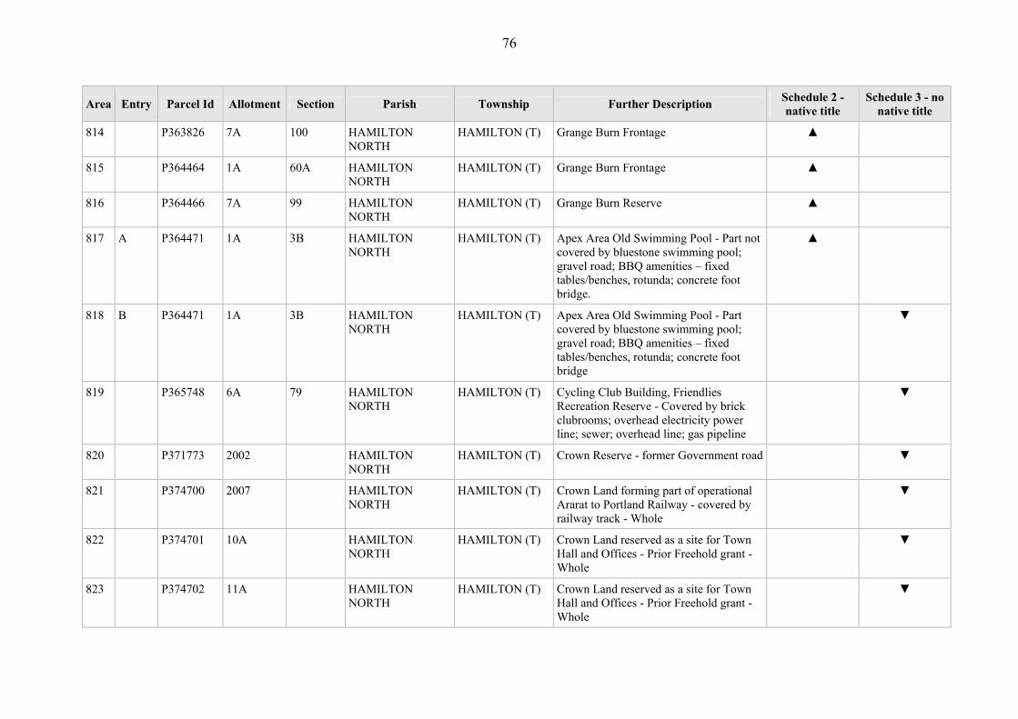
76
Area Entry Parcel Id Allotment Section Parish Township Further Description Schedule 2 - native title
Schedule 3 - no native title
814 P363826 7A 100 HAMILTON NORTH
HAMILTON (T) Grange Burn Frontage ▲
815 P364464 1A 60A HAMILTON NORTH
HAMILTON (T) Grange Burn Frontage ▲
816 P364466 7A 99 HAMILTON NORTH
HAMILTON (T) Grange Burn Reserve ▲
817 A P364471 1A 3B HAMILTON NORTH
HAMILTON (T) Apex Area Old Swimming Pool - Part not covered by bluestone swimming pool; gravel road; BBQ amenities – fixed tables/benches, rotunda; concrete foot bridge.
▲
818 B P364471 1A 3B HAMILTON NORTH
HAMILTON (T) Apex Area Old Swimming Pool - Part covered by bluestone swimming pool; gravel road; BBQ amenities – fixed tables/benches, rotunda; concrete foot bridge
▼
819 P365748 6A 79 HAMILTON NORTH
HAMILTON (T) Cycling Club Building, Friendlies Recreation Reserve - Covered by brick clubrooms; overhead electricity power line; sewer; overhead line; gas pipeline
▼
820 P371773 2002 HAMILTON NORTH
HAMILTON (T) Crown Reserve - former Government road ▼
821 P374700 2007 HAMILTON NORTH
HAMILTON (T) Crown Land forming part of operational Ararat to Portland Railway - covered by railway track - Whole
▼
822 P374701 10A HAMILTON NORTH
HAMILTON (T) Crown Land reserved as a site for Town Hall and Offices - Prior Freehold grant - Whole
▼
823 P374702 11A HAMILTON NORTH
HAMILTON (T) Crown Land reserved as a site for Town Hall and Offices - Prior Freehold grant - Whole
▼

77
Area Entry Parcel Id Allotment Section Parish Township Further Description Schedule 2 - native title
Schedule 3 - no native title
824 P374703 12A HAMILTON NORTH
HAMILTON (T) Crown Land reserved as a site for Town Hall and Offices - Prior Freehold grant - Whole
▼
825 P374704 13A HAMILTON NORTH
HAMILTON (T) Crown Land reserved as a site for Town Hall and Offices - Prior Freehold grant - Whole
▼
826 P374947 2006 HAMILTON NORTH
HAMILTON (T) Hamilton Indoor Leisure Centre - Prior Scheduled Interest and Government Road - Whole
▼
827 P041107 37A A HAMILTON NORTH
Bandicoot Park ▲
828 P041108 7 8 HAMILTON NORTH
Doling Doling Swamp ▲
829 A P041109 5E 16 HAMILTON NORTH
Cruckoor Reserve - Part not covered by former Government road
▲
830 B P041109 5E 16 HAMILTON NORTH
Cruckoor Reserve - Part covered by former Government road
▼
831 A P041110 5F 16 HAMILTON NORTH
Cruckoor Reserve School Plantation - Part not covered by former Government road
▲
832 B P041110 5F 16 HAMILTON NORTH
Cruckoor Reserve School Plantation - Part covered by former Government road
▼
833 P041111 2C 20 HAMILTON NORTH
Unreserved Crown Land ▲
834 P041112 2D 20 HAMILTON NORTH
Crown Land reserved for Public Purpose ▲
835 P041113 2E 20 HAMILTON NORTH
Crown Land reserved as a site for a Contagious Diseases Hospital
▲
836 A P041114 2F 20 HAMILTON NORTH
Trigonometrical Survey Station, Crown Land reserved as a site for Public
▲

78
Area Entry Parcel Id Allotment Section Parish Township Further Description Schedule 2 - native title
Schedule 3 - no native title
Purposes - Part not covered by trigonometrical beacon, shed.
837 B P041114 2F 20 HAMILTON NORTH
Trigonometrical Survey Station, Crown Land reserved as a site for Public Purposes - Part covered by trigonometrical beacon, shed.
▼
838 P041116 23 25 HAMILTON NORTH
Hamilton Racecourse - Covered by brick buildings (various); galvanised iron/colourbond sheds (various); brick toilet blocks; racetrack and amenities (stables, watering stands, exercise yards, various sheds/structures); dam; electricity powerline/poles;; sewer; formed sealed road
▼
839 P041118 6A 27 HAMILTON NORTH
Hamilton Parklands - covered by water catchment drain
▼
840 P041119 10A 27 HAMILTON NORTH
Hamilton Parklands - covered by water catchment drain
▼
841 A P041120 59 27 HAMILTON NORTH
Hamilton Golf Course and clubhouse – Part not covered by clubrooms, kennel club, umpires rooms, office, toilet blocks and pavillions
▲
842 B P041120 59 27 HAMILTON NORTH
Hamilton Golf Course and clubhouse -Part not covered by clubrooms, kennel club, umpires rooms, office, toilet blocks and pavillions
▼
843 P041121 58 27 HAMILTON NORTH
Pedrina Park - Covered by galvanised iron/timber/brick sheds/kiosks (x7); brick clubroom; brick changerooms; asphalt netball court including electric lightposts (x6); memorial plaque; oval; cricket – turf pitch/wicket
▼

79
Area Entry Parcel Id Allotment Section Parish Township Further Description Schedule 2 - native title
Schedule 3 - no native title
844 P041122 38 27 HAMILTON NORTH
Bainbridge Nature Reserve, Hamilton High School
▲
845 P044506 2H 20 HAMILTON NORTH
Mt Bainbridge area ▲
846 P367709 24A 1A HAMILTON NORTH
Crown Land reserved for Public Purposes (Recreation & Conservation) - Prior Freehold grant - Whole
▼
847 P367710 27A 1A HAMILTON NORTH
Crown Land reserved for Public Purposes (Recreation & Conservation) - Part Prior Freehold grant and Part Government road - Whole
▼
848 P367711 33A 1A HAMILTON NORTH
Crown Land reserved for Public Purposes (Recreation & Conservation) - Part Prior Freehold grant and Part Government road - Whole
▼
849 P367712 14A HAMILTON NORTH
Crown Land reserved for Public Purposes (Recreation & Conservation) -Prior Freehold grant
▼
850 P040177 14A HAMILTON SOUTH
HAMILTON (T) Unreserved Crown Land - Prior Freehold grant - Whole
▼
851 P040179 74C HAMILTON SOUTH
HAMILTON (T) Camping Reserve, adjacent to Grange Burn
▲
852 P040180 74D HAMILTON SOUTH
HAMILTON (T) Frontage to Grange Burn ▲
853 P040181 20C 98 HAMILTON SOUTH
HAMILTON (T) Unreserved Crown Land ▲
854 P040182 20A 98 HAMILTON SOUTH
HAMILTON (T) Mitchell Park - Covered by kindergarten; sheds; hall; clubrooms; toilet block; cricket nets.
▼
855 P040183 20B 98 HAMILTON HAMILTON (T) Mitchell Park - Covered by electricity ▼
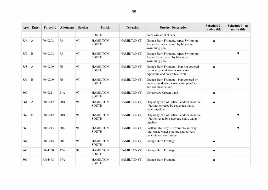
80
Area Entry Parcel Id Allotment Section Parish Township Further Description Schedule 2 - native title
Schedule 3 - no native title
SOUTH pole; wire cricket nets
856 A P040208 7A 97 HAMILTON SOUTH
HAMILTON (T) Grange Burn Frontage, Apex Swimming Area - Part not covered by bluestone swimming pool
▲
857 B P040208 7A 97 HAMILTON SOUTH
HAMILTON (T) Grange Burn Frontage, Apex Swimming Area - Part covered by bluestone swimming pool.
▼
858 A P040209 7B 97 HAMILTON SOUTH
HAMILTON (T) Grange Burn Frontage - Part not covered by underground steel waste water pipe/drain and concrete culvert
▲
859 B P040209 7B 97 HAMILTON SOUTH
HAMILTON (T) Grange Burn Frontage - Part covered by underground steel waste water pipe/drain and concrete culvert
▼
860 P040211 21A 97 HAMILTON SOUTH
HAMILTON (T) Unreserved Crown Land ▲
861 A P040212 20D 98 HAMILTON SOUTH
HAMILTON (T) Originally part of Police Paddock Reserve - Part not covered by sewerage main, water pipeline
▲
862 B P040212 20D 98 HAMILTON SOUTH
HAMILTON (T) Originally part of Police Paddock Reserve - Part covered by sewerage main, water pipeline
▼
863 P040213 20E 98 HAMILTON SOUTH
HAMILTON (T) Portland Railway - Covered by railway line; waste water pipeline and culvert; concrete railway bridge
▼
864 P040214 20F 98 HAMILTON SOUTH
HAMILTON (T) Grange Burn Frontage ▲
865 P044160 22A 98 HAMILTON SOUTH
HAMILTON (T) Grange Burn Frontage ▲
866 P364468 47A HAMILTON SOUTH
HAMILTON (T) Grange Burn Frontage ▲

81
Area Entry Parcel Id Allotment Section Parish Township Further Description Schedule 2 - native title
Schedule 3 - no native title
867 P364482 74E HAMILTON SOUTH
HAMILTON (T) Crown Land reserved for Public Purposes (Recreation & Conservation)
▲
868 P367708 61C HAMILTON SOUTH
HAMILTON (T) Crown Land reserved for Public Purposes (Recreation & Conservation - Part Prior Freehold grant and Part Government road - Whole
▼
869 P041124 43B 2C HAMILTON SOUTH
Frontage to Muddy Creek, Pony Club ▲
870 A P041125 43C 2C HAMILTON SOUTH
Frontage to Muddy Creek ▲
871 P041127 7C 24 HAMILTON SOUTH
Water Reserve, Muddy Creek ▲
872 P041128 1A 23 HAMILTON SOUTH
Frontage to Muddy Creek ▲
873 P041131 2B 1 HAMILTON SOUTH
Crown Land reserved for Public Hall purposes - Part covered by road
▼
874 P041135 6 7 HAMILTON SOUTH
Crown Land reserved for Public Purposes (Racecourse & Recreation) - Prior Freehold grant - Whole
▼
875 P041138 1A 5 HAMILTON SOUTH
Grange Burn Frontage- Prior Freehold grant
▼
876 P041139 9A E HAMILTON SOUTH
Grange Burn Frontage - Prior Freehold grant
▼
877 P041140 17B 9 HAMILTON SOUTH
Grange Burn Frontage - Prior Freehold grant
▼
878 P041141 4A 20 HAMILTON SOUTH
Mt Pierrepoint ▲
879 P041142 4B 20 HAMILTON SOUTH
Unreserved Crown Land ▲

82
Area Entry Parcel Id Allotment Section Parish Township Further Description Schedule 2 - native title
Schedule 3 - no native title
880 P041143 4C 20 HAMILTON SOUTH
Former Stone Reserve ▲
881 A P041144 4D 20 HAMILTON SOUTH
Mt. Pierrepoint Trig Reserve - Part not covered by steel survey beacon station
▲
882 B P041144 4D 20 HAMILTON SOUTH
Mt. Pierrepoint Trig Reserve - Part covered by steel survey beacon station
▼
883 P041145 4E 20 HAMILTON SOUTH
Formerly Government Road ▼
884 P041146 4F 20 HAMILTON SOUTH
Mt Pierrepoint Water Storage Reservoir - Parcel used for water storage. Covered by concrete water reservoir; water storage tank and road
▼
885 P044271 61A B HAMILTON SOUTH
Crown Land reserved for Fauna (Eastern Barred Bandicoot) Purposes -Prior Freehold grant- Whole
▼
886 P044283 9D 4 HAMILTON SOUTH
Crown Land occupied under authority of a licence for a fire station - Part Prior Freehold grant and Part Government road - Whole
▼
887 P044440 4G 20 HAMILTON SOUTH
Crown Land occupied under authority of a lease as a site for the construction of a facility
▲
888 P367713 18A B HAMILTON SOUTH
Crown Land reserved for Public Purposes (Recreation & Conservation) - Prior Freehold grant - Whole
▼
889 P367714 18B B HAMILTON SOUTH
Crown Land reserved for Public Purposes (Recreation & Conservation - Part Prior Freehold grant and Part Government road - Whole
▼
890 P367715 24A B HAMILTON Crown Land reserved for Public Purposes ▼

83
Area Entry Parcel Id Allotment Section Parish Township Further Description Schedule 2 - native title
Schedule 3 - no native title
SOUTH (Recreation & Conservation) -Prior Freehold grant
891 P367716 45A B HAMILTON SOUTH
Crown Land reserved for Public Purposes (Recreation & Conservation - Part Prior Freehold grant and Part Government road - Whole
▼
892 P367717 2003 HAMILTON SOUTH
Crown Land reserved for Public Purposes (Recreation & Conservation - Part Prior Freehold grant and Part Government road - Whole
▼
893 P367718 26A HAMILTON SOUTH
Crown Land reserved for Public Purposes (Recreation & Conservation) -Prior Freehold grant
▼
894 P367719 29A HAMILTON SOUTH
Crown Land reserved for Public Purposes (Recreation & Conservation) -Prior Freehold grant
▼
895 P367720 37A HAMILTON SOUTH
Crown Land reserved for Public Purposes (Recreation & Conservation) -Prior Freehold grant
▼
896 A P371116 2002 HAMILTON SOUTH
Unreserved Crown Land near summit of Mt Pierrepoint - Part not covered by road
▲
897 B P371116 2002 HAMILTON SOUTH
Unreserved Crown Land near summit of Mt Pierrepoint - Part covered by road
▼
898 P040252 4 2A HEYWOOD HEYWOOD (T) Fitzroy River Frontage ▲
899 A P040256 2 1A HEYWOOD HEYWOOD (T) Crown Land reserved for Swimming Pool and Public Park Purposes - Part not covered by Prior Freehold grant
▲
900 B P040256 2 1A HEYWOOD HEYWOOD (T) Crown Land reserved for Swimming Pool and Public Park Purposes - Part covered by Prior Freehold grant
▼

84
Area Entry Parcel Id Allotment Section Parish Township Further Description Schedule 2 - native title
Schedule 3 - no native title
901 P040257 35A HEYWOOD HEYWOOD (T) Crown Land forming part of operational Ararat to Portland Railway - Railway tracks - Whole
▼
902 P040258 3A 5 HEYWOOD HEYWOOD (T) Crown Land reserved as a site for Public Purposes (Municipal Purposes) - Fire Station building - Whole
▼
903 P040259 5A 5 HEYWOOD HEYWOOD (T) Crown Land reserved as a site for Public Purposes (Municipal Purposes) - Fire Station building - Whole
▼
904 A P040260 17 11 HEYWOOD HEYWOOD (T) Crown Land forming part of operational Ararat to Portland Railway - Part not covered by railway track
▲
905 B P040260 17 11 HEYWOOD HEYWOOD (T) Crown Land forming part of operational Ararat to Portland Railway - Part covered by railway track.
▼
906 P040261 1A 22B HEYWOOD HEYWOOD (T) Unreserved Crown Land ▲
907 P040262 7A 23A HEYWOOD HEYWOOD (T) Unreserved Crown Land ▲
908 P040263 3A 13A HEYWOOD HEYWOOD (T) Unreserved Crown Land ▲
909 P040264 7A 34 HEYWOOD HEYWOOD (T) Crown Land reserved as a State School - former Government road - Whole
▼
910 P040265 4A 31 HEYWOOD HEYWOOD (T) Unreserved Crown Land ▲
911 A P040266 4B 31 HEYWOOD HEYWOOD (T) Heywood Waterworks - Part not covered by water bore surrounded by wire fence.
▲
912 B P040266 4B 31 HEYWOOD HEYWOOD (T) Heywood Waterworks - part covered by water bore surrounded by fence.
▼
913 P043958 5 21 HEYWOOD HEYWOOD (T) Heywood Public Gards Reserve, Fitzroy River Frontage
▲
914 A P043959 5A 21 HEYWOOD HEYWOOD (T) Heywood Sewerage Authority Pump Station - Part not covered by brick
▲
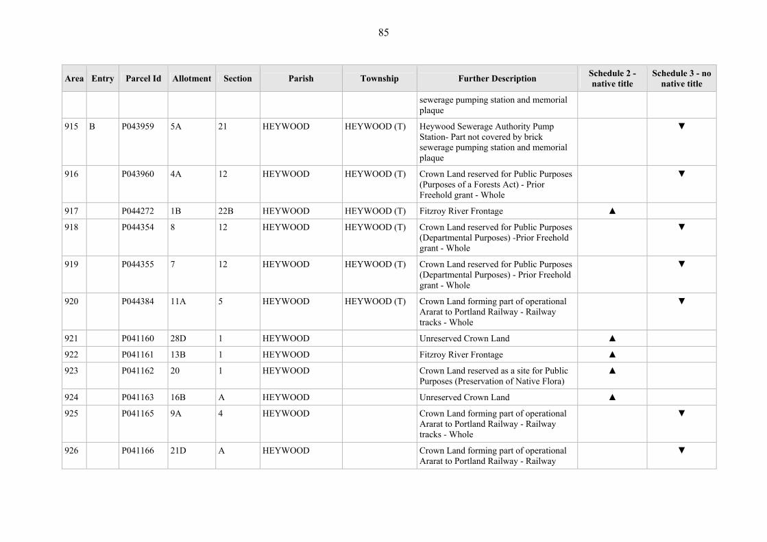
85
Area Entry Parcel Id Allotment Section Parish Township Further Description Schedule 2 - native title
Schedule 3 - no native title
sewerage pumping station and memorial plaque
915 B P043959 5A 21 HEYWOOD HEYWOOD (T) Heywood Sewerage Authority Pump Station- Part not covered by brick sewerage pumping station and memorial plaque
▼
916 P043960 4A 12 HEYWOOD HEYWOOD (T) Crown Land reserved for Public Purposes (Purposes of a Forests Act) - Prior Freehold grant - Whole
▼
917 P044272 1B 22B HEYWOOD HEYWOOD (T) Fitzroy River Frontage ▲
918 P044354 8 12 HEYWOOD HEYWOOD (T) Crown Land reserved for Public Purposes (Departmental Purposes) -Prior Freehold grant - Whole
▼
919 P044355 7 12 HEYWOOD HEYWOOD (T) Crown Land reserved for Public Purposes (Departmental Purposes) - Prior Freehold grant - Whole
▼
920 P044384 11A 5 HEYWOOD HEYWOOD (T) Crown Land forming part of operational Ararat to Portland Railway - Railway tracks - Whole
▼
921 P041160 28D 1 HEYWOOD Unreserved Crown Land ▲
922 P041161 13B 1 HEYWOOD Fitzroy River Frontage ▲
923 P041162 20 1 HEYWOOD Crown Land reserved as a site for Public Purposes (Preservation of Native Flora)
▲
924 P041163 16B A HEYWOOD Unreserved Crown Land ▲
925 P041165 9A 4 HEYWOOD Crown Land forming part of operational Ararat to Portland Railway - Railway tracks - Whole
▼
926 P041166 21D A HEYWOOD Crown Land forming part of operational Ararat to Portland Railway - Railway
▼

86
Area Entry Parcel Id Allotment Section Parish Township Further Description Schedule 2 - native title
Schedule 3 - no native title
tracks - Whole
927 P041167 23E A HEYWOOD Unreserved Crown Land ▲
928 P041168 11B A HEYWOOD Unreserved Crown Land ▲
929 P041169 25C A HEYWOOD Unreserved Crown Land formerly part of Heywood Common, between Railway Line & Princes Highway
▲
930 P041170 8F 6 HEYWOOD Unreserved Crown Land ▲
931 P041171 8D 6 HEYWOOD Unreserved Crown Land ▲
932 P041172 2A 6 HEYWOOD Drain Reserve ▲
933 P041173 9C 6 HEYWOOD Surrey River Frontage ▲
934 P041174 11A 6 HEYWOOD Unreserved Crown Land ▲
935 P041175 9B 6 HEYWOOD Unreserved Crown Land ▲
936 P041176 12C 6 HEYWOOD Unreserved Crown Land ▲
937 P041177 12B 6 HEYWOOD Crown Land forming part of operational Ararat to Portland Railway - Railway tracks - Whole
▼
938 P041178 5D 5 HEYWOOD Unreserved Crown Land ▲
939 P041180 15 6 HEYWOOD Surrey River Frontage ▲
940 A P041181 17A 5 HEYWOOD Surrey Ridge Picnic Area - Part not covered by weatherboard toilets (x2); iron water tank; BBQ area – stone BBQ; fixed timber tables/seats; dam.
▲
941 B P041181 17A 5 HEYWOOD Surrey Ridge Picnic Area- Part not covered by weatherboard toilets (x2); iron water tank; BBQ area – stone BBQ; fixed timber tables/seats; dam.
▼
942 P041182 12A 5 HEYWOOD Fitzroy River Frontage ▲

87
Area Entry Parcel Id Allotment Section Parish Township Further Description Schedule 2 - native title
Schedule 3 - no native title
943 P041183 11C 5 HEYWOOD Fitzroy River Frontage ▲
944 P041184 11B 5 HEYWOOD Crown Land set aside for Water Reserve ▲
945 P041185 9B 5 HEYWOOD Fitzroy River Frontage ▲
946 P044157 1B 6 HEYWOOD Surrey River Frontage ▲
947 P044353 6B A HEYWOOD Unreserved Crown Land ▲
948 P044472 1A 2 HEYWOOD Unreserved Crown Land - Prior Freehold grant - Whole
▼
949 P369471 11B 6 HEYWOOD Surrey River Frontage ▲
950 P369472 4A 5 HEYWOOD Unreserved Crown Land ▲
951 P042979 12C 1 HILGAY Wannon River Frontage ▲
952 P042980 13B 1 HILGAY Adjacent to Wannon River Frontage ▲
953 P042981 15B2 3 HILGAY Wannon River Frontage, 100 metre buffer to Wannon River
▲
954 P042982 15E 3 HILGAY Wannon River Frontage, 100 metre buffer to Wannon River
▲
955 P042984 1C 24 HILGAY Wannon River Frontage ▲
956 P042985 1A2 24 HILGAY Wannon River Frontage ▲
957 P042986 4B 27 HILGAY Wannon River Frontage, 100 metre buffer to Wannon River
▲
958 P044404 13C 1 HILGAY Adjacent to Wannon River Frontage, 100 metre buffer to Wannon River
▲
959 P044405 13D 1 HILGAY Wannon River Frontage ▲
960 P044406 12A 1 HILGAY Adjacent to Wannon River Frontage - ▲
961 P044407 12B 1 HILGAY Adjacent to Wannon River Frontage - ▲
962 P042932 1C HOMERTON Crown Land forming part of operational Ararat to Portland Railway - Railway
▼

88
Area Entry Parcel Id Allotment Section Parish Township Further Description Schedule 2 - native title
Schedule 3 - no native title
tracks - Whole
963 P042933 23E HOMERTON Crown Land forming part of operational Ararat to Portland Railway - Railway tracks - Whole
▲
964 P042934 21C HOMERTON Crown Land forming part of operational Ararat to Portland Railway - Railway tracks - Whole
▼
965 P042935 27C HOMERTON Crown Land forming part of operational Ararat to Portland Railway - Railway tracks - Whole
▼
966 P042937 105A HOMERTON Crown Land reserved for Public Purposes (Sewerage Purposes) - Former Government road
▼
967 A P042938 102D HOMERTON Fitzroy River Frontage - Part not covered by 60 metre-wide SEC easement
▲
968 B P042938 102D HOMERTON Fitzroy River Frontage - Part covered by 60 metre-wide SEC easement
▼
969 P042939 153A HOMERTON Fitzroy River Frontage ▲
970 P042940 159D HOMERTON Fitzroy River Frontage ▲
971 A P042941 159E HOMERTON Darlots Creek Frontage - Part not covered by footprint of powerline easement footprint 13.6m wide; and poweline easement footprint 20.4m wide
▲
972 B P042941 159E HOMERTON Darlots Creek Frontage - Part covered by footprint of powerline easement footprint 13.6m wide; and poweline easement footprint 20.4m wide 20.4m wide
▼
973 P042942 144A HOMERTON Darlots Creek Frontage ▲
974 P042943 64A HOMERTON Darlots Creek Frontage ▲
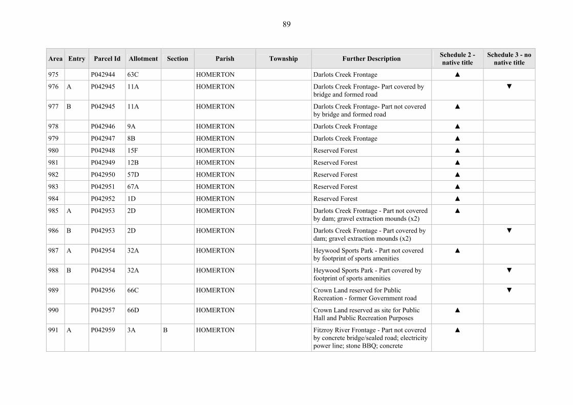
89
Area Entry Parcel Id Allotment Section Parish Township Further Description Schedule 2 - native title
Schedule 3 - no native title
975 P042944 63C HOMERTON Darlots Creek Frontage ▲
976 A P042945 11A HOMERTON Darlots Creek Frontage- Part covered by bridge and formed road
▼
977 B P042945 11A HOMERTON Darlots Creek Frontage- Part not covered by bridge and formed road
▲
978 P042946 9A HOMERTON Darlots Creek Frontage ▲
979 P042947 8B HOMERTON Darlots Creek Frontage ▲
980 P042948 15F HOMERTON Reserved Forest ▲
981 P042949 12B HOMERTON Reserved Forest ▲
982 P042950 57D HOMERTON Reserved Forest ▲
983 P042951 67A HOMERTON Reserved Forest ▲
984 P042952 1D HOMERTON Reserved Forest ▲
985 A P042953 2D HOMERTON Darlots Creek Frontage - Part not covered by dam; gravel extraction mounds (x2)
▲
986 B P042953 2D HOMERTON Darlots Creek Frontage - Part covered by dam; gravel extraction mounds (x2)
▼
987 A P042954 32A HOMERTON Heywood Sports Park - Part not covered by footprint of sports amenities
▲
988 B P042954 32A HOMERTON Heywood Sports Park - Part covered by footprint of sports amenities
▼
989 P042956 66C HOMERTON Crown Land reserved for Public Recreation - former Government road
▼
990 P042957 66D HOMERTON Crown Land reserved as site for Public Hall and Public Recreation Purposes
▲
991 A P042959 3A B HOMERTON Fitzroy River Frontage - Part not covered by concrete bridge/sealed road; electricity power line; stone BBQ; concrete
▲

90
Area Entry Parcel Id Allotment Section Parish Township Further Description Schedule 2 - native title
Schedule 3 - no native title
table/seats; underground line and marker; underground gas pipelines (x2) and markers (x2)
992 B P042959 3A B HOMERTON Fitzroy River Frontage - Part covered by concrete bridge/sealed road; electricity power line; stone BBQ; concrete table/seats; underground line and marker; underground gas pipelines (x2) and markers (x2)
▼
993 P042960 6A HOMERTON Unreserved Crown Land ▲
994 P042961 7A B HOMERTON Fitzroy River Frontage ▲
995 P042962 7B B HOMERTON Crown Land reserved for Preservation of Species of Natural Plants
▲
996 P042963 2A B HOMERTON Fitzroy River Frontage and Darlots Creek Frontage -
▲
997 A P044082 6A B HOMERTON Fitzroy River Frontage - Part not covered by concrete bridge/sealed road; electricity power line; stone BBQ; concrete table/seats; underground line and marker; underground gas pipelines (x2) and markers (x2)
▲
998 B P044082 6A B HOMERTON Fitzroy River Frontage - Part covered by concrete bridge/sealed road; electricity power line; stone BBQ; concrete table/seats; underground line and marker; underground gas pipelines (x2) and markers (x2)
▼
999 P375063 2002 HOMERTON Crown Land forming part of operational Ararat to Portland Railway - Part not covered by railway track.
▼
1000 P375064 2003 HOMERTON Darlot's Creek Frontage ▲

91
Area Entry Parcel Id Allotment Section Parish Township Further Description Schedule 2 - native title
Schedule 3 - no native title
1001 P375065 2001 HOMERTON Fitzroy River Frontage ▲
1002 P043067 42 A HOTSPUR HOTSPUR (T) Unreserved Crown Land ▲
1003 P043068 41 A HOTSPUR HOTSPUR (T) Unreserved Crown Land ▲
1004 P043069 21 HOTSPUR HOTSPUR (T) Unreserved Crown Land ▲
1005 P043070 20 HOTSPUR HOTSPUR (T) Crown Land reserved for Public Recreation Purposes
▲
1006 P043072 1 11 HOTSPUR HOTSPUR (T) Unreserved Crown Land ▲
1007 P043073 2 11 HOTSPUR HOTSPUR (T) Unreserved Crown Land ▲
1008 P043074 3 11 HOTSPUR HOTSPUR (T) Unreserved Crown Land ▲
1009 P043075 4 11 HOTSPUR HOTSPUR (T) Unreserved Crown Land ▲
1010 P043076 6 11 HOTSPUR HOTSPUR (T) Crown Land temporarily reserved for Roman Catholic Church
▲
1011 P043078 4A 18 HOTSPUR HOTSPUR (T) Unreserved Crown Land ▲
1012 P043079 2A 17 HOTSPUR HOTSPUR (T) Unreserved Crown Land ▲
1013 P043080 1A 19 HOTSPUR HOTSPUR (T) Unreserved Crown Land ▲
1014 A P043081 100 A HOTSPUR HOTSPUR (T) Crawford River Crossing - Part not covered by bridge and road.
▲
1015 B P043081 100 A HOTSPUR HOTSPUR (T) Crawford River Crossing - Part covered by bridge and road.
▼
1016 P043082 60 A HOTSPUR HOTSPUR (T) Unreserved Crown Land ▲
1017 P043083 58A A HOTSPUR HOTSPUR (T) Unreserved Crown Land ▲
1018 P043978 9 8 HOTSPUR HOTSPUR (T) Crown Land reserved as a Mechanic Institute - Prior Freehold grant - Whole
▼
1019 P043979 44 A HOTSPUR HOTSPUR (T) Unreserved Crown Land ▲
1020 P043413 1B 4 HOTSPUR Crawford River Frontage ▲

92
Area Entry Parcel Id Allotment Section Parish Township Further Description Schedule 2 - native title
Schedule 3 - no native title
1021 P043414 10A 3 HOTSPUR Crawford River Frontage ▲
1022 P043415 13 B HOTSPUR Gravel Reserve ▲
1023 P043416 2001 HOTSPUR Unreserved Crown Land ▲
1024 P043417 5A B HOTSPUR Crawford River Frontage ▲
1025 P043418 25A B HOTSPUR Crawford River Frontage ▲
1026 P043419 25B B HOTSPUR Crawford River Frontage ▲
1027 A P043420 21A B HOTSPUR Reserved Forest - Part not covered by road - Part not covered by Prior Freehold grant
▲
1028 B P043420 21A B HOTSPUR Reserved Forest - Part covered by road ▼
1029 C P043420 21A B HOTSPUR Reserved Forest - Part covered by Prior Freehold grant
▼
1030 A P043421 25C B HOTSPUR Reserved Forest ▲
1031 P043422 11B A HOTSPUR Crown Land used for softwood production vested in Victorian Plantations Corporation - Prior Freehold grant - Whole
▼
1032 P043424 19C A HOTSPUR Unreserved Crown Land vested in Victorian Plantations Corporation - Prior Freehold grant - Whole
▼
1033 P044083 7A A HOTSPUR Unreserved Crown Land ▲
1034 A P044084 17 B HOTSPUR Unreserved Crown Land ▲
1035 A P367768 26A B HOTSPUR Land vested in Victorian Plantations Corporation - Part covered by Prior Freehold grants
▼
1036 B P367768 26A B HOTSPUR Land vested in Victorian Plantations Corporation - Part covered by road
▼

93
Area Entry Parcel Id Allotment Section Parish Township Further Description Schedule 2 - native title
Schedule 3 - no native title
1037 P042523 5B 1 JERRYWAROOK Wannon River Frontage ▲
1038 P042524 4C 1 JERRYWAROOK Unreserved Crown Land ▲
1039 P042526 5A 8 JERRYWAROOK Wannon River Frontage ▲
1040 P042527 3A 8 JERRYWAROOK Wannon River Frontage ▲
1041 A P042528 2B 12 JERRYWAROOK Public Purpose Reserve adjoining Wannon River - Part not covered by bitumen road
▲
1042 B P042528 2B 12 JERRYWAROOK Public Purpose Reserve adjoining Wannon River - Part covered by bitumen road
▼
1043 P042529 7C 3 JERRYWAROOK Wannon River Frontage ▲
1044 P042530 8A 3 JERRYWAROOK Wannon River Frontage ▲
1045 P042543 77B KARABEAL Unreserved Crown Land withheld from sale, leasing and licencing
▲
1046 P042544 79B KARABEAL Former Gravel Reserve ▲
1047 A P041196 15 5 KENTBRUCK Lower Glenelg National Park - Part not covered by road
▲
1048 B P041196 15 5 KENTBRUCK Lower Glenelg National Park - Part covered by road
▼
1049 P041198 11A 1 KENTBRUCK Unreserved Crown Land, adjacent to McPhail's Creek
▲
1050 P041199 14 1 KENTBRUCK Johnstone's Creek Flora Reserve ▲
1051 P041200 9 5 KENTBRUCK Unreserved Crown Land ▲
1052 P041201 12 2 KENTBRUCK Forest Commercial Plantation- Prior Scheduled Interest
▼
1053 P041202 12B 2 KENTBRUCK Crown Land reserved for Preservation of Landscape
▲
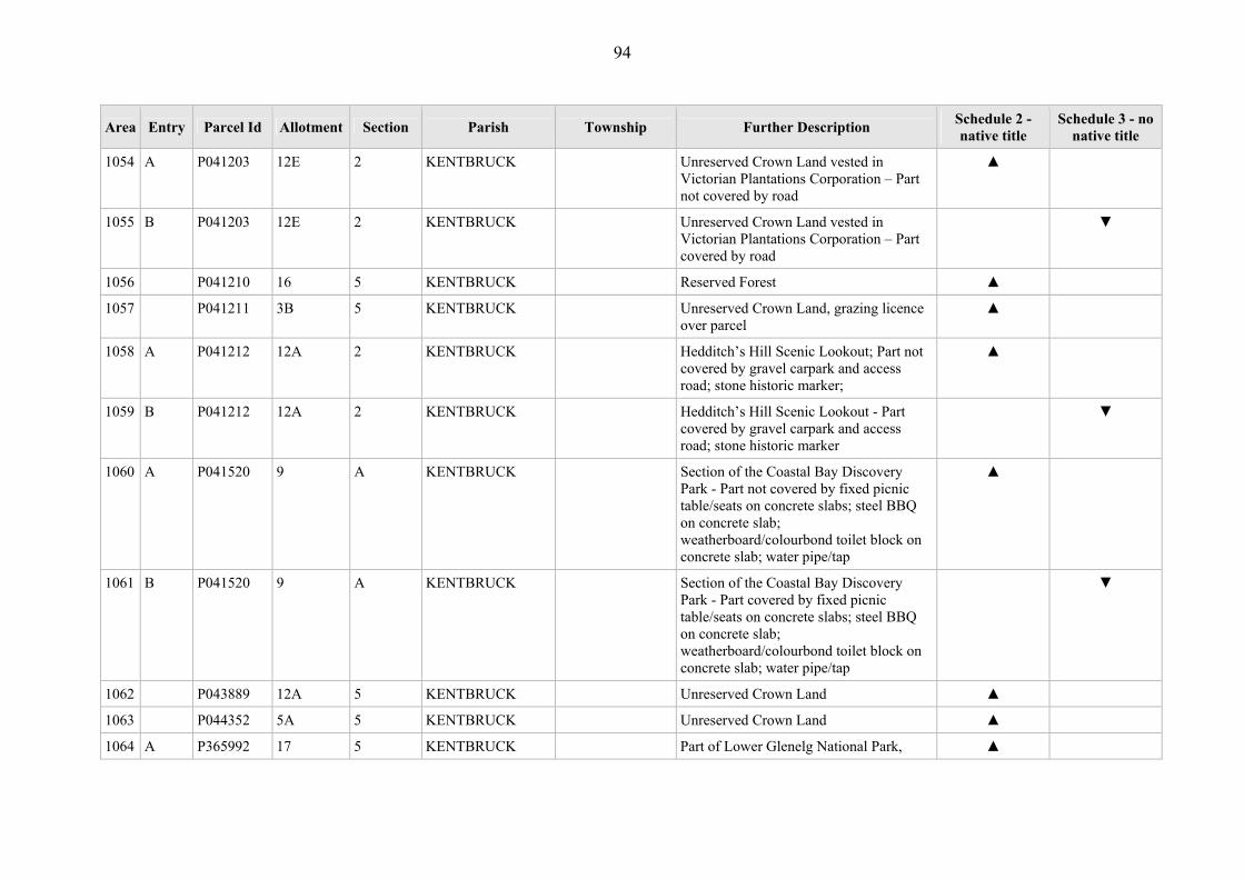
94
Area Entry Parcel Id Allotment Section Parish Township Further Description Schedule 2 - native title
Schedule 3 - no native title
1054 A P041203 12E 2 KENTBRUCK Unreserved Crown Land vested in Victorian Plantations Corporation – Part not covered by road
▲
1055 B P041203 12E 2 KENTBRUCK Unreserved Crown Land vested in Victorian Plantations Corporation – Part covered by road
▼
1056 P041210 16 5 KENTBRUCK Reserved Forest ▲
1057 P041211 3B 5 KENTBRUCK Unreserved Crown Land, grazing licence over parcel
▲
1058 A P041212 12A 2 KENTBRUCK Hedditch’s Hill Scenic Lookout; Part not covered by gravel carpark and access road; stone historic marker;
▲
1059 B P041212 12A 2 KENTBRUCK Hedditch’s Hill Scenic Lookout - Part covered by gravel carpark and access road; stone historic marker
▼
1060 A P041520 9 A KENTBRUCK Section of the Coastal Bay Discovery Park - Part not covered by fixed picnic table/seats on concrete slabs; steel BBQ on concrete slab; weatherboard/colourbond toilet block on concrete slab; water pipe/tap
▲
1061 B P041520 9 A KENTBRUCK Section of the Coastal Bay Discovery Park - Part covered by fixed picnic table/seats on concrete slabs; steel BBQ on concrete slab; weatherboard/colourbond toilet block on concrete slab; water pipe/tap
▼
1062 P043889 12A 5 KENTBRUCK Unreserved Crown Land ▲
1063 P044352 5A 5 KENTBRUCK Unreserved Crown Land ▲
1064 A P365992 17 5 KENTBRUCK Part of Lower Glenelg National Park, ▲
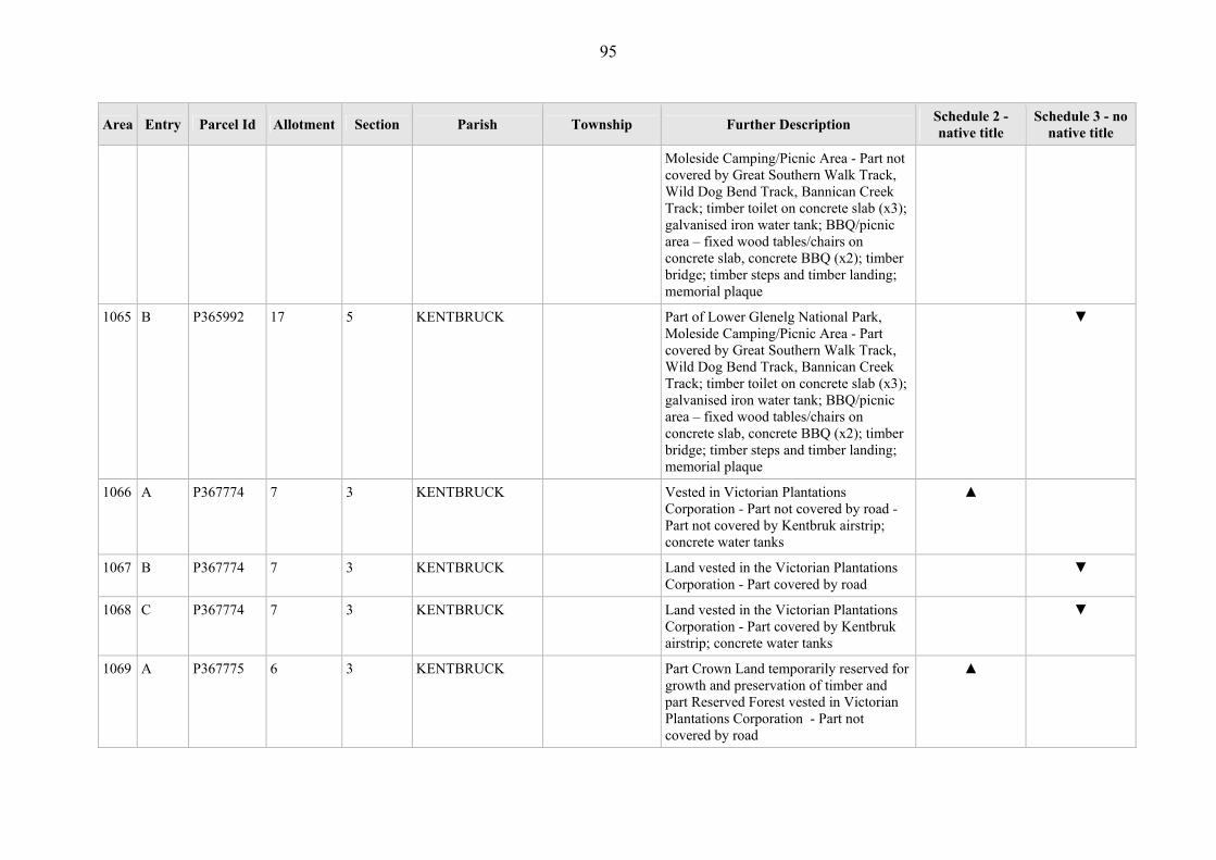
95
Area Entry Parcel Id Allotment Section Parish Township Further Description Schedule 2 - native title
Schedule 3 - no native title
Moleside Camping/Picnic Area - Part not covered by Great Southern Walk Track, Wild Dog Bend Track, Bannican Creek Track; timber toilet on concrete slab (x3); galvanised iron water tank; BBQ/picnic area – fixed wood tables/chairs on concrete slab, concrete BBQ (x2); timber bridge; timber steps and timber landing; memorial plaque
1065 B P365992 17 5 KENTBRUCK Part of Lower Glenelg National Park, Moleside Camping/Picnic Area - Part covered by Great Southern Walk Track, Wild Dog Bend Track, Bannican Creek Track; timber toilet on concrete slab (x3); galvanised iron water tank; BBQ/picnic area – fixed wood tables/chairs on concrete slab, concrete BBQ (x2); timber bridge; timber steps and timber landing; memorial plaque
▼
1066 A P367774 7 3 KENTBRUCK Vested in Victorian Plantations Corporation - Part not covered by road - Part not covered by Kentbruk airstrip; concrete water tanks
▲
1067 B P367774 7 3 KENTBRUCK Land vested in the Victorian Plantations Corporation - Part covered by road
▼
1068 C P367774 7 3 KENTBRUCK Land vested in the Victorian Plantations Corporation - Part covered by Kentbruk airstrip; concrete water tanks
▼
1069 A P367775 6 3 KENTBRUCK Part Crown Land temporarily reserved for growth and preservation of timber and part Reserved Forest vested in Victorian Plantations Corporation - Part not covered by road
▲

96
Area Entry Parcel Id Allotment Section Parish Township Further Description Schedule 2 - native title
Schedule 3 - no native title
1070 B P367775 6 3 KENTBRUCK Part Crown Land temporarily reserved for growth and preservation of timber and part Reserved Forest vested in Victorian Plantations Corporation - Part covered by road
▼
1071 P369478 2001 KENTBRUCK Unreserved Crown Land ▲
1072 P373670 2002 KENTBRUCK Unreserved Crown Land ▲
1073 P043013 10A A KILLARA Glenelg River Frontage ▲
1074 P043018 8B C KILLARA Glenelg River Frontage ▲
1075 P043019 14A D KILLARA Glenelg River Frontage ▲
1076 P043020 20C D KILLARA Barry's Swamp Preservation of Landscape Reserve
▲
1077 P043021 14 KILLARA Wildlife Habitat Reserve- Prior Scheduled Interest
▼
1078 P043022 7 KILLARA Wildlife Habitat Reserve- Prior Scheduled Interest
▼
1079 P043023 6 KILLARA Wildlife Habitat Reserve- Prior Scheduled Interest
▼
1080 P043024 5 KILLARA Wildlife Habitat Reserve- Prior Scheduled Interest
▼
1081 P043025 5A KILLARA Drainage Reserve ▲
1082 P043026 4A D KILLARA Crown Land set aside for Water Reserve ▲
1083 P043027 14 D KILLARA Crown Land Reserved for Natural Interest ▲
1084 P043028 3A D KILLARA Unreserved Crown Land ▲
1085 P043029 3B D KILLARA Unreserved Crown Land ▲
1086 P043030 3C D KILLARA Unreserved Crown Land ▲
1087 P043031 3B C KILLARA Wilkin Park Flora and Fauna Reserve ▲
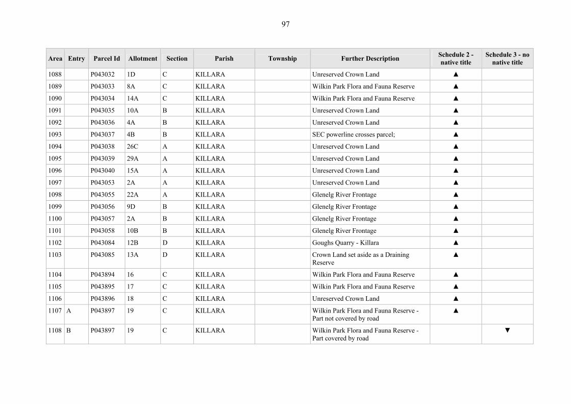
97
Area Entry Parcel Id Allotment Section Parish Township Further Description Schedule 2 - native title
Schedule 3 - no native title
1088 P043032 1D C KILLARA Unreserved Crown Land ▲
1089 P043033 8A C KILLARA Wilkin Park Flora and Fauna Reserve ▲
1090 P043034 14A C KILLARA Wilkin Park Flora and Fauna Reserve ▲
1091 P043035 10A B KILLARA Unreserved Crown Land ▲
1092 P043036 4A B KILLARA Unreserved Crown Land ▲
1093 P043037 4B B KILLARA SEC powerline crosses parcel; ▲
1094 P043038 26C A KILLARA Unreserved Crown Land ▲
1095 P043039 29A A KILLARA Unreserved Crown Land ▲
1096 P043040 15A A KILLARA Unreserved Crown Land ▲
1097 P043053 2A A KILLARA Unreserved Crown Land ▲
1098 P043055 22A A KILLARA Glenelg River Frontage ▲
1099 P043056 9D B KILLARA Glenelg River Frontage ▲
1100 P043057 2A B KILLARA Glenelg River Frontage ▲
1101 P043058 10B B KILLARA Glenelg River Frontage ▲
1102 P043084 12B D KILLARA Goughs Quarry - Killara ▲
1103 P043085 13A D KILLARA Crown Land set aside as a Draining Reserve
▲
1104 P043894 16 C KILLARA Wilkin Park Flora and Fauna Reserve ▲
1105 P043895 17 C KILLARA Wilkin Park Flora and Fauna Reserve ▲
1106 P043896 18 C KILLARA Unreserved Crown Land ▲
1107 A P043897 19 C KILLARA Wilkin Park Flora and Fauna Reserve - Part not covered by road
▲
1108 B P043897 19 C KILLARA Wilkin Park Flora and Fauna Reserve - Part covered by road
▼

98
Area Entry Parcel Id Allotment Section Parish Township Further Description Schedule 2 - native title
Schedule 3 - no native title
1109 P043898 20 C KILLARA Wilkin Park Flora and Fauna Reserve ▲
1110 P043899 21 C KILLARA Wilkin Park Flora and Fauna Reserve ▲
1111 A P043901 23 C KILLARA Wilkin Park Flora and Fauna Reserve - Part not covered by road
▲
1112 B P043901 23 C KILLARA Wilkin Park Flora and Fauna Reserve - Part covered by road
▼
1113 P044402 12C D KILLARA Unreserved Crown Land ▲
1114 P044090 15G KINKELLA Glenelg River Frontage ▲
1115 P044091 7B KINKELLA Crown Land temporarily reserve for Public Purposes
▲
1116 A P044093 23 KINKELLA Lower Glenelg National Park, portion within 100 metre buffer to Glenelg River - Part not covered by Prior Freehold grant - Part not covered by road
▲
1117 B P044093 23 KINKELLA Lower Glenelg National Park, portion within 100 metre buffer to Glenelg River - Part covered by Prior Freehold grant
▼
1118 C P044093 23 KINKELLA Lower Glenelg National Park, portion within 100 metre buffer to Glenelg River - Part covered by road
▼
1119 P044094 22 KINKELLA Conservation of Area of Natural Interest Reserve
▲
1120 P044095 15 KINKELLA Conservation of Area of Natural Interest Reserve
▲
1121 A P040276 4 8 MACARTHUR MACARTHUR (T)
Breakfast Creek Frontage - Part not covered by Prior Freehold grant
▲
1122 B P040276 4 8 MACARTHUR MACARTHUR (T)
Breakfast Creek Frontage - Part covered by Prior Freehold grant
▼

99
Area Entry Parcel Id Allotment Section Parish Township Further Description Schedule 2 - native title
Schedule 3 - no native title
1123 A P040282 12A 16 MACARTHUR MACARTHUR (T)
Unreserved Crown Land used as a Department of Sustainability and Environment Depot - Part not covered by depot and building
▲
1124 B P040282 12A 16 MACARTHUR MACARTHUR (T)
Unreserved Crown Land used as a Department of Sustainability and Environment Depot - Part covered by depot and building
▼
1125 P040283 12B 16 MACARTHUR MACARTHUR (T)
Unreserved Crown Land used as a Department of Sustainability and Environment Depot - Prior Freehold grant
▼
1126 P040289 20 6A MACARTHUR MACARTHUR (T)
Macarthur State School - Covered by school buildings; developed playground areas - Whole
▼
1127 P040290 21 6A MACARTHUR MACARTHUR (T)
Unreserved Crown Land ▲
1128 P040291 15 5 MACARTHUR MACARTHUR (T)
Crown Land reserved as a site for Public Purposes and Public Recreation - covered by swimming pool; bowling green; playground; various amenity/facility buildings.
▼
1129 A P040293 4B 2 MACARTHUR MACARTHUR (T)
Infant Welfare Centre, fenced parcel - part covered by playground area.
▼
1130 B P040293 4B 2 MACARTHUR MACARTHUR (T)
Infant Welfare Centre, fenced parcel - part not covered by playground area.
▲
1131 P040294 4C 2 MACARTHUR MACARTHUR (T)
Infant Welfare Centre, fenced parcel - covered by various buildings; water tanks; septic tanks.
▼
1132 P040295 4D 2 MACARTHUR MACARTHUR (T)
Infant Welfare Centre, fenced parcel - part covered by various buildings; water tanks; septic tanks.
▼

100
Area Entry Parcel Id Allotment Section Parish Township Further Description Schedule 2 - native title
Schedule 3 - no native title
1133 P040295 4D 2 MACARTHUR MACARTHUR (T)
Infant Welfare Centre, fenced parcel - part covered by various buildings; water tanks; septic tanks.
▲
1134 P040296 3 13 MACARTHUR MACARTHUR (T)
Unreserved Crown Land ▲
1135 P040297 7 11 MACARTHUR MACARTHUR (T)
Unreserved Crown Land ▲
1136 P040298 6 11 MACARTHUR MACARTHUR (T)
Eumeralla River Frontage, Native Game Sanctuary
▲
1137 A P374818 9 2 MACARTHUR MACARTHUR (T)
Infant Welfare Centre, fenced parcel - part covered by various buildings; water tanks; septic tanks.
▼
1138 B P374818 9 2 MACARTHUR MACARTHUR (T)
Infant Welfare Centre, fenced parcel - part not covered by various buildings; water tanks; septic tanks.
▲
1139 P041237 13A 8 MACARTHUR Unreserved Crown Land ▲
1140 P041238 12A 8 MACARTHUR Mount Eccles National Park ▲
1141 P041239 20D 8 MACARTHUR Unreserved Crown Land - Prior Freehold grant - Whole
▼
1142 P041240 15E 8 MACARTHUR Eumeralla Drainage Area - Covered by Drain.
▼
1143 P041241 28B 8 MACARTHUR Mount Eccles National Park ▲
1144 P041242 28A 8 MACARTHUR Mount Eccles National Park ▲
1145 P041244 22C 8 MACARTHUR Lake Gorrie Drainage Area - Covered by Drain
▼
1146 P041247 10A 12A MACARTHUR Eumeralla River Frontage ▲
1147 P041248 6A 11 MACARTHUR Unreserved Crown Land ▲
1148 P041249 15B 12B MACARTHUR Unreserved Crown Land ▲
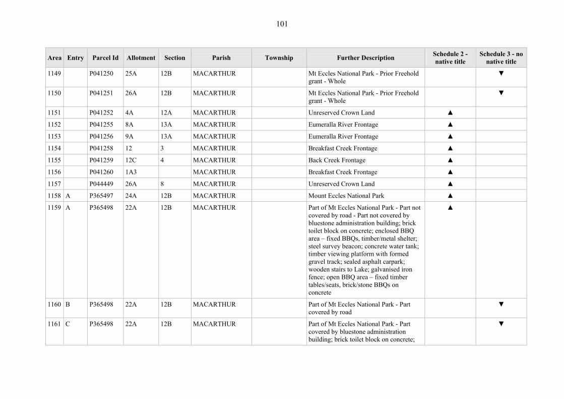
101
Area Entry Parcel Id Allotment Section Parish Township Further Description Schedule 2 - native title
Schedule 3 - no native title
1149 P041250 25A 12B MACARTHUR Mt Eccles National Park - Prior Freehold grant - Whole
▼
1150 P041251 26A 12B MACARTHUR Mt Eccles National Park - Prior Freehold grant - Whole
▼
1151 P041252 4A 12A MACARTHUR Unreserved Crown Land ▲
1152 P041255 8A 13A MACARTHUR Eumeralla River Frontage ▲
1153 P041256 9A 13A MACARTHUR Eumeralla River Frontage ▲
1154 P041258 12 3 MACARTHUR Breakfast Creek Frontage ▲
1155 P041259 12C 4 MACARTHUR Back Creek Frontage ▲
1156 P041260 1A3 MACARTHUR Breakfast Creek Frontage ▲
1157 P044449 26A 8 MACARTHUR Unreserved Crown Land ▲
1158 A P365497 24A 12B MACARTHUR Mount Eccles National Park ▲
1159 A P365498 22A 12B MACARTHUR Part of Mt Eccles National Park - Part not covered by road - Part not covered by bluestone administration building; brick toilet block on concrete; enclosed BBQ area – fixed BBQs, timber/metal shelter; steel survey beacon; concrete water tank; timber viewing platform with formed gravel track; sealed asphalt carpark; wooden stairs to Lake; galvanised iron fence; open BBQ area – fixed timber tables/seats, brick/stone BBQs on concrete
▲
1160 B P365498 22A 12B MACARTHUR Part of Mt Eccles National Park - Part covered by road
▼
1161 C P365498 22A 12B MACARTHUR Part of Mt Eccles National Park - Part covered by bluestone administration building; brick toilet block on concrete;
▼

102
Area Entry Parcel Id Allotment Section Parish Township Further Description Schedule 2 - native title
Schedule 3 - no native title
enclosed BBQ area – fixed BBQs, timber/metal shelter; steel survey beacon; concrete water tank; timber viewing platform with formed gravel track; sealed asphalt carpark; wooden stairs to Lake; galvanised iron fence; open BBQ area – fixed timber tables/seats, brick/stone BBQs on concrete
1162 P365512 7A 12A MACARTHUR Mt Eccles National Park - Prior Freehold grant - Whole
▼
1163 P365602 20 12B MACARTHUR Mt Eccles National Park - Prior Freehold grant - Whole
▼
1164 P365603 10B 12A MACARTHUR Former government road in Mt Eccles National Park
▼
1165 P042246 2F 1A MERINO MERINO (T) Crown Land reserved for Public Purposes - former Government road - Whole
▼
1166 P042247 2G 1A MERINO MERINO (T) Merino Park - Oval, buildings, pavilion;, tennis courts, swimming pool, toilet blocks - Whole
▼
1167 P042248 2H 1A MERINO MERINO (T) Crown Land reserved for Railway Purposes
▲
1168 A P042249 2E 1A MERINO MERINO (T) Casterton to Branxholme Railway - Part not covered by railway tracks.
▲
1169 B P042249 2E 1A MERINO MERINO (T) Casterton to Branxholme Railway - Part covered by railways tracks
▼
1170 P042250 4 1A MERINO MERINO (T) Unreserved Crown Land, grazing licence over parcel
▲
1171 P042251 3 1A MERINO MERINO (T) Unreserved Crown Land ▲
1172 P042252 4A 1A MERINO MERINO (T) Merino Creek Frontage ▲

103
Area Entry Parcel Id Allotment Section Parish Township Further Description Schedule 2 - native title
Schedule 3 - no native title
1173 A P042253 5A 1 MERINO MERINO (T) Casterton to Branxholme Railway - Part not covered by railway tracks.
▲
1174 B P042253 5A 1 MERINO MERINO (T) Casterton to Branxholme Railway - Part not covered by railway tracks
▼
1175 A P042254 6 2 MERINO MERINO (T) Casterton to Branxholme Railway - Part covered by railways tracks
▲
1176 B P042254 6 2 MERINO MERINO (T) Casterton to Branxholme Railway - Part not covered by railway tracks
▼
1177 P042255 13A 2 MERINO MERINO (T) Merino Creek Frontage ▲
1178 P042256 63A MERINO MERINO (T) Palmers Creek Frontage ▲
1179 P042257 60B MERINO MERINO (T) Crown Land temporarily reserved for Public Recreation Purposes
▲
1180 P042258 60A MERINO MERINO (T) Palmers Creek frontage ▲
1181 P042259 60C MERINO MERINO (T) Merino Railway Station - Railway station, grounds, railway tracks - Whole
▼
1182 P042260 3A 6 MERINO MERINO (T) Merino Bush Nursing Hospital, post/wire fence around parcel - covered by hospital; shed (x3); water tanks/meters - Whole .
▼
1183 P042261 7 3 MERINO MERINO (T) Crown Land reserved for Merino Mechanics Institute - Prior Freehold grant - Whole
▼
1184 P042262 9 3 MERINO MERINO (T) Merino Fire Station - covered by fire station; garage; tower - Whole
▼
1185 P042263 9B 3 MERINO MERINO (T) Merino Telephone Exchange - covered by automated telephone exchange - Whole
▼
1186 P042264 1 14 MERINO MERINO (T) Unreserved Crown Land - Prior Freehold grant - Whole
▼
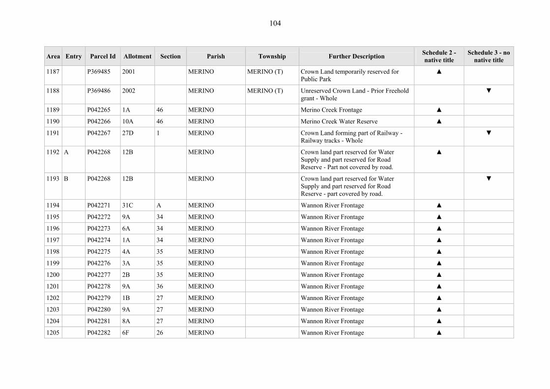
104
Area Entry Parcel Id Allotment Section Parish Township Further Description Schedule 2 - native title
Schedule 3 - no native title
1187 P369485 2001 MERINO MERINO (T) Crown Land temporarily reserved for Public Park
▲
1188 P369486 2002 MERINO MERINO (T) Unreserved Crown Land - Prior Freehold grant - Whole
▼
1189 P042265 1A 46 MERINO Merino Creek Frontage ▲
1190 P042266 10A 46 MERINO Merino Creek Water Reserve ▲
1191 P042267 27D 1 MERINO Crown Land forming part of Railway - Railway tracks - Whole
▼
1192 A P042268 12B MERINO Crown land part reserved for Water Supply and part reserved for Road Reserve - Part not covered by road.
▲
1193 B P042268 12B MERINO Crown land part reserved for Water Supply and part reserved for Road Reserve - part covered by road.
▼
1194 P042271 31C A MERINO Wannon River Frontage ▲
1195 P042272 9A 34 MERINO Wannon River Frontage ▲
1196 P042273 6A 34 MERINO Wannon River Frontage ▲
1197 P042274 1A 34 MERINO Wannon River Frontage ▲
1198 P042275 4A 35 MERINO Wannon River Frontage ▲
1199 P042276 3A 35 MERINO Wannon River Frontage ▲
1200 P042277 2B 35 MERINO Wannon River Frontage ▲
1201 P042278 9A 36 MERINO Wannon River Frontage ▲
1202 P042279 1B 27 MERINO Wannon River Frontage ▲
1203 P042280 9A 27 MERINO Wannon River Frontage ▲
1204 P042281 8A 27 MERINO Wannon River Frontage ▲
1205 P042282 6F 26 MERINO Wannon River Frontage ▲

105
Area Entry Parcel Id Allotment Section Parish Township Further Description Schedule 2 - native title
Schedule 3 - no native title
1206 P042283 6G 26 MERINO Wannon River Frontage, Merino Creek Frontage
▲
1207 P042284 6H 26 MERINO Merino Creek Frontage ▲
1208 P042285 14B 16 MERINO Merino Creek Frontage ▲
1209 P042286 6A 6 MERINO Unreserved Crown Land, grazing licence over parcel
▲
1210 P044101 6J 26 MERINO Wannon River Frontage ▲
1211 P044102 5B 26 MERINO Merino Creek Frontage ▲
1212 P044103 1 46 MERINO Crown Land with licence for Merino Golf Course, formerly temporary Reserve for Police - Prior Scheduled Interest - Whole
▼
1213 P042290 1A 16 MOCAMBORO Unreserved Crown Land ▲
1214 A P042291 1B 16 MOCAMBORO Unreserved Crown Land - Part not covered by gravel road
▲
1215 B P042291 1B 16 MOCAMBORO Unreserved Crown Land - Part gravel road
▼
1216 A P042292 5 16 MOCAMBORO Crown land vested in the Victorian Plantation Corporation - Part not covered by former grant Vol 2230 Fol445954;); Part not covered by concrete water tank (x2); underground water pipeline – valves (x2); major earthworks – extracted gravel mounds; water dam (x2); Part not covered by road
▲
1217 B P042292 5 16 MOCAMBORO Crown land vested in the Victorian Plantation Corporation - Part covered by former grant Vol 2230 Fol445954;)
▼
1218 C P042292 5 16 MOCAMBORO Crown land vested in the Victorian Plantation Corporation - Part covered by
▼

106
Area Entry Parcel Id Allotment Section Parish Township Further Description Schedule 2 - native title
Schedule 3 - no native title
concrete water tank (x2); underground water pipeline – valves (x2); major earthworks – extracted gravel mounds; water dam (x2)
1219 D P042292 5 16 MOCAMBORO Crown land vested in the Victorian Plantation Corporation – Part covered by road
▼
1220 P042294 4D 15 MOCAMBORO Crown Land reserved for Education Purposes
▲
1221 P042295 2A 16 MOCAMBORO Unreserved Crown Land ▲
1222 P042296 1C 18 MOCAMBORO Unreserved Crown Land ▲
1223 P042297 2A 19 MOCAMBORO Unreserved Crown Land ▲
1224 P042298 4B 12 MOCAMBORO Unreserved Crown Land ▲
1225 P042299 4A 12 MOCAMBORO Unreserved Crown Land ▲
1226 P042300 7A 1 MOCAMBORO Water Reserve ▲
1227 P042301 5A 6 MOCAMBORO Water Reserve ▲
1228 P042302 1E 2 MOCAMBORO Merino Creek Frontage ▲
1229 P042303 5C 1 MOCAMBORO Water Supply Reserve ▲
1230 P042304 1A 2 MOCAMBORO Unreserved Crown Land ▲
1231 P042305 6A 2 MOCAMBORO Unreserved Crown Land ▲
1232 A P042306 6B 2 MOCAMBORO Water and Camping Reserve - Part not covered by formed dirt road (x2); post/wire fence and timber entrance gate
▲
1233 B P042306 6B 2 MOCAMBORO Water and Camping Reserve - Part covered by formed dirt road (x2); post/wire fence and timber entrance gate
▼
1234 A P042308 1B 8 MOCAMBORO Merino Tip, post/wire fence and wooden ▲

107
Area Entry Parcel Id Allotment Section Parish Township Further Description Schedule 2 - native title
Schedule 3 - no native title
gate surrounding tip- - Part not covered by rubbish tip (x2); formed dirt road into tip; major earthworks – gravel mounds; concrete water tank
1235 B P042308 1B 8 MOCAMBORO Merino Tip, post/wire fence and wooden gate surrounding tip - Part covered by rubbish tip (x2); formed dirt road into tip; major earthworks – gravel mounds; concrete water tank
▼
1236 P042309 1D 4 MOCAMBORO Former Tip ▲
1237 A P044105 3B 24 MOCAMBORO Heath Point Trig Station - Part not covered by footprint of steel survey beacon station
▲
1238 B P044105 3B 24 MOCAMBORO Heath Point Trig Station - Part covered by footprint of steel survey beacon station
▼
1239 P044106 3C 24 MOCAMBORO Unreserved Crown Land ▲
1240 P044107 2D 23 MOCAMBORO Unreserved Crown Land ▲
1241 A P044108 2C 23 MOCAMBORO Trig Track, post/wire fence on western boundary - Part not covered by Powercor underground line/timber marker; underground line/metal marker; dirt road – Trig Track
▲
1242 B P044108 2C 23 MOCAMBORO Trig Track, post/wire fence on western boundary - Part covered by Powercor underground line/timber marker; underground line/metal marker; dirt road – Trig Track
▼
1243 A P044109 2E 23 MOCAMBORO North Mocamboro Bore - Part not covered by bore and electric water pump (wire fence surround); brick shed/concrete water tank (wire fence surround);
▲

108
Area Entry Parcel Id Allotment Section Parish Township Further Description Schedule 2 - native title
Schedule 3 - no native title
overhead electricity line/timber pole; underground line and marker; dirt track – Perrys Track; dirt track
1244 B P044109 2E 23 MOCAMBORO North Mocamboro Bore - Part covered by bore and electric water pump (wire fence surround); brick shed/concrete water tank (wire fence surround); overhead electricity line/timber pole; underground line and marker; dirt track
▼
1245 A P044110 3A 21 MOCAMBORO South Mocamboro Bore, Square Wheel Road - Part not covered by bore and electric water pump (wire fence surround); formed dirt track; formed dirt track – Perrys Track
▲
1246 B P044110 3A 21 MOCAMBORO South Mocamboro Bore, Square Wheel Road - Part covered by bore and electric water pump (wire fence surround); formed dirt track; formed dirt track – Perrys Track
▼
1247 P044111 1D 20 MOCAMBORO Unreserved Crown Land ▲
1248 P044112 1C 20 MOCAMBORO Crown Land set aside as Water Reserve ▲
1249 P044113 1B 20 MOCAMBORO Crown Land deemed reserved for Preservation of a Species of Native Plants - Prior Freehold grant
▼
1250 P026018 84H MOKANGER Former Timber Reserve - ▲
1251 P026019 84F MOKANGER Former Timber Reserve - ▲
1252 P043300 84C MOKANGER Unreserved Crown Land, formerly part of the Karabeal Agricultural Common
▲
1253 P043301 20G MOKANGER Unreserved Crown Land, formerly part of the Karabeal Agricultural Common
▲

109
Area Entry Parcel Id Allotment Section Parish Township Further Description Schedule 2 - native title
Schedule 3 - no native title
1254 A P043302 2E MOKANGER Wannon River Frontage - Part not covered by Glenelg Region Water Authority underground pipeline; timber/metal bridge over Wannon River
▲
1255 B P043302 2E MOKANGER Wannon River frontage - Part covered by Glenelg Region Water Authority underground pipeline; timber/metal bridge over Wannon River
▼
1256 A P043303 8C MOKANGER Mokanger Common Yards, Wannon Region Water Authority Hamilton Supply Main passes through parcel, parcel includes grazing licence - Part not covered by underground water supply mains
▲
1257 B P043303 8C MOKANGER Mokanger Common Yards, Wannon Region Water Authority Hamilton Supply Main passes through parcel, parcel includes grazing licence - Part covered by underground water supply mains
▼
1258 P043304 2F MOKANGER Wannon River Drainage Reserve - Underground water supply mains - Whole
▼
1259 P043838 2D MOKANGER Unreserved Crown land, current grazing licence
▲
1260 P043839 2C MOKANGER Unreserved Crown land, current grazing licence
▲
1261 P044228 20F MOKANGER Wannon River Frontage ▲
1262 P044229 84G MOKANGER Wannon River Frontage ▲
1263 P366627 84J MOKANGER Wannon River Frontage ▲
1264 P041823 1D 11 MONIVAE Unreserved Crown Land ▲
1265 A P043475 8 3 MONIVAE Monivae Water Supply Reserve - Part not covered by water dams (x2); steel
▲
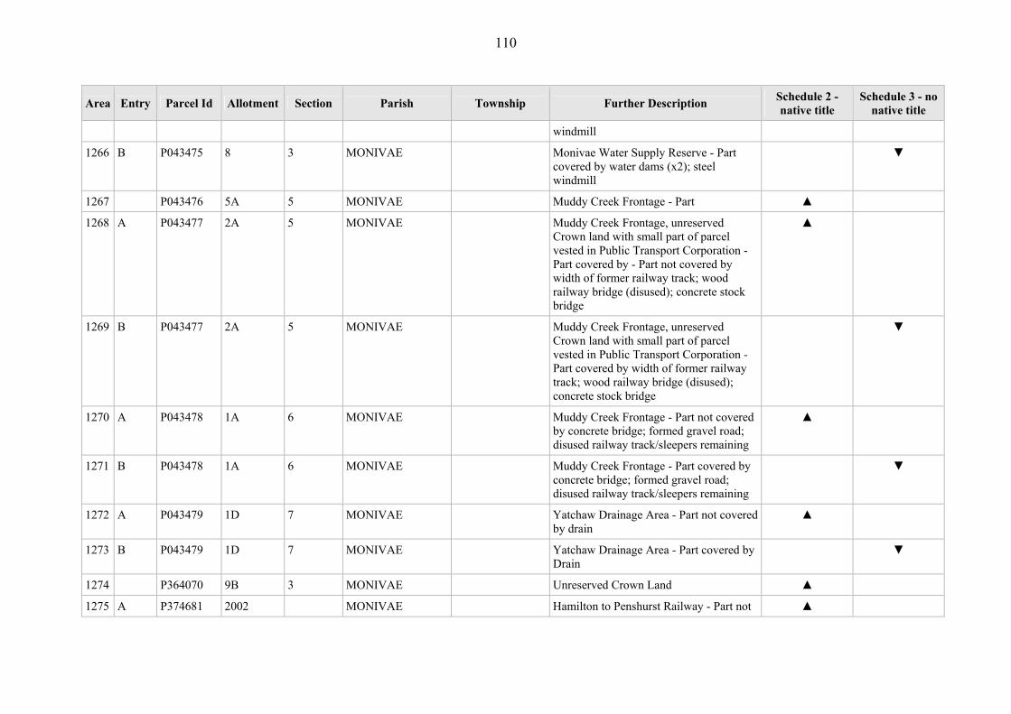
110
Area Entry Parcel Id Allotment Section Parish Township Further Description Schedule 2 - native title
Schedule 3 - no native title
windmill
1266 B P043475 8 3 MONIVAE Monivae Water Supply Reserve - Part covered by water dams (x2); steel windmill
▼
1267 P043476 5A 5 MONIVAE Muddy Creek Frontage - Part ▲
1268 A P043477 2A 5 MONIVAE Muddy Creek Frontage, unreserved Crown land with small part of parcel vested in Public Transport Corporation - Part covered by - Part not covered by width of former railway track; wood railway bridge (disused); concrete stock bridge
▲
1269 B P043477 2A 5 MONIVAE Muddy Creek Frontage, unreserved Crown land with small part of parcel vested in Public Transport Corporation - Part covered by width of former railway track; wood railway bridge (disused); concrete stock bridge
▼
1270 A P043478 1A 6 MONIVAE Muddy Creek Frontage - Part not covered by concrete bridge; formed gravel road; disused railway track/sleepers remaining
▲
1271 B P043478 1A 6 MONIVAE Muddy Creek Frontage - Part covered by concrete bridge; formed gravel road; disused railway track/sleepers remaining
▼
1272 A P043479 1D 7 MONIVAE Yatchaw Drainage Area - Part not covered by drain
▲
1273 B P043479 1D 7 MONIVAE Yatchaw Drainage Area - Part covered by Drain
▼
1274 P364070 9B 3 MONIVAE Unreserved Crown Land ▲
1275 A P374681 2002 MONIVAE Hamilton to Penshurst Railway - Part not ▲
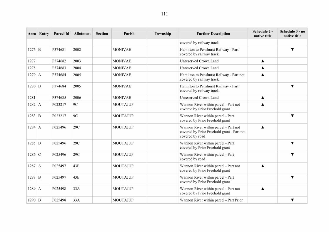
111
Area Entry Parcel Id Allotment Section Parish Township Further Description Schedule 2 - native title
Schedule 3 - no native title
covered by railway track.
1276 B P374681 2002 MONIVAE Hamilton to Penshurst Railway - Part covered by railway track.
▼
1277 P374682 2003 MONIVAE Unreserved Crown Land ▲
1278 P374683 2004 MONIVAE Unreserved Crown Land ▲
1279 A P374684 2005 MONIVAE Hamilton to Penshurst Railway - Part not covered by railway track.
▲
1280 B P374684 2005 MONIVAE Hamilton to Penshurst Railway - Part covered by railway track.
▼
1281 P374685 2006 MONIVAE Unreserved Crown Land ▲
1282 A P023217 9C MOUTAJUP Wannon River within parcel - Part not covered by Prior Freehold grant
▲
1283 B P023217 9C MOUTAJUP Wannon River within parcel - Part covered by Prior Freehold grant
▼
1284 A P025496 29C MOUTAJUP Wannon River within parcel - Part not covered by Prior Freehold grant - Part not covered by road
▲
1285 B P025496 29C MOUTAJUP Wannon River within parcel - Part covered by Prior Freehold grant
▼
1286 C P025496 29C MOUTAJUP Wannon River within parcel - Part covered by road
▼
1287 A P025497 43E MOUTAJUP Wannon River within parcel - Part not covered by Prior Freehold grant
▲
1288 B P025497 43E MOUTAJUP Wannon River within parcel - Part covered by Prior Freehold grant
▼
1289 A P025498 33A MOUTAJUP Wannon River within parcel - Part not covered by Prior Freehold grant
▲
1290 B P025498 33A MOUTAJUP Wannon River within parcel - Part Prior ▼

112
Area Entry Parcel Id Allotment Section Parish Township Further Description Schedule 2 - native title
Schedule 3 - no native title
Freehold grant
1291 P043316 116A MOUTAJUP Ararat to Hamilton Railway - Railway track - Whole
▼
1292 P043317 108A MOUTAJUP Unreserved crown land ▲
1293 P043318 121A MOUTAJUP Ararat to Hamilton Railway - Part not covered by railway track.
▼
1294 P043319 77D MOUTAJUP Unreserved Crown Land ▲
1295 P043320 62F MOUTAJUP Unreserved Crown Land, grazing licence on parcel
▲
1296 A P043321 62G MOUTAJUP Former Moutajup State School - Part not covered by school buildings
▲
1297 B P043321 62G MOUTAJUP Former Moutajup State School - Part covered by school buildings
▼
1298 A P041276 11 5 MOUZIE Mouzie Sand Dunes, Discovery Bay Coastal Park - part not Prior Freehold grant - Part not covered by Prior Scheduled Interest - Part not covered by road - Part not covered by weatherboard/iron toilet block (x2); concrete water tank and taps; picnic table/seats; steel BBQ on concrete base; water pump – concrete/steel housing; concrete water tank (large); campsite demarcated by pine posts; formed dirt picnic area
▲
1299 B P041276 11 5 MOUZIE Mouzie Sand Dunes, Discovery Bay Coastal Park - Part covered by Prior Freehold grant
▼
1300 C P041276 11 5 MOUZIE Mouzie Sand Dunes, Discovery Bay Coastal Park - Part covered by Prior
▼

113
Area Entry Parcel Id Allotment Section Parish Township Further Description Schedule 2 - native title
Schedule 3 - no native title
Scheduled Interest
1301 D P041276 11 5 MOUZIE Mouzie Sand Dunes, Discovery Bay Coastal Park - Part covered by road
▼
1302 E P041276 11 5 MOUZIE Mouzie Sand Dunes, Discovery Bay Coastal Park - Part covered by weatherboard/iron toilet block (x2); concrete water tank and taps; picnic table/seats; steel BBQ on concrete base; water pump – concrete/steel housing; concrete water tank (large); campsite demarcated by pine posts; formed dirt picnic area
▼
1303 P041277 4A 6 MOUZIE Perpetual Licence issued to Hancock Victorian Plantations - Prior Freehold grant - Whole
▼
1304 P041278 20A 7 MOUZIE Cashmore Drainage Area - Covered by Drain - Whole
▼
1305 P041279 18B 7 MOUZIE Cashmore Drainage Area - Covered by Drain - Whole
▼
1306 P041280 16A 7 MOUZIE Unreserved Crown Land ▲
1307 A P041281 3A 6 MOUZIE Crown Land vested in Victorian Plantations Corporation - Part not covered by Prior Freehold grant; Part not covered by road
▲
1308 B P041281 3A 6 MOUZIE Crown Land vested in Victorian Plantations Corporation - Part Prior Freehold grant
▼
1309 C P041281 3A 6 MOUZIE Crown Land vested in Victorian Plantations Corporation – Part covered by road
▼

114
Area Entry Parcel Id Allotment Section Parish Township Further Description Schedule 2 - native title
Schedule 3 - no native title
1310 P041282 9 2 MOUZIE Crown Land vested in Victorian Plantations Corporation
▲
1311 P041283 21 10 MOUZIE Mouzie Natural Interest Reserve ▲
1312 P041284 15A 10 MOUZIE Mt Richmond Recreation Reserve- ▲
1313 P041285 15B 7 MOUZIE Crown Land set aside as Quarry Reserve ▲
1314 P041286 16 8 MOUZIE Unreserved Crown Land ▲
1315 P041287 15 8 MOUZIE Unreserved Crown Land ▲
1316 P041288 4B 10 MOUZIE Unreserved Crown Land ▲
1317 P041289 5A 10 MOUZIE Crown Land set aside as Gravel Reserve ▲
1318 P041290 5 1 MOUZIE Unreserved Crown Land ▲
1319 P041291 6 1 MOUZIE Unreserved Crown Land ▲
1320 P041292 4 1 MOUZIE Johnstones Creek Flora Reserve ▲
1321 P041293 4A 1 MOUZIE Reserve for Preservation of Native Species
▲
1322 P041294 8 2 MOUZIE Mouzie Bushland Reserve ▲
1323 P041297 1A 10 MOUZIE Crown Land set aside as Quarry Reserve ▲
1324 A P041298 12 5 MOUZIE Mt Richmond National Park - Part not covered by Prior Freehold grant - Part not covered by road
▲
1325 B P041298 12 5 MOUZIE Mt Richmond National Park - Part covered by Prior Freehold grant
▼
1326 C P041298 12 5 MOUZIE Mt Richmond National Park - Part covered by road
▼
1327 P041300 23A 9 MOUZIE Cashmore Drainage Area - Covered by drain.
▼
1328 A P041304 35A 9 MOUZIE Cashmore Drainage Area - Part not ▲
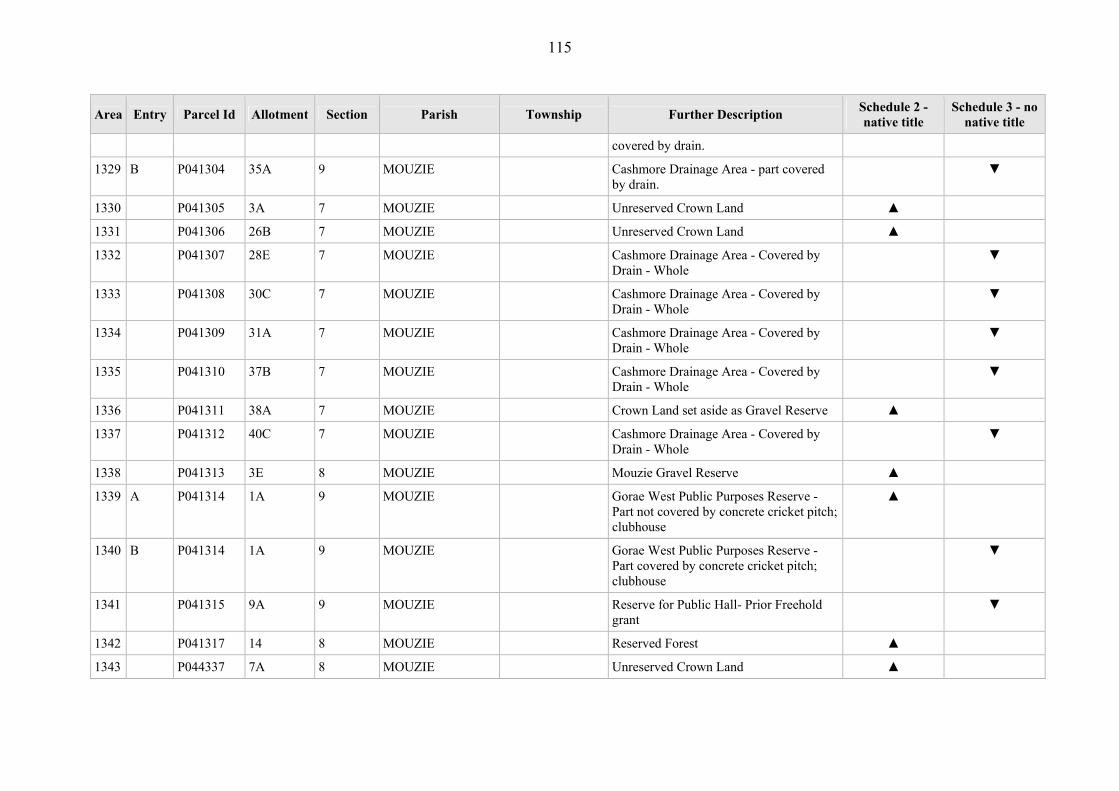
115
Area Entry Parcel Id Allotment Section Parish Township Further Description Schedule 2 - native title
Schedule 3 - no native title
covered by drain.
1329 B P041304 35A 9 MOUZIE Cashmore Drainage Area - part covered by drain.
▼
1330 P041305 3A 7 MOUZIE Unreserved Crown Land ▲
1331 P041306 26B 7 MOUZIE Unreserved Crown Land ▲
1332 P041307 28E 7 MOUZIE Cashmore Drainage Area - Covered by Drain - Whole
▼
1333 P041308 30C 7 MOUZIE Cashmore Drainage Area - Covered by Drain - Whole
▼
1334 P041309 31A 7 MOUZIE Cashmore Drainage Area - Covered by Drain - Whole
▼
1335 P041310 37B 7 MOUZIE Cashmore Drainage Area - Covered by Drain - Whole
▼
1336 P041311 38A 7 MOUZIE Crown Land set aside as Gravel Reserve ▲
1337 P041312 40C 7 MOUZIE Cashmore Drainage Area - Covered by Drain - Whole
▼
1338 P041313 3E 8 MOUZIE Mouzie Gravel Reserve ▲
1339 A P041314 1A 9 MOUZIE Gorae West Public Purposes Reserve - Part not covered by concrete cricket pitch; clubhouse
▲
1340 B P041314 1A 9 MOUZIE Gorae West Public Purposes Reserve - Part covered by concrete cricket pitch; clubhouse
▼
1341 P041315 9A 9 MOUZIE Reserve for Public Hall- Prior Freehold grant
▼
1342 P041317 14 8 MOUZIE Reserved Forest ▲
1343 P044337 7A 8 MOUZIE Unreserved Crown Land ▲

116
Area Entry Parcel Id Allotment Section Parish Township Further Description Schedule 2 - native title
Schedule 3 - no native title
1344 P044339 4A 2 MOUZIE Crown Land set aside as Departmental Reserve
▲
1345 P365532 11A 5 MOUZIE Mount Richmond National Park ▲
1346 P368694 10B 9 MOUZIE Unreserved Crown Land ▲
1347 P368695 8A 8 MOUZIE Cashmore Drainage Area - Covered by Drain - Whole
▼
1348 P043518 7 5 MURNDAL Crown Land reserved for the Protection of the Bed and Banks of a Lake
▲
1349 A P043519 13A C MURNDAL Grange Burn River frontage, post/wire fence at northern boundary - Part not covered by underground cable and marker; hydrographic wire installation and timber landing; metal hydrographic water level recorder; water level staffs/rulers; concrete hydrographic weir
▲
1350 B P043519 13A C MURNDAL Grange Burn River frontage, post/wire fence at northern boundary - part underground cable and marker; hydrographic wire installation and timber landing; metal hydrographic water level recorder; water level staffs/rulers; concrete hydrographic weir
▼
1351 P044118 1B2 16 MURNDAL Unreserved Crown Land ▲
1352 P374819 13 C MURNDAL Unreserved Crown Land - Prior Freehold grant - Whole
▼
1353 P041859 1 6 MYAMYN MILLTOWN (T) Unreserved Crown Land ▲
1354 P041860 2 6 MYAMYN MILLTOWN (T) Unreserved Crown Land ▲
1355 P041861 3 6 MYAMYN MILLTOWN (T) Unreserved Crown Land ▲
1356 P041862 4 6 MYAMYN MILLTOWN (T) Unreserved Crown Land ▲
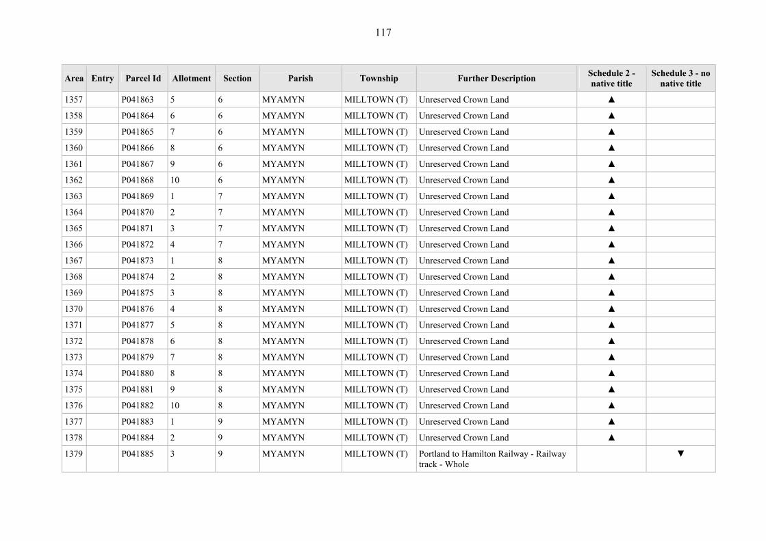
117
Area Entry Parcel Id Allotment Section Parish Township Further Description Schedule 2 - native title
Schedule 3 - no native title
1357 P041863 5 6 MYAMYN MILLTOWN (T) Unreserved Crown Land ▲
1358 P041864 6 6 MYAMYN MILLTOWN (T) Unreserved Crown Land ▲
1359 P041865 7 6 MYAMYN MILLTOWN (T) Unreserved Crown Land ▲
1360 P041866 8 6 MYAMYN MILLTOWN (T) Unreserved Crown Land ▲
1361 P041867 9 6 MYAMYN MILLTOWN (T) Unreserved Crown Land ▲
1362 P041868 10 6 MYAMYN MILLTOWN (T) Unreserved Crown Land ▲
1363 P041869 1 7 MYAMYN MILLTOWN (T) Unreserved Crown Land ▲
1364 P041870 2 7 MYAMYN MILLTOWN (T) Unreserved Crown Land ▲
1365 P041871 3 7 MYAMYN MILLTOWN (T) Unreserved Crown Land ▲
1366 P041872 4 7 MYAMYN MILLTOWN (T) Unreserved Crown Land ▲
1367 P041873 1 8 MYAMYN MILLTOWN (T) Unreserved Crown Land ▲
1368 P041874 2 8 MYAMYN MILLTOWN (T) Unreserved Crown Land ▲
1369 P041875 3 8 MYAMYN MILLTOWN (T) Unreserved Crown Land ▲
1370 P041876 4 8 MYAMYN MILLTOWN (T) Unreserved Crown Land ▲
1371 P041877 5 8 MYAMYN MILLTOWN (T) Unreserved Crown Land ▲
1372 P041878 6 8 MYAMYN MILLTOWN (T) Unreserved Crown Land ▲
1373 P041879 7 8 MYAMYN MILLTOWN (T) Unreserved Crown Land ▲
1374 P041880 8 8 MYAMYN MILLTOWN (T) Unreserved Crown Land ▲
1375 P041881 9 8 MYAMYN MILLTOWN (T) Unreserved Crown Land ▲
1376 P041882 10 8 MYAMYN MILLTOWN (T) Unreserved Crown Land ▲
1377 P041883 1 9 MYAMYN MILLTOWN (T) Unreserved Crown Land ▲
1378 P041884 2 9 MYAMYN MILLTOWN (T) Unreserved Crown Land ▲
1379 P041885 3 9 MYAMYN MILLTOWN (T) Portland to Hamilton Railway - Railway track - Whole
▼

118
Area Entry Parcel Id Allotment Section Parish Township Further Description Schedule 2 - native title
Schedule 3 - no native title
1380 P041886 1 1 MYAMYN MILLTOWN (T) Unreserved Crown Land ▲
1381 P041887 1 2 MYAMYN MILLTOWN (T) Unreserved Crown Land ▲
1382 P041888 1 3 MYAMYN MILLTOWN (T) Unreserved Crown Land ▲
1383 P041889 1 4 MYAMYN MILLTOWN (T) Unreserved Crown Land ▲
1384 P041890 1 5 MYAMYN MILLTOWN (T) Unreserved Crown Land ▲
1385 P041891 2 5 MYAMYN MILLTOWN (T) Unreserved Crown Land ▲
1386 P041892 3 5 MYAMYN MILLTOWN (T) Unreserved Crown Land ▲
1387 P041893 4 5 MYAMYN MILLTOWN (T) Unreserved Crown Land ▲
1388 P041894 5 5 MYAMYN MILLTOWN (T) Unreserved Crown Land ▲
1389 P041895 6 5 MYAMYN MILLTOWN (T) Unreserved Crown Land ▲
1390 P041896 7 5 MYAMYN MILLTOWN (T) Unreserved Crown Land ▲
1391 P041897 8 5 MYAMYN MILLTOWN (T) Unreserved Crown Land ▲
1392 P041898 9 5 MYAMYN MILLTOWN (T) Unreserved Crown Land ▲
1393 P041899 10 5 MYAMYN MILLTOWN (T) Unreserved Crown Land ▲
1394 P041900 5 7 MYAMYN MILLTOWN (T) Unreserved Crown Land ▲
1395 P041901 6 7 MYAMYN MILLTOWN (T) Unreserved Crown Land ▲
1396 P041902 7 7 MYAMYN MILLTOWN (T) Unreserved Crown Land ▲
1397 P041903 8 7 MYAMYN MILLTOWN (T) Unreserved Crown Land ▲
1398 P041904 9 7 MYAMYN MILLTOWN (T) Unreserved Crown Land ▲
1399 A P041905 15 11 MYAMYN MILLTOWN (T) Unreserved Crown Land - Part not covered by road
▲
1400 B P041905 15 11 MYAMYN MILLTOWN (T) Unreserved Crown Land - Part covered by road
▼
1401 P041906 4B 2 MYAMYN Unreserved Crown Land ▲
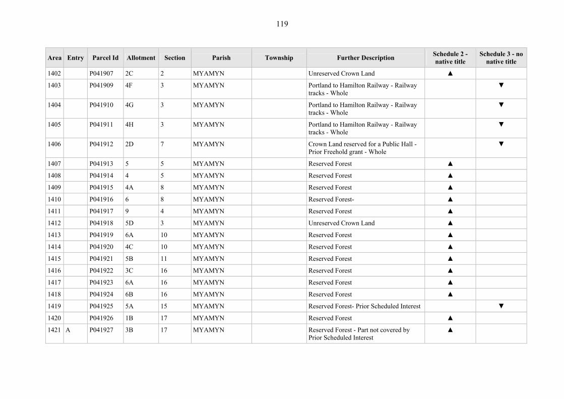
119
Area Entry Parcel Id Allotment Section Parish Township Further Description Schedule 2 - native title
Schedule 3 - no native title
1402 P041907 2C 2 MYAMYN Unreserved Crown Land ▲
1403 P041909 4F 3 MYAMYN Portland to Hamilton Railway - Railway tracks - Whole
▼
1404 P041910 4G 3 MYAMYN Portland to Hamilton Railway - Railway tracks - Whole
▼
1405 P041911 4H 3 MYAMYN Portland to Hamilton Railway - Railway tracks - Whole
▼
1406 P041912 2D 7 MYAMYN Crown Land reserved for a Public Hall - Prior Freehold grant - Whole
▼
1407 P041913 5 5 MYAMYN Reserved Forest ▲
1408 P041914 4 5 MYAMYN Reserved Forest ▲
1409 P041915 4A 8 MYAMYN Reserved Forest ▲
1410 P041916 6 8 MYAMYN Reserved Forest- ▲
1411 P041917 9 4 MYAMYN Reserved Forest ▲
1412 P041918 5D 3 MYAMYN Unreserved Crown Land ▲
1413 P041919 6A 10 MYAMYN Reserved Forest ▲
1414 P041920 4C 10 MYAMYN Reserved Forest ▲
1415 P041921 5B 11 MYAMYN Reserved Forest ▲
1416 P041922 3C 16 MYAMYN Reserved Forest ▲
1417 P041923 6A 16 MYAMYN Reserved Forest ▲
1418 P041924 6B 16 MYAMYN Reserved Forest ▲
1419 P041925 5A 15 MYAMYN Reserved Forest- Prior Scheduled Interest ▼
1420 P041926 1B 17 MYAMYN Reserved Forest ▲
1421 A P041927 3B 17 MYAMYN Reserved Forest - Part not covered by Prior Scheduled Interest
▲

120
Area Entry Parcel Id Allotment Section Parish Township Further Description Schedule 2 - native title
Schedule 3 - no native title
1422 B P041927 3B 17 MYAMYN Reserved Forest - Part covered by Prior Scheduled Interest
▼
1423 P041928 3C 18 MYAMYN Reserved Forest - Prior Scheduled interest ▼
1424 P041931 1C 20 MYAMYN Unreserved Crown Land ▲
1425 P041932 3B 20 MYAMYN Unreserved Crown Land - Prior Scheduled Interest
▼
1426 P041933 4B 10 MYAMYN Drainage Reserve for Sunday Creek ▲
1427 P041934 2E 10 MYAMYN Drainage Reserve for Sunday Creek ▲
1428 P041935 2D 10 MYAMYN Drainage Reserve for Sunday Creek ▲
1429 P041937 5C 17 MYAMYN Sunday Creek Frontage ▲
1430 A P041938 6E 19 MYAMYN Former Mt Eckersley State School - Part former school building; oval; memorial plaque; toilets (x2).
▼
1431 B P041938 6E 19 MYAMYN Former Mt Eckersley State School - Part covered by road
▼
1432 P041939 6F 19 MYAMYN Crown Land reserved for Public Recreation - Prior Freehold grant - Whole
▼
1433 P041940 6G 19 MYAMYN Portland to Hamilton Railway - Railway tracks - Whole
▼
1434 P041941 5E 12 MYAMYN Portland to Hamilton Railway - Railway tracks - Whole
▼
1435 P041942 1D 12 MYAMYN Portland to Hamilton Railway - Railway tracks - Whole
▼
1436 P041943 5F 12 MYAMYN Unreserved Crown Land - former Government road - Whole
▼
1437 P041944 2E 12 MYAMYN Portland to Hamilton Railway - Railway tracks - Whole
▼

121
Area Entry Parcel Id Allotment Section Parish Township Further Description Schedule 2 - native title
Schedule 3 - no native title
1438 P041949 3D 14 MYAMYN Portland to Hamilton Railway - Railway tracks - Whole
▼
1439 P041950 5A 14 MYAMYN Portland to Hamilton Railway - Railway tracks - Whole
▼
1440 P041951 2D 17 MYAMYN Unreserved Crown Land ▲
1441 P041952 1C 18 MYAMYN Unreserved Crown Land ▲
1442 P041953 2C 19 MYAMYN Unreserved Crown Land ▲
1443 P041954 5D 19 MYAMYN Unreserved Crown Land ▲
1444 A P041955 3D 21 MYAMYN Portland to Hamilton Railway - Part not covered by railway track
▲
1445 B P041955 3D 21 MYAMYN Portland to Hamilton Railway - Part covered by railway track
▼
1446 P044441 4G 6 MYAMYN Crown Land Reserved for Public Purposes (Sportsground and Showground) - Prior Freehold grant - Whole
▼
1447 P367760 2F 12 MYAMYN Perpetual Licence issued under Victorian Plantations Corporation - Prior Freehold grant - Whole
▼
1448 A P367761 2G 12 MYAMYN Perpetual Licence issued under Victorian Plantations Corporation - Part not covered by Prior Freehold grant; Part not covered by former Government road
▲
1449 B P367761 2G 12 MYAMYN Perpetual Licence issued under Victorian Plantations Corporation - Part covered by Prior Freehold grant
▼
1450 C P367761 2G 12 MYAMYN Perpetual Licence issued under Victorian Plantations Corporation - Part covered by former Government road
▼
1451 A P367762 4A 21 MYAMYN Crown Land vested in Victorian ▼

122
Area Entry Parcel Id Allotment Section Parish Township Further Description Schedule 2 - native title
Schedule 3 - no native title
Plantations Corporation - Part Prior Freehold grant
1452 B P367762 4A 21 MYAMYN Crown Land vested in Victorian Plantations Corporation - Part road
▼
1453 P369480 5B 15 MYAMYN Unreserved Crown Land ▲
1454 P043524 26A B MYARING Balls Swamp ▲
1455 P043525 29E B MYARING Crown Land set aside as Drainage Reserve
▲
1456 A P043526 29F B MYARING Reserved Forest - Part not covered by overhead electricity powerline and pole/easement; formed limestone road
▲
1457 B P043526 29F B MYARING Reserved Forest - Part covered by overhead electricity powerline and pole/easement; formed limestone road
▼
1458 P043527 10A A MYARING Reserved Forest ▲
1459 P043528 14A A MYARING Unreserved Crown Land ▲
1460 P043529 36B B MYARING Conservation of Area of Natural Interest ▲
1461 P043530 37 B MYARING Red Hill Swamp Wildlife Reserve ▲
1462 P043533 33A B MYARING Former Camping and Watering Reserve ▲
1463 P043534 13C B MYARING Unreserved Crown Land ▲
1464 P043535 13D B MYARING Unreserved Crown Land ▲
1465 P043536 13E B MYARING Glenelg River Frontage ▲
1466 P043537 16B C MYARING Conservation of Area of Natural Interest ▲
1467 P043538 7C C MYARING Glenelg River Frontage ▲
1468 P043539 13B C MYARING Stokes River Frontage ▲
1469 P043540 13A C MYARING Behind Stokes River Frontage ▲

123
Area Entry Parcel Id Allotment Section Parish Township Further Description Schedule 2 - native title
Schedule 3 - no native title
1470 P043541 12A C MYARING Behind Stokes River Frontage ▲
1471 P043542 15A C MYARING Unreserved Crown Land ▲
1472 P043543 16E C MYARING Unreserved Crown Land ▲
1473 P043544 17C C MYARING Unreserved Crown Land ▲
1474 P043545 16D C MYARING Unreserved Crown Land ▲
1475 P043546 16C C MYARING Conservation of an Area of Natural Interest
▲
1476 P043547 9D A MYARING Unreserved Crown Land ▲
1477 P044376 5C C MYARING Unreserved Crown Land ▲
1478 P044395 14B A MYARING Unreserved Crown Land ▲
1479 P365402 28A NAPIER Mount Napier State Park ▲
1480 P043131 5 12 NARRAWONG NARRAWONG (T)
Crown Land reserved as a site for a Mechanics Institute
▲
1481 P043136 6 15 NARRAWONG NARRAWONG (T)
Reserved for State School Purposes - Covered by school house; portable classroom; sheds; playground areas; toilets - Whole
▼
1482 P043137 10 2A NARRAWONG NARRAWONG (T)
Unreserved Crown Land ▲
1483 P043138 7 4A NARRAWONG NARRAWONG (T)
Narrawong Foreshore ▲
1484 A P043139 19 3A NARRAWONG NARRAWONG (T)
East Narwong Foreshore - Part not covered by timber boardwalk and steps (to beach)
▲
1485 B P043139 19 3A NARRAWONG NARRAWONG (T)
East Narwong Foreshore - Part covered by timber boardwalk and steps (to beach)
▼
1486 A P043140 6 4A NARRAWONG NARRAWONG Surry River Frontage - Part not covered ▲

124
Area Entry Parcel Id Allotment Section Parish Township Further Description Schedule 2 - native title
Schedule 3 - no native title
(T) by road; Part not covered by timber retaining wall - river; timber retaining wall – picnic area; fixed tables/seats (numerous); fixed steel BBQs (numerous); timber rotunda; concrete boat ramp; formed dirt access road; timber footbridge and memorial plaque
1487 B P043140 6 4A NARRAWONG NARRAWONG (T)
Surry River Frontage - Part covered by road
▼
1488 C P043140 6 4A NARRAWONG NARRAWONG (T)
Surry River Frontage - Part covered by timber retaining wall - river; timber retaining wall – picnic area; fixed tables/seats (numerous); fixed steel BBQs (numerous); timber rotunda; concrete boat ramp; formed dirt access road; timber footbridge and memorial plaque
▼
1489 A P043141 12 5 NARRAWONG NARRAWONG (T)
Narrawong Esplanade and Surry River Frontage - Part not covered by formed gravel carpark; fixed timber table/seats and steel BBQ on concrete (x2); timber toilet block; timber rotunda (x2) and table/seats (x2); steel BBQ on concrete; timber boat landing
▲
1490 B P043141 12 5 NARRAWONG NARRAWONG (T)
Narrawong Esplanade and Surry River Frontage - Part covered by formed gravel carpark; fixed timber table/seats and steel BBQ on concrete (x2); timber toilet block; timber rotunda (x2) and table/seats (x2); steel BBQ on concrete; timber boat landing
▼
1491 P043142 9A 11 NARRAWONG NARRAWONG (T)
Unreserved Crown Land ▲
1492 P043143 5 4A NARRAWONG NARRAWONG Narrawong Camping and Recreation ▼

125
Area Entry Parcel Id Allotment Section Parish Township Further Description Schedule 2 - native title
Schedule 3 - no native title
(T) Reserve - Sports oval, camping area, caravan park.
1493 P042965 59 NARRAWONG Fitzroy River Frontage ▲
1494 P042966 60 NARRAWONG Behind 150 link frontage to Southern Ocean
▲
1495 P042967 42A NARRAWONG Coastal Foreshore Reserve ▲
1496 P042968 31C NARRAWONG Former Stone Reserve ▲
1497 P042969 31B NARRAWONG Former Weleyan Church Reserve ▲
1498 A P042972 28 A NARRAWONG Surry River Frontage - Part not covered by 60 metre wide easement for Powercor electricity cable
▲
1499 B P042972 28 A NARRAWONG Surry River Frontage - Part covered by 60 metre wide easement for Powercor electricity cable
▼
1500 P042973 15C 2 NARRAWONG Surry River frontage ▲
1501 P042975 17A 2 NARRAWONG Departmental Stone Reserve ▲
1502 P042976 13 11 NARRAWONG Reserved Forest ▲
1503 P042977 14 11 NARRAWONG Reserved Forest ▲
1504 P042978 1C 9 NARRAWONG Fitzroy River Frontage ▲
1505 A P043239 29 A NARRAWONG Mount Clay Sand Pit - Part not covered by Prior Freehold grant - Part not covered by major earthworks – Sand Pit; formed sand/dirt road; high voltage overhead powerlines/easement – western boundary; formed dirt road – Rifle Range Road; dam; fixed wood table/seats; fixed concrete BBQ; timber toilet blocks (x4); BBQ area and pine stump fence; timber playground equipment
▲
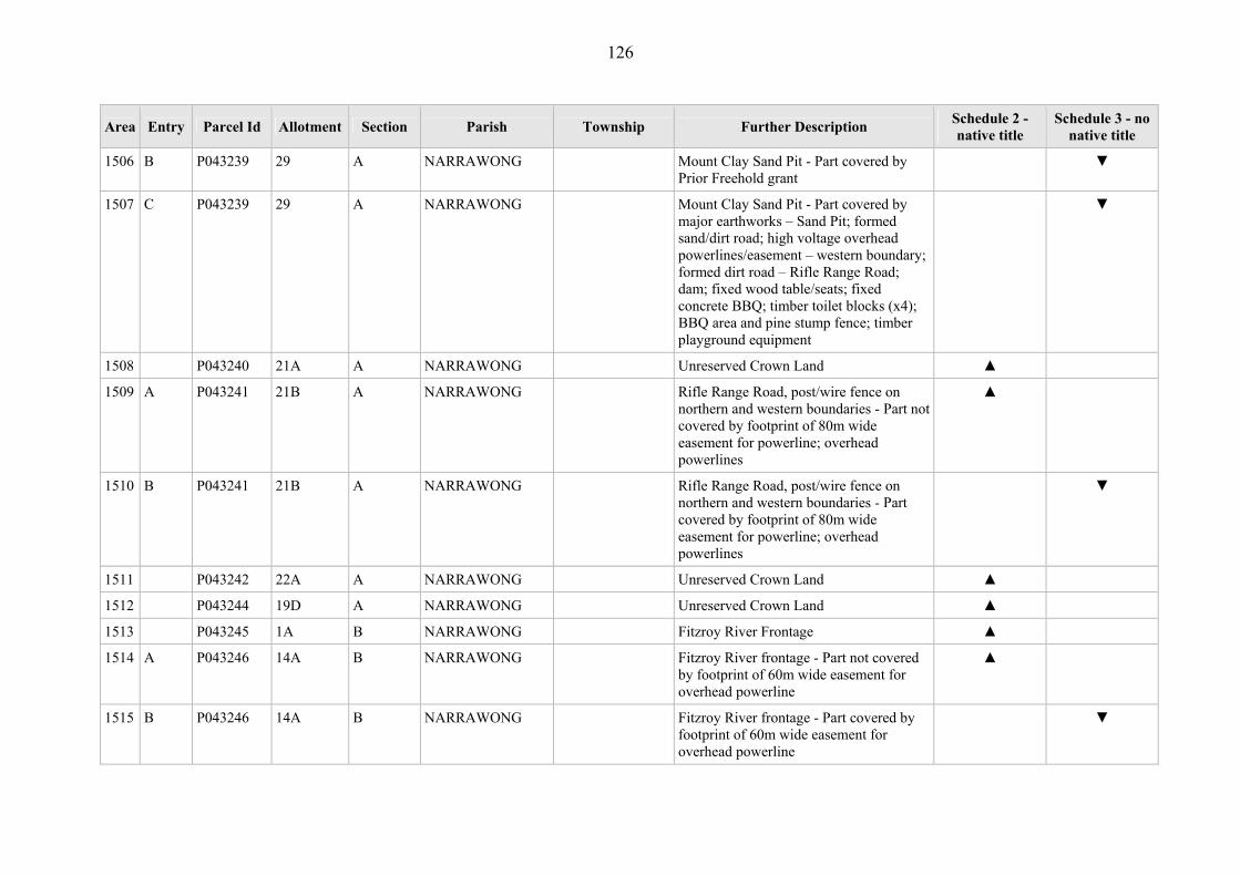
126
Area Entry Parcel Id Allotment Section Parish Township Further Description Schedule 2 - native title
Schedule 3 - no native title
1506 B P043239 29 A NARRAWONG Mount Clay Sand Pit - Part covered by Prior Freehold grant
▼
1507 C P043239 29 A NARRAWONG Mount Clay Sand Pit - Part covered by major earthworks – Sand Pit; formed sand/dirt road; high voltage overhead powerlines/easement – western boundary; formed dirt road – Rifle Range Road; dam; fixed wood table/seats; fixed concrete BBQ; timber toilet blocks (x4); BBQ area and pine stump fence; timber playground equipment
▼
1508 P043240 21A A NARRAWONG Unreserved Crown Land ▲
1509 A P043241 21B A NARRAWONG Rifle Range Road, post/wire fence on northern and western boundaries - Part not covered by footprint of 80m wide easement for powerline; overhead powerlines
▲
1510 B P043241 21B A NARRAWONG Rifle Range Road, post/wire fence on northern and western boundaries - Part covered by footprint of 80m wide easement for powerline; overhead powerlines
▼
1511 P043242 22A A NARRAWONG Unreserved Crown Land ▲
1512 P043244 19D A NARRAWONG Unreserved Crown Land ▲
1513 P043245 1A B NARRAWONG Fitzroy River Frontage ▲
1514 A P043246 14A B NARRAWONG Fitzroy River frontage - Part not covered by footprint of 60m wide easement for overhead powerline
▲
1515 B P043246 14A B NARRAWONG Fitzroy River frontage - Part covered by footprint of 60m wide easement for overhead powerline
▼

127
Area Entry Parcel Id Allotment Section Parish Township Further Description Schedule 2 - native title
Schedule 3 - no native title
1516 P043247 15A 16 NARRAWONG Fitzroy River Frontage ▲
1517 P043248 17A 16 NARRAWONG Fitzroy River Frontage ▲
1518 P043249 16D 16 NARRAWONG Reserved Forest- Prior Freehold grant ▼
1519 A P043250 6A 16 NARRAWONG Reserved forest - Part not covered by road ▲
1520 B P043250 6A 16 NARRAWONG Reserved forest - Part covered by road ▼
1521 P043251 3A 16 NARRAWONG Narrawong State Forest ▲
1522 P043252 7A 16 NARRAWONG Narrawong State Forest ▲
1523 P043253 2B 16 NARRAWONG Fitzroy River Frontage ▲
1524 P043254 7B 16 NARRAWONG Narrawong State Forest ▲
1525 A P367229 59A NARRAWONG Behind Fitzroy River Frontage ▲
1526 P367230 59B NARRAWONG Behind Fitzroy River Frontage, close to river mouth
▲
1527 P367232 60B NARRAWONG Fitzroy River Frontage, at mouth of river ▲
1528 P367233 60A NARRAWONG Portland Bay Frontage ▲
1529 A P369483 21C 2 NARRAWONG Former Narrawong Rubbish Depot and part former Government Road - Part covered by Prior Freehold
▼
1530 B P369483 21C 2 NARRAWONG Former Narrawong Rubbish Depot and part former Government Road - Part covered by former Government road
▼
1531 P369484 29A A NARRAWONG Reserved Forest ▲
1532 A P042632 16C PALPARA Crown land vested in Victorian Plantations Corporation - Part not covered by concrete water tank; steel windmill; water pipe/marker; formed limestone airstrip – now grassed; overhead powerlines – eastern boundary; major
▲

128
Area Entry Parcel Id Allotment Section Parish Township Further Description Schedule 2 - native title
Schedule 3 - no native title
earthworks – quarry
1533 B P042632 16C PALPARA Crown land vested in Victorian Plantations Corporation - Part covered by concrete water tank; steel windmill; water pipe/marker; formed limestone airstrip – now grassed; overhead powerlines – eastern boundary; major earthworks – quarry
▼
1534 P042633 16D PALPARA Crown land vested in Victorian Plantations Corporation, within 100 metre buffer to Glenelg River -
▲
1535 A P042634 17 PALPARA Princess Margaret Rose Cave (part of Lower Glenelg National Park)- Part not covered by administration building and kiosk; fenced caretaker’s residence; shed at cave; toilet block on concrete at cave; concrete water tank/pump at cave; timber huts and pine stump fence; steel BBQ and fixed timber table/seats (numerous); sealed carpark at cave; fixed tables/seats at Sandy Waterholes; timber toilets (x2); timber canoe/fishing landing; concrete boat ramp; (at Lasletts) memorial plaque – Major Mitchell; timber toilet/iron water tank; timber boat ramp; fixed tables/seats/steel BBQ
▲
1536 B P042634 17 PALPARA Princess Margaret Rose Cave (part of Lower Glenelg National Park)- Part not covered by administration building and kiosk; fenced caretaker’s residence; shed at cave; toilet block on concrete at cave; concrete water tank/pump at cave; timber huts and pine stump fence; steel BBQ and fixed timber table/seats (numerous);
▼

129
Area Entry Parcel Id Allotment Section Parish Township Further Description Schedule 2 - native title
Schedule 3 - no native title
sealed carpark at cave; fixed tables/seats at Sandy Waterholes; timber toilets (x2); timber canoe/fishing landing; concrete boat ramp; (at Lasletts) memorial plaque – Major Mitchell; timber toilet/iron water tank; timber boat ramp; fixed tables/seats/steel BBQ
1537 P367786 18A PALPARA Crown land vested in Victorian Plantations Corporation, within 100 metre buffer to Glenelg River
▲
1538 P374398 2001 PALPARA Reserved Forest ▲
1539 P023461 70C PANYYABYR Former Reserved Forest ▲
1540 P023462 74B PANYYABYR Drainage Reserve for Wannon River, 400 links wide
▲
1541 P026015 70E PANYYABYR Former Reserved Forest- ▲
1542 P026016 70D PANYYABYR Former Reserved Forest ▲
1543 P026017 70F PANYYABYR Former Reserved Forest- ▲
1544 P026025 70G PANYYABYR Former Reserved Forest- ▲
1545 P365991 70H PANYYABYR Wannon River Frontage ▲
1546 P040544 11A 7 PORTLAND PORTLAND (T) Crown Land reserved for Hospital Purposes - Prior Freehold grant - Whole
▼
1547 A P040545 16D 6 PORTLAND PORTLAND (T) Market Square Reserve, parcel is fenced post/wire at northern boundary - Part not covered by concrete fountain; memorial plaque on fountain; fixed wood/concrete seats (x7)
▲
1548 B P040545 16D 6 PORTLAND PORTLAND (T) Market Square Reserve, parcel is fenced post/wire at northern boundary - Part covered by concrete fountain; memorial
▼

130
Area Entry Parcel Id Allotment Section Parish Township Further Description Schedule 2 - native title
Schedule 3 - no native title
plaque on fountain; fixed wood/concrete seats (x7)
1549 A P040546 16E 6 PORTLAND PORTLAND (T) Portland Scouts Hall - Part not covered by hall.
▲
1550 B P040546 16E 6 PORTLAND PORTLAND (T) Portland Scouts Hall - Part covered by hall.
▼
1551 P040548 1 19A PORTLAND PORTLAND (T) Part of Hanlon Park, post/wire fencing around parcel - Part covered by brick clubrooms/kitchen; brick tabaret; galvanised iron shelter; steel lighting around oval (x4); steel/galvanised iron scoreboard; brick toilet block; galvanised iron storage shed; galvanised iron machinery shed; brick kindergarten; galvanised iron storage sheds at kindergarten
▼
1552 A P040549 2 19A PORTLAND PORTLAND (T) Part of Hanlon Park - Part not covered by brick grandstand; brick changerooms; turf cricket pitch/wicket
▲
1553 B P040549 2 19A PORTLAND PORTLAND (T) Part of Hanlon Park - Part covered by brick grandstand; brick changerooms; turf cricket pitch/wicket
▼
1554 P040550 3 19A PORTLAND PORTLAND (T) Part of Hanlon Park - Part covered by brick coaches boxes (x2); colorbond timekeepers box; formed gravel path around oval; steel training light/poles (x2); asphalt netball courts; pine post barriers around netball courts; cricket practice nets – concrete pitch and steel wire/mesh nets
▼
1555 P040551 11B 18B PORTLAND PORTLAND (T) Crown Land reserved for State Schools Purposes - former Government road
▼
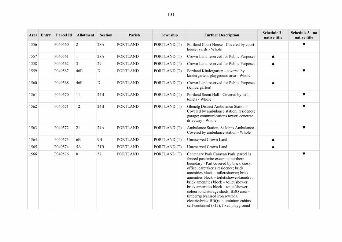
131
Area Entry Parcel Id Allotment Section Parish Township Further Description Schedule 2 - native title
Schedule 3 - no native title
1556 P040560 2 28A PORTLAND PORTLAND (T) Portland Court House - Covered by court house; yards - Whole
▼
1557 P040561 1 28A PORTLAND PORTLAND (T) Crown Land reserved for Public Purposes ▲
1558 P040562 3 29 PORTLAND PORTLAND (T) Crown Land reserved for Public Purposes ▲
1559 P040567 46E D PORTLAND PORTLAND (T) Portland Kindergarten - covered by kindergarten; playground area - Whole
▼
1560 P040568 46F D PORTLAND PORTLAND (T) Crown Land reserved for Public Purposes (Kindergarten)
▲
1561 P040570 11 24B PORTLAND PORTLAND (T) Portland Scout Hall - Covered by hall, toilets - Whole
▼
1562 P040571 12 24B PORTLAND PORTLAND (T) Glenelg District Ambulance Station - Covered by ambulance station; residence; garage; communications tower; concrete driveway - Whole
▼
1563 P040572 21 24A PORTLAND PORTLAND (T) Ambulance Station, St Johns Ambulance - Covered by ambulance station - Whole
▼
1564 P040573 6B 9B PORTLAND PORTLAND (T) Unreserved Crown Land ▲
1565 P040574 5A 21B PORTLAND PORTLAND (T) Unreserved Crown Land ▲
1566 P040576 8 37 PORTLAND PORTLAND (T) Centenary Park Caravan Park, parcel is fenced post/wire except at northern boundary - Part covered by brick kiosk, office, caretaker’s residence; brick amenities block – toilet/shower; brick amenities block – toilet/shower/laundry; brick amenities block – toilet/shower; brick amenities block – toilet/shower; colourbond storage sheds; BBQ area – timber/galvanised iron rotunda, electric/brick BBQs; aluminium cabins – self-contained (x12); fixed playground
▼

132
Area Entry Parcel Id Allotment Section Parish Township Further Description Schedule 2 - native title
Schedule 3 - no native title
equipment; road/paths are sealed gravel or bitumen
1567 A P040577 6A A PORTLAND PORTLAND (T) Reserved Crown land- Part covered by a lease to the Commonwealth and land covered by the fenced off two storey building and boat storage area.
▼
1568 P040577 6A A PORTLAND PORTLAND (T) Reserved Crown land- Part not covered by a lease to the Commonwealth and land not covered by the fenced off two storey building and boat storage area.
▲
1569 P040578 5 44 PORTLAND PORTLAND (T) Henty Park Portland - Part covered by Leisure and Aquatic centre, club rooms, car park, shelters, playgrounds, sheds, powerlines, cricket pitches, cooling towers , tennis courts, toilets, gardens, Bluestone Historic cottage, monuments, Glass house, bench seats, concrete kerbing, barbeques, drink fountains, concrete steps, blue stone wall, picnic tables and many other works.
▼
1570 P040585 5A 28 PORTLAND PORTLAND (T) Municipal Buildings, former Portland Harbour Trust Office - Covered by office; residence; garage; sheds - Whole
▼
1571 P040586 9 28 PORTLAND PORTLAND (T) Portland Library, Reserved for Free Library - Covered by library building; carpark - Whole
▼
1572 P040587 10 28 PORTLAND PORTLAND (T) Crown Land reserved for a Free Library - Prior Freehold grant - Whole
▼
1573 P040588 11 28 PORTLAND PORTLAND (T) Crown Land reserved as a site for a Free Library
▲
1574 A P040589 7 28 PORTLAND PORTLAND (T) Portland Bowling Club, Municipal Purposes Reserve – Part not covered by
▲

133
Area Entry Parcel Id Allotment Section Parish Township Further Description Schedule 2 - native title
Schedule 3 - no native title
bowling green.
1575 B P040589 7 28 PORTLAND PORTLAND (T) Portland Bowling Club, Municipal Purposes Reserve – Part covered by bowling green.
▼
1576 P040590 4 28A PORTLAND PORTLAND (T) Portland Police Station, Public Purposes (Police Purposes) Reserve - covered by police station; residence - Whole
▼
1577 P040591 3 28A PORTLAND PORTLAND (T) Crown Land reserved for Public Purposes ▲
1578 P040592 6A 6A PORTLAND PORTLAND (T) Unreserved Crown Land ▲
1579 P040595 5A 38 PORTLAND PORTLAND (T) Unreserved Crown Land - Prior Freehold grant - Whole
▼
1580 P040597 1 41A PORTLAND PORTLAND (T) Crown Land Reserved for Higher Elementary School Purposes
▲
1581 P040598 1A 41A PORTLAND PORTLAND (T) Crown Land temporarily reserved for Education Purposes - Part covered by former road
▼
1582 P040599 6 42B PORTLAND PORTLAND (T) Unreserved Crown Land - Prior Freehold grant - Whole
▼
1583 P040601 68F D PORTLAND PORTLAND (T) Unreserved Crown Land ▲
1584 P040604 68D D PORTLAND PORTLAND (T) Unreserved Crown Land ▲
1585 P040605 1 16D PORTLAND PORTLAND (T) Magazine Hill ▲
1586 P040606 5A 44 PORTLAND PORTLAND (T) Crown Land reserved for Public Purposes ▲
1587 P040607 4 44 PORTLAND PORTLAND (T) Park and Recreation Reserve ▲
1588 P040608 16A 1 PORTLAND PORTLAND (T) Old Friendly's Society Reserve, between Hood and Glenelg Streets - Covered by steel light towers (x4); brick clubhouse; fenced ovals; bitumen carpark; grassed carpark and wood barriers
▼

134
Area Entry Parcel Id Allotment Section Parish Township Further Description Schedule 2 - native title
Schedule 3 - no native title
1589 P040611 60N D PORTLAND PORTLAND (T) Yarraman Park ▲
1590 P040612 60P D PORTLAND PORTLAND (T) Yarraman Park - Covered by various buildings, fixed structures, bitumen road/carparks for Yarraman Park, Go Kart Track and Trotting Track
▼
1591 A P040613 60L D PORTLAND PORTLAND (T) Part of Yarraman Park - Part not covered by overhead powerline and easement
▲
1592 B P040613 60L D PORTLAND PORTLAND (T) Part of Yarraman Park - Part covered by overhead powerline and easement
▼
1593 P040614 60M D PORTLAND PORTLAND (T) Yarraman Park ▲
1594 P040615 52K D PORTLAND PORTLAND (T) Nelson Park - Covered by bitumen road at entrance; brick clubhouse; fixed flagpoles; galvanised iron machinery shed; formed gravel carpark
▼
1595 A P040617 30A C PORTLAND PORTLAND (T) Flinders Park, Portland - Part not covered by fixed metal playground equipment on formed sand/dirt
▲
1596 B P040617 30A C PORTLAND PORTLAND (T) Flinders Park, Portland - Part covered by fixed metal playground equipment on formed sand/dirt
▼
1597 P040618 30B C PORTLAND PORTLAND (T) Flinders Park, Portland - Covered by netballs courts, fire brigade training and competition track, toilets, football and cricket oval, playground
▼
1598 A P040619 30C C PORTLAND PORTLAND (T) Part of Flinders Park and Portland Bowling Club - Part covered by covered brick bowling club; galvanised iron storage shed; brick storage shed; bowling greens – brick surrounds; brick/electric BBQs; sealed gravel carpark and access road; fixed playground equipment
▲
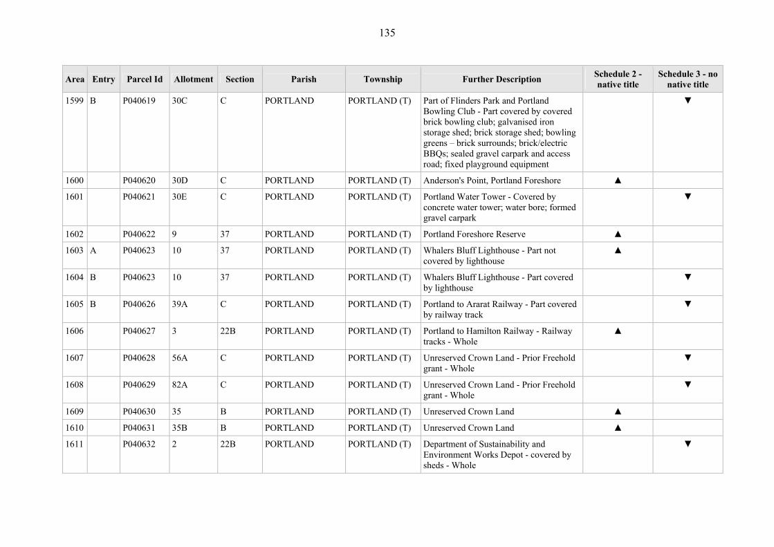
135
Area Entry Parcel Id Allotment Section Parish Township Further Description Schedule 2 - native title
Schedule 3 - no native title
1599 B P040619 30C C PORTLAND PORTLAND (T) Part of Flinders Park and Portland Bowling Club - Part covered by covered brick bowling club; galvanised iron storage shed; brick storage shed; bowling greens – brick surrounds; brick/electric BBQs; sealed gravel carpark and access road; fixed playground equipment
▼
1600 P040620 30D C PORTLAND PORTLAND (T) Anderson's Point, Portland Foreshore ▲
1601 P040621 30E C PORTLAND PORTLAND (T) Portland Water Tower - Covered by concrete water tower; water bore; formed gravel carpark
▼
1602 P040622 9 37 PORTLAND PORTLAND (T) Portland Foreshore Reserve ▲
1603 A P040623 10 37 PORTLAND PORTLAND (T) Whalers Bluff Lighthouse - Part not covered by lighthouse
▲
1604 B P040623 10 37 PORTLAND PORTLAND (T) Whalers Bluff Lighthouse - Part covered by lighthouse
▼
1605 B P040626 39A C PORTLAND PORTLAND (T) Portland to Ararat Railway - Part covered by railway track
▼
1606 P040627 3 22B PORTLAND PORTLAND (T) Portland to Hamilton Railway - Railway tracks - Whole
▲
1607 P040628 56A C PORTLAND PORTLAND (T) Unreserved Crown Land - Prior Freehold grant - Whole
▼
1608 P040629 82A C PORTLAND PORTLAND (T) Unreserved Crown Land - Prior Freehold grant - Whole
▼
1609 P040630 35 B PORTLAND PORTLAND (T) Unreserved Crown Land ▲
1610 P040631 35B B PORTLAND PORTLAND (T) Unreserved Crown Land ▲
1611 P040632 2 22B PORTLAND PORTLAND (T) Department of Sustainability and Environment Works Depot - covered by sheds - Whole
▼

136
Area Entry Parcel Id Allotment Section Parish Township Further Description Schedule 2 - native title
Schedule 3 - no native title
1612 P040635 52A B PORTLAND PORTLAND (T) Unreserved Crown Land ▲
1613 P040636 47A B PORTLAND PORTLAND (T) Unreserved Crown Land ▲
1614 P040637 8 5A PORTLAND PORTLAND (T) Portland Water Supply Reserve, Wyatt Street Facility- electricity power poles and transformer; Pump Sheds & switchgear; Pump Shed - brick and galvanised iron roof; Cooling tower; Brick shed (x2); Store shed; Storage & mixing tank
▼
1615 A P040642 42B D PORTLAND PORTLAND (T) Battery Hill - Part not covered by carpark and lookout area; various formed dirt/gravel tracks
▲
1616 B P040642 42B D PORTLAND PORTLAND (T) Battery Hill - Part covered by carpark and lookout area; various formed dirt/gravel tracks
▼
1617 P040644 20A D PORTLAND PORTLAND (T) Crown Land reserved for Public Purposes (Sewerage) - Prior Freehold grant - Whole
▼
1618 P040654 21C D PORTLAND PORTLAND (T) Unreserved Crown Land - Prior Freehold grant - Whole
▼
1619 P040655 22A D PORTLAND PORTLAND (T) Unreserved Crown Land - Prior Freehold grant - Whole
▼
1620 P043880 8 7 PORTLAND PORTLAND (T) Subject to restricted Crown grant - Prior Freehold grant - Whole
▼
1621 P043881 9 7 PORTLAND PORTLAND (T) Subject to restricted Crown grant - Prior Freehold grant - Whole
▼
1622 P043885 35A B PORTLAND PORTLAND (T) Portland Basketball and Squash Stadium, Battery Hill; basketball stadium; Squash Courts; Carpark
▼
1623 P043886 1B 44 PORTLAND PORTLAND (T) Unreserved Crown Land - former Government road
▼
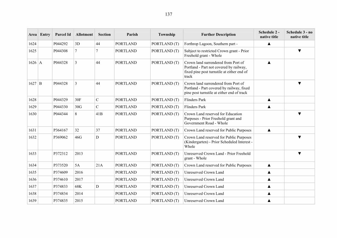
137
Area Entry Parcel Id Allotment Section Parish Township Further Description Schedule 2 - native title
Schedule 3 - no native title
1624 P044292 3D 44 PORTLAND PORTLAND (T) Forthrop Lagoon, Southern part - ▲
1625 P044308 7 7 PORTLAND PORTLAND (T) Subject to restricted Crown grant - Prior Freehold grant - Whole
▼
1626 A P044328 3 44 PORTLAND PORTLAND (T) Crown land surrendered from Port of Portland - Part not covered by railway, fixed pine post turnstile at either end of track
▲
1627 B P044328 3 44 PORTLAND PORTLAND (T) Crown land surrendered from Port of Portland - Part covered by railway, fixed pine post turnstile at either end of track
▼
1628 P044329 30F C PORTLAND PORTLAND (T) Flinders Park ▲
1629 P044330 30G C PORTLAND PORTLAND (T) Flinders Park ▲
1630 P044344 8 41B PORTLAND PORTLAND (T) Crown Land reserved for Education Purposes - Prior Freehold grant and Government Road - Whole
▼
1631 P364167 32 37 PORTLAND PORTLAND (T) Crown Land reserved for Public Purposes ▲
1632 P369062 46G D PORTLAND PORTLAND (T) Crown Land reserved for Public Purposes (Kindergarten) - Prior Scheduled Interest - Whole
▼
1633 P372312 2013 PORTLAND PORTLAND (T) Unreserved Crown Land - Prior Freehold grant - Whole
▼
1634 P373520 5A 21A PORTLAND PORTLAND (T) Crown Land reserved for Public Purposes ▲
1635 P374609 2016 PORTLAND PORTLAND (T) Unreserved Crown Land ▲
1636 P374610 2017 PORTLAND PORTLAND (T) Unreserved Crown Land ▲
1637 P374833 68K D PORTLAND PORTLAND (T) Unreserved Crown Land ▲
1638 P374834 2014 PORTLAND PORTLAND (T) Unreserved Crown Land ▲
1639 P374835 2015 PORTLAND PORTLAND (T) Unreserved Crown Land ▲

138
Area Entry Parcel Id Allotment Section Parish Township Further Description Schedule 2 - native title
Schedule 3 - no native title
1640 P374837 2018 PORTLAND PORTLAND (T) Unreserved Crown Land - Prior Freehold grant - Whole
▼
1641 P374838 68H D PORTLAND PORTLAND (T) Unreserved Crown Land - Prior Freehold grant - Whole
▼
1642 P374839 2019 PORTLAND PORTLAND (T) Unreserved Crown Land - Prior Freehold grant - Whole
▼
1643 P374840 2020 PORTLAND PORTLAND (T) Unreserved Crown Land - former Government road
▼
1644 A P40626 39A C PORTLAND PORTLAND (T) Portland to Ararat Railway - Part not covered by railway track
▲
1645 A P041340 14A 13 PORTLAND Portland Sewerage Authority, ocean outfall - Part not covered by fixed pine post turnstile at either end of track
▲
1646 B P041340 14A 13 PORTLAND Portland Sewerage Authority, ocean outfall - Part covered by covered fixed pine post turnstile at either end of track
▼
1647 A P041342 14B 13 PORTLAND Reserve for Public Purposes - Part not covered by 10m wide corridor along Portland Coast Water
▲
1648 B P041342 14B 13 PORTLAND Reserve for Public Purposes - Part covered by 10m wide corridor along Portland Coast Water
▼
1649 A P041343 86A 13 PORTLAND Recreation Reserve - Part not covered by overhead powerlines; fixed pine post turnstiles at entrance of reserve
▲
1650 B P041343 86A 13 PORTLAND Recreation Reserve - Part covered by overhead powerlines; fixed pine post turnstiles at entrance of reserve
▼
1651 P041345 90 13 PORTLAND Lawrence Rocks, site for Preservation of Wildlife
▲

139
Area Entry Parcel Id Allotment Section Parish Township Further Description Schedule 2 - native title
Schedule 3 - no native title
1652 A P041346 14 13 PORTLAND Bald Hills Water Recreation Reserve - Part not covered by steel trigonometric station; concrete/galvanised iron storage reservoir; steel/concrete cooling towers; brick pumphouse/bore (x2 on parcel); underground water pipeline
▲
1653 B P041346 14 13 PORTLAND Bald Hills Water Recreation Reserve - Part covered by steel trigonometric station; concrete/galvanised iron storage reservoir; steel/concrete cooling towers; brick pumphouse/bore (x2 on parcel); underground water pipeline
▼
1654 A P041350 3G 13 PORTLAND Public Purposes Reserve - Part not covered by SEC powerline
▲
1655 B P041350 3G 13 PORTLAND Public Purposes Reserve - Part covered by SEC overhead powerline.
▼
1656 P041351 8 3 PORTLAND Walook Swamp ▲
1657 P041352 9 3 PORTLAND Extension to Public Purposes Reserve (formerly Stockade Reserve)
▲
1658 P041353 10 3 PORTLAND Crown Land reserved for Railway Purposes
▲
1659 P041354 5C 3 PORTLAND Dutton Bluff Area ▲
1660 P041358 F3 2 PORTLAND Crown Land reserved for State School purposes
▲
1661 A P041359 4A 7 PORTLAND Alexandra Park, southern half of the parcel is natural bushland - Part not covered by greyhound training track; netball courts and clubrooms; oval and clubrooms; cricket nets; storage sheds; toilet block; canteen; gatekeepers box; shed
▲
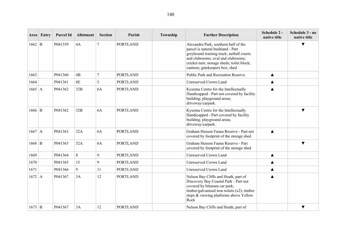
140
Area Entry Parcel Id Allotment Section Parish Township Further Description Schedule 2 - native title
Schedule 3 - no native title
1662 B P041359 4A 7 PORTLAND Alexandra Park, southern half of the parcel is natural bushland - Part greyhound training track; netball courts and clubrooms; oval and clubrooms; cricket nets; storage sheds; toilet block; canteen; gatekeepers box; shed
▼
1663 P041360 4B 7 PORTLAND Public Park and Recreation Reserve ▲
1664 P041361 8E 5 PORTLAND Unreserved Crown Land ▲
1665 A P041362 32B 6A PORTLAND Kyeema Centre for the Intellectually Handicapped - Part not covered by facility building; playground areas; driveway/carpark.
▲
1666 B P041362 32B 6A PORTLAND Kyeema Centre for the Intellectually Handicapped - Part covered by facility building; playground areas; driveway/carpark.
▼
1667 A P041363 32A 6A PORTLAND Graham Husson Fauna Reserve - Part not covered by footprint of the storage shed
▲
1668 B P041363 32A 6A PORTLAND Graham Husson Fauna Reserve - Part covered by footprint of the storage shed
▼
1669 P041364 8 9 PORTLAND Unreserved Crown Land ▲
1670 P041365 15 9 PORTLAND Unreserved Crown Land ▲
1671 P041366 9 11 PORTLAND Unreserved Crown Land ▲
1672 A P041367 3A 12 PORTLAND Nelson Bay Cliffs and Heath, part of Discovery Bay Coastal Park - Part not covered by bitumen car park; timber/galvanised iron toilets (x2); timber steps & viewing platforms above Yellow Rock
▲
1673 B P041367 3A 12 PORTLAND Nelson Bay Cliffs and Heath, part of ▼
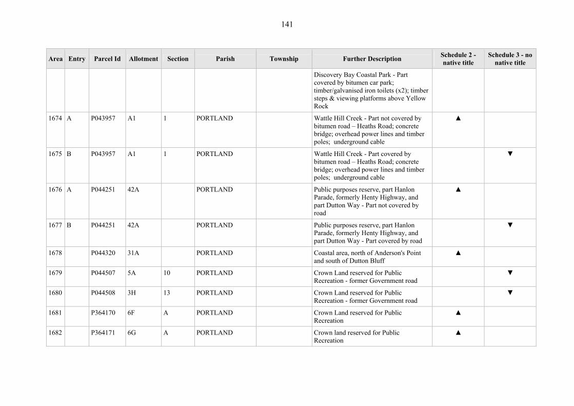
141
Area Entry Parcel Id Allotment Section Parish Township Further Description Schedule 2 - native title
Schedule 3 - no native title
Discovery Bay Coastal Park - Part covered by bitumen car park; timber/galvanised iron toilets (x2); timber steps & viewing platforms above Yellow Rock
1674 A P043957 A1 1 PORTLAND Wattle Hill Creek - Part not covered by bitumen road – Heaths Road; concrete bridge; overhead power lines and timber poles; underground cable
▲
1675 B P043957 A1 1 PORTLAND Wattle Hill Creek - Part covered by bitumen road – Heaths Road; concrete bridge; overhead power lines and timber poles; underground cable
▼
1676 A P044251 42A PORTLAND Public purposes reserve, part Hanlon Parade, formerly Henty Highway, and part Dutton Way - Part not covered by road
▲
1677 B P044251 42A PORTLAND Public purposes reserve, part Hanlon Parade, formerly Henty Highway, and part Dutton Way - Part covered by road
▼
1678 P044320 31A PORTLAND Coastal area, north of Anderson's Point and south of Dutton Bluff
▲
1679 P044507 5A 10 PORTLAND Crown Land reserved for Public Recreation - former Government road
▼
1680 P044508 3H 13 PORTLAND Crown Land reserved for Public Recreation - former Government road
▼
1681 P364170 6F A PORTLAND Crown Land reserved for Public Recreation
▲
1682 P364171 6G A PORTLAND Crown land reserved for Public Recreation
▲

142
Area Entry Parcel Id Allotment Section Parish Township Further Description Schedule 2 - native title
Schedule 3 - no native title
1683 P367221 3 12 PORTLAND Scenic Road and Public Purposes Reserve - Covered by scenic road
▼
1684 A P367222 3B 12 PORTLAND Nelson Bay Cliffs and Heath, part of Discovery Bay Coastal Park - Part not covered by bitumen road
▲
1685 B P367222 3B 12 PORTLAND Nelson Bay Cliffs and Heath, part of Discovery Bay Coastal Park - Part covered by bitumen road
▼
1686 P367223 3C 12 PORTLAND Coastal area, part of Discovery Bay Coastal Park
▲
1687 P367227 86D 13 PORTLAND Temporary Public Purposes reserve, sea frontage
▲
1688 A P367749 86E 13 PORTLAND Point Danger Reserve and Rifle Range, sea frontage - Part not covered by plaque commemorating Western District Aboriginals; steel overhead conveyor – part of factory; formed limestone road; rifle range and footprint; timber/galvanised iron shed; galvanised iron clubhouse and toilet block; sandstone/timber shed; mutton bird enclosure; fixed timber seats; formed dirt carpark
▲
1689 B P367749 86E 13 PORTLAND Point Danger Reserve and Rifle Range, sea frontage - Part covered by plaque commemorating Western District Aboriginals; steel overhead conveyor – part of factory; formed limestone road; rifle range and footprint; timber/galvanised iron shed; galvanised iron clubhouse and toilet block; sandstone/timber shed; mutton bird enclosure; fixed timber seats; formed dirt
▼

143
Area Entry Parcel Id Allotment Section Parish Township Further Description Schedule 2 - native title
Schedule 3 - no native title
carpark
1690 P370904 2002 PORTLAND Unreserved Crown Land ▲
1691 P374391 2001 PORTLAND Unreserved Crown Land ▲
1692 P374821 2003 PORTLAND Unreserved Crown Land ▲
1693 P374822 2004 PORTLAND Ararat to Portland Railway - Covered by railway alignment
▼
1694 P043188 16A REDRUTH WANNON (T) Unreserved Crown Land ▲
1695 P043196 50 REDRUTH WANNON (T) Wannon River Frontage ▲
1696 P043197 20A REDRUTH WANNON (T) Wannon River Frontage ▲
1697 P043198 17A REDRUTH WANNON (T) Wannon River Frontage ▲
1698 P043210 49A REDRUTH WANNON (T) Crown Land reserved for Public Purposes ▲
1699 P042636 5A 13 REDRUTH Wannon River Frontage ▲
1700 P042637 2A 4 REDRUTH Wannon River Frontage ▲
1701 P042638 4A 8 REDRUTH Wannon River Frontage ▲
1702 P042639 9B 8 REDRUTH Wannon River Frontage ▲
1703 P042640 3A 4 REDRUTH Wannon River Frontage ▲
1704 P367732 10A 14 REDRUTH Crown Land reserved for Public Purposes (Recreation & Conservation) - Prior Freehold grant - Whole
▼
1705 P043144 57 SANDFORD SANDFORD (T) Wannon River Frontage ▲
1706 P043170 48C SANDFORD SANDFORD (T) Unreserved Crown Land ▲
1707 P043173 48B SANDFORD SANDFORD (T) Crown Land forming part of Casterton-Branxholme Railway - Covered by railway alignment
▼
1708 P043174 58 SANDFORD SANDFORD (T) Crown Land reserved for Military Purposes
▲

144
Area Entry Parcel Id Allotment Section Parish Township Further Description Schedule 2 - native title
Schedule 3 - no native title
1709 P044249 57A SANDFORD SANDFORD (T) Frontage to Wannon River anabranch, within 100 metres of Wannon River
▲
1710 P043581 1F 5 SANDFORD Wannon River Frontage ▲
1711 P043582 2E 5 SANDFORD Wannon River Frontage ▲
1712 P043583 3H 5 SANDFORD Wannon River Frontage ▲
1713 A P043585 3E 5 SANDFORD Reserve for State School Forest Plantation - Part not covered by road
▲
1714 B P043585 3E 5 SANDFORD Reserve for State School Forest Plantation - Part covered by road
▼
1715 P043587 2C 6 SANDFORD Wannon River Frontage ▲
1716 P043588 3C 6 SANDFORD Wannon River Frontage ▲
1717 P043589 2B 7 SANDFORD Wannon River Frontage ▲
1718 P043590 8E 4 SANDFORD Wannon River Frontage ▲
1719 P043591 3F 7 SANDFORD Casterton to Branxholme Railway - Covered by railway track
▼
1720 P043592 2C 7 SANDFORD Unreserved Crown Land, adjacent Dwyers Creek
▲
1721 P043832 7E 4 SANDFORD Wannon River Frontage ▲
1722 A P043833 3A 4 SANDFORD Henty Paschendale Road - Part not covered by sealed road – Paschendale Rd
▲
1723 B P043833 3A 4 SANDFORD Henty Paschendale Road - Part covered by sealed road – Paschendale Rd
▼
1724 P044131 1D 6 SANDFORD Wannon River Frontage ▲
1725 P044133 3A4 6 SANDFORD Wannon River Frontage ▲
1726 P368794 1G 5 SANDFORD Wannon River Frontage ▲
1727 P370190 2001 SANDFORD Unreserved Crown Land ▲

145
Area Entry Parcel Id Allotment Section Parish Township Further Description Schedule 2 - native title
Schedule 3 - no native title
1728 P370191 3D 8 SANDFORD Unreserved Crown Land ▲
1729 P370192 17B 1 SANDFORD Crown Land forming part of former Casterton and Branxhome Railway - Prior Freehold grant - Whole
▼
1730 A P042489 2 4 TAHARA TAHARA (T) Tahara Recreation Reserve - Part not covered by road , Tahara-Merino Road; dams (x2); cricket oval; community centre building; tennis court (x2); tennis club building; pavilion; office, bar; horse stalls; cycle track; race track.
▲
1731 B P042489 2 4 TAHARA TAHARA (T) Tahara Recreation Reserve - Part covered by road, Tahara-Merino Road; dams (x2); cricket oval; community centre building; tennis court (x2); tennis club building; pavilion; office, bar; horse stalls; cycle track; race track.
▼
1732 A P042490 3 4 TAHARA TAHARA (T) Tahara State School, - Part not covered by school, playground, road
▲
1733 B P042490 3 4 TAHARA TAHARA (T) Tahara State School, - Part covered by school, playground, road
▼
1734 P042491 6 3 TAHARA TAHARA (T) Tahara Hall Reserve - Prior Freehold grant - Whole
▼
1735 P042643 8A 6 TAHARA Wannon River Frontage- ▲
1736 P042644 1 7 TAHARA Temporary Crown Reserve ▲
1737 A P042645 2 7 TAHARA Tahara Bridge Picnic Area - Part not covered by fixed timber table/seats
▲
1738 B P042645 2 7 TAHARA Tahara Bridge Picnic Area - Part covered by fixed timber table/seats
▼
1739 P042646 2A 7 TAHARA Wannon River Frontage ▲

146
Area Entry Parcel Id Allotment Section Parish Township Further Description Schedule 2 - native title
Schedule 3 - no native title
1740 P042647 1B 10A TAHARA North side of Coleraine to Merino Road ▲
1741 P042648 3C 10A TAHARA Quarry Reserve ▲
1742 P042649 4A 18 TAHARA Watering purposes Reserve ▲
1743 A P042650 9A 11 TAHARA Crown Land reserved for Watering Purposes - Part not covered by Tiemans Road
▲
1744 B P042650 9A 11 TAHARA Crown Land reserved for Watering Purposes - Part covered by Tiemans Road
▼
1745 P042651 9B D TAHARA Miakite Creek ▲
1746 P042652 9C D TAHARA Camping Reserve ▲
1747 P042653 6A TAHARA Quarry Reserve ▲
1748 P370188 3A 12 TAHARA Unreserved Crown Land ▲
1749 P370189 3B 12 TAHARA Unreserved Crown Land ▲
1750 P041393 1D 22 TALLANGOORK Eumeralla River Frontage- Prior Freehold grant
▼
1751 P043597 18C 4 TARRAGAL Discovery Bay Coastal Park - Prior Freehold grant - Whole
▼
1752 P043598 18D 4 TARRAGAL Discovery Bay Coastal Park - Prior Freehold grant - Whole
▼
1753 P043599 9 5 TARRAGAL Part of Discovery Bay Coastal Park ▲
1754 P043600 10 5 TARRAGAL Part of Discovery Bay Coastal Park ▲
1755 A P043601 18 2 TARRAGAL Bridgewater Bay Foreshore Reserve - Part not covered by kiosk; brick toilet block; concrete boat ramp; fixed timber table/seats (numerous); timber stairs to top of cliff; drainage pipe from top of cliff; asphalt carpark at top of cliff; overhead line; electricity overhead power
▲
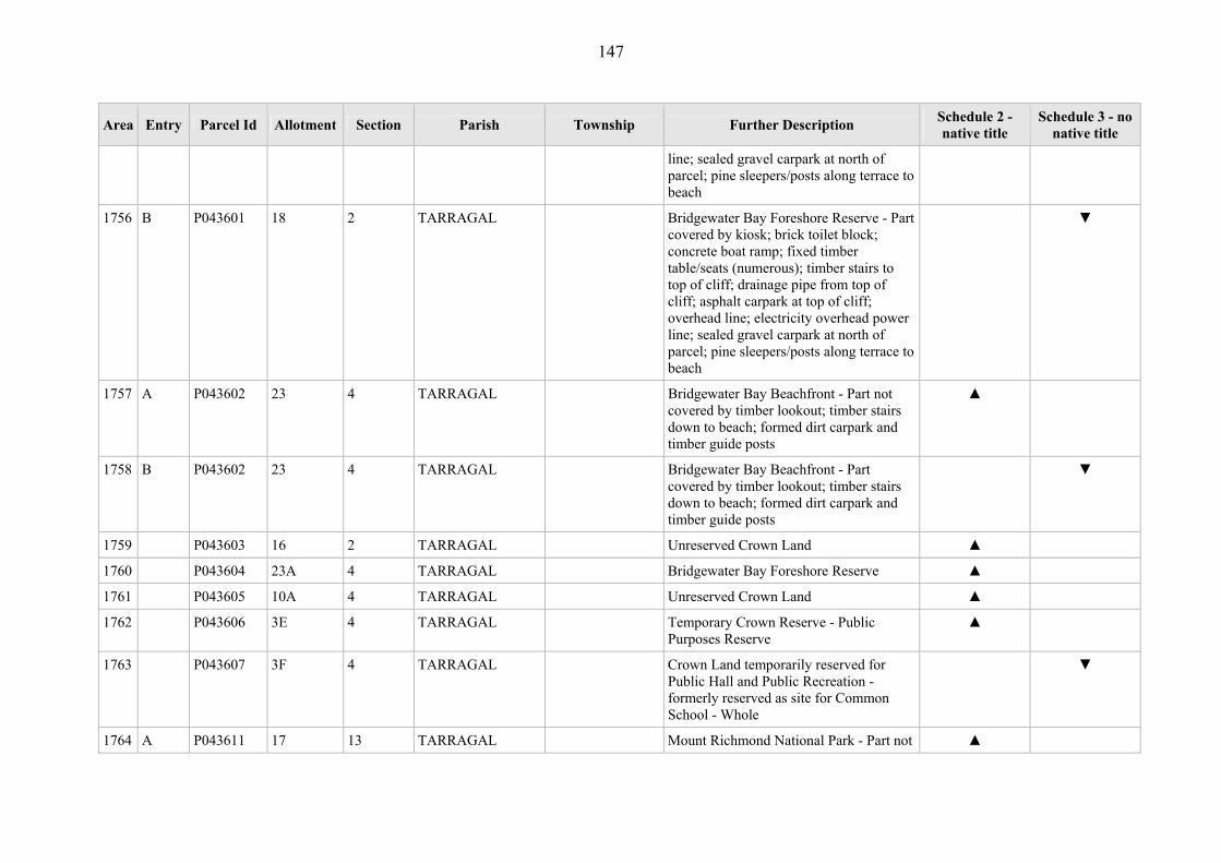
147
Area Entry Parcel Id Allotment Section Parish Township Further Description Schedule 2 - native title
Schedule 3 - no native title
line; sealed gravel carpark at north of parcel; pine sleepers/posts along terrace to beach
1756 B P043601 18 2 TARRAGAL Bridgewater Bay Foreshore Reserve - Part covered by kiosk; brick toilet block; concrete boat ramp; fixed timber table/seats (numerous); timber stairs to top of cliff; drainage pipe from top of cliff; asphalt carpark at top of cliff; overhead line; electricity overhead power line; sealed gravel carpark at north of parcel; pine sleepers/posts along terrace to beach
▼
1757 A P043602 23 4 TARRAGAL Bridgewater Bay Beachfront - Part not covered by timber lookout; timber stairs down to beach; formed dirt carpark and timber guide posts
▲
1758 B P043602 23 4 TARRAGAL Bridgewater Bay Beachfront - Part covered by timber lookout; timber stairs down to beach; formed dirt carpark and timber guide posts
▼
1759 P043603 16 2 TARRAGAL Unreserved Crown Land ▲
1760 P043604 23A 4 TARRAGAL Bridgewater Bay Foreshore Reserve ▲
1761 P043605 10A 4 TARRAGAL Unreserved Crown Land ▲
1762 P043606 3E 4 TARRAGAL Temporary Crown Reserve - Public Purposes Reserve
▲
1763 P043607 3F 4 TARRAGAL Crown Land temporarily reserved for Public Hall and Public Recreation - formerly reserved as site for Common School - Whole
▼
1764 A P043611 17 13 TARRAGAL Mount Richmond National Park - Part not ▲

148
Area Entry Parcel Id Allotment Section Parish Township Further Description Schedule 2 - native title
Schedule 3 - no native title
covered by Prior Freehold grant
1765 B P043611 17 13 TARRAGAL Mount Richmond National Park - Part Prior Freehold grant
▼
1766 A P043612 9B 13 TARRAGAL Unreserved Crown Land - Part not covered by road
▲
1767 B P043612 9B 13 TARRAGAL Unreserved Crown Land - Part road ▼
1768 P043613 5 A TARRAGAL Discovery Bay Coastal Park ▲
1769 P043616 12 9 TARRAGAL Discovery Bay Coastal Park ▲
1770 P043617 10 3 TARRAGAL Discovery Bay Coastal Park ▲
1771 A P043618 20 2A TARRAGAL Old Cape Bridgewater Coastal Reserve, post/wire fence at eastern boundary - Part not covered by timber footbridges and steps (x2); timber lookout; fixed timber table/seats; water tap; timber toilet block and underground sewerage tank; timber footbridge
▲
1772 B P043618 20 2A TARRAGAL Old Cape Bridgewater Coastal Reserve, post/wire fence at eastern boundary - Part covered by timber footbridges and steps (x2); timber lookout; fixed timber table/seats; water tap; timber toilet block and underground sewerage tank; timber footbridge
▼
1773 A P043619 43 1 TARRAGAL Old Cape Bridgewater Coastal Reserve - Part not covered by galvanised iron boat shed; timber lookout/viewing platform; timber bridge; safety post & rail fencing; car park; formed dirt access track to bitumen road; jetty; memorial plaque – Couzner; memorial plaque – Misha; formed dirt/asphalt tracks
▲
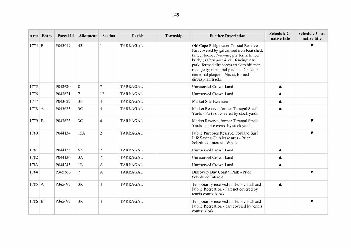
149
Area Entry Parcel Id Allotment Section Parish Township Further Description Schedule 2 - native title
Schedule 3 - no native title
1774 B P043619 43 1 TARRAGAL Old Cape Bridgewater Coastal Reserve - Part covered by galvanised iron boat shed; timber lookout/viewing platform; timber bridge; safety post & rail fencing; car park; formed dirt access track to bitumen road; jetty; memorial plaque – Couzner; memorial plaque – Misha; formed dirt/asphalt tracks
▼
1775 P043620 8 7 TARRAGAL Unreserved Crown Land ▲
1776 P043621 7 12 TARRAGAL Unreserved Crown Land ▲
1777 P043622 3B 4 TARRAGAL Market Site Extension ▲
1778 A P043623 3C 4 TARRAGAL Market Reserve, former Tarragal Stock Yards - Part not covered by stock yards
▲
1779 B P043623 3C 4 TARRAGAL Market Reserve, former Tarragal Stock Yards - part covered by stock yards
▼
1780 P044134 15A 2 TARRAGAL Public Purposes Reserve, Portland Surf Life Saving Club lease area - Prior Scheduled Interest - Whole
▼
1781 P044135 5A 7 TARRAGAL Unreserved Crown Land ▲
1782 P044136 3A 7 TARRAGAL Unreserved Crown Land ▲
1783 P044245 1B A TARRAGAL Unreserved Crown Land ▲
1784 P365566 7 A TARRAGAL Discovery Bay Coastal Park - Prior Scheduled Interest
▼
1785 A P365697 3K 4 TARRAGAL Temporarily reserved for Public Hall and Public Recreation - Part not covered by tennis courts; kiosk.
▲
1786 B P365697 3K 4 TARRAGAL Temporarily reserved for Public Hall and Public Recreation - part covered by tennis courts; kiosk.
▼

150
Area Entry Parcel Id Allotment Section Parish Township Further Description Schedule 2 - native title
Schedule 3 - no native title
1787 A P366592 6 A TARRAGAL Bridgewater Lakes - Part not covered by Prior Scheduled Interest - Part not covered by formed gravel access road; overhead powerline and 2 timber poles; brick/galvanised iron club rooms – Bridgewater Lakes Aquatic Club Inc; brick BBQ; timber tables/seats (x5); brick retaining wall; timber steps; timber/galvanised iron toilet block; sealed asphalt carpark/loading area; concrete boat ramp; timber jetty; ski jump ramp in lake – fixed
▲
1788 B P366592 6 A TARRAGAL Bridgewater Lakes - Part covered by formed gravel access road; overhead powerline and 2 timber poles; brick/galvanised iron club rooms – Bridgewater Lakes Aquatic Club Inc; brick BBQ; timber tables/seats (x5); brick retaining wall; timber steps; timber/galvanised iron toilet block; sealed asphalt carpark/loading area; concrete boat ramp; timber jetty; ski jump ramp in lake – fixed
▼
1789 C P366592 6 A TARRAGAL Bridgewater Lakes - Part covered by Prior Scheduled Interest
▼
1790 P371909 2001 TARRAGAL Discovery Bat Marine National Park ▲
1791 P043628 1D 8 TOOLKA Wannon River Frontage ▲
1792 P043629 1C 8 TOOLKA Wannon River Frontage ▲
1793 P043630 2A 6 TOOLKA Nigretta Falls Reserve ▲
1794 A P043631 5D 5 TOOLKA Hewitt Park - Part not covered by sealed bitumen road - Nigretta Rd; gravel access track
▲

151
Area Entry Parcel Id Allotment Section Parish Township Further Description Schedule 2 - native title
Schedule 3 - no native title
1795 B P043631 5D 5 TOOLKA Hewitt Park - Part covered by sealed bitumen road - Nigretta Rd; gravel access track
▼
1796 P043632 5C 5 TOOLKA Wannon River Frontage ▲
1797 P043633 6A 5 TOOLKA Wannon River Frontage ▲
1798 P043634 6B 6 TOOLKA Wannon River Frontage ▲
1799 P044142 11A 6 TOOLKA Wannon River Frontage ▲
1800 P043643 32B 9 TREWALLA Crown Land set aside as a Departmental Reserve
▲
1801 P043644 4A 11 TREWALLA Quarry Reserve ▲
1802 P043645 7A 11 TREWALLA Drainage Reserve ▲
1803 A P043646 2A 12 TREWALLA Wildlife Reserve - Part not covered by Prior Freehold grant
▲
1804 B P043646 2A 12 TREWALLA Wildlife Reserve - Part covered by Prior Freehold grant
▼
1805 P043647 2B 12 TREWALLA Bats Ridge Wildlife Reserve ▲
1806 P043648 2C 12 TREWALLA Wildlife Reserve ▲
1807 P043649 2D 12 TREWALLA Wildlife Reserve ▲
1808 P043650 7C 12 TREWALLA Drainage Reserve, Grazing Licence over part of parcel
▲
1809 P043651 10A 12 TREWALLA Boltes Lane passes through parcel ▲
1810 P043652 23A 11 TREWALLA Quarry Reserve ▲
1811 P043653 14A 11 TREWALLA Unreserved Crown Land ▲
1812 A P043654 14B 11 TREWALLA Unreserved Crown Land includes earthen drain East of Oakley's Road - Part not covered by drain.
▲

152
Area Entry Parcel Id Allotment Section Parish Township Further Description Schedule 2 - native title
Schedule 3 - no native title
1813 B P043654 14B 11 TREWALLA Unreserved Crown Land includes earthen drain East of Oakley's Road - Part covered by drain.
▼
1814 A P043655 23B 11 TREWALLA Unreserved Crown Land includes earthen drain East of Oakley's Road - Part not covered by drain.
▲
1815 B P043655 23B 11 TREWALLA Unreserved Crown Land includes earthen drain East of Oakley's Road - Part covered by drain.
1816 P043657 17C 11 TREWALLA Cashmore Public Hall - Covered by hall - Whole
▼
1817 A P043658 17D 11 TREWALLA Cashmore Hall and Recreation Reserve - Part not covered by toilet block.
▲
1818 B P043658 17D 11 TREWALLA Cashmore Hall and Recreation Reserve - Part covered by toilet block.
▼
1819 A P043659 17E 11 TREWALLA Cashmore Hall and Recreation Reserve - Part not covered by oval; dressing sheds; tennis courts; kiosk; netball court; netball shed; timekeeper’s box.
▲
1820 B P043659 17E 11 TREWALLA Cashmore Hall and Recreation Reserve - Part covered by oval; dressing sheds; tennis courts; kiosk; netball court; netball shed; timekeeper’s box.
▼
1821 P043660 6 5 TREWALLA Cape Nelson Coastal Reserve, Discovery Bay Coastal Park - Covered by bitumen road (Scenic Road); formed gravel road; toilet block; tank
▼
1822 P043661 4B 5 TREWALLA Cape Nelson Park - Prior Freehold grant ▼
1823 A P043662 4A 5 TREWALLA National Park - Part not covered by Prior Freehold grant
▲

153
Area Entry Parcel Id Allotment Section Parish Township Further Description Schedule 2 - native title
Schedule 3 - no native title
1824 B P043662 4A 5 TREWALLA National Park - Part covered by Prior Freehold grant
▼
1825 P043663 8 5 TREWALLA Discovery Bay Coastal Park ▲
1826 P043664 7 5 TREWALLA Nelson Heath, Discovery Bay Coastal Park
▲
1827 P043665 19 4 TREWALLA Trewalla Beach, Discovery Bay Coastal Park
▲
1828 P043666 20 4 TREWALLA Discovery Bay Coastal Park ▲
1829 P043667 29C 9 TREWALLA Discovery Bay Coastal Park ▲
1830 P043668 29B 9 TREWALLA Discovery Bay Coastal Park ▲
1831 P043669 2A 8 TREWALLA Discovery Bay Coastal Park ▲
1832 P043670 12A 9 TREWALLA Discovery Bay Coastal Park ▲
1833 P043671 20 9 TREWALLA Crown land set aside as a Reserve ▲
1834 P043672 34E 9 TREWALLA Bats Ridge Wildlife Reserve ▲
1835 P043673 34D 9 TREWALLA Bats Ridge Wildlife Reserve ▲
1836 P043674 34C 9 TREWALLA Bats Ridge Wildlife Reserve ▲
1837 P043815 29D 9 TREWALLA Discovery Bay Coastal Park - Prior Freehold grant - Whole
▼
1838 P044138 14B 9 TREWALLA Unreserved Crown Land, grazing licences on parcel
▲
1839 P044465 5A 5 TREWALLA Crown Reserve - Prior Freehold grant ▼
1840 P044466 5B 5 TREWALLA Crown Reserve - Prior Freehold grant ▼
1841 P044467 5C 5 TREWALLA Crown Reserve- Prior Freehold grant ▼
1842 P044475 5 5 TREWALLA Crown Reserve- Prior Freehold grant ▼
1843 A P367819 6A 5 TREWALLA Discovery Bay Coastal Park - Part not covered by formed gravel – access road;
▲

154
Area Entry Parcel Id Allotment Section Parish Township Further Description Schedule 2 - native title
Schedule 3 - no native title
timber walking track marking post; sealed road – Scenic Rd; steel BBQ on concrete base; fixed timber table/seats; poly water tank on timber base; timber/galvanised iron toilet block; timber lookout; timber underground cable markers (x2); underground cable safety anchor to secure lookout; lookout point – timber seat, memorial plaque “Collins, timber barrier
1844 B P367819 6A 5 TREWALLA Discovery Bay Coastal Park - Part covered by formed gravel – access road; timber walking track marking post; sealed road – Scenic Rd; steel BBQ on concrete base; fixed timber table/seats; poly water tank on timber base; timber/galvanised iron toilet block; timber lookout; timber underground cable markers (x2); underground cable safety anchor to secure lookout; lookout point – timber seat, memorial plaque “Collins, timber barrier
▼
1845 A P367820 6B 5 TREWALLA Discovery Bay Coastal Park - Part not covered by fixed timber tables/seats; timber toilet blocks
▲
1846 B P367820 6B 5 TREWALLA Discovery Bay Coastal Park - Part covered by fixed timber tables/seats; timber toilet blocks
▼
1847 P368744 2B 8 TREWALLA Unreserved Crown Land ▼
1848 P368748 2C 8 TREWALLA Unreserved Crown Land ▲
1849 P368753 6A 3 TREWALLA Unreserved Crown Land ▲
1850 P368762 2D 8 TREWALLA Unreserved Crown Land ▲
1851 P368787 29F 9 TREWALLA Unreserved Crown Land ▲
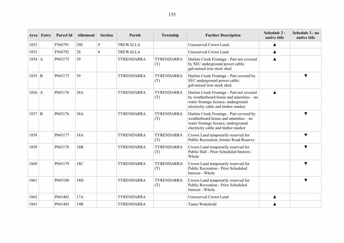
155
Area Entry Parcel Id Allotment Section Parish Township Further Description Schedule 2 - native title
Schedule 3 - no native title
1852 P368791 29E 9 TREWALLA Unreserved Crown Land; ▲
1853 P368792 2E 8 TREWALLA Unreserved Crown Land ▲
1854 A P043175 39 TYRENDARRA TYRENDARRA (T)
Darlots Creek Frontage - Part not covered by SEC underground power cable; galvanised iron stock shed
▲
1855 B P043175 39 TYRENDARRA TYRENDARRA (T)
Darlots Creek Frontage - Part covered by SEC underground power cable; galvanised iron stock shed
▼
1856 A P043176 38A TYRENDARRA TYRENDARRA (T)
Darlots Creek Frontage - Part not covered by weatherboard house and amenities – no water frontage licence; underground electricity cable and timber marker
▲
1857 B P043176 38A TYRENDARRA TYRENDARRA (T)
Darlots Creek Frontage - Part covered by weatherboard house and amenities – no water frontage licence; underground electricity cable and timber marker
▼
1858 P043177 18A TYRENDARRA TYRENDARRA (T)
Crown Land temporarily reserved for Public Recreation, former Road Reserve
▼
1859 P043178 18B TYRENDARRA TYRENDARRA (T)
Crown Land temporarily reserved for Public Hall - Prior Scheduled Interest - Whole
▼
1860 P043179 18C TYRENDARRA TYRENDARRA (T)
Crown Land temporarily reserved for Public Recreation - Prior Scheduled Interest - Whole
▼
1861 P043180 18D TYRENDARRA TYRENDARRA (T)
Crown Land temporarily reserved for Public Recreation - Prior Scheduled Interest - Whole
▼
1862 P041402 17A TYRENDARRA Unreserved Crown Land ▲
1863 P041403 19B TYRENDARRA Tanns Waterhold ▲

156
Area Entry Parcel Id Allotment Section Parish Township Further Description Schedule 2 - native title
Schedule 3 - no native title
1864 P041412 67G TYRENDARRA Protection of Coastline Reserve - ▲
1865 P041413 67H TYRENDARRA Unreserved Crown Land ▲
1866 P041414 67J TYRENDARRA Unreserved Crown Land ▲
1867 A P041415 47L TYRENDARRA Fitzroy River - Part not covered by footprint of the formed road through reserve and access to the boat ramp; picnic facilities and area surrounding
▲
1868 B P041415 47L TYRENDARRA Fitzroy River - Part covered by footprint of the formed road through reserve and access to the boat ramp; picnic facilities and area surrounding
▼
1869 A P041416 34D TYRENDARRA Unreserved Crown Land - Part not covered by footprint of the easement for powerline crossing the parcel
▲
1870 B P041416 34D TYRENDARRA Unreserved Crown Land - Part covered by footprint of the easement for powerline crossing the parcel
▼
1871 P041417 38A TYRENDARRA Unreserved Crown Land ▲
1872 P041418 39J TYRENDARRA Unreserved Crown Land ▲
1873 P041419 44N TYRENDARRA Unreserved Crown Land ▲
1874 P041420 44P TYRENDARRA Fitzroy River Frontage - ▲
1875 P041421 43K TYRENDARRA Frontage to Fitzroy River and Darlots Creek
▲
1876 P041422 43L TYRENDARRA Unreserved Crown Land ▲
1877 A P041423 1E TYRENDARRA Frontage to Darlots Creek - Part not covered by footprint of 13.6m easement for powerline
▲
1878 B P041423 1E TYRENDARRA Frontage to Darlots Creek - Part covered ▼

157
Area Entry Parcel Id Allotment Section Parish Township Further Description Schedule 2 - native title
Schedule 3 - no native title
by footprint of 13.6m easement for powerline
1879 P044429 8E TYRENDARRA Unreserved Crown Land ▲
1880 A P043677 22A B URANGARA Wannon River Frontage -Part not covered by Prior Freehold grant
▲
1881 B P043677 22A B URANGARA Wannon River Frontage - Part covered by Prior Freehold grant
▼
1882 A P043683 49 WANWIN Lower Glenelg National Park, North Side - Part not covered by campsites
▲
1883 B P043683 49 WANWIN Lower Glenelg National Park, North Side - Part covered by campsites
▼
1884 P373519 2001 WANWIN Crown Land< Victorian Plantations Corporation
▲
1885 A P043696 1E 11 WARRABKOOK Weerangourt Creek; Part not covered by gas pipeline easement (20 metre-wide)
▲
1886 B P043696 1E 11 WARRABKOOK Weerangourt Creek - Part covered by gas pipeline easement (20 metre-wide)
▼
1887 A P043697 1C 9 WARRABKOOK Weerangourt Creek - Part not covered by overhead cable; galvanised iron shed housing water pump; concrete water trough; concrete bridges and formed road (x2)
▲
1888 B P043697 1C 9 WARRABKOOK Weerangourt Creek - Part covered by overhead cable; galvanised iron shed housing water pump; concrete water trough; concrete bridges and formed road (x2)
▼
1889 P043698 2C 9 WARRABKOOK Water Reserve ▲
1890 P043699 2D 9 WARRABKOOK Weerangourt Creek ▲

158
Area Entry Parcel Id Allotment Section Parish Township Further Description Schedule 2 - native title
Schedule 3 - no native title
1891 A P043702 8 WARRAIN Crown Land declared as National Park by Act 1975 No. 8702 - Part not covered by Prior Freehold grant - Part not covered by Prior Scheduled Interest - Part not covered by road
▲
1892 B P043702 8 WARRAIN Crown Land declared as National Park by Act 1975 No. 8702 - Part covered by Prior Freehold grant
▼
1893 C P043702 8 WARRAIN Crown Land declared as National Park by Act 1975 No. 8702 - Part covered by Prior Scheduled Interest
▼
1894 D P043702 8 WARRAIN Crown Land declared as National Park by Act 1975 No. 8702 - Part covered by road
▼
1895 P043703 9B WARRAIN Unreserved Crown Land, Prior Scheduled Interest - Whole
▼
1896 P043706 34 WARRAIN Unreserved Crown Land, Prior Scheduled Interest - Whole
▼
1897 P043707 35 WARRAIN Unreserved Crown Land, Prior Scheduled Interest - Whole
▼
1898 P043708 37 WARRAIN Unreserved Crown Land, Prior Scheduled Interest - Whole
▼
1899 P043709 45 WARRAIN Reserved Forest vested in Victorian Plantations Corporation
▲
1900 A P043711 44 WARRAIN Lower Glenelg National Park, South Side - Part not covered by campsites - Part not covered by road
▲
1901 B P043711 44 WARRAIN Lower Glenelg National Park, South Side - Part covered by campsites
▼
1902 C P043711 44 WARRAIN Lower Glenelg National Park, South Side - Part covered by road
▼

159
Area Entry Parcel Id Allotment Section Parish Township Further Description Schedule 2 - native title
Schedule 3 - no native title
1903 P044151 12A WARRAIN Discovery Bay Coastal Park - Prior Freehold grant - Whole
▼
1904 P366570 15A WARRAIN Discovery Bay Coastal Park ▲
1905 P366573 41B WARRAIN Black Swamp, Discovery Bay Coastal Park
▲
1906 P366579 24C WARRAIN Discovery Bay Coastal Park ▲
1907 P366580 6A WARRAIN Discovery Bay Coastal Park ▲
1908 P366581 7A WARRAIN Discovery Bay Coastal Park ▲
1909 P043128 16A 18 WARRAYURE WARRAYURE (T)
Public Purposes and Water Supply Reserve, Nine Mile Creek
▲
1910 P044154 23A B WARRAYURE Unreserved Crown Land, Prior Freehold grant - Whole
▼
1911 P044155 32 B WARRAYURE Ararat to Hamilton Railway - Covered by railway track.
▼
1912 P044156 12A B WARRAYURE Unreserved Crown Land ▲
1913 P044239 4A B WARRAYURE Unreserved Crown Land ▲
1914 P044242 18A B WARRAYURE Unreserved Crown Land - Prior Freehold grant - Whole
▼
1915 P043712 56 WATAEPOOLAN Reserved Forest ▲
1916 P043713 55 WATAEPOOLAN Reserved Forest ▲
1917 P043714 56B WATAEPOOLAN Crawford River Frontage ▲
1918 A P043716 36 WATAEPOOLAN Unreserved Crown Land - Part not covered by footprint of McKenzie Ck Road
▲
1919 B P043716 36 WATAEPOOLAN Unreserved Crown Land - Part covered by footprint of McKenzie Ck Road
▼
1920 P043717 35 WATAEPOOLAN Unreserved Crown Land; ▲

160
Area Entry Parcel Id Allotment Section Parish Township Further Description Schedule 2 - native title
Schedule 3 - no native title
1921 P043718 2B WATAEPOOLAN Unreserved Crown Land ▲
1922 P043719 17A WATAEPOOLAN Unreserved Crown Land ▲
1923 A P043720 16A WATAEPOOLAN Stokes River Frontage - Part not covered by footprint of stream gauge facility, bridge and bitumen road
▲
1924 B P043720 16A WATAEPOOLAN Stokes River Frontage - Part covered by footprint of stream gauge facility, bridge and bitumen road
▼
1925 P043721 16 WATAEPOOLAN Unreserved Crown Land ▲
1926 P043722 20 WATAEPOOLAN Unreserved Crown Land ▲
1927 P043724 19C WATAEPOOLAN Unreserved Crown Land ▲
1928 P043725 21B WATAEPOOLAN Unreserved Crown Land ▲
1929 P043726 19 WATAEPOOLAN Unreserved Crown Land ▲
1930 P043727 18 WATAEPOOLAN Unreserved Crown Land ▲
1931 P043728 17 WATAEPOOLAN Unreserved Crown Land; ▲
1932 A P043729 49A WATAEPOOLAN Crawford River Frontage - Part not covered by high voltage powerline and 80 metre wide easement timber bridges across river (x2); concrete bridge
▲
1933 B P043729 49A WATAEPOOLAN Crawford River Frontage - Part covered by high voltage powerline and 80 metre wide easement timber bridges across river (x2); concrete bridge
▼
1934 A P043730 9A A WATAEPOOLAN Stokes River Frontage - Part not covered by bitumen Dartmoor and Casterton Road; concrete bridge
▲
1935 B P043730 9A A WATAEPOOLAN Stokes River Frontage - Part covered by bitumen Dartmoor and Casterton Road;
▼
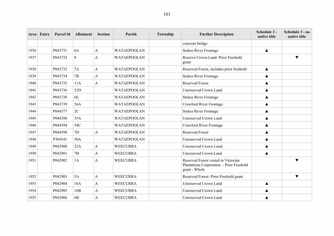
161
Area Entry Parcel Id Allotment Section Parish Township Further Description Schedule 2 - native title
Schedule 3 - no native title
concrete bridge
1936 P043731 6A A WATAEPOOLAN Stokes River Frontage ▲
1937 P043732 8 A WATAEPOOLAN Reserve Crown Land- Prior Freehold grant
▼
1938 P043733 7A A WATAEPOOLAN Reserved Forest, includes prior freehold ▲
1939 P043734 7B A WATAEPOOLAN Stokes River Frontage ▲
1940 P043735 11A A WATAEPOOLAN Reserved Forest ▲
1941 P043736 31D WATAEPOOLAN Unreserved Crown Land ▲
1942 P043738 6E WATAEPOOLAN Stokes River Frontage ▲
1943 P043739 56A WATAEPOOLAN Crawford River Frontage ▲
1944 P044377 2C WATAEPOOLAN Stokes River Frontage ▲
1945 P044388 35A WATAEPOOLAN Unreserved Crown Land ▲
1946 P044394 54C WATAEPOOLAN Crawford River Frontage ▲
1947 P044398 7D A WATAEPOOLAN Reserved Forest ▲
1948 P369341 50A WATAEPOOLAN Unreserved Crown Land ▲
1949 P042900 22A A WEECURRA Unreserved Crown Land; ▲
1950 P042901 7B A WEECURRA Unreserved Crown Land ▲
1951 P042902 1A A WEECURRA Reserved Forest vested in Victorian Plantations Corporation - Prior Freehold grant - Whole
▼
1952 P042903 5A A WEECURRA Reserved Forest- Prior Freehold grant ▼
1953 P042904 16A A WEECURRA Unreserved Crown Land ▲
1954 P042905 16B A WEECURRA Unreserved Crown Land ▲
1955 P042906 6B A WEECURRA Unreserved Crown Land ▲

162
Area Entry Parcel Id Allotment Section Parish Township Further Description Schedule 2 - native title
Schedule 3 - no native title
1956 P042907 15 A WEECURRA Unreserved Crown Land ▲
1957 P042908 7A A WEECURRA Unreserved Crown Land- Former road ▼
1958 P042909 7 A WEECURRA Unreserved Crown Land ▲
1959 P042911 14B A WEECURRA Unreserved Crown Land ▲
1960 P042912 8 A WEECURRA Unreserved Crown Land ▲
1961 P042913 9 A WEECURRA Unreserved Crown Land ▲
1962 P042914 11A C WEECURRA Unreserved Crown Land ▲
1963 P042916 17C C WEECURRA Unreserved Crown Land ▲
1964 P042917 15B C WEECURRA Unreserved Crown Land ▲
1965 A P042918 25 C WEECURRA Morgans Plains Road - Part not covered by road
▲
1966 B P042918 25 C WEECURRA Morgans Plains Road - Part covered by road
▼
1967 P042921 9A B WEECURRA Unreserved Crown Land ▲
1968 P042922 4B B WEECURRA Unreserved Crown Land ▲
1969 P042923 24A C WEECURRA Unreserved Crown Land ▲
1970 P042924 9B B WEECURRA Unreserved Crown Land ▲
1971 P042925 16B B WEECURRA Unreserved Crown Land ▲
1972 P042926 10B B WEECURRA Unreserved Crown Land ▲
1973 A P042927 10A B WEECURRA Unreserved Crown Land - Part not covered by road
▲
1974 B P042927 10A B WEECURRA Unreserved Crown Land - Part covered by road
▼
1975 P042928 13A A WEECURRA Unreserved Crown Land ▲
1976 P042929 12A A WEECURRA Unreserved Crown Land ▲

163
Area Entry Parcel Id Allotment Section Parish Township Further Description Schedule 2 - native title
Schedule 3 - no native title
1977 P042930 12C A WEECURRA Crown Land vested in Victorian Plantations Corporation- Prior Freehold grant
▼
1978 P042931 10A A WEECURRA Unreserved Crown Land ▲
1979 P044380 17D C WEECURRA Unreserved Crown Land ▲
1980 A P044381 17E C WEECURRA Stokes River Frontage - Part not covered by footprint of stream gauge facility, bridge and bitumen road
▲
1981 B P044381 17E C WEECURRA Stokes River Frontage - Part covered by footprint of stream gauge facility, bridge and bitumen road
▼
1982 P044382 12B C WEECURRA Stokes River Frontage ▲
1983 P044383 11A B WEECURRA Unreserved Crown Land; ▲
1984 P044389 26 C WEECURRA Reserved Forest ▲
1985 P044390 8 B WEECURRA Unreserved Crown Land ▲
1986 P044391 9C B WEECURRA Reserved Forest ▲
1987 A P044392 27 C WEECURRA Morgans Plains Road - Part not covered by road
▲
1988 B P044392 27 C WEECURRA Morgans Plains Road - Part covered by road
▼
1989 A P044393 12A C WEECURRA Unreserved Crown Land - Part not covered by Prior Scheduled Interest
▲
1990 B P044393 12A C WEECURRA Unreserved Crown Land - Part covered by Prior Scheduled Interest
▼
1991 P367771 5B A WEECURRA Reserved Forest vested in Victorian Plantations Corporation - Prior Freehold grant - Whole
▼
1992 P367772 14C A WEECURRA Unreserved Crown Land vested in ▼
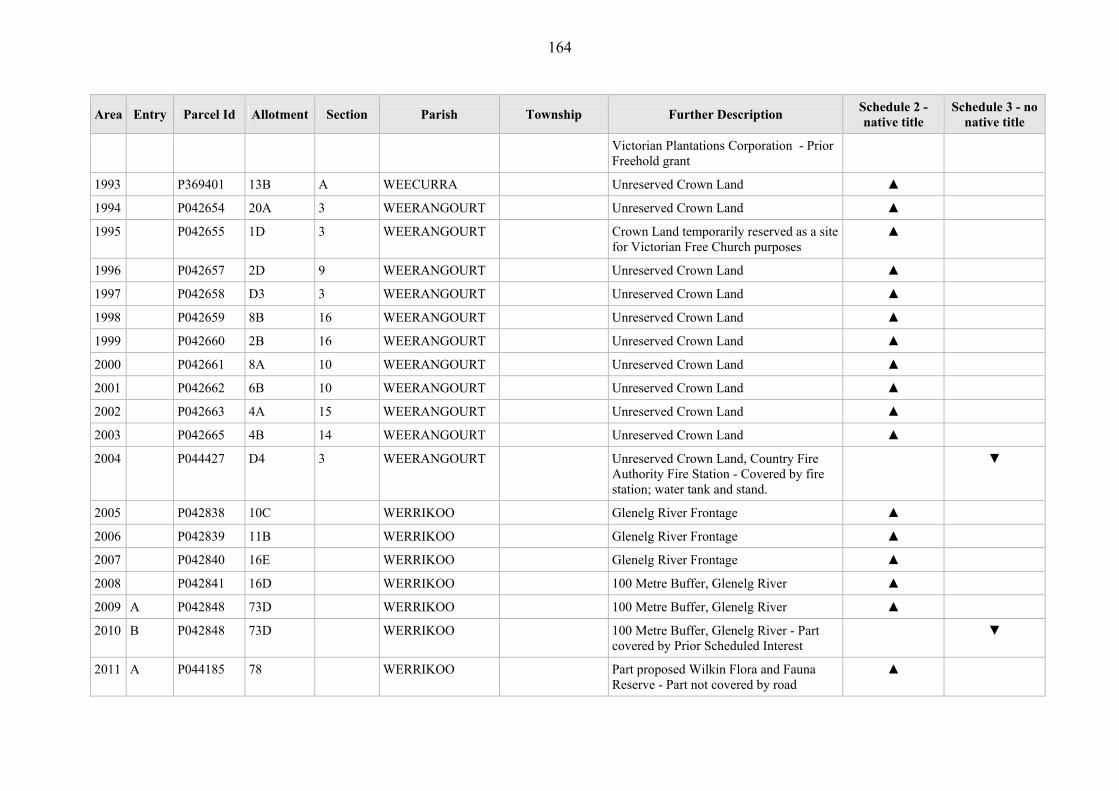
164
Area Entry Parcel Id Allotment Section Parish Township Further Description Schedule 2 - native title
Schedule 3 - no native title
Victorian Plantations Corporation - Prior Freehold grant
1993 P369401 13B A WEECURRA Unreserved Crown Land ▲
1994 P042654 20A 3 WEERANGOURT Unreserved Crown Land ▲
1995 P042655 1D 3 WEERANGOURT Crown Land temporarily reserved as a site for Victorian Free Church purposes
▲
1996 P042657 2D 9 WEERANGOURT Unreserved Crown Land ▲
1997 P042658 D3 3 WEERANGOURT Unreserved Crown Land ▲
1998 P042659 8B 16 WEERANGOURT Unreserved Crown Land ▲
1999 P042660 2B 16 WEERANGOURT Unreserved Crown Land ▲
2000 P042661 8A 10 WEERANGOURT Unreserved Crown Land ▲
2001 P042662 6B 10 WEERANGOURT Unreserved Crown Land ▲
2002 P042663 4A 15 WEERANGOURT Unreserved Crown Land ▲
2003 P042665 4B 14 WEERANGOURT Unreserved Crown Land ▲
2004 P044427 D4 3 WEERANGOURT Unreserved Crown Land, Country Fire Authority Fire Station - Covered by fire station; water tank and stand.
▼
2005 P042838 10C WERRIKOO Glenelg River Frontage ▲
2006 P042839 11B WERRIKOO Glenelg River Frontage ▲
2007 P042840 16E WERRIKOO Glenelg River Frontage ▲
2008 P042841 16D WERRIKOO 100 Metre Buffer, Glenelg River ▲
2009 A P042848 73D WERRIKOO 100 Metre Buffer, Glenelg River ▲
2010 B P042848 73D WERRIKOO 100 Metre Buffer, Glenelg River - Part covered by Prior Scheduled Interest
▼
2011 A P044185 78 WERRIKOO Part proposed Wilkin Flora and Fauna Reserve - Part not covered by road
▲

165
Area Entry Parcel Id Allotment Section Parish Township Further Description Schedule 2 - native title
Schedule 3 - no native title
construction; underground cable/timber marker; formed gravel track.
2012 B P044185 78 WERRIKOO Part proposed Wilkin Flora and Fauna Reserve- Part not covered by road construction; underground cable/timber marker; formed gravel track.
▼
2013 A P365775 77B WERRIKOO Part proposed Wilkin Flora and Fauna Reserve - Part covered by road
▼
2014 B P365775 77B WERRIKOO Part proposed Wilkin Flora and Fauna Reserve - Part covered by Prior Scheduled Interest
▼
2015 P042666 34B WILKIN Behind permanent frontage to Glenelg River
▲
2016 P042667 16A WILKIN Glenelg River Frontage ▲
2017 P042668 3A WILKIN Glenelg River Frontage ▲
2018 P042673 19A WILKIN Behind permanent frontage to Glenelg River
▲
2019 P042678 2A WILKIN Glenelg River Frontage ▲
2020 P042821 27D WINYAYUNG Reserved Forest - Prior Freehold grant - Whole
▼
2021 P042822 34 WINYAYUNG Reserved Forest ▲
2022 P042824 53 WINYAYUNG Reserved Forest ▲
2023 P042825 51A WINYAYUNG Reserved Forest- ▲
2024 P042826 56B WINYAYUNG Reserved Forest ▲
2025 P042827 53A WINYAYUNG Reserved Forest ▲
2026 P042828 63 WINYAYUNG Reserved Forest ▲
2027 P042829 61A WINYAYUNG Crown Land temporarily reserved as a site ▲
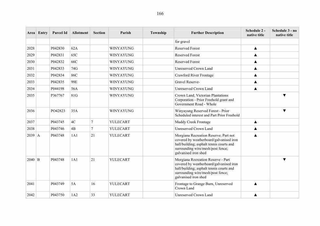
166
Area Entry Parcel Id Allotment Section Parish Township Further Description Schedule 2 - native title
Schedule 3 - no native title
for gravel
2028 P042830 62A WINYAYUNG Reserved Forest ▲
2029 P042831 65C WINYAYUNG Reserved Forest ▲
2030 P042832 66C WINYAYUNG Reserved Forest ▲
2031 P042833 74G WINYAYUNG Unreserved Crown Land ▲
2032 P042834 86C WINYAYUNG Crawford River Frontage ▲
2033 P042835 99E WINYAYUNG Gravel Reserve- ▲
2034 P044198 56A WINYAYUNG Unreserved Crown Land ▲
2035 P367767 81G WINYAYUNG Crown Land, Victorian Plantations Corporation - Prior Freehold grant and Government Road - Whole
▼
2036 PO42823 35A WINYAYUNG Winyayung Reserved Forest - Prior Scheduled interest and Part Prior Freehold
▼
2037 P043745 4C 7 YULECART Muddy Creek Frontage ▲
2038 P043746 4B 7 YULECART Unreserved Crown Land ▲
2039 A P043748 1A1 21 YULECART Morgiana Recreation Reserve; Part not covered by weatherboard/galvanised iron hall/building; asphalt tennis courts and surrounding wire/mesh/post fence; galvanised iron shed
▲
2040 B P043748 1A1 21 YULECART Morgiana Recreation Reserve - Part covered by weatherboard/galvanised iron hall/building; asphalt tennis courts and surrounding wire/mesh/post fence; galvanised iron shed
▼
2041 P043749 5A 16 YULECART Frontage to Grange Burn, Unreserved Crown Land
▲
2042 P043750 1A2 33 YULECART Unreserved Crown Land ▲

167
Area Entry Parcel Id Allotment Section Parish Township Further Description Schedule 2 - native title
Schedule 3 - no native title
2043 P043751 7B 2 YULECART Water Supply Reserve, adjacent to Muddy Creek
▲
2044 A P043752 1B 1 YULECART Unreserved Crown Land - Part not covered by road
▲
2045 B P043752 1B 1 YULECART Unreserved Crown Land - Part covered by road
▼
2046 P044208 7C 28 YULECART Unreserved Crown Land ▲
2047 P044209 8A 29 YULECART Unreserved Crown Land ▲
2048 P370737 2001 YULECART Portland to Hamilton Railway - Covered by railway track
▼
2049 P370738 2002 YULECART Portland to Hamilton Railway - Covered by railway track
▼
2050 All waters contained in each waterway (as defined in the Water Act1989 (Vic), as in force at the date of the determination) within the location described in Schedule 1
▲
2051 All land in and abutting each waterway (as defined in the Water Act 1989 (Vic), as in force at the date of the determination) within the location described in Schedule 1 not otherwise including in this table
▲
2052 A Area 2052 comprises such of the land and waters declared under s.5 of the Port Services Act 1995 (Vic), namely: (a) that area of land coloured yellow on
map numbered LEGL./04-243, lodged in the Central Plan Office of the Department of Sustainability and Environment, to be the port land of
▲

168
Area Entry Parcel Id Allotment Section Parish Township Further Description Schedule 2 - native title
Schedule 3 - no native title
the Port of Portland in the Orders in Council dated 24 May 2005 (Victorian Government Gazette 21, p 1121); and
(b) the waters delineated as such on the plan numbered LEGL./00-07 lodged in the Central Plan Office of the Department of Natural Resources and Environment (as it then was) to be the Port of Portland in the Orders in Council 19 December 2000 (Victoria Government Gazette 51, p 3048-9),
as is within 100 metres seaward of the mean low water mark as described in Schedule 1 (Port of Portland), excluding the following areas: (c) the land and waters shown on the
Determination Area Table Attachment (and described in Area 2053); and
(d) the land and waters described in Area 2054
2053 B Area 2053 is the area shown on the Determination Area Table Attachment, being that part of the Port of Portland (as defined in relation to Area 2052) that is encompassed by the eastern green straight line, the western green straight line and the purple lines connecting those green lines, noting that: (a) the eastern green line starts at the
point where the landward foot of the Main Breakwater meets the Portland Bay coast (shown on LEGL./04-243 as the point where the south-eastern
▼
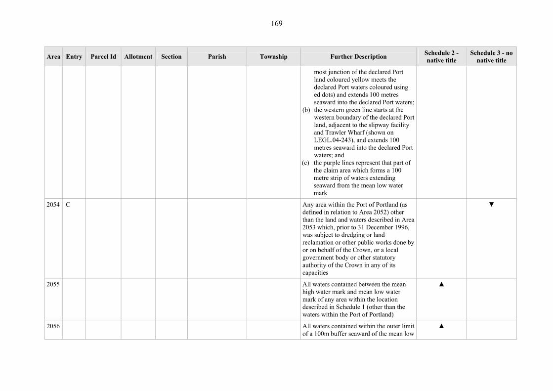
169
Area Entry Parcel Id Allotment Section Parish Township Further Description Schedule 2 - native title
Schedule 3 - no native title
most junction of the declared Port land coloured yellow meets the declared Port waters coloured using ed dots) and extends 100 metres seaward into the declared Port waters;
(b) the western green line starts at the western boundary of the declared Port land, adjacent to the slipway facility and Trawler Wharf (shown on LEGL.04-243), and extends 100 metres seaward into the declared Port waters; and
(c) the purple lines represent that part of the claim area which forms a 100 metre strip of waters extending seaward from the mean low water mark
2054 C Any area within the Port of Portland (as defined in relation to Area 2052) other than the land and waters described in Area 2053 which, prior to 31 December 1996, was subject to dredging or land reclamation or other public works done by or on behalf of the Crown, or a local government body or other statutory authority of the Crown in any of its capacities
▼
2055 All waters contained between the mean high water mark and mean low water mark of any area within the location described in Schedule 1 (other than the waters within the Port of Portland)
▲
2056 All waters contained within the outer limit of a 100m buffer seaward of the mean low
▲

170
Area Entry Parcel Id Allotment Section Parish Township Further Description Schedule 2 - native title
Schedule 3 - no native title
water mark of any area within the location described in Schedule 1 (other than the land and waters comprising Areas 2052, 2053 and 2054)

5
6G
6F
3D4
1
8
31
3
3
3B
42B
6A
5A
10
1
9
16A
5
68D
7
2
4
8
2
2017
6
32
2
5A 11A897
2016
11B
3
2020
1
56A
2015
16D
1230E
9
1B
20
82A 6B
46E
47A
PT526A
5A
6A
2019
5A
MUST STREET
FAWTHROP LAGOON
DETERMINATION AREA TABLE ATTACHMENT (Area 2053)

169
SCHEDULE 4 - “other interests”
“Other interests”– Orders 10 and 11
The following interests as they exist as at the date of the determination:
(a) so far as confirmed pursuant to s 15 of the Land Titles Validation Act 1994
(Vic) as at 24 November 1998, public access to and enjoyment of the
following places:
(i) waterways;
(ii) beds and banks or foreshores of waterways;
(iii) coastal waters;
(iv) beaches;
(v) areas that were public places at the end of 31 December 1993;
(b) the right of an employee or agent or instrumentality of the Crown, or of any
local government or other statutory authority, to access land or waters in the
Determination Area as required in the performance of statutory or common
law duties;
(c) the interests of the Crown, or a local government body or other statutory
authority of the Crown, in any capacity in any public works and other
facilities whose construction or establishment:
(i) was valid or has been validated;
(ii) did not extinguish native title (even as a consequence of validation);
and
(iii) commenced prior to the date of this determination.
(e) the following interests of Telstra Corporation Limited:
170
(i) rights and interests as the owner or operator of telecommunications
facilities installed within the Determination Area and as the holder
of a carrier licence under the Telecommunication Act 1997 (Cth);
(ii) rights and interests created pursuant to the Post and Telegraph Act
1901 (Cth), the Telecommunications Act 1975 (Cth), the Australian
Telecommunications Corporation Act 1989 (Cth), the
Telecommunications Act 1991 (Cth) and the Telecommunications
Act 1997 (Cth); and
(iii) rights to enter land or waters in the Determination Area by
employees, agents or contractors of Telstra Corporation Limited to
enable access to its telecommunications facilities in, and in the
vicinity of, the Determination Area; and
(f) any public right to fish;
(g) the public right to navigate;
(h) the interest of the holder of a licence granted pursuant to Part 3A of the
Victorian Plantations Corporation Act 1993 (Vic);
(i) the interests of persons holding licences, permits, statutory fishing rights, or
other statutory rights pursuant to:
(i) the Fisheries Act 1995 (Vic) or regulations or management plans
made under that Act;
(ii) the Fisheries Management Act 1991 (Cth), or regulations or
management plans made under that Act;
(iii) any other legislative scheme for the control, management and
exploitation of the living resources within the Determination Area
(j) the interest of the holder of petroleum exploration permit number PEP 160
pursuant to the Petroleum Act 1998 (Vic) and the interest of any other person

171
in that permit as registered in the petroleum register established under
Division 1 of Part 14 of that Act;
(k) rights and interests created under and granted pursuant to the Alcoa (Portland
Aluminium Smelter) Act 1980 (Vic) other than interests the existence of
which have extinguished native title;
(l) rights and interests of Port of Portland Pty Ltd pursuant to the Port Services
Act 1995 (Vic) and the Marine Act 1988 (Vic) other than interests the
existence of which have extinguished native title;
(m) the interests of Powercor Australia Limited (and its related entities),
including:
(i) rights and interests as an entity holding a distribution licence under
the Electricity Industry Act 2000 (Vic);
(ii) rights and interests created pursuant to the Electricity Industry Act
2000 (Vic);
(iii) rights and interests as holder of a carrier licence under the
Telecommunications Act 1997 (Cth);
(iv) rights and interests as owner or operator of electrical and
telecommunications facilities and infrastructure (facilities) installed
within the Determination Area; and
(v) rights of access for the performance of their duties by employees,
agents or contractors of Powercor Australia Limited to its facilities
in, and in the vicinity of, the Determination Area; and
(n) the interests of persons to whom valid and validated rights have been:
(i) granted by the Crown pursuant to statute or otherwise in the exercise
of its executive power; or
(ii) otherwise conferred by statute.

172
SCHEDULE 5 – Determination Area Map

!
!
!
!
!
!
!
!
!
!
!
!
!
!
!
!
!
!
!
Lady Julia PercyIsland Wildlife
Reserve
PortlandBushlandReserve
Bats RidgeWildlife Reserve
Mount RichmondNational Park
NarrawongFlora
ReserveDiscovery BayCoastal Park
Discovery BayCoastal Park
Dunmore StateForest
Mount EcclesNational Park
Lower GlenelgNational Park
Crawford RiverRegional Park
Mount NapierState Park
Jens Rd/BessiebelleState ForestNarrawong State
Forest
Hommerton State Forest
CobbobooneeState Forest
AnnyaState Forest
HotspurState Forest
WeecurraState Forest
Discovery BayMarine National
Park
Claim extends 100m from the mean low water mark
Claim extends 100m from the mean low water mark
Claim extends 100m from the mean low
water mark
Area A
Area B
1A
157
21
5A
9
29
18A
23
8
50A
11
44
21A
10
56
19E
9C
9A
27
4A
49
17A
9A
23A
7A
5
1B
5
25
23
6C
5A
12
14
23B
15
6
14
21
5A
29B
52
17
5
3A
17
9
15
6
1
10A
8
4
45
22A
12A
10
16E
8D
10A
26
12
9A
1D
17B
78
7
5
26C
12 11
53
2A
9A
25C
16A
59
1131B
2E
29C
9
17
24A
4B
5
22A
78
30A
26C
3A
6A
1B
16C
18
6
15A
17
4C
4B
34
3B
18
7
16
17
6A
6D
51A
3A
16
14A
2D
2D
3B
7
19D
8
19C
4C
16D
3C
25A
5A
1J
3C
63
5A
8
11
2C
6B
17C
2A
13
31B
13B
4A
3G3F
65C
1A
1C
1B
15
14
1D
13A
13D
9
17
12B
86
10A
43
24A
9
11A
36
67A
9
8
4A
7C
4B
35
7
82
86E
23A
15G
5B
11
29A
6A
2C
20
66C
9
22
8
9
10
17C
15F
2E
5C
27B
31A
16E
16
8B
19B
14
1486C24B
1C
55
37
20
62A
6A
28
20A
4P
8
19
15A
13E
13A
60
38A
14A19
5A
7B
91A
15A
10B
16C
16A
10
11A
32A
22G
3A
16B
81
4B
9A
15B
13D
34D
25B
73D
23
14
23D
45E
5A
1D
15B
6B
7C
5B
6A
30M
3C
7A
14A
3J
10A
42A
7D
2F
3B
10B
29E
86A
10A
1E
5B
5B
6B
1A
49A
19D
13
17F
6E
29F
11A
80C
45D
17A
9
3A
12B
9C
14A
59
159E
1C
13A
23F
70C
6E
57D
24
8
2D
8A
7B
17E
15G
19
2A
13A
7A
16
14B
3C
2D
17A
16A
6A
2E
19A
3D
9C
34C
12A28B
11A
1A
21B
9B
4B
20F
26A1K
102D
7B
18
59B
2A
13B
34C
8A
1J
26B
12A
9B
12E
3B
4A
3A
45D
57
2C
21B
9D 22A
8
29C
4A
34E
33A
4
9C
2A43K
4
10A
1B
22A
9A
5E
41B
7C
4A
3D
4C
7F
16B
20H
2D
42A
6A
12C
12A
2B
29C
5E
44
86D
56B
8A
9B
9A
16
27
10A
12A
4B
11B
84F
1C
7A
1K
15A
30N
53A11A
13B
3C
1A8
1
3B
28A
20D
30A
84H
6
17A
2
13A
11B
70H
14B
8B
2C
5A
11C
10B
10C
1E
2C
43E
5A
310
26H
2B
1A
159D
39
2C
70D
43D
11B
60A
1E
16D
3A
2B
1D
3G
40A
70E
22A
12
15
3C
4E
3A
4B
5B
12A
3A
56A
12
33A
3H
4A
3A
84J
44P
50A
3C
42B
3B
25A
2D
5F
14A
4A
1B
90
6A
55C
8C
79B
1C
1C
3G
6A
13D
12B
13C
1
4
12A
5E
15
4D
5C
2C
6
2B
16
6A
7E
6
12A
70C
20
4F
1E
44G
91A
14F
2A
8A
11A
1F55E
13B
2B
1
38
5D
153A
6J
3A
9C
1A
7E
45J
1
19
A1
1D
23
13A
22B
30A64A
8E
31D
2A
17
1D
E3
15E
10A
11C
31A
6E
7B
6F
12
1A7
9B
12B
6B
1B
4C
8A
7C
1A2
3
8C
15B
1A9
1D
9A
1C
3A
51
10A
25C
2
59A
22
45H
4B
30D
15A
1A
2A
6
2C
3E38A
1E
99E
9D
3A
6C
10
58A
47A
20
11B
7G
4C2A 5D
43B
45G
7A
60L
43A
8A
1A
3E
17A
44A
40A
2
3E
3A
3C
11D
8A
4C
1A1
1
1C
32B
5A
18
25B
6C
1A
38
8A
1A4A
13A
84G
15A
32A
4A
1C
1B
1
77B
1A
40B
4A
1Q
16B
15B2
7B
46
60N
4C
7A
13A 5A
2B
16A
23A
48C
36B
16G
2D
31C
19B
34D
144A
5
9A
4C
16
13A
25A
63D
5A
12C
4A
4A
2E
29E
12C3A4
15C
1B
12C
7A
2
1G
1B
9A
1A3
2C
37A
38A
24A
2017
38A
24C
1G 17A
5C
70F
2001
9A
1E
6D
2016
28A
1A
6H
8A
39J
30A
1D
9B
16D
14B
36A
70G
8A
32B
1D
812
3C
4A
35A
1A
77B
14E
125A
7
12C
26A
23
16D
1A
25F
5
14B
7
5A
58
60P
3
7
7
7
6
1
7A
2
9A
6A
24
10B
1A
1
7
3C
4A
16A
3A
1F
1A
4E
8
52K
20A
8B
14D
6A
17B
35A
24A
21C9A
40B
10A
9
2
3
78 5
2C4
65A 6B
2001
2001
26A
3
3A1
5B
4G
5A6A
5C
1C
7B
48H15B
10B
6D
27C
23J
10B
96A
26C
1C
44E
138D
3D
4B
8B
139D
9A
48F
42C
8A
40C
L1
3B
98A
13B11A
54C1
4A
22A
44E
44E
99B
44E
31A
22E
44E
7C
4B
44E
2001
12B
5E
13A
33B
1A
6C
6D
4A
2
6A
3D
43A
10A
72A
3A
1C
14A
2C
66B
27B
6
4A
2C
171A
1D
1E
66B
1D
5 21A
6B
8A
8A
36E
26B
4A10A
8D
1A
76A
22C
15B
51G
58C
148D
20B
8A
3B
17A
35D
15A
113D
28A
59E
7
58C
36E36D
132D
3D
3A
7C
133C
157B
6
2001
23A
2G
2
14
29A
15
7B
13
1
56B
6G
2A
4A
3
5D
2C
8A
2D
7B
19
19D
1
3
74B
2A
4B
3D
62F
8C
13B
16E
16
1A
6A
3
7A
4A
74G
56A
1
12
7C
1D
1
5A
9B
7A1
17
2001
46C1
11
8F
9B
5
12B
4
2B
38B1
15
26B
41B
12A1
3A
4B61A
D3
3A
12B
3C
2001
20
35A
7B
17E
26A
2001
3E
11
12A
4A
2E
2A
2A 1C
22D
2D
23B
6A
84C
50A
19A1
22
4D4A
1
5A
6A
7A
2004
13B
15
1A
1B2
8A
1F
17A
23E
9D
2D
2008
20G
21B
1A2
10A
6B
8D
29A
3
16B
7C
58C
2001
9A
14B
44N
2002
68D
2006
9A
2D
6A
2009
7B
6A
4A
6B
13C
35B
3D
15
23E
22
2C
20A
10A
13A
9B
3B
10
7
2B
5C
7A
4A
20D
10A
2003
3
39D1
4A
19C
12A
10
6B
9A
13E
5D
5D
11B
39A
17B
67H
28E
2C
2C
6
8F
39A1
8
9
21A 24B1
16A
8E
2002
7C
1D
2001
4A
60A
7A
66D
66D
F3
12C
18A
1D1
21
2001
15B
23A
67J
4A
28D
8B
1B
7A
8A
8E
77D
9B
18F
16B3A
108A
21A
2001
46F
37
5A
19C
7
81G
1A
1A
35
13
11B
2002
27D
6A
23A
6
2G
2
6
12A
3E
2F
34
7C1
5B
21A
9B14B
32
11A
15A
1
3
6A
5A
6G
1A
29D
12B
1
10
5C
6A
22C
31A 4G
21D
9B
6D
10B
7A
12B
7A
5A
29A
1B
9A
3D
2G
15D
33A
20
2B
8A
5D1C
4A
23A
2B
17B
18D
5F
8A
5A
4E
2001
2E
61A
27C
9C
2002
4D
3A
26A
11D
18A
4F
33A
4A
2004
21C
31F
1
39A
6E
27A
1A
7C
15E
3
18A
24A
30C
40C
2003
2002
48B
9A
10A
48A
29A
18B
20A
14A 1
2C
13D
28E 8A
5A
2004
31A
8A
13
121A
3A
9A
8A
9
2001
2003
105A
3B
24A
11A 23A
13A
8
61
20D
1
2002
37B
1B
2001
5E
4G
2004
2B
10A
2D
1A
9D
27D
4H
MOUZIE
KENTBRUCK
GORAE
NAPIER
DIGBY
NANGEELA
ARDNO
KALADBRO
MERINO
PALPARA
KILLARA
WERRIKOO
MYAMYN
CASTERTON
DUNMORE
ANNYA
WANWIN
KAY
WARRONG
MURNDAL
WEECURRA
GLENAULIN
HILGAY
TAHARA
KAPONG
GLENELG
YULECART
BYADUK
PANYYABYR
KINKELLA
CLONLEIGH
COBBOBOONEE
WARRAIN
YAMBUK KOROIT
MUMBANNAR
BELFAST
DRIK DRIK
NAGWARRY
MYARING
HEYWOOD
MONIVAE
BULART
MOCAMBORO
DRAJURK
BROADWATER
LANGULAC
WILKIN
WILLATOOK
DARTMOOR
CONDAH
NARRAWONG
HOTSPUR
BOCHARA
HOMERTON
ST. HELENS
REDRUTHBAHGALLAH
TULLICH
BEERIK
DRUMBORG
WINYAYUNG
COLERAINE
GRASSDALE
BESSIEBELLE
BANANGAL
AUDLEY
MACARTHUR
BRAMBURRA
MOKANGER
BYAMBYNEE
TARRAGAL
BRANXHOLME
CAVENDISH
TREWALLA
KANGERTONG
WATAEPOOLAN
MOUTAJUP
GREENHILLS
KANAWALLA
TYRENDARRA
MINHAMITE
CARAPOOK
TOOLANG
WARRABKOOK
MUNTHAM
KARABEAL
WARRAYURE
GRITJURK
LINLITHGOW
CARRAKBYJUKE
BALROOK
TOOLKA
URANGARA
MALANGANEE
CURRACURT
SANDFORD
DUNKELD
BRUK BRUK
BOOTAHPOOL
YALIMBA
PORTLAND
ARDONACHIE
HAMILTON SOUTH
HAMILTON NORTH
JERRYWAROOK
WEERANGOURT
YATMERONE
BOONAHWAH
PURDEET
BOLWARRA
KONONG WOOTONG
TALLANGOORK
JENNAWARRA
BRIT BRIT BULLAWIN
YANGERY
WANDO
BORAMBORAM
CROXTON WEST
TOOLOYGEERAKMOORALLA
CODRINGTON
YATCHAW WEST
MINJAH
BARNOOLUT MIRRANATWA
EUMERALLA
CROXTON EAST
YATCHAW EAST
WOOLSTHORPE
YARPTURK
MINJAH NORTH
YALIMBA EAST
CARAMUT SOUTH
Digby
Nelson
Byaduk
Merino
Koroit
Dunkeld
Heywood
Portland
Drumborg
Dartmoor
Hamilton
Casterton
Macarthur
Port Fairy
Tyrendarra
Branxholme
Tarrington
GLENELG RIVER
WANN
ON R
IVER
FITZROY RIVER
SHAW RIVER
CRAW
FORD
RIVE
R
EUMERALLA RIVER
MIAKITE CREEK
GRANGE BURN
SURREY RIVER
STOKES RIVER
MOYNE RIVER
DARL
OT C
REEK
VIOLET CREEK
SCOTT CREEK
BRYAN CREEK
COX CREEK
LYNE CREEK
DWYE
R CREE
K
WENN
ICOT
T CRE
EK
SALT
CRE
EK
NINE MILE CREEK
MURR
AY B
ROOK
YOUN
G CR
EEK
BOONAWAH CREEK
CAMP CREEK
MCPHERSONS CREEK
WATTLE HILL CREEK
HAWKINS CREEK
TULL
OH CR
EEK
DEEP CREEK
BOGG
Y CR
EEK
NARDOO CREEKMIDDLE CREEK
SALT WATER CREEK
DEN HILLS CREEK
HUMPY CREEK
GULL
Y CRE
EK
DUNDAS RIVER
LOG HUT C
REEK
LIMES
TONE
CRE
EK
KURRAMBEE CREEK
PORTLAND CREEK
CARM
ICHA
EL C
REEK
CORE
A CR
EEK
JUDY CREEK
BACK
CREE
K
PALM
ER C
REEK
SALTPAN CREEK
CORDUROY CREEK
CLARK CREEK
AUSTINS CREEK
WARBURTONS CREEK
HASSALL CREEK
WANDO RIVER
SAWYERS CREEK
BOWTELL CREEK
BREAKAWAY CREEK
MESSE
RS CREE
K
CAWKER CREEK
MAGPIE CREEK
SMOKY CREEK
SAWPIT CREEK
JONES CREEK
KANG
AROO
CREE
K
COTTAMS CREEK
MCCRAE CREEK
LOFT
US C
REEK
LITTLE MOLESIDE CREEK
HORS
E CR
EEK
SANDY CREEK
SPRING CREEK
CHIN CHAP CREEK
BOBBY CREEK
CONDAH DRAIN
BACCI CREEK
WILD DOG CREEK
RED C
REEK
SCRUBBERS CREEK
PEARSON CREEK
TEA TREE CREEK
GUNN CREEK
MCDO
NALD
CRE
EK
WARE CREEK
BACK CREEK
MCDONALD CREEK
BRYA
N CRE
EK
COND
AH DR
AIN
DEEP CREEK
BACK CREEK
GLENELG RIVER
BACK
CRE
EK
KANGAROO CREEK
SANDY CREEK
SPRING CREEK
DEEP
CRE
EK
SPRING CREEK
BACK
CREE
K
BACK CREEK
DWYER CREEK
LAKE LINLITHGOW
LAKE MUNDI
TOWER HILL LAKE
LAKE KENNEDY
OXBOW LAKE
BELFAST LOUGH
KALADBRO SWAMP
GUNDITJMARANative Title Determination Application #1
& #2VID6004/98, VID655/06
Consent Determination Area
This publication may be of assistance to you but the State of Victoria and itsemployees do not guarantee that the publication is without flaw of any kindor is wholly appropriate for your particular purposes and therefore disclaimsall liability for any error, loss or other consequence which may arise fromyou relying on any information in this publication.
¥0 4 8 12 16 202Kilometers
This plan is a representation only as assessed by the state, of the general vicinity of land and waters subject to applications for a native title determination. The Crown Land is the only land subject to claim. Park information is current to 2005.The applications for determination of native title are held by the Federal Court. Accurate inform-ation on land status and boundary definition is held at the Land Information Centre, Dept. of Sustainability and Environment.
Department of Sustainabilityand Environment
Department ofJustice
Date: 28, March, 2007File: P:\p_102461\programs\arcmap\gourn_mara_determination_04A_04B_20070323.mxd
This map was created by Spatial Information Infrastructure, DSE
© The State of Victoria, Department of Sustainability and Environment 2006
LEGENDGunditjmara (VID6004/98, VID655/06) claim boundaryArea BEast North East EnclaveParcels in Schedule 2 Gunditjmara Native Title ClaimParcels in Schedule 3 Gunditjmara Native Title ClaimParcels in Area B Gunditjmara Native Title ClaimParish BoundaryMajor Waterbodies - Lakes/PondagesRiverStreamState Border