guidelines for developments - land transport …...transport impact assessment guidelines for...
TRANSCRIPT
Transport Impact Assessment
Guidelines for Developments
2017 Edition
Land Transport Authority
Singapore
Transport Impact Assessment Guidelines for Developments
2
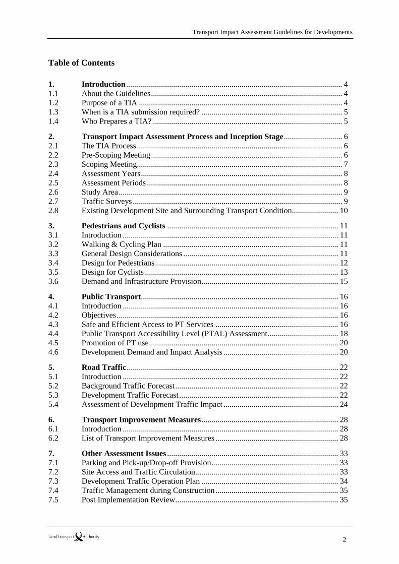
Table of Contents
1. Introduction ........................................................................................................... 4
1.1 About the Guidelines ............................................................................................... 4
1.2 Purpose of a TIA ..................................................................................................... 4
1.3 When is a TIA submission required? ...................................................................... 5
1.4 Who Prepares a TIA? .............................................................................................. 5
2. Transport Impact Assessment Process and Inception Stage ............................. 6
2.1 The TIA Process ...................................................................................................... 6
2.2 Pre-Scoping Meeting ............................................................................................... 6
2.3 Scoping Meeting...................................................................................................... 7
2.4 Assessment Years .................................................................................................... 8
2.5 Assessment Periods ................................................................................................. 8
2.6 Study Area ............................................................................................................... 9
2.7 Traffic Surveys ........................................................................................................ 9
2.8 Existing Development Site and Surrounding Transport Condition....................... 10
3. Pedestrians and Cyclists ..................................................................................... 11
3.1 Introduction ........................................................................................................... 11
3.2 Walking & Cycling Plan ....................................................................................... 11
3.3 General Design Considerations ............................................................................. 11
3.4 Design for Pedestrians ........................................................................................... 12
3.5 Design for Cyclists ................................................................................................ 13
3.6 Demand and Infrastructure Provision.................................................................... 15
4. Public Transport.................................................................................................. 16
4.1 Introduction ........................................................................................................... 16
4.2 Objectives .............................................................................................................. 16
4.3 Safe and Efficient Access to PT Services ............................................................. 16
4.4 Public Transport Accessibility Level (PTAL) Assessment ................................... 18
4.5 Promotion of PT use .............................................................................................. 20
4.6 Development Demand and Impact Analysis ......................................................... 20
5. Road Traffic ......................................................................................................... 22
5.1 Introduction ........................................................................................................... 22
5.2 Background Traffic Forecast ................................................................................. 22
5.3 Development Traffic Forecast ............................................................................... 22
5.4 Assessment of Development Traffic Impact ......................................................... 24
6. Transport Improvement Measures .................................................................... 28
6.1 Introduction ........................................................................................................... 28
6.2 List of Transport Improvement Measures ............................................................. 28
7. Other Assessment Issues ..................................................................................... 33
7.1 Parking and Pick-up/Drop-off Provision ............................................................... 33
7.2 Site Access and Traffic Circulation....................................................................... 33
7.3 Development Traffic Operation Plan .................................................................... 34
7.4 Traffic Management during Construction ............................................................. 35
7.5 Post Implementation Review................................................................................. 35
Transport Impact Assessment Guidelines for Developments
3
8. TIA Submissions and Reports ............................................................................ 37
8.1 Submissions may be required ................................................................................ 37
8.2 Inception Report .................................................................................................... 38
8.3 Interim Report ....................................................................................................... 38
8.4 Full TIA Report ..................................................................................................... 39
8.5 General Note.......................................................................................................... 39
ANNEXES ............................................................................................................................ 40
ANNEX A – Conditions When a Transport Impact Assessment (TIA) is Required ............. 41
ANNEX B – Checklist to facilitate TIA processing at Pre-Scoping Stage ........................... 42
ANNEX C – Guide for Pedestrian Accesses and Conflict Treatments ................................. 53
ANNEX D – Guide for Adequate Provision of Wayfinding Signage Within Developments 57
ANNEX E – Guide for Bicycle Parking and Related Facilities ............................................ 63
ANNEX F – Examples of Walk Radius and Indicative Walk Time Isochrones ................... 67
ANNEX G – Example of Pedestrian and Cycle Routes to Nearby PT Access Points .......... 68
ANNEX H – PTAL Calculation Methodology ...................................................................... 69
ANNEX I – Transport Improvement Measures ..................................................................... 72
Acknowledgements .............................................................................................................. 77
References ............................................................................................................................. 78
Transport Impact Assessment Guidelines for Developments
4
1. Introduction
1.1 About the Guidelines
The Land Transport Authority (LTA) has developed this set of Guidelines to assist
those preparing a Transport Impact Assessment (TIA) report for submission to the
LTA. These Guidelines (i) specify when a TIA is required to be submitted as part of a
development application, and (ii) sets out the standards and general technical
requirements for the preparation of TIA reports.
This set of Guidelines replaces the previous “Guidelines for Preparation of Traffic
Impact Assessment Reports” (also known as the TIA Guidelines), which was
introduced in 2002 and subsequently updated in 2007, 2011 and 20161.
It includes a number of amendments to ensure that the Guidelines are up to date with
on-going conditions and take into account feedback gathered from the industry.
Furthermore, the LTA has embarked on a strategy to reduce reliance on cars, and to
promote walking, cycling and public transport as the choice modes under the banner
of Walk Cycle Ride Singapore (WCR SG). The main objective of these Guidelines is
to strengthen the application of the WCR SG strategy on new development and
redevelopment projects. As such, these Guidelines are to serve as a guide for
developers to work closely with the LTA to develop transport connectivity plans
centred on Walk, Cycle and Ride to serve their respective development or
redevelopment projects.
The purpose of this document is therefore to:
• Assist developers (and transport professionals who are engaged) by outlining the
requirements and the level of detail required for the TIA studies; and
• Provide greater clarity, and maintain uniformity and consistency in the
preparation and evaluation of TIA studies in order to expedite the approval of
development applications.
1.2 Purpose of a TIA
In summary, the objectives of a TIA study are to:
• determine the transportation requirements of a new development / redevelopment,
and propose adequate and appropriate design features, facilities, and
infrastructural improvements to meet future transport demand;
• enhance the development’s overall active and mass transport connectivity,
accessibility and convenience in relation to the wider transport network with a
focus on promoting walking, cycling and mass transport; and
• identify the development’s impacts on the surrounding transport network and
recommend necessary measures to mitigate its negative impacts.
1 Walking and Cycling Plan was introduced in July 2016, as part of TIA submission.
Transport Impact Assessment Guidelines for Developments
5
Given the above objectives, TIAs shall focus on: 1) putting forth proposals to achieve
higher mass transport and/or active mobility mode shares, and 2) where possible, to
prioritise mass transport and active mobility modes over private transport modes
while at the same time striking a balance with overall traffic efficiency.
TIA studies help in the early identification of potential provision / design issues and
can thus help avoid expensive remedial actions if the issues are addressed upfront in
tandem with the implementation of the development. In addition, a TIA assists the
LTA to better plan and design the wider transportation system by enabling it to
anticipate incremental changes in transport demand for each new development.
1.3 When is a TIA submission required?
Generally, a TIA submission is required if the type and size of the proposed
development meets one or more of the criteria stipulated in Annex A. The size of a
given development is correlated with the additional trips that it generates, which in
turn determines the likelihood of impact to the surrounding transport network.
Due to the variances in the type, size and location of a development(s), it is not
practical to describe a single scope of work that can be applicable for all proposals.
As such, while this document is intended to serve as a guide, developers and
consultants are still strongly encouraged to discuss and review their scope of
work with the LTA before proceeding with their respective TIA studies.
1.4 Who Prepares a TIA?
The TIA report shall be prepared by a professional organisation (referred to as
Consultant in this document) appointed by the developer. The Consultant should
ensure (a) accuracy and validity of all information and assumptions to be used in the
study and (b) discuss the project scope with the LTA in advance of commencing the
study.
For developments requiring a Walking and Cycling Plan (WCP) submission as part of
the TIA, the WCP shall be prepared by the Consultant together with the Qualified
Person (Architect) appointed by the developer. As the architectural design of a
development and its connectivity to the surrounding transport network directly affects
the user experience of pedestrians and cyclists, it is important for the Qualified Person
(Architect) engaged for the development project to work closely with the Consultant
in the preparation of WCP. The Qualified Person (Architect) shall design for safe
access and routing of pedestrians and cyclists within the development, between the
development and other developments, as well as between the development and the
major transportation nodes surrounding it. The content to be included in WCP is
summarized in Annex B. A preliminary WCP shall be submitted at the pre-
scoping stage to facilitate the discussion at the scoping meeting with the LTA (See Annex B for the submission procedure of WCP).
Transport Impact Assessment Guidelines for Developments
6
2. Transport Impact Assessment Process and Inception Stage
2.1 The TIA Process
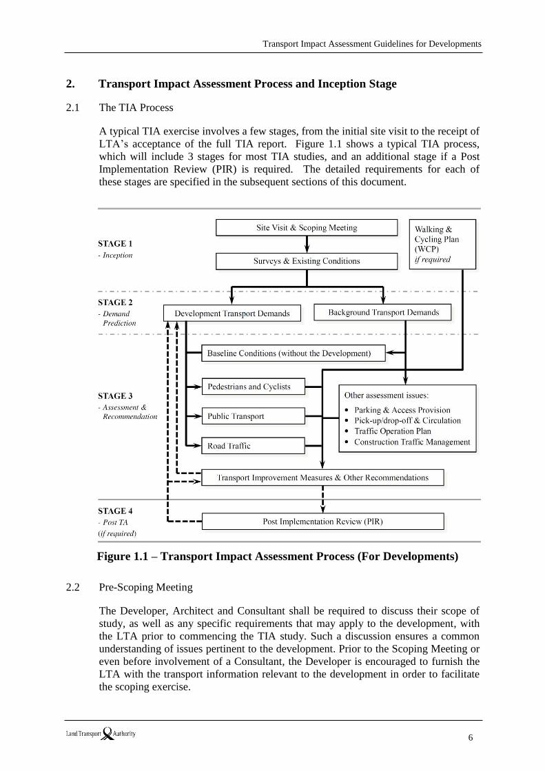
A typical TIA exercise involves a few stages, from the initial site visit to the receipt of
LTA’s acceptance of the full TIA report. Figure 1.1 shows a typical TIA process,
which will include 3 stages for most TIA studies, and an additional stage if a Post
Implementation Review (PIR) is required. The detailed requirements for each of
these stages are specified in the subsequent sections of this document.
Figure 1.1 – Transport Impact Assessment Process (For Developments)
2.2 Pre-Scoping Meeting
The Developer, Architect and Consultant shall be required to discuss their scope of
study, as well as any specific requirements that may apply to the development, with
the LTA prior to commencing the TIA study. Such a discussion ensures a common
understanding of issues pertinent to the development. Prior to the Scoping Meeting or
even before involvement of a Consultant, the Developer is encouraged to furnish the
LTA with the transport information relevant to the development in order to facilitate
the scoping exercise.
Transport Impact Assessment Guidelines for Developments
7
Where applicable, the LTA will then provide additional transport related information,
such as planned cycling path networks in the vicinity of the development. The
Developer and/or Consultant are to submit a preliminary WCP prior to the scoping
meeting. In addition, the Consultant is strongly encouraged to conduct a site visit to
gain an appreciation of the existing site conditions, and to provide the LTA with
questions/queries before the meeting. Site photos should be provided to support the
identification and description of existing transport and/or traffic conditions.
A checklist is provided in Annex B. The Consultant is to submit the completed
checklist to [email protected] when initiating the Scoping Meeting
with the LTA.
2.3 Scoping Meeting
The scope of a TIA is dependent on the type, size, and location of the development.
As such, studies may vary between localised evaluation of a development’s internal
transport facilities and access point(s) for smaller developments, to regional transport
impact assessment for larger developments.
A senior level representative of the Developer and Consultant is to attend the Scoping
Meeting with the LTA. This is to facilitate clear understanding of the extent of the
TIA to be done. Developers and/or Consultants are advised to submit to the LTA the
minutes of the Scoping Meeting based on the agreed timeline and scope discussed at
the Scoping Meeting.
Issues typically discussed at the Scoping Meeting include but are not limited to:
• Study purpose and objectives,
• Proposed methodology and assumptions,
• Existing data intended to be used,
• Size of the study area and transport elements to be studied,
• Assessment years,
• Forecast background traffic growth rate and/or method to be adopted,
• Type of surveys to be undertaken e.g. trip rate, mode share, junction traffic
counts, pedestrian and cyclist counts, travel time, origin-destination, etc.,
• Relevant peak hour(s) and site(s) for the conduct of traffic surveys,
• Derivation of vehicular and/or person-trip generation rates,
• Proposed modelling / assessment tool(s) and parameters to be used,
• Whether microscopic simulation/network assessment is required, and if yes, what
are the assessment area(s) and scenario(s) required and the requirements for
model calibration and validation,
• LTA road and/or junction improvement plans for the study area to be taken into
consideration as a base for analysis for corresponding assessment year(s),
• Intended location of development’s vehicular, pedestrian and cyclist access
Transport Impact Assessment Guidelines for Developments
8
point(s), supporting cycling facilities, parking provision and vehicular circulation,
• Whether public transport/pedestrian/cyclist analyses, development traffic
operation plans, construction traffic management plans and/or PIR are required
and to what extent,
• Whether there is a planned cycling path/covered link way abutting the
development,
• Whether there is a need for an Inception Report and/or Interim Report,
• Comments and requirements on the preliminary WCP,
• Other requirements if any, that may apply to the proposed development,
• Deliverables of the TIA study and timeline of submissions.
After the scoping meeting, the Consultant is encouraged to follow up expeditiously
with the LTA to finalise the parameters used for the TIA.
2.4 Assessment Years
The assessment years generally include the opening year, or when the development is
expected to be fully operational. The LTA may request for an assessment to be
carried out for a design year, which is typically five years after the opening year.
However, LTA may propose a different design year from the typical definition
according to respective study needs. For developments that are expected to be opened
or completed in phases, a separate assessment representing the expected completion
date of each major phase may be required.
Table 2.1 – Assessment Years for New Developments / Redevelopments
If different areas of assessment are required, such as for road traffic, public transport
and / or pedestrians / cyclist connectivity, the assessment years may be different.
Certain assessment year(s) may be required for some of the assessment areas but not
for the rest. Consultants are to seek the LTA’s direction on the assessment year(s) to
adopt for case specific development proposals.
2.5 Assessment Periods
An assessment of the surrounding transport infrastructure is to be undertaken for the
period that is expected to be significantly affected by trips associated with the
proposed development. These peak hours to be assessed shall be determined in
Type Assessment Year
Single phase
developments
- Anticipated opening year assuming full occupation
- Anticipated design year (might be required)
Multiple-phase
developments
- Anticipated major phases of completion of the
development including the first and the last phase
- Anticipated design year (might be required)
Transport Impact Assessment Guidelines for Developments
9
consultation with the LTA during the Scoping Meeting.
Under circumstances where the development’s peak trip generation occurs outside of
regular commuting peak hours, the periods to be surveyed and/or studied may include
both commuting peaks as well as the development’s peak period(s), which may occur
in the off-peak periods or at the weekend.
2.6 Study Area
The study area will depend on the type, size and transport conditions in the vicinity of
the development. Generally, small developments that are not expected to generate
high volume of vehicular, cyclist and pedestrian traffic are likely to experience
localised impacts only, and as such the area to be studied may include the
development’s own vehicular, pedestrian and cyclist access point(s) and the
immediate intersections. In contrast, larger developments with higher volumes of
additional trips may have a wider impact on the surrounding transport network over a
longer distance from the development site. As such, a wider study area will be
needed. A wider study area may also be applicable for developments situated within
an already congested transport network. Consultants are advised to confirm the extent
of the study area with the LTA prior to commencing the study.
2.7 Traffic Surveys
The existing transport / traffic condition in the vicinity area of the development shall
be well appreciated as it forms the base for the impact analysis. Traffic survey is a
common practice to collect basic information to support analysis and understanding of
existing conditions.
Generally, for commercial, industrial and residential developments, traffic surveys are
conducted in the morning and evening weekday peak periods. Retail developments
may require surveys at the weekend as well as weekday. Traffic surveys are
commonly carried out in 15 minute intervals and classified by vehicle type to
determine the profile of traffic changes within the peak hours. Unless specified,
traffic surveys shall be undertaken on a typical weekday, excluding Mondays,
Fridays, weekends and public / school holidays, and not be affected by inclement
weather. The results of the surveys shall be summarised with the peak hours
identified and graphically illustrated within the main body of the report.
For certain locations where there is already or is expected to have high volume of
pedestrians / cyclists, surveys shall include pedestrians / cyclists movements. For TIA
cases requiring calibration and validation of the existing year models, surveys shall
include traffic queue lengths at junctions, travel times along major routes and/or other
data as specified by LTA. For surveys used to determine development trip generation
rate, Section 5 of this Document specifies the requirements.
Consultants shall agree with the LTA on the intended survey scope, location(s),
period(s) and date(s), at least 3 working days prior to the survey. Consultant is to
seek LTA’s agreement on any change to the plan at least 1 working day prior to the
survey date, unless the change is due to unexpected incidents such as inclement
Transport Impact Assessment Guidelines for Developments
10
weather or occurrence of a traffic accident at the survey site(s). During the intended
survey period(s), LTA officers may selectively undertake survey observations.
The LTA may request for raw data of traffic surveys conducted by consultants.
Consultants are to ensure that the survey data are appropriately formatted and the raw
data are to be kept for at least six months for LTA’s possible audit.
2.8 Existing Development Site and Surrounding Transport Condition
The Consultant is to provide a description and/or analysis of the existing site and
transport condition of the proposed development within its vicinity as follows:
• Analysis of contextual site issues e.g. size, current use, vehicular, cyclist and
pedestrian access point(s) etc.
• Description of the road geometry, pedestrian routes, cycling paths, bus stops and
MRT/LRT stations near the development.
• Appreciation of surrounding land use and environs.
• A map with the location of the proposed development in relation to its
surrounding road network and the overall study area is to be included.
An assessment of the transport elements likely to be affected by additional trips from
the development during the peak hours is to be undertaken. The scope of assessment
should be determined in consultation with the LTA during the Scoping Meeting.
Identifications of existing transport problems are to be supported by site survey and
photos.
The following sections of this Document will specify the technical requirements of
the TIA. The techniques adopted for assessment shall be consistently applied to the
various assessment years including the existing year as applicable or unless specified /
agreed by the LTA.
Transport Impact Assessment Guidelines for Developments
11
3. Pedestrians and Cyclists
3.1 Introduction
Due consideration shall be given to pedestrians’ and cyclists’ safety and needs in the
design stage of all new developments or redevelopments. The TIA is to identify major
desired pedestrian lines and cycling route(s) to/from the development to MRT, bus
stops or existing pedestrian/cycling network (including places of attractions/amenities
such as supermarket, markets, schools, hawker centre, etc.), based on the shortest
and/or most convenient travel distance. A plan of the site with the location of desired
pedestrian lines and direct cycling routes shall be provided in the report, together with
a comprehensive way-finding plan. The location of crossing facilities i.e. at grade
crossing and grade separated crossing shall match pedestrian movement needs with
minimal diversion from the most convenient route. Justifications are required on why
a proposed pedestrian or cyclist facility cannot be provided along the desired route.
The provision of bicycle parking facilities shall be made in accordance with the
LTA’s guidelines in Annex E and Code of Practice for Vehicle Parking Provision for
development proposals. All infrastructure design (e.g. cycling path, footpath, ramp,
etc.) shall comply with the LTA’s Standard Details of Road Elements. Consultants are
to review and propose the provision of cycling paths linking the proposed
development to existing/planned cycling tracks and MRT/LRT stations nearby.
The TIA shall also address pedestrian and cyclist safety in terms of visibility and sight
distance at intersections, entry/ exit points to the development and road crossings.
3.2 Walking & Cycling Plan
The Walking and Cycling Plan (WCP) is an in-depth study of the pedestrian and
cyclist accesses and routes. The WCP will require the developer to consider the
pedestrian and cycling connectivity in the upfront design of the development. Direct
and seamless connection to major transport nodes and related facilities shall be
provided for wherever possible.
A WCP is required to be submitted for Commercial and Retail Developments,
Business Parks, and Schools that meet the TIA criteria stipulated in Annex A. These
are developments that are expected to generate high volume of pedestrians and
cyclists. Developments that do not fall under the criteria requiring the submission of a
WCP shall provide a pedestrian and cyclist assessment as described in Section 3.1.
3.3 General Design Considerations
• Pedestrian and cyclist routes shall ideally be located along the natural desired
routes i.e. the most direct path where possible. There shall also be seamless
connections between developments and transport nodes such as MRT station, bus
stop and the existing pedestrian/cycling network as shown in Figure 3.1.
Segregated paths for pedestrians and cyclists are preferred. Where there are site
constraints, shared paths for pedestrians and cyclists can be considered.

Transport Impact Assessment Guidelines for Developments
12
Figure 3.1 – Examples of Good Practices
• Vehicular access(es) of the developments shall be located away from major
pedestrian and cyclist routes, where the site permits. Where pedestrian and
cyclist routes intersect with vehicular access points, appropriate measures are to
be adopted to safeguard pedestrian and cyclist safety. Hard structures such as
concrete boundary walls/fencing/etc. are to be recessed adequately to allow
sufficient line of sight between vehicles exiting the development &
pedestrians/cyclists using the footpath/cycling path(s). Alternatively, the
boundary wall/ fencing/etc. is to be constructed with porous materials.
• Where existing footpaths/linkways/pedestrian crossings/cycling paths are to be
removed upon hoarding of the development site, there should be provision of
interim linkages and alternative pedestrian crossings during the construction
phase of the development.
3.4 Design for Pedestrians
An assessment of pedestrian movement associated with the development shall be
shown in the WCP. In addition to the general considerations in Section 3.3, other
areas of consideration include:
• Provision of sheltered pedestrian routes to adjacent developments; surrounding
pedestrian network and major transport nodes e.g. MRT and bus stops where
adequate;
• Seamless connection between covered walkways/linkways and open walkways.
Ramps instead of stairs to be provided to mitigate level difference where
possible.
• Assessment of pedestrian numbers, capacity and performance of nearby
pedestrian facilities including walkways, stairways and crossings to substantiate
the adequacy of the design to accommodate the expected pedestrian volume;
• Pedestrian safety e.g. adequacy of sight distances at crossing facilities, mitigating
conflicts at driveways, cycling paths, by provision of slow points/
signages/markings to alert pedestrians, cyclists and motorists, etc. (see Annex C).
Transport Impact Assessment Guidelines for Developments
13
Details of treatments at intersections, entry/exit points to the development and
road crossings shall be presented in a write-up with relevant drawing(s) and
justifications in the report; and
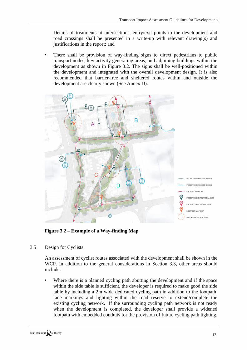
• There shall be provision of way-finding signs to direct pedestrians to public
transport nodes, key activity generating areas, and adjoining buildings within the
development as shown in Figure 3.2. The signs shall be well-positioned within
the development and integrated with the overall development design. It is also
recommended that barrier-free and sheltered routes within and outside the
development are clearly shown (See Annex D).
Figure 3.2 – Example of a Way-finding Map
3.5 Design for Cyclists
An assessment of cyclist routes associated with the development shall be shown in the
WCP. In addition to the general considerations in Section 3.3, other areas should
include:
• Where there is a planned cycling path abutting the development and if the space
within the side table is sufficient, the developer is required to make good the side
table by including a 2m wide dedicated cycling path in addition to the footpath,
lane markings and lighting within the road reserve to extend/complete the
existing cycling network. If the surrounding cycling path network is not ready
when the development is completed, the developer shall provide a widened
footpath with embedded conduits for the provision of future cycling path lighting.
Transport Impact Assessment Guidelines for Developments
14
The LTA will complete the cycling path finishing and the network in due course.
• Provision of bicycle parking spaces within the development shall be based on the
bicycle parking guidelines in Annex E, the number of bicycle parking required
and details of single-tier or double-tier bicycle parking racks can be found in the
Code of Practice for Vehicle Parking Provision in development proposals.
• Assessment of cyclist numbers, capacity and associated facilities such as shower
facilities, lockers, bike sharing facilities to accommodate the expected cyclists
demand; access(es) to the building to be cyclist-friendly e.g. automated sliding
door.
• Cyclist safety e.g. adequacy of sight distance at crossing facilities, conflict at
driveways, pedestrian paths, provision of slow points etc. Details of treatments at
intersections, entry/exit points to the development and road crossings are to be
presented in a write-up with relevant drawing(s) and justifications included in the
report; and
• In addition to the wayfinding signs for pedestrians, there shall also be signs
directing cyclists to facilities such as bicycle parking, shower areas, lockers etc.
within the development, especially when the facilities are provided at multiple
locations. The following types of signs are recommended: (1) Location map
indicating “you are here” and where the related facilities are; (2) Floor directory
at lift lobbies and access points to the building indicating the level the facilities
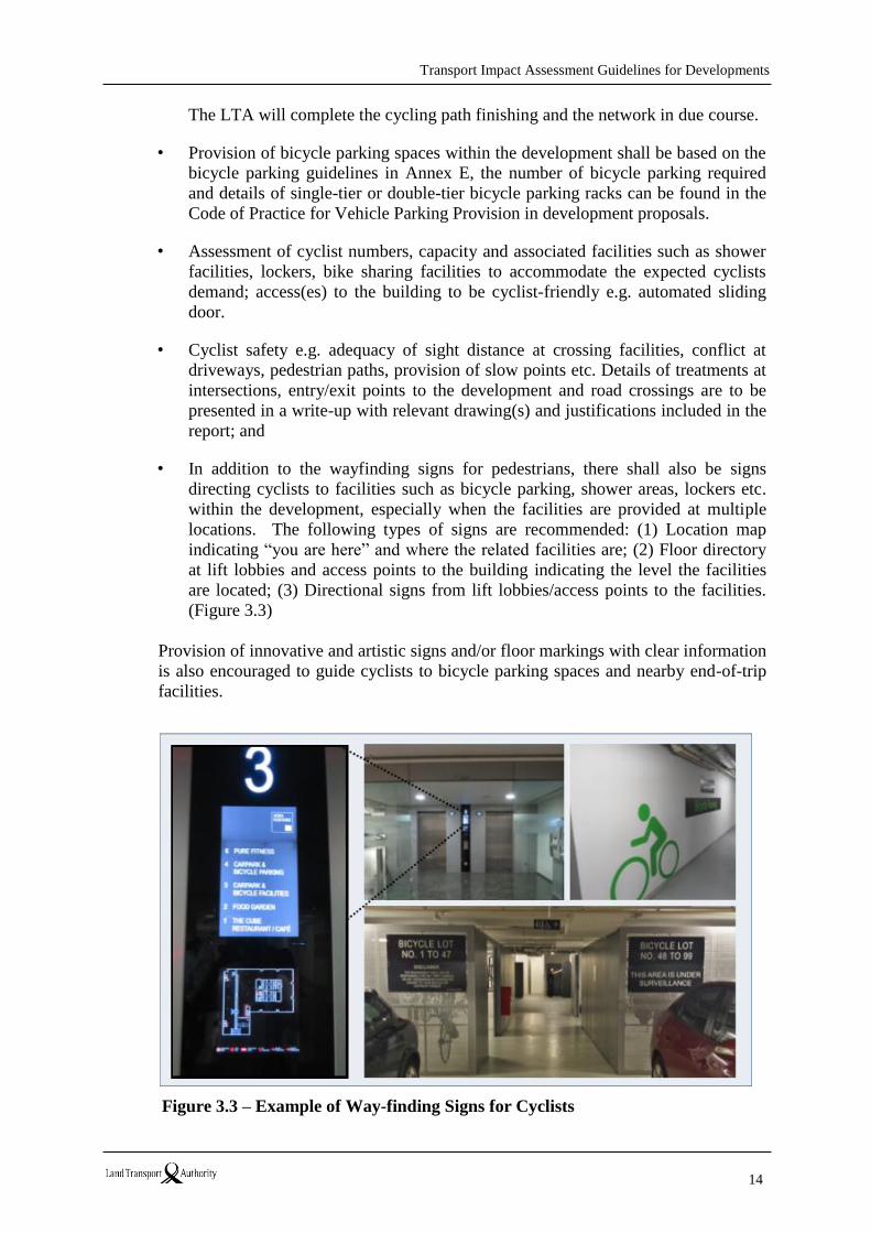
are located; (3) Directional signs from lift lobbies/access points to the facilities.
(Figure 3.3)
Provision of innovative and artistic signs and/or floor markings with clear information
is also encouraged to guide cyclists to bicycle parking spaces and nearby end-of-trip
facilities.
Figure 3.3 – Example of Way-finding Signs for Cyclists
Transport Impact Assessment Guidelines for Developments
15
3.6 Demand and Infrastructure Provision
Depending on the type of development proposed, quantitative assessment on the size
of the pedestrian and cyclist facilities may not be required.
Where the proposed development is expected to generate high pedestrian and/or
cyclist volume, the TIA is to include an assessment of the capacity requirements and
performance of the pedestrian and/or cyclist facilities to substantiate the adequacy of
the design to accommodate the expected pedestrian and/or cyclist demand.
Consultants are to seek the LTA’s advice on the requirements specified for such an
assessment.
Transport Impact Assessment Guidelines for Developments
16
4. Public Transport
4.1 Introduction
Emphasis is expected for the following:
1) improved public transport (PT) accessibility of new development, and
2) measures to encourage future site users to take PT to/from the new development,
especially for developments with high PT accessibility.
Specifically, the TIA is to demonstrate that it provides a more multimodal approach in
the assessment of the likely travel behaviours of site users to/from the proposed
development (e.g. through person-trip generation surveys).
Improving PT accessibility and services2 is a “win-win” as it not only benefits site
users but also enhances the attractiveness of the development. To help quantify PT
accessibility, LTA has adapted the London’s Public Transport Accessibility Level
(PTAL) methodology and made it relevant to Singapore. All TIA submissions would
now need to undertake a PTAL assessment for the proposed development using
LTA’s PTAL methodology.
For large-scale developments, an assessment should also be made of the available
capacity on the PT network relevant to the development. This is particularly
important when considering rail network capacity, which is generally less variable
compared to the bus network. Developers/Consultants should consult LTA on the
need for such analysis during the pre-application/scoping stage. LTA will assess such
a need and decide on the scope of the study on a case-by-case basis taking the scale,
size, use, type and location of the development, as well as network performance into
consideration. Upon developments’ request the LTA would help outline the study
requirements even before a Consultant is involved.
4.2 Objectives
One of the main objectives of the TIA Guidelines is to make PT an integral part of the
development planning process. To this end, developers shall demonstrate that the
development would:
1. provide safe and efficient access to PT services
2. undertake PTAL assessment for the proposed development
3. minimise adverse impact on the PT networks and the users of those networks
4. promote the use of PT
4.3 Safe and Efficient Access to PT Services
The main issue to be addressed is whether access to nearby bus stops and MRT/LRT
2 if demand justifies

Transport Impact Assessment Guidelines for Developments
17
stations3 from a development is direct, safe, attractive and convenient. Factors that
may be considered include:
• Directness of pedestrian routes to nearby bus stops and MRT/LRT stations
• Walk time to/from nearby bus stops in view of whether new bus stops are
required or existing ones ought to be relocated
• Ability of pedestrians to cross major roads
• Potential conflicts between pedestrian and vehicular movements along the way
leading to nearby PT services
• Minimise walk distance to PT nodes in view of the location of pedestrian
entrance (including side gate) and building orientation of the proposed
development
• Provision of sheltered walkway
• Standards and conditions of existing PT infrastructure and passenger facilities
(comply with prevailing design standards). For example,
- http://www.lta.gov.sg/content/ltaweb/en/industry-matters/development-and-
building-and-construction-and-utility-works/architectural-standards.html - http://www.lta.gov.sg/content/dam/ltaweb/corp/Industry/files/SDRE%282014
%29/SDRE14-REVA-OCT15-0contentA1-7.pdf) 4
• Convenient and useful information for potential PT users (e.g. directional signs
and way-finding maps)
The pedestrian routes to all bus stops/stations within catchment areas is to be well
integrated with public footpaths. They are to be well surfaced, well lit, without steep
inclines or barriers that are difficult to negotiate, and protected from the weather (if
demand warrants). PT passengers from the proposed development should be able to
cross the road(s) conveniently to the bus stops on the opposite side, and vice versa.
Individuals should not have to cross major traffic flows to reach a bus stop without
pedestrian crossing facilities.
For developments served by the MRT, the aim is to provide safe, direct and
convenient pedestrian and cycling routes to and from the development. For the
purpose of the TIA, the maximum walking distance to bus/LRT and MRT services is
400m (or 5-min walk) and 800m (or 10-min walk), respectively. There are existing
websites which can help measure actual walking distance5, e.g.
http://sg.mapometer.com/6 or http://www.onemap.sg/index.html.
When determining the pedestrian access point(s) of the development site,
consideration is to be given to providing direct and high quality access for pedestrians
who walk to nearby PT nodes, as well as whether the site has been provided with
adequate level of access(es) (both capacity and connectivity) to all nearby PT nodes
within the catchment areas. In addition, developers are to consider the needs of
3 Up to 400m (or 5-min walk) for a bus stop/LRT station, and up to 800m (or 10-min walk) for a MRT station. 4 These design standards and guidelines will be updated from time to time. 5 Actual walking distance should be based on network distance (not ‘the crow-flies’ distance) 6 The LTA take no responsibility for the accuracy of the information provided by the website.
Transport Impact Assessment Guidelines for Developments
18
individuals with mobility impairments for accessing PT services.
Bus services are generally more accessible and affordable compared with most other
PT services. If well planned, they help promote social inclusion and transport equity,
and benefit the vulnerable the most. Therefore, greater effort is to be placed on
improving accessibility to nearby bus services, as well as their associated facilities
wherever possible.
To facilitate LTA’s evaluation of TIA, developers should provide the following plans:
• 400m & 800m walk radius and indicative walk time isochrones from the
proposed development (See example in Annex F)
• Pedestrian routes to nearby bus stops and LRT stations (both within 400m
walking distance) and MRT stations (within 800m walking distance), as well as
cycle routes to nearby MRT stations (within 2km cycling distance) from the
development site. For each bus/LRT/MRT service, only the walk route to the
nearest bus stops (for both directions)/station entrance would need to be indicated
(See example in Annex G). However, the LTA might also request for additional
walk routes (to any bus stops within 400m walking distance) to be included in the
plan if there is reason(s) to believe that those bus stops are also likely commonly
used by future site users.
Mapping this information where possible will present a clearer picture. Interactive,
bus maps, timetable and frequencies of existing services are available at:
- https://www.transitlink.com.sg/TIdetail.aspx?ty=catart&Id=15,
- http://www.mytransport.sg/content/mytransport/home.html#, and
- http://www.onemap.sg/index.html.
Overall, developers are required to clearly describe and indicate the level of access to
the site by PT, and identify areas where possible improvements can be made to
encourage site users to use PT, and provide the necessary support to those without
access to cars.
The requirements above are not exhaustive and further supplementary information
may be required to take into account local condition and other material
considerations. Equally, TIAs of some developments may not need to meet all the
requirements mentioned above. Therefore, it is important that the scope of work is
agreed with LTA as early as possible.
4.4 Public Transport Accessibility Level (PTAL) Assessment
PTAL is a measurement of a combination of how close PT services are from a given
point (walking time) and the frequency of those services (waiting time). The PTAL
methodology was developed in 1992 by the London Borough of Hammersmith and
Fulham. It was adopted by Transport for London (TfL) about 10 years later, and has
now become the most recognised method of measuring a combination of accessibility
Transport Impact Assessment Guidelines for Developments
19
(or First Last Mile Connectivity (FLMC)7) and availability of PT services. Some
regard PTAL as the density of the PT network.
An appreciation of the level of PT accessibility of a development site would enable
developers to maximise the PTAL potential of the site by strategically placing
pedestrian access gates nearer to PT service access points without compromising on
safety, convenience and accessibility of other road users. The location of pedestrian
access gates, put forward by developers, would be considered by the LTA on a case-
by-case basis with an objective of balancing the interests of site users, other road
users and wider WCR objectives. The PTAL score would also help LTA decide on
whether or not improvements to PT services and/or local walking network (and hence,
the overall PT and walking connectivity and permeability of an area) are necessary.
This has now become all the more important as LTA’s current policy is to promote
mode shift from car to sustainable modes of transport, like PT, walking and cycling.
PTAL ranges from Levels 0 to 9 where 9 represents a high level (best) of accessibility
and 0 a low level (worst) of accessibility. Level 1 has been further subdivided into
two sub-levels to provide greater clarity. A location will have a higher PTAL if:
• it is a short walking distance (proximity) to the nearest stations or bus stops
• waiting times (frequency) for services at the nearest stations or bus stops are short
• more services (choice) call at the nearest stations or bus stops
• any combination of all the above (Transport for London, 2010).
As part of the TIA, developers are now required to assess the PTAL rating for the
proposed development using the LTA’s PTAL methodology (See Annex H). The
point chosen for PTAL calculation should be the centre point or the centre of
activities (e.g. a building block) within the development site.
As PTAL is calculated on a point basis, multiple PTAL calculations will be required
for a single development if it has more than one building on site which is more than
160m apart (i.e. 2-min walk), or if the site has a large site area where centres of
activity are more than 160m apart. As a general guide, PTAL should be calculated at
160m intervals.
If a development has more than one building and they are less than 160m apart
(measured from the centre point of each building), the mid-point between these
buildings should be used for PTAL calculation. For the avoidance of doubt,
developers should agree with LTA on the detailed requirements on PTAL during pre-
application/scoping stage of a TIA submission.
As far as PTAL is concerned, the important question that LTA is looking to answer
are 1) whether the development will enjoy a reasonable level of PTAL in relation to
the scale and type of the development, and 2) whether PT and/or walking
7 FLMC is the journey leg that, combined with the services at the PT nodes, often determines if PT is the chosen
mode of transport.
Transport Impact Assessment Guidelines for Developments
20
improvement measures are required to improve the PT connectivity of the
development site.
Developers are not obliged to contribute to local PT improvements simply because of
low PTAL rating of their development site. However, the LTA strongly encourages
developers and their consultants to put forward PT improvement proposals for LTA’s
consideration. It must however be emphasised that the decision on whether or not to
take up any improvement proposals and the level at which the issues identified would
be addressed (at local, area-wide or strategic level) is at the discretion of LTA.
4.5 Promotion of PT use
The TIA is considered the most appropriate tool for promoting the use of PT at a
development level. Developers are to put forward measures of promoting PT usage as
a realistic alternative to private car trips. The purpose is to foster behavioural change
and result in increased use of PT.
The key questions to answer here are 1) whether the development has been adequately
designed to encourage PT use, and 2) whether the development has put forward
reasonable measures (relative to the scale of the development) that would maximise
the potential of PT use.
Proposed initiatives/measures are to be in place before site users occupy the new
development(s), otherwise the habit of using private cars will become ingrained and
the change to PT will be more difficult to achieve. Measures may vary from
development to development. Some of these measures are listed in Section 6 of the
Guidelines.
4.6 Development Demand and Impact Analysis
As a general guide for PT impact, developers are required to:
• estimate the number of person-trips generated by the proposed development by
transport mode during the peak development generation period(s)
• establish (or estimate) future mode share pattern of the proposed development
during the peak development generation period(s)
• establish and address access (e.g. barrier-free, directness) and capacity (e.g.
crowding) concerns, if any, along access routes between PT nodes (within
catchment areas) and the proposed development
• highlight bus or MRT capacity problems, if any, (within catchment areas) through
observations (e.g. by including photographs in the TIA report) 8
PT capacity is usually not an issue for individual development applications.
Therefore, detailed capacity assessments of the bus and MRT/LRT networks are
8 It is at the full discretion of LTA to decide whether the issues would be taken up at a development, area-wide
or strategic level.

Transport Impact Assessment Guidelines for Developments
21
usually not required by TIA. This is also due to the complex patterns of passenger
demand using these networks and the fact that a single development application does
not usually warrant such an analysis.
However, this needs to be addressed if a proposed development is expected to
generate a significant amount of PT trips. The extent to which capacity analysis
would depend on the size and significance of the development. Developers should
discuss what the analysis requirements are with LTA prior to commencing the study
so that agreement can be reached on what level of analysis is appropriate.
To facilitate TIA evaluation, developers should provide maps showing the catchment
areas of a development in 400m & 800m walk time isochrones on maps based on the
walking network (i.e. using network distance instead of ‘the crow-flies” distance). As
the choice of time-bands may vary in response to the use and scale of the
development, it is important that further guidance be sought from LTA at the scoping
stage.
Transport Impact Assessment Guidelines for Developments
22
5. Road Traffic
5.1 Introduction
The LTA has embarked on the Walk Cycle Ride (WCR) SG strategy to build a car-
lite society. An effective road network is required to facilitate urban mobility,
especially to ensure the efficiency and safety for pedestrian, cyclist and bus
movements on road elements. Measures are required to make sure that the proposed
development / redevelopment has minimal traffic impact to the surrounding road
network. This section is to provide a guide on how to assess the development’s traffic
impacts on the surrounding road network and requirements to mitigate the negative
impacts.
5.2 Background Traffic Forecast
In general, the future background traffic volume can be estimated using the growth
factor method for forecasts from the current year. Typical growth factors between 0%
and 0.5% per annum may be considered appropriate. Notwithstanding this, the
location and proximity of the development to other major new developments and/or
new roads are likely to influence the extent of background traffic. Thus, other growth
rates may be more applicable in some circumstances. Consultants are required to
consult with LTA to confirm on appropriate growth rate(s) to be adopted for the
estimation of background traffic.
Where applicable (e.g. areas to have significant changes in landuse and/or
infrastructure), the LTA may advise on the methodology to estimate the future
background traffic.
5.3 Development Traffic Forecast
Trip Generation
Trip generation rates are to be based on survey(s) of similar development(s) agreeable
to LTA. Such survey(s) data shall have a maximum validity of not more than two
years prior to the date of the TIA study. The survey information including site(s),
location(s), date(s) and time period(s) is to be included in the TIA report to
substantiate similarities.
Trip generation rate surveys are commonly classified by vehicle type. For large
developments, person-trip rate survey classed by transport mode might be required.
Certain types of developments may generate a significant volume of goods vehicles
traffic. If necessary, the LTA may require survey to be done at similar developments
to identify the goods vehicles’ travelling profiles including volume and timing. For
developments where a comparable site may not exist, trip generation may be
estimated from first principles e.g. employee numbers, number of visitors etc. based
on the methodology agreeable to the LTA.
For mixed developments such as retail/office or retail/residential where there may be
interaction between various land uses, a portion of the trips will be generated from
Transport Impact Assessment Guidelines for Developments
23
within the development. The total traffic generation of the development is likely to be
lower than the sum of individual uses if the rates are derived from stand-alone
developments. A reduction in the development’s trip generation rate may be
warranted when estimating additional traffic on external roads.
The type, the choice of site(s) and the time of survey(s) to obtain trip generation
survey rates, or the intent to use historical trip/traffic generation survey data, shall be
discussed at the Scoping Meeting and agreed by the LTA prior to commencing the
study.
Trip Distribution
A description of the methodology used to distribute traffic is to be provided for LTA’s
review. For most developments, the distribution of development traffic may be based
on the survey of an existing nearby development that is similar to the proposed
development. Where such development is unavailable, current travel patterns on
nearby links and intersections may be used to distribute traffic to/from the
development onto the road network. For larger developments or those likely to attract
traffic from further afield, traffic distribution may be based on the area of influence of
the development e.g. retail centre catchment area or from an origin and destination
study to assign the development’s traffic to the appropriate routes.
Diagrams are to be included with clear indications of directional and turning
distributions (in percentage) of the proposed development trips onto the road network.
For mixed developments, different trip distribution for different components of the
development may need to be adopted to account for different travel behaviour of
users.
For certain cases where it is required to project the proposed development/
redevelopment’s public transport demand and/or assess on its impacts to the public
transport system, the LTA will advise on the methodology to derive the distribution of
public transport trips.
Modal Split of Development Trips
Developments located away from major public transport nodes are likely to have
higher vehicular generation compared to those nearer to public transport facilities.
The vehicular trip generation rates shall therefore account for the differences in level
of public transport accessibility to ensure relevance. For a same development, the
vehicular trip generation rate could also be changed over the years where the transport
mode share has a significant change. Adjustments to the vehicular trip rates might be
required where the level of public transport accessibility and/or transport situation
will be significantly different. Modal split of a similar development in a similarly
located site with similar level of public transport service would provide useful
information and should be used wherever possible. For those areas the public
transport accessibility is expected to be different than today’s, the LTA will advise on
whether there is a need to adjust the vehicular trip generate rate corresponding to the
future mode share.
Transport Impact Assessment Guidelines for Developments
24
If required, the TIA shall address alternative modes of travel and the provisions to
cater for pedestrians and cyclists’ needs (refer to Section 3). The methodology being
used to estimate the development demand for walking and/or cycling shall be
agreeable with the LTA.
Development Traffic Assignment and Traffic Forecast Results
The assignment of traffic from the development shall be based on shortest travel
time/cost in the peak periods (where appropriate, the LTA may request the inclusion
of weekend peak period) and shortest travel distance/cost in the off-peak periods. For
larger developments, traffic assignment accounting for travel condition on available
routes needs to be considered. The appropriate methodology is first to be accepted by
the LTA.
On routes with ERP, the applicable rate is to be converted to generalised time and
added to the travel time for that route. The LTA will provide the appropriate values
of time for private and public vehicles.
The LTA may require the consultant to substantiate the routes chosen for the
assignment using field travel time and/or origin-destination surveys.
A diagram with the routes and the assigned volumes (in pcu/hr) is to be included in
the report.
5.4 Assessment of Development Traffic Impact
Priority for Walking, Cycling and Mass Transport
For all developments, developers are strongly advised to consider transport
improvement measures which can encourage the use of mass transport, and/or
walking and cycling as a mode and hence reduce reliance on cars. These measures
would bring down the vehicular trip generation rate of the proposed development/
redevelopment and hence to have less traffic impact on the surrounding road network.
A list of transport improvement measures is provided in Section 6 of this Document
for developers/consultants to review if applicable for the proposed development/
redevelopment.
In general, priorities for bus, pedestrian and/or cyclist movements shall be considered
and encouraged to ensure these modes of travellers are able to get through
roads/junctions with reduced delays where possible. For identified locations, the
LTA will guide on specific measures to prioritise buses and/or pedestrians/cyclists.
Junction Evaluation Criteria
For individual signalised road junctions, traffic situation in general may be considered
acceptable where:
• all the vehicular traffic turning movements are able to clear the individual
Transport Impact Assessment Guidelines for Developments
25
junction within three (3) traffic light cycles, and
• the additional development traffic does not increase the individual junction’s
delay by 1 or more traffic light cycles.
For areas where there is significant volume of public buses and/or a higher traffic
efficiency is required, the LTA will advise on the possible use of other performance
standard(s) – e.g. if all the traffic turning movements are able to clear the individual
junction within two (2) traffic light cycles. For junctions without traffic signals, the
LTA will advise on the appropriate traffic performance standard, such as the
acceptable average delay for vehicles on opposed traffic turning movement(s).
Consultant shall seek the LTA’s instruction if there is any uncertainty on the expected
traffic performance standard required.
Road Junction Analysis
The performance of the affected junctions shall be assessed using a commercially
available intersection modelling program. The LTA uses the latest version of the
SIDRA software. Generally, intersection assessment outcomes produced by an
outdated version of the software will not be acceptable, if there has been a newer
version(s) available to users for more than two years. The use of other types of
software for analysis is acceptable provided that it can produce results comparable to
SIDRA. Consultants are advised to seek the LTA’s approval on the suitable software
to be used at the Scoping Meeting.
The LTA road and/or junction improvement plans (if any) for the study area shall be
taken into consideration as a base in the analysis for corresponding year(s)
assessment. The TIA report shall include intersection and road analyses for each year
of assessment, with separate analysis for the scenarios of with and without the
development traffic. Changes in the average delay for all vehicles at each of the
affected intersections as well as the average travel speed along each of the affected
roads (where applicable) due to traffic associated with the proposed development
shall be analysed and clearly stated in the report.
The values listed below are provided as a guide for the evaluation of isolated
signalised junctions.
• Cycle time: Existing cycle time in peak period for existing junctions, or an
optimised cycle time within the range of 90-150 seconds to determine a new or
future traffic signal along arterial roads,
• Peak flow factor: 0.95 in general. Lower values are to be used for areas with
significant demand peaks e.g. areas for schools, cinema, stadium,
• Basic lane saturation flow rate: 2,000pcu/hr/lane for arterial roads. Lower values
are to be used for residential streets and environment with high roadside friction
e.g. CBD,
• Queue definition: 95% back of queue. When necessary the LTA may request
consultants to assess the queue length based on other specified definitions,
Transport Impact Assessment Guidelines for Developments
26
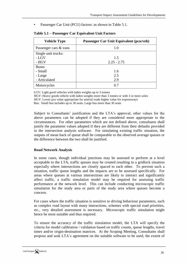
• Passenger Car Unit (PCU) factors: as shown in Table 5.1.
Table 5.1 – Passenger Car Equivalent Unit Factors
Vehicle Type Passenger Car Unit Equivalent (pcu/veh)
Passenger cars & vans 1.0
Single unit trucks:
- LGV
- HGV
1.5
2.25 - 2.75
Buses
- Small
- Large
- Articulated
1.6
2.5
2.9
Motorcycles 0.7
LGV: Light good vehicles with laden weights up to 3 tonnes
HGV: Heavy goods vehicle with laden weights more than 3 tonnes or with 3 or more axles
HGV: Lower pcu value appropriate for arterial roads higher value for expressways
Bus: Small bus includes up to 30 seats. Large bus more than 30 seats
Subject to Consultants’ justification and the LTA’s approval, other values for the
above parameters can be adopted if they are considered more appropriate to the
circumstances. For other parameters which are not defined above, consultants shall
justify the parameter values adopted if they are different from their defaults provided
in the intersection analysis software. For simulating existing traffic situation, the
outputs of mean back of queue shall be comparable to the observed average queues or
the difference between the two shall be justified.
Road Network Analysis
In some cases, though individual junctions may be assessed to perform at a level
acceptable to the LTA, traffic queues may be created resulting in a gridlock situation
especially where intersections are closely spaced to each other. To prevent such a
situation, traffic queue lengths and the impacts are to be assessed specifically. For
areas where queues at various intersections are likely to interact and significantly
affect traffic, a traffic simulation model may be required for assessing traffic
performance at the network level. This can include conducting microscopic traffic
simulation for the study area or parts of the study area where queues become a
concern.
For cases where the traffic situation is sensitive to driving behaviour parameters, such
as complex road layout with many interactions, schemes with special road priorities,
etc., very detailed assessment is necessary. Microscopic traffic simulation might
hence be most suitable and thus required.
To ensure the accuracy of the traffic simulation model, the LTA will specify the
criteria for model calibration / validation based on traffic counts, queue lengths, travel
times and/or origin-destination matrices. At the Scoping Meeting, Consultants shall
propose and seek LTA’s agreement on the suitable software to be used, the extent of
Transport Impact Assessment Guidelines for Developments
27
the area(s) to be included in the microscopic traffic simulation model and the
requirements on model calibration / validation.
Measures to Mitigate Negative Traffic Impact
Developers are to demonstrate best effort to encourage / promote walk / cycle / mass
transport modes for trips related to the proposed development / redevelopment. This
helps to minimise vehicular traffic generated by the development and its impact on
the road network. More stringent transport improvement measures are required to
encourage the change of travelling behaviour if the development traffic impact is
significant.
If the resultant traffic performance after mitigating measures have been incorporated
is still unable to achieve the specified performance standard(s), the Consultant is to
recommend junction/road improvement measures and include them in the TIA report.
Where necessary, at-grade widening of roads/junctions within the safeguarded road
reserve lines can be considered prior to considering/proposing other infrastructure
improvement proposals. In areas where the specified performance standard(s) of
road/junction performance are not achievable, the LTA may request the Consultant to
conduct further scenario tests and/or sensitivity analysis as appropriate.
The TIA report is to include relevant tables that clearly explain the summarised
assessment of results, including traffic volume, delay, back of queue and/or travel
speed as appropriate, of individual transport facilities pertaining to each assessment
year. The summary tables are to include separate results for the scenarios with and
without the proposed development. If road/intersection improvements and/or
additional scenario tests or sensitivity analyses are required, the report is to also
incorporate tables with a separate summary of the assessment results. Relevant
proposals/assumptions for each scenario are to be clearly listed in the tables.
The LTA generally requires the submission of softcopies of all data files and
modelling files for verification of results.
Transport Impact Assessment Guidelines for Developments
28
6. Transport Improvement Measures
6.1 Introduction
To achieve the TIA objectives, transport improvement measures are required to be
applied to new developments/redevelopments, particularly with the priority to
promote walking, cycling and mass transport.
The LTA will advise on the applicable measures for new developments/
redevelopments as listed in the following section. The Consultant is required to work
closely with the Developer and the LTA to go through these measures and adopt those
that are applicable to the proposed development/redevelopment.
Apart from the measures advised by the LTA, the Consultant can also recommend
other transport improvement measures that may help the proposed development in the
use of more sustainable modes of transport, reduce reliance on private transport
and/or change travel patterns to mitigate the development’s traffic impact.
6.2 List of Transport Improvement Measures
Consultant is required to duly complete Table I.1 in Annex I and submit it as part of
the TIA report. Explanation/justification is required for measures that are not to be
implemented.
Walking & Cycling Provision within the Development
M1 – Access Consideration
Ensure that access to and around the development is considered in the design process
to improve accessibility for non-car users and the disabled, e.g. site and building
accesses are laid out to prioritise pedestrians and cyclists
M2 – Design Integration
Ensure that the design of the developments is walking and cycling friendly (E.g. level
difference is mitigated by ramps instead of steps; bicycle parking and related facilities
shall be located near cycling path or access points.)
M3 – Control Measures
Implement lower speed limits and traffic control measures within the development
M4 – Safety of Pedestrian
Implement traffic management or traffic calming measures to make walking safer,
including the provision of new footways, raised pedestrian crossing, speed humps/
cushions and etc.
M5 – Way Finding for Pedestrian
Provide way finding maps to nearby amenities such as MRT station, bus stops/
interchange, community spaces, etc.)

Transport Impact Assessment Guidelines for Developments
29
M6 – Bicycle Parking
Provide bicycle parking space that is above and beyond minimum standard.
M7 – Bicycle Parking for different users
Provide short term and long term bicycle parking facilities.
M8 – Facilities for cyclist
Provide shower, changing, drying, lockers and other end-of-trip facilities
M9 – Bicycle Friendly Access
Provide bicycle-friendly access points to development via lift, auto door and cyclist
ramp.
M10 – Dedicated Bicycle Routing
Provide demarcated cycling path to link the development to the surrounding cycling
path and within development to the bicycle parking and end-of-trip facilities
M11 – Signage for Cyclist
Provide clear location signs to guide cyclists to the bicycle facilities and other end-of-
trip facilities
Walking & Cycling Provision surrounding the Development
M12 – Connectivity for Pedestrian
Ensure that suitable pedestrian links serve and run through the area and link with
existing routes.
M13 – Priority for Pedestrian
Give priority to pedestrian circulation and ensure that vehicular circulation is located
away from pedestrian circulation.
M14 – Accessibility for Non-car Users
Access improvement initiatives, i.e. make it easy to reach the development by public
transport, walking or cycling (e.g. connections such as underground/elevated
pedestrian links, crossing, covered linkway, cycling path).
M15 – Safe Connectivity
Ensure footpaths/cycling paths leading to nearby PT nodes are properly demarcated
and well lit
M16 – Cycling at Crossings
Provide wider crossing at road junctions and bicycle crossing at midblock pedestrian
crossings (e.g. wider crossing, bicycle box).
M17 – Cycling Route Maps
Provide maps / map display boards indicating cycling routes of the local area.
M18 – Place Making
Implement place-making environment within the ground floor of the development e.g.
city room
Transport Impact Assessment Guidelines for Developments
30
M19 – Share Space Design
Development designed to create a shared space - style atmosphere
Mass Transport
M20 – Shuttle Bus Service
Private shuttle bus service is to ferry staff/residents/visitors to and fro the
development and provide direct connection to nearby main transport node(s) such as
bus interchange or MRT station. Providing this service will greatly enhance the
accessibility to the development for public transport users.
M21 – Educational Engagement
Engaging and educating staff and residents on the benefits of walking, cycling and
taking public transport (PT) and what the developer has provided for easy or
improved connectivity will provide awareness on the benefit of public transport and
active modes for travelling. (Example: conducting a lunch time talk, activities, games,
exhibits, and etc.)
M22 – Facility / Service for Shoppers Taking Public Transport
Being able to shop without worrying on how to bring home bulky items makes trips to
shopping malls by public transport more attractive and hassle free. This can be
achieved by providing a centralised delivery service for shops/tenants to deliver items
bought by shoppers.
Programmes / Schemes to Promote Walk Cycle Ride
M23 – Promote Early with Walk, Cycle and Ride
Informing potential clients/tenants/residents that the development design considers the
needs of cyclists and non-car users with the provision of cycling connections to park
connectors, cycling routes and public transport facilities can be a value add to the
attractiveness of the development. Promoting walking, cycling and public transport
accessibility early through marketing information demonstrates that the development
has the added value of an inclusive design for all modes of transportation.
M24 – Engage Interest Group to Organise Courses
It is important to ensure that cyclists are aware and well informed on the dos and
don’ts when cycling either on the cycling paths, shared paths or on roads. This can be
achieved by engaging interest groups to conduct training/induction course/road safety
education to educate safe cycling and promote cycling skills
M25 – Encourage Cycling Community
As cycling is increasing as a form of alternative mode of traveling in Singapore, there
are situations/locations that may act as a barrier against cyclists. This can be
addressed by establishing a Bicycle User Group (BUG) to help overcome barriers to
cycling for tenants/staff/residents.
M26 – Bicycle Sharing
Traveling to a few places to run errands or to another building in a large development
may involve some distance to walk. Generally those with cars will opt to drive.
Transport Impact Assessment Guidelines for Developments
31
Providing “bikes for sharing” to staff/tenants/residents can reduce the need to use the
car or walk long distances.
M27 – Events to Promote Cycling
Organising events such as Cycle to Work Day can help to convey awareness on
alternative modes to the private car.
Demand Management
M28 – Parking Provision
The Ranged-Based Car Parking Standard (RCPS) allows developers the flexibility to
manage parking provision. Providing parking lots close to or at the lower bound of
the RCPS can help reduce private car demand to the development.
M29 – Daily Season Parking
Instead of applying the monthly season parking charging method, the daily flat rate
charging with unlimited use of parking lot gives drivers more flexibility of
commuting by public transport.
M30 – Reduce Allocation for Season Parking
Reducing the allocation of season parking lots upon benchmarking with similar
developments in the vicinity may help in reducing development private car trips.
M31 – Delivery and Goods Vehicles Management
Developments that generate significant volume of delivery or goods vehicles trips
during the traditional peak hours can contribute to congestion. Moving the operations
of delivery and/or goods transferring outside of the morning and evening peak periods
may help relieve / reduce congestion on the road network.
Developers are also encouraged to work with Urban Logistics (UL) operators to
manage deliveries effectively. UL aims to reduce the dwelling time of goods vehicle
within the shopping malls by having an assigned UL service provider taking over the
goods from the various suppliers and disbursing them to the outlets in the mall. The
UL also allows for delivery traffic to be better distributed by the use of pre-booked
delivery slots thus resulting in time savings for the suppliers. This would also ease
congestion on the roads leading to the shopping malls. More information on the
adoption of UL could be obtained from the Info-communications Media Development
Authority and Spring Singapore.
M32 – Car Club
With the rising cost of owning a private car, an alternative where the cost of
utilisation may be shared with others may be an attractive scheme for residential
developments. Developing a car club scheme or partnering with one/a few existing
car club(s) and allocate dedicated parking lots for car club vehicles, can provide
residents the option to use/drive a car when they need/want to.
M33 – Car Sharing Parking Allocations
Car club/sharing may be supported by allocating parking spaces near the access, for
example allocating parking spaces near to the lift lobby or exit door of the parking
area.
Transport Impact Assessment Guidelines for Developments
32
M34 – Parking Charges
In promoting the use of the public transport, increase in parking charges may dissuade
drivers from driving. The additional revenue may be used by the developer to
subsidise other measures – for example: to improve end-of–trip facilities for cyclists.
M35 – Travel Smart Scheme
Travelling on public transport outside the peak hours may help spread commuter peak
demand. This may be achieved by periodically conveying awareness on the LTA’s
Travel Smart scheme to companies/tenants/staffs/residents.
M36 – Adjustment to Working Hour
The use of technology such as tele-conferencing, e-mail and instant messages have
made working away from the office desk a possibility. By encouraging companies/
tenants to adopt or permit flexible working hours/compressed working weeks (e.g. 9
working days fortnightly)/teleworking from home for staff, demand for trips can be
reduced and collectively may help alleviate traffic congestion.
M37 – Onsite Facilities
Having onsite facilities such as child care, healthcare and shopping/home delivery
may reduce the need to travel. Developers are encouraged to incorporate a certain
number of on-site facilities.
M38 – Onsite Services
Services such as cafeteria, convenience shopping, canteen and/or cash dispensers are
important to reducing the need to travel. Developers are encouraged to provide a
certain number of on-site services to reduce the need to travel.
M39 – Home Delivery
As delivery services are becoming more common to Singaporeans, the developer may
want to provide tenants/companies with home delivery services so that customers do
not have to carry items home when taking public transport.
Other Measures
M40 – Provide Charging Facility for Electric Vehicle
The use of alternative energy will help in reducing the emission of GHG and carbon
footprint. Providing electric vehicle charging points within the development to
facilitate charging of vehicles may help encourage drivers to consider eco-friendly
private vehicles over conventional combustion engine vehicles.
M41 – Eco-Driving Course to Promote Fuel Efficiency
Providing courses on environmentally and climate friendly driving techniques may
benefit not only the environment but also improves safety, reduces stress levels and
save costs for the driver.
M42 – Road / Junction Improvements
Propose measures to prioritise bus, pedestrian and cyclist movements at roads and
junctions, and propose improvements to ensure the traffic performance meets the
LTA’s standard as specified in Section 5.4.
Transport Impact Assessment Guidelines for Developments
33
7. Other Assessment Issues
7.1 Parking and Pick-up/Drop-off Provision
The consultant shall document the analysis for parking provision. The number of
parking spaces and access arrangement of new developments shall comply with the
requirements stipulated in “Code of Practice for Vehicle Parking Provision in
Developments” and “Street Works Proposals Relating to Development Works”.
The consultant shall also consider the potential traffic impact and externalities that
may arise as a result of car parking operations, and provide appropriate mitigation
measures as necessary. If the proposal is unable to meet the access provision and
arrangement requirements or the LTA considers that the development access point
warrants detailed evaluation, the consultant is to demonstrate the viability of the
proposed arrangement.
For different relevant modes, such as taxi, coach, car (including private cars and hired
cars such as Uber and Grab cars), motorcycle, etc., the Consultant is to assess whether
there is a need to provide dedicated pick-up/drop-off facilities and to estimate the
number of bays required and to propose suitable location(s). If the development
design is carried out as the TIA is in progress, the Consultant is to comment on the
layout, identify potential traffic problems associated with the proposed pick-up/drop-
off facilities and recommend necessary improvements to the plan.
7.2 Site Access and Traffic Circulation
Provision of good site access and circulation for all users whether for motorists,
public transport commuters or pedestrians help towards the successful operation of a
development. The ease with which users move to/from the development and nearby
areas, roads and public transport facilities is important to the long-term success of the
development.
The proposals (access, lay-by, pick-up/drop-off point, pedestrian facility etc.) are to
take into consideration the following requirements:
(a) Safety – The location and configuration of the access, lay-by, pick-up/drop-off
point, pedestrian facilities etc shall not pose a danger to motorists and
pedestrians. Good sight visibility are to be ensured in order not to allow
motorists’ lines of sight to be obstructed by trees, structures, buildings, etc.
Generally, the proposal to locate the development access at major arterial
roads may not be supported when there are alternative feasible option(s)
available.
(b) Capacity of road – This is to be considered when designing the configuration
of the access. For example, a Left-In-Left-Out (LILO) arrangement of an
access connecting to a road with heavy traffic may be more appropriate.
(c) Queue length – Sufficient queue space within the development is to be
provided at the proposed access, lay-by or pick-up/drop-off point(s) to prevent
Transport Impact Assessment Guidelines for Developments
34
queues encroaching onto main road carriageways as these can obstruct traffic.
The TIA is to include an assessment of entry barrier capacity and queue length
to demonstrate that the distance between the development boundary line and
the car-park barrier is sufficient to accommodate the expected queue.
(d) Traffic conflicts – Proposals shall not create conflicts of traffic. Access points
are not to be located opposite of each other, near bus stops or traffic junctions.
(e) Obstruction to traffic – Vehicles manoeuvring into access(es) are not to
obstruct traffic along the road carriageway. All vehicles are to enter and exit
the site in a forward direction. Reversing of vehicles is not allowed onto a
public road.
(f) Pedestrian/commuter facilities – Should a pedestrian crossing facility be
proposed, analysis of its impact on traffic flow is to be done. Depending on
pedestrian/traffic volumes, other facilities such as a barrier-free accessible
overhead bridge or underpass are to be considered if these are considered to be
more appropriate. These facilities are to be made accessible to the public at all
times.
Generally, proposals to introduce a traffic signal at the junction of the development
access on arterial roads will not be favoured unless it can be justified. If a new traffic
signal is proposed, the impact of the traffic signal on the traffic flow along affected
roads is to be evaluated as described in Section 5 of the Guidelines. This is to
demonstrate that the proposed traffic signal will not significantly affect the traffic
flow or reduce travel speeds along the roads.
Access, road carriageway and junction improvements are to be designed in
accordance with the relevant LTA design standards and specifications. Site
constraints are also to be taken into consideration.
7.3 Development Traffic Operation Plan
For developments expected to have significant surge in traffic (e.g., shopping mall
opening stage, school morning arrival peaks, development major events, etc.), the
Consultant may be required to:
(a) Establish the traffic and pedestrian surge profile;
(b) Estimate the traffic and pedestrian volumes during the peak hours of the surge
periods;
(c) Assess the impacts of traffic within the proposed development as well as on
surrounding public roads during the peaks;
(d) Develop conceptual traffic operation plans to mitigate the negative impacts.
The plans are to cover transport facilities which can potentially create
significant traffic concerns due to high traffic demand such as car-park
accesses, lay-bys, pick-up/drop-off points, loading/unloading schedules,
pedestrian crossings, immediate junctions with traffic approaching the
proposed development, pedestrian holding areas, etc.
Transport Impact Assessment Guidelines for Developments
35
(e) Recommend whether it is necessary to engage Auxiliary Police Officers
(APO) to implement the proposed traffic operation plans.
A diagram indicating the proposed traffic control measures at relevant locations is to
be included in the report.
7.4 Traffic Management during Construction
For developments associated with a significant volume of traffic during the
construction period, an assessment of the impact may be required as a separate
assessment/submission (not as part of the TIA report). The LTA will advise whether
such a study/evaluation is required to be submitted.
Where there are significant impacts caused by the development’s construction traffic,
the LTA may require the Consultant to propose measures to mitigate the negative
impacts.
7.5 Post Implementation Review
For large developments or developments with uncertainty on whether certain
Transport Improvement Measures are necessary to be adopted, the LTA may require
the developer to conduct a Post Implementation Review (PIR) about 12 months after
the development’s opening. For multi-phase developments, a PIR may be required
for the final opening. If relevant, a PIR may also be imposed when the development
is partially open.
The objective of a PIR is to review the transport situation with the additional
development transport demand and to evaluate the implementation and effectiveness
of the Transport Improvement Measures adopted, and if necessary to explore further
measures for improvement. For a PIR, the Developer may consider involving the
same or a different Consultant from the one who conducted the development TIA.
The following scope may be required for a PIR:
Classified vehicular traffic counts and/or pedestrians and cyclists counts
associated with the development may be required. This is to determine the
demand by transport mode / trip purpose;
Observation of transport and/or traffic situation and highlighting of issues
relating to the surrounding transport network;
Certain type(s) of traffic and transport survey(s), other than counts, may be
required. The main aim is to evaluate the transport and/or traffic situation
surrounding the development;
Transport / traffic assessment using suitable tool(s) may be required to
quantitatively evaluate the situation;
Propose further improvements and/or mitigation measures as necessary.

Transport Impact Assessment Guidelines for Developments
36
Prior to commencing the PIR, the developer / Consultant is to discuss and seek
agreement from the LTA to determine the scope and requirements. The Developer is
strongly encouraged to seek LTA’s advice at an early stage to outline the scope and
requirements of the PIR, even before a Consultant is involved.
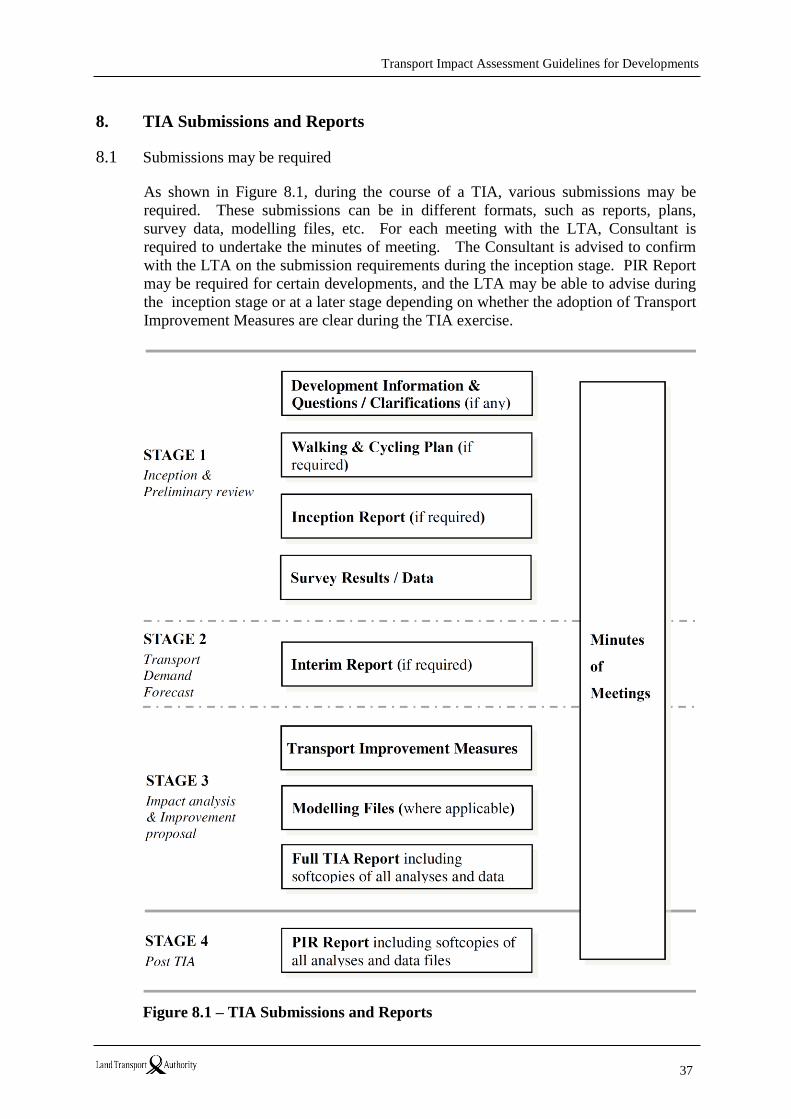
Transport Impact Assessment Guidelines for Developments
37
8. TIA Submissions and Reports
8.1 Submissions may be required
As shown in Figure 8.1, during the course of a TIA, various submissions may be
required. These submissions can be in different formats, such as reports, plans,
survey data, modelling files, etc. For each meeting with the LTA, Consultant is
required to undertake the minutes of meeting. The Consultant is advised to confirm
with the LTA on the submission requirements during the inception stage. PIR Report
may be required for certain developments, and the LTA may be able to advise during
the inception stage or at a later stage depending on whether the adoption of Transport
Improvement Measures are clear during the TIA exercise.
Figure 8.1 – TIA Submissions and Reports

Transport Impact Assessment Guidelines for Developments
38
8.2 Inception Report
Where appropriate especially for large development TIAs, the LTA may require the
submission of an Inception Report to ensure that all involved parties are clear about
the scope and approach to conduct the analysis. The report may include but not be
limited to the following:
Study objectives and scope of work,
Description of the proposed development, size, location of vehicular,
pedestrian and cyclist access point(s), parking provision and intended
circulation, for vehicles, pedestrians and cyclists,
Study area, roads and intersections,
Existing land use/transport network nearby,
Assessment years,
Study methodology and assumptions,
Model development approach and calibration/validation target as applicable,
Survey plan,
Historical data/overseas data intended for use.
The consultant is required to obtain LTA’s endorsement of the Inception Report prior
to commencing the study.
8.3 Interim Report
For large development TIAs, the LTA may require the submission of an Interim
Report. The report may include but not be limited to the following:
Survey(s) conducted and results,
Progress or results of major tasks such as PTAL, refinements to WCP if
applicable, etc.
Assessment of the existing traffic conditions and/or mode split for similar
developments in the area,
Background traffic forecasts for the assessment years,
Development vehicular traffic generation and/or person-trip generation where
applicable by transport mode (e.g. public transport, walking and cycling),
Trip distribution (including diagrams as specified in Section 5),
Estimated development’s modal split as applicable,
Traffic / trip assignment.
Transport Impact Assessment Guidelines for Developments
39
To avoid delays to the study, the Consultant is advised to obtain the LTA’s
endorsement of the Interim Report before further progressing on the study.
8.4 Full TIA Report
The TIA report is to be set out logically with clear analyses, conclusions and
recommendations. All assumptions and sources of information are to be clearly
documented. Inadequate reports are to be returned to the Consultant for completion
or modification as required.
The report is to include an Executive Summary to provide concise and clear
information on the study purpose, major findings, conclusions and recommendations.
Improvements recommended in the TIA are to be illustrated using appropriate plan(s)
with sufficient detail to substantiate their feasibility.
All the analysis files and data related to the study are to be submitted as appendices to
the Report for LTA’s records.
8.5 General Note
This set of Guidelines sets the general technical requirements for the preparation and
submission of TIA reports. Some requirements stated in this document may not be
imposed for a particular TIA if unsuitable. The Consultant is to follow the LTA
officers’ instructions during the course of preparing the TIA. Ambiguities and
validity/lack of information are to be resolved with the LTA as early as possible.
Transport Impact Assessment Guidelines for Developments
40
ANNEXES
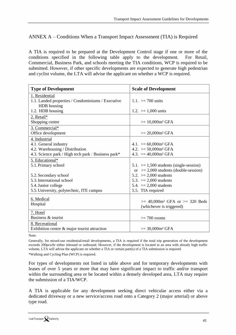
Transport Impact Assessment Guidelines for Developments
41
ANNEX A – Conditions When a Transport Impact Assessment (TIA) is Required
A TIA is required to be prepared at the Development Control stage if one or more of the
conditions specified in the following table apply to the development. For Retail,
Commercial, Business Park, and schools meeting the TIA conditions, WCP is required to be
submitted. However, if other specific developments are expected to generate high pedestrian
and cyclist volume, the LTA will advise the applicant on whether a WCP is required.
Type of Development Scale of Development
1. Residential
1.1. Landed properties / Condominiums / Executive
HDB housing
1.2. HDB housing
1.1. >= 700 units
1.2. >= 1,000 units
2. Retail*
Shopping centre
>= 10,000m² GFA
3. Commercial*
Office development
>= 20,000m² GFA
4. Industrial
4.1. General industry
4.2. Warehousing / Distribution
4.3. Science park / High tech park / Business park*
4.1. >= 60,000m² GFA
4.2. >= 50,000m² GFA
4.3. >= 40,000m² GFA
5. Educational*
5.1. Primary school
5.2. Secondary school
5.3. International school
5.4. Junior college
5.5. University, polytechnic, ITE campus
5.1. >= 1,500 students (single-session)
or >= 2,000 students (double-session)
5.2. >= 2,000 students
5.3. >= 2,000 students
5.4. >= 2,000 students
5.5. TIA required
6. Medical
Hospital
>= 40,000m² GFA or >= 320 Beds
(whichever is triggered)
7. Hotel
Business & tourist
>= 700 rooms
8. Recreational
Exhibition centre & major tourist attraction
>= 30,000m² GFA
Note:
Generally, for mixed-use residential/retail developments, a TIA is required if the total trip generation of the development
exceeds 200pcu/hr either inbound or outbound. However, if the development is located in an area with already high traffic
volume, LTA will advise the applicant on whether a TIA or certain part(s) of a TIA submission is required.
*Walking and Cycling Plan (WCP) is required.
For types of developments not listed in table above and for temporary developments with
leases of over 5 years or more that may have significant impact to traffic and/or transport
within the surrounding area or be located within a densely developed area, LTA may require
the submission of a TIA/WCP.
A TIA is applicable for any development seeking direct vehicular access either via a
dedicated driveway or a new service/access road onto a Category 2 (major arterial) or above
type road.
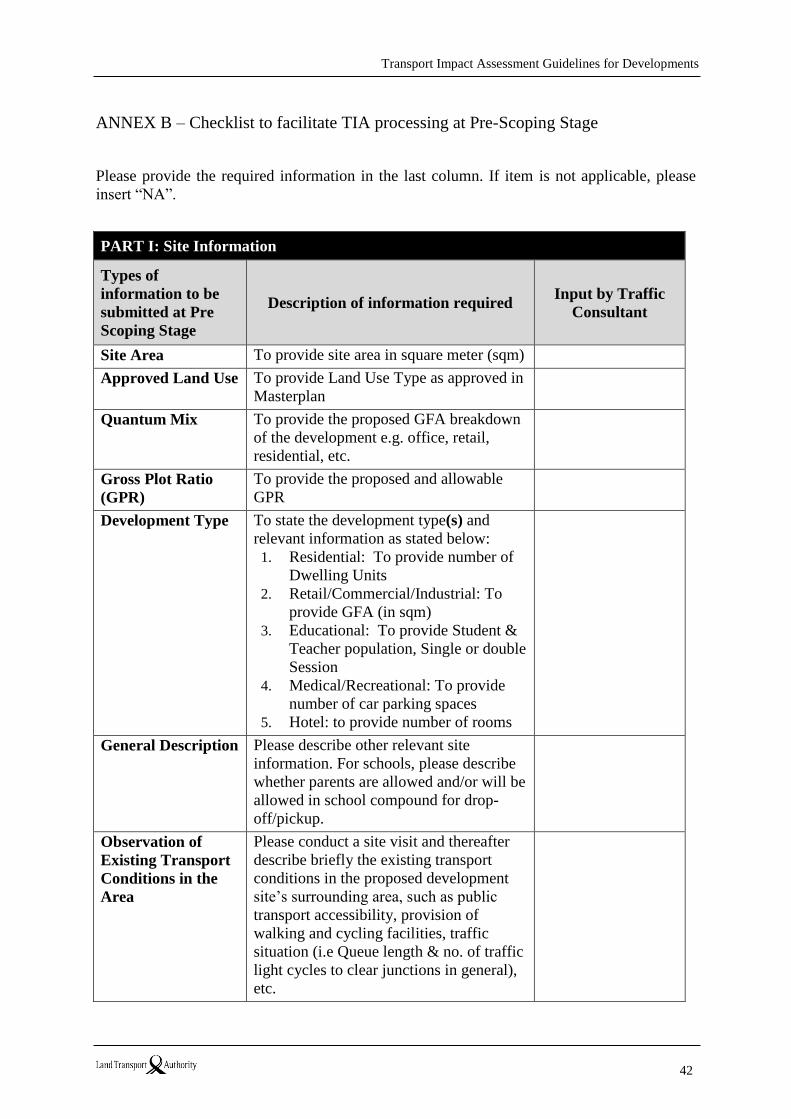
Transport Impact Assessment Guidelines for Developments
42
ANNEX B – Checklist to facilitate TIA processing at Pre-Scoping Stage
Please provide the required information in the last column. If item is not applicable, please
insert “NA”.
PART I: Site Information
Types of
information to be
submitted at Pre
Scoping Stage
Description of information required Input by Traffic
Consultant
Site Area To provide site area in square meter (sqm)
Approved Land Use To provide Land Use Type as approved in
Masterplan
Quantum Mix To provide the proposed GFA breakdown
of the development e.g. office, retail,
residential, etc.
Gross Plot Ratio
(GPR)
To provide the proposed and allowable
GPR
Development Type To state the development type(s) and
relevant information as stated below:
1. Residential: To provide number of
Dwelling Units
2. Retail/Commercial/Industrial: To
provide GFA (in sqm)
3. Educational: To provide Student &
Teacher population, Single or double
Session
4. Medical/Recreational: To provide
number of car parking spaces
5. Hotel: to provide number of rooms
General Description Please describe other relevant site
information. For schools, please describe
whether parents are allowed and/or will be
allowed in school compound for drop-
off/pickup.
Observation of
Existing Transport
Conditions in the
Area
Please conduct a site visit and thereafter
describe briefly the existing transport
conditions in the proposed development
site’s surrounding area, such as public
transport accessibility, provision of
walking and cycling facilities, traffic
situation (i.e Queue length & no. of traffic
light cycles to clear junctions in general),
etc.
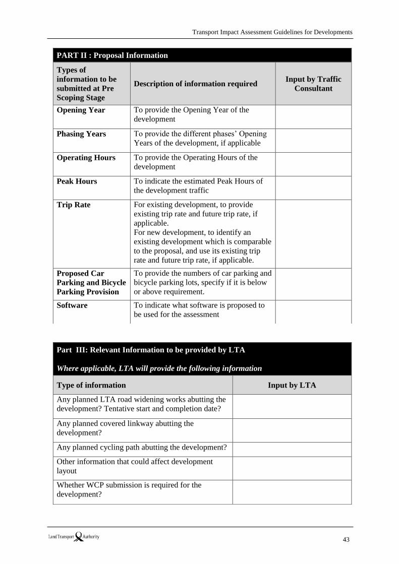
Transport Impact Assessment Guidelines for Developments
43
PART II : Proposal Information
Types of
information to be
submitted at Pre
Scoping Stage
Description of information required Input by Traffic
Consultant
Opening Year To provide the Opening Year of the
development
Phasing Years To provide the different phases’ Opening
Years of the development, if applicable
Operating Hours To provide the Operating Hours of the
development
Peak Hours To indicate the estimated Peak Hours of
the development traffic
Trip Rate For existing development, to provide
existing trip rate and future trip rate, if
applicable.
For new development, to identify an
existing development which is comparable
to the proposal, and use its existing trip
rate and future trip rate, if applicable.
Proposed Car
Parking and Bicycle
Parking Provision
To provide the numbers of car parking and
bicycle parking lots, specify if it is below
or above requirement.
Software To indicate what software is proposed to
be used for the assessment
Part III: Relevant Information to be provided by LTA
Where applicable, LTA will provide the following information
Type of information Input by LTA
Any planned LTA road widening works abutting the
development? Tentative start and completion date?
Any planned covered linkway abutting the
development?
Any planned cycling path abutting the development?
Other information that could affect development
layout
Whether WCP submission is required for the
development?
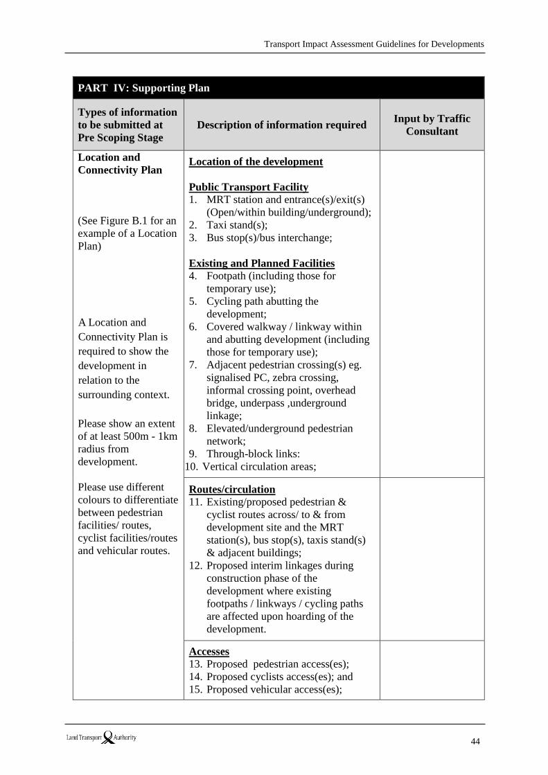
Transport Impact Assessment Guidelines for Developments
44
PART IV: Supporting Plan
Types of information
to be submitted at
Pre Scoping Stage
Description of information required Input by Traffic
Consultant
Location and
Connectivity Plan
(See Figure B.1 for an
example of a Location
Plan)
A Location and
Connectivity Plan is
required to show the
development in
relation to the
surrounding context.
Please show an extent
of at least 500m - 1km
radius from
development.
Please use different
colours to differentiate
between pedestrian
facilities/ routes,
cyclist facilities/routes
and vehicular routes.
Location of the development
Public Transport Facility
1. MRT station and entrance(s)/exit(s)
(Open/within building/underground);
2. Taxi stand(s);
3. Bus stop(s)/bus interchange;
Existing and Planned Facilities
4. Footpath (including those for
temporary use);
5. Cycling path abutting the
development;
6. Covered walkway / linkway within
and abutting development (including
those for temporary use);
7. Adjacent pedestrian crossing(s) eg.
signalised PC, zebra crossing,
informal crossing point, overhead
bridge, underpass ,underground
linkage;
8. Elevated/underground pedestrian
network;
9. Through-block links:
10. Vertical circulation areas;
Routes/circulation
11. Existing/proposed pedestrian &
cyclist routes across/ to & from
development site and the MRT
station(s), bus stop(s), taxis stand(s)
& adjacent buildings;
12. Proposed interim linkages during
construction phase of the
development where existing
footpaths / linkways / cycling paths
are affected upon hoarding of the
development.
Accesses
13. Proposed pedestrian access(es);
14. Proposed cyclists access(es); and
15. Proposed vehicular access(es);
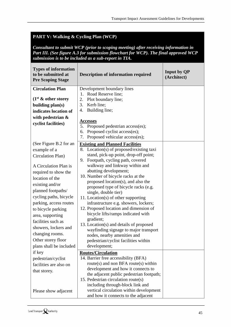
Transport Impact Assessment Guidelines for Developments
45
PART V: Walking & Cycling Plan (WCP)
Consultant to submit WCP (prior to scoping meeting) after receiving information in
Part III. (See figure A.3 for submission flowchart for WCP). The final approved WCP
submission is to be included as a sub-report in TIA.
Types of information
to be submitted at
Pre Scoping Stage
Description of information required Input by QP
(Architect)
Circulation Plan
(1st & other storey
building plan(s)
indicates location of
with pedestrian &
cyclist facilities)
(See Figure B.2 for an
example of a
Circulation Plan)
A Circulation Plan is
required to show the
location of the
existing and/or
planned footpaths/
cycling paths, bicycle
parking, access routes
to bicycle parking
area, supporting
facilities such as
showers, lockers and
changing rooms.
Other storey floor
plans shall be included
if key
pedestrian/cyclist
facilities are also on
that storey.
Please show adjacent
Development boundary lines
1. Road Reserve line;
2. Plot boundary line;
3. Kerb line;
4. Building line;
Accesses
5. Proposed pedestrian access(es);
6. Proposed cyclist access(es);
7. Proposed vehicular access(es);
Existing and Planned Facilities
8. Location(s) of proposed/existing taxi
stand, pick-up point, drop-off point;
9. Footpath, cycling path, covered
walkway and linkway within and
abutting development;
10. Number of bicycle racks at the
proposed location(s), and also the
proposed type of bicycle racks (e.g.
single, double tier)
11. Location(s) of other supporting
infrastructure e.g. showers, lockers;
12. Proposed location and dimension of
bicycle lifts/ramps indicated with
gradient;
13. Location(s) and details of proposed
wayfinding signage to major transport
nodes, nearby amenities and
pedestrian/cyclist facilities within
development;
Routes/Circulation
14. Barrier free accessibility (BFA)
route(s) and non BFA route(s) within
development and how it connects to
the adjacent public pedestrian footpath;
15. Pedestrian circulation route(s)
including through-block link and
vertical circulation within development
and how it connects to the adjacent
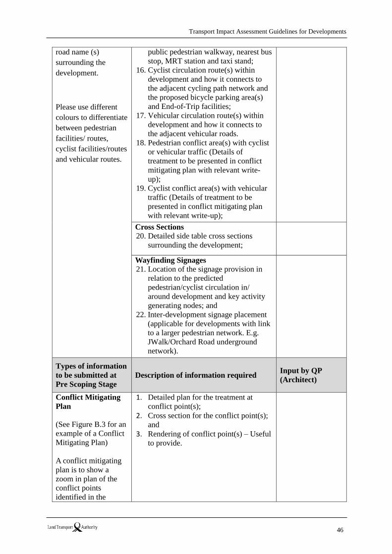
Transport Impact Assessment Guidelines for Developments
46
road name (s)
surrounding the
development.
Please use different
colours to differentiate
between pedestrian
facilities/ routes,
cyclist facilities/routes
and vehicular routes.
public pedestrian walkway, nearest bus
stop, MRT station and taxi stand;
16. Cyclist circulation route(s) within
development and how it connects to
the adjacent cycling path network and
the proposed bicycle parking area(s)
and End-of-Trip facilities;
17. Vehicular circulation route(s) within
development and how it connects to
the adjacent vehicular roads.
18. Pedestrian conflict area(s) with cyclist
or vehicular traffic (Details of
treatment to be presented in conflict
mitigating plan with relevant write-
up);
19. Cyclist conflict area(s) with vehicular
traffic (Details of treatment to be
presented in conflict mitigating plan
with relevant write-up);
Cross Sections
20. Detailed side table cross sections
surrounding the development;
Wayfinding Signages
21. Location of the signage provision in
relation to the predicted
pedestrian/cyclist circulation in/
around development and key activity
generating nodes; and
22. Inter-development signage placement
(applicable for developments with link
to a larger pedestrian network. E.g.
JWalk/Orchard Road underground
network).
Types of information
to be submitted at
Pre Scoping Stage
Description of information required Input by QP
(Architect)
Conflict Mitigating
Plan
(See Figure B.3 for an
example of a Conflict
Mitigating Plan)
A conflict mitigating
plan is to show a
zoom in plan of the
conflict points
identified in the
1. Detailed plan for the treatment at
conflict point(s);
2. Cross section for the conflict point(s);
and
3. Rendering of conflict point(s) – Useful
to provide.
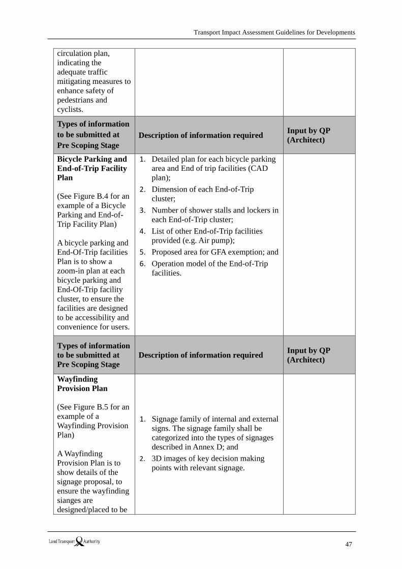
Transport Impact Assessment Guidelines for Developments
47
circulation plan,
indicating the
adequate traffic
mitigating measures to
enhance safety of
pedestrians and
cyclists.
Types of information
to be submitted at
Pre Scoping Stage
Description of information required Input by QP
(Architect)
Bicycle Parking and
End-of-Trip Facility
Plan
(See Figure B.4 for an
example of a Bicycle
Parking and End-of-
Trip Facility Plan)
A bicycle parking and
End-Of-Trip facilities
Plan is to show a
zoom-in plan at each
bicycle parking and
End-Of-Trip facility
cluster, to ensure the
facilities are designed
to be accessibility and
convenience for users.
1. Detailed plan for each bicycle parking
area and End of trip facilities (CAD
plan);
2. Dimension of each End-of-Trip
cluster;
3. Number of shower stalls and lockers in
each End-of-Trip cluster;
4. List of other End-of-Trip facilities
provided (e.g. Air pump);
5. Proposed area for GFA exemption; and
6. Operation model of the End-of-Trip
facilities.
Types of information
to be submitted at
Pre Scoping Stage
Description of information required Input by QP
(Architect)
Wayfinding
Provision Plan
(See Figure B.5 for an
example of a
Wayfinding Provision
Plan)
A Wayfinding
Provision Plan is to
show details of the
signage proposal, to
ensure the wayfinding
sianges are
designed/placed to be
1. Signage family of internal and external
signs. The signage family shall be
categorized into the types of signages
described in Annex D; and
2. 3D images of key decision making
points with relevant signage.
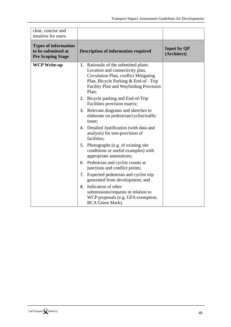
Transport Impact Assessment Guidelines for Developments
48
clear, concise and
intuitive for users.
Types of information
to be submitted at
Pre Scoping Stage
Description of information required Input by QP
(Architect)
WCP Write-up 1. Rationale of the submitted plans:
Location and connectivity plan,
Circulation Plan, conflict Mitigating
Plan, Bicycle Parking & End-of –Trip
Facility Plan and Wayfinding Provision
Plan;
2. Bicycle parking and End-of-Trip
Facilities provision matrix;
3. Relevant diagrams and sketches to
elaborate on pedestrian/cyclist/traffic
issue;
4. Detailed Justification (with data and
analysis) for non-provision of
facilities;
5. Photographs (e.g. of existing site
conditions or useful examples) with
appropriate annotations;
6. Pedestrian and cyclist counts at
junctions and conflict points;
7. Expected pedestrian and cyclist trip
generated from development; and
8. Indication of other
submissions/requests in relation to
WCP proposals (e.g. GFA exemption,
BCA Green Mark).
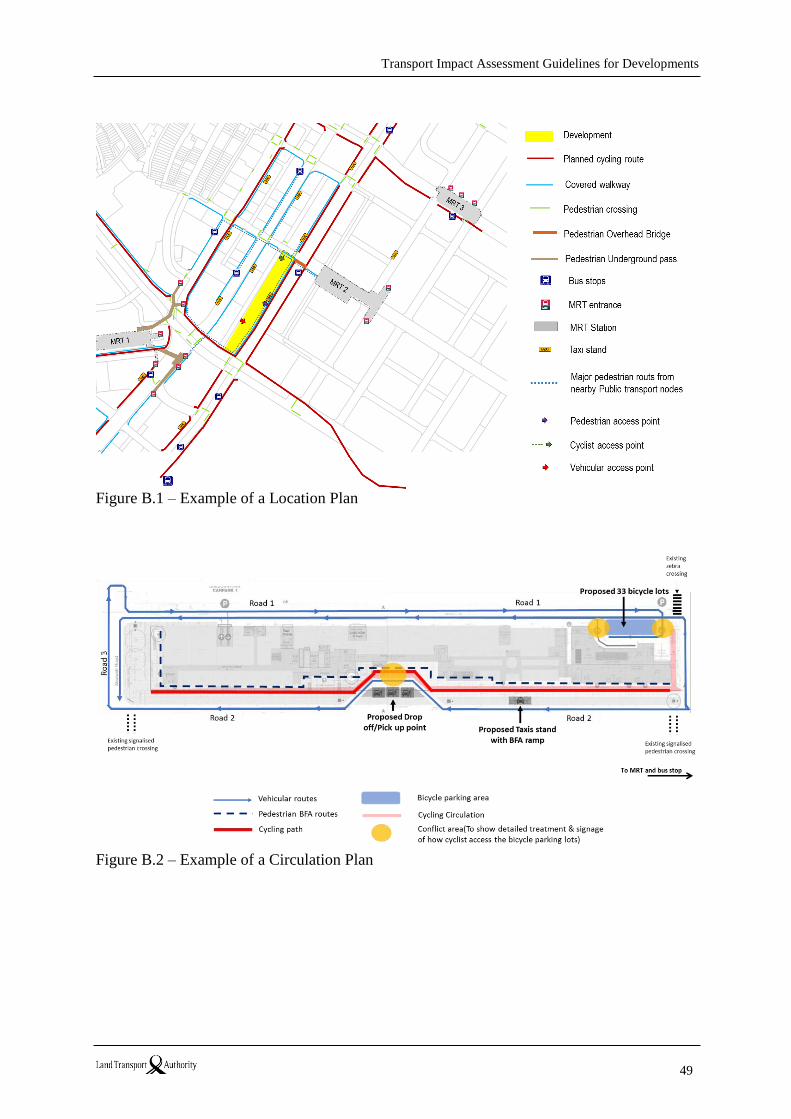
Transport Impact Assessment Guidelines for Developments
49
Figure B.1 – Example of a Location Plan
Figure B.2 – Example of a Circulation Plan
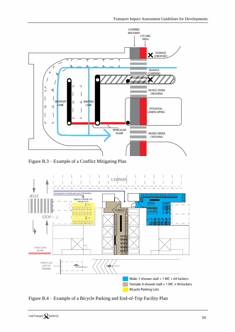
Transport Impact Assessment Guidelines for Developments
50
Figure B.3 – Example of a Conflict Mitigating Plan
Figure B.4 – Example of a Bicycle Parking and End-of-Trip Facility Plan
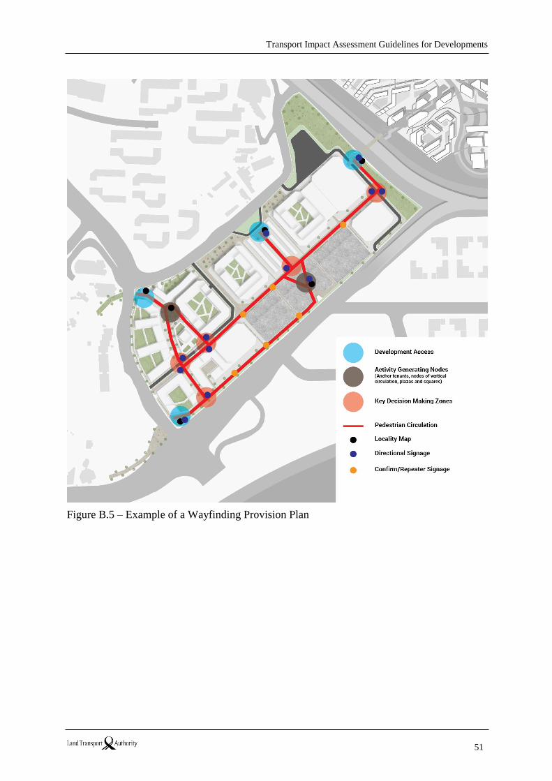
Transport Impact Assessment Guidelines for Developments
51
Figure B.5 – Example of a Wayfinding Provision Plan
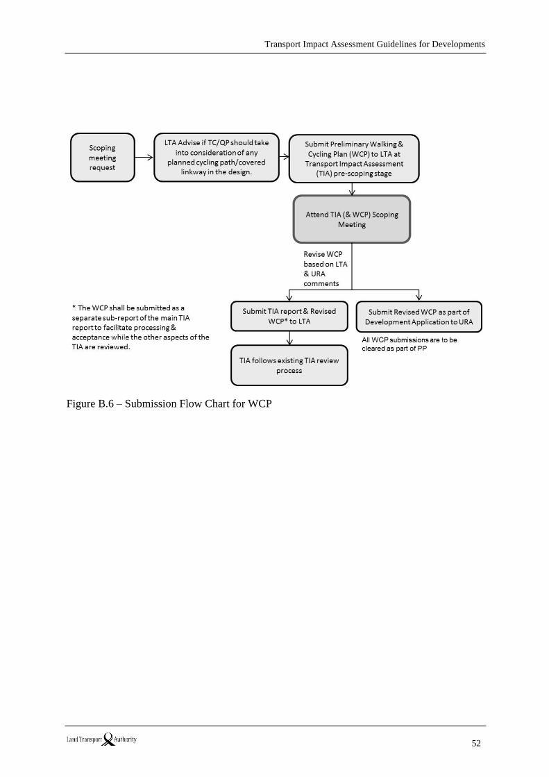
Transport Impact Assessment Guidelines for Developments
52
Figure B.6 – Submission Flow Chart for WCP
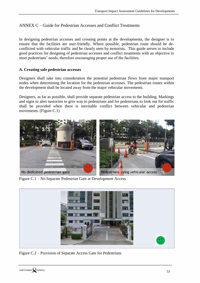
Transport Impact Assessment Guidelines for Developments
53
ANNEX C – Guide for Pedestrian Accesses and Conflict Treatments
In designing pedestrian accesses and crossing points at the developments, the designer is to
ensure that the facilities are user-friendly. Where possible, pedestrian route should be de-
conflicted with vehicular traffic and be clearly seen by motorists. This guide serves to include
good practices for designing of pedestrian accesses and conflict treatments with an objective to
meet pedestrians’ needs, therefore encouraging proper use of the facilities.
A. Creating safe pedestrian accesses
Designers shall take into consideration the potential pedestrian flows from major transport
nodes when determining the location for the pedestrian accesses. The pedestrian routes within
the development shall be located away from the major vehicular movements.
Designers, as far as possible, shall provide separate pedestrian access to the building. Markings
and signs to alert motorists to give way to pedestrians and for pedestrians to look out for traffic
shall be provided when there is inevitable conflict between vehicular and pedestrian
movements. (Figure C.1)
Figure C.1 – No Separate Pedestrian Gate at Development Access
Figure C.2 – Provision of Separate Access Gate for Pedestrians
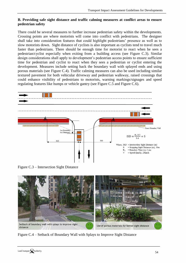
Transport Impact Assessment Guidelines for Developments
54
B. Providing safe sight distance and traffic calming measures at conflict areas to ensure
pedestrian safety
There could be several measures to further increase pedestrian safety within the developments.
Crossing points are where motorists will come into conflict with pedestrians. The designer
shall take into consideration features that could highlight pedestrians’ presence as well as to
slow motorists down. Sight distance of cyclists is also important as cyclists tend to travel much
faster than pedestrians. There should be enough time for motorist to react when he sees a
pedestrian/cyclist especially when exiting from a building access (see Figure C.3). Similar
design considerations shall apply to development’s pedestrian access points to ensure sufficient
time for pedestrian and cyclist to react when they sees a pedestrian or cyclist entering the
development. Measures include setting back the boundary wall with splayed ends and using
porous materials (see Figure C.4). Traffic calming measures can also be used including similar
textured pavement for both vehicular driveway and pedestrian walkway, raised crossings that
could enhance visibility of pedestrians to motorists, warning markings/signages and speed
regulating features like humps or vehicle gantry (see Figure C.5 and Figure C.6).
Figure C.3 – Intersection Sight Distance
Figure C.4 – Setback of Boundary Wall with Splays to Improve Sight Distance
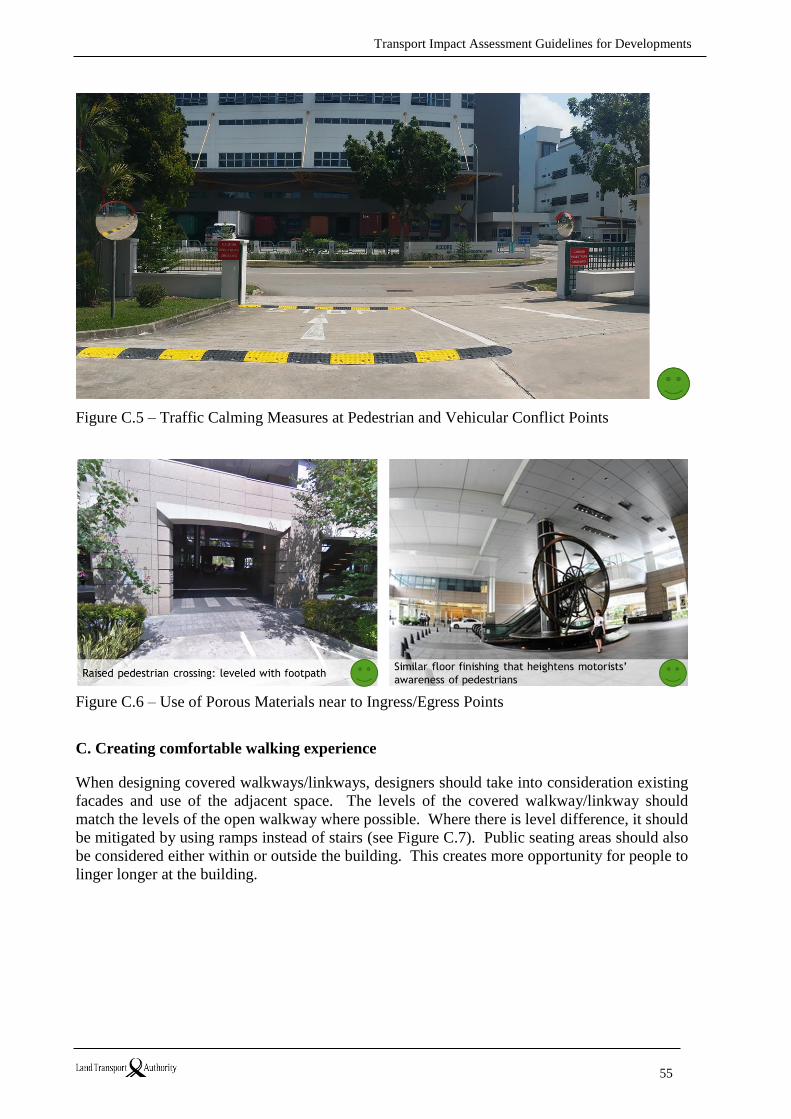
Transport Impact Assessment Guidelines for Developments
55
Figure C.5 – Traffic Calming Measures at Pedestrian and Vehicular Conflict Points
Figure C.6 – Use of Porous Materials near to Ingress/Egress Points
C. Creating comfortable walking experience
When designing covered walkways/linkways, designers should take into consideration existing
facades and use of the adjacent space. The levels of the covered walkway/linkway should
match the levels of the open walkway where possible. Where there is level difference, it should
be mitigated by using ramps instead of stairs (see Figure C.7). Public seating areas should also
be considered either within or outside the building. This creates more opportunity for people to
linger longer at the building.
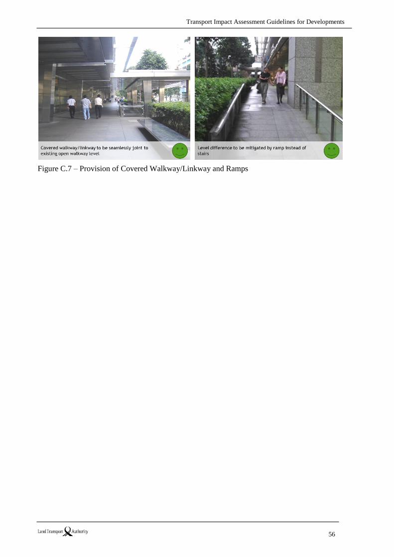
Transport Impact Assessment Guidelines for Developments
56
Figure C.7 – Provision of Covered Walkway/Linkway and Ramps
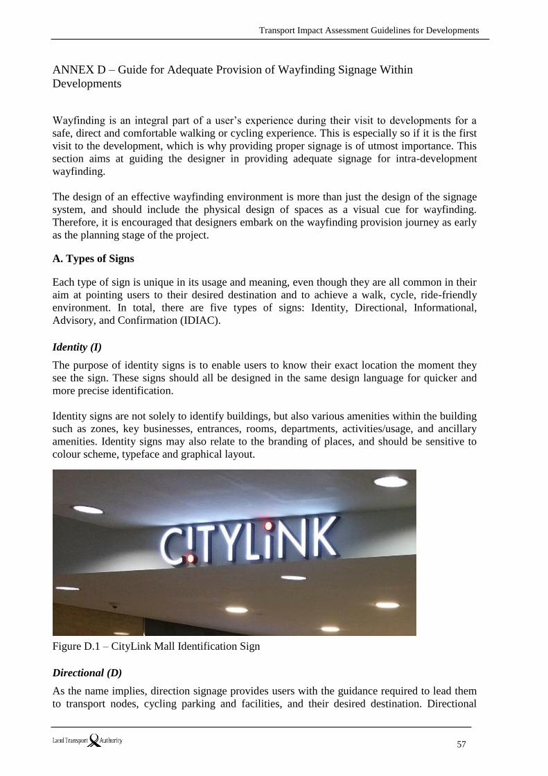
Transport Impact Assessment Guidelines for Developments
57
ANNEX D – Guide for Adequate Provision of Wayfinding Signage Within
Developments
Wayfinding is an integral part of a user’s experience during their visit to developments for a
safe, direct and comfortable walking or cycling experience. This is especially so if it is the first
visit to the development, which is why providing proper signage is of utmost importance. This
section aims at guiding the designer in providing adequate signage for intra-development
wayfinding.
The design of an effective wayfinding environment is more than just the design of the signage
system, and should include the physical design of spaces as a visual cue for wayfinding.
Therefore, it is encouraged that designers embark on the wayfinding provision journey as early
as the planning stage of the project.
A. Types of Signs
Each type of sign is unique in its usage and meaning, even though they are all common in their
aim at pointing users to their desired destination and to achieve a walk, cycle, ride-friendly
environment. In total, there are five types of signs: Identity, Directional, Informational,
Advisory, and Confirmation (IDIAC).
Identity (I)
The purpose of identity signs is to enable users to know their exact location the moment they
see the sign. These signs should all be designed in the same design language for quicker and
more precise identification.
Identity signs are not solely to identify buildings, but also various amenities within the building
such as zones, key businesses, entrances, rooms, departments, activities/usage, and ancillary
amenities. Identity signs may also relate to the branding of places, and should be sensitive to
colour scheme, typeface and graphical layout.
Figure D.1 – CityLink Mall Identification Sign
Directional (D)
As the name implies, direction signage provides users with the guidance required to lead them
to transport nodes, cycling parking and facilities, and their desired destination. Directional
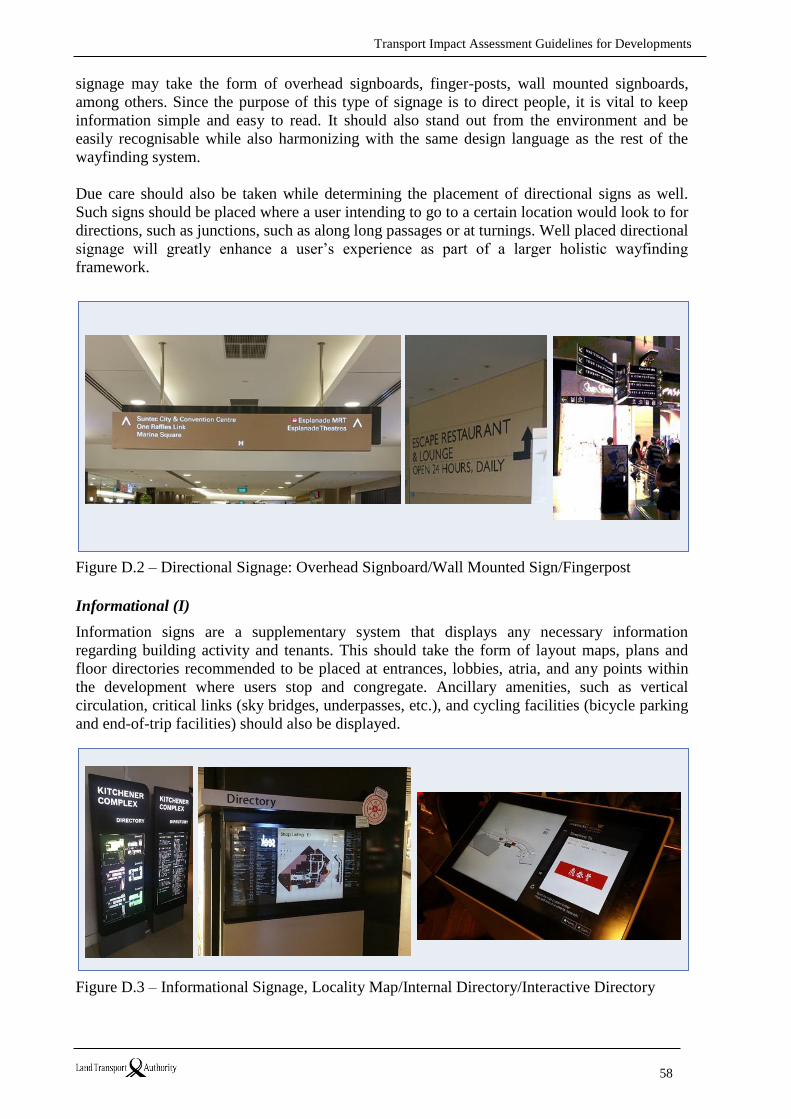
Transport Impact Assessment Guidelines for Developments
58
signage may take the form of overhead signboards, finger-posts, wall mounted signboards,
among others. Since the purpose of this type of signage is to direct people, it is vital to keep
information simple and easy to read. It should also stand out from the environment and be
easily recognisable while also harmonizing with the same design language as the rest of the
wayfinding system.
Due care should also be taken while determining the placement of directional signs as well.
Such signs should be placed where a user intending to go to a certain location would look to for
directions, such as junctions, such as along long passages or at turnings. Well placed directional
signage will greatly enhance a user’s experience as part of a larger holistic wayfinding
framework.
Figure D.2 – Directional Signage: Overhead Signboard/Wall Mounted Sign/Fingerpost
Informational (I)
Information signs are a supplementary system that displays any necessary information
regarding building activity and tenants. This should take the form of layout maps, plans and
floor directories recommended to be placed at entrances, lobbies, atria, and any points within
the development where users stop and congregate. Ancillary amenities, such as vertical
circulation, critical links (sky bridges, underpasses, etc.), and cycling facilities (bicycle parking
and end-of-trip facilities) should also be displayed.
Figure D.3 – Informational Signage, Locality Map/Internal Directory/Interactive Directory
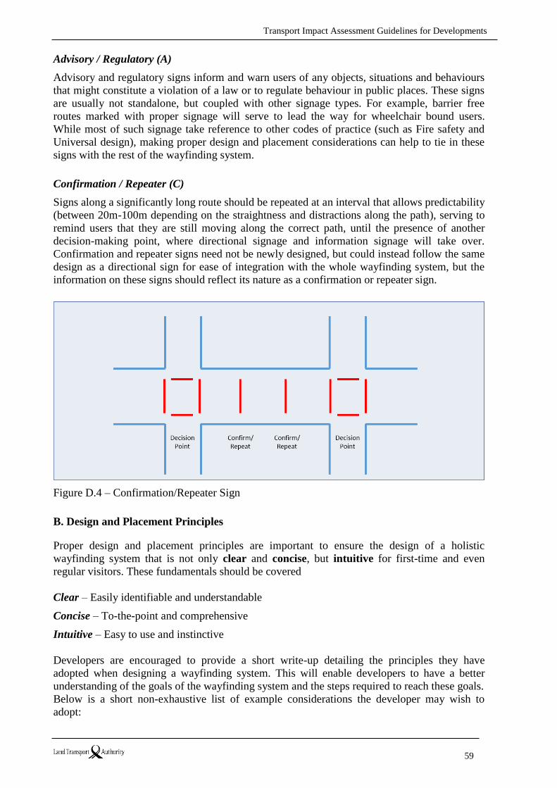
Transport Impact Assessment Guidelines for Developments
59
Advisory / Regulatory (A)
Advisory and regulatory signs inform and warn users of any objects, situations and behaviours
that might constitute a violation of a law or to regulate behaviour in public places. These signs
are usually not standalone, but coupled with other signage types. For example, barrier free
routes marked with proper signage will serve to lead the way for wheelchair bound users.
While most of such signage take reference to other codes of practice (such as Fire safety and
Universal design), making proper design and placement considerations can help to tie in these
signs with the rest of the wayfinding system.
Confirmation / Repeater (C)
Signs along a significantly long route should be repeated at an interval that allows predictability
(between 20m-100m depending on the straightness and distractions along the path), serving to
remind users that they are still moving along the correct path, until the presence of another
decision-making point, where directional signage and information signage will take over.
Confirmation and repeater signs need not be newly designed, but could instead follow the same
design as a directional sign for ease of integration with the whole wayfinding system, but the
information on these signs should reflect its nature as a confirmation or repeater sign.
Figure D.4 – Confirmation/Repeater Sign
B. Design and Placement Principles
Proper design and placement principles are important to ensure the design of a holistic
wayfinding system that is not only clear and concise, but intuitive for first-time and even
regular visitors. These fundamentals should be covered
Clear – Easily identifiable and understandable
Concise – To-the-point and comprehensive
Intuitive – Easy to use and instinctive
Developers are encouraged to provide a short write-up detailing the principles they have
adopted when designing a wayfinding system. This will enable developers to have a better
understanding of the goals of the wayfinding system and the steps required to reach these goals.
Below is a short non-exhaustive list of example considerations the developer may wish to
adopt:
Transport Impact Assessment Guidelines for Developments
60
Principle Description Fulfilled
Fundamental
Within pedestrian line-of-sight For easy identification without the need for
excessive effort
Clear
Intuitive
At key decision making areas At junctions and atria where pedestrians are
likely to pause to find their bearings
Clear
Intuitive
Along pre-determined pedestrian
flows
To understand where people are more likely to
walk and subsequently require more detailed
directions
Clear
Intuitive
At consistent and predictable
locations
So that users do not need to actively look for
signage
Intuitive
Along long passages For reassurance that users are going in the
correct direction
Intuitive
Exclusion zone around signs Protect from visual clutter Clear
Appropriate placing of signs To avoid clustering of signage leading to
confusion
Clear
Table D.1 – Principles for Placement of Wayfinding Signage
Principle Description Fulfilled
Fundamental
Concise and consistent use of simple language to avoid confusion Concise
Avoid visual clutter use of easy-to-understand icons and pictograms Clear
Concise
Effective and intuitive
communication
avoid lengthy labels Clear
Concise
Well-structured and organised proper categorisation of information Clear
Concise
Standardised nomenclature adopt a fixed system of naming Clear
Intuitive
Multilingual signage to avoid misunderstandings due to inability to
read signs
Clear
Reinforcement and reassurance using the same design for peace of mind Clear
Intuitive
Colour coding for better differentiation of zones and types of
information
Intuitive
Table D.2 – Principles for Design of Wayfinding Signage
C. Development Design Strategies to support integrated Wayfinding
Designing a wayfinding system should go in tandem with the design of the development. By
properly laying the ground work during the building design stage, not only will integrating
signage at a later stage be easier, the whole system will look and feel more intuitive and
natural.
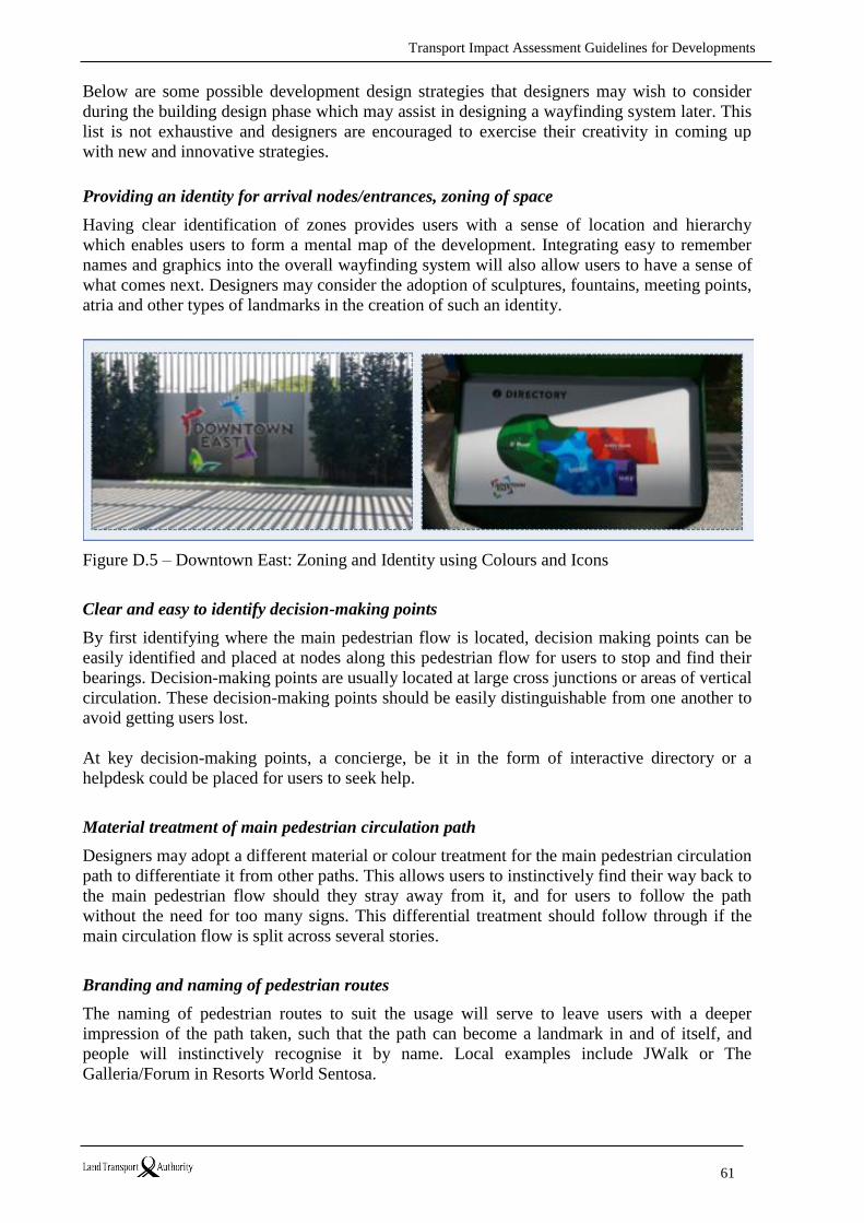
Transport Impact Assessment Guidelines for Developments
61
Below are some possible development design strategies that designers may wish to consider
during the building design phase which may assist in designing a wayfinding system later. This
list is not exhaustive and designers are encouraged to exercise their creativity in coming up
with new and innovative strategies.
Providing an identity for arrival nodes/entrances, zoning of space
Having clear identification of zones provides users with a sense of location and hierarchy
which enables users to form a mental map of the development. Integrating easy to remember
names and graphics into the overall wayfinding system will also allow users to have a sense of
what comes next. Designers may consider the adoption of sculptures, fountains, meeting points,
atria and other types of landmarks in the creation of such an identity.
Figure D.5 – Downtown East: Zoning and Identity using Colours and Icons
Clear and easy to identify decision-making points
By first identifying where the main pedestrian flow is located, decision making points can be
easily identified and placed at nodes along this pedestrian flow for users to stop and find their
bearings. Decision-making points are usually located at large cross junctions or areas of vertical
circulation. These decision-making points should be easily distinguishable from one another to
avoid getting users lost.
At key decision-making points, a concierge, be it in the form of interactive directory or a
helpdesk could be placed for users to seek help.
Material treatment of main pedestrian circulation path
Designers may adopt a different material or colour treatment for the main pedestrian circulation
path to differentiate it from other paths. This allows users to instinctively find their way back to
the main pedestrian flow should they stray away from it, and for users to follow the path
without the need for too many signs. This differential treatment should follow through if the
main circulation flow is split across several stories.
Branding and naming of pedestrian routes
The naming of pedestrian routes to suit the usage will serve to leave users with a deeper
impression of the path taken, such that the path can become a landmark in and of itself, and
people will instinctively recognise it by name. Local examples include JWalk or The
Galleria/Forum in Resorts World Sentosa.

Transport Impact Assessment Guidelines for Developments
62
D. Physical design standards for wayfinding signage
Please refer to Singapore Standard 599: Guide for Wayfinding Signage in Public Areas (SS599:
2014) for more detailed physical design consideration for wayfinding signage. Developers are
encouraged to comply with SS599 to ensure that the wayfinding design is user friendly.
E. Developments directly adjacent to RTS stations and Bus Interchanges
Developers are strongly recommended to provide a complete wayfinding signage system to
direct commuters to the transit facilities, including public underpasses, overhead-bridges and
walkways, facilitating increased footfall to the development. The wayfinding signage for the
transit facilities may be integrated with the signage of the development, according to the
guidelines provided above. However, the information depicting the transit facilities should
remain clearly identifiable using standard public transit pictograms and associated text
messages. These signs should be designed to be very prominent.
Proper clear signage should be provided at the entrances/exits and linkages to the development
from transit facilities identifying and indicating the access to these facilities. Where the existing
entrance of the transit facility is modified or subsumed, identification of the transit facility at
the interface should be addressed with signage in accordance with the LTA’s public transit
signage guidelines.
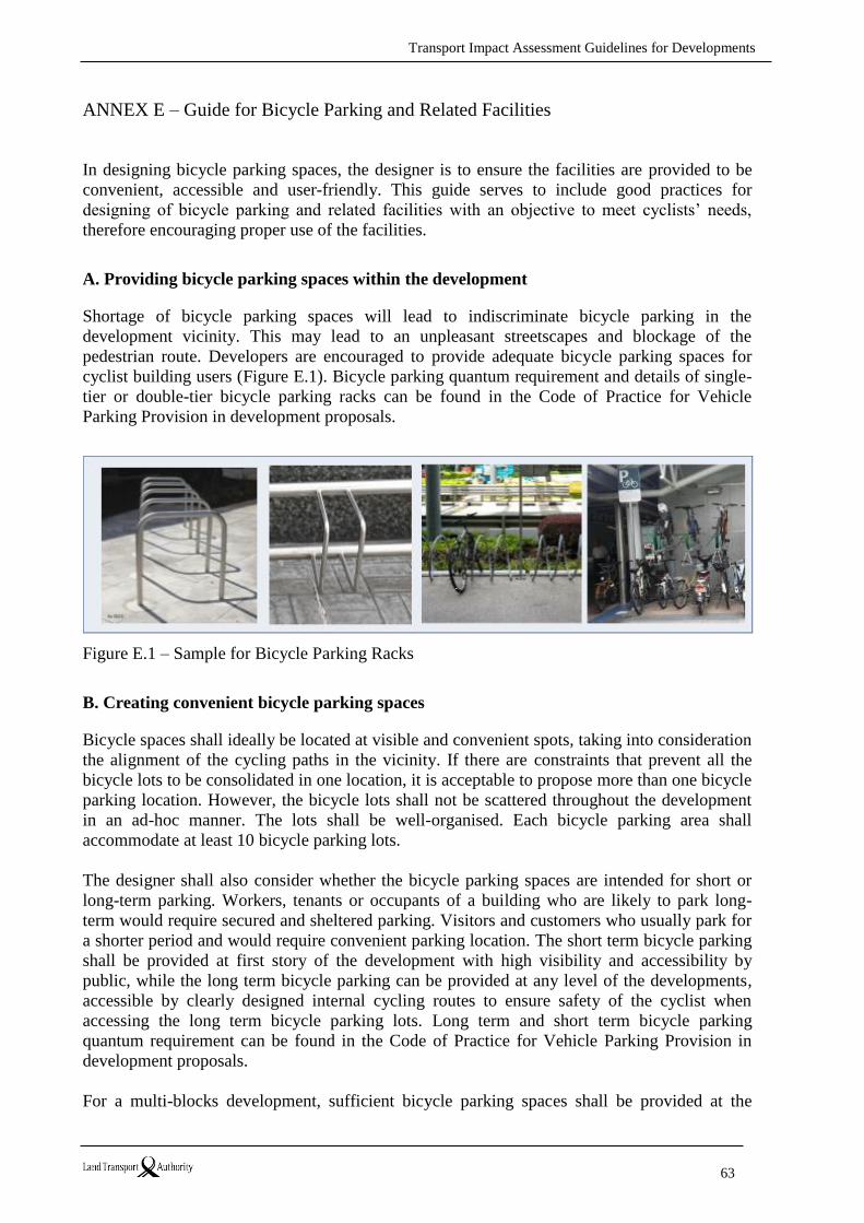
Transport Impact Assessment Guidelines for Developments
63
ANNEX E – Guide for Bicycle Parking and Related Facilities
In designing bicycle parking spaces, the designer is to ensure the facilities are provided to be
convenient, accessible and user-friendly. This guide serves to include good practices for
designing of bicycle parking and related facilities with an objective to meet cyclists’ needs,
therefore encouraging proper use of the facilities.
A. Providing bicycle parking spaces within the development
Shortage of bicycle parking spaces will lead to indiscriminate bicycle parking in the
development vicinity. This may lead to an unpleasant streetscapes and blockage of the
pedestrian route. Developers are encouraged to provide adequate bicycle parking spaces for
cyclist building users (Figure E.1). Bicycle parking quantum requirement and details of single-
tier or double-tier bicycle parking racks can be found in the Code of Practice for Vehicle
Parking Provision in development proposals.
Figure E.1 – Sample for Bicycle Parking Racks
B. Creating convenient bicycle parking spaces
Bicycle spaces shall ideally be located at visible and convenient spots, taking into consideration
the alignment of the cycling paths in the vicinity. If there are constraints that prevent all the
bicycle lots to be consolidated in one location, it is acceptable to propose more than one bicycle
parking location. However, the bicycle lots shall not be scattered throughout the development
in an ad-hoc manner. The lots shall be well-organised. Each bicycle parking area shall
accommodate at least 10 bicycle parking lots.
The designer shall also consider whether the bicycle parking spaces are intended for short or
long-term parking. Workers, tenants or occupants of a building who are likely to park long-
term would require secured and sheltered parking. Visitors and customers who usually park for
a shorter period and would require convenient parking location. The short term bicycle parking
shall be provided at first story of the development with high visibility and accessibility by
public, while the long term bicycle parking can be provided at any level of the developments,
accessible by clearly designed internal cycling routes to ensure safety of the cyclist when
accessing the long term bicycle parking lots. Long term and short term bicycle parking
quantum requirement can be found in the Code of Practice for Vehicle Parking Provision in
development proposals.
For a multi-blocks development, sufficient bicycle parking spaces shall be provided at the
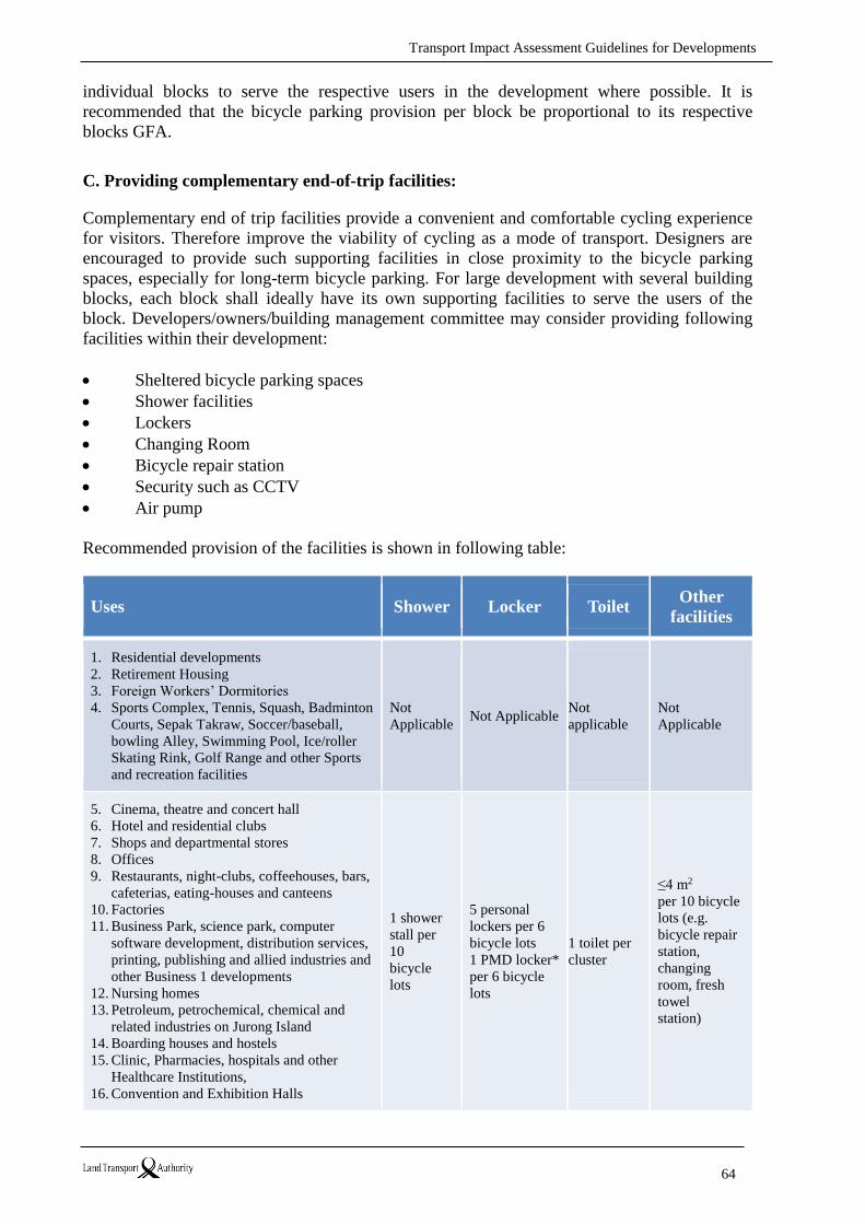
Transport Impact Assessment Guidelines for Developments
64
individual blocks to serve the respective users in the development where possible. It is
recommended that the bicycle parking provision per block be proportional to its respective
blocks GFA.
C. Providing complementary end-of-trip facilities:
Complementary end of trip facilities provide a convenient and comfortable cycling experience
for visitors. Therefore improve the viability of cycling as a mode of transport. Designers are
encouraged to provide such supporting facilities in close proximity to the bicycle parking
spaces, especially for long-term bicycle parking. For large development with several building
blocks, each block shall ideally have its own supporting facilities to serve the users of the
block. Developers/owners/building management committee may consider providing following
facilities within their development:
Sheltered bicycle parking spaces
Shower facilities
Lockers
Changing Room
Bicycle repair station
Security such as CCTV
Air pump
Recommended provision of the facilities is shown in following table:
Uses Shower Locker Toilet Other
facilities
1. Residential developments
2. Retirement Housing
3. Foreign Workers’ Dormitories
4. Sports Complex, Tennis, Squash, Badminton
Courts, Sepak Takraw, Soccer/baseball,
bowling Alley, Swimming Pool, Ice/roller
Skating Rink, Golf Range and other Sports
and recreation facilities
Not
Applicable Not Applicable
Not
applicable
Not
Applicable
5. Cinema, theatre and concert hall
6. Hotel and residential clubs
7. Shops and departmental stores
8. Offices
9. Restaurants, night-clubs, coffeehouses, bars,
cafeterias, eating-houses and canteens
10. Factories
11. Business Park, science park, computer
software development, distribution services,
printing, publishing and allied industries and
other Business 1 developments
12. Nursing homes
13. Petroleum, petrochemical, chemical and
related industries on Jurong Island
14. Boarding houses and hostels
15. Clinic, Pharmacies, hospitals and other
Healthcare Institutions,
16. Convention and Exhibition Halls
1 shower
stall per
10
bicycle
lots
5 personal
lockers per 6
bicycle lots
1 PMD locker*
per 6 bicycle
lots
1 toilet per
cluster
≤4 m2 per 10 bicycle
lots (e.g.
bicycle repair
station,
changing
room, fresh
towel
station)
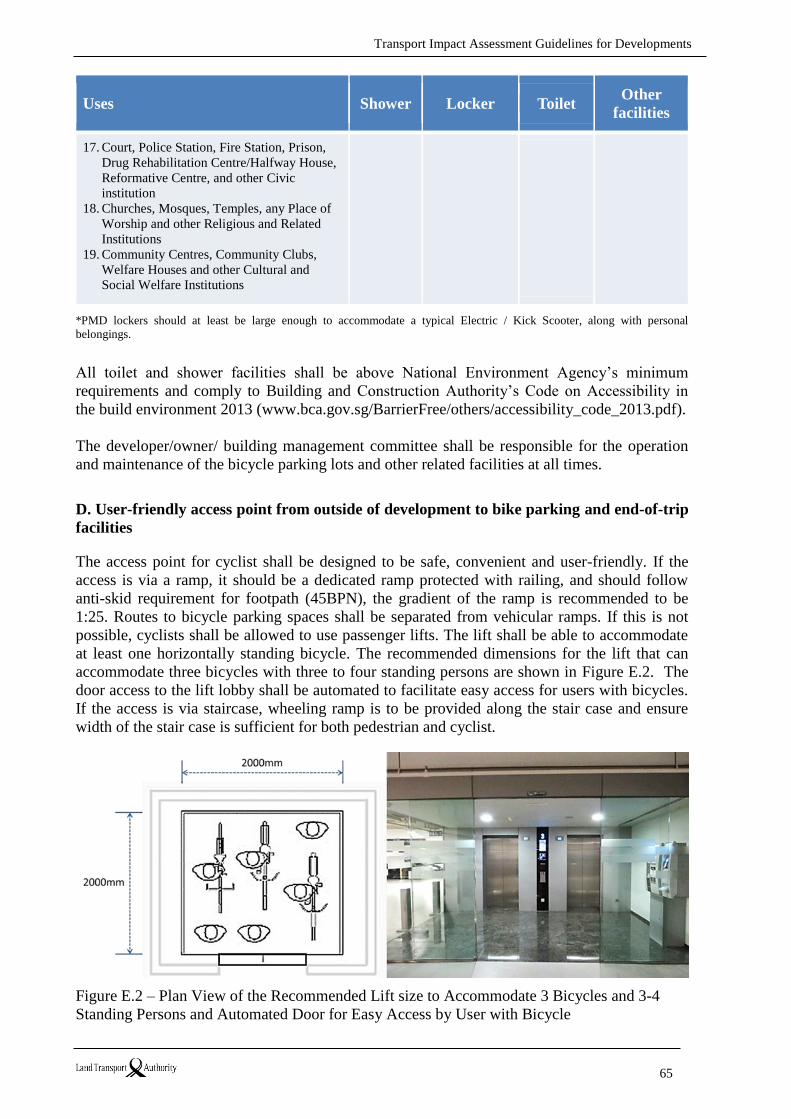
Transport Impact Assessment Guidelines for Developments
65
Uses Shower Locker Toilet Other
facilities
17. Court, Police Station, Fire Station, Prison,
Drug Rehabilitation Centre/Halfway House,
Reformative Centre, and other Civic
institution
18. Churches, Mosques, Temples, any Place of
Worship and other Religious and Related
Institutions
19. Community Centres, Community Clubs,
Welfare Houses and other Cultural and
Social Welfare Institutions
*PMD lockers should at least be large enough to accommodate a typical Electric / Kick Scooter, along with personal
belongings.
All toilet and shower facilities shall be above National Environment Agency’s minimum
requirements and comply to Building and Construction Authority’s Code on Accessibility in
the build environment 2013 (www.bca.gov.sg/BarrierFree/others/accessibility_code_2013.pdf).
The developer/owner/ building management committee shall be responsible for the operation
and maintenance of the bicycle parking lots and other related facilities at all times.
D. User-friendly access point from outside of development to bike parking and end-of-trip
facilities
The access point for cyclist shall be designed to be safe, convenient and user-friendly. If the
access is via a ramp, it should be a dedicated ramp protected with railing, and should follow
anti-skid requirement for footpath (45BPN), the gradient of the ramp is recommended to be
1:25. Routes to bicycle parking spaces shall be separated from vehicular ramps. If this is not
possible, cyclists shall be allowed to use passenger lifts. The lift shall be able to accommodate
at least one horizontally standing bicycle. The recommended dimensions for the lift that can
accommodate three bicycles with three to four standing persons are shown in Figure E.2. The
door access to the lift lobby shall be automated to facilitate easy access for users with bicycles.
If the access is via staircase, wheeling ramp is to be provided along the stair case and ensure
width of the stair case is sufficient for both pedestrian and cyclist.
Figure E.2 – Plan View of the Recommended Lift size to Accommodate 3 Bicycles and 3-4
Standing Persons and Automated Door for Easy Access by User with Bicycle

Transport Impact Assessment Guidelines for Developments
66
E. Creating safe bicycle parking spaces and End-of-Trip facilities
Designers shall take into consideration the vehicle and pedestrian movements when
determining the location for the bicycle parking spaces and End-of-Trip facilities. The bicycle
parking spaces and End-of-Trip facilities within the development shall be away from the major
vehicle and pedestrian movements. The routes to bicycle parking areas and End-of-Trip
facilities shall be carefully considered in the overall design of the development. Designers, as
far as possible, shall avoid using vehicular ingress and egress for cyclist access to bicycle
parking spaces and end-of-trip facilities. Markings and warning signage that indicate cyclists’
presence shall be provided when there is inevitable conflict between vehicular and cyclist
movements. (Figure E.3).
Figure E.3 – Traffic Mitigating Measures at Vehicular, Cyclist and Pedestrian Conflict
When the cyclist is using the internal vehicular driveway to access the bicycle parking and end-
of-trip facilities, clearly demarcated lane for dedicated pedestrian and cyclist use is highly
recommended to avoid potential collision between cyclists and vehicular users. (Figure E.4)
Figure E.4 – Providing Demarcated Lane for Pedestrians and Cyclists

Transport Impact Assessment Guidelines for Developments
67
ANNEX F – Examples of Walk Radius and Indicative Walk Time Isochrones
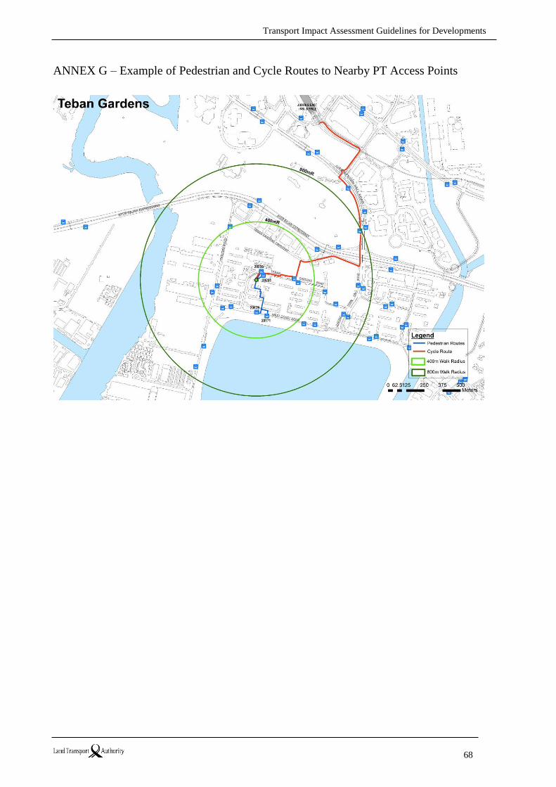
Transport Impact Assessment Guidelines for Developments
68
ANNEX G – Example of Pedestrian and Cycle Routes to Nearby PT Access Points
Transport Impact Assessment Guidelines for Developments
69
ANNEX H – PTAL Calculation Methodology
LTA has adopted the London’s PTAL methodology from Transport for London (and adapted it
to suit local circumstances) to objectively assess the public transport accessibility level of
proposed development in a consistent manner.
This ANNEX draws heavily on TfL’s Assessing Transport Connectivity in London (2015) as
this document is a recent, practical and succinct guidance on connectivity assessments.
To calculate PTAL values, the following data/information is required:
1. A walking network in the vicinity (up to 800m walking distance) of the point of interest
(POI). This is to calculate the walk time from the POI to all relevant PT Service Access
Points (SAPs), i.e. bus stops and MRT/LRT station entrances
2. Location of all relevant SAPs (within 400m for bus stops or LRT entrances, and 800m
for MRT entrances) walking distances from the POI)
3. Service frequency of all PT services at the relevant SAPs
The full calculation method for a single location is described below (this needs to be repeated
when PTAL is calculated for multiple points):
Step 1 – Calculate Walking Times (WT) to all relevant SAPs
The walking network includes all paved walk paths, including footpaths, alleys,
pedestrian crossings, pedestrian overhead bridges (POBs), underpasses, through routes
within private/public properties which allow public access during daytime, etc.
Maximum walking distances to a bus stop/LRT station entrance and a MRT station
entrance are assumed up to 400m (5mins) and 800m (10mins), respectively.
Step 2 – Calculate Service Waiting Time (SWT) for each service at each relevant SAPs
The standard PTAL calculation is based on service headway/frequencies during the AM
peak, typically between 0800hr and 0900hr on a weekday.9
Service headway can be downloaded from this website:
https://www.transitlink.com.sg/TIdetail.aspx?ty=catart&Id=15
The SWT (in minutes) is estimated as half the time interval between scheduled arrivals
of the service at the SAP, i.e. SWT = 0.5 x (60/frequency). For example, a bus service
with a frequency of 12 buses per hour will have an interval of 5mins and a SWT of
2.5mins, which is the average amount of time a passenger who arrives randomly will
have to wait.
9 AM peak is the basic requirement for all PTAL assessments. Developers may be requested to undertake PTAL
assessments for additional time periods (e.g. interpeak, PM peak or off-peak) if their developments have a peak
trip generation period outside of the AM peak.
Transport Impact Assessment Guidelines for Developments
70
If a single route has several stops in the catchment area of a point, only the nearest is
considered.
If a service runs in both directions, the nearer direction should be used in the
calculation, i.e. each bus service and rail line should only be considered once, regardless
of direction.
Step 3 – Calculate Average Waiting Times (AWT) for each service at each relevant SAP
The AWT (in minutes) is a combination of the SWT and a modal preference value (a
time penalty). The latter varies by mode of transport, and reflects the preference of
commuters for MRT/LRT over bus.
LTA recommends modal preference value of 1.5mins and 0.83mins for buses and
MRT/LRT, respectively. These values would be reviewed by LTA from time to time.
Step 4 – Calculate Total Access Time (TAT) for each service at each relevant SAP
The TAT (in minutes) combines the walk time to the SAP with the AWT at the SAP,
i.e. TAT = WT + AWT
Step 5 – Calculate Equivalent Doorstep Frequency (EDF) for each service at each relevant
SAPs
The EDF (services per hour) converts the TAT back into units of frequency, i.e. EDF =
0.5 x (60/TAT). It is a measure of what the service frequency would be like if the
service was available without any walk time (as if the services are provided at the
doorstep).
Step 6 – Calculate Access Index (AI) for each service and Sum of AI for the POI
Individual AI is calculated by adjusting the corresponding EDF value, i.e. a higher
weight (a factor of 1) will be given to the service with the highest EDF for each SAP,
and a lower weight (a factor of 0.5) to all other services within the same SAP, before
adding them together to get total AI.
Halving the EDF values for all but the most accessible or dominant route for each SAP
compensates for such factors as 1) routes often travel in parallel for some distance, and
2) travellers often have to change routes in order to reach the desired destination – this
can add significant delays to the journey.
Step 7 – Convert to a PTAL Score
The sum of AI is converted to PTAL using the bands specified in the following table 10:
10 The bands are subject to further review by the LTA.
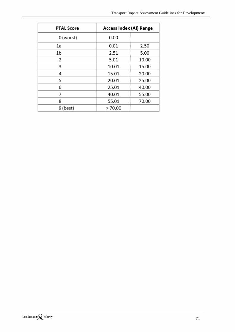
Transport Impact Assessment Guidelines for Developments
71
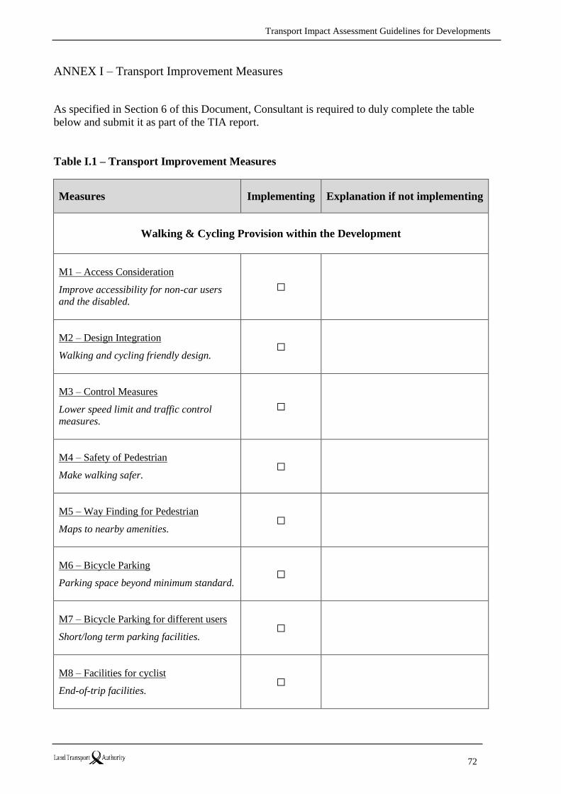
Transport Impact Assessment Guidelines for Developments
72
ANNEX I – Transport Improvement Measures
As specified in Section 6 of this Document, Consultant is required to duly complete the table
below and submit it as part of the TIA report.
Table I.1 – Transport Improvement Measures
Measures Implementing Explanation if not implementing
Walking & Cycling Provision within the Development
M1 – Access Consideration
Improve accessibility for non-car users
and the disabled.
☐
M2 – Design Integration
Walking and cycling friendly design.
☐
M3 – Control Measures
Lower speed limit and traffic control
measures.
☐
M4 – Safety of Pedestrian
Make walking safer.
☐
M5 – Way Finding for Pedestrian
Maps to nearby amenities.
☐
M6 – Bicycle Parking
Parking space beyond minimum standard.
☐
M7 – Bicycle Parking for different users
Short/long term parking facilities.
☐
M8 – Facilities for cyclist
End-of-trip facilities.
☐
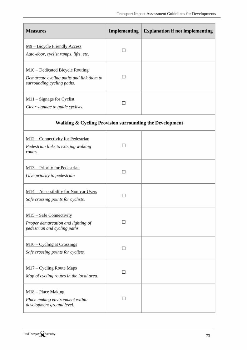
Transport Impact Assessment Guidelines for Developments
73
Measures Implementing Explanation if not implementing
M9 – Bicycle Friendly Access
Auto-door, cyclist ramps, lifts, etc.
☐
M10 – Dedicated Bicycle Routing
Demarcate cycling paths and link them to
surrounding cycling paths.
☐
M11 – Signage for Cyclist
Clear signage to guide cyclists.
☐
Walking & Cycling Provision surrounding the Development
M12 – Connectivity for Pedestrian
Pedestrian links to existing walking
routes.
☐
M13 – Priority for Pedestrian
Give priority to pedestrian
☐
M14 – Accessibility for Non-car Users
Safe crossing points for cyclists.
☐
M15 – Safe Connectivity
Proper demarcation and lighting of
pedestrian and cycling paths.
☐
M16 – Cycling at Crossings
Safe crossing points for cyclists.
☐
M17 – Cycling Route Maps
Map of cycling routes in the local area.
☐
M18 – Place Making
Place making environment within
development ground level.
☐

Transport Impact Assessment Guidelines for Developments
74
Measures Implementing Explanation if not implementing
M19 – Share Space Design
Designed to create shared space.
☐
Mass Transport
M20 – Private Shuttle Bus Service
Shuttle service to main Public Transport
nodes.
☐
M21 – Educational Engagement
Engage to promote awareness on benefits
of walk, cycle and ride PT.
☐
M22 – Facility/Service for Shoppers
taking Public Transport
Centralised delivery service i.e. Urban
Logistics.
☐
Programmes / Schemes to Promote Walk Cycle Ride
M23 – Promote Early with Walk, Cycle
and Ride
Include development’s connectivity to PT
and active mode facilities in marketing
promotion for development.
☐
M24 – Engage Interest Group to Organise
Courses
Conduct trainings/courses for cyclists.
☐
M25 – Encourage Cycling Community
Establish bicycle user group.
☐
M26 – Bicycle Sharing
Provide bike sharing for development.
☐
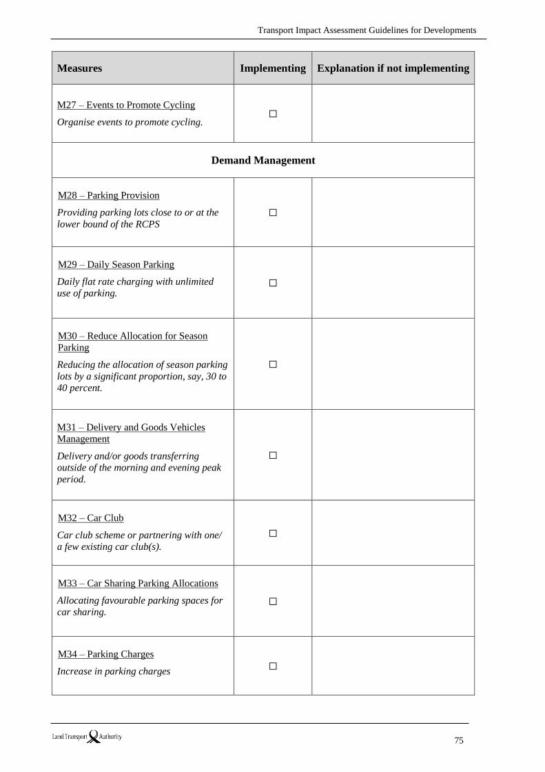
Transport Impact Assessment Guidelines for Developments
75
Measures Implementing Explanation if not implementing
M27 – Events to Promote Cycling
Organise events to promote cycling.
☐
Demand Management
M28 – Parking Provision
Providing parking lots close to or at the
lower bound of the RCPS
☐
M29 – Daily Season Parking
Daily flat rate charging with unlimited
use of parking.
☐
M30 – Reduce Allocation for Season
Parking
Reducing the allocation of season parking
lots by a significant proportion, say, 30 to
40 percent.
☐
M31 – Delivery and Goods Vehicles
Management
Delivery and/or goods transferring
outside of the morning and evening peak
period.
☐
M32 – Car Club
Car club scheme or partnering with one/
a few existing car club(s).
☐
M33 – Car Sharing Parking Allocations
Allocating favourable parking spaces for
car sharing.
☐
M34 – Parking Charges
Increase in parking charges
☐
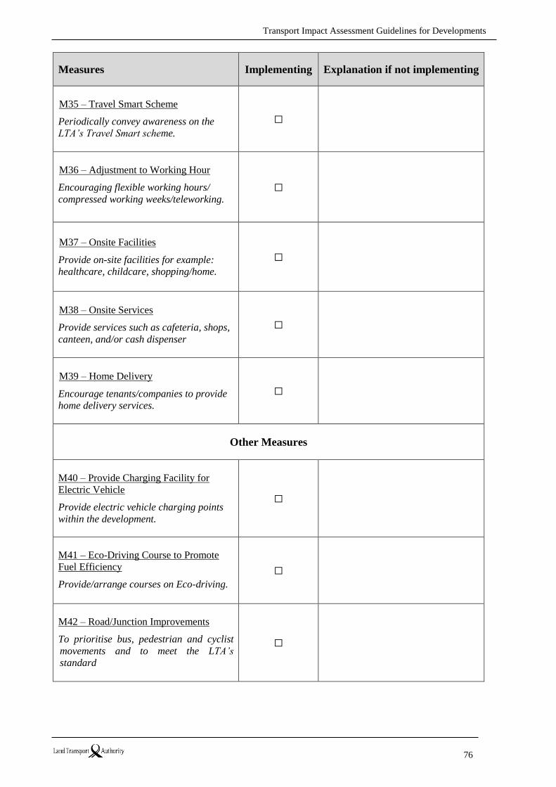
Transport Impact Assessment Guidelines for Developments
76
Measures Implementing Explanation if not implementing
M35 – Travel Smart Scheme
Periodically convey awareness on the
LTA’s Travel Smart scheme.
☐
M36 – Adjustment to Working Hour
Encouraging flexible working hours/
compressed working weeks/teleworking.
☐
M37 – Onsite Facilities
Provide on-site facilities for example:
healthcare, childcare, shopping/home.
☐
M38 – Onsite Services
Provide services such as cafeteria, shops,
canteen, and/or cash dispenser
☐
M39 – Home Delivery
Encourage tenants/companies to provide
home delivery services.
☐
Other Measures
M40 – Provide Charging Facility for
Electric Vehicle
Provide electric vehicle charging points
within the development.
☐
M41 – Eco-Driving Course to Promote
Fuel Efficiency
Provide/arrange courses on Eco-driving.
☐
M42 – Road/Junction Improvements
To prioritise bus, pedestrian and cyclist
movements and to meet the LTA’s
standard
☐

Transport Impact Assessment Guidelines for Developments
77
Acknowledgements
The editors would like to thank the project team, the LTA management and other officers who
have contributed to this Guidelines document.
The LTA would also like to thank all participants from the industry including developers,
architects, engineers and transport consultants, for their feedbacks and suggestions to enhance
the Guidelines.
A very special gratitude goes out to Transport for London (TfL) officers who have shared with
the LTA on the London’s requirements and best practices on conducting Transport Assessment
especially on the requirements of Public Transport Accessibility Level (PTAL).

Transport Impact Assessment Guidelines for Developments
78
References
Transport for London (April 2015), Assessing Transport Connectivity in London,
Transport for London
Transport for London (April 2010), Transport Assessment Best Practice - Guidance
Document, Transport for London